upperhb ctypes veg-plot · table 2a honeywell wastebed b/ harbor brook site vegetation survey...
TRANSCRIPT

����
��
��
�� ��
��
��
��
�� ��
HARBOR BROOK
�
HB-VEG-P3
HB-VEG-P8
HB-VEG-P7
HB-VEG-P6HB-VEG-P4
HB-VEG-P5
HB
-VE
G-P
2
HB-VEG-P1S
HB
-VE
G-P
9E
HB-VEG-P9 W HB-VEG-P1 N
�
HONEYWELL UPPER HARBOR BROOK
PRE-DESIGN INVESTIGATIONGEDDES AND SYRACUSE, NY
FIGURE 2
AUGUST 20081163. 42071
T:\1
163_
Hon
eyw
ell\S
yrac
use\
MX
D\4
2071
\Upp
erH
B_P
reD
esig
n_W
P\U
pper
HB
_Cty
pes_
Veg
-Plo
t.mxd
PLO
T D
ATE
: 8/
4/08
DIV
014
AK
M
0 200 400100
Feet
Aerials obtained from the NYS GIS Clearing house: http://www.nysgis.state.ny.us.This document was developed in color. Reproduction in B/W may not represent the data as intended.
VEGETATIVE COVERTYPES
AND SURVEY PLOTLOCATIONS
ONONDAGA LAKE
NOTE: Vegetative covertype boundaries are approximate.
HARBOR BROOK
WASTEBED D/E DRAINAGE DITCH
LEGEND
RG/PLS AND SUCCESSIONALNORTHERN HARDWOODS (NHW)
RG/PLS WITH DOGWOOD SPECIES
REEDGRASS/PURPLE LOOSESTRIFE MARSH (RG/PLS)
FLOODPLAIN FOREST (FF)
��APPROXIMATE VEGETATIVE PLOT LOCATIONCULVERT SECTION
SUCCESSIONAL SHRUBLAND (SS)

Table 1Honeywell
Wastebed B/ Harbor Brook SiteObserved Species Master Plant List
Common Name Scientific NameObserved Plot Location(s)1
Regional Indicator2
Native Status3
1 Bebb Willow Salix bebbiana 6 FACW N2 Bittersweet Nightshade Solanum dulcamara 4, 5 FAC- I*3 Black Locust Robinia pseudo-acacia 9W FACU- N4 Box Elder Acer negundo 1N, 2, 5, 9W, 9E FAC+ N5 Canada Goldenrod Solidago canadensis 1N, 1S, 4, 5, 6, 7, 9W FACU N6 Clasping-leaved Dogbane Apocynum sibiricum 6 FAC NA7 Common Buckthorn Rhamnus cathartica 1N, 2, 4, 5, 7, 9W, 9E FACU+ I*8 Common Mugwort Artemisia vulgaris 1N FACU- NI9 Common Plantain Plantago major 5 FACU I
10 Common Reed Phragmites australis 1N, 2, 3, 4, 5, 6, 7, 8 FACW N*11 Eastern Cottonwood Populus deltoides 4, 7, 9E FAC N12 Enchanter's Nightshade Circaea lutetiana 1N FACU N13 European Honeysuckle Lonicera xylosteum 1S, 4 NI I14 False Nettle Boehmeria cylindrica 1N FACW+ N15 Field Mustard Brassica rapa 9W NI I16 Field Sowthistle Sonchus arvensis 1N, 5 UPL I17 Giant Goldenrod Solidago gigantia 4 FACW N18 Gray Dogwood Cornus foemina racemosa 1S, 8 FAC- N19 Green Ash Fraxius pennsylvanica 4, 9E FACW N20 Ground Ivy Glechoma hederacea 5, 9W FACU I21 Hedge Bindweed Convolvulus sepium 4, 5, 6 FAC- I22 Lance-leaved Goldenrod Solidago graminifolia 1N FAC N23 Purple Loosestrife Lythrum salicaria 4, 6 FACW+ I*24 Red-osier Dogwood Cornus stolonifera 6 FACW N25 Red-panicle Dogwood Cornus racemosa 1S, 8 FAC N26 Rough Avens Geum laciniatum 9W FACW N27 Silky Willow Salix sericea 6 OBL N28 Staghorn Sumac Rhus typhina 4, 8 NI N29 Summer Grape Vitis aestivalis 1N, 4, 5, 7, 9E FACU N30 Swamp Rose Rosa palustris 9W OBL N31 Tatarian Honeysuckle Lonicera tatarica 1N, 3 FACU I*32 Tree of Heaven Ailanthus altissima 9W, 9E NA I33 Virginia Creeper Parthenocissus quinquefolia 1S, 9W, 9E FACU N34 Wood Sorrel Oxalis montana 9W FAC- N
Notes: 1) Vegetative species as observed between July 15 and 17, 2008. 2) Indicators obtained from the USDA PLANTS Database, 2008.OBL= occurs almost always (99%) under natural conditions in wetlands; FACW= usually occurs in wetlands (67-99%), but occassionally found in non-wetlands; FAC= equally likely to occur in wetlands or non-wetlands; FACU= usually occurs in non-wetlands (67-99%), but occassionally found in wetlands; UPL= occurs almost always (99%) in non-wetlands in region specified;+= more frequently found in wetlands; -= less frequently found in wetlands.3) Information obtained from the USDA PLANTS Database, 2008.N= Native; I= Introduced; NI= Native and Introduced; NA= Not available, *= Considered Invasive (imapinvasives.org)
I:\DIV82\PROJECTS\Div_014\Honeywell Projects.1163\Upper Harbor Brook PID\Wetland_Veg_Survey\Master Plant List_HB.xlsO'Brien & Gere
1 of 1

Table 2aHoneywell
Wastebed B/ Harbor Brook SiteVegetation Survey
Herbaceous Layer - Relative Frequency
Scientific Name 1 Common NameNumber of plot
locations species occur
Frequency = (# of plots where
species occurs/11 plots
sampled)
Relative Frequency (%)= (frequency/total
freq. of all species) x 100
1 Acer negundo Box Elder 1 0.09 1.752 Apocynum sibiricum Clasping-leaved Dogbane 1 0.09 1.753 Artemisia vulgaris Common Mugwort 1 0.09 1.754 Boehmeria cylindrica False Nettle 1 0.09 1.755 Brassica rapa Field Mustard 1 0.09 1.756 Circaea lutetiana Enchanter's Nightshade 1 0.09 1.757 Convolvulus sepium Hedge Bindweed 3 0.27 5.268 Cornus foemina racemosa Gray Dogwood 2 0.18 3.519 Cornus racemosa Red-panicle Dogwood 2 0.18 3.51
10 Geum laciniatum Rough Avens 1 0.09 1.7511 Glechoma hederacea Ground Ivy 2 0.18 3.5112 Lonicera xylosteum European Honeysuckle 1 0.09 1.7513 Lythrum salicaria Purple Loosestrife 2 0.18 3.5114 Oxalis montana Wood Sorrel 1 0.09 1.7515 Parthenocissus quinquefolia Virginia Creeper 3 0.27 5.2616 Phragmites australis Common Reed 8 0.73 14.0417 Plantago major Common Plantain 1 0.09 1.7518 Rhamnus cathartica Common Buckthorn 4 0.36 7.0219 Rhus typhina Staghorn Sumac 1 0.09 1.7520 Rosa palustris Swamp Rose 1 0.09 1.7521 Solanum dulcamara Bittersweet Nightshade 2 0.18 3.5122 Solidago canadensis Canada Goldenrod 7 0.64 12.2823 Solidago gigantia Giant Goldenrod 1 0.09 1.7524 Solidago graminifolia Lance-leaved Goldenrod 1 0.09 1.7525 Sonchus arvensis Field Sowthistle 2 0.18 3.5126 Vitis aestivalis Summer Grape 6 0.55 10.53
5.18NOTES:1) Includes vegetative species observed less than 3 feet tall.
total frequency for all species =
I:\DIV82\PROJECTS\Div_014\Honeywell Projects.1163\Upper Harbor Brook PID\Wetland_Veg_Survey\Veg_Stats_rev.xls\rel freq_herbO'Brien & Gere
1 of 1
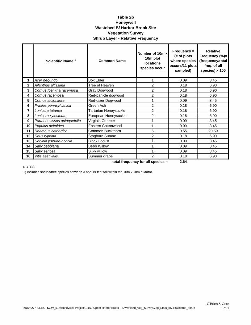
Table 2bHoneywell
Wastebed B/ Harbor Brook SiteVegetation Survey
Shrub Layer - Relative Frequency
Scientific Name 1 Common Name
Number of 10m x 10m plot locations
species occur
Frequency = (# of plots
where species occurs/11 plots
sampled)
Relative Frequency (%)= (frequency/total
freq. of all species) x 100
1 Acer negundo Box Elder 1 0.09 3.452 Ailanthus altissima Tree of Heaven 2 0.18 6.903 Cornus foemina racemosa Gray Dogwood 2 0.18 6.904 Cornus racemosa Red-panicle dogwood 2 0.18 6.905 Cornus stolonifera Red-osier Dogwood 1 0.09 3.456 Fraxius pennsylvanica Green Ash 2 0.18 6.907 Lonicera tatarica Tartarian Honeysuckle 2 0.18 6.908 Lonicera xylosteum European Honeysuckle 2 0.18 6.909 Parthenocissus quinquefolia Virginia Creeper 1 0.09 3.45
10 Populus deltoides Eastern Cottonwood 1 0.09 3.4511 Rhamnus cathartica Common Buckthorn 6 0.55 20.6912 Rhus typhina Staghorn Sumac 2 0.18 6.9013 Robinia pseudo-acacia Black Locust 1 0.09 3.4514 Salix bebbiana Bebb Willow 1 0.09 3.4515 Salix sericea Silky willow 1 0.09 3.4516 Vitis aestivalis Summer grape 2 0.18 6.90
total frequency for all species = 2.64NOTES:1) Includes shrubs/tree species between 3 and 19 feet tall within the 10m x 10m quadrat.
I:\DIV82\PROJECTS\Div_014\Honeywell Projects.1163\Upper Harbor Brook PID\Wetland_Veg_Survey\Veg_Stats_rev.xls\rel freq_shrubO'Brien & Gere
1 of 1

Table 2cHoneywell
Wastebed B/ Harbor Brook SiteVegetation Survey
Tree Layer - Relative Frequency
Scientific Name 1 Common NameNumber of plot
locations species occur
Frequency = (# of plots
where species occurs/11 plots
sampled)
Relative Frequency (%)= (frequency/total
freq. of all species) x 100
1 Acer negundo Box Elder 5 0.45 41.672 Populus deltoides Eastern Cottonwood 3 0.27 25.003 Rhamnus cathartica Common Buckthorn 3 0.27 25.004 Rhus typhina Staghorn Sumac 1 0.09 8.33
total frequency for all species = 1.09NOTES:1) Includes tree/shrub species greater than or equal to 20 feet tall within the 10m x 10m quadrat.
I:\DIV82\PROJECTS\Div_014\Honeywell Projects.1163\Upper Harbor Brook PID\Wetland_Veg_Survey\Veg_Stats_rev.xls\rel freq_treeO'Brien & Gere
1 of 1

Table 3aHoneywell
Wastebed B/ Harbor Brook SiteVegetation Survey
Herbaceous Layer - Relative Percent Cover
Plot ID P1N P1S P2 P3 P4 P5 P6 P7 P8 P9W P9E
Sum of % Cover per Species 2
Average % Cover per Plot
Relative Percent Cover
Scientific Name1 Acer negundo 1 1 0.09 0.1072 Apocynum sibricum 40 40 3.64 4.303 Artemisia vulgaris 10 10 0.91 1.074 Boehmeria cylindrica 2 2 0.18 0.215 Brassica rapa 5 5 0.45 0.546 Circaea lutetiana 5 5 0.45 0.547 Convolvulus sepium 3 5 <1 8 0.73 0.868 Cornus foemina racemosa 2 1 3 0.27 0.3229 Cornus racemosa 2 1 3 0.27 0.32210 Geum lainiatum 1 1 0.09 0.1111 Glechoma hederacea 90 30 120 10.91 12.8912 Lonicera xylosteum 2 2 0.18 0.21513 Lythrum salicaria 5 10 15 1.36 1.6114 Oxalis montana 1 1 0.09 0.1115 Parthenocissus quinquefolia 5 3 5 13 1.18 1.4016 Phragmites australis 5 100 100 85 15 25 85 100 515 46.82 55.3217 Plantago major <1 0 0.00 0.0018 Rhamnus cathartica 5 <1 1 2 8 0.73 0.85919 Rhus typhina 5 5 0.45 0.53720 Rosa palustris 25 25 2.27 2.68521 Solanum dulcamara 2 <1 2 0.18 0.2122 Solidago canandensis 10 10 7 70 2 <1 5 104 9.45 11.1723 Solidago gigantis <1 0 0.00 0.0024 Solidago graminifolia 2 2 0.18 0.2125 Sonchus arvensis 25 <1 25 2.27 2.6926 Vitis aestivalis 1 5 1 5 1 3 16 1.45 1.72
NOTES:1) Includes vegetative species observed less than 3 feet tall.2) <1% cover is not included in total percent cover.
90100 112 181 77TOTAL % COVER PER 3m x 3m PLOT
65 21 100 102 73 10 931
I:\DIV82\PROJECTS\Div_014\Honeywell Projects.1163\Upper Harbor Brook PID\Wetland_Veg_Survey\Veg_Stats_rev.xls\rel % cover-herbO'Brien & Gere
1 of 1

Table 3bHoneywell
Wastebed B/ Harbor Brook SiteVegetation Survey
Shrub and Tree Layers - Relative Percent CoverShrub Layer
Plot ID P1N P1S P2 P3 P4 P5 P6 P7 P8 P9W P9E Sum of % Cover per Species 2
Average % Cover per Plot
Relative Percent Cover
Scientific Name 1
1 Acer negundo 3 3 0.27 1.322 Ailanthus altissima 10 <1 10 0.91 4.393 Cornus foemina racemosa 15 <1 15 1.36 6.584 Cornus racemosa 10 65 75 6.82 32.895 Cornus stolonifera <1 0 0.00 0.006 Fraxius pennsylvanica <1 1 1 0.09 0.447 Lonicera tatarica 15 <1 15 1.36 6.588 Lonicera xylosteum 2 <1 2 0.18 0.889 Parthenocissus quinquefolia 70 70 6.36 30.7010 Populus deltoides <1 0 0.00 0.0011 Rhamnus cathartica 1 <1 <1 <1 5 15 21 1.91 9.2112 Rhus typhina <1 2 2 0.18 0.8813 Robinia pseudo-acacia <1 0 0.00 0.0014 Salix bebbiana <1 0 0.00 0.0015 Salix sericea 2 2 0.18 0.8816 Vitis aestivalis 7 5 12 1.09 5.26
NOTES:1) Includes shrubs/trees species between 3 and 19 feet tall.2) <1% cover is not included in total percent cover.
Tree Layer
Plot ID P1N P1S P2 P3 P4 P5 P6 P7 P8 P9W P9E Sum of % Cover per Species 2
Average % Cover per Plot
Relative Percent Cover
Scientific Name 1
1 Acer negundo 15 10 10 10 35 80 7.27 33.062 Populus deltoides 2 65 50 117 10.64 48.353 Rhamnus cathartica 20 10 30 2.73 12.404 Rhus typhina 15 15 1.36 6.20
NOTES:1) Includes trees/shrub species greater than or equal to 20 feet tall.2) <1% cover is not included in total percent cover.
TOTAL % COVER PER 10m x 10m PLOT
TOTAL % COVER PER 10m x 10m PLOT
15
10
0 10 0
67 1015 98 0 0 0 7 2
1017 10 0 85 0 95 242
22819
I:\DIV82\PROJECTS\Div_014\Honeywell Projects.1163\Upper Harbor Brook PID\Wetland_Veg_Survey\Veg_Stats_rev.xls\rel % cover-shrub_treeO'Brien & Gere
1 of 1

Table 4aHoneywell
Wastebed B/ Harbor Brook SiteVegetation Survey
Shrub Layer - Relative Density
Scientific Name 1 Common Name
Total number of stems for each
individual species
Density = (# of stems/0.11 ha)
(stems/ha)
Relative Density (%)=
(# of individual species stems/sum total of densities) x
1001 Acer negundo Box Elder 3 27.27 1.452 Ailanthus altissima Tree of Heaven 8 72.73 3.863 Cornus foemina racemosa Gray Dogwood 12 109.09 5.804 Cornus racemosa Red-panicle dogwood 83 754.55 40.105 Cornus stolonifera Red-osier Dogwood 1 9.09 0.486 Fraxius pennsylvanica Green Ash 4 36.36 1.937 Lonicera tatarica Tartarian Honeysuckle 17 154.55 8.218 Lonicera xylosteum European Honeysuckle 2 18.18 0.979 Parthenocissus quinquefolia Virginia Creeper 1 9.09 0.48
10 Populus deltoides Eastern Cottonwood 1 9.09 0.4811 Rhamnus cathartica Common Buckthorn 29 263.64 14.0112 Rhus typhina Staghorn Sumac 6 54.55 2.9013 Robinia pseudo-acacia Black Locust 1 9.09 0.4815 Salix bebbiana Bebb Willow 8 72.73 3.8616 Salix sericea Silky willow 25 227.27 12.0817 Vitis aestivalis Summer grape 6 54.55 2.90
Totals = 207 1882NOTES:1) Includes shrubs/tree species between 3 and 19 feet tall within the 10m x 10m quadrat.
I:\DIV82\PROJECTS\Div_014\Honeywell Projects.1163\Upper Harbor Brook PID\Wetland_Veg_Survey\Veg_Stats_rev.xls\rel density_shrubO'Brien & Gere
1 of 1

Table 4bHoneywell
Wastebed B/ Harbor Brook SiteVegetation Survey
Tree Layer - Relative Density
Scientific Name 1 Common Name
Total number of stems for
each individual species
Density = (# of stems/0.11 ha)
(stems/ha)
Relative Density (%)= (# of individual
species stems/sum total of densities) x
100
1 Acer negundo Box Elder 11 100.00 40.742 Populus deltoides Eastern Cottonwood 8 72.73 29.633 Rhamnus cathartica Common Buckthorn 7 63.64 25.934 Rhus typhina Staghorn Sumac 1 9.09 3.70
Totals = 27 245NOTES:1) Includes tree/shrub species greater than or equal to 20 feet tall within the 10m x 10m quadrat.
I:\DIV82\PROJECTS\Div_014\Honeywell Projects.1163\Upper Harbor Brook PID\Wetland_Veg_Survey\Veg_Stats_rev.xls\rel density_treeO'Brien & Gere
1 of 1
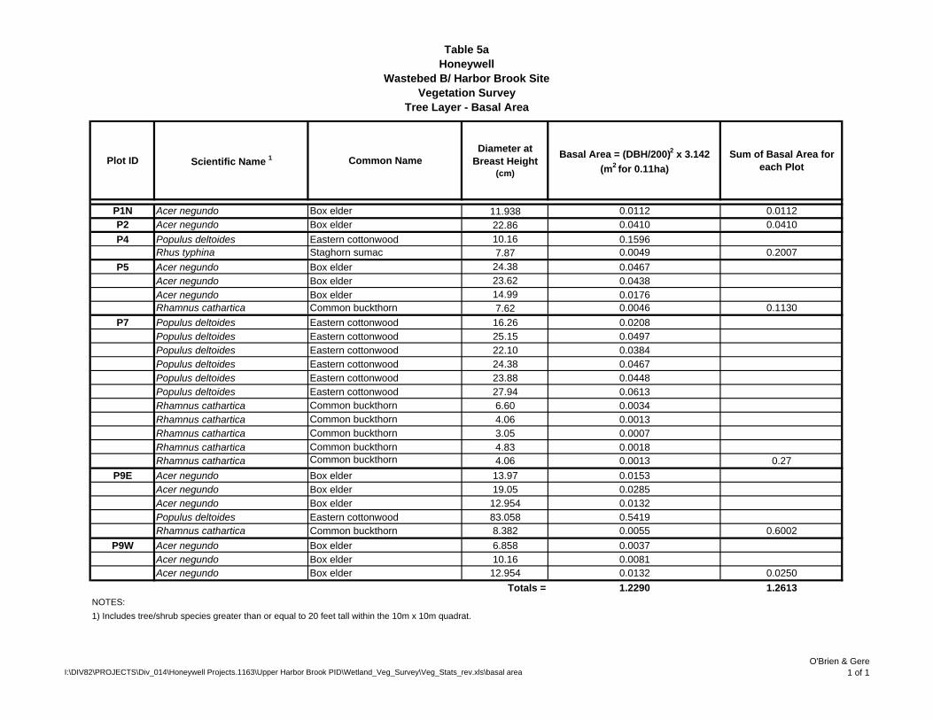
Table 5aHoneywell
Wastebed B/ Harbor Brook SiteVegetation Survey
Tree Layer - Basal Area
Plot ID Scientific Name 1 Common NameDiameter at
Breast Height (cm)
Basal Area = (DBH/200)2 x 3.142 (m2 for 0.11ha)
Sum of Basal Area for each Plot
P1N Acer negundo Box elder 11.938 0.0112 0.0112P2 Acer negundo Box elder 22.86 0.0410 0.0410P4 Populus deltoides Eastern cottonwood 10.16 0.1596
Rhus typhina Staghorn sumac 7.87 0.0049 0.2007P5 Acer negundo Box elder 24.38 0.0467
Acer negundo Box elder 23.62 0.0438Acer negundo Box elder 14.99 0.0176Rhamnus cathartica Common buckthorn 7.62 0.0046 0.1130
P7 Populus deltoides Eastern cottonwood 16.26 0.0208Populus deltoides Eastern cottonwood 25.15 0.0497Populus deltoides Eastern cottonwood 22.10 0.0384Populus deltoides Eastern cottonwood 24.38 0.0467Populus deltoides Eastern cottonwood 23.88 0.0448Populus deltoides Eastern cottonwood 27.94 0.0613Rhamnus cathartica Common buckthorn 6.60 0.0034Rhamnus cathartica Common buckthorn 4.06 0.0013Rhamnus cathartica Common buckthorn 3.05 0.0007Rhamnus cathartica Common buckthorn 4.83 0.0018Rhamnus cathartica Common buckthorn 4.06 0.0013 0.27
P9E Acer negundo Box elder 13.97 0.0153Acer negundo Box elder 19.05 0.0285Acer negundo Box elder 12.954 0.0132Populus deltoides Eastern cottonwood 83.058 0.5419Rhamnus cathartica Common buckthorn 8.382 0.0055 0.6002
P9W Acer negundo Box elder 6.858 0.0037Acer negundo Box elder 10.16 0.0081Acer negundo Box elder 12.954 0.0132 0.0250
Totals = 1.2290 1.2613NOTES:1) Includes tree/shrub species greater than or equal to 20 feet tall within the 10m x 10m quadrat.
I:\DIV82\PROJECTS\Div_014\Honeywell Projects.1163\Upper Harbor Brook PID\Wetland_Veg_Survey\Veg_Stats_rev.xls\basal areaO'Brien & Gere
1 of 1

Table 5bHoneywell
Wastebed B/ Harbor Brook SiteVegetation Survey
Tree Layer - Relative Basal Area
Scientific Name 1 Common NameTotal Observed Basal Area
= (DBH/200)2 x 3.142 (m2 for 0.11ha)
Relative Basal Area (%) = (total basal area for each species/total basal area for all plots) x 100
1 Acer negundo Box elder 0.200 16.362 Rhamnus cathartica Common buckthorn 0.597 48.783 Rhus typhina Staghorn sumac 0.160 13.044 Populus deltoides Eastern cottonwood 0.267 21.82
Total Species Basal Area = 1.22
NOTES:1) Includes tree/shrub species greater than or equal to 20 feet tall within the 10m x 10m quadrat.
I:\DIV82\PROJECTS\Div_014\Honeywell Projects.1163\Upper Harbor Brook PID\Wetland_Veg_Survey\Veg_Stats_rev.xls\rel basal areaO'Brien & Gere
1 of 1

Table 6aHoneywell
Wastebed B/ Harbor Brook SiteVegetation Survey
Importance Values - Herbaceous Layer
Scientific Name 1 Relative Frequency (%) Relative Percent Cover (%) Importance Values 2
(%)1 Acer negundo 1.75 0.11 0.932 Apocynum sibiricum 1.75 4.30 3.033 Artemisia vulgaris 1.75 1.07 1.414 Boehmeria cylindrica 1.75 0.21 0.985 Brassica rapa 1.75 0.54 1.156 Circaea lutetiana 1.75 0.54 1.157 Convolvulus sepium 5.26 0.86 3.068 Cornus foemina racemosa 3.51 0.32 1.929 Cornus racemosa 3.51 0.32 1.9210 Geum laciniatum 1.75 0.11 0.9311 Glechoma hederacea 3.51 12.89 8.2012 Lonicera xylosteum 1.75 0.21 0.9813 Lythrum salicaria 3.51 1.61 2.5614 Oxalis montana 1.75 0.11 0.9315 Parthenocissus quinquefolia 5.26 1.40 3.3316 Phragmites australis 14.04 55.32 34.6817 Plantago major 1.75 0.00 0.8818 Rhamnus cathartica 7.02 0.86 3.9419 Rhus typhina 1.75 0.54 1.1520 Rosa palustris 1.75 2.69 2.2221 Solanum dulcamara 3.51 0.21 1.8622 Solidago canadensis 12.28 11.17 11.7323 Solidago gigantia 1.75 0.00 0.8824 Solidago graminifolia 1.75 0.21 0.9825 Sonchus arvensis 3.51 2.69 3.1026 Vitis aestivalis 10.53 1.72 6.12
NOTES:1) Includes shrubs/tree species between 3 and 19 feet tall within the 10m x 10m quadrat. 2) Importance values for each species = (rel. freq. + rel. percent cover) / 2
I:\DIV82\PROJECTS\Div_014\Honeywell Projects.1163\Upper Harbor Brook PID\Wetland_Veg_Survey\Veg_Stats_rev.xls\IV_herbO'Brien & Gere
1 of 1

Table 6bHoneywell
Wastebed B/ Harbor Brook SiteVegetation Survey
Importance Values - Shrub Layer
Scientific Name 1Relative Frequency
(%)Relative Density
(%)Relative Percent
Cover (%)Importance Values 2
(%)1 Acer negundo 3.45 1.45 1.32 2.072 Ailanthus altissima 6.90 3.86 4.39 5.053 Cornus foemina racemosa 6.90 5.80 6.58 6.424 Cornus racemosa 6.90 40.10 32.89 26.635 Cornus stolonifera 3.45 0.48 0.00 1.316 Fraxius pennsylvanica 6.90 1.93 0.44 3.097 Lonicera tatarica 6.90 8.21 6.58 7.238 Lonicera xylosteum 6.90 0.97 0.88 2.919 Parthenocissus quinquefolia 3.45 0.48 30.70 11.54
10 Populus deltoides 3.45 0.48 0.00 1.3111 Rhamnus cathartica 20.69 14.01 9.21 14.6412 Rhus typhina 6.90 2.90 0.88 3.5613 Robinia pseudo-acacia 3.45 0.48 0.00 1.3114 Salix bebbiana 3.45 3.86 0.00 2.4415 Salix sericea 3.45 12.08 0.88 5.4716 Vitis aestivalis 6.90 2.90 5.26 5.02
NOTES:1) Includes shrubs/tree species between 3 and 19 feet tall within the 10m x 10m quadrat. 2) Importance values for each species = (rel. freq. + rel. dens. + rel. percent cover) / 3
I:\DIV82\PROJECTS\Div_014\Honeywell Projects.1163\Upper Harbor Brook PID\Wetland_Veg_Survey\Veg_Stats_rev.xls\IV_shrubO'Brien & Gere
1 of 1

Table 6cHoneywell
Wastebed B/ Harbor Brook SiteVegetation Survey
Importance Values - Tree Layer
Scientific Name 1 Relative Frequency (%)
Relative Density (%)
Relative Basal Area (%)
Importance Values 2
(%)1 Acer negundo 41.67 40.74 22.67 35.032 Populus deltoides 25.00 29.63 75.13 43.253 Rhamnus cathartica 25.00 25.93 1.74 17.564 Rhus typhina 8.33 3.70 0.46 4.16
NOTES:1) Includes tree/shrub species greater than or equal to 20 feet tall within the 10m x 10m quadrat.2) Importance values for each species = (rel. freq. + rel. dens. + rel. percent cover) / 3
I:\DIV82\PROJECTS\Div_014\Honeywell Projects.1163\Upper Harbor Brook PID\Wetland_Veg_Survey\Veg_Stats_rev.xls\IV_treeO'Brien & Gere
1 of 1

APPENDIX A
Field Data Forms

VEGETATION SURVEYDATA FORM
Project/Site: Upper Harbor Brook PDI Geddes, NY Date/ Time: 7/15/2008/ 1215Applicant/Owner: Honeywell County: Onondaga Covertype ID: N. BankInvestigator: KWB, AJV, AKM, CJK State: NY Plot ID: HB-VEG-P1N
VEGETATION
Dominance (% cover)
Total # of Stems
Density (# stems/area)
Dominance (% cover)
Total # of stems Density (# stems/area)
1 Solidago canadensis (Canada goldenrod) 10 7 7 7 Solidago graminifolia (Lance-leaved goldenrod) 2 1 12 Artemisia vulgaris (Common mugwort) 10 4 4 8 Phragmites australis (Common reed) 5 10 103 Boehmeria cylindrica (False nettle) 2 2 2 94 Sonchus arvensis (Field sowthistle) 25 40 40 105 Vitis aestivalis (Summer grape) 1 1 1 116 Circaea lutetiana (Enchanter's nightshade) 5 10 10 12
Total % cover 60
Dominance (% cover)
Total # of stems Density (# stems/area)
Dominance (% cover)
Density (# stems/area)
1 Rhamnus cathartica (Common buckthorn) 15 4 4 42 53 6
Total % cover 15
Dominance (% cover)
Total # of stems Density (# stems/area)
Dominance (% cover)
Density (# stems/area)
1 Lonicera tatarica (Tartarian honeysuckle) 15 6 0.67 52 Lonicera tatarica snags (Tartarian honeysuckle) 5 0.56 63 74 8
Total % cover 15
Dominance (basal area;
dbh)
Canopy Dominance (% cover)
Density (# stems/area)
Dominance (basal area; dbh)
Canopy Dominance (% cover)
Density (# stems/area)
1 Acer negundo (Box elder) 4.7" 15 0.11 102 113 124 135 146 157 168 179 18
Total % cover 15
NOTES: Due to size of bank, a 3m x 3m and 1m x 1m quad were used instead of a 10m x 10m and 3m x 3m.
Ditch bank adj. to HB-SED-24; WB D/E drainage ditch
Sample Location:
Observed herbaceous species (1m x 1m plot)
Observed shrub/ tree species up to 3ft tall (1m x 1m plot)
Observed herbaceous species (1m x 1m plot)
Observed shrub/ tree species up to 3ft tall (1m x 1m plot)
Observed tree species 20 ft and taller (3m x 3m plot) Observed shrub/ tree species 20 ft and taller (3m x 3m plot)
Observed shrub/ tree species <20ft tall (3m x 3m plot) Observed shrub/ tree species <20ft tall (3m x 3m plot)
I:\DIV82\PROJECTS\Div_014\Honeywell Projects.1163\Upper Harbor Brook PID\Wetland_Veg_Survey\HB_Data_forms.xlsDate Printed: 8/18/2008
Page 1 of 11

VEGETATION SURVEYDATA FORM
Project/Site: Upper Harbor Brook PDI Geddes, NY Date/ Time: 7/16/2008/ 1200Applicant/Owner: Honeywell County: Onondaga Covertype ID: S. Bank Investigator: RPC, KWB, SJW State: NY Plot ID: HB-VEG-P1S
VEGETATION
Dominance (% cover)
Total # of Stems
Density (# stems/area)
Dominance (% cover)
Total # of stems
1 Solidago canadensis (Canada goldenrod) 10 10 10 72 Parthenocissus quinquefolia (Virginia creeper) 5 4 4 83 94 105 116 12
Total % cover 15
Dominance (% cover)
Total # of stems Density (# stems/area)
Dominance (% cover)
Density (# stems/area)
1 Cornus foemina racemosa (Gray dogwood) 2 1 1 42 Cornus racemosa (Red-panicle dogwood) 2 1 1 53 Lonicera xylosteum (European honeysuckle) 2 1 1 6
Total % cover 6
Dominance (% cover)
Total # of stems Density (# stems/area)
Dominance (% cover)
Density (# stems/area)
1 Cornus racemosa (Red-panicle dogwood) 3 qty 10 0.33 5 Rhamnus cathartica (Common buckthorn) 5 0.112 Lonicera xylosteum (European honeysuckle) 2 0.11 63 Cornus foemina racemosa (Gray dogwood) 6 qty 15 0.67 74 Parthenocissus quinquefolia (Virginia creeper) 70 0.11 8
Total % cover 102
Dominance (basal area;
dbh)
Canopy Dominance (% cover)
Density (# stems/area)
Dominance (basal area; dbh)
Canopy Dominance (% cover)
Density (# stems/area)
1 none 102 113 124 135 146 157 168 179 18
Total % cover 0
NOTES: Due to size of bank, a 3m x 3m and 1m x 1m quad were used instead of a 10m x 10m and 3m x 3m.Virginia creeper: 4 rooted in 1m x 1m plot w/ more overhanging (dominant covertype in 3m x 3m plot). Trees/ shrubs listed in 3m x 3m plot do not include those listed in 1m x 1m plot.
Observed tree species 20 ft and taller (3m x 3m plot) Observed shrub/ tree species 20 ft and taller (3m x 3m plot)
Observed shrub/ tree species up to 3ft tall (1m x 1m plot) Observed shrub/ tree species up to 3ft tall (1m x 1m plot)
Observed shrub/ tree species <20ft tall (3m x 3m plot) Observed shrub/ tree species <20ft tall (3m x 3m plot)
Sample Location:
S. Bank adj. to HB-SED-24; WB D/E drainage ditch
Observed herbaceous species (1m x 1m plot) Observed herbaceous species (1m x 1m plot)
I:\DIV82\PROJECTS\Div_014\Honeywell Projects.1163\Upper Harbor Brook PID\Wetland_Veg_Survey\HB_Data_forms.xlsDate Printed: 8/18/2008
Page 2 of 11

VEGETATION SURVEYDATA FORM
Project/Site: Upper Harbor Brook PDI Geddes, NY Date/ Time: 7/16/2008/ 1100Applicant/Owner: Honeywell County: Onondaga Covertype ID: Wetland WRR3Investigator: RPC, SJW State: NY Plot ID: HB-VEG-P2
VEGETATION3m x 3m 1m x 1m
Dominance (% cover) Total # of Stems
Density (# stems/area)
Dominance (% cover)
Total # of stems
1 Phragmites australis (Common reed) 100 52 52 72 83 94 105 116 12
Total % cover 100
Dominance (% cover)
Total # of stems Density (# stems/area)
Dominance (% cover)
Density (# stems/area)
1 none 42 53 6
Total % cover 0
Dominance (% cover)
Total # of stems Density (# stems/area)
Dominance (% cover)
Density (# stems/area)
1 Rhamnus cathartica (Common buckthorn) <1 1 0.01 52 63 74 8
Total % cover <1
Dominance (basal area;
dbh)
Canopy Dominance (% cover)
Density (# stems/area)
Dominance (basal area; dbh)
Canopy Dominance (% cover)
Density (# stems/area)
1 Acer negundo (Box elder) 9" 10 0.01 102 113 124 135 146 157 168 179 18
Total % cover 10
NOTES: Multiple dead reed stems laying on ground; common buckthorn along North edge; only one shrub/ tree >20 ft. and one <20 ft. observed along Northern 10m plotline.
Observed tree species 20 ft and taller (10m x 10m plot) Observed tree species 20 ft and taller (10m x 10m plot)
Observed shrub/ tree species up to 3ft tall (3m x 3m plot)
Observed shrub/ tree species <20 ft tall (10m x 10m plot)
Observed shrub/ tree species up to 3ft tall (3m x 3m plot)
Observed shrub/ tree species <20 ft tall (10m x 10m plot)
Sample Location: Gen. surrounding HB-WSD-38
Observed herbaceous species Observed herbaceous species
I:\DIV82\PROJECTS\Div_014\Honeywell Projects.1163\Upper Harbor Brook PID\Wetland_Veg_Survey\HB_Data_forms.xlsDate Printed: 8/18/2008
Page 3 of 11

VEGETATION SURVEYDATA FORM
Project/Site: Upper Harbor Brook PDI Geddes, NY Date/ Time: 7/16/2008/ 1400Applicant/Owner: Honeywell County: Onondaga Covertype ID: Wetland 6Investigator: RPC, SJW State: NY Plot ID: HB-VEG-P3
VEGETATION3m x 3m 1m x 1m
Dominance (% cover) Total # of Stems
Density (# stems/area)
Dominance (% cover)
Total # of stems
1 Phragmites australis (Common reed) 100 164 164 72 83 94 105 116 12
Total % cover 100
Dominance (% cover)
Total # of stems Density (# stems/area)
Dominance (% cover)
Density (# stems/area)
1 none 42 53 6
Total % cover 0
Dominance (% cover)
Total # of stems Density (# stems/area)
Dominance (% cover)
Density (# stems/area)
1 Lonicera tartarica (Tartarian honeysuckle) <1 6 0.06 52 63 74 8
Total % cover <1
Dominance (basal area;
dbh)
Canopy Dominance (% cover)
Density (# stems/area)
Dominance (basal area; dbh)
Canopy Dominance (% cover)
Density (# stems/area)
1 none 102 113 124 135 146 157 168 179 18
Total % cover 0
NOTES: Some Virginia creeper along 690 fenceline, <1% cover.
Observed tree species 20 ft and taller (10m x 10m plot) Observed tree species 20 ft and taller (10m x 10m plot)
Observed shrub/ tree species up to 3ft tall (3m x 3m plot) Observed shrub/ tree species up to 3ft tall (3m x 3m plot)
Observed shrub/ tree species <20 ft tall (10m x 10m plot) Observed shrub/ tree species <20 ft tall (10m x 10m plot)
Sample Location:
About 5m dwnstrm (SE) from HB-WSD-42
Observed herbaceous species Observed herbaceous species
I:\DIV82\PROJECTS\Div_014\Honeywell Projects.1163\Upper Harbor Brook PID\Wetland_Veg_Survey\HB_Data_forms.xlsDate Printed: 8/18/2008
Page 4 of 11

VEGETATION SURVEYDATA FORM
Project/Site: Upper Harbor Brook PDI Geddes, NY Date/ Time: 7/16/2008/ 1530Applicant/Owner: Honeywell County: Onondaga Covertype ID: Wetland WRR4Investigator: RPC, KWB, AJV, SJW State: NY Plot ID: HB-VEG-P4
VEGETATION3m x 3m 1m x 1m
Dominance (% cover) Total # of Stems
Density (# stems/area)
Dominance (% cover)
Total # of stems
1 Phragmites australis (Common reed) 85 72 72 7 Solidago canadensis (Canada goldenrod) 72 Vitis aestivalis (Summer grape) 5 overhang 83 Solidago gigantia (Giant goldenrod) <1 9 9 94 Solanum dulcamara (Bittersweet nightshade) 2 7 7 105 Convolvulus sepium (Hedge bindweed) 3 116 Lythrum salicaria (Purple loosestrife) 5 12
Total % cover 107
Dominance (% cover)
Total # of stems Density (# stems/area)
Dominance (% cover)
Density (# stems/area)
1 Rhus typhina seedlings (Staghorn sumac) 5 5 0.56 42 Rhamnus cathartica (Common buckthorn) <1 3 0.33 53 6
Total % cover 5
Dominance (% cover)
Total # of stems Density (# stems/area)
Dominance (% cover)
Density (# stems/area)
1 Fraxius pennsylvanica (Green ash) <1 1 0.01 52 Poplus deltoides (Eastern cottonwood) <1 1 0.01 63 Fraxius pennsylvanica (Green ash) <1 1 0.01 74 Lonicera xylosteum(European honeysuckle) <1 1 0.01 8
Total % cover <1
Dominance (basal area;
dbh)
Canopy Dominance (% cover)
Density (# stems/area)
Dominance (basal area; dbh)
Canopy Dominance (% cover)
Density (# stems/area)
1 Rhus typhina (Staghorn sumac) 3.1" 15 0.01 102 Poplus deltoides (Eastern cottonwood) 4" 2 0.01 113 124 135 146 157 168 179 18
Total % cover 17
NOTES: Summer grape clinging to reed stems within 1m x 1m plot but not rooted w/in plot.In 10m x 10m plot, 5% of plot was virginia creeper and 5% grapevine. 10m x 10m plot actually set as 40' x 22' due to size and shape of wetland.
Observed tree species 20 ft and taller (10m x 10m plot) Observed tree species 20 ft and taller (10m x 10m plot)
Observed shrub/ tree species up to 3ft tall (3m x 3m plot) Observed shrub/ tree species up to 3ft tall (3m x 3m plot)
Observed shrub/ tree species <20 ft tall (10m x 10m plot) Observed shrub/ tree species <20 ft tall (10m x 10m plot)
Sample Location: Adjacent to HB-WSD-34
Observed herbaceous species Observed herbaceous species
I:\DIV82\PROJECTS\Div_014\Honeywell Projects.1163\Upper Harbor Brook PID\Wetland_Veg_Survey\HB_Data_forms.xlsDate Printed: 8/18/2008
Page 5 of 11

VEGETATION SURVEYDATA FORM
Project/Site: Upper Harbor Brook PDI Geddes, NY Date/ Time: 7/17/2008/ 1000Applicant/Owner: Honeywell County: Onondaga Covertype ID: Wetland WRR3Investigator: RPC, AJV, SJW State: NY Plot ID: HB-VEG-P5
VEGETATION3m x 3m 1m x 1m
Dominance (% cover) Total # of Stems
Density (# stems/area)
Dominance (% cover)
Total # of stems Density (# stems/area)
1 Solidago canandensis (Canada goldenrod) 70 48 48 7 Vitis aestivalis (Summer grape) 1 2 22 Phragmites australis (Common reed) 15 6 6 8 Plantago major (Common plantain) <13 Glechoma hederacea (Ground ivy) 90 94 Convolvulus sepium (Hedge bindweed) 5 6 6 105 Solanum dulcamara (Bittersweet nightshade) <1 116 Sonchus arvensis (Field sowthistle) <1 12
Total % cover 181
Dominance (% cover)
Total # of stems Density (# stems/area)
Dominance (% cover)
Density (# stems/area)
1 none 42 53 6
Total % cover 0
Dominance (% cover)
Total # of stems Density (# stems/area)
Dominance (% cover)
Density (# stems/area)
1 Rhamnus cathartica (Common buckthorn) <1 4 0.04 52 Vitis aestivalis (Summer grape) 7 6 0.06 63 74 8
Total % cover 7
Dominance (basal area;
dbh)
Canopy Dominance (% cover)
Density (# stems/area)
Dominance (basal area; dbh)
Canopy Dominance (% cover)
Density (# stems/area)
1 Rhamnus cathartica snag (Common buckthorn) 3" 0 0.01 102 Acer negundo (Box elder) 9.6" 113 Acer negundo (Box elder) 9.3" 124 Acer negundo (Box elder) 5.9" 135 146 157 168 179 18
Total % cover 10
NOTES: Ground ivy too numerous to count but makes up about 90% of 1m x 1m ground cover. Bittersweet nightshade and field sow thistle in 3m x 3m plot, not 1m x 1m plot.Box elder is multistem, w/ 3 stems each measured for dbh, smallest stem had split from main trunk but still alive.
Observed tree species 20 ft and taller (10m x 10m plot) Observed tree species 20 ft and taller (10m x 10m plot)
10
Observed shrub/ tree species up to 3ft tall (3m x 3m plot) Observed shrub/ tree species up to 3ft tall (3m x 3m plot)
Observed shrub/ tree species <20 ft tall (10m x 10m plot) Observed shrub/ tree species <20 ft tall (10m x 10m plot)
0.03
Sample Location:
Just North of WSD-35 and SB-167
Observed herbaceous species Observed herbaceous species
I:\DIV82\PROJECTS\Div_014\Honeywell Projects.1163\Upper Harbor Brook PID\Wetland_Veg_Survey\HB_Data_forms.xlsDate Printed: 8/18/2008
Page 6 of 11
VEGETATION SURVEYDATA FORM
Project/Site: Upper Harbor Brook PDI Geddes, NY Date/ Time: 7/17/2008/ 1100Applicant/Owner: Honeywell County: Onondaga Covertype ID: Wetland WRR2Investigator: RPC, AJV, SJW State: NY Plot ID: HB-VEG-P6
VEGETATION3m x 3m 1m x 1m
Dominance (% cover) Total # of Stems
Density (# stems/area)
Dominance (% cover)
Total # of stems
1 Apocynum sibiricum (Clasping-leaved dogbane) 40 12 12 72 Phragmites australis (Common reed) 25 20 20 83 Convolvulus sepium (Hedge bindweed) <1 2 2 94 Lythrum salicaria (Purple loosestrife) 10 105 Solidago canandensis (Canada goldenrod) 2 116 12
Total % cover 77
Dominance (% cover)
Total # of stems Density (# stems/area)
Dominance (% cover)
Density (# stems/area)
1 none 42 53 6
Total % cover 0
Dominance (% cover)
Total # of stems Density (# stems/area)
Dominance (% cover)
Density (# stems/area)
1 Cornus stolonifera (Red-osier dogwood) <1 1 0.01 52 Salix bebbiana (Bebb willow) <1 about 8 (multi) 0.08 63 Salix sericea (Silky willow) 2 about 25 0.25 74 8
Total % cover 2
Dominance (basal area;
dbh)
Canopy Dominance (% cover)
Density (# stems/area)
Dominance (basal area; dbh)
Canopy Dominance (% cover)
Density (# stems/area)
1 none 102 113 124 135 146 157 168 179 18
Total % cover 0
NOTES: Bebb willow had about 8 stems in one clump.
Observed tree species 20 ft and taller (10m x 10m plot) Observed tree species 20 ft and taller (10m x 10m plot)
Observed shrub/ tree species up to 3ft tall (3m x 3m plot) Observed shrub/ tree species up to 3ft tall (3m x 3m plot)
Observed shrub/ tree species <20 ft tall (10m x 10m plot) Observed shrub/ tree species <20 ft tall (10m x 10m plot)
Sample Location: Just north of HB-SB-172
Observed herbaceous species Observed herbaceous species
I:\DIV82\PROJECTS\Div_014\Honeywell Projects.1163\Upper Harbor Brook PID\Wetland_Veg_Survey\HB_Data_forms.xlsDate Printed: 8/18/2008
Page 7 of 11
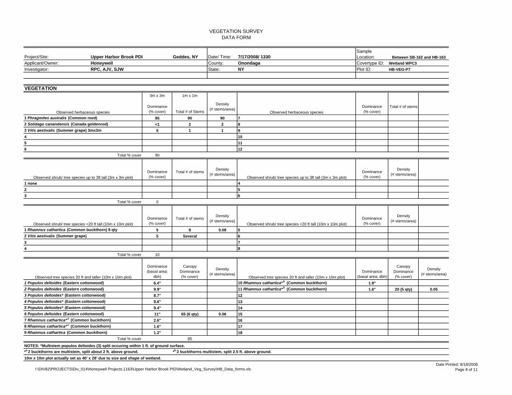
VEGETATION SURVEYDATA FORM
Project/Site: Upper Harbor Brook PDI Geddes, NY Date/ Time: 7/17/2008/ 1330Applicant/Owner: Honeywell County: Onondaga Covertype ID: Wetland WPC3Investigator: RPC, AJV, SJW State: NY Plot ID: HB-VEG-P7
VEGETATION3m x 3m 1m x 1m
Dominance (% cover) Total # of Stems
Density (# stems/area)
Dominance (% cover)
Total # of stems
1 Phragmites australis (Common reed) 85 90 90 72 Solidago canandensis (Canada goldenrod) <1 2 2 83 Vitis aestivalis (Summer grape) 3mx3m 5 1 1 94 105 116 12
Total % cover 90
Dominance (% cover)
Total # of stems Density (# stems/area)
Dominance (% cover)
Density (# stems/area)
1 none 42 53 6
Total % cover 0
Dominance (% cover)
Total # of stems Density (# stems/area)
Dominance (% cover)
Density (# stems/area)
1 Rhamnus cathartica (Common buckthorn) 8 qty 5 8 0.08 52 Vitis aestivalis (Summer grape) 5 Several 63 74 8
Total % cover 10
Dominance (basal area;
dbh)
Canopy Dominance (% cover)
Density (# stems/area)
Dominance (basal area; dbh)
Canopy Dominance (% cover)
Density (# stems/area)
1 Populos deltoides (Eastern cottonwood) 6.4" 10 Rhamnus cathartica* b (Common buckthorn) 1.9"2 Populos deltoides (Eastern cottonwood) 9.9" 11 Rhamnus cathartica*b (Common buckthorn) 1.6" 20 (5 qty) 0.053 Populos deltoides* (Eastern cottonwood) 8.7" 124 Populos deltoides* (Eastern cottonwood) 9.6" 135 Populos deltoides* (Eastern cottonwood) 9.4" 146 Populos deltoides (Eastern cottonwood) 11" 65 (6 qty) 0.06 157 Rhamnus cathartica*a (Common buckthorn) 2.6" 168 Rhamnus cathartica*a (Common buckthorn) 1.6" 179 Rhamnus cathartica (Common buckthorn) 1.2" 18
Total % cover 85
NOTES: *Multistem populos deltoides (3) split occuring within 1 ft. of ground surface.*a 2 buckthorns are multistem, split about 2 ft. above ground. *b 2 buckthorns multistem, split 2.5 ft. above ground.10m x 10m plot actually set as 40' x 28' due to size and shape of wetland.
Observed tree species 20 ft and taller (10m x 10m plot) Observed tree species 20 ft and taller (10m x 10m plot)
Observed shrub/ tree species up to 3ft tall (3m x 3m plot) Observed shrub/ tree species up to 3ft tall (3m x 3m plot)
Observed shrub/ tree species <20 ft tall (10m x 10m plot) Observed shrub/ tree species <20 ft tall (10m x 10m plot)
Sample Location: Between SB-162 and HB-163
Observed herbaceous species Observed herbaceous species
I:\DIV82\PROJECTS\Div_014\Honeywell Projects.1163\Upper Harbor Brook PID\Wetland_Veg_Survey\HB_Data_forms.xlsDate Printed: 8/18/2008
Page 8 of 11

VEGETATION SURVEYDATA FORM
Project/Site: Upper Harbor Brook PDI Geddes, NY Date/ Time: 7/17/2008/ 1400Applicant/Owner: Honeywell County: Onondaga Covertype ID: Wetland WPC1Investigator: RPC, AJV, SJW State: NY Plot ID: HB-VEG-P8
VEGETATION3m x 3m 1m x 1m
Dominance (% cover) Total # of Stems
Density (# stems/area)
Dominance (% cover)
Total # of stems
1 Phragmites australis (Common reed) 100 46 46 72 83 94 105 116 12
Total % cover 100
Dominance (% cover)
Total # of stems Density (# stems/area)
Dominance (% cover)
Density (# stems/area)
1 Cornus foemina racemosa (Gray dogwood) 4 qty 1 1 each 0.44 42 Cornus racemosa (Red-panicle dogwood) 2 qty 1 1 each 0.22 53 6
Total % cover 2
Dominance (% cover)
Total # of stems Density (# stems/area)
Dominance (% cover)
Density (# stems/area)
1 Cornus foemina racemosa (Gray dogwood) 6 qty <1 6 0.06 52 Cornus racemosa (Red-panicle dogwood) 80 qty 65 80 0.8 63 Rhus typhina (Staghorn sumac) 5 qty 2 5 0.05 74 8
Total % cover 67
Dominance (basal area;
dbh)
Canopy Dominance (% cover)
Density (# stems/area)
Dominance (basal area; dbh)
Canopy Dominance (% cover)
Density (# stems/area)
1 none 102 113 124 135 146 157 168 179 18
Total % cover 0
NOTES: 10m x 10m plot actually set as 40' x 30' due to size and shape of wetland.
Observed tree species 20 ft and taller (10m x 10m plot) Observed tree species 20 ft and taller (10m x 10m plot)
Observed shrub/ tree species up to 3ft tall (3m x 3m plot) Observed shrub/ tree species up to 3ft tall (3m x 3m plot)
Observed shrub/ tree species <20 ft tall (10m x 10m plot) Observed shrub/ tree species <20 ft tall (10m x 10m plot)
Sample Location: Surrounding HB-WSD-33
Observed herbaceous species Observed herbaceous species
I:\DIV82\PROJECTS\Div_014\Honeywell Projects.1163\Upper Harbor Brook PID\Wetland_Veg_Survey\HB_Data_forms.xlsDate Printed: 8/18/2008
Page 9 of 11

VEGETATION SURVEYDATA FORM
Project/Site: Upper Harbor Brook PDI Geddes, NY Date/ Time: 7/17/2008/ 1445Applicant/Owner: Honeywell County: Onondaga Covertype ID:Investigator: RPC, AJV, SJW State: NY Plot ID: HB-VEG-P9E
VEGETATION3m x 3m 1m x 1m
Dominance (% cover) Total # of Stems
Density (# stems/area)
Dominance (% cover)
Total # of stems
1 Vitis aestivalis (Summer grape) 3 1 1 72 Parthenocissus quinquefolia (Virginia creeper) 1 1 83 Parthenocissus quinquefolia (Virginia creeper) 5 6 6 94 105 116 12
Total % cover 8
Dominance (% cover)
Total # of stems Density (# stems/area)
Dominance (% cover)
Density (# stems/area)
1 Rhamnus cathartica (Common buckthorn) 3 qty 2 3 0.33 42 53 6
Total % cover 2
Dominance (% cover)
Total # of stems Density (# stems/area)
Dominance (% cover)
Density (# stems/area)
1 Rhamnus cathartica (Common buckthorn) 6 qty 15 6 0.06 52 Acer negundo (Box elder) 3 qty 3 3 0.03 63 Fraxius pennsylvanica (Green ash) 2 qty 1 2 0.02 74 Ailanthus altissima (Tree of heaven) <1 1 0.01 8
Total % cover 19
Dominance (basal area;
dbh)
Canopy Dominance (% cover)
Density (# stems/area)
Dominance (basal area; dbh)
Canopy Dominance (% cover)
Density (# stems/area)
1 Acer negundo (Box elder) 5.5" 102 Populus deltoides (Eastern cottonwood) 32.7" 50 0.01 113 Rhamnus cathartica (Common buckthorn) 3.3" 10 0.01 124 Acer negundo (Box elder) 7.5" 135 Acer negundo (Box elder) 5.1" 35 (3 box elders) 0.03 146 157 168 179 18
Total % cover 95
NOTES: 2 dead/ downed buckthorns in 10m x 10m plot area.10m x 10m plot actually set as 35' x 11' due to size and shape of area and presence of Harbor Brook; also to remain consitent with HB-VEG-P9W.
Observed tree species 20 ft and taller (10m x 10m plot) Observed tree species 20 ft and taller (10m x 10m plot)
Observed shrub/ tree species up to 3ft tall (3m x 3m plot) Observed shrub/ tree species up to 3ft tall (3m x 3m plot)
Observed shrub/ tree species <20 ft tall (10m x 10m plot) Observed shrub/ tree species <20 ft tall (10m x 10m plot)
Sample Location: East bank of OW-4 on HB
Observed herbaceous species Observed herbaceous species
I:\DIV82\PROJECTS\Div_014\Honeywell Projects.1163\Upper Harbor Brook PID\Wetland_Veg_Survey\HB_Data_forms.xlsDate Printed: 8/18/2008
Page 10 of 11

VEGETATION SURVEYDATA FORM
Project/Site: Upper Harbor Brook PDI Geddes, NY Date/ Time: 7/17/2008/ 1500Applicant/Owner: Honeywell County: Onondaga Covertype ID:Investigator: RPC, AJV, SJW State: NY Plot ID: HB-VEG-P9W
VEGETATION3m x 3m 1m x 1m
Dominance (% cover) Total # of Stems
Density (# stems/area)
Dominance (% cover)
Total # of stems Density (# stems/area)
1 Solidago canandensis (Canada goldenrod) 5 3 3 7 Vitis aestivalis (Summer grape) 1 1 12 Glechoma hederacea (Ground ivy) 30 40 40 83 Brassica rapa (Field mustard) 5 10 10 94 Oxalis montana (Wood sorrel) 1 2 2 105 Geum laciniatum (Rough avens) 1 4 4 116 Parthenocissus quinquefolia (Virginia creeper) 3 6 6 12
Total % cover 46
Dominance (% cover)
Total # of stems Density (# stems/area)
Dominance (% cover)
Density (# stems/area)
1 Rosa paulustris (Swamp rose) 25 1 0.11 42 Rhamnus cathartica (Common buckthorn) 1 1 0.11 53 Acer negundo (Box elder) 1 1 0.11 6
Total % cover 27
Dominance (% cover)
Total # of stems Density (# stems/area)
Dominance (% cover)
Density (# stems/area)
1 Ailanthus altissima (Tree of heaven) 7 qty 10 7 0.07 52 Robinia pseudo-acacia (Black locust) <1 1 0.01 63 74 8
Total % cover 10
Dominance (basal area;
dbh)
Canopy Dominance (% cover)
Density (# stems/area)
Dominance (basal area; dbh)
Canopy Dominance (% cover)
Density (# stems/area)
1 Acer negundo (Box elder) 2.7" 0.01 102 Acer negundo* (Box elder) 4" 0.01 113 Acer negundo* (Box elder) 5.1" 10 (3 qty) 0.03 124 135 146 157 168 179 18
Total % cover 10
NOTES: *Box elder (2) split 1 ft. above ground.10m x 10m plot actually set as 35' x 11' due to size and shape of area and presence of Harbor Brook.
Observed tree species 20 ft and taller (10m x 10m plot) Observed tree species 20 ft and taller (10m x 10m plot)
Observed shrub/ tree species up to 3ft tall (3m x 3m plot) Observed shrub/ tree species up to 3ft tall (3m x 3m plot)
Observed shrub/ tree species <20 ft tall (10m x 10m plot) Observed shrub/ tree species <20 ft tall (10m x 10m plot)
Sample Location:
West bank of OW#4, south of HB-VEG-P9E
Observed herbaceous species Observed herbaceous species
I:\DIV82\PROJECTS\Div_014\Honeywell Projects.1163\Upper Harbor Brook PID\Wetland_Veg_Survey\HB_Data_forms.xlsDate Printed: 8/18/2008
Page 11 of 11
APPENDIX B
Photograph Log

Honeywell, Wastebed B/ Harbor Brook SiteVegetation Survey July 2008 - Photo Log
I:\DIV82\PROJECTS\Div_014\Honeywell Projects.1163\Upper Harbor Brook PID\photolog.doc O’Brien & Gere
Photo 1. Looking north at northern bank of Wastebed D/E drainage ditch and vegetation plot P1N.
Photo 2. Looking at vegetation plot P1S dense with gray dogwood, Virginia creeper, and summer grape.

Honeywell, Wastebed B/ Harbor Brook SiteVegetation Survey July 2008 - Photo Log
I:\DIV82\PROJECTS\Div_014\Honeywell Projects.1163\Upper Harbor Brook PID\photolog.doc O’Brien & Gere
Photo 3. Looking at center of vegetation plot P2.
Photo 4. Looking east at vegetation plot P6.

Honeywell, Wastebed B/ Harbor Brook SiteVegetation Survey July 2008 - Photo Log
I:\DIV82\PROJECTS\Div_014\Honeywell Projects.1163\Upper Harbor Brook PID\photolog.doc O’Brien & Gere
Photo 5. Looking west at center of vegetation plot P7.
Photo 6. Looking north along western bank of Harbor Brook at vegetation plot P9W.