urban growth management through zoning …
TRANSCRIPT

URBAN GROWTH MANAGEMENT
THROUGH ZONING REGULATION SYNCHRONIZATION
IN JAKARTA METROPOLITAN AREA
BAYU WIRAWAN
S2905892
ENVIRONMENTAL AND INFRASTRUCTURE PLANNING
FACULTY OF SPATIAL SCIENCES
UNIVERSITY OF GRONINGEN
2016


URBAN GROWTH MANAGEMENT
THROUGH ZONING REGULATION SYNCHRONIZATION
In Jakarta Metropolitan Area
Master Thesis
M.Sc. Environmental and Infrastructure Planning
August 2016
Faculty of Spatial Sciences
Rijksuniversiteit Groningen
First Supervisor: Ward S. Rauws, Phd
Second Supervisor: Dr. Petrus Natalivan Indradjati
Author
Bayu Wirawan
S2905892

ii

iii
SUMMARY
Summary
Urban sprawl in Jakarta Metropolitan Area (JMA) happens due to the rapid urbanisation which
resulted inefficient and unsustainable growth in JMA. This condition exacerbates by absence of
integrated spatial plan and fragmented local government priorities. Indonesia’s decentralized
system and promulgation on new spatial planning law 26/2007 mandated all local government to
formulate and implement their own spatial plans. Nevertheless JMA’s urban growth management
vision is still unclear despite the availability of JMA spatial plans since 2008.
This research examines the extent to which synchronization of zoning regulation in JMA can be
used as means to managing JMA urban growth and thus reducing the negative effect on urban
sprawl. The synchronization process itself is part of an effort to integrate JMA spatial planning
policy, and in doing that this research identified several factors that supporting and hindering the
integration process. To make sure that synchronisation of zoning regulation is the right measure
to deal with urban sprawl, this research also learned from Portland-Vancouver and Hong Kong,
experiences.
The research reveals the willingness of local government in JMA to cooperate and Indonesia
standardization of planning system in Indonesia is able to support spatial plan integration.
However, budget gap and diverse priorities become the main factors that hindering spatial plan
integration. Learning from other metropolitans, local government in JMA needs to have common
vision related to JMA urban areas development. To ensure the achievement of these common
goals, local governments in JMA also needs to escalate its inclusivity towards all stakeholders in
Jakarta. As part of spatial plan integration in managing urban sprawl, local government in JMA
also needs to provide supporting arrangements of spatial plans which are public transportation
and housing provision. It can be concluded that apart from relying on cooperation, local
government in JMA also needs to improve its coordination in order to integrating spatial plan
policy.

iv

v
ACKNOWLEDGEMENT
Acknowledgement
…….you choose the difficult way by coming here, but it is your voyage of discovery.
Bon voyage
(Prof Gregory J. Ashworth, RUG international student opening ceremony, 27 August 2015,)
.
Those words still ringing in my ears after spend my time in Groningen for a year. Indeed this
words is true. There’s a mix feeling during my stay, sad, tired and disappointed often come to
minds. However new experiences, different life environment and new friends made me realise
all of this is worth. My voyage of discovery also bring me new perspective about managing urban
system. Studying regional and city planning in Bandung followed by environmental and
infrastructure planning in Groningen amplifies my understanding about there is so much diverse
in the world, nevertheless there are also many similarities. I tried to capture that diverse and
similarities into a writing in an academic way. Again believe me it was hard but in the end at
least I’m able to satisfying my curiosity regarding how metropolitan spatial management works.
My thesis is not a world-class masterpiece, I admitted that. But this is my small token to my home
country. And I really hope for you the reader able to extracting the positive message of my
writing.
First, I praise my Lord, Allah SWT, for His grace and love. I would like to express my gratitude to
all of the people which I have met during the course of my study both in ITB, Bandung and RUG,
Groningen for their generosity to spare their time for exchanging ideas or just listening my
bubbling. It was such an intellectual joy to know all of you.
My sincere thanks to my supervisor Ward Rauws. Your patience in guiding me and relentless input
to deliver better quality always motivated me doing the best that I can do. I would like also to
thank to Dr. Petrus Natalivan Indradjati for comments and suggestions to improve my thesis.
Many thanks also for all my friends in RUG-EIP and ITB-DD programmes. Knowing all you bring
much enjoyment while lives in Bandung and Groningen. For Taufiq Hidayat Putera, Savitri Rayanti
Soegijoko, Khairul Rizal and Ari Krisna Tarigan thank you for enthusiastically brainstorming with
me regarding my thesis topic and proofread my thesis. Special gratitude for Nico Maris, Indah
Widya Astuti and Naomi Lolok for our togetherness in Groningen; Pak Wilmar Salim and Ibu Jeane
for ITB’s support; Henry Poerborianto and Bustanul Arifin generosity for providing their abode
when I really needed; all PPIG’s friends for exciting lives in Groningen; all ITB regular Master’s
friends for pleasant lives in Bandung; and all 6th Floor VHL dorm mates which we share our lives
together.
Lastly, I would like to thank my families in Bogor, Jambi and Tangsel - Indonesia for their pray
and support. My sincerest, deepest and earnest gratitude is due to my beloved wife Vietrina
Hafriany Adonis for your patience, love, dedication and sacrifice during my whole time of study.
Without your support, I couldn’t have done it and this is not an exaggeration.
Groningen, August 2016
Bayu Wirawan

vi
vii
TABLE OF CONTENTS
Table of Contents
Tittle Page ...................................................................................................... i
Summary ....................................................................................................... iii
Acknowledgement ............................................................................................. v
Table of Contents ............................................................................................ vii
List of Tables .................................................................................................. ix
List of Figures .................................................................................................. x
1 Introduction .................................................................................................. 1
1.1 Background ............................................................................................. 1
1.1.1 World Urban Eras ................................................................................ 1
1.1.2 Indonesia Urban Growth ........................................................................ 2
1.2 Objective and Research Question................................................................... 4
1.3 Structure of the Thesis ............................................................................... 5
2 Theoretical Review ......................................................................................... 7
2.1 Introduction ............................................................................................ 7
2.2 Urban Sprawl........................................................................................... 7
2.2.1 Definition and Concept of Urban Sprawl ..................................................... 7
2.2.2 Challenges in Urban Sprawl .................................................................... 8
2.3 Urban Development Control ......................................................................... 9
2.4 Policy Integration ..................................................................................... 9
2.5 Facilitators and Barriers for Policy Integration in Metropolitan Governance ............... 11
2.6 Conclusion: The Conceptual Model ............................................................... 12
3 Research Methodology .................................................................................... 13
3.1 Introduction .......................................................................................... 13
3.2 Comparative Cases Selection ...................................................................... 13
3.3 Literature Review ................................................................................... 14
3.4 Data Collection on the Cases ...................................................................... 16
3.4.1 Desk Study ...................................................................................... 16
3.4.2 Interview ........................................................................................ 18
3.5 Analysis of the Data ................................................................................. 18
3.6 Conclusion: Research Design ...................................................................... 19
4 Planning and Development in Jakarta Metropolitan Area ........................................... 21
4.1 Introduction .......................................................................................... 21

viii
4.2 Indonesia Spatial Planning System ................................................................ 21
4.2.1 Spatial Plan Hierarchy ........................................................................ 21
4.2.2 Spatial Plan Formulation ..................................................................... 23
4.2.3 Linking Metropolitan Spatial Plan and Zoning Regulation................................ 24
4.3 Spatial Planning in Jakarta Metropolitan Area .................................................. 25
4.4 Spatial Development in Jakarta Metropolitan Area ............................................ 28
4.5 Conclusion ............................................................................................ 33
5 Comparative Cases ........................................................................................ 35
5.1 Introduction .......................................................................................... 35
5.2 Portland-Vancouver Metropolitan Area .......................................................... 35
5.2.1 Portland-Vancouver Metropolitan Area Spatial Planning System ....................... 35
5.2.2 Portland-Vancouver Metropolitan Area Development .................................... 38
5.3 Hong Kong Special Administrative Region ....................................................... 40
5.3.1 Hong Kong Special Administrative Region Planning System ............................. 40
5.3.2 Hong Kong Special Administrative Region Area Development ........................... 43
5.4 Conclusion: Lesson Learned of Urban Growth Management .................................. 45
6 Integrating Spatial Plan for Urban Growth Management ............................................ 47
6.1 Introduction .......................................................................................... 47
6.2 Learning from Other Metropolitan Areas ........................................................ 47
6.2.1 Spatial Planning Integration and Administrative Government Fragmentation ........ 48
6.2.2 Supporting Elements .......................................................................... 49
6.3 Conclusion: Utilizing Facilitators and Overcoming Barriers on Policy Integration for Jakarta
Metropolitan Area’s Urban Growth Management ..................................................... 50
6.3.1 Utilizing Facilitator Factors .................................................................. 51
6.3.2 Overcoming Barrier Factors .................................................................. 51
7 Conclusion: Synchronising Zoning Regulation as a Spatial Policy Integration .................... 53
7.1 Conclusions ........................................................................................... 53
7.2 Reflection on the Research ........................................................................ 54
References .................................................................................................... 55
Glossary ....................................................................................................... 63
Appendix ...................................................................................................... 64
ix
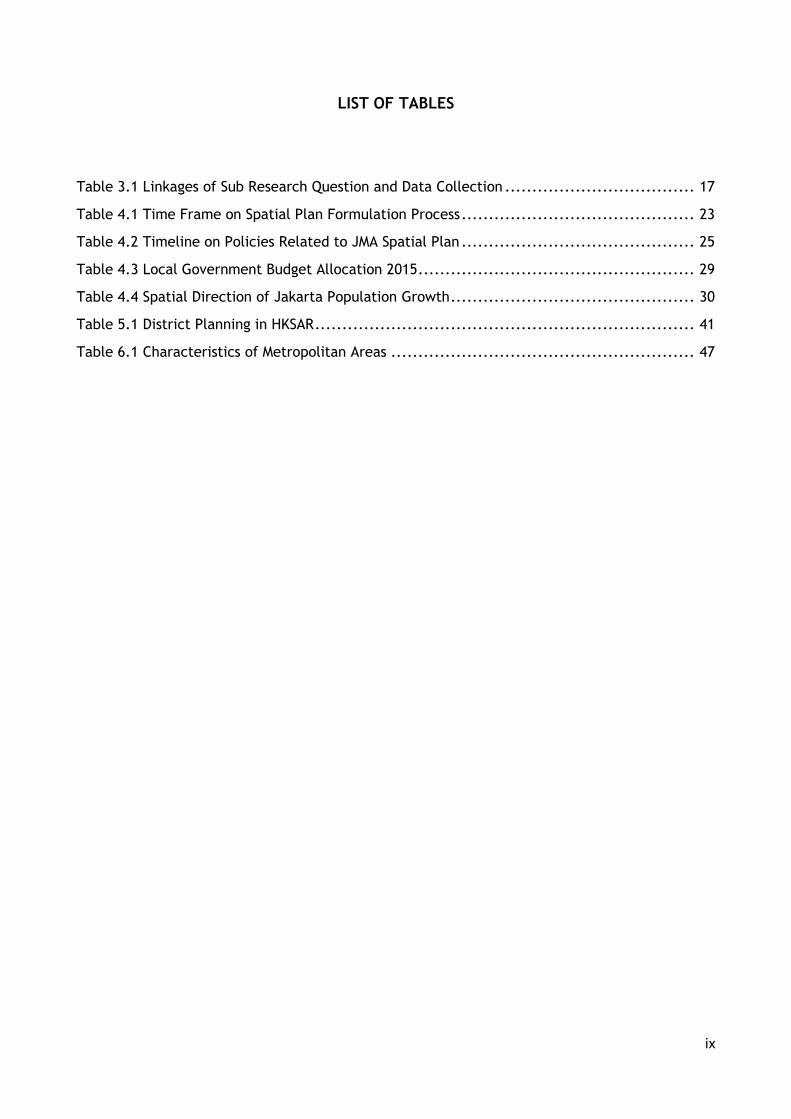
LIST OF TABLES
List of Tables
Table 3.1 Linkages of Sub Research Question and Data Collection ................................... 17
Table 4.1 Time Frame on Spatial Plan Formulation Process ........................................... 23
Table 4.2 Timeline on Policies Related to JMA Spatial Plan ........................................... 25
Table 4.3 Local Government Budget Allocation 2015 ................................................... 29
Table 4.4 Spatial Direction of Jakarta Population Growth ............................................. 30
Table 5.1 District Planning in HKSAR ...................................................................... 41
Table 6.1 Characteristics of Metropolitan Areas ........................................................ 47

x
LIST OF FIGURES
List of Figures
Figure 1.1 Jakarta Metropolitan Area ...................................................................... 3
Figure 2.1 Correlation Between Policy Making, Coordination and Cooperation .................... 10
Figure 2.2 Conceptual Model of Research ............................................................... 12
Figure 3.1 Research Design ................................................................................ 20
Figure 4.1 Spatial Plan Classification in Indonesia ..................................................... 22
Figure 4.2 Relation between Metropolitan Spatial Plan and Zoning Regulation in Indonesia ..... 25
Figure 4.3 JMA Structure and Land Use Plan ............................................................. 27
Figure 4.4 Distribution of Local Government Revenue ................................................ 30
Figure 4.5 Change of Population Density in JMA ........................................................ 31
Figure 4.6 Illustration on JMA Spatial Development 1972-2013 ...................................... 32
Figure 5.1 Portland-Vancouver Metropolitan Area Spatial Planning System ........................ 36
Figure 5.2 Portland Metro 2040 Growth Concept ........................................................ 36
Figure 5.3 Vancouver City Growth Concept ............................................................. 37
Figure 5.4 Portland-Vancouver Metropolitan Area ...................................................... 38
Figure 5.5 Dynamics of Portland-Vancouver Metropolitan Area Urban Expansion .................. 39
Figure 5.6 Hong Kong Spatial Planning System ......................................................... 41
Figure 5.7 Hong Kong 2030 Concept Development ..................................................... 42
Figure 5.8 Map of Hong Kong Special Area Region Administrative .................................... 43
Figure 5.9 Hong Kong Topographic Situation and Reclamation Areas ................................ 44
Figure 5.10 Hong Kong Built Up Areas Development .................................................... 45

CHAPTER 1
INTRODUCTION
1 Introduction
1.1 Background
1.1.1 World Urban Eras
The beginning of the 21st century was marked as turning point for the world to literally enter what
is called urban eras. United Nations Department of Economic and Social Affairs (UN-DESA)
reported in 2008 that half of the world population lived in urban areas whereas a half century
before in 1960 it was less than one-third (UN-DESA, 2008). Furthermore, UN-DESA predicts that
two-thirds of world population are expected to lives in urban areas by 2050 (UN-DESA, 2015). At
the moment, half of those urban dwellers lived in Asia, followed by 14% in Europe, then 13% in
Latin America-Caribbean. However, according to the later report, the composition is likely to
change as majority of urban dwellers will be in Asia (52%) and Africa (21%) by 2030 due to the
rapid population growth in both regions (ibid). The report estimates quadrupled figure of 2,225
cities by 2030 where most of these new cities will be located in Asian and African Regions.
Increasing number of urban population will inflict the need of more space to accommodate all of
its activities. Using population data by UN and Angel et al (2010) medium assumption it was
estimated by 2030 the world will need more than 1.3 million km2 of new spaces for urban areas
spreading in all continents, of which nearly two-third of it located in less developed regions such
as 37.5% in Asia and Pacific, 9.9% in Africa, and 14.5% in Latin America-Caribbean. These
projections show that Asia Region is the most prominent place for urban area development in the
future.
Cities become more important due to their influence over the world economy. As a centre of
populations assemble, city becomes the place of production and consumption at once. Thus they
become the centre of economic activities as well. Several studies (Florida, et al, 2009; UN-
Habitat, 2011; Oxford Economics, 2014) affirm that nearly two-third of world economic activities
hosted by cities and this trend will continue and enlarge upon the year of 2030 mainly hosted by
Asia, Europe and North America regions (Oxford Economics, 2014). Combined with the facts
previously discussed, it can be assumed that urbanisation has a substantial influences on spatial
development in Asia region.
In line with rapid urbanisation, growth of metropolitan cities also increased dramatically. In 1950
there were only three urban areas with around ten million inhabitants. In 2014 however, there
were thirty metropolitan cities and more than half of them were located in Asia (UN-DESA, 2015).
Again, these numbers suggest a rapid urbanisation phenomenon in Asia (Ginkel and Marcotullio,
2004; ADB, 2006; Teriman, et al, 2009).
Despite its promising future that urbanisation could create better opportunities for the world
economic, it also poses several risks to the sustainability of urban areas. In terms of environment
aspect, rapid urbanisation could accelerate depletion of natural resources degradation of
environmental quality such as worsening air pollution that contributes to climate change. In terms
of social aspect, rapid urbanisation could stimulate unplanned growth which creates inefficiency
to the infrastructure provision, the emergence of slums areas, and social segregation between the
poor and rich.

2
1.1.2 Indonesia Urban Growth
According to Indonesia Law No 26 Year 2007 on Spatial Planning, metropolitan area is defined as
areas that consist of core urban areas and outskirts urban areas; that have functional linkages;
that are connected with integrated regional infrastructure; that are inhabited by more than one
million inhabitants. Metropolitan area is [usually] created through the transformation of close
range or administratively adjacent cities that lead to conurbation (Winarso, 2006). In the last
decade, Indonesia experienced a rapid growth of metropolitan areas. In 2005, there were five
metropolitan areas in Indonesia metropolitan areas in Indonesia (Winarso, 2006). The number
changed into seven in 2008 (Indonesia, 2008) and by the time this thesis is being written there are
fourteen metropolitan areas in Indonesia (Demographia, 2016).
Jakarta Metropolitan Area (JMA1) as one of the major urban areas in Indonesia is experiencing a
darting development growth of urbanizing areas, population, economic and so forth during last
two decades (Rustiadi and Panuju, 1999; Firman, 2012; Firman 2014). JMA comprises of nine local
government units at various levels, which make JMA as the largest urban areas in Indonesia. They
include Special Capital Region of Jakarta (DKI Jakarta) as a province; five municipalities/kota
including Bogor, Depok, Bekasi, Tangerang, and Tangerang Selatan; and three
regencies/kabupaten covering Bogor, Tangerang, and Bekasi. Based on this administrative and
spatial location, Cox (2011) divides JMA into three layers, namely: the first is called the core layer
which is Jakarta City; the second layer is inner suburbs that consist of Depok, Bekasi, Bogor,
Tangerang, and Tangerang Selatan municipalities; the third layer is outer suburbs and exurbs that
consist of Bogor, Bekasi and Tangerang regencies (see figure 1).
The fast growth in JMA can be describing based on evidence of the establishment of several
municipalities within JMA. In the past 25 years there were several municipalities which were
proliferated from their parent administrative region. They include Tangerang City (proliferate
from Tangerang Regency in 1993); Bekasi City (proliferate from Bekasi Regency in 1996); Depok
City (proliferate from Bogor Regency in 1999); and Tangerang Selatan City (proliferate from
Tangerang Regency in 2008). JMA population also experienced very high growth of population,
from about 11.5 million inhabitants in 1980 to approximately 27.9 million inhabitants in 2010
(Abidin, 2011). JMA population growth contributed to the changed in built-up areas from merely
11.2% in 1992 to 35.6% of total JMA in 2009 (Arifien, 2012). Some causes are put forward, mainly
related to poor enforcement of spatial plan (Firman, 2012; Rukmana, 2015) and high pressure
from market (Sudianto, 2008; Firman, 2012).
Whilst the population of Jakarta City were increases, its population shared among JMA is
decreasing. Firman (2014) elucidated that from 1990 to 2010 the population of Jakarta City were
waning from from 54.6% to 35.5% and followed by high population growth in the Jakarta City
suburban areas (Vioya, 2010). The limitation of land availability in Jakarta City becomes the main
reason of this decreasing. At the same time the facts show that municipalities adjacent to Jakarta
1Jakarta Metropolitan Area concept in this research is different with Jakarta Metropolitan Region (JMR) or Jabodetabekjur concept. JMA focus about urban-suburban connection while JMR focus on ecoregion concepts which used watershed as its basic consideration.

3
City are experiencing high population growth. This condition has led to explosive development of
urban areas surrounding Jakarta City thus resulting urban sprawl in JMA.
Figure 1.1 Jakarta Metropolitan Area (Source: Author, 2016)
Growth in the Jakarta City outskirts has created vast and fast urban sprawl that has caused
inefficiency and wastefulness of urban land use. The absence of effective spatial plans
complemented with other instruments that gave direction and control of new development
activities has allowed JMA urban periphery to extend uncontrolled leading to random and
scattered development centres (Soegijoko, 2011). Hudalah (2010) stated that the greatest
challenge is the fact that the fringe area is a transition zone that is regulated by a complex
4
institutional structure and exacerbated by autonomy, vision, style of government, and different
capacity. In addition, some spatial plans in parts of Jakarta Metropolitan Area are still
commandeered by central government due to its function as national strategic areas (Rukmana,
2015). This power dispersal caused local government unable to well implement its spatial plans
(Rahmawati, 2014; Rukmana, 2015).
To avoid sprawling condition that already happened worsening, JMA needs to manage their urban
growth by establishing urban growth boundaries of municipality by synchronising theirs
development control. Based on Law No. 26/2007, there were four tools of development control
in Indonesia, namely: zoning regulation, permit provision, incentive and disincentive provision,
and sanction provision. By this law, zoning regulation is formally mandated as a tool of
development control in Indonesia spatial planning system. This law also specifies that each
municipality is required to formulate its own zoning regulation and stipulated it as their local law.
Consequently, JMA will have nine different local laws about zoning regulation. However, the
synchronization of zoning regulation between municipalities still has not found its format in
Indonesia planning system (Pratama et al, 2012; Wirawan, 2015; Zhu and Simarmata, 2015). This
situation is also exacerbated by local government’s lack of readiness in implementation their
zoning regulation (Fanani, 2014; Rukmana, 2015). To make those local laws performing better
this thesis tries to understand about how synchronization of zoning regulation between all
municipalities in JMA can be used as a tool for JMA growth control.
As a reference to develop and manage appropriate strategies for urban growth control, learning
from the others successful metropolitan can be used, and Portland-Vancouver Metropolitan Area
and Hong Kong Special Administrative Region are considered as two best practices metropolitan
areas which success to manage its urban growth. Both metropolitans are chosen as comparative
case in this research because to some extent they have similarity with JMA. In Portland-Vancouver
case for instance, the metropolitan consist of several municipalities within different
states/provinces. The case of Hong Kong shows some degree of similarities with JMA in terms of
having high population density. In the development process, both Portland-Vancouver and Hong
Kong have enacted their urban growth boundaries and became one of the success story of urban
growth management in the world (Abbott & Margheim, 2008; Portland Metro Authority, 2015).
1.2 Objective and Research Question
1.2.1 Objective
The main objective of this thesis is to identify how synchronization of zoning regulation among
different municipalities in JMA could become a main tool for the urban growth control strategy in
order to mitigate urban sprawl in JMA. This objective will be achieved by applying comparative
urbanism approach using two established metropolitans i.e. Portland-Vancouver and Hong Kong
as case study. Specifically this thesis will thoroughly analyse the implementation of urban growth
control strategy in Portland-Vancouver and Hong Kong to draw some learning out of both cases
and to identify the possible barriers and facilitators in adopting it.
1.2.2 Research Questions
Based on problems and objective described above, the research question is:

5
“How can the synchronization of development control policies in Jakarta Metropolitan Area can
contribute to reducing the negative effect of urban sprawl?”
Sub research questions are:
1. How is rapid urbanisation affecting the liveability in metropolitan area?
2. How institutional design aimed at the integration of spatial plan can support planning
contributions to deal with rapid urbanisation?
3. What are drivers behind rapid urbanisation in Jakarta Metropolitan Area? To what extend
zoning regulation able to guide urban development and what factors that inhibited zoning
regulation integration in Jakarta Metropolitan Area?
4. How do the metropolitans of Portland-Vancouver and Hong Kong spatial plan integration
contributes in managing their urban growth? To what extend metropolitans of Portland-
Vancouver and Hong Kong developed their spatial plan integration?
5. What lesson learned from Portland-Vancouver and Hong Kong could be implemented in order
to support zoning regulation synchronization in Jakarta Metropolitan Area?
1.3 Structure of the Thesis
This thesis consists of two main parts. The first part represents the ideas of the research, which
are includes in chapter 1, chapter 2 and chapter 3. The first chapter will briefly explain about
the background of this research, research objective and research questions, and structure of the
thesis. The second chapter will present the theoretical review of urban sprawl, urban
development control, policy integration, and barriers and opportunity for spatial plan integration
from the academic point of view. The third chapter will craft a research design that will used in
this thesis.
The second part is about the analytical section of this research, which are includes in chapter 4
through chapter 7. The next two chapter will elaborate about the cases studied in this thesis,
which are Jakarta Metropolitan Area in chapter 4 and Portland-Vancouver and Hong Kong in
chapter 5. Chapter 4 and 5 will discuss about spatial planning system and urban development
situation in all Jakarta Metropolitan Area as the case study and both metropolitan Portland-
Vancouver and Hong Kong metropolitan areas as comparison cases.
Chapter 6 will discuss about linking the comparative cases experience with barriers and facilitators
factors of JMA urban growth management situation. By Linking these aspect hopefully this
research able to reveal what needs to be done by JMA to control its urban development and
manage its urban sprawl.
All explanation and analysis summarized in Chapter 7, furthermore a reflection about strengths
and limitation of this research will be given to provide recommendation which can be useful for
future research in urban growth control management, particularly in zoning regulation
synchronization issues.

6

7
CHAPTER 2
THEORETICAL REVIEW
2 Theoretical Review
2.1 Introduction
The previous chapter given us a brief description and motivation about the topic of this research.
In answering the research questions which are presented on the previous chapter a deep
understanding about the urban land use management and policy integration is needed for this
research through examining the literatures that pertinent to this research. Therefore this chapter
will conducted a literature review on urban land use management and spatial plan policy
integration. The discussion will be focused first on urban land use management specifically on
the urban sprawl phenomenon and then directly followed by urban development control as a
strategy to manage urban sprawl. The second part is about policy integration which focused on
the spatial plan integration and then followed by identifying some key factors in implementing
spatial plan policy integration.
2.2 Urban Sprawl
2.2.1 Definition and Concept of Urban Sprawl
There are several definitions regarding of urban sprawl. Bruegmann (2006) stated that sprawl is
low density and dispersed urban development supported by unsystematic regional public spatial
planning. Meanwhile, Staley (1998) in Hidayat (2014) considered sprawl as urban physical
appearance propagation process to the outer part of cities. Urban sprawl is also defined as a
situation when rate of urban land consumption is faster than its population growth (Fulton, et al,
2001; Jaeger and Schwik, 2014).
The urban sprawl leads to the dynamics of land use that is quite high and fast, both for the volume
and for the frequency. Urban sprawl is often viewed negatively by urban planners as it often
result in adverse and poor conditions in those city outskirt areas. Uncontrolled urban sprawl have
negative effects on the overall function of cities and surrounding regions. In the literature, there
are three kinds of urban sprawl:
1) Concentric development urban sprawl. This type is the slowest urban sprawling and the
condition limited only on some parts of city outskirts and usually involve only the whole urban
exterior physical features. Due to uneven nature of sprawling in the next stage it will form
a relatively compact morphological appearance of the city. The role of transportation in this
sprawl is not so great.
2) Ribbon development urban sprawl. This type shows inequality urban sprawl in all parts of
fringes and on the main city area. The most rapid sprawl is seen along existing transportation
lines, especially within radial structure from the city centre
3) Leap frog development urban sprawl. This type considered the worst urban sprawl by
environmentalists due to several aspects such as: inefficiency in economic terms, no or little
aesthetic values, and unattractive patterns. Urban land development occurs sporadically
with dispersed locations allowing enclave built areas in the middle of farmland.

8
Urban sprawl usually happened along with peri-urbanisation process. Rustiadi and Panuju (1999)
stated that formation and change of land in peri-urban areas caused by the peri-urbanisation
process in which the occurrence of rapid but irregular and unplanned physical growth has caused
inefficiency and wastefulness (the phenomenon of urban sprawl). Peri-urbanisation is defined as
a process of formation of new settlements and industrial zones in peri-urban areas mainly
triggered by the displacement of urban city dwellers that need places to settle for industrial
activities. Furthermore peri-urbanisation is a suburb growth process that is systematically faster
than the city centre, and characterized by different lifestyle that affect day-to-day activities such
as commuting to the central city.
2.2.2 Challenges in Urban Sprawl
Hardin (1968) in Jaegger and Schwick (2014) elucidated that urban sprawl is an example of tragedy
of the commons whereas benefits of the landscape as common resource goes to individuals
however the detrimental effects are affects the society. The expansion of the urban areas could
reduce land as source of food and water (Boggart, 2006). On another aspect, urban expansion
could induce high motorization which resulted in more high pollution. It is believed that urban
sprawl had negative effect on the environment sustainability (Arellano and Loca, 2012; Jaegger
and Schwick, 2014)
Hudalah (2010) stated that the greatest challenge of urban sprawl is its locations in a transition
zone which are regulated by a complex institutional structure and overlapped with different
autonomy, vision, style, and capacity of government. In addition, some planning tasks are divided
by central government responsible for coordinating between local planning issues. These
conditions resulted in incoordination between private and local initiatives thus exacerbated the
physical and institutional fragmentation in peri-urban areas.
Previously viewed as a trend in developed countries, nowadays urban sprawl is also a common
situation in developing countries. UN Habitat (2011) reported that urban areas grew faster than
population by 1.5 times. UN Habitat also reported that two kinds of urban sprawl which are core
city sprawl and suburban sprawl happened on many cities in developing countries such as in China,
Mexico, India, and several major city in Africa Regions. In most cities, urban sprawl usually
dominated by the need for residential area combined with road-based infrastructure
development. Indonesia metropolitan also face the same situation.
The using for residential area became the main reason of farmland loss in many Indonesia
Metropolitan. World Bank reported that annual land conversion rate into built environment in
several Indonesia’s metropolitans is more than 100 per cent between the year 2000-2005. The
development of toll road in Indonesia’s metropolitans (Jakarta, Bandung, and Semarang) also
encourage people to live in suburbs area especially due to its lower land price and using private
motorization as a mean of mode of transportation (Silver, 2008; Ardiwijaya et al, 2014; Buchori
and Sugiri, 2016). This situation is exacerbated by stagnant development of public transportation
in most Indonesia metropolitan. Intrans, A NGO in Indonesia (2011) reported that daily travel
time in Jakarta is significantly increases whereas by 2005 it takes about 45 minutes to transverse
30 km distance, and by 2011 it takes at least 90 minutes for the same path. All of those situation
which mentioned above emphasized how deeply Indonesia controlled its urban areas
development.

9
2.3 Urban Development Control
Rapid urbanisation has resulted in expansion of urban growth, and to avoid the negative impacts
of this urban growth metropolitan managers needs to have development control strategy in their
hands. Development control is an effort in shaping the transformation of built environment in
urban areas by regulating market sector in order to achieve particular social objectives (Tang and
Tang, 1998). As explained by Eskilsson (1997) there is clear connection between built environment
in urban area with development control on several cities in developed countries, whereas cities
with strong public authorities control for the development is more structured whilst cities with
strong market sectors are usually being more dispersed due to the car oriented transport system.
In broader definition, development control also covers on issues about consent, exempted
development, enforcement and others matter that related to the development of built
environment.
There were many kinds of development control, but basically it can be categorized into two main
category, which are planning regulations and building regulations. Due to the aims of this
research, this thesis will focus on planning regulation as development control. Learning from
developed countries experience, planning regulation itself also diverse in each metropolitan
because it will based on what types of planning approach the metropolitan used. For statutory
planning approach, zoning is the most prominent development control tools (for example: in most
US metropolitan areas, France, Netherland, and Singapore). Whilst for discretionary planning
approach, development permit based on public consensus is the most prominent development
control tools (e.g. United Kingdom). Many developed countries then followed by developing
countries uses statutory planning approach because at some point it gives clarity on how to
manage the effective functioning of the built environment.
Indonesia planning approach nowadays also using statutory planning approach marked with 2007
Law’s on Spatial Planning. Learning from past experience where the discretionary approach is
failed to manage urban growth, the Spatial Planning Law which also accommodated the
decentralization of governance is mandated that each municipal needs to have municipal spatial
plan as a guidance for spatial development and zoning regulation as a development control tools
to manage the development of built environment (Winarso, 2006). However, Indonesia is still
haunted by the capability of government apparatus as the key actors both in formulating the
zoning regulation, and implement and enforce the zoning regulation (Rukmana, 2015; Wirawan,
2015). As March 2016 there are only 3 out of 514 municipalities in Indonesia whom had zoning
regulation law as their development control tools (Sekretariat BKPRN, 2016).
Decentralization process in Indonesia which was started in 1999 has enhanced by spatial planning
law by giving local government more authority to formulate their own spatial plans. At one side,
this is a good thing especially in optimising local spatial resource, nevertheless it may resulted in
diverse spatial plans which may contradict between one to each other. In the end, it may
inhibited regional spatial development as a whole (Firman, 2009a). Looking to this situation, it is
necessary for adjacent municipalities to integrate their spatial plans to ensure the sustainability
of the regional system (Firman, 2014a).
2.4 Policy Integration
In the wake of the more fragmented, multi-dimensional, and sectoral view of urban areas
development, policy makers need to integrated spatial plan that available to them to answer

10
future problems or challenges in urban areas development especially urban sprawl in metropolitan
areas which involved multi local governments. Various spatial plans which need to involve various
actors with different backgrounds may result in impasse situations which then could hinder urban
development process. In this kind of situation, the notion of policy integration on spatial plan
matter. Earlier, a policy qualified as integrated if it has three criteria, namely
comprehensiveness, consistency and aggregation (Underdal, 1980). Meanwhile, Stead and Meijers
(2004a) stated that policy integration is about manage the overlapping proposition that beyond
available policy bounds, which could connected to integration on horizontal, vertical, or both
manners. Policy integration also defined as amalgamation of particular policy goals which
immaterial to policy domain for existing sectoral policies (Giesen, 2011).
Policy integration is different from policy coordination and policy cooperation. Cooperation can
be seen as an effort of different parties to achieve common goals, whereas coordination is more
focusing on the outcomes which could result in differing than preferred previous one. Meanwhile,
policy integration is beyond both coordination and cooperation although it still on the same
dimension (Stead and Meijers, 2004a). Figure 2.1 will depict the connection between policy
integration, coordination and cooperation.
Figure 2.1 Correlation between policy making, coordination and cooperation
(Source: Stead and Meijers, 2004a)
Policy integration on spatial plan cannot be taken for granted because it will always need to
balance barriers and facilitator of the policy making without forgetting its benefit and cost. There
are several factors that need to consider in spatial plan integration, namely: political; institutional
and organizational; economic and financial; behavioural, cultural and personal factors; process,
management and instrumental (Stead and Meijers, 2004a; Stead and Meijers, 2009). Giesen (2011)
also elucidated there are two factor that may obstruct policy integration. First, policy integration
is not in accordance with specialized/autonomous designed type of government which usually
avoided overlapping of tasks. Second, policy integration is not in line with economic concerns
from involved actors in this autonomous system.
Many stakeholders believe that policy integration is a good notion in dealing with complexity of
the problems, however in the practice there is still a fuzziness regarding how to conduct policy
integration. Methods of policy integration are combinations of several different approaches or
different setting of its related factors (Stead and Meijers, 2004b). Based on England, Denmark
and Germany experiences, there are three methods in policy integration, which are impact

11
assessment techniques, targets and indicators based techniques, and public participation
techniques (Stead and Meijers, 2004b).
Policy integration for urban development and management can be served through various tools,
and spatial planning is one of the prominent tool. There are two roles of spatial planning for
policy integration which are (1) as integrating tools between sectors, and (2) channel of
communication between sectors (Stead and Meijers, 2009). Spatial planning which involves multi
actors (government, public and private) and multi processes will strengthen the policy integration
for urban development and management, so both of them need to coexist within one and others.
In the Indonesia planning system, the effectuation of spatial planning also tries to fulfilled those
two roles, through the ample discussion among sectors and increased participatory and public
hearing to the community (PP No. 15/2010; Rukmana, 2015)
2.5 Facilitators and Barriers for Policy Integration in Metropolitan Governance
There were many efforts to created parameter for a sound policy integration, dates back from
Underdal (1980) concept of “comprehensiveness, aggregation and consistency”, then by OECD
(1996) through its “coherent policy making”, and Shannon and Schmid (2002) concept of “inter-
sectoral linkages”. Nevertheless Stead and Meijers (2009) already stated that there are no specific
parameters that could become facilitators and barriers for policy integration. Later they said that
the parameters will be based on the context of the object of research. Basically there are 6 basic
factors (see chapter 2.4) and Stead and Meijers (2004a; 2009) also created a sub-parameter list
on the each basic factors.
For metropolitan governance in JMA context, this research limited the analysis on two most
important parameters for each facilitators and barriers. The decision to choose those parameters
based on author personal experience in spatial planning practices in Indonesia. Explication about
each parameters in the next section also supported by others research in order to guarantees their
worthiness.
For facilitator’s parameters of policy integration on spatial plan in metropolitan governance, this
research will used ‘procedure standardization’ and ‘willingness to cooperate’ parameters. These
parameters were chosen because some studies said that governance in East-Asia metropolitans
have a strong connection between coordinated guidance and strong informal relationship among
the actors (Legates and Hudalah, 2014). Procedure standardization is chosen due the hierarchical
system of spatial plan in Indonesia which has resulted in uniformity of the spatial plan product
across local government in Indonesia (Legates and Hudalah, 2014; Zhu and Simarmata, 2015).
Willingness to cooperate is also been chosen because Indonesia has strong cultural roots on
cooperation among its community, especially for those whose lives in the Java Island (Hudalah
and Woltjer, 2007; Hudalah, Firman, and Woltjer, 2014). Harnessing this strong cultural
cooperation among the actors could be smoothen the integration of spatial plan in JMA.
Willingness to cooperation also may lead to the inclusiveness of the spatial plan whereas Laquian
(2008) mentions that inclusive development on metropolitan development can be achieved
through five measures: (a) integrating rural-urban areas with metropolitan regions; (b) including
all multi-level government stakeholder related to the metropolitan areas; (c) including all
stakeholders, private and public sectors, especially the marginally stakeholders; (d) integrating
metropolitan infrastructure and service networks; and (e) making metropolitan development as
an instrument to gain sustainability in all sectors.

12
For barrier’s parameters of policy integration on spatial plan in metropolitan governance, this
research will used ‘budget allocation’ and ‘divergent priorities’ parameters. The budget
allocation become the barriers due to the most of Indonesia local government still rely on central
government for their income (Setiadi and Adi, 2007; Firman, 2012) that limit their freedom in
utilizing their own budget for spatial planning (Ritonga, Clark, and Wickremasinghe, 2012). Under
this circumstance local government have obligation to focus their effort in health, education and
public infrastructure (Law 32/2004 on Local Government). The divergent priorities parameter
also chose because in the decentralization system, local government have fragmented opinion
related the most important programmes which need to realised (Firman, 2008; 2009a; 2014c).
2.6 Conclusion: The Conceptual Model
Based on explanation above, I conclude that there is a silver lining between three aspects which
are urban sprawl, development control, and policy integration in dealing with urban growth.
Regarding Jakarta Metropolitan Area urban growth, these three aspect become relevant due to
the contextual situation in Jakarta Metropolitan Area. Combining these three aspects considered
as an alternative approach in dealing with Jakarta Metropolitan Area growth. In conclusion,
interaction between urban sprawl, development control, and policy integration enable us to
create comprehensive concept which connect the empirical situation and the future
transformation which need to be done in dealing with managing Jakarta Metropolitan Area urban
growth based on those theoretical views.
Figure 2.2 Conceptual Model of Research (Source: Author, 2016)

13
CHAPTER 3
RESEARCH METHODOLOGY
3 Research Methodology
3.1 Introduction
The research will analyse the correlation between synchronization of development tools to
support metropolitan urban growth management. In order to achieve this goal, it was necessary
to understand process of the research and this chapter will provide that. This chapter will
connect the research question theories which already put into first and second chapter of the
thesis with finding and relevance which will put in the second half of the thesis. The connection
will explain through methods that will be used by author of reviewing the literature, data
collection and analysis process.
The main idea of this research is about policy evaluation. Crabbe and Leroy (2008) stated:
Policy evaluation is a scientific analysis of a certain policy area, the policies of which
are assessed for certain criteria, and on the basis of which recommendations are
formulated (Crabbe and Leroy, 2008, p. 1).
Based above definition of policy evaluation, this research attempts to evaluate the spatial
planning process in metropolitan areas as their policy in managing urban growth, using JMA as the
case study. The analysis of the study is also supported by a comparative analysis based on cases
from other metropolitan areas on how they manage their urban growth.
Though I have three cases study for this research which is JMA as the locus of research and 2
metropolitan areas as the comparative case, I will not fully reviewed all of them. I only doing full
review on Jakarta case study, while the comparison cases study only used to get an illustration
how proposed urban growth management tools worked in comparative cases situation. Based on
the illustration hopefully lesson learned can be drawn as a recommendation to improve JMA urban
growth management in my effort to give an evaluation for JMA spatial plan policy.
3.2 Comparative Cases Selection
The main contribution of performing a comparative study is to uncover structural and cultural
differences in planning across nations, including its strength and weakness (Nadin, 2012). A
comparative study will demonstrate how other metropolitan areas dealing with their urban
strategies and management in handling urban sprawl. In this study, we used two cases from
western and eastern countries. A western metropolitan area is selected in the study since this
established region has experienced a post suburbia metropolitan development, which marked by
chaotically polycentric structures combined with decline of population in core/old area of the
metropolitan (Soja, 2000; Borsdorf, 2004 cited in Firman, 2012). For eastern countries, it is known
by its extended metropolitan region (EMR) which is characterized by the rapid development on
built-up areas, dispersed into all directions in suburbs and surpassed city/metropolitan
administrative boundary, especially due to the high population growth (Firman, 2012).

14
To select the two cases, three parameters are used:
First, both cases must be recognised as metropolitan areas for obvious reason that JMA is a
metropolitan areas.
Second, as in Indonesia planning system is driven by statutory planning, the two cases must
utilise statutory planning as its urban development approach.
Third, utilising statutory planning enabled both cases to manage negative impacts of their
urban sprawl
For the case from eastern country, the parameter for selecting a metropolitan area are: (1) having
more than 1 million inhabitants; (2) higher HDI index2 than JMA; (3) its function as economic
centre in their own country and/or world; and (4) acknowledge by international agencies due to
their successfulness in managing urban development. Based on parameter (1) and (2) there were
127 metropolitan areas in eastern countries selected. Using parameter (3) which based on Florida
et al (2010) there were 12 out of 127 metropolitan areas in Asian countries which have big share
on global economic activities. Related to parameter (4), EIU (2012) reported that based on their
sprawl index there are 3 out of 12 metropolitans which have sprawl index better than Jakarta
which is Hong Kong and Nagoya3. Hong Kong exceled itself for its liveability and in 2012 Hong
Kong was measured as one of the best cities in dealt with sprawl (EIU, 2012). Based on the
selection process, this research decided Hong Kong as comparison case study representing Eastern
country.
For western country, the specific parameter would be (1) land areas of the metropolitan which
should be more than 1,000 square kilometres with reason so it has the same complexity with JMA;
(2) similarity situation with JMA which is multiple government involvement at local and provincial
level; (3) time of exercised the statutory planning as main strategy to manage urban growth; and
(4) acknowledge from international agencies about their successfulness in managing urban
development. By parameter (1) there are 66 metropolitan areas in western countries which has
land areas more than 1,000 square kilometres. Using parameter (2), there are 15 out of 66
metropolitan areas which involve multiple government at provincial level whereas majority of
these metropolitan areas located in the US. Portland is the most prominent example from all 15
metropolitan areas which have long experience in using statutory planning in its planning system.
Hence, Portland has been chosen in this study as a case from western countries.
3.3 Literature Review
In my efforts to develop conceptual thinking to answer the research questions, I need to review
several of the theories that have closed linkage with the base idea of the research. This reviewing
2Based on UNDP’s latest human development index (HDI) report, whereas divided countries into 4 basic categories which are countries with very high, high, medium and, low human development. This report place Indonesia at medium level (See: UNDP, 2015. Human Development Report 2015, Work for Human Development).
3Hong Kong graded with 1.0, Singapore graded with 2.0, and Nagoya graded with 2.3 from scale 1 to 5 which 1 is for the best and 5 is for the worst. Jakarta graded with 2.7 in this report (see: EIU, 2012. Best cities ranking and report)

15
process begun by collecting the theories related to the keywords: urban sprawl, development
control, policy integration and institutional design. There are two kinds of main goals for
literature review. First is to get the general ideas of the concepts and second the implementation
of the concepts in general places and then focused on the Indonesia contextual.
Sources of these theories will be based on reputable publication such as scientific journal or books
which authored by reputable researcher which specialized in their own fields of expertise. Utilize
Google Scholar as my primary search engine based on those keywords will give me quick results
from related theories. My next moved then is to narrowing which publication that I will use for
my research. The narrowing process carried out by considering several joining factors, first is by
the novelty or the research by looking the year of the publications whereas my priority will be for
publications which published by the year 2000 onwards in order to get the latest information on
the related subject. The second consideration is by looking the author’s publication history to
find the prominent researcher on the topics. To make sure that the publication is well received
by other researcher, I will look from how many researchers citing the publications. By using those
three considerations (year of publication, authors history, and number of cites), I believe could
reduce my subjectivity on the related matters.
For Indonesia contextual situation, this part also supported by review of government agency’s
report that has responsibility for Indonesia spatial planning, this agency as Directorate General
Spatial Planning (Direktorat Jenderal Penataan Ruang) of Ministry Agrarian and Spatial Planning;
Directorate of Agrarian and Spatial Planning, Bappenas (National Planning and Development
Agency); and Office of BKPRN Secretariat. Website of these agencies listed in the appendix 4.
The process of literature review of each theoretical aspects are:
The review of the urban sprawl looked it as the main issues of the urban growth, how it
changed world metropolitan landscape, and how the metropolitan areas manage their urban
growth. This part gave a brief description of the situation of urban sprawl in the world and
Indonesia’s urban areas.
The next review was development control. The review started to look at the correlation
between development controls as an effort to support urban growth management. Then,
followed by looking deeply at theories about kinds of development control for urban
development. These theories will be tested with contextual situation which is how world
metropolitans managed their urban development by using development control. It also
analyses Indonesia policies on urban development control for Indonesia metropolitan areas.
Policy integration theory will be reviewed due to the reason that metropolitan usually
consisted of several administrative municipalities which in the decentralization era has their
own autonomy in governing urban growth. Looking at this situation, it is necessary to
understand the idea of policy integration, especially related to the integration of spatial
planning across municipalities. This reviewed attempts to describe practical aspect of spatial
plan policy integration in the world, and how the contextual situation of spatial plan policy
integration in Indonesia.
The next part is about how spatial plan policy integration can be utilized as an institutional
design to managing metropolitan area’s spatial development. By using the idea of spatial
plan integration as an effort to renew rule of the game for metropolitan development control
new discourse towards managing JMA development was discussed. This part also summarized
kind of factors that may arise as barriers and opportunities in the policy integration process.
16
The final part, a conclusion about the conceptual model that will be used as a guidance for
this entire research.
3.4 Data Collection on the Cases
The analysis of this study is based on two data resources. First is desk study. We review JMA
governance of spatial planning and cases from Portland and Hong Kong based on past studies,
official reports and other scientific literatures. Second is based on a number of interviews with
JMA stakeholders, especially those who deeply understand JMA governance on spatial planning.
By combining those two source of datas, this research hopefully can maintain its objectivity. The
secondary data is important to minimize the bias that might be resulted from the interpretation
of the primary data, and vice versa the primary data is also useful to check out the currentness
of the information. The detail of linkages between sub research question and data collection can
be seen on the table 3.1.
3.4.1 Desk Study
With desk study, basically I used the same methods as the literature review, which is trying to
find related publication that able to support my research through several stage processes of
selection. However, to support the novelty of the contextual situation, information from
government report, unpublished thesis and mass media also will be used to extend the view of
existing conditions in all case study areas (Jakarta, Portland and Hong Kong). All of the selected
material then analysed by using qualitative content analysis.
As the focus on this research is about guiding urban development in JMA, a secondary collection
data onto desk study become relevant. This secondary data collection is necessary to provide
more contextual material for this research especially to give profound information about the case
studies. For JMA case, national level data also will be collected. The Indonesia data focuses on
implementation of urban growth management in Indonesia; kind of support given by central
government to the local government; and policies use by Indonesia government to dealt with
issues on urban growth. Data and information also focus after the enactment of new Indonesia
Spatial Planning Law in 2007. Meanwhile for the comparison case studies, the data and
information will be needed to give clear understanding about the circumstances in the comparison
case studies.
I understand that there is a limitation on using secondary data collection for desk study process.
One main issue is the various sources that available which might result inflexibility for me to
customize it. To overcome this situation, my experience in following and involved with
metropolitan and/or local government spatial plan formulation and implementation will
supported me to be able to stay focus on the context of the research is needed, especially to
choose the right information that will be used in this research.

Table 3.1 Linkages of Sub Research Question and Data Collection
Sub Research Question Kind of Data Sources of Data Method of Data
Collection Goals
How is rapid urbanisation affecting the liveability in metropolitan area?
Urbanisation situation on metropolitan
Impact of urbanisation for metropolitan
Past studies and publications on urbanisation and metropolitan development
Document and literature review
Understanding the current situation of the urbanisation and it consequences especially for the metropolitan area
How institutional design aimed at the integration of spatial plan can support planning contributions to deal with rapid urbanisation?
Opportunities and barriers factors that may affected spatial plan policy integration
Past studies and publications on urban growth management and spatial plan integration
Literature review
Understanding factors which affecting the process of policy integration for metropolitan spatial planning
What are drivers behind rapid urbanisation in Jakarta Metropolitan Area (JMA)? To what extend zoning regulation able to guide urban development and what factors that inhibited zoning regulation integration in Jakarta Metropolitan Area?
History of JMA urban development and planning.
Current situation on JMA development control and planning process
Stakeholder perception on JMA urban development control
Past studies and publication; Policy Document; Laws; Government archive; Scientific Publication; Stakeholders Perspectives
Document and literature review
Desk Study
Interviews
Understanding the current situation on JMA development and what hindrances that they face especially in the planning process.
Understanding stakeholders perspective about JMA development and how the planning performance in guiding JMA development
How do the metropolitans of Portland-Vancouver and Hong Kong spatial plan integration contributes in managing their urban growth? To what extend metropolitans of Portland-Vancouver and Hong Kong developed their spatial plan integration?
Spatial planning system that have been use by Portland and Hong Kong.
Current situation on Portland and Hong Kong development control and planning process
Past studies and publication; Policy Document; Government archive
Desk Study Understanding case studies situation and what they strategies to deal with rapid urbanisation in their metropolitan areas.
What lesson learned from other metropolitans could be implemented in order to support zoning regulation synchronization in Jakarta Metropolitan Area?
Possibilities of lesson learn for the JMA development control.
Possibilities of new institutional design by using inter-municipal zoning regulation synchronization for managing JMA development.
Policy Document; Laws; Government archive; Scientific Publication
Desk Study Understanding strategies that can be used for JMA context learned from the case studies
Formulating recommendations as part of new institutional design to guiding JMA development.

3.4.2 Interview
To understand the current circumstance regarding JMA planning process in-depth interviews with
Jakarta Metropolitan Area planning stakeholders were carried out. The purpose is to gain insights
about stakeholder’s perception and experiences in daily planning process, coordination,
opportunities and barriers among them. A set of interviews was conducted through a semi
structure interview approach, considering several points of open question (see appendix 1 for the
interview guidance). The key informants were picked based on the snowball method, meaning
that the next interviewees were selected based on recommendation from other previous
interviewees. For the national level, apparatuses from Ministry of Agrarian and Spatial Plan are,
which are responsible for coordinating spatial plan in Indonesia, were selected. On this ministry,
the interviews search the respondents which are responsible on the policy level (related to the
national strategy of urban areas development) and at the practitioner level (related to the
coordinating metropolitan development). Getting the whole pictures at national level, this
research also interviewed representative from Indonesia Association of Planners, which have deep
knowledge related to the empirical implementation on the spatial plan in Indonesia.
For local level, this interview targeted local government apparatuses that involved directly with
the formulation and/or coordination of the spatial plan. Base on the recommendation from
national level government apparatuses combined with researcher network, 3 representatives from
local government were selected.
3.5 Analysis of the Data
This research use document analysis as its main research reviews as well as the interviews as a
complement to support the analysis. As explained by Bowen (2009) document analysis is a
systematic procedure ~which are finding, selecting, appraising, and synthesising of data in the
documents~ for reviewing or evaluating documents. Bowen also explained that with document
analysis empirical knowledge can be produced and furthermore understanding is developed.
The analysis processes starts with the theoretical review of several theories that related to the
urban sprawl, urban development control, policy integration and institutional design. Based on
those theories, the notions of urban growth management will be structured and use for the next
step of analysis.
Secondly, the research used qualitative content analysis which includes (i) summarising, an effort
to summarize and narrowing overlapping statement; (ii) explicating, an effort to define different
or unclear passages; and (iii) structuring, an effort to connect and amalgamation the materials
(Flick, 2006) to analyse existing condition of JMA urban growth which have been structured
through data collection process. Information based on theoretical review is based on past
research that reviewed the growth of JMA urban areas and this is the first key on this phase. Then
to bolster the supposition, population and economic data from scientific or government
documents are used. Impact on the JMA development on its liveability are studied, based on
several resources, such as scientific publication from recognizable researchers that focus on JMA
development, then combined with unpublished research or organization paper/report from
reputable institutions (United Nations, World Bank, UNDP, Indonesia’s NGO) or using unpublished
theses which came from reputable universities. As to understanding the planning process this
research will analyse information from desk study and cross-checked it with information from
interviews.

19
Thirdly, comparison analysis is carried out. It focuses on the analysis regarding how other
metropolitans in the world have faced the same situation with JMA, which demonstrate rapid
urbanisation. Not just facing it, they also able to come up and succeeded in their strategies to
deal with their rapid urbanisation problems. How other metropolitans utilize development control
tools of facing urban sprawl will be compared. Those comparisons look deeply for the kinds of
urban sprawl that each city faced, what kinds of development control tools that they used for in
dealing with their urban growth, and at what extend they have done their horizontal policy
integration. Again, document analysis will be used to explain the comparison. This method is
used because it can systematically and accurately describe a particular issue and then linkage the
issue with the theoretical aspect. To help understanding the comparison, the comparison table
will included.
Lastly, formulation of lesson learned based on comparison result is conducted. Using empirical
analysis, lesson learned from other metropolitan related to urban development control and spatial
plan integration are utilized to support synchronization of zoning regulation as an institutional
design to guiding Jakarta Metropolitan Area urban growth.
3.6 Conclusion: Research Design
This research uses a qualitative research to evaluate spatial plan policy in JMA. This evaluation
process combination between theory and practice. The theory as the foundation of this research
explained in Chapter 2. Meanwhile the practical aspect of this research explained on Chapter 4
and Chapter 5. Chapter 4 discussed on JMA as case study which discussed about spatial planning
system and spatial development in JMA and how those two aspects lead to urban sprawl in JMA.
Chapter 5 discussed about spatial planning and spatial development on comparative case
metropolitan areas, also this chapter discussed how comparative metropolitan areas manage their
urban growth.
Chapter 6 synthesises the case study analysis and comparison analysis. It focuses on understanding
and learning about urban development control for JMA through integrating spatial plan based on
the factors which may supported or inhibited the process.
The research structure design of this analysis is presented as follow.

20
Figure 3.1 Research Design (Source: Author, 2016)

21
CHAPTER 4
PLANNING AND DEVELOPMENT
IN JAKARTA METROPOLITAN AREA
4 Planning and Development in Jakarta Metropolitan Area
4.1 Introduction
This chapter will explain about spatial planning in Jakarta Metropolitan Area and how it is actually
being implemented. The chapter will begin with brief discussion about the planning system in
Indonesia. This part is crucial, especially in providing insight on spatial planning system that
currently being practiced in Indonesia. This research will not discuss about the history of
Indonesia planning system or why Indonesia have chosen the current system. Therefore part of
the discussion will based solely on the planning system that stipulated in Indonesia’s current
spatial planning law (Law No. 26/2007). The second part of this chapter will discuss about the
current spatial plan that is exercised in JMA. Again this part will only discuss about spatial plan
which is in accordance with Law No. 26/2007. Meanwhile, the third part of the chapter will discuss
about JMA spatial development. To give better insight, the discussion will also include JMA
development prior the enactment of Law No. 26/2007. At the end of the chapter, a conclusion
which will try to link the spatial planning system in Indonesia and spatial development in JMA will
be provided.
4.2 Indonesia Spatial Planning System
Considering the contextual situation in JMA is important in order to understand about Indonesia’s
spatial planning system. The first part of this sub-chapter will try to explain about Indonesia
planning system based on Law No. 26/2007. This part will explain about hierarchy and process of
spatial plan (rencana tata ruang wilayah/RTRW) formulation. The second part will explain about
process of making the spatial plan in Indonesia, which mainly consists of formulation stage and
legislation stage. The final part of this sub-chapter will try to link the metropolitan spatial plan
with zoning regulation in Indonesia context as this is the main idea of the research, which is the
integration of zoning regulation on metropolitan level.
4.2.1 Spatial Plan Hierarchy
According to the Spatial Planning Law (Law 26/2007), Indonesia uses hierarchical spatial plan as
an effort to harmonize the nature protection and development of built up environment. This law
superseded the previous spatial planning law (Law 24/1992) due to its failure in managing land
use control and due the needs of accommodating the then newly implemented decentralization
system in 1999 (Rukmana, 2015). Hierarchically, spatial plan of Indonesia consisted of national,
provincial and local spatial plan. At local level, there are also two kinds of category which were
municipal (kota) spatial plan and regency (kabupaten) spatial plan.
Each of those spatial plans then classified into two major groups, which are general plan and
detail plan. The General plan is formulate based on administrative level (such as national spatial
plan or RTRWN, provincial spatial plan or RTRW Provinsi, and local spatial plan or RTRW

22
Kota/Kabupaten) while detail spatial plan is more specific based on activities or strategic interest
of an area which part of the general plan (RTR Kawasan Rinci) or as zoning regulation (RDTR dan
PZ) for urban areas. Based on its function, the general plan is a guidance of an administrative
area in regards for spatial structure and pattern plan while the detail plan explicate in more
precise about on spatial pattern plan. Therefore, the detail plan is a basic requirements for the
certitude of zoning regulation. The Detail plan is required to be in coherence with general plan,
therefore detail plan usually formulated after the general plan. All of the spatial plan has 20
years of planning periods.
As an instrument, Indonesia spatial management combines three policies which are spatial
planning process (perencanaan tata ruang), space utilisation (pemanfaatan ruang), and control
over space utilisation (pengendalian pemanfaatan ruang) (Law No. 26/2007). By definition, the
spatial planning is a process to determine spatial structure and pattern that comprised of
preparing and formulating the spatial plan. Space utilization is an effort in materializing the
spatial structure and pattern based on the spatial plan programmes that is formulated and
executed and supported with funding. Control over space utilization is an effort to monitor,
evaluate and control on development of the space.
In Indonesia planning system, metropolitan areas considered as strategic area. Due to the
economic interest, most metropolitan areas noted as national’s urban strategic areas (kawasan
strategis nasional perkotaan) although there are several metropolitan areas which stated as
province strategic area. The formulation of metropolitan area spatial plan is also intended as an
effort to coordinate and integrate municipals’ regional development. Meanhwile, the
metropolitan area spatial plan functioned as guidance for land use and infrastructure development
and at the same time also act as joint spatial plan for several municipals.
Figure 4.1 Spatial Plan Classification in Indonesia (Source: Law No. 26/2007)
The local’s detailed spatial plan and zoning regulation are new tools introduced in Law No.26/2007
for spatial development control. Zoning regulation become necessary because the previous
detailed spatial plan (based on old spatial planning law) only regulate about building envelope

23
(such as building height, floor area ratio, floor coverage coefficient) and does not oversee the
activities in the building. By adding the zoning regulation on the detailed spatial plan, it is
expected that it will be able to overcome the lack of thoroughness of the old detailed spatial plan
models.
4.2.2 Spatial Plan Formulation
Formulation process of spatial plan in Indonesia consisted of two main phased. First is the
formulation of academic papers and legal drafting of the regulation, and second, is the legislation
process. Several handbooks from the Ministry of Public Works (Kementerian Pekerjaan Umum4)
mentioned the first process takes up to 18 months for municipal/province level spatial plan and
24 months for national level spatial plan (see table 4.1). The formulation process consist of 5
phased, which are preparation, data collection/gathering, data analysis, creation of spatial plan
concept, and drafting for the regulation. During the formulation, integration with other
sectors/stakeholders was part of the consideration. This process is committed by public hearing
and discussion with all local government stakeholders either within the local administrative area
and/or with the neighbour areas through the Local Spatial Planning Coordination Board (Badan
Koordinasi Penataan Ruang Daerah/BKPRD) meeting. This process is applied for both types of
general plans and detail plans.
Table 4.1 Time Frame on Spatial Plan Formulation Process
Type of Spatial Plan
Process (months) Total Time Required (months) Preparation
Data Collection
Analysis Spatial Plan
Concept
Legal Drafting
Province General Spatial Plan1 1 2-3 2-6 2-7 1 8-18
Regency General Spatial Plan 2 1 2-3 2-6 2-7 1 8-18
Municipal General Spatial Plan 3 1 2-3 2-6 2-7 1 8-18
Metropolitan Spatial Plan4 1 2-3 2-6 2-7 2-6 9-24
City Detailed Spatial Plan5 1 2-3 2-3 2-3 3 10-13
Source:1Peraturan Menteri Pekerjaan Umum (Ministry of Public Works Decree) No. 15/PRT/M/2009
2Peraturan Menteri Pekerjaan Umum No. 16/PRT/M/2009
3Peraturan Menteri Pekerjaan Umum No. 17/PRT/M/2009
4Peraturan Menteri Pekerjaan Umum No. 15/PRT/M/2012
5Peraturan Menteri Pekerjaan Umum No. 20/PRT/M/2011
The second process, which is legislation process, was necessary in order to bind the whole society.
The legislation process involved discussion with many stakeholders such as: all community through
public hearing, local government, provincial government, national government, and local
legislative assembly (Dewan Perwakilan Rakyat Daerah/DPRD). The general and detail spatial
plan are required to be discussed at local and provincial level marked with Local and Province’s
BKPRD meeting, then followed by national level discussion through National Spatial Planning
Coordination Board (BKPRN) meeting (see appendix 3). In order to accommodate sectoral needs
4 transformed to Ministry of Agrarian and Spatial Planning (Kementerian Agraria dan Penataan Ruang) by 2015

24
which may overlap and/or contradict among each other’s, the Province BKPRD and BKPRN meeting
could be held for multiple time to resolve it. Due to this long process, there are around 13% of
508 municipal’s general spatial plan that still have not finished the legislation process (Ditjen Tata
Ruang, 2016), whereas it was six years deviated from intended target time5. For detail plan, only
about 0.2% of total 1,625 proposed municipal and province detail spatial plan that are being
legalized by local government (Sekretariat BKPRN, 2016).
The complicated process of formulation and legalization the general spatial then followed by
detailed spatial plan for municipalities/regencies which is standardized by the central
government, is an effort to integrate multi-level spatial plans. Nevertheless, this long process of
integration effort resulted into unclear status of spatial development especially at the local level.
Although many local government already have had their general spatial plan, Spatial Planning Law
specifically stated that the general plan cannot be use as a base on issuance of land use
development permit, and it must be completed with the detail spatial plan. As there were many
local government who have not completed with the detailed spatial plan, they used their own
comprehension on the implementation of land use development control and this may resulted in
the fragmented land use on local level. Looking back on the data which only 0.2% detailed spatial
plan that available in Indonesia, the potential of spatial development fragmentation is still high
despite that it is now almost a decade after the implementation of the Spatial Planning Law (Law
No.26/2007).
4.2.3 Linking Metropolitan Spatial Plan and Zoning Regulation
Both of metropolitan spatial plan and local detailed spatial plan and zoning regulation are
derivatives from their own general plan. Metropolitan spatial plan is a derivate from national
spatial plan (RTRWN) or province spatial plan (RTRWP) which then also need to adopt or being
adopted with local spatial plan (whichever comes first). Meanwhile, the local detailed spatial
plan and zoning regulation is a derivate from local spatial plan. With vast difference of planning
scale, it seems local detailed spatial plan and zoning regulation do not have direct linkage with
the metropolitan spatial plan.
However, the guidance of metropolitan spatial plan formulation (Permen PU No. 15/PRT/M/2012)
already stated that the metropolitan spatial plan need to be equipped with several general
guidance of zoning regulation, which consist of permitted type of activities, the intensity of the
spatial use, minimum requirement of infrastructure, and others related regulation. The local
detailed spatial plan and zoning regulation are oblige to adopt this general guidance which is
provided by the metropolitan spatial plan. If local detailed spatial plan and zoning regulation did
not adopted the zoning regulation guidance without proper reason, the national or province
government have the right not to give their recommendation for local detailed spatial plan and
zoning regulation legalization process. Relationship between metropolitan spatial plan, local
detailed spatial plan and zoning regulation, and others spatial plan depicted in figure 4.2.
5 Law No. 26/2007 mandated that by 2010, all local governments must finished with general spatial plan legislation process

25
Figure 4.2 Relation between Metropolitan Spatial Plan and Zoning Regulation in Indonesia
(Source: Author, 2016)
4.3 Spatial Planning in Jakarta Metropolitan Area
Spatial planning in JMA is based and included several general spatial plans and detailed spatial
plans on multi hierarchy, which are national, province and local level. On national level, there
were several regulations which need to be adopted or use by JMA spatial planning such as National
Spatial Plan, Jawa and Bali Islands Spatial Plan, and other guidance related to spatial plan making
and coordination. At local level, all local government in JMA already legalized their own spatial
plan which Bogor Regency was the earliest and Depok City was the latest. For detailed spatial
plan and zoning regulation only Jakarta City that already have, while the other
municipals/regencies still on the formulation or legalization process (see Table 4.2).
On positive side, this multi hierarchical spatial plans is able to ensure that each spatial plans have
a common vision and guidance, thus all spatial plans should be integrated. However, this multi
hierarchy spatial plans also means that drastic change in one spatial plans vision may nullified the
vision on other spatial plans which may resulted in chain effect of great effort to revised multi
spatial plans. Revising process on spatial plans is a time consuming effort, and during the process
may create fuzziness in the spatial development legal status. In a metropolitan area with the
need of high economic activities, fuzzy arrangement on spatial development may cause unwanted
outcomes such as self-organizing development or worst, illegal spatial development.
JMA spatial planning is based on Jabodetabekjur Spatial Plan (Perpres No. 54/2008). In this spatial
plan, JMA using radial national activity centres concept which centred on Jakarta City. There
were nine national activity centres located surrounding Jakarta City plus one centre on the
southern region of JMA. In order to create connectivity among those national activity centres,
JMA spatial plan focus on the development of toll road. The location around the national activity
centres whereas located in the inner and suburbs of JMA proposed to become medium to high
density development of built up areas for many functions such as residential, industrial and
services (see Figure 4.3).

26
Table 4.2 Timeline on Policies Related to JMA Spatial Plan
Year National Level Province/Local Level
2007 Law 26/2007 Spatial Planning -
2008 Government Regulation 26/2008 National Spatial Plan
Presidential Regulation 54/2008 JMA Spatial Plan
Bogor Regency Spatial Plan
2009 Ministry of Public Works Regulation 11/2009 Guidelines for Process of Ministry Approval on Spatial Plan
Ministry of Public Works Regulation 15,16, and 17/2009 Guidance of Province, Regency and Municipal Spatial Plan Making
Ministry on Home Affair Regulation 50/2009 Guidance of Local Spatial Planning Coordination
-
2010 Government Regulation 15/2015 Implementation of Spatial Planning
Jawa Barat Province Spatial Plan
2011 Ministry of Public Works Regulation 20/2011 Guidelines for formulation of Detailed Spatial Plan and Zoning Regulation.
Banten Province Spatial Plan
Bekasi City Spatial Plan
Bekasi Regency Spatial Plan
Bogor City Spatial Plan
Tangerang Regency Spatial Plan
Tangerang Selatan City Spatial Plan
2012 Presidential Regulation 28/2012 Jawa and Bali Islands Spatial Plan
Ministry of Public Works Regulation No. 15/2012 on Guidelines for formulation of National Strategic Areas Spatial Plan
Jakarta Province Special Capital Region Spatial Plan
Tangerang City Spatial Plan
2013 Government Regulation 8/2013 Spatial Plan’s Level of Accuracy Map
-
2014 - Jakarta City Detailed Spatial Plan and Zoning Regulation
2015 - Depok City Spatial Plan
Source: Author, 2015
The creation of multi sub-centres in JMA is the effort of central government in dispersing the
activities and reducing the burden of the core metropolitan areas. However, after almost a decade
of implementating this spatial plan, the activities are still centred on core areas and the multi
sub-centres have become the stage areas for the next JMA urban expansions. During the
formulation, this spatial plan also does not considered the existing situation, thus some local
government has difficulties in integrating their spatial plans with the JMA spatial plans
(interviewee: Arief, Depok City; and Yulia, Tangerang Selatan City, 2016) which furthermore
delayed the local government in legalizing their spatial plans. As JMA spatial plan did not give
clear arrangement about limit of urbanise areas, the local government uses JMA spatial plans as
justification to encourage the development of their urban area, especially in the areas which are
transverse by toll road. The common reason of this situation is to accommodate Jakarta City
built-up area (ibid).
Basically, JMA spatial plan should be use as guidance and adopted by local government spatial
plan (for all general and detailed spatial plan). However, due to the dynamics of JMA, there was

27
a concern that JMA Spatial Plan is not up to date with latest development and newest regulation
and with that reasons, the national government deem it as necessary to revise the JMA Spatial
Plan (Ditjen Tata Ruang, 2013). Interview with Tangerang Selatan City revealed that at some
point local government have to follow the JMA planning although in the reality those planning
already obsolete, and because of this reason, local government felt that they deliberately have
to create an improper spatial plan (Interviewee: Yulia, Tangerang Selatan City, 2016).
Regarding zoning regulation, JMA Spatial Plan also lacks general guidance for local spatial plan.
JMA Spatial Plan only stated that zoning regulation will be regulated by local government, this is
not coherent with other newest Indonesia’s metropolitan spatial plans (Medan, Makassar and
Denpasar) whereas they already have general guidance of zoning regulation (Ditjen Tata Ruang,
2013). All Interviewees in this research agreed that JMA spatial plan was unable to be used as
source of zoning regulation due to absence of this arrangements in the spatial plan documents.
Therefore it can be said that although there is an effort to create integrated spatial plan, however
there is still missing several arrangements related to synchronization of the zoning regulation
between JMA spatial plan and local detailed spatial plans.
Figure 4.3 JMA Structure and Land Use Plan (Source: Perpres No. 54/2008) Notes: Classification on Land Use Plan see in Appendix 5

28
Indonesia’s Spatial Planning Law also mandates that each spatial plan needs to involved multi
stakeholders during all process, from the formulation, legalization, implementation and
evaluation. Based author experience in following local general spatial plan formulation and
legalization process, public sectors involvement happened only by sub-district public hearing and
local government level public-hearing, after that the involvement would be on sector consultation
discussion. Several local government in JMA has cognition to put their legalized complete general
spatial plan document in their official website (Jakarta City, Bogor City, Tangerang City, Bogor
Regency) however the majority of local government still not utilize this powerful media to
disseminate their spatial plan, therefore it still hard for public users to attained the information
about planning several municipal/regency. For detailed spatial plan the situation is not better.
By 2016, most of the local government already formulate the detailed spatial plans, however
public users still have limited access to read and understand those plans. Despite some local
government already use their website to disseminate their spatial plan, another problems that
encountered by author is the quality of downloadable file. Most of the important downloadable
file (map, graphics, and so forth) is in low resolution, therefore it’s hard to get full information
from those downloaded file. Authors found that only Jakarta City and Bogor City that seriously
utilizing their website to disseminate their spatial plan.
Jakarta Metropolitan Area Spatial Planning which legalized since 2008 already gave designation
for the land use, however as a statutory planning it did not give clear indication related to the
urban areas containment, such as what is high, medium, and low density built-up areas. Several
of the land use designation also based on administrative boundary without physical barriers which
may become the source of the problems. Example of the problem is the designation of high
density areas and low density areas between Depok-Jakarta City and between the sub-districts in
the Tangerang City or different land use designation for medium density areas that adjacent to
wetland agriculture areas in Bekasi and Tangerang Regencies (see Figure 4.3). Without making
clear urban expansion boundary, fragmented local government will accepted it as an opportunities
to develop the built-up areas on their own needs by using their own local spatial plans. This
situation also ensure that JMA urban growth become more expanse and sprawling towards all
direction from the JMA metropolitan core city.
4.4 Spatial Development in Jakarta Metropolitan Area
This part will discussed about spatial development in JMA. The historical of population growth
and change on urban land use is used to give the ideas how JMA is developed which resulted in
the current sprawled situation with the absence of integrated spatial plan.
Jakarta Metropolitan Area, which also called Jabodetabek an acronym which stands for Jakarta-
Bogor-Depok-Tangerang-Bekasi, is the most populous metropolitan area in the Southeast Asia
region. The Central Bureau of Statistics (Badan Pusat Statistik/BPS) reported that JMA is
inhabited by around 28 million people by 2010, this number was growing 3.5 times than year in
1970. The dramatically increased of the population in JMA is due to its attractiveness for
investment and migrants because of its better infrastructure, good accessibility to market,
numbers of high skilled labour and close proximity to decision makers (Abidin, 2011). With its
function as national capital, many major urban infrastructure development in Indonesia is
prioritize in JMA such as busiest international airport (Soekarno Hatta International Airport),
biggest port (Tanjung Priok Port), the longest interconnecting toll road in single metropolitan,
first underground train based mass rapid transportation, biggest industrial areas, and so forth. It
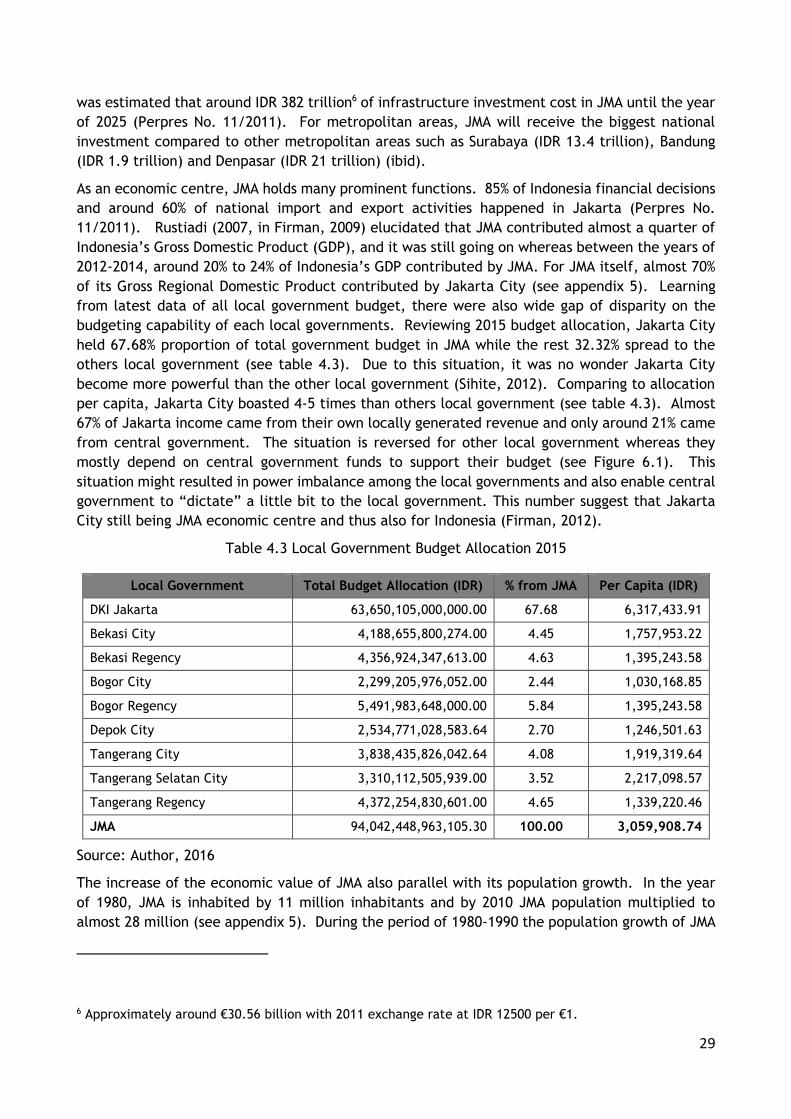
29
was estimated that around IDR 382 trillion6 of infrastructure investment cost in JMA until the year
of 2025 (Perpres No. 11/2011). For metropolitan areas, JMA will receive the biggest national
investment compared to other metropolitan areas such as Surabaya (IDR 13.4 trillion), Bandung
(IDR 1.9 trillion) and Denpasar (IDR 21 trillion) (ibid).
As an economic centre, JMA holds many prominent functions. 85% of Indonesia financial decisions
and around 60% of national import and export activities happened in Jakarta (Perpres No.
11/2011). Rustiadi (2007, in Firman, 2009) elucidated that JMA contributed almost a quarter of
Indonesia’s Gross Domestic Product (GDP), and it was still going on whereas between the years of
2012-2014, around 20% to 24% of Indonesia’s GDP contributed by JMA. For JMA itself, almost 70%
of its Gross Regional Domestic Product contributed by Jakarta City (see appendix 5). Learning
from latest data of all local government budget, there were also wide gap of disparity on the
budgeting capability of each local governments. Reviewing 2015 budget allocation, Jakarta City
held 67.68% proportion of total government budget in JMA while the rest 32.32% spread to the
others local government (see table 4.3). Due to this situation, it was no wonder Jakarta City
become more powerful than the other local government (Sihite, 2012). Comparing to allocation
per capita, Jakarta City boasted 4-5 times than others local government (see table 4.3). Almost
67% of Jakarta income came from their own locally generated revenue and only around 21% came
from central government. The situation is reversed for other local government whereas they
mostly depend on central government funds to support their budget (see Figure 6.1). This
situation might resulted in power imbalance among the local governments and also enable central
government to “dictate” a little bit to the local government. This number suggest that Jakarta
City still being JMA economic centre and thus also for Indonesia (Firman, 2012).
Table 4.3 Local Government Budget Allocation 2015
Local Government Total Budget Allocation (IDR) % from JMA Per Capita (IDR)
DKI Jakarta 63,650,105,000,000.00 67.68 6,317,433.91
Bekasi City 4,188,655,800,274.00 4.45 1,757,953.22
Bekasi Regency 4,356,924,347,613.00 4.63 1,395,243.58
Bogor City 2,299,205,976,052.00 2.44 1,030,168.85
Bogor Regency 5,491,983,648,000.00 5.84 1,395,243.58
Depok City 2,534,771,028,583.64 2.70 1,246,501.63
Tangerang City 3,838,435,826,042.64 4.08 1,919,319.64
Tangerang Selatan City 3,310,112,505,939.00 3.52 2,217,098.57
Tangerang Regency 4,372,254,830,601.00 4.65 1,339,220.46
JMA 94,042,448,963,105.30 100.00 3,059,908.74
Source: Author, 2016
The increase of the economic value of JMA also parallel with its population growth. In the year
of 1980, JMA is inhabited by 11 million inhabitants and by 2010 JMA population multiplied to
almost 28 million (see appendix 5). During the period of 1980-1990 the population growth of JMA
6 Approximately around €30.56 billion with 2011 exchange rate at IDR 12500 per €1.

30
was 4.12%, decreased in the period of 1990-2000 to 2.53% due to the economic crises (Firman,
2009) and increased again to 3.7% in the period of 2000-2010 (see appendix 5). Jakarta City is
still the most populous area in JMA, however shared on Jakarta City towards JMA population have
decreased due to the scarce of land availability in Jakarta City (Firman, 2014). The need to live
near national economic centre resulted into high population growth in the Jakarta City suburb
and exurb area (Vioya, 2010). At the period of 1980-1990 the suburbanisation process mostly
happened in southern part of JMA followed then by western part due to the development of the
JMA ring road and its first toll road which connected Jakarta City to Bogor City (Silver, 2008).
However during period 1990-2000 high population concentration was shared in eastern part of
JMA, especially due to the completion of the Jakarta-Bandung toll road which transverse the
eastern part of JMA. During the period of 2000-2010, along with recovery of economic crises JMA
population growth to all three direction (see table 4.4).
Figure 4.4 Distribution of Local Government Revenue (Source: Author, 2016)
Table 4.4 Spatial Direction of Jakarta Population Growth
Local Government Shared on JMA Population (%)
1980 1990 2000 2010
Core Area (Jakarta City) 56.40 50.71 41.10 34.37
Western Side (Tangerang City, Tangerang Selatan City, and Tangerang Regency)
9.91 16.98 20.07 21.18
Eastern Side (Bekasi City and Bekasi Regency) 9.92 7.80 15.18 17.76
Southern Side (Depok City, Bogor City and Bogor Regency) 23.77 24.51 23.65 26.68
Jakarta Metropolitan Area 100.00 100.00 100.00 100.00
Source: Author, 2016
Based on population density, there were also increase on the number of sub-districts (kecamatan)
with more than 100 people per hectare. By 2000, concentration of high density population mostly
located in sub-district on central part of Jakarta, Bekasi, Bogor and Tangerang City. By 2010, high
density population expanse towards most of all sub-district in Jakarta City and sub-district on
0%
10%
20%
30%
40%
50%
60%
70%
80%
90%
100%
DKI Jakarta Bekasi City BekasiRegency
Bogor City Bogor Regency Depok City TangerangCity
TangerangSelatan City
TangerangRegency
Locally Generated Central Government Other Sources

31
other municipals which located closely to Jakarta City (Salim, 2013). This show how during a
decade JMA population increased and spread towards all direction from the core metropolitan
which also decrease density in the core city.
Figure 4.5 Change of Population Density in JMA (Source: Salim, 2013)
Development of economic activities and population in JMA also resulted into extensive conversion
of land, especially from farmland to built-up areas and other non-agricultural function (Firman,
2012). With around 6,000 km2 areas of land, many of JMA areas converted into built-up area in
the last three decades. Using land cover analysis, Arifien (2012) found that there was dramatically
an increase of built-up areas in JMA, which is from 8.9% by 1983 to 35.6% by 2009. By using land
cover data and population growth, he concluded that every increase of 1000 person in JMA will
also increase development of around 13 hectare built-up areas (ibid). Ditjen Tata Ruang (2013)
projected by 2030 there were 52.88 million inhabitants in Jakarta Metropolitan Region whereas
for JMA it was around 52 million7. Based on DJPR projection there will be 24 million more
inhabitants that will live in JMA, therefore by using Arifien (2012) assumption there will be demand
for 312.000 hectares of new built-up areas in JMA or almost half of existed JMA land areas.
Without proper spatial management, by 2030 more than 80% of JMA land areas will become built-
up areas.
Besides population growth, toll road development in JMA will also induce more land conversion,
especially in suburbs and exurbs area. Northern and southern corridor is developed along with
development of Jagorawi toll road, western part developed along with Serpong and Tangerang-
Merak toll road, and eastern part developed along with Bekasi-Cikampek-Padalarang toll road (see
next figure). The situation of the land conversion also exacerbated by violations of spatial plan
due to pressure of market forces, political interest, and insufficient local government capability
to deal with land conversion process, poor coordination among institutions, and absence of zoning
regulation (Firman, 2012; Hidayat et al, 2013; Trimarmanti, 2014). The next phase of toll road
development (marked with dotted line in next figure) will connected the outer ring of JMA exurbs
7 Jakarta Metropolitan Region concept is including Cianjur Regency as, whereas JMA concept in this research do not include Cianjur Regency.

32
especially on the western and eastern part (see figure 4.6), based on past experience and without
better spatial plan implementation the next urban sprawl in JMA is definitely being happened
again.
One of the main problems within JMA urban management is the different priorities among its
actors. Transportation management in JMA is one example. Jakarta City now is heavily burdened
by congestion due to the high private motorization by commuters, which is more than one million
daily trips per day (JUTPI Study, 2012 cited in Putra, 2014). The effort of Jakarta City in
integrating its public transportation by creating TransJakarta was not meet with same enthusiasm
of other local government because there were none public transportation authority manage by
local government on outside Jakarta City. Local government entrusted its regional public
transportation to private companies (usually bus companies) and/or to state owned company
(Indonesia Railway Company). Due to the limited choice of public transportation mode choice
resulted most commuters using private vehicle for their daily trips toward Jakarta City.
Figure 4.6 Illustration on JMA Spatial Development 1972-2013 (Source: Author, 2016)
Another example is flood management. Jakarta as downstream areas relies heavily for its riparian
flood management to others upstream municipals or regencies to conserve their watershed areas.
However, most local government outside Jakarta City do not put river conservation as their urgent
priorities due to the budget limitation and river management authority. For budget allocation,
most local government focus their spending on basic needs such as education or health. The other
reason is river management in JMA comes under the responsibility of Ministry of Public Works,
which resulted local government perceived major rivers conservation is central government
responsibility not theirs. Those two examples showed that without unifying aspect to hold on,
local government will always pursue its own priority. Without common goals, it will hard to create
coordination or cooperation on spatial plan, therefore policy integration will become far to reach.
33
There are formal process to avoid this divergent priorities lock-in situation, which is through
BKPRD, BKPRN, and BKSP discussion. However those forums consisted by only government
representations and there are almost none of public representation therefore the discourse will
bounce back between local governments and central government fragmented priorities
(Interviewee: Anni, Jakarta City, 2016). It is also revealed that BKSP which aims as coordinating
agency is only focus on infrastructure development and not on spatial planning and the connection
between BKPRD and/or BKPRN with BKSP is non-existent (Interviewee: Yulia, Tangerang Selatan
City; and Arief, Depok City, 2016). It is unfortunate whereas BKSP proposed as the main agency
to integrating development policy in JMA (Firman, 2009; 2014) the BKSP itself do not have
authority to deal with spatial plan formulation and/or integration.
4.5 Conclusion
We have seen in that JMA experienced a rapid urbanisation in the past decades. High economic
activities attract peoples to JMA, and then those peoples create more economic activities and
this process is still going on. The circular between economic activities and human mobility
resulted for the need of land to accommodate on both occurrences. In Jakarta, the need of land
created sprawled situation which converted almost 27% of its farmland into built-up between the
years 1983-2009. With the current rate of expansion in 2030 it was simulated that more than 80%
of JMA land areas will become built-up areas. Based on the result of the simulation, JMA really
needs to make sure its spatial plan able to face future development.
Based on description in the previous section, JMA has a several factors that related to its urban
development management. First is about the hierarchical spatial planning system which allowed
the promulgation of standardized spatial plan. Second is about cooperation culture in Indonesia
society which enabled JMA actors to working together. Third, as national economic centre JMA
has big resources on budget, this is a privilege that may not occurred in other regions. Fourth,
due to the many local government related in the JMA may resulted in the different priorities
among them especially in the Indonesia’s decentralization system.
The case study indicated the availability of standardized guidance and willingness to cooperation
which lead to inclusivity of spatial plans are supporting factors to manage urban growth. Utilizing
both factors may enables JMA to integrate their spatial plan through the finding and agreeing the
common visions. However JMA still not utilising these factors optimally and resulted in the fuzzy
and fragmented development control among its local government.
JMA case study also indicated that there is budgeting and priorities factors that may inhibits their
policy integration. As mentioned in the previous chapter not all local government has ‘strong’
budget allocation therefore most of them still trapped for basic infrastructure provision and have
little allocation to integrating spatial plans. This situation exacerbated by different priorities of
development, whereas Jakarta City aware of their lack of sustainability but limited by availability
of land resource. On the other hand, local government with vast land availability more concern
to pursue their economic growth. JMA needs to be aware on the existence of this factors thus
able to exploit it by integrating their policies. However, for spatial plan aspect the system is still
fragile, therefore JMA needs to learn from other metropolitan which already had a robust
integrated planning system.

34

35
CHAPTER 5
COMPARATIVE CASES
5 Comparative Cases
5.1 Introduction
This chapter describes about selected comparison case studies as a source of lesson to a better
urban growth management for JMA. As have been stated in chapter 3, there are two metropolitan
areas that is selected as case studies which are Greater Portland-Vancouver Metropolitan Area in
USA and Hong Kong Special Administrative Region in PRC. This chapter will describe both
metropolitan areas on 3 aspects, first is about description of spatial planning system in the case
study. Second part is about description of metropolitan development which mainly focuses on
the population development and its connection with urban land use growth. The last part of each
case study is about a policy lesson learned from each case which can be transferred to JMA case.
5.2 Portland-Vancouver Metropolitan Area
5.2.1 Portland-Vancouver Metropolitan Area Spatial Planning System
The US planning system does not recognize national spatial planning system, the spatial planning
have been given to the level of the State8 (Schmidt and Buehler, 2007). The national government
(federal government) only curtailed on oblique aspect such as: environmental regulation, housing
grant, management of national owned lands, transportation infrastructure’s investment, and
technical assistances (ibid). As for Portland-Vancouver Metropolitan Area (PVMA) which is one of
the metropolitan area located in north-western part of the United States, the spatial planning
become the responsibility for their own states.
Basically, Portland-Vancouver Metropolitan Area consisted of two different state’s spatial
planning systems which are Oregon State spatial planning system and Washington State planning
system. The Oregon State spatial planning came first in 1973 with Oregon Land Use Act while the
Washington State spatial planning came later in 1991 with Growth Management Act (Kline et al,
2014). After the state level, there are county and/or city level of spatial planning which needs
to be in accordance with the state level.
Counties and city in Portland Metro mostly created their first comprehensive plan on early 1980’s.
These comprehensive plans follow one of the most important goal in Oregon Land Use Act which
is required all counties and cities in Oregon State to create their own urban growth boundaries in
order to accommodate 20 years period of growth. In 1979, the Oregon State created Portland
Metro for coordination of spatial planning and management through the functional plans that
address regional issues in the Portland Metropolitan Areas. By creating Portland Metro, Oregon
show their serious intentions in integrating urban development in Portland Metropolitan Areas.
8 State in US is may also considered as province in many other countries.

36
Figure 5.1 Portland-Vancouver Metropolitan Area Spatial Planning System (Source: Author, 2016) Notes: *Multnomah, Clackamas and Washington Counties
Figure 5.2 Portland Metro 2040 Growth Concept (Source: http://www.oregonmetro.gov/2040-growth-concept)

37
Meanwhile in Washington State, most of its spatial planning just for local needs. Learning from
Oregon effort to manage urban growth, in 1991 Washington State with its Growth Management
Act also mandates all of its counties to establish their urban growth boundaries. Nevertheless,
Washington State is still relying on decentralize system which left for local government in
Washington State to promulgate their own comprehensive plans (Settle and Gavigan, 1993 cited
in Kline et al, 2014). Clark County first developed their comprehensive plan in 1979, way ahead
before the Washington State in order to deal with their urban growth. Though Clark County did
not create the urban growth boundary, its comprehensive plan already mentioned the allocation
of built-up areas and farmland areas (Clark County, 2010). In more detailed, Vancouver City
development also plans to manage its urban growth on their urban growth area (UGA) almost
similar as its counterparts in Oregon. By creating UGA earlier than its own state, Clark County
showed some initiatives to learn from Oregon and shared the same interest with Oregon to manage
and maintain urban growth.
Figure 5.3 Vancouver City Growth Concept (Source: City of Vancouver WA, 2011)
The key planning concept of both states is by using Urban Growth Boundary (UGB) to manage their
urban growth. UGB is basically a zoning regulation supported by land purchased and conservation
easements measure with aim to maintain high density built up areas inside the boundary and use
areas outside the boundary as farmland or rural density areas. Although UGB is statutory plan,
nevertheless it’s positive aspect is its flexibility to periodically expand the boundaries when the
need of growth arise.
The responsibility for managing UGB in Oregon State is under legal authority on the Metro Portland
(Kline, 2014). As a coordinating organization, there are three duties related to land use:
developing areas inside the UGB, restrict development outside UGB, and create flexibility of the
UGB borderline (Daniels, 1999 cited in Jun, 2004). To ensure it openness and public participation,

38
Portland Metro organises a body which is called the Metro Council comprises of elected officials
as representation of six individual districts (Seltzer, 2008; Kline, 2014). For Washington State
there is no metro authority body like in the Oregon State. Responsibility for managing metro
comes to the city of Vancouver which following guidance from Clark County comprehensive plans.
To my knowledge there were no coordinating agency between Oregon and Washington States
related to Portland-Vancouver Metropolitan Areas spatial plan.
Looking at Portland-Vancouver Metropolitan Area spatial planning system, there are similarities
and differences with JMA. The most visible aspect is JMA and Portland-Vancouver consist of
different autonomous local government which have own agendas and budgeting related to urban
growth management. Both metropolitan also created an agency to support the metropolitan
governance. The other similarity is both metropolitans also created a common vision for urban
development supported by multi-tiers spatial plans. However, those similarities only at the macro
level, looking at meso and micro level both metropolitans had different kind of mechanism with
implementation of their common vision, multi-tiers spatial plan system and also institutional
governance whereas JMA is more to the hierarchical cooperation and top-down system while
Portland-Vancouver is more to the horizontal coordination.
5.2.2 Portland-Vancouver Metropolitan Area Development
Portland-Vancouver Metropolitan Area located in States of Washington and Oregon and consisted
from four counties (Multnomah, Clackamas, Washington, and Clark). With total area 9,573 km2
and inhabited by 2.1 million in the year of 2010 makes Portland-Vancouver Metropolitan Area as
one of largest metropolitan areas in north-western part of the US (US Census Bureau, n.d; Greater
Portland, 2011; Kline et al, 2014). Strategically located in the western coast of USA and have
direct access to Pacific Ocean, makes Portland-Vancouver Metropolitan Area become one of the
biggest exporting region in the USA and one of economically top metropolitan (Florida, 2010;
Greater Portland, 2011; Greater Portland Pulse, 2015).
Figure 5.4 Portland-Vancouver Metropolitan Area (Source: Klein et al, 2014; www.portlandweird.weebly.com)
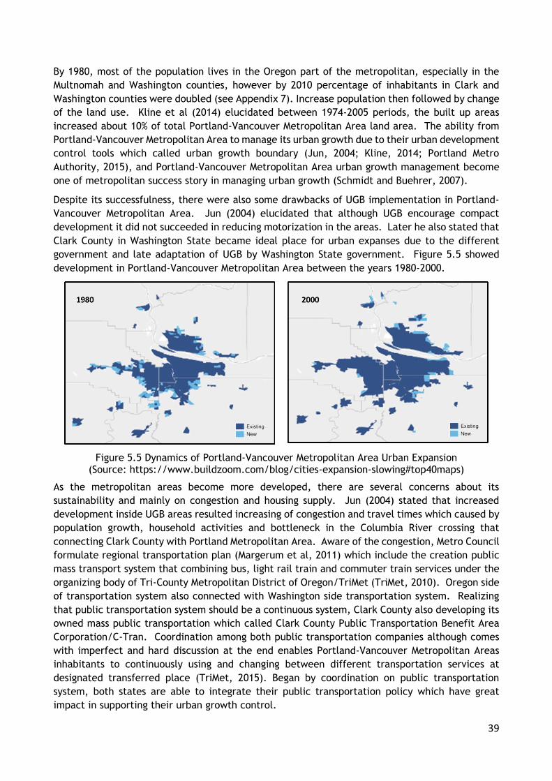
39
By 1980, most of the population lives in the Oregon part of the metropolitan, especially in the
Multnomah and Washington counties, however by 2010 percentage of inhabitants in Clark and
Washington counties were doubled (see Appendix 7). Increase population then followed by change
of the land use. Kline et al (2014) elucidated between 1974-2005 periods, the built up areas
increased about 10% of total Portland-Vancouver Metropolitan Area land area. The ability from
Portland-Vancouver Metropolitan Area to manage its urban growth due to their urban development
control tools which called urban growth boundary (Jun, 2004; Kline, 2014; Portland Metro
Authority, 2015), and Portland-Vancouver Metropolitan Area urban growth management become
one of metropolitan success story in managing urban growth (Schmidt and Buehrer, 2007).
Despite its successfulness, there were also some drawbacks of UGB implementation in Portland-
Vancouver Metropolitan Area. Jun (2004) elucidated that although UGB encourage compact
development it did not succeeded in reducing motorization in the areas. Later he also stated that
Clark County in Washington State became ideal place for urban expanses due to the different
government and late adaptation of UGB by Washington State government. Figure 5.5 showed
development in Portland-Vancouver Metropolitan Area between the years 1980-2000.
Figure 5.5 Dynamics of Portland-Vancouver Metropolitan Area Urban Expansion (Source: https://www.buildzoom.com/blog/cities-expansion-slowing#top40maps)
As the metropolitan areas become more developed, there are several concerns about its
sustainability and mainly on congestion and housing supply. Jun (2004) stated that increased
development inside UGB areas resulted increasing of congestion and travel times which caused by
population growth, household activities and bottleneck in the Columbia River crossing that
connecting Clark County with Portland Metropolitan Area. Aware of the congestion, Metro Council
formulate regional transportation plan (Margerum et al, 2011) which include the creation public
mass transport system that combining bus, light rail train and commuter train services under the
organizing body of Tri-County Metropolitan District of Oregon/TriMet (TriMet, 2010). Oregon side
of transportation system also connected with Washington side transportation system. Realizing
that public transportation system should be a continuous system, Clark County also developing its
owned mass public transportation which called Clark County Public Transportation Benefit Area
Corporation/C-Tran. Coordination among both public transportation companies although comes
with imperfect and hard discussion at the end enables Portland-Vancouver Metropolitan Areas
inhabitants to continuously using and changing between different transportation services at
designated transferred place (TriMet, 2015). Began by coordination on public transportation
system, both states are able to integrate their public transportation policy which have great
impact in supporting their urban growth control.

40
Limited availability of vacant land due to the UGB implementation also resulted in the competition
of housing development which made Portland Metropolitan Area as one of the least affordable
places for housing in US (Staley and Mildner, 1999). Scarcity of vacant lots resulted dramatic
difference of price for land inside the UGB than outside the UGB (Cox, 2011a), however Phillips
and Goldstein (2000) argued that the increase was not solely by UGB but also from market sector’
speculation. Still the increase of housing price burdened the low income family in the Portland-
Vancouver Metropolitan Area. Dealing with this situation, government in Portland-Vancouver
Metropolitan Area employs several strategies such as allowing more than one family living in the
single family plot, giving subsidize for housing own or rent, and other public housing initiatives
which supported by federal government (Metro, 2016).
Portland-Vancouver Metropolitan Area urban growth management is good example of
implementing a statutory planning system. Despite the different States, Portland-Vancouver is
able to come up with single vision which is limiting their urban expansion. Both Oregon and
Washington States utilize zoning regulation as main development control tools in implementing
their vision. However they also still flexible in their zoning regulation when met with locked-in
situation. Counties or cities may have different kinds of zoning regulation, however state
government have important roles to make sure that those zoning regulation still in accordance
with states vision. By integrating state policy to the local policy, Portland-Vancouver succeeded
to limiting their urban growth. Nevertheless, strict zoning also come with its difficulties. Limited
availability of land resulted compact development thus increasing movement inside urban
boundary. Scarce of vacant land also affected housing supply in Portland-Vancouver either its
numbers and/or its prices. Dealing with negative effect of growth boundary, Portland-Vancouver
developed integrated public transportation and amended their zoning regulation inside the urban
boundary.
5.3 Hong Kong Special Administrative Region
5.3.1 Hong Kong Special Administrative Region Planning System
Hong Kong which officially known as Hong Kong Special Administrative Region (HKSAR) of the
People’s Republic of China (PRC) is one of two Special Administrative Regions in China and located
on the south-eastern part of the PRC. Under 2005 Town Planning Ordinance, Hong Kong has two
tiers system of planning, consisted of Territorial Development Strategy and District Plan (UrbanHK,
2016). The Territorial Development Strategy (TDS) is a long term planning strategy to connect
future development with economic growth and infrastructure provision in order to achieved
government policy on spatial aspect. The current TDS known as HK2030, promulgated in 2007, it
is the sixth version since its first formulation in 1970, and HK2030 have vision of Hong Kong to
become one of the world cosmopolitan city (HK Planning Department, 2015). While for districts
they use statutory plans and departmental plans (Government of Hong Kong, 2016). Statutory
plans consisted of Outline Zoning Plan and Development Permission Area while departmental plans
consisted of Outline Development Plans and Layout Plans.

41
Figure 5.6 Hong Kong Spatial Planning System (Source: Author, 2016)
Table 5.1 District Planning in HKSAR
Plans Remarks
Statutory
Plan
Outline Zoning Plan
Displays roads, land use zones, and development borders for designated uses (residential, commercial, industrial government, and open spaces or green belts)
Development Permission Area
Giving initial guidance and control over planning in new areas as an interim planning until an Outline Zoning Plan is ready
Effective for 3 years
Departmental Plan
Outline Development Plan
Provide more detailed planning such as the boundaries of a prepared site or the specific placements of access points.
The planning process incorporated involvement of the public through exhibitions, forums and workshops
Layout Plan
Source: Government of Hong Kong, 2016
Hong Kong ideas of spatial planning are by dispersing its city centre and created multi-centres
which can meet several requisites, such as balancing residential areas provision with
infrastructure, employment and other needs of developments, creating higher linkage with
Mainland of PRC, and creating higher segregation of antipodal spatial uses (HK Planning
Department, 2015). The connection with Mainland also big consideration for Hong Kong
development due to the Mainland is the biggest source of Hong Kong workforce. Creating multi-
centres also ease the burden of core areas which now focused on Kowloon and Island of Hong Kong
areas, and distributed it activity centres on the other areas of Hong Kong. With this consideration,
Hong Kong concept development will divide Hong Kong into four area/axes, which are:

42
Metro Development Core, located in the old centre of Hong Kong (Kowloon and northern part
of Hong Kong Island). Its function are intensive commercial/business zones and housing for
urban-style living;
Central Development Axis, connected Metro Core with northern part of Hong Kong SAR. Its
function are community-type housing and education/knowledge-building facilities;
Southern Development Axis, connected Metro Core with western part of Hong Kong SAR
(Lantau Island.) Its function are logistics and major tourism facilities; and
Northern Development Axis, located in northern part of Hong Kong SAR which also border area
with Shenzen Metropolitan Areas. Its function are non-intensive technology and commercial
zones and other uses that capitalise on the strategic advantage of the border location.
For area outside those four areas/axes, it was proposed to develop as conservation areas and/or
low density development (ibid). To support this general strategies, Hong Kong then divided into
7 district planning offices which have responsibility to enforce the statutory and departmental
plans (UrbanHK, 2016). With its spatial plan, Hong Kong is trying to managing its urban
development by using HK2030 as the foundation, then backed by statutory planning in order to
acomplished sustainable compact city with high densities (Teriman, 2008).
Figure 5.7 Hong Kong 2030 Concept Development (Source: HK Planning Department, 2015)
Based on Hong Kong’s spatial planning system, there are similarities and differences with JMA.
The most visible aspect is JMA and Hong Kong have the same model of hierarchical planning;
where higher level tier spatial plan/guidance must be adopted by lower tier spatial plan. Both
metropolitan also primary economic centre in their country which attract more people come to
that resulted the high needs of infrastructure provision to support mobility and accommodation.
JMA and Hong Kong at macro level have similarity in creating the metropolitan vision, however

43
unified government structure in Hong Kong is able to provide better coordination and integration
for spatial plans than JMA decentralized system. For spatial plans, there is a similarity in using
polycentric development as their metropolitan urban structure.
There are also dissimilarity especially related to their spatial plan implementation. While JMA do
not have constraints developable land areas, development in JMA is dispersed towards all
direction and unsupported by efficient public transportation system thus the sprawled is happened
in JMA. Meanwhile, Hong Kong due to its physical landscape able to wisely develop its area. Hong
Kong utilize zoning regulation to make sure the conservation area (which around 80% of Hong Kong
land areas) is protected, and efficiently developed its built up area through vertical based
development. As a result, Hong Kong able to create a compact and high density metropolitan
area. Hong Kong metropolitan centres also connected with efficient mass public transportation
that enables Hong Kong to limits its metropolitan centres expansion.
5.3.2 Hong Kong Special Administrative Region Area Development
Hong Kong SAR is one of two Special Administrative Regions in China which ruled “One Country
Two System9” policy. Hong Kong consisted of three regions namely Hong Kong Island, Kowloon,
and New Territories which then divided into 18 districts. With its 1,104 km2 of land areas, Hong
Kong only able to developed around 20% of its land due to its geographical constraints (Teriman,
2009). Nevertheless Hong Kong have big role in economic activity, not just for China but for the
world whereas (Florida, 2015; A.T. Kearney, 2016).
Figure 5.8 Map of Hong Kong Special Area Region Administrative (Source: https://commons.wikimedia.org/wiki/File:Map_of_Hong_Kong_18_Districts_zh.svg)
9 Main ideas of the "one country, two systems" policy are while Hong Kong government is under PRC government however Hong Kong permitted to maintain its capitalist system while the PRC using socialist system. This policy aims to achieve peaceful reunification and maintain stability and prosperity between the PRC as motherland and Hong Kong as the new protectorate regions.

44
Dramatic economic growth attracts peoples to come to Hong Kong which doubled its population
from 3.96 million in 1970 to 7.19 million in 2010 and all of them lived in urban areas (UN-DESA,
2015). With only 20% of developable areas, Hong Kong density is around 6,690 person per square
kilometers and the core centre reached 57,250 people per square kilometers (Government of Hong
Kong, 2015), making Hong Kong as one of the densest metropolitan in the world. In the last
quarter century, most inhabitants lived in the New Territories Region (HK Census and Statistics,
2016) and the number is still increasing to the next decade (HK Planning Department, 2015a).
Kowloon is still the densest region whereas with only 4.3% of the areas, Kowloon inhabited by
30.22% of the population (see Appendix 8). This population concentration on Kowloon happened
especially due to the supporting topographical factors of this area as flattened areas and by others
pull factors such as centre of economic activity, urban infrastructure availability, and
concentration of land reclamation project in this relatively small areas (CEDD, 2009). The
reclaimed area in the whole Hong Kong is able to gain 6% more of onshore areas for Hong Kong
development to accommodate 20% of population’s housing (Ibid).
Figure 5.9 Hong Kong Topographic Situation and Reclamation Areas (Source: CEDD, 2009)
Change in the number of population also had impact on the land utilization in Hong Kong. The
dramatic change of land utilization from non-built up to built-up areas happened between the
years 1996-2000, especially after the change of Hong Kong “ownership” from United Kingdom to
PRC. With the addition of around 400 thousands inhabitants resulted in the decreasing of almost
5% of total non-built up areas in Hong Kong. Nevertheless non-built up areas is still dominated
Hong Kong land utilization whereas by 2014 there were around 76% (HK Planning Department,
2015b). The creation and enforcement statutory plans which protected the hilly areas around
Hong Kong are the main reason behind this situation, combined with the development of compact
city in Hong Kong built up areas (Teriman, 2008).

45
Figure 5.10 Hong Kong Built Up Areas Development (Source: Sudianto, 2008; HK Planning Department, 2001; HK Planning Department, 2015b; World Bank, 2016)
5.4 Conclusion: Lesson Learned of Urban Growth Management
Looking from Portland-Vancouver Metropolitan Area and Hong Kong Special Administrative Region,
there is similarity in how they manage their urban growth. By using statutory planning, both
metropolitan employed zoning regulation tools to control their spatial development. Both
metropolitans have strong commitment to protecting non-built up designated areas, whereas
Portland-Vancouver Metropolitan Area using their Urban Growth Boundary and Hong Kong Special
Administrative Region using designated conservation areas. In order to increase sustainability of
metropolitan areas, both metropolitans chose compact city development as their main strategy.
By using compact city development, both city able to efficiently manage their designated built-
up area.
In order to make sure their urban growth control is worked, Portland-Vancouver and Hong Kong
employs zoning regulation as their main development control tools. Not just employ, both
metropolitan also synchronise their zoning regulation though each metropolitan has different
methods. For Hong Kong, their unified system facilitate synchronisation of zoning regulation by
using hierarchical spatial plan that combined with standardized arrangements. By doing this Hong
Kong is able to make sure that their multi urban centres development following the same
procedure and standard. With the standardized zoning regulation, they also able to avert
encroachment in the protected areas. As for Portland, they have different situation. With
decentralization system, all counties and cities in Portland-Vancouver has their own zoning
regulation. Nevertheless single aims to contain urban areas expansion are able to bringing them
together to synchronise their zoning regulation. Despite different detail on arrangements, they
follows their states guidance which strictly limited their urban areas and left the farmland areas
undeveloped until further amend is necessary.
Another point of view is both metropolitans utilize their statutory planning in the long run and
avoided of digressing from the original plan through consistent implementation and monitoring
combined with periodically evaluation. Oregon State started their statutory planning since 1974

46
then followed by Clark County, Washington in 1979 (the whole Washington State takes longer time
to follow Clark County). Since late 70’s, Portland-Vancouver consequently use this zoning system,
therefore in almost three decades ‘only’ 6% of their total area converted from farmland to urban
built-up areas. Hong Kong story also almost the same. They officially started using statutory
planning in 1991, and with their strong willed effort they still have almost 80% of their areas as
non-built-up areas. Both facts showed that to accept good result on the enactment of strict
zoning regulation needs long time frame and consistency from involved actors.
Related to JMA situation, there are specific lesson learned that can be taken from Portland-
Vancouver experiences. They are:
First, JMA must realise that different local government does not mean they cannot learn from
each other’s. The process may take a long time, nevertheless in the end local government
able to come up with their own version of urban growth containment.
Second, realizing the common goals which is contained urban growth will enable JMA to adopt
similar system of urban development control despite there is different kinds of zoning
regulations arrangements which used by each local government.
Third, in order to develop compact city development, JMA need to provide integrated public
mass transportation and other arrangements to divert private motorization.
Fourth, Jakarta City as the core metropolitan must have willingness to embroil other local
government spatial plan concept despite Jakarta City excellence in budgeting.
Fifth, the needs to create of coordinating agency on the based on inclusiveness. This
organization needs to include multi stakeholders, not merely just government representatives
or appointees.
From Hong Kong experiences, lesson learned that can be taken by Jakarta are:
First, while JMA do not have limited developable land like Hong Kong, however focuses on
vertical development may enables JMA to efficiently use their available land areas and offers
chance in conserve JMA non-built up areas.
Second, JMA needs to realise that high population growth accompanied with high economic
activities do not justify to encroaching the protected or farmland areas.
Third, as national strategic area JMA need to maximize its privilege to exert their own spatial
plan although it did not means they completely cut away central government guidance.
Fourth, JMA needs to utilize its hierarchical and standardized spatial plan as a guidance to
integrate fragmented and diverse zoning regulation.
Fifth, JMA needs to learn how Hong Kong development of new metropolitan centre always
consider the carrying capacity and outer regional centre, not just focused on existed activity
centres.

47
CHAPTER 6
INTEGRATING SPATIAL PLAN FOR
URBAN GROWTH MANAGEMENT
6 Integrating Spatial Plan for Urban Growth Management
6.1 Introduction
This chapter will combine results from JMA case study analysis with Portland-Vancouver and Hong
Kong analysis. This combination intended to get possibilities and strategies on how to
synchronising zoning regulation as an effort to achieved JMA’s spatial plan integration JMA. This
chapter consisted two parts. The first part tries to digest the results of comparison cases study on
urban growth management and highlights some of its supporting element. This part also includes
the analysis of feasibility for transferring what have been learnt from the case study into JMA
context. The second part is about how to utilize the facilitators that have been recognized and
at the same time to overcome the potential barriers in crafting strategies for policy integration.
6.2 Learning from Other Metropolitan Areas
Spaans and Louw (2009) state that there are shared of ideologies or philosophies among planners
despite they live in different cities or countries. This statement serves as a foundation to this
research about the importance to learn from a different system that exhibits similar
characteristics in one way or the other. Metropolitan areas may have different planning system,
especially in managing urban sprawl. Nevertheless shared ideas and objectives become the main
driven from different system to learning among each other’s. Portland-Vancouver Metropolitan
Area and HKSAR urban development management are proven to be well exercised from which
lesson can be drawn to improve JMA urban growth management. It is important to note that
understanding about the planning system adopted by each metropolitan area under study is the
key to ensure the effectiveness of lesson drawing that can be applied for the improvement of JMA
urban growth management. For that purpose, the next table offers some brief descriptions and
comparison of the three metropolitan areas.
Table 6.1 Characteristics of Metropolitan Areas
Characteristics JMA Portland-Vancouver Hong Kong
Country Indonesia USA PRC
Population
- 1980 11,532,000 1,341,491 5,063,000
- 2010 27,954,000 2,226,009 7,204,000
Avg. Population Growth 4.75% per years 2.19% per years 1.41% per years
Land Area (km2) 6,027 9,573 1,100
Administrative Government
3 Provinces, 8 local government
2 states, 4 counties 1 administrative region, 18 Districts
Planning Level 4 tiers 3 tiers 2 tiers
Planning System

48
Characteristics JMA Portland-Vancouver Hong Kong
- National Plan Statutory Plan -- --
- Regional Plan Statutory Plan Guidance Strategic Plan
- Metropolitan Plan Statutory Plan Strategic Plan --
- Local Plan Statutory Plan Statutory Statutory Plan
Built-up area 2,145 km2/35.6%
(2009)
1,560.5 km2/16%
(2005)
264.55 km2/24.05%
(2011)
Built-up area expansion 26,70% (1983-2009) 6,00% (1974-2005) 11,03% (1988-2011)
Officially Implementing Statutory Plan
2007 1974 1991
Urban Sprawl Problematic Controlled Controlled
Source: Author, 2016
6.2.1 Spatial Planning Integration and Administrative Government Fragmentation
Jakarta, Portland-Vancouver, and Hong Kong metropolitan areas due to the different political
system had different level of tiers in governing and planning. In terms of administrative
government, Jakarta has similar situation with Portland-Vancouver of which both consist of
several local governments, whereas Hong Kong is composed by single administrative metropolitan
government. In many experiences, metropolitan areas with multiple administrative governments
may result in fragmented institutional landscapes, whereas individual administrative government
that formed the metropolitan areas may have its own priorities on their urban development and
management (Sellers and Martinot, 2009). In terms of spatial planning system, Jakarta has the
most hierarchical spatial plan tiers than the others. Jakarta has national-province-metropolitan-
local spatial plan that their accordance needs to be maintained on to the others, especially at the
lowest tier. Due to its function as national capital, all of those spatial plan should be taken into
account in the formulation of zoning regulation. One can imagine the complexity and messiness
in formulating zoning regulation. In contrast, Hong Kong zoning regulation is much easier to
formulate as its only reference is its regional spatial guidance. Even Portland-Vancouver which is
formed from different states only has regional and metropolitan plans as guidance to formulate
its zoning regulation.
Jakarta could learn from Portland-Vancouver case how two different states (Oregon and
Washington States) which have different kinds of government system are willing to realize the
need to have same goals in managing their metropolitan growth. Oregon and Washington
understand that urban expansion will spread beyond their administrative boundaries despite the
existence of Columbia River as natural divider. This awareness enabled both states to look beyond
their own hidebound vision and strategy, and make an effort to concede and accommodate the
pivotal urban spill over occurred between them. The efforts of Oregon State to implement its
UGB in Portland Metropolitan inspired Washington State to do the same thing and both states
finally manage to integrate their policies to maintain urban expansion. In summarize Portland-
Vancouver experience shows common vision can enable diverse zoning regulation to achieve same
goals.
In terms of land designation, Hong Kong experience in rigorously protected its conservation and
limitation development areas offers useful insights to be learned. Instead of trying to occupy the

49
mountainous and hilly areas area, Hong Kong government is prone to use vertical development in
their flattened urban designate area, especially in the core and metropolitan centre areas,
furthermore, they also prefer to reclaimed the sea for Kowloon expansion and Chek Lap Kok
Airport (see figure 5.9). As unified single planning body, Hong Kong is able to create integrated
zoning regulation on all is districts. Inclination and willingness on vertical development based on
integrated spatial plan allow Hong Kong to become compact city and at the same time avoids
urban sprawling. In sum, JMA could learn how to employ strict urban areas containment combined
with standardized zoning regulation as the primary key of spatial plan integration.
Bengston, et al (2004) elucidate that in order to make public policy as the main tool in managing
urban growth it needs to get national level guidance and voluntary participation from all related
actors. JMA has the national level guidance in place, however the voluntary participation
especially from local government still become the major challenge that needs to be overcome.
Horizontal coordination as exemplified by Portland-Vancouver is important for JMA. Part of the
coordination is in creating JMA urban growth extension that is acknowledged by all local
governments. Something that Portland-Vancouver and Hong Kong that successfully done.
Lastly, it is also important for the integrated spatial plans accessible to all actors in order to
guarantee their inclusivity. JMA needs to learn from local government in Portland-Vancouver and
Hong Kong in utilizing the internet as powerful tools to disseminate their spatial plans. Both
metropolitan do not only put the legalized spatial plan, they also put the draft of amended plan
in order to reassure that all stakeholder able to gain access to the latest update/version of spatial
plan documents. Willingness to open all access to the spatial plan is not only a crucial element if
inclusive development, but it is also a vital auxiliary to achieve good metropolitan governance.
Learning from comparative case studies, there are three important nuances to integrate spatial
plan in the fragmented institutional landscape of JMA. First, JMA need to establish a single vision
to contain urban built-up development. Second, the use of standardized procedure as guidance
is beneficial to incorporate the single vision into diverse zoning regulation created by various local
governments. Third, inclusiveness and voluntary engagement of all different stakeholders are
essential to manage the integration of spatial plan through a coordinating institution, not just
merely a cooperating institution.
6.2.2 Supporting Elements
Establishing sustainable metropolitan also need support from other aspects. As learning from
Portland-Vancouver and Hong Kong, both metropolitan not only manage to contain their urban
expansion resulting in compact cities, but are also supported by the development of good and
integrated public transportation and the availability of housing for their inhabitants.
With regard to transportation, JMA really needs to learn from Portland-Vancouver and Hong Kong
in managing its urban mobility. Both metropolitan areas aware that public transportations system
need to be coordinated and integrated under a single authority to ensure that the entire system
will work properly. In Portland-Vancouver case although there are two transport authorities
(TriMet and C-Tran), they manage to coordinate so there are no overlapping routes and the users
are able to use public transportation in smooth and efficient ways. Hong Kong is better example
on utilizing public transportation. With single transport authority, Hong Kong is able to expand
its public transportation network and service to cover all developed areas in Hong Kong. Due to
this expanded network supported by reliable service, Hong Kong public transportations are able

50
to accommodate 12 million daily journeys in during 2012-2014, almost twice the number of
population in Hong Kong (HK Transport Department, 2015).
Learning from Portland-Vancouver and Hong Kong about public transportation development to
support metropolitan compact development is an important measures for Jakarta. Putra, Woltjer
and Tan (2015) state that there are two important step for Jakarta in developing public
transportation. The first is by improving its transport institutional design at meso-level (inter
local governmental). The second is by enhancing coordination and cooperation among key actors,
which are local governments, regional agencies, national government, and private sectors.
Regarding the housing availability, we need to understand about people’s behaviour in utilize
personal space by looking for the parameter of land consumption per capita within the cities.
Bertraud (2010) reported that Jakarta City land consumption is about 79 m2 per capita, almost
three times higher than Hong Kong which is 27 m2 per capita. However both metropolitans are
still far below Portland which is 722 m2 per capita. Both Portland-Vancouver and Hong Kong shows
that with that level of consumption and scarcity of vacant lands has forced them to develop
vertical housing and to intensify their residential areas. Portland with its vast need of land
consumption per capita come with intensify its residential areas by allowing single family lot to
be divided for two and/or three families and by developing vertical public housing. Meanwhile,
aware of its limitation of land availability Hong Kong goes forward with three main strategies
which are (1) building more public rental housing; (2) providing more subsidy for vertical housing
ownership; and (3) stabilizing property market through demand management measures
(Government of Hong Kong, 2015).
Housing in JMA is built by both formal and informal sectors. Previous planning system (prior 2007)
which relied on discretionary system made both sectors to use its own self organization in
developing residential areas (Rahmawati, 2014; Rukmana, 2015). Dealing with this situation,
Indonesia’s Government is aware the necessity of vertical development in metropolitan areas.
Ministry of Public Housing (now Ministry of Public Works) has set target to develop around 500
vertical housing building blocks for low income people in the JMA (Ministry of Public Housing,
2014). This target will be achieved in cooperation with private sectors. However this program
faces several constraints, such as difficulties in land acquisition in the core metropolitan areas,
available vacant land in non-high density designate areas, low connectivity to the basic
infrastructure such as water and electrical, and so forth. Jakarta vertical housing situation shows
that development of built up areas need to integrated by utilizing spatial plan. Learning from
Portland-Vancouver and Hong Kong reveals that by designating and limiting built-up areas in their
spatial plan, they have been able to concentrate urban development along with its infrastructures
in the specified place.
6.3 Conclusion: Utilizing Facilitators and Overcoming Barriers on Policy Integration for
Jakarta Metropolitan Area’s Urban Growth Management
Previous part in this chapter has shown that spatial plan is an important key factor for integrating
JMA urban growth policies. This key factor has its own facilitators and barriers for supporting
policy integration. In chapter 2.4, I already identified several important parameters for
integrating spatial plan in JMA which are (i) procedure standardization and (ii) willingness to
cooperate for facilitator’s parameters and (iii) budget allocation and (iv) divergent priorities for
barrier’s parameters.

51
6.3.1 Utilizing Facilitator Factors
Interview with representatives of Directorate General Spatial Plan-Ministry of Agrarian and Spatial
Planning and representatives from Tangerang Selatan City has revealed that standardized
procedure in formulating spatial plan really helpful as method for integrating the spatial planning.
The established procedure of Local BKPRD discussion and then followed by BKPRD Province’s
discussion have ensured both general and detailed spatial plans are always in accordance with
adjacent local government needs. For JMA, due to its national strategic function there are also
BKPRN discussion for their spatial plans (see appendix 3). In my view this standardized procedure
for creating a common vision is a helpful means to synchronise diverse zoning regulation. However,
there are still some shortfall on this system. First, the available standardized procedures mainly
focus on the formulation process of spatial plan, but lacking on the implementation stages.
Second, this synchronisation procedure is relies heavily on government representatives and it lack
inclusivity especially stakeholders from civic societies. In my opinion Central Government should
develop additional standardize procedures related to the implementation and evaluation of
spatial plans. The standardized procedure should also more incorporate more non-governmental
representatives, such as from planning association, academic and universities, people
representatives, and so forth. Learning from Hong Kong, this standardized procedure will able to
bring all stakeholder to focus more on the content of the plan than the trivialities of the
procedures, especially for the fragmented local government in JMA.
For the willingness to cooperate, Tangerang Selatan City representatives elaborated that the
discussion forum in JMA BKSP (Development Cooperation Agency) is really helpful for all JMA
stakeholders to share their needs and agendas. BKSP members consist of all JMA heads of
provincial and local government, however for daily activities of this organization is administered
by Ministry of Home Affairs through its appointed executive secretary. BKSP performed well for
its coordination role, however BKSP is still poor at the monitoring and evaluation role (Firman,
2012; Sihite, 2013). Moreover BKSP also does not have authority to implementing JMA
development program (Firman, 2012). IAP (Indonesia Association of Planner) representatives
corroborated that although willingness to cooperate is high among local government, however the
fragmented mindsets are still overshadowing the local governments (Interviewee: IAP
representatives, 2016). Reflecting from Portland Metro Council, BKSP need to reform itself from
merely a cooperation agency towards a coordinating agency. This reform is a good leap for BKSP
to become an integrated policy making institutions (see figure 2.1). This transformation is highly
plausible especially due to the willingness to cooperate attitude among stakeholders in JMA.
6.3.2 Overcoming Barrier Factors
There is different opinion regarding budget allocation as barriers of policy integration.
Interviewees from central government, IAP and Depok City agreed that local government budget
is the main barriers to implementing spatial plan integration while interviewees from Jakarta and
Tangerang Selatan City did not see budget allocation as its problem. For local government with
strong local revenues sources such as Jakarta City and Tangerang Selatan City, their concern is
mainly related to how the higher level spatial plan is able to resonate with their needs to improve
compact development. In this instance, the availability of integrated JMA spatial plan become
necessary. The situation is different for local government that relied heavily on central
government funds. Despite the amendment of local government law has included spatial planning

52
as one of the priorities program, interview with Depok City representatives revealed that at
certain point they felt envy to other local governments’ capability to allocate more budget to
supporting spatial planning process. In overcoming this kind of barriers, central government
representatives said that they have allocated specific budget for local governments to improve
their spatial plan, either in the form of technical assistance or through capacity building of local
government through workshop or training. However, Depok City and Tangerang Selatan City
interviewees’ reveals that they did not received technical assistance in formulating zoning
regulation because those assistance are prioritized for regions in more remote areas. In terms of
capacity building, local government interviewees’ also revealed that in the last couple years they
did not receive capacity building support from central government, especially after organisational
restructuration which moved Directorate General Spatial Planning from Ministry of Public Works
into Ministry of Agrarian and Spatial Planning. Learning from Portland-Vancouver, JMA needs to
combine both sources of central and local funds to enhance their cooperation agency (BKSP) into
coordination agency that includes the whole process of spatial planning, i.e. formulation,
implementation, and controlling as its responsibilities.
One of the problem with decentralization is the presence of divergent priorities in the
development among local governments. All local governments believe that by using JMA spatial
plan as their guidance for their spatial plans is sufficient to bridge their diverse land use
development. However due to the unclear definition related to the arrangements of urban growth
containment, many local governments believed that at micro level they are allowed to adjust
their zoning regulation with the current dynamics of urban expansion. Thus, micro level planning
becomes the supporters of urban sprawl. My own observation over built-up areas development on
inner suburbs and exurbs parts of JMA especially between adjacent cities/regencies such as
Tangerang Selatan City-Bogor Regency, Bogor City-Bogor Regency, and Depok City-Bogor Regency
confirmed this phenomenon. Central government has proposed to use local BKPRD and province
BKPRD discussion to overcome these diverse priorities. However, due to the lack of authority of
the BKRPD members, most of the discussion are restricted to only local spatial problems.
Furthermore, as BKPRD is just a cooperation institution with very limited authorities, no clear
solutions or binding decisions for the cross border problems have been produced so far. Learning
from Hong Kong, JMA needs a strong integrated institution which has responsibilities to manage
the implementations and evaluation of spatial plans. By having this institution in place it is
expected that the implementation on micro level spatial plan (aka zoning regulation) between
different local governments can be synchronised and well monitored.

53
CHAPTER 7
CONCLUSION: SYNCHRONISING ZONING REGULATION
AS A SPATIAL PLAN POLICY INTEGRATION
7 Conclusion: Synchronising Zoning Regulation as a Spatial Policy Integration
Last chapter of this research provides conclusion on synchronising zoning regulation that
contributes to the spatial plan policy integration. This chapter will directly answer the research
questions posed at the outset of this thesis. Also this chapter will offer a reflection regarding the
limitation of this research that could be useful for related researches in the future in spatial plan
integration particularly on integration at zoning regulation level.
7.1 Conclusions
Rapid urbanisation in JMA is marked by high population growth and massive expansion of built-up
areas, leading to a sprawled condition in JMA urban landscape. Inability of local governments to
quickly promulgated zoning regulation as development control tools combined with fragmented
institutional landscape among local governments exacerbate the situation. JMA case presented
in this research provides an example of how poor metropolitan governance in spatial planning
might contribute to severe urban sprawl.
This research has found that there is a mismatch between macro and micro level of JMA spatial
plan. Integration of spatial plan as an effort to deal with this mismatch also is confronted with
several supporting and hindering factors. The hierarchical spatial planning system equipped with
standardized procedure still unable to overcome JMA urban sprawl. At macro level, JMA spatial
plan as the strategic guidance has its own fragility in spatial pattern designation and development
controls arrangement. Meanwhile at micro level, local governments’ diverse priorities become
the main reason and justification to their tardiness in making and implementing their zoning
regulation. Culture of willingness to cooperate in most JMA stakeholders also hindered by
differences in budgeting power, which confirms the fragmented local governments in JMA.
In answering those supporting and hindering factors that already mention above a comparative
analysis is used. Comparing JMA with Portland-Vancouver and Hong Kong reveals that in managing
urban sprawl there are several important aspects that JMA needs to learn. First, local
governments in JMA need to recognize the importance of establishing single consent on JMA urban
growth strategy. Second, local governments in JMA need to synchronise their zoning regulation
so they could steer clear of fragmented development arrangements. Third, local governments in
JMA need to enhance its coordination agency to become a strong and inclusive coordinating agency
that has authority to monitor and evaluate the implementation of spatial plan both at
metropolitan and local government levels.
Taken together, all these three aspects, I believed, are able to contribute to the integration of
spatial planning policy in JMA. Focusing on the synchronization on zoning regulation among local
government will enhance JMA capacity to manage their urban sprawl. Thus, JMA will able to
guide its urban development in order to achieve better and sustainable future.

54
7.2 Reflection on the Research
One of the main concern of this research is about data collection regarding the comparison of
metropolitan areas. All of the information regarding Portland-Vancouver Metropolitan Area and
Hong Kong Special Administrative Region come from secondary data that despite my effort to find
the most current information it cannot be avoided that several information is more than a decade
ago. In order to improve the quality of the research, I implore the future research able to come
up with more up to date data on both comparison metropolitan areas, especially on data about
land use and location of built-up areas. I also need to remind that for Portland-Vancouver
Metropolitan Area, there are some references which only describe about the Portland Metro side
and not mention about the Vancouver side, this situation as Kline et al (2014) say, is unavoidable
situation.
Different context about planning system in Indonesia, USA and PRC have given a broad
understanding on different context of zoning regulation implementation. I understand that
planning practice is a contextual situation, therefore the lesson learned from this research are
only effective to be used in other metropolitan areas in Indonesia that have similar conditions and
issues with JMA.
This research also focus on “only” four parameters on facilitators and barriers of policy
integration. In my view those parameters are the closest measure/indicator to explain the JMA
situation. Nevertheless future research which apply more complete parameters which stated by
Stead and Meijers (2004) should give more detailed explanation about spatial plan integration
through zoning regulation as tools to manage JMA urban growth.

55
References
REFERENCES
Abidin, H. Z., 2011. Mapping and Analysis of Land Subsidence Impacts in Jakarta Area. Bandung:
Institut Teknologi Bandung, Bandung.
Abbott, C. and Margheim, J., 2008. “Imagining Portland's Urban Growth Boundary: Planning
Regulation as Cultural Icon”. In Journal of the American Planning Association, 74(2), pp.
196-208.
ADB, 2006. Urbanisation and Sustainability in Asia.
Angel, S., Parent, J., Civco, D., Blei, A., and Potere, D., 2010. A Planet for Cities: Urban Land
Cover Estimates and Projections for All Countries, 2000-2050. Massachusetts: Lincoln
Institute of Land Policy.
Arellano, B. and Roca, J., 2012. “The Urban Sprawls in Megacities, it is an Unsustainable Model?”
In European Real Estate Society 19 th Annual Conference, Edinburg, pp. 1-8.
Arifien, Y., 2012. Patterns of Spatial Transformation in the Jabodetabek Region Spatial. PhD
Dissertation. Bogor: Bogor Agricultural University.
A.T. Kearney, 2016. Global Cities 2016. Available from: https://www.atkearney.be/
documents/10192/8178456/Global+Cities+2016.pdf/8139cd44-c760-4a93-ad7d-
11c5d347451a. Accessed 22 July 2016.
Bengston, D.N., Fletcher, J.O., and Nelson, K.C., 2004. “Public policies for managing urban
growth and protecting open space: policy instruments and lesson learned in the United
States”. In Landscape and Urban Planning, Vol. 69, pp. 271-286.
Boggart, W., 2006. Don’t call it Sprawl, Metropolitan Structure in Twenty-First Century. New
York: Cambridge University Press.
Bowen, G. A. (2009). "Document analysis as a qualitative research method." In Qualitative
research journal, 9(2), pp. 27-40.
Bruegmann, R., 2005. Sprawl, a Compact History. Chicago: The University of Chicago Press.
CEDD, 2009. Hong Kong Landscape and Human Impacts. Available from:
http://hkss.cedd.gov.hk/hkss/eng/education/GS/eng/hkg/chapter9.htm?tab=2. Accessed
28 July 2016.
Civic Exchange, 2006. The User’s Guide to the Town Planning Process, How the public can
participate in the Hong Kong Planning System.
City of Vancouver WA, 2011. Vancouver Comprehensive Plan 2011-2030.
Clark County, 2010. 20-Year comprehensive growth management plan, 2004–2024. Clark County,
WA. Available from: https://www.clark.wa.gov/sites/all/files/community-
planning/comprehensive-plan/WebVersion_AmORD2012-12-20.pdf.
Commission of the European Communities, 1990. Green Paper on Urban Environment.
Cox, W., 2011. “The Evolving Urban Form: Jakarta (Jabotabek)”. In Newgeography, 31 May.
Available from: http://www.newgeography.com/content/002255-the-evolving-urban-form-
jakarta-jabotabek. Accessed 2 April 2016.

56
Cox, W., 2011a. “Constraints on Housing Supply: Natural and Regulatory”. In Econ Journal Watch,
Vol. 8(1), pp. 13-27.
Crabbe, A., and Leroy, P., 2008. The Handbook of Environmental Policy Evaluation. London:
Earthscan.
Demographia, 2016. Demographia World Urban Areas (Built Up Urban Areas or World
Agglomerations), 12th Annual Edition.
Ditjen Tata Ruang, 2016. Status RTRW Provinsi/Kabupaten/Kota Seluruh Indonesia per Maret
2016. Jakarta: Kementerian Agraria dan Tata Ruang/Badan Pertanahan Nasional.
Ditjen Tata Ruang, 2013. Pokok-pokok Review Perpres 54/2008 RTR Kawasan Perkotaan
Jabodetabekpunjur. Jakarta: Kementerian Pekerjaan Umum. Available from:
http://tataruangpertanahan.com/pdf/pustaka/kebijakan_strategi/10.pdf. Accessed on 2
July 2016.
EIU, 2012. Best cities ranking and report, a special report from the Economist Intelligence Unit.
Available from: http://pages.eiu.com/rs/eiu2/images/EIU_BestCities.pdf. Accessed 22 July
2016.
Eskilsson, L. 1997. The influence of development control on city structure - with examples from
five different cities. In Proceedings of the Seminar of Policy, Planning and Sustainability,
Brunel University, 1-5 September 1997, pp. 173-182.
Fanani, F., 2014. Kesiapan Pemerintah Daerah Kabupaten Sleman dalam Penerapan Peraturan
Zonasi sebagai Instrumen Pengendalian Pemanfaatan Ruang di Kawasan Perkotaan
Yogyakarta. Master Thesis. Yogyakarta: Gadjah Mada University.
Firman, T., 2008. “In Search of a Governance Institution Model for Jakarta Metropolitan Area
(JMA) under Indonesia’s New Decentralisation Policy: Old Problems, New Challenges”. In
Public Administration and Development, Vol. 28, pp. 280-290.
Firman, T., 2009. “The continuity and change in mega-urbanisation in Indonesia: A survey of
Jakarta–Bandung Region (JBR) development”. In Habitat International, Vol. 33, pp. 327-339.
Firman, T., 2009a. “Decentralization Reform and Local-Government Proliferation In Indonesia:
Towards A Fragmentation of Regional Development”. In Urban and Regional Development
Studies, Vol. 21(2-3), pp. 143-157.
Firman, T., 2012. “Change and Continuity in the Development of Jakarta Metropolitan Area
(Jabodetabek); Towards Post-Suburbanisation” In Population Association of America 2012
Annual Meeting Program, 3 May 2010, San Fransisco.
Firman, T., 2014a. “The Dynamics of Jabodetabek Development: the Challenge of Urban
Governance”. In Hill, H. (ed) in Regional Dynamics in a Decentralized Indonesia, pp. 368-
385. Canberra: Australian National University.
Firman, T., 2014b. Privatization of the Outskirts: The Trends of 'Post Suburbanisation' in
Jabodetabek (Jakarta Extended Metropolitan Region), Indonesia. Boston: Princeton
University.
Firman, T., 2014c. “Inter-local-government partnership for urban management in decentralizing
Indonesia: from below or above? Kartamantul (Greater Yogyakarta) and Jabodetabek
(Greater Jakarta) compared”. In Space and Polity, Vol. 18(3), pp. 215-232.

57
Flick, U., 2006. In Introduction to Qualitative Research. London: Sage Publications.
Florida, R., Mellander, C., and Gulden, T., 2009. Global Metropolis: The Role of the Cities and
Metropolitan Areas in the Global Economy. Toronto: Martin Prosperity Institute. Available
from: https://www.creativeclass.com/rfcgdb/articles/Global%20metropolis.pdf.
Florida, R., 2015. Sorry, London: New York Is the World's Most Economically Powerful City. 3
March. Available from http://www.citylab.com/work/2015/03/sorry-london-new-york-is-
the-worlds-most-economically-powerful-city/386315/. Accessed 22 July 2016.
Giesen, L., 2011. “Vertical Policy Integration”. In Schifman, H.S.,(ed) Green Issues and Debates -
An A to Z guide, pp.486-489, SAGE
Greater Portland, 2011. Portland Vancouver Metropolitan Region Comprehensive Economic
Development Strategy. Available from http://futureworks-web.com/pubs/Greater%20
Portland%20Final%20CEDS%202012.pdf. Accessed 25 July 2016.
Greater Portland Pulse, 2015. Global Portland, Trends from Greater Portland Pulse. Available
from http://www.portlandpulse.org/sites/all/pdfs_gpp/GPP%20Global%20Portland.pdf.
Accessed 25 July 2016.
Government of Hong Kong, 2015a. Hong Kong: The Facts, Population. Updated April. Available
from: http://www.gov.hk/en/about/abouthk/factsheets/docs/population.pdf. Accessed 28
July 2016.
Government of Hong Kong, 2015b. Hong Kong: The Facts, Housing. Updated August. Available
from: http://www.gov.hk/en/about/abouthk/factsheets/docs/population.pdf. Accessed 28
July 2016.
Government of Hong Kong, 2016. Hong Kong: The Facts, Town Planning. Updated 31 May. Available
from: http://www.gov.hk/en/about/abouthk/factsheets/docs/housing.pdf. Accessed 30
July 2016.
Hidayat, J. T., Sitorus, S.R.P., Rustiadi, E., and Machfud, 2014. “Urban Sprawl Effects on
Settlement Areas in Urban Fringe of Jakarta Metropolitan Area”. In Journal of Environment
and Earth Science, Vol. 3(12), pp. 172-179.
Hidayat, J. T., 2014. Model Pengelolaan Kawasan Permukiman Berkelanjutan di Pinggiran Kota
Metropolitan Jabodetabek. PhD Dissertation. Bogor: Bogor Agricultural University.
HK Census and Statistics Department, 2016. The Profile of Hong Kong Population Analysed by
District Council District. Updated 15 July. Available from: http://www.censtatd.gov.hk/
hkstat/sub/sp150.jsp?productCode=FA100096. Accessed 28 July 2016.
HK Planning Department, 2001. Consultancy Study to Analyse Broad Land Use Pattern of Hong
Kong. Available from: http://www.pland.gov.hk/pland_en/p_study/comp_s/lup/
index_e.htm#table_2. Accessed 28 July 2016.
HK Planning Department, 2015. Hong Kong 2030, Planning Vision and Strategy. Available from:
http://www.pland.gov.hk/pland_en/p_study/comp_s/hk2030/eng/finalreport/. .
Accessed 25 July 2016.
HK Planning Department, 2015a. Projections and Population Distribution, 2015-2024. Available
from: http://www.pland.gov.hk/pland_en/info_serv/statistic/tables/Lock_WGPD%20
Report_2015-2024.pdf. Accessed 28 July 2016.

58
HK Planning Department, 2015b. Land Utilization in Hong Kong 2014. Available from:
http://www.pland.gov.hk/pland_en/info_serv/statistic/landu.html. Accessed 28 July 2016
HK Transport Department, 2015. 2015 Annual Transport Digest, Section 5 Public Transport.
Available from: http://www.td.gov.hk/mini_site/atd/2015/en/section5_1.html. Accessed
30 July 2016.
Hudalah, D., and Woltjer, J., 2007. “Spatial Planning System in Transitional Indonesia”. In
International Planning Studies, Vol. 12(3), pp. 291-303.
Hudalah, D., 2010. "Peri-urbanisation and the regional economic performance of Jakarta
Metropolitan Area". In Eastern Regional Organisation for Planning and Human Settlements
(EAROPH) Congress, 1-5 November, Adelaide.
Hudalah, D., Firman, T., and Woltjer, J., 2014. “Cultural Cooperation, Institution Building and
Metropolitan Governance in Decentralizing Indonesia”. In International Journal of Urban and
Regional Research, Vol. 38(6), pp. 2217-2234.
Jacobs, J., 1961. The Death and Life of Great American Cities Summary and Study Guide
Description. New York: Random House.
Jaeger, J.A.G. and Schwick, C., 2014. “Improving the measurement of urban sprawl: Weighted
Urban Proliferation (WUP) and its application to Switzerland”. In Ecological Indicators, Vol
38, pp. 294-308.
Jun, M.J., 2004. “The Effects of Portland’s Urban Growth Boundary on Urban Development
Patterns and Commuting”. In Urban Studies, Vol. 41(7), pp. 1333-1348.
Kline, J.D., Thiers, P., Ozawa, C.P., Yeakley, J.A., and Gordon, S.N., 2014. “How well has land-
use planning worked under different governance regimes? A case study in the Portland, OR-
Vancouver, WA metropolitan area, USA”. In Landscape and Urban Planning, Vol. 131, pp.
51-63.
Laquian, A.A., 2008. The Planning and Governance of Asia’s Mega Urban Regions. Available from:
www.un.org/esa/population/meetings/EGM_PopDist/P04_Laquian.pdf. Accessed 28 July
2016.
Legates, R., and Hudalah, D., 2014. “Peri-Urban Planning For Developing East Asia: Learning from
Chengdu, China and Yogyakarta/Kartamantul, Indonesia”. In Journal of Urban Affairs, Vol.
36(1), pp. 334-353
Margerum, R., Brody, S., Parker, R., and McEwen, G., 2011. Regional Transportation and Land
Use Decision Making. Available from: https://scholarsbank.uoregon.edu/xmlui/bitstream/
handle/1794/12161/MPO_Append_1__Detailed_Findings__final.pdf?sequence=2. Accessed
26 July 2016.
Melia, S., Parkhurst, G. and Barton, H. (2011). “The paradox of intensification”. In Transport
Policy, Vol. 18 (1). pp. 46-52.
Metro, 2016. Opportunities and Challenges for Equitable Housing. Available from:
http://www.oregonmetro.gov/sites/default/files/EquitableHousingReport-20160122.pdf.
Ministry of Public Housing, 2014. Rapat Konsultasi Regional Deputi Bidang Perumahan Formal.
Presentation. Available from: http://slideplayer.info/slide/2680861/. Accessed 31 July
2016.

59
Nadin, V., 2012. “International Comparative Planning Methodology: Introduction to the Theme
Issue”. In Planning Practice & Research, Vol. 27(1), pp. 1-5.
Nabielek, K., 2012. “The Compact City: Planning Strategies, Recent Developments and Future
Prospects in the Netherland”. In 26th AESOP Congress, 11-15 July 2012, Ankara.
OECD, 1996. “Building Policy Coherence, Tools and Tensions”. In Public Management Occasional
Papers, No.12. Paris: OECD.
OECD, 2012. Compact City Policies: A Comparative Assessment.
Oxford Economics, 2014. Future trends and market opportunities in the world’s largest 750 cities.
Executive Summary.
Pemerintah Provinsi DKI Jakarta, 2012. Peraturan Daerah Provinsi DKI Jakarta No. 1 Tahun 2012
tentang RTRW DKI Jakarta 2030. Jakarta: Pemerintah Provinsi DKI Jakarta.
Persson, A., 2004. Environmental Policy Integration: An Introduction. Stockholm Environment
Institute.
Portland Metro Authority, 2015. 2014 Urban Growth Report: Investing in Our Communities 2015-
2035.
Pratama, M.A., Wirawan, B., Maria, D., Bidari, G.S.A., and Santoso, S., 2012. Menata Ruang
Melalui RDTR: Semua Bisa Paham, Semua Bisa Turut Serta. Jakarta: Andi Publisher.
ProximityOne, 2016. Metropolitan Area Situation & Outlook Report, Portland-Vancouver-
Hillsboro, OR-WA Metropolitan Statistical Area. Available from: http://proximityone.com/
metros/2013/cbsa38900.htm#2. Accessed 27 July 2016.
Punch, K. F., 2014. Introduction to Social Research: Quantitative and Qualitative Approaches.
SAGE Publication, third edition.
Putra, T.H., Woltjer, J., and Tan, W.G.Z., 2015. “Metropolitan Governance and Institutional
Design: Transportation in Jakarta Metropolitan Region”. In Decentralization and Governance
in Indonesia, Vol. 3, pp. 171-200.
Rahmawati, Y.D., 2014. Understanding Self-Organisation, Urban Transformation, and the Spatial
Planning System in Greater Jakarta Area, Indonesia. Master Thesis. Groningen:
Rijksuniversit Groningen.
Rijkswaterstaat, 2013. Transport Infrastructure Integrated with Land-Use Planning Prologue.
Ritonga, I.T., Clark, C., and Wickremasinghe, G., 2012. “Assessing financial condition of local
government in Indonesia: an exploration”. In Public and Municipal Finance, Vol. 1(2), pp.
37-50.
Roo, G.D., 2000. “Environmental conflicts in compact cities: Complexity, decision making, and
policy approaches”. In Environment and Planning B: Planning and Design Environ. Plann. B,
Vol. 27(1), pp. 151-162.
Rukmana, D., 2015. “The Change and Transformation of Indonesian Spatial Planning after
Suharto's New Order Regime: The Case of the Jakarta Metropolitan Area”. In International
Planning Studies, Vol. 20(4).
Rustiadi, E., and Panuju, D.R., 1999. “Suburbanisasi Kota Jakarta”. In 7th Persada National
Seminar, 6 December 1999. Bogor: Bogor Agricultural University.

60
Salim, W., 2013, Urban Development and Spatial Planning of Greater Jakarta. Presentation.
Available from https://crawford.anu.edu.au/acde/ip/pdf/lpem/2013/FKP_2013_03_18_-
_ITB_Wilmar_Salim.pdf. Accessed 21 July 2016.
Setiaji, W., and Adi, P.H., 2007. “Peta Kemampuan Keuangan Daerah Sesudah Otonomi Daerah:
Apakah Mengalami Pergeseran. Studi pada Kabupaten dan Kota se Jawa-Bali”. In Simposium
Nasional Akuntansi X, 26-28 July, Makassar.
Scheurer, J., 2007. “How Europe Rediscovered its History and Met Resistance”. In The Urban
Reinventors, Vol. 2.
Schmidt, S., and Buehler, R., 2007. “The Planning Process in the US and Germany: A Comparative
Analysis”. In International Planning Studies, Vol. 12(1), pp. 55-76.
Sekretariat BKPRN, 2016. Perkembangan Status Penetapan Rencana Tata Ruang dan Data
Informasi lainnya. Presentation. March 15. Available at:
https://www.scribd.com/doc/306492294/Perkembangan-Status-Penetapan-Rencana-Tata-
Ruang-dan-Data-Informasi-Lainnya-150316#download. Accessed: 01 July 2016.
Sellers, J., and Martinot, V.H., 2009. "Metropolitan Governance," in United Cities and Local
Governments, World Report on Decentralization and Local Democracy, pp. 255-279.
Barcelona: United Cities and Local Governments.
Seltzer, E.P., 2008. “Regional Planning and Local Governance: The Portland Story”. In Sustainable
City Regions: Space, Place and Governance". Tokyo, Japan: Springer.
Shannon, M.A. & Schmidt, C.H., 2002. “Theoretical approaches to understanding intersectoral
policy integration”. In: I. Tikkanen, P. Gluck & H. Pajuoja (Eds) Cross-Sectoral Policy Impacts
on Forests, EFI Proceedings No. 46. Joensuu: European Forest Institute.
Sihite, G.J.R., 2013. Efektivitas Pelaksanaan Fungsi Sekretariat Badan Kerjasama Pembangunan
Jabodetabekjur. Undergraduate Theses. Yogyakarta: University of Gadjah Mada.
Silver, C., 2008. Planning the Megacity: Jakarta in the Twentieth Century. London: Routledge.
Soegijoko, B.T.S., 2006. Metropolitan di Indonesia: Kenyataan dan Tantangan dalam Penataan
Ruang. Jakarta: Direktorat Penataan Ruang-Kementrian Pekerjaan Umum.
Soegijoko, B.T.S., 2011. "Keterkaitan Antar Kota dalam Suatu Sistem Perkotaan." In Bunga Rampai
Pembangunan Kota Indonesia dalam Abad 21, Konsep dan Pendekatan Pembangunan
Perkotaan di Indonesia, Vol. 2, pp. 133-146. Jakarta: URDI.
Spaans, M., and Louw, E., 2009. “Crossing borders with planners and developers and the limits of
lesson-drawing”. In City Futures in a Globalising World. Madrid: University Rey Juan Carlos
of Madrid.
Sudianto, A., 2008. The Role of Market Forces and Spatial Planning on Land Development: Case
Study Jakarta, Indonesia and Hong Kong. Master Thesis. Groningen: Rijksuniversit
Groningen.
Staley S.R., and Mildner, G.C.S., 2008. Urban-Growth Boundaries and Housing Affordability:
Lessons from Portland
Stead, D., and Meijers, E., 2004a. Policy integration: what does it mean and how can it be
achieved? A multi-disciplinary review. Delft: Delft University of Technologies.

61
Stead, D., and Meijers, E., 2004b. Policy integration in practice: some experiences of integrating
transport, land-use planning and environmental policies in local government. Delft: Delft
University of Technologies.
Stead, D., and Meijers, E., 2009. “Spatial Planning and Policy Integration: Concepts, Facilitators
and Inhibitors”. In Planning Theory and Practice, Vol. 10(3), pp. 317-322.
Tang, B., and Tang, R.M.H., 1999. “Development Control, Planning Incentive and Urban
Development: Evaluation of a Two-tier Slot Ratio System in Hong Kong”. In Land Use Policy,
Vol. 16, pp. 33-43.
Teriman, S., Yigitcanlar, T. and Mayere, S., 2008. “Promoting Sustainable Urban Development in
Fast Growing City-Regions: Practices from Kuala Lumpur and Hong Kong”. In Subtropical
Cities Conference 2008.
Teriman, S., Yigitcanlar, T. and Mayere, S., 2009. “Urban Growth Management for Sustainable
Urbanisation: Examples from Asia-Pacific City Regions. In Proceedings of the International
Postgraduate Conference, 5-6 June 2009. Hong Kong: Hong Kong Polytechnic University.
Trimarmanti, T.K.E., 2014. “Evaluasi Perubahan Penggunaan Lahan Kecamatan di Daerah Aliran
Sungai Cisadane Kabupaten Bogor”. In Jurnal Wilayah dan Lingkungan, Vol. 2(1), pp. 55-72.
TriMet, 2010. Livable Portland, Land Use and Transportation Initiatives. Portland: TriMet.
TriMet, 2015. Making History, 45 Years of TriMet and Transit in the Portland Region. Portland:
TriMet.
Underdal, A., 1980. “Integrated marine policy – What? Why? How?”. In Marine Policy, Vol. 4(3),
pp. 159–169.
UN-DESA, 2008. World Urbanisation Prospects: The 2007 Revision. New York: United Nations.
UN-DESA, 2015. World Urbanisation Prospects: The 2014 Revision. New York: United Nations.
UN-Habitat, 2011. The Economic Roles of Cities. Nairobi: UN-Habitat
UrbanHK, 2016. Hong Kong Planning Department. Website. Available from:
http://urbanhongkong.weebly.com/history.html. Accessed 27 July 2016.
US Census Bureau, n.d. Census and Population Housing. Available from
http://www.census.gov/prod/www/decennial.html. Accessed on 22 July 2016.
Vioya, A., 2010. “Tahapan Perkembangan Kawasan Metropolitan Jakarta”. In Jurnal Perencanaan
Wilayah dan Kota, Vol. 21(3), pp. 215-226.
Winarso, H., 2006. Metropolitan di Indonesia: Kenyataan dan Tantangan dalam Penataan Ruang.
Jakarta: Direktorat Jenderal Penataan Ruang Departemen Pekerjaan Umum.
Wirawan, B., 2015. “Meretas Kebermanfaatan Rencana Tata Ruang pada Penataan Ruang Kota di
Indonesia”. In Soegijoko, B.T.S, and Mulyana, W. (eds) In Bunga Rampai Pembangunan Kota
Indonesia, Dari Perencanaan ke Pelaksanaan Pembangunan Perkotaan di Indonesia, Vol. 4.
Jakarta: URDI.
World Bank, 2016. Hong Kong SAR, China Total Population. Available from:
http://data.worldbank.org/indicator/SP.POP.TOTL?end=2015&locations=HK&start=1960&vi
ew=chart. Accessed on 28 July 2016.
Yunus, Hadi Sabari. Struktur Tata Ruang Kota. Yogyakarta: Pustaka Pelajar, 2000.

62
Zhu, J., and Simarmata, H.A., 2015. “Formal land rights versus informal land rights: Governance
for sustainable urbanisation in the Jakarta metropolitan region, Indonesia”. In Land Use
Policy, Vol. 43, pp.63-73.
Laws and Regulation
Law No. 26/2007 about Spatial Planning.
Law No. 32/2004 about Local Government
Law No. 23/2014 about Amandment of Law No. 32/2004
Government Regulation No. 26/2008 on National Spatial Plan (RTRWN).
Government Regulation No. 15/2010 on Spatial Planning Implementation.
Presidential Decree No. 54/2008 on Jabodetabekpunjur Spatial Plan.
Presidential Decree No. 32/2011 on The Masterplan for Acceleration and Expansion of Indonesia's
Economic Development.
Ministry of Public Works Decree No. 15/PRT/M/2009 on Guidelines for formulation of Province
Spatial Plan.
Ministry of Public Works Decree No. 16/PRT/M/2009 on Guidelines for formulation of Regency
Spatial Plan.
Ministry of Public Works Decree No. 17/PRT/M/2009 on Guidelines for formulation of City Spatial
Plan.
Ministry of Public Works Decree No. 15/PRT/M/2012 on Guidelines for formulation of Strategic
National Area Spatial Plan.
Ministry of Public Works Decree No. 20/PRT/M/2011 on Guidelines for formulation of Detailed
Spatial Plan and Zoning Regulation.

63
GLOSSARY
Glossary
Bappenas : Badan Perencanaan Pembangunan Nasional; State Ministry of National Development
Planning
BKPRD : Badan Koordinasi Penataan Ruang Daerah; Local Spatial Planning Coordination
Board
BKPRN : Badan Koordinasi Penataan Ruang National; National Spatial Planning Coordination
Board
BKSP : Badan Kerja Sama Pembangunan; Development Cooperation Agency
BPS : Badan Pusat Statistik; Central Bureau of Statistics
DKI : Daerah Khusus Ibukota; Special Capital Region
DPRD : Dewan Perwakilan Rakyat Daerah; Local House of Representatives
EMR : Extended Metropolitan Region
GDP : Gross Domestic Product
HK : Hong Kong
HKSAR : Hong Kong Special Administrative Region
JMA : Jakarta Metropolitan Area
NGO : Non-Governmental Organisation
Pergub : Peraturan Gubernur; Governor Decree
Permen : Peraturan Menteri; Minister Decree
Perpres : Peraturan Presiden; Presidential Decree
PP : Peraturan Pemerintah; Government Regulation
PRC : People Republic of China
PU : Pekerjaan Umum; Public Works
PVMA : Portland-Vancouver Metropolitan Area
RTRW : Rencana Tata Ruang Wilayah; Spatial Plan
RTRWN : Rencana Tata Ruang Wilayah Nasional; National Spatial Plan
SAR : Special Administrative Region
UGA : Urban Growth Areas
UGB : Urban Growth Boundary
US : United States (of America)

64
Appendix

65
APPENDIX

66
Appendix 1 Research Interview Guide
Interview Guide
Urban Growth Management through Synchronization of Zoning Regulation in Jakarta Metropolitan Area
Interviewee: National Government
Groningen, July 2016.
Dear Sir or Madam,
For completing my studies at the University of Groningen, hereby I request your permission to have an interview with you. This interview is about how metropolitan governance in Jakarta Metropolitan Area (JMA) using zoning regulation integration to manage urban sprawl. This research is about two primary topics:
1. First, understanding whether spatial planning policies in JMA able to answer the urban sprawl challenges;
2. Second, Law No. 26/2007 stated zoning regulation is the main instrument to control urban spatial development. However among municipals in metropolitan, the zoning regulation not yet integrated. Therefore this research try to find what effort have been done to integrate the zoning regulation, and what opportunities and challenges that arise in the integration process.
This interview will takes 30-45 minutes of your time. I also ask your permission to recording this interview. Thank you in advance for any help.
Kind Regards,
Bayu Wirawan
Master Student of Environmental and Infrastructure Planning
Faculty of Spatial Sciences - University of Groningen
Part 1 Spatial Planning Policy
1. Urban sprawl is the main issue and challenge for Indonesia’s metropolitan areas due to its fast growing. How national government perception about this condition?
2. What kind of spatial plan policies that national government already had or wanted to dealt with urban sprawl?
3. Jakarta Metropolitan Area (JMA) national policy now based on JMA Spatial Plan (Perpres No. 58/2008). To what extend this spatial plan able to manage JMA spatial development?
4. Are there any specify policy which regulate metropolitan development control?
5. National policy also mandated for all municipal to have zoning regulation. What roles of national government to support/push this policy? What are main barriers or challenges from local government to actualizing this policy?
6. What kind of incentives from national government in supporting local government to formulate and/or harness their zoning regulation
Part 2 Spatial Plan Integration

67
1. Main issue of metropolitan spatial planning is interregional spatial plan integration. Are there any kind of mechanism from national government to push local government in materializing the interregional spatial plan integration?
2. To what extend national government involved in the interregional spatial plan integration? Do this spatial integration also included at the detail level which are zoning regulation integration?
3. Handbook of zoning regulation formulation not specifically regulate on zoning regulation integration among adjacent municipals. What kind of mechanism used by national government to support zoning integration among municipals in metropolitan areas?
4. What kind of incentives given by national government for local governments which has tried to integrate their zoning regulation?
5. There are chances that in adjacent area between municipals some different of zoning may arise. If this zoning was contradict on each other, what national government position in this situation?
Part 3 Actors Coordination
1. What kinds of role of national government for coordination and integration among actors in metropolitan area? What is the example?
2. JMA is a national strategic area (PP No. 26/2008). What is the role of national government for coordination and integration on formulation and legalization of municipal zoning regulation? What kind of input did the national government gave? And to what extent did this input an impact on the plan?
3. Are there any examples of successful inter-municipals zoning regulation integration in Indonesia?
4. In case there is a conflict on zoning regulation in adjacent municipals, what national government role/action in this conflict? Who has the responsibility to manage the dispute?
5. JMA have institution called BKSP, for coordinating metropolitan development. To what extend coordinating function from this agency able to support spatial plan integration? Do this coordination also included zoning regulation integration?
6. Stead & Meiers (2009) stated several factor that influence the policy integration process. Please give an assessment for each of this factor related to zoning regulation integration in JMA (put check mark on table below)
Parameters National Government Local Government
Facilitators Barriers Facilitators Barriers
Procedure standardization
Willingness to cooperate
Budget allocation
Divergent priorities
-End of question-
These were the questions I had prepared. Do you have any additional information that could be
relevant for my research?
Are there particular persons you would recommend me to speak to? Or any specific documentation
to read?
Thank you for this interview.

68
Interview Guide
Urban Growth Management through Synchronization of Zoning Regulation in Jakarta Metropolitan Area
Interviewee: Local Government
Groningen, July 2016.
Dear Sir or Madam,
For completing my studies at the University of Groningen, hereby I request your permission to have an interview with you. This interview is about how metropolitan governance in Jakarta Metropolitan Area (JMA) using zoning regulation integration to manage urban sprawl. This research is about two primary topics:
1. First, understanding whether spatial planning policies in JMA able to answer the urban sprawl challenges;
2. Second, Law No. 26/2007 stated zoning regulation is the main instrument to control urban spatial development. However among municipals in metropolitan, the zoning regulation not yet integrated. Therefore this research try to find what effort have been done to integrate the zoning regulation, and what opportunities and challenges that arise in the integration process.
This interview will takes 30-45 minutes of your time. I also ask your permission to recording this interview. Thank you in advance for any help.
Kind Regards,
Bayu Wirawan
Master Student of Environmental and Infrastructure Planning
Faculty of Spatial Sciences - University of Groningen
Part 1 Spatial Planning Policy
1. Urban sprawl is the main issue and challenge for Indonesia’s metropolitan areas. What is your government view related to this phenomenon?
2. To what extend your spatial plan (RTRW) able to accommodate urban sprawl issue?
3. Jakarta Metropolitan Area (JMA) national policy now based on JMA Spatial Plan (Perpres No. 58/2008). To what extend your RTRW accommodate the JMA spatial plan? Do the JMA spatial plan still able to catch up with dynamics of spatial land use in JMA?
4. Are there any national policy which supported metropolitan spatial plan cooperation? To what extend this policy able to support harmonization on municipals spatial land use management?
5. National policy also mandated for all municipal to have zoning regulation. What roles of your government to support this policy? What are main barriers or challenges on your government to actualizing this policy?
6. To what extend your government have the zoning regulation (formulation or legalization or legalized)? How long have it takes in your zoning regulation process? If your government still have not legalized the zoning regulation, when is your target?
7. What kind of incentives given by national and/or province government in supporting your government to formulate and/or harness the zoning regulation?
Part 2 Spatial Plan Integration

69
1. Main issue of metropolitan spatial planning is interregional spatial plan integration. Are there any kind those process? What mechanism from your government in materializing the interregional spatial plan integration?
2. To what extend your government involved in the interregional spatial plan integration process? Do this spatial integration also included at the level of zoning regulation?
3. Handbook of zoning regulation formulation not specifically regulate on zoning regulation integration among adjacent municipals. What kind of mechanism need to do by local government to support zoning integration among municipals in metropolitan areas?
4. Did your government also had discussion and public hearing with other municipals during on zoning regulation? In what phase did this process is being done?
5. What kind of incentives received by your government for integrate your zoning regulation with national/province policies (vertical integration) and adjacent municipals zoning regulation (horizontal integration)?
6. There are chances that in adjacent area between municipals some different of zoning may arise. If this zoning was contradict on each other, what your government do in this situation?
Part 3 Actors Coordination
1. To what extend do you think national and province government has supported the coordination and integration of spatial planning?
2. What kinds the role of your government for coordination and integration among actors in metropolitan area? What is the example?
3. JMA is a national strategic area (PP No. 26/2008). What is the role of your government for coordination and integration on formulation and legalization of municipal zoning regulation? What kind of input did the national government and other municipal governments gave? And to what extent did this input an impact on your plan?
4. In case there is a conflict on zoning regulation in adjacent municipals, what is your government role/action in this conflict? Who has the responsibility to manage the dispute?
5. JMA have institution called BKSP, for coordinating metropolitan development. To what extend coordinating function from this agency able to support spatial plan integration? Do this coordination also included zoning regulation integration?
6. Stead & Meiers (2009) stated several factor that influence the policy integration process. Please give an assessment for each of this factor related to zoning regulation integration in JMA (put check mark on table below)
Parameters National Government Local Government
Facilitators Barriers Facilitators Barriers
Procedure standardization
Willingness to cooperate
Budget allocation
Divergent priorities
-End of question-
These were the questions I had prepared. Do you have any additional information that could be
relevant for my research?
Are there particular persons you would recommend me to speak to? Or any specific documentation
to read?
Thank you for this interview.

70
Appendix 2 Interviewees
Overview of the interviewees
1 Name Marcia Tamba
Institution Directorate General Spatial Planning, Ministry of Agrarian and Spatial Planning
Date of Interview 20 July 2016
2 Name Anni Maryam Siregar
Institution Planning and Development Agency, Jakarta Special Capital Region
Date of Interview 22 July 2016
3 Name Maulana Prayoga and Yulia Rahmawati
Occupation Planning and Development Agency, City of Tangerang Selatan
Date of Interview 30 July 2016 and 31 July 2016
4 Name Hendricus Andi Simarmata
Occupation Secretary General – Indonesia Association of Planners
Date of Interview 25 July 2016
5 Name Ika Pancawati
Occupation Directorate General Spatial Planning, Ministry of Agrarian and Spatial Planning
Date of Interview 4 August 2016
6 Name Arief Panuju
Occupation Planning and Development Agency, City of Depok
Date of Interview 5 August 2016

71
Appendix 3 Legislation Process Of Spatial Plan
A. Municipal Spatial Plan
Source: PP No. 15/2010 and Permen PU No. 11/2009

72
B. Provincial Spatial Plan
Source: PP No. 15/2010 and Permen PU No. 11/2009
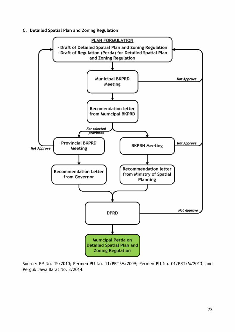
73
C. Detailed Spatial Plan and Zoning Regulation
Source: PP No. 15/2010; Permen PU No. 11/PRT/M/2009; Permen PU No. 01/PRT/M/2013; and
Pergub Jawa Barat No. 3/2014.

74
Appendix 4 Website List of Indonesia Government Agencies
No. Name of Agency Website
1 Bappeda DKI Jakarta - http://bappedajakarta.go.id/ - http://www.sosialisasirdtrdkijakarta.com/index.php
2 BKPRN http://www.bkprn.org
3 BPS http://bps.go.id/
4 BPS Bekasi City https://bekasikota.bps.go.id
5 BPS Bekasi Regency https://bekasikab.bps.go.id
6 BPS Bogor City https://bogorkota.bps.go.id
7 BPS Bogor Regency https://bogorkab.bps.go.id
8 BPS Depok City https://depokkota.bps.go.id
9 BPS DKI Jakarta http://jakarta.bps.go.id/
10 BPS Tangerang City https://tangerangkota.bps.go.id
11 BPS Tangerang Regency https://tangerangkab.bps.go.id
12 BPS Tangerang Selatan City https://tangselkota.bps.go.id
13 Directorate General Spatial Planning,
Ministry of Agrarian and Spatial Plan
http://tataruang.bpn.go.id/
14 Directorate Agrarian and Spatial Plan http://tataruangpertanahan.com/
15 Ministry of Public Works http://www.pu.go.id/

75
Appendix 5 Jakarta Metropolitan Area Statistics
Local Administration Area Gross Regional Domestic Product Contribution for JMA (IDR Billion)
Local Government 2014 2013 2012
GRDP % of JMA GRDP % of JMA GRDP % of JMA
DKI Jakarta 1,760,217.25 69.85 1,546,876.49 69.54 1,103,738.00 64.56
Jawa Barat Province
- Depok City 43,675.17 1.73 38,517.10 1.73 33,283.56 1.95
- Bekasi City 64,126.99 2.54 57,715.00 2.59 51,699.22 3.02
- Bogor City 19,535.00 0.78 19,535.00 0.88 17,323.34 1.01
- Bogor Regency 151,285.11 6.00 136,134.83 6.12 120,328.73 7.04
- Bekasi Regency 227,469.49 9.03 206,362.68 9.28 188,175.43 11.01
Banten Province
- Tangerang City 110,772.32 4.40 94,241.19 4.24 83,648.13 4.89
- Tangerang Selatan City
51,230.27 2.03 44,611.13 2.01 39,071.49 2.29
- Tangerang Regency 91,692.76 3.64 80,570.55 3.62 72,303.65 4.23
JMA 2,520,004.35 100.00 2,224,563.96 100.00 1,709,571.55 100.00
Source: Statistic bureau on each municipals in JMA
JMA Gross Regional Domestic Product Contribution for Indonesia (IDR Billion)
2014 2013 2012
JMA 2,520,004.35 2,224,563.96 1,709,571.55
Indonesia 10,542,693.50 9,524,736.50 8,615,704.50
JMA contribution to Indonesia (%) 23.90 23.36 19.84
Source: Author, Processed from CBS data, 2016
JMA Population
Local Government Population (thousands) Proportion on JMA (%)
1980 1990 2000 2010 1980 1990 2000 2010
DKI Jakarta 6,504 8,259 8,384 9,608 56.40 50.71 41.10 34.37
Bekasi City - - 1,471 2,336 - - 7.21 8.36
Bekasi Regency 1,144 1,270 1,625 2,630 9.92 7.80 7.97 9.41
Bogor City 247 255 751 950 2.14 1.57 3.68 3.40
Bogor Regency 2,494 3,737 3,100 4,772 21.63 22.95 15.20 17.07
Depok City - - 973 1,736 - - 4.77 6.21
Tangerang City - - 1,312 1,798 - - 6.43 6.43
Tangerang Selatan City
- - - 1,290 - - - 4.61
Tangerang Regency 1,143 2,765 2,783 2,834 9.91 16.98 13.64 10.14
JMA 11,532 16,286 20,399 27,954 100.00 100.00
100.00 100.00
Growth Rate (% per yr)
4.12 2.52 3.71
Source: Sedyawati et al, 1987; Statistical Board from each Municipals in JMA, 2016
Note: Kota Tangerang established in 1993
Kota Bekasi established in 1996
Kota Depok established in 1999
Kota Tangerang Selatan established in 2008

JMA Local Government Revenue Budget in 2015
Government Local Revenues
(1) Central Gov't Transfers (2)
Other Sources (3)
Financing Revenue (4)
Total % of Revenue Budget
(1) (2) (3) (4)
Jakarta City 40,355,853.09 12,760,465.93 7,326,419.77 8,843,683.22 69,286,422.00 58.24 18.42 10.57 12.76
Depok City 669,967.43 977,223.33 515,464.13 386,816.14 2,549,471.03 26.28 38.33 20.22 15.17
Bogor City 541,062.16 869,535.05 318,337.57 150,936.05 1,879,870.82 28.78 46.26 16.93 8.03
Bogor Regency 1,605,209.70 2,471,188.91 1,103,158.37 343,334.67 5,522,891.65 29.06 44.74 19.97 6.22
Bekasi Regency 1,325,077.67 1,693,546.60 897,939.80 440,360.28 4,356,924.35 30.41 38.87 20.61 10.11
Bekasi City 1,325,896.80 1,380,334.29 956,436.72 550,518.36 4,213,186.17 31.47 32.76 22.70 13.07
Tangerang City 1,313,553.70 1,126,190.13 717,731.38 680,960.61 3,838,435.83 34.22 29.34 18.70 17.74
Tangerang Regency
1,428,990.55 1,493,169.53 765,724.61 684,370.14 4,372,254.83 32.68 34.15 17.51 15.65
Tangerang Selatan City
1,120,064.01 759,320.31 676,203.91 754,524.24 3,310,112.48 33.84 22.94 20.43 22.79
JMA 49,685,675.11 23,530,974.06 13,277,416.27 12,835,503.70 99,329,569.15 50.02 23.69 13.37 12.92
Source: Statistic bureau on each municipals in JMA

Appendix 6 Classification of Land Use Function in Regional Spatial Plan of JMA
The spatial zone in JMA divided into three categories which are protection,
cultivation, and buffer zone. The direction for each zone is explained bellow.
No. Code Remarks
Protection Area (Kawasan Lindung)
1. N1 Non-cultivation (in case there are cultivation areas in this zone, those should be removed immediately), protected forest, research activities, forest streams, lakes, seas and slopes, forest retention and mangrove.
2. N2 Non-cultivation, nature tourism, preservation and conservation areas for culture, flora and fauna, and research activities
Cultivation Area (Kawasan Budidaya)
3. B1 high density of urban settlement, business and services, and small, non-polluting, and market orientation industries
4. B2 medium density of rural settlement, agriculture, labour orientation industries
5. B3 low density of settlement (low-intensity for built up with technical engineering intervention) and agriculture
6. B4 low density of settlement, dry/wet crop, fishery, plantation, agro farms, and production forest
7. B4/HP B4 zone that has been issued as permanent production forest or limited production forest as in accordance with regulations and laws
8. B5 wetland agriculture (technical irrigation)
9. B6 low density of settlement (with 50% maximum of building zone coefficient), low environmental carrying capacity, and any other development activities that have been
approved by national planning coordination board
10. B7 low density of settlement (with 40% maximum of building zone coefficient), low environmental carrying capacity, production of forest, and any other development
activities that have been approved by national planning coordination board
11. B7/HP B7 zone that has been issued as permanent production of forest or limited production
of forest as in accordance with regulations and laws
Buffer Zone Area (Kawasan Penyangga)
12. P1 a land use zone that is functioned to protect from abrasion, seawater intrusion, pollution, and other damaging forces from sea, and also any other land uses aiming to protect and support N1 zone
13. P2 a land use zone that is functioned as flood prone and protection from abrasion, intrusion, pollution and other damaging forces from sea, and any other land uses aiming to protect N1 and P5
14. P3 a land use zone that is functioned as buffer zone for high density activities and accessibilities and any other land uses aiming to protect and support B1
15. P4 a land use zone that is functioned as low environmental carrying capacity aiming to support B2 and B4
16. P5 a land use zone that is functioned to protect abrasion, retention, seawater intrusion, mangrove conversion, and low environmental carrying capacity zone, and any other land
uses aiming to support N1 and B1

78
Appendix 7 Comparative Metropolitan Cases Statistics
Portland-Vancouver Metropolitan Area Population Growth
County - State Land Areas
(km2) Population (‘000)
1980 1990 2000 2010
Clark – Washington 1,699 192,227 238,053 345,238 425,363
Multnomah – Oregon 1,127 562,640 583,887 660,486 735,334
Clackamas – Oregon 4,867 241,919 278,850 338,391 375,992
Washington - Oregon 1,880 245,808 311,554 445,342 529,710
Portland-Vancouver
Metropolitan Area 9,573 1,242,594 1,412,344 1,789,457 2,066,399
Source: US Census Bureau, n.d.
Portland-Vancouver Metropolitan Area Population Distribution
County - State Population Density (people/km2) Shared on Population (%)
1980 1990 2000 2010 1980 1990 2000 2010
Clark – Washington 113.14 140.11 203.20 250.36 15.47 16.86 19.29 20.58
Multnomah – Oregon 499.40 518.26 586.24 652.68 45.28 41.34 36.91 35.59
Clackamas – Oregon 49.71 57.30 69.53 77.26 19.47 19.74 18.91 18.20
Washington - Oregon 130.73 165.69 236.84 281.71 19.78 22.06 24.89 25.63
Portland-Vancouver Metropolitan Area
129.81 147.54 186.94 215.87 100 100 100 100
Source: Author, 2016
Portland-Vancouver Metropolitan Area Built Up Areas Development (in %)
County Urban Area Low density residential Total
1974 2005 1974 2005 1974 2005
Clark – Washington 7 15 12 21 19 36
Multnomah – Oregon 41 49 9 10 50 59
Clackamas – Oregon 5 8 14 21 19 29
Washington - Oregon 7 15 3 5 10 20
Portland-Vancouver Metropolitan Area 10 16 10 15 20 31
Source: Kline, 2014
Population Dynamics and Distribution in Hong Kong
Region Land
Area (%)
Population (%) Density (people / km2)
2000 2015 2024 2000 2015 2024
Hong Kong Island 7.30 20.25 17.19 15.36 17,098 15,438 14,816
Kowloon 4.26 30.62 30.22 30.01 44,322 46,514 49,620
New Territories 88.44 49.14 52.99 54.63 3,426 3,899 4,531
Hong Kong SAR 100.00 100.00 100.00 100.00 6,167 6,557 7,044
Source: HK Planning Department, 2015a; HK Census and Statistics, 2016

79
Appendix 8 Interview Transcripts
Interview 1
Interviewee : Marcia Tamba, ST, MT, MSc.
Institution : Directorate General Spatial Planning - Ministry of Agrarian and Spatial Planning
Represent : National Sector
Part 1 Spatial Planning Policy
Q: Urban sprawl is the main issue and challenge for Indonesia’s metropolitan areas due to its fast
growing. How national government perception about this condition?
A: National government believe it is urgent to manage all metropolitan areas development so their
development able to controlled. One of the managing process is by designating metropolitan areas
as national strategic areas on RTRWN, followed with formulation of metropolitan area spatial plan
as a guidance for metropolitan areas development
Q: What kind of spatial plan policies that national government already had or wanted to dealt with
urban sprawl?
A: As for now, there are President’s Decrees which legalised metropolitan area spatial plans In
several metropolitan area. There are also several metropolitan spatial plans still in the process
of legalisation.
Q: Jakarta Metropolitan Area (JMA) national policy now based on JMA Spatial Plan (Perpres No.
58/2008). To what extend this spatial plan able to manage JMA spatial development?
A: I can only say that Jabodetabekjur spatial plan recently is in evaluation and revised process. So
far we believe there are several matter that needs to be update with recent development.
Q: Are there any specify policy which regulate metropolitan development control?
A: Metropolitan spatial plans now is already incorporated development control arrangements
Q: National policy also mandated for all municipal to have zoning regulation. What roles of national
government to support/push this policy? What are main barriers or challenges from local
government to actualizing this policy?
A: National government always encourage local government to have their detailed spatial plans and
zoning regulation. There are several measure in doing this encouragement such as: giving
authority to provincial government to give recommendation on spatial plans to shorten the
procedure on formulation of zoning regulation, giving technical assistance for zoning regulation
promulgation, workshop and capacity building to local government, provision on appropriate map
for zoning regulation, etc.
The main challenges are the lack of human resources capacity to promulgate zoning regulation,
difficulties on creating detailed map which correspondence with spatial agency requirements, etc.
Q: What kind of incentives from national government in supporting local government to formulate
and/or harness their zoning regulation
A: There are none for now, or at least not yet.
Part 2 Spatial Plan Integration

80
Q: Main issue of metropolitan spatial planning is interregional spatial plan integration. Are there any
kind of mechanism from national government to push local government in materializing the
interregional spatial plan integration?
A: We used intensive discussion along with related provincial and local government during spatial
plan formulation.
Q: To what extend national government involved in the interregional spatial plan integration? Do this
spatial integration also included at the detail level which are zoning regulation integration?
A: Yes, on zoning regulation promulgation, the zoning regulation needs to in accordance with
metropolitan spatial plan and also spatial plans of adjacent municipalities
Q: Handbook of zoning regulation formulation not specifically regulate on zoning regulation
integration among adjacent municipals. What kind of mechanism used by national government to
support zoning integration among municipals in metropolitan areas?
A: In substantial approval process, one of the main requirements is the availability on memorandum
of understanding among adjacent municipalities. We believe this system able to create
integration among adjacent municipalities.
Q: What kind of incentives given by national government for local governments which has tried to
integrate their zoning regulation?
A: Again, there are none for now, or at least not yet.
Q: There are chances that in adjacent area between municipals some different of zoning may arise.
If this zoning was contradict on each other, what national government position in this situation?
A: By looking the guidance on detailed spatial plan and zoning regulation formulation, it already
established general standard thus we hope there is a coherence in the general nomenclature. This
aspect also become the main concern of examination during substantial approval process, whether
at national level or at provincial level. I would also like to informed that there are several
provinces that authorized in granting substantial approval.
Part 3 Actors Coordination
Q: What kinds of role of national government for coordination and integration among actors in
metropolitan area? What is the example?
A: Metropolitan spatial plan mandated that metropolitan area need to establish an institution
consists of all multi-level stakeholders from national, provincial, and local
municipalities/regencies within the metropolitan areas. For Jakarta case, they already have BKSP
Jabodetabekjur.
Q: JMA is a national strategic area (PP No. 26/2008). What is the role of national government for
coordination and integration on formulation and legalization of municipal zoning regulation? What
kind of input did the national government gave? And to what extent did this input an impact on
the plan?
A: On substantial approval process, central government will check to what extend the detailed spatial
plan and zoning regulation is synchronized with metropolitan spatial plans. Central government
also check the agreement among the adjacent local government. Those two efforts is essential
due to the importance of zoning regulation which in accordance with metropolitan spatial plan
and synchronised with adjacent municipalities/regencies spatial plan.
Q: Are there any examples of successful inter-municipals zoning regulation integration in Indonesia?

81
A: All zoning regulation which already have substantial approval we believe already passes through
the synchronisation and integration process with metropolitan spatial plan and local spatial plans
Q: In case there is a conflict on zoning regulation in adjacent municipals, what national government
role/action in this conflict? Who has the responsibility to manage the dispute?
A: In case there is un-synchronise spatial plan, we will look upon the higher tier spatial plan. Such
as for metropolitan area, we will use metropolitan area spatial plan. If the conflict is persists,
the institution in those national strategic area will discussed and giving the solution.
Q: JMA have institution called BKSP, for coordinating metropolitan development. To what extend
coordinating function from this agency able to support spatial plan integration? Do this
coordination also included zoning regulation integration?
A: I’m not qualified to answer this question, you may ask Ika, my colleagues for this question.

82
Interview Transcript 2
Interviewee : Ika Pancawati, ST, MT.
Institution : Directorate General Spatial Planning - Ministry of Agrarian and Spatial Planning
Represent : National Sector
Part 1 Spatial Planning Policy
Q: Urban sprawl is the main issue and challenge for Indonesia’s metropolitan areas due to its fast
growing. How national government perception about this condition?
A: For metropolitan areas, we utilize metropolitan spatial planning to managing urban sprawl. The
concept of metropolitan development in our views is a combination between rural and urban
integration in specified areas based on eco region and administrative boundary consideration.
Q: What kind of spatial plan policies that national government already had or wanted to dealt with
urban sprawl?
A: We already have metropolitan spatial plans for JMA, Medan, Denpasar, and Makassar which already
legalized through presidential regulation (Perpres). Now, we also in the process of final phase of
Surabaya, Bandung, Semarang and Yogyakarta spatial plan formulation. The availability of
Ministry Regulation on guidance on formulation of national strategic area spatial plan also helps
us to standardize the metropolitan spatial planning.
The standardize spatial plan is necessary because those spatial plan also equipped with program
indications that states all central government programmes which will implemented on the
metropolitan areas.
By using metropolitan, we have clear guidance and able to formulate the medium term integrated
infrastructure development plan which contains list of all development plan from all central
government sectors in the related metropolitan areas. This document, also our way to
incorporating sectors plans to support spatial plan implementation
Q: Jakarta Metropolitan Area (JMA) national policy now based on JMA Spatial Plan (Perpres No.
58/2008). To what extend this spatial plan able to manage JMA spatial development?
A: For JMA spatial plan case, we admitted that there are several aspects in JMA spatial plan which
already outdate and need to be revised. For example, JMA spatial plan is not incorporated the
development of MRT in Jakarta City, and also Jakarta City BRT system and its connection with
Jakarta City hinterland
Q: Are there any specify policy which regulate metropolitan development control?
A: The new metropolitan spatial plan is more comprehensive than JMA metropolitan plans. We plan
to revised and upgrade JMA spatial plan towards that level. There are also guidance for
formulating metropolitan spatial plans which states what kind development control tools that will
be used and more detailing about zoning residential guidance.
Q: National policy also mandated for all municipal to have zoning regulation. What roles of national
government to support/push this policy? What are main barriers or challenges from local
government to actualizing this policy?
A: National government become a place for local government to giving advice and counsel. We
encourage all local government to rapidly formulating and legalising their zoning regulation. I
believed that main barriers which hindered zoning regulation formulation process is the number
of local government budget, knowledge and experiences of the local government apparatus, .

83
Q: What kind of incentives from national government in supporting local government to formulate
and/or harness their zoning regulation
A: Central government giving technical assistance for the municipals or giving an help for BKPRD
province for the substantial approval process.
Part 2 Spatial Plan Integration
Q: Main issue of metropolitan spatial planning is interregional spatial plan integration. Are there any
kind of mechanism from national government to push local government in materializing the
interregional spatial plan integration?
A: First, the mechanism is through the agreement among adjacent municipal on spatial planning.
Second, the agreement must be signed by all adjacent municipals. Lastly, central government also
analysed the content of the local government spatial plan to understand the consistency of their
zoning regulation with JMA spatial plan and other related guidance.
Q: To what extend national government involved in the interregional spatial plan integration? Do this
spatial integration also included at the detail level which are zoning regulation integration?
A: We involved in the process of evaluating the result of the zoning regulation. At some point, we
also giving an example by creating a zoning regulation for some parts of the metropolitan areas
as part of our technical assistance programmes. Yes, like with the making of general spatial plans
we also enacted the same arrangements for zoning regulation which is the plans must be discussed
and agreed by neighbouring municipals.
Q: Handbook of zoning regulation formulation not specifically regulate on zoning regulation
integration among adjacent municipals. What kind of mechanism used by national government to
support zoning integration among municipals in metropolitan areas?
A: I think the guidance already include that. It said that local government needs to have a signed
agreement with other municipals that their spatial plans Is in accordance with their neighbouring
spatial plans.
Q: What kind of incentives given by national government for local governments which has tried to
integrate their zoning regulation?
A: By facilitating them through the BKPRN discussions. At some level, we also allowed province
governance to giving substantial process to reduce the red tape.
Q: There are chances that in adjacent area between municipals some different of zoning may arise.
If this zoning was contradict on each other, what national government position in this situation?
A: Yes, unfortunately this situation may happened with so many zoning regulation that will available
in Indonesia. Our guidance of zoning regulation promulgation is tried to avoid that by giving
example of land use designate standardization. However, if the problem is still persisted, we will
use the metropolitan spatial plans as the main source of answers.
Part 3 Actors Coordination
Q: What kinds of role of national government for coordination and integration among actors in
metropolitan area? What is the example?
A: We involved in multi-function capacity. At some point, we become the initiator for encouraging
local government in metropolitan areas to coordinating their spatial plan. We also become the
evaluator regarding whether the zoning regulation is acceptable or not. For example, zoning

84
regulation must have detailed information on the scale of map in 1:5000 scale. National
government, especially geospatial agency always making sure that the map is in accordance with
the requirement. We also evaluate perda (local laws) of the zoning regulation.
Q: JMA is a national strategic area (PP No. 26/2008). What is the role of national government for
coordination and integration on formulation and legalization of municipal zoning regulation? What
kind of input did the national government gave? And to what extent did this input an impact on
the plan?
A: Our role is by creating a guidance aspect for metropolitan development, in this instance we must
able to provide with metropolitan spatial plan. This metropolitan spatial plan needs to adopted
by general local spatial plans and zoning regulation.
Q: Are there any examples of successful inter-municipals zoning regulation integration in Indonesia?
A: Unfortunately, for zoning regulation is not yet available. Our efforts is still focus at the general
spatial plan level right now.
Q: In case there is a conflict on zoning regulation in adjacent municipals, what national government
role/action in this conflict? Who has the responsibility to manage the dispute?
A: It was BKPRN and BKPRD functions as the mediator. We give recommendation for local government
if the problem is arise. Of course, with decentralization the local government may have their own
priorities. In this instance, we can use the substantial approval process as our chance to manage
this dispute or inconsistency of planning.
Q: JMA have institution called BKSP, for coordinating metropolitan development. To what extend
coordinating function from this agency able to support spatial plan integration? Do this
coordination also included zoning regulation integration?
A: We aware of BKSP, however they only focus on the development, not in the spatial plan.

85
Interview Transcript 3
Interviewee : Hendricus Andi Simarmata, ST, MSi, PhD.
Institution : Indonesia Association of Planner.
Represent : National Sector
Part 1 Spatial Planning Policy
Q: Urban sprawl is the main issue and challenge for Indonesia’s metropolitan areas due to its fast
growing. How national government perception about this condition?
A: I think central government already aware about this situation. As far as I know, several ministry
have a document reports about this. Like DG Spatial Planning with their JMA spatial plan. Off
course JMA spatial planning is not solely DG Spatial Planning document’s because have consensus
with many stakeholder, however in this example let’s just say that JMA Spatial planning is DG
Spatial Planning document. Other report is Bappenas with Urban Development Strategy. For
integrated infrastructure development there is Urban Settlement Infrastructure Development Plan
(RP2KP) from DG Human Settlements.
Are of my example shows that central government already aware of the urban sprawl, however
those caring is become fragmented in different central government sectors.
Q: What kind of spatial plan policies that national government already had or wanted to dealt with
urban sprawl?
A: For specifically spatial plan, there are RTRWN followed by Island spatial plans such as Java-Bali
Island Spatial Plan for JMA case. And there also JMA Spatial Plan. RTRWN is the main guidance
for metropolitan development because in this document national government stated the name
and location of the national metropolitan areas. There are I think 9 metropolitan areas which
become central government concern, which are Jakarta, Bandung, Surabaya, Semarang, Medan,
Makassar, Denpasar, and Banjar Baru.
Some of the spatial plan were already legalised through Presidential Regulation, while the others
is still in the process either in the formulation or legalisation.
Q: Jakarta Metropolitan Area (JMA) national policy now based on JMA Spatial Plan (Perpres No.
58/2008). To what extend this spatial plan able to manage JMA spatial development?
A: I would say that for spatia structure development, such as toll road, rail track and other
infrastructure, JMA is good enough to provide guidance. However for spatial patter, which is land
use designation arrangement, JMA spatial plan still needs more elaboration. I understand that
JMA spatial plan also has other flaw such as no program indication, no zoning regulation
arrangements, land use mismatch between the plan and reality after 8 years being legalised, etc.
Those flaws happened because JMA Spatial Plan in my opinion little bit rushed for its legalisation.
Created in the era of old spatial planning law (Law No. 14/1992) and then come the new one (Law
No. 26/2007), JMA spatial plan tried to in accordance with the new law in a very short time.
Nevertheless there are many details still not mention in the Law 26/2007 about metropolitan
spatial plan, the details come later by Government Regulation No. 15/2010 and Guidance of
National Strategic Area’s Spatial Plan formulation (Permen PU No. 15/2012).
Thus if compare JMA spatial plan with Medan or Makassar or Denpasar spatial plans, many of JMA
spatial plan content is still “minimalize”.
Q: Are there any specify policy which regulate metropolitan development control?

86
A: Besides metropolitan spatial plans and local government zoning regulations, there are no policy
about metropolitan development control.
Q: National policy also mandated for all municipal to have zoning regulation. What roles of national
government to support/push this policy? What are main barriers or challenges from local
government to actualizing this policy?
A: In previous years, there are several program from central government to support municipal to
have zoning regulation. Such as technical assistance for zoning regulation formulation, workshop
and training for local government apparatus, and seminar on zoning regulation importance and
implementation.
Those central government aims is to elevate local government capacity building, which is the
primary reason behind local government lagging in zoning regulation formulation. Several local
government also have problems with their budget for planning since most of their funding is come
from central government fund. Prior to 2014, based on local government laws, most of funds must
allocated to the basic human needs priorities such as education, health and infrastructure.
Fortunately the amendment of local government law in 2014 include spatial plan as local
government priority.
At local level, there are also different priorities between local governments. Some wants to boost
its economic development, the others focus on basic infrastructure development, and some still
juggling with how to balanced their budget. Those different priorities sometimes makes local
government put spatial planning on low priorities.
Q: What kind of incentives from national government in supporting local government to formulate
and/or harness their zoning regulation
A: Intensive workshop or training is the key. It is just those effort only held by government. We from
Indonesia Association of Planners also have the similar program, however there is no cooperation
between our institution and government institution. Yes, some of our management members is
the one whom become the trainer or assistance in the workshop or training, however that is in
personal or contractual arrangement not in inter institution collaboration arrangement.
Part 2 Spatial Plan Integration
Q: Main issue of metropolitan spatial planning is interregional spatial plan integration. Are there any
kind of mechanism from national government to push local government in materializing the
interregional spatial plan integration?
A: There are BKPRN and BKPRD meeting/discussion for integration of spatial planning. However those
discussion is a limited forum. It is only involved government sector representation. Towards more
communicative planning, I would recommended that BKPRN and BKPRD discussion need to
inclusive more broad representatives. In development planning, there is an inclusive effort called
musyarawah perencanaan pembangunan/musrenbang (development planning discussion) which
incorporated representatives from various actors not just government actors. It’s a pity spatial
planning discussion is not using the same model.
Q: To what extend national government involved in the interregional spatial plan integration? Do this
spatial integration also included at the detail level which are zoning regulation integration?
A: National government only focus on the national strategic areas, that is way they trying hard to
finished all of national strategic areas spatial plan. There is more than 100 of them, so it takes
lot of time and effort to finish the target.
And yes, those spatial plan integration also in zoning regulation level. At some point, central
government also creates zoning regulation arrangement for the specific national strategic areas

87
which has small size land area such are for Borobudur Temple areas or Komodo Island. They
integrating national plan into local plan. For other general zoning regulation, the BKPRN and
BKPRD is the national government effort to ensure that local zoning regulation is in accordance
with national policies.
Q: Handbook of zoning regulation formulation not specifically regulate on zoning regulation
integration among adjacent municipals. What kind of mechanism used by national government to
support zoning integration among municipals in metropolitan areas?
A: Yes, this handbook not giving much details about zoning regulation integration. I think this
concern is not arise yet because this handbook only focus on quickly make local government has
their own zoning regulations. This handbook believes as long as the general planning is already
integrated and there is an agreement among adjacent municipals so it was enough.
Q: What kind of incentives given by national government for local governments which has tried to
integrate their zoning regulation?
A: Not much, perhaps just appreciation and making the local government as lesson learned for others.
There is a discourse to put more funds for local government who already fulfil their duties in
finishing zoning regulation, however there is no recent news about this suggestion.
Q: There are chances that in adjacent area between municipals some different of zoning may arise.
If this zoning was contradict on each other, what national government position in this situation?
A: This situation actually already happened. If we take a look on zoning regulation in JMA areas,
Jakarta City have different category of land designation with Bekasi and Depok City. I really hope
BKPRN discussion is aware about this situation, because if not there will be overlapping or
mismatch on physical development in JMA.
Part 3 Actors Coordination
Q: What kinds of role of national government for coordination and integration among actors in
metropolitan area? What is the example?
A: Central government must act as mediator which enabled multi actors to have same degree of
position. This function will allows no hierarchical boundary among involved actors. Yogyakarta is
one of good example for this. Their provincial government creates joint secretary with municipal
government to discuss their problems. Each member on this joint secretary is regarded as equal,
and due to that they able to easily gain consensus for solution of their problems.
Q: JMA is a national strategic area (PP No. 26/2008). What is the role of national government for
coordination and integration on formulation and legalization of municipal zoning regulation? What
kind of input did the national government gave? And to what extent did this input an impact on
the plan?
A: I think my answer by using Yogyakarta examples is good enough to answer the question about
coordination. Off course, central government is benefits with lots of expert pools in their reach,
therefore they must utilize this resources to produce positive input to improve municipals zoning
regulation. Then, whether or not this input able to change the municipals zoning regulation is
need to discussed as equal partners not as sub-ordinate.
Q: Are there any examples of successful inter-municipals zoning regulation integration in Indonesia?
A: For zoning regulation, in my knowledge there is none inter municipals zoning regulation because
only few of municipals which already have legalised zoning regulation.

88
Q: In case there is a conflict on zoning regulation in adjacent municipals, what national government
role/action in this conflict? Who has the responsibility to manage the dispute?
A: Again, national government should be a mediator. Responsibility of this dispute is need to put
under equal joint committee in order to ensure inclusiveness. However, this is not one for all
panacea, the national government also need to be able to put different position such as leader or
initiators when the need is arise.
Q: JMA have institution called BKSP, for coordinating metropolitan development. To what extend
coordinating function from this agency able to support spatial plan integration? Do this
coordination also included zoning regulation integration?
A: Fortunately, BKSP not being used to coordinating spatial plan. It focus is only development
planning for infrastructure. There are many research shows that BKSP need to enhance its role
not just about development institution but also an inclusive planning institution with strong power
to monitor and evaluating the implementation of JMA spatial plan and JMA’s local government
spatial plans.

89
Interview Transcript 4
Interviewee : Anni Maryam Siregar, ST, MT.
Institution : Planning and Development Agency – Jakarta Special Capital Region
Represent : Local Government
Part 1 Spatial Planning Policy
Q: Urban sprawl is the main issue and challenge for Indonesia’s metropolitan areas. What is your
government view related to this phenomenon?
A: Jakarta Special Capital Region is very aware of the situation. As the densest area in Indonesia,
we are really concern about urban sprawl. In our latest spatial plan and zoning regulation, we
encourage new development in the vertical dimension.
Q: To what extend your spatial plan (RTRW) able to accommodate urban sprawl issue?
A: As I said before, by encouraging of vertical development. To support this development, we also
enabled the mixed use development. The mixed use is between residential-commercial,
residential-services, and commercial=services.
Q: Jakarta Metropolitan Area (JMA) national policy now based on JMA Spatial Plan (Perpres No.
58/2008). To what extend your RTRW accommodate the JMA spatial plan? Do the JMA spatial plan
still able to catch up with dynamics of spatial land use in JMA?
A: Our RTRW is based on JMA spatial plan, however we have difficulties to really adopting JMA spatial
plan because JMA spatial plan is already outdated. Several national strategic project is not yet
regulate by JMA spatial plan, such as our new MRT project, new development of fast train
supported infrastructure, and so on.
Q: Are there any national policy which supported metropolitan spatial plan cooperation? To what
extend this policy able to support harmonization on municipals spatial land use management?
A: There is national policy related to development cooperation, however for spatial plan cooperation
is only through metropolitan spatial plan.
Q: National policy also mandated for all municipal to have zoning regulation. What roles of your
government to support this policy? What are main barriers or challenges on your government to
actualizing this policy?
A: Jakarta City as 2015 already have legalized zoning regulation. We may say that we are the pioneer
in Indonesia. Our main barriers is to made consensus from our stakeholders. Jakarta is consists
of to many various actors with different priority. In order to made sure zoning regulation able to
accommodate many differences we put an extra time in dissemination and public hearing process.
Q: To what extend your government have the zoning regulation (formulation or legalization or
legalized)? How long have it takes in your zoning regulation process? If your government still have
not legalized the zoning regulation, when is your target?
A: Our zoning regulation is already legalized. We officially started the process in 2011, so it takes
almost 4 years to complete the formulation process.
Q: What kind of incentives given by national and/or province government in supporting your
government to formulate and/or harness the zoning regulation?

90
A: The national government giving workshop or training on the content of zoning regulation. As this
arrangement is new in Indonesia, we also have many discussions related how bring zoning
regulation in the practical aspect in Indonesia
Part 2 Spatial Plan Integration
Q: Main issue of metropolitan spatial planning is interregional spatial plan integration. Are there any
kind those process? What mechanism from your government in materializing the interregional
spatial plan integration?
A: For spatial plan, the availability on metropolitan spatial plans in my opinion able to enhance
spatial plan integration. By using JMA spatial plan as guidance, each local government already
know their function and role in the JMA spatial development.
Q: To what extend your government involved in the interregional spatial plan integration process? Do
this spatial integration also included at the level of zoning regulation?
A: As the core of JMA, we expressed our hope related interregional spatial plan. By using BKPRN
forum, we always giving our concern how development in JMA is not sustainable. For example,
there is no integrated transportation system among us. Jakarta City already giving our concept,
however the cooperation is not yet established. Rail transportation is helping us to reducing
motorization, however its network is still limited. And the rail transportation is managed by state
owned company which responsible to central government. Therefore, some of their plan is central
government plan, not local government plan.
Yes, the spatial integration is also for zoning regulation. Fortunately, our outskirts is designate as
residential areas which in accordance with Jakarta City neighbourhood. So there is not much
problem. Probably the problem that may arise is in Jakarta City southern parts. We planned to
develop low density development in those areas with its function as catchment area. However,
we afraid Depok City will encourage medium to high density development in the border areas. If
yes, that could be threaten us in the practice.
Q: Handbook of zoning regulation formulation not specifically regulate on zoning regulation
integration among adjacent municipals. What kind of mechanism need to do by local government
to support zoning integration among municipals in metropolitan areas?
A: No, I think the agreement among local government which states on that guidance is rather enough.
Q: Did your government also had discussion and public hearing with other municipals during on zoning
regulation? In what phase did this process is being done?
A: Yes we have public hearing with other municipals during our zoning regulation formulation
process. As I said earlier, there are not many differences with other local government that
adjacent to us, which are Tangerang City, Tangerang Selatan City, Depok City and Bekasi City.
Our long process is happened in internal Jakarta City. We have to accommodate various
aspirations from our various stakeholders.
Q: What kind of incentives given by national government for local governments which has tried to
integrate their zoning regulation?
A: Only in the terms of workshop or seminar.
Q: There are chances that in adjacent area between municipals some different of zoning may arise.
If this zoning was contradict on each other, what your government do in this situation?
A: We believe that our spatial plan is an answer to our crowded and uncontrolled situation. We just
hope that other municipals just follow our leads in the zoning regulation.

91
Part 3 Actors Coordination
Q: To what extend do you think national and province government has supported the coordination
and integration of spatial planning
A: National government supported us through its BKPRN procedure. With those procedure, central
government able to binding other municipals to always in accordance with JMA spatial plan.
Q: What kinds the role of your government for coordination and integration among actors in
metropolitan area? What is the example?
A: As the biggest in the terms of land area on JMA, we really hope we can be the example for other
government. For example, our zoning regulation can be used as inspiration for other municipals
zoning regulation. Our transportation authority also could be example on how to organize
integrate public transportation which previously come from many private sectors. Of course it’s
not perfect, but it’s better than just rely on uncoordinated private sectors to organize it.
Q: JMA is a national strategic area (PP No. 26/2008). What is the role of your government for
coordination and integration on formulation and legalization of municipal zoning regulation? What
kind of input did the national government and other municipal governments gave? And to what
extent did this input an impact on your plan?
A: As strategic area, especially in Jakarta City, there are many national interest that will developed
in Jakarta City. Sometimes, those interest is not accommodated in our spatial plan. Therefore,
although we use statutory plan with zoning regulation, we also must employ flexibility when there
is major national infrastructure happened in us. The case of Jakarta-Bandung high speed train is
one example. Our spatial plan is not contain about this project, fortunately development of the
train infrastructure is happened in Halim areas, which is also transportation hub, so this won’t
change much in our zoning regulation. However, I can’t imagine how other areas deal with this
situation.
Q: In case there is a conflict on zoning regulation in adjacent municipals, what is your government
role/action in this conflict? Who has the responsibility to manage the dispute?
A: The responsibility of managing the conflict is on the central government. Jakarta City with its
budget power may become the leader, but in order to honoured other local government we prefer
central government as the one who have responsibility as mediator and bring all local government
in JMA to come up with agreement.
Q: JMA have institution called BKSP, for coordinating metropolitan development. To what extend
coordinating function from this agency able to support spatial plan integration? Do this
coordination also included zoning regulation integration?
A: We are using BKSP mainly for infrastructure development coordination. For example is the
creation of water flood infrastructure which involved multi government. And then final disposal
cooperation, and soon. Jakarta City would like to use BKSP in spatial plan coordination, however
we see that BKSP is manage by central government appointee. What we really like is BKSP is an
institution which equally represents all local government.

92
Interview Transcript 5
Interviewee : Maulana Prayoga (1) and Yulia Rachmawati (2)
Institution : Planning and Development Agency, City of Tangerang Selatan
Represent : Local Government
Part 1 Spatial Planning Policy
Q: Urban sprawl is the main issue and challenge for Indonesia’s metropolitan areas. What is your
government view related to this phenomenon?
A: (1): First, I would like to explain that for spatial plan, as for now Tangerang Selatan already have
RTRW. It was legalized in 2011. The RTRW is the legal based for development permit in our cities,
of course it is not ideal due to scale of planning. However, Tangerang Selatan City is a new city.
We proliferated from Tangerang Regency in 2008. After become autonomous, there are lots that
need to consolidate. But in the end we able to legalized our RTRW in 2011.
(2): Our RTRW is our interpretation of JMA spatial plan to our local needs. And in dealing with
urban sprawl, our RTRW already designated space in our city for high, medium and low density
development. The location is based on the proximity to Jakarta City and our surrounding cities or
activity centres.
Q: To what extend your spatial plan (RTRW) able to accommodate urban sprawl issue?
A: (1) Our RTRW as development control guidance is not detailed enough, therefore our spatial plan
agency is already formulate zoning regulation, it’s not legalized yet. But we used major decree
for our development permit based on spatial agency recommendation. Their recommendation is
based on our draft of zoning regulation. Therefore yes I can say we still use hybrid of discretionary
and statutory system now, not fully statutory system. As for whether or not our system now
enabled us to manage urban sprawl, at some point we could say we are lucky. As a dormitory
areas most of our place is already developed by big developer such as Bintaro Jaya, Bumi Serpong
Damai, Alam Sutera, etc. We utilize their master plan and then combined it with ours. For those
areas, we could say we can manage with urban sprawl. Our concern now is on the kampong (urban
village) or self-organising development areas which developed by small developer or the people
itself. Those areas was spontaneous growth and existed before our proliferation, therefore we
need to take extra efforts to manage those areas.
Q: Jakarta Metropolitan Area (JMA) national policy now based on JMA Spatial Plan (Perpres No.
58/2008). To what extend your RTRW accommodate the JMA spatial plan? Do the JMA spatial plan
still able to catch up with dynamics of spatial land use in JMA?
A: (1) I’m not really know about this, but my colleague Yulia will able to answer this question.
(2) Our spatial plan must in accordance with JMA spatial plan. That is the main requirement from
central government to give approval for our spatial plan during the BKPRN discussion.
Q: Are there any national policy which supported metropolitan spatial plan cooperation? To what
extend this policy able to support harmonization on municipals spatial land use management?
A: (1) and (2): JMA is the main policy.
(1) I think we don’t have any problem with our neighbouring municipalities. Our focuses is for
residential development and some commercial areas in the main corridor. Our neighbour, Jakarta
City, Depok City, Tangerang City, Bogor Regency, and Tangerang Regency also develop their
border area with us for residential area. Also the gradation of development is almost the same,
high density development in the eastern areas which adjacent with Jakarta City and Depok City.

93
Medium density in centre of our administrative area and then low density development in our
western and southern area which adjacent with Tangerang and Bogor Regency.
(2) The JMA spatial plan is one of the primary guidance in formulating our RTRW. For its binding
guidance, Tangerang Selatan cannot do anything if our plan is different with JMA spatial plan.
Such as, several of our areas designated as B3 and B2 while in the reality they are already B2 and
B1. Also, we understand that JMA spatial plan formulated while Tangerang Selatan still under
Tangerang Regency, and by that time there are several areas designated as industrial areas.
However, now Tangerang Selatan City is more focus on development for commercial and
residential areas. There will be no new development for industrial areas. They are some examples
which happened in our City.
Q: National policy also mandated for all municipal to have zoning regulation. What roles of your
government to support this policy? What are main barriers or challenges on your government to
actualizing this policy?
A: (1) We still don’t have zoning regulation now, however we used draft of the zoning regulation as
our based on development permit.
(2) Now we are still in the process of formulating zoning regulation. Next year we are going to
begin legalizing proses. Mainly our challenges is we are new city in term of administrative
government. At first 3 years after our city officially seceded from Tangerang, most of our efforts
is for internal consolidation. It’s have been better now, that’s why we can more focus on the
spatial planning. And we also one of the new administrative region in Indonesia which do not have
problems with budgeting because our local revenues is very good.
Q: To what extend your government have the zoning regulation (formulation or legalization or
legalized)? How long have it takes in your zoning regulation process? If your government still have
not legalized the zoning regulation, when is your target?
A: (2) As I answered in previous question, we still on the formulation phased. We actually already
have the zoning regulation, however recent dynamics such as new toll road development and new
railway development make us to revise our zoning regulation.
Q: What kind of incentives given by national and/or province government in supporting your
government to formulate and/or harness the zoning regulation?
A: There is not much, it is us who often ask for guidance and consultation with DG spatial planning.
And they always willing to help us when we come to them.
Part 2 Spatial Plan Integration
Q: Main issue of metropolitan spatial planning is interregional spatial plan integration. Are there any
kind those process? What mechanism from your government in materializing the interregional
spatial plan integration?
A: (1) and (2): BKPRN discussion is the process of creating integrated interregional spatial plan.
Q: To what extend your government involved in the interregional spatial plan integration process? Do
this spatial integration also included at the level of zoning regulation?
A: (2) Our involvement is in the form of participated in each discussion held by central government.
Yes this spatial integration is on zoning regulation. Previously I forgot to mention that in zoning
regulation formulation, we also must conducted an agreement proses with neighbouring
municipals. This process is also a requirement from national government in order to get their
substantial approval.

94
Q: Handbook of zoning regulation formulation not specifically regulate on zoning regulation
integration among adjacent municipals. What kind of mechanism need to do by local government
to support zoning integration among municipals in metropolitan areas?
A: (2) I think with its procedure which required local government to have agreement with
neighbouring municipals already considered as integration effort. So that’s enough.
Q: Did your government also had discussion and public hearing with other municipals during on zoning
regulation? In what phase did this process is being done?
A: (2) Yes, like I said before. We meet and discuss it with our adjacent municipals and then created
and agreement about our zoning regulation. This happened in our formulation process, we are not
yet in the legislation process.
Q: What kind of incentives given by national government for local governments which has tried to
integrate their zoning regulation?
A: (2) Again, not much. I think by we often come to central government to ask for counsel, they
already believed we realise our needs, and they don’t have to “push” us anymore in creating
zoning regulation.
Q: There are chances that in adjacent area between municipals some different of zoning may arise.
If this zoning was contradict on each other, what your government do in this situation?
A: (1) and (2) concurs that the neighboring areas agreement is enough for this situation
Part 3 Actors Coordination
Q: To what extend do you think national and province government has supported the coordination
and integration of spatial planning
A: (1) I will leave Yulia explain about this part.
(2) National government is very supporting us. Now is almost five years after we promulgated our
RTRW. By definition of law, we able to evaluate and revise our spatial plan every five years. On
this occasion, we also asked for counsel for central government. At the same time, we also suggest
our recommendation for JMA spatial plan revision related development in our areas. They gladly
accept our suggestion, and put it in their reports on progress of JMA spatial plan revision.
Q: What kinds the role of your government for coordination and integration among actors in
metropolitan area? What is the example
A: (2) By following the guidance from the JMA spatial plan, and actively come to BKPRN discussion, I
believed we already involved with coordination and integration.
Q: JMA is a national strategic area (PP No. 26/2008). What is the role of your government for
coordination and integration on formulation and legalization of municipal zoning regulation? What
kind of input did the national government and other municipal governments gave? And to what
extent did this input an impact on your plan?
A: (2) Our contribution is only in our part creating our zoning regulation which then counselled with
central government and neighbouring municipals. National government inputs mostly about
national newly plan of infrastructure development which would located or transverse Tangerang
Selatan City. I admit, this new dynamics also the reason why our zoning regulation still not finished
is formulation process.
Q: In case there is a conflict on zoning regulation in adjacent municipals, what is your government
role/action in this conflict? Who has the responsibility to manage the dispute?

95
A: (2) I think we need to hold off our development and asking central government counsel or
meditating through BKPRN discussion.
Q: JMA have institution called BKSP, for coordinating metropolitan development. To what extend
coordinating function from this agency able to support spatial plan integration? Do this
coordination also included zoning regulation integration?
A: (2) Your question actually makes me realized. I knew there is BKSP forum, however as far as I
know we never have or I never joining any discussion about spatial planning in BKSP forum.

96
Interview Transcript 6
Interviewee : Arief Panuju
Institution : Spatial Planning Agency, City of Depok
Represent : Local Government
Part 1 Spatial Planning Policy
Q: Urban sprawl is the main issue and challenge for Indonesia’s metropolitan areas. What is your
government view related to this phenomenon?
A: In dealing with urban sprawl, by the end of 2015 we (Depok City) already have and legalized our
RTRW Kota (city general spatial plan). This RTRW mainly based on the JMA spatial plan although
there were some differences in the content of our RTRW. However, this differences already
discussed with province and central government through Provincial BKPRD and BKPRN discussion.
For your information, the substantial approval for Depok City is given by West Java Province. West
Java Province is selected as one of several provinces in Indonesia which given authority by central
government for giving approval in the substantial approval process.
Q: To what extend your spatial plan (RTRW) able to accommodate urban sprawl issue?
A: Our RTRW is the adoption of JMA spatial plan in detailed scale. We believe, despite there are
several things that need to be revised, the JMA spatial plan is already consider about urban sprawl.
Therefore, by adopting JMA spatial plan, our RTRW already accommodating urban sprawl issue.
JMA spatial plan designated Depok City as B1, B2, and B3 which is basically for built-up area
development. Our spatial tries to put those designated land use into more detail scale.
Q: Jakarta Metropolitan Area (JMA) national policy now based on JMA Spatial Plan (Perpres No.
58/2008). To what extend your RTRW accommodate the JMA spatial plan? Do the JMA spatial plan
still able to catch up with dynamics of spatial land use in JMA?
A: Yes, we see that there is some discrepancies with condition in reality. Actually, when JMA spatial
plans being legalized back in 2008, the discrepancies is already exit. Depok City already giving
their opinions regarding those discrepancies and noted by central government. However, the
current JMA spatial plans is just the way it is.
Example of discrepancies is the gap for designated of land in southern Jakarta City as B3 which
adjacent to northern part of Depok City which is B1. In our spatial plan, we designated those area
as B2 to avoid those “leap”.
We realised that central government are in the process of revised the JMA spatial plan. Some of
Directorate General of Spatial Planning representatives also come to us to gain new information
on Depok current situation. They also comes and ask our help in updating their data/
Q: Are there any national policy which supported metropolitan spatial plan cooperation? To what
extend this policy able to support harmonization on municipals spatial land use management?
A: I think it is the function of BKPRN meeting. Of course for West Java Province now we have BKPRD
province meeting.
Q: National policy also mandated for all municipal to have zoning regulation. What roles of your
government to support this policy? What are main barriers or challenges on your government to
actualizing this policy?
A: Yes, we currently already have our draft of zoning regulation. Actually, after the draft of RTRW
is completed but not yet legalized, we started the process of formulating our zoning regulation.

97
Now our zoning regulation is in the process of legalization, and the process is already started in
this year. However we can’t certain when the zoning regulation is going to be legalized because
the process now is political process. What I mean of political process is, the process not just about
a technical or optimization of land use, it’s about bringing the plan able to accepted by public
entities, which in this situation is represents by our house of representatives (DPRD) members.
Q: To what extend your government have the zoning regulation (formulation or legalization or
legalized)? How long have it takes in your zoning regulation process? If your government still have
not legalized the zoning regulation, when is your target?
A: (previous explanation by interviewees already explain the answer)
Q: What kind of incentives given by national and/or province government in supporting your
government to formulate and/or harness the zoning regulation?
A: There are some training and workshop as an effort to increase our capacity building related to
zoning regulation, both from central government and provincial government. Nevertheless, you
question is makes me realise that last time central government giving those capacity building is
about two years ago. If my memory serves better, those capacity building happened when DG
Spatial Planning still under Ministry of Public Works. In my opinion, looks DG Spatial Planning now
in consolidating phased, especially with the creation of Ministry of Agrarian and Spatial Planning
which amalgamated the DG Spatial Planning with national land agency.
Part 2 Spatial Plan Integration
Q: Main issue of metropolitan spatial planning is interregional spatial plan integration. Are there any
kind those process? What mechanism from your government in materializing the interregional
spatial plan integration?
A: For interregional spatial plan integration, we exercised process which called agreement with
neighbouring areas. This process is enabled through a discussion between Depok City and other
neighbouring municipalities about our spatial plan. For this occasion, we support each other’s’.
What I meant is, when Bogor Regency needs to discuss their spatial plan, they invite us to have
discussion. The result of the discussion is an agreement or kinds of memorandum of understanding
that there is a synchronisation of our land use planning. These MoU then used by us when we
submit for substantial approval to Provincial BKPRD or BKPRN. We also doing the same thing with
our other neighbouring area such as Jakarta City, Tangerang Selatan City and Bekasi City.
Q: To what extend your government involved in the interregional spatial plan integration process? Do
this spatial integration also included at the level of zoning regulation?
A: I think, my explanation above is already answers the first question. For the next question, my
answer is yes. Likely with general spatial plan, zoning regulation also need to have MoU with
neighbouring areas.
Q: Handbook of zoning regulation formulation not specifically regulate on zoning regulation
integration among adjacent municipals. What kind of mechanism need to do by local government
to support zoning integration among municipals in metropolitan areas?
A: Yes, I agree if we talk about specific or matter of detail. The guidance is only says that we need
to be in accordance and have agreement with neighbouring areas. However, the BKPRD and BKPRN
forum/arrangements is enough to bridging this undetailed/unspecific matters.
Q: Did your government also had discussion and public hearing with other municipals on zoning
regulation? In what phase did this process is being done?

98
A: Yes, I think I already said that we have discussion and public hearing with neighbouring municipals
on zoning regulation. This process is executed after we have finished creating zoning regulation
draft, but before going to legalize it. I think PP 15/2010 on Spatial Planning implementation is
already explain the procedure.
Q: What kind of incentives given by national government for local governments which has tried to
integrate their zoning regulation?
A: Like I said before, it comes in training and workshop. There are no technical assistance from
central government to Depok City related to formulation of zoning regulation. Those training or
workshop usually about formulation of zoning regulation, the process of integration is assumed
under the process of agreement among neighbouring municipals.
Q: There are chances that in adjacent area between municipals some different of zoning may arise.
If this zoning was contradict on each other, what your government do in this situation?
A: Yes, we aware of that. Honestly, our draft on zoning regulation have different with Jakarta City
zoning regulation. For example, Jakarta City using administrative boundary of kecamatan (sub-
district) as their smallest planning hierarchy. We in Depok City using kelurahan (urban village or
sub sub-district, author) for our smallest planning hierarchy. We using kelurahan level because
we are much smaller than JMA. Another reason is the guidance did not say anything about level
of administrative for zoning plan. We choose using administrative as boundary of zoning planning
because our statistics data is based on administrative hierarchy. Actually, at first we tried to use
functional consideration, however we faced difficulties on the analysis phased because level of
data availability. Therefore in the end we decided using the kelurahan administrative boundary
is our best option.
Part 3 Actors Coordination
Q: To what extend do you think national and province government has supported the coordination
and integration of spatial planning
A: With BKPRD and BKPRN forum, they already created a good procedure to integrating spatial plan.
Q: What kinds the role of your government for coordination and integration among actors in
metropolitan area? What is the example?
A: Not really much, because we just following the procedure which already published by central
government. Perhaps the specific role that I can mention is our notes to central government
related to JMA revision.
Q: JMA is a national strategic area (PP No. 26/2008). What is the role of your government for
coordination and integration on formulation and legalization of municipal zoning regulation? What
kind of input did the national government and other municipal governments gave? And to what
extent did this input an impact on your plan?
A: All of higher government input is based on JMA spatial plan. Thus our spatial plan must to be in
accordance with the JMA spatial plan. It was realised by all actor that the JMA spatial plan is
already outdated. Therefore if there’s a different designate between JMA and local spatial plan,
there is must be some kinds of agreement in the BKPRN discussion.
Q: In case there is a conflict on zoning regulation in adjacent municipals, what is your government
role/action in this conflict? Who has the responsibility to manage the dispute?
A: I believe this is the role of BKPRD province and/or BKPRN

99
Q: JMA have institution called BKSP, for coordinating metropolitan development. To what extend
coordinating function from this agency able to support spatial plan integration? Do this
coordination also included zoning regulation integration?
A: BKSP only focuses on the metropolitan development, especially in the infrastructure development.
There are no discussion at all regarding spatial plans in BKSP forum.