urban trekking itineraries 2013
DESCRIPTION
15 excursions to discover Trento and its surroundingsTRANSCRIPT

Urbantrekkingitineraries15 excursions to discover Trento and the surroundingswith information and suggestions suiting different skill levels

TRENTO FOR EVERYBODY
Such a catch phrase sparks off the ambitious project which intro-duces, through only one tool, the different itineraries of urban trek-king gathered in the past few years and destined to EVERYBODY. The aim is to offer usable paths deprived of particular technical difficulties and accessible to EVERYBODY.
In order to realise this innovative and qualified initiative, the Touri-sm Board of Trento, Monte Bondone, the city of Trento – Cul-ture, Tourism and Political Youth Service together with Han-diCREA cooperative, have worked closely and created a new guide, among the first in Italy, designed and realized with indica-tions and advices for EVERYBODY.
The stroll is an experience for EVERYBODY, especially when go-ing along the beautiful paths that the Trento city offers, between culture and nature, history and tradition. And the people involved in this project have considered the architectural barriers, so often invisible to many, so that nobody will be left behind.
The guide exemplifies, for every proposed itinerary, the historical – artistic description, the images of what you could discover and the technical information, whereas the attached map indicates the paths.
Choose among the 15 itineraries which range from the historical city centre to the different outskirts of the city.
Have a good trekking EVERYBODY!

IndexThe Imperial Walk 4Piazza Duomo > Via Manci > Torre Verde > Castello del Buonconsiglio
Subterranean Tridentum 8Piazza Duomo > Piazza Battisti
The City of the Future 12Piazza Duomo > Piazza Fiera > Palazzo delle Albere
The ancient village and Doss Trento 16Piazza Dante > Piedicastello > Doss Trento
The fortress of Trento 20Piazza Dante > Cadine > Sorasass
A glance up ancient chestnut oaks 24Piazza Dante > Funivia > Sardagna > Sentiero dei Castagni
Among the vineyards on the right of the Adige river 28Piazza Dante > Ravina > Romagnano
The Alpine Wildlife path 32Piazza Dante > Ronchi > Novaline > Mattarello
The slopes of Marzola 36Piazza Dante > San Rocco > A) Bosco della Città B) Rifugio ai Bìndesi
Path of the kites 40Piazza Dante > San Rocco > Rifugio ai Bìndesi
The pat among the Maranza woods 44Trento > Povo > Passo del Cimirlo > Rifugio Maranza > Percorso Naturalistico di Maranza
A journey in the past 48Piazza Dante > Povo > Dosso di S. Agata > Oltrecastello > Ponte Alto > Cognola
The stone of Trento 52Villamontagna > Moià > A) Trento B) Martignano
The ancient Claudia Augusta road 56Piazza Dante > S. Lazzaro > Camparta Bassa > Gazzadina > Meano > Gardolo di Mezzo > Gardolo
The hill of Science 60Piazza Dante > S. Bartolomeo > Villazzano > Povo Ponte Cornicchio > Gocciadoro
Key symbol suiting different skill levels
privateparking %
accessramp door width steps
lift dedicated toilet services
non dedicated toilet services
1
2
3
4
5
6
7
8
9
10
11
12
13
14
15

ROUTE
The Imperial Walk is a short walk through the centre of Trento,
following the historical route of the Prince Bishops’ progress from their Cathedral to the Castle. The walk begins at Piazza Duomo – Trento’s large Cathedral Square, referred to as the city’s living room – a harmonious and refined ur-ban space, with the Fountain of Neptune, the Palazzo Pretorio, frescoed house facades and the Cathedral dedicated to St. Vig-ilius, the patron saint of the city, the most representative setting of the Council of Trent. Continue along Via Belenzani, which is a truly striking Impe-rial street: wide and colourful, with many imposing town man-
sions and the characteristic tower houses. Turn right into Via Manci, which also features a number of historic town mansions, full of art and legend, such as the Palazzo Galasso, also known as the “Dev-il’s Mansion”. At the next junction, one of the most busy of the Medieval city, turn left onto Via del Suffragio, with its characteristic arcades and the historic houses of what used to be known as the “German Quar-ter”. After a while you arrive at the Medieval Green Tower, so named
because of its large Gothic dome, built in the 15th century as part of the Adige river port defences, along the old course of the river, before its diversion in Modern times. Turn right for the last stretch onto Via Clesio, flanking the bastions of the Castello del Buonconsiglio, the imposing yet elegant symbol of the secular power of the Prince Bishops, who made it their resi-dence from 1255 to 1803. The castle complex is a treasure trove of history and art, culminat-ing in the lively and celebrated “Cycle of the Months” fresco, a masterpiece of International Goth-ic painting in the Eagle Tower. Currently housing a number of prestigious museums and exhibi-tions, the Castle is the arrival point of this very historic and symbolic walk, between the two centres of spiritual and temporal power.
Difficulty easyTime 30 min.Distance 1 kmMax. height 195 m
Features of interest history, art,
culture, landscape
The Imperial Walk
54
1 Piazza Duomo > Via Manci > Torre Verde > Castello del Buonconsiglio

URBAN TREKKING FOR EVERYBODY:information and suggestions suiting different skill levels
% Preserved parking areas, white and blue parking areas of Trento municipality
The itinerary, about 1 km long, crosses the histor-
ic centre of Trento and can also be completed by car, provided that you have a dis-abled badge. Time required: about 1 hour. Disabled car parking in via Belenzani, via Manci, via Suffragio . Disabled badge holders may also park free of charge in the blue-striped parking ar-eas throughout the city . Always ensure you display your badge. There are no signals and warnings for people with impaired sight or impaired hearing. The itiner-ary – which is in a pedestrian
and restricted traffic zone – is flat, evenly paved. The pavement narrows in via Manci (60 cm) and along the walls surrounding the Cas-tle in via B. Clesio (73 cm), where there’s a cross slope of 7.4% %. All the historical buildings/sites are open to the public and are easily accessed, except for Palazzo Galasso (which houses offices), the Green Tower and the Buon-consiglio Castle, which is only partly open and which can be accessed via a 12 metre long ramp with a 7% slope %.
6 7
1
Piazza Duomo > Via Manci > Torre Verde >Castello del Buonconsiglio

Difficulty easyTime 30 min.Distance 1 kmHeight 195 m
Features of interest history, archaeology
ROUTE
This is an easy and interesting walk touching on the remains
of Roman Trento, which was an important military outpost and crossroads at the foot of the Alps. The remains of the Roman “mag-nificum municipium”, built using the local red and white stone, can be seen 4 metres below the cur-rent ground level. These subter-ranean sites can be visited from a number of locations: A. From the interior of the Ca-thedral of S. Vigilio, where visi-tors can descend to the remains of an Early Christian Basilica, erected outside the ancient walls to house the mortal remains of 3 Trento martyrs, Sisinius, Martyri-us and Alexander, and the patron
saint of Trento, St. Vigilius. B. Beneath Piazza Duomo, in the entrance hall of the Tridentino Diocesan Museum, there are the remains of the monumental Porta Veronensis, the principal southern gate of the Roman city, and traces of the main north-south street (cardo maximus), with its surprising cart ruts.C. In via Belenzani, near the ar-chaeological area of Casa Ter-lago (to visit call 335.6933961), there are the remains of a Roman residential quarter, with parts of streets and houses.
D. In via Oss Mazzurana, in the basement of Palazzo Tabarelli (to visit call 0461.888111), the remains can be seen of another housing block of the Roman city, with a precious mosaic from the dwelling of a wealthy citizen.E. In the archaeological area of Piazza Lodron, we can observe stretches of the walls, a tower, pri-vate houses and a wine maker’s shop.F. Near piazzetta Anfiteatro there are the remains of a large building (71x50m, closed to the public), where gladiatorial and other games were held.G. At the S.A.S.S., in Piazza Bat-tisti, there is a huge area (1,700 square metres) of the Roman city, open to the public, featuring parts of walls, streets, mosaics, court-yards, wells and shops, giving us an insight, albeit necessarily lim-ited, into the atmosphere of the ancient Tridentum, a 2,000 year old city of stone.
Subterranean Tridentum
98
2 Piazza Duomo > Piazza Battisti

URBAN TREKKING FOR EVERYBODY:information and suggestions suiting different skill levels
The 1 km long itinerary runs on flat ground, in the
pedestrianised historic cen-tre of the city and can also be completed by car, provided you have a disabled badge. Estimated time, about 2 hours 15 minutes, includ-ing short tours of the open
sights. Pink stone pavements and smooth porphyry road paving. Ring the numbers given above to visit the ar-chaeological sites. Disabled drivers may also park free of charge in the blue-striped parking areas throughout the city. Always ensure you dis-play your badge . There are no signals and warnings for people with impaired sight or impaired hearing. The archaeological areas/sites partly inside private prem-ises and/or public buildings open to the public can be ac-cessed as follows:• the Early Christian Basilica inside the Cathedral can be
reached via a flight of steps (more than 20) ;• the area inside the Triden-tino Diocesan Museum (Pi-azza Duomo), features 17 steps 19 cm high , followed by slightly sloping ramps % and other steps . The pas-sageway narrows to no less than 80 cm ;• the archaeological site called “La Cave des Artistes” at Casa Terlago (via Belen-zani 37), can be reached via 21 steps 20 cm high . Inside there are rooms with other steps (335.6933961);• the Subterranean Area of Piazza Lodron 31 (at the headquarters of Volks-bank 0461.492161) can be reached via a lift (the door is 74 cm wide, while the lift cab is 122x80 cm ), followed by 2 steps at 90°, 5 and 7 cm high . The area is only part-ly open to the public (various slopes and steps) %;• the remains in the basement of Palazzo Tabarelli (via Oss Mazzurana 63), which can be partly reached by lift (the door is 80 cm wide, while the lift cab is 138x118 cm ), can also be accessed from the entrance hall of the bank (0461.888111);• the S.A.S.S. space (Piazza C. Battisti) can be reached from behind the stage of the
Teatro Sociale, with a 10 cm high step and a lift (the door is 86 cm wide, while the lift cab is 150x115 cm) . The area is only partly open to the public (various slopes and steps );• Piazza C. Battisti and Pi-azzetta Anfiteatro can be ac-cessed.
%
Preserved parking areas, white and blue parking areas of Trento municipality
10 11
Piazza Duomo > Piazza Battisti
2
Difficulty easyTime 45 min.Distance 2,5 kmMax. height 195 m
Features of interest art, nature,
wine & food, architecture
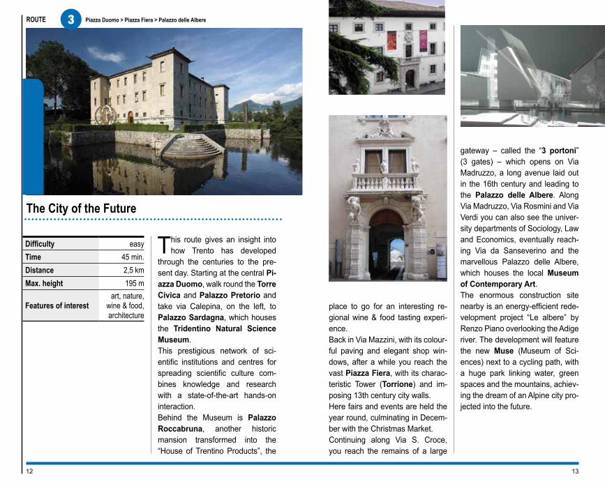
This route gives an insight into how Trento has developed
through the centuries to the pre-sent day. Starting at the central Pi-azza Duomo, walk round the Torre Civica and Palazzo Pretorio and take via Calepina, on the left, to Palazzo Sardagna, which houses the Tridentino Natural Science Museum. This prestigious network of sci-entific institutions and centres for spreading scientific culture com-bines knowledge and research with a state-of-the-art hands-on interaction. Behind the Museum is Palazzo Roccabruna, another historic mansion transformed into the “House of Trentino Products”, the
ROUTE
place to go for an interesting re-gional wine & food tasting experi-ence. Back in Via Mazzini, with its colour-ful paving and elegant shop win-dows, after a while you reach the vast Piazza Fiera, with its charac-teristic Tower (Torrione) and im-posing 13th century city walls. Here fairs and events are held the year round, culminating in Decem-ber with the Christmas Market. Continuing along Via S. Croce, you reach the remains of a large
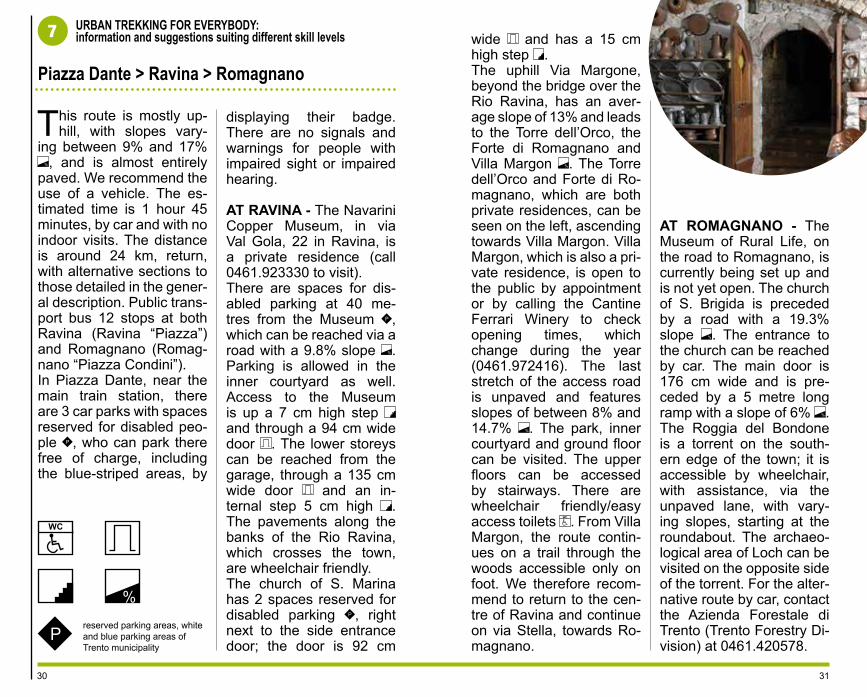
gateway – called the “3 portoni” (3 gates) – which opens on Via Madruzzo, a long avenue laid out in the 16th century and leading to the Palazzo delle Albere. Along Via Madruzzo, Via Rosmini and Via Verdi you can also see the univer-sity departments of Sociology, Law and Economics, eventually reach-ing Via da Sanseverino and the marvellous Palazzo delle Albere, which houses the local Museum of Contemporary Art. The enormous construction site nearby is an energy-efficient rede-velopment project “Le albere” by Renzo Piano overlooking the Adige river. The development will feature the new Muse (Museum of Sci-ences) next to a cycling path, with a huge park linking water, green spaces and the mountains, achiev-ing the dream of an Alpine city pro-jected into the future.
The City of the Future
1312
3 Piazza Duomo > Piazza Fiera > Palazzo delle Albere
The itinerary, about 2.5 km long, starts in the
city centre, which is a pe-destrianised area. Except for the Via Verdi subway – 150 metres long, with slopes of 7% to 9% % – the route is entirely on flat ground and ends on the
URBAN TREKKING FOR EVERYBODY:information and suggestions suiting different skill levels
bank of the Adige river. Time required: about 1 and a half hours, on foot, with no indoor visits. Cars are allowed into the city centre of Trento, provid-ed you have a disabled badge. There is disabled car parking along the en-tire itinerary, except for a short stretch of Via Mazzini
. Disabled badge hold-ers may also park free of charge in the blue-striped parking areas throughout the city. Always ensure you display your badge . There are no signals and warnings for people with impaired sight or impaired
hearing. On the central Pi-azza Duomo is the Palaz-zo Pretorio, which houses the Diocesan Museum, which can be accessed via a 740 cm long ramp, with a 9% slope %, a door 120 cm wide and a threshold 5 cm high . Inside, two carpeted ramps – of 99 cm and 110 cm, respectively – with slopes of 7.6% e and 15.1% %.In Via Calepina, Palazzo Sardagna houses the Tri-dentino Museum of Natu-ral Sciences and features an access ramp 125 cm long, with a 25% slope % and a lift (the door is 90 cm wide, room size 110x140 cm ).Inside there are wheelchair friendly/easy access toilets (176x174 cm) .About 50 metres further on is Palazzo Roccabru-na. Here, the pavement is rather uneven. The upper storeys of the building can be reached by lift, except for the conference room, which is preceded by 5 steps 17 cm high . There are wheelchair friendly/easy access toilets (the door is 81 cm wide, room size 164x197cm) .Along Via Mazzini is Pi-azza Fiera (paved in por-
phyry), on which are the Torrione and the Medieval walls of the city. At about 100 metres from the Tre Portoni is Via Madruzzo. Continuing along Via Ros-mini you pass the Univer-sity departments of Sociol-ogy, Law and Economics. All the department build-ings are accessible and served by lifts inside, with wheelchair friendly/easy access toilet . The end stretch of Via Ver-di is a 150 m long subway, with slopes of 7% to 9% %, leading to the San Sev-erino car park (8 spaces reserved for disabled park-ing) . In the same street is Palazzo delle Albere (cur-rently being refurbished), which can be accessed via two carpeted ramps with slopes of 8% to 13% %.Nearby is the construction site of the Muse, the new Science Museum of Tren-to.
%
Preserved parking areas, white and blue parking areas of Trento municipality
14 15
Piazza Duomo > Piazza Fiera > Palazzo delle Albere
3

Difficulty easyTime 1 hr.Distance 2 kmAltitude change 105 mMax. height 300 mBus lines n. 2
Features of interest views, history-
archaeology, nature,
recreation
ROUTE
This is one of the best loved walks, encompassing the Adige river,
several churches, an ancient village and a peculiarly shaped hill. It goes from Piazza Dante to the banks of the Adige river and includes the in-teresting church of S. Lorenzo, built in the 12th century by Benedic-tine monks. Today, the church is curi-ously below ground level, due to the numerous floods that, over the cen-turies, have deposited alluvial soil raising the surrounding ground level. Cross the Ponte S. Lorenzo bridge to one of the most typical urbanised river landscapes in Trentino, with the church of S. Apollinare, the an-cient village of Piedicastello, with its workers’ district, towered over by the huge rocky outcrop of Doss Trento.
The slender church, built in the 13th century and painted by Dürer, reflects in its shape the rocky outcrop, while Piedicastello still preserves the old-time atmosphere of a village of fish-ermen and raft-builders, the houses all neatly arranged in a row against the nearby escarpment. Cross the little square and take Via Brescia to Piazzale Divisioni Alpine, from where an easy road leads up to the summit of the Doss Trento. This is a place of considerable historic and natural interest, having been the site of an inaccessible Prehistoric fort, a Ro-man fortress and an Early Christian church, and also featuring a number of rare plants and monumental trees. The 1940 road and its tunnels, and the National Historical Museum on the summit, were built by the Alpine Corps and form a sort of “shrine”. On the side facing toward Trento there is the monumental Mausoleum of Cesare Battisti, built with the red and white stone of Monte Calisio. This is a great spot for some marvel-
lous views. Returning to the church of S. Apollinare, nearby are the so-called “Galleries”, a prestigious and original exhibition space of the His-torical Museum of Trentino, where local history is on show according to state-of-the-art display techniques.
The ancient village and Doss Trento
1716
4 Piazza Dante > Piedicastello > Doss Trento

This walk is predominant-ly uphill, with slopes of
between 7% and 18% %. There is a short tunnel and a flat stretch at the top of the hill. The roads are all metalled, except for the park. The itinerary is about 6.6 km long, return, and the estimated time is 2 hours 40 minutes, by car, with brief visits. We recommend you use a vehicle to reach the Doss Trento Park, although this requires a permit is-sued by the Roads & Parks Department (Servizio Ges-tione Strade e Parchi) of the Local Authority of Tren-to (0461.884528). There is a bus stop for disabled passengers on the bus line 2 at “Doss Trento Apuleio”.
URBAN TREKKING FOR EVERYBODY:information and suggestions suiting different skill levels
In Piazza Dante, near the main train station, there are 3 parking areas re-served for disabled drivers, who can park there free of charge, including the blue-striped areas, by showing their badge . There are no signals and warnings for people with impaired sight or impaired hearing.The first part of the walk (about 1.6 km) is wheel-chair accessible, on the pavement. The main at-tractions along the way are:• the Badia di S. Lorenzo, which has a 31 metre ramp with a slope of 9.5% % and a 6 cm high step . In the courtyard, there are 2 park-ing spaces reserved for disabled parking ;• the S. Lorenzo overpass features an average cross slope of 4% and 6.6% %; • the church of S. Apollinare is temporarily closed to the public;• the Galleries of Piedicas-tello (“Nera” and “Bianca”, i.e. White and Black), both of which are accessible, feature a 115 cm wide door
.
The Piazza di Piedicastello can be reached by car or on foot, via an asphalt-paved ramp 43 metres long, with an average slope of 7.6%
%. There are parking spac-es reserved for disabled parking . The second part of the walk (1.7 km) is inside the Doss Trento Park, uphill, with various slopes (from 7% to 18% %), there is a short tunnel and a flat area right next to the Mausoleum of Cesare Battisti. The paving is asphalt. There is a large parking area in the upper reaches of the walk .The Mausoleum area is flat (grass and gravel). The monument can be ac-cessed via a 7.5 cm step. Only parts of the interior can be visited because of the many steps . A 100 metres further on, along an unpaved road (even surface, slopes of between 10% and 18% %) and a grassy stretch of 20 metres (slopes of between 8% and 15% %), is the Early Chris-tian Basilica. Nearby there are stretches of a Nature Trail on flat ground. There are toilets, but no easy ac-cess toilets for the disabled (size 182x182 cm ).The Museum of the Al-
pine Troops has a car park about 100 metres further on . The approach road features slopes of between 7.5% and 10% %. Disabled badge holders are allowed to park inside the internal courtyard of the Museum, subject to permission by the staff (call 0461.827248)
. Access to the Museum is via an internal mobile ramp 314 cm long, with a 15% slope %. The entire Museum can be visited. The surrounding space is paved with porphyry slabs joined by short ramps (for accessing the exterior dis-play areas). There are no public toilets.
%
Preserved parking areas, white and blue parking areas of Trento municipality
18 19
Piazza Dante > Piedicastello > Doss Trento
4

ROUTE
Difficultyaverage- to-easy,
on unpaved ground
Time 2 hrs. and 30 min.
Distance 7 kmAltitude change 320 mMax. height 770 mBus lines n. 6
Features of interest view,
military sites, historical
routes
The Sorasass Circular Route. This is a rewarding circular ex-
cursion, featuring some interesting military sites, breathtaking views from dizzy heights, along several old trails. From Càdine, you cross the crafts estate, headed North-East, until you reach a large white stone cross. Continue straight ahead for another 100m up until you reach several signs, then con-tinue left to the car park at Fer de Caval. The route begins here (information signs) and continues, in a counter-clockwise direction, through thick woodland. At the eve of World War I, a series of important military defence works were built in the area of Càdine, and in the nearby
locations of Vintitrè Pini, Poza dei Pini, including, on the left, the military road with a Fuciliera, an in-teresting military facility, which has now been restored and opened to the public. It includes a trench, a 40m long tunnel, 11 casemate emplacements and various other emplacements. Back on the origi-nal route, there is a stretch of the main trail, a stretch of the San Vili Trail, dedicated to the patron saint of Trento, Saint Vigilius, who during his evangelisation mission, in the 4th century, travelled a number of times along this 95 km route, from the Vela di Trento to Madonna di Campiglio. Continuing north, you come to a number of military sites, includ-ing various stoi (shelters in natu-ral caves) and the pontesel, an
extraordinary observation point at the top of a sheer precipice 500 metres high; quite an eagle’s nest. On the way back, you pass through Spazadomeneghe and Poza de la Casara, passing an old lime furnace, which is a relic of one of the ancient crafts practised in the valley, before returning to the Fer de Caval. Alongside the tunnel leading back to Trento is the Forte Buss de Vela Fort, one of the most important fortifications in the whole of Trentino.
The fortress of Trento
2120
5 Piazza Dante > Cadine > Sorasass
URBAN TREKKING FOR EVERYBODY:information and suggestions suiting different skill levels
The itinerary is about 14 km long: 7 on paved
roads (from Trento to Ca-dine) and 7 on the Giro Sorasass, which is an un-paved road, with an un-even surface at times and slopes of between 8% and 20% %, as well as flat stretches.The estimated time need-ed to complete the circu-
lar route is about 1 hour 40 minutes, by car, keep-ing in mind that this in-cludes only half the Giro Sorasass route. To access the Giro Sorasass by car you need a permit issued by the Azienda Forestale di Trento (Trento Forestry Di-vision) (call 0461.420578).There are no public trans-port services along this route.In Piazza Dante, near the main train station, there are 3 car parks with spaces reserved for disabled peo-ple , who can park there free of charge, including the blue-striped areas, by
displaying their badge . There are no signals and warnings for people with impaired sight or impaired hearing.From Piazza Dante, travel-ling on the SS 45 bis main road, after 6 km you reach Cadine. At the traffic lights, turn right into Via Coltura and continue towards Tez, until you reach the Fer dei Cavai car park. This stretch is 1 km long, except for a short ascent leading to the car park .The area features a grass and packed earth picnic area, with slopes of be-tween 8% and 12% %.The Sorasass circular routes forms a 7 km long ring, which starts and ends at the Fer dei Cavai car park .You can drive to Poza dei Pini, but must then pro-ceed on foot, or with other special means, along the narrow and steep hairpin turns further on.The military road with the Fuciliera, above Poza dei Pini, is a trail about 1 me-tre wide, which climbs up through the woods.The second part of the ring (after Pontesel and up to Poza dela Casara), is a wide and even forest road,
the end stretch of which narrows and becomes rather rough.The Bus de Vela Fort, which is currently closed to the public, can be reached via a 70 metre long un-paved road surfaced with gravel, with slopes of be-tween 8% and 14% %.
%
Preserved parking areas, white and blue parking areas of Trento municipality
22 23
Piazza Dante > Cadine > Sorasass
5

ROUTE
Difficulty
easy, with unpaved uphill sections, while
the descent can be
classified as medium
Time 2 hrs.Distance 5 kmAltitude change 170 mMax. height 710 m
Cableway Station on the Lung’Adige
Features of interest view, religion, nature, art
A balcony overlooking Trento. This excursion combines
breathtaking views, nature, ancient and contemporary art. Start at Pi-azza Dante, near the Adige river bank, by the interesting church of S. Lorenzo, built in the 12th century by Benedictine monks. To-day, the church is curiously below ground level, due to the numer-ous floods that, over the centuries, have deposited alluvial soil rais-ing the surrounding ground level. Beyond the railway overpass is the cableway station, right on the bank of the river. This cableway is 1,200 metres long, with an altitude change of almost 400 m, and is one of the oldest in Europe, having been opened in 1924. After having
ascended the slope of Monte Bon-done, you reach the upper station of Sardagna: this is a great obser-vation point overlooking the city and the Adige Valley, the second longest river in Italy. Descending to the southern edge of the town, you will find the isolated church of SS. Filippo e Giacomo, built in the 11th century and containing important 16th century frescoes by
Fogolino. Nearby is the great wa-terfall, 174 m tall, which is visible from the centre of Trento. Tracing your steps back to the town, you can admire the interesting Villa Rizzi, now housing an educational establishment, and the 18th centu-ry parish church. Passing through the town centre you will notice some modern and interesting mu-ral paintings, depicting local coun-try life between the 19th and 20th centuries. Following the signs, you climb up towards the mountain, on the left, in the southern part of the town. This is where the Sentiero dei Castagni – Chestnut Trail – begins (signposted), an unpaved circular route offering some spec-tacular views and returning back to the town. You can climb up the steep wooded sides of Monte Bon-done, cutting through some old and more recent chestnut woods, from which the appreciated Sardagna “marrons” come, where even the monumental centuries-old trees have a story to tell.
A glance up ancient chestnut oaks
2524
6 Piazza Dante > Funivia > Sardagna > Sentiero dei Castagni

URBAN TREKKING FOR EVERYBODY:information and suggestions suiting different skill levels
%
P
The itinerary features slopes of between 6%
and 12%. The average slope for the Chestnut Trail is 25% %. The area of Sardagna can be reached by car (Monte Bondone road) or cableway.The time required is about 1 hour 10 minutes, return, by car and with no indoor visits, except for the Chest-nut Trail, which is 15.3 km long. In Piazza Dante, near the main train station, there are 3 car parks with spaces reserved for disa-bled people, who can park there free of charge , including the blue-striped areas, by displaying their badge. There are no sig-nals and warnings for peo-
ple with impaired sight or impaired hearing.The first part of the route is wheelchair friendly, on the pavement from Piaz-za Dante to the Badia di S. Lorenzo Abbey, which can be accessed via a 31 m long ramp, with a slope of 9.5% % and a 6 cm high step . The internal court-yard features 2 spaces for disabled parking .Past the bus station, take the S. Lorenzo overpass, which has an average cross slope of between 4% and 6.6% %, to the Trento-Sardagna cableway. Access is by means of a stairlift (dimensions 80x79 cm, max. capacity 200 kg)
. The cab (door width 72 cm, size 235x137.5 cm), features down steps of 3 cm . The exit at the Up-per Station of Sardagna (viewing point at the Centro Congressi Europa confer-ence facility) is by means of a 23 metre ramp, with a slope of 17.5% %. There is a large flat car park with 2 spaces reserved for disa-
bled parking . The road leading to the town is 900 metres long, with slopes of between 6% and 9% and with a pavement %.In the Piazza dei SS. Filip-po e Giacomo, which fea-tures an average slope of 9% %, there are spaces re-served for disabled parking
and the parish church which can be accessed via a 107 cm wide door .Descending towards the cemetery, on a road with a maximum slope of 9.7%
%, you will pass alongside Villa Rizzi to a large car park . Inside the cemetery is the church of SS. Filippo e Gi-acomo, preceded by a 197 cm wide gate and a ramp, 10 metres long with a slope of 4.2% %. The door of the church is 139 cm wide and inside there are 6 steps . Continuing, whether on foot or by wheelchair, about 150 metres further on is the waterfall. The ground here is grassy and uneven.Walking in the narrow al-leyways of the town, with slopes of between 8.7% and 11.3%, you can ad-mire the Mural paintings %.The Chestnut Trail is all
uphill, behind the wood; the trail is unpaved and rather uneven, with vari-able slopes, of 20-25%
% on average. It can be travelled on foot, or using special vehicles, although permission must first be obtained from the Azienda Forestale di Trento (Tren-to Forestry Division) (call 0461.420578).
reserved parking areas, white and blue parking areas of Trento municipality
26 27
Piazza Dante > Funivia > Sardagna >Sentiero dei Castagni
6

ROUTE
Difficulty
easy, while the descent to Ro-magnano can
be classified as medium-to-
easyTime 2 hrs.Distance 4,5 kmAltitude change 200 mMax. height 445 mBus lines n. 12
Features of interest landscape,
military history, archaeology,
alpine,
Featuring the attractions on the right bank of the Adige river.
This is an easy varied walk be-tween luxuriant vineyards and sev-eral country houses built by the no-bility, at the foot of Monte Bondone. The suburb of Ravina, with its mansions, castles and wealthy res-idences, features the extraordinary Navarini Copper Museum and a Museum of Rural Life, housed in old summer residences erected by noble Trento families. The impos-ing hydraulic works in the centre of the town and upstream reveal the crossing of the wild Rio Ravina torrent, which used to cause much flooding in the past. The walk starts across the bridge in front of the church of S. Marina, southwards,
in the direction of the clearly visible Torre dell’Orco. Walking past the romantic 16th century tower, you continue uphill on a paved road to the Forte di Romagnano Fort (1890-1895, now a private resi-dence), a massive defensive struc-ture dominating the Adige Valley, and a pleasant landscape planted with orchards and vineyards. This is an area of production of excel-lent still and sparkling wines. On the right, a detour leads to the esplanade in front of the magnifi-cent Villa Margòn, one of the most exclusive country houses (open to the public by reservation only 0461.972416). Its elegant lines, refined decorations and large park make it one of the most important examples and monuments of the Trentino Renaissance. Return-
ing to the road, you continue past some large oaks, hornbeams and beech trees, descending towards Romagnano, encountering a num-ber of military defence and fortifica-tion works along the way. Cross the town, with its picturesque alleys, doorways, the church of S. Brigida, and continue 1 km southwards, to the beautiful waterfall of Roggia del Bondone, at just a few metres from the archaeological site of Loch (a shelter with deposits rang-ing from the Mesolithic to the Iron Age), set in an enchanting rocky environment, which also features a historic rock climbing wall.
Among the vineyards on the right of the Adige river
2928
7 Piazza Dante > Ravina > Romagnano
%
P
URBAN TREKKING FOR EVERYBODY:information and suggestions suiting different skill levels
This route is mostly up-hill, with slopes vary-
ing between 9% and 17% %, and is almost entirely
paved. We recommend the use of a vehicle. The es-timated time is 1 hour 45 minutes, by car and with no indoor visits. The distance is around 24 km, return, with alternative sections to those detailed in the gener-al description. Public trans-port bus 12 stops at both Ravina (Ravina “Piazza”) and Romagnano (Romag-nano “Piazza Condini”).In Piazza Dante, near the main train station, there are 3 car parks with spaces reserved for disabled peo-ple , who can park there free of charge, including the blue-striped areas, by
displaying their badge. There are no signals and warnings for people with impaired sight or impaired hearing.
AT RAVINA - The Navarini Copper Museum, in via Val Gola, 22 in Ravina, is a private residence (call 0461.923330 to visit).There are spaces for dis-abled parking at 40 me-tres from the Museum , which can be reached via a road with a 9.8% slope %. Parking is allowed in the inner courtyard as well. Access to the Museum is up a 7 cm high step and through a 94 cm wide door . The lower storeys can be reached from the garage, through a 135 cm wide door and an in-ternal step 5 cm high . The pavements along the banks of the Rio Ravina, which crosses the town, are wheelchair friendly.The church of S. Marina has 2 spaces reserved for disabled parking , right next to the side entrance door; the door is 92 cm
wide and has a 15 cm high step . The uphill Via Margone, beyond the bridge over the Rio Ravina, has an aver-age slope of 13% and leads to the Torre dell’Orco, the Forte di Romagnano and Villa Margon %. The Torre dell’Orco and Forte di Ro-magnano, which are both private residences, can be seen on the left, ascending towards Villa Margon. Villa Margon, which is also a pri-vate residence, is open to the public by appointment or by calling the Cantine Ferrari Winery to check opening times, which change during the year (0461.972416). The last stretch of the access road is unpaved and features slopes of between 8% and 14.7% %. The park, inner courtyard and ground floor can be visited. The upper floors can be accessed by stairways. There are wheelchair friendly/easy access toilets . From Villa Margon, the route contin-ues on a trail through the woods accessible only on foot. We therefore recom-mend to return to the cen-tre of Ravina and continue on via Stella, towards Ro-magnano.
AT ROMAGNANO - The Museum of Rural Life, on the road to Romagnano, is currently being set up and is not yet open. The church of S. Brigida is preceded by a road with a 19.3% slope %. The entrance to the church can be reached by car. The main door is 176 cm wide and is pre-ceded by a 5 metre long ramp with a slope of 6% %. The Roggia del Bondone is a torrent on the south-ern edge of the town; it is accessible by wheelchair, with assistance, via the unpaved lane, with vary-ing slopes, starting at the roundabout. The archaeo-logical area of Loch can be visited on the opposite side of the torrent. For the alter-native route by car, contact the Azienda Forestale di Trento (Trento Forestry Di-vision) at 0461.420578.
reserved parking areas, white and blue parking areas of Trento municipality
30 31
Piazza Dante > Ravina > Romagnano
7

ROUTE
Difficulty medium easy
Time
A) 2 hrs and 30 min.
B) 3 hrs and30 min.
DistanceA) 5 kmB) 7 km
Altitude change A) 180 mB) 300 m
Max. height 405 mBus lines n. 8
Features of interest landscape,
Alpine wildlife, historic-military
The door of Trento. From the ancient road on the valley
bottom to the cultivated and rein-forced reliefs. A classic mountain landscape with 2 different souls: the farming-rural soul, perched up in the heights, and the commer-cial one at the bottom of the val-ley, close to the highway crossing through Trento, heir of the Imperial road which connected Italy and Central Europe. You get off the bus in the town of Ronchi, go up the “Strada ai Palazzi” (wooden boards) con-tinue and then turn left (board) towards the Fauna Alpina di Casteller, an interesting wildlife recovery centre, managed by the Associazione Cacciatori Trentini
(Hunter’s Association of Trento) (guided tours only) 0461.825834. Next to the parking area you go into the woods on the Fauna Al-pina Path. You continue up going along the wildlife area fence up to a clear-ing with a park bench on the right and a closed gate to the left. Climb up to the right to reach the county road in the town of Novaline: splendid vineyard landscape fea-turing 3 aristocratic mansions dat-ing back to the sixteen hundreds (Saracini, Sardagna, Gentilotti) and ancient mountain farmhouses dominated by the massive Vigola-na group. Go down 250m, go back up to the left (boards and capital) to Valli and then start down on the opposite slope, at first on a narrow path, then on a more comfortable track up to Laste.
ROUTE A - going along he left bank of Rio Valsorda you will en-counter many old windmills, a
round-about, and then will reach Via della Decima in the centre, the name of this road refers to the old tax that was paid there; the tall houses and large portals leading to the inner spaces are quite char-acteristic. To the right you can see the long walls of the Torre Fran-ca, which was once an important Medieval castle, now in ruins.
ROUTE B - from Laste go to the south for 2 km on the 2 high-grounds (vast panorama) occu-pied by the massive ruins of the forts of Mattarello, dating back the end of the 1800s, and then come down on route A).
The Alpine Wildlife path
3332
8 Piazza Dante > Ronchi > Novaline > Mattarello

%
P
URBAN TREKKING FOR EVERYBODY:information and suggestions suiting different skill levels
The route goes uphill and downhill with slopes
ranging from 4% and 25% % and a few flat stretches.
The route is paved and can also be travelled by motor vehicle, except for the Alpine wildlife path and the path between Valli and Laste which can only be covered on foot.The total distance is about 15 km circa, except for the foot paths and the Trento-Mattarello stretch, and lasts two hours (in the car without stops). For mo-tor vehicle access to the Forte “Medio” contact the Forest Agency of Trento (0461.420578).There are two reserved car parks in the Centro Fauna di Casteller and some rest stops along the route (in Novaline, Laste, Villa Piani Longhi and at the forts) .
The stops of bus route 8 going towards Mattarello: Mattarello “Nazionale” (c/o Shopping Centre, 500 me-tres after Ronchi), going towards Trento: Mattarello “Catoni”.In Piazza Dante, near the train station, there are 3 parking spaces reserved for disabled people . Disabled people may also park free of charge in the blue-striped parking areas throughout the city, by dis-playing their badge .There are no signals or warnings for people with impaired sight or hearing. From Ronchi go up Strada dei Palazzi leading to the Centro Fauna di Casteller and Novaline. The road has a 11% slope in the first part and reaches 17% % in the second part with some flat stretches.Centro Fauna di Castel-ler can be reached on a 30-metres long road hav-ing a slope of 20% %. The Fauna Alpina path start-ing from the car park and leading to Novaline can be covered only on foot due to
its broken surface and gra-dients up to 30% %. As an alternative, take Strada dei Palazzi up to. Novaline, where you can see the pri-vate Villas. To reach Le Valli, turn into via Menestrina with slopes between 4% and 20% %
with flat stretches, where it is advisable to leave your car and continue on foot or by wheel chair, due to the narrowing of the road. The route continues over a narrow, broken path lead-ing to Laste, which can also be reached by car by going back to the Stra-da delle Novaline, going down to the fork for Strada dei Forti having gradients between 5% and 17% %
which crosses the bridge on Rio Valsorda.
ROUTE A - Go down along the narrow road flanking Rio Valsorda. If you are travelling by motor vehicle it is advisable to take the road located 50 metres after the sign the first part of which has a gradient of 25% %.At the round-about go down along Via della Dec-ima. The historical centre of Mattarello has slopes between 8% and 15% %.
Castello della Torre Franca is visible from Via del Cas-tel.The shop Mastro 7 can be reached by flat road.
ROUTE B - From Laste go up Strada dei Forti having slopes from 2% to 15% %.After 1 km take the road right towards Forte “Me-dio”. The access road is 250 metres long, is a dirt road and is uneven. Before the last 50 metres there is a closed bar without side passages and a rest area.The large flat space in front of the fort has an un-even grass coverage. You can visit the ground floor of the fort.By proceeding on Strada dei Forti for another 800 metres you will reach Forte “Alto” which is locat-ed about 250 metres after Villa Piani Longhi. The ac-cess road, uneven dirt, has an average slope of 15%
% in the last 50 metres. The area surrounding the fort is flat with an uneven grass coverage.For the return trip, follow Route A in Laste.
reserved parking areas, white and blue parking areas of Trento municipality
34 35
Piazza Dante > Ronchi > Novaline > Mattarello
8
ROUTE
DifficultyA) easy
B) medium
TimeA) 40 min.B) 50 min.
DistanceA) 2 kmB) 2 km
Altitude change A) 90 m
B) 230 mMax. height 611 mBus lines n. 6 and n. 13
Features of interest
panorama, botanical,
historic-military,
mountaineer-ing
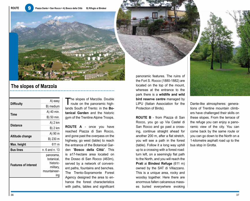
The slopes of Marzòla. Double route on the panoramic high-
lands South of Trento: in the Bo-tanical Garden and the historic gym of the Trentine Alpine Troops.
ROUTE A - once you have reached Piazza di San Rocco, and gone past the overpass on the highway, go west (table) to reach the entrance of the Botanical Gar-den “Bosco della Città”. This is a17-hectare area located on the Dosso di San Rocco (463m), served by a network of conveni-ent paths, fountains and benches. The Trento-Sopramonte Forest Agency designed the area to en-hance the forest characteristics with paths, tables and significant
panoramic features. The ruins of the Fort S. Rocco (1880-1882) are located on the top of the mount, whereas at the entrance to the park there is a wildlife and wild bird reserve centre managed by LIPU (Italian Association for the Protection of Birds).
ROUTE B - from Piazza di San Rocco, you go up Via Castel di San Rocco and go past a cross-ing, continue straight ahead for another 200 m, after a flat stretch, you will see a path in the forest (table). Follow it a long way uphill up to a crossing with a forest road: turn left, on a seemingly flat path to the North, and you will reach the Prati ai Bìndesi Refuge (611 m) owned by the SAT di Villazzano. This is a unique area, rocky and woodsy together. Here there are enormous fallen calcareous mass-es buried everywhere evoking
Dante-like atmospheres: genera-tions of Trentine mountain climb-ers have challenged their skills on these slopes. From the terrace of the refuge you can enjoy a pano-ramic view of the city. You can come back by the same route or you can go down to the North on a 1-kilometre asphalt road up to the bus stop in Grotta.
The slopes of Marzola
3736
9 Piazza Dante > San Rocco > A) Bosco della Città B) Rifugio ai Bìndesi

URBAN TREKKING FOR EVERYBODY:information and suggestions suiting different skill levels
The route is mainly uphill with gradients between
5% and 19% % and is about 10 km long, one-way only and excluding the part from Piazza Dante to San Rocco.The entire route lasts about 2 hours in a car with short side trips. Bosco della Città is a green area
%
P
that can be reached by car if you have a special pass and authorisation from the Forestry Division of the Autonomous Province of Trento (0461.495943).The Pino Prati ai Bindesi refuge can be reached by a 7-km long paved road with an average gradient of 19% %.Bus line 13 of the city of Trento provides service for disabled people with a specially equipped stop in Piazza di San Rocco.In Piazza Dante, near the train station, there are 3 parking spaces reserved
for disabled people . Disabled people may also park free of charge in the blue-striped parking areas throughout the city, by dis-playing their badge .There are no signals or warnings for people with impaired sight or hearing.
ROUTE A - The large car park Bosco della Città hav-ing an average cross gra-dient of 7.6% % is about 200 metres from Piazza di San Rocco. Proceed for a few hundred metres along an even dirt road having a gradient between 5% and 11.3% %.The green area is divided in two parts: the first part is a Botanical Garden and Wildlife and Bird Recovery Centre, the second is for forest nursery and hunting management activities.The area is provided with panoramic points, bench-es and drinking water. The main routes (Pian dei Pini, Dosso and Busa dei Castagnari) have slight gradients and flat grassy meadows. The secondary routes, suitable for trek-king, have maximum gra-dients of 46% %.It is possible to visit the Wildlife and Bird Recovery
Centre (Centro di Recu-pero Avifauna Selvatica) and it can be reached by an even dirt road which is about 50 metres long and having a max. gradient of 14.7% % (0461.931481).
ROUTE B - From Piazza di San Rocco go uphill to Grotta, with an average gradient of 13% %. After 1.4 km turn for the Bindesi refuge. The road is nar-row and paved and has a gradient of 26.1% % in the steepest parts.Along the route, there is a rest area with a large car park. The Refuge is about 1 km away. There is parking for disabled peo-ple near the access ramp which is 15 metres long with a gradient of 8% % leading to the entrance (the door is 100 cm wide) and the panoramic terrace.
reserved parking areas, white and blue parking areas of Trento municipality
38 39
Piazza Dante > San Rocco > A) Bosco della Città B) Rifugio ai Bìndesi
9
ROUTE
Difficulty mediumTime 50 min.Distance 2 kmAltitude change 230 mMax. height 620 mBus lines n. 6 and n. 13
Features of interest multi-sensory
route, panorama
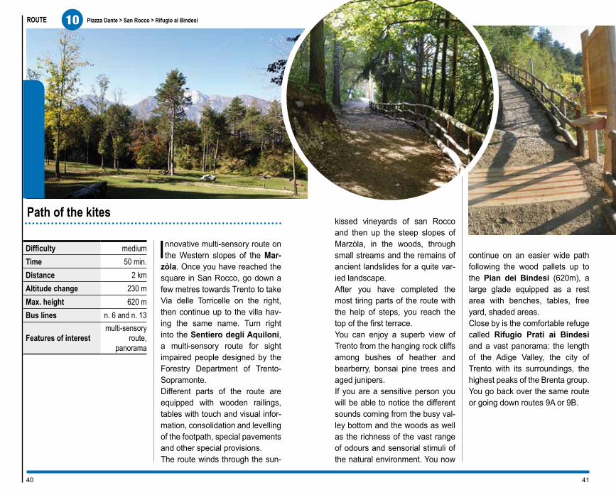
Innovative multi-sensory route on the Western slopes of the Mar-
zòla. Once you have reached the square in San Rocco, go down a few metres towards Trento to take Via delle Torricelle on the right, then continue up to the villa hav-ing the same name. Turn right into the Sentiero degli Aquiloni, a multi-sensory route for sight impaired people designed by the Forestry Department of Trento-Sopramonte. Different parts of the route are equipped with wooden railings, tables with touch and visual infor-mation, consolidation and levelling of the footpath, special pavements and other special provisions. The route winds through the sun-
kissed vineyards of san Rocco and then up the steep slopes of Marzòla, in the woods, through small streams and the remains of ancient landslides for a quite var-ied landscape. After you have completed the most tiring parts of the route with the help of steps, you reach the top of the first terrace. You can enjoy a superb view of Trento from the hanging rock cliffs among bushes of heather and bearberry, bonsai pine trees and aged junipers. If you are a sensitive person you will be able to notice the different sounds coming from the busy val-ley bottom and the woods as well as the richness of the vast range of odours and sensorial stimuli of the natural environment. You now
continue on an easier wide path following the wood pallets up to the Pian dei Bindesi (620m), a large glade equipped as a rest area with benches, tables, free yard, shaded areas. Close by is the comfortable refuge called Rifugio Prati ai Bindesi and a vast panorama: the length of the Adige Valley, the city of Trento with its surroundings, the highest peaks of the Brenta group. You go back over the same route or going down routes 9A or 9B.
Path of the kites
4140
10 Piazza Dante > San Rocco > Rifugio ai Bìndesi

URBAN TREKKING FOR EVERYBODY:information and suggestions suiting different skill levels
The route called degli Aquiloni (kites), a vari-
ant of route 9, from San Rocco reaches the Refugio Bindesi. It was designed for people with sight im-pairment and is challeng-ing due to the gradients ranging from 8% to 39.5%
%. It has different tactile pavements, mainly on dirt roads alternating with por-phyry paved areas. There are steps an average of 14 cm high . Along the route there are wooden poles indicating the posi-tions on the information tables. On the right side of the route, at about a metre high, there is a wooden railing and, in the final part of the route, a 20 cm high curb on both sides of the path. The route is about 2 km long and it takes about
an hour and a half on foot, one way only considering a few rest stops for read-ing the information tables.Bus line 13 provides ser-vice for disabled peo-ple and has a specially equipped stop in Piazza di San Rocco. In Piazza Dante, near the train sta-tion, there are 3 park-ing spaces reserved for disabled people . Disa-bled people may also park free of charge in the blue-striped parking areas throughout the city, by dis-playing their badge .From Piazza Dante after about 6 km you will reach Piazza di San Rocco. From here proceed for 1 km on a paved road along via Tor-riccelle up to Villa Torric-celle. The Sentiero degli Aquiloni is just to the right of the villa (SAT 412, route 11). After the first 100 me-tres on dirt road, turn left into the path starting uphill with a gradient of 20% %. On the right side there is a 1 m high round wood rail-ing. After about 20 metres there are wooden cross
%
P
boards on the dirt road which indicate the tactile information tables. Go up a stretch of porphy-ry paved road at a gradi-ent of 33.8% %. There is a diagonal water duct 8 cm deep. Proceed on dirt road having gradients between 20% to 29% %.You will then reach the plain “Armonia” intersect-ing with a variant of the route; proceed to the Ref-uge on a dirt road.The route has gradients reaching up to 38% %, fol-lowed by 34 14-cm high steps , of different depths and 1.30 m wide.The steps alternate with ramps. At the end of the stairway you reach a seemingly flat plane and after going downhill briefly you reach a panoramic ter-race which is accessible by 11 12-cm high steps . There is a 103-cm high metal railing. A route going up and down having a gradient of 9% %
and a 65-cm high curb on the left side follows.The last climb is 50 me-tres long having a gradi-ent of 20% %. There is a short downhill stretch and flat stretch with a 30-cm high curb on the left side.
Park with rest areas for picnics. The park area is followed by a road (150 metres), partially closed by a bar, the remaining pas-sage is 85 cm wide; the road is clay having slight gradients (max. 13% %). The park is situated on a slanted grassy area having different gradients (max. 20% %). The Rifugio Bindesi is a few metres away from the park. Parking spaces re-served for disabled peo-ple near the access ramp which is 15 m long and has a gradient of 8% %, and leads to the entrance (100-cm wide door ) and the panoramic terrace.
reserved parking areas, white and blue parking areas of Trento municipality
42 43
10
Piazza Dante > San Rocco > Rifugio ai Bìndesi

ROUTE
Difficulty easy on forest road and path
Time 1 hr. and40 min.
Distance 6 kmAltitude change 170 mMax. height 1,240 m
Bus lines
n. 5. During the summer
there is a shuttle bus be-
tween Passo del Cimirlo
and Maranza refuge
Features of interest panorama,
prestigious for-est ambience, military history
A beautiful ring trek in the woods at the foot of Monte
Marzola (1,738 m), in a mountain ambience full of different kinds of biological aspects. From Trento to Passo del Cimirlo (730m), to reach the Maranza refuge in about 6 km. Today’s refuge is lo-cated on a green glade at a height of 1,070 m where there used to be an ancient mountain dairy. Right under the refuge is a path going South which passes by the chapel of the Alpine troops, built on the ruins of an Austrian capital of 1914-15. By following the characteristic signposts you start the “Maranza Nature Route”, designed by the Trento-Sopramonte Forest Agen-
cy, accompanied by tables and signs describing the forest types and species that you meet along the way. The rocky spur called Doss de le Spazadore, a spectacular pano-ramic point is just a few minutes away from the refuge where you can admire: the city of Trento, the Adige Valley, opposite the Monte Bondone, to the South la Vigo-lana. It was a strategic military observation point, was connected to the overlying Forte di Maranza, whose ruins are close by, and oth-er similar works in the area. Proceeding pleasantly under the coverage of the treetops of many types of forest vegetation, you reach Prà dell’Albi) (you can re-turn to the refuge at this point), Malga Nova, Busa dei Pezi for the exciting meeting with 2 monu-ments of the vegetable world: a huge red fir and a mountain ma-
ple. At Salizoni, the path curves back towards the Maranza refuge, thus completing a circle featur-ing a full immersion in the forest ambience, full of awesome trees, plays of light, bird songs, solemn atmospheres.
The path among the Maranza woods
4544
11 Trento > Povo > Passo del Cimirlo > Rifugio Maranza > Percorso Naturalistico di Maranza

URBAN TREKKING FOR EVERYBODY:information and suggestions suiting different skill levels
The route goes mainly through the woods, on
paved roads with varying gradients, max. 14% and flat stretches %. The Na-ture Route goes into the woods and can only be covered on foot.The total length is 16.5 km (from Piazza Dante to Maranza Refuge, exclud-ing the Nature Route), and takes about 50 minutes by car.The city bus line no. 5 can-not be used by disabled people. In Piazza Dante, near the train station, there are 3 parking spaces re-
%
P
served for disabled people . Disabled people may
also park free of charge in the blue-striped parking ar-eas throughout the city, by displaying their badge .There are no signals or warnings for people with impaired sight or hearing.The distance between Trento and Povo is 6 km, between Povo and Passo Cimirlo is 4.5 km and be-tween Passo Cimirlo and Rifugio Maranza another 6 km. From the village square go along via Per Sprè towards Oltrecastello.Along the road there are car parks and rest areas which can be reached on short dirt roads having a max. gradient of 10% %.
There is a large car park at Passo del Cimirlo .The Maranza refuge has a car park reserved for disabled people next to the building . Door width: 124 cm . Accessible outside terrace. Another large car park 100 metres away . The small church of the Al-pine troops can be reached by a route which is partial-ly grass and uneven dirt road; it is about 150 m long and has a gradient ranging from 8% to 15% %.The rest of the route is in the woods and can be cov-ered only on foot.
reserved parking areas, white and blue parking areas of Trento municipality
46 47
Trento > Povo > Passo del Cimirlo > Rifugio Maranza > Percorso Naturalistico di Maranza
11

ROUTE
Difficultyil Dosso -
medium, the rest is easy
Time 2 hrs. and 20 min.
Distance 4,5 kmAltitude change 170 mMax. height 550 m
Bus lines No. 5 and No. 13; No. 9 and No. 10 for the
return
Features of interest panorama, landscape,
geology
A trip going back in time. From avant-garde science research
centres to primordial natural events written in the rocks. There are many interesting things to see in the main square of Povo: the Cosbi Research centre of the Microsoft company, the Parish church with precious operas by Fogolino and Moroder. In the im-mediate vicinity old local stone fountains, typical houses built on the walls, narrow alleys: elements of a rural village with the atmos-phere of times gone by. Go 100 m up the main road, then turn left (table) towards Dosso di S. Agata, continue along this varied, panoramic road, some stretches of which cross through gardens or
the woods, up to the small hermit-age church of S. Agata. The top, which was the location of a prehistoric castellar and a Me-dieval castle, offers the visitor a large glade inspiring the contem-plation of the large surrounding area. Go down in a North East direc-tion to the edge of the field on the well-marked, steep path up to Oltrecastello (which can also be reached directly from Povo going through the lovely village of Sprè), an inhabited area situated on a vast terrace overlooking the wild gorge of Fersina. After a short, pleasant trip around Villa di Sopra and Villa di Sot-to, with the Villa Pompeati and Villa Fogarolli, dating back to the 1600s, go down towards Ponte Alto, and, after 200m, turn right (table) proceeding up to the bridge on the Torrente Fersina. Here the stream becomes a spec-tacular 40-metre cascade, after
having dug a deep canyon in the 65 million year old red rocks. Cross the road, pass the prestig-ious Villa Madruzzo and reach Cognola, an ancient, characteris-tic village, important stopover on the ancient Roman road Claudia Augusta Altinate.
A journey in the past
4948
12 Piazza Dante > Povo > Dosso di S. Agata > Oltrecastello > Ponte Alto > Cognola

URBAN TREKKING FOR EVERYBODY:information and suggestions suiting different skill levels
The route is all ups and downs with gradients
from 5% to 14% %, and flat stretches. It is completely paved except for the part going up to Dosso di S. Ag-ata, which can be covered only on foot. The route is approx. 11.5 km long and takes about an hour by car (except for the Dosso di S.Agata and using the al-ternative taking you straight to Spré). The only bus line providing service for disa-bled people is no. 13 (Povo “Piazza Manci”). In Piazza Dante, near the train sta-tion, there are 3 parking
spaces reserved for disa-bled people . Disabled people may also park free of charge in the blue-striped parking areas through-out the city, by displaying their badge . There are no signals or warnings for people with impaired sight or hearing. The distance from Trento to Povo is 6 km. At 30 metres from Pi-azza Manci there is a car park reserved for disabled people. On the left, on the other side of the road, is the Parish Church, which can be reached by a 9 metres long ramp having a max. gradient of 11.4% % and a 176 cm wide door . Going down along the road to the Fall you can see the modern buildings of the Trento sci-ence research area. From the square we advise you to proceed uphill along via Sprè to the villages of Spré and Oltrecastello since the trek to the Dosso di S. Ag-ata is possible only on foot. This stretch of road is 1.5 km long and has a gradient of 5.4% %; some parts are provided with sidewalks.The stretch of road lead-ing to Ponte Alto, passing through the Villas (private residences) has gradients ranging from 4% to 14% %.
The last part, leading to the bridge on the Torrente Fersina and the Cascata dell’Orrido (gorge water-fall), has a sidewalk with-out ramps at the ends and has an average gradient of 9.4% %. Here there is a small car park . The wa-terfall can be seen from the bridge which has a 110 cm high railing and from the terrace accessible from the nearby snack bar-restau-rant. By going across the Valsugana road and tak-ing the via Ponte Alto you go along Villa Madruzzo, which is now a restaurant and hotel. This final part of the route goes up and down slightly, with max. gradients of 7% %, and leads to Pi-azza Argentario in Cognola where there is a car park reserved for disabled peo-ple .
%
Preserved parking areas, white and blue parking areas of Trento municipality
50 51
Piazza Dante > Povo > Dosso di S. Agata >Oltrecastello > Ponte Alto > Cognola
12

ROUTE
Difficulty easy
TimeA) 3 hrs.
B) 2 hrs. and 40 min.
DistanceA) 5 km
B) 4,5 km
Altitude change A) 270 mB) 250 m
Max. height 585 m
Bus lines
No. 9 Villamontagna
No. 10 Martignano
Features of interest
panorama, landscape,
geology,history
The Stone of Trento. Double trek along the South slope
of Monte Calisio facing the sun, where, after over 2,000 years we are still extracting the beautiful calcareous stone used to build Trento. We start from the panoramic square of Villamontagna (spec-tacular view of Trento and the Adige Valley), and continue East, going over a narrow alley up to the historical quarries of Pila, which once were heavily exploited and are now equipped with information panel. You can still see the digging planes and faces and the barracks of the mine workers. Continue going down making a large semi-circle around the last active quarry
where you can see large blocks of white and red stone which are over 170 million years old and full of fos-sils. The modern urban furnishings of Trento were made out of stone coming from this quarry. Now go down to Tavernaro and Moià, situ-ated along the Claudia Augusta Altinate route, an ancient Impe-rial Roman road which, through the Alps connected the Adriatic Sea to the Danube River. These places have the charming atmosphere of the small rural vil-lages on the hills of Trento: manor villas, old country houses, fresh fountains made of local stone.
ROUTE A - Once you have gone past Moià, turn downhill on the left to reach Zell and the Parco delle Coste, which was once an impor-tant excavation site, and, thanks to wise town planning, has been turned into a popular town park. You are now close to the town, go down to the nice Santuario delle
Laste (sanctuary built in the 17th century), Villa S. Ignazio, Porta Aquila, the town centre.
ROUTE B - Once you have gone by Moià, continue to the East touching Maso Bergamini, Mad-erno, Martignano thus crossing the large terraces cultivated as vineyards, part of the prestigious wineries on the “Strada del Vino e dei Sapori” (Road of Wine and Flavours).
The stone of Trento
5352
13 Villamontagna > Moià > A) Trento B) Martignano

%
P
URBAN TREKKING FOR EVERYBODY:information and suggestions suiting different skill levels
This route goes up and down and has a max.
gradient of 19% % alternat-ing with flat stretches. In some parts the narrowing of the road makes it difficult for cars to pass through. The road is paved except for the “Quarry area” and the road leading from it to Tavernaro which is very uneven.The length of the two routes is about 18 km, in-cluding the alternate routes from Parco delle Coste to Santuario delle Laste, from via Bassano, and from Villa Sant’Ignazio to the city, from via Cervara. The entire route takes about 2 hours by car. To enter into the Parco delle Coste you must have the permission of the “Servizio Aree Verdi”
(Green areas Department) of the Municipality of Tren-to 0461.884528.The city bus lines 9 and 10 do not provide service for disabled people.In Piazza Dante, near the train station, there are 3 parking spaces reserved for disabled people . Disabled people may also park free of charge in the blue-striped parking areas throughout the city, by dis-playing their badge .There are no signals or warnings for people with impaired sight or hearing. 7 km away from the city the square of Villamontagna offers a panoramic view of Trento and the Adige Val-ley. There is a parking area for disabled people in the square . Slightly ahead of the square you go into via Per Pila leading to the quarries with the same name: a flat, paved stretch about 900 metres long.The area has a dirt road, crossed by a very uneven road with slight gradients and very broken stretches
in the part going through the woods leading to Tav-ernaro from via Cantang-hel. The last stretch is about 1.3 km long.You reach Moià by tak-ing via Ciurletti which has slight gradients, up to a maximum of 10.7% %.
ROUTE A - After Moià, at the fork in the road for Zell, go down a narrow paved road about 1.6 km long having a gradient between 5% and 10% %, and near the intersection with via Pradiscola, you enter into the Parco delle Coste.The park, preceded by two rest areas, is crossed by paved roads having gra-dients varying from 8% to 14% %.The Santuario delle Laste can be reached by go-ing along the via Bassano alternate route, towards
Trento, going down via de-gli Olivi and via delle Laste having an average gradient of 13.9% %. The sanctuary is surrounded by a large courtyard. The entrance to the Church has four 25-cm high steps and a 90-cm wide door .The area around Villa S. Ignazio is a flat park with a clay road.To go back into the city it is advisable to continue on via Cervara. This last part of the route is about 3.9 km long.
ROUTE B - After Moià, turn into the road for Maderno and go up towards Maso Bergamini until you reach Maderno and then Martig-nano. This part of the route is paved and is about 3 km long with gradients from 10% to 19% alternating with flat stretches %.
reserved parking areas, white and blue parking areas of Trento municipality
54 55
Villamontagna > Moià >A) Trento B) Martignano
13

ROUTE
Difficulty medium/easy
Time 2 hrs. and40 min.
Distance 5,5 kmAltitude change 250 mMax. height 445 m
Bus lines
N. 17 S. Lazzaro
ponte Avisio; Nos. 3,7,11 in
Gardolo
Features of interest panorama,
historic, wine production
On the Northern hills of Trento. Quite varied route over his-
toric roads and modern vineyards, ancient villages and wide panora-mas. The route starts next to the bridge of San Lazzaro, a lovely village with a prestigious Medieval Church overlooking the Avisio stream, where it comes out of the rocky gorge. Climb up the steep stairway so you can admire the beautiful river landscape towards Lavis with its unique hanging garden called Ciuciòi. The sound of the water accompa-nies you as you go to the right up to Camparta Bassa and Media; then turn left up to Gazzadina along the Val dei Molinari, which
was once full of windmills. At the intersection with the highway, go down to the right for 50 m at the base of the mount where you can see the bell tower of the Church of San Martino. Then turn left and immediately right in the direction of Meano (on the right there are signs for the Church) on the ancient Clau-dia Augusta Altinate, a Roman military road which connected the Adriatic Sea to the Danube River crossing over the Alps. After passing a stretch of road carved out of the live rock, you fi-nally reach Meano, a typical Tren-tine town where there used to be a lot of mining activity. Resting among large vineyard ter-races suspended over the Adige Valley, Meano offers a stupendous view of Paganella and Monte Bondone. From the central Chie-sa dell’Assunta, you continue on apaved road to the village of
Gardolo di Mezzo, an interest-ing archaeological site dominated by the cone-shaped relief called Doss della Purga. Go down to-wards the valley on a paved road, in an area of prestigious wineries. Shortly thereafter, on the left, take the steep, picturesque Via Crucis (chapel and cross made of white stone dating back to 1727), sign of ancient popular devotion, and then it is a short way to Gardolo.
The ancient Claudia Augusta road
5756
14 Piazza Dante > S. Lazzaro > Camparta Bassa > Gazzadina > Meano > Gardolo di Mezzo > Gardolo

The route goes mainly up and down with gradi-
ents from 7% and 19% %, and some flat stretches. It is paved and is 20 km long including the alternative routes, it takes about 70 minutes by car.It is possible to stop for a rest in the squares of the centres you travel through.
URBAN TREKKING FOR EVERYBODY:information and suggestions suiting different skill levels
%
P
Bus line 17 going to Lavis “Lavis Cembra” and which leave from Trento Gazzo-letti “Piazza Dante”, pro-vides service for disabled people. Bus line 11 doesn’t make any stops near the route, whereas line 7, going to-wards Gardolo, has stops only up to Gardolo “Piaz-zale Neufahrn”.Bus line 3 for Gardolo pro-vides service for disabled people leaving from Trento Gazzoletti “Piazza Dante” and arriving at Gardolo “Pi-azza Chiesa”.In Piazza Dante, near the
train station, there are 3 parking spaces reserved for disabled people . Disabled people may also park free of charge in the blue-striped parking areas throughout the city, by dis-playing their badge .There are no signals or warnings for people with impaired sight or hearing. From Piazza Dante go North along highway no. 12 and slightly before reach-ing Lavis, after about 7 km, turn right towards S. Laz-zaro. Near the old bridge, climb the long stairway up to the hanging gardens of Ciuciòi.The alternate route can be taken after a few metres, turning left for Meano and passing by the Medieval Church which can be ac-cessed by 2 steps which are 16 and 10 cm high .The road has a gradient of 7% % for a stretch and then becomes steeper un-til it reaches 19% %. Take via di Camparta Bassa (at Maso Bianco) and stay on it up to the stairways; this part of the road is flat and makes it possible to have an overhead view of the river park and hanging gar-dens. Go back and keep climbing towards Gazzad-
ina on Strada dei Molinari, having a gradient of about 19% %.From Gazzadina, going down towards Meano, continue on the main road, going by the S. Martino Bell tower on your left. The ancient Claudia Augusta Altinate road is accessible only on foot.Go into Meano on via Ped-erzolli; proceed up to Gar-dolo di Mezzo; the route is practically flat and part of it has a sidewalk.The via Crucis connect-ing the town of Gardolo di Mezzo to Gardolo can only be covered on foot. An alternative route is the main road of Gardolo, via di Castel, turning left for Sant’Anna until you reach the town.
reserved parking areas, white and blue parking areas of Trento municipality
58 59
Piazza Dante > S. Lazzaro > Camparta Bassa >Gazzadina > Meano > Gardolo di Mezzo > Gardolo
14

ROUTE
Difficulty easy
Time2 hrs. + 30 min. for the
park
Distance 5 km + 1 km the park
Altitude change 200 m + 70 m the park
Max. height 445 m
Bus lines
No. 7 or by the Valsugana train up to the stop Goccia-doro Arcate
Features of interest scientific,
landscape,history
A city park, aristocratic villas, modern science: a hill to dis-
cover by a ring route. You start from the entrance to the Parco di Gocciadoro going down and turn-ing left right away for Via San Bar-tolomeo then go up to the highly esteemed, panoramic church dat-ing back to the XII century. Go over the bridge opposite the church and over the railway line of Valsugana (dating back to 1896) to reach highway 349. Continue on it for 200 m, turn left between the hous-es (wooden table). At the top there is a peculiar rail-way underground passage, and then, among chicken pens and woods, on the ancient road leading to the foot of Toresèla Mersi, Re-
naissance building for hunting and relaxation. On the edge of large vineyards, in an ever vaster landscape, you will reach via Tambosi and then the square in Villazzano, close to the prestigious Villa de’ Mersi (XVIII century), one of the most beautiful villas in Trentino, embellished with an Italian garden which you are free to visit. From the square go up to the North East, where you will reach the an-cient Franciscan convent, Gabbio-lo and the fascinating Villa Salva-dori (’600/’700) with its park. Then you will come to Salè, crossing pleasant vineyard terraces, with country-style aristocratic villas here and there, and finally, Povo, viva-cious scientific area. In the central square you can see the Parish Church with a precious painting by Fogolino, and the Microsoft Cosbi Research Centre. Go down Via alla Cascata and then on Via dei Valoni and pass in front
of the Scientific and Technologic Research Institute, while you will see Villa Gherta immersed in its luxurious park on your right. Pass through the peculiar railway turn-stile and go down to the Faculty of Engineering and steeper down to the 16th century bridge of Cornic-chio, where the first hydroelectric power plant of Trento was built. Go along the imposing palace of Dame di Sion on your left, and you will be on the other side of the Par-co di Gocciadoro, thus completing the ring route.
The hill of Science
6160
15 Piazza Dante > S. Bartolomeo > Villazzano > Povo Ponte Cornicchio > Gocciadoro

The route goes uphill with gradients between
7% and 17% and has flat stretches in the area of Salé
%. It is almost completely paved, except for some parts which are not accessi-ble to motor vehicles: from the Church of San Bartolo-meo to Toresela Mersi and from the University Faculty of Engineering to Parco di Gocciadoro. The length of the route is about 13 km, both ways, in-cluding the alternate routes. The route takes about an hour by car.Bus line 7 stops at “Goc-ciadoro Arcate”. In Piazza Dante, near the train sta-tion, there are 3 parking spaces reserved for disa-bled people . Disabled
URBAN TREKKING FOR EVERYBODY:information and suggestions suiting different skill levels
%
Paree di sosta riservate, blu e bianche del comune di Trento
people may also park free of charge in the blue-striped parking areas throughout the city, by displaying their badge . There are no signals or warnings for people with impaired sight or hearing. From Piazza Dante you reach the entrance of the Parco di Gocciadoro; it is partially closed by a bar and the remaining passage is 120 cm wide. The lower part of the park is flat. Via San Bartolomeo, leading to the Church with the same name has a max. gradient of 17% %. Next to the building there is a car park with spaces reserved for disabled peo-ple . Toresela Mersi, a private building can be reached only on foot. Pro-ceed on Via Asiago and, at the round-about, go up to-wards Villazzano. You will go along Villa Mersi on your right; it is possible to visit the building and its park. Inside there is a lift with a 90 cm wide door, dimen-sions 150x138 cm .
The park has gravel paths and an average gradient of 6.6% %. In via dei Colli and in the square of Villazzano there are two parking spac-es reserved for disabled people . Go up briefly towards Grot-ta, a road having a max. gradient of 9.7% %, and continuing in the direction of Gabbiolo, you will reach the Salé area. This stretch is nearly flat, with an aver-age gradient of 7% %. Along the route you can see the ancient Franciscan Convent and Villa Salvadori (private residence). At 30 metres from Piazza Manci, at Povo, there is a car park reserved for disa-bled people . In the square you can visit the Parish Church which has a 9 m long access ramp having a max. gradient of 11.4% % and a 176 cm. wide door .Continue on via alla Cas-cata and via dei Valoni hav-ing a gradient of 13.5% %, pass by the intersection with Via Sommarive, until you reach Villa Gherta (pri-vate residence). Along the route you can see the mod-ern buildings of the science and research area of the city of Trento, all of which are accessible.
At the end of the road there is a turnstile near the rail-way from which you can continue on foot only. It is advisable to go back to the city by via Sommarive and, after having turned right, at the round-about go down in the direction of Trento on the road to Valsugana and via Venezia. On the left you will see the Faculty of Engineering with a wide entrance lane and large car park . Or you can return to Parco Goccia-doro over the same route.
62 63
Piazza Dante > S. Bartolomeo > Villazzano > Povo > Ponte Cornicchio > Gocciadoro
15

Basilica Paleocristiana Piazza Duomo, 18 – Trento | Tel. 0461.234419www.museodiocesanotridentino.itCastello del Buonconsiglio - Monumenti e Collezioni ProvincialiVia B. Clesio, 5 – Trento | Tel. 0461.233770 | www.buonconsiglio.itEcomuseo Argentario c/o Biblioteca Comunale | CivezzanoTel. +39 0461.858400 | www.ecoarge.netFondazione Galleria Civica Via Belenzani, 45 / Via Cavour, 19 – TrentoTel. 0461.985511 | www.fondazionegalleriacivica.tn.itLe Gallerie di Piedicastello Piazza di Piedicastello – TrentoTel. 0461.230482 | www.museostorico.itMart - Museo d’arte Moderna e Contemporanea di Trento e RoveretoPalazzo delle Albere/Torre Vanga - Via Sanseverino, 45 – TrentoTel. 0461.234860 | www.mart.trento.itMausoleo Cesare Battisti Doss TrentoUfficio Parchi e Giardini del Comune di Trento | Tel. 0461.884528Museo Del Rame Via Val Gola, 22 Ravina – TrentoTel. 0461 923330 | www.navarinirame.comMuseo Della S.A.T. Via Manci, 57 – Trento | Tel. 0461.982804www.sat.tn.itMuseo dell’Aeronautica “Gianni Caproni” Via Lidorno, 3 Mattarello Trento | Tel. 0461.944888 | www.museocaproni.itMuseo Diocesano Tridentino Piazza Duomo, 18 – TrentoTel. 0461.234419 | www.museodiocesanotridentino.itMuseo Storico delle Truppe Alpine Doss Trento | Tel. e fax 0461.827248www.museonazionalealpini.itMuseo Storico in Trento Via Torre d’Augusto, 41 – TrentoTel. 0461.230482 | www.museostorico.itMuseo Tridentino di Scienze Naturali Via Calepina, 14 – TrentoTel. 0461.270311 | www.mtsn.tn.itS.A.S.S. Spazio Archeologico Sotterraneo del SasPiazza Battisti – Trento | Tel. 0461.230171 | www.trentinocultura.netTrentino Trasporti Esercizio Via Innsbruck, 65 – TrentoTel. 0461.821000 | www.ttesercizio.itFunivia Trento-Sardagna Lung’Adige Monte Grappa – TrentoTel. 0461.232154
Useful numbers
Euro 8,00
ApT Trento, Monte Bondone,Valle dei LaghiInformation office TrentoVia Manci, 2 – 38122 TrentoTel. 0461.216000fax [email protected]
Cooperativa HandiCREAHandicap Ricerca e AttivitàSportello Handicapper la Provincia di TrentoVia S. Martino, 46 – 38122 TrentoTelefono e fax [email protected]@trentino.netwww.handicrea.it