urban&planning&studio&–095990& · soria y mata and the lineal city arturo soria y...
TRANSCRIPT

Politecnico di Milano School of Architecture and Society URBAN PLANNING STUDIO – 095990 Second semester, first year Prof. Marco Facchine: marco.facchine:@polimi.it 02 2399 5462 www.marcofacchine:.com March, 13th 2015
READING THE CITY The spa<al dimension: dimensions, shapes, growth, renewal FOUNDING, EXPANDING, TRANSFORMING AND SHRINKING THE CITY
1A

2
The 19th and 20th centuries were the most intense and creative of the centuries. Many of the very technological advances that today we know also fed world economic growth on a scale never seen before.
Cities everywhere have been the engines and the symbols of economic growth and changing economic conditions.
In Europe, a lot of theories and ideas were developed to improve the conditions of living cities
By 1914 the ideas were sufficiently developed in most advanced capitalist countries to warrant being given a specific name, such as stadtebau, town planning, urbanisme, city planning, urbanismo

3
These ideas,
together with national traditions and differences, brought to the European city, as we know it today, with a well recognizable old town center, a more or less designed compact and modern city, new urbanized areas and above all a lot of networks of infrastructures, open spaces, public spaces, pedestrian areas, bicycle paths.
The lecture will focus on
studying the different patterns of the different parts of well-known European cities, recognizing
built spaces, open spaces and networks
...understanding the different traditions and ideas that brought to the physical articulation of the spaces, plans and policies that developed the ideas and typological characteristics that help us today to recognize, live and design all urban spaces.

4
buil
t sp
aces
, op
en s
pace
s an
d ne
twor
ks

The shape of the city
The rules of the city
The scales of the city

The shape of the city
A balance between:
ü BUILT UP SPACES ü OPEN PUBLIC AND PRIVATE AREAS
ü NETWORKS
RelaVons between:
ü The inner city ü The outer city ü The suburbs

The shape of the city
A balance between:
ü BUILT UP SPACES

The shape of the city
A balance between:
OPEN PUBLIC AND PRIVATE AREAS

The shape of the city
A balance between:
NETWORKS

The shape of the city
A balance between:
ü BUILT UP SPACES ü OPEN PUBLIC AND PRIVATE AREAS
ü NETWORKS
RelaVons between:
ü The inner city ü The outer city ü The suburbs

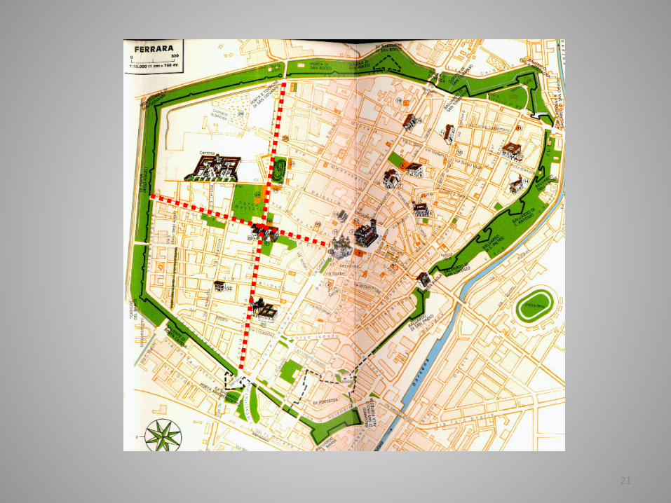
The shape of the city
The inner city

The shape of the city
The inner city

The shape of the city
The inner city

The shape of the city
The outer city

The shape of the city
A balance between:
The suburbs
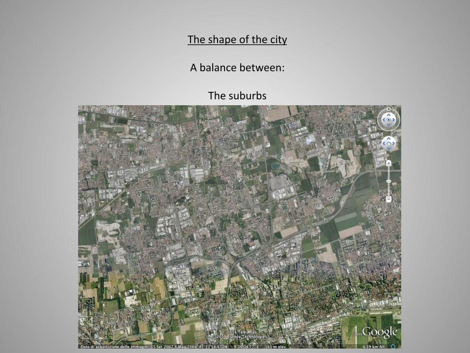
The shape of the city
A balance between:
The suburbs

17
The grid plan
The grid plan, made by streets and blocks for buildings, is by far one of the oldest urban tradition.
Since the ancient Greek world (for the Western traditions), the grid has been used to set and to build human settlements.

18
Roman Empire, and Roman city builders, used the grid plan to set new urban areas around Europe, to establish Roman possessions and to measure the space.
The first human operation to define his presence on the space is to draw a cross of two lines, one north-south and one east-west. The crossing point is the most important place for the settlement.
20/82

19

20
21

22
23
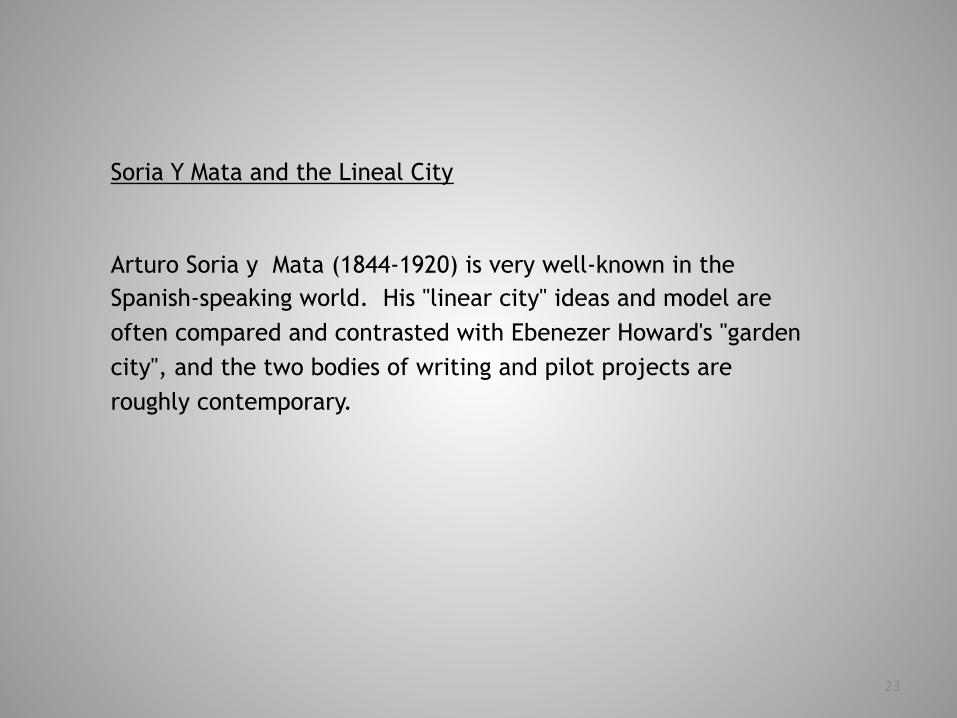
Soria Y Mata and the Lineal City
Arturo Soria y Mata (1844-1920) is very well-known in the Spanish-speaking world. His "linear city" ideas and model are often compared and contrasted with Ebenezer Howard's "garden city", and the two bodies of writing and pilot projects are roughly contemporary.

24
Soria y Mata was born in Madrid, lived in Madrid much of his life, and died in La Ciudad Lineal, a linear streetcar suburb of Madrid that he and his associates created as a pilot "linear city".
He established the first tramline in Madrid in 1875, and according to his entry in Enciclopedia Universal iIlustrada (Espasa-Calpe S.A., Madrid-Barcelona, 1927), "he invented urban telephone networks".

25
In 1894 he got initial approval for a "railway-tram" in a loop-route linking Madrid with various surrounding towns and villages, and he was also an advocate of a subway system for Madrid.
Soria y Mata established a magazine on urbanism called "La Ciudad Lineal", and he published booklets called "Ferrocarril-tranvia de circunvalacion" (1892) and "La ciudad lineal" (1894).

26
Soria y Mata's linear city was intended to "ruralize the city and urbanize the countryside", and his first article developing these ideas came out in March 1883 (15 years before Ebenezer Howard's rather different thesis).
He established the Compania Madrilena de Urbanizacion in 1892 as a means to bring his first linear city around Madrid to fruition -- intended to be 48 kilometers long, ringing the city, with a 7 kilometer radial connection -- but he had major problems selling sufficient shares in the company and raising the necessary capital.

27
Nevertheless, construction began in 1894 and olny one 5 kilometer section was completed in the 1910s -- a linear suburb of fairly dense low-rise housing all along the axis of a combined railway/tramway/boulevard.

28

29

30

31

32

33

34
35

36 30/82
37
The modern city
The word “urbanism” was born in the years 1880-1890.
According to the historian A. Sutcliffe, urbanisation at the beginning of the century meant to proceed in the organisation by a public authority of all or part of a city of where the land is in the possession of private individuals.
This needed controlling laws.
At the end of the century, urbanisation encompassed theories of the planning of urban space which were developed at that time.
Urbanisation became Town Planning around 1900.

38
The modern city
This re-thinking of the concept of urbanisation was imposed everywhere at the same time in the cities of the industrialised world.
There was an internationalisation of reforming action in cities.
International exhibitions took place in the major capitals. That of 1867, which was held in Paris, attracted 200,000 visitors.
It was the occasion to publicise abroad the work of Baron Haussmann who had remodelled Paris as a modern city.

39
The modern city
Remodelling of Paris 1853 – 1870. The first modern plan
Haussmann was an administrator, appointed prefect of the department of the Seine (which included Paris) in July 1853.
He was not a planner
Napoleon III, the newly proclamed emperor, wanted a capital that would be a showpiece
The population of the city had grown from 581.000 in 1800 to just over a million in 1850.
Paris was an overgrown medieval city, congested, filthy and politically unstable, its citizens feared by most French rulers.
The city was also experiencing inexorable economic pressures for change.

40
The modern city
Remodelling of Paris 1853 – 1870. The first modern plan

41
The modern city
Remodelling of Paris 1853 – 1870. The first modern plan
The emperor wanted (and in large measure, got) a new network of great boulevards, with circulation places where they came together.
Central to the overall concepts was what Haussmann called la grande croisée of Paris, which improved north-south and east-west communications.
In addition, there was extensive redevelopment in the very oldest parts.
Haussmann’s proposals, largely fullfilled after his time as prefect, included major road improvements in the southern part of the city and diagonal streets in the central zone.

42
The modern city
Remodelling of Paris 1853 – 1870. The first modern plan

43
44
The modern city
Remodelling of Paris 1853 – 1870. The first modern plan
All this was superimposed on the old arrangement of land plots, streets and alleyways. It was hugely disruptive to the historic environment and to existing interests, involving expensive and complex appropriations of land
The approach had, in theory at least, the great advantage that the new piercing streets created new frontages that had much higher values

45
The modern city
Remodelling of Paris 1853 – 1870. The first modern plan

46
The modern city
Remodelling of Paris 1853 – 1870. The first modern plan
47
The modern city
Remodelling of Paris 1853 – 1870. The first modern plan
175 streets were opened in Paris during these years.
The most important was the rue Rambuteau in 1838, because it was the first to be cut in the densely interwoven city-centre, which involved compulsory purchase and demolition.
The ancient system of waiting for obstructing buildings to fall into disrepair before forcing the owners to respect the alignment of the street was replaced by a new system of massive expropriation.
The same was done for the street of the Bourse, around the Louvre and the place Vendôme.

48
The modern city
Remodelling of Paris 1853 – 1870. The first modern plan
Haussmann was also able to exert careful facade controls on the rebuilding in relation to materials, height and architectural treatment
These gave great unity to the new thoroughfares that were created

49
The modern city
Remodelling of Paris 1853 – 1870. The first modern plan

50

51

52

53

54
The modern city
Remodelling of Paris 1853 – 1870. The first modern plan
Yet the restructuring of the street circulation system was only
part of Haussmann’s overall achievement.
Beneath the new streets a new drainage system was installed.
Haussmann can also claim credit, along with the emperor, for
several major new parks including the Bois de Boulogne, Bois de
Vincennes and the Buttes Chaumont

55
The modern city
Remodelling of Paris 1853 – 1870. The first modern plan

56
The modern city
Remodelling of Paris 1853 – 1870. The first modern plan

57
The modern city
Remodelling of Paris 1853 – 1870. The first modern plan
In practice, the Haussmann approach to forming new thoroughfares did not work quite as well as had been hoped.
) Acquisition costs increased, mainly because the colossal scale and rapid success of the whole undertaking encouraged speculation
) Nor did Haussmann’s appropriation and disposal powers give him as much freedom as they initially appeared to.
In any case, the payback time was inevitably long term, while costs were incurred short term.
The remodelling therefore had to be financed by massive amounts of credit, on a scale that was previously unknown.

58
The modern city
Remodelling of Paris 1853 – 1870. The first modern plan
Can we then see Haussmann as the originator of modern urban planning?
The city that Haussmann fashioned was much more bourgeois and businnes-oriented than it was aristocratic and courtly.
In one sense, Napoleon III was quite deliberately echoing a premodern tradition of regal and princely planning.
Yet, even more, he was addressing urban forces that were unmistakably modern and functional.

59
The modern city
Remodelling of Paris 1853 – 1870. The first modern plan

60
The modern city
Remodelling of Paris 1853 – 1870. The first modern plan
Haussmann was primarily undertaking a public works program. And public works are just a part of modern urban planning in advanced capitalist countries, but they are rather less than the whole.
They have tended to be seen as one of the 20th century planner’s bluntest and most expensive instruments.
Planning has, more typically, aspired to a more comprehensive coordination of public and private investment in the urban fabric. It also involved a wider regulation of the use of private land, something which was entirely absent from Haussmann.

61
The modern city
Remodelling of Paris 1853 – 1870. The first modern plan

62
The modern city
Remodelling of Paris 1853 – 1870. The first modern plan

63
The modern city
Remodelling of Paris 1853 – 1870. The first modern plan

64
The modern city
Remodelling of Paris 1853 – 1870. The first modern plan
A related point is that, despite Napoleon III’s original map (which has not survived), there was evidently no overall master plan.
Individual schemes were conceived incrementally within a very general conceptual one.
Haussmann improvised street lines even while schemes were under way.
In part, this avoidance of any very clear statement of intentions may have been a deliberate tactic to thwart the speculators. Yet it underlined the essentially opportunistic nature of Haussmannism.

65
The modern city
Remodelling of Paris 1853 – 1870. The first modern plan
These limitations did not, however, prevent knowledge of Haussmannism from spreading rapidly, and becoming one element of modern planning as it took shape over the following decades.
There were similar schemes in many French provincial cities, most notably Lyon and Marseilles.
During the 1860s, especially in the wake of the 1867 Universelle Exposition held in Paris, the model became international.
Amongst its first, and closest, imitators was Jules Anspach, mayor of Brussels from 1863, who directly sought Haussmann’s advice about his own projects for the Belgian capital.

66

67
The modern city
Remodelling of Paris 1853 – 1870. The first modern plan

68
The modern city
Remodelling of Paris 1853 – 1870. The first modern plan

69
The modern city
Remodelling of Paris 1853 – 1870. The first modern plan

70
The modern city
Remodelling of Paris 1853 – 1870. The first modern plan

71
The modern city
Remodelling of Paris 1853 – 1870. The first modern plan
There were also many echoes of Haussmannism in cities as diverse as Stockholm, Birmingham, Rome, during the later decades of the 19th century.
More followed in the early 20th century, often far outside Europe
Yet these references never produced anything on the same scale as the original , and often different in quite important aspects of detail.
In most cities the main problem was not the already built core. Rather, it was to ensure that urban growth occurred on well conceived lines.

72
The modern city
Remodelling of Paris 1853 – 1870. The first modern plan

73
The modern city
Remodelling of Paris 1853 – 1870. The first modern plan
This leads to the conclusion that Haussmannism was a breathtaking demonstration of the possibility of changing cities on a grand scale.
Except on a rather modest scale, it was not itself a transferable model of exactly how they would be changed.

74
The modern city
Urban growth in Europe 1850 – 1875. The German tradition
Planned urban extensions became quite common in continental Europe in the second half of 19th century.

75
The modern city
Urban growth in Europe 1850 – 1875. The German tradition
The main pretext for their preparation varied.
As in Barcelona, the removal or downgrading of urban fortifications was often important, for example, in the extension of Copenhagen, Vienna, Amsterdam, Milan.
In other cases, urban areas which retained strategic importance were refortified around an enlarged area, for example Lille.
The more general pressures of economic and population growth were also important. These were the main concerns of the well-known 1862 Berlin extension plan prepared by James Hobrecht.

76
The modern city
Urban growth in Europe 1850 – 1875. The German tradition

77
The modern city
Urban growth in Europe 1850 – 1875.
The nature of early extension plans varied but essentially they were road and streets layouts, typically revealing some thought about major and minor thoroughfares.
Most gave priority to formal aesthetic rather than functional criteria.
The extension plans were also underpinned by building regulations of varying sophistication.
But full land use and density zoning was not yet present.

78
The modern city
Urban growth in Europe 1875 – 1900. The German tradition
The last quarter of the 19th century marked a critical phase in the development of modern urban planning.
Everywhere, but particularly in western Europe and North America, there was a noticeable growth of interest in the nature of the city, its problems and how they might be remeiled.
Urban reformist movements

79
The modern city
Urban growth in Europe 1875 – 1900. The German tradition
In contrast to the pre-1875 period, most of the key innovations occurred in the newly united nation-state of Germany, or at least in German-speaking world.
Echoing British trends, German urban growth went hand in hand with industrial expansion.
The Prussian State parliament, the most important in Germany, passed a new law on street lines in 1875. The effect was to make town extension plans almost universal for all urban expansions.

80
The modern city
Urban growth in Europe 1875 – 1900. The German tradition
Municipalities had automatic compulsory purchase rights for the new streets in the extension plans, and permitted the costs of building, draining and lighting the nex streets to be passed to the frontage owners.
Many municipalities prepared extension plans on the pattern of the 1862 Hobrecht plan for Berlin, and permitted very high-density development.
There where mountains of criticisms from reformers.

81
The modern city
Urban growth in Europe 1875 – 1900. The German tradition
Reinhard Baumeister
first textbook on modern urban planning
Town extensions: their links with technical and economic concerns and with building regulations
1876
He was a professor of civil engineering and a planner of urban extensions.
The book defined two principal tasks:
to produce new housing and to expedite circulation

82
The modern city
Urban growth in Europe 1875 – 1900. The German tradition
Theorisation of ideal solutions was absent.
There was a scientific and functional basis offered to guide urban development in matters such as streets and major roads

83
The modern city
Urban growth in Europe 1875 – 1900. The German tradition
Camillo Sitte
Town building according to artistic principles
1889
Sitte’s essential argument was for a more organic approach to urban planning
He was inspired by the morphological qualities of historic towns in Europe, mainly those formed in the medieval period.
His ideas can be seen as the antithesis of highly formalised layouts with grand avenues and vistas

84
The modern city
Urban growth in Europe 1875 – 1900. The German tradition
The quality of organic historic towns arose precisely because of subtle variations around common features.

Politecnico di Milano School of Architecture and Society URBAN PLANNING STUDIO – 095990 Second semester, first year Prof. Marco Facchine: marco.facchine:@polimi.it 02 2399 5462 www.marcofacchine:.com March, 13th 2015
READING THE CITY The spa<al dimension: dimensions, shapes, growth, renewal FOUNDING, EXPANDING, TRANSFORMING AND SHRINKING THE CITY
1B

2
The modern city
Cerdà and Barcelona
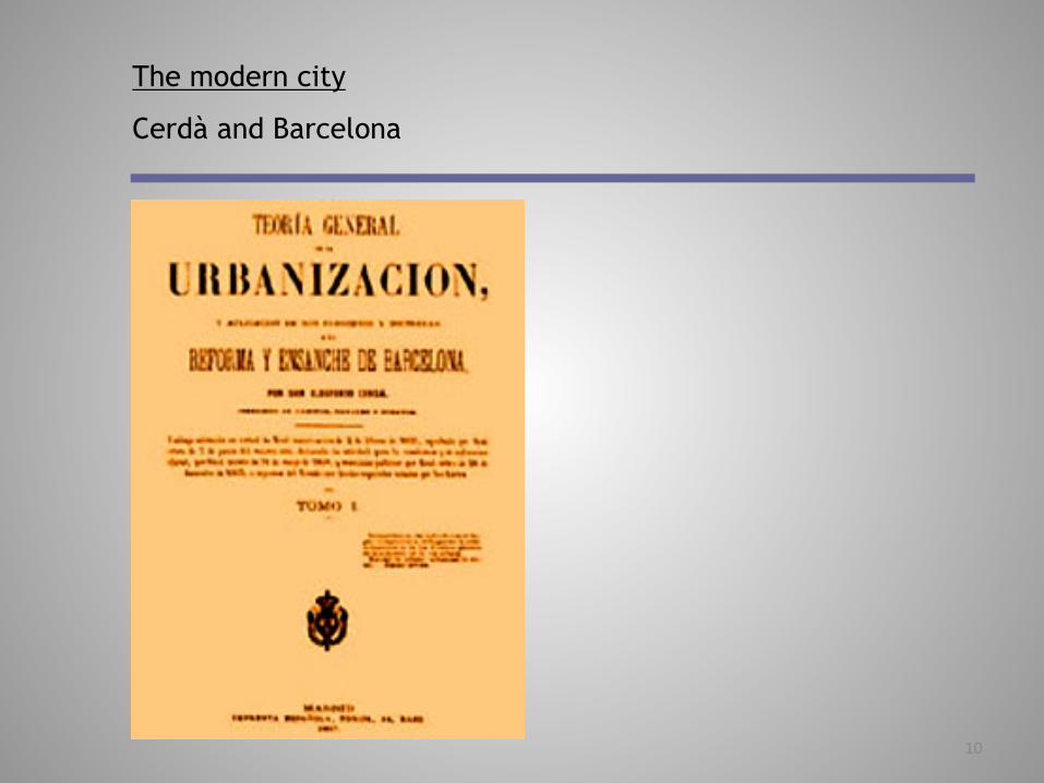
Another powerful contender for the title of first modern urban planner is Ildefons Cerdà
A Catalan engineer, Cerdà produced the highly distinctive plan for Barcelona’s Eixample (extension) beyond the former city walls in 1859.
He published in 1867 the Teorìa General de la Urbanizaciòn (general theory of urbanisation), one of the first modern attempt to theorise urban planning.

3
The modern city
Cerdà and Barcelona
Despite this, and very unlike Haussmann, Cerdà has been a rather neglected figure. Recently, however, his reputation has been restored and he is now far better known internationally than ever he was during his lifetime.
Cerdà exhibited many qualities that are associated with the values of the modern urban planning movements of the early 20th century.
A trained engineer, he possessed high technical skills, yet he combined these with a great visionary quality.
4
The modern city
Cerdà and Barcelona
Once Barcelona’s walls were down, a plan was needed to develop the land beyond them and connecting the city with the other suburban smaller cities (Gracia among them).
The city council held a competition for projects and proposals
in 1859.
Cerdà didn’t win the competition, but orders came from Madrid
that the plan to be adopted was the Cerdà’s scheme.

5
The modern city
Cerdà and Barcelona
Cerdà decided to ignore the overcrowded old town center and to develop a totally new, modern and rational scheme for the city beyond the demolished wall.
Two of the Eixample’s main avenues along a geographical
parallel split by roads crossing perpendicularly.
His central aim was to overcome social problems by using
quadrangular blocks of a standard size, with strict building
controls to ensure that they were built up on only two sides, to
a limited height, leaving a shady square or garden in between.

6
The modern city
Cerdà and Barcelona
The recreational open space with open sides to the blocks was
to guarantee the houses the maximum amount of sun, light and
ventilation.
The housing blocks were to be orientated NW-SE to ensure all
apartments received sunshine during the day.
Each district would be of 20 blocks, containing all the
community shops and services.

7
The modern city
Cerdà and Barcelona

8
The modern city
Cerdà and Barcelona
The most characteristic feature of Cerdà’s plan is the 45°
angled corner of each block.
The idea behind this was to ensure more fluid traffic in all
directions, above all for public transport.
It was mainly the steam tram that Cerdà had in mind, and it
was its turning radius that determined the angle of the corners
of the buildings.

9
The modern city
Cerdà and Barcelona
10
The modern city
Cerdà and Barcelona

11
The humanistic side of the engineer is reflected in the way, rather unusual by that time, Cerdà scientifically analyzed many theoretical aspects, for istance urban and housing standards.
The modern city
Cerdà and Barcelona
A new conception of the urbanisation process
Coherent design of streets/blocks, public/private spaces, utility networks, public/private transportation, considering as well the subtle link between housing economics and issues of social integration.

12
Extension’s implementation, mainly through legal and financial regulations linked to the development process, was done in such a way as to allow the different social levels to live together in the same building:
Quality apartments on the first and second floor with back gardens for owners and high income families
Upper level apartments, more modest but subject to the established standards for workers
The modern city
Cerdà and Barcelona

13
This model implies equal access to the same neighbourhood and commercial facilities.
It is a fundamental part of an implicit social contract between the industrial upper class and the working class, which has clearly contributed to smoother relations and the removal of radical conflicts.
The modern city
Cerdà and Barcelona
Catalonia particular situation: from 1900 to 2000 the region tripled its population, while that of the rest of Spain hardly doubled

14
Despite this, and very unlike Haussmann, Cerdà has been a rather neglected figure. Recently, however, his reputation has been restored and he is now far better known internationally than ever he was during his lifetime.
Cerdà exhibited many qualities that are associated with the values of the modern urban planning movements of the early 20th century.
A trained engineer, he possessed high technical skills, yet he combined these with a great visionary quality.
The modern city
Cerdà and Barcelona

15
The modern city
Cerdà and Barcelona

16
The modern city
Cerdà and Barcelona

17
1855 was the year when the Government authorized the demolition of the walls of the ancient city, and also when the engineer Ildefons Cerdà drew up the blueprint of the Extension Plan of Barcelona.
The plan was based on the excellent topographic map of the city and its neighbouring territory, drawn up under the engineer’s own direction.
The modern city
Cerdà and Barcelona

18
The modern city
Cerdà and Barcelona

19
The modern city
Cerdà and Barcelona

20
The smoothly sloped plain was for centuries artificially kept free from any kind of urbanisation due to military reasons, only gathering by Cerdà’s time some traditional towns (Sants, Sarrià, Gracia, Sant Andreu, among other smaller ones), which today constitute the core of the different boroughs in Barcelona.
The Extension plan was basically conceived by Cerdà as an antidote to the extremely high density “that kills”, of near 900 inhabitants per hectare, and resultant unhealtly living conditions.
The modern city
Cerdà and Barcelona

21
Once Barcelona’s walls were down, a plan was needed to develop the land beyond them and connecting the city with the other suburban smaller cities (Gracia among them).
The city council held a competition for projects and proposals
in 1859.
The city council actually preferred the scheme developed by Antoni Rovira i Tras, for long straight streets radiating out fan-like from the old city center.
For reasons that have never been explained, orders came from Madrid that the plan to be adopted was Cerdà’s plan. The city council had disliked Cerdà’s scheme because it ignored the old center of the city.
The modern city
Cerdà and Barcelona

22
Cerdà has surveyed and drawn the city’s first accurate plans in 1855. He was also influenced by the problems of El Raval, concerned with the cramped and unhealthy contitions of workers’housing and the high death rate and crime that he saw resulted from this.
Cerdà surveyed the working-class way of life in the 1850s and found that a diet of bread and potatoes, enhanced with the odd sardine, was all an average family could afford.
Observers blamed the cholera epidemic of 1854, which clamed 6,000 lives, on overcrowding in insanitary conditions. Disorder, disease and riots were a regular feature of the long hot summer of 1854
The modern city
Cerdà and Barcelona

23
Cerdà loved straight lines, and his idea was to place two of the Eixample’s main avenues along a geographic parallel split by roads crossing perpendicularly.
The modern city
Cerdà and Barcelona

24
The modern city
Cerdà and Barcelona

25
The modern city
Cerdà and Barcelona
26
The modern city
Cerdà and Barcelona

27
Cerdà’s central aim was to overcome social problems by using quadrangular blocks of a standard size, with strict building controls to ensure that they were built up on only two sides, to a limited height, leaving a shady square of garden in between.
This recreational open space with open sides to the blocks was to guarantee the houses the maximum amount of sun, light and ventilation.
The housing blocks were to be oriented NW – SE to ensure all apartments received sunshine during the day.
The modern city
Cerdà and Barcelona

28
The modern city
Cerdà and Barcelona

29
The modern city
Cerdà and Barcelona

30
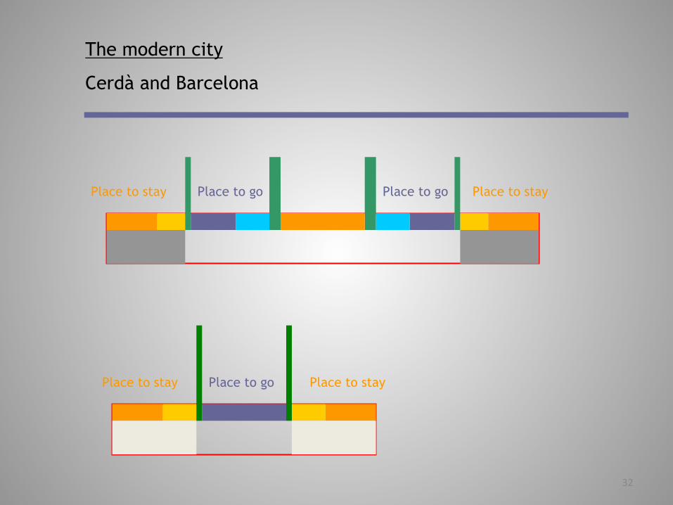
The regular streets were built 20 metres wide.
Gran Via was 50 metres wide
Passeig de Gracia was as much as 60 metres wide
For Cerdà, the function of the street was for communication and the movement of traffic.
Places to go – the street’s grid
Places to stay – the block’s grid
The modern city
Cerdà and Barcelona

31
The modern city
Cerdà and Barcelona
32
Place to stay
Place to stay Place to stay
Place to stay Place to go
Place to go Place to go
The modern city
Cerdà and Barcelona

33
The modern city
Cerdà and Barcelona

34
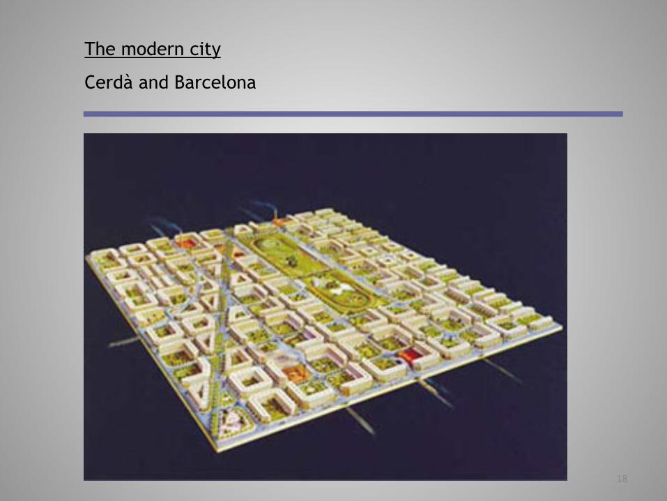
The Eixample was planned using an extensive grid-iron pattern.
The grid, with wide roads and bevelled street corners was designed for the easy passage of the steam tram along each street.
The most characteristic feature of Cerdà’s plan is the 45° angled corner of each block.
The idea behind this was to ensure more fluid traffic in all directions, above all for public transportation. It was mainly the steam tram that Cerdà had in mind, and it was its long turning radius which determined the angle of the corners of the buildings.
The modern city
Cerdà and Barcelona

35
The modern city
Cerdà and Barcelona

36
The modern city
Cerdà and Barcelona
37
The modern city
Cerdà and Barcelona

38
The plan intended a kind of garden city in which two sides of each low-rise block would be left open for small parks and greenery.
The sides of the blocks measured 113,3 metres and covered 12,370 squares metres, of which at least 800 square metres were to be gardens.
The modern city
Cerdà and Barcelona

39
The modern city
Cerdà and Barcelona

40
The modern city
Cerdà and Barcelona

Politecnico di Milano School of Architecture and Society URBAN PLANNING STUDIO – 095990 Second semester, first year Prof. Marco Facchine: marco.facchine:@polimi.it 02 2399 5462 www.marcofacchine:.com March, 13th 2015
READING THE CITY The spa<al dimension: dimensions, shapes, growth, renewal FOUNDING, EXPANDING, TRANSFORMING AND SHRINKING THE CITY
1C

2
The modern city
Cerdà and Barcelona

3
In the twentieth century, with increasing populaton pressure, and the need for car parking, most of these open areas were developed and infilled.
Most of the blocks were increased in height to a uniform eight floors by developers intent upon maximising their incomes.
Today the population density of l’Eixample is one of the highest in the world.
The modern city
Cerdà and Barcelona

4
The modern city
Cerdà and Barcelona

5
The modern city
Cerdà and Barcelona
6
Each district would be of 20 blocks, containing all the community facilities, shops and services.
The large urban facilities in Barcelona had to find a way of fitting into the grid, allowing easy access for everybody, without interfering with the functionality of the whole.
The modern city
Cerdà and Barcelona

7
For more than a century, the city has systematically adopted the trend to embrace complete block units into a larger unit,
one (several goods markets...)
two (prison, Central University, Hospital)
three (Antoni Gaudi’s Holy Family Sanctuary)
four ( ancient polytechnic university, parks...)
nine (Sant Pau hospital)
The modern city
Cerdà and Barcelona

8
The modern city
Cerdà and Barcelona

9
PLN
685
Urb
an d
esig
n is
sues
in E
urop
e The modern city
Cerdà and Barcelona

10
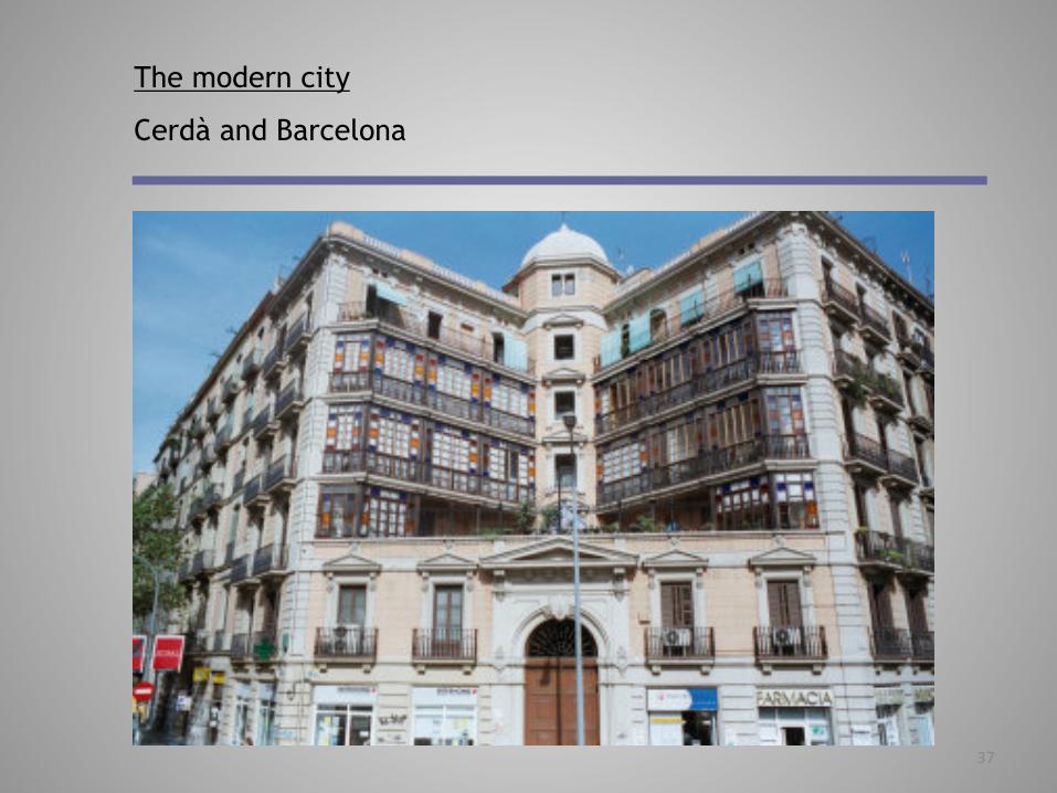
In the event, though, this idealised use of urban space was scarcely achieved, for the private developers who actually built the Eixample regarding Cerdà’s restrictions on their property (and profits) as pointless interferences.
While the Cerdà’s more visionary ideas were largely lost over time, the construction of the Eixample did see the development of a specific type of building: the quality apartment block, with large apartments on the lower principal floor. The top floors contained apartments with roof gardens.
The modern city
Cerdà and Barcelona

11
The modern city
Cerdà and Barcelona

12
The modern city
Cerdà and Barcelona

13
The modern city
Cerdà and Barcelona

14
The larger blocks today have been converted into offices and multi-family dwellings.
Old-time residents of the district have to mix with newcomers such as banks, hotels, offices and shops.
The Passeig the Gracia makes up the heart of the Eixample.
The right of the Eixample contains most of the more distinguished architecture since it was the first area to be developed, with many buildings designed for the wealthy textile merchants.
The modern city
Cerdà and Barcelona

15
The left of the Eixample was built slightly later than the right and is more residential and even working class in places.
It is more liberally sprinkled with general city services such as the Hospital, the Escola Industrial, the Prison.
The area has two very large markets, the Nonot and the Mercat de Sant Antoni, touching onto the Raval.
The modern city
Cerdà and Barcelona

16
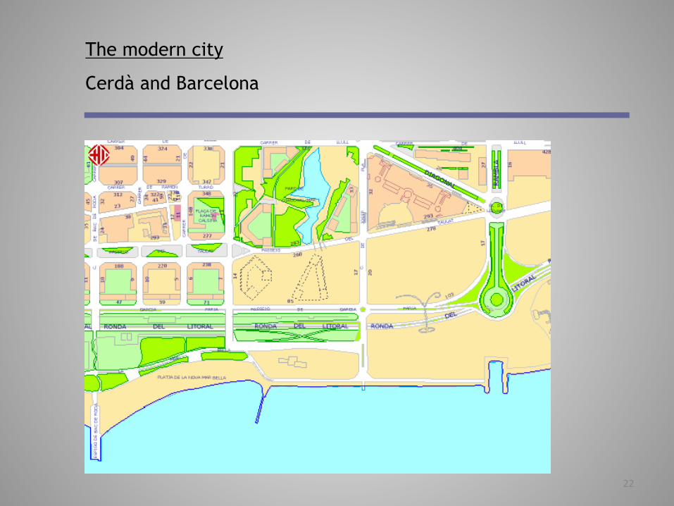
Over the past few years the city has begun trying to implement Cerdà’s idea for green public spaces behind the buildings.
The organisation responsible for this project is called
Proeixample S.A.
It is a joint venture of the city of Barcelona and Catalan Banks.
When part of the block becomes available, Proeixample takes the initiative. The design and layout costs of the parks are paid by development and sale of the remainder of the land for apartments or public services.
The modern city
Cerdà and Barcelona

17
The advantage of this method is that it doesn’t cost any money
The disadvantage is that it is a very slow process.
Eight squares have been laid out and another ten are planned.
The ultimate goal is to create one patio-garden for every nine blocks.
But in order to achieve that, 20 inner courtyards must be recovered. The patio-gardens contribute only modestly to the increase of public space in the Eixample. From 1.6m2 per resident, the number has gone up to 1.7m2.
The modern city
Cerdà and Barcelona
18
The modern city
Cerdà and Barcelona

19
A chain of successive permissive building regulations, only broken in 1976, thanks to the land use metropolitan plan still applying today, have brought the Eixample density far beyond Cerda’s initial perspectives.
But, recent physical proposals such as the Olympic Village or the industrial restructuring on the Eixample’s east side are shown to be able to be easily fitted into the same scheme.
The modern city
Cerdà and Barcelona

20
In preparing for the 1992 Olympics, significant modifications and improvements were made to the city structure.
In order to house the athletes an Olympic village was constructed on a coastal site to the north-east of the city.
The Olympic Village apartment blocks were designed along the lines originally envisaged by Cerdà.
The modern city
Cerdà and Barcelona

21
The modern city
Cerdà and Barcelona
22
The modern city
Cerdà and Barcelona

23
The modern city
Cerdà and Barcelona

24
The modern city
Cerdà and Barcelona
25
The Cerdà plan covers 1300 hectares of rectangular blocks, more or less 14% of the present municipal surface area. It has been implemented in different stages, from the start of industrialisation in Catalonia.
The modern city
Cerdà and Barcelona
It is seen by many scholars as a consistent framework which has conferred to the city not only an individual personality, but also a special ability to accomodate changes in social structure, economy or land use regulations throughout time.

26
More than this, it has proved to be a framework able to produce dynamic impulses as well as be responsible for much stability in the urban system, while keeping its basic spatial functions.
It makes the urban system develop as a coherent whole in the fields of productivity, competition and internal cohesion.
The modern city
Cerdà and Barcelona
That has something to do with the creative forces emanating from the strong interaction between some crucial elements starting in the middle of the 19th century.
...the birth of a new industrial bourgeoisie...