us 16 - wyoming department of transportation is a favorite destination for ... fishing, hiking,...
TRANSCRIPT

US 16 ©WYDOT/Rick Carpenter
?Å
A÷
?Ä
)v
)v
)¦)¦
)v
A÷
)y
)vAî
Af
!"̀$)¦
!"b$
Aí
Aì AñAï
Cloud Peak Skyway Scenic Byway
Red Gulch/AlkaliScenic Backway
0 105
MILES
J O H N S O N
N
STATE SIGNIFICANTCORRIDOR
Hyattville
Worland*
Buffalo
W A S H A K I E
B I G H O R N
TenSleep
BLM USFS Scenic Byway Intercity Bus Route Designated Bike Route Primary Airport
o
General Aviationp Urban AreaGreyhound Stations Local Service
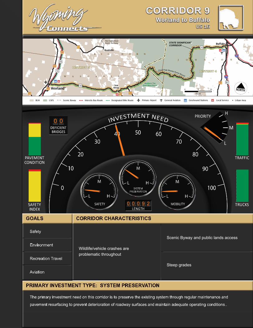
Corridor 9
0 0
0 0 0 9 2
Worland to BuffaloUS 16
CO
RR
IDO
R 9
Safety
Environment
Recreation Travel
Aviation
The primary investment need on this corridor is to preserve the existing system through regular maintenance and
pavement resurfacing to prevent deterioration of roadway surfaces and maintain adequate operating conditions..
Wildlife/vehicle crashes are problematic throughout
Scenic Byway and public lands access
Steep grades
CO
RR
IDO
R 9

Worland to Buffalo | US 169-2
Corridor DescriptionState Significant Corridor (SSC) 9 follows US 16 from Worland to Buffalo. This 92 mile corridor passes through the counties of Washakie and Johnson. US 16 and US 20 diverge in Worland; US 16 turns east toward Ten Sleep and Buffalo while US 20/WYO 789 connects south to Thermopolis. US 16/20 travels north to Basin and Greybull.
Washakie County is a leading producer of sugar beets, corn, small grains, alfalfa hay, and beans on mostly irrigated land. Farmers irrigate much of the land here to ensure adequate watering. As US 16 heads east, it leaves this agricultural area behind as it enters Ten Sleep Canyon and the Big Horn Mountains.
From the town of Ten Sleep (population 315), US 16 heads east along Ten Sleep Creek and through Ten Sleep Canyon. As US 16 continues into the Big Horn Mountains, it crosses Powder River Pass at an elevation of 9,666 feet.
The Cloud Peak Scenic Byway overlays part of the corridor. It begins at WYO 435 just off US 16 and continues east through Ten Sleep Canyon, ending just before entering Buffalo. The route includes spectacular views and access to the Cloud Peak Wilderness Area. (“Wyoming’s Scenic Byways and Backways;” WYDOT; 7/1/04). The segment from Worland to Buffalo is also designated as part of the Northern Tier East-West Bicycle Route.
US 16 makes a steep descent into Buffalo and Johnson County. The grade is measured at six to seven percent in many places. US 16 intersects with the US 87 business route in downtown Buffalo and I-25 and I-90 just outside of town.
Corridor CharaCteristiCs

US 16 | Worland to Buffalo 9-3
Corridor 9
ENVIRONMENTAL CONTEXT
?Å
A÷
?Ä
)v
)v
)¦)¦
)v
A÷
)y
)vAî
Af
!"̀$)¦
!"b$
Aí
Aì AñAï
0 105
MILES
J O H N S O N
N
Hyattville
Worland*
Buffalo
W A S H A K I E
B I G H O R N
TenSleep
Ten Sleep Canyon
B I G H O R N N A T I O N A L
F O R E S T
Red Gulch/AlkaliScenic Backway
Cloud Peak Skyway Scenic Byway
Outdoor Recreation Heavy Snow Uranium
The above map identifies issues and environmental constraints that form the basis for environmental review. Future projects in the corridor will take these and other issues under consideration prior to final design.
Environmental ContextUS 16 from Worland to Ten Sleep is mostly agricultural before entering the western foothills of the Big Horn Mountains. Just east of Ten Sleep is Ten Sleep Canyon, which ascends 3,000 feet in less than 10 miles through a series of switchbacks. The canyon is a favorite destination for rock climbers because of its diverse climbing challenges.
The Bighorn National Forest also includes the Cloud Peak Wilderness Area. This area totals 189,039 acres of sharp summits and towering sheer rock faces and is managed by the U.S. Forest Service.
Corridor Interests:
▪ Scenic Byway
▪ Visual Resources
▪ Recreation Management
▪ Travel Management
▪ Wildlife Connectivity, Habitat Fragmentation, & Fish Passage
▪ Wetlands, Fens
▪ Invasive Species
Source: U.S. Forest Service

Worland to Buffalo | US 169-4
Key Issues and Emerging Trends
Ñ The corridor attracts recreational and tourist travelers who have special requirements, which are accommodated by enhanced signage and pull over and observation stops. Because of the steepness of Ten Sleep Canyon, buses and slower vehicles can pull over, and passing lanes maintain traffic flow. Recreational uses include all terrain vehicles, snowmobiles, fishing, hiking, camping, and skiing.
�Safety issues are a concern along US 16 east of Ten Sleep in Ten Sleep Canyon to Buffalo.
��The public lands and Ten Sleep Canyon are environmentally sensitive and require special efforts to ensure good water quality, contiguous wildlife habitat, storm water run off controls, preservation of wetlands and view sheds.
��Wildlife/vehicle conflicts are an issue, especially east of Ten Sleep.
�Roadway surface conditions on local roads including WYO 436 and WYO 435 are in poor condition, symptomatic of the high costs of construction and maintenance in mountainous areas.
• A rockfall area exists west of Deer Haven, requiring frequent mitigation and maintenance activities.
• Continuing cooperation/coordination with the Bureau of Land Management and Big Horn Forest USFS is vital for effective management of the corridor
�
Major Traffic Generators
▪ Dispersed recreational traffic – National Forest
▪ Meadowlark Ski Area (future)

US 16 | Worland to Buffalo 9-5
Corridor 9
Goals & StrategiesGoals for the corridor represent issues communicated by participants in the planning process. These goals lay groundwork for the development of a financially feasible multi-modal transportation plan designed to support the planning, engineering, construction, operation, and maintenance of the State’s transportation system.
By identifying broad goals that are both visionary and practical, and that respond to the values of this region, the focus of future actions is readily identified. The goals are further defined with specific supporting strategies to attain each goal. The key goal for the corridor is to maintain
the existing system.
Primary Investment TypeSYSTEM PRESERVATION – The primary investment need on this corridor is to preserve the existing system through regular maintenance and pavement resurfacing to prevent deterioration of roadway surfaces and maintain adequate operating conditions.
Goals strateGies
Preserve the existing transportation system Surface treatment/overlays
Reduce fatalities, injuries, and property damage crash rate Support farm to market economic sustainability
Establish appropriate speed limits
General safety improvements
Auxiliary lanes if warranted (passing, turn, accel/decel)
Promote environmentally responsible transportation improvements
Improve access to public lands
Cultural resources
Stormwater runoff
View sheds
Wetlands preservation/banking
Wildlife corridors/wildlife habitat connectivity
Support recreation travel
ITS/VMS
Roadway pullouts for breakdowns, buses, and slow vehicles
Traveler information
Ensure airport facility meets existing and projected demands Passenger air service

Worland to Buffalo | US 169-6
The pavement surface conditions along SSC 9 are rated mostly good to fair. From Worland to Ten Sleep, US 16 is rated as good and from Ten Sleep to southwest of Granite Pass, the pavement is rated fair with one section rated poor. From southwest of Granite Pass to Buffalo, the pavement is rated mostly good/excellent.
?Å
A÷
?Ä
)v
)v
)¦)¦
)v
A÷
)y
)vAî
Af
!"̀$)¦
!"b$
Aí
Aì AñAï
0 105
MILES
J O H N S O N
N
Hyattville
Worland*
Buffalo
W A S H A K I E
B I G H O R N
TenSleep
Excellent
Good
Fair
SURFACE CONDITION
Poor
PAVEMENT SURFACE CONDITION
?Å
A÷
?Ä
)v
)v
)¦)¦
)v
A÷
)y
)vAî
Af
!"̀$)¦
!"b$
Aí
Aì AñAï
0 105
MILES
J O H N S O N
N
Hyattville
Worland*
Buffalo
W A S H A K I E
B I G H O R N
TenSleep
< 1,000
1,000 - 2,500
2,500 - 5,000
> 10,000
VEHICLES PER DAY
5,000 - 10,000
AVERAGE ANNUAL DAILY TRAFFIC (AADT)
From Worland to Ten Sleep, SSC 9 averages 1,000 to 2,500 vehicles per day (vpd). Through Ten Sleep Canyon and Powder River Pass, US 16 has less than 1,000 vpd, then increases to 1,000 to 2,500 vpd.
Roadway CharacteristicsThe following maps identify conditions on the corridor with respect to surface condition, total traffic, truck traffic, safety, and bridges. The data represent the most recent available and are subject to change over time as projects are completed or other factors affect existing conditions. The system data play a big part in determining current operating characteristics, the type of need, and the extent of improvements necessary to achieve corridor goals.

US 16 | Worland to Buffalo 9-7
Corridor 9
?Å
A÷
?Ä
)v
)v
)¦)¦
)v
A÷
)y
)vAî
Af
!"̀$)¦
!"b$
Aí
Aì AñAï
0 105
MILES
J O H N S O N
N
Hyattville
Worland*
Buffalo
W A S H A K I E
B I G H O R N
TenSleep
< 100
100 - 500
500 - 1,000
> 2,500
TRUCKS PER DAY
1,000 - 2,500
AVERAGE ANNUAL DAILY TRUCK TRAFFIC (AADTT)
The truck traffic from Worland east to Ten Sleep averages 100 to 500 trucks per day. From Ten Sleep to Buffalo, the truck traffic drops to less than 100 trucks per day.
A five mile section of the corridor on Powder River Pass has a below average Safety Index grade of D.
?Å
A÷
?Ä
)v
)v
)y)¦)¦
)v
!"b$
)q )v )y
A÷
)y
)v
?Ä
Aî
Af
!"̀$)¦
!"b$
Aí
Aì AñAï
0 105
MILES
J O H N S O N
N
STATE SIGNIFICANTCORRIDOR
Hyattville
Worland*
Buffalo
W A S H A K I E
B I G H O R N
TenSleep
AB
C
F
SAFETY INDEX GRADE
D
SAFETY INDEX
kj
kj
kj
kj
kj
kjkj
kj
kj
kjkj
kj
kj
?Å
A÷
?Ä
)v
)v
)¦)¦
)v
A÷
)y
)vAî
Af
!"̀$)¦
!"b$
Aí
Aì AñAï
0 105
MILES
J O H N S O N
N
Hyattville
Worland*
Buffalo
W A S H A K I E
B I G H O R N
TenSleep
Deficient Bridges
BRIDGE STRUCTURES
DEFICIENT BRIDGES
There are no deficient bridges for this corridor. All deficient bridges visible in the map window are displayed, regardless of designation as SSC, Regional, or Local Routes.

Worland to Buffalo | US 169-8
reGional reference information
Public Transportation Agencies
Provider aGency name location tyPe of service size of
fleet
annual PassenGer triPs fy08
Ten Sleep Senior Center
Ten Sleep Non-Profit - Demand Response
2 Vehicles 4,884
Buffalo Senior Citizens Center
Buffalo Non-Profit - Demand Response
3 Vehicles 18,564
Jefferson Bus Lines Rapid City, SD to Billings, MT through Buffalo
For Profit; Fixed Route Intercity Bus
N/A N/A
Washakie County Senior Citizens Center
Washakie Non-Profit - Demand Response
3 Vehicles 7,649
Black Hills Stage Line Billings, MT to Denver, CO through Worland
Private; Fixed Route Intercity Bus
N/A N/A
Source: WYDOT
INTERMODAL FACILITIES
Intercity Bus Routes The Black Hills Stage Line passes through Worland as it travels between Denver, Colorado and Billings, Montana.
Class 1 RailroadsNone
REGIONAL ROUTES
No regional routes connect to this corridor.
URBAN AREAS
Urban areas are cities with populations greater than 5,000 people. Even though the population of Worland dropped below the 5,000 threshold in 2008, it is still considered part of WYDOT’s urban program. Urban areas are discussed in detail in the Urban Corridors section later in the document.
LOCAL ROUTES
local route county from to
WYO 434 Washakie US 16 South
WYO 435 Washakie US 16 Southeast to Bighorn National Forest
WYO 436 Washakie US 16 Hazelton Rd
Source: Official State Highway Map of Wyoming

US 16 | Worland to Buffalo 9-9
Corridor 9
Airport Information
airPort name (associated city)
nPias role & HuB tyPe1 nPias
Wydot classification (2008)
Wydot classification (future)
total airPort oPerations
Based aircraft
total PassenGers (2006)
Worland Municipal Airport (Worland)2
GA NPIAS Commercial Commercial 4,180 13 6,091
Notes: P - Primary Commercial Service, N - Non-hub Facility, GA - General Aviation 1NPIAS (National Plan of Integrated Airport Systems) Role and Hub Type are same for both existing (2007) and 5-year federal forecast 2Worland is listed as a “GA” airport in the NPIAS, but currently has scheduled airline service and is recognized by WYDOT as a Commercial Service Airport
Source: WYDOT and FAA
DEMOGRAPhIC ChARACTERISTICS
SSC 9 travels through three counties: Big Horn, Johnson and Washakie Counties. Johnson County grew at a rate of 19.6 percent between 2000 and 2008. Johnson County includes Buffalo, which had a population of 4,832 in 2008, and which had a 23.5 percent growth rate during the period.
Washakie County lost 5.6 percent of its population in that same time period, with a total population of 7,821 in 2008. Worland, in Washakie County, lost 6.3 percent of its population in the period from 2000 to 2008. Big Horn County lost 1.2 percent of its population between 2000 and 2008
Education & Health jobs account for the highest category of employment for the three counties. In Big Horn County, Retail and Agriculture, both at 11 percent employment, follow behind Education & Health at 24 percent employment. Education & Health account for 20 percent of employment in Johnson County with Agriculture close behind with 16 percent of employment. In Washakie County, Education & Health account for 19 percent of employment and Retail provides 12 percent of employment. See Appendix B for more details about employment by county.
PoPulation: 2000-2008
COUNTY CITY 2000 2008 % GROWTH % STATE TOTAL (2008)
Big Horn county 11,461 11,322 -1.2 2.1
Basin 1,238 1,243 -0.2
Burlington 250 253 1.2
Byron 557 557 0.0
Cowley 560 614 9.6
Deaver 177 177 0.0
Frannie (pt.) 180 179 -0.6
Greybull 1,815 1,739 -4.2
Lovell 2,281 2,276 -3.6
Manderson 104 100 -3.8
Johnson county 7,075 8,464 19.6 1.6
Buffalo 3,900 4,832 23.5
Kaycee 249 290 16.5
Washakie County 8,289 7,821 -5.6 1.5
Ten Sleep 304 315 3.6
Worland 5,250 4,958 -6.3
Source: Population Division, US Census Bureau, July 1, 2009