us 25 alternatives study - kentucky transportation cabinettransportation.ky.gov/planning/planning...
TRANSCRIPT

FINAL REPORTApril 2009
US 25 Alternatives StudyItem No. 6-112.00 Grant County
Executive Summary
US 25 Alternatives Study Page S-1
KENTUCKY TRANSPORTATION CABINET US 25 ALTERNATIVES STUDY, GRANT COUNTY
KYTC Item No. 6-112.00 Improvement and/or potential realignment of US 25 between Dry Ridge and Crittenden
April 2009
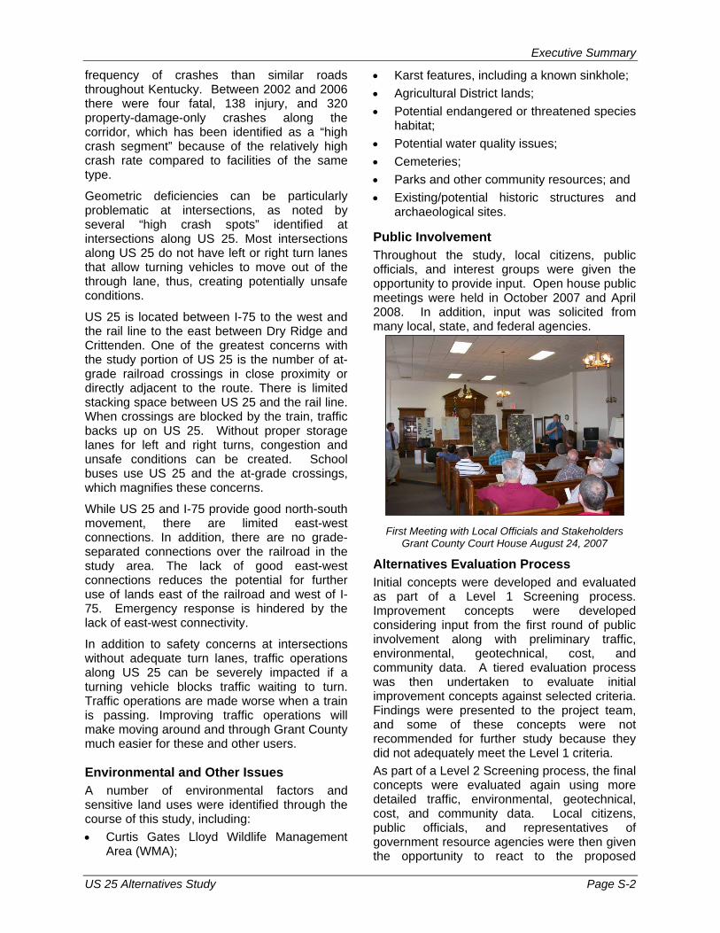
The Kentucky Transportation Cabinet (KYTC) has undertaken this Alternatives Study to consider the improvement and/or potential realignment of US 25 between Dry Ridge and Crittenden in Grant County, including consideration of a new interchange with I-75.
The purpose of this study is to:
• Identify known issues, concerns, and constraints, including safety, traffic, social, environmental, and geotechnical considerations.
• Develop preliminary “purpose and need” and goals for the proposed project.
• Listen to and share information with local officials, government agencies, other interested parties, and the public.
• Develop and evaluate improvement concepts for US 25 based on purpose and need, including a potential new interchange with I-75 and short-term improvements along the existing route.
• Make project recommendations.
Study Area
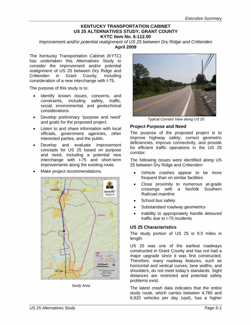
Typical Corridor View along US 25
Project Purpose and Need The purpose of the proposed project is to improve highway safety, correct geometric deficiencies, improve connectivity, and provide for efficient traffic operations in the US 25 corridor.
The following issues were identified along US 25 between Dry Ridge and Crittenden:
• Vehicle crashes appear to be more frequent than on similar facilities
• Close proximity to numerous at-grade crossings with a Norfolk Southern Railroad mainline
• School bus safety • Substandard roadway geometrics • Inability to appropriately handle detoured
traffic due to I-75 incidents
US 25 Characteristics The study portion of US 25 is 9.5 miles in length.
US 25 was one of the earliest roadways constructed in Grant County and has not had a major upgrade since it was first constructed. Therefore, many roadway features, such as horizontal and vertical curves, lane widths, and shoulders, do not meet today’s standards. Sight distances are restricted and potential safety problems exist.
The latest crash data indicates that the entire study route, which carries between 4,780 and 6,920 vehicles per day (vpd), has a higher
Executive Summary
US 25 Alternatives Study Page S-2
frequency of crashes than similar roads throughout Kentucky. Between 2002 and 2006 there were four fatal, 138 injury, and 320 property-damage-only crashes along the corridor, which has been identified as a “high crash segment” because of the relatively high crash rate compared to facilities of the same type.
Geometric deficiencies can be particularly problematic at intersections, as noted by several “high crash spots” identified at intersections along US 25. Most intersections along US 25 do not have left or right turn lanes that allow turning vehicles to move out of the through lane, thus, creating potentially unsafe conditions.
US 25 is located between I-75 to the west and the rail line to the east between Dry Ridge and Crittenden. One of the greatest concerns with the study portion of US 25 is the number of at-grade railroad crossings in close proximity or directly adjacent to the route. There is limited stacking space between US 25 and the rail line. When crossings are blocked by the train, traffic backs up on US 25. Without proper storage lanes for left and right turns, congestion and unsafe conditions can be created. School buses use US 25 and the at-grade crossings, which magnifies these concerns.
While US 25 and I-75 provide good north-south movement, there are limited east-west connections. In addition, there are no grade-separated connections over the railroad in the study area. The lack of good east-west connections reduces the potential for further use of lands east of the railroad and west of I-75. Emergency response is hindered by the lack of east-west connectivity.
In addition to safety concerns at intersections without adequate turn lanes, traffic operations along US 25 can be severely impacted if a turning vehicle blocks traffic waiting to turn. Traffic operations are made worse when a train is passing. Improving traffic operations will make moving around and through Grant County much easier for these and other users.
Environmental and Other Issues A number of environmental factors and sensitive land uses were identified through the course of this study, including: • Curtis Gates Lloyd Wildlife Management
Area (WMA);
• Karst features, including a known sinkhole; • Agricultural District lands; • Potential endangered or threatened species
habitat; • Potential water quality issues; • Cemeteries; • Parks and other community resources; and • Existing/potential historic structures and
archaeological sites.
Public Involvement Throughout the study, local citizens, public officials, and interest groups were given the opportunity to provide input. Open house public meetings were held in October 2007 and April 2008. In addition, input was solicited from many local, state, and federal agencies.
First Meeting with Local Officials and Stakeholders Grant County Court House August 24, 2007
Alternatives Evaluation Process Initial concepts were developed and evaluated as part of a Level 1 Screening process. Improvement concepts were developed considering input from the first round of public involvement along with preliminary traffic, environmental, geotechnical, cost, and community data. A tiered evaluation process was then undertaken to evaluate initial improvement concepts against selected criteria. Findings were presented to the project team, and some of these concepts were not recommended for further study because they did not adequately meet the Level 1 criteria. As part of a Level 2 Screening process, the final concepts were evaluated again using more detailed traffic, environmental, geotechnical, cost, and community data. Local citizens, public officials, and representatives of government resource agencies were then given the opportunity to react to the proposed

Executive Summary
US 25 Alternatives Study Page S-3
improvement concepts through the second round of public involvement activities. Results of the Level 2 Screening, along with public and resource agency input, were summarized and presented to the project team for discussion. The result of this meeting was the recommendation of a preferred concept.
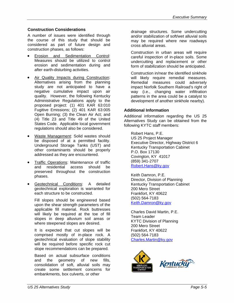
Recommendations Based upon consideration of project purpose and need, transportation issues, access needs, potential environmental and community impacts, and public input, the project team selected a recommended solution for US 25. The recommended long-term vision includes: • Use of new (Sherman-Mt. Zion Road) and
existing (US 25 Bypass and relocated KY 491) grade-separated crossings in place of existing at-grade crossings;
• New roadway connections on the east side of the tracks to ensure that each existing roadway that presently crosses the tracks is connected to a new or existing grade-separated crossing; and
• A new interchange with I-75 at KY 1994 (Sherman-Mt. Zion Road) with improvement to Sherman-Mt. Zion Road and its connection to US 25.
The recommended long-term vision meets the purpose and need for the US 25 corridor by: • Eliminating 12 to 13 at-grade railroad
crossings, thereby removing a potential safety hazard with the train.
• Removing the need for additional storage between US 25 and the railroad.
• Resolving the queuing that occurs on US 25 when trains pass.
• Specifically providing for safer crossing of the railroad for school buses.
• Increasing regional mobility and reducing traffic volumes on US 25 by providing a new interchange with I-75. Providing the new interchange and improved access to the east is also a necessary piece of infrastructure to support local and regional growth and enhance the opportunities for economic development.
• Reducing emergency response time for interstate incidents, as well as incidents on the east side of the railroad.
• Providing improved parallel roadways on each side of the railroad and new grade-
separated crossings, thus, improving connectivity to the east of the railroad.
• Improving or removing intersections with substandard geometrics (and high crash history), therefore, improving safety and traffic operations and reducing delays.
• Reducing traffic through the Curtis Gates Lloyd Wildlife Management Area while improving regional access and traffic operations.
Based on planning level cost estimates, the recommended vision could cost between $59 and $62 million dollars. Transportation funds are limited and unpredictable. Therefore, it is recommended that the number one priority for the US 25 long-term vision be the I-75/KY 1994 (Sherman-Mt. Zion Road) interchange and the flyover between KY 1994 (Sherman-Mt. Zion Road) and Sherman-Newtown Road. Construction of the new interchange will reduce traffic on both the north and south ends of US 25, provide greater access for emergency vehicles, and open up additional areas for potential development. By connecting the new interchange with the flyover, an improved east-west linkage will be created that provides a grade-separated railroad crossing. The new interchange and flyover will allow for the closure of 9 at-grade railroad crossings. In the interest of safety, intersection improvements should be undertaken in the short-term, given that funding may not be available soon for major improvements. KYTC District 6 is currently awaiting a response on a request for funds to improve the US 25/KY 491 (Violet Road) and US 25/KY 2942 (Crittenden-Mt. Zion Road) intersections. Study findings led the project team to recommend the following intersections be improved in the priority order shown: • US 25/KY 491 (Gardnersville Road) • US 25/Bannister Pike/Lemon-Northcutt • US 25/Hyde Road • US 25/Dry Ridge Road • US 25/KY 1994 (Sherman-Mt. Zion Road) • US 25/Needham Lane (Northern) • US 25/Assembly Church Road The proposed intersection improvements range in cost from $935,000 to $2,861,000 each.
Executive Summary
US 25 Alternatives Study Page S-4
Executive Summary
US 25 Alternatives Study Page S-5
Construction Considerations A number of issues were identified through the course of this study that should be considered as part of future design and construction phases, as follows: • Erosion and Sedimentation Control:
Measures should be utilized to control erosion and sedimentation during and after earth-disturbing activities.
• Air Quality Impacts during Construction: Alternatives arising from the planning study are not anticipated to have a negative cumulative impact upon air quality. However, the following Kentucky Administrative Regulations apply to the proposed project: (1) 401 KAR 63:010 Fugitive Emissions; (2) 401 KAR 63:005 Open Burning; (3) the Clean Air Act; and (4) Title 23 and Title 49 of the United States Code. Applicable local government regulations should also be considered.
• Waste Management: Solid wastes should be disposed of at a permitted facility. Underground Storage Tanks (UST) and other contaminants should be properly addressed as they are encountered.
• Traffic Operations: Maintenance of traffic and residential access should be preserved throughout the construction phases.
• Geotechnical Conditions: A detailed geotechnical exploration is warranted for each structure to be constructed.
Fill slopes should be engineered based upon the shear strength parameters of the applicable fill material. Rock buttresses will likely be required at the toe of fill slopes in deep alluvium soil areas or where steepened slopes are desired.
It is expected that cut slopes will be comprised mostly of in-place rock. A geotechnical evaluation of slope stability will be required before specific rock cut slope recommendations can be prepared.
Based on actual subsurface conditions and the geometry of new fills, consolidation of soft, alluvial soils may create some settlement concerns for embankments, box culverts, or other
drainage structures. Some undercutting and/or stabilization of soft/wet alluvial soils may be required where new roadways cross alluvial areas.
Construction in urban areas will require careful inspection of in-place soils. Some undercutting and replacement or other form of stabilization should be anticipated.
Construction in/near the identified sinkhole will likely require remedial measures. Remedial measures could adversely impact Norfolk Southern Railroad’s right of way (i.e., changing water infiltration patterns in the area could be a catalyst to development of another sinkhole nearby).
Additional Information Additional information regarding the US 25 Alternatives Study can be obtained from the following KYTC staff members:
Robert Hans, P.E. US 25 Project Manager Executive Director, Highway District 6 Kentucky Transportation Cabinet P.O. Box 17130 Covington, KY 41017 (859) 341-2707 [email protected]
Keith Damron, P.E. Director, Division of Planning Kentucky Transportation Cabinet 200 Mero Street Frankfort, KY 40622 (502) 564-7183 [email protected]
Charles David Martin, P.E. Team Leader KYTC Division of Planning 200 Mero Street Frankfort, KY 40622 (502) 564-7183 [email protected]

Table of Contents
US 25 Alternatives Study i
US 25 Alternatives Study KYTC Item No. 6-112.00
TABLE OF CONTENTS
I. Introduction ............................................................................................................................I-1 A. Background.......................................................................................................................I-1 B. Project Location................................................................................................................I-1 C. Programming and Schedule .............................................................................................I-2
II. Project Purpose and Need ....................................................................................................II-1 A. Project Purpose ...............................................................................................................II-1 B. Other Desirable Goals .....................................................................................................II-2
III. Existing Conditions...............................................................................................................III-1 A. Highway Systems ...........................................................................................................III-1 B. Geometric Characteristics ..............................................................................................III-2 C. Bridges ...........................................................................................................................III-2 D. Traffic and Operational Measures ..................................................................................III-3 E. Crash Analysis................................................................................................................III-4 F. Adequacy Ratings...........................................................................................................III-4 G. Railroad Crossings .........................................................................................................III-5 H. Programmed Highway Improvements ............................................................................III-5
IV. Environmental Overview..................................................................................................... IV-1 A. Natural Environment ...................................................................................................... IV-1 B. Cultural Environment ..................................................................................................... IV-3 C. Noise Environment ........................................................................................................ IV-3
V. Geotechnical Overview......................................................................................................... V-1
VI. Environmental Justice ........................................................................................................ VI-1 A. Population by Race........................................................................................................ VI-1 B. Population by Poverty Level .......................................................................................... VI-1 C. Population by Age Group and Disability ........................................................................ VI-1
VII. Initial Cabinet, Public, and Agency Input .......................................................................... VII-1 A. Project Team Meeting................................................................................................... VII-1 B. Local Officials and Stakeholders Meeting..................................................................... VII-1 C. Public Information Meeting ........................................................................................... VII-1 D. Resource Agency Coordination.................................................................................... VII-2
VIII. Concept Development Process ...................................................................................... VIII-1 A. Project Team Meeting.................................................................................................. VIII-1 B. Level 1 Screening........................................................................................................ VIII-2 C. Refinement of Eliminate At-Grade Crossings Concept ............................................... VIII-3 D. Summary ..................................................................................................................... VIII-3

Table of Contents
US 25 Alternatives Study ii
IX. Final Concept Evaluation Process...................................................................................... IX-1 A. Environmental/Community Issues ................................................................................. IX-1 B. Geotechnical Concerns ................................................................................................. IX-6 C. Cultural Resources........................................................................................................ IX-7 D. Environmental Justice Impacts.................................................................................... IX-11 E. Level 2 Screening........................................................................................................ IX-11
X. Additional Cabinet, Public, and Agency Input....................................................................... X-1
A. Project Team Meeting..................................................................................................... X-1
B. Local Officials and Stakeholders Meeting....................................................................... X-1
C. Public Information Meeting ............................................................................................. X-2
D. Resource Agency Coordination...................................................................................... X-2
XI. Recommendations.............................................................................................................. XI-1
A. Project Purpose and Need............................................................................................. XI-1
B. Project Team Recommendations .................................................................................. XI-1
C. Potential Design Criteria and Considerations................................................................ XI-5
D. Summary of Environmental Issues for Future Phases .................................................. XI-5
E. Construction Considerations.......................................................................................... XI-7
LIST OF APPENDICES Appendix A - Figures Appendix B - Study Area Photos Appendix C - Tables Appendix D - Environmental Overview Report Appendix E - Cultural Resources Overview Report Appendix F - Noise Impacts Report Appendix G - Geotechnical Overview Report Appendix H - Environmental Justice Overview Report Appendix I - Initial Involvement Meeting Minutes Appendix J - Resource Agency Coordination Responses, Round 1 Appendix K - Additional Meeting Minutes Appendix L - Resource Agency Coordination Responses, Round 2
LIST OF FIGURES Figure 1.1 – Study Area.......................................................................................................................A-1 Figure 3.1 – 2006 Average Daily Traffic and Level of Service ............................................................A-2 Figure 3.2 – 2030 Average Daily Traffic and Level of Service ............................................................A-3 Figure 3.3 – Crash Information............................................................................................................A-4 Figure 3.4 – Adequacy Ratings Percentiles ........................................................................................A-5 Figure 3.5 – At-Grade Railroad Crossings ..........................................................................................A-6 Figure 4.1 – Environmental Footprint ..................................................................................................A-7
Table of Contents
US 25 Alternatives Study iii
Figure 8.1 – Initial Improvement Concepts..........................................................................................A-8 Figure 8.2 – Eliminate At-Grade Crossings Option A1........................................................................A-9 Figure 8.3 – Eliminate At-Grade Crossings Option A2..................................................................... A-10 Figure 8.4 – Eliminate At-Grade Crossings Option A3..................................................................... A-11 Figure 8.5 – Eliminate At-Grade Crossings Option A4..................................................................... A-12 Figure 8.6 – Eliminate At-Grade Crossings Option A5..................................................................... A-13 Figure 8.7 – Eliminate At-Grade Crossings Option B1..................................................................... A-14 Figure 8.8 – Eliminate At-Grade Crossings Option B2..................................................................... A-15 Figure 8.9 – Eliminate At-Grade Crossings Option C1 .................................................................... A-16 Figure 8.10 – Eliminate At-Grade Crossings Option C2 .................................................................. A-17 Figure 8.11 – Eliminate At-Grade Crossings Option C3 .................................................................. A-18 Figure 10.1 – Improve Existing US 25.............................................................................................. A-19 Figure 10.2 – Eliminate At-Grade Crossings Option A1 & A2.......................................................... A-20 Figure 10.3 – At-Grade Crossings Option A3 & A4.......................................................................... A-21 Figure 10.4 – Eliminate At-Grade Crossings Option A5................................................................... A-22 Figure 10.5 – Eliminate At-Grade Crossings Option B1................................................................... A-23 Figure 10.6 – Eliminate At-Grade Crossings Option B2................................................................... A-24 Figure 10.7 – Eliminate At-Grade Crossings Option C1 & C2 ......................................................... A-25 Figure 10.8 – Eliminate At-Grade Crossings Option C3 .................................................................. A-26 Figure 10.9 – New Eastern Corridor................................................................................................. A-27 Figure 10.10 – New I-75 Interchange at Bannister Pike .................................................................. A-28 Figure 10.11 – New I-75 Interchange at KY 1994............................................................................ A-29 Figure 10.12 – Potential Intersection Improvements........................................................................ A-30 Figure 11.1 – Recommended Long-term Vision............................................................................... A-31 Figure 11.2 – Typical Section .............................................................................................................XI-5 Figure 11.3 – Typical Section .............................................................................................................XI-5
LIST OF TABLES Table 3.1 – Major Study Area Routes ................................................................................................ III-1 Table 3.2 – Highway Systems............................................................................................................ C-1 Table 3.3 – Geometric Characteristics ............................................................................................... C-2 Table 3.4 – Traffic Characteristics...................................................................................................... C-3 Table 3.5 – Vehicle Crash Segment Analysis .................................................................................... C-4 Table 3.6 – Vehicle Crash Spot Analysis ........................................................................................... C-5 Table 3.7 – Adequacy Ratings ........................................................................................................... C-7 Table 3.8 – Six Year Highway Plan Improvements ............................................................................ C-8 Table 7.1 – Public Meeting Survey Summary .................................................................................... C-9 Table 8.1 – Level 1 Screening Matrix............................................................................................... C-10 Table 9.1 – Level 2 Screening of Potential US 25 Improvement Concepts........................................................................................................................................... C-11 Table 10.1 – Level 2 Screening of Potential US 25 Improvement Concepts........................................................................................................................................... C-12 Table 10.2 – Potential Intersection Improvements ........................................................................... C-13 Table 10.3 – Second Public Meeting Survey Summary................................................................... C-14 Table 11.1 – Planning Level Cost Estimate .......................................................................................XI-3
I. Introduction
US 25 Alternatives Study Page I-1
I. INTRODUCTION The Kentucky Transportation Cabinet (KYTC) has undertaken this Alternatives Study to consider the improvement and/or potential realignment of US 25 between Dry Ridge and Crittenden, Kentucky, in Grant County, including consideration of a new interchange with I-75.
The purpose of this study is to:
• Identify known issues, concerns, and constraints, including safety, traffic, social, environmental, and geotechnical considerations.
• Develop preliminary “purpose and need” and goals for the proposed project.
• Listen to and share information with local officials, government agencies, other interested parties, and the public.
• Develop and evaluate improvement concepts for US 25 based on project purpose and need, including a potential new interchange with I-75 and short-term “spot” improvements along the existing route.
• Make project recommendations.
Through this Alternatives Study, the KYTC ensures that any future project improvements to US 25 effectively address identified transportation needs and that project development decisions meet federal requirements as defined in the National Environmental Policy Act (NEPA).
A. Background The US 25 Alternatives Study was identified in the Kentucky Enacted Six-Year Highway Plan FY 2006-2012 (generally referred to as the Six-Year Plan) as Item No. 6-112.00.
B. Project Location The study area, shown in Figure 1.1 in Appendix A, lies between Dry Ridge and Crittenden within Grant County, Kentucky. The study portion of US 25 is 9.5 miles in length.
The Kentucky State Data Center estimated the population of Grant County to be 24,769 in July 2006, including 2,174 persons in Dry Ridge and 2,573 persons in Crittenden. Comparison of 1990 and 2000 US Census data reveals that Grant County experienced 42 percent growth during that decade, which was much higher than the growth experienced by the state of Kentucky (9.6 percent). Population projections from the Kentucky State Data Center indicate that Grant County will have a 2030 population of 40,733, an 82.0 percent increase over the next 30 years.
At the time of the 2000 US Census, the median household income in Grant County was $38,438, or 4.8 percent higher than that for the state ($36,672). The number of persons living in poverty (11.1 percent) was proportionally lower than that of the state of Kentucky (15 percent).
US Census data indicates that minorities constituted less than 2 percent of the total county population in 2000, compared to 9.9 percent for the state of Kentucky.
2000 US Census data revealed that 9.5 percent of the population was 65 and older and 28.7 percent was younger than 18, compared to 12.5 percent and 24.6 percent, respectively, for the state of Kentucky.
In 2000, Grant County had a total labor force of 11,249 persons. The manufacturing sector provides the greatest number of jobs at 2,496, followed by education/health/social services
I. Introduction
US 25 Alternatives Study Page I-2
at 1,468 jobs, retail at 1,353 jobs, and transportation/warehousing/utilities at 826 jobs. Approximately 59 percent of the workforce living in Grant County commutes outside of the county, primarily to Boone, Kenton, Scott, and Fayette Counties. An additional 1,749 persons are drawn into the county from other areas to work.
C. Programming and Schedule This Alternatives Study was funded in the FY 2006 (2006-2012) Six-Year Highway Plan, with committed planning funds of $250,000.
Subsequent phases of project development, including Design, Right-of-Way Acquisition, Utility Relocation, and Construction, are not scheduled in the Recommended FY 2008 (2008-2014) Six-Year Highway Plan.
II. Project Purpose and Need
US 25 Alternatives Study Page II-1
II. PROJECT PURPOSE AND NEED The general scope of the US 25 Alternatives Study is to consider the improvement and/or potential realignment of US 25 between Dry Ridge and Crittenden, in Grant County, Kentucky, including consideration of a new access point with I-75.
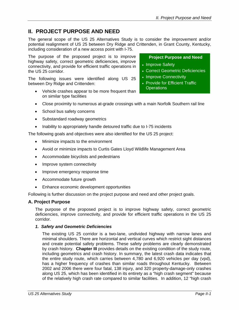
The purpose of the proposed project is to improve highway safety, correct geometric deficiencies, improve connectivity, and provide for efficient traffic operations in the US 25 corridor.
The following issues were identified along US 25 between Dry Ridge and Crittenden:
• Vehicle crashes appear to be more frequent than on similar type facilities
• Close proximity to numerous at-grade crossings with a main Norfolk Southern rail line
• School bus safety concerns
• Substandard roadway geometrics
• Inability to appropriately handle detoured traffic due to I-75 incidents
The following goals and objectives were also identified for the US 25 project:
• Minimize impacts to the environment
• Avoid or minimize impacts to Curtis Gates Lloyd Wildlife Management Area
• Accommodate bicyclists and pedestrians
• Improve system connectivity
• Improve emergency response time
• Accommodate future growth
• Enhance economic development opportunities
Following is further discussion on the project purpose and need and other project goals.
A. Project Purpose The purpose of the proposed project is to improve highway safety, correct geometric deficiencies, improve connectivity, and provide for efficient traffic operations in the US 25 corridor.
1. Safety and Geometric Deficiencies The existing US 25 corridor is a two-lane, undivided highway with narrow lanes and minimal shoulders. There are horizontal and vertical curves which restrict sight distances and create potential safety problems. These safety problems are clearly demonstrated by crash history. Chapter III provides details on the existing condition of the study route, including geometrics and crash history. In summary, the latest crash data indicates that the entire study route, which carries between 4,780 and 6,920 vehicles per day (vpd), has a higher frequency of crashes than similar roads throughout Kentucky. Between 2002 and 2006 there were four fatal, 138 injury, and 320 property-damage-only crashes along US 25, which has been identified in its entirety as a “high crash segment” because of the relatively high crash rate compared to similar facilities. In addition, 12 “high crash
Project Purpose and Need • Improve Safety • Correct Geometric Deficiencies • Improve Connectivity • Provide for Efficient Traffic
Operations

II. Project Purpose and Need
US 25 Alternatives Study Page II-2
spots” were identified along the study corridor. This indicates that crashes are occuring more frequently within these 12 “spot” locations than on other facilities of the same type.
US 25 was constructed as one of the early roadways in Grant County and has not had a major upgrade. As such, many roadway features, such as horizontal and vertical curves, lane widths, and shoulders, do not meet today’s standards. These substandard geometrics are likely one of the causes or are at least contributing factors to the 113 rear-end crashes, 107 single vehicle accidents, and 107 angle crashes experienced along the study portion of US 25 between 2002 and 2006.
These geometric deficiencies can be particularly problematic at intersections, as noted by several high crash spots identified at intersections. Most intersections along US 25 do not have left or right turn lanes that allow turning vehicles to move out of the through lane, requiring through traffic to slow or stop and creating potentially unsafe conditions.
One of the greatest concerns is the number of at-grade railroad crossings in close proximity or directly adjacent to US 25. The limited stacking space between US 25 and the rail line can create an unsafe condition. When the crossing is blocked by the train, traffic backs up on US 25. Without proper storage lanes for left and right turns, this can create congestion and unsafe conditions.
School bus routes frequent US 25 and use the at-grade crossings, magnifying safety concerns.
2. Improve Connectivity US 25 is located between I-75 to the west and the rail line to the east between Dry Ridge and Crittenden. While US 25 and I-75 provide good north-south movement, there are limited east-west connections. Additionally, there are no grade-separated connections over the railroad in the study area. The lack of good east-west connections reduces the potential for further use of lands east of the railroad and west of I-75 and can hinder emergency response to these areas.
3. Provide for Efficient Traffic Operations In addition to safety concerns at intersections without adequate turn lanes, traffic operations along US 25 can be severely impacted if a turning vehicle blocks traffic waiting to turn onto the cross street. Traffic operations are made worse when a train is crossing one of the intersecting streets with US 25. US 25 serves a host of different users from people going to/from work or school, trucks moving goods, recreation enthusiasts, and local residents as part of their everyday life. Improving traffic operations will make moving around and through Grant County much easier for all these users.
B. Other Desirable Goals As improvement plans are made for US 25, other important goals should be considered. These goals were identified by the technical analysis and in consultation through the public involvement and agency coordination processes.
• Minimize Impacts to the Environment - Of primary importance is balancing the need for improvements along the US 25 corridor with the protection and preservation of sensitive environmental resources. Some improvements may involve impacts to these resources, and attempts should be made to minimize any impacts. In addition, any improvements should be designed to fit within the context of adjoining land uses.
• Avoid or Minimize Impacts to Curtis Gates Lloyd Wildlife Management Area - The Lloyd WMA, located adjacent to US 25 near KY 491 in the northern portion of the study

II. Project Purpose and Need
US 25 Alternatives Study Page II-3
area, is a particularly important resource. The WMA is approximately 1,176 acres in size and consists of a mix of woods, open fields in rolling terrain, Leary Lake, and one of the state’s oldest forest stands. At least two tracts of old growth forest are located in the WMA. The Kentucky Department of Fish and Wildlife Resources owns the WMA and ensures that wildlife management objectives are utilized to preserve and protect wildlife in their natural habitat and to create, enhance, and sustain new habitats and populations. The WMA provides outdoor public recreation and educational opportunities for area residents and tourists. US 25 runs through and adjacent to the WMA. Efforts should be made to avoid or minimize impacts to this valuable resource.
• Accommodate Bicyclists and Pedestrians - Except on the northerly section, there are presently no accommodations for bicyclists and pedestrians. As improvements are developed, consideration should be given to accommodating bicycles and pedestrians. Such improvements should be connected to an overall state, county, or local plan.
• Improve System Connectivity - Grant County is between the expanding Northern Kentucky area and Lexington/Georgetown. As such, travel to, from, and through this area should increase over time. Any US 25 improvements should attempt to provide grade-separated connections over the railroad in conjunction with increased east-west connectivity.
• Improve Emergency Response Time - The lack of good east-west links limit emergency access to I-75 and US 25. When there is an incident along I-75 between Crittenden and Dry Ridge, it can be difficult for emergency vehicles to get to the scene. Because there is no median cut on I-75 for them to turn around, they must use the adjacent interchanges. During incidents, traffic can back up all along US 25 as well.
• Accommodate Future Growth - Grant County has experienced growth in the US 25 corridor and there are expectations of continued growth. Any improvements should consider future land use locally and countywide. Understanding these expectations will help insure properly and safely defined access points and adequate capacity to accommodate growth.
• Enhance Economic Development Opportunities - Transportation infrastructure is key for economic development. As Northern Kentucky continues to expand, Grant County will see increased development pressure. US 25 improvements should be designed to support economic growth both regionally and locally by increasing access to potential development sites and improving traffic flow to and from existing facilities.

III. Existing Conditions
US 25 Alternatives Study Page III-1
III. EXISTING CONDITIONS Characteristics of US 25 and the other state highways in the study area are identified in the following sections. Information is included about highway systems, geometric characteristics, bridges, traffic conditions, crash history, railroad crossings, and planned highway improvements. Roadway information is summarized from the KYTC Highway Information System (HIS) database. Photographs of some features in the study area are contained in Appendix B.
Project area roadways considered as part of this analysis are presented below in Table 3.1. These roadways were selected because they were deemed most important to the overall transportation system in the study area. Specifically, they are the primary traffic carriers within the project area. In addition, portions of these roadways could become part of a proposed improvement between Dry Ridge and Crittenden. In some cases, maps and tables may include roadway segments that fall outside the segments defined in Table 3.1.
Table 3.1 – Major Study Area Routes
Route Begin Milepoint End Milepoint
US 25 14.449 23.961
US 25X 0.000 2.239
KY 491 2.844 5.423
KY 1994 1.349 3.934
KY 2942 3.123 4.097
It is important to note that the segment of interest for this study is US 25 between MP 16.082 and MP 23.961. This portion, which lies between US 25X (the business route) in Dry Ridge and the Kenton County line in Crittenden, will be referred to as the study portion of US 25. MP 14.449 to MP 16.082 is part of the bypass that was completed in October 2005 and, like US 25X, is important to evaluate, but it is not the focus of this study effort.
A. Highway Systems Major highway systems information is shown in Table 3.2 in Appendix C, including the State Primary Road System, Functional Classification System, National Highway System (NHS), National Truck Network (NN), Designated Truck Weight Class, and others. Major highway systems information is summarized here:
• State-maintained roads in Kentucky are categorized under the State Primary Road System, ranging from the highest order classification to the lowest as follows: State Primary Routes, State Secondary Routes, Rural Secondary Routes, and Supplemental Roads. State Primary Routes are those routes which are considered to be long-distance, high-volume intrastate routes that are of statewide significance. Mobility is the prime function of the routes that can be distinguished by high traffic-carrying capacity. These routes link major urban centers within the state and/or serve as major regional corridors.
The study portion of US 25 is currently classified as a State Secondary Route.
• One of 13 functional classification categories is assigned to each state-maintained road in Kentucky, based on the function that each road provides and whether the road is an urban or rural road. These are classified from highest to lowest and by
III. Existing Conditions
US 25 Alternatives Study Page III-2
geographic designation as: Rural Interstate, Urban Interstate, Other Rural Freeways and Expressways (Principal Arterial), Other Urban Freeways and Expressways (Principal Arterial), Other Rural Principal Arterial, Other Urban Principal Arterial, Rural Minor Arterial, Urban Minor Arterial, Rural Major Collector, Rural Minor Collector, Urban Collector, Rural Local, and Urban Local.
The study portion of US 25 is classified as a Rural Major Collector.
• The NHS was first established in 1991 by the Intermodal Surface Transportation Efficiency Act. It includes the Interstate Highway System and other significant Principal Arterial roads important to the nation’s economy, defense, and mobility.
There are no NHS routes in the study area.
• The NN includes roads specifically designated for use by commercial trucks with increased dimensions (102 inches wide; 13 feet, 6 inches high; semi-trailers up to 53 feet long; and trailers up to 28 feet long – not to exceed two trailers per truck).
In the study area, there are no NN routes.
• Kentucky Revised Statutes impose weight limits on the state-maintained highway system. There are three weight classification limits: AAA – 80,000 lbs. maximum gross vehicle weight; AA – 62,000 lbs. maximum gross vehicle weight; and A – 44,000 lbs. maximum gross vehicle weight. [NOTE: For special circumstances, occasional exceptions may be granted for over-dimensional or overweight vehicles by permits issued by the KYTC, Division of Motor Carriers.]
The study portion of US 25 has a weight classification limit of AAA.
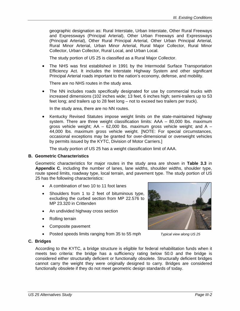
B. Geometric Characteristics Geometric characteristics for major routes in the study area are shown in Table 3.3 in Appendix C, including the number of lanes, lane widths, shoulder widths, shoulder type, route speed limits, roadway type, local terrain, and pavement type. The study portion of US 25 has the following characteristics:
• A combination of two 10 to 11 foot lanes
• Shoulders from 1 to 2 feet of bituminous type, excluding the curbed section from MP 22.576 to MP 23.320 in Crittenden
• An undivided highway cross section
• Rolling terrain
• Composite pavement
• Posted speeds limits ranging from 35 to 55 mph
C. Bridges According to the KYTC, a bridge structure is eligible for federal rehabilitation funds when it meets two criteria: the bridge has a sufficiency rating below 50.0 and the bridge is considered either structurally deficient or functionally obsolete. Structurally deficient bridges cannot carry the weight they were originally designed to carry. Bridges are considered functionally obsolete if they do not meet geometric design standards of today.
Typical view along US 25

III. Existing Conditions
US 25 Alternatives Study Page III-3
There is one structure (Bridge No. 041B00038) along the study portion of US 25. This bridge, located at MP 22.770, is 146 feet long with three spans of pre-stressed concrete continuous stringer/multi-beam or girder. This structure has a sufficiency rating of 80.8. It is not listed as structurally deficient or functionally obsolete in the KYTC State Bridge Inventory (March 2006).
Two other bridges exist along routes of consideration for this study. Bridge No. 041B00050 along KY 1994 (MP 3.48) passes over I-75. Bridge No. 041B00051 along KY 2942 (MP 3.90) also passes over I-75. According to the KYTC State Bridge Inventory (March 2006), both structures have sufficiency ratings over 90, and neither is listed as structurally deficient or functionally obsolete.
D. Traffic and Operational Measures
Existing (Year 2007) and estimated future (Year 2030) traffic and operational conditions for each major route in the study area have been identified and are discussed in the following subsections.
1. Existing Traffic Volumes (Year 2007) Existing traffic volumes (Year 2007) for segments of the study area routes were summarized based primarily on information provided in the HIS database. Existing truck percentages were determined for the study area routes using HIS data and the KYTC default values based on the functional classification of the segment. Year 2007 traffic characteristics for all major state routes in the study area are shown in Figure 3.1 in Appendix A and Table 3.4 in Appendix C.
Traffic volumes along existing US 25 in the study area range between 4,780 and 6,920 vehicles per day (vpd). Existing truck percentages are approximately 2 percent of the total traffic along the study route.
2. Existing Level of Service (Year 2007) The level of service (LOS) is a qualitative measure of highway traffic conditions, as defined in the 2000 Highway Capacity Manual, published by the Transportation Research Board. Individual levels of service characterize these conditions in terms of speed, travel time, freedom to maneuver, traffic interruptions, and comfort and convenience. Six levels of service are defined and given letter designations from A to F, with LOS A as the best condition, representing free flow conditions, and LOS F as the worst condition, representing severe congestion and/or time delays. Typically, a minimum of LOS D is considered acceptable in urban areas and LOS C is considered acceptable in rural areas.
Figure 3.1 in Appendix A and Table 3.4 in Appendix C show the existing LOS calculated for segments of each route in the study area. The study portion of US 25 in Grant County operates predominately from LOS D to LOS E, with the exception of 1.2 miles through Crittenden which are operating at LOS B.
3. Estimated Future Traffic (Year 2030) Based on Historic Growth Year 2030 traffic was estimated using historic growth rates based on KYTC’s historic traffic counts for each study area route. Future transportation improvements were not taken into consideration. Traffic along US 25 was forecast with a compounded annual growth rate of 2.5 percent through Year 2030, resulting in an increase of nearly 50 percent from 2007 to 2030. Projected future year traffic volumes are shown in Figure 3.2 in Appendix A and Table 3.4 in Appendix C.
III. Existing Conditions
US 25 Alternatives Study Page III-4
4. Estimated Future Level of Service (Year 2030) Based on Historic Growth Level of Service is expected to remain the same along the study portion of US 25 through the Year 2030. The estimated future LOS is shown for the study area in Figure 3.2 in Appendix A and Table 3.4 in Appendix C.
While LOS is expected to remain the same in the future (through Year 2030), the current LOS, which ranges from D to E for most of the study corridor, is considered unacceptable for the rural route. It is also important to consider the routes ability to handle detoured I-75 traffic when there is an incident on the interstate. With already congested conditions, the route would have difficulty accommodating more traffic. This is a primary concern for US 25, as mentioned in Chapter II.
E. Crash Analysis
Crash records were collected from KYTC for major state routes in the project area over a five-year period (2002 - 2006). The location of crashes with valid milepoint designations, recorded in the HIS database, are shown by corridor segment in Table 3.5 in Appendix C and by spot locations (0.1 miles in length) in Table 3.6 in Appendix C.
A spot location or segment of roadway is considered to be a high crash location when its crash rate is higher than the average crash rate for similar roads in the state. This is measured by the critical rate factor (CRF), the ratio of the crash rate for the spot or segment compared to the average crash rate for similar roads. When the CFR is greater than 1.0, crashes may not be occurring randomly at a given location. The CFRs are based on formulas published by the Kentucky Transporation Center.
As part of the crash analysis process, each crash was classified into one of three categories based on the degree of severity: fatal, injury, or property-damage-only. During the period studied, there were four fatal, 138 injury, and 320 property-damage-only crashes reported along the study portion of US 25.
Figure 3.3 in Appendix A displays the severity and location of crashes, identified high crash segments and spots (CRF > 1.0), and other crash details. As shown, 12 high crash spots were identified along the study portion of US 25. It is also very important to note that the entire route was identified as a high crash segment. This is depicted by the CRF > 1.0 for each study route segment, as shown in Table 3.5 in Appendix C.
F. Adequacy Ratings The KYTC HIS database provides an adequacy rating percentile for many major routes. The composite rating is based on the condition, safety, and service component scores of the route, as described below:
• The Condition Index, based solely on the condition of the road’s pavement
• The Safety Index, based on lane width, shoulder width, median widths, alignment, and critical rate factor (CRF)
• The Service Index, based on the route’s volume-to-capacity (V/C) ratio (a measure of congestion) and access control
These components are given equal weight in the calculation of the Composite Adequacy Rating.
Figure 3.4 in Appendix A and Table 3.7 in Appendix C depict the adequacy ratings assigned to the study portion of US 25 and the percentile group, divided into fourths (Poor, Fair, Good, and Very Good). If a road or road segment falls into the lowest percentile group
III. Existing Conditions
US 25 Alternatives Study Page III-5
(Poor), this indicates that a problem may exist that merits further investigation. As shown in this figure and table, the ratings for the majority of the study area is either Poor (0 percent to 24.9 percent) or Good (50 percent to 74.9 percent). US 25 is rated as Good between the Dry Ridge Bypass and KY 2942, Fair between KY 2942 and KY 491 (Violet Road), and Poor between KY 491 (Violet Road) and the county line. Table 3.7 in Appendix C shows that the Service Component, which is based on congestion and access control, and the Condition Compent, which is based on pavement condition, contributed positively to the Composite Adequacy Rating for the study route. The Safety Component, however, was relatively low for segments of the study route which warrants consideration of improvements to US 25 since safety is one of the primary purposes for the proposed project.
G. Railroad Crossings The study portion of US 25 parallels and crosses the Norfolk Southern Railroad, which lies in close proximity to the highway. There are 14 railroad crossings in the corridor, as shown in Figure 3.5 in Appendix A.
H. Programmed Highway Improvements
While no improvements are programmed for the study portion of US 25, four other projects are planned and programmed for Grant County in KYTC’s 2008 Recommended Highway Plan, as summarized in Table 3.8 in Appendix C. Major activities include:
• $5.2 million for construction activities for the relocation of KY 22 from US 25 to I-75 via Barnes Road Corridor (Item No. 06-165.00)
• $1.2 million for construction activities for the safety of construction of bridge on Eagle Tunnel Road at CSX Tunnel Northwest of Junction KY 467 West of Folsom (Item No. 06-190.00)
• $5.2 million for construction activities for the replacement of the bridge and approaches at Norfolk Southern System and Park Road 0.4 miles south of Junction KY 22 (Item No. 06-1049.00)
• $1.69 million for right-of-way, utility relocation, and construction activities for the replacement of the bridge and approaches on Stringtown Road in Corinth over Norfolk Southern Railroad 0.1 mile east of Junction US 25 (Item No. 06-1059.00)
IV. Environmental Overview
US 25 Alternatives Study Page IV-1
IV. ENVIRONMENTAL OVERVIEW This chapter provides a summary of environmental issues located in the US 25 study area. In the summer of 2007, teams of specialists performed data analysis and field surveys of the project area to identify key natural, cultural, and noise-related environmental features associated with this study. The following sections present the findings of these investigations. Figure 4.1 in Appendix A, a map detailing the discussed features, is presented at the end of this chapter.
A. Natural Environment This section presents the summary findings of the field review completed by Third Rock Consultants, LLC. Air quality, aquatic and terrestrial resources, threatened and endangered species, socioeconomic data, and underground storage tank/hazardous materials components were reviewed and documented in an Environmental Overview technical report, presented in its entirety in Appendix D.
Grant County is located in the hills of the Bluegrass ecoregion of the Interior Plateau of Kentucky. Most of the study area is in a rural setting. As US 25 approaches Crittenden, the study area becomes much more developed with numerous businesses, homes, and apartment buildings. Towards Dry Ridge to the south, the study area becomes more rural, with large farms, several churches, and various residences, including several large mobile home parks east of the road. US 25 in the study area follows mostly along open ridgetops with some undulations. Travelling east on other roads in the study area, the terrain becomes much more undulating with large farms located on the ridgetops above forested headwater tributaries of various streams.
Based upon the preliminary data research and subsequent field reconnaissance, environmental concerns for the proposed project are typical for a predominantly rural corridor with small urban concentrations. Other than the presence of a large wildlife management area in the study area, no significant environmental concerns were noted.
Alternatives arising from the planning study are not anticipated to have a negative cumulative impact upon air quality.
Impacts to aquatic resources are likely for any alternative that deviates significantly from the current US 25 centerline. Stream crossings may require US Army Corps of Engineers Section 404 and Kentucky Division of Water Section 401 permits. If any wetlands are impacted by a proposed alternative, they should be delineated and their jurisdictional status determined.
Curtis Gates Lloyd Wildlife Management Area (WMA) is located near KY 491 just south of Crittenden. It is approximately 1,176 acres in size and consists of a mix of woods, open fields in rolling terrain, and a lake (Leary Lake). This WMA contains one of the state’s oldest forest stands. At least two tracts of old growth forest are located in the WMA. The Kentucky Department of Fish and Wildlife Resources, which owns the WMA, ensures that wildlife management objectives are utilized to preserve and protect wildlife in their natural habitat and to create, enhance, and sustain new habitats and populations. The WMA provides outdoor public recreation and educational opportunities for area residents and tourists and includes features such as several shooting ranges, a clubhouse, trails, and an archery range. Significant populations of deer, turkey, rabbit, and squirrel are located in the WMA and may be hunted on 929 acres of the WMA. US 25 and the Norfolk Southern railroad
Environmental Components Natural Environment Cultural Resources
Noise Impacts
IV. Environmental Overview
US 25 Alternatives Study Page IV-2
cross through the WMA near its westernmost tip, dividing this small section from the main portion. Appendix D contains a Kentucky Fish and Wildlife Resources official map.
Roosting and foraging habitat for the Indiana bat is present throughout the study area. The best habitat is located within the Wildlife Management Area. Avoiding the WMA, however, will not eliminate impacts to bat habitat. Nearly all of the stream bottoms were forested, providing excellent roosting and foraging habitat for this species. To comply with Section 7 of the Endangered Species Act for Indiana bat, potential impacts may be addressed in one of three ways: a biological assessment to determine presence/absence of the species may be conducted between May 15 and August 15; tree cutting may be restricted to the period between October 15 and March 31; or KYTC may pay for the acquisition of any summer maternity habitat (roost trees) under its Programmatic Biological Opinion Agreement with the US Fish and Wildlife Service.
Habitat favorable for the growth of running buffalo clover is present in portions of the study area. These areas include cemeteries, the potentially historic homestead near Dry Ridge, and forest/field edges on farms or in the Lloyd WMA. The species may also be found along gravel bars and edges of partially shaded ephemeral streams, which are located throughout the study area. The species flowers in early to mid-spring. Upon development of alternatives, a biological assessment of these areas should be conducted to determine presence/absence of the species should any of the alternatives impact these areas.
Several historic properties are also located along US 25 (although their identification was outside the scope of this study effort).
Impact to the WMA, park, or any historic properties would invoke Section 4(f) under the Department of Transportation Act of 1966 (re-codified in 1983) (49 USC 1653(f)).
In 2005, Section 4(f) was amended to allow approval of transportation projects that have a de minimis impact on lands or resources impacted by Section 4(f). De minimis impacts are defined as those impacts that do not adversely affect the activities, features, and attributes that qualify the resource for protection under Section 4(f). For the proposed project, acquisition of small portions of land from either the park or the WMA may be determined by FHWA to be de minimis. Minimizing impacts to both these resources should be considered during development of possible alternatives.
The Grant County Fiscal Court received Land and Water Conservation Fund Act (LWCFA) monies in 1998 or 1999 for the Grant County Park to construct trails. Therefore, any impact to the Grant County Park would require mitigation as set forth in the act.
Section 6(f) of the Land and Water Conservation Fund Act of 1965 (16 U.S.C. 4601-4) established a funding source for both federal acquisition of park and recreation lands and matching grants to state and local governments for recreation planning, acquisition, and development. It set requirements for state planning and provided a formula for allocating annual LWCFA appropriations to the states. Section 6(f) concerns transportation projects that propose impacts to, or the permanent conversion of, outdoor recreation property that was acquired or developed with LWCFA grant assistance, which is distributed by the Interagency Committee for Outdoor Recreation of the Office of the Interagency Committee in Washington, DC.
Any right-of-way taking from a public park that has received LWCFA funding is considered a Section 6(f) impact. A 6(f) impact requires coordination with, and approval from, the US National Park Service and US Department of the Interior and the replacement of acquired property with an equal amount of adjacent property. Prior to a right-of-way taking from a

IV. Environmental Overview
US 25 Alternatives Study Page IV-3
park, the Kentucky Transportation Cabinet would be responsible for acquiring acceptable replacement property and transferring ownership to the park.
If there is a use or taking of Section 6(f) property within a 4(f) property, the 6(f) provisions would apply only to the portion of the overall property where the LWCFA funds were used. Thus, it would be possible to have both Section 4(f) and 6(f) impacts to a resource, but the impacts would be defined differently.
Approximately 900 acres of agricultural district land are located within the study area. Agricultural districts are created because they are intended to preserve Kentucky’s farmlands and protect against annexation, to some degree. If land enrolled in an agricultural district is condemned by a state agency, the agency must mitigate the impact on the conversion of that land to non-farm (e.g., highway right-of-way) uses. The form of mitigation is not specified and historically has been the same as for any other land acquisition in accordance with the Kentucky Transportation Cabinet’s Division of Right-of-Way and Utilities’ policies and procedures. Additionally, if an agency wishes to acquire land that is enrolled in an agricultural district, the property owner may request a public hearing by the local soil and water conservation district board of supervisors prior to such acquisition. This right of public hearing does not apply to utilities as defined by KRS 278.080(3) and if they have obtained a certificate of convenience and necessity as required by KRS 278.020(1).
No hazardous materials sites that represent a significant potential hazard were identified in the study area.
According to the Division of Waste Management, there are five registered facilities with 14 identified underground storage tanks (UST) within the area. UST sites can represent a significant cleanup cost liability. Future alignments should consider the potential for significant cleanup costs associated with taking right-of-way associated with UST facilities.
B. Cultural Environment This section presents an overview of key cultural resources within the project area. A copy of the Cultural Resources Overview technical report is presented in Appendix E.
More than 200 structures over the age of 50 years exist in the study area. These structures would have to be documented in a Cultural Historic study in future phases of any US 25 improvement project. At first glance, it appears most structures would not be eligible for listing on the National Register of Historic Places (NRHP).
There is one structure within the project area, along existing US 25, that is listed on the NRHP, the Sherman Tavern (state number Gr 2). Six additional properties have been surveyed previously but their National Register status was listed as “undetermined” by the Kentucky Heritage Council.
In relation to archaeological sites, the area of potential effect (APE) encompasses three known sites. It is highly likely that additional archaeological sites will be encountered, especially historic sites, due to the importance the US 25 corridor played in the past. The numerous drainages and ridge tops also signal a high likelihood for prehistoric sites. In addition, six potentially historic cemeteries lie within the project area.
C. Noise Environment Potential noise-sensitive receptor sites were identified during a field visit to the project area. These areas include trailer parks, schools, a day care facility, residential areas, churches, cemeteries, a park, a campground, and the Curtis Gates Lloyd WMA. The city of Crittenden seems to contain the most transportation-related noise receptors within the study area. No

IV. Environmental Overview
US 25 Alternatives Study Page IV-4
significant noise-related impacts are anticipated to result from this project. A Noise Overview technical report documents this review and can be found in Appendix F.

V. Geotechnical Overview
US 25 Alternatives Study Page V-1
V. GEOTECHNICAL OVERVIEW This chapter presents a summary of the findings of the geotechnical data analyis and the field review completed June 2007. A copy of the full Geotechnical Overview technical report is included in Appendix G.
The US 25 corridor is characterized by rolling hills. There are numerous farm ponds in the study area. Several small creeks/branches and wet weather ditches occupy the low lying areas.
According to the United States Geological Survey, US 25 is located on the Ordovician System of the Bluegrass Region physiographic province, with thick deposits of horizontal to slightly dipping interbedded limestone and shale bedrock. This region often exhibits typical karst topography, including sinkholes, sinking streams, streamless valleys, springs, and caverns.
Available mapping identifies one known sinkhole within the study area. It is located east of the Southern Railroad and about ¼ mile north of the intersection of US 25 and KY 1994. US 25 improvement alternatives should avoid the immediate vicinity of the identified sinkhole.
Alternatives located at least ¼ mile east of the Norfolk Southern rail line will have a smaller probability of karst feature development relative to existing US 25.
Three major soil units are present within the study area, including the Eden, Lowell and Nicholson. These soils receive a poor rating for use as roadway fill because of such issues as low strength and shrink-swell issues. The depth to bedrock is often less than 5 feet.
There are no known surface or deep mining activities within the study area.
According to the Division of Waste Management, there are five registered facilities with 14 identified underground storage tanks (UST) within the area.
There are no nine gas wells, and one water well, all in close proximity to US 25.
The soil and rock in the study area are subject to post-construction changes associated with rapid weathering, especially in the presence of water. Flatter than typical fill and cut slopes will likely be required for any improvement project. Deeper fills comprised of native materials may be subject to long-term compression. Achieving adequate compaction on the more plastic soils may be difficult given their moisture sensitivity. Development of alternatives that minimize cuts and fills are preferred to limit the design and construction cost implications of using the native materials.
Shallow depth to bedrock can adversely affect cut/fill quantities, increase excavation costs, and result in additional design and inspection requirements. Deeper cuts may also extend into bedrock requiring potential mixed face slope designs and/or encounter zones of weathered rock, requiring special consideration. Stability of permanent rock slopes should be readily engineered and constructed. Areas comprised mostly of limestone will likely require blasting to allow efficient excavation.
Significant changes to grades adjacent to the Norfolk Southern Railroad may adversely affect the railroad embankment. Alternatives utilizing minimal earthwork operations near the railroad right of way are recommended.
If alternatives cross North Fork Middle Fork Grassy Creek, structures could be adversely impacted by shallow groundwater and/or the presence of soft/wet soils.

VI. Environmental Justice
US 25 Alternatives Study Page VI-1
VI. ENVIRONMENTAL JUSTICE OVERVIEW This chapter presents a summary of the findings of an Environmental Justice Overview technical report, prepared by the Northern Kentucky Area Development District (NKADD). NKADD completed a comprehensive review of demographic data from the US Census Bureau and Kentucky State Data Center, discussed community features with local officials, and conducted site reconaissance to assess community demographics and characteristics within the US 25 study area. A copy of the full report is included in Appendix H.
A. Population by Race A comprehensive review of US Census Block data and discussions with local officials revealed no minority concentrations within or surrounding the immediate study area. Therefore, the implementation of this project will not have a disproportionate effect on minorities residing in the study area.
B. Population by Poverty Level Within the US 25 study area, the percentage of persons in poverty was slightly higher for one Block Group (Block Group 1, Census Tract 9802) than the percentage for the US as a whole. Discussions with local officials led to the conclusion that no concentration of individuals below the poverty level would be disproportionately affected by this project.
Community leaders have expressed support for the proposed project and anticipate that it will provide an economic benefit to the community.
There are several mobile home parks located within the study area. Because US Census data providing specific income levels for residents of these mobile home parks is not available, further research may be needed to determine whether concentrations of populations living in poverty exist within these locations. If this is the case, proactive measures should be undertaken to ensure that these groups are not disproportionately affected by the project.
C. Population by Age Group and Disability Analysis of age and disability data indicated that the number of elderly and disabled residents in the study area slightly exceeds the national and state averages, but no specific concentrations of elderly or disabled residents were discovered. It has been determined that no elderly or disabled residents living within the study area would be disproportionately affected by this project.
VII. Initial Cabinet, Public, and Agency Input
US 25 Alternatives Study Page VII-1
VII. INITIAL CABINET, PUBLIC, AND AGENCY INPUT Throughout the course of the US 25 Alternatives Study information was shared with and input solicited from local citizens, public officials and resource agency representatives. This chapter summarizes the first KYTC project team meeting and the first round of public, local official and resource agency involvement. KYTC project team meetings and activities conducted during the second round of local, public, and agency involvement are summarized in Chapter X as they relate to the development and evaluation of improvement concepts. Meeting minutes are presented in Appendix I for each meeting discussed in this chapter. Details of public meetings are included in public meeting notebooks on file with KYTC.
A. Project Team Meeting (July 26, 2007) The first project team meeting was held on July 26, 2007, at the KYTC District 6 office building in Covington, Kentucky. The project team convened to discuss the purpose, goals, and objectives of the proposed project; review preliminary existing conditions data for the study corridor; and identify study needs. The meeting minutes are included in Appendix I. The study was added by the legislature to Kentucky’s Six-Year Highway Plan. The description in the Six-Year Highway Plan also called for KY 1994 to be examined as a location for a potential new interchange with I-75. It was decided at the meeting, however, that it was also important to examine Bannister Pike as a potential location for a new interchange with I-75, because it appears to be a feasible location and has been studied as such by KYTC in the past.
The majority of the meeting discussion focused on project issues. Team members cited safety, specifically for school buses; access for emergency responders; and development and rapid growth as key issues to be considered.
B. Local Officials and Stakeholders Meeting (August 24, 2007) As part of the initial public involvement, a combined meeting was held with local officials and stakeholders on August 24, 2007. The purpose of this meeting was to inform these groups about the project, discuss potential project issues and concerns, and solicit input.
Meeting attendees identified project issues on aerial plots of the study area using markers and post-it notes. A number of important features were identified on the maps, including what attendees perceived to be the most dangerous curves, where development is occurring, and important environmental and community features. The comments are summarized in the meeting minutes, which can be found in Appendix I.
C. Public Information Meeting - Round I (October 2, 2007) A public meeting was held during the first round of public involvement for this project. The meeting was held in a meeting hall at Sherman Baptist Church in Dry Ridge on October 2, 2007. The purpose of the meeting was to provide preliminary information to the public on the proposed project and to get public input on possible issues, impacts, and alternates. In addition to the information presented in this chapter, material related to the first public involvement meeting is included in a separate public meeting notebook on file with the KYTC Division of Highway Design and Division of Planning.
Public and Agency Involvement
• Project Team Meetings • Local Elected Officials and
Stakeholders Meetings • Public Information Meetings • Public Comment Surveys • Resource Agency Coordination

VII. Initial Cabinet, Public, and Agency Input
US 25 Alternatives Study Page VII-2
Minutes of this public meeting may be found in Appendix I. General project information displays, such as project location, traffic volumes, railroad crossing information, crash history, and preliminary environmental maps, were presented for review and comment. Potential improvement concepts for US 25 had not yet been identified and therefore were not included in the meeting materials.
1. Map Exercise In this open house meeting, attendees were given the opportunity to identify areas to avoid and ideas for an improved US 25 on aerial plots of the study area. In this forum, attendees were also able to ask questions and provide comments one-on-one with KYTC, Area Development (ADD), and consultant staff. Following is a summary of the items depicted by attendees on the maps provided:
• Sherman crossing: very dangerous and very time consuming
• Connect Bannister Pike to Dry Ridge Mount Zion Road
• Connect Ruark Road and Sherman Mount Zion Road
• No interchange [at Bannister Pike]
• Yes to interchange [at Bannister Pike]
• Place interchange here [at Sherman Mount Zion Road]
• Bridge over old Highway 25 and railroad here [at Sherman Mount Zion Road/US 25]
• Crossover at Sherman Mount Zion Road to east side of railroad
• Kenton and Pendleton residents use KY 491 to come into Grant County
• Turning lane not feasible [at KY 491], it would have to go all the way back into town; suggest closing crossing
• Close crossing at KY 491/US 25; new route connecting KY 491 to US 25 [just outside WMA]
One attendee drew a potential new eastern route on the project information sheet and submitted the following additional comment on other project material distributed at the meeting:
• Turn lanes, signalization, planning and zoning – much new development
2. Public Comment Survey Responses KYTC provided each attendee with a survey form so that citizens could provide input on the study. All surveys received were included in the aforementioned public meeting notebook which is on file with KYTC. Table 7.1 in Appendix C summarizes the survey results.
D. Resource Agency Coordination - Round I (September 2007) Many local, state, and federal resource agencies, with diverse areas of public responsibility, were included in this planning process. Input was solicited through written requests by letter on two occasions. For the first round of resource agency coordination, each agency was sent a copy of the project information sheet including a study area map, maps showing crash history, railroad crossing data, and environmental information. This section describes
VII. Initial Cabinet, Public, and Agency Input
US 25 Alternatives Study Page VII-3
the input received during this first coordination effort. Copies of the response letters from the various resource agencies are located in Appendix J and are summarized below.
The following 22 agencies responded by offering comments or concerns regarding the project:
• Department of the Army (February 29, 2008) - The study area encompasses numerous streams that may fall within the Army’s area of jurisdiction under the Clean Water Act, including North Fork Grassy Creek, Middle Fork Grassy Creek, Sawyers Fork, Townsend Branch, and Wildcat Branch, to name a few, not to mention numerous unnamed tributaries and impounded waters throughout the review area. These would need to be identified and delineated and the information submitted for the Army’s review so a jurisdictional determination may be made about the need for a Department of the Army permit for any work that might result in a discharge of dredged and/or fill material into jurisdictional waters of the U.S.
• Department for Natural Resources, KY Environmental and Public Protection Cabinet (October 22, 2007) - The Lloyd WMA lies in the study area, covering approximately 366 acres. It is one of the largest contiguous forested blocks in the area and contains a small “old growth” forest just north of KY 491. “Old growth” forests are rare in Kentucky, especially in the northern portion of the state. The Lloyd WMA should be protected as a unique environmental area. The remaining study area is primarily pasture with small forested woodlots of immature timber.
• Division for Air Quality, KY Environmental and Public Protection Cabinet (October 24, 2007 & November 8, 2007) - Precautions should be taken to prevent particulate matter from becoming airborne, including covering open-bodied trucks and avoiding depositing earth onto paved roadways. Open burning is prohibited for all but the express purposes detailed in the Open Burning Fact Sheet. The project must meet the conformity requirements of the Clean Air Act and the transportation planning provisions of Titles 23 and 49 of the US Code. The division suggests investigating local government requirements as well.
• Division of Conservation, KY Environmental and Public Protection Cabinet (October 25, 2007) - There are three certified agricultural districts within the study area. These districts are developed to conserve, protect, and improve agricultural land for the production of food, fiber, and agricultural products. Any impacts to these areas must be mitigated. The loss of farmlands – prime farmlands and farmlands of statewide importance – is another issue. Best management practices for erosion control are recommended to prevent nonpoint source water pollution.
• Division of Mine Reclamation and Enforcement, KY Environmental and Public Protection Cabinet (October 1, 2007) - There is no indication of active or abandoned mining activity within the study area.
• Division of Waste Management, KY Environmental and Public Protection Cabinet (October 25, 2007 and November 8, 2007) - There are no major issues in the project area, but an open dump site and a superfund site (Royal Auto Parts) lie nearby. There are five registered facilities with a total of 14 identified underground storage tanks in the area, but none are undergoing corrective actions. All solid waste should be disposed of at a permitted facility. Any underground storage tanks or other contaminants should be properly addressed.
VII. Initial Cabinet, Public, and Agency Input
US 25 Alternatives Study Page VII-4
• Federal Aviation Administration (October 4, 2007) - No environmental impacts are expected to result from this project that would affect development at the Falmouth-Pendleton County airport.
• Forest Service, US Dept of Agriculture (October 2, 2007) - Though no impacts are anticipated to the Daniel Boone National Forest, wildlife-friendly passages are recommended for ecological integrity.
• Grant County Industrial Development Authority (October 23, 2007) - A new route, parallel to US 25 east of the railroad line, is recommended. In the south, the new alignment should connect to Dry Ridge Connector Road. An interchange with I-75 at KY 1994 should travel above existing US 25 and the rail line to connect to the proposed new roadway and Sherman-Mount Zion Road. The portion of KY 491 between the new route and US 25 should be removed to eliminate the rail crossing. At its northern terminus, this new corridor should tie into KY 2363 for additional interstate connectivity.
• KY Department of Agriculture (October 1, 2007) - This agency has no concerns at this time.
• KY Department of Fish and Wildlife Resources (October 19, 2007) - No threatened or endangered species are known to occur in close proximity to the project area. The Lloyd WMA lies within the study area; impacts to the WMA should be avoided. Consideration should be given during future phases to minimizing impacts to fish and wildlife habitats by avoiding forested areas, designing structures to allow wildlife passage, and developing wildlife-friendly crossings. Coordination with the Army Corps of Engineers and the Kentucky Division of Water is recommended if this project involves waterways or wetlands. Specific recommendations for stream impacts include avoiding impacts to intermittent and perennial streams, using natural channel design for any channel changes, designing culverts to allow passage for aquatic organisms, excavating during low flow periods, employing erosion control measures, and preserving/restoring stream habitats and a 100 foot wide forested buffer along any disturbed streams.
• KY Geological Survey (October 4, 2007) - The study area lies on the outer edge of the Outer Bluegrass physiographic region, underlain by limestone, shale, gravel, sand, silt, and clay unsuitable for construction uses. Karst features are not likely to be encountered in the project limits, but some areas may contain elements prone to landslides. Unconsolidated sediments in drainage areas would likely be encountered in construction. No conflicts due to prior mining rights are anticipated, but there is an abandoned gas field south of Sherman-Newton Road. Gas wells at this site were shallow; pockets of natural gas may be encountered. No faults appear in the project area and the peak ground acceleration for an earthquake is 0.09g with a low potential for slope failure.
• KY National Guard, Department of Military Affairs (October 2, 2007) - This agency cannot identify any issues accompanying the development of this project.
• KY State Nature Preserves Commission (October 3, 2007) - Indirect and cumulative impacts to natural resources are likely to outweigh direct impacts for this project. Proactive planning is necessary to anticipate future impacts in and around the project area which will occur due to development. KYTC should provide innovative leadership in proposing substantive mitigation to offset these effects.

VII. Initial Cabinet, Public, and Agency Input
US 25 Alternatives Study Page VII-5
• KY State Police (October 14, 2007) - The large number of collisions occurring on US 25 may be due to a variety of reasons including high traffic volumes, intersection layouts, at-grade rail crossings, and the terrain. Developments in the area – new subdivisions and a new school in Sherman – will only increase traffic volumes. When I-75 is closed for an incident, volumes grow astronomically and are not limited to Grant County residents. High crash spots tend to occur at intersections; the majority of these do not provide warning signs, turn lanes, or traffic control devices along mainline US 25. Crashes result when drivers fail to yield right-of-way during turning maneuvers or are unable to stop as vehicles ahead stop for turning vehicles or at rail crossings. Limited sight distance at crest vertical curves increases this problem.
The KSP recommends adding warning lights/signs and turn lanes at intersections. Widening lanes would help accommodate pedestrians and bicyclists, while adding shoulders would provide a safe storage area for disabled vehicles. Improvements to select cross streets, such as Needham Lane and Sherman-Mount Zion Road, would improve visibility.
An additional interchange with I-75 would provide regional benefits: reduced response times for emergencies, improved access to the new school at Sherman, and reduced strain on roadways in the outskirts of Dry Ridge and Crittenden. Situating a new interchange on Bannister Pike would increase access to and from the KSP post for improved emergency response service and would provide an opportunity to improve the Lemon Northcutt Road intersection, which has had the most railroad collisions in the county, but would only provide a one-directional connection unless Bannister Pike were extended to Dry Ridge-Mount Zion Road. Placing a new interchange on Sherman-Mount Zion Road would improve access for the communities of Sherman, Elliston, and Mount Zion but would require improvements to the US 25 intersection with Sherman-Mount Zion Road, including installation of a 4-way stop.
Any construction along US 25 would further exacerbate current conditions; consideration should be given during construction phases to maintaining access for residents and emergency responders.
• KY Transportation Cabinet: Geotechnical Branch (November 1, 2007) - The study area is underlain by a variety of bedrocks; the majority of the area lies on the Fairview Formation of the Ordovician System. Stones encountered will be a combination of shale and limestone. Cut and fill slopes will likely be flatter than normal due to the poor engineering qualities of the shale. Material suitable for roadbed construction is not likely to be encountered during site excavation activities.
• KY Transportation Cabinet: Office of Special Programs (October 9, 2007) - Portions of US 25 make up part of the Ramblin’ River Bike Route. Any improvements should incorporate bike-friendly elements. Safe biking and walking provisions encourage alternative transportation options for new developments in the study area. Rail crossings should also be improved for safer travel for cyclists.
• KY Transportation Cabinet Permits Branch (October 11, 2007) - The facility should be classified as a partially controlled access facility with access control fencing installed and potential access points marked on plans according to 603 KAR 5:120. The design speed for the route should be set to match the anticipated posted speed limit. If this route is incorporated into the National Highway System, further coordination with this office is necessary.

VII. Initial Cabinet, Public, and Agency Input
US 25 Alternatives Study Page VII-6
• KY Vehicle Enforcement (October 19, 2007) - This agency has no specific concerns related to the project.
• Natural Resources Conservation Service, US Dept of Agriculture (October 25, 2007) - Any improvements to US 25 in the study area would impact prime farmland soils and/or farmlands of statewide importance. If federal funding is used to convert these farmlands to non-agricultural uses, Form AD-1006 should be submitted. GIS outlines of the affected areas have been provided.
• State Historic Preservation Office, Kentucky Heritage Council (October 23, 2007) - A number of cultural and historic resources occur within the project area: National Register properties, archaeological sites, and places which have not yet been surveyed. Depending on funding sources, the Section 106 review process must be completed with a full survey of both cultural and archaeological resources.
• US Coast Guard (October 16, 2007) - Proposed improvements may involve work over Kittle Run, Arnold’s, Wildcat Branch, and Grassy Creeks. As none of these include bridges over navigable waterways, no Coast Guard bridge permits are required.
VIII. Concept Development Process
US 25 Alternatives Study Page VIII-1
VIII. CONCEPT DEVELOPMENT PROCESS Following the existing conditions review and first round of public involvement, preliminary improvement concepts were developed for the US 25 corridor. This chapter presents a brief discussion of the development and refinement of the preliminary improvement concepts, a detailed Level 1 Screening, and input from the project team.
A. Project Team Meeting (October 10, 2007) The second project team meeting for the US 25 Alternatives Study was held on October 10, 2007, in Dry Ridge, Kentucky. The purpose of the meeting was to review the input received at the first local officials/stakeholders meeting and public meeting, review the existing conditions information, tour the study route, and develop initial improvement concepts together.
The project team decided it was important to include the following potential “build” concepts for US 25. These include:
• Improve Existing US 25 - Upgrade US 25 to current design standards to the maximum extent possible. Recommendations should also create opportunities for US 25 to safely cross the railroad tracks, providing connectivity on the east side of the rail line.
• Eliminate At-Grade Crossings (referred to at the project team meeting as “Combined Concepts”) – Construct a systematic railroad grade separation concept including new and existing grade separated crossings to replace all of the existing at-grade crossings. This should include roadway connections on the east side of the tracks to ensure that each existing roadway that presently crosses the tracks is connected to one of the new grade-separated crossings. In addition to new railroad grade separations, improvements (cross-section improvements, intersection improvements, etc.) to existing US 25 should be included to address safety and operational issues.
• New Eastern Corridor – Construct a new route between Dry Ridge and Crittenden, east of the Norfolk Southern Railroad.
The project team also discussed a new western corridor made up of a number of north-south connections to the west of I-75, including connecting Curry Lane to Peoples Road, Cason Lane to Ruark Road (at Sherman-Mt. Zion Road), and Duncan Road to Lebanon Road to create a new route west of I-75 between Dry Ridge and Crittenden. This concept was a product of public input. The project team concluded that, although making such connections does seem fruitful, further study of that concept was outside the physical study area and failed to meet the purpose and need for this project. The project team agreed to include this concept in the Level 1 Screening of concepts, but suggested that such north-south connections should only be documented as part of this study and recommended for further consideration by Grant County local officials.
Interchange options at both Bannister Pike and Sherman-Mount Zion Road were also identified as an important consideration for this study.
The following intersections were identified for consideration as potential low-cost/short-term improvements:
• US 25/KY 491 (Violet Road)
• US 25/KY 491 (Gardnersville Road)
• US 25/KY 2942 (Crittenden-Mount Zion Road)

VIII. Concept Development Process
US 25 Alternatives Study Page VIII-2
• US 25/Hyde Road
• US 25/KY 1994 (Sherman-Mount Zion Road)
• US 25/Needham Lane (northern intersection)
• US 25/Bannister Pike*
• US 25/Dry Ridge Road
• US 25/Assembly Church Road
Finally, the no-build option was identified as a key consideration to carry forward.
Consultant staff worked with KYTC after the project team meeting to further develop the general concepts identified. The initial concepts identified as a result are presented in Figure 8.1 in Appendix A.
*NOTE: Soon after the October 10, 2007 project team meeting, US 25/Bannister Pike was added to the list of potential low-cost/short-term improvements due to the similar nature of the issues at this location compared to the others selected for further evaluation.
B. Level 1 Screening The potential US 25 improvement concepts were evaluated against the project’s purpose and need statement, which was discussed at length in Chapter II, and is shown here:
The purpose of this project is to improve safety, correct geometric deficiencies, improve connectivity, and provide for efficient traffic operations along US 25 between Dry Ridge and Crittenden.
For this level 1 screening, the purpose and need statement was broken down into four evaluation criteria, as follows:
• Does this concept specifically improve safety?
• Does this concept specifically correct geometric deficiencies?
• Does this concept specifically improve connectivity?
• Does this concept specifically provide for efficient traffic operations?
The Level 1 Screening matrix is shown as Table 8.1 in Appendix C. Note that the color of each concept matches the color presented for that concept on the above referenced Figure 8.1 located in Appendix A.
Concepts specifically meeting one purpose and need component were ranked as low; concepts specifically meeting two or three purpose and need components were ranked as medium; and components specifically meeting four purpose and need components were ranked as high. The word “specifically” is key to this subjective evaluation. A case could be made that each concept does in some way meet each purpose and need component, but the idea was to get at the primary purposes of each concept.
Another important note is that the components of each improvement concept are not exclusive to the concept in which they are shown. In other words, concepts may evolve and borrow elements from other concepts.
As a result of this evaluation, it was decided that all concepts except the New Western Corridor should move forward for further evaluation. The New Western Corridor was the only concept that ranked as low for addressing the project purpose and need. While outside the scope of this project, the project team agrees that making these connections does seem

VIII. Concept Development Process
US 25 Alternatives Study Page VIII-3
logical and beneficial; therefore, it is recommended that Grant County local officials further study this concept, as desired.
C. Refinement of Eliminate At-Grade Crossings Concept Before more detailed analysis could be conducted on the remaining concepts, it was important to further define the Eliminate At-Grade Crossings concept, so it could be evaluated appropriately. This systematic railroad grade separation concept includes the use of new and existing grade-separated crossings to replace existing at-grade crossings to the maximum extent possible. This includes roadway connections on the east side of the tracks to ensure that each existing roadway that presently crosses the tracks is connected to one of the new grade-separated crossings.
From this concept, five improvement options in the southern portion of the study area (identified as A1, A2, A3, A4, and A5), two options in the middle portion of the study area (identified as B1 and B2), and three options in the northern portion of the study area (C1, C2, and C3) were developed. These options include a combination of new alignment, improvements to existing alignment, and unique features to eliminate railroad crossings, such as a flyover. A flyover is a structure over the railroad and US 25, combined with new alignment to tie back into US 25. The Eliminate At-Grade Crossings options are depicted on Figures 8.2 – 8.11 in Appendix A. It should be noted that changes were made to options within this concept as a result of the third project team meeting (March 25, 2008), as summarized in Chapter X. Final maps (of all concepts) are also shown there.
D. Summary To summarize, the concepts selected to move forward for further consideration are as follows:
• Improve existing US 25
• Eliminate at-grade crossings
o A1, A2, A3, A4, A5
o B1, B2
o C1, C2, C3
• New interchange with I-75 at Bannister Pike
• New interchange with I-75 at KY 1994
• Intersection improvements
o US 25/KY 491 (Violet Road)
o US 25/KY 491 (Gardnersville Road)
o US 25/KY 2942 (Crittenden-Mount Zion Road)
o US 25/Hyde Road
o US 25/KY 1994 (Sherman-Mount Zion Road)
o US 25/Needham Lane (Northern Intersection)
o US 25/Bannister Pike
o US 25/Dry Ridge Road
o US 25/Assembly Church Road

IX. Final Concept Evaluation Process
US 25 Alternatives Study Page IX-1
IX. FINAL CONCEPT EVALUATION PROCESS This chapter presents an overview of the level 2 screening process for the major improvement concepts presented in Chapter VIII. These include:
• Improve existing US 25
• Eliminate at-grade crossings
o A1, A2, A3, A4, A5
o B1, B2
o C1, C2, C3
• New interchange with I-75 at Bannister Pike
• New interchange with I-75 at KY 1994
It is important to note that the nine intersections identified for potential improvement were not measured against or compared to the major improvement concepts, but they were carried forward and further developed. The intersection improvements were handled separately throughout the study process as potential short-term solutions for US 25. Details such as crash history, description of proposed improvement, and cost for each of the proposed locations are presented in Chapter X, as they relate to discussions with the project team and presentation to officials and the public.
Secondary field and data reviews were conducted for each of the major improvements concepts, focusing on environmental, geotechnical, cultural resource, and environmental justice impacts. The results of these studies are presented in the following sections. Reported impacts are recorded for the total corridor width; actual impacts will be less severe.
A. Environmental/Community Issues This section summarizes potential environmental impacts identified by Third Rock Consultants, LLC for each corridor concept.
1. Improve Existing US 25 The option to improve existing US 25 involves upgrading the road to the fullest extent possible. The discussion that follows presumes that the road will be modified for the full length of the project corridor.
Approximately 75 homes are located along the study route, with the majority of residents living east of US 25 and the railroad. Highest concentrations of housing occur at the intersecting roadways and within the Crittenden city limits. Mobile home parks are located at intersections with Lemon Northcutt Road, Grantland and Spillman Drives, Needham Lane, Lisa Drive, and Angela Drive; all are east of the railroad tracks and are accessed by at-grade crossings. Thus, a large population living along the corridor may be considered low-income. Churches located along US 25 include Liberty Apostolic Church, Sherman Baptist Church, Immanuel Lutheran Church, Sherman Full Gospel Church, Grace Baptist Church, and Crittenden Baptist Church. Section 4(f) resources include the Curtis Gates Lloyd WMA and the Grant County Park.
Businesses on US 25 include Restlands Angus cattle farm, Cincinnati South campground, Bank of Crittenden, Grant County Industrial Park, and an asphalt plant. The Dry Ridge post of the Kentucky State Police is located near the future home of the Sherman Elementary School just north of Bannister Pike.

IX. Final Concept Evaluation Process
US 25 Alternatives Study Page IX-2
An 800-acre gas field is present in the middle of the project corridor. The epicenter of the field is located approximately at the intersection of KY 1994 and US 25. Several gas wells are located around the perimeter of the field. Impacts to any gas well would represent a right-of-way (economic) impact rather than a hazardous materials impact. Improvements to existing US 25 do not appear to impact any of the gas wells, yet the potential exists that unmapped wells are present near the existing right-of-way.
Impacts to the Grant County Park could require mitigation as set forth in Section 6(f) of the Land and Water Conservation Fund Act of 1965.
Social impacts for improvements along US 25 could potentially be high, depending upon the degree and nature of improvements. Natural environment impacts are low.
2. Eliminate At-Grade Crossings The study area was divided into three areas (A, B and C) for the Eliminate At-Grade Crossings Concept. Environmental impacts for each area are summarized below.
Area A (Options in the Southern Study Area) Area A is located at the southern portion of the study area between the Dry Ridge Bypass and Needham Lane. There are five improvement options in area A. Environmental concerns for options in area A include the highest concentration of agricultural district acreage, Hillcrest Cemetery, High Ridge Mobile Home Park, and Open Door Baptist Church.
Option A1 Option A1 is primarily new alignment, the southern terminus of which is within the Dry Ridge city limits. Existing Dry Ridge Road would be improved. The corridor crosses wooded and farmed land. The area is sparsely developed except for the intersection of Dry Ridge Road and Lemon-Northcutt Road, where the High Ridge Mobile Home Park is located along Chetalou Drive. This option could impact approximately 26 acres of agricultural district, 21 acres of Indiana bat habitat, and 264 feet of blue-line stream. Up to six residential properties may be impacted in the northern half of this option. Rehabilitation of existing Dry Ridge Road is not anticipated to impact any residential structures. However, if the mobile home park is impacted, this may result in an environmental justice issue.
Option A2 Option A2 is mostly new alignment. Existing Dry Ridge Road would be improved. This option could impact approximately 28 acres of agricultural district and 7.5 acres of Indiana bat habitat. Up to five residential properties may be impacted as well as the food plant property. This option could impact the Open Door Baptist Church on Dry Ridge Road across from Grant County Foods plant. Rehabilitation of existing Dry Ridge Road is not anticipated to impact any residential structures. However, if the mobile home park is impacted, this may result in an environmental justice issue. Social and natural environment impacts for Option A2 are low.
Option A3 Option A3 includes a new route from the Dry Ridge Bypass to existing Dry Ridge Road. Dry Ridge Road would be improved for its length to Lemon-Northcutt Road, and a new route would be added north to connect with Needham Lane. No residential properties would be directly impacted, but the High Ridge Mobile Home Park is located at the SE quadrant of the US 25/Lemon-Northcutt Road intersection
IX. Final Concept Evaluation Process
US 25 Alternatives Study Page IX-3
on Chetalou Drive. The Open Door Baptist Church property could be impacted. Rehabilitation of existing Dry Ridge Road is not anticipated to impact any residential structures. However, if the mobile home park is impacted, this may result in an environmental justice issue. Social and natural environment impacts for Option A3 are low.
Option A4 Option A4 includes a new route from Business Boulevard to Dry Ridge Road just south of Assembly Church. Dry Ridge Road would be improved along its length to Needham Lane. No residential properties would be impacted, but the High Ridge Mobile Home Park is located at the SE quadrant of the US 25/Lemon-Northcutt Road intersection on Chetalou Drive. The Open Door Baptist Church property could be impacted. Option A4 could impact approximately 18 acres of Indiana bat habitat and 500 feet of blue-line stream. Rehabilitation of existing Dry Ridge Road is not anticipated to impact any residential structures. However, if the mobile home park is impacted, this may result in an environmental justice issue.
Option A5 Option A5 creates a flyover from Eckler Road across the railroad tracks and existing US 25 to reconnect with US 25. No residential properties will be impacted, but the High Ridge Mobile Home Park is located at the SE quadrant of the US 25/Lemon-Northcutt Road intersection on Chetalou Drive. Rehabilitation of existing Dry Ridge Road is not anticipated to impact any residential structures. However, if the mobile home park is impacted, this may result in an environmental justice issue. Social and natural environment impacts for Option 5 are low.
Area B (Options in the Middle Study Area) Area B is located in the middle portion of the study area between Needham Lane and Angela Drive. Two improvement options are offered in area B. Housing density increases for Area B, with the greatest number of homes just south of KY 1994 and across from a large mobile home park. The Cincinnati South campground, which is privately owned and thus not a Section 4(f) concern, is located across from a large unnamed mobile home park at Lisa Drive. Churches in this segment include the Liberty Apostolic Church at the KY 1994/US 25 intersection; and the Sherman Baptist Church, Immanuel Lutheran Church, and Sherman Full Gospel Church near the Grant Mobile Home Park. The future home of the Sherman Elementary School is located at the southern portion of this section just north of the Ashley subdivision.
An approximately 800-acre gas field is present beneath Area B. The epicenter of the field is located roughly at the intersection of KY 1994 and US 25. Several gas wells are located around the perimeter of the field. Impacts to any gas well would represent a right-of-way (economic) impact rather than a hazardous materials impact. However, none of the proposed corridors appear to impact any of the gas wells, yet the potential exists that unmapped wells are present.
Option B1 Option B1 is primarily new alignment which traverses the railroad and existing US 25 twice and includes new connector routes on the east side of the railroad. Existing Hyde Road would be improved and tied in to the new connector. Rehabilitation to existing alignment will occur along Needham Lane and Hyde Road at the Sherman, Countryside Estates, and Grant Mobile Home Parks. Provided none of the mobile
IX. Final Concept Evaluation Process
US 25 Alternatives Study Page IX-4
homes are impacted, Option B1 would not present any environmental justice concerns. The new route for US 25 could cross the railroad tracks twice. The new connector could potentially impact three residences. The new US 25 route would potentially impact four residences. Liberty Apolostic Church is adjacent to the new US 25 corridor. Social and natural environment impacts for Option B1 are low.
Option B2 Option B2 includes new alignment, a structure over US 25 and the railroad line, and connections on the east side of the railroad tracks. Existing Hyde Road would be improved and tied in to the new connector. Provided none of the nearby mobile homes are impacted, Option B2 would not present any environmental justice concerns. The new connector would potentially impact up to three residences, the new route for US 25 could potentially impact up to four residences, and the KY 1994/Sherman-Newton Road connector could potentially impact up to 4 residences. Thus, up to 11 residences may be impacted by Option B2. This option may also impact the Liberty Apolostic Church and the Sherman Baptist Church.
Area C (Option in the Northern Study Area) Area C is located in the northern portion of the study area between Angela Drive and the Grant/Kenton county line. Area C includes three different improvement options. All options avoid impacting the Curtis Gates Lloyd WMA. The northern portion of this section is intensively developed. Residential properties, businesses, churches, cemeteries, recreational facilities, and an industrial park are located along existing US 25. The Curtis Gates Lloyd WMA and Grant County Park comprise most of the open land along this section. Churches include the Grace Baptist Church at the southern end, the Crittenden Christian Church and cemetery at Harlan Street, and Crittenden Baptist Church at Farrell Drive. The Crittenden fire station is also located near the Crittenden Church and cemetery. An asphalt plant is located across from the Grant County Industrial Park.
Option C1 Option C1 includes new alignment between KY 491 and US 25 at Violet Road. It also includes improvements to Wildlife Road and Hyde Road, as well as a new connection between these two roads. Improvements to Needham Lane and Hyde Road, as well as a new connector between them, would also be included. Wildlife Road comprises the western boundary for the WMA. A new connector will be constructed at the southern end of Area C. Option C1 could potentially impact 1 residence along KY 491 and 1 residence at the US 25/KY 2363/492 interchange. Option C1 could impact approximately 24 acres of Indiana bat habitat, 14 acres of running buffalo clover habitat, and 364 linear feet of blue-line stream crossing. Option C1 crosses the North Fork Grassy Creek.
Option C2 Option C2 includes new alignment between KY 491 and Case Lane and an upgrade of Case Lane to its intersection with US 25. It also includes improvements to Wildlife Road and Hyde Road, as well as a new connection between these two roads. Provided the existing alignment is used to the fullest extent possible, no residential properties appear to be impacted. An apartment complex is located at the intersection of US 25 and KY 491. Case Lane near its intersection with US 25 contains about 15 homes between US 25 and where the proposed new KY 491 route will tie in; these residences may potentially be impacted. Rehabilitation of Wildlife
IX. Final Concept Evaluation Process
US 25 Alternatives Study Page IX-5
Road and the new connector to Hyde Road will not potentially impact any residences. Option C2 could impact approximately 12.5 acres of Indiana bat habitat and 845 linear feet of blue-line stream. Option C2 crosses the North Fork Grassy Creek.
Option C3 Option C3 includes a flyover from KY 491 to US 25. This option also includes a new connection to the flyover, improvements to Wildlife Road and Hyde Road, as well as a new connection between these two roads. Option C3 could potentially impact 1 residence. Option C3 has Section 4(f) concerns, because KY 491 east of Wildlife Road crosses through the Curtis Gates Lloyd WMA. The flyover west of US 25 could impact the Grant County Park. Impacting the Grant County Park would not only invoke Section 4(f) but possibly Section 6(f) of the Land and Water Conservation Fund Act (LWCF) as well. The park was a recipient of LWCF funds in the 1990s to improve trails. The flyover appears to be close to a wetland in the park.
3. New Eastern Corridor The new eastern corridor concept is a 2,000-foot-wide corridor that extends from the Dry Ridge Bypass to US 25 at the Grant/Kenton county line and curves east to avoid the Curtis Gates Lloyd WMA. At the northern end, two options to the US 25 tie-in are proposed. The first (northern) option will be at the county line and is, for the most part, outside the Crittenden city limits. The second (southern) option will cross the railroad and possibly tie into existing KY 2363. The new eastern connector will use existing roadway corridors to the maximum extent possible. Except for small portions at the southern and northern termini, the land use is rural and farmed or wooded. An agricultural district is located between Townsend Branch and Eckler Road. This option could directly impact the asphalt plant at the US 25/Case Lane intersection. This corridor could impact approximately 131 acres of Indiana bat habitat, 44 acres of running buffalo clover habitat, 7,035 feet of blue-line streams, five wetlands, 26 acres of agricultural district, and 177 acres of farmland. Stream crossings include: Townsend Branch, Middle Fork Grassy Creek, two unnamed tributaries to North Fork Middle Fork Grassy Creek, Wildcat Branch, North Fork Middle Fork Grassy Creek, and North Fork Grassy Creek.
Sixty-four potential residential impacts occur along the cross-roads.
The only business potentially impacted by the new eastern connector is the asphalt plant for the southern option for the US 25 tie-in. Two environmental sites of potential concern are located along Gruen Road (south) and US 25 (north).
4. New Interchange at Bannister Pike The proposed area for a new interchange for I-75 at Bannister Pike is an approximate 1,000 by 2,000 foot oval. The land use at the proposed interchange location is rural. Restlands Angus cattle farm is located in the southeast quadrant. Social and natural environment impacts for the new interchange at Bannister Pike are low.
5. New Interchange at KY 1994 The proposed area for a new interchange to I-75 at KY 1994 (Sherman-Newton Road) is an approximate 1,000 by 2,000 foot oval. The land use at the proposed interchange location is rural and actively farmed. A farm with residence and outbuildings, which is accessed off Cason Lane, is located in the southwest quadrant. Social and natural environment impacts for the new interchange at KY 1994 are low.
IX. Final Concept Evaluation Process
US 25 Alternatives Study Page IX-6
6. Summary and Conclusions Concepts (or in some cases options) with the likely impacts include:
• New Eastern Corridor (farmland, agricultural district, homes, threatened and endangered species habitat, wetlands, and US Army Corps of Engineers permitting considerations)
• Improvements to Existing US 25 (homes, environmental justice potential, commercial impacts, potential hazardous materials clean-up costs, gas well right-of-way acquisition cost, Section 4(f), community impacts)
• Eliminate At-Grade Crossings Option A1 (homes, environmental justice potential, threatened and endangered species habitat, stream crossings)
• Eliminate At-Grade Crossings Option B2 (homes, environmental justice potential, gas well right-of-way acquisition cost, community impacts)
Wetlands were not determined or delineated. The project corridors were not walked to verify National Wetland Inventory (NWI) mapping. Therefore, wetland size and jurisdictional status is not stated or known with certainty. Whether a proposed concept appeared to impact a wetland or was located close to a wetland that may be larger than suggested in NWI mapping was included in the ranking given for “Potential Impacts to Social and Natural Environment Resources” in the Level 2 Screening matrix shown in Table 9.2 in Appendix C and discussed in Section E of this chapter.
An approximately 800-acre gas field is present beneath Area B. The epicenter of the field is located roughly at the intersection of KY 1994 and US 25. Several gas wells are located around the perimeter of the field. Impacts to any gas well would represent a right-of-way impact including cost of acquisition and capping, rather than a hazardous materials impact. However, none of the proposed concepts appear to impact any of the known gas wells.
B. Geotechnical Concerns Following is a summary of the likely geotechnical impacts for each of the proposed improvement concepts.
Each of the identified concepts will be subject to certain geologic impacts, such as the likely shallow depth to rock and the instability of steepened cut and fill slopes comprised of native materials. However, some concepts will be more prone to unique challenges, such as those associated with soft/wet alluvium near stream crossings
While some concept areas will be subject to greater karst potential, most of the study area has minimal potential for significant karst impacts. The area in the immediate vicinity of a sinkhole located northeast of US 25 and KY 1994 is of greatest concern with respect to potential karst impacts.
From a geotechnical and constructability perspective, the selected concepts should minimize the potential geotechnical problems. However, each concept can be constructed using sound engineering and construction practices that address these issues appropriately.
The most desirable to least desirable concepts, from a geotechnical standpoint, are as follows:
• New interchange – I-75 & Bannister Pike
• New diamond interchange – I-75 & KY 1994,
IX. Final Concept Evaluation Process
US 25 Alternatives Study Page IX-7
• Improve existing US 25
• Eliminate at-grade crossings along existing US 25
• New eastern corridor
It appears probable that the new I-75 interchanges offer the least geotechnical challenges of the identified concepts. It was assumed that the existing I-75 overpass bridges will remain, and only grading associated with construction of the new ramps will be required for these concepts.
While the alignment of a new eastern corridor has a low risk of karst impacts, there may be significant costs associated with right-of-way acquisition, rock excavation, significant fills due to undulating topography, potential requirement for relatively flat cut and fill slopes and remedial measures associated with alluvial deposits. The use of relatively flat slopes (and potentially limited fill heights) for slopes comprised of native materials will likely require increased right-of-way acquisition costs and/or costs associated with importing off-site select materials.
Earthwork-related challenges for improving existing US 25 should be minimal compared to the other concepts. However, approximately a quarter of the potentially widened US 25 alignment is classified as having moderate karst potential and may therefore be subject to karst-related costs/challenges.
There are several identified options available to explore minimization of costs and construction challenges associated with Options A and C. However, with the concept to eliminate at-grade crossings along US 25, there will be increased costs/risks associated with construction of flyover structures or roadways near the identified sinkhole (see Options B1 and B2). Approach embankments at flyover structures associated with this concept will likely be subject to additional right-of-way costs associated with the limitation of slope inclination for native materials.
Within the Eliminate At-Grade Crossings concept, the most desirable to least desirable options from a geotechnical standpoint are as follows:
• A3, A2, A5, A4, A1
• B2, B1
• C2, C3, C1
None of the A options appear to be significantly different with regard to construction cost or geotechnical-related risks. Given there are two major structures associated with Option B1 and that one of these structures would be partially located within the identified sinkhole footprint, it is very likely that bridge foundations and/or preparation of bearing surfaces for Option B1 will be significantly more expensive and complex relative to Option B2. Regarding the C options, it appears that the costs associated with flyover structures and associated foundations in Options C1 and C3 will exceed the cost of two anticipated culvert crossings in Option C2. The karst potential is similar for each of the C options.
C. Cultural Resources Potential cultural resource impacts are described below for each corridor concept.
1. Improve Existing US 25 There is one property located along existing US 25 that is listed on the National Register of Historic Places, the Sherman Tavern (State number Gr 2). In addition to the Sherman
IX. Final Concept Evaluation Process
US 25 Alternatives Study Page IX-8
Tavern, two other properties have been previously surveyed, the Clement Theobold House (State number Gr 1) and the Henderson House (State number Gr 3). Their National Register status is currently listed as undetermined by the Kentucky Heritage Council.
The highest concentration of existing structures is located along existing US 25. Approximately 85 structures, including residences, churches and businesses, are located along US 25, with the majority occurring at roadway intersections and near the Crittenden and Dry Ridge city limits.
It is highly likely that archaeological sites will be encountered, especially for historic sites, due to the importance the US 25 corridor has played in history. The cultural resource impacts for the improvement of existing US 25 are high.
2. Eliminate At-Grade Crossings The study area was divided into three sections (A, B, and C) for the Eliminate At-Grade Crossings Concept. Cultural-historic impacts are summarized as such below.
Option A1 Option A1 consists mostly of new alignment on wooded and agricultural land. The area is not developed except for a trailer park at the northern tie-in to US 25. No previously recorded archaeological sites or cultural historic properties are located within the proposed area for Option A1. Approximately fewer than ten residential properties and a cemetery would be close enough to warrant evaluation.
As the proposed corridor extends through mostly farmed and wooded terrain, the numerous drainages and ridge tops signal likelihood for prehistoric archaeological sites within the corridor. The cultural resource impacts for Option A1 are low.
Option A2 Option A2 consists mostly of new alignment on wooded and agricultural land. The area is not heavily developed except for a trailer park at the northern termini. No previously recorded archaeological sites or cultural historic properties are located within the proposed area for Option A2. Approximately fewer than ten residential properties and a cemetery would be close enough to warrant evaluation.
As the proposed corridor extends through mostly farmed and wooded terrain, the numerous drainages and ridge tops signal a likelihood for prehistoric archaeological sites to be present within the corridor. The cultural resource impacts for Option A2 are low.
Option A3 Roughly half of Option A3 is new alignment on wooded and agricultural land, and half would utilize a rehabilitated Dry Ridge Road. The area is not heavily developed except for a trailer park in the northern section. No previously recorded archaeological sites or cultural historic properties are located within the proposed area for Option A3. Approximately ten residential properties would be close enough to warrant evaluation.
As the proposed corridor extends through farmed and wooded terrain, the drainages and ridge tops signal a likelihood for prehistoric archaeological sites to be present within the corridor as well as the potential for historical sites along Dry Ridge Road and the proposed new connector north of the trailer park along US 25. The cultural resource impacts for Option A3 are moderate.

IX. Final Concept Evaluation Process
US 25 Alternatives Study Page IX-9
Option A4 Roughly half of Option A4 is new alignment on wooded and agricultural land and half would utilize a rehabilitated Dry Ridge Road. The area is not heavily developed except for a trailer park in the northern section. No previously recorded archaeological sites or cultural historic properties are located within the proposed area for Option A4. Approximately ten properties would be close enough to warrant evaluation.
As the proposed corridor extends through farmed and wooded terrain, the drainages and ridge tops signal a likelihood for prehistoric archaeological sites to be present within the corridor as well as the potential for historical sites along Dry Ridge Road and the proposed new connector north of the trailer park along US 25. The cultural resource impacts for Option A4 are moderate.
Option A5 Option A5 includes a flyover near Eckler Road. The area is not heavily developed except for a trailer park in the northern section. No previously recorded archaeological sites or cultural historic properties are located within the proposed area for Option A5. Approximately ten residential properties would be close enough to warrant evaluation.
As the proposed corridor extends along existing routes the potential for prehistoric sites are low. The cultural resource impacts for Option A5 are low.
Option B1 Option B1 consists mostly of new alignment. The area is not heavily developed except for a trailer park in the northern section on Hyde Road. No previously recorded archaeological sites or cultural historic properties are located within the proposed area for Option B1. Approximately fifteen to twenty structures would be close enough to warrant evaluation.
As the proposed connector corridor roughly parallels existing US 25 and the new US 25 corridor remains fairly close to the existing route, the potential for prehistoric archaeological sites are low. However, historic sites are likely to be encountered. The cultural resource impacts for Option B1 are moderate.
Option B2 Option B2 consists of new alignment, a major structure, and improvements to existing routes. The area is not heavily developed except for two trailer parks, one at the southern and one at the northern section of this option. No previously recorded archaeological sites or cultural historic properties are located within the proposed area for Option B2. Approximately twenty to twenty-five residential properties would be close enough to warrant evaluation.
As the proposed connector corridor roughly parallels existing US 25 and the new US 25 corridor remains fairly close to the existing route, the potential for prehistoric archaeological sites are low. However, historic sites are likely to be encountered. The cultural resource impacts for Option B2 are moderate.
Option C1 Option C1 includes mostly new alignment, a new structure, and some improvements to existing routes. The area is not heavily developed. No previously recorded archaeological sites or cultural historic properties are located within the proposed
IX. Final Concept Evaluation Process
US 25 Alternatives Study Page IX-10
area for Option C1. Approximately fifteen residential properties would be close enough to warrant evaluation.
As the proposed corridor extends through farmed and wooded terrain, the drainages and ridge tops signal a likelihood for prehistoric archaeological sites to be present within the corridor as well as the potential for historical sites along Wildlife Road. The cultural resource impacts for Option C1 are moderate.
Option C2 Option C2 includes mostly new alignment and some improvements to existing routes. The area is not heavily developed. No previously recorded archaeological sites or cultural historic properties are located within the proposed area for Option C2. Approximately fifteen residential properties would be close enough to warrant evaluation.
As the proposed corridor extends through farmed and wooded terrain, the drainages and ridge tops signal a likelihood for prehistoric archaeological sites to be present within the corridor as well as the potential for historical sites along Wildlife Road. The cultural resource impacts for Option C2 are moderate.
Option C3 Option C3 consists of a flyover at KY 491. The area is not heavily developed and, while there are no previously recorded archaeological sites located within the proposed area for Option C3, there is one previously recorded historic structure. The Henderson house (state number Gr 3) sits on the western side of US 25 directly across from KY 491. Its status is listed as undetermined by the Kentucky Heritage Council. In addition to the Henderson house, there are approximately ten properties that would be close enough to warrant evaluation.
As the proposed corridor extends through the Curtis Gates Lloyd WMA and the flyover impacts the Grant County Park, and the Henderson house (State number Gr 3), the cultural resource impacts for Option C3 could be high.
3. New Interchange at Bannister Pike No previously recorded archaeological sites or cultural historic properties are located within the proposed area for the new interchange with I-75. There are approximately five structures over the age of 50 years that are near the proposed interchange and would have to be evaluated for their eligibility for listing on the National Register of Historic Places. While the topography and perennial water sources nearby signal the likelihood for archaeological sites, the impact area for the proposed interchange makes the impacts low in terms of archaeology. Cultural resource impacts for the proposed interchange at Bannister Pike are low.
4. New Interchange at KY 1994 No previously recorded archaeological sites or cultural historic properties are located within the proposed area for the new interchange with I-75. There are approximately seven structures over the age of 50 years that are near the proposed interchange which would have to be evaluated for their eligibility for listing on the National Register of Historic Places. While the topography and perennial water sources nearby signal the likelihood for archaeological sites, the impact area for the proposed interchange makes the impacts low in terms of archaeology. Cultural Resource impacts for the proposed interchange at KY 1994 are low.

IX. Final Concept Evaluation Process
US 25 Alternatives Study Page IX-11
5. New Eastern Corridor There are no previously recorded archaeological sites located within the proposed new eastern corridor. One cultural historic property (state number Gr 19) is located within the proposed new eastern corridor. Its National Register status is currently listed as undetermined by the Kentucky Heritage Council.
There are two options for the proposed eastern corridor to tie into US 25 at the northern end. The northern option falls very close to the county line and mostly outside the Crittenden city limits. The southern option would tie into US 25 near existing KY 2363 and would fall within the city limits of Crittenden.
Approximately 65 to 70 structures would have to be evaluated for eligibility along the proposed corridor. These are situated along the intersecting roads of US 25 that run east-west and at both the southern and northern termini. The properties are a combination of single residences and farm complexes that contain agricultural outbuildings.
As the proposed corridor extends through mostly farmed and wooded terrain, the numerous drainages and ridge tops signal a likelihood for prehistoric archaeological sites to be present within the corridor. The cultural resource impacts for the eastern corridor are moderate.
D. Environmental Justice Impacts As mentioned in Chapter VI, no environmental justice impacts are expected as a result of any US 25 improvements. Furthermore, none of the proposed corridors appear to directly impact the identified low-income populations. However, several mobile home parks are located along US 25, most notably in Area B. As such, care should be taken during final design to ensure that these populations do not receive disproportionately high and adverse effects as a result of the project. It should be noted that eliminating the at-grade railroad crossings in the vicinity of these mobile home parks will improve safety for residents.
E. Level 2 Screening Based on more detailed data analysis, the project purpose and need, and further reviews of environmental, community, geotechnical, and cultural-historic resource impacts, an evaluation matrix was developed that summarizes the potential impacts for each of the corridor concepts, as shown in Table 9.1 in Appendix C. This includes traffic volumes that were projected using the Kentucky Statewide Travel Demand Model for each of the “build” concepts.
Concepts were ranked as good, average, or poor for measures related to safety, connectivity, and traffic operations. Concepts were ranked most desirable, average, or least desirable for measures related to potential impacts. Impacts shown in this matrix are estimated for each concept, indicating the total potential impacts in the corridor based on the widths, as mentioned previously. However, actual impacts associated with a final alignment will ultimately be less severe since the improvement right-of-way footprint will not require the full corridor width.
Findings from the Level 2 Screening shown in Table 9.1 in Appendix C were used in discussions with the project team on March 25, 2008, as outlined in Chapter X. A revised Level 2 Screening matrix reflective of project team decisions is also presented in Chapter X. The revised matrix is what moved forward for presentation to officials and the public.
IX. Final Concept Evaluation Process
US 25 Alternatives Study Page IX-12
These findings, along with project team and public input, were then used to help formulate the final recommendations discussed in Chapter XI.

X. Additional Cabinet, Public, and Agency Input
US 25 Alternatives Study Page X-1
X. ADDITIONAL CABINET, PUBLIC, AND AGENCY INPUT As part of the public involvement portion of this study, meetings were held in March and April of 2008 with the project team, local officials, stakeholders, and the public. A second round of coordination with resource agencies was conducted in May 2008. The purpose of these meetings was to update participants about what took place after the first round of community involvement activities. Summary information was provided on the existing conditions, all technical analyses, the improvement concept development process, and the corridor evaluation process. Copies of the meeting minutes are included in Appendix K.
A. Project Team Meeting (March 25, 2008) The third project team meeting was held on March 25, 2008, at the KYTC District 6 office building in Covington, Kentucky.
The project team convened to preview the Level 2 Screening of concepts and prepare for the upcoming local officials, stakeholders, and public meetings.
In discussion of the potential intersection improvements, the KYTC noted that the district office had submitted applications for HSIP funding to improve US 25/KY 491 (Violet Road) and US 25/KY 2942.
Regarding the Eliminate At-Grade Crossings concept, the project team decided that A1 and A2, A3 and A4, and C1 and C2 could be combined due to similar functionality. It was also decided that routes shown as “Connector (Rehab Existing)” should be changed to “Connector (Reconstruct Existing).” Because, these are early planning stages, it should be assumed that both the “Connector (New Route)” and “Connector (Reconstruct Existing)” segments would be built to the standard of a US route.
The project team concurred with the final corridor concepts, the findings of the Level 2 Screening, and the proposed spot improvements. The team also approved the presentation of this information to the public, contingent on changes outlined in the meeting minutes, which can be found in Appendix K.
The decisions made at this meeting resulted in the concepts and level 2 screening shown in Figures 10.1 – 10.11 in Appendix A and Table 10.1 in Appendix C as well as the intersection improvements shown in Figure 10.12 in Appendix A and Table 10.2 in Appendix C. These are the items that were presented for public official, stakeholder, public, and resource agency consideration, as discussed in the following sections.
B. Local Officials and Stakeholders Meeting (April 16, 2008) A second meeting with local elected officials and stakeholders was conducted on April 16, 2008, at the Grant County Court House in Williamstown, Kentucky. Existing conditions data, public input from the initial involvement meetings and surveys, and corridor concepts and screening data were presented. Meeting minutes can be found in Appendix K.
The local officials and stakeholders in attendance did not express any major concerns with any of the proposed items. It was agreed that all improvement concepts and options discussed should move forward for further consideration by the public.
Public and Agency Involvement
• Project Team Meetings • Local Elected Officials and
Stakeholders Meetings • Public Information Meetings • Public Comment Surveys • Resource Agency Coordination
X. Additional Cabinet, Public, and Agency Input
US 25 Alternatives Study Page X-2
C. Public Information Meeting (April 24, 2008) A second public meeting was held at the Grant County High School on April 24, 2008. The meeting was designed to communicate the study process and findings to the public and solicit input on the proposed concepts.
The meeting was set up to facilitate one-on-one discussions between staff and attendees, with areas for examining exhibit boards, completing a survey, and providing feedback on concept maps. The details of the meeting are included in a second public meeting summary notebook on file with KYTC’s Division of Highway Design and Division of Planning.
1. Public Comment Survey Responses KYTC provided each attendee with surveys for each proposed improvement concept so that citizens could provide input. All surveys received were included in the aforementioned public meeting notebook which is on file with KYTC. Table 10.3 in Appendix C summarizes the survey results.
D. Resource Agency Coordination - Round 2 (May 7, 2008) Many local, state, and federal resource agencies, with diverse areas of public responsibility, were included in this planning process. Input was solicited through written requests on two occasions. For this second round of coordination, agencies were directed to the KYTC website to view the proposed improvement concepts and were requested to comment. A copy of the informational letter distributed by the KYTC and response letters from the various resource agencies are located in Appendix L and are summarized below.
The following 16 agencies responded by offering comments or concerns regarding the project:
• KY Airport Zoning Commission (May 22, 2008) - No negative impact to air navigation is anticipated. However, if any construction equipment exceeds 200 feet above ground level, this equipment will require a permit from the Airport Zoning Commission.
• KY Commission on Human Rights (May 21, 2008) – No known issues. No comments.
• KY Division of Forestry (May 29, 2008) - No state or national champion trees would be impacted by any road construction at the potential interchange locations. There is no state forest property that would be impacted by road construction. Care should be taken around existing trees that will remain after construction. Consider planting back native trees that will keep the scenic vistas beautiful and healthy.
• KY Justice and Public Safety Cabinet, Vehicle Enforcement (June 6, 2008) - Widening US 25 could entice the trucking industry to utilize US 25 as a bypass route around the Kenton County scale facility more so than it is at the present time. US 25 has been, and will continue to be, a bypass route around the scale facility. Regardless, in the interest of safety, it would be in the Commonwealth’s best interest to make the improvements.
• KYTC Division of Environmental Analysis (June 19, 2008) - The following Issues and concerns were noted regarding the potential new eastern corridor:
• Impacts to North Fork Grassy Creek, Middle Fork Grassy Creek, and Townsend Branch would likely require LOP/IP.

X. Additional Cabinet, Public, and Agency Input
US 25 Alternatives Study Page X-3
• Several wetlands are located in the study area. Depending on alignments, wetland impacts are possible.
• Habitat assessment would be required. Biological Assessment with USFW concurrence would be likely. Known endangered species for Grant County include clubshell mussel, Indiana bat, and running buffalo clover.
• Historic baseline with subsequent eligibility and effects determination documentation is likely. No known National Historic Landmarks are located within the study area.
• Phase I archeology reports will be required. Phase II may be required depending on Phase I results.
• Socio-economic baseline will be required. Community impact assessment may be required depending on baseline results and whether or not federal funds are involved.
• UST/Hazmat Phase I will be required. Phase II and subsequent remediation of sites possible based on Phase I results.
• Curtis Lloyd WMA is in the vicinity of the project study area but impacts to the WMA appear to be avoided.
The following issues and concerns were noted regarding potential improvements to existing US 25:
• Minor stream impacts may occur in the existing corridor. An individual permit will be unlikely; Nationwide Permit 14 and Water Quality Certification may be required depending on right-of-way impacts.
• Known wetland is located near the existing US 25 corridor located north of Dry Ridge.
• Habitat assessment will be required if we are planning to get outside of existing ROW. No effect for clubshell mussel likely. Subsequent biological assessment for Indiana bat and running buffalo clover is possible.
• Archeological work would be minimal since areas are largely disturbed. • Historic baseline with subsequent eligibility and effects determination
documentation is likely. No known National Historic Landmarks are located within the study area.
• UST/Hazmat Phase I will be required. Phase II and subsequent remediation of sites likely since several sites with UST sites are located near existing US25 ROW.
• Curtis Lloyd WMA adjacent to existing US 25 in the northern half of the study area. Improvements to the existing US25 facility would likely be a 4(f) impact to the WMA. Impacts would likely be determined to be de minimis if taking only small frontage areas from the WMA is involved.
• KYTC Geotechnical Branch, Division of Structural Design (May 19, 2008) - The branch has no comments at this time.
• KY Environmental and Public Protection Cabinet, Department for Environmental Protection, Division for Air Quality (May 27, 2008, and May 30, 2008) - Precautions should be taken to prevent particulate matter from becoming airborne, including covering open-bodied trucks and avoiding depositing earth onto paved roadways. Open burning is prohibited for all but the express purposes detailed in the Open Burning Fact Sheet. The project must meet the conformity requirements of the Clean Air Act and the transportation planning provisions of Titles 23 and 49 of the US Code. The division suggests investigating local government requirements as well.
X. Additional Cabinet, Public, and Agency Input
US 25 Alternatives Study Page X-4
• KY Environmental and Public Protection Cabinet, Department for Environmental Protection, Division of Waste Management (May 30, 2008) - All solid waste should be disposed of at a permitted facility. All underground storage tanks or other contaminants should be properly addressed.
• KY Environmental and Public Protection Cabinet, Department for Environmental Protection, Division of Water (May 20, 2008) - If the proposed project site is in a designated flood hazard area, application must be made to the Division of Water for a floodplain construction permit.
If the construction area disturbed is equal to or greater than 1 acre, the applicant will need to apply for a Kentucky Pollutant Discharge Elimination System storm water discharge permit from the Division of Water. The surrounding streams of US 25 between Dry Ridge and Crittenden drain to sensitive waterbodies such as Boltz Lake (sediment problems in the upper lake) and the Licking River (Outstanding State Resource Water – federally endangered and threatened species Cypprogenia stegaria) by way of the Grassy Creek watershed. Best management practices and a spill prevention and control countermeasures plan should be utilized to control storm water runoff and sediment damage to water quality and aquatic habitat.
• KY Environmental and Public Protection Cabinet, Department for Natural Resources, Division of Mine Reclamation and Enforcement (May 19, 2008) - Review of the project location does not indicate the presence of any active or abandoned mining activities in the vicinity.
• Northern KY Health Department (May 30, 2008) - During the planning and development stages, the Northern Kentucky District Health Department should be contacted to determine the impact on private sewage disposal systems and private water supplies.
• US Department of Agriculture, Forest Service (June 3, 2008) - Direct impacts to resources or programs on National Forest Systems lands are not likely with the proposed improvements. However, because much of the area being studied is rural, please consider wildlife-friendly passage needs because ecological integrity occurs at a landscape scale.
• US Department of Agriculture, Natural Resources Conservation Service (May 20, 2008) - Any improvements to US 25 in the study area would impact prime farmland soils and/or farmlands of statewide importance. If federal funding is used to convert these farmlands to non-agricultural uses, Form AD-1006 should be submitted. GIS outlines of the affected areas have been provided.
• US Department of Homeland Security, United States Coast Guard, Eighth Coast Guard District (June 2, 2008) - Proposed improvements may involve work over Kittle Run, Arnold’s, Wildcat Branch, and Grassy Creeks. As none of these include bridges over navigable waterways, no Coast Guard bridge permits are required.
• US Environmental Protection Agency, Region 4 (June 9, 2008) - NEPA documents for this project should fully evaluate all environmental impacts, cultural resource impacts, and environmental justice impacts, in addition to considering cumulative and secondary impacts of the alternatives. Best management practices that will prevent, reduce, or mitigate environmental impacts should be considered.

X. Additional Cabinet, Public, and Agency Input
US 25 Alternatives Study Page X-5
• University of KY, KY Geological Survey (May 29, 2008) - The study area lies on the outer edge of the Outer Bluegrass physiographic region, underlain by limestone, shale, gravel, sand, silt, and clay unsuitable for construction uses. Karst features are not likely to be encountered in the project limits, but some areas may contain elements prone to landslides. It is likely to encounter unconsolidated sediments in drainage areas. No conflicts due to prior mining rights are anticipated but there is an abandoned gas field south of Sherman-Newton Road. Gas wells at this site were shallow; pockets of natural gas may be encountered. No faults appear in the project area and the peak ground acceleration for an earthquake is 0.09g with a low potential for slope failure.
XI. Recommendations
US 25 Alternatives Study Page XI-1
XI. RECOMMENDATIONS This chapter provides recommendations for improvements to US 25 between Dry Ridge and Crittenden in Grant County, Kentucky. The recommendations made in this chapter are the result of the Alternatives Study process for the US 25 corridor.
A. Project Purpose and Need To summarize, the purpose of the proposed project is to improve highway safety, correct geometric deficiencies, improve connectivity, and provide for efficient traffic operations in the US 25 corridor.
Additional project goals include the following:
• Minimize impacts to the environment
• Avoid or minimize impacts to Curtis Gates Lloyd WMA
• Accommodate bicyclists and pedestrians
• Improve system connectivity
• Improve emergency response time
• Accommodate future growth
• Enhance economic development opportunities
Detailed discussion of the purpose and need can be found in Chapter II. B. Project Team Recommendations
Recommendations developed by the project team for short-term and long-term improvements to US 25 are presented in the following discussion.
1. Long-term Vision Based upon consideration of project purpose and need, transportation issues, access needs, potential environmental and community impacts, and public/agency input, the project team agreed on the following recommended long-term solution for US 25:
Eliminate At-Grade Crossings Concept - Option A3 (or A4) in the southern portion of the study area, Option B2 in the central study area, and Option C1 (or C2) in the northern study area, along with a new I-75 interchange at KY 1994 (Sherman-Mt. Zion Road). The recommendation, shown in Figure 11.1 in Appendix A, includes:
o Use of new (Sherman-Mt. Zion Road) and existing (US 25 Bypass and relocated KY 491) grade-separated crossings in place of existing at-grade crossings;
o New roadway connections on the east side of the tracks to ensure that each existing roadway that presently crosses the tracks is connected to a new or existing grade-separated crossing; and
o A new interchange with I-75 at KY 1994 (Sherman-Mt. Zion Road) with improvement to Sherman-Mt. Zion Road and its connection to US 25.

XI. Recommendations
US 25 Alternatives Study Page XI-2
Specifically, the recommended Eliminate At-Grade Crossings Concept includes a continuous roadway connection on the east side of the railroad tracks between the US 25 Bypass and KY 491 (Gardnersville Road). This connection is a combination of new alignments and the reconstruction of local roads. The recommended concept also includes a flyover structure over both US 25 and the railroad to connect KY 1994 (Sherman-Mt. Zion Road) on the west and Sherman-Newtown Road on the east side of US 25 and the railroad. The flyover includes a section of new alignment that ties down to US 25. The recommended concept also includes a new interchange with I-75 at KY 1994 (Sherman-Mt. Zion Road). In the northern portion of the study area, the recommendation includes a new east-west alignment from KY 491 (Gardnersville Road) (just under one mile east of the intersection with US 25) to KY 491 (Violet Road) (Option C1) or just north of KY 491(Violet Road) (Option C2). This connection provides another grade separated crossing over the railroad with either a new structure (Option C1) or use of an existing structure (Option C2). The recommended concept results in the closure of 12 to 13 at-grade railroad crossings and provides three grade separated connections from the east of the railroad to US 25. These include the US 25 Bypass, Sherman-Mt. Zion Road flyover, and a new structure at KY 491 (Violet Road) (Option C1) or existing structure just north of KY 491 (Violet Road) (Option C2).
The recommended long-term vision meets the purpose and need for the US 25 corridor by:
o Eliminating 12 to 13 at-grade railroad crossings, thereby removing a potential safety hazard with the train.
o Removing the need for additional storage between US 25 and the railroad.
o Resolving the queuing that occurs on US 25 when trains pass.
o Specifically providing for safer crossing of the railroad for school buses.
o Increasing regional mobility and reducing traffic volumes on US 25 by providing a new interchange with I-75. Providing the new interchange and improved access to the east is also a necessary piece of infrastructure to support local and regional growth and enhance the opportunities for economic development.
o Reducing emergency response time for interstate incidents, as well as incidents on the east side of the railroad.
o Providing improved parallel roadways on each side of the railroad and new grade-separated crossings, thus, improving connectivity to the east side of the railroad tracks.
o Improving or removing intersections with substandard geometrics (and high crash history), therefore, improving safety and traffic operations and reducing delays.
o Reducing traffic through the Curtis Gates Lloyd WMA while improving regional access and traffic operations.
Based on planning level cost estimates, the recommended vision could cost between $59 and $62 million dollars. A breakdown of cost by improvement and phase is shown in Table 11.1 on the following page.

XI. Recommendations
US 25 Alternatives Study Page XI-3
Design Right-of-Way Utilities Construction TotalA3 $700,000 $300,000 $940,000 $6,980,000 $8,920,000A4 $780,000 $330,000 $1,200,000 $7,810,000 $10,120,000
B2 $1,680,000 $2,350,000 $3,140,000 $16,750,000 $23,920,000
C1 $1,120,000 $770,000 $1,260,000 $11,200,000 $14,350,000C2 $900,000 $1,170,000 $1,510,000 $9,000,000 $12,580,000
I-75/KY 1994 Interchange $1,100,000 $650,000 $450,000 $11,000,000 $13,200,000
Total: $59,000,000 - $62,000,000Note: The recommended vision includes A3 or A4, B2, and C1 or C2. Total cost is provided as a range due to the options (A3 or A4 and C1 or C2) to be decided in a future phase.
Recommended Improvement
Planning Level Cost Estimate (2008 Dollars)
Table 11.1 – Planning Level Cost Estimate
Transportation funds are limited and availability is highly unpredictable. Therefore, it is recommended that the number one priority for the US 25 long-term vision be the I-75/Sherman-Mt. Zion Road interchange and Eliminate At-Grade Crossing Option B2. Construction of the new interchange will reduce traffic on both the north and south ends of US 25, provide greater access for emergency vehicles, and open up additional areas for potential development. By connecting the new interchange with Eliminate At-Grade Crossing Option B2, improved east-west linkage will be created, providing a grade-separated railroad crossing. The new interchange and Option B2 will also close 9 at-grade railroad crossings and allow traffic safer access to the east side of the tracks.
It should be noted that if funding were to be secured for the I-75 interchange with KY 1994 (Sherman-Mt. Zion Road) and not for section B2, major improvements to the US 25/KY 1994 intersection would be necessary as part of the interchange project.
2. Intersection Improvements Because the US 25 long-term vision may take years to come to fruition, intersection improvements should be undertaken in the short-term to improve safety and correct geometric deficiencies to the maximum extent possible, in line with the purpose and need for the project, as outlined in Chapter II. As mentioned in Chapter II, geometric deficiencies can be particularly problematic at intersections, as demonstrated by several high crash spots identified at intersections along US 25. Most of these intersections do not have left or right turn lanes that allow turning vehicles to move out of the through lane. Adding to this are the number of at-grade railroad crossings further posing a potential hazard for motorists. Implementing intersection improvements is a cost effective way to start addressing the purpose and need for this project as soon as possible.
KYTC District 6 is currently awaiting a response on a request for funds to improve the US 25/KY 491 (Violet Road) and US 25/KY 2942 (Crittenden-Mt. Zion Road). The estimated cost for improving the US 25/KY 491 intersection is $940,000 and will include a northbound left turn lane on US 25. The estimated cost for improving the US 25/KY 2942 intersection is $1,030,000 and will include a northbound left turn lane on US 25 and improving the sight distance in the northern quadrant.
XI. Recommendations
US 25 Alternatives Study Page XI-4
Study findings led the project team to recommend that the number one priority, among the remaining intersections, be the improvement of the US 25/KY 491 (Gardnersville Road) intersection. The estimated cost for improving this intersection is $2,480,000 and will include a southbound left turn lane on US 25 and improving the sight distance in the southern quadrant.
The second intersection improvement priority is recommended to be US 25/Bannister Pike/Lemon-Northcutt Road. The estimated cost for improving this intersection is $1,570,000 and will include a northbound and southbound left turn lane on US 25 and the reconstruction of the Bannister Pike approach. Sight distances along US 25 appear satisfactory. It should be noted that the Lemon-Northcutt at-grade approach would be closed with implementation of the long-term vision for US 25 (section A3 or A4). However, the Bannister Pike approach to this intersection would remain open.
If funding does not become available within a reasonable time, the remaining intersections (which would be closed with implementation of the long-term vision) should be improved in the order shown:
• US 25/Hyde Road – Improvements include a southbound left turn lane and a northbound right turn lane on US 25 and improving the sight distance in the northern and southern quadrants. The estimated cost is $2,060,000.
• US 25/Dry Ridge Road – Improvements include a southbound left turn lane and a northbound right turn lane on US 25 and improving the sight distance in the southern quadrant. The estimated cost is $960,000.
• US 25/KY 1994 (Sherman-Mt. Zion Road) – Improvements include left and right turn lanes on US 25 at the KY 1994 and Sherman-Newton Road intersections and improving the sight distance in the southern quadrant. This will require realigning US 25 and reconstructing the KY 1994 approach and the Sherman-Newton Road approach. The estimated cost is $2,060,000.
• US 25/Needham Lane (Northern Intersection) – Improvements include a southbound left turn lane and a northbound right turn lane on US 25 and improving the sight distance in the southern quadrant. The estimated cost is $1,620,000.
• US 25/Assembly Church Road – Improvements include a southbound left turn lane and a northbound right turn lane on US 25 and improving the sight distance in the northern quadrant. The estimated cost is $1,160,000.
Details, such as description of improvements and cost estimates, for all intersection improvements are shown in Figure 10.12 in Appendix A and Table 10.2 in Appendix C.
3. New Western Corridor As a result of public input, a concept for a new western corridor made up of a number of north-south connections to the west of I-75 emerged during this Alternatives Study. The project team explored this improvement, which would include connecting Curry Lane to Peoples Road, Cason Lane to Ruark Road (at Sherman-Mt. Zion Road), and Duncan Road to Lebanon Road to create a new route west of I-75 between Dry Ridge and Crittenden. However, while making such connections does seem logical and beneficial, further study of that concept was outside the physical study area for this study and failed to meet the purpose and need for this project. The project team does recommend that
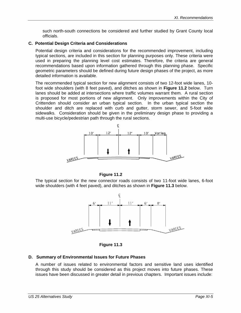
XI. Recommendations
US 25 Alternatives Study Page XI-5
such north-south connections be considered and further studied by Grant County local officials.
C. Potential Design Criteria and Considerations Potential design criteria and considerations for the recommended improvement, including typical sections, are included in this section for planning purposes only. These criteria were used in preparing the planning level cost estimates. Therefore, the criteria are general recommendations based upon information gathered through this planning phase. Specific geometric parameters should be defined during future design phases of the project, as more detailed information is available.
The recommended typical section for new alignment consists of two 12-foot wide lanes, 10-foot wide shoulders (with 8 feet paved), and ditches as shown in Figure 11.2 below. Turn lanes should be added at intersections where traffic volumes warrant them. A rural section is proposed for most portions of new alignment. Only improvements within the City of Crittenden should consider an urban typical section. In the urban typical section the shoulder and ditch are replaced with curb and gutter, storm sewer, and 5-foot wide sidewalks. Consideration should be given in the preliminary design phase to providing a multi-use bicycle/pedestrian path through the rural sections.
Figure 11.2
The typical section for the new connector roads consists of two 11-foot wide lanes, 6-foot wide shoulders (with 4 feet paved), and ditches as shown in Figure 11.3 below.
Figure 11.3 D. Summary of Environmental Issues for Future Phases
A number of issues related to environmental factors and sensitive land uses identified through this study should be considered as this project moves into future phases. These issues have been discussed in greater detail in previous chapters. Important issues include:
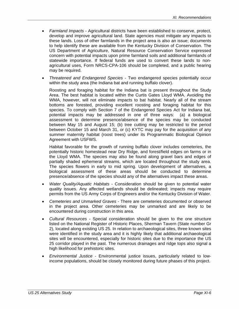
XI. Recommendations
US 25 Alternatives Study Page XI-6
• Farmland Impacts - Agricultural districts have been established to conserve, protect, develop and improve agricultural land. State agencies must mitigate any impacts to these lands. Loss of other farmlands in the project area is also an issue; documents to help identify these are available from the Kentucky Division of Conservation. The US Department of Agriculture, Natural Resource Conservation Service expressed concern with potential impacts upon prime farmland soils and additional farmlands of statewide importance. If federal funds are used to convert these lands to non-agricultural uses, Form NRCS-CPA-106 should be completed, and a public hearing may be required.
• Threatened and Endangered Species - Two endangered species potentially occur within the study area (the Indiana bat and running buffalo clover).
Roosting and foraging habitat for the Indiana bat is present throughout the Study Area. The best habitat is located within the Curtis Gates Lloyd WMA. Avoiding the WMA, however, will not eliminate impacts to bat habitat. Nearly all of the stream bottoms are forested, providing excellent roosting and foraging habitat for this species. To comply with Section 7 of the Endangered Species Act for Indiana bat, potential impacts may be addressed in one of three ways: (a) a biological assessment to determine presence/absence of the species may be conducted between May 15 and August 15; (b) tree cutting may be restricted to the period between October 15 and March 31, or (c) KYTC may pay for the acquisition of any summer maternity habitat (roost trees) under its Programmatic Biological Opinion Agreement with USFWS.
Habitat favorable for the growth of running buffalo clover includes cemeteries, the potentially historic homestead near Dry Ridge, and forest/field edges on farms or in the Lloyd WMA. The species may also be found along gravel bars and edges of partially shaded ephemeral streams, which are located throughout the study area. The species flowers in early to mid spring. Upon development of alternatives, a biological assessment of these areas should be conducted to determine presence/absence of the species should any of the alternatives impact these areas.
• Water Quality/Aquatic Habitats - Consideration should be given to potential water quality issues. Any affected wetlands should be delineated; impacts may require permits from the US Army Corps of Engineers and/or the Kentucky Division of Water.
• Cemeteries and Unmarked Graves - There are cemeteries documented or observed in the project area. Other cemeteries may be unmarked and are likely to be encountered during construction in this area.
• Cultural Resources - Special consideration should be given to the one structure listed on the National Register of Historic Places, Sherman Tavern (State number Gr 2), located along existing US 25. In relation to archaeological sites, three known sites were identified in the study area and it is highly likely that additional archaeological sites will be encountered, especially for historic sites due to the importance the US 25 corridor played in the past. The numerous drainages and ridge tops also signal a high likelihood for prehistoric sites.
• Environmental Justice - Environmental justice issues, particularly related to low-income populations, should be closely monitored during future phases of this project.
XI. Recommendations
US 25 Alternatives Study Page XI-7
E. Construction Considerations Construction-related issues were also identified within this study. More detail was presented in previous chapters, potential construction issues include:
• Erosion and Sediment Control - Measures should be utilized to control erosion and sedimentation during and after the commencement of earth-disturbing activities. Careful consideration should be given to erosion control methods; a Best Management Practices for Construction Activities guide is available from the Kentucky Division of Conservation.
• Air Quality - According to the Kentucky Environmental and Public Protection Cabinet, Division of Air Quality, the following Kentucky Administrative Regulations apply to the proposed project: (1) 401 KAR 63:010 Fugitive Emissions; (2) 401 KAR 63:005 Open Burning; (3) the Clean Air Act; and (4) Title 23 and Title 49 of the United States Code. Applicable local government regulations should also be considered.
• Waste Management - Solid wastes occurring as part of the construction process should be disposed of at a permitted facility. Underground storage tanks and other contaminants should be properly addressed as they are encountered.
• Traffic Operations - Maintenance of traffic and residential access should be preserved throughout the construction process.
• Geotechnical Considerations - It is expected that box culverts (or other minor structures) can be founded on shallow foundations bearing on either stiff soil or rock. Further, that bridge foundations will be required to bear on rock via shallow foundations or deep foundations, such as driven steel piles or drilled shafts. A detailed geotechnical exploration is warranted for each structure.
Fill slopes will likely be comprised of a mixture of native soil and rock; therefore, the fill slopes should be engineered based upon the shear strength parameters of the applicable fill material. Rock buttresses will likely be required at the toe of fill slopes in deep alluvium soil areas or where steepened slopes are desired.
As the depth to rock in the study area is anticipated to generally be no more than 5 feet, we expect cut slopes to be comprised mostly of in-place rock. A geotechnical engineering evaluation of rock slope stability will be required before specific rock cut slope recommendations can be prepared.
Based on actual subsurface conditions and the geometry of new fills, consolidation of soft, alluvial soils, where present, may create some settlement concerns for embankments, box culverts, or other drainage structures. Some undercutting and/or stabilization of soft/wet alluvial soils may be required where new roadways cross alluvial areas.
Construction in urban areas will require careful inspection of in-place soils. Some undercutting and replacement or other form of stabilization should be anticipated, where the new roadway passes over undocumented fills, which may not be adequately compacted.
Construction of new roadways or flyover structures in or near the study area’s identified sinkhole will likely require remedial measures, such as injection grouting, to more confidently build on or near this area. There is some risk that performance of
XI. Recommendations
US 25 Alternatives Study Page XI-8
remedial measures could adversely impact Norfolk Southern Railroad’s right of way (i.e., changing water infiltration patterns in the area could be a catalyst to development of another sinkhole nearby).