us army engineer center and school geology army...subcourse en 5462 edition a united states army...
TRANSCRIPT
SUBCOURSE EDITIONEN5462 A
US ARMY ENGINEER CENTER AND SCHOOL
GEOLOGY
GEOLOGY
Subcourse EN 5462
EDITION A
United States Army Engineer SchoolFort Leonard Wood, Missouri 65473
7 Credit Hours
Edition Date: April 1996
SUBCOURSE OVERVIEW
This subcourse, Geology is designed to help you identify specific rock types from written descriptionsand line drawings and to determine engineering properties of rocks in terms of their suitability forconstruction use. Information is provided on rock types and properties, geological structures, slopefailure, surficial features, and construction material. Appendix C contains conversion factors for anymetrics introduced in the subcourse. This course is taught in four lessons.
There are no prerequisites for this subcourse.
The lessons in this subcourse reflect the doctrine which was current at the time it was prepared. In yourown work situation, always refer to the latest official publications.
Unless otherwise stated, the masculine gender of singular pronouns is used to refer to both men andwomen.
TERMINAL LEARNING OBJECTIVE:
ACTION: You will identify geological processes and products.
CONDITION: You will be given the material contained in this subcourse and an ArmyCorrespondence Course Program (ACCP) examination response sheet.
STANDARD: To demonstrate proficiency of this task, you must achieve a minimum of 70percent on the subcourse examination.
i EN5462
TABLE OF CONTENTS
Section Page
Subcourse Overview....................................................................................................................... i
Lesson 1: Rock Types and Properties..................................................................................... 1-1
Part A: Identify the Major Rock Types................................................................ 1-2
Part B: Identifying the Key Engineering Properties of Rocks.............................. 1-17
Practice Exercise..................................................................................................... 1-21
Answer Key and Feedback...................................................................................... 1-24
Lesson 2: Geologic Structures................................................................................................. 2-1
Practice Exercise..................................................................................................... 2-21
Answer Key and Feedback...................................................................................... 2-22
Lesson 3: Slope Failure........................................................................................................... 3-1
Practice Exercise..................................................................................................... 3-9
Answer Key and Feedback...................................................................................... 3-12
Lesson 4: Surficial Features and Construction Materials........................................................ 4-1
Part A: Fluvial and Coastal Features.................................................................... 4-2
Part B: Glacial and Eolian Landforms................................................................. 4-14
Part C: Residual Landforms................................................................................. 4-26
Practice Exercise..................................................................................................... 4-31
Answer Key and Feedback...................................................................................... 4-36
EN5462 ii

Section Page
Examination.................................................................................................................................... E-1
Appendix A: List of Common Acronyms..................................................................................... A-1
Appendix B: Recommended Reading List................................................................................... B-1
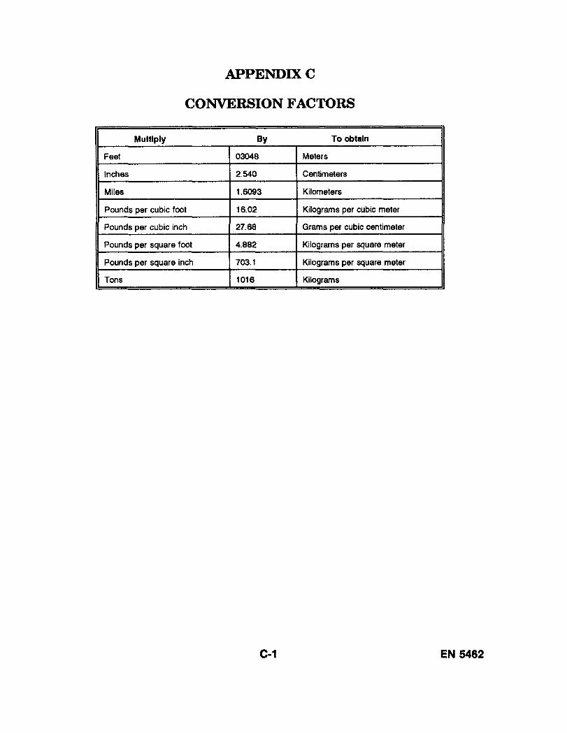
Appendix C: Conversion Factors................................................................................................. C-1
iii EN5462

THIS PAGE INTENTIONALLY LEFT BLANK
EN5462 iv
LESSON 1
ROCK TYPES AND PROPERTIES
Critical Task: 051-243-3027
OVERVIEW
LESSON DESCRIPTION:
In this lesson you will learn about different rock types, simple methods for identifying and describingthem, and about the properties of rocks in terms of suitability for construction needs. Appendix Ccontains conversion factors for any metrics introduced in this lesson.
TERMINAL LEARNING OBJECTIVE:
ACTION: You will identify and describe rock types and define the properties of rocks interms of suitability for construction.
CONDITION: You will be given the material contained in this lesson.
STANDARDS: You must complete the lesson and the practice exercise.
REFERENCES: The material contained in this lesson was derived from FM 5-410.
INTRODUCTION
Geology is not the study of rocks: it is the study of the earth. It is a science that is broken down intomany subfields. For example: volcanology is the study of volcanoes, seismology the study ofearthquakes, the study of minerals (the building blocks of rocks) is called mineralogy, and the study ofrocks is called petrology. On a small scale, the study of the grains which make up certain rocks is calledstratigraphy. On a larger scale, the study of the orientation of large bodies of rock is called structuralgeology. The sciences of groundwater geology and hydrology are important not only as means offinding water supplies but also as ways to get rid of unwanted water on construction sites. Whengeology (the study of the earth) is combined with biology (the study of life) the science is calledpaleontology, (the study of ancient life on earth).
1-1 EN5462
You, as an engineer, may not be as interested in the earth's history and composition as you are inpractical applications of geology. For most people, geology is a nice-to-know subject, but for anengineer, a knowledge of geologic processes and products is absolutely essential. History is filled withaccounts of engineering projects that failed because the engineer did not have a thorough understandingof geologic processes at work.
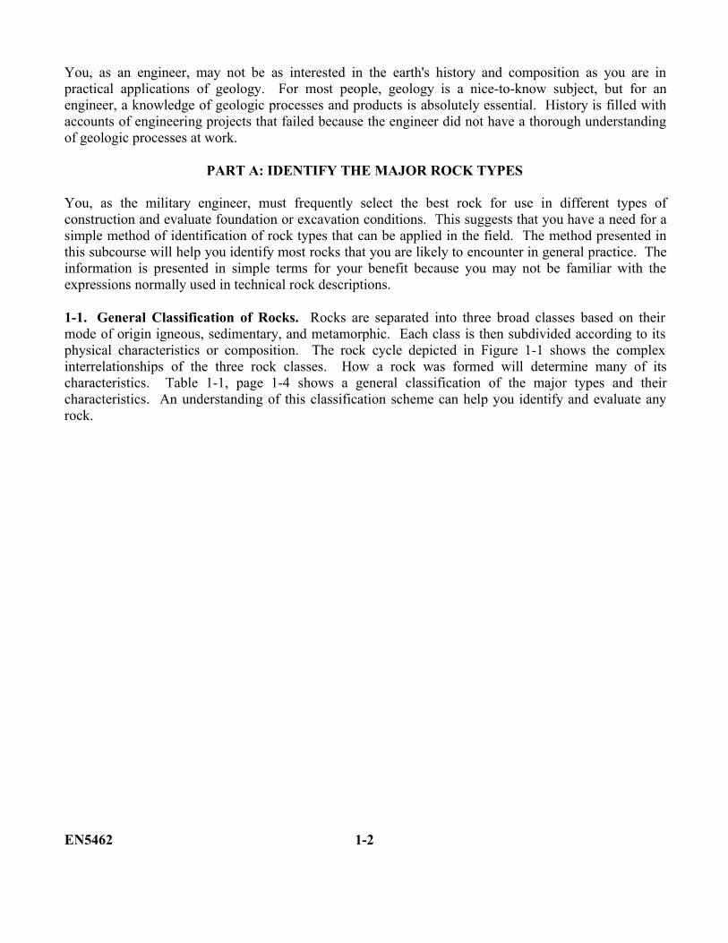
PART A: IDENTIFY THE MAJOR ROCK TYPES
You, as the military engineer, must frequently select the best rock for use in different types ofconstruction and evaluate foundation or excavation conditions. This suggests that you have a need for asimple method of identification of rock types that can be applied in the field. The method presented inthis subcourse will help you identify most rocks that you are likely to encounter in general practice. Theinformation is presented in simple terms for your benefit because you may not be familiar with theexpressions normally used in technical rock descriptions.
1-1. General Classification of Rocks. Rocks are separated into three broad classes based on theirmode of origin igneous, sedimentary, and metamorphic. Each class is then subdivided according to itsphysical characteristics or composition. The rock cycle depicted in Figure 1-1 shows the complexinterrelationships of the three rock classes. How a rock was formed will determine many of itscharacteristics. Table 1-1, page 1-4 shows a general classification of the major types and theircharacteristics. An understanding of this classification scheme can help you identify and evaluate anyrock.
EN5462 1-2
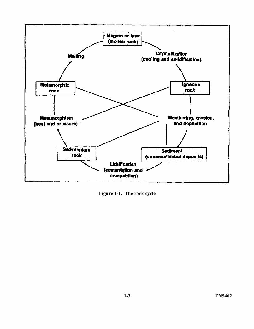
Figure 1-1. The rock cycle
1-3 EN5462
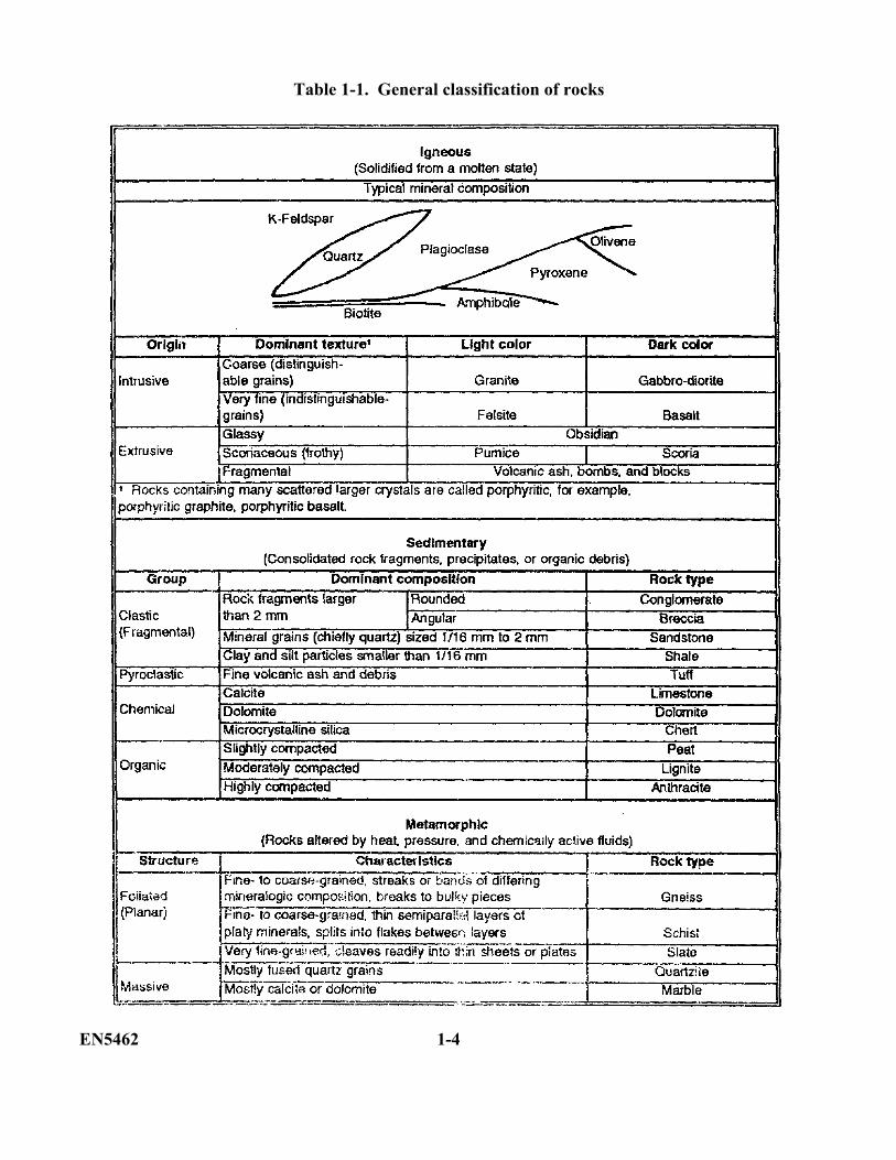
Table 1-1. General classification of rocks
EN5462 1-4
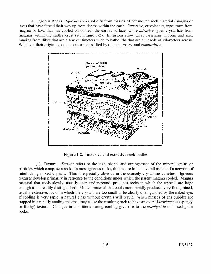
a. Igneous Rocks. Igneous rocks solidify from masses of hot molten rock material (magma orlava) that have forced their way up from depths within the earth. Extrusive, or volcanic, types form frommagma or lava that has cooled on or near the earth's surface, while intrusive types crystallize frommagmas within the earth's crust (see Figure 1-2). Intrusions show great variations in form and size,ranging from dikes that are a few centimeters wide to batholiths that are hundreds of kilometers across.Whatever their origin, igneous rocks are classified by mineral texture and composition.
Figure 1-2. Intrusive and extrusive rock bodies
(1) Texture. Texture refers to the size, shape, and arrangement of the mineral grains orparticles which compose a rock. In most igneous rocks, the texture has an overall aspect of a network ofinterlocking mixed crystals. This is especially obvious in the coarsely crystalline varieties. Igneoustextures develop primarily in response to the conditions under which the parent magma cooled. Magmamaterial that cools slowly, usually deep underground, produces rocks in which the crystals are largeenough to be readily distinguished. Molten material that cools more rapidly produces very fine-grained,usually extrusive, rocks in which the crystals are too small to be clearly distinguished by the naked eye.If cooling is very rapid, a natural glass without crystals will result. When masses of gas bubbles aretrapped in a rapidly cooling magma, they cause the resulting rock to have an overall scoriaceous (spongyor frothy) texture. Changes in conditions during cooling give rise to the porphyritic or mixed-grainrocks.
1-5 EN5462
(2) Composition. Composition refers to the color of the igneous rocks. The color dependson the chemical composition of the parent magma. Sialic magmas, rich in silicon and aluminum, formlight-colored rocks that are composed mainly of colorless, white, blue, pink or reddish minerals. Maficmagmas, rich in iron and magnesium, form dark-colored rocks that are composed mainly of gray, green,black, or brown materials.
b. Sedimentary Rocks. Sedimentary rocks are consolidated from accumulations of solid rockdebris, chemical precipitate, or organic material by compaction, cementation, or crystallization. Mostform in distinct parallel layers separated by abrupt fairly even contact surfaces called bedding planes.Each layer represents a successive deposit of material. Fossils, mud cracks, dunes, buried streamchannels, and other features are often preserved as these deposits build up. As a class, sedimentary rockscover about 75 percent of the earth's surface. Over 95 percent of the total volume of sediments iscomposed of varieties of shale, sandstone, and limestone. Sedimentary rocks are described as eitherclastic or nonclastic.
(1) Clastic. Clastic sedimentary rocks consist mainly of individual fragments of preexistingrocks cemented together by silica, iron oxides, or calcite deposited around the particles by groundwater.Pyroclastic types, sometimes considered to be igneous rocks, form from violently-erupted volcanicparticles which have been fused or cemented after settling in air or water. The clastic (or fragmental)rocks are classified by grain size with subsequent subdivisions based on composition.
(2) Nonclastic. Nonclastic sedimentary rocks are composed of interlocking crystals or are inearthy masses. They are generally grouped as inorganic (or chemical) or organic:
(a) Chemical sedimentary rocks consist mainly of chemical or biochemical precipitates.Most form in shallow seas rich in dissolved minerals. Classification of chemical rocks is based oncomposition. Further subdivisions are based on texture or other features.
(b) Organic sedimentary rocks consist mainly of compacted organic material. Thesetypes of rocks are classified based on degree of compaction.
c. Metamorphic Rocks. Metamorphic (or changed) rocks form from preexisting rocks by theaction of heat pressure, and chemically active fluids deep underground. Like the intrusive rocks withwhich they are often associated, metamorphic rocks are initially classified into two groups based onstructure. They are foliated and massive (or nonfoliated). Further subdivisions of these two groups arebased on composition or physical characteristics.
EN5462 1-6
(1) Foliated. Foliated metamorphic rocks are characterized by a distinctive planararrangement of their various mineral components. This foliation may be expressed by closely-spacedfractures (slaty cleavage), by parallel arrangement of platy minerals in thin layers (schistosity), or byalternating streaks or bands of differing mineralogic composition (gneissic layering). Common foliatedor banded metamorphic rocks include slate, schist, and gneiss.
(2) Massive. Massive (or nonfoliated) metamorphic rocks are essentially structureless andcommonly contain only one mineral. They are crystalline or composed of a mass of fused grains.Common massive metamorphic rocks include quartzite and marble.
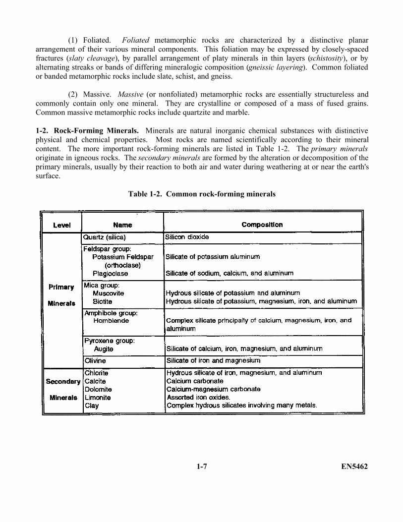
1-2. Rock-Forming Minerals. Minerals are natural inorganic chemical substances with distinctivephysical and chemical properties. Most rocks are named scientifically according to their mineralcontent. The more important rock-forming minerals are listed in Table 1-2. The primary mineralsoriginate in igneous rocks. The secondary minerals are formed by the alteration or decomposition of theprimary minerals, usually by their reaction to both air and water during weathering at or near the earth'ssurface.
Table 1-2. Common rock-forming minerals
1-7 EN5462
Each rock-forming mineral and rock type has special characteristics, limitations, and variations ofproperties.
a. Primary Rock-Forming Minerals. Common primary rock-forming minerals are--
(1) Quartz. Quartz (silica) is an extremely hard, transparent to translucent mineral with aglassy or waxy luster. Colorless to white or smoky-gray varieties are most common, but impurities mayproduce many other colors. Like man-made glass, quartz has a conchoidal (shell like) fracture, oftenimperfectly developed. It forms pointed, six-sided prismatic crystals on occasion but occurs most oftenas irregular grains inter-grown with other minerals in igneous and metamorphic rocks, as rounded orangular grains in sedimentary rocks (particularly sandstone), and as a microcrystalline sedimentary rockor cementing agent. Veins of milky white quartz, often quite large, fill cracks in many igneous andmetamorphic rocks. Unlike nearly all other minerals, quartz is virtually unaffected by chemicalweathering.
(2) Feldspars. Feldspars form very hard, blocky, opaque crystals with a pearly or porcelainlike luster and nearly rectangular in cross section. Crystals tend to cleave in two directions along flatshiny, nearly perpendicular surfaces. Plagioclase varieties often have fine parallel grooves (striations) onone cleavage surface. Potassium varieties (orthoclase) are usually pink, reddish, ivory, or pale gray,while plagioclase crystals are usually white to greenish gray. Crystalline feldspars are major componentsof most igneous rocks, gneisses, and schists. Where more than one variety is present color differencesare normally distinct. In the presence of air and water, the feldspars weather into clay minerals, solublesalts, and colloidal silica.
(3) Micas. Micas form soft, extremely thin, transparent to translucent, elastic sheets andflakes with a bright glassy or pearly luster. Layers (books) of easily-separated sheets frequently occur.The biotite variety of mica is usually brown or black while muscovite is yellowish, white, or silverygray. Micas are very common in granite rocks, gneisses, and schists. They slowly weather to clayminerals.
(4) Amphiboles. Amphiboles (chiefly hornblende) are hard, dense, glassy to silky mineralsfound chiefly in intermediate to dark igneous rocks and in gneisses and schists. They generally occur aswell-formed, slender, often needlelike, crystals with a nearly diamond-shaped cross section. Dark greento black varieties are most common, although light gray or greenish types occur in some marbles andschists. The amphiboles weather rapidly to form chlorite and, ultimately, clay minerals, iron oxides, andsoluble carbonates.
(5) Pyroxenes. Pyroxenes (chiefly augite) are hard, very dense, glassy to resinous mineralsfound chiefly in dark igneous rocks and, less often, in dark gneisses and schists. They usually occur aswell-formed short, stout, columnar crystals that appear almost square in cross-section. Granular crystalsare common in some very dark gabbroic rocks. Colors of green to black or brown are most common,but, pale green or gray varieties sometimes occur in marbles or schists. Masses of nearly pure pyroxeneform a rock called pyroxenite. Pyroxenes weather much like the amphiboles.
EN5462 1-8
(6) Olivine. Olivine is a very hard, dense mineral that forms yellowish green to dark olivegreen or brown, glassy grains or granular masses in very dark, iron-rich rocks, particularly gabbro andbasalt. Masses of almost pure olivine form a rare rock called peridotite. Olivine weathers rapidly intoiron oxides and soluble silica.
b. Secondary Rock-Forming Minerals. Common secondary rock-forming minerals are--
(1) Chlorite. Chlorite is a very soft, grayish green to dark green mineral with a pearly luster.It occurs most often as crusts, masses, or thin sheets or flakes in metamorphic rocks, particularly schistsand greenstone (an altered form of gabbro or basalt). Chlorite forms from amphiboles and pyroxenes byweathering or metamorphism and, in turn, weathers to clay minerals and iron oxides.
(2) Calcite. Calcite (lime) is a soft, usually colorless to white mineral distinguished by arapid bubbling or fizzing reaction when it comes in contact with dilute hydrochloric acid. Calcite oftenoccurs as well-formed, glassy to dull, blocky crystals. As a rock-forming mineral, calcite is fine tocoarsely crystalline in marble and loose to compactly granular in ordinary limestone. In addition, calciteis the major component of sea shells and coral skeletons. As a secondary mineral, calcite occurs as acementing agent in many sedimentary rocks and as veins, or crack-fillings, in igneous and other types ofrocks. Calcite weathers chiefly by solution in acidic waters or water containing dissolved carbondioxide.
(3) Dolomite. Dolomite is similar to calcite in appearance and occurrence but is slightlyharder and more resistant to dissolving in a solution. It is distinguished by a slow bubbling or fizzingreaction when it comes in contact with dilute hydrochloric acid. Usually the reaction can be observedonly if the mineral is first powdered (as by scraping it with a knife). Coarse dolomite crystals often havecurved sides and a pinkish color. Calcite and dolomite frequently occur together, often in intimatemixtures.
(4) Limonite. Limonite most often occurs as soft, yellowish-brown to reddish-brown fine-grained earthy masses or compact lumps or pellets. It is a common and durable cementing agent insedimentary rocks, and it is also the major component of laterite. Most weathered rocks contain somelimonite as a result of the decomposition of ion-bearing minerals.
(5) Clay. Clay minerals form soft microscopic flakes that are usually mixed with impuritiesof various types (particularly silica, limonite, and calcite). Clays form a major part of most soils and ofsuch rocks as shale and slate. They are a common impurity in all types of sedimentary rocks. Whenbarely moistened, as by the breath or tongue, clays give off a characteristic musty odor.
1-9 EN5462
c. Rocks. The following rock types listed are composed of one or more of the primary andsecondary rock-forming minerals previously discussed.
(1) Granite. Granite is a coarsely crystalline, hard, massive, light-colored rock composedmainly of potassium feldspar and quartz, usually with mica and/or hornblende. Common colors includewhite, gray, and shades of pink to brownish red. Granite makes up most of the larger intrusive massesand is frequently associated with (and may grade into) gneisses and schists. In general, it is a reasonablyhard, tough, and durable rock that provides good foundations, building stones, and aggregates for alltypes of construction. However, very coarse-grained and quartz-rich granites often bond poorly withcementing materials, particularly asphaltic cements. For this reason, antistripping agents should be usedwhen granite is used in bituminous pavements. Finer-grained varieties are normally much tougher andmore durable than more coarse-grained types, many of which disintegrate rather rapidly undertemperature extremes or frost action. Virtually quartz-free granite, called syenite, generally providesbetter bonds and is somewhat denser and tougher than ordinary granite of equal grain size.
(2) Felsite. Felsite is a very fine-grained, usually extrusive equivalent of granite. Colorscommonly range from light or medium gray to pink, red, buff, purplish, or light brownish gray. Felsitesoften contain scattered large crystals of quartz or feldspar. Isolated gas bubbles and streak like flowstructures are also common in felsites. As a rule, felsites are about as hard and dense as granites, butthey are generally tougher and tend to splinter and flake when crushed (particularly if extremely fine-grained). Many felsites contain a form of silica which produces alkali-aggregate reactions with portlandcements. Barring these considerations, felsites can provide good general-purpose aggregates forconstruction.
(3) Gabbro and diorite. Gabbro and diorite form a series of dense, coarsely crystalline, hard,dark-colored intrusive rocks that are composed mainly of one or more dark minerals and plagioclasefeldspar. Gabbro is composed mainly of augite, olivine, or hornblende with plagioclase. Its color isgenerally dark green to black or brown. Diorite is an intermediate silicate formed mainly of plagioclasewith hornblende, biotite, or augite and virtually no potassium, feldspar, or quartz. The color is generallygray to greenish gray. Since both rocks are similar in properties and may be difficult to distinguish in thefield, they are often grouped under the name gabbro-diorite. The gabbro-diorites are common in smallerintrusive masses, particularly dikes and sills. As a group, they make strong foundations and excellentaggregates for all types of construction. Their great toughness and high density; however, makeexcavation and crushing costs very high, particularly when using finer-grained varieties.
(4) Basalt. Basalt is a very fine-grained, hard, dense, dark-colored extrusive rock that occurswidely in lava flows around the world. Colors are usually dark gray to black, greenish-black, or brown.Scattered coarse crystals of olivine, augite, or plagioclase are common, as are isolated gas bubbles,which may be mineral filled or open. With increasing grain size, basalt often grades into diabase, anextremely tough variety intermediate to gabbro. Despite a tendency to crush into chips or flakes in sizessmaller than 2 to 3 centimeters, both basalt and diabase make aggregates of the highest quality.
EN5462 1-10
(5) Obsidian. Obsidian is a hard, shiny, usually black, brown, or reddish volcanic glass thatmay contain scattered gas bubbles or visible crystals. Like man-made glass, it breaks readily into sharp-edged flakes. Obsidian is chemically unstable, weak and valueless as a construction material of anytype.
(6) Pumice. Pumice is a very frothy or foamy, light-colored rock that forms over glassy orfelsitic lava flows and in blocks blown from erupting volcanoes. Innumerable closely-spaced gasbubbles make it light enough to float on water and also give pumice good insulating qualities. Althoughhighly abrasive, pumice is very weak and can usually be excavated with hand tools. You may use it inthe manufacture of low-strength, lightweight concrete and concrete blocks. Most varieties arechemically unstable and you will need the use of special low-alkali portland cements.
(7) Scoria. Scoria looks very much like a coarse, somewhat cindery slag. It may be stony orglassy, or a mixture of both textures, having colors that range from reddish brown to dark gray or black.The gas bubbles (vesicles) that give scoria its spongy or frothy appearance are generally larger and morewidely spaced than those in pumice. Scoria is very common in volcanic regions and generally formsover basaltic lava flows. Compared to pumice, scoria is somewhat denser and tougher; consequently, itis widely used as a lightweight aggregate in concrete and concrete blocks. As with pumice, you mayneed the use of special low-alkali cements.
(8) Conglomerate and breccia. Conglomerate and breccia resemble man-made concrete inthat they consist of gravel-sized or larger rock fragments in a finer grained matrix. Different varietiessuch as limestone breccia, boulder conglomerate, or quart pebble conglomerate are generallydistinguished by the composition or size of the rock fragments. Wide variations in composition, degreeof cementation, and unpredictable degree of weathering of their component particles make these rockshighly unpredictable, even within the same deposit. Generally they exhibit poor engineering propertiesand are avoided in construction. You may use some very weakly cemented types by crushing them foruse as fill or subbase material in road or airfield construction.
(9) Sandstone. Sandstone is a medium-to-coarse grained, hard, gritty clastic rock that iscomposed mainly of sand-size (1/16 to 2 millimeters), quartz grains, often with feldspar, calcite, or clay.Sandstone varies widely in properties according to composition and cementation. Clean, compactquartz-rich varieties well-cemented by silica or iron oxides generally provide good material forconstruction of all types. Low-density, poorly cemented, and clayey varieties lack toughness anddurability and should be avoided as sources of construction material. However, you may use some clay-free types by finely crushing them to provide sand.
1-11 EN5462
(10) Shale. Shale is a soft to moderately hard sedimentary rock composed of very fine-grained(silt-sized) particles and clay materials. Silica, iron oxide, or calcite cements may be present, but manyshales lack cement and readily disintegrate or slake when soaked in water. Characteristically, shalesform in very thin layers, break into thin platy pieces or flakes, and give off a musty clay odor whenbarely moistened. Occasionally it will form into massive shales (mudstones), which may break intobulky fragments. Shales are frequently interbedded with sandstones and limestones and, with increasingamounts of sand or calcite, may grade into these rock types. You can excavate most shales without theneed for blasting. Because of their weakness and lack of durability, shales make very poor constructionmaterial.
(11) Tuff. Tuff is a low-density, soft to moderately hard pyroclastic rock composed mainly offine-grained volcanic ash. Colors range from white through yellow, gray, pink, and light brown to arather dark grayish brown. When barely moistened, some tuffs give off a weak clay odor. Very compactvarieties often resemble felsite but can usually be distinguished by their softness and the presence ofglass or pumice fragments. Loose, chalky types usually feel rough and produce a gritty dust unlike thesmooth particles of a true chalk or clay. Tuff is a weak easily excavated rock of low durability. Whenfinely ground, it has weak cementing properties and is often used as an extender for portland cement andas a pozzolana to improve workability and neutralize alkali-aggregate reactions. You can also use it asfills and base course materials.
(12) Limestones. Limestones are soft to moderately hard rocks composed mainly of calcite inthe form of shells, crystals, grains, or cementing material. All varieties are distinguished by a rapidbubbling or fizzing reaction when they come in contact with diluted hydrochloric acid. Colors normallyrange from white through various shades of gray to black, while other colors may result from impurities.Ordinary limestone is a compact moderately tough, very fine-grained or coarsely crystalline rock thatserves as a quality material for all construction needs. Hardness, toughness, and durability normallyincrease with increasing amounts of silica cement; however, more than about 30 percent silica mayproduce bonding problems or alkali-aggregate reactions. Clayey varieties usually lack durability andtoughness and should be avoided. Weak low-density limestones, including limerock and coral, areweakly recemented when crushed, wetted, and compacted. Therefore, they are widely used as fills andbase course materials. In mild climates, some may even prove suitable for your use in low-strengthportland cement concrete.
(13) Dolomites. Dolomites are soft to moderately hard rocks composed mainly of calcium-magnesium carbonates. They are distinguished by a slow bubbling or fizzing reaction when they comesin contact with diluted hydrochloric acid. Usually, the reaction can be observed only if the rock is firstpowdered (as by scraping it with a knife) before testing. Colors are normally grayish, yellowish, orpinkish. The characteristics of dolomite are similar to those of limestone, although dolomites are moreresistant to weathering.
EN5462 1-12
(14) Chert. Chert is a very hard, very fine-grained rock composed of microcrystalline silicaprecipitated from seawater or groundwater. It occurs mainly as irregular layers or nodules in limestonesand dolomites and as pebbles in gravel deposits or conglomerates. Most cherts are white to shades ofgray. Very dark, often black cherts are called flint, while red and brown varieties are called jasper.Pure, unweathered cherts break along smooth conchoidal (shell-like) surfaces with a waxy luster;weathered or impure forms may seem dull and chalky-looking. Although cherts are very hard and tough,they vary widely in chemical stability and durability. Many produce alkali-aggregate reactions withportland cement and most require the use of antistripping agents with bituminous cements. Low-densitycherts may swell slightly when soaked and disintegrate when exposed to frost action. Despite theseproblems, cherts are acceptable for road construction in many areas where better materials are notavailable.
(15) Gneiss. Gneiss is a roughly-foliated, medium-to-coarse grained rock that consists ofalternating streaks or bands of differing mineralogic composition. These may be straight wavy, orcrumpled and of uniform or variable thickness. Gneisses normally break into irregular, bulky pieces andresemble the granitic rocks in properties and uses. With increasing amounts of mica or more perfectlayering, gneisses grade into schists.
(16) Coal. Coal is an organic sedimentary rock composed mainly of carbonaceous plantmaterial. Peat is a low-grade variety of coal formed from the accumulation of partially-decomposedorganic matter at the bottom of a stagnant body of water. With increased pressure due to the weight ofoverlying sediments, peat is transformed through the intermediate-grade varieties of coal such as ligniteand bituminous coal, to a high-grade variety of coal known as anthracite. Mid-to-high grade varieties ofcoal are used extensively as fossil fuels.
(17) Schist. Schist is a fine-to-coarse grained, well-foliated rock composed of discontinuousthin layers of parallel mica, chlorite, hornblende, or other minerals. As a rule, adjacent layers in schistconsist of the same minerals. Schists split readily along these mineral layers into thin slabs or flakes.This characteristic makes schists undesirable for construction use and hazardous to excavate. Varietiesintermediate to gneiss may prove suitable, however, for you to use as fills, base course materials, orportland cement concrete.
(18) Quartzite. Quartzite is an extremely hard, fine-to-coarsely grained, massive rock thatforms from the metamorphism of sandstone. Unlike sandstone quartzite fractures through its componentgrains rather than around them because the cement and sand grains have been fused or welded togetherduring metamorphism. Broken surfaces are, therefore, not gritty and often have a splintery or sugaryappearance like that of a broken sugar cube or hard candy. Quartzite is one of the hardest, toughest andmost durable rocks known. It makes excellent construction material, but excavation and crushing costsare usually very high. Because of its high quartz content, antistripping agents are normally required withbituminous cements. Even so, bonds may be poor with very fine-grained types.
1-13 EN5462
(19) Marble. Marble is a soft, fine-to-coarse crystalline, massive metamorphic rock that formsfrom limestone or dolomite. It is distinguished by its softness, acid reaction, lack of fossils, and sugaryappearance of freshly broken surfaces. Marble is similar to ordinary compact or crystalline limestones inits engineering properties and uses. However, because of its softness, marble is usually avoided as anaggregate for pavements of highways and airfields. White calcite or pinkish dolomite veins and subtleswirls or blotches of trace impurities give marble its typical veined or marbled appearance, whatever itsactual color may be.
1-3. System for Rock Identification. The military system of field identification of rock types is givenin flow chart form in Table 1-3. In this method, all considerations are based on the appearance orcharacter of a clean, freshly-broken, unweathered rock surface. When you are determining theidentification of gravel or weathered samples, you may find pieces to be stained or partially altered, andyou may expect some modifications of their characteristics.
The three main rock properties you will use in the field identification of rocks are appearance, hardness,and reaction to acid:
Appearance includes color (light or dark) and texture (size, shape, and arrangement of grains)
Hardness includes hard (difficult or unable to scratch) and soft (nail scratches rock)
Reaction to acid includes none (shale and tuff), unstable (pumice and scoria), and rapid(limestone or marble). An acid test performed on powdered dolomite (a form of limestone)will produce a rapid acid reaction. The reaction to acid test is performed on samples identifiedas soft. Your samples should have good fresh surfaces.
Your first determination when using the system is to place the sample, based on its outward appearance,into one of three general groups:
Foliated. Very fine-grained (frothy, glassy, and stony). Course-grained.
Simple physical and chemical determinations then permit your further progression through the flowchart until a final identification is made. For most rocks, the identification process will be direct anduncomplicated. If you cannot make a positive identification, you should consult the more detailed rockdescriptions given previously in this lesson. However, you should use the flow chart first to eliminate allclearly inappropriate rock types. By using adjectives, you can modify a basic rock classification tocompose a "word picture" of the rock such as “a pale brown, fine-gained, thin-bedded, compact, clayey,silica-cemented sandstone.” Table 1-4, page 1-16, lists the key terms used to modify rock descriptions;these terms should offer further help with identification of samples.
EN5462 1-14
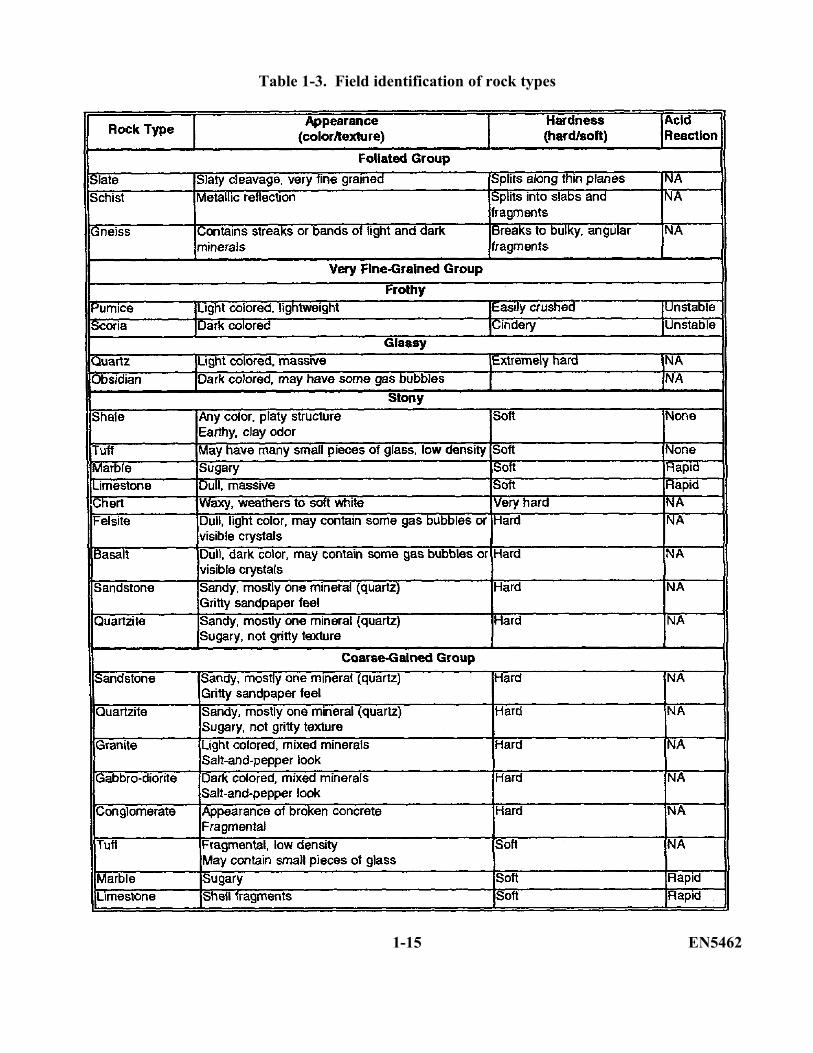
Table 1-3. Field identification of rock types
1-15 EN5462
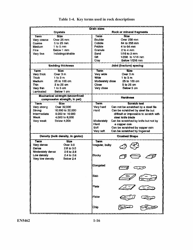
Table 1-4. Key terms used in rock descriptions
EN5462 1-16
PART B: IDENTIFYING THE KEY ENGINEERINGPROPERTIES OF ROCKS
A generalized summary of the engineering properties of fresh, unweathered rocks is given in Table 1-5,page 1-18. The key engineering properties are toughness, hardness, durability, chemical stability,surface character, crushed shape, and density.
1-4. Toughness. Toughness (mechanical strength) is a measure of resistance to crushing or breaking.In the field, you may be able to estimate this property by attempting to break the rock with a hammer orby measuring its resistance to penetration by impact drills.
1-5. Hardness. Hardness is a measure of resistance to scratching or abrasion. In the field, you mayestimate this by attempting to scratch the rock with a steel knife blade. Soft materials may be readilyscratched with a knife, while hard materials are difficult or impossible to scratch with a knife.
1-6. Durability. Durability is a measure of resistance to slaking or disintegration due to alternatingcycles of wetting and drying or freezing and thawing. You can estimate this property in the field byobserving the effects of weathering on natural exposures of the rock. A durable rock is preferable foruse as a construction material.
1-7. Chemical stability. Chemical stability is a measure of the resistance to reaction with alkalimaterials in portland cements. Several rock types contain impure forms of silica that react with alkaliesin cement to form a gel which absorbs water and expands, causing hardened concrete to crack. In thefield, you can estimate potential alkali-aggregate reactions by two methods: by identifying the rock andcomparing it to known reactive types or by investigating structures in which the aggregate has previouslybeen used.
1-8. Surface character. Surface character refers to the bonding characteristics of the broken rocksurface. Excessively smooth, slick, nonabsorbent aggregate surfaces bond poorly with cementingmaterials and shift readily under loads. Excessively rough, jagged, or absorbent surfaces are alsoundesirable for construction use because they resist compaction or placement and require excessiveamounts of cementing material.
1-9. Crushed shape. Crushed-shape rocks are irregular, bulky fragments of broken rock. Theyprovide the best aggregates for construction needs because the component particles compact well. Theyalso interlock to resist displacement and to distribute loads and are of nearly equal strength in alldirections. Rocks that break into elongated pieces or thin slabs, sheets, or flakes are weak in theirnarrow dimensions and do not compact, interlock or distribute loads effectively.
1-10. Density. Density is equal to the weight per unit volume. You may estimate this property in the field by hefting a rock sample. Density influences excavation and hauling costs and may affect the selection of rocks for special requirement, such as riprap, jetty stone, or lightweight aggregate. Among rocks of the same type, high density often
1-17 EN5462
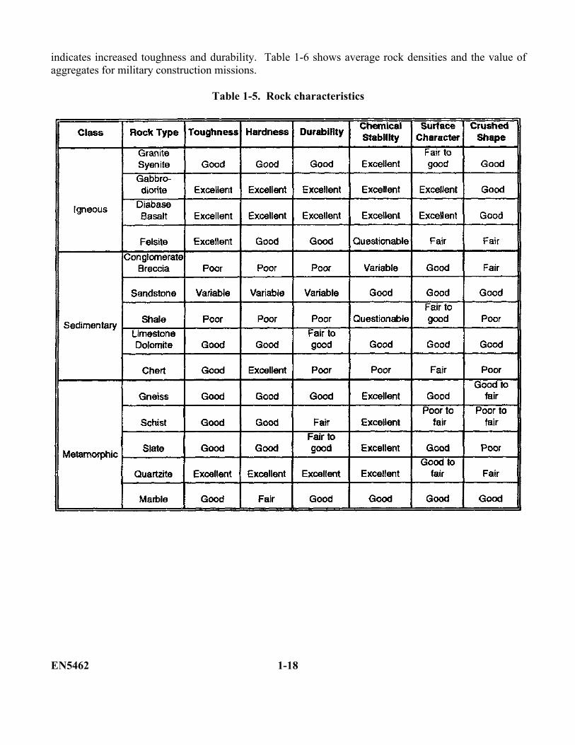
indicates increased toughness and durability. Table 1-6 shows average rock densities and the value ofaggregates for military construction missions.
Table 1-5. Rock characteristics
EN5462 1-18
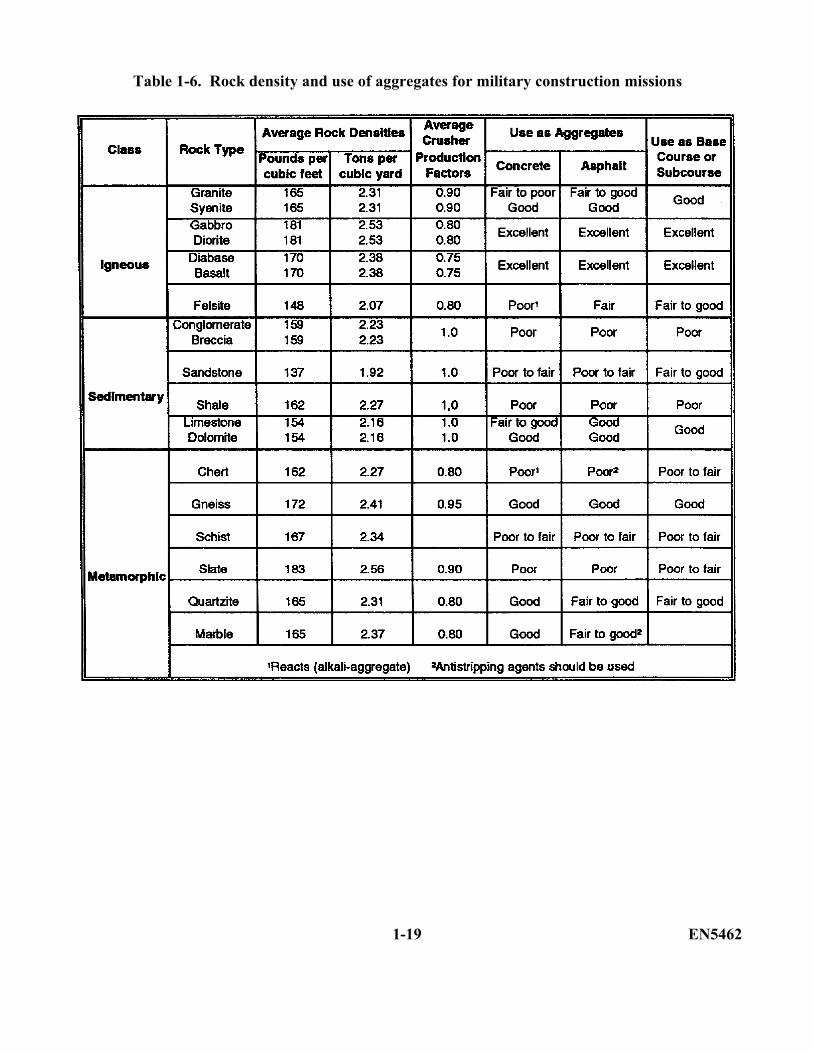
Table 1-6. Rock density and use of aggregates for military construction missions
1-19 EN5462

THIS PAGE IS INTENTIONALLY LEFT BLANK
EN5462 1-20
PRACTICE EXERCISE
The following items will test your grasp of the material covered in this lesson. When you havecompleted the exercise, check your answers with the key that follows. If you answer any itemincorrectly, study again that part which contains the portion involved.
1. What are the three major classes of rocks?
__________________________________________________________________________________________________________________________________________________________________________________________________________________________________________
2. Which class of rock solidifies from magma?
______________________________________________________________________________
3. Which class of rock represents material that consolidates from accumulations of solid rockdebris, chemical precipitate, or organic material by compaction, cementation or crystallization?
______________________________________________________________________________
4. What percent of the earth's surface does the class of sedimentary rocks cover?
______________________________________________________________________________
1-21 EN5462
5. Sedimentary rocks are predominately composed of varieties of shale, sandstone, and limestonesediments. What percent of sedimentary rocks do these sediments represent?
______________________________________________________________________________
6. How are extrusive-type rocks formed?
__________________________________________________________________________________________________________________________________________________________________________________________________________________________________________
7. How are intrusive-type rocks formed?
__________________________________________________________________________________________________________________________________________________________________________________________________________________________________________
8. What particles make up the main composition of chemical sedimentary rocks?
______________________________________________________________________________
EN5462 1-22
9. Metamorphic rocks are initially classified into two groups on the basis of structure. What are thetwo groups?
____________________________________________________________________________________________________________________________________________________________
10. What mineral type is extremely hard, transparent to translucent has a glassy or waxy luster, and isvirtually unaffected by chemical weathering?
______________________________________________________________________________
11. What three main rock properties are used in the field identification of rocks?
______________________________________________________________________________
Some of the key engineering properties of rock are toughness and density.
12. Define the term toughness.
____________________________________________________________________________________________________________________________________________________________
13. Define the term density.
____________________________________________________________________________________________________________________________________________________________
1-23 EN5462
Lesson 1
PRACTICE EXERCISE
ANSWER KEY AND FEEDBACK
Item Correct Answer
1. Igneous, sedimentary and metamorphic. (page 1-2, para 1-1)
2. Igneous. (page 1-5, para 1-la)
3. Sedimentary. (page 1-6, para 1-1b)
4. 75 percent. (page 1-6, para l-lb)
5. 95 percent. (page 1-6, para 1-1b)
6. Extrusive rocks are formed from magma or lava that has cooled on or near the earth'ssurface. (page 1-5, para 1-la)
7. Intrusive rocks crystallize from magmas within the earth's crust (page 1-5, para 1-1a)
8. Chemical sedimentary rocks consist mainly of chemical or biochemical precipitates.(page 1-6, para 1-lb(2)(a))
9. Foliated and massive. (page 1-6, para 1-1c)
10. Quartz. (page 1-8, para 1-2a(1))
11. Appearance, hardness, and reaction to acid. (page 1-14 para 1-3)
12. Toughness is a measure of resistance to crushing or breaking. (page 1-17, para 1-4)
13. Density refers to the weight per unit volume. (page 1-17, para 1-10)
EN5462 1-24
LESSON 2
GEOLOGIC STRUCTURES
Critical Tasks: 051-243-2006051-243-3011051-243-3012051-243-3027
OVERVIEW
LESSON DESCRIPTION:
In this lesson you will learn about large bodies of rock and their orientation and distribution within theearth's crust.
TERMINAL LEARNING OBJECTIVE
ACTION: You will identify major geologic structures and their engineering significance.
CONDITION: You will be given the materials contained in this lesson.
STANDARD: You must complete the lesson and the practical exercise.
REFERENCES: The material contained in this lesson was derived from FM 5-410.
INTRODUCTION
In Lesson 1 of this subcourse, you learned about the three major categories of rocks. You also learnedabout some basic rock properties and how to identify rocks. In this lesson, you will learn about largebodies of rock and their orientation and distribution within the earth's crust.
A knowledge of structural geology is important to you, as a military engineer, because of the effect it hason road construction, rock blasting, quarrying, and many other types of engineering projects.
2-1. Geologic Structures. Geologic structure controls the distribution of rock bodies and features along and beneath the earth's surface. Rocks tend to fracture along existing zones of weakness. The presence and spacing of bedding, foliation, and joint planes can control the size and shape of rock fragments produced in quarries and other excavations.
2-1 EN5462
Operational and production costs may be prohibitive if rock fragments are too large, too small, tooslabby, or too irregular for intended uses. You can significantly reduce excavation and aggregateproduction costs by identifying advantageous joint or bedding spacings.
The primary structure, or original form and arrangement, of rock bodies in the earth is often altered bysecondary structural features such as folds, faults, and joints. The features are produced in the rocks bymovements in the earth after deposition (and usually after consolidation) of the rocks. Like plastic steel,and other familiar materials, rocks may behave as viscous, plastic, or elastic solids when placed understress. Depending on the amount and duration of the stress and on their composition, temperature, anddegree of confinement rocks may flow, bend, or break. Some of the important causes of stress (andmovement) in the earth's interior include slow circulation of heat in the dense, hot rocklike materialsfound below the earth's thin outer crust and rising bodies of molten rock (magma). Other importantcauses of stress are loading by accumulation of deposits, unloading due to the erosion of surface rockdeposits, and contraction due to the compaction or cooling of rock bodies. During the 4.5 billion yearsof the earth's existence, weathering, erosion, deposition, magnetic intrusions, crustal movements, andclimatic conditions have acted at various times and places to produce the different rock bodies andfeatures that make up the today’s earth.
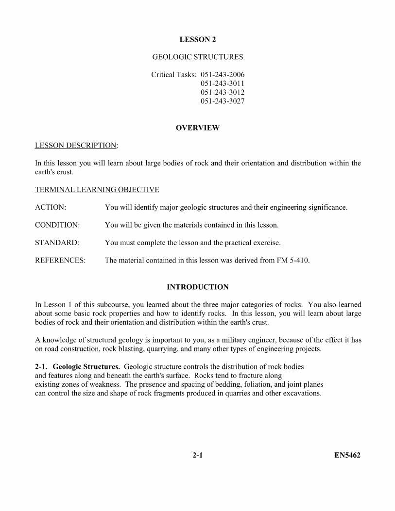
2-2. Outcrops. An outcrop is that part of a rock formation which is exposed at the earth's surface. Youmay view outcrops in areas where soil cover has not developed or where the developed soil cover hasbeen removed, leaving the underlying rock exposed. A few possible outcrop locations are shown inFigure 2-1. Information you can obtain from outcrops includes the rock type, contacts and attitudes.
Figure 2-1. Typical locations of outcrops
EN5462 2-2
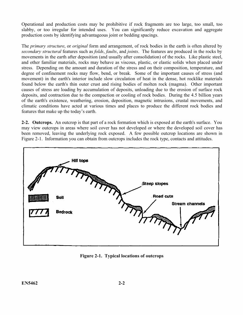
2-3. Primary Structural Features. Primary structural features are igneous structures, metamorphicfoliation, and sedimentary stratification.
a. Igneous Structures. The basic forms and relationships of igneous rock bodies are shown inFigure 2-2. They are formed as intrusive or extrusive rock forms:
(1) Intrusive. Intrusive rock bodies form within the earth's crust and may be eitherconcordant or discordant with surrounding rocks. Concordant intrusions, such as sills and laccoliths,form tabular or lens-shaped bodies that parallel the structure of the rocks around them. Discordantintrusions, such as dikes, solidify in fractures that cut across the structure of the surrounding rocks.Some very large discordant bodies such as batholiths and stocks are up to several kilometers wide. Theyessentially melt their way into place by forming masses of rock that may contain inclusions of oldersurrounding rocks.
(2) Extrusive. Extrusive igneous rocks form at or near the earth's surface. Most aredeposited in thin, broad sheets parallel to the local topography. Older extrusions are often buried underlayers of younger extrusive rock or even sedimentary material. In addition, younger intrusive bodiesmay form around or within older intrusions.
Figure 2-2. Intrusive and extrusive rock forms
2-3 EN5462
b. Metamorphic Foliation. Most metamorphic rocks are distinguished by the segregation andalignment of their component minerals into parallel streaks, bands, layers, or sheets. This arrangement iscalled foliation, and the planes of weakness along which the minerals are aligned are called planes offoliation or, simply, foliation planes. Foliation planes develop at right angles to the pressure appliedduring metamorphism. They frequently form parallel to the original surface of large intrusive bodies andmay parallel or cut across older bedding structures in metamorphosed sediments. Often foliation planesare highly distorted by rock flowage associated with the temperatures and pressures of metamorphism.
c. Sedimentary Stratification. Most sedimentary rocks are characterized by an original beddedstructure known as bedding or stratification. The lines of parting between individual beds or strata arecalled bedding planes. The sorting action of water and wind will produce such structures in sedimentaryrocks. The sediment is deposited in nearly horizontal layers which may vary in thickness from less thanan inch to more than 100 feet.
An important principle on which the study of structural geology is based is called the Law ofSuperposition. It states that in an undisturbed sequence of sediments or sedimentary rocks, the layer onthe bottom is older than all the rocks which overlie it. It is clearly obvious that if the bottom bed was notin place first, the others could not have been deposited on top of it.
2-4. Secondary Structural Features. Secondary structural features include folds, joints, and faults.
a. Folds. Folds are undulations that exist in the rocks of the earth. They are the most commontype of deformation. The size of folds varies considerably. Some folds are miles across; the width ofothers may be only a few feet, a few inches, or even fractions of an inch. Most folds (Figure 2-3) may beclassified as one of three principal types:
Monocline. Monocline exhibits step-like slopes in otherwise flat or gently inclined rocklayers.
Anticline. Anticline exhibits upfold slopes.
Syncline. Syncline exhibits downfold slopes.
Upfold and downfold slopes are the most common types of folds. These tend to produce linear valleysand ridges. Since symmetry is a rarity in nature, asymmetrical anticlines and synclines are common.
EN5462 2-4
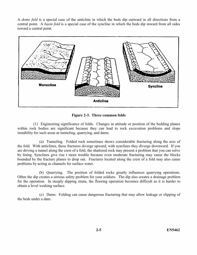
A dome fold is a special case of the anticline in which the beds dip outward in all directions from acentral point. A basin fold is a special case of the syncline in which the beds dip inward from all sidestoward a central point.
Figure 2-3. Three common folds
(1) Engineering significance of folds. Changes in attitude or position of the bedding planeswithin rock bodies are significant because they can lead to rock excavation problems and slopeinstability for such areas as tunneling, quarrying, and dams.
(a) Tunneling. Folded rock sometimes shows considerable fracturing along the axis ofthe fold. With anticlines, these fractures diverge upward; with synclines they diverge downward. If youare driving a tunnel along the crest of a fold, the shattered rock may present a problem that you can solveby lining. Synclines give rise t more trouble because even moderate fracturing may cause the blocksbounded by the fracture planes to drop out. Fractures located along the crest of a fold may also causeproblems by acting as channels for surface water.
(b) Quarrying. The position of folded rocks greatly influences quarrying operations.Often the dip creates a serious safety problem for your soldiers. The dip also creates a drainage problemfor the operation. In steeply dipping strata, the flooring operation becomes difficult as it is harder toobtain a level working surface.
(c) Dams. Folding can cause dangerous fracturing that may allow leakage or slipping ofthe beds under a dam.
2-5 EN5462
(2) Measuring and defining local bedrock. To be able to discuss or describe the structure oflocal bedrock, you must have some means by which you can measure and define the trend of the rock onthe earth's surface.
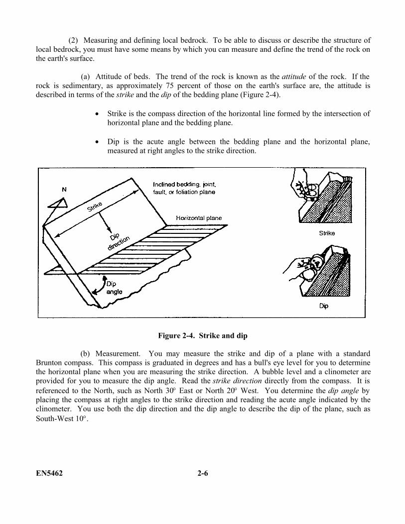
(a) Attitude of beds. The trend of the rock is known as the attitude of the rock. If therock is sedimentary, as approximately 75 percent of those on the earth's surface are, the attitude isdescribed in terms of the strike and the dip of the bedding plane (Figure 2-4).
Strike is the compass direction of the horizontal line formed by the intersection ofhorizontal plane and the bedding plane.
Dip is the acute angle between the bedding plane and the horizontal plane,measured at right angles to the strike direction.
Figure 2-4. Strike and dip
(b) Measurement. You may measure the strike and dip of a plane with a standardBrunton compass. This compass is graduated in degrees and has a bull's eye level for you to determinethe horizontal plane when you are measuring the strike direction. A bubble level and a clinometer areprovided for you to measure the dip angle. Read the strike direction directly from the compass. It isreferenced to the North, such as North 30 East or North 20 West. You determine the dip angle byplacing the compass at right angles to the strike direction and reading the acute angle indicated by theclinometer. You use both the dip direction and the dip angle to describe the dip of the plane, such asSouth-West 10.
EN5462 2-6
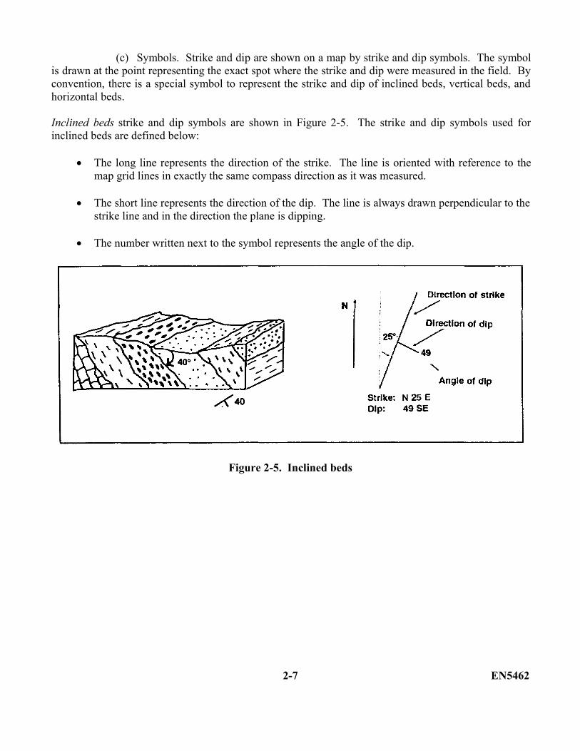
(c) Symbols. Strike and dip are shown on a map by strike and dip symbols. The symbolis drawn at the point representing the exact spot where the strike and dip were measured in the field. Byconvention, there is a special symbol to represent the strike and dip of inclined beds, vertical beds, andhorizontal beds.
Inclined beds strike and dip symbols are shown in Figure 2-5. The strike and dip symbols used forinclined beds are defined below:
The long line represents the direction of the strike. The line is oriented with reference to themap grid lines in exactly the same compass direction as it was measured.
The short line represents the direction of the dip. The line is always drawn perpendicular to thestrike line and in the direction the plane is dipping.
The number written next to the symbol represents the angle of the dip.
Figure 2-5. Inclined beds
2-7 EN5462
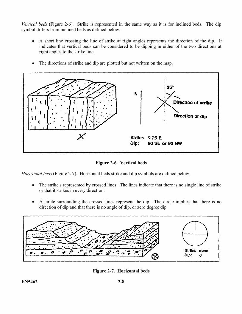
Vertical beds (Figure 2-6). Strike is represented in the same way as it is for inclined beds. The dipsymbol differs from inclined beds as defined below:
A short line crossing the line of strike at right angles represents the direction of the dip. Itindicates that vertical beds can be considered to be dipping in either of the two directions atright angles to the strike line.
The directions of strike and dip are plotted but not written on the map.
Figure 2-6. Vertical beds
Horizontal beds (Figure 2-7). Horizontal beds strike and dip symbols are defined below:
The strike s represented by crossed lines. The lines indicate that there is no single line of strikeor that it strikes in every direction.
A circle surrounding the crossed lines represent the dip. The circle implies that there is nodirection of dip and that there is no angle of dip, or zero degree dip.
Figure 2-7. Horizontal beds
EN5462 2-8

b. Joints. Joints are fractures along which there has been no visible movement. Although jointscharacteristically produce planar surfaces, some may produce curved surfaces. Joints may have anyattitude; some joints are vertical, others are horizontal, and many are inclined at various angles (Figure2-8). You measure the strike and dip of joints in the same manner as the strike and dip of beddingplanes. The strike is the direction of a horizontal line on the surface of the joint. The dip, measured in avertical plane at right angles to the strike of the joint, is the angle between a horizontal plane and thejoint. Joints vary greatly in magnitude. Some joints are only a few feet long while others are hundredsor even thousands of feet long. Joints are formed as freshly emplaced igneous rocks that contract andcool. This occurs during lithification as sedimentary rocks are compacted, during metamorphism asrocks are stressed, and when rock masses expand as overlying rock is removed by erosion. A specialtype of jointing known as exfoliation occurs when alternating heating and cooling periods cause rocks toexpand and contract. In dense and compact extrusive igneous rock such as basalt, a form of prismaticfracturing known as columnar jointing (as shown in Figure 2-8) often develops as the rock cools rapidlyand shrinks.
Figure 2-8. Block diagrams illustrating common joint patterns
2-9 EN5462
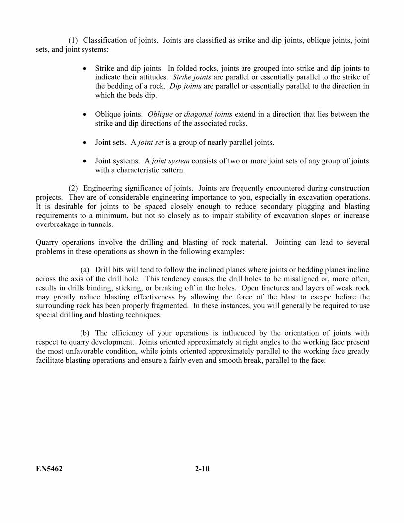
(1) Classification of joints. Joints are classified as strike and dip joints, oblique joints, jointsets, and joint systems:
Strike and dip joints. In folded rocks, joints are grouped into strike and dip joints toindicate their attitudes. Strike joints are parallel or essentially parallel to the strike ofthe bedding of a rock. Dip joints are parallel or essentially parallel to the direction inwhich the beds dip.
Oblique joints. Oblique or diagonal joints extend in a direction that lies between thestrike and dip directions of the associated rocks.
Joint sets. A joint set is a group of nearly parallel joints.
Joint systems. A joint system consists of two or more joint sets of any group of jointswith a characteristic pattern.
(2) Engineering significance of joints. Joints are frequently encountered during constructionprojects. They are of considerable engineering importance to you, especially in excavation operations.It is desirable for joints to be spaced closely enough to reduce secondary plugging and blastingrequirements to a minimum, but not so closely as to impair stability of excavation slopes or increaseoverbreakage in tunnels.
Quarry operations involve the drilling and blasting of rock material. Jointing can lead to severalproblems in these operations as shown in the following examples:
(a) Drill bits will tend to follow the inclined planes where joints or bedding planes inclineacross the axis of the drill hole. This tendency causes the drill holes to be misaligned or, more often,results in drills binding, sticking, or breaking off in the holes. Open fractures and layers of weak rockmay greatly reduce blasting effectiveness by allowing the force of the blast to escape before thesurrounding rock has been properly fragmented. In these instances, you will generally be required to usespecial drilling and blasting techniques.
(b) The efficiency of your operations is influenced by the orientation of joints withrespect to quarry development. Joints oriented approximately at right angles to the working face presentthe most unfavorable condition, while joints oriented approximately parallel to the working face greatlyfacilitate blasting operations and ensure a fairly even and smooth break, parallel to the face.
EN5462 2-10
(c) Joints offer channels for groundwater circulation. They may increase water problems,especially in areas of underground excavation. Where permeable rocks or fractures dip toward a tunnel,road cut, or other excavation, groundwater movement can cause drainage problems and promote rockslides by weakening or lubricating the rocks. Permeable rock zones can also permit water to escapefrom canals and reservoirs.
(d) Joints may exert an important influence on weathering of rocks.
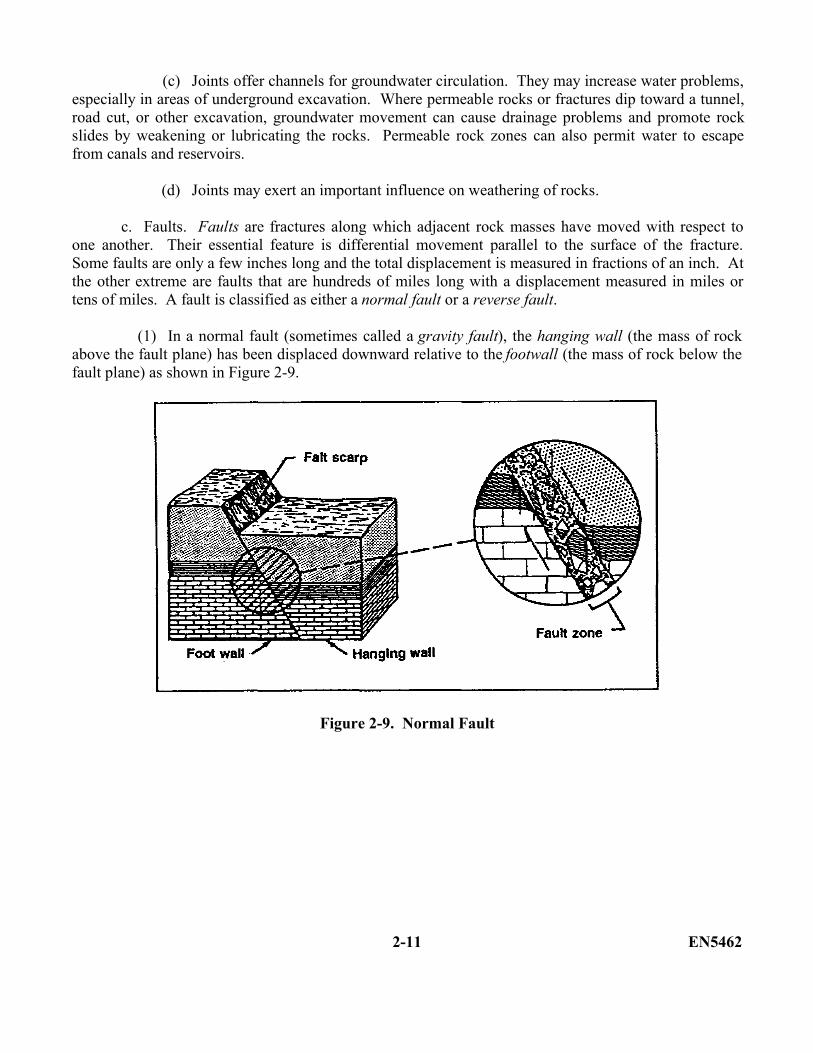
c. Faults. Faults are fractures along which adjacent rock masses have moved with respect toone another. Their essential feature is differential movement parallel to the surface of the fracture.Some faults are only a few inches long and the total displacement is measured in fractions of an inch. Atthe other extreme are faults that are hundreds of miles long with a displacement measured in miles ortens of miles. A fault is classified as either a normal fault or a reverse fault.
(1) In a normal fault (sometimes called a gravity fault), the hanging wall (the mass of rockabove the fault plane) has been displaced downward relative to the footwall (the mass of rock below thefault plane) as shown in Figure 2-9.
Figure 2-9. Normal Fault
2-11 EN5462
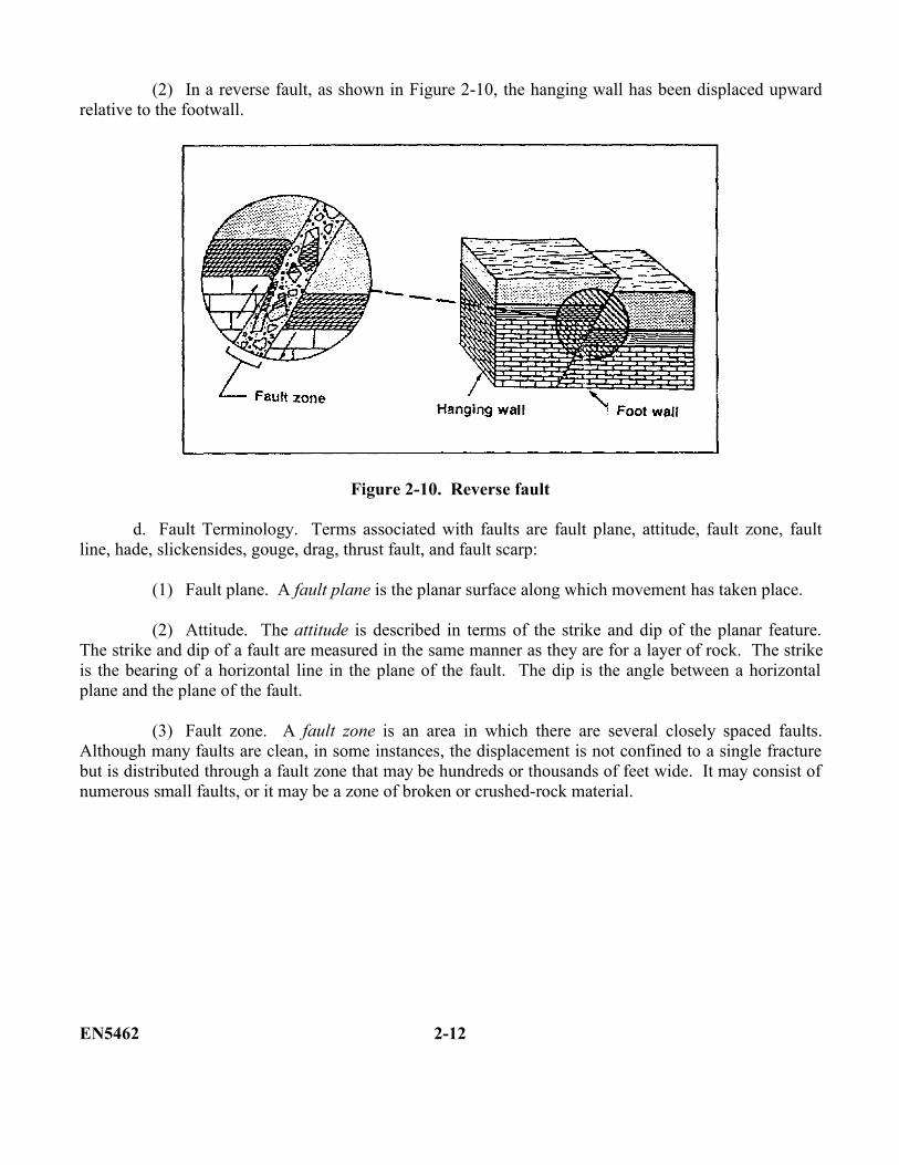
(2) In a reverse fault, as shown in Figure 2-10, the hanging wall has been displaced upwardrelative to the footwall.
Figure 2-10. Reverse fault
d. Fault Terminology. Terms associated with faults are fault plane, attitude, fault zone, faultline, hade, slickensides, gouge, drag, thrust fault, and fault scarp:
(1) Fault plane. A fault plane is the planar surface along which movement has taken place.
(2) Attitude. The attitude is described in terms of the strike and dip of the planar feature.The strike and dip of a fault are measured in the same manner as they are for a layer of rock. The strikeis the bearing of a horizontal line in the plane of the fault. The dip is the angle between a horizontalplane and the plane of the fault.
(3) Fault zone. A fault zone is an area in which there are several closely spaced faults.Although many faults are clean, in some instances, the displacement is not confined to a single fracturebut is distributed through a fault zone that may be hundreds or thousands of feet wide. It may consist ofnumerous small faults, or it may be a zone of broken or crushed-rock material.
EN5462 2-12
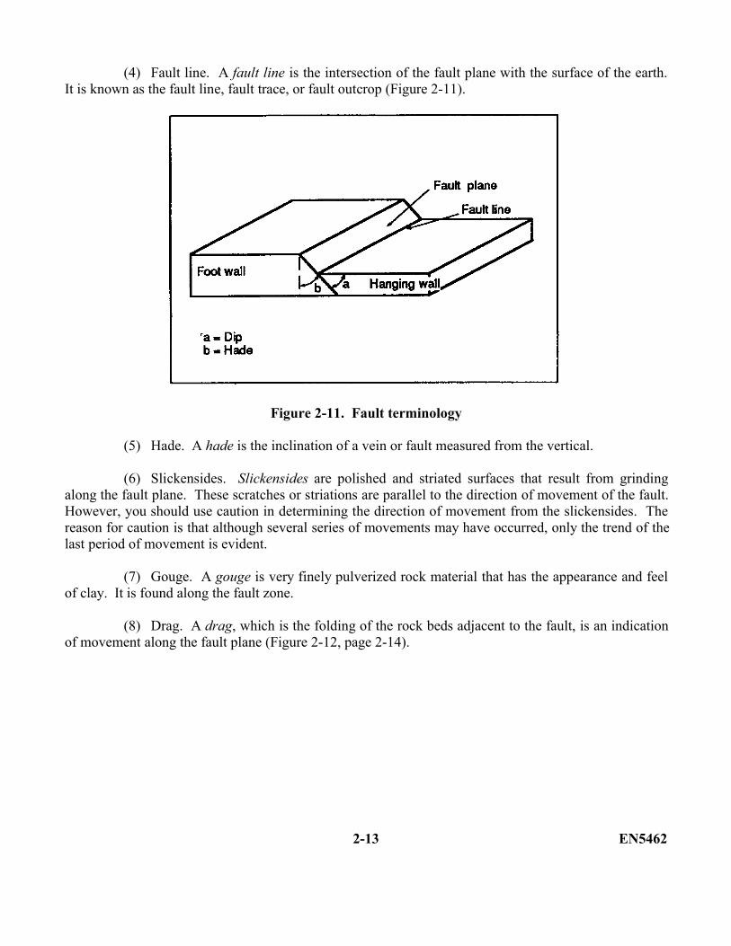
(4) Fault line. A fault line is the intersection of the fault plane with the surface of the earth.It is known as the fault line, fault trace, or fault outcrop (Figure 2-11).
Figure 2-11. Fault terminology
(5) Hade. A hade is the inclination of a vein or fault measured from the vertical.
(6) Slickensides. Slickensides are polished and striated surfaces that result from grindingalong the fault plane. These scratches or striations are parallel to the direction of movement of the fault.However, you should use caution in determining the direction of movement from the slickensides. Thereason for caution is that although several series of movements may have occurred, only the trend of thelast period of movement is evident.
(7) Gouge. A gouge is very finely pulverized rock material that has the appearance and feelof clay. It is found along the fault zone.
(8) Drag. A drag, which is the folding of the rock beds adjacent to the fault, is an indicationof movement along the fault plane (Figure 2-12, page 2-14).
2-13 EN5462
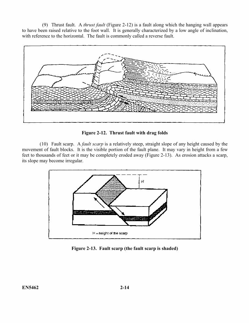
(9) Thrust fault. A thrust fault (Figure 2-12) is a fault along which the hanging wall appearsto have been raised relative to the foot wall. It is generally characterized by a low angle of inclination,with reference to the horizontal. The fault is commonly called a reverse fault.
Figure 2-12. Thrust fault with drag folds
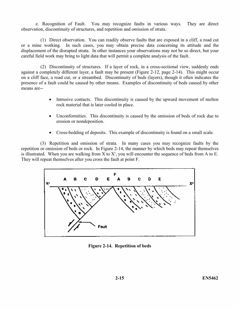
(10) Fault scarp. A fault scarp is a relatively steep, straight slope of any height caused by themovement of fault blocks. It is the visible portion of the fault plane. It may vary in height from a fewfeet to thousands of feet or it may be completely eroded away (Figure 2-13). As erosion attacks a scarp,its slope may become irregular.
Figure 2-13. Fault scarp (the fault scarp is shaded)
EN5462 2-14
e. Recognition of Fault. You may recognize faults in various ways. They are directobservation, discontinuity of structures, and repetition and omission of strata.
(1) Direct observation. You can readily observe faults that are exposed in a cliff, a road cutor a mine working. In such cases, you may obtain precise data concerning its attitude and thedisplacement of the disrupted strata. In other instances your observations may not be so direct, but yourcareful field work may bring to light data that will permit a complete analysis of the fault.
(2) Discontinuity of structures. If a layer of rock, in a cross-sectional view, suddenly endsagainst a completely different layer, a fault may be present (Figure 2-12, page 2-14). This might occuron a cliff face, a road cut, or a streambed. Discontinuity of beds (layers), though it often indicates thepresence of a fault could be caused by other means. Examples of discontinuity of beds caused by othermeans are--
Intrusive contacts. This discontinuity is caused by the upward movement of moltenrock material that is later cooled in place.
Unconformities. This discontinuity is caused by the omission of beds of rock due toerosion or nondeposition.
Cross-bedding of deposits. This example of discontinuity is found on a small scale.
(3) Repetition and omission of strata. In many cases you may recognize faults by therepetition or omission of beds or rock. In Figure 2-14, the manner by which beds may repeat themselvesis illustrated. When you are walking from X to X1, you will encounter the sequence of beds from A to E.They will repeat themselves after you cross the fault at point F.
Figure 2-14. Repetition of beds
2-15 EN5462
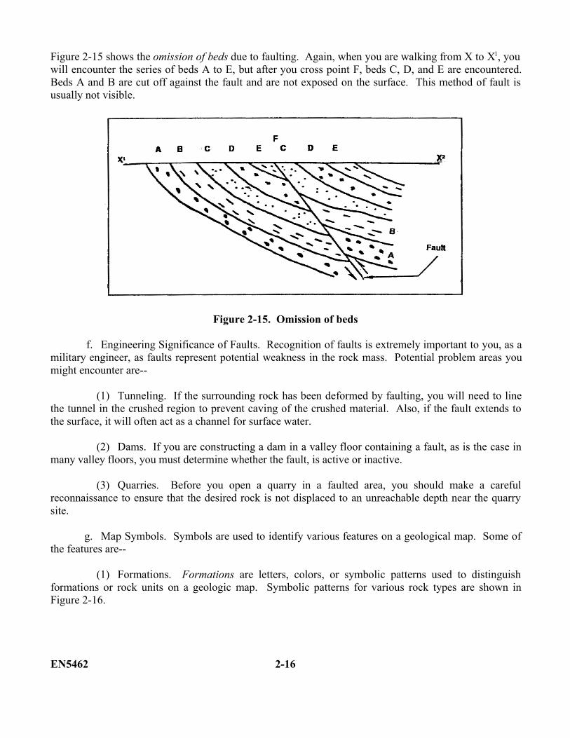
Figure 2-15 shows the omission of beds due to faulting. Again, when you are walking from X to X1, youwill encounter the series of beds A to E, but after you cross point F, beds C, D, and E are encountered.Beds A and B are cut off against the fault and are not exposed on the surface. This method of fault isusually not visible.
Figure 2-15. Omission of beds
f. Engineering Significance of Faults. Recognition of faults is extremely important to you, as amilitary engineer, as faults represent potential weakness in the rock mass. Potential problem areas youmight encounter are--
(1) Tunneling. If the surrounding rock has been deformed by faulting, you will need to linethe tunnel in the crushed region to prevent caving of the crushed material. Also, if the fault extends tothe surface, it will often act as a channel for surface water.
(2) Dams. If you are constructing a dam in a valley floor containing a fault, as is the case inmany valley floors, you must determine whether the fault, is active or inactive.
(3) Quarries. Before you open a quarry in a faulted area, you should make a carefulreconnaissance to ensure that the desired rock is not displaced to an unreachable depth near the quarrysite.
g. Map Symbols. Symbols are used to identify various features on a geological map. Some ofthe features are--
(1) Formations. Formations are letters, colors, or symbolic patterns used to distinguishformations or rock units on a geologic map. Symbolic patterns for various rock types are shown inFigure 2-16.
EN5462 2-16
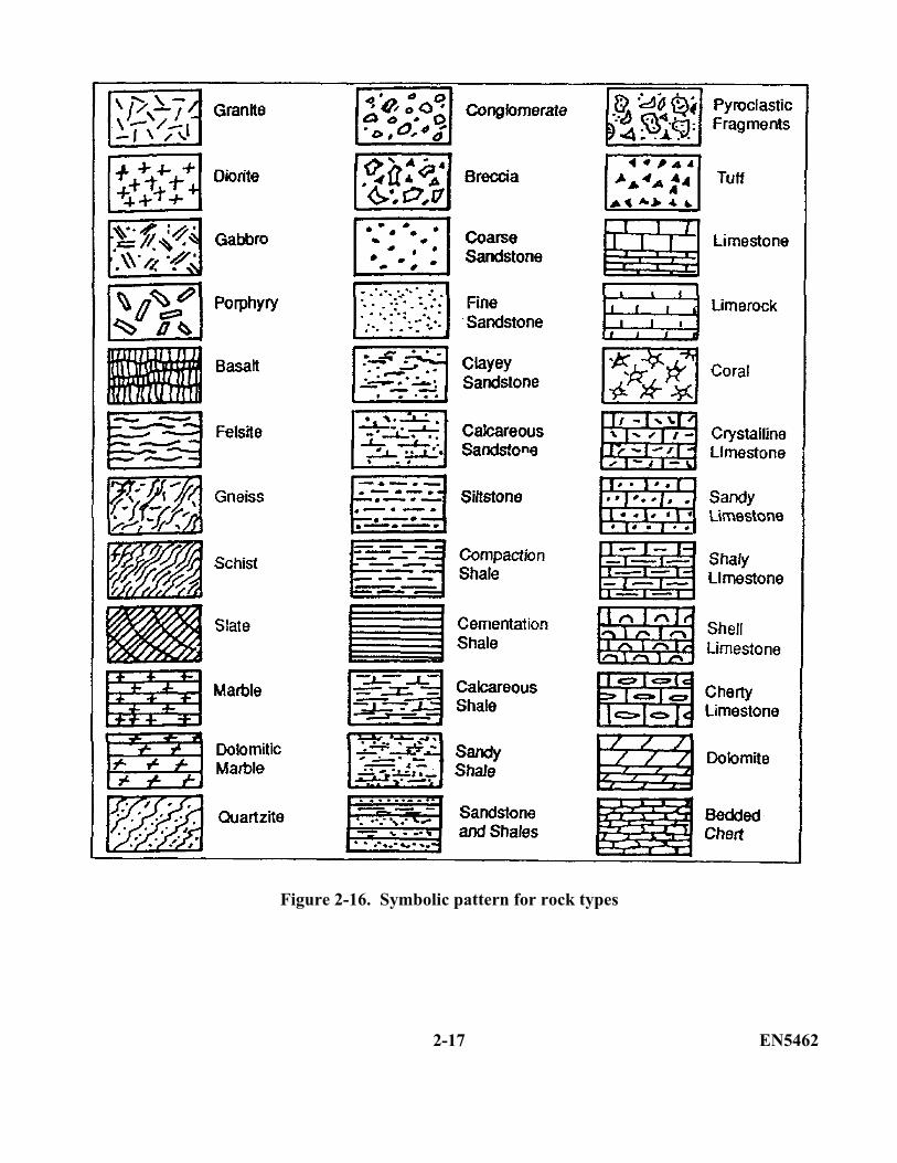
Figure 2-16. Symbolic pattern for rock types
2-17 EN5462
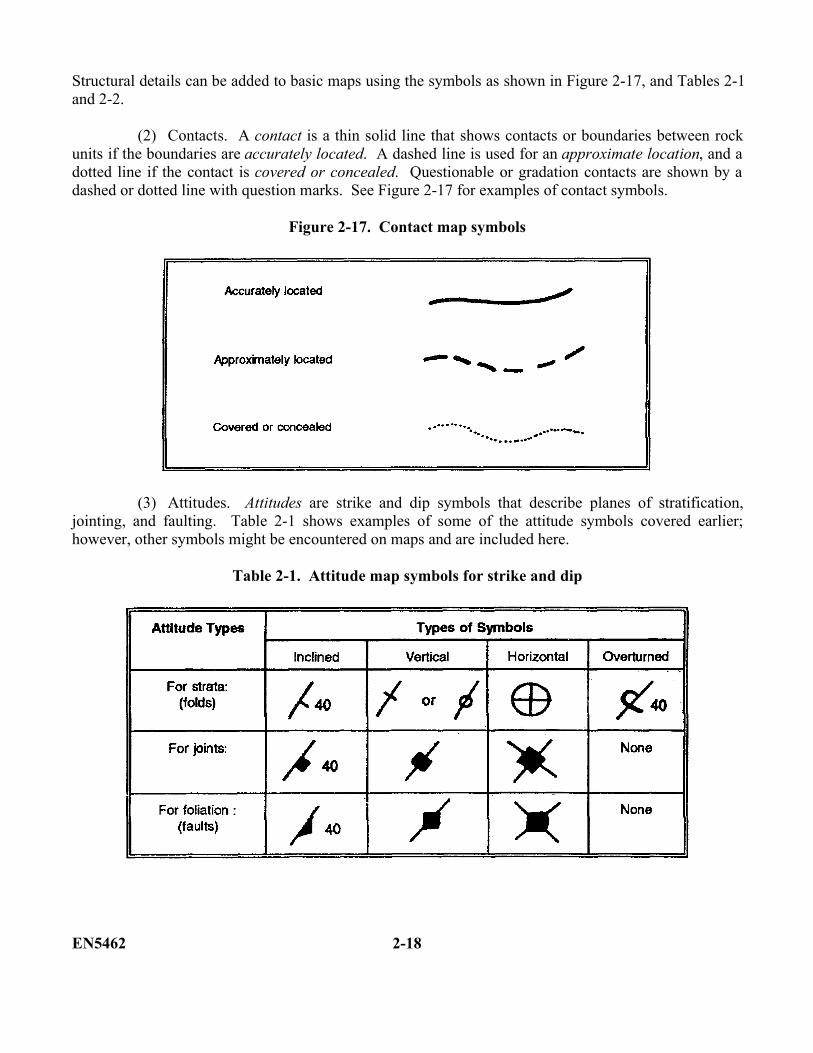
Structural details can be added to basic maps using the symbols as shown in Figure 2-17, and Tables 2-1and 2-2.
(2) Contacts. A contact is a thin solid line that shows contacts or boundaries between rockunits if the boundaries are accurately located. A dashed line is used for an approximate location, and adotted line if the contact is covered or concealed. Questionable or gradation contacts are shown by adashed or dotted line with question marks. See Figure 2-17 for examples of contact symbols.
Figure 2-17. Contact map symbols
(3) Attitudes. Attitudes are strike and dip symbols that describe planes of stratification,jointing, and faulting. Table 2-1 shows examples of some of the attitude symbols covered earlier;however, other symbols might be encountered on maps and are included here.
Table 2-1. Attitude map symbols for strike and dip
EN5462 2-18
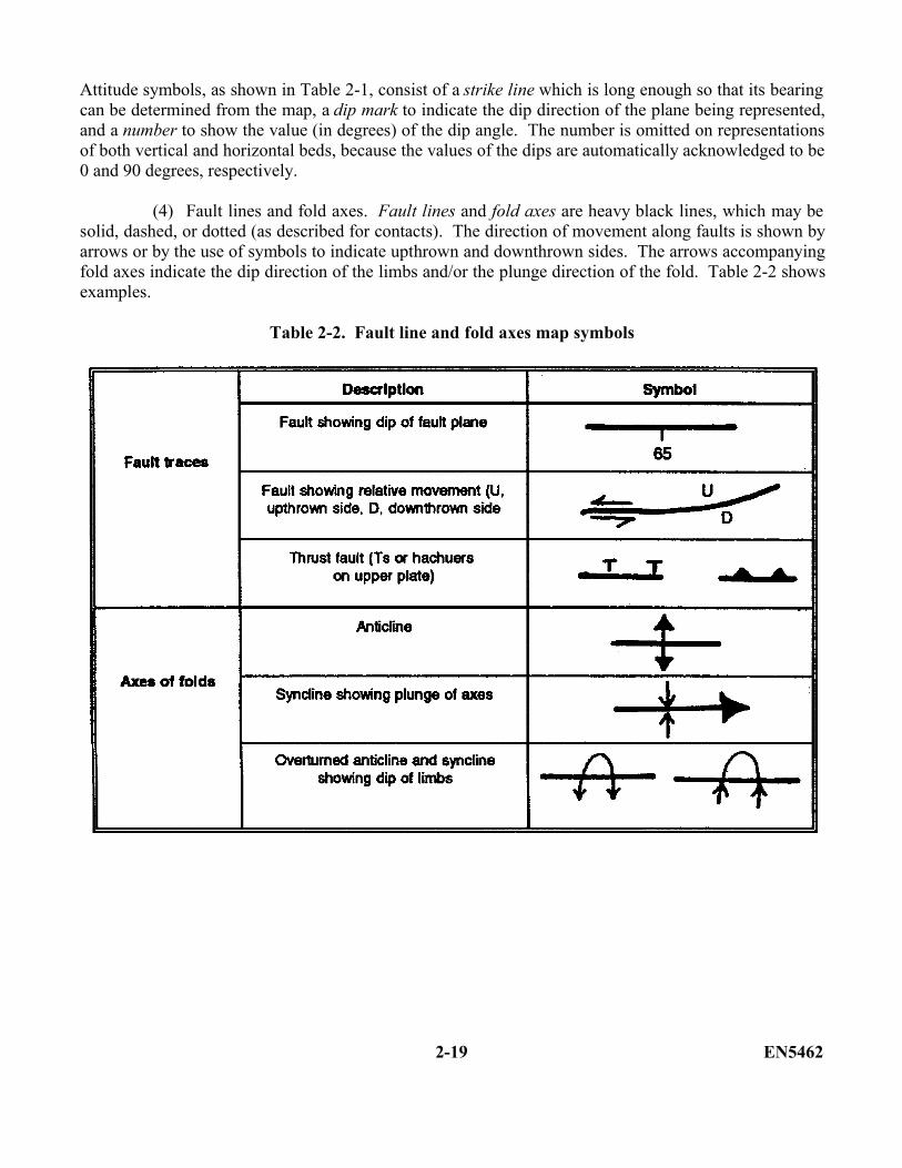
Attitude symbols, as shown in Table 2-1, consist of a strike line which is long enough so that its bearingcan be determined from the map, a dip mark to indicate the dip direction of the plane being represented,and a number to show the value (in degrees) of the dip angle. The number is omitted on representationsof both vertical and horizontal beds, because the values of the dips are automatically acknowledged to be0 and 90 degrees, respectively.
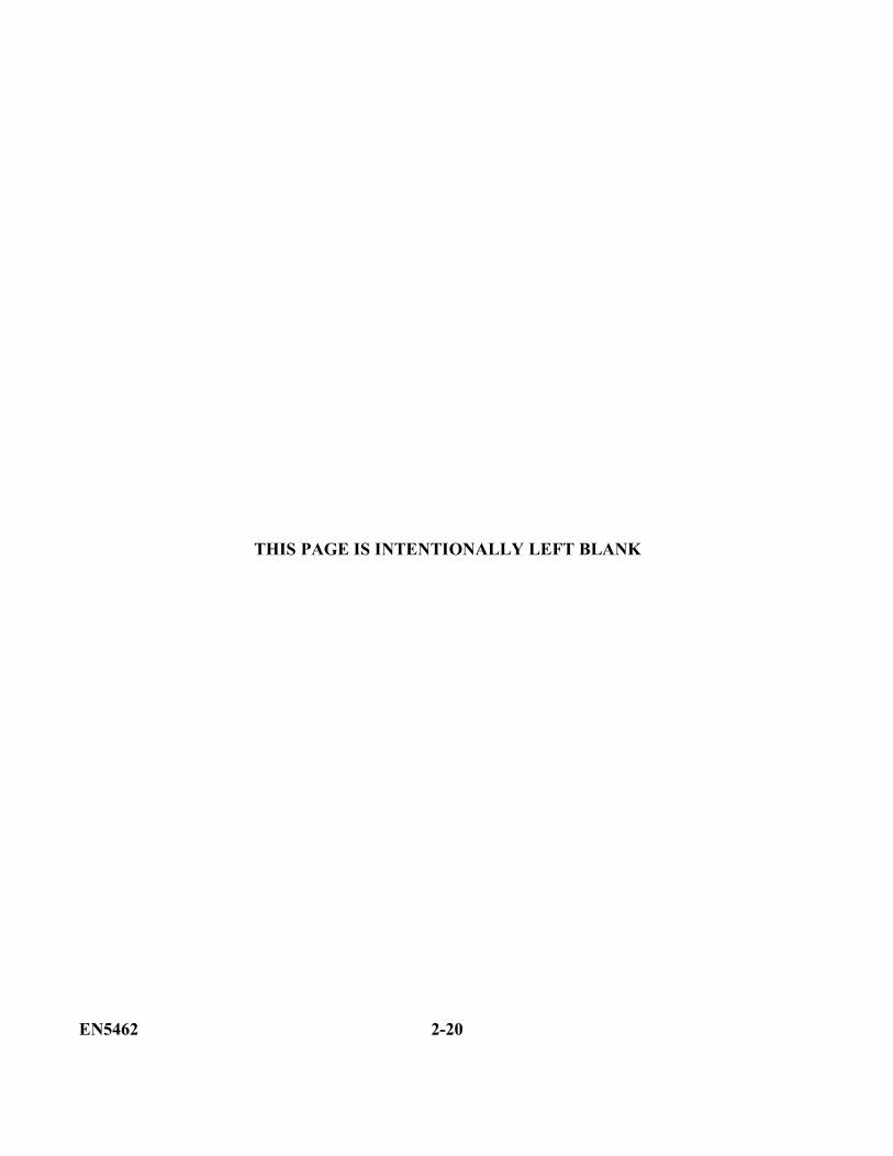
(4) Fault lines and fold axes. Fault lines and fold axes are heavy black lines, which may besolid, dashed, or dotted (as described for contacts). The direction of movement along faults is shown byarrows or by the use of symbols to indicate upthrown and downthrown sides. The arrows accompanyingfold axes indicate the dip direction of the limbs and/or the plunge direction of the fold. Table 2-2 showsexamples.
Table 2-2. Fault line and fold axes map symbols
2-19 EN5462
THIS PAGE IS INTENTIONALLY LEFT BLANK
EN5462 2-20
LESSON 2
PRACTICE EXERCISE
The following items will test your grasp of the material covered in this lesson. When you havecompleted the exercise, check your answers with the key that follows. If you answer any itemincorrectly, study again that part which contains the portion involved.
1. Define outcrop.__________________________________________________________________________________________________________________________________________________________________________________________________________________________________________
2. Define fold.__________________________________________________________________________________________________________________________________________________________________________________________________________________________________________
3. List the three common folds.__________________________________________________________________________________________________________________________________________________________________________________________________________________________________________
4. Define strike.__________________________________________________________________________________________________________________________________________________________________________________________________________________________________________
5. Define dip.__________________________________________________________________________________________________________________________________________________________________________________________________________________________________________
6. Define joint.__________________________________________________________________________________________________________________________________________________________________________________________________________________________________________
7. Define fault.__________________________________________________________________________________________________________________________________________________________________________________________________________________________________________
2-21 EN5462
Lesson 2
PRACTICE EXERCISE
ANSWER KEY AND FEEDBACK
Item Correct Answer and Feedback
1. An outcrop is that part of a rock formation which is exposed at the earth's surface. (page2-2, para 2-2)
2. Folds are undulations that exist in the rocks of the earth. They are the most common typeof deformation. (page 2-4, para 2-4a)
3. Monocline, anticline, and syncline. (page 2-4, para 2-4a)
4. Strike is the compass direction of the horizontal line formed by the intersections ofhorizontal plane and the bedding plane. (page 2-6, para (2)(a))
5. Dip is the acute angle between the bedding plane and the horizontal plane, measured atright angles to the strike direction. (page 2-6, para (2)(a))
6. Joints are fractures along which there has been no visible movement. (page 2-9, para b)
7. Faults are fractures along which adjacent masses of rock masses have moved with respectto one another. (page 2-11, para c)
EN5462 2-22
LESSON 3
SLOPE FAILURE
Critical Tasks: 051-243-2006051-243-3011051-243-3012051-243-3027
OVERVIEW
LESSON DESCRIPTION:
In this lesson, you will learn to identify slope failure problems and significant risks involved withconstruction on slopes.
TERMINAL LEARNING OBJECTIVES:
ACTION: You will identify causes of slope failure and the actions to be taken to preventslope failure.
CONDITIONS: You will be given the materials contained in this lesson.
STANDARD: You must complete the lesson and the practical exercise.
REFERENCES: The material contained in this lesson was derived from FM 5-410.
INTRODUCTION
In areas of moderate to high relief, there is a significant risk of major damage to roads and otherconstruction from unstable slopes. As a military engineer, you must be able to anticipate slope-failureproblems and modify construction in the presence of unstable slopes.
3-1. Identification of Mass Movement. Mass movement is the downslope movement of earthmaterials in response to the forces of gravity. For the most part, the movement is slow, but it may belocally rapid or even catastrophic. You must consider the possibilities of this movement occurringbefore you undertake any construction project.
The reason engineers are concerned about gravity as an erosional agent is because of the effect that slope failure has on engineer projects. A slope failure occurs when the downslope component of forces acting on a soil or rock mass exceeds the strength of shearing resistance of the material. Force is equal to mass times acceleration, so there
3-1 EN5462
are two ways to increase the force acting on a slope: by increasing the component of acceleration due togravity (such as making a steeper slope) or by increasing the mass of the slope. Another way to cause aslope failure is to reduce the resistance to it.
3-2. Causes and Types of Slope Failures. In simple terms, a slope will fail when the strength of theslope material is not sufficient to withstand the pull of gravity. A slope may be weakened to failure inone or more of the following four ways:
Overloading. This is caused by an increase of weight on the slope.
Loss of internal strength. This loss is the result of deterioration of the internal strength of thebedrock and/or soil.
Loss of external friction. This is caused by loss of friction between the soil and bedrock orbetween individual planes within the bedrock.
Loss of physical support. This loss is caused by removal of material located at the toe of aslope.
Man's construction efforts sometimes contribute to overloading or loss of physical support. Rainfall,though, can directly or indirectly weaken a slope in all of the above-mentioned ways.
Slopes are made up of combinations of different rock and/or soil types; consequently, they may beweakened in different ways. As a result, several types of a slope failure may be produced, some ofwhich are distinctive. Although slope failures may closely model one of the following major types otherfailures may be a combination of failure types.
a. Slow Movement. Forms of slow movement consist of creep, solifluction, and rock creep:
(1) Creep. Creep (Figure 3-1) is the slow downslope migration of materials consisting of soiland loose rocks. The material on even the gentlest surface moves slowly down the slope. You maydetect the actual movement only by such things as tilted and dislocated telephone poles, trees, fences,roadbeds, and railroad grades. This process occurs primarily in the weathered soil above bedrock. Themotivating force is gravity acting on material partially saturated with groundwater. Creep is particularlyevident in regions having a cold winter, where each freezing of the water in the soil lifts the soil in adirection perpendicular to the slope and each thawing drops the material downward vertically. Hence, asa result of repeated freezing and thawing, the soil moves a considerable distance down the slope. In anyevent creeping soil indicates a slope that is slightly but clearly unstable. Additional weakening of theslope may cause a more rapid form of slope failure. Debris slide or debris flow are examples of slopeweakening.
EN5462 3-2
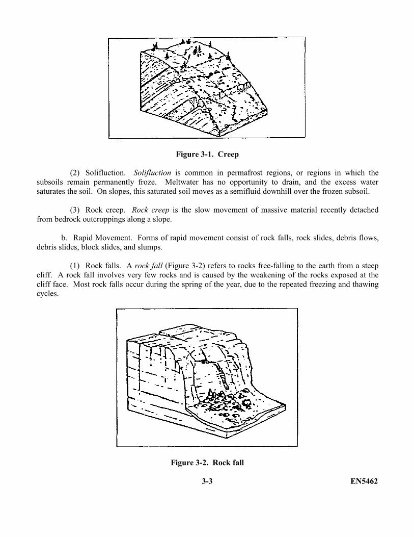
Figure 3-1. Creep
(2) Solifluction. Solifluction is common in permafrost regions, or regions in which thesubsoils remain permanently froze. Meltwater has no opportunity to drain, and the excess watersaturates the soil. On slopes, this saturated soil moves as a semifluid downhill over the frozen subsoil.
(3) Rock creep. Rock creep is the slow movement of massive material recently detachedfrom bedrock outcroppings along a slope.
b. Rapid Movement. Forms of rapid movement consist of rock falls, rock slides, debris flows,debris slides, block slides, and slumps.
(1) Rock falls. A rock fall (Figure 3-2) refers to rocks free-falling to the earth from a steepcliff. A rock fall involves very few rocks and is caused by the weakening of the rocks exposed at thecliff face. Most rock falls occur during the spring of the year, due to the repeated freezing and thawingcycles.
Figure 3-2. Rock fall
3-3 EN5462
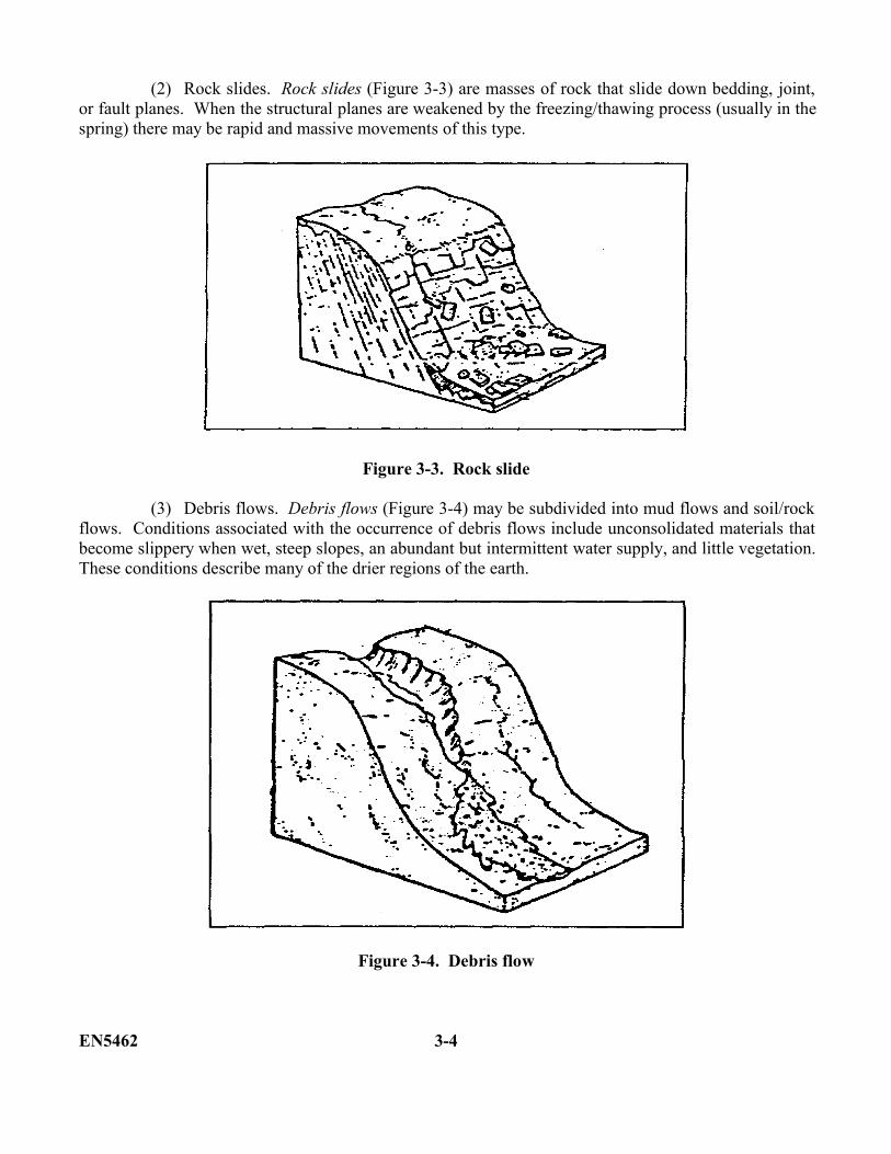
(2) Rock slides. Rock slides (Figure 3-3) are masses of rock that slide down bedding, joint,or fault planes. When the structural planes are weakened by the freezing/thawing process (usually in thespring) there may be rapid and massive movements of this type.
Figure 3-3. Rock slide
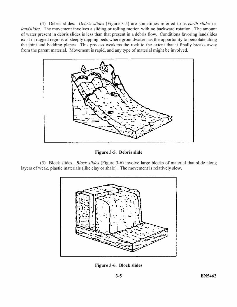
(3) Debris flows. Debris flows (Figure 3-4) may be subdivided into mud flows and soil/rockflows. Conditions associated with the occurrence of debris flows include unconsolidated materials thatbecome slippery when wet, steep slopes, an abundant but intermittent water supply, and little vegetation.These conditions describe many of the drier regions of the earth.
Figure 3-4. Debris flow
EN5462 3-4
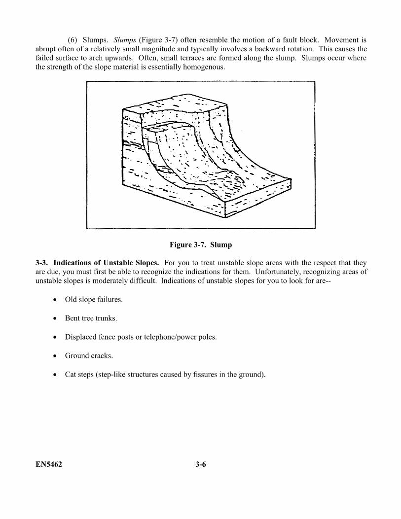
(4) Debris slides. Debris slides (Figure 3-5) are sometimes referred to as earth slides orlandslides. The movement involves a sliding or rolling motion with no backward rotation. The amountof water present in debris slides is less than that present in a debris flow. Conditions favoring landslidesexist in rugged regions of steeply dipping beds where groundwater has the opportunity to percolate alongthe joint and bedding planes. This process weakens the rock to the extent that it finally breaks awayfrom the parent material. Movement is rapid, and any type of material might be involved.
Figure 3-5. Debris slide
(5) Block slides. Block slides (Figure 3-6) involve large blocks of material that slide alonglayers of weak, plastic materials (like clay or shale). The movement is relatively slow.
Figure 3-6. Block slides
3-5 EN5462
(6) Slumps. Slumps (Figure 3-7) often resemble the motion of a fault block. Movement isabrupt often of a relatively small magnitude and typically involves a backward rotation. This causes thefailed surface to arch upwards. Often, small terraces are formed along the slump. Slumps occur wherethe strength of the slope material is essentially homogenous.
Figure 3-7. Slump
3-3. Indications of Unstable Slopes. For you to treat unstable slope areas with the respect that theyare due, you must first be able to recognize the indications for them. Unfortunately, recognizing areas ofunstable slopes is moderately difficult. Indications of unstable slopes for you to look for are--
Old slope failures.
Bent tree trunks.
Displaced fence posts or telephone/power poles.
Ground cracks.
Cat steps (step-like structures caused by fissures in the ground).
EN5462 3-6
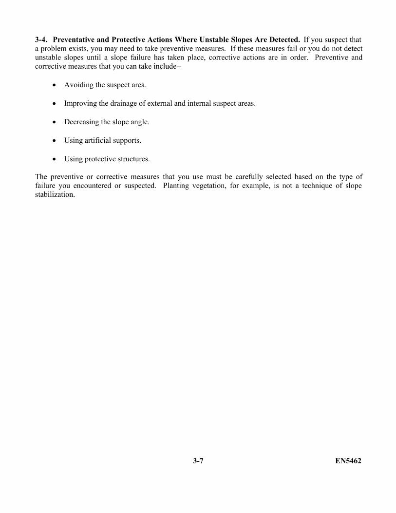
3-4. Preventative and Protective Actions Where Unstable Slopes Are Detected. If you suspect thata problem exists, you may need to take preventive measures. If these measures fail or you do not detectunstable slopes until a slope failure has taken place, corrective actions are in order. Preventive andcorrective measures that you can take include--
Avoiding the suspect area.
Improving the drainage of external and internal suspect areas.
Decreasing the slope angle.
Using artificial supports.
Using protective structures.
The preventive or corrective measures that you use must be carefully selected based on the type offailure you encountered or suspected. Planting vegetation, for example, is not a technique of slopestabilization.
3-7 EN5462

THIS PAGE IS INTENTIONALLY LEFT BLANK
EN5462 3-8
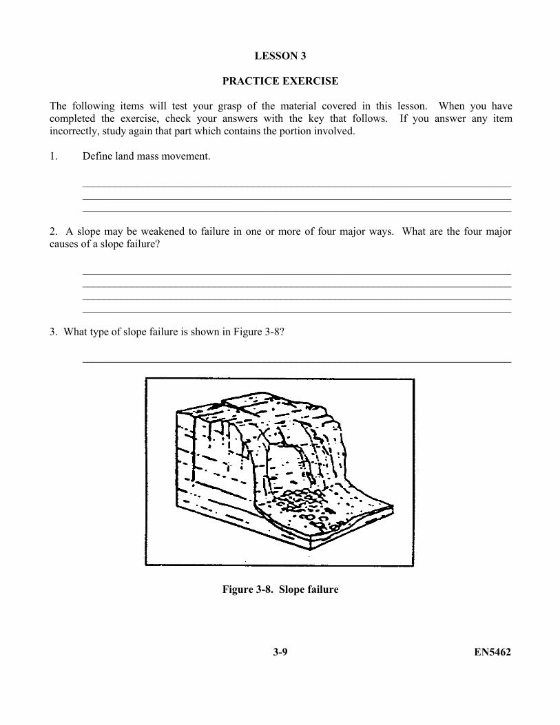
LESSON 3
PRACTICE EXERCISE
The following items will test your grasp of the material covered in this lesson. When you havecompleted the exercise, check your answers with the key that follows. If you answer any itemincorrectly, study again that part which contains the portion involved.
1. Define land mass movement.
__________________________________________________________________________________________________________________________________________________________________________________________________________________________________________
2. A slope may be weakened to failure in one or more of four major ways. What are the four majorcauses of a slope failure?
________________________________________________________________________________________________________________________________________________________________________________________________________________________________________________________________________________________________________________________
3. What type of slope failure is shown in Figure 3-8?
______________________________________________________________________________
Figure 3-8. Slope failure
3-9 EN5462
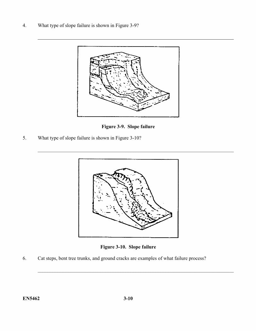
4. What type of slope failure is shown in Figure 3-9?
______________________________________________________________________________
Figure 3-9. Slope failure
5. What type of slope failure is shown in Figure 3-10?
______________________________________________________________________________
Figure 3-10. Slope failure
6. Cat steps, bent tree trunks, and ground cracks are examples of what failure process?
______________________________________________________________________________
EN5462 3-10
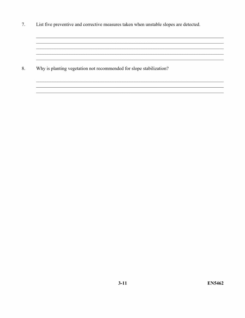
7. List five preventive and corrective measures taken when unstable slopes are detected.
______________________________________________________________________________________________________________________________________________________________________________________________________________________________________________________________________________________________________________________________________________________________________________________________________
8. Why is planting vegetation not recommended for slope stabilization?
__________________________________________________________________________________________________________________________________________________________________________________________________________________________________________
3-11 EN5462

Lesson 3
PRACTICE EXERCISE
ANSWER KEY AND FEEDBACK
Item Correct Answer and Feedback
1. Mass movement is the downslope movement of earth materials in response to the force ofgravity. (page 3-1, para 3-1)
2. Overloading loss of internal strength, loss of external friction, and loss of physicalsupport. (page 3-2, para 3-2)
3. Rock fall. (page 3-3, Figure 3-2)
4. Slump. (page 3-6, Figure 3-7).
5. Debris flow. (page 3-4, Figure 3-4)
6. Indications of unstable slopes. (page 3-6, para 3-3)
7. Avoiding the suspect area, improving drainage of suspect area, decreasing slope angle,using artificial supports, and using protective structures. (page 3-7, para 3-4)
8. Preventive or corrective measures that you use must be carefully selected based upon thetype of failure you encountered or suspected. Planting vegetation is not a technique ofslope stabilization. (page 3-7, para 3-4)
EN5462 3-12
LESSON 4
SURFICIAL FEATURES AND CONSTRUCTION MATERIALS
Critical Tasks: 051-243-2006051-243-3011051-243-3012051-243-3027
OVERVIEW
In this lesson you will learn about surficial features which may provide construction materials and assessthe trafficability, foundation, and excavation conditions of the material.
TERMINAL LEARNING OBJECTIVE
ACTION: You will identify surficial features which may provide construction materials andassess the trafficability, foundation, and excavation conditions of the material.
CONDITION: You will be given the materials contained in this lesson.
STANDARD: You must complete the lesson and the practical exercise.
REFERENCES: The material contained in this lesson was derived from FM 5-410.
INTRODUCTION
In this lesson you will learn about the most important geologic agent at work on the earth today--water.Fluvial processes, products, and their engineering significance will be discussed. The term fluvial refersto the action of running water. This lesson also covers coastal processes and some methods of coastalerosion control. A knowledge of fluvial and coastal geology is important to you, as a military engineer,because of the effect it has on location of construction materials, site location for construction projects,and trafficability.
This lesson has three parts: Fluvial and coastal features, glacial and eolian landforms, and residuallandforms.
4-1 EN5462
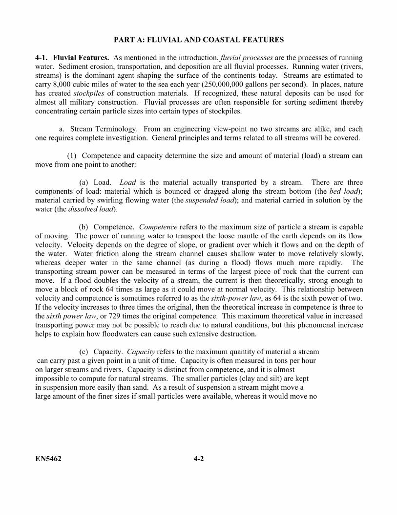
PART A: FLUVIAL AND COASTAL FEATURES
4-1. Fluvial Features. As mentioned in the introduction, fluvial processes are the processes of runningwater. Sediment erosion, transportation, and deposition are all fluvial processes. Running water (rivers,streams) is the dominant agent shaping the surface of the continents today. Streams are estimated tocarry 8,000 cubic miles of water to the sea each year (250,000,000 gallons per second). In places, naturehas created stockpiles of construction materials. If recognized, these natural deposits can be used foralmost all military construction. Fluvial processes are often responsible for sorting sediment therebyconcentrating certain particle sizes into certain types of stockpiles.
a. Stream Terminology. From an engineering view-point no two streams are alike, and eachone requires complete investigation. General principles and terms related to all streams will be covered.
(1) Competence and capacity determine the size and amount of material (load) a stream canmove from one point to another:
(a) Load. Load is the material actually transported by a stream. There are threecomponents of load: material which is bounced or dragged along the stream bottom (the bed load);material carried by swirling flowing water (the suspended load); and material carried in solution by thewater (the dissolved load).
(b) Competence. Competence refers to the maximum size of particle a stream is capableof moving. The power of running water to transport the loose mantle of the earth depends on its flowvelocity. Velocity depends on the degree of slope, or gradient over which it flows and on the depth ofthe water. Water friction along the stream channel causes shallow water to move relatively slowly,whereas deeper water in the same channel (as during a flood) flows much more rapidly. Thetransporting stream power can be measured in terms of the largest piece of rock that the current canmove. If a flood doubles the velocity of a stream, the current is then theoretically, strong enough tomove a block of rock 64 times as large as it could move at normal velocity. This relationship betweenvelocity and competence is sometimes referred to as the sixth-power law, as 64 is the sixth power of two.If the velocity increases to three times the original, then the theoretical increase in competence is three tothe sixth power law, or 729 times the original competence. This maximum theoretical value in increasedtransporting power may not be possible to reach due to natural conditions, but this phenomenal increasehelps to explain how floodwaters can cause such extensive destruction.
(c) Capacity. Capacity refers to the maximum quantity of material a stream can carry past a given point in a unit of time. Capacity is often measured in tons per hour on larger streams and rivers. Capacity is distinct from competence, and it is almost impossible to compute for natural streams. The smaller particles (clay and silt) are kept in suspension more easily than sand. As a result of suspension a stream might move a large amount of the finer sizes if small particles were available, whereas it would move no
EN5462 4-2
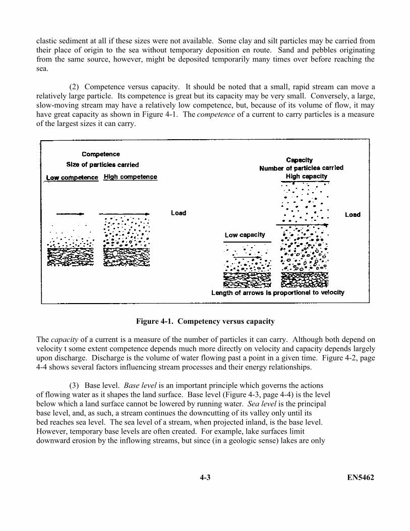
clastic sediment at all if these sizes were not available. Some clay and silt particles may be carried fromtheir place of origin to the sea without temporary deposition en route. Sand and pebbles originatingfrom the same source, however, might be deposited temporarily many times over before reaching thesea.
(2) Competence versus capacity. It should be noted that a small, rapid stream can move arelatively large particle. Its competence is great but its capacity may be very small. Conversely, a large,slow-moving stream may have a relatively low competence, but, because of its volume of flow, it mayhave great capacity as shown in Figure 4-1. The competence of a current to carry particles is a measureof the largest sizes it can carry.
Figure 4-1. Competency versus capacity
The capacity of a current is a measure of the number of particles it can carry. Although both depend onvelocity t some extent competence depends much more directly on velocity and capacity depends largelyupon discharge. Discharge is the volume of water flowing past a point in a given time. Figure 4-2, page4-4 shows several factors influencing stream processes and their energy relationships.
(3) Base level. Base level is an important principle which governs the actions of flowing water as it shapes the land surface. Base level (Figure 4-3, page 4-4) is the level below which a land surface cannot be lowered by running water. Sea level is the principal base level, and, as such, a stream continues the downcutting of its valley only until its bed reaches sea level. The sea level of a stream, when projected inland, is the base level. However, temporary base levels are often created. For example, lake surfaces limit downward erosion by the inflowing streams, but since (in a geologic sense) lakes are only
4-3 EN5462
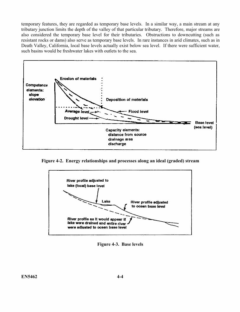
temporary features, they are regarded as temporary base levels. In a similar way, a main stream at anytributary junction limits the depth of the valley of that particular tributary. Therefore, major streams arealso considered the temporary base level for their tributaries. Obstructions to downcutting (such asresistant rocks or dams) also serve as temporary base levels. In rare instances in arid climates, such as inDeath Valley, California, local base levels actually exist below sea level. If there were sufficient water,such basins would be freshwater lakes with outlets to the sea.
Figure 4-2. Energy relationships and processes along an ideal (graded) stream
Figure 4-3. Base levels
EN5462 4-4
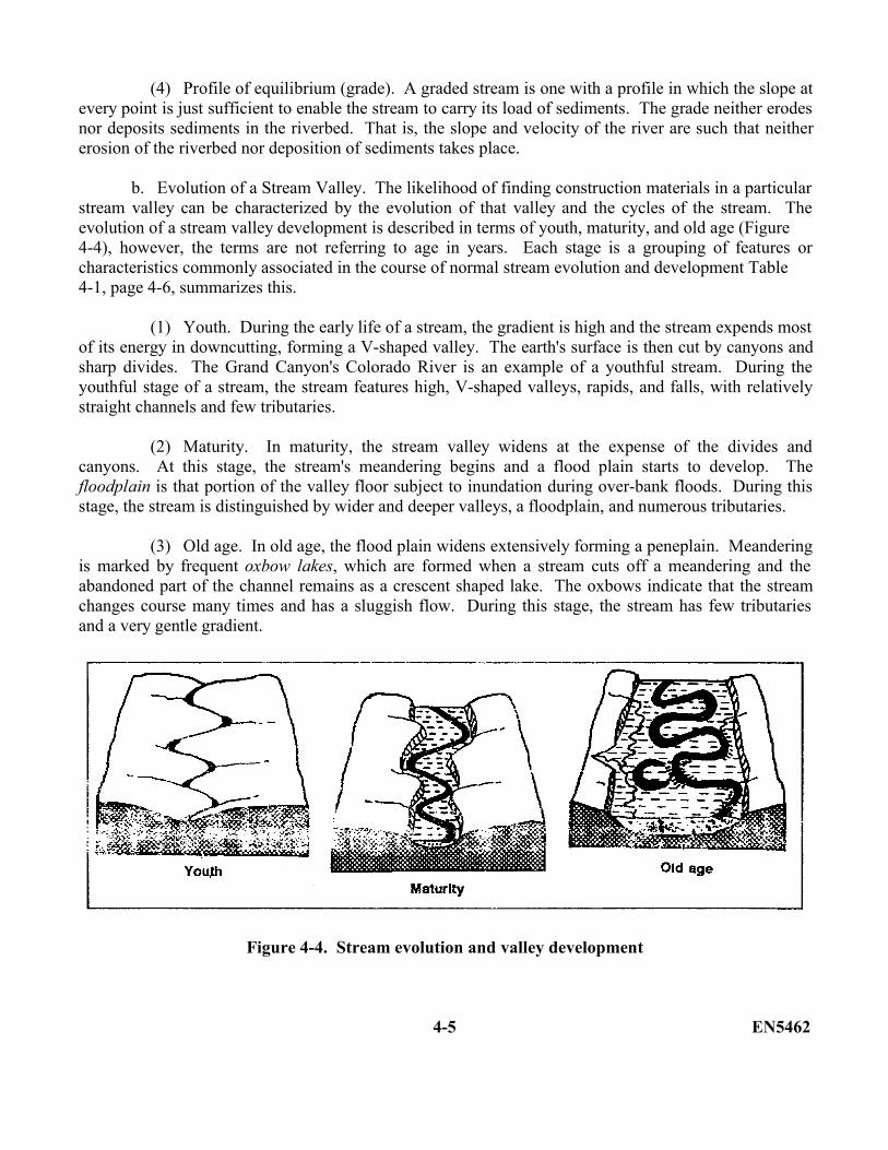
(4) Profile of equilibrium (grade). A graded stream is one with a profile in which the slope atevery point is just sufficient to enable the stream to carry its load of sediments. The grade neither erodesnor deposits sediments in the riverbed. That is, the slope and velocity of the river are such that neithererosion of the riverbed nor deposition of sediments takes place.
b. Evolution of a Stream Valley. The likelihood of finding construction materials in a particularstream valley can be characterized by the evolution of that valley and the cycles of the stream. Theevolution of a stream valley development is described in terms of youth, maturity, and old age (Figure4-4), however, the terms are not referring to age in years. Each stage is a grouping of features orcharacteristics commonly associated in the course of normal stream evolution and development Table4-1, page 4-6, summarizes this.
(1) Youth. During the early life of a stream, the gradient is high and the stream expends mostof its energy in downcutting, forming a V-shaped valley. The earth's surface is then cut by canyons andsharp divides. The Grand Canyon's Colorado River is an example of a youthful stream. During theyouthful stage of a stream, the stream features high, V-shaped valleys, rapids, and falls, with relativelystraight channels and few tributaries.
(2) Maturity. In maturity, the stream valley widens at the expense of the divides andcanyons. At this stage, the stream's meandering begins and a flood plain starts to develop. Thefloodplain is that portion of the valley floor subject to inundation during over-bank floods. During thisstage, the stream is distinguished by wider and deeper valleys, a floodplain, and numerous tributaries.
(3) Old age. In old age, the flood plain widens extensively forming a peneplain. Meanderingis marked by frequent oxbow lakes, which are formed when a stream cuts off a meandering and theabandoned part of the channel remains as a crescent shaped lake. The oxbows indicate that the streamchanges course many times and has a sluggish flow. During this stage, the stream has few tributariesand a very gentle gradient.
Figure 4-4. Stream evolution and valley development
4-5 EN5462
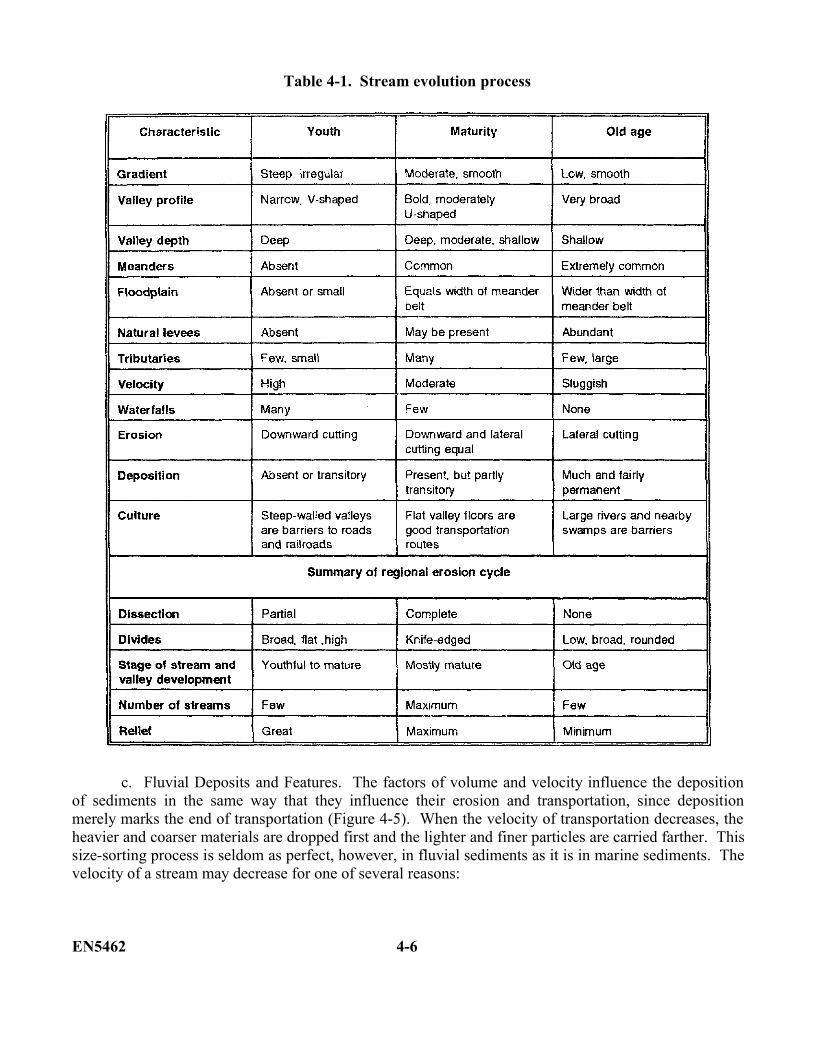
Table 4-1. Stream evolution process
c. Fluvial Deposits and Features. The factors of volume and velocity influence the depositionof sediments in the same way that they influence their erosion and transportation, since depositionmerely marks the end of transportation (Figure 4-5). When the velocity of transportation decreases, theheavier and coarser materials are dropped first and the lighter and finer particles are carried farther. Thissize-sorting process is seldom as perfect, however, in fluvial sediments as it is in marine sediments. Thevelocity of a stream may decrease for one of several reasons:
EN5462 4-6
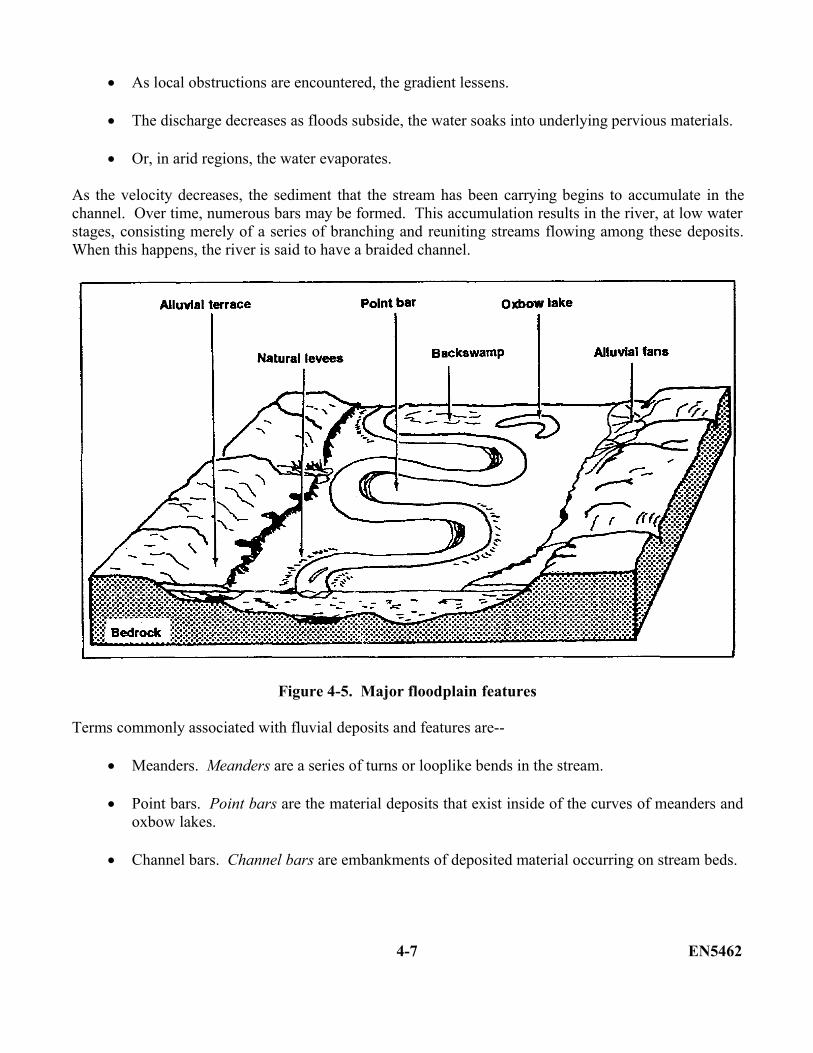
As local obstructions are encountered, the gradient lessens.
The discharge decreases as floods subside, the water soaks into underlying pervious materials.
Or, in arid regions, the water evaporates.
As the velocity decreases, the sediment that the stream has been carrying begins to accumulate in thechannel. Over time, numerous bars may be formed. This accumulation results in the river, at low waterstages, consisting merely of a series of branching and reuniting streams flowing among these deposits.When this happens, the river is said to have a braided channel.
Figure 4-5. Major floodplain features
Terms commonly associated with fluvial deposits and features are--
Meanders. Meanders are a series of turns or looplike bends in the stream.
Point bars. Point bars are the material deposits that exist inside of the curves of meanders andoxbow lakes.
Channel bars. Channel bars are embankments of deposited material occurring on stream beds.
4-7 EN5462
Braided channels. Braided channels are streams choked with sandbars so that they are dividedinto intricate networks of interlacing channels.
Floodplain. A floodplain is that expanse of land that is inundated during flood stages of theriver.
Natural levees. Natural levees are embankments built up along the river by sand depositionduring flood stages.
Backswamp deposits. A backswamp deposit is a marsh or wetlands area that was caused by animpermeable layer of fines (deposits) in the lower lying areas of the floodplain.
Oxbow lake. An oxbow lake is a crescent or U-shaped body of water formed by a meander-neck cutoff
Filled oxbow lake. A filled oxbow lake is a thick deposit of fine-grained material in an oldoxbow lake.
Alluvial terraces. Alluvial terraces are extensive, flat-topped river deposits of ancientfloodplains that generally parallel the river or stream.
Alluvial fans. Alluvial fans are dryland counterparts of deltas. Where streams flow from steepslopes onto a bordering lowland, the abrupt drop in gradient results in the channel filling withsediment, causing the water to overflow to the lowest available point. With time, the process isrepeated. As a result, a fan-shaped deposit called an alluvial fan is built up. Its apex is at thepoint where the stream emerged from the canyon at the base of the steep slope. Fans ofenormous dimensions have developed at the margins of fault-block mountains in the Westernand Southwestern U. S. Adjacent fans may grow and overlap each other to form a continuousalluvial plain.
Delta. A delta is the alluvial deposit at the mouth of a river. The loss of stream velocity when a river enters the sea or other body of standing water causes deposition of clastic sediments. Wave and current action may exert a minor influence on final depositionof sediments. Because of the abrupt decrease in velocity, the coarser sediments, such as gravel and sand, settle out first at the mouth of the stream. The finer materials, such as silt and clay, are carried farther out into the standing body of water. The entire process results in the formation of a delta. There are many large and famous deltas such as the Nile Delta and the Mississippi Delta. However, in the Northern U. S. and Southern Canada, many small deltas were deposited in the temporary lakes that existed along the margin of the last continental glacier during its final stages. These deltas consist mostly of sand and gravel and are important sources of supply for concrete constructionand for road materials. As with the larger deltas, the coarser materials overlie the
EN5462 4-8
finer, a condition not always realized by pit operators. A common error is to suppose that thecoarsest materials are to be found at the base of the entire deposit
Alluvium. Alluvium is a broad category that includes all the deposits made by streams. Theterm is not, however, generally used for delta deposits in seas or lakes, nor does it refer toglaciofluvial deposits, which generally are referred to as outwash. The considerable variations,within short distances, of the conditions of stream deposition preclude good size sorting. Inthis respect, alluvium contrasts strongly with the broad uniformity of stratification and goodsize sorting that characterize most marine and lake sediment.
4-2. Coastal Features. Over 70 percent of the earth's surface is covered by water. The interfacebetween land and oceans is important to you, as an engineer. Coastal areas give rise to a variety ofengineering problems, including mobility, location of construction materials, and excessive shorelineerosion.
Most coastlines are continually changing. Some sandy beaches are being eroded while others are beingbuilt up by the deposition of sand. Other coastal areas are composed of rocky shores and bluffs, but,even these may yield to the onslaught of coastal processes.
a. Coastal Processes. Present-day shore changes are primarily due to water in motion. Waves,wave action, and currents are types of water movement that erode and deposit materials along coastlines.
(1) Waves. Every body of standing water is affected to some extent by waves. The size andpower of the waves depend upon the surface area and the depth of the body of water and also on theforce generating the waves. Most waves are caused by winds, tides, seismic activity, or gravity(displacement of water by ice, soil, or rock). The erosive power of a wave is enhanced by any rockfragments the wave may carry.
(2) Wave action. The wind passing over water sets up waves by alternately raising anddepressing the water surface. These types of waves are called waves of oscillation. No forwardmovement of the water actually occurs, but there is a circular motion of water particles at the surface, thediameter of which is determined by the height of the wave crest above the adjacent wave trough. Theeffect of this movement is a progression of the wave shape in the direction of the wind. In shallowwater, this oscillating motion is retarded by friction along the bottom. Friction causes the wave crests tobecome more closely spaced, each wave becoming higher and narrower. The top eventually pitchesforward, resulting in a translation of the water that sweeps up sediment. The return flow washes muchof the sediment back with it, leaving only the coarser particles behind.
4-9 EN5462
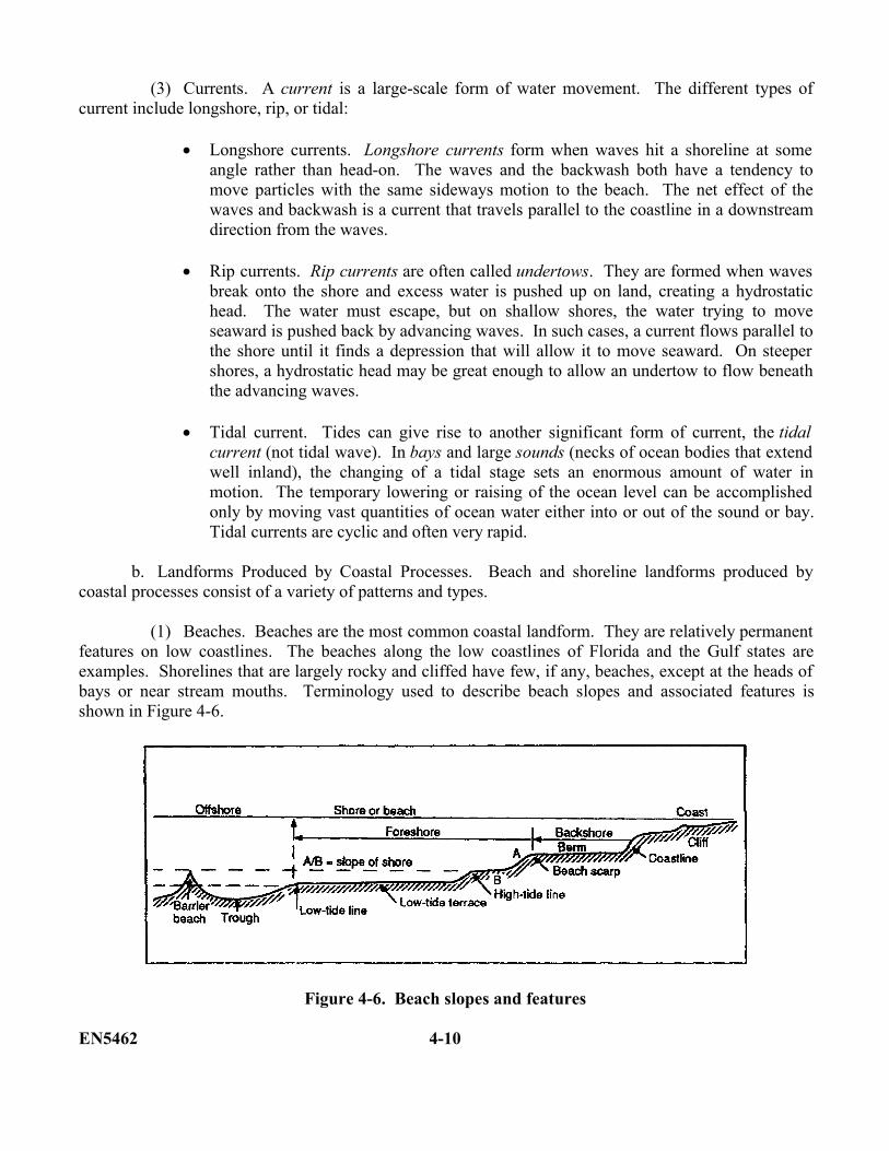
(3) Currents. A current is a large-scale form of water movement. The different types ofcurrent include longshore, rip, or tidal:
Longshore currents. Longshore currents form when waves hit a shoreline at someangle rather than head-on. The waves and the backwash both have a tendency tomove particles with the same sideways motion to the beach. The net effect of thewaves and backwash is a current that travels parallel to the coastline in a downstreamdirection from the waves.
Rip currents. Rip currents are often called undertows. They are formed when wavesbreak onto the shore and excess water is pushed up on land, creating a hydrostatichead. The water must escape, but on shallow shores, the water trying to moveseaward is pushed back by advancing waves. In such cases, a current flows parallel tothe shore until it finds a depression that will allow it to move seaward. On steepershores, a hydrostatic head may be great enough to allow an undertow to flow beneaththe advancing waves.
Tidal current. Tides can give rise to another significant form of current, the tidalcurrent (not tidal wave). In bays and large sounds (necks of ocean bodies that extendwell inland), the changing of a tidal stage sets an enormous amount of water inmotion. The temporary lowering or raising of the ocean level can be accomplishedonly by moving vast quantities of ocean water either into or out of the sound or bay.Tidal currents are cyclic and often very rapid.
b. Landforms Produced by Coastal Processes. Beach and shoreline landforms produced bycoastal processes consist of a variety of patterns and types.
(1) Beaches. Beaches are the most common coastal landform. They are relatively permanentfeatures on low coastlines. The beaches along the low coastlines of Florida and the Gulf states areexamples. Shorelines that are largely rocky and cliffed have few, if any, beaches, except at the heads ofbays or near stream mouths. Terminology used to describe beach slopes and associated features isshown in Figure 4-6.
Figure 4-6. Beach slopes and features
EN5462 4-10
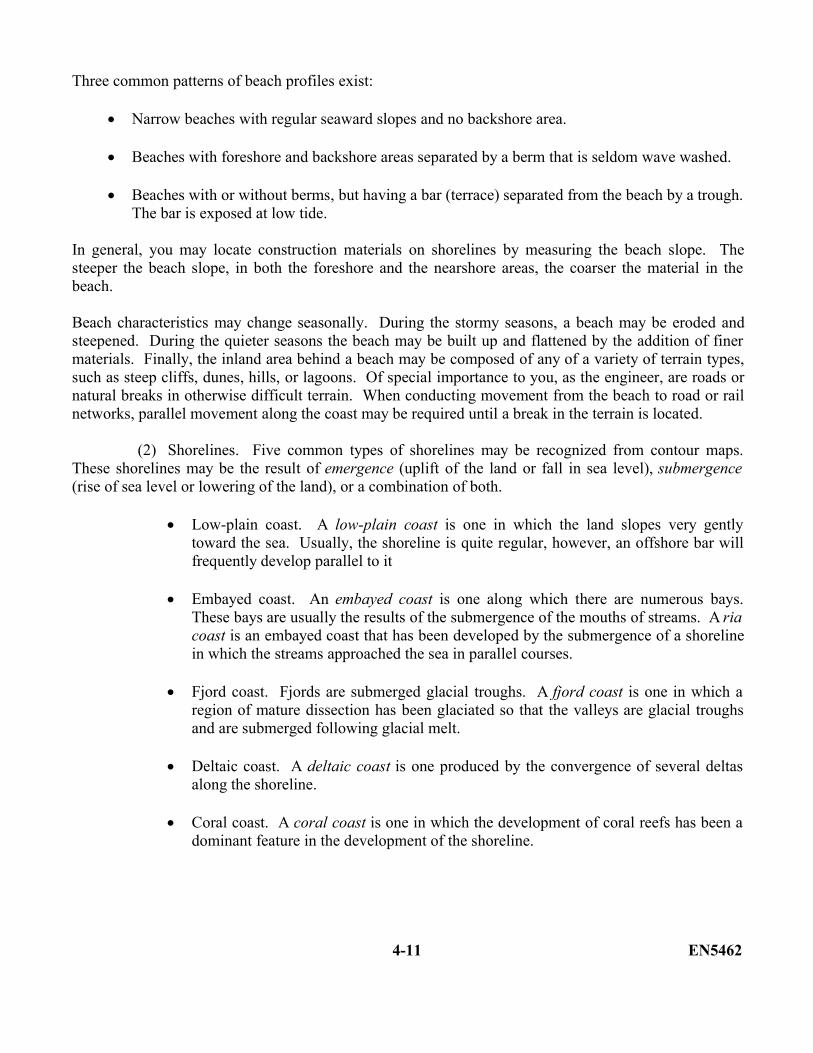
Three common patterns of beach profiles exist:
Narrow beaches with regular seaward slopes and no backshore area.
Beaches with foreshore and backshore areas separated by a berm that is seldom wave washed.
Beaches with or without berms, but having a bar (terrace) separated from the beach by a trough.The bar is exposed at low tide.
In general, you may locate construction materials on shorelines by measuring the beach slope. Thesteeper the beach slope, in both the foreshore and the nearshore areas, the coarser the material in thebeach.
Beach characteristics may change seasonally. During the stormy seasons, a beach may be eroded andsteepened. During the quieter seasons the beach may be built up and flattened by the addition of finermaterials. Finally, the inland area behind a beach may be composed of any of a variety of terrain types,such as steep cliffs, dunes, hills, or lagoons. Of special importance to you, as the engineer, are roads ornatural breaks in otherwise difficult terrain. When conducting movement from the beach to road or railnetworks, parallel movement along the coast may be required until a break in the terrain is located.
(2) Shorelines. Five common types of shorelines may be recognized from contour maps.These shorelines may be the result of emergence (uplift of the land or fall in sea level), submergence(rise of sea level or lowering of the land), or a combination of both.
Low-plain coast. A low-plain coast is one in which the land slopes very gentlytoward the sea. Usually, the shoreline is quite regular, however, an offshore bar willfrequently develop parallel to it
Embayed coast. An embayed coast is one along which there are numerous bays.These bays are usually the results of the submergence of the mouths of streams. A riacoast is an embayed coast that has been developed by the submergence of a shorelinein which the streams approached the sea in parallel courses.
Fjord coast. Fjords are submerged glacial troughs. A fjord coast is one in which aregion of mature dissection has been glaciated so that the valleys are glacial troughsand are submerged following glacial melt.
Deltaic coast. A deltaic coast is one produced by the convergence of several deltasalong the shoreline.
Coral coast. A coral coast is one in which the development of coral reefs has been adominant feature in the development of the shoreline.
4-11 EN5462
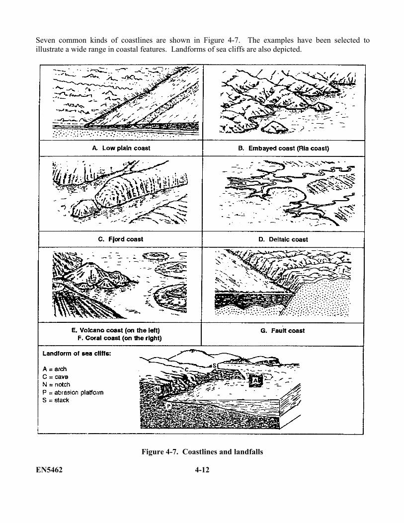
Seven common kinds of coastlines are shown in Figure 4-7. The examples have been selected toillustrate a wide range in coastal features. Landforms of sea cliffs are also depicted.
Figure 4-7. Coastlines and landfalls
EN5462 4-12
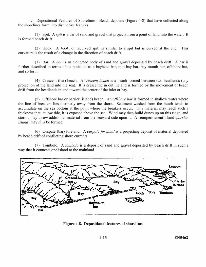
c. Depositional Features of Shorelines. Beach deposits (Figure 4-8) that have collected alongthe shorelines form into distinctive features:
(1) Spit. A spit is a bar of sand and gravel that projects from a point of land into the water. Itis formed beach drift.
(2) Hook. A hook, or recurved spit, is similar to a spit but is curved at the end. Thiscurvature is the result of a change in the direction of beach drift.
(3) Bar. A bar is an elongated body of sand and gravel deposited by beach drift. A bar isfurther described in terms of its position, as a bayhead bar, mid-bay bar, bay-mouth bar, offshore bar,and so forth.
(4) Crescent (bar) beach. A crescent beach is a beach formed between two headlands (anyprojection of the land into the sea). It is crescentic in outline and is formed by the movement of beachdrift from the headlands inland toward the center of the inlet or bay.
(5) Offshore bar or barrier (island) beach. An offshore bar is formed in shallow water wherethe line of breakers lies distinctly away from the shore. Sediment washed from the beach tends toaccumulate on the sea bottom at the point where the breakers occur. This material may reach such athickness that, at low tide, it is exposed above the sea. Wind may then build dunes up on this ridge, andstorms may throw additional material from the seaward side upon it. A semipermanent island (barrierisland) may thus be formed.
(6) Cuspate (bar) foreland. A cuspate foreland is a projecting deposit of material depositedby beach drift of conflicting shore currents.
(7) Tombolo. A tombolo is a deposit of sand and gravel deposited by beach drift in such away that it connects one island to the mainland.
Figure 4-8. Depositional features of shorelines
4-13 EN5462
d. Erosional Features of Shorelines. The major erosional features of shorelines are the wave-cutcliff, wave-cut bench, and the stack. Of these, the wave-cut cliff and the stack may be identified fromtopographic maps.
(1) Wave-cut cliff. A wave-cut cliff is a cliff formed by wave erosion. The cliff, therefore, isa seaward-facing cliff whose base represents the elevation of sea level at the time the cliff was cut out.
(2) Wave-cut bench. A wave-cut bench or terrace is created at the base of the cliff andwidens as wave erosion proceeds landward against the cliff.
(3) Stack. A stack is a remnant of rock left standing on a wave-cut bench as the result oferosion by waves on all sides.
e. Shoreline Protection. Few coastal protection projects are undertaken without careful study.Your study should include an evaluation of past as well as present conditions, the rate of movement, andsource of shore deposits. Most shoreline structures are built to aid navigation or prevent damageresulting from wave attack. There are a number of forms of shoreline protection, but, in all cases, theconstruction materials that you use should be of high density and durability to resist the forces of water.Common forms of shoreline protection for consideration are--
(1) Seawalls and bulkheads. Seawalls and bulkheads are structures built on the shorelineparallel to the beach. They may be vertical walls and pilings, stepped or curved. The design is to protectthe shore from wave erosion.
(2) Groins. Groins are built perpendicular to the shoreline. They may be of permeable(porous) or impermeable (nonporous) material. The purpose is to induce deposition of sand on thebeach.
(3) Jetties. Jetties are built perpendicular to the shore at harbor entrances, river mouths, orbay inlets. They are usually made of porous material. The design is to induce erosion to keep theentrance free of material. As with all of these structures, the construction material is of high density anddurability to resist the forces of water.
PART B: GLACIAL AND EOLIAN LANDFORMS
4-3. Glaciers. During the last million years (geologic time) large continental ice sheets haveencroached upon and retreated from the continents on four separate occasions. At times, these glaciershave covered up to 30 percent of the earth's land surface. The last retreat of these ice sheets wasapproximately ten thousand years ago.
EN5462 4-14
A glacier is a mass of snow and ice that moves under the influence of gravity out over the land from anarea of perennial snow which is its source or head. Glaciers may be classified as one of three maintypes: alpine, piedmont, or continental. An alpine glacier (also called mountain or valley glacier) is anice stream that flows from a snowfield down a steep-walled mountain valley (Figure 4-9, page 4-16).The merging of several alpine glaciers at the foot of a mountain forms a piedmont glacier. Continentalglacier (also called ice sheet) is found only in high latitudes, and covers vast areas (Figure 4-10, page 4-17). For example, Greenland is covered by such a glacier.
a. Factors Influencing Glacial Erosion. Glaciers are important agents of erosion andtransportation. Glacial action has shaped much of the present topography of the northern hemisphere.Glacial erosion is accomplished by plucking, plowing, and abrasion.
(1) Plucking. Plucking is when a glacier dislodges and picks up protruding fragments ofbedrock.
(2) Plowing. Plowing is when loose material is pushed ahead of the glacier. Material is oftenloosed by frost wedging. This is the process of breaking down by which water freezes in the cracks andpores of rock and expands in all directions.
(3) Abrasion. Abrasion occurs when ice-plucked blocks and other rock debris grind (scratchand polish) the bedrock over which the glacier passes.
Abrasion is the primary erosional process of glaciers. Speed of abrasion depends on the resistance of thelocal bedrock, the abundance of cutting debris, the speed of glacial flow, and the weight or thickness ofthe ice. The effects of abrasion are more pronounced under the thick continental glaciers (Figure 4-10).Figure 4-9 shows a number of erosional and depositional features formed by alpine glaciers. Commonterms found in alpine glacial feature are--
Cirque. A cirque is the head of mountain glacier valley (semicircular in shape).
Tarn. A tarn is a water-filled cirque that forms a lake.
Horn. A horn is an angular peak formed by intersecting walls of several cirques.
Arete. An arete is a knife-edged ridge.
Hanging valley. A hanging valley is a truncated glacial valley.
Moraine. Moraine is a linear deposit of glacial debris.
Outwash. Outwash is water-sorted glacial sediment.
Firn. Firn is compacted, granular snow that is also called neve.
4-15 EN5462
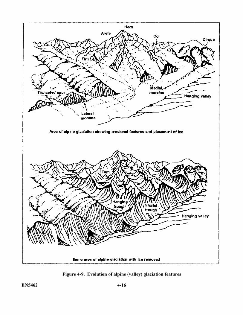
Figure 4-9. Evolution of alpine (valley) glaciation features
EN5462 4-16
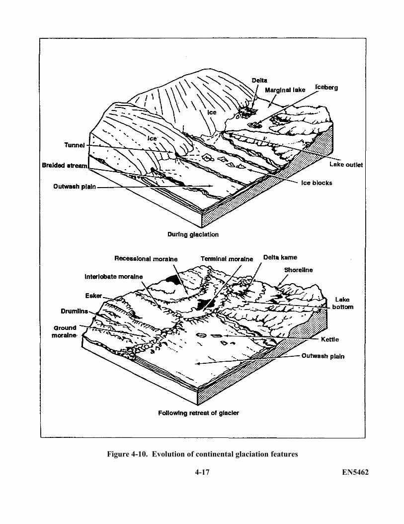
Figure 4-10. Evolution of continental glaciation features
4-17 EN5462
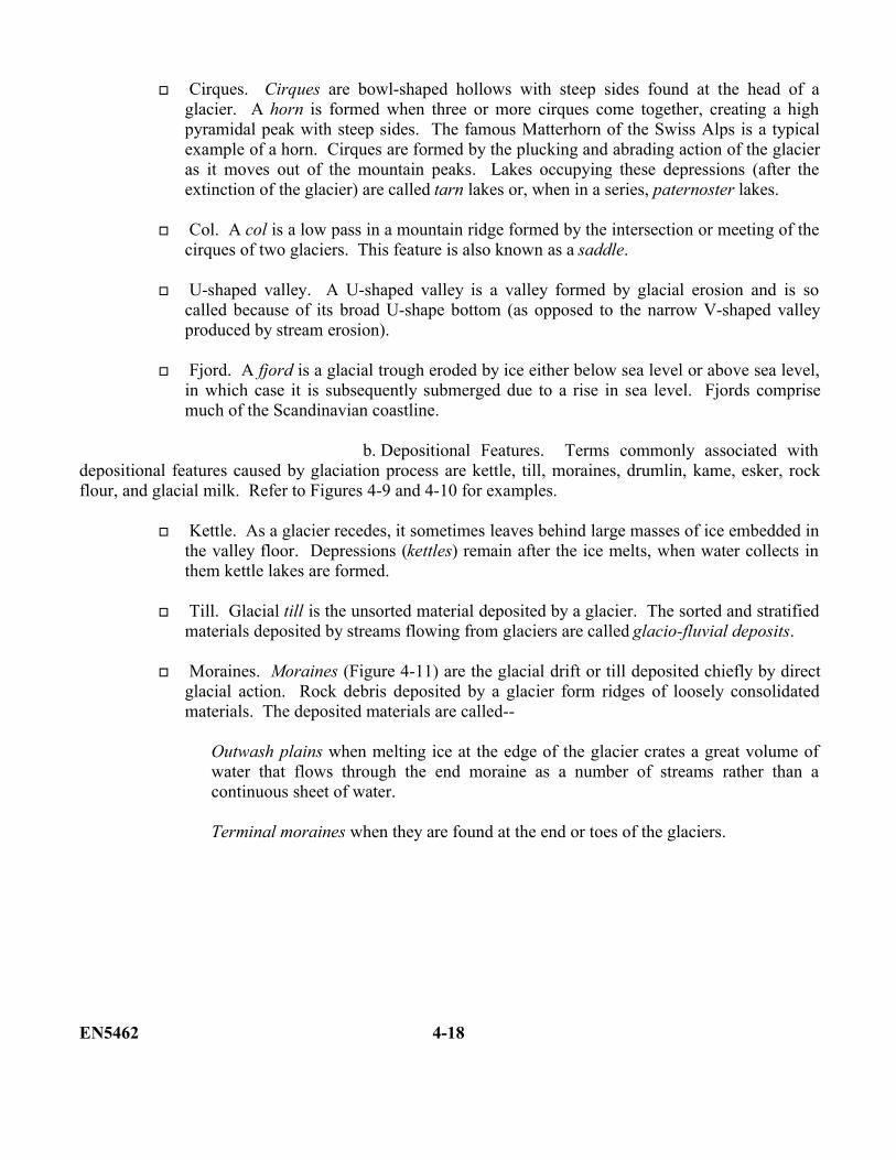
Cirques. Cirques are bowl-shaped hollows with steep sides found at the head of aglacier. A horn is formed when three or more cirques come together, creating a highpyramidal peak with steep sides. The famous Matterhorn of the Swiss Alps is a typicalexample of a horn. Cirques are formed by the plucking and abrading action of the glacieras it moves out of the mountain peaks. Lakes occupying these depressions (after theextinction of the glacier) are called tarn lakes or, when in a series, paternoster lakes.
Col. A col is a low pass in a mountain ridge formed by the intersection or meeting of thecirques of two glaciers. This feature is also known as a saddle.
U-shaped valley. A U-shaped valley is a valley formed by glacial erosion and is socalled because of its broad U-shape bottom (as opposed to the narrow V-shaped valleyproduced by stream erosion).
Fjord. A fjord is a glacial trough eroded by ice either below sea level or above sea level,in which case it is subsequently submerged due to a rise in sea level. Fjords comprisemuch of the Scandinavian coastline.
b. Depositional Features. Terms commonly associated withdepositional features caused by glaciation process are kettle, till, moraines, drumlin, kame, esker, rockflour, and glacial milk. Refer to Figures 4-9 and 4-10 for examples.
Kettle. As a glacier recedes, it sometimes leaves behind large masses of ice embedded inthe valley floor. Depressions (kettles) remain after the ice melts, when water collects inthem kettle lakes are formed.
Till. Glacial till is the unsorted material deposited by a glacier. The sorted and stratifiedmaterials deposited by streams flowing from glaciers are called glacio-fluvial deposits.
Moraines. Moraines (Figure 4-11) are the glacial drift or till deposited chiefly by directglacial action. Rock debris deposited by a glacier form ridges of loosely consolidatedmaterials. The deposited materials are called--
Outwash plains when melting ice at the edge of the glacier crates a great volume ofwater that flows through the end moraine as a number of streams rather than acontinuous sheet of water.
Terminal moraines when they are found at the end or toes of the glaciers.
EN5462 4-18
Ground moraines when laid down on the valley floor of a glacier.
Lateral moraines when formed by the deposition of material along the sides of aglacier.
Medial moraine, when formed as a common moraine by the merger of two glaciers.
Figure 4-11. A block of a valley glacier showingthe relationship and nature of the deposits
Drumlin. A drumlin is a streamlined, lens-shaped deposit of glacial till with its longer axisparallel to the direction of the glacial movement (Figure 4-12).
Kame. A kame is a terrace or flat-topped hill created by the deposition of material carried bystreams flowing along the margin of the glacier.
Esker. An esker is a winding ridge of stream-built stratified glacial gravel and sand formedbetween walls of ice or in ice tunnels.
Rock Flour. Rock flour is the finely powdered rock material produced by glacial erosion
Glacial milk. Glacial milk is the milk-white water (charged with rock flour) that flows frombeneath glaciers.
4-19 EN5462
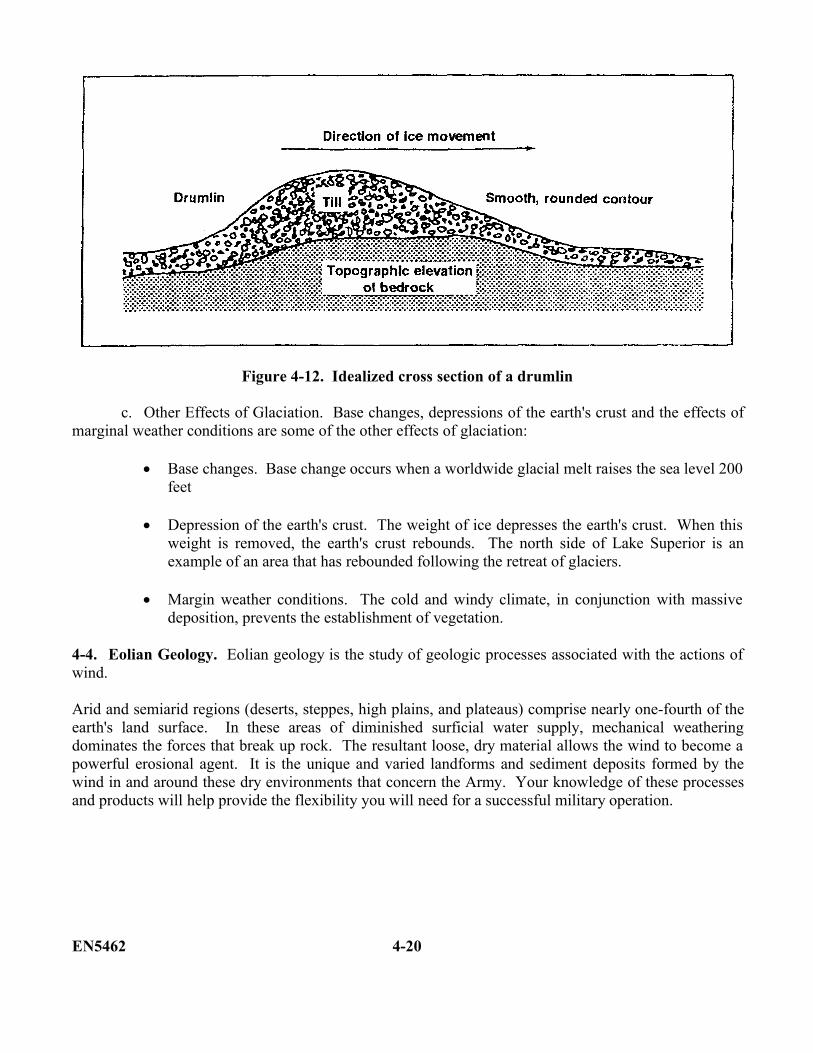
Figure 4-12. Idealized cross section of a drumlin
c. Other Effects of Glaciation. Base changes, depressions of the earth's crust and the effects ofmarginal weather conditions are some of the other effects of glaciation:
Base changes. Base change occurs when a worldwide glacial melt raises the sea level 200feet
Depression of the earth's crust. The weight of ice depresses the earth's crust. When thisweight is removed, the earth's crust rebounds. The north side of Lake Superior is anexample of an area that has rebounded following the retreat of glaciers.
Margin weather conditions. The cold and windy climate, in conjunction with massivedeposition, prevents the establishment of vegetation.
4-4. Eolian Geology. Eolian geology is the study of geologic processes associated with the actions ofwind.
Arid and semiarid regions (deserts, steppes, high plains, and plateaus) comprise nearly one-fourth of theearth's land surface. In these areas of diminished surficial water supply, mechanical weatheringdominates the forces that break up rock. The resultant loose, dry material allows the wind to become apowerful erosional agent. It is the unique and varied landforms and sediment deposits formed by thewind in and around these dry environments that concern the Army. Your knowledge of these processesand products will help provide the flexibility you will need for a successful military operation.
EN5462 4-20
a. Types of Eolian Erosion. The eolian erosion process consists of two types: deflation andabrasion.
(1) Deflation. Deflation occurs when loose particles are lifted and removed by the wind.Wind picks up finer material and lets heavier particles or pebbles to settle and compact themselves.Deflation lowers the land surface and is not limited by base level. It can continue as long as it has loosematerial to carry away; however, moisture stops deflation and leads to vegetation. Death Valley,California is an example of deflation.
(2) Abrasion. Abrasion is a weathering process by which particles carried by the windscratch exposed rock surfaces. It occurs when hard particles are blown against a rock, causing it to breakdown. As they are broken off, the resulting fragments are carried away by wind. These abraded rocksare called ventifacts. Abrasion also occurs due to water and glacial actions.
Ventifacts (Figure 4-13) are pebbles or boulders shaped by abrasive action of windblown sand. Inwindswept arid areas, pebbles may develop smoothly polished facets on the side facing the blast of sand.Over time, the process eventually produces many facets on the stones. NOTE: The pebbles shown inFigure 4-13 become a ventifact between stage A and stage B.
Figure 4-13. Four stages in cuttingof a ventifact
b. Modes of Transport. The two transportation modes of eolian erosion are saltation andsuspension.
(1) Saltation. Saltation is a process whereby unconsolidated material is bounced from onelocation to another.
(2) Suspension. Suspension is a process whereby material is transported in an airbornefashion. Suspended loads consist of fines carried at least two feet off the ground.
4-21 EN5462
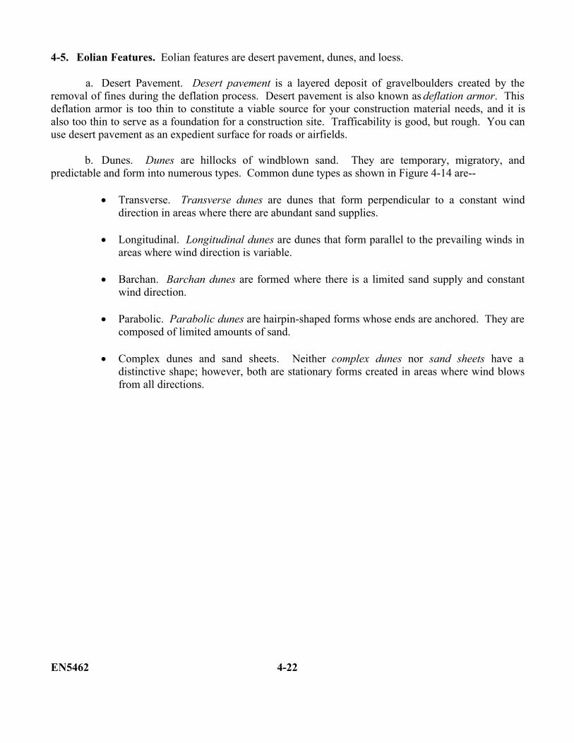
4-5. Eolian Features. Eolian features are desert pavement, dunes, and loess.
a. Desert Pavement. Desert pavement is a layered deposit of gravelboulders created by theremoval of fines during the deflation process. Desert pavement is also known as deflation armor. Thisdeflation armor is too thin to constitute a viable source for your construction material needs, and it isalso too thin to serve as a foundation for a construction site. Trafficability is good, but rough. You canuse desert pavement as an expedient surface for roads or airfields.
b. Dunes. Dunes are hillocks of windblown sand. They are temporary, migratory, andpredictable and form into numerous types. Common dune types as shown in Figure 4-14 are--
Transverse. Transverse dunes are dunes that form perpendicular to a constant winddirection in areas where there are abundant sand supplies.
Longitudinal. Longitudinal dunes are dunes that form parallel to the prevailing winds inareas where wind direction is variable.
Barchan. Barchan dunes are formed where there is a limited sand supply and constantwind direction.
Parabolic. Parabolic dunes are hairpin-shaped forms whose ends are anchored. They arecomposed of limited amounts of sand.
Complex dunes and sand sheets. Neither complex dunes nor sand sheets have adistinctive shape; however, both are stationary forms created in areas where wind blowsfrom all directions.
EN5462 4-22
Figure 4-14. Sand dune types
(1) Control of dunes. From a construction standpoint, migrating sand poses a significantengineering problem--how to prevent dune formations on facilities. As an engineer, your objectives fordune and drift-sand control are to--
Destroy or stabilize wind-borne sand accumulations-in order to prevent furthermigrating and encroachment
Divert windblown sand around works requiring protection.
4-23 EN5462
Stop sand movement short of the works to be protected.
Avoid sand deposits over a specific location by encouraging its movement. This isaccomplished primarily by surface smoothing and obstacle removal.
There are many ways for you to control dune and drift sand, each with certain advantages anddisadvantages. The following methods for the stabilization are listed with the most attractive methodsfirst:
(a) Aligning. You achieve this method by aligning the route upwind of the sand sourceto avoid major dune fields.
(b) Oiling. Cover the windblown materials with a suitable oil product, such as high-gravity penetrating oil. The oil will stabilize the treated surface and may destroy dune formation. Thisis often a quick, cheap, and effective method for you to perform.
(c) Fencing. Use relatively porous barriers to stop or divert the sand movement or todestroy or stabilize dunes. Cheap, portable, and expendable structures are suitable barriers. Forexample: palm fronds, chicken wire, or snow fencing.
(d) Planting. Plant appropriate vegetation that is designed to stop or reduce sandmovement, bind surface sand, and provide surface protection. You may be required during early stagesof control to use planting or sand-stilling plants through mulching, seeding, and the systematic creationof surface organic matter. Planting is permanent and attractive, but it is expensive to initiate andmaintain.
(e) Paving. Smoothing or hard-surfacing a relatively level area will increase the saltationcoefficient of wind-transporting material. This process promotes sand migration and prevents itsaccumulation at undesirable sites. You will often use this method downwind of fencing where wind isunladen of sediment and the paving will prevent its recharge. Your paving materials may consist ofconcrete asphalt or wind-stable aggregates such as crushed rock or gravel.
(f) Panelling. Erect solid barriers to the windward side of areas to be protected. Thebarriers will either stop or deflect sand movement (depending largely on the angle of the barrier to winddirection). In general, this method is unsatisfactory and expensive, although it may be suitable for short-term emergency action.
(g) Trenching. This method involves cutting trenches across dunes. The process willdestroy the symmetry of the dunes and may lead to dune destruction. By excavating pits on the lee ofsand mounds or on the windward side of the work to be protected, you will provide temporary localaccumulation areas.
(h) Removal of material. This method is rarely successful and is normally not long-term.
EN5462 4-24
(2) Engineering considerations. Your engineering considerations for dunes includeconstruction materials, construction sites, and trafficability.
(a) Construction material considerations for sand:
Use a snow fence to collect sand.
Use a native brick or stone because timber and steel are often lacking in eolianenvironments.
Use matting and membranes.
(b) Construction site considerations for sand:
Confine and compact sand to provide a good base.
Orient buildings carefully and add depth to the foundations to deter windundermining.
(c) Trafficability considerations for sand:
Avoid dunes, loose sand is often a barrier to wheels.
Mix asphalt with aggregate (pavement) to improve the trafficability of sand.
(d) Other considerations for sand:
Avoid concrete construction due to a lack of water and high salt content inaggregates.
Destroy dunes if they approach within 20 times the height of the structure.
c. Loess. Loess is a yellow or beige deposit comprised primarily of windblown silt. It maycontain small amounts of clay or fine sand, and it erodes to form nearly vertical walls. The Dauiz Desertin Iran is an example of an area composed of loess.
(1) Origin. Loess becomes airborne on dry, windblown outwash plains at the edges ofglacier. It is then transported to distant areas, where it is deposited in layers 10 to 100 feet thick.
4-25 EN5462
(2) Engineering considerations. Your engineering considerations for loess are constructionmaterials, construction sites, and trafficability.
Construction materials. Loess is a poor construction material. It is weak due to itsopen structure, and it tends to liquefy when wet
Construction sites. You should avoid the use of loess if possible. It does notmaintain a cut slope. Although some of its properties resemble consolidated rock, itis weak due to its open structure. Furthermore, it erodes quickly.
Trafficability. Loess has no trafficability if wet, but it will support a load if dry.
PART C: RESIDUAL LANDFORMS
Now it is time for you to get acquainted with the various landforms created by the erosion of igneous,metamorphic, and sedimentary structures in various climates.
4-6. Sedimentary Rocks. The best differentiator of sedimentary rocks is the presence of layersseparated by bedding planes. This section discusses the most common types of sedimentary rocks andthe characteristics associated with them.
a. Conglomerate and Sandstone. The following characteristics of conglomerate and sandstoneinclude--
(1) Landforms. Conglomerates and sandstones are relatively resistant to erosion and formareas of high relief. In temperate climates, sandstone topography is somewhat rounded. In arid regions,sandstone and conglomerate form the cap rock of plateaus and ridges, and the relief is usually ruggedand angular.
(2) Drainage patterns. Flat-lying sandstones and conglomerates usually develop a dendriticdrainage pattern. However, a rectangular drainage pattern, which is one characterized by right anglebends of streams, may result from the presence of joints and faults. A trellis pattern develops wheresandstones and softer rocks are interbedded and folded. In contrast to shale, sandstone will show amedium-to-coarse drainage network
(3) Vegetation. In humid climates, sandstone and conglomerates will support a heaviergrowth of vegetation than will limestone and shale.
(4) Photo tone. The tone is generally light-colored because of good drainage and light-colored minerals.
(5) Special keys. Special keys to sandstone are angular relief; bold, massive hills; light tone;and a curved or pincer-like dendritic drainage pattern.
EN5462 4-26
b. Shale. The following characteristics of shale include--
(1) Landforms. Shale is usually very susceptible to erosion in both humid and arid climates,and it often forms areas of low relief. In arid regions where sandstones develop vertical cliffs, shalesform slopes below the sandstone, often with parallel drainage of fine density. If sandstone is not presentwith shale in an arid climate, badlands topography (a region marked by intricate erosional sculpturing,scanty vegetation, and fantastically formed hills) develops. In humid regions, shale forms valleys andlow, rounded hills.
(2) Drainage pattern. Shale exhibits fine-textured dendritic and angular drainage patternsthat often contain small, rounded projections (crenulations). A trellis pattern develops on shale when itis interbedded with harder rocks and has been folded. Water erosion produces trench patterns such as V-shaped gullies in arid regions and U-shaped gullies in humid regions.
(3) Vegetation. In humid areas, shale may be heavily forested, but in arid regions, it isusually barren.
(4) Photo tone. Tones in humid areas are mottled due to variations in moisture and organiccontent. In arid climates, tones are uniformly light or dark except for occasional horizontal banding inthe rock.
(5) Special keys. Mottled tones, dendritic drainage patterns, and subdued landforms, as wellas the definite badlands topography, are indicators of shale.
c. Limestones-Karst Topography. The following characteristics of limestone-karst include--
(1) Landforms. Because of its solubility, limestone is very susceptible to chemicalweathering in humid regions. Sinkholes that appear as depressions in the limestone terrain, are verycharacteristic of this rock type in humid areas and are easily identified on aerial photographs.Underground water flowing through limestone deposits causes cavities to develop. Many limestones arehoneycombed with these voids. Limestone also forms lowlands when interbedded with sandstone inhumid climates. In arid regions, however, limestones are just as resistant to erosion as sandstones andmay also form the cap rock of plateaus or of ridges.
(2) Drainage patterns. Where they are present sinkholes represent the main surface drainage.In many areas, streams are found to disappear into sinkholes. In other areas, dendritic and rectangulardrainage patterns are most likely to form on limestone terrain. A trellis pattern is developed oninterbedded and tilted rock.
(3) Vegetation. In humid areas, limestone supports much vegetation since it develops a veryfertile soil. Orchards are commonly planted in limestone regions. Only a weak soil profile develops inarid regions and, consequently, the vegetation is usually sparse.
4-27 EN5462
(4) Photo tone. The overall tone of limestone is fairly uniform light gray, but it may beinterrupted by the occurrence of darker spots, indicating sinkholes. The mottled tone thus created is anexcellent guide to ground underlain by limestone.
(5) Special keys. The occurrence of sinkholes and the mottled tones are easy to see and areexcellent photo aids. Although basalt also displays mottled tones, there should be no confusion indifferentiating limestone and basalt. Mottled tones associated with sinkholes indicate limestone, whilemottled tones associated with columnar jointing indicate basalt. Stratification should, of course, beevident on limestone, but a coarse layering sometimes is exhibited by basalt.
d. Interbedded Flat-Lying Sedimentary Rocks. Two or more types of sedimentary rocks oftenoccur together. If these rocks are flat-lying or nearly so, they can be identified by several characteristics.Differences in resistance to weathering between the rocks can cause a stair-stepped or bench-liketopography. This topography may be accentuated by a distinct banding due to vegetation color andphoto tone. A dendritic drainage pattern will develop on thick interbedded sedimentary rocks, whiledifferences in drainage indicate differences in rock types.
e. Interbedded Tilted Sedimentary Rocks. Tilted sedimentary rocks may be identified by thecharacteristic topography of each individual rock type. Generally, the different rock types will beaccentuated by differences in drainage pattern, topographic expression, tone, and/or vegetation type.Folded sedimentary rocks usually develop a trellis drainage pattern which accentuates alternating valleysand ridges. If all three rock types are present, sandstone will form the highest landforms, limestone theintermediate slopes, and shale the valleys.
4-7. Igneous Rocks. Igneous rocks vary greatly in mineral and chemical composition, texture, andmode of occurrence. Intrusive rocks are emplaced as dikes, sills, batholiths, laccoliths, and stock.Extrusive igneous rocks generally occur as lava flows and volcanoes.
a. Intrusive Igneous Rocks. The following characteristics of intrusive igneous rocks include--
(1) Landforms. Depending upon the climate, intrusive igneous rocks will weather in differing ways. Some intrusive bodies like dikes and laccoliths will form characteristic shapes upon exposure to erosion. A dike will usually appear as a distinct ridge, while laccoliths and batholiths generally appear as dome like masses. Generally, in a humid or temperate climate, granite rocks will produce rounded or knobby topography, while in arid or semiarid climates they will appear more angular. All igneous rocks, regardless of their composition and structure, showjointing or cracking. Upon cooling during and after emplacement, these masses develop both horizontaland vertical cracks. The vertical cracks show up well on aerial photographs and, in most instances,specific directions can be ascertained. They are more resistant to erosion in any type of climate thanmost sedimentary or metamorphic rocks. Intrusive igneous rocks will form high areas, hills, or
EN5462 4-28
mountains where they occur in association with other kinds of rocks due to their erosion resistance. Inregions where granitic rocks alone cover extensive areas, they may be eroded by glaciation or streamaction to low rolling plains.
(2) Drainage patterns. Dendritic, rectangular, and radial drainage may all be produced ongranitic rocks. Since any one of these three patterns may be developed, other keys must be used inconjunction with this one to identify the rock type more specifically. Furthermore, annular drainage isfrequently developed in association with small intrusive bodies.
(3) Vegetation. In humid climates, igneous rocks are affected by chemical weathering toform a deep soil horizon that will support much vegetation. In arid climates, jointing and fracturing inthe mass may he evidenced by alignment of vegetation.
(4) Photo tone. Since intrusive igneous rocks are usually primarily composed of light-colored minerals, the photo tone will usually be light, provided the surface of the mass is` not extremelyrough.
(5) Special keys. Jointing, rectangular drainage pattern, exfoliation, angular relief, lack ofbanding, and light photo tone are basic keys in the identification of intrusive igneous rock types.
b. Extrusive Igneous Rocks. Extrusive igneous rocks are typified by lava flows or volcaniccones composed of dark-colored minerals. The following characteristics of extrusive igneous rocksinclude--
(1) Landforms. Lava flows may be recognized by the rounded projections along their edgesor by the vegetation patterns. Lava flows sometimes build up deposits many thousands of feet thick.Layering due to the intermittent outpouring of lava is common. Depending on the age of the flow andthe intensity of weathering, the surface may vary from smooth and rolling to very rough. Columnarjointing is a characteristic feature. This jointing is perpendicular to the surface of the flow and is causedby cooling. Cinder cones are identified by their conical shapes.
(2) Drainage pattern. Since lava flows are relatively flat-lying, homogeneous masses, adendritic pattern may develop. In many cases, however, there is little visible drainage. The joints inbasalt render it very porous, so much of the drainage is internal.
(3) Vegetation. In humid areas, abundant vegetation may be present because basalt weathersrapidly and develops a thick soil profile. In more arid areas, very little vegetation is found.
(4) Photo tone. Basalt usually shows dull and dark tones on aerial photos. One feature of thebasaltic lava flows is a characteristic mottled tone that is usually easy to identify unless the soil cover istoo thick.
4-29 EN5462
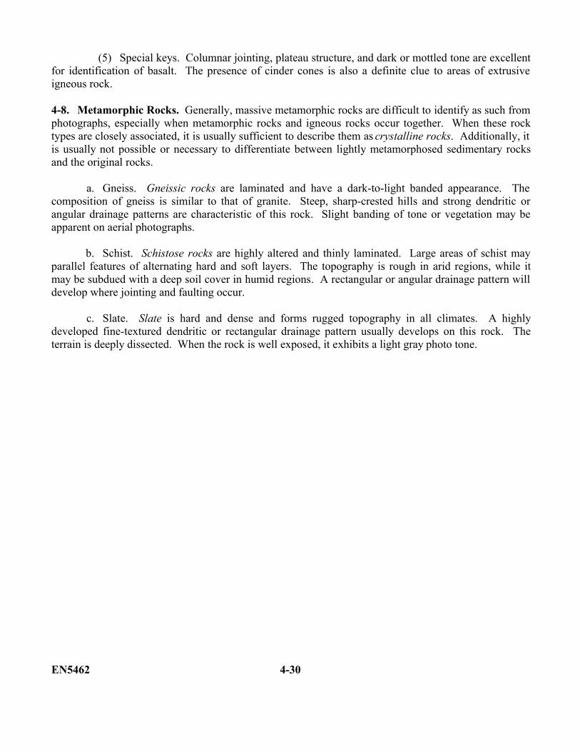
(5) Special keys. Columnar jointing, plateau structure, and dark or mottled tone are excellentfor identification of basalt. The presence of cinder cones is also a definite clue to areas of extrusiveigneous rock.
4-8. Metamorphic Rocks. Generally, massive metamorphic rocks are difficult to identify as such fromphotographs, especially when metamorphic rocks and igneous rocks occur together. When these rocktypes are closely associated, it is usually sufficient to describe them as crystalline rocks. Additionally, itis usually not possible or necessary to differentiate between lightly metamorphosed sedimentary rocksand the original rocks.
a. Gneiss. Gneissic rocks are laminated and have a dark-to-light banded appearance. Thecomposition of gneiss is similar to that of granite. Steep, sharp-crested hills and strong dendritic orangular drainage patterns are characteristic of this rock. Slight banding of tone or vegetation may beapparent on aerial photographs.
b. Schist. Schistose rocks are highly altered and thinly laminated. Large areas of schist mayparallel features of alternating hard and soft layers. The topography is rough in arid regions, while itmay be subdued with a deep soil cover in humid regions. A rectangular or angular drainage pattern willdevelop where jointing and faulting occur.
c. Slate. Slate is hard and dense and forms rugged topography in all climates. A highlydeveloped fine-textured dendritic or rectangular drainage pattern usually develops on this rock. Theterrain is deeply dissected. When the rock is well exposed, it exhibits a light gray photo tone.
EN5462 4-30
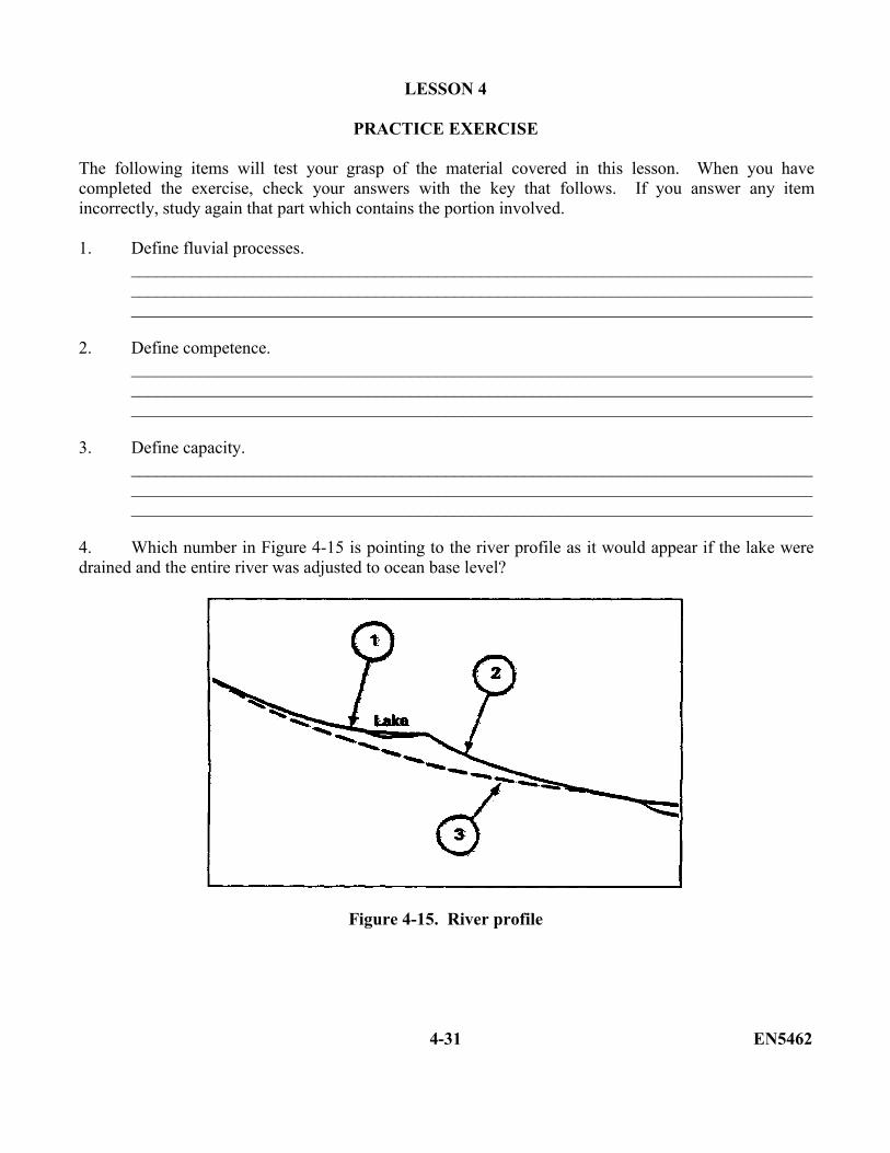
LESSON 4
PRACTICE EXERCISE
The following items will test your grasp of the material covered in this lesson. When you havecompleted the exercise, check your answers with the key that follows. If you answer any itemincorrectly, study again that part which contains the portion involved.
1. Define fluvial processes.__________________________________________________________________________________________________________________________________________________________________________________________________________________________________________
2. Define competence.__________________________________________________________________________________________________________________________________________________________________________________________________________________________________________
3. Define capacity.__________________________________________________________________________________________________________________________________________________________________________________________________________________________________________
4. Which number in Figure 4-15 is pointing to the river profile as it would appear if the lake weredrained and the entire river was adjusted to ocean base level?
Figure 4-15. River profile
4-31 EN5462
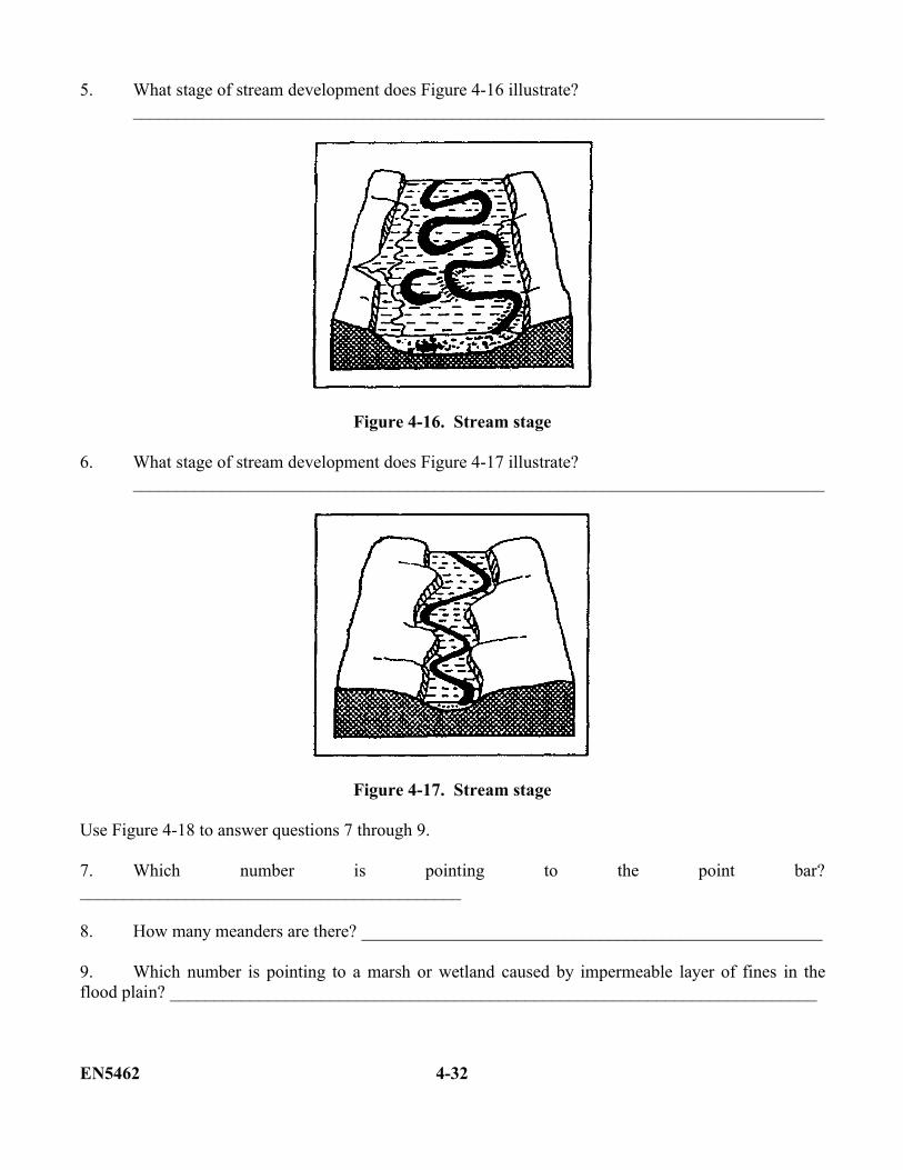
5. What stage of stream development does Figure 4-16 illustrate?______________________________________________________________________________
Figure 4-16. Stream stage
6. What stage of stream development does Figure 4-17 illustrate?______________________________________________________________________________
Figure 4-17. Stream stage
Use Figure 4-18 to answer questions 7 through 9.
7. Which number is pointing to the point bar?___________________________________________
8. How many meanders are there? ____________________________________________________
9. Which number is pointing to a marsh or wetland caused by impermeable layer of fines in theflood plain? _________________________________________________________________________
EN5462 4-32


Figure 4-18. Major flood plain features
10. Define shoreline of emergence.__________________________________________________________________________________________________________________________________________________________________________________________________________________________________________
11. Define shoreline of submergence.__________________________________________________________________________________________________________________________________________________________________________________________________________________________________________
12. How is a wave-cut bench created?__________________________________________________________________________________________________________________________________________________________________________________________________________________________________________
13. Define glacier.__________________________________________________________________________________________________________________________________________________________________________________________________________________________________________
4-33 EN5462

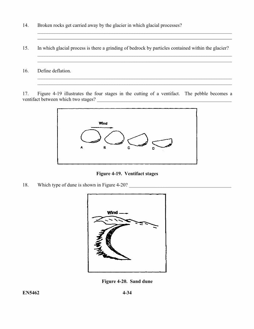
14. Broken rocks get carried away by the glacier in which glacial processes?____________________________________________________________________________________________________________________________________________________________
15. In which glacial process is there a grinding of bedrock by particles contained within the glacier?____________________________________________________________________________________________________________________________________________________________
16. Define deflation.____________________________________________________________________________________________________________________________________________________________
17. Figure 4-19 illustrates the four stages in the cutting of a ventifact. The pebble becomes aventifact between which two stages? ______________________________________________________
Figure 4-19. Ventifact stages
18. Which type of dune is shown in Figure 4-20? _________________________________________
Figure 4-20. Sand dune
EN5462 4-34
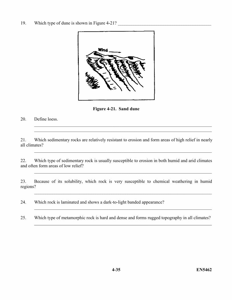
19. Which type of dune is shown in Figure 4-21? _________________________________________
Figure 4-21. Sand dune
20. Define loess.____________________________________________________________________________________________________________________________________________________________
21. Which sedimentary rocks are relatively resistant to erosion and form areas of high relief in nearlyall climates?
______________________________________________________________________________
22. Which type of sedimentary rock is usually susceptible to erosion in both humid and arid climatesand often form areas of low relief?
______________________________________________________________________________
23. Because of its solubility, which rock is very susceptible to chemical weathering in humidregions?
______________________________________________________________________________
24. Which rock is laminated and shows a dark-to-light banded appearance?______________________________________________________________________________
25. Which type of metamorphic rock is hard and dense and forms rugged topography in all climates?______________________________________________________________________________
4-35 EN5462
LESSON 4PRACTICE EXERCISE
ANSWER KEY AND FEEDBACK
Item Correct Answer
1. Fluvial processes are processes of running water. (page 4-2, para 4-1)
2. Competence refers to the maximum size of particle a stream is capable of moving. (page4-2, para 4-1a(1)(b))
3. Capacity is the maximum quantity of a material a steam can carry past a given point in aunit of time. (page 4-2, para 4-1a(1)(c))
4. Three. (page 4-4, Figure 4-3)
5. Old age. (page 4-5, Figure 4-4)
6. Mature. (page 4-5, Figure 4-4)
7. 3. (page 4-7, Figure 4-5)
8. 4. (page 4-7, Figure 4-5)
9. 5. (page 4-7, Figure 4-6)
10. A shoreline of emergence is the result of an uplift of land or fall in sea level. (page 4-11,para b(2))
11. A shoreline of submergence is the result of a rise in sea level or lowering of land. (page4-11, para b(2))
12. A wave-cut bench or terrace is created at the base of a cliff and widens as wave erosionproceeds landward against the cliff. (page 4-14, para d(2))
13. A glacier is a mass of snow and ice that moves under the influence of gravity out over theland from an area of perennial snow which is its source or head. (page 4-15, para 4-3)
14. Plucking and plowing. (page 4-15, para 4-3a(1)(2))
15. Abrasion. (page 4-15, para 4-3a(3))
EN5462 4-36
16. Deflation occurs when loose particles are lifted and removed by the wind. Wind picks upthe finer material and lets heavier particles or pebbles to settle and compact themselves.(page 4-21, para 4-4a(1))
17. Stages A and B (page 4-21, para 4-4a(2)).
18. Barchan (page 4-23, Figure 4-14).
19. Transverse (page 4-23, Figure 4-14).
20. Loess is a yellow or beige deposit comprised primarily of wind-blown silt. (page 4-25,para 4-5c)
21. Conglomerate and sandstone (page 4-26, para 4-6a(1)).
22. Shale (page 4-27, para 4-6b(1).
23. Limestone (page 4-27, para 4-6c(1)).
24. Gneiss (page 4-30, para 4-8a).
25. Slate (page 4-30, para 4-8c).
4-37 EN5462

THIS PAGE IS INTENTIONALLY LEFT BLANK
EN5462 4-38