u.s. department of homeland security united states … september 2016 lnm: 37/16 coast guard...
TRANSCRIPT

14 September 201637/16LNM:
11Coast Guard DistrictPage 1 of 16
U.S. Departmentof Homeland Security
United StatesCoast Guard
LOCAL NOTICE TO MARINERS
CORRESPONDENCE TO:COMMANDER
DISTRICT ELEVEN (DPW)COAST GUARD ISLAND BUILDING 50-2
ALAMEDA, CA 94501-5100
REFERENCES: COMDTPUB P16502.6, Light List Volume VI, 2016 Edition, U.S. Chart No.1 12th Edition, and Coast Pilot Volume 7 46th Edition. These publications, along with corrections, are available at: http://www.nauticalcharts.noaa.gov/nsd/cpdownload.htm.
BROADCAST NOTICE TO MARINERS - Information concerning aids to navigation and waterway managementpromulgated through BNM HB-0017-16, SF-0152-16, LA-0137-16, and SD-0125-16 have been incorporated in this notice, or will continue if still
significant.
SECTION I - SPECIAL NOTICESThis section contains information of special concern to the Mariner.
SUBMITTING INFORMATION FOR PUBLICATION IN THE LOCAL NOTICE TO MARINERS
BRIDGE INFORMATION- PROJECTS, DISCREPANCIES, CORRECTIONS & REGULATORY
MARINE SAFETY INFORMATION BULLETIN
MARINE SAFETY INFORMATION BULLETIN
MARINE SAFETY INFORMATION BULLETIN
A complete set of guidelines with examples and contact information can be found at http://www.uscg.mil/D11/DP/LnmRequest.asp or call BM1 Alfred Albert at 510-437-2980 or e-mail [email protected]. Please provide all Local Notice to Mariners submissions 14 days prior to the start of operations.
For all bridge related issues, including lighting, operation, obstructions, construction, demolition, etc. contact the Eleventh Coast Guard District Bridge Administrator 24 hour cell phone at 510-219-4366. Flotsam may accumulate on and near bridge piers and abutments. Mariners should approach all bridges with caution. A vessel delay at a drawbridge may be reported to the District Bridge Administrator by telephone, or by using the DelayRept0207.pdf included in the Enclosures section of this Local Notice to Mariners.
Some vessel operators are choosing to depart the Traffic Separation Scheme (TSS) established in the Santa Barbara Channel and transit through an area to the south of San Miguel, Santa Rosa, and Santa Cruz Islands (referenced herein as “south of the Channel Islands”). As such, the Los Angeles / Long Beach Harbor Safety Committee has published voluntary western traffic lanes for vessels approaching and departing the Ports of Los Angeles and Long Beach. Mariners transiting through the western and northern approaches to and from the Ports of Los Angeles and Long Beach (LA/LB) are advised that the established TSS through the Santa Barbara Channel as shown on NOAA and Admiralty charts is the only International Maritime Organization (IMO) approved routing measure in this area. An IMO approved TSS reduces the risk of collision by providing for the separation of arriving and departing traffic and minimizing potentially hazardous crossing situations. Mariners, who have traditionally used this approved TSS, are encouraged to continue to do so. For additional information please see MSIB Voluntary Traffic Lane 11-09.pdf in the Enclosures Section.
The Harbor Safety Committee of the San Francisco Bay Region adopted a proposal to establish anchorage berthing schemes in general anchorages 7, 8, and 8A. These berthing schemes will provide more efficient use and greater predictability of the available space in these anchorages. All existing regulations governing the use of these anchorages remain in effect. Vessels using these anchorages should strive to let go their anchor in the center of the drop bucket. For more details or comments contact Sean Kelley, Sector San Francisco VTS Director at 415-399-7402. For additional information see MSIB 15-07.pdf in the enclosure section.
It is strongly suggested that fishermen avoid placing crab pots within 500 yards of any navigational buoy, to allow servicing units to reach the aid. For more information contact Coast Guard District Eleven at [email protected] or 510-437-2982.
LNM:
LNM:
43/09
47/15
District: 11 Week: 37/16

14 September 201637/16LNM:
11Coast Guard DistrictPage 2 of 16
NOAA NATIONAL WEATHER SERVICE-FTP MAIL SYSTEM CHANGE
POINT ARGUELLO AND DANA POINT AREA-TSS SPEED REDUCTION
SAN FRANCISCO BAY-ENTRANCE TSS-SPEED REDUCTION
SAN FRANCISCO BAY-TEMPORARY FLEET WEEK BUOYS
The Marine, Tropical and Tsunami Services Branch of the NWS wants to inform you of an important change in the NWS' FTPMail system. FTPMail is very popular system for mariners to request and receive NWS marine weather products via email and we want to get the widest distribution possible. Feel free to post this information where you see fit but it would probably be widely received in your Local Notice to Mariners. The Service Change Notice linked below highlights a change to the email address used to request and receive NWS Products via email.
https://urldefense.proofpoint.com/v2/url?u=http-3A__www.nws.noaa.gov_os_notification_scn16-2D37ftpmail.htm&d=CwIBAg&c=0NKfg44GVknAU-XkWXjNxQ&r=AXJUmWWgQgZRWaORmshlkqvCQortm5MvFUMhSbV3gjw&m=iGfeOM3wHUykOuVt5_papPJSDTYM1QARp5y3OVA8wJo&s=l65MjiXftTthDrkKX6OM9kx0vtMNOGmk12Zn8YTdm9o&e=
The New FTPMail Service Email Address is: [email protected] and it is currently active. Both email addresses will work to request and receive products via FTPMail until October6 when [email protected] is planned for decommissioning. NWS recommends users begin transitioning to the new email address by October 6, 2016 to ensure continuing responses to FTPMail requests.
Vessels transiting the area between Point Arguello and Dana Point, including the Traffic Separation Schemes in the Santa Barbara Channel and San Pedro Channel, from June through November, should exercise caution and consider reducing speed. These areas contain populations of endangered blue, humpback and fin whales that are federally protected under the Federal Endangered Species Act (16 U.S.C. 1538 et seq.), the Marine Mammal Protection Act (16 U.S.C. 1361 et seq.), and the National Marine Sanctuaries Act (16 U.S.C. 1431 et seq.).NOAA strongly recommends that vessels 300 gross registered tons or larger transiting the Santa Barbara Channel Traffic Separation Scheme between Carrington Point, Santa Rosa Island and Diablo Point, Santa Cruz Island, do so at speeds not in excess of 10 kts due to endangered whales in the area (see SB Channel speed reduction zone.pdf). Please report any collisions with whales or any observed injured or dead whales to NOAA at 877-SOS-WHALe (877-767-9425) or to the U.S. Coast Guard on VHF Channel 16.NOAA is asking for the public’s help in tracking whales. If you see whales, please record the date and location, the number of whales, the species (if known) and a description of the animals. Please email [email protected]. You can also report whales through WhaleAlert, a free application available at http://westcoast.whalealert.org. For more details or comments contact Sean Hastings, [email protected].
NOAA Sanctuaries request a voluntary Vessel Speed Reduction until 15 Nov 16 within the SF TSS. Vessels 300 gross registered tons or larger transiting the San Francisco Traffic Separation Scheme (33 CFR 167.400) are encouraged to transit at speeds not in excess of 10kts.
These areas contain concentrations of endangered Blue, Humpback, and Fin Whales that are protected under the Federal Endangered Species Act (16 U.S.C. 1538 et seq.), the Marine Mammal Protection Act (16 U.S.C. 1361 et seq.), and the National Marine Sanctuaries Act (16 U.S.C. 1431 et seq.). Please report any collisions with whales or any observed injured or dead whales to NOAA at 877-SOS-WHAL 877-767-9425 or to the U.S. Coast Guard on VHF Channel 16. NOAA is asking for the public's help in tracking whales. If you see whales, please record the date, location, the number of whales, the species (if known) and a description of the animals. Please report sightings to [email protected]. You can also report whales through WhaleAlert, a free application available at http://westcoast.whalealert.org.
For more details or comments please contact Michael Carver at [email protected]
On 03 Oct 16 the Coast Guard temporarily established five yellow, lighted, special purpose buoys to identify the Fleet Week security zone boundaries and center point. The buoys are on station at the following positions until approximately 10 Oct 16. 37-48-36.880N 122-26-58.380W 37-49-05.760N 122-27-03.330W 37-49-23.340N 122-24-21.240W 37-48-53.280N 122-24-16.320W 37-49-00.480N 122-25-35.400WPlease submit any questions or comments to LTJG Leslie Stenkamp at 510-437-3801 or [email protected].
LNM:
LNM:
LNM:
LNM:
LNM:
25/16
37/16
26/16
17/16
37/16
18720
18645
18649 18650 18652
Chart
Chart
Charts:
14 September 201637/16LNM:
11Coast Guard DistrictPage 3 of 16
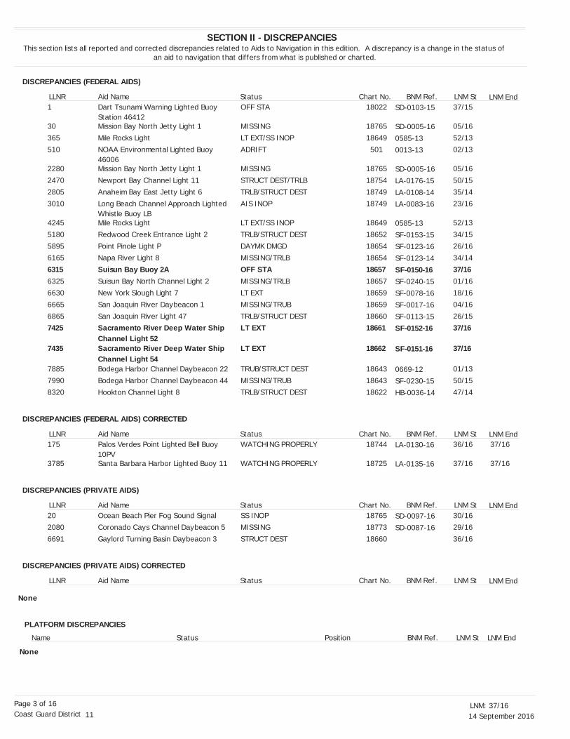
DISCREPANCIES (FEDERAL AIDS)
DISCREPANCIES (FEDERAL AIDS) CORRECTED
DISCREPANCIES (PRIVATE AIDS)
DISCREPANCIES (PRIVATE AIDS) CORRECTED
SECTION II - DISCREPANCIESThis section lists all reported and corrected discrepancies related to Aids to Navigation in this edition. A discrepancy is a change in the status of
an aid to navigation that differs from what is published or charted.
LNM End
LNM End
LNM End
LNM End
LLNR
LLNR
LLNR
LLNR
Aid Name
Aid Name
Aid Name
Aid Name
Status
Status
Status
Status
Chart No.
Chart No.
Chart No.
Chart No.
BNM Ref.
BNM Ref.
BNM Ref.
BNM Ref.
LNM St
LNM St
LNM St
LNM St
Dart Tsunami Warning Lighted Buoy Station 46412Mission Bay North Jetty Light 1
Mile Rocks LightNOAA Environmental Lighted Buoy 46006Mission Bay North Jetty Light 1
Newport Bay Channel Light 11
Anaheim Bay East Jetty Light 6Long Beach Channel Approach Lighted Whistle Buoy LBMile Rocks Light
Redwood Creek Entrance Light 2
Point Pinole Light PNapa River Light 8
Suisun Bay Buoy 2ASuisun Bay North Channel Light 2New York Slough Light 7
San Joaquin River Daybeacon 1
San Joaquin River Light 47Sacramento River Deep Water Ship Channel Light 52Sacramento River Deep Water Ship Channel Light 54Bodega Harbor Channel Daybeacon 22Bodega Harbor Channel Daybeacon 44
Hookton Channel Light 8
Palos Verdes Point Lighted Bell Buoy 10PVSanta Barbara Harbor Lighted Buoy 11
Ocean Beach Pier Fog Sound Signal
Coronado Cays Channel Daybeacon 5
Gaylord Turning Basin Daybeacon 3
OFF STA
MISSING
LT EXT/SS INOPADRIFT
MISSING
STRUCT DEST/TRLB
TRLB/STRUCT DESTAIS INOP
LT EXT/SS INOP
TRLB/STRUCT DEST
DAYMK DMGDMISSING/TRLB
OFF STAMISSING/TRLBLT EXT
MISSING/TRUB
TRLB/STRUCT DESTLT EXT
LT EXT
TRUB/STRUCT DESTMISSING/TRUB
TRLB/STRUCT DEST
WATCHING PROPERLY
WATCHING PROPERLY
SS INOP
MISSING
STRUCT DEST
37/15
05/16
52/1302/13
05/16
50/15
35/1423/16
52/13
34/15
26/1634/14
37/1601/1618/16
04/16
26/1537/16
37/16
01/1350/15
47/14
36/16
37/16
30/16
29/16
36/16
37/16
37/16
18022
18765
18649501
18765
18754
1874918749
18649
18652
1865418654
186571865718659
18659
1866018661
18662
1864318643
18622
18744
18725
18765
18773
18660
1
30
365510
2280
2470
28053010
4245
5180
58956165
631563256630
6665
68657425
7435
78857990
8320
175
3785
20
2080
6691
None
SD-0103-15
SD-0005-16
0585-130013-13
SD-0005-16
LA-0176-15
LA-0108-14LA-0083-16
0585-13
SF-0153-15SF-0123-16
SF-0123-14
SF-0150-16SF-0240-15SF-0078-16
SF-0017-16
SF-0113-15SF-0152-16
SF-0151-16
0669-12SF-0230-15
HB-0036-14
LA-0130-16
LA-0135-16
SD-0097-16
SD-0087-16
PLATFORM DISCREPANCIES
Name Status Position BNM Ref. LNM St LNM End
None
14 September 201637/16LNM:
11Coast Guard DistrictPage 4 of 16
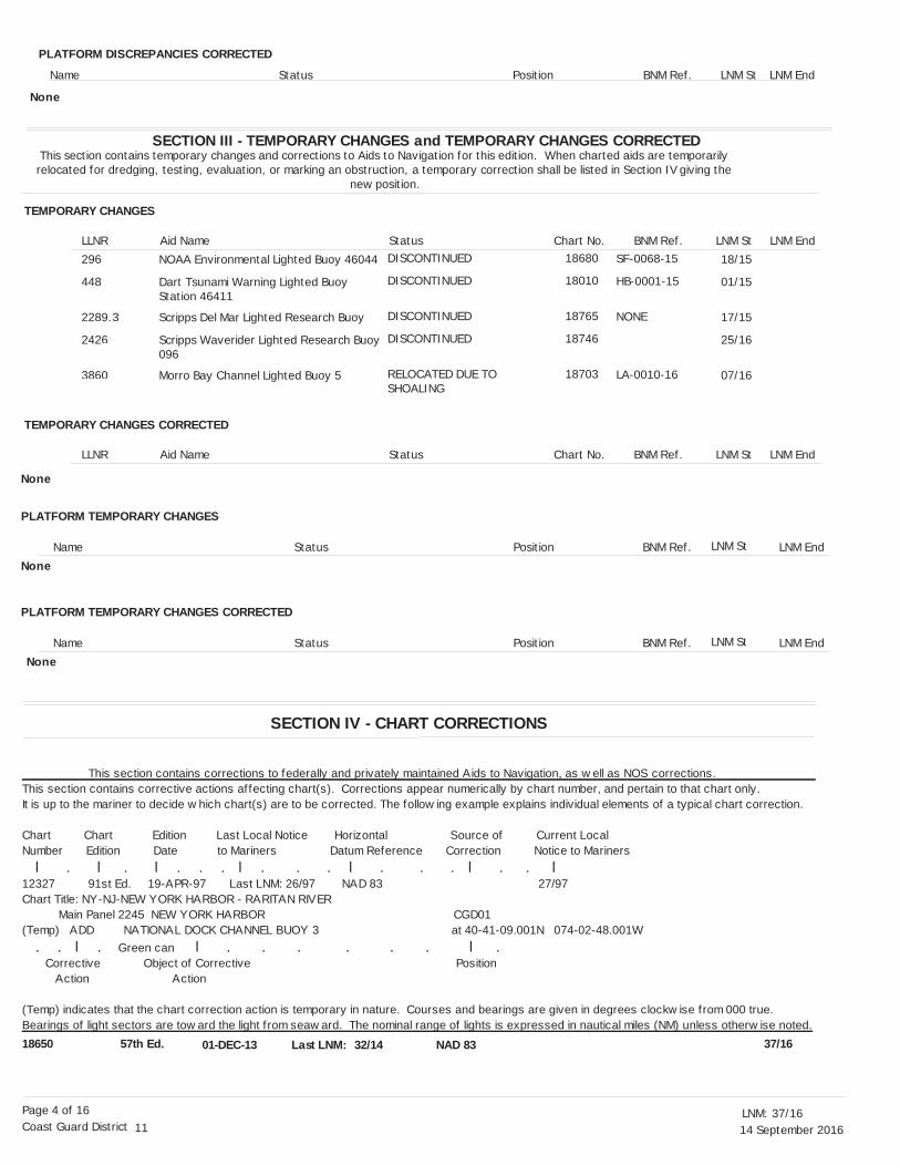
SECTION III - TEMPORARY CHANGES and TEMPORARY CHANGES CORRECTEDThis section contains temporary changes and corrections to Aids to Navigation for this edition. When charted aids are temporarily relocated for dredging, testing, evaluation, or marking an obstruction, a temporary correction shall be listed in Section IV giving the
new position.
TEMPORARY CHANGES
TEMPORARY CHANGES CORRECTED
LNM End
LNM End
LLNR
LLNR
Aid Name
Aid Name
Status
Status
Chart No.
Chart No.
BNM Ref.
BNM Ref.
LNM St
LNM St
18650 57th Ed. 01-DEC-13 32/14 NAD 83Last LNM: 37/16
NOAA Environmental Lighted Buoy 46044
Dart Tsunami Warning Lighted Buoy Station 46411
Scripps Del Mar Lighted Research Buoy
Scripps Waverider Lighted Research Buoy096
Morro Bay Channel Lighted Buoy 5
DISCONTINUED
DISCONTINUED
DISCONTINUED
DISCONTINUED
RELOCATED DUE TO SHOALING
18/15
01/15
17/15
25/16
07/16
18680
18010
18765
18746
18703
296
448
2289.3
2426
3860
None
This section contains corrections to federally and privately maintained Aids to Navigation, as w ell as NOS corrections.This section contains corrective actions affecting chart(s). Corrections appear numerically by chart number, and pertain to that chart only.It is up to the mariner to decide w hich chart(s) are to be corrected. The follow ing example explains individual elements of a typical chart correction.
Chart Chart Edition Last Local Notice Horizontal Source of Current LocalNumber Edition Date to Mariners Datum Reference Correction Notice to Mariners l . l . l . . . l . . . l . . . l . . l12327 91st Ed. 19-APR-97 Last LNM: 26/97 NAD 83 27/97Chart Title: NY-NJ-NEW YORK HARBOR - RARITAN RIVER Main Panel 2245 NEW YORK HARBOR CGD01(Temp) ADD NATIONAL DOCK CHANNEL BUOY 3 at 40-41-09.001N 074-02-48.001W . . l . Green can l . . . . . . l . Corrective Object of Corrective Position Action Action
(Temp) indicates that the chart correction action is temporary in nature. Courses and bearings are given in degrees clockw ise from 000 true.Bearings of light sectors are tow ard the light f rom seaw ard. The nominal range of lights is expressed in nautical miles (NM) unless otherw ise noted.
SF-0068-15
HB-0001-15
NONE
LA-0010-16
PLATFORM DISCREPANCIES CORRECTED
Name Status Position BNM Ref. LNM St LNM End
None
PLATFORM TEMPORARY CHANGES
PLATFORM TEMPORARY CHANGES CORRECTED
Name
Name
Status
Status
Position
Position
BNM Ref.
BNM Ref.
LNM St
LNM St
LNM End
LNM End
None
None
SECTION IV - CHART CORRECTIONS
14 September 201637/16LNM:
11Coast Guard DistrictPage 5 of 16
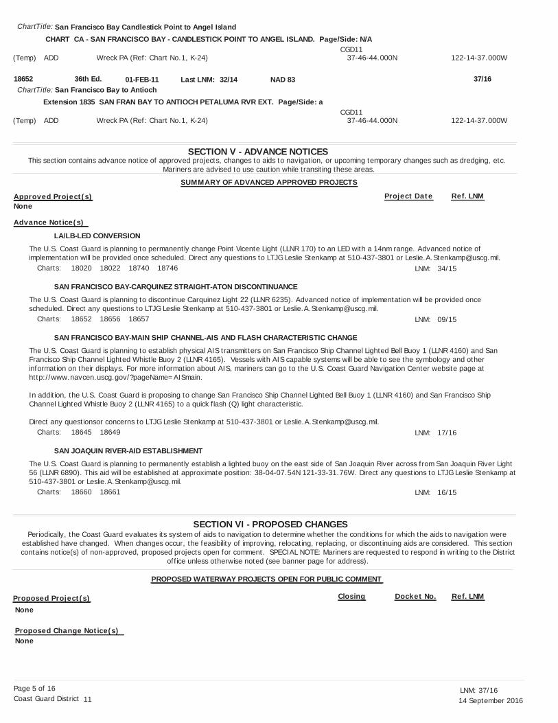
SECTION V - ADVANCE NOTICESThis section contains advance notice of approved projects, changes to aids to navigation, or upcoming temporary changes such as dredging, etc.
Mariners are advised to use caution while transiting these areas.
SUMMARY OF ADVANCED APPROVED PROJECTS
Approved Project(s) Project Date Ref. LNM
LA/LB-LED CONVERSION
SAN FRANCISCO BAY-CARQUINEZ STRAIGHT-ATON DISCONTINUANCE
SAN FRANCISCO BAY-MAIN SHIP CHANNEL-AIS AND FLASH CHARACTERISTIC CHANGE
SAN JOAQUIN RIVER-AID ESTABLISHMENT
The U.S. Coast Guard is planning to permanently change Point Vicente Light (LLNR 170) to an LED with a 14nm range. Advanced notice of implementation will be provided once scheduled. Direct any questions to LTJG Leslie Stenkamp at 510-437-3801 or [email protected].
The U.S. Coast Guard is planning to discontinue Carquinez Light 22 (LLNR 6235). Advanced notice of implementation will be provided once scheduled. Direct any questions to LTJG Leslie Stenkamp at 510-437-3801 or [email protected].
The U.S. Coast Guard is planning to establish physical AIS transmitters on San Francisco Ship Channel Lighted Bell Buoy 1 (LLNR 4160) and San Francisco Ship Channel Lighted Whistle Buoy 2 (LLNR 4165). Vessels with AIS capable systems will be able to see the symbology and other information on their displays. For more information about AIS, mariners can go to the U.S. Coast Guard Navigation Center website page at http://www.navcen.uscg.gov/?pageName=AISmain.
In addition, the U.S. Coast Guard is proposing to change San Francisco Ship Channel Lighted Bell Buoy 1 (LLNR 4160) and San Francisco Ship Channel Lighted Whistle Buoy 2 (LLNR 4165) to a quick flash (Q) light characteristic.
Direct any questionsor concerns to LTJG Leslie Stenkamp at 510-437-3801 or [email protected].
The U.S. Coast Guard is planning to permanently establish a lighted buoy on the east side of San Joaquin River across from San Joaquin River Light 56 (LLNR 6890). This aid will be established at approximate position: 38-04-07.54N 121-33-31.76W. Direct any questions to LTJG Leslie Stenkamp at510-437-3801 or [email protected].
LNM:
LNM:
LNM:
LNM:
34/15
09/15
17/16
16/15
SECTION VI - PROPOSED CHANGESPeriodically, the Coast Guard evaluates its system of aids to navigation to determine whether the conditions for which the aids to navigation were
established have changed. When changes occur, the feasibility of improving, relocating, replacing, or discontinuing aids are considered. This section contains notice(s) of non-approved, proposed projects open for comment. SPECIAL NOTE: Mariners are requested to respond in writing to the District
office unless otherwise noted (see banner page for address).
PROPOSED WATERWAY PROJECTS OPEN FOR PUBLIC COMMENT
Proposed Project(s) Closing Docket No. Ref. LNM
18652 36th Ed. 01-FEB-11 32/14
San Francisco Bay Candlestick Point to Angel Island
San Francisco Bay to Antioch
ChartTitle:
ChartTitle:NAD 83Last LNM: 37/16
CHART CA - SAN FRANCISCO BAY - CANDLESTICK POINT TO ANGEL ISLAND. Page/Side: N/A
Extension 1835 SAN FRAN BAY TO ANTIOCH PETALUMA RVR EXT. Page/Side: a
(Temp)
(Temp)
ADD
ADD
Wreck PA (Ref: Chart No.1, K-24)
Wreck PA (Ref: Chart No.1, K-24)
CGD11
CGD11
37-46-44.000N
37-46-44.000N
122-14-37.000W
122-14-37.000W
Charts:
Charts:
Charts:
Charts:
18020 18022 18740 18746
18652 18656 18657
18645 18649
18660 18661
None
None
None
Advance Notice(s)
Proposed Change Notice(s)
14 September 201637/16LNM:
11Coast Guard DistrictPage 6 of 16
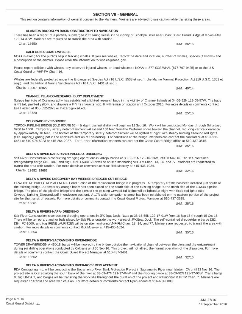
SECTION VII - GENERALThis section contains information of general concern to the Mariners. Mariners are advised to use caution while transiting these areas.
There has been a report of a partially submerged 23ft sailing vessel in the vicinity of Brooklyn Basin near Coast Guard Island Bridge at 37-46-44N 122-14-37W. Mariners are requested to transit the area with caution.
NOAA is asking for the public’s help in tracking whales. If you see whales, record the date and location, number of whales, species (if known) and a description of the animals. Please email the information to [email protected].
Please report collisions with whales, any observed injured whales, or dead whales to NOAA at 877-SOS-WHAL (877-767-9425) or to the U.S. Coast Guard on VHF-FM Chan. 16.
Whales are federally protected under the Endangered Species Act (16 U.S.C. 1538 et seq.), the Marine Mammal Protection Act (16 U.S.C. 1361 etseq.), and the National Marine Sanctuaries Act (16 U.S.C. 1431 et seq.).
Scripps Institute of Oceanography has established a lighted research buoy in the vicinity of Channel Islands at 34-05-52N 119-05-57W. The buoy is 4ft tall, painted yellow, and displays a Fl Y 4s characteristic. It will remain on station until October 2016. For more details or comments contact Lisa Hazard at 858-822-2873 or [email protected].
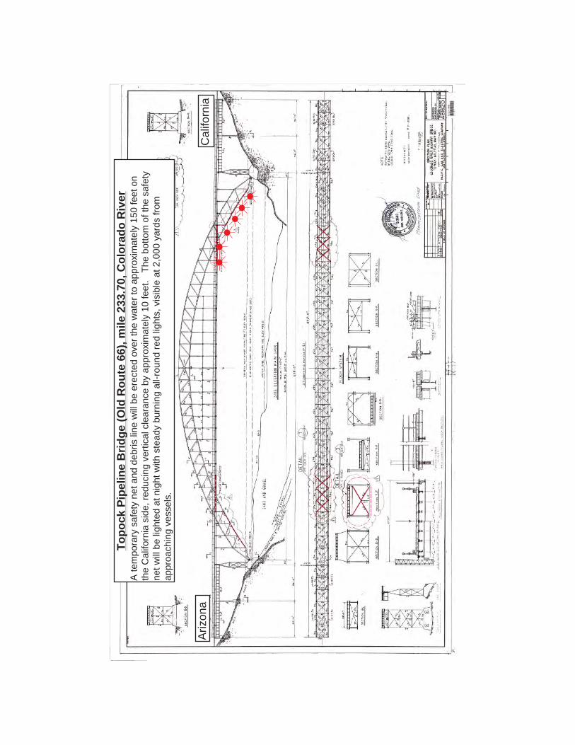
TOPOCK PIPELINE BRIDGE (OLD ROUTE 66) - Bridge truss installation will begin on 12 Sep 16. Work will be conducted Monday through Saturday, 0700 to 1600. Temporary safety net/containment will extend 150 feet from the California shore toward the channel, reducing vertical clearance by approximately 10 feet. The bottom of the temporary safety net/containment will be lighted at night with steady burning all-round red lights. (See Topock_Lighting.pdf in the enclosure section of this notice). For conditions at the bridge, mariners can contact the contractor at 510-866-6451 or 510-974-5223 or 415-264-2927. For further information mariners can contact the Coast Guard Bridge office at 510-437-3515.
Salt River Construction is conducting dredging operations in Vallejo Marina at 38-06-31N 122-16-13W until 30 Nov 16. The self-contained dredge/dump barge DB1, DB2, and tug IRENE LAURITZEN will be on site monitoring VHF-FM Chan. 13, 14, and 77. Mariners are requested to transit the area with caution. For more details or comments contact Rick Moseley at 415-435-1024.
ORWOOD RD BRIDGE REPLACEMENT- Construction of the replacement bridge is in progress. A temporary trestle has been installed just south of the existing bridge. A temporary orange boom has been placed on the south side of the existing bridge to the north side of the EBMUD pipeline bridge. The piers of the pipeline bridge and the piers of the existing Orwood Rd Bridge will be lighted at night with fixed red lights (see Orwood_Lighting_Diagram2.pdf in enclosure section). A 17ft wide navigation channel has been established on the eastern portion of the project site for the transit of vessels. For more details or comments contact the Coast Guard Project Manager at 510-437-3515.
Salt River Construction is conducting dredging operations in JFK Boat Dock, Napa at 38-15-55N 122-17-01W from 16 Sep 16 through 15 Oct 16. There will be temporary anchor balls placed by Salt River outside the work area of JFK Boat Dock. The self-contained dredge/dump barge DB2, DB4, PC-1000, and tug IRENE LAURITZEN will be on site monitoring VHF-FM Chan. 13, 14, and 77. Mariners are requested to transit the area with caution. For more details or comments contact Rick Moseley at 415-435-1024.
TOWER DRAWBRIDGE- A 45'X18' barge will be moored to the bridge outside the navigational channel between the piers and the embankment during soil drilling operations conducted by Caltrans until 30 Sep 16. This project will not affect the normal operation of the drawspan. For more details or comments contact the Coast Guard Project Manager at 510-437-3461.
RDA Contracting Inc. will be conducting the Sacramento River Bank Protection Project in Sacramento River near Isleton, CA until 23 Nov 16. The project site is located along the south bank of the river at 38-09-47N 121-37-04W and the mooring barge at 38-09-52N 121-37-03W. Crane barge 8, tug LINDA T, and barges will be transiting the work site throughout the duration of the project and will monitor VHF/FM Chan. 7. Mariners are requested to transit the area with caution. For more details or comments contact Ryan Abood at 916-601-0080.
LNM:
LNM:
LNM:
LNM:
LNM:
LNM:
LNM:
LNM:
36/16
49/14
25/16
35/16
32/16
25/15
35/16
32/16
ALAMEDA-BROOKLYN BASIN-OBSTRUCTION TO NAVIGATION
CALIFORNIA COAST-WHALES
CHANNEL ISLANDS-RESEARCH BUOY DEPLOYMENT
COLORADO RIVER-BRIDGE
DELTA & RIVER-NAPA RIVER-VALLEJO- DREDGING
DELTA & RIVERS-DISCOVERY BAY-WERNER DREDGER CUT-BRIDGE
DELTA & RIVERS-NAPA- DREDGING
DELTA & RIVERS-SACRAMENTO RIVER-BRIDGE
DELTA & RIVERS-SACRAMENTO RIVER-ROCK REPLACEMENT
Chart
Chart
Chart
Chart
Chart
Charts:
Charts:
18650
18007 18022
18720
18652 18655
18661
18654
18662

14 September 201637/16LNM:
11Coast Guard DistrictPage 7 of 16
Camenzind Dredging Inc. will be conducting continuous dredging operations in Napa River between 38-17-51N 122-16-58W and 38-10-57N 122-18-31W 24 hours a day 7 days a week until 15 Dec 16. Dredged material will be disposed at Imola Upland Disposal Site and Napa Pipe Upland Disposal Site. The submerged pipeline will be marked with yellow floats and anchors with white buoys. PAUL VINCENT, FESTER and various skiffs will be monitoring VHF-FM Chan. 16 and 67. Mariners are requested to transit the area with caution. For more details or comments contact Project Manager, Kurt Camenzind at 650-424-0367.
CS Marine Contractors, Inc. will be conducting marine operations at San Joaquin River on the east side of the Antioch Bridge between 38-01-46N 121-44-57W and 38-01-12N 121-44-55W until 31 Oct 16. The operations consist of pipeline removal and diving operations. The derrick barge D/B MARE ISLAND will be onsite and will be tended by tug WESTAR. The derrick barge will be moored with four anchors in a four-point mooring system that will extend out as much as 500 feet from the corners of the derrick barge or be moored by its spuds. When moored on anchors, each of the four anchors will be marked by a 5 ft diameter steel spherical crown buoy painted white with a horizontal blue stripe. The buoys will be lighted at night with flashing white strobes. Mariners are requested to transit the area with caution and maintain a minimum safe distance of 500ft from the barge. D/B MARE ISLAND and WESTAR will be monitoring VHF-FM Chan. 14 and 16. For more Details or comments, contact Jeff Thompson at (707)562-4100.
The Corps of Engineers is conducting dredging operations in Humboldt Harbor from 16-23 Sep 16. Dredge ESSAYONS will be performing annual maintenance dredging on the Humboldt Bar and entrance channel. Disposal will be at the designated offshore Humboldt Open Ocean Disposal Site (HOODS). Mariners are requested to transit the area with caution. Dredge ESSAYONS will be monitoring VHF-FM Chan. 16. For more details or comments contact dredge ESSAYONS Master at 503-709-8459 or 971-770-9351.
A sunken 96.6ft sailing vessel has sunk in the vicinity of Hookton channel at 40-43-54N 124-13-09W. The vessel's mast is out of the water at low tide and is marked by a quick flashing green light. Mariners are requested to transit the area with caution.
The U.S. Coast Guard has established a temporary lighted buoy at 33-43-33.809N 118-06-02.318W to mark the end of the damaged Anaheim BayEast Jetty. The buoy displays a Fl Red 2.5s characteristic. It will be discontinued when Anaheim Bay East Jetty Light 6 (LLNR 2805) is reestablished. Direct any questions to LTJG Leslie Stenkamp at 510-437-3801 or [email protected].
Aqueos Corporation will be conducting underwater pipeline maintenance off of Huntington Beach between platforms Elly and Eureka until 30 Sep 16. The operation will include M/V CLEAN OCEAN being in a 4-point mooring while conducting remote operated vehicle operations. The M/V CLEAN OCEAN will monitor VHF-FM Chan. 16 and via cell at 805-895-9005. Mariners are requested to transit the area with caution. For more details or comments contact Jason Smith at 805-205-3156.
The unmanned research vehicle, LORIS, will be conducting unmanned maritime vehicle operations in vicinity of King Harbor and within 5nm of 33-50-24N 118-23-38W and 33-23-48N 119-13-48W until 31 Sep 16. The vehicle is 9 ft long, solar powered, and lightly constructed. It contains no fuel, lubricants, or hydrocarbons. It travels at about 2 kts and is designed to give way if contacted by a vessel. Mariners are requested to transit the area with caution. For more information contact Jon Lieb at 310-308-8537 or [email protected].
Connolly-Pacific Co. will conduct repairs to the Middle / Long Beach federal breakwater Mon-Fri during daylight hours until 15 Dec 16. Derrick barge LONG BEACH will place armor stone on damaged section of the Middle and Long Beach Breakwater and will use anchors to position itself along the breakwater to keep from the main channel. Tug DURANGO and derrick barge LONG BEACH will be on site monitoring VHF FM Chan. 13, 16, 73, 78, 79, and 79A. Mariners are requested to transit the area with caution. For more details or comments contact Ron Allard at 562-577-0814 or Luis Camacho at 562-577-0718.
Connoly-Pacific Co. will be building a containment dike in East Basin, Long Beach at 33-45-19.130N 118-12-40.136W from 0700-0330 Mon-Fri until 30 Aug 17. The derrick barge LOS ANGELES is aware of active terminal at Berth F and will stay clear of vessel traffic. Tug DURANGO and derrick barge LOS ANGELES will be on site monitoring VHF FM Chan. 13, 16, 78, 79A. Mariners are requested to transit the area with caution. For more details or comments contact Ron Allard at 562-577-0814 or Luis Camacho at 562-577-0718.
LNM:
LNM:
LNM:
LNM:
LNM:
LNM:
LNM:
LNM:
LNM:
36/16
34/16
30/16
37/16
09/16
48/14
32/16
36/16
45/15
DELTA & RIVERS-SACRAMENTO RIVER-ROCK REPLACEMENT
DELTA AND RIVERS-NAPA RIVER-DREDGING
DELTA AND RIVERS-SAN JOAQUIN RIVER-PIPELINE REMOVAL AND DIVE OPERATIONS
HUMBOLDT BAY-DREDGING
HUMBOLDT BAY-HOOKTON CHANNEL-SUNKEN VESSEL
LONG BEACH-ANAHEIM BAY-TEMPORARY BUOY
LONG BEACH-HUNTINGTON BEACH-PIPELINE MAINTENANCE
LONG BEACH-KING HARBOR-UNMANNED RESEARCH VEHICLE OPERATIONS
LONG BEACH-MARINE CONSTRUCTION
LONG BEACH-MARINE CONSTRUCTION
Chart
Chart
Chart
Chart
Chart
Chart
Chart
Chart
Chart
18661
18654
18661
18622
18622
18749
18746
18744
18751

14 September 201637/16LNM:
11Coast Guard DistrictPage 8 of 16
Manson Construction Company is conducting continuous filling operations until 15 Sep 17 in the vicinity of Long Beach Middle Harbor within the following coordinates: 33-45-02N 118-13- 59W 33-45-21N 118-12-36W 33-46-04N 118-13-19WTugs ELMER and JEFFREY M along with Derrick barges VALHALLA, VULCAN, NJORD, and H.R. MORRIS will monitor VHF-FM Chan. 13, 16, and 71. Mariners are requested to transit the area with caution. For more details or comments contact Dylan Porter at 562-283-7100 or [email protected].
PARK AVE BRIDGE REPLACEMENT–The City of Newport Beach’s contractor, John S. Meek Company Inc., is replacing the Park Ave Bridge over Grand Canal. Construction is anticipated to be completed by 31 Jan 17. A temporary bridge has been constructed to facilitate construction of the replacement bridge. The Captain of the Port Los Angeles-Long Beach has established a temporary safety zone in support of navigation safety during construction (see SafetyZoneGrandCanal in the enclosure section). Persons and vessels are prohibited from entering into, departing from, transiting through, or anchoring within the designated area unless authorized by the Captain of the Port Los Angeles-Long Beach or her designated representatives. For conditions at the construction site mariners can contact the John S. Meeks Co at 310-505-7515; 310-482-7367; 310-505-3906; or the City of Newport Beach at 949-644-3321. For further information mariners can contact the Coast Guard Bridge Office at 510-437-3515.
Manson Construction Company will conduct demolition operations in the Port of Los Angeles, Berth 214-217 until 03 Feb 17. Operations will consist of removal of plastic fender pile and drive steel sheet pile at Yusen Terminals. Derrick barge NORSEMAN and tug PUP will be on site monitoring VHF-FM Chan. 16 and 66. For more details or comments contact Project Manager Randy Maddox 206-303-7186.
Sea Risk Solutions will be conducting dive operations off of Hermosa beach at 33-52-03N 118-24-50W from 20-30 Sep 16. M/V DANNY C will be on scene with divers inspecting the punch out location and will monitor VHF/FM Chan. 16. Mariners are requested to transit the area with caution. For more details or comments contact Glenn Hovermale at 609-772-1871.
There has been a report of a mooring buoy sinking off of Malibu pier in the vicinity of 34-02-02N 118-40-21W. Mariners are requested to transit the area with caution and report any relevant observations regarding this buoy to the U.S Coast Guard on Chan. 16.
Shoaling has been reported in Marina Del Rey Harbor in vicinity of the head of the North Jetty at 33-57-45N 118-27-45W. Mariners are requested to transit the area with caution.
Connolly-Pacific Co. will conduct repairs to Seal Beach Jetty breakwater 0600-1730, Mon-Fri until 30 Sep 16. Derrick barge LONG BEACH will be mobilized and used to place armor stone on damaged head section of the East Jetty. The derrick barge will be anchored inside the jetty away from the channel. Tug DURANGO and derrick barge LONG BEACH will be on site monitoring VHF FM Chan. 13, 16, 79, 79A. Mariners are requested to transit the area with caution. For more details or comments contact Ron Allard at 562-577-0814 or Luis Camacho at 562-577-0718.
The Monte Foundation will sponsor a pyrotechnics display from the Capitola Pier in Capitola, CA at 36-58-10N 121-57-12W from 2030-2100 on 09 Oct 16. Mariners are requested to transit the area with caution. For more details or comments contact LTJG Christina Ramirez at 415-399-3585.
The Monterey Bay Aquarium Research Institute (MBARI) will conduct continuous, unmanned maritime vehicle data collection operations off of MossLanding between 35-07-14N 122-58-35W and 37-12N 122-58-35W until 28 Oct 16. The Wave Glider is designed to conduct scientific data collection operations. It carries no fuel, lubricants, or hydrocarbons. It is wave powered, remotely attended from MBARI, moving at speeds of around 1kt, and designed to give way or part if encountered by a vessel. The vehicle is approximately 6.5ft x 2ft (surfboard size), yellow in color, with a contact plaque and mast extending 1 meter above the water surface supporting a flag. Mariners are requested to transit the area with caution. For more details or comments contact MBARI at 831-775-1700 [email protected] or Liquid Robotics 24/7 WGOC Operations Center at 888-574-4574 / 408-636-4205.
LNM:
LNM:
LNM:
LNM:
LNM:
LNM:
LNM:
LNM:
LNM:
11/16
12/16
13/16
30/16
37/16
04/16
30/16
16/16
36/16
LONG BEACH-MARINE CONSTRUCTION
LONG BEACH-MIDDLE HARBOR-MARINE CONSTRUCTION
LONG BEACH-NEWPORT BAY-GRAND CANAL-BRIDGE
LOS ANGELES-FENDER REMOVAL
LOS ANGELES-HERMOSA BEACH-DIVE OPERATIONS
LOS ANGELES-MALIBU-OBSTRUCTION TO NAVIGATION
LOS ANGELES-MARINA DEL REY-SHOALING
LOS ANGELES-SEAL BEACH-MARINE CONSTRUCTION
MONTEREY BAY-CAPITOLA-FIREWORKS DISPLAY
MONTEREY BAY-MOSS LANDING-ROV OPERATIONS
Chart
Chart
Chart
Chart
Chart
Chart
Chart
Chart
Charts:
18751
18749 18751
18754
18749
18744
18744
18744
18749
18685
14 September 201637/16LNM:
11Coast Guard DistrictPage 9 of 16
Kinnetic Laboratories in conjunction with Central Coast Long-term Environmental Assessment Network (CCLEAN) has deployed two water-quality samplers in Monterey Bay at 36-53-20N 121-55-30W and 36-42-40N 121-54-40W until 01 Oct 16. The samplers are 1 meter below the surface andare marked by white buoys, with two horizontal orange stripes, with a warning label, and Fl Y 15/min. Mariners are requested to transit the area with caution and remain 400ft away from the buoys. For more details or comments contact Greg Cotten at 831-239-6192 or Jon Toal at 831-457-3950.
Associated Pacific Constructors Inc. will conduct dredging operations in the Linda Isle residential area in Newport Bay until 09 Dec 16. A temporary mooring area will be established just north of the entrance channel with anchors at 33-36-43N 117-54-23W and 33-36-39N 117-54-20W. Mooring anchors will be marked with two 12ft 40inch white lighted buoys; moored vessels will be lighted with flashing yellow lights at each end. Dredged material will be disposed of at LA-3 disposal site. The excavator barge MERI, tug AMERICAN SPIRIT, BALANA, and assistant vessel BREE TESSAwill monitor VHF-FM Chan. 14, 16, and 80A. Mariners are requested to transit the area with caution. For more details or comments contact Paul Gillen at 805-234-5055 or [email protected].
A 5ft diameter temporary mooring buoy has been established for M/V INVICTUS in Newport Bay at 33-37-02-38N 117-55-28-12W. The buoy will remain in position until approximately 26 Sep 16. For more details or comments contact David Nutkins at 323-533-1314.
The city of Newport Beach will be installing a temporary anchorage in the western-most part of Newport Harbor near Lido Marina Village. The temporary anchorage will be in effect until 20 Nov 16 and is marked by four small, unlit buoys in the following coordinates: 33-37-07N 117-55-35W 33-37-08N 117-55-34W 33-37-05N 117-55-28W 33-37-01N 117-55-31WVessels will be permitted to anchor for short periods of time and the anchorage will be administered by the harbor patrol at 949-723-1002. For more details or comments contact Chris Miller at 949-644-3043.
Scripps Institutions of Oceanography has deployed a waverider buoy 9nm northwest of Humboldt Bay at 40-53.76N 124-21.42W. The buoy is a 3ft diameter sphere with an attached telemetry whip antenna and is lighted with a flashing yellow light. Visual range is 1000yds. The buoy is painted yellow and marked "Wave Buoy" with the phone number 858-534-3032.
EMBARCADERO RD BRIDGE REPLACEMENT-Bridge replacement construction activities are now in progress, Monday through Friday, 0700 to 1700, through 31 May 2018. Dry cofferdams will be installed to facilitate removal of the existing bridge and construction of the replacement bridge. The contractor will use 3 to 4, 3 foot X 7.5 foot X 30 foot, flexi-float barges during the demolition of the eastern pier (see enclosure Embarcadero_Flexi_Float_Lighting.pdf at the end of this notice). A 66 foot horizontal clearance for vessels will be maintained during construction. Mariners are urged to use caution when transiting the work site. For on-site conditions mariners can contact the contractor at 707-310-0631.After hours mariners can contact the City of Oakland at 510-615-5566. For further information contact the Coast Guard Bridge Office at 510-347-3515.
CJW Construction Inc. will be conducting dredging operations within Oceanside Harbor and the entrance channel at 33-12-26N 117-24-06W until 30 Sep 16. Dredge SANDCAT will be monitoring VHF-FM Chan. 78. Mariners are requested to transit the area with caution. For more details or comments contact Mike Munyon at 714-719-2944.
Shoaling has been reported at the Haystack Landing Railroad Bridge in Petaluma. The shoaling extends from the bridge pier on the north bank of the river, 80ft downstream and 140ft upstream from the bridge. The shoaling extends approximately 25ft into the channel. Mariners are requested to transit the area with caution. For more details or comments contact the District Bridge Administrator at 510-437-3516.
Naval Air Systems Command deployed a atmospheric survey mooring buoy at 34-05-52N 119-05-57W, it will remain until 31 Oct 16. The mooring buoy is yellow in color with a flashing yellow light FL Y 4s. Mariners are requested to transit the area with caution. For more details contact Robi
LNM:
LNM:
LNM:
LNM:
LNM:
LNM:
LNM:
LNM:
LNM:
34/16
33/16
35/16
31/16
23/16
22/16
20/16
32/16
51/15
MONTEREY BAY-MOSS LANDING-ROV OPERATIONS
MONTEREY BAY-WATER QUALITY SURVEY
NEWPORT BAY-DREDGING
NEWPORT BAY-TEMPORARY MOORING BUOY
NEWPORT BEACH-TEMPORARY ANCHORAGE
NORTHERN CALIFORNIA–HUMBOLDT BAY-WAVERIDER BUOY DEPLOYED
OAKLAND INNER HARBOR-LAKE MERRITT CHANNEL-BRIDGE
OCEANSIDE-DREDGING
PETALUMA RIVER-SHOALING
PORT HUENEME-ATMOSPHERIC SURVEY
Chart
Chart
Chart
Chart
Chart
Chart
Chart
Chart
Chart
18685
18685
18754
18754
18754
18620
18649
18758
18654
14 September 201637/16LNM:
11Coast Guard DistrictPage 10 of 16
Garcia at 805-989-5040 [email protected].
REPLACEMENT SCHUYLER HEIM BRIDGE CONSTRUCTION - Caltrans has installed turbidity curtains around the in-water piers in during pier removalover the next several months. The curtains lining the navigational channel through the trestles will be on the outside of the channel, behind the trestle wall, away from passing vessels. Vessel prop wash should be controlled to avoid damaging the turbidity curtains. Divers will be used to check the curtains as well as other work associated with bridge removal. Divers will be supported by dive vessels and support crews. The dive vessel will be on scene, out of the channel, during daylight hours, Mon-Sat, and moored off site when not in use. The dive vessel will monitor VHF-FM channel 13, 16, and 80A. The dive company, American Marine Corporation, will notify the Coast Guard Sector Los Angeles - Long Beach Command Center prior to deploying divers, if divers relocate, and upon conclusion of daily dive operations. The Coast Guard will issue a Broadcast Notice to Mariners during dive operations. Vessels needing to transit in the vicinity of dive operations are requested to contact AMERICAN MARINEDIVE VESSEL via marine radio at least 30 minutes prior to transiting the area to ensure diver safety. Mariners may contact USCG Sector LA/LB Command Center at 310-521-3805 for diving operation status. The main span of the being-demolished bridge has been removed and falsework removed from the channel. Two temporary eastern trestles remain in place at the replacement bridge site. The main navigation span of the bridge,between the temporary trestles, provides 48.5ft of vertical clearance from the edge of the trestles to the lowest hittable part of the bridge and 75ft of horizontal clearance. The temporary trestles are lighted at night with fixed red lights (See Trestle_Lighting_Heim.pdf at the end of this notice). Portions of the eastern fenders on the existing bridge have been removed. The western portions of the fenders remain in place. Construction activities are taking place from 0700 to 1530, Mon-Fri until May 2017. For conditions at the bridge mariners can contact Caltrans at 213-792-5518, MCM Construction at 714-305-2725, or MCM Construction at 714-330-5370. Mariners are requested to transit the area with caution.
Overhead power cables upstream of Sacramento River lights 11 and 12 at 38-03-54N 121-47-09W have a reported reduced vertical clearance of 120.7 feet.
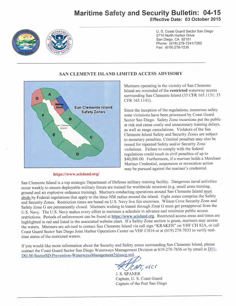
Mariners operating in the vicinity of San Clemente Island are reminded of the restricted waterway access surrounding San Clemente Island (33 CFR 165.1131; 33CFR 165.1141). Since the inception of the regulations, numerous safety zone violations have been processed by Coast Guard Sector San Diego. Safety Zone Incursions put the public at risk and cause costly and unnecessary training delays, as well as range cancellations. Violators of the San Clemente Island Safety and Security Zones are subject to monetary penalties. Criminal penalties may also be issued for repeated Safety and/or Security Zone violations. Failure to comply with the federal regulations could result in civil penalties of up to $40,000.00. Furthermore, if a mariner holds a Merchant MarinerCredential, suspension or revocation action may be pursued against the mariner's credential. For more details see MSSB 04-15 SCI Safety Zone.pdf in the enclosure section.
CORONADO BRIDGE- Scaffolding installed at spans 13-14, 15-17, and 18-19, west of the west main navigational channel, has reduced the verticalclearance by not more than 8ft and is lighted at night with red lights. RACON "T" (LLNR 1859) has been removed from the West Navigational Channel Span and temporarily not in service until 08 Dec 16. For more details or comments contact the Coast Guard Project Manager at 510-437-3461.
Manson Construction Co. will conduct marine construction and dredging in vicinity of San Diego Pier 1 at 32-41-30N 117-08-44W until 15 Nov 16. The disposal site will be at LA-5 Disposal site. Derrick barge VALHALLA, VALKYRIE; along with tug JEFFREY M and scow Rockport, Freeport, and Gulfport will be on site monitoring VHF-FM Chan. 13 and 65. Mariners are requested to transit the area with caution and minimize wake in the vicinity of the dredge site. For more details or comments contact Project Manager Eric Faria at 562-762-5396.
NORTH COUNTY TRANSIT DISTRICT RAILROAD BRIDGE- Work has begun to replace the existing railroad bridge. A temporary bridge has been erected alongside the existing bridge to facilitate construction of the replacement bridge. For more details or comments contact the Coast Guard Project Manager at 510-437-3515.
The U.S. Navy Undersea Rescue Command (URC) will be conducting diving operations until 30 Sep 16 at the following positions: 32-23-27N 118-20-01W 32-41-01N 117-16-24W 32-51-57N 117-26-36W 32-35-00N 117-19-30W The HOS DOMINATOR will be on scene monitoring VHF-FM Chan.16. Mariners are requested to transit the area with caution and directed to maintain a minimum safe distance of 1nm from the dive site, due to risk of entanglement. For more details or comments contact LT Charles Kreuzberger at 619-545-9188.
LNM:
LNM:
LNM:
LNM:
LNM:
LNM:
LNM:
23/16
10/15
22/16
39/15
21/14
07/16
31/15
PORT HUENEME-ATMOSPHERIC SURVEY
PORTS OF LOS ANGELES/LONG BEACH-CERRITOS CHANNEL-BRIDGE
SACRAMENTO RIVER-REDUCED VERTICAL CLEARANCE
SAN CLEMENTE ISLAND-SAFETY ZONES
SAN DIEGO BAY-BRIDGE
SAN DIEGO BAY-PIER 1-MARINE CONSTRUCTION
SAN DIEGO-DEL MAR-LOS PEÑASQUITOS LAGOON-BRIDGE
SAN DIEGO-DIVING OPERATIONS
Chart
Chart
Chart
Chart
Chart
Chart
Charts:
18724
18749
18660
18762
18772 18773
18751
18765

14 September 201637/16LNM:
11Coast Guard DistrictPage 11 of 16
Thunderboats Unlimited, Inc is sponsoring the San Diego Bayfair 2016 event involving 200 participants racing powerboats in Mission Bay from 0700-1800 on 16-18 Sep 16. A special local regulation has been established encompassing the navigable waters of Mission Bay to include Fiesta Island, the east side of Vacation Isle, and Crown Point Shores. Mariners will be prohibited from transiting through the special local regulation area during this period. For more details or comments contact Mr. Bob Davies at 619-572-6274.
MCCS-Semper Fit is sponsoring the Water Warrior Event at Oceanside Harbor from 0600-2000 on 16-17 Sep 16. All different types of racing consists of paddleboards, surf skis, and swimming. Mariners are requested to transit the area with caution and share the waterway with event participants. For more details or comments contact Jimi Shive at 760-725-6289.
Manson Construction Co. will conduct marine construction and dredging at BAE Systems San Diego Pier 1 North Dry Dock and South Bay Mitigation Site until 15 Oct 16. Derrick barge VALHALLA, VALKYRIE; along with tug JEFFREY M; scows ROCKPORT, EASTPORT, GULFPORT and survey vessel BAYOU BENGAL will be on site monitoring VHF-FM Chan. 13, 16, and 65. Mariners are requested to transit the area with caution and minimize wakein the vicinity of the dredge site. For more details or comments contact Project Manager Brad Hunter at 562-762-5241.
Dutra Construction Company will be conducting dredging operations around various piers of the Naval Base San Diego, 24 hours a day, 7 days a week until April 2017. Dredged material will be disposed of at offshore LA5 disposal site. The dredge barge MORTY and tug TERRI L will be on site monitoring VHF/FM Chan. 12, 16, and 82. Mariners are requested to transit the area with caution. For more details or comments contact Andrew Hunt at 415-847-6640.
Manson Construction Co. will conduct marine construction at the San Francisco Structure and Ferry Plaza Deck until 20 May 17. Derrick barge EINAR will be on scene monitoring VHF/FM Chan. 13, 16, and 68. Mariners are requested to transit the area with caution and minimize wake in the vicinity of the construction site. For more details or comments contact Project Manager Terry Hammerwold at 510-773-6963.
SAN MATEO-HAYWARD BRIDGE - Caltrans’ contractor, Liberty Maintenance, will be conducting maintenance during daylight hours, Monday through Saturday. A work platform will be installed below low steel of the bridge deck, from the western shore to the second pier west of the main channel span and from the 2nd pier east of the main channel span to the eastern start of the high rise, reducing vertical clearance in those spans by approximately 5 ft. The upstream and downstream low steel of the platform will be lighted at night with red lights placed every 75 ft. A 160ft X50ft equipment barge and a 110ft X 30ft service barge will be moored, via spuds, at various locations on the north side of the bridge, each corner lighted at night with red lights (See San Mateo Lighting Plan in the enclosure section). The main navigation span of the bridge will remain clear at this time. For details at the work site, mariners can contact Caltrans at 408-592-3785, or Liberty Maintenance at 330-272-4667, 516-369-8535, 330-509-4535, or 917-709-0742. For more details or comments contact the Coast Guard Project Manager at 510-437-3515.
RICHMOND-SAN RAFAEL BRIDGE - Caltrans will be conducting dive operations on various piers, including the main and auxilary navigation spans, from 0700-1530 on 10-14 Oct and 24-28 Oct 16. The dive vessel OFFICIAL BUSINESS is a 10ft X 33ft aluminum landing craft. The diver's breathinggas hose may be on or near the surface and there is heavy equipment on the vessel's deck. Mariners are requested to contact the vessel OFFICIAL BUSINESS on VHF/FM Chan. 16 or via cell at 916-343-6731, at least 30 minutes prior to transiting the bridge dive site. Mariners are requested to transit the area with caution. For further information, mariners can contact the Coast Guard Bridge Office at 510-437-3515.
Dutra will conduct continuous dredging operations in Clipper Yacht Harbor, Sausalito at 37-52-16N 122-29-46W until 30 Nov 16. Dredged material will be disposed of at the SF-10 and SF-11 disposal sites. The excavator dredge REN DRAG BARGE along with tugs SEA W and TERRI L. BRUSCO will monitor VHF-FM Chan. 13, 14, and 80. Mariners are requested to transit the area with caution. For more details or comments contact Operations Manager Dennis Salyers at 415-497-5289.
Deteriorating concrete pilings above and below the waterline are present in the vicinity of the the south edge of the Southampton Shoal Light (LLNR 5480). Mariners are advised to use caution when transiting this area. Direct any questions to LTJG Leslie Stenkamp at 510-437-3801 or [email protected].
LNM:
LNM:
LNM:
LNM:
LNM:
LNM:
LNM:
LNM:
LNM:
LNM:
33/16
35/16
34/16
12/16
34/16
32/16
11/16
37/16
34/16
23/15
SAN DIEGO-DIVING OPERATIONS
SAN DIEGO-MISSION BAY-MARINE EVENT
SAN DIEGO-OCEANSIDE HARBOR-MARINE EVENT
SAN DIEGO-PIER 1-MARINE CONSTRUCTION
SAN DIEGO-SAN DIEGO NAVAL BASE-DREDGING
SAN FRANCISCO BAY- MARINE CONTRUCTION
SAN FRANCISCO BAY-BRIDGE
SAN FRANCISCO BAY-BRIDGE
SAN FRANCISCO BAY-CLIPPER YACHT HARBOR-DREDGING
SAN FRANCISCO BAY-DETERIORATING CONCRETE PILINGS
Chart
Chart
Chart
Chart
Chart
Chart
Chart
Chart
Charts:
18772
18765
18773
18773
18649
18651
18649
18649
18649 18652
14 September 201637/16LNM:
11Coast Guard DistrictPage 12 of 16
Hornblower Cruises will sponsor a pyrotechnics event involving barge conducting a pyrotechnics display near Pier 9 in San Francisco at 37-48-15N 122-23-27W from 2100-2130 on 08 Oct 16. Mariners are requested to transit the area with caution. For more details or comments contact LTJG Christina Ramirez at 415-399-3585.
Bigge Crane and Rigging will sponsor a pyrotechnics event involving 1 barge conducting a pyrotechnics display near Pt Potrero Turn in the Richmond Inner Harbor at 37-54-23N 122-21-37W from 2130-2200 on 08 Oct 16. Mariners are requested to transit the area with caution. For more details or comments contact LTJG Christina Ramirez at 415-399-3585.
Mare Island Drydock LLC. will conduct maintenance dredging at Mare Island Shipyard at 38-05-49N 122-15-54W until 15 Oct 16. Vessels will be transporting material north on the Napa River to the Dutchman Slough. Dredge barge SONNIE DELIGHT, barge GRETA JEAN; along with tugs TRIG LIND and SHELLEY LIND will be on site monitoring VHF/FM Chan. 11. Mariners are requested to transit the area with caution. For more details or comments contact Kevin Tweed of Bay Marine Services at 415-798-0007.
Shoaling has been reported on the south side of the Oakland Inner Harbor South Channel in the east passage through the Fruitvale Ave. Bridge. Mariners are requested to transit the area with caution and report any observed changes in shoaling conditions to the San Francisco VTS on VHF-FM Chan. 14. For more details or comments contact U.S. Coast Guard Sector San Francisco Waterways Management at 415-399-7443.
Dutra Construction Company will be conducting continuous dredging operations in Oakland Inner and Outer Harbor Channels until 30 Nov 16. Dredged material will be disposed of at the Montezuma Wetlands Restoration Site. Clamshell dredge DB 24 along with tugs SARAH REED, ARTHUR BRUSCO, HEIDI L. BRUSCO and BECKY T will be on site monitoring VHF-FM Chan. 13, 14, and 82. Mariners are requested to transit the area with caution. For more details or comments contact Dredge Operations Manager Dennis Salyers at 415-497-5289.
A sunken 56ft vessel has been reported in the vicinity of 5th Ave. Marina, Oakland at 37-47-18.91N 122-15-51.60W. Approximately 2ft to 4ft of the vessel’s mast is out of the water and also marked by a quick flashing green light. Mariners are requested to transit the area with caution.
Salt River Construction will conduct dredging operations in the Paradise Cay Homeowners Channel at 37-54-53N 122-28-32W until 30 Nov 16. The dredge/dump barges DB1 and DB2, along with tug IRENE LAURITZEN will monitor VHF-FM Chan. 13, 14, and 77. Mariners are requested to transit the area with caution. For more details or comments contact Rick Moseley at 415-435-1024.
Shoaling has been reported extending from the south side of the North Jetty at the entrance to San Francisco Marina. An unlighted white buoy has been established at 37-48-30N 122-26-23W in 9ft of water to mark the shifting shoal. The northern entrance is subject to rapid shoaling and should be avoided due to unknown depths. It is recommended that vessels transiting the marina enter and exit from the south side of the floating wave attenuator. Mariners are requested to transit the area with caution. For more details or comments contact Lawrence O'Donnel at 415-831-6322.
Tiburon Volunteer Fire Department will sponsor a pyrotechnics event involving 1 barge conducting a pyrotechnics display near Tiburon in the San Francisco Bay at 37-52-10N 122-27-03W from 2030-2115 on 30 Sep 16. Mariners are requested to transit the area with caution. For more details or comments contact LTJG Christina Ramirez at 415-399-3585.
The USGS Pacific Coastal and Marine Science Center (PCMSC) will be conducting geophysical surveys in Ocean Beach until 10 Mar 17. The survey area is bounded by the following coordinates: 37-46-36N 122-31-47W 37-42-35N 122-31-47W 37-46-36N 122-30-11W 37-42-35N 122-30-11W Operations will include two vessels, CPS DUKE and CPS EDDIE, each equipped with a 200 kHz single beam echo sounder, that will be used to conduct cross shore transects from within the surf zone. CPS DUKE and CPS EDDIE will monitor VHF/FM Chan. 16 and 82a. Mariners are requestedto transit the area with caution. For more details or comments contact Jenny White at 831-460-7544.
LNM:
LNM:
LNM:
LNM:
LNM:
LNM:
LNM:
LNM:
LNM:
36/16
36/16
34/16
16/15
30/16
39/15
13/16
11/15
36/16
SAN FRANCISCO BAY-FIREWORKS DISPLAY
SAN FRANCISCO BAY-FIREWORKS DISPLAY
SAN FRANCISCO BAY-MARE ISLAND STRAIT-DREDGING
SAN FRANCISCO BAY-OAKLAND INNER HARBOR-SHOALING
SAN FRANCISCO BAY-OAKLAND-DREDGING
SAN FRANCISCO BAY-OAKLAND-SUNKEN VESSEL
SAN FRANCISCO BAY-PARADISE CAY HARBOR-DREDGING
SAN FRANCISCO BAY-SAN FRANCISCO MARINA-SHOALING
SAN FRANCISCO BAY-TIBURON-MARINE EVENT
SAN FRANCISCO-GEOPHYSICAL SURVEY
Chart
Chart
Chart
Chart
Chart
Chart
Chart
Chart
Chart
18650
18649
18655
18652
18649
18652
18653
18649
18649
14 September 201637/16LNM:
11Coast Guard DistrictPage 13 of 16
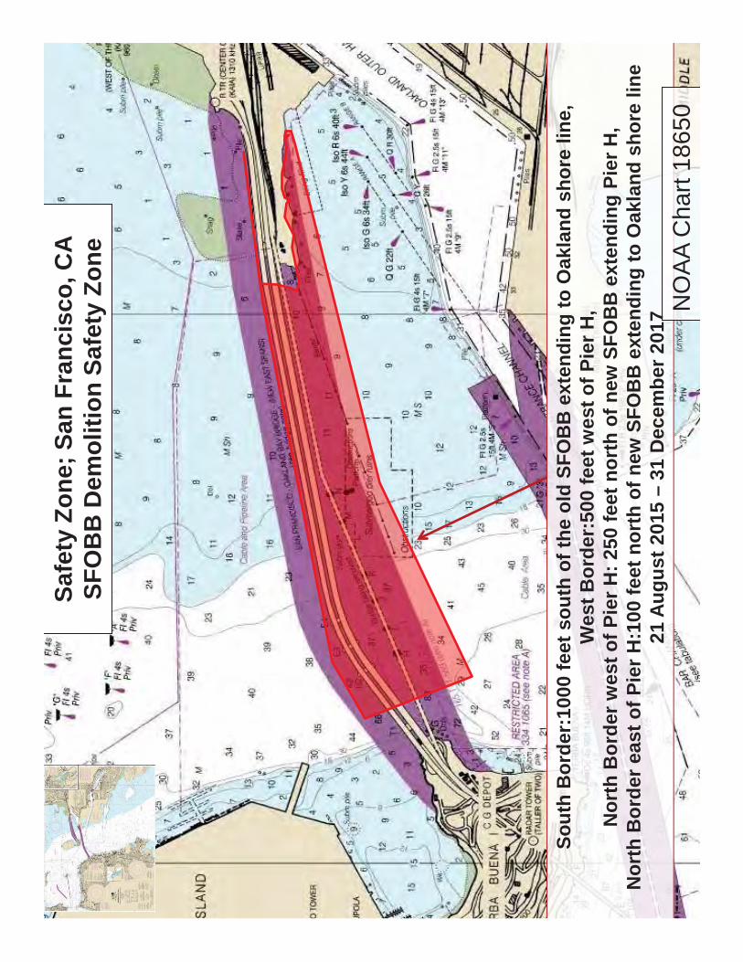
SAN FRANCISCO/OAKLAND BAY BRIDGE-EAST OF YBI -A Safety Zone has been established from 1000 feet west of pier "I" and extends east to the Oakland shoreline. (see 2015-2017_East_SFOBB_Safety Zone.pdf in enclosure section) This safety zone has been established to protect mariners from the dangers associated with removal operations of the SFOBB. All vessels passing through the bridge east of YBI should use the "G"- "H" span of the Replacement SFOBB Eastern Span until demolition of the replaced bridge is complete. Unauthorized persons or vessels will be prohibited from entering into, transiting through, or remaining in the safety zone without permission of the Captain of the Port or their designated representative.
Work is in progress in removing the spans between piers I-N, Typical in-water equipment to be utilized are two 250ft X 72ft X 15ft barges, two 99ft X 99ft crane barges, and a 133ft X 46ft material barge, spudded and anchored beneath the structure. Typical anchor lines will extend from each corner of the barges out 1500ft. Each corner of the anchored barges shall be lighted at night will an all-round red lights. Red lights will mark the upstream and downstream portion of the pier bases until their removal. (see Barge-504Removal.pdf in enclosure section)
The process of removing piers "I" and "j" is in progress. Typical in-water equipment to be utilized are a 140ft X 70ft anchored crane barge with 700ft anchor wires on the NW, NE, SW, and SE corners of the barges and a 200ft X 60ft spudded flat deck barge beside the crane barge. At night, each corner of each barge and each corner of each exposed pier will be lighted at night with steady burning all-round red lights. (See Pier-Barge_LightingPlan.pdf in the enclosure section)
For details at the work site, mariners may contact Caltrans at 650-222-7242 or the Contractor at 510-774-1204. For more details or comments contact the Coast Guard Project Manager at 510-437-3515.
There has a been a report of an unknown unlit yellow can buoy at 37-53-09N 122-24-09W 0.5nm northwest of Southampton Shoal Light. Mariners are requested to transit the area with caution and report any relevant observations regarding this buoy to D11 Private Aids to Navigation Manager at 510-437-2984.
Associated Pacific Constructors, Inc. will be installing fender piling and conducting dive operations under the pier at the US Coast Guard Pier in San Pedro, CA. A 120ftx 40ft barge will be alongside the pier at 33-43-41-51N 118-16-13-03W. The operation will start 0730-1700, Mon-Fri, from 19 Sep 16 through 30 Nov 16. Mariners are requested to transit the area with caution. For more details or comments please contact Jorge Tomas at 949-258-4410.
Dudek Inc. will be conducting dive operations and maintenance at Charles Myers Desalination Facility Offshore Intake Structure in Santa Barbara at 34-24-28N 119-40-46W until 17 Sep 16. See Santa Barbara-Desalination Intake Maintenance.pdf. in the enclosure section. M/V DANNY C, D.B. SAN DIEGO, A.N. TILLET, AND OUTRAGE will be monitoring VHF/FM Chan. 7, 16. Mariners are requested to transit the area with caution. For moredetails or comments contact John Davis at 805-252-7996 or [email protected].
The USGS Pacific Coastal and Marine Science Center (PCMSC) will be conducting a geophysical survey southeast of San Miguel Island and along thecoast of Santa Barbara to Point Conception until 01 Oct 16. Operations will include two vessels. R/V PARKE SNAVELY will use multibeam echo sounder and mini-sparker while the R/V SHEARWATER operations will include a mini-sparker and towed camera system. R/V PARKE SNAVELY and R/V SHEARWATER will moniter VHF/FM Chan. 13 and 16. Mariners are requested to transit the area with caution. For more details or comments contact Jenny White at 831-460-7485.
Scripps Institute of Oceanography will be conducting oceanographic operations in Santa Barbara until 20 Sep 16. The operation will include deployment and recovery of six sub-surface moorings. The operation area will be bound by the following coordinates: 34-18-00N 120-12-00W 34-18-00N 120-00-00W 34-12-00N 120-00-00W 34-12-00N 120-12-00WM/V SALLY RIDE will be restricted in ability to maneuver during operations and will be monitoring VHF/FM Chan. 13 and 16. Mariners are requested to transit the area with caution and maintain a safe distance of 1000yds. For more details or comments contact Captain Eric Buck at 858-534-5568.
Freeport McMoRan Oil and Gas will be conducting pipeline inspections off Point Conception (see Pt ConceptionPipeline Maintenance.pdf) from 22 Sep 16 through 03 Oct 16, 24 hours a day 7 days a week. The M/V ADELE ELISE will be site monitoring VHF/FM Chan. 16 and bridge phone 985-
LNM:
LNM:
LNM:
LNM:
LNM:
LNM:
LNM:
35/16
43/08
18/16
36/16
29/16
34/16
34/16
SAN FRANCISCO-GEOPHYSICAL SURVEY
SAN FRANCISCO-OAKLAND BAY BRIDGE (EAST OF YBI)
SAN PABLO BAY-OSTRUCTION TO NAVIGATION
SAN PEDRO-MARINE CONSTRUCTION
SANTA BARBARA-DESALINATION INTAKE STRUCTURE MAINTENANCE
SANTA BARBARA-GEOPHYSICAL SURVEY
SANTA BARBARA-OCEANOGRAPHIC OPERATIONS
SANTA BARBARA-POINT CONCEPTION-PIPELINE MIANTENANCE
Chart
Chart
Chart
Chart
Charts:
Charts:
Charts:
18645 18649
18650
18640
18749
18720 18721
18720 18721
18720

14 September 201637/16LNM:
11Coast Guard DistrictPage 14 of 16
532-1060. ROV VAN will be equipped with SAT Com System 337-769-0253. For more comments and details contact Jason Smith at 805-676-4330 or 805-205-3156.
The City of Santa Cruz will sponsor a pyrotechnics display from the Santa Cruz Main Beach in Santa Cruz, CA at 36-57-49N 122-00-54W from 2000-2045 on 01 Oct 16. Mariners are requested to transit the area with caution. For more details or comments contact LTJG Christina Ramirez at415-399-3585.
The USGS Pacific Coastal and Marine Science Center (PCMSC) will be conducting geophysical surveys at Santa Cruz to Moss landing until 21 Sep 16. The survey area is bounded by the following coordinates: 36-58-51N 122-02-28W 36-48-26N 122-02-28W 36-58-51N 122-47-15W 36-48-26N 122-47-15W Operations will include two vessels, CPS DUKE and CPS EDDIE, each equipped with a 200 kHz single beam echo sounder, that will be used to conduct cross shore transects from within the surf zone. CPS DUKE and CPS EDDIE will monitor VHF/FM Chan. 16 and 82a. Mariners are requestedto transit the area with caution. For more details or comments contact Daniel Hoover at 831-460-7544.
The harbormaster’s office in Santa Cruz has reported significant shoaling in the entrance to Santa Cruz due to recent weather events. Mariners are advised to exercise caution when operating in this area as actual water depths may vary from charted depths.
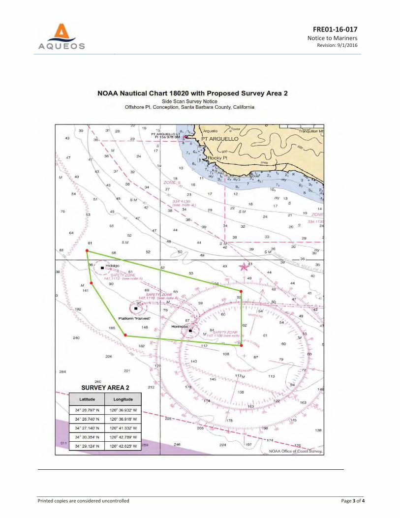
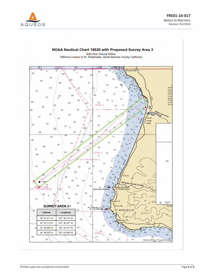
Fugro will be conducting a side scan sonar and fathometer survey off the coast of Santa Maria Basin, CA during daylight hours until 30 Sep 16 in an area bound by the following coordinates: Area 1 34-28-47N 120-36-55W 34-27-58N 120-36-54W 34-27-46N 120-28-31W 34-28-07N 120-28-32W Area 2 34-28-47N 120-36-55W 34-26- 44N 120-36-55W 34-27- 08N 120-41-19W 34-30- 21N 120-42-47W 34-29- 07N 120-42-37W Area 3 34-41-58N 120-36-12W 34-42-43N 120-36-20W 34-36-39N 120-44-12W 34-36-13N 120-43-49W
M/V CLEAN OCEAN will be towing up to 2000ft of cable, will have limited maneuverability during mapping operations and will be monitoring VHF/FM Chan.16. Mariners are requested to transit the area with caution. For more details or comments contact Jeff Carothers or Eddie Stutts at 805-650-7000.
LNM:
LNM:
LNM:
LNM:
LNM:
36/16
36/16
35/16
50/15
34/16
SECTION VIII - LIGHT LIST CORRECTIONSAn Asterisk *, indicates the column in which a correction has been made to new information
PUBLICATION CORRECTIONS
(1)No.
(2)Name and Location
(3)Position
(4)Characteristic
(5)Height
(6)Range
(7)Structure
(8)Remarks
SANTA BARBARA-POINT CONCEPTION-PIPELINE MIANTENANCE
SANTA CRUZ-FIREWORKS DISPLAY
SANTA CRUZ-GEOPHYSICAL SURVEY
SANTA CRUZ-SHOALING
SANTA MARIA BASIN-SURVEY OPERATIONS
3188 LOS ANGELES OUTER HARBOR LIGHT E
33-42-46.036N118-16-32.709W
NW on post.Fl W 2.5s
*
20 37/16
Chart
Chart
Chart
Chart
Chart
18020
18685
18680
18685
18020
4

14 September 201637/16LNM:
11Coast Guard DistrictPage 15 of 16
ENCLOSURESSANTA BARBARA-POINT CONCEPTION-PIPELINE MAINTENANCE
COLORADO RIVER-BRIDGE-TOPOCK PIPELINE (OLD ROUTE 66)
REPORT OF DELAY AT DRAWBRIDGE
DELTA & RIVERS-DISCOVERY BAY-WERNER DREDGER CUT-BRIDGE
SAN CLEMENTE ISLAND SAFETY ZONE
PORTS OF LOS ANGELES/LONG BEACH-CERRITOS CHANNEL-BRIDGE
MARINE SAFETY INFORMATION BULLETION
SAN FRANCISCO-OAKLAND BAY BRIDGE (EAST OF YBI)
SAN FRANCISCO BAY-BRIDGE-SAN MATEO/HAYWARD BRIDGE
NEWPORT BAY-GRAND CANAL-BRIDGE
SAN FRANCISCO BAY-ENTRANCE TSS-SPEED REDUCTION
See link above.
See link above for safety net/containment lighting.
Use link above to Report a Delay at a Drawbridge.
See link above
See link above.
See link above
See link above.
See links above for safety zone, barge mooring and lighting diagrams.
See link above for barge and below deck lighting diagram.
See link above for safety zone.
36/16
35/16
06/07
25/15
39/15
45/11
47/15
04/16
11/16
13/16
LNM:
LNM:
LNM:
LNM:
LNM:
LNM:
LNM:
LNM:
LNM:
LNM:
Pt ConceptionPipeline Maintenance.pdf
Topock-Lighting.pdf
DelayRept0207.pdf
Orwood_Lighting_Diagram2.pdf
MSSB 04-15 SCI Safety Zone.pdf
Trestle_Lighting_Heim.pdf Pier_Removal_Plan_Drawing.pdf
MSIB 15-07.pdf
2015-2017_East_SFOBB_SafetyZone.pdf Barge_Lighting_504RemovalSFOBB.pdf Pier-Barge_LightingPlan.pdf
SanMateo_LightingPlan.pdf
SafetyZoneGrandCanal.pdf
2016 Speed Reduction Zone.pdf
None

14 September 201637/16LNM:
11Coast Guard DistrictPage 16 of 16
WHALE ADVISORY AND VESSEL SPEED REDUCTION ZONE
OAKLAND INNER HARBOR-LAKE MERRITT CHANNEL-BRIDGE
SANTA BARBARA-DESALINATION STRUCTURE MAINTENANCE
SOUTHERN CALIFORNIA-MARINE SAFETY INFORMATION BULLETIN
See link above.
See link above.
See Link Above.
See link above.
See link above.
17/16
26/16
20/16
29/16
09/10
LNM:
LNM:
LNM:
LNM:
LNM:
THE LOCAL NOTICE TO MARINERS IS AVAILABLE ON THE WORLD WIDE WEB AT WWW.NAVCEN.USCG.GOV/.
D. H. SulouffU.S. Coast Guard
Acting Chief Waterways Management Branch
SB Channel Speed Reduction Zone.pdf
Embarcadero_Flexi _Float_Lighting.pdf
Desalination intake maintenance.pdf
MSIB Voluntary Traffic Lane 11-09.pdf

FRE01-16-017 Notice to Mariners
Revision: 9/1/2016
Printed copies are considered uncontrolled Page 2 of 4
FRE01-16-017 Notice to Mariners
Revision: 9/1/2016
Printed copies are considered uncontrolled Page 3 of 4
FRE01-16-017 Notice to Mariners
Revision: 9/1/2016
Printed copies are considered uncontrolled Page 4 of 4
Ariz
ona
Cal
iforn
ia
Topo
ckPi
pelin
eB
ridge
(Old
Rou
te66
),m
ile23
3.70
,Col
orad
oR
iver
Ate
mpo
rary
safe
tyne
tand
debr
islin
ew
illbe
erec
ted
over
the
wat
erto
appr
oxim
atel
y15
0fe
eton
the
Cal
iforn
iasi
de,r
educ
ing
verti
calc
lear
ance
byap
prox
imat
ely
10fe
et.
The
botto
mof
the
safe
tyne
twill
belig
hted
atni
ghtw
ithst
eady
burn
ing
all-r
ound
red
light
s,vi
sibl
eat
2,00
0ya
rds
from
appr
oach
ing
vess
els.
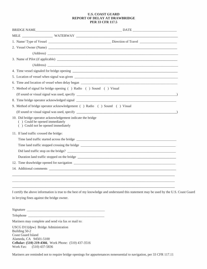
U.S. COAST GUARD REPORT OF DELAY AT DRAWBRIDGE
PER 33 CFR 117.5
BRIDGE NAME___________________________________________________ DATE __________________________
MILE __________________ WATERWAY ____________________________________________________________
1. Name/ Type of Vessel _____________________________________ Direction of Travel ______________________
2. Vessel Owner (Name) ____________________________________________________________________________
(Address) _____________________________________________________________________________
3. Name of Pilot (if applicable) _______________________________________________________________________
(Address) _____________________________________________________________________________
4. Time vessel signaled for bridge opening ______________________________________________________________
5. Location of vessel when signal was given _____________________________________________________________
6. Time and location of vessel when delay began _________________________________________________________
7. Method of signal for bridge opening ( ) Radio ( ) Sound ( ) Visual
(If sound or visual signal was used, specify ___________________________________________________________)
8. Time bridge operator acknowledged signal ___________________________________________________________
9. Method of bridge operator acknowledgement ( ) Radio ( ) Sound ( ) Visual
(If sound or visual signal was used, specify ___________________________________________________________)
10. Did bridge operator acknowledgement indicate the bridge ( ) Could be opened immediately ( ) Could not be opened immediately
11. If land traffic crossed the bridge:
Time land traffic started across the bridge ___________________________________________________________
Time land traffic stopped crossing the bridge ________________________________________________________
Did land traffic stop on the bridge? ________________________________________________________________
Duration land traffic stopped on the bridge __________________________________________________________
12. Time drawbridge opened for navigation ____________________________________________________________
14. Additional comments ___________________________________________________________________________
________________________________________________________________________________________________
________________________________________________________________________________________________
________________________________________________________________________________________________
I certify the above information is true to the best of my knowledge and understand this statement may be used by the U.S. Coast Guard
in levying fines against the bridge owner.
Signature ______________________________________________
Telephone _____________________________________________
Mariners may complete and send via fax or mail to:
USCG D11(dpw) Bridge Administration Building 50-2 Coast Guard Island Alameda, CA 94501-5100 Cellular: (510) 219-4366, Work Phone: (510) 437-3516 Work Fax: (510) 437-5836
Mariners are reminded not to require bridge openings for appurtenances nonessential to navigation, per 33 CFR 117.11

Orw
ood
Brid
geR
epla
cem
entP
roje
ctM
ile1.
5,W
erne
rCut
Tem
pora
ryTr
estle
and
Ligh
ting
Pla
n

Rep
lace
men
tSch
uyle
rH
eim
Bri
dge
Proj
ect
Tem
pora
ryL
ight
ing
Dia
gram
duri
ngC
onst
ruct
ion
The
tem
pora
rytre
stle
spro
vide
75fe
etof
horiz
onta
lcle
aran
cean
d48
.5fe
etof
verti
calc
lear
ance
from
Mea
nH
igh
Wat
erto
the
low
esth
ittab
lepo
rtion
ofth
ebr
idge
betw
een
the
trest
les.
The
upst
ream
and
dow
nstre
amtre
stle
sare
light
edat
nigh
twith
stea
dybu
rnin
gal
l-rou
ndre
dlig
hts.
The
cent
erof
the
navi
gatio
nsp
an,b
etw
een
pier
s14
and
15,i
smar
ked
atni
ghtw
ithal
l-rou
ndst
eady
burn
ing
gree
nlig
hts.
48.5
feet
Ver
tical
Cle
aran
ceat
MH
W
75fe
etH
oriz
onta
lC
lear
ance
betw
een
trest
les
EN
CL
OSU
RE
( )


Safe
ty Z
one;
San
Fra
ncis
co, C
ASF
OB
B D
emol
ition
Saf
ety
Zone
Sout
h B
orde
r:10
00 fe
et s
outh
of t
he o
ld S
FOB
B e
xten
ding
to O
akla
nd s
hore
line
, W
est B
orde
r:50
0 fe
et w
est o
f Pie
r H,
Nor
th B
orde
r wes
t of P
ier H
: 250
feet
nor
th o
f new
SFO
BB
ext
endi
ng P
ier H
,N
orth
Bor
der e
ast o
f Pie
r H:1
00 fe
et n
orth
of n
ew S
FOB
B e
xten
ding
to O
akla
nd s
hore
line
21 A
ugus
t 201
5–
31 D
ecem
ber 2
0177 N
OA
A C
hart
1865
0

Typi
calB
arge
Con
figur
atio
n-E
aste
rnS
pan
SFO
BB
,mile
8.9,
San
Fran
cisc
oB
ayTw
o25
0'X
72'b
arge
s,tw
o99
'X99
'cra
neba
rges
and
a13
3'X
46',
mat
eria
lbar
gew
illbe
anch
ored
and
spud
ded
unde
rnea
thsp
ans
"I"-"
J"(E
4-E
5),"
J"-"
K"(
E5-
E-6
),"K
"-"L
"(E
6-E
7),"
L"-"
M"(
E7-
E8)
,and
"M"-
"N"(
E8-
E9)
atva
rious
times
tofa
cilit
ate
rem
oval
ofth
esp
ans.
The
barg
esw
illbe
light
edat
nigh
twith
stea
dybu
rnin
gre
dlig
hts.
AC
oast
Gua
rdC
apta
inof
the
Por
tS
afet
yZo
neis
inef
fect
inth
isw
ork
area
.M
arin
ers
mus
trec
eive
perm
issi
onfro
mth
eC
OTP
toen
tert
heS
afet
yZo
ne.
Onc
eth
esp
ans
and
itsco
rres
pond
ing
tow
ers
are
rem
oved
,eac
hco
rner
ofth
eex
pose
din
-wat
erre
mai
ning
pier
sw
illbe
light
edat
nigh
twith
stea
dybu
rnin
gre
dlig
hts.

Typi
calB
arge
Con
figur
atio
n-E
aste
rnS
pan
SFO
BB
,mile
8.9,
San
Fran
cisc
oB
ay. .
Two
250'
X72
'bar
ges
and
two
99'X
99'c
rane
barg
esw
illbe
anch
ored
and
spud
ded
unde
rnea
thsp
ans
"I"-"
J"(E
4-E
5),
"J"-
"K"(
E5-
E-6
),"K
"-"L
"(E
6-E
7),"
L"-"
M"(
E7-
E8)
,and
"M"-
"N"(
E8-
E9)
atva
rious
times
tofa
cilit
ate
rem
oval
ofth
esp
ans.
The
barg
esw
illbe
light
edat
nigh
twith
stea
dybu
rnin
gre
dlig
hts.
AC
oast
Gua
rdC
apta
inof
the
Por
tSaf
ety
Zone
isin
effe
ctin
this
wor
kar
ea.
Mar
iner
sm
ustr
ecei
vepe
rmis
sion
from
the
CO
TPto
ente
rthe
Saf
ety
Zone
.O
nce
the
span
san
dits
corr
espo
ndin
gto
wer
sar
ere
mov
ed,e
ach
corn
erof
the
expo
sed
in-w
ater
rem
aini
ngpi
ers
will
belig
hted
atni
ghtw
ithst
ead y
burn
ing
red
light
s
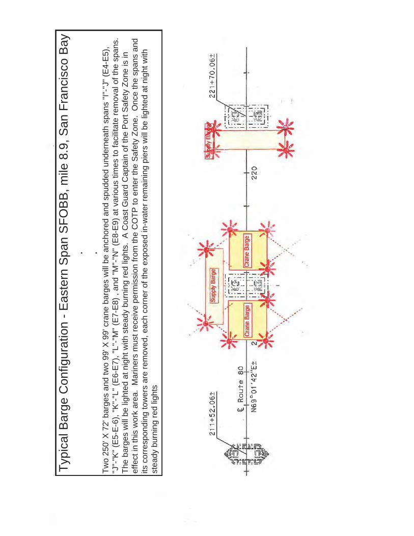
Typi
calB
arge
Con
figur
atio
n-E
aste
rnS
pan
SFO
BB
,mile
8.9,
San
Fran
cisc
oB
ay. .
Two
250'
X72
'bar
ges
and
two
99'X
99'c
rane
barg
esw
illbe
anch
ored
and
spud
ded
unde
rnea
thsp
ans
"I"-"
J"(E
4-E
5),
"J"-
"K"(
E5-
E-6
),"K
"-"L
"(E
6-E
7),"
L"-"
M"(
E7-
E8)
,and
"M"-
"N"(
E8-
E9)
atva
rious
times
tofa
cilit
ate
rem
oval
ofth
esp
ans.
The
barg
esw
illbe
light
edat
nigh
twith
stea
dybu
rnin
gre
dlig
hts.
AC
oast
Gua
rdC
apta
inof
the
Por
tSaf
ety
Zone
isin
effe
ctin
this
wor
kar
ea.
Mar
iner
sm
ustr
ecei
vepe
rmis
sion
from
the
CO
TPto
ente
rthe
Saf
ety
Zone
.O
nce
the
span
san
dits
corr
espo
ndin
gto
wer
sar
ere
mov
ed,e
ach
corn
erof
the
expo
sed
in-w
ater
rem
aini
ngpi
ers
will
belig
hted
atni
ghtw
ithst
eady
burn
ing
red
light
s

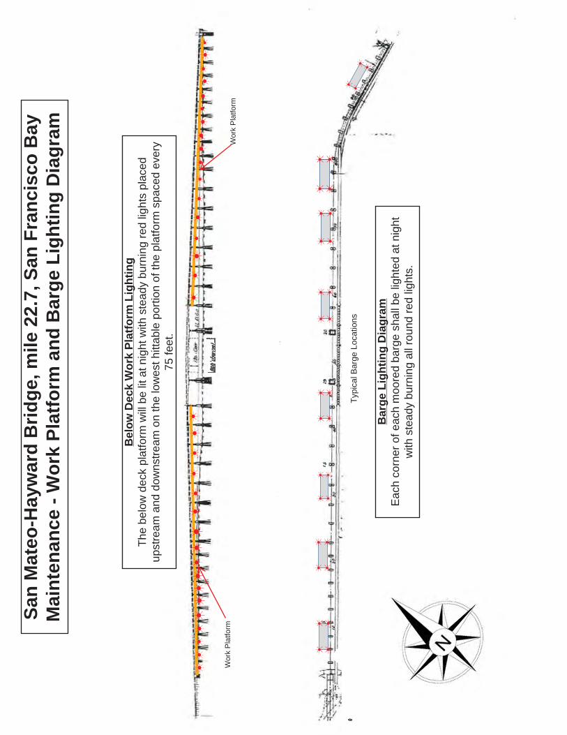
San
Mat
eo-H
ayw
ard
Brid
ge,m
ile22
.7,S
anFr
anci
sco
Bay
Mai
nten
ance
-Wor
kPl
atfo
rman
dB
arge
Ligh
ting
Dia
gram
Bel
owD
eck
Wor
kPl
atfo
rmLi
ghtin
gTh
ebe
low
deck
plat
form
will
belit
atni
ghtw
ithst
eady
burn
ing
red
light
spl
aced
upst
ream
and
dow
nstre
amon
the
low
esth
ittab
lepo
rtion
ofth
epl
atfo
rmsp
aced
ever
y75
feet
.
Bar
geLi
ghtin
gD
iagr
amE
ach
corn
erof
each
moo
red
barg
esh
allb
elig
hted
atni
ght
with
stea
dybu
rnin
gal
lrou
ndre
dlig
hts.
Wor
kP
latfo
rmW
ork
Pla
tform
Typi
calB
arge
Loca
tions

Nautical Charts & Pubs Surveys & Wrecks GIS & Other Products Research & DevelopmentCustomer Service Business Opportunities Education
HOME | ABOUT US | CONTACT | REGIONAL MANAGERS
Chart 18754 Chart 18754 Page 1 of 2
Monday, March 28, 20161
Safety ZoneGrand Canal, Newport Beach
The Captain of the Port has established a temporary safety zone (area highlighted in red below)in support of navigation safety during the Park Ave Bridge Replacement at Newport BeachGrand Canal on Balboa Island from 04 Apr 2016 through 31 Jan 2017..Persons and vessels are prohibited from entering into, departing from, transiting through, oranchoring within the designated area unless authorized by the Captain of the Port Los Angeles-Long Beach or her designated representatives.
Safety Zone
.


RED
UC
EDSP
EED
10K
NO
TS
WH
ALE
AD
VISO
RY Z
ON
E
34° 1
6.43
3' N
120°
00.
833'
W
34° 1
1.23
6' N
120°
02.
147'
W34
° 07.
125'
N11
9° 4
3.13
0' W
34° 1
1.92
2' N
119°
41.
988'
W
33° 2
7.6'
N12
0° 3
9' W
34° 3
4.62
' N12
0° 3
9' W
33° 2
7.6'
N11
7° 4
2.36
' W
Pt. A
rgue
llo Pt. C
once
ptio
n
Dan
a Pt
.R
educ
edS
peed
Zone
Wha
le A
dvis
ory
Zone
010
205
Nau
tical
Mile
s
ÜC
oord
inat
es re
porte
d in
dec
imal
min
utes
.C
hart
not f
or n
avig
atio
nal p
urpo
ses.
NO
AA
Cha
rts 1
8720
and
187
409
JUN
E 20
16
WH
ALE
AD
VISO
RY Z
ON
E A
ND
VO
LUN
TARY
VES
SEL
SPEE
D R
EDU
CTI
ON
ZO
NE
TO R
EDU
CE
IMPA
CT
OF
SHIP
STR
IKES
ON
WH
ALE
S
Vess
els
tran
sitin
g th
e ar
ea b
etw
een
Poin
t Arg
uello
and
Dan
a Po
int,
incl
udin
g th
e Tr
affic
Sep
arat
ion
Sche
mes
in th
e Sa
nta
Bar
bara
Cha
nnel
and
San
Ped
ro C
hann
el, f
rom
Jun
e th
roug
h N
ovem
ber,
shou
ld e
xerc
ise
caut
ion
and
redu
ce s
peed
. The
se a
reas
con
tain
popu
latio
ns o
f end
ange
red
blue
, hum
pbac
k an
d fin
wha
les
that
are
fede
rally
pro
tect
ed u
nder
the
Fede
ral E
ndan
gere
d Sp
ecie
sA
ct (1
6 U
.S.C
. 153
8 et
seq
.), th
e M
arin
e M
amm
al P
rote
ctio
n A
ct (1
6 U
.S.C
. 136
1 et
seq
.), a
nd th
e N
atio
nal M
arin
e Sa
nctu
arie
sA
ct (1
6 U
.S.C
. 143
1 et
seq
.).
NO
AA
stro
ngly
reco
mm
ends
that
ves
sels
300
gro
ss re
gist
ered
tons
or l
arge
r tra
nsiti
ng th
e Sa
nta
Bar
bara
Cha
nnel
Traf
fic S
epar
atio
n Sc
hem
e be
twee
n C
arrin
gton
Poi
nt, S
anta
Ros
a Is
land
and
Dia
blo
Poin
t, Sa
nta
Cru
z Is
land
, do
soat
spe
eds
not i
n ex
cess
of 1
0 kt
s du
e to
end
ange
red
wha
les
in th
e ar
ea. P
leas
e re
port
any
col
lisio
ns w
ith w
hale
s or
any
obse
rved
inju
red
or d
ead
wha
les
to N
OA
A at
877
-SO
S-W
HA
LE (8
77-7
67-9
425)
or t
o th
e U
.S. C
oast
Gua
rd o
nVH
F C
hann
el 1
6.
NO
AA
is a
skin
g fo
r the
pub
lic’s
hel
p in
trac
king
wha
les.
If y
ou s
ee w
hale
s, p
leas
e re
cord
the
date
and
loca
tion,
the
num
ber o
f wha
les,
the
spec
ies
(if k
now
n) a
nd a
des
crip
tion
of th
e an
imal
s. P
leas
e em
ail w
hale
s@no
aa.g
ov.
You
can
also
repo
rt w
hale
s th
roug
h W
hale
Ale
rt, a
free
app
licat
ion
avai
labl
e at
http
://w
estc
oast
.wha
leal
ert.o
rg. F
or m
ore
deta
ils p
leas
e co
ntac
t Sea
nH
astin
gs a
t sea
n.ha
stin
gs@
noaa
.gov
.

RE
FER
EN
CE
SU
BM
ITTA
L 02
7-00
1-00
3 S
TAG
ING
LA
YO
UT
Loca
tion
ofFl
exi
Floa
tsdu
ring
span
6de
mol
ition
.
Em
barc
ader
oR
oad
Brid
geR
epla
cem
entP
roje
ct,M
ile0.
17,L
ake
Mer
rittC
hann
elTy
pica
lFle
xi-F
loat
Bar
geLi
ghtin
g
City
ofO
akla
ndC
ontra
ctor
inte
nds
tous
e3
to4,
3fo
otX
7.5
foot
X30
foot
,fle
xi-fl
oatb
arge
sdu
ring
the
dem
oliti
onof
the
east
ern
pier
ofth
eex
istin
gE
mba
rcad
ero
Rd
Brid
ge.
The
dow
nstre
amco
rner
sof
each
flexi
-floa
tbar
gesh
all
belig
hted
atni
ghtw
ithst
eady
all-r
ound
red
light
s.


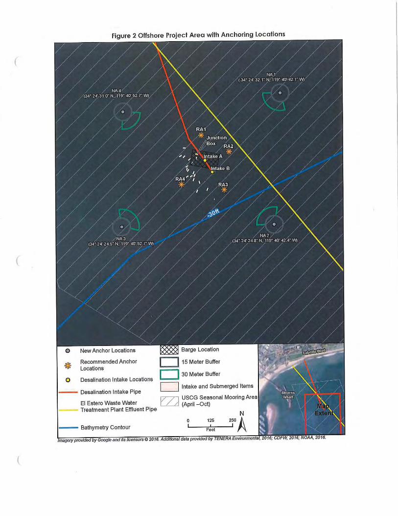

Los Angeles / Long Beach Harbor Safety Committee Voluntary Western Traffic Lanes
th
traffic lanes for vessels approaching and departing the Ports of Los ngeles and Long Beach.
llision
iners, who have traditionally used this approved TSS, are ncouraged to continue to do so.
Voluntary Western Traffic Lanes
traffic
vessel safety. The Coast Guard is taking eparate action to study the increased traffic in this area.
he LA/LB SC secretary at http://www.mxsocal.org/Blogs/24/Voluntary-Routing-Zones.aspx
U. S. Coast Guard Sector Los Angeles – Long Beach
MARINE SAFETY INFORMATION BULLETIN 11-09
There has been a recent trend in traffic patterns where some vessel operators are choosing to departthe Traffic Separation Scheme (TSS) established in the Santa Barbara Channel and transit through an area to the south of San Miguel, Santa Rosa and Santa Cruz Islands (referenced herein as “souof the Channel Islands”). As such, the Los Angeles / Long Beach Harbor Safety Committee has published voluntary westernA
Mariners transiting through the western and northern approaches to and from the Ports of Los Angeles and Long Beach (LA/LB) are advised the established TSS through the Santa Barbara Channel as shown on NOAA and Admiralty charts is the only International Maritime Organization (IMO) approved routing measure in this area. An IMO approved TSS reduces the risk of coby providing for the separation of arriving and departing traffic and minimizing potentially hazardous crossing situations. Mare
To address the safety concerns created by increased traffic south of the Channel Islands, on October 6, 2009, the Los Angeles/Long Beach Harbor Safety Committee (LA/LB HSC) endorsed voluntary traffic lanes in the area south of the Channel Islands (referenced herein as “voluntary westernlanes.”). The new voluntary western traffic lanes are not approved by the IMO, nor are theyapproved by any U.S. federal authority, including the U.S. Coast Guard. The LA/LB HSC developed theses lanes as a voluntary measure to promote s
The geographical coordinates for the voluntary western traffic lanes are published by tH .
Pacific Missile Test Range, Point Magu

Departing the IMO approved TSS and transiting south of the Channel Islands may result in delays and diversions, as this transit will take vessels through the Pacific Missile Test Range, Point MuguCalifornia. The U.S. Navy advises that hazardous operations may take place within the test range. The test range extends for 180 miles in a South West direction from P
,
oint Mugu and is up 210 miles wide. The specific hazardous areas within the range are broadcast by the Navy daily
lyt
or 16, or at (805) 89-8841/8843 from 0600-1800, and at (805) 816-0792 after 1800. If you are unable to contact
he Navy requests all vessels transiting the range to submit a notification to PLEAD CONTROL indicating the vessel name, destination, and estimated time of entry into, and departure from, the test range. Notifications can be faxed to (805) 989-0102.
annel, both
me are listed as endangered species. Please report any collisions with whales or ny observed live, injured, or dead whales, including time and position, to the National
Oceanographic and Atmospheric Administration (NOAA) at 877-SOS-WHALE (877-767-9425) or the Coast Guard.
not be aware of the new voluntary western traffic lanes or at ship traffic has recently increased in this area. Since the new voluntary western traffic lanes are
not an IMO approved traffic separation scheme, the International Regulations for Avoiding Collisions at Sea (COLREGS) Rule 10 does not apply.
Questions
Questions relating to the voluntary western traffic lanes should be directed to the LA/LB HSC Secretary at (310) 832-6411.
toMonday through Friday at 0900 and 1200 on 2638 kHz and 2738 kHz. When notified by the Navy, the Coast Guard also broadcasts this information on VHF-FM channel 16.
When transiting south of the Channel Islands (inbound or outbound to the Ports of Los Angeles and Long Beach), all mariners should communicate with Navy PLEAD CONTROL in a timely mannerso that early decisions can be made regarding safe routing. Every effort should be made to compfully with any instructions received from the Navy. For information regarding the status of currenhazardous operations contact “PLEAD CONTROL” on VHF Marine channel 119“PLEAD CONTROL”, contact “SAN PEDRO TRAFFIC” on VHF-FM channel 14 or (310) 832 6411 for the most recent information regarding hazardous military operations.
T
Whales
Mariners are further reminded that large whales, including Blue, Grey, Humpback, and Fin whales,as well as other marine mammals, have been sighted in and around the Santa Barbara Chwithin the TSS as well as to the south of the Channel Islands. These whales are all protected under federal law and soa
Recreational and Fishing Vessels
The area to the south of the Channel Islands is also used by both commercial fishing vessels and recreational vessels, whose operators mayth
2