u.s. department of the interior hawaiian volcano
TRANSCRIPT

U.S. DEPARTMENT OF THE INTERIOR U.S. GEOLOGICAL SURVEY
HAWAIIAN VOLCANO OBSERVATORYSUMMARY 93, PART III
ELECTRONIC TILT DATA, JANUARY TO DECEMBER 1993
BYGARY S. PUNIWAI ALLAN J. LARGO
U.S. GEOLOGICAL SURVEYHAWAIIAN VOLCANO OBSERVATORY
HAWAII VOLCANOES NATIONAL PARK, HAWAII 96718
Open-File Report 95-268
This report is preliminary and has not been reviewed for conformity with U.S. Geological Survey editorial standards or with the North American Stratigraphic Code. Any use of trade, product, or firm names is for descriptive purposes only and does not imply endorsement by the U.S. Government.
1995

1993 HAWAIIAN VOLCANO OBSERVATORY STAFF
DAVID A. CLAGUE (SCIENTIST-IN-CHARGE) ARNOLD T. OKAMURA (DEPUTY S-I-C)
GEOLOGY
C. CHRISTINA HELIKER TARI N. MATTOX MARGARET T. MANGAN
GEOPHYSICS
JAMES P. KAUAHIKAUA GARY S. PUNIWAI
SEISMOLOGY
JENNIFER S. NAKATA PAUL G. OKUBO ALVIN H. TOMORI
DEFORMATION
ROGER P. DENLINGER ASTA MIKLIUS MAURICE K. SAKO
GEOCHEMISTRY
TAMAR ELIAS ANDREW J.SUTTON+
ELECTRONICS
RENEE L. ELLORDA KENNETH T. HONMA ALLAN J. LARGO
COMPUTER/SEISMOLOGY
WILFRED R. TANIGAWA
CARTOGRAPHY
SANDRA C. MARGRITER
SCIENTIST EMERITUS
DALLAS B. JACKSON ROBERT Y. KOYANAGI
LIBRARY/PHOTO ARCHIVE
T. JANE TAKAHASHI
ADMINISTRATION
PAULINE N. FUKUNAGA MARIAN M. KAGIMOTO IRENE S. TENGAN
AFFILIATED USGS PROJECTS
JOHN LOCKWOOD-GEOLOGic HISTORY OF KAUNALOA VOLCANO
FRANK TRUSDELL
CONTRACTS-SEISMIC RECORD CHANGING
GLADYS FORBES+
+ Arrived during 1993 * Left during 1993

TABLE OF CONTENTS
Prnre Introduction .................. 1Instrumentation 1 Data Collection & Processing ............ 3Station Information and Discussion 3 Event of January 24, 1993 ................. 15Event of February 7, 1993 15 Conclusions ........................ 17Bibliography 17 Appendix I. Tilt Vector Plots .............. 17Appendix II. Maintenance Log 29
LIST OF ILLUSTRATIONS
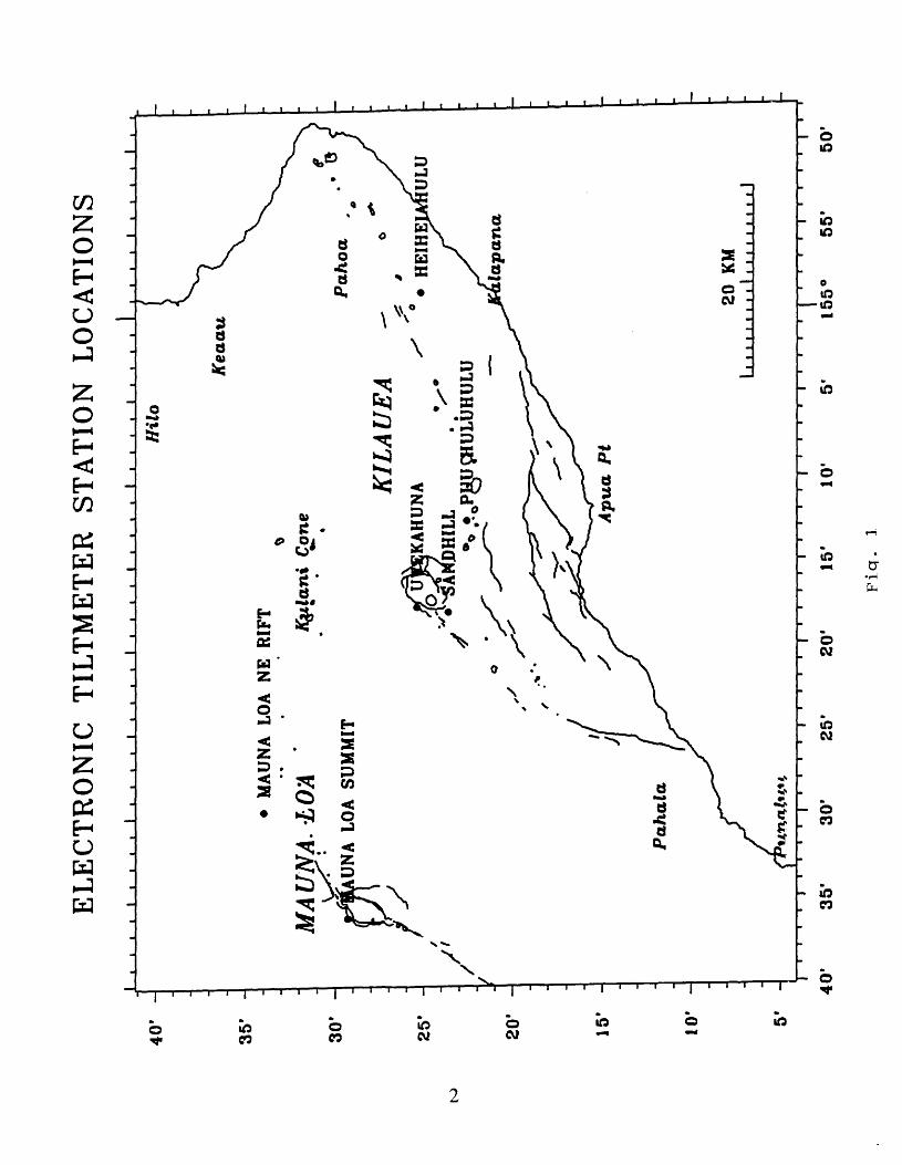
1. Electronic Tiltmeter Station Locations ........ 2
TIME-SERIES PLOTS FOR THE YEAR 1993
2. Uwekahuna East-West Components ............ 53. Uwekahuna North-South Components 64. Uwekahuna Rainfall .................. 75. Sandhill 96. Pu'u Huluhulu ................... 117. Heiheiahulu 138. Mauna Loa Summit .................. 149. Mauna Loa Northeast Rift 16
JANUARY 24 EVENT, TIME-SERIES PLOT
10. Kilauea Summit Tiltmeters ............. 18
FEBRUARY 7 EVENT, TIME SERIES PLOTS
11. Kilauea Summit Tiltmeters ............. 1912. Kilauea East Rift Tiltmeters 20
ELECTRONIC TILT VECTORS
13. Kilauea Summit and East Rift, Jan. 1 to Feb. 6 ... 2114. Kilauea Summit and East Rift, Feb. 7 and Feb. 8 2215. Pu'u Huluhulu, Feb. 7 and 8 ............ 2316. Kilauea Summit and East Rift, Feb. 8 to June 1 2417. Kilauea Summit and East Rift, June 1 to Oct. 1 ... 2518. Kilauea Summit and East Rift, Oct.l to Dec. 31 2619. Mauna Loa, Jan. 1 to July 1 ............ 2720. Mauna Loa, July 1 to Dec. 31 28

INTRODUCTION
Electronic tilt monitoring is one of the methods used by the Hawaiian Volcano Observatory (HVO) to measure ground deformation on the island of Hawaii. The station locations are depicted in Figure 1. It is the only method employed by HVO at present to monitor ground deformation in real time. This report will also include the rainfall record and the watertube tilt data at Uwekahuna, which have a bearing on some of the events detected or measured by the electronic tiltmeters.
IJSTS TRUMEJSTTATI ON
There are two basic styles of electronic tiltmeters used by HVO borehole and platform models. The borehole tiltmeters used at HVO consist of an electrolytic bubble sensor mounted at the bottom end of a buried, vertically oriented pipe about 1 meter long. The HVO does not currently have any borehole tiltmeters of the pendulum type. The platform tiltmeters consists of a sensor mounted en a rectangular or triangular-shaped platform designed for surface (floor) mounting.
A detailed description of each type of electronic tiltmeter used at HVO follows under the manufacturer's heading.
ROCKWELL AUTONETICS AND KINEMETRICS
These borehole tiltmeters were originally built by Rockwell Autonetics, then, subsequently, by Kinemetrics, Inc. These tiltmeters have a single sensor with four electrodes mounted orthogonally, forming a dual axis sensor. The sensor contains a conductive fluid with a small air bubble to indicate the vertical pole. The electrodes indicate the position of the bubble, and, hence any change in tilt. The sensor is mounted at the bottom end of a buried, vertically oriented, meter long pipe. HVO had six of this type of meters operating at the beginning of 1993.
WESTPHAL
This platform tiltmeter was built by J. A. Westphal of Caltech in 1984 (Westphal, 1983). It utilizes two single-axis electrolytic bubble transducers mounted orthogonally, forming a dual axis instrument. Each bubble contains conductive fluid, two opposing electrodes, and a small air bubble to indicate the vertical pole. The bubbles are mounted in holders fastened on an 20.3 cm. square invar plate. HVO currently operates one of this type of instrument.
IDEAL AEROSMITH
This platform tiltmeter is built by the Ideal Aerosmith Corporation. This single-axis tiltmeter utilizes two interconnected cisterns spaced a meter apart filled with mercury.
EL
EC
TR
ON
IC
TIL
TM
ET
ER
ST
AT
ION
L
OC
AT
ION
Si
I i
i i
i I
i i
i i
I i
i i
i I
i i
i i
i i
i t
I i
i i
i I
i t
i i
I i
i i
iI
.
KIL
A U
FA
UTC
KA
HU
NA
20
KMi 1
11 1
11 i
i 11
i 1
40
' -
Hil
o
35'
30
'
M
AU
NA
LO
A
NE
RIF
T
MA
UN
A.-L
OA
'
LOA
SU
MM
IT
ffyi
lan
i C
one
25'
-
20'
-
15'
-
10*
40
'
Fiq
. 1

The mercury and the cistern cover act as capacitance plates with an air gap for a dielectric. The capacitance is measured thru a wein bridge and converted to a voltage output calibrated in microradians. HVO operates one of this type of instrument.
DATA COLLECTION & PROCESSING
All tiltmeters present their output signals expressed cs a voltage. These voltage signals are collected by the HVO Polling Telemetry System for Low Frequency Data Acquisition (Puniwai, 1990) every 10 minutes. The polling system converts the voltage into digital form, collects the information in the central polling computer, and then passes the data to the HVO minicomputers for storage, retrieval and analysis.
The central polling computer failed in late July, and was back online in early August. HVO switched from Vax 11-750 minicomputers to microVax computers in mid September. These two events caused the data loss evident in the electronic tilt time-series p]ots covering those time periods.
The tilt information is stored as 12-bit data values (0 to 4096 bits), converted back to voltage (2.44 mv/bit), translated into microradians (per tiltmeter calibration values), then plotted. All the time-series plots presented in this paper have been produced with BOB, an interactive program for accessing, processing, and displaying time-series data (Murray, 1986). Both the year long data plots and the event plots have been cleaned (noise spikes removed/earthquake and instrumental offsets removed).
The station location and vector plots were produced with QFLOT (Klein, 1980). The data for the vector plots were taken from the BOB data files for the corresponding period.
STATION INFORMATION & DISCUSSION
1. DWEV (Uwekahuna) Latitude 19.4239° Longitude 155.2839o
The UWEV station (labelled "UWEKAHUNA" in the data plots) is located in the Uwekahuna Vault operated by the HVO at Kilauea's summit. This station is used to monitor Kilauea's summit magma chamber. The vault was constructed in 1948. The single-wall, concrete vault is located 360 m west of the Hawaiian Volcano Observatory. It is 6 m long, 3.6 m wide, with a 2.4-m-high ceiling. The vault is divided into three rooms: two, small entrance chambers and a large instrument room. The instrument r^om is supplied with 120 VAC uninterruptible power, is dehumidified, and has less than 0.5°C daily temperature variation. The vault has approximately .5 m of ash overburden, and rests on bedrock.
INSTRUMENTATION
Three independent tilt instruments are housed within the
3
vault: an Ideal Aerosmith tiltraeter, a Westphal tiltraeter, and a watertube tiltmeter.
The Ideal Aerosmith tiltmeter (model no. DCTM-31, serial no. 10567) is an electronic, single-axis instrument and is aligned F-W. It was installed in 1968 and has been operating since then, with occasional down time for repairs and calibration. The instruir^nt is relatively insensitive to small temperature fluctuations.
The Westphal tiltmeter (model WTM-1), an electronic, biaxial instrument, was installed in 1984. It has been operating since that time with occasional down time for repairs and calibration. The instrument is relatively insensitive to daily temperature fluctuation.
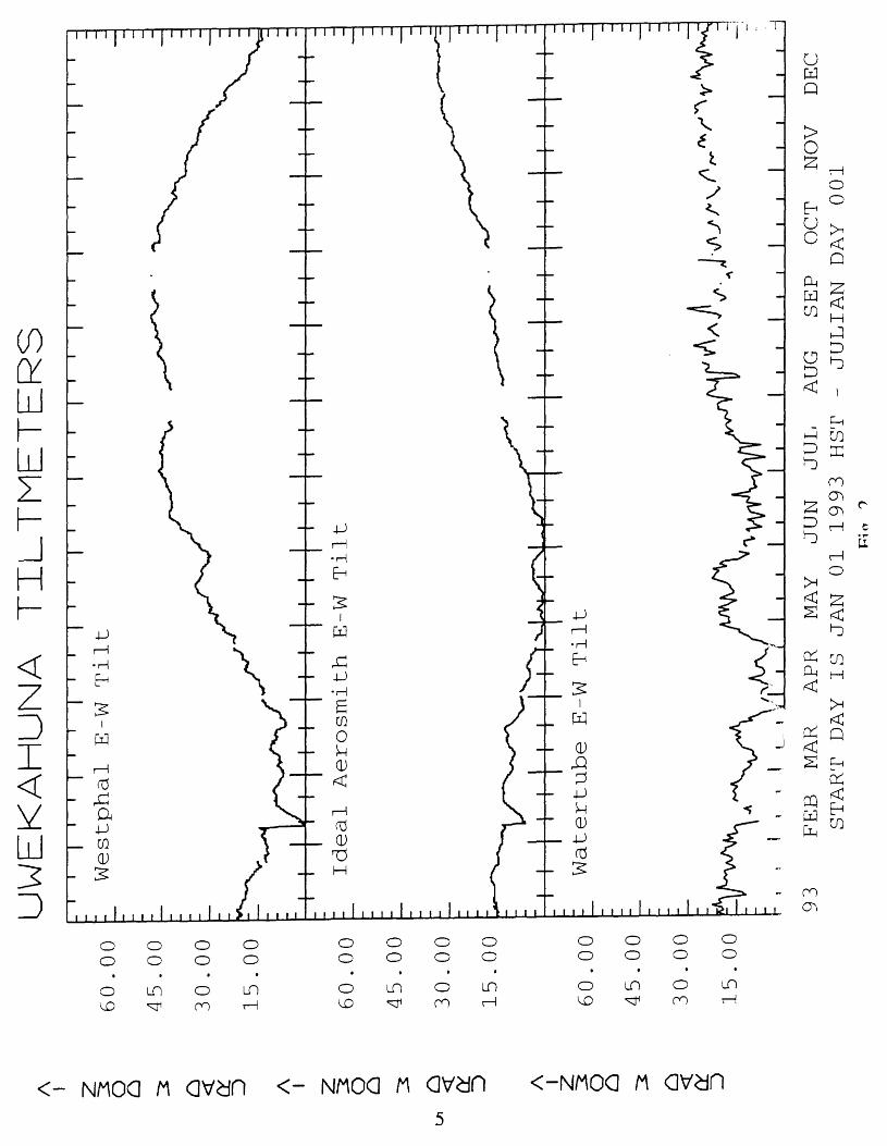
The two electronic instruments in the Uwekahuna vault are the only tiltmeters in the HVO network whose output can be easily verified by alternate means. HVO has a 3-m-long biaxial watertube tiltmeter, installed in the Uwekahuna vault, which is usually read on a daily basis. This provides a convenient check for the electronic tiltmeters, and the data have been plotted in this report with the electronic data. The watertube was installed in 1956 and provides a long-term record of Kilauea summit tilt changes.
DISCUSSION
On April 1 and 23 work was performed on the vault. Data gathered during the disturbances have been eliminated. On April 23 the watertube tiltmeter was serviced (cleaned and flushed).
The Ideal Aerosmith tiltmeter record reasonalbly resembles the watertube record (fig. 2), which indicates correlation between these instruments. The Ideal Aerosmith does show a slightly lower amplitude signal than the watertube for specific events, but correlates well with the Westphal tiltmeter in event amplitudes. From January to June, the Ideal Aerosmith generally coincided with the tilt trends displayed on the watertube E-W component. F~om June to the end of the year, the Ideal Aerosmith showed a west-down tilt vector, the direction confirmed by the watertube but not at the same scale. The value of the Ideal Aerosmith lies in its ability to provide continuous signals, and to be generally counted on for long-term tilt trends.
The Westphal tiltmeter depicted a minor east-down tilt and a more substantial south-down tilt over the first three to four months of the year, but showed short duration tilt events well (fig. 2 & 3). For an unknown reason, this instrument was seriously affected by the vault work in April. The good tilt response for the first quarter of the year was overshadowed by the unacceptaMe signal for the next three quarters of the year. The onset of the instrument drift began at the time of the vault work, continued for five months, and then possibly began trying to recover during the last three months of the year. Throughout the large apparent tilt signal, small tilt events are easily discerned and easily confirned by the other vault tiltmeters.
The watertube tiltmeter showed a consistent south-down tilt
A O A I Z
O ^ o D A I Z O
UWEKAHUNA TILTMETERS
60.0
0
45.0
0
30.0
0
15
.00
60
.00
45.0
0
30
.00
15
.00
60.0
0
45
.00
30
.00
15.0
0
I I
i i
i i
i i
i i
ii
i
Westphal E-W Tilt
Ideal Aerosmith E-W Tilt
Watertube E-W Tilt
L_
5I
I I
II
II
II.
I_
I _I
I__I
li
1!
93
FEB MAR
APR
MAY
JUN
JUL
AUG
SEP
OCT
NOV
DEC
START DAY IS JAN 01 1993 HST
- JULIAN DAY 001

UWEKAHUNA TZLTMETERS
A O A I O (Y D
60.00
45.00
30.00
15.00
32.00
24.00
16.00
8.00
i r
i I
ii
i r
\ i
i i
r i
r i
r
Westphal N-S Tilt
Watertube N-S Tilt
93
FEE MAR
APR
MAY
JUN
JUL
AUG
SEP
OCT
NOV
START DAY IS JAN 01 1993 HST
- JULIAN DAY 001
DEC
f !
r%
I ^ I f>
*

L
CUMULATIVE INCH
in
o o
OLnoinoinoLn
ooooo ooooo
ooo ooo
-3
O
H
>
O
LO
^
>
"^ C_ip ^ a -£» ^
U>
H-rH __|
CO MH6
1 >. GM O
u
O O
w
°
O Mn
l 1 1 1 1 1 J 1 I 1 1 1 1 1 1 1 1 I 1 1 1 I 1 1 i 1 1 1 1 1 1 1 1 1 1 1 1 1 1 1 1 I
s
u >rK;

direction on the N-S component all year. The E-W component shoved a general east-down tilt for the first four months of the year, then a west-down tilt for the remainder of the year.
An event occurred in late April and lasted through the month of May, reflected in the watertube and Westphal E-W components, and the Sandhill and Pu'u Huluhulu tiltmeters. This tilt event, though recorded across the summit and upper east rift zone, could also be related to a rain storm that began on April 24 and dropped almost 5 inches of rain over a few days. This event began at the end of April and terminated at the end of May.
From October through December, all three E-W components differed in tilt response. The watertube stayed relatively level or tilted west-down by about 5 microradians, the Ideal Aerosmith tilted west-down by about 20 microradians, and the Westphal tiltmeter tilted east-down by about 35 microradians. The Westphal instrument was probably still recovering from its instrumental problem, as evidenced by its lack of correlation.
The Uwekahuna rainfall record is introduced here (fig. 4) because of the instrument location and its use as a general indicator for rainfall over Kilauea volcano as a whole. This standard National Weather Service rain gauge is usually read daily, and the data is plotted as a cumulative record for ease of interpretation. The intent for including this data is an atterpt to correlate any specific tilt event with rainfall. High levels of rainfall can cause tilt events at a specific site or affect the mountain as a whole.
2. SDH2 (Sandhill) Latitude 19.3879<> Longitude 155.29P1<>
The SDH2 station (labelled "SANDHILL" in the data plots) is located 400 m SW of the Sandhill benchmark (HVO 119) at Kilauea summit. This station is used to monitor Kilauea's summit magma chamber and is much closer to the assummed epicenter of the chamber than the UWEV station, which may account for the large tilt chances recorded at this site. The geology of this site consists of arh, approximately 3 m thick, underlain by pahoehoe. The tiltmeter is installed in a meter-long pipe, the top of which is .5m below surface level.
The Sandhill site was established in 1974, and a series of tiltmeters have occupied this site over time. The current tiltmeter, an Autonetics borehole tiltmeter (serial no. 0096B), fas occupied this site since June 1, 1989.
DISCUSSION
The Sandhill tiltmeter showed large tilt changes throughout the year (fig. 5). The changes in direction of tilt at Sandhill is correlated with tiltmeter changes at other stations, but it is uncertain whether the changes are volcanic or seasonal.
The Sandhill tiltmeter remained flat for the first thr^e months of the year, then showed a strong summit inflation (about
8

SANDHILL TILTMETER
A I Z o A I O O
80.00 1
60.00 L
40.00 L
20.00 L
80.00 1
60.00 1
40.00 L
20.00 1 93
FEE MAR
APR
MAY
JUN
JUL
AUG
SEP
OCT
NOV
START DAY IS JAN 01 1993 HST
- JULIAN DAY 001
Fig.
5
DEC

110 microradians) for April through September, then a summit deflation (about 100 microradians) from October to the end of the year.
The station is in excellent position to monitor volcanic changes of Kilauea summit, but suffers from the effects of heavy rain. Heavy rains affected this site in late April, late July, and late September.
3. PUHH (Pu'u Huluhulu) Latitude 19.3762<> Longitude 155.2068<>
The PUHH station (labelled "PU'U HULUHULU" in the data plots) is located on the north-facing slope of Pu'u Huluhulu, a forested, consolidated cinder cone on Kilauea's East Rift Zone (ERZ). TJ^is site is intended to monitor Kilauea's upper ERZ. The geology of the site is interbedded cinder and very thin pahoehoe flows and welded pyroclastics. A meter-long pipe is cemented in place, the top of which is about 20 cm below ground level.
The Pu'u Huluhulu site was established in 1974, and a series of tiltmeters has occupied this site over time. The current tiltmeter, an Autonetics borehole (serial no. 008b), has occupied this site since March 1, 1991.
DISCUSSION
The largest signal recorded by this station is the February 7 event, which is discussed in a later section. Other than tlat event, the rest of the year is relatively uneventful (fig. 6). The tilt event of late April through May discussed in the UWEV section is clearly depicted by this instrument. From February to early June the site shows an east-down vector of 15 microradians, and from June to the end of the year, the site shows a WNW vector of 20 microradians.
This site responds well to events in the upper ERZ. The site is insensitive to rainfall and seems very stable when the long-term record is analysed. The tiltmeters' N-S component has a large diurnal signature, but both components show an excellent response to events. The very low diurnal component on the E-W channel makes it very valuable in discerning small events.
4. HHHS (Heiheiahulu) Latitude 19.4170o Longitude 154.9757o
The HHHS station (labelled "HEIHEIAHULU" in the data plots) is located 1.8 km SE of Heiheiahulu cinder cone on Kilauea's EFZ. This site is intended to monitor changes near Heiheiahulu in the middle ERZ. The geology of the site consists of thick pahoehoe flows. The tiltmeter is installed in a 1.5-m-deep borehole.
This site was established in 1977, and a series of tiltmeters has occupied this site over time. The current instrument, an Autonetics borehole tiltmeter (serial no. 0107B), has occupied this site since June 7, 1989.
10

PU'U HULUHULU TILTMETER
A Z o o: A z o o I
35.0
0
25.0
0
15
.00
5.0
0
35.0
0
25
.00
15
.00
5.0
0
i i
i r
i i
i i
i i
i r
N-S
T
ilt
E-W
T
ilt
MM
i
93
FEE MAR
APR
MAY
JUN
JUL
AUG
SEP
OCT
NOV
START DAY IS JAN 01 1993 HST - JULIAN DAY 001
DEC

DISCUSSION
This tiltmeter did not record any significant events in its area (fig. 7). It did record some long term changes that could be attributed to seasonal changes. From January to May, the station recorded a west-down tilt of 12 microradians. From May to October, the station recorded a ESE-down tilt vector of about 35 microradians. From October to the end of the year, the tiltmeter recorded a WNW vector of about 22 microradians. Some instrumental problems started in October and continued to plague the station to the end of the year.
5. MOKE (Mokuaweoweo) Latitude 19.4980o Longitude 155.5866o
The MOKE station, labelled "MAUNA LOA SUMMIT" on the data plots, is located to the NW of Mokuaweoweo, Mauna Loa's sumrit caldera. It is situated about 300 m from the caldera edge, at the end of the summit access road. The geology of the site consists of pahoehoe flows. A 1.5-m-deep hole was drilled within a 1-m-deep partially collapsed lava bubble for the tiltmeter.
This site was established in 1975, and a series of tilt- meters has occupied this site over time. The current tiltmeter, an Autonetics borehole (serial no. 0008B), has occupied this site since July 23, 1991.
DISCUSSION
The tiltmeter has shown no dramatic changes for the year, except for several small events related to weather (rain or snow) (fig. 8). For the month of January, both components were recovering from a severe winter storm that began at the end of 1992. The sharp spike in the E-W component in mid-March (also visible in the MLCC data) is due to a rainstorm. The N-S component shows a slight north-down trend for the year. The E-W component shows a typical yearly pattern. The cumulative tilt changes for the year indicates slight summit inflation. It has not been determined whether the annual E-W signal is instrumental drift, seasonal changes, or reflecting true ground tilt.
6. MLCC (Mauna Loa Cinder Cone)Latitude 19.5661o Longitude 155.4949o
The MLCC station, labelled "MAUNA LOA NE RIFT" in the dcta plots, is located about 4 km north of Mauna Loa's NE rift zone, and 4.5 km NW of Pu'u Ulaula. The station is located on an unconso- lidated cinder cone. A 1.5-m-long pipe installed in the cinder houses the tiltmeter.
This site was established in 1975, and a series of tilt- meters has occupied this site over time. The current tiltmeter, an Autonetics borehole (serial no. 0003), has occupied this site since
12

AHULU TILTMETER
A I O z O D A O
O O
<
ft
35.00 L
25.00 1
15.0
0
5.0
0
1
35.0
0
L
25.0
0
L
15.0
0
5.00 1
I I
1 I III
I I
I I
I I
|T
I I
93
FEE MAR
APR
MAY
JUN
JUL
AUG
SEP
OCT
NOV
START DAY IS JAN 01 1993 HST
- JULIAN DAY 001
7
DE
C

MAUNA LOA SUMMIT TILTMETER
A I O A I Z
O I 12 D
35.0
0
25
.00
15
,00
5,0
0
35.0
0
25.0
0
15
.00
5,0
0
. ,
i i
]
N-S
T
ilt
i i
E-W
T
ilt
i i
I I
III
III
I I
I I
I I
I I
I 11
II
i .
Ii
i i
i i
93
F
EE
M
AR
A
PR
M
AY
JU
N
JUL
A
UG
S
EP
O
CT
N
OV
D
EC
S
TA
RT
D
AY
IS
JA
N
01
1993
HS
T
- JU
LIA
N
DA
Y
001
October 17, 1989. The top of the tiltmeter is a few centimeters below ground level.
DISCUSSION
This station has shown no recognized volcanic events for the year (fig. 9). Over all, both components showed the general typical yearly pattern which has been displayed in the past. It has not been determined whether the long-term signal is instrumental drift, seasonal changes, or reflect true ground tilt. The event displayed on the N-S component from January 1 to mid February is the tiltmeter/site recovering from a severe winter storm. Several other small events in the MLCC instrument data are related to weather.
EVENT OF CTAJSTTJAJRY 24, X ^ ̂ 3
On January 24, at 2214 hrs, an earthquake (M=4.5) triggered a swarm on the eastern end of the Kaoiki Fault Zone, due west of HVO. The aftershocks associated with this swarm totaled nearly 1000, with seven events of M=3 or greater. The earthquake(s) caused either an offset on the summit tiltmeters or a physical change to Kilauea's summit (fig. 10). This event caused about 4 microradians of change on the Uwekahuna tilt components and a 12 microradian offset on the Sandhill tiltmeter. The two Uwekahuna E-W components moved in opposite directions, indicating they were physically affected by the event and not necessarily responding to ground tilt.
EVENT OF FEBRUARY 7 , 3.9^3
On February 7, at 2325 hours, the seismic station at Makaopuhi began recording an increase in volcanic tremor. At 2330 hrs, the Pu'u Huluhulu tiltmeter began showing a SE-down tilt vector (fig. 11 & 12). At 2340 hrs, the Uwekahuna tiltmeters began showing east-down tilt changes, indicating summit deflation. At 0030 hrs on February 8, the Pu'u Huluhulu tiltmeter changed direction and began showing a SW-down tilt vector (fig. 15). On February 8, tremor levels at Pu'u 'O'o began to decrease and reached backgrorand levels by 0400 hrs. A swarm of earthquakes also accompanied this event in the upper ERZ, totaling over 5000 for these two days.
The Pu'u Huluhulu tiltmeter recorded 39.6 microradians of change during this event, Uwekahuna Westphal tiltmeter 15.1 microradians of change, and the Uwekahuna Ideal Aerosmith 7.5 microradians of change.
All tiltmeters reached background levels by 1600 hrs on February 8.
The sequence of events showed that the event began near Makaopuhi, then affected the summit and later the Pu'u 'O'o areas.

A Z o o
<
o: A I Z
O o I o
<
o:
MAUNA LOA NE RIFT TILTMETER
35.0
0
25
.00
15.0
0
5.0
0
35.0
0
25.0
0
15.0
0
5.0
0
T
T
N-S
T
ilt
I I
I I
I I
E-W
T
ilt
yv*
^^II
I I
I I
I I III ill
II
l_l_
l
I I
I I
I I
\
I I
I I
J 1
J J
I
93
FE
B
MA
R
AP
R
MA
Y
JUN
JU
L
AU
G
SE
P
OC
T
NO
V
ST
AR
T
DA
Y
IS
JAN
0
1
1993
HS
T
- JU
LIA
N
DA
Y
00
1P
irr
0
DE
C

XO1ST
The electronic tiltmeters can be a very good tool in the remote monitoring of volcanoes. The tiltmeters provided important information on the sequence of events and changes that occured during the Feb. 7 event. Inspecting the tilt vector plots reveal that the tiltmeters can provide a coherent view to the charges occuring on the volcanoes.
Care must be given to installation of the tiltmeters and the history and the quality of the data signal from each site must be understood. The data are generally good in the short term but irust be critically questioned in the long term due to uncertainties in instrumental and site stability.
B X BI_, X OGRAE^H Y
1. English, T.T., 1987, HVO polling telemetry system for low frequency data acquisition: software users' guide: U.S. Geological Survey Open-File Report 87-633, 51 p.
2. Klein, F.W., 1980, EQPLT and ZEOPLT: interactive computer plotting programs for earthquake and geophysical data: U.S. Geological Survey Open-File Report 80-827, 34 p.
3. Murray, T.L., and Endo, E.T., 1986, BOB, a computer graphics tool for real-time integrated volcanic monitoring [abs.]: Eos, v. 67, no. 16, p. 397.
4. Puniwai, G.S., Honma, K.T., Largo, A. J., 1990, The Hawaiian Volcano Observatory polling telemetry system for low frequency data acquisition: U.S. Geological Survey Open-File Report 90-525, 75 p.
5. Westphal, J., Carr, M., Miller, W., Dzurisin, D., 1983, Expendable bubble tiltmeter for geophysical monitoring: Review of Scientific Instruments, vol. 54, no. 4, p. 415-418, April 1983.
X .
VECTOR PLOTS
The time periods were chosen by looking at all stations and delineating periods by change in direction of tilt.
XT'

KILAUEA SUMMIT TZLTMETERS
A I ?.
O -z. A Z 0 A I ~Z.
- O
CX O A
Z 0 ° A
Z 0
12 .00
9.00
6.00
3 .00
12 .00
9.00
6.00
3 .00
12 .00
9.00
6.00
3 .00
12 .00
9.00
6.00
3 .00
16.00
12 .00
8.00
4 .00
UWEKAHUNA, WESTPHAL N-S
UWEKAHUNA, WESTPHAL E-W
UWEKAHUNA, IDEAL AEROSMITH E-W
SANDHILL N-S
24
04
08
12
16
20
25
04
08
12
16
START DAY IS JAN 24 1993 HST
- JULIAN DAY 024
20

KJ_LA
UE
A
SU
MM
IT
TIL
TM
ET
NO
A O A O O A I
O A I O A I Z O
12 .00
9.00
6.00
3.00
12 .00
9.00
6.00
3 .00
12 .00
9.00
6.00
3 .00
12 .00
9.00
6.00
3 .00
12 .00
9.00
6.00
3 .00
i i
r^
i i
UWEKAHUNA, WESTPHAL N-S
UWEKAHUNA, WESTPHAL E-W
UWEKAHUNA, IDEAL AEROSMITH E-W
SANDHILL N-S
SANDHILL E-W
07
04
08
12
16
20
Q8
04
08
12
16
START DAY IS FEB 07 1993 HST
- JULIAN DAY 038
Fig.
11
20

KTLAUEA EAST RIFT TILTMET
A I Z ^ O o Z A I O
to oA I o
o Z A I Z ^ O o
24 .00
18.00
12 .00
6.00
20.00
15.00
10.00
5.00
20.00
15.00
10.00
5.00
20.00
15.00
10.00
5.00
PUU HULUHULUW-S
t-
PUU HULUHULU E-W
t- HEIHEIAHULU N-S
t- HEIHEIAHULU E-W
07
04
08
12
16
20
Q8
04
08
12
16
START DAY IS FEB 07 1993 HST
- JULIAN DAY 038
Fig. 12
20

KILAUEA SUMMIT AND EAST RIFT ELECTRONIC TILT VECTORSJanuary 1 to February 6, 1993
30' -
25' -
ZO' -
15' -
geiheic hulu
0 20 MicroradiansI,, MM,,, I, MM,,,,!
10 KM
ZO' 15' ID 155'
Figure 13. Kilauea summit and east rift electronic tilt vectors,January 1 to February 6, 1993. All tiltmeters indicate deflation in the respective areas.
21

KILAUEA SUMMIT AND EAST RIFT ELECTRONIC TILT VECTORSFebruary 7 through February 8, 1993
30' -
25' -
20' -
15' -
20* 15 155'
Figure 14. Kilauea summit and east rift electronic tilt vectors,February 7 and February 8, 1993. The cumulative results of this event indicate deflation in the respective areas.
22

PUU HULUHULU TILT VECTORSVECTOR DIRECTION TIME SCALE
0800 Feb. 8
0700
0600
0500
0400
0300
0200
0100
0000
2320 Feb. 7
012 microradians
Arrows indicate tilt vectors in microradians/10 minute tine interval
Figure 15. Pu'u Huluhulu tilt vectors, February 7 and February 8, 1993. This plot reveals the vectors through time of this tiltmeter, with time as a vertical pole and azimuth directions as noted. This plot is intended to show the rotation of the tilt vector through time.
23
KILAUEA SUMMIT AND EAST RIFT ELECTRONIC TILT VECTORSFebruary 6 through June 1, 1093
30 1 -
25' -
20' -
IS' -
20'
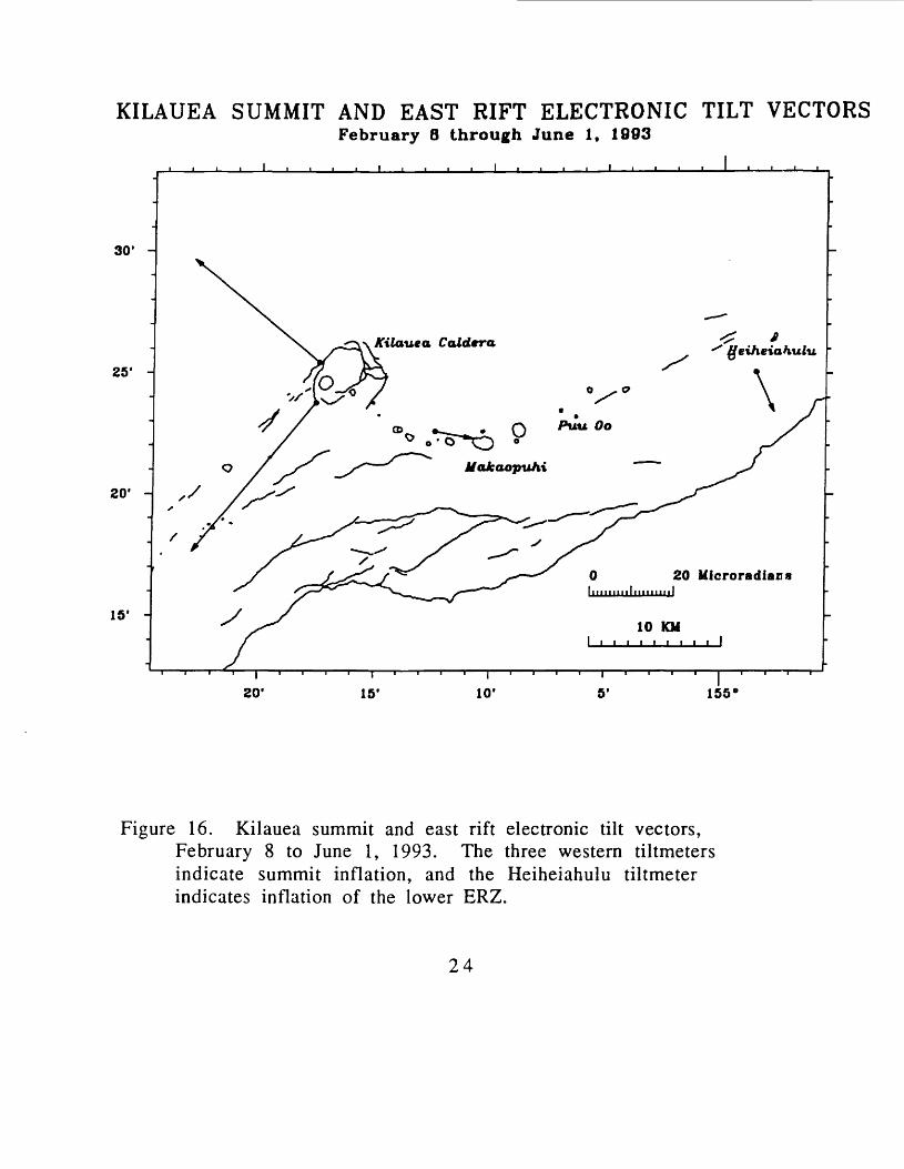
Figure 16. Kilauea summit and east rift electronic tilt vectors, February 8 to June 1, 1993. The three western tiltmeters indicate summit inflation, and the Heiheiahulu tiltmeter indicates inflation of the lower ERZ.
24

KILAUEA SUMMIT AND EAST RIFT ELECTRONIC TILT VECTORSJune 1 through October 1, 1993
30' -
25' -
20' -
15' -
geiheictiulu
I 20'
0 40 MicroradiansI,.,,,,,,!,,,,,,,,,!,,,,.,,,,!,,,,,,,,.!
10 KM
15' ID 155'
Figure 17. Kilauea summit and east rift electronic tilt vectors, June 1 to October 1, 1993. All tiltmeters indicate inflation in their respective areas.
25
KILAUEA SUMMIT AND EAST RIFT ELECTRONIC TILT VECTORSOctober 1 to December 31, 1993
30' -
25' -
20' -
15' -
155*
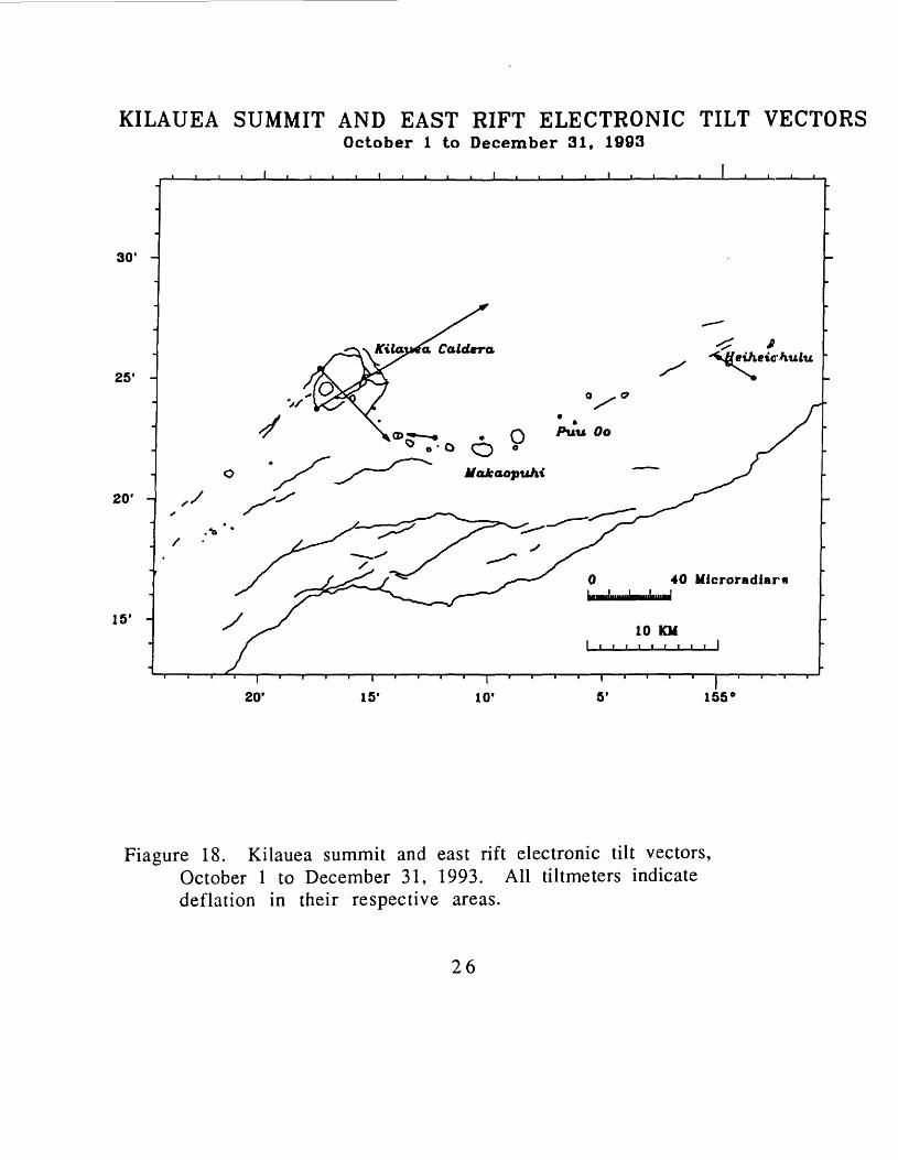
Fiagure 18. Kilauea summit and east rift electronic tilt vectors, October 1 to December 31, 1993. All tiltmeters indicate deflation in their respective areas.
26

MAUNA LOA ELECTRONIC TILTMETER VECTOR.0January 1 to July 1, 1993
35'
30' -
25' -
20' -
Mokuaweoweo
Sulfur Cone / /
/
Puu Ulaula
20 Microradians
10 KM
45'\
40' 35' 30' 25'1 i
20'
Figure 19. Mauna Loa electronic tiltmeter vectors, January 1 to July 1, 1993. the summit tiltmeter indicates inflation, and the NE rift tiltmeter deflation or seasonal changes.
27

MAUNA LOA ELECTRONIC TILTMETER VECTORSJuly 1 to December 31 v 1993
35'
30' -
25' -
20' -
Mokuaweoweo
Sulfur Cone J I
/
A-r
Puu Ulaula
20 MicroradianaItllllHllllllllllll I
10 KM
i 45' 40* 35' 30' 25'
i 20'
Figure 20. Mauna Loa electronic tiltmeter vectors, July 1 toDecember 31, 1993. The summit tiltmeter indicates inflation and the NE rift tiltmeter inflation or typical seasonal changes.
28

XX. LOG
****
UWEV
Tiltmeter make & serial no.: Westphal, WTM-1Calibration factors: X (NS) =10.0 mv/microradian
Y (EW) = 10.0 mv/microradian Tiltmeter make & serial no.: Ideal Aerosmith, sn: 10567
Calibration factor: 100.0 mv/microradianTiltmeter make & serial no.: Applied Geomechanics, sn: 1436
Calibration factors: X (NS) = 21.16 mv/microradianY (EW) = 21.06 mv/microradian
Digital system inputs:1: Westphal Tiltmeter, X component2: Westphal Tiltmeter, Y component3: Temperature4: Ideal Aerosmith5: Applied Geomechanics, X component6: Applied Geomechanics, Y component7: Short8: Battery
05/ /93 Installed Applied Geomechanics platform tiltmeter
07/01/931059 Problem: Applied Geomechanics tiltmeter off scale.
Reset tiltmeter.VOLTAGES
Before After X: 4.54 V. X: 0.0626 V. Y: 7.85 V. Y: 0.0515 V.
08/ /93 Problem: Applied Geomechanics tiltmeter off scale.
SDH2
Tiltmeter make & serial no.: Autonetics, sn: 0096BCalibration factors: X (NS)
Y (EW) Digital system inputs:
1: Tiltmeter, X component2: Tiltmeter, Y component3: Temperature4:5:6:7: Short8: Battery
18.4 mv/microradian 20.5 mv/microradian

*****************************************************************
PUHH
Tiltmeter make & serial no.: Autonetics, sn: 0008B Calibration factors: X (NS) = 58.68 mv/microradian
Y (EW) = 47.28 mv/microradian Digital system inputs:
1: Tiltmeter, X component 2: Tiltmeter, Y component 3: Temperature 4: THTN 5: THTE 6: Battery 7: None8: Solar Battery
02/02/931415 Problem: Station operating intermittent.
Found digital box problem, replaced mux board.VOLTAGES
Before After Battery:X: 1.408 V. X: 1.420 V. Y: -3.242 V. Y: -3.218 V. Temp: 3.049 V. Temp: 3.034 V.
HHHS
Tiltmeter make & serial no.: Autonetics, sn: 0107B Calibration factors: X (NS) = 18.75 mv/microradian
Y (EW) = 20.67 mv/microradian Digital system inputs:
1: Tiltmeter, X component2: Tiltmeter, Y component3: Temperature4: Short5: None6: None7: None8: Battery
01/20/931220 Installed a locked battery housing for the station
VOLTAGESBefore After
Battery: 14.06 VX: 3.269 V. X: 3.279 V. Y: 1.262 V. Y: 1.275 V. Temp: 2.96 V. Temp: 3.065 V.
3 O
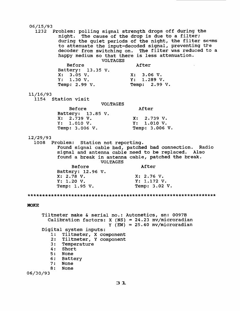
06/15/931232 Problem: polling signal strength drops off during the
night. The cause of the drop is due to a filter; during the quiet periods of the night, the filter se«ms to attenuate the input-decoded signal, preventing tfe decoder from switching on. The filter was reduced to a happy medium so that there is less attenuation.
VOLTAGESAfter
35 V.X: 3.06 V. Y: 1.289 V. Temp: 2.99 V.
BeforeBattery: 13 X: 3.05 V. Y: 1.30 V. Temp: 2.99 V.
11/16/931154 Station visit
VOLTAGES Before
Battery: 13.85 V. X: 2.739 V. Y: 1.010 V. Temp: 3.006 V.
After
X: 2.739 V. Y: 1.010 V. Temp: 3.006 V,
12/29/931008 Problem: Station not reporting.
Found signal cable bad, patched bad connection. Radio signal and antenna cable need to be replaced. Also found a break in antenna cable, patched the break.
VOLTAGESBefore After
Battery: 12.96 V.X: 2.78 V. X: 2.76 V. Y: 1.20 V. Y: 1.172 V. Temp: 1.95 V. Temp: 3.02 V.
MOKE
Tiltmeter make & serial no.: Autonetics, sn: 0097B Calibration factors: X (NS) = 24.23 mv/microradian
Y (EW) = 25.40 mv/microradian Digital system inputs:
1: Tiltmeter, X component2: Tiltmeter, Y component3: Temperature4: Short5: None6: Battery7: None8: None
06/30/93
3 O.

0945 Station check. Batteries dried up, replaced with new set of batteries and installed voltage regulator. Solar current = 2.20 amps.
VOLTAGESBefore After
Battery: 12.62 V.X: 1.411 V. X: 1.41 V. Y: 2.34 V. Y: 2.33 V. Temp: 2.92 V. Temp: 3.04 V.
*****************************************************************
MLCC
Tiltmeter make & serial no.: Autonetics, sn: 0003B Calibration factors: X (NS) =30.0 mv/microradian
Y (EW) =35.0 mv/microradian Digital system inputs:
1: Tiltmeter, X component 2: Tiltmeter, Y component 3: Temperature 4: Short 5: Battery