u.s. department of the interior number
TRANSCRIPT

OCS StudyM M S 8 5 - 0 0 2 7
U.S. Department of the Interior Technical ReportNumber 114
b. . . . . . . . . . . . . . . . . . . . . . . . . . . . . . . . . .y.:::yjjjj:y$:::: :::::.
:::::::::::::::::::::: :::::::::.
k=$::::?:k . . . . ..=. . . . . . . . . . . . . . . . . . . . . . . . . . .. . 0 . - . - . . . . . . . . . . . . . . . . . . . . . . . . . . .. . . . . . . . . . . . .:::::::::::::::::::::::::::: ::::
. . . . . . . . . . . . . . . . . . . . . . . . . . . . . .::::::::: ; ::: ;:::jj$:::: ; ::::::
:::::.. . . %:.:.:.......:.:.:.:.
:. . . . . . . . . . .
. . . . . . . . . . .
[
. . . . . . . . . . . . .. . . .y.:::::::::::::
, . . . . . . . . . . .. . . . . .
::::::::.
;:~::::.
Social and EconomicStudies Program
Sponsor:Minerals ManagementService
I H. . . . . . . . . . . Alaska Outer. ./:..J::.y w Continental-%,./::::: Shel f Region~.:.:.. .
Monitoring OCS Activity in the Bering Sea

Contract No. 14-12-0001-30171
——
ALASKA OCS SOCIOECONOWC STUDIES PROGR.%M
—
FINAL TECHNICAL REPORT
MONITORING OCS ACTIL’lTY IN THE BERING SEA
—
prepared forMinerals Yanagenent. Service
Alaska Outer Continental Shelf Office
by
Patrick L. BurdenMarvin L. FeldmanKathrvn L. Bai-loon
Patrick Burden & Associates
and
Dames & Moore
June 1’385

The Minerals Management Service
ABSTRACT
(MMS) commissioned this study to obtain an
historical accounting of exploration activities and
offshore leasing activity in the Bering Sea for
study period. In the course of this research, over
the effects of federal
the 1980 through 1984
seventy firms who were
active in Bering Sea exploration as either lease operators or service
contractors were contacted. This report of the findings of the studv
includes a description of past, present, and future exploration activities
and their effects on employment and the economy. Information presented in
the report will assist the MMS to more reliably assess the potential
effects of future oil industry activities in the Bering Sea on local
communities and the State of Alaska.
Petroleum exploration activities in the Bering Sea Outer Continental
Shelf (OCS) began with geophysical surveys in 1963. From 1976 to 1983,
Continental Offshore Stratigraphic Test (COST) wells were drilled and
regional geophysical and geological studies were conducted, Tracts were
leased in the Norton and the St. George basins in 1983, and tracts were
leased in the Navarin Basin in 1984. Eleven exploratory wells were
drilled in the relatively intense exploration effort that began in 1934.
Pre-lease exploration activities included regional marine seismic
high-resolution geophysical surveys, geological (geotechnical
surveys,
and geo-
chemical) surveys, airborne geophysical surveys, and the installation and
operation of navigation systems. Drilling phase activities included
drilling vessel operations, marine and air support services and bases,
lease operator supervision, and the serivces provided by numerous
specialized contractors such as mud loggers and divers.
-i-

!farine support bases for the
near Unalaska and to some
exploration activities included Captain’s Bay
extent Nome. A new facility was built at
Captain’s Bay expressly for the purpose of supporting Bering Sea explor-
ation. Fuel, water, food, and drilling supplies were staged from these
bases. Air support bases at Cold Bay and Nome were used to support
helicopters transporting crews to the drilling vessels.
Employment and expenditure data were obtained for all pre-lease and post-
Iease exploratory drilling phase activities. The expenditure estimates in
this report do not include facilities construction expenditures, the
capital cost of acquiring the vessels used in geophysical exploration, or
the cost of acquiring leases. The employment estimates do not include
facilities construction employment, the labor of governmental regulatory
agencies, or secondary employment estimates.
During the 1980-1984 period, almost 4000 person years of employment were
required for oil exploration in the Bering Sea. Approximately 510 person-
yeai-s or 13 percent of all employment related to exploration activities in
the Bering Sea OCS went to Alaska residents, and 255 person years or 6.5
percent went to local residents. Total wages and salaries paid during the
1980-1984 period approached $166 million, with Alaska residents accruing
approximately 11 percent or $18 million.
Total expenditures during the period exceeded $500 million. About $126
million, or 25 percent of these expenditures were made in the State of
Alaska. Local expenditures made in communities on or near the Bering Sea,
approached $44 million or 9 percent of the total.
-ii-
,–
—.-
—
—.-
*
●
�

—
TABLE OF CONTENTS—
—
—
——
Section No. and Title Page No.
1.0 INTRODUCTION ● *.*** .*..* . . . $ . ● ● **** . . ● . . . . . ● ● * . ● . . ● ● . . ● . .* 1
1.1 Purpose and Scope of the Study ● . ● . ● ● ● ● ● . . . . ● . . ● . . . .*. 11.2 Petroleum Development in Alaska . . . . . . . . . . . . . . . . . . . . . . 41.3 Research Methods ● *.*.*..*. .*.. **.*** . . . . . . . . . . . ...0.. 5
2.0 BACKGROUND . ● . . . ● . . . ● . . . ● ● . . . ● . ● . . . . . . . . . . . . . . . . . . . . . . . ● . . 9
2.1 Exploration Activities by Basin . . . . . . . . . . . . . . . . . . . . . . 9
2.1.1 Norton Sound ..* ***... . . . . . . . . . . . . . . . . . . . . . . . . . . 92.1.2 St. George . . . . . . . . . . . . . . . . . . . . . . . . . . . . . . . . . . . . . 132.1.3 Navarin . . . . . . . . . , . ● ● ● ● . . ● . ● . . . . . ● . . . . ● . , ● . . . . ● . 162.1.4 North Aleutian . . . . . . . . . . . . ...*.. ● . . . . . . . . . . . . . . 18
2.2 Management of Exploration Activities . . . . . . ● . ● ● . ● ● . . . . 20
2.2.1 Permitting . . . . . . . . . . . . . . . . . . . . . . . . . . . . . . . . . . . . . 20
2.2.1.1 Overview of the permitting process . . . . . 202.2.1.2 Permitting process for ARCO’S Birch Well 25
2.2.2 Lease Sale Stipulations . . . . . . . . . . . . . . . . . . . . . . . .
2.2.2.1 Common lease sale stipulations . . . . . . . . . 302.2.2.2 Stipulations for lease sale 57 .* ***.*.* 32
—
2.2.3 Mitigation Measures . . . . . . . . . . . . . . . . . . . . . . . . . . . . 362.2,4 Accident Data in the Bering Sea OCS ● . . . . . . . . . . . 38
2.2.4.1 Hydrocarbon accidents . . . . . . . . . . . . . . . . . . 382.2.4.2 Personal injury accidents . . . . . . . . . . . . . . 39
—
—-.
3.0 PETROLEUM EXPLORATION PROCESS . . . . . . ● . . . . . . . . . . . . . . . . . . . . 40
3.1 Introduction ● .*. .* s. ● * . . ● . ● **. ● ● ● . ● . . ● . . . . . . . ● ● . . . , . . 403.2 Summary of the Exploration Process . . . . . . . . . . . . . . . . . . . 413.3 Pre-lease Sale Activities . . . . ● ● . . . . . . . . . . . . . . ● . . . , . . . 43
3.3.1 Geophysical Surveys . . . . . . . . . . . . . . . . . . . . . . . . . . . . 44
3.3.1.1 Airborne geophysical surveys . . . . . . . . . . 443.3.1.2 Regional marine geophysical surveys . . . 473.3.1.3 High-resolution geophysical surveys . . . 52
3.3.2 Regional Geological Surveys . . . . . . . . . . . . . . . . . . . . 543.3 .3 Marine Navigation Systems . . . . . . . . . . . . . . . . . . . . . . 553.3.4 Lease Sale Evaluation . . . ● . ● , . . . . . . . . . . . . ● , .* .* . 56

Section No. and Title Page No.
3.4 Drilling Phase Activities . . . . . . . . . . . . . . . . . . . . . . . . . . . . 57
3.4.1 Site Surveys . ● . . ● . . . . . ● . ● . . . ● . . ● ● . ● . . . ● ● . . ● . . . ●57
304+~D~illingvessels . . . . . . . . . . . . . . . . . . . . . . . . . . . . . . . 58
3.4.2.1 Types of vessels . . . . . . . . . . . . . . . . . . . . . . 583.4.2.2 Sununary of drilling . . . . . . . . . . . . . . . . . . . 603.4.2.3 Data on drilling . . . . . . . . . . . . . . . . . . . . . . 61
3.4.3 Supply Vessels . . . . . . . . . . . . . . . . . . . . . . . . . . . . . . . . . 653.4.4 Other Marine Support Vessels . . . . . . . . . . . . . . . . . . . 663.4.5 Air Support ● *.*...*.. ● *O*.**.** . . . . . . ...0 . ..**. 69
3.4.5.1 Aircraft operations . . . . . . . . . . . . . . . . . . . 693.4.5.2 Equipment . . . . . . . . . . . . . . . . . . . . . . . . . . . . . 723.4.5.3 Support facilities . ...***.. ● . . ...**. . . 73
3.4.6 Shorebases . . . . . . . . . . . . . . . . . . . . . . . . . . . . . . . . . . . . . 74
3.4.6.1 Shorebase facilities . . . . . . . . . . . . . . . . . . 763.4.6.2 Shorebase operations . . . . . . . . . . . . . . . . . . 78
3.4.70ther Contractors . . . . . . . . . . . . . . . . . . . . . . . . . . . . . . 81
3.5 Transportation . . . . . . . . . . . . . . . . . . . . . . . . . . . . . . . . . . . . . . . 86
3.5.1 Origin of Major Supplies . . . . . . . . . . . . . . . . . . . . . . . 863.5.2 Major Carriers . . . . . . . . . . . . . . . . . . . . . . . . . . . . .+... 873.5.3 Distribution and Supply Routes . . . . . . . . . . . . . . . . . 88
3.5.3.1 Norton Basin . . . . . . . . . . . . . . . . . . . . . . . . . . 883.5.3.2 St. George Basin . . . . . . . . . . . . . . . . . . . . . . 893.5.3.3 Navarin Basin . . . . . . . . . . . . . . . . . . . . . . . . . 913.5.3.4 North Aleutian Basin . . . . . . . . . . . . . . . . . . 91
3.5.4 Commercial and Subsistence Fishing . . . . . . . . . . . . . ’313.5.5 Other Subsistence Resources . . . . . . . . . . . . . . . . . . . . 94
3.6 Future Plans . . . . . . . . . . . . . . . . . . . . . . . . . . . . . . . . . . . . . . . . . 95
3.6.1 Continued Exploration Plans . . . . . . . . . . . . . . . . . . . . 96
3.6.1.1 Lease operator plans . . . . . . . . . . . . . . . . . . 963.6.1 .2 Planned support . . . . . . . . . . . . . . . . . . . . . . . 98
—
3.6.2 Development Concepts .. *.*...* . . . . . . . . . .*** . . . . . 100
.-

Section No. and Title
4.0 ECONOMIC EFFECTS OF EXPLORATION ACTIVITIES . . . . . . . . . . . . . . .
4.1 Expenditures . . . . . . . . . . . . . . . . . . . . . . . . . . . . . . . . . . . . . . . . .
. . .~.l.l Pre-lease Sale Actlvltles . . . . . . . . . . . . . . . . . . . . . .
4.1.1.1 Background and assumptions . . . . . . . . . . . .4.1.1.2 Total expenditures . . . . . . . . . . . . . . . . . . . .4.1.1.3 Expenditures by operational activity . .4.1.1.4 Expenditures for major supplies . . . . . . .4.1.1.5 Local and state-wide expenditures . . . . .
4.1.2 Expenditures During the Drilling Phase . . . . . . . . .
4.1.2.1 Total expenditures by well .*. . . . . . . . . .4,1.2.2 Major drilling phase expenditures . . . . .4.1.2.3 Major supplies . . . . . . . . . . . . . . . . . . . . ● . . .4.1.2.4 Local and state-wide expenditures . . . . .
4.2 Employment . . . . . . . . . . . . . . . . . . . . . . . . . . . . . . . . . . . . . . . . . . .
4.2.1 Pre-lease Sale Activities . . , . . . . . . . . . . . . . . . . . . .
4.2.1.1 Total employment . . . . . . . . . . . . . . . . . . . . . .4.2.1.2 Employment by contractor type . . . . . . . . .4.2.1.3 Wages and salaries . . . . . . . . . . . . . . . . . . . .4.2.1.4 Residency . . . . . . . . . . . . . . . . . . . . . . . . . . . . .4.2.1.5 Effects on local labor . . . . . . . . . . . . . . . .4.2.1.6 Company hiring policies . . . . . . . . . . . . . . .
4.2.2 Drilling Phase . . . . . . . . . . . . . . . . . . . . . . . . . . . . . . . . .
4.2.2.1 Total employment . . . . . . . . . . . . . . . . . . . . . .4.2.2.2 Employment by contractor type . . . . . . . . .4.2.2.3 Wages and salaries . . . . . . . . . . . . . . . . . . . .4.2.2.4 Residency . . . . . . . . . . . . . . . . . . . . . . . . . . . . .4.2.2.5 Effects on local labor . . . . . . . . . . . . . . . .4.2.2.6 Company hiring policies . . . . . . . . . . . . . . . .
4.3 Summary . . . . . . . . . . . . . . . . . . . . . . . . . . . . . . . . . . . . . . . . . . . . . .
4.3.1 Expenditures . . . . . , . . . . . . , . . .* . . . . . . . . ● . . . . . . . . .4.3.2 Employment . . . . . . . . . . . . . . . . . . . . . . . . . . . . . . . . . . . . .
5.0 References . . ● . ● . , . ● ● ● . . , . ● . . . . . . . . . . . . . . . . . . . . . . . . . . .
APPENDICES
Appendix A: Lease Sale Stipulations and Clarifications
Page No.
107
107
109
109111113114117
121
121127131131
13h
135
135135140145149149
151
151152155160163169
170
170171
175
Appendix B: Geophysical and Geotechnical Permits Issued by Basin
—
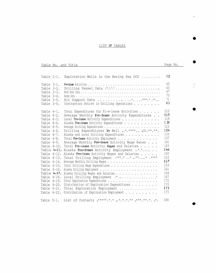
LIST OF TABLES
Table No. and Title Page No.*
Table 2-1.
Table 3-1.Table 3-2.Table 3-3.Table 3-4.Table 3-5.Table 3-6.
Table 4-1.Table 4-2.Table 4-3.Table 4-4.Table 4-5.Table 4-6.Table 4-7.Table 4-8.Table 4-9.Table 4-10.Table 4-11.Table 4-12.Table 4-13.Table 4-14.Table 4-15.Table 4-16.Table 4T17.Table 4-18.Table 4-19.Table 4-20.Table 4-21.Table 4-22.
Table 5-1.
Exploration Wells in the Bering Sea OCS . . . . . . . . . ●
Pre-lease Activities . . . . . . . . . . . . . . . . . . . . . . . . . . . . .Drilling Vessel Data ● **.*,*.* . . . . . . . . . . . . . . . . . . ● .Work Boat Data . . . . . . . . . . . . . . . . . . . . . . . . . . . . . . . . . . .Barge Data . . . . . . . . . . . . . . . . . . . . . . . . . . . . . . . . . . . . . . .Air Support Data . . . . . . . . . ● . . ...*.. . ..****.* .**...Contractors Active in Drilling Operations . . . . . . . .
Total Expenditures for Pi-e-lease Activities . . . . . .Average Monthly Pre-lease Activity Expenditures . .Local Pre-lease Activity Expenditures . . . . . . . . . . . .Alaska Pre-lease Activity Expenditures . . . . . . . . . . .Average Drilling Expenditures . . . . . . . . . . . . . . . . . . . .Drilling Expenditures by Well ● .*.****.. ● CO.**.**.Alaska and Local Drilling Expenditures . . . . . . . . . . .Total Pre-lease Activity Employment . . . . . . . . . . . . .Average Monthly Pre-lease Activity Wage Rates . . .Total Pre-lease Activity Wages and Salaries . . . . .Alaska Pre-lease Activity Employment ● .*.*..... . .Alaska Pre-lease Activity Wages and Salaries . . . . .Total Drilling Employment .***.* ..* ● .**...,* .****Average Monthly Drilling Wages . . . . . . . . . . . . . . . . . .Total Drilling Wage Expenditures . . . . . . . . . . . . . . . .Alaska Drilling Employment . . . . . . . . . . . . . . . . . . . . . .Alaska Drilling Wages and Salaries . . . . . . . . . . . . . .Local Drilling Employment .**. ● . . . . . . . . . . . . . . . . .*Total Exploration Expenditures . . . . . . . . . . . . . . . . . .Distribution of Exploration Expenditures . . . . . . . .Total Exploration Employment . . . . . . . . . . . . . . . . . . . .Distribution of Exploration Employment . . . . . . . . . .
List of Contacts ● *****.*.* ● .*.*.*.** ● ***.**.*. ● *.
12
456367707183
1121151191 ~o123124133137141143146150153157153161164167172172173173
180

—— LIST OF FIGURES
Figure No. and Title Page No.
Figure 1-1.
Figure 2-1.Figure 2-2.Figure 2-3.Figure 2-4.Figure 2-5.Figure 2-6.Figure 2-7$
Figure 3-1.Figure 3-2.
Bering SeaOCS Planning Areas . . . . . . . . . . . . . . . . . . .
Exploration in the Bering Sea OCS ● . . . ...*. ● ,.**.Norton Basin Lease Sale 57 . . . . . . . . . . . . . ...*... . .St. George Lease Sale 70 ● ****.*.*, .. *.*..*.* .***Navarin Lease Sale 83 . . . . . . . . . . . . . . . . . . . . .**..*.
North Aleutian Lease Sale 92 . . . . . . . . . . . . . . . . . . . .Sequence of Major Permits Required . . . . . . . . . . ● , ● .Major Permitting Process for ARCO’S
Birch Well No. 1-OCS-Y0436 . . . . . . . . . . . . . . . . . . .
Phases of Offshore Activity . . . . . . . . . . . . . . . . . . . . .Major Supply Routes . . . . . . . . . . . . . . . . . . . . . . . . . . . . .
6
101114171921
26
4290

1.0 INTRODUCTION”
—1.1 PURPOSE AND SCOPE OF STUDY
The Bering Sea is a promising frontier area in the continuing search for—
additional domestic reserves of hydrocarbons. The potential reserves of
the Bering Sea represent approximately 10 percent of the estimated undis-
covered offshore oil resources of the U.S. (Dames & Moore, 1982). There
are many promising geological formations in the Bering Sea. and this poten-
tial for hydrocarbon production is likely to stimulate a substantial
increase in exploration activity in the next few years.
—
Bering Sea petroleum exploration was conducted at a relatively low level
of activity for many years. Seismic surveys conducted in 1963 first indi-
cated the petroleum resource potential in the area. In the following 12
years, other geophysical exploration activities reinforced the original
positive indications. In 1976, the first Bering Sea Continental Offshore
Stratigraphic Test (COST) well was drilled in the St. George Basin.
Beginning in 1980 a series of four additional COST wells were drilled in
the area. In 1983 the first Bering Sea lease sales occurred for the
Norton and St. George basins. Since then, the magnitude of petroleum
operations has increased with each lease sale. These operations will
expand significantly if commercial quantities of oil are discovered.
Since previous petroleum operations in this area have affected the human
and natural environments, it is likely that the effects will increase as
the scale of activity increases. However, an accurate assessment of
these effects is often difficult since there is insufficient information
available on the affected environment.
-1-

The U.S. Department of the Interior, Minerals Management Service (MMS) has
regulatory and permitting responsibilities related to leasing. explor- ‘-
ation. development. and production of offshore oil and gas resources. In
addition, MMS, other federal agencies, and state agencies are charged with
protecting the human and natural environments while allowing develop ment ~
of the Outer Continental Shelf (OCS)
agencies are uncertain of the potential
and development on the environment.
resources. When the regulatory
effects of petroleum exploration
they must assume a conservative 1
posture to ensure that the stipulations and other regulations controlling
the activities of the petroleum industry will, in fact, protect the
environment. Often, as additional information becomes available and the
degree to which petroleum-related activity affects the environment is
better understood, the initial stipulations or regulations are modified to
be more or less stringent while still ensuring that environmental goals
are achieved.
In order to predict and evaluate the effects of OCS development upon the
—
—
human environment within the
Social and Economic Studies
research effort that includes
State of Alaska, MMS conducts the Alaska OCS
Program (S ES P). The SESP is a multi-year
several completed projects as well as contin- .—
uing studies of the human environment in the Bering Sea. The general
approach followed in SESP studies of the effects of petroleum activities
is to conduct a three-step analysis. This initiates with a projection of -
major petroleum-related activities, progresses to forecasting the direct
and indirect population and socioeconomic changes, and concludes with an
analysis of the effects of these changes.
-2-

To date, most”of the analyses and resultant stipulations for Bering Sea
lease sales have been based upon work that was completed prior to the
lease sales. These studies provided information on expected levels of
employment and equipment deployment, as well as the likely timing and
expenditures for OCS development.
To obtain more current
related OCS activities
Burden L Associates, in
information on the extent and effects of petroleum-
in the Bering Sea, MMS contracted with Patrick
cooperation with Dames & Moore, to conduct a
of relevant OCS activities in this area. The purpose of this study
study
is to
obtain sufficient information to provide an accurate description of OCS
development in the Bering Sea since 1980, including information regarding
events. equipment, timing, employment, and expenditures. In addition,
this study is designed to determine the effects of OCS activities,
including the effectiveness of stipulations, and to integrate data
collected by federal and state studies.
This report, which presents a summary of the findings of the Bering Sea
survey. is divided into three major sections: Background information on -
Bering Sea exploration (Section 2.0); a description of the exploration
process (Section 3.0); and a discussion of the effects of exploration
activities on economic characteristics
The remaining portions of this introduction
petroleum development in Alaska (Section 1.2)
of the area (Section 4.0).
present a brief overview of
and a summary description of
the research methods used in this study (Section 1.3).
-3-

—
].Q PETRoLEUM DEVELOPMENT IN ALASKA
The first commercial discovery of oil in Alaska occurred in 1902 near
Katalla, a now abandoned community located approximately 80 miles south of
Cordova on the Gulf of Alaska coast. Production continued until 1932 when “
fire destroyed part of the production facility.
The modern era of petroleum development in Alaska began with the discovery
of oil in the Swanson River area on the Kenai Peninsula in 1957, and the
first offshore petroleum discovery in Alaska occurred in 1964 in the
waters of nearby Cook Inlet. In that same year the State of Alaska began
leasing land on the North Slope for oil exploration. The Prudhoe Bay
oilfield was discovered in 1968, and planning for development of the field
began that year. Production from the field was delayed until completion
of the TransAIaska Pipeline System in 1977. Although a number of other
fields have been discovered in the vicinity of Prudhoe Bay (such as
Kuparuk, Milne Point, Seal Island, Endicott, West Saks Sands, and Point
Thomson), only Kuparuk and Prudhoe Bay are currently producing. Milne
Point is under development, and development of the remaining reservoirs is
under consideration by the lease owners.
The first federal lease sale of the Alaska offshore area was held in April
1976 in the northern Gulf of Alaska. Since that time, there have been ten _—
additional lease sales, three of which have been in the
Although exploration activities have occurred in leased
Alaska OCS, they have not yet resulted in commercial
Bering Sea.
areas on the
discoveries. .:
-4-

The Bering Sea OCS area extends from the Alaska Peninsula and its continu-
ation as the Aleutian Chain, northward to the Bering Straits. As shown in
Figure 1-1, this area contains five OCS planning areas: Norton Basin, St.
George Basin, Navarin Basin, North Aleutian Basin, and St. Matthew Hall.
Lease sales have been conducted for the first three planning areas.
Exploration drilling has taken place on leases in Norton Basin and St.
George Basin, and several firms plan to conduct drilling in the Navarin
Basin in the summer of 1985. A lease offering for the North Aleutian
Basin is scheduled for December 1985. St. Matthew Hall is not included on
the present leasing schedule. (Additional information on exploration
activities in the Bering Sea is presented in Section 2.1.)
1.3 RESEARCH METHODS
The study of Bering Sea OCS activities from 1980 through 1984 was con-
ducted from October 1984 through February 1985. As described below,
information was obtained from published documents and interviews with
lease operators and support contractors. Field verification was not
included but will be partially achieved through public and industry review
of the draft of this document.
In the initial phase of the study, the project team assembled and reviewed
available published documents for pertinent data. The primary sources
were exploration plans and environmental reports; permit applications and
similar public documents on file at public agencies; petroleum and con-
struction industry trade publications (e.g., Oil and Gas Journal, Alaska
-5-

—
‘b,
C#j‘3
m
-6”-
—
—
——
—

—
Report, Alaska Construction and Oil, and Offshore) that regularly report
on the status of industry plans and projects; newspapers from several
Alaskan communities; and available studies on relevant OCS related topics.
The extracted data were reviewed for timeliness and adequacy for the
project, and data gaps were identified. The necessary additional infor-
mation was obtained by further research of documents or file data, and
through interviews with (1) industry
the Bering Sea, and (2) staff members
management of OCS exploration.
personnel about oil exploration in
of public agencies responsible for
Contacts were made with lease operator personnel and with staff members of
firms providing services or equipment to the lease operators. Because of
the different types of data requested in the scope of work for this studv.
different sets of questions were asked of lease operators, marine support
contractors, air support contractors, shore bases, and other contractors,
This arrangement assured full coverage and comparability in the quality of
data collected from lease operators and contractors.
The project team contacted over 100 firms and agencies to obtain the
primary data for this report. A critical aspect of contacts with
operating firms was the verification of exploration data. Verification
was necessary since published data sources were sometimes in disagreement,
and unforeseeable factors occasionally necessitated revising exploration
plans after publication. In addition, the lease operators and support
contractors represent an extensive source of information, whereas
-7-

—
information presented in general interest publications or even trade
journals often did not meet the level of detail and specific data
requirements of this study.
9
—
—
—
-8-
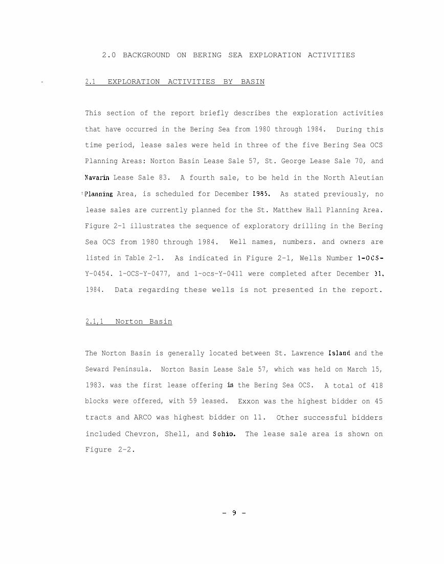
2.0 BACKGROUND ON BERING SEA EXPLORATION ACTIVITIES
— 2.1 EXPLORATION ACTIVITIES BY BASIN
This section of the report briefly describes the exploration activities
that have occurred in the Bering Sea from 1980 through 1984. During this
time period, lease sales were held in three of the five Bering Sea OCS
Planning Areas: Norton Basin Lease Sale 57, St. George Lease Sale 70, and
Navarin Lease Sale 83. A fourth sale, to be held in the North Aleutian
lPlanning Area, is scheduled for December 1985. As stated previously, no
lease sales are currently planned for the St. Matthew Hall Planning Area.
Figure 2-1 illustrates the sequence of exploratory drilling in the Bering
Sea OCS from 1980 through 1984. Well names, numbers. and owners are
listed in Table 2-1. As indicated in Figure 2-1, Wells Number l-OCS-
Y-0454. 1-OCS-Y-0477, and 1-ocs-Y-0411 were completed after December 31.
1984. Data regarding these wells is not presented in the report.
2.1,1 Norton Basin
The Norton Basin is generally located between St. Lawrence Island and the
Seward Peninsula. Norton Basin Lease Sale 57, which was held on March 15,
1983. was the first lease offering in the Bering Sea OCS. A total of 418
blocks were offered, with 59 leased. Exxon was the highest bidder on 45
tracts and ARCO was highest bidder on 11. Other successful bidders
included Chevron, Shell, and Sohio. The lease sale area is shown on
Figure 2-2.
-9-

1980 1981 ‘ 1982 1983 1984 1985Lease Sale JAN. DEC. JAN. DEC. JAN. DEC. JAN.Activity
DEC. JAN. DEC. JAN. DEe.
Iorton Basin Sale 57
Norton COST Well No. 1 ■mNorton COST Well No. 2 mDExxon 1-OCS-Y-0414 ❑6ExxorI I-OCS-Y-0430 mA13C0 I-OCS-Y-0436 am
it. George Sale No. 70
St. George COST We!! No. 2 EmMobil I-OCS-Y-0466 ❑mChevron %ocs-Y-0519 mExxon I-OCS-Y-0527 ❑ mExxon 1-OCS-Y-0530 d mARCO 1-OCS-Y-0537 m mARCO 1-OCS-Y0411 DShell 1-OCS.W0454 mGulf 1-OCS-W0477 b
Iavarin Sale No. 83Navarin COST Well No, 1 m-m
Iorth Aleutian Planning Area
N. Aleutian COST Well No. 1
(1 1, II I I ,, II 1, (1

—
—
Prior to the sale, two Continental Offshore Stratigraphic Test wells (COST
wells) were drilled in the Norton Basin Planning Area. The first well.
which was located about 55 miles (88 kilometers) south-southwest of Nome,
was drilled by ARCO on behalf of 20 other companies during the summer of
1980. The second COST well, drilled in the summer of 1982. was completed
by ARCO on behalf of 19 other companies. This well was located about 50
miles (80 kilometers) east of the first COST well.
The first exploration wells in the Norton Basin were drilled by ARCO and
Exxon in the summer of 1984. Exxon used the jack-up rig Rowan ?4iddletown
to drill Well Number 1-OCS-Y-0414” in June and July, and Well Number l-OCS-
y-0430 in July and August. Well Number 1-OCS-Y-0414 was plugged and aban-
doned as a dry hole, but no results have been released for Well Number
1-OCS-Y-0430. In June, July, and August of 1984, ARCO contracted for the
jack-up rig Key Hawaii to drill Birch Well Number 1-OCS-Y-0436; data for
this well have not been released.
2.1.2 St. George Basin
The St. George Basin is located east and southeast of the P ribilof Islands
and west of Bristol Bay. The lease sale area is shown on Figure 2-3.
Governor Sheffield did not concur with the Department of Interior’s
determination as presented in the proposed Notice of Sale for St. George
Lease Sale 70 that Lease Sale 70 would be consistent with the State of
Alaska’s Coastal Management Program. Consequently, two stipulations and
-13-

Figure 24s’% GNMMGE LEASE WuJEl 70
—
Si G@cwgeW2w3d
@,-,-(3
yj%
Chev !Sxxcm.0527
Exxon.0530
“E?2a
EXPLANATION
E2 Lease Sale 70 Blocks Offered
~ Lease Sale 70 Leased Wads
+ C(3ST Well+ IExphatwy Wel!s
Ml. O 10 1 50 , 50IKM. O 1 1 I 150
$s!’$ RCO COST0.21980
Mobil-0466
Ad
OQ
cow say *
\
MaJn 8s. P
—
1

—
Lease operators drilled five exploration wells in the lease sale area
between June and November 1984. Mobil, Chevron, and ARCO had each com-
pleted one exploration well by December 1. 1984. and Exxon had completed
two wells. Additional wells were underway in the lease area but had not
yet been completed as of December 31, 1984. Because these wells were not
completed within the study time period, they are addressed as future plans
(see Section 3.4.1).
2.1.3 Navarin Basin
The Navarin Basin is located west and northwest of St. Matthew Island. It
consists of three distinct subbasins, one of which extends beyond the U.S.
Continental Shelf and straddles the U.S.-Russia Convention Line of 1867.
The actual location of this line is presently being negotiated by the U.S.
State Department and the U.S.S.R.
Navarin Lease Sale 83 was held”on April 17. 1984. The lease sale area.
which is shown on Figure 2-4, consisted of over 5,000 blocks. with 163
leased. The total area of the leased blocks is 928,000 acres (375.562
hectares). Bids for 17 blocks covering 96.784 acres (39.169 hectares)
were accepted by MMS in the area of the 1867 Convention Line. Leases for
these bids cannot be issued until an agreement is reached between the U.S.
and U.S.S.R. Future activities in this lease sale area are addressed in
Section 3.4.1.—
–16-
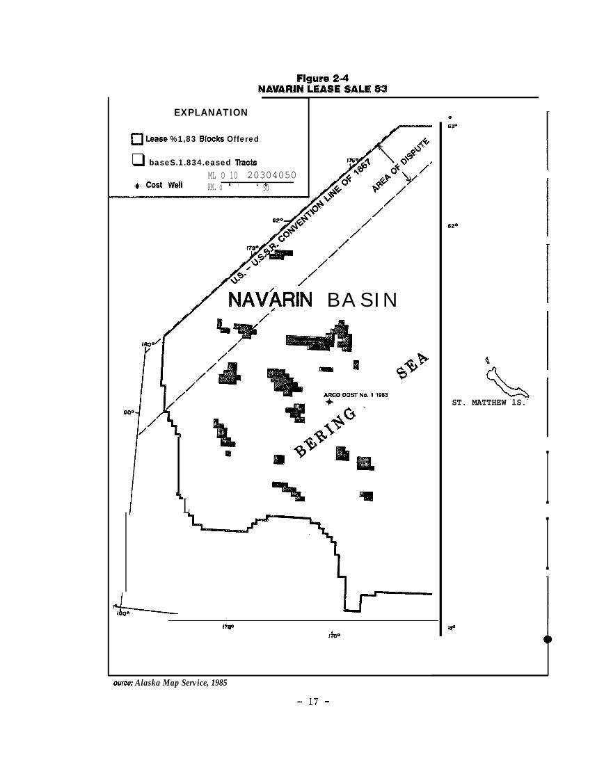
figure 2.4NAVAR~N LEASE SALE 83
EXPLANATION
~ Lease %1,83 ~,OdCS Offered
❑ baseS.1.834.eased TractsML O 10 20304050
+ Cx3st well 1 ,KM. o 1 850
//
//
/
/ lUAVhRIN B A S I N/
m
L
Ieo’a1I?@
1%30
ource: Alaska Map Service, 1985
ST. MATTHEW lS.-
[
[
1[
II
Ma
-17-

Prior to, the lease sale, one COST well was drilled in the Navarin Planning
Area. This well was drilled by ARCO during May through November of 1983.
on behalf of 17 other companies.
2 .1.4 North Aleutian Basin
The North Aleutian Basin underlies part of the Alaska Peninsula and
extends north into the Bering Sea. The area has been considered for
leasing since at least 1975. In October 1983, a lease sale was proposed
for an area termed North Aleutian Shelf Sale 75. However. This sale was
postponed until December 1985 to
Cooperative Management Plan. This
result of anticipated environmental
reduced the size of the sale area.
allow completion of the Bristol Bay
plan was completed in early 1984. As a.
concerns addressed in the plan. MMS
Thus, the originally proposed 5.947
blocks covering 32.4 million acres (13.1 million hectares) was reduced on
March 9, 1984. to 990 blocks covering 5.6 million acres (2.3 million
hectares), The revised” sale area named North Aleutian Lease Sale 92 is
depicted on Figure 2-5.
The Draft EIS for Lease Sale 92 has been completed, and public hearings
were held during February 1985 in Dillingham. Naknek. Sand Point, and
Anchorage.
One COST well has been drilled in the North Aleutian Planning Area. This
well was drilled by ARCO in the fall and winter of 1982-1983. Since North
Aleutian Lease Sale 92 has not taken place, no exploration activity has
occurred in the lease area.
-18-

-19-

2.2 MANAGEMENT OF EXPLORATION ACTIVITIES
The following portions of the report describe the methods and regulations
used by MMS and other agencies to manage exploration activities. Section
2.2.1 describes the permitting process and presents a specific example of
how this process has functioned. and Section 2.2.2 addresses stipulations
that are included in lease sales. Section 2.2.3 presents information on
mitigation measures that have been developed as lease sale stipulations or
other regulatory controls to minimize effects during exploration
activities.
2.2.1 The Permitting Process for Exploration
2.2.1.1 Overview of the Permitting Process
Lease operators must satisfy the major permit requirements listed below
before MMS can approve offshore drilling in a lease sale area. The
sequence of permitting is illustrated in Figure 2-6. The application of
these permit requirements for exploration activity in the Bering Sea is
addressed in the remainder of this section. The major permit requirements
are as follows:
1. Preliminary surveys must be performed as required
lease sale stipulations. Surveys required for a
sale may include any or all of the following:
cultural resources, biological resources, and
aspects.
by MMS in the
specific lease
geohazards.
geotechnical
-20-

FIgwe 2=6SEQUENCE OF MAJOR PERMITS REQUIRED FOR EXPLORATION
EPA WOES PERMITAPF%lCATKIN FLED~
iv
I EXPLORATION PLAN 1SUBMITTED
FiEVIEWV OF EXPLORATIONPLAN W MMS AND OTHERFEDERAL, W..TE ANDLOCAL AGENCIES
CMitWI’s COASTAL ZONECONSISTENCY
AW%EATKX4 FORPEBM!T K) BRILL
c MMS DRILLINGv UNIT APPROVAL
APPROVED PERMITTO DRILL
W. COAST GUARDRIG INSPECTION \A EPA NFV3ES PERMITCERTFKATN3N APPI%OVAL
\/
IDRMJNG I
This flow chart illustrates the gene@sequence of -MAJOR permits. anqknotintended to represent a!! aspects of the permitting pr6ce%s. -
-21:
—
—m
.—

.
The preliminary survey requirements are prescribed in the lease sale stipu-
lations. Cultural and biological survey requirements may be eliminated by
the MMS Regional Supervisor if it is unlikely that areas of cultural or
biological significance occur in the lease sale area. The Regional
Supervisor determines what surveys will be required after reviewing
comments from an appointed Biological Task Force and the State of Alaska
Historical Preservation Officer. To date, geotechnical surveys in the
Bering Sea have been
tures. Consequently,
Norton Sound where
required only for bottom-founded OT fixed struc-
geotechnical surveys were required only for wells in
jack-up rigs were used. Geohazards surveys are
required for all operations.
After survey results are submitted to MMS by lease operators. MMS reviews
the data and may request revisions or additional information”, if neces-
sary. MMS formally approves surveys concurrently with issuance of an APD.
The most critical requirement for lease operators is approval of the
Exploration Plan. Once the plan is submitted. MMS has 10 working days to
determine whether or not the Exploration Plan is complete; that is. MMS
must determine if the plan provides the information necessary for the
regulatory review process. At the end of the 10-day peiiod, M&fS issues a
Determination of Completeness. If the Exploration Plan is incomplete, the
lease operator has as much time as necessary to complete and resubmit the
plan. After the plan is determined to be complete. the lease operator
must then submit copies of the Exploration Plan to MMS for distribution to
federal, state. and local agencies. From this point, MMS has 30 calendar
days to approve or disapprove the plan or require modification to the
-23-

plan. Within this 30-day time period, other reviewing agencies have 20
days to submit comments to MMS, and MMS must complete an environmental
assessment of the plan. If MMS determines the Exploration Plan will not -
—
result in significant impacts, a Finding of No Significant Impact (F ONSI)
is issued. However. if MMS finds that significant effects may result from
exploration activities, the agency must prepare an EIS. Issuance of the -
Final EIS may take up to 2 years from the time the decision is made to
prepare the document assuming that the Draft EIS is not challenged in
court.
As part of the application review process, the state’s Coastal Zone
Management Office, a branch of the Office of Management and Budget (O MB),
evaluates the completed exploration plan with regard to consistency with
the Coastal Zone Management Program. OMB has 45 days from the date it
receives the plan from MMS to determine whether or not the plan meets
Coastal Zone Consistency Certification requirements.—
The C east Guard initiates a review of the drilling rig proposed for use
by the vessel operator in the Exploration Plan. When the vessel is
approved, the Coast Guard issues a Certificate of Inspection. This
certification is issued on an annual basis for each rig and the certif-
ication process usually does not affect the permit processing schedule.
The MMS district office also approves each drilling unit. Xost rigs are
generally approved for use on a special lease although the MMS District
Office occasionally approves a rig for an area or a proposed well site.
-24-

Each lease operator must obtain a NPDES permit from the EPA prior to
initiation of exploration activities. Upon receipt of an NPDES
application deemed to be complete by the agency, EPA will distribute
appropriate information to agencies for review, with comments due back
within 30 to 45 days. An individual NPDES permit can be issued for each
well, a process that can take up to 6 months following receipt of an
application deemed to be complete, or EPA can issue a general permit which
covers an entire lease sale area. Within this general permit system, the
lease operator need only apply for coverage of a specific well under an
existing general NPDES permit.
EPA has issued general NPDES permits for Lease Sale Area 57, 70, and 83.
A waived request seeking coverage under these permits must be submitted at
least 60 days in advance of discharges. After approval of the Exploration
Plan package by MMS, and after a Coastal Zone Consistency Certification is
issued by OMB, a permit to drill can be filed and approved by the MMS
District Supervisor. However, lease operators must still meet the
requirements of the EPA and Coast Guard before any drilling can take
place.
2.2.1.2 Permitting Process for ARCO’S Birch Well
The following portion of the report describes the permitting process that
was followed for ARCO’S Birch Well Number 1-OCS-Y-0436 in Norton Basin
Lease Sale 57. The procedures identified for this well are thought to be
representative of the permitting process for all Bering Sea exploratory
wells.
-25-

—
-26-

In general, permitting for this well was accomplished within the time “
frame outlined above. With the exception of a delay in the Coastal Zone
Consistency Certification Process, all other permits were issued on time
and the entire process from receipt of the Exploration Plan by MMS to
issuance of the APD. took 141 davs, or about 4.5 months (see Figure 2-7).
No surveys of cultural or biological resources of the site were required
by the MMS Regional Supervisor. A geohazards survey was conducted on
September 8 and 9, 1983 and survey results were submitted to MMS on
January 3. 1984. A geotechnical survey was performed on September 8, 9.
and 10. 1983 and submitted to the MMS District Office on April 3, 1984.
Approval of these surveys coincided with the issuance of an APD on June 1.
1984.
The Exploration Plan for Birch was
12, 1984. In the Determination of
initially submitted to MMS on Januarv
Completeness issued 10 working days
later (January 27, 1984) MMS deemed the plan incomplete and requested
further information on the Oil Spill Contingency Plan. ARCO resubmitted
an Exploration Plan package that included the additional information. The
plan was deemed complete on February lb, 1984 and the 30-calendar-day
review period began. MMS issued a Finding of No Significant Impact
(FONSI) and the Exploration Plan was approved on March 19, 1984. Although
plan
30th
day
approval was issued 32 days after the plan was deemed complete, the
day was a Saturd”ay, and the plan was approved on the first working
after that weekend.
-27-

As noted above, the OMB review process for issuance of the Certification
of Consistency with the State Coastal Zone Management Plan normally takes
45 days from the date of receipt of a copy of the Exploration Plan from
MMS. OMB received the Birch No. 1 document on February 22. 1984. On
March 20, 1984 OMB stopped the 45-day process to request additional
information on ARCO’S Oil Spill Contingency Plan. ARCO prepared and
submitted the requested materials to OMB on April 16, 1984. and the 45-day
review process resumed. A Certification of Consistency was issued on Mav
7, 1984. This portion of the permitting process was delayed approximately
28 days.
—
.
ARCO proposed to use the drill rig Key Hawaii for the exploration well. -—
This vessel had received a Coast Guard Certificate of Inspection on
October 14, 1983 and MMS’s Drilling Unit Approval inspection was performed
on April 11, 1984, with the rig approved on April 17, 1984.
The Alaska Oil and Gas Association (AOGA) and several companies requested
a general NPDES permit be prepared for Norton Basin Sale 57 in 1980. EPA -—
issued this draft general NPDES permit on June 24, 1983. Public hearings
were held on July 29 and August 2 in Nome, and public comments were
accepted until August 15. The final general NPDES permit was issued on _
December 7, 1983. According to EPA personnel. the time taken to issue the
permit was slightly longer than usual, primarily due to a lawsuit filed bv
the people of
the Interior.
Lease Sale 57
Interior to
the Village of Gambell against James G. Watt, Secretary of
The village sought a preliminary injunction to postpone
and a-permanent injunction requiring the Department of the
protect their subsistence rights. —
-28-

.—
-,
ARCO requested coverage under the EPA’s NPDES general permit for Norton
Basin on April 17, 1984. It was granted 22 days later on May 9. 1984, a
relatively fast turnaround time. In addition to filing for the permit.
ARCO was required to notify the EPA of any mud additives anticipated for
use in their drilling fluids that were not already listed on the general
permit. ARCO notified the EPA in four separate letters sent between April
13 and June 6 of the anticipated use of several such additives. On June
25, 1984, EPA approved the use of all chemicals identified in these
letters.
After satisfying other permit requirements, ARCO submitted its Application
for a Permit to Drill on May 5, 1984. Approval was granted on June 1,
1984, 141 days after submittal
2.2.2 Lease Sale Stipulations
of the Exploration Plan.
The Notice of Sale for each oil and gas lease sale offered by the MMS
includes stipulations that are intended to minimize potential environ-
mental and cultural impacts due to OCS oil exploration and development.
Stipulations for an individual lease sale are formulated by MMS in
consultation with federal agencies such as the National Marine Fisheries
Services and the U.S Fish and Wildlife Service, with the State Historical
Preservation Officer, and with other local government agencies and private
organizations. The stipulations used in Bering Sea lease sales are
generally similar; commonly used lease sale stipulations are briefly
addressed in Section 2.3.2.1. Section 2.3.2.2 provides more detailed
-29-

.
information on the stipulations included in Norton Basin Lease Sale 57,
and their relevance to AR CO’S Birch No. 1 well.
The stipulations in an oil and gas lease Notice of Sale are followed by a
clarification of federal laws and othef items pertaining to activities in
the lease area (“Information to Lessees”). Other requirements are also Q
included in the Notice of Sale, such as the requirement to submit an Oil
Spill Contingency Plan, and suggestions regarding local input and local
hiring are also listed.
‘2,2,~oI Common Lease Sale Stipulations
\_
In lease areas where the MMS Regional Supervisor has reason to believe
that a site. structure, or object of historical or archaeological signif -
icance, or a “cultural resource” may exist, the lease operator is requireda
to conduct a remote sensing survey before any exploration activity can
commence. This stipulation is included in all Notices of Sale regardless
of the probable existence or non-existence of such resources.
The MMS Regional Supervisor determines whether or not there are biological
resources or habitats present that require additional protection. If any _
such areas are identified, a biological survey may be required to further
evaluate these areas.
@A stipulation in each lease sale requires the lease operator to establish
and conduct an environmental training -program for all personnel involved
in exploration. In this program the lease operator must identify environ
-30-

9
mental, social, and cultural concerns unique to the lease sale area. This
program must be attended at least once a year by all personnel involved in
the conduct of operations.
Another commonly applied stipulation prohibits drilling below a designated
depth in broken or pack ice conditions, unless the lease operator can
demonstrate the ability to “detect, contain. clean-up and dispose of
spilled oil in broken and pack ice condition s.” Another stipulation used
in all but Navarin Lease Sale 83 gives MMS the authority to determine if
pipelines should be constructed, given a set of technical. environmental.
and economic circumstances.
In some lease sale areas, endangered bowhead whales and gray whales are
protected by a seasonal stipulation. This stipulation provides the MMS
Regional Supervisor with the “authority to suspend oil and gas drilling
operations” when these whales migrate close enough to the drilling
operations to be adversely affected. For each lease sale area in which
whales may be affected, the stipulation indicates the time period when the
Regional Supervisor may require the suspension of exploration drilling.
For example, in Norton Basin Lease Sale 57, a stipulation in the Notice of
Sale listed April 15 through June 15, and November 1 through January 1 as
the most likely periods of migration.
After the stipulations in the Notice of Sale for any lease sale area are
made public, the MMS Regional Office may clarify and update information on
these stipulations. For example, after consultation with the Bering Sea
Biological Task Force. the need for and scope of biological surveys are
-31-

determined. Similarly, if it can be determined that no cultural resources
exist on a specific lease tract or in the entire lease sale area, or if
known cultural resources will not be disturbed by exploration activities, -
a cultural survey may not be required; The lessees are still required to
report any cultural resources that are found during operation to the MMSa
Regional Supervisor, and the operators must take precautions against
damage until the resource has been evaluated.
‘7 9 2.2---- Stipulations for Lease Sale 57—
Stipulations included in Norton Basin Lease Sale 57 are considered
representative of stipulations that would he applied throughout the Bering -
Sea OCS. These stipulations are briefly addressed below, with the full
text of the Lease
Stipulation Number 1
survey be conducted.
Sale 57 stipulations presented in Appendix A,
of Lease Sale 57 requires that a cultural resources
However, the MMS Regional Supervisor stated in a
letter dated September 28. 1983 that a cultural resources survey would not -—
be necessary since MMS had determined that (1) cultural resources are
probably not present in the lease sale area and, (2) if such resources are
present, they would not be
in consultation with the
stated that if any cultural
additional actions may
detectable. This MMS decision, which was made @
State Historic Preservation Officer, further
resource is detected during geohazard surveys,
be required.

The second stipulation required all personnel involved in exploration
activities to have environmental training relating SP ecif ically to envir-
onmental, social, and cultural conditions of Norton Sound. Lease oper-
ators were required to submit information regarding their training
programs along with the Exploration Plan.
——-
*
Stipulation Number 4 required the “suspension of exploratory drilling and
downhole activities below predetermined threshold depth during broken ice
and pack ice conditions” unless the lessee can demonstrate an ability to
“clean up and dispose of spilled oil in broken and pack ice conditions”.
To date, no operator in Lease Sale 57 has applied for permission to drill
during broken and pack ice conditions.
Stipulation Number 5 gave the MMS Regional Supervisor “authority to
suspend oil and gas operations whenever bowhead whales are near enough to
be affected by oilspills or other disturbances which would be likely to
adversely affect the speciest’, specifically if bowhead whales are sighted
east of St. Lawrence Island. It further indicated that migration would
most likely occur between April 15 through June 15, and from November 1
through January 1. Basically, this same seasonal stipulation was app lied
to drilling during gray whale migration east of St. Lawrence Island. HMS
intends to have or require lessees to have a monitoring program in place
to determine the status of bowhead and gray whale migration in the Lease
Sale 57 area if operations are proposed during these periods when whales
are expected to be present.
-33-

To date. all exploratory drilling in Lease Sale 57 has been conducted
after June 15. Therefore, no suspension of operation was necessary in the
spring of 1984. However, both Exxon and ARCO proposed to drill during the ~
fall of 1984. To be consistent with the Alaska Coastal Management Program
which has policies to ensure protection of migrating bowhead and gray
whales, ARCO agreed to shut down Well Number I-OCS-Y-0436 (Birch No. 1) by .=
August 15, 1984 and Exxon proposed to shut down Wells Number 1-OCS-Y-0414
and 1-OCS-Y-0430 (Teton No. 1 and Chugach No. 1) by September 10. 1984. or
sooner if necessary to maintain relief well capability. These dates were *
selected to allow time for the drilling of a relief well during the
ice-free season and before whales entered the area, in the event such
wells were necessary.:—
Stipulations 6. 7 and 8 address production activities such as pipeline
location. offshore tankership loading and discharge of produced waters. .
Since oil development has not reached the production phase, these
stipulations have “not gone into effect. .
Other lease area requirements and suggestions to lease operators in Lease
Sale 57 are presented in the “Information to Lessee” section of the Notice
of Sale (see Appendix B for the full text). These additional requirements
were included at the request of Governor Sheffield in 1982 after the orig-
inal Notice of Sale was found to be in conflict with the Alaska Coastal
Management Program. Major aspects are listed below.●
-34-

e
1. Marine vessels and aircraft are required “to maintain at least a
l-mile distance from observed wildlife and known wildlife concen-
tration areas ...”
2. Operators and contractors are advised to protect portions of the
Iditarod Trail from Kaltag to Nome “ . .. following along Norton Sound
and crossing the ice between Shaktoolik and Bald Head and Ungalik and
Bald Head... ”
3. There should be minimal interference with subsistence harvests.
4. The Yukon Delta and St. Lawrence Island areas need specia I
protection in the case of an oil spill.
5. The seasonal restrictions for the gray whale are to be identical
to those for bowhead whales.
6. Lessees are encouraged to hire local residents and provide
training programs to help mitigate local social and economic impacts.
7. Lessees are encouraged to work with local individuals and organi-
zations to minimize adverse impacts.
-35-

—2.2 .3 Mitigation Measures
Offshore oil development in the Bering Sea could cause a variety of
environmental, cultural. social, and economic effects in the Bering Sea
region. Mitigation measures have been developed to reduce or eliminate
anticipated effects. Many of these measures have been included as part of
the lease sale stipulations, and others have been developed through local
planning documents or public meetings.
Mitigation measures developed for Norton Basin Lease Sale 57 are described
below. These mitigation measures were applicable to AR CO’S Birch No. 1
well.
The stipulations and “Information to Lessee” listed in the Notice of Sale
for Lease Sale 57 represent a set of mitigation measures. These stipu-
lations. which are discussed in the preceding section, are intended to
reduce effects to the local environmental, cultural, and socioeconomic
systems.
The City of Nome Coastal Management Program, prepared by the City of Nome
in 1983, addresses methods to minimize the impacts of exploration
activities on Nome. It also includes measures designed to reduce the
anticipated effects from siting an energy production facility in Nome.
The program outlines specific measures that must be taken by lease
operators if a population increase of at least 5 percent of Nome’s
existing population occurs. In addition, the program more generallv
\_
*
*
4!!
●
9
—
- 3 6 -
—

●
addresses construction of new housing and utilities, subsistence
protection, recreation facility needs, police protection, fire fighting
cap abilities, and adequate medical facilities. Mitigation measures are
also addressed in the coastal management plans of areas adjacent to the
Bering Sea. These areas include the Bering Straits Coastal Resource
Service Area (C RSA) which has a plan currently under review, and the
Yukon/Kuskokwim CRSA which had a Coastal Management Program adopted in
October 1984.
In addition to the Coastal Management Programs, the Final EIS prepared bv
MMS for Lease Sale 57 also discusses mitigation measures. This document
lists mitigation measures that were considered by MMS, the issue that has
generated the mitigation measure,
to the proposed measures from a
solicited by MMS during a series
the intent of the measure, and response
variety of sources, including comments
of public hearings held for the Draft EIS
in Nome, Savoonga, Unalakleet, Kotlik, Emmonak, Bethel, and Anchorage.
The types of mitigation measures discussed in the Final EIS fall into the
six general categories listed below.
1. Orientation or training for oil-service personnel.
2. Transportation of hydrocarbon products.
3. Protection of marine mammals during peak migration periods.
4. Areas of special concern.
5. Other information to lessees on bird and mammal protection.
6. Information to lessee on subsistence activities.
-37-

2.z.4 Accidents in the Bering Sea” OCS
c:Environmental protection is one of the primary concerns in the exploration
and development of a petroleum resource. For this reason, lease
involved in oil-related activities are required to submit an
Contingency Plan to MMS as part of the Exploration Plan.
operators
Oil Spill9
Further,
stipulations listed in the Notice of Sale for lease sales in the Bering
Sea require lease operators to design and implement an environmental
training program for employees involved in drilling-related operations. A -
demonstration of oil spill cleanup capability and an oil spill training
program are also required by the stipulations. However, accidents
occasionally happen during exploration and
extensive effort designed to minimize
development, in spite of the -
their occurrence.
2.2.4.1 Hydrocarbon accidents
MMS defines a major (Class III) hydrocarbon accident as one in which over
200 barrels of hydrocarbons are spilled in a single incident within a ●
30-day period. From 1980 through 1984, no Class III accidents occurred in
the Bering Sea Planning Area. A Class II hydrocarbon spill (between 6 and
2(3(3 barrels) occurred in Norton sound on July 19, 1984, when a fuel tank -
was punctured while being transferred from a barge to the supply vessel
Indian Seahorse. Approximately 100 barrels of diesel fuel spilled into
Norton Sound creating a “sheen” 30 to 40 feet wide and about 4 miles @
long. There were also several reports of spillages of 1 gallon or less in
the Planning Area.
-33-

—
2.2.4.2 Personal injury accidents
A major personal injury is defined by MMS as an injury that results in a
loss of work time exceeding 72 hours. Several major personal injuries,
including injuries that resulted in death, occurred during exploration in
the Bering Sea OCS from 1980 through 1984. These injuries included a—
bi-oken leg that occurred when an ARCO representative tripped as he
disembarked from a helicopter onto the Key Hawaii in Norton Sound, and a
hernia rupture suffered by an employee on the Rowan Middletown in Norton
Sound.
Two diving-related deaths took place in 1980 and 1984. The first death
occurred in the Norton Sound on the jack-up rig Dan Prince, and the second
occurred in the St. George Planning Area on the Sedco 708. According to
the attending physicians’ reports, both deaths were the result of
embolisms. A third death in January of 1985 was caused when a snatch
block was dropped 85 feet and struck an employee on the Ocean Odyssey.
-3’3-

3.0 THE PETROLEUM EXPLORATION PROCESS
3.1 INTRODUCTION ,
Petroleum exploration is performed by a broadly-based industry that empha-
sizes a variety of special skills and technical disciplines. As Hutcheson *
and Hogg (1975) observed in the North Sea, major oil companies finance and
control the exploration activities, but most of the work is contracted to
specialist firms within the industry. For example, geophysical explora-
tion and exploratory drilling are normally undertaken by specialist firms
that own and operate the necessary vessels and equipment. Downhole engi-
neering services such as well-logging, directional drilling, and flow- .—
testing of oil or gas discoveries are performed by other service companies
with the specialized equipment and expertise.
*
The network of firms involved in a Bering Sea petroleum exploration
program is complex. Firms involved in providing services and supplies
range from large international firms that own and operate semisubmersible
drilling rigs that lease for $100,000 per day, to small, local janitorial
supply firms that provide paper buckets for core samples.
To provide an understanding of the exploration industry and the manner in
which it affects local communities and the State of Alaska, this section
of the report addresses the exploration operation and the firms that are a●
part of this industry. Section 3.2 presents a brief summary of the explor-
ation process. and Sections 3.3 and 3.4 provide information on pre-lease
sale activities and drilling phase activities. Section 3.5 discusses the
-40-
transportation system used for exploration, and Section 3.6 describes
planned exploration and development activities in the Bering Sea OCS.
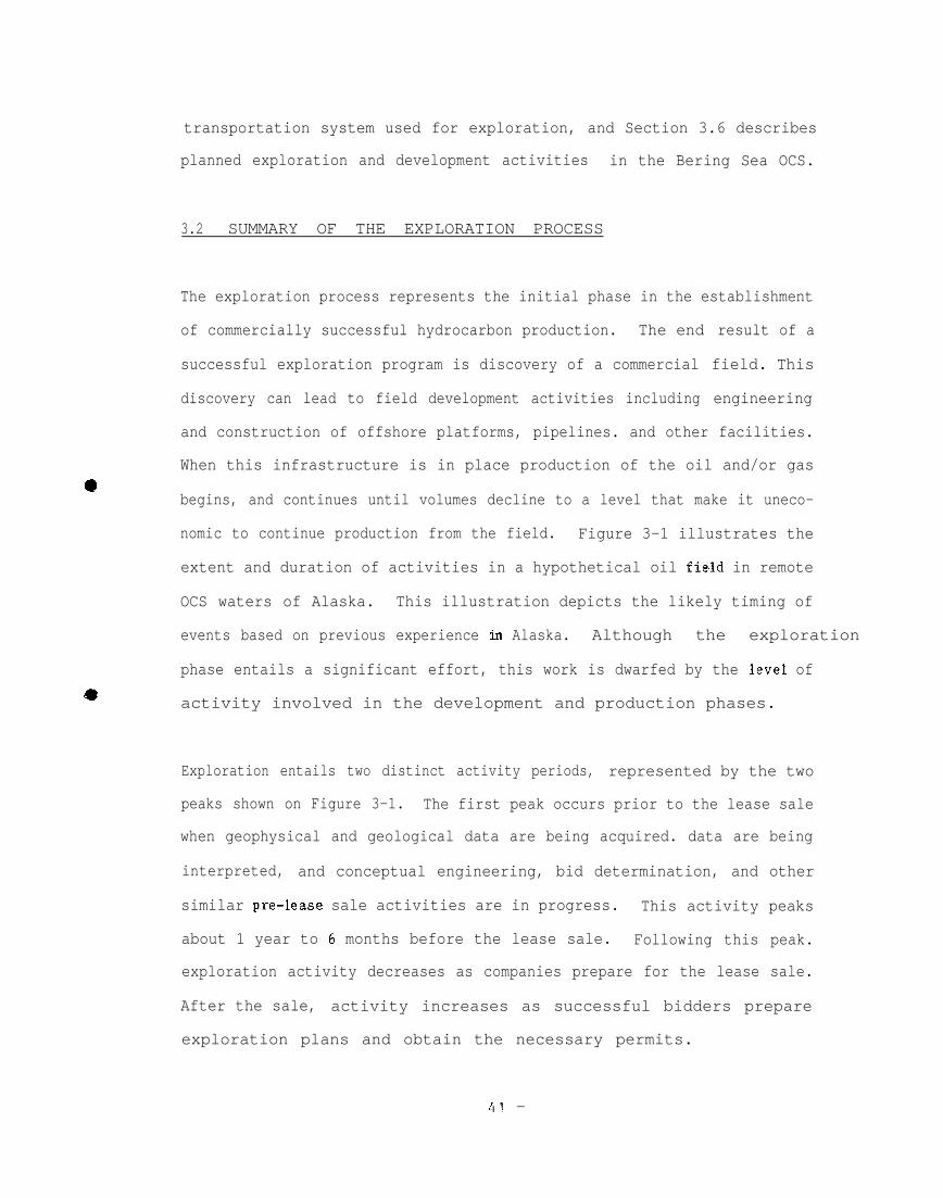
3.2 SUMMARY OF THE EXPLORATION PROCESS
The exploration process represents the initial phase in the establishment
of commercially successful hydrocarbon production. The end
successful exploration program is discovery of a commercial
discovery can lead to field development activities including
result of a
field. This
engineering
and construction of offshore platforms, pipelines. and other facilities.
When this infrastructure is in place production of the oil and/or gas
begins, and continues until volumes decline to a level that make it uneco-
nomic to continue production from the field. Figure 3-1 illustrates the
extent and duration of activities in a hypothetical oil field in remote
OCS waters of Alaska. This illustration depicts the likely timing of
events based on previous experience in Alaska. Although the exploration
phase entails a significant effort, this work is dwarfed by the level of
activity involved in the development and production phases.
Exploration entails two distinct activity periods, represented by the two
peaks shown on Figure 3-1. The first peak occurs prior to the lease sale
when geophysical and geological data are being acquired. data are being
interpreted, and conceptual engineering, bid determination, and other
similar pre-lease sale activities are in progress. This activity peaks
about 1 year to 6 months before the lease sale. Following this peak.
exploration activity decreases as companies prepare for the lease sale.
After the sale, activity increases as successful bidders prepare
exploration plans and obtain the necessary permits.
41 -

IIiI iI i
—
. .81iiK+30Oam.
-‘ - 4 2 -. - .

The second peak in the exploration process occurs during exploratory dril-
ling. Drilling normally continues for about 3 years, to delineate a
commercial discovery, or until a lease operator determines that the like-
lihood of finding a commercial field in the lease area is very small. If
exploration results in the delineation of a commercial field, development
activities commence in earnest.
3.3 PRE-L EASE SALE ACTIVITIES
The primary activities during this phase of the exploration process are
(1) the performance of preliminary geophysical and geological su rvevs over
an entire region of development potential, and (2) the interp retation of
data obtained in these surveys. The data obtained during this phase
allows individual companies or operating groups to identify particular
blocks of land they consider promising for exploration. COST wells are
drilled before a lease sale occurs, and the information obtained and the
effects of COST wells are similar to those of exploratory drilling. Thus.
COST wells are discussed in Section 3.4, Drilling Phase Activities.
Seismic surveys as well as gravity and magnetic surveys are conducted as a
part of pre-lease sale activities to evaluate areas likely to be further
explored. Although most of these surveys are undertaken before the lease
sale, additional surveys may be conducted after the sale to gather site-
specific geological data to assist with exploration drilling and deline-
ation decisions. High-resolution geophysical surveys are also conducted
to determine the potential for shallow geologic hazards in the lease sale
area. Most high-resolution geophysical surveys are conducted after the
lease sale,
-43-

●
Descriptions of specific activities occurring during this phase of exp lor-
ation as well as the equipment, labor, and support associated with them _
are addressed below.
3.3 .1 Geophysical Surveys
Airborne, regional marine, and high-resolution marine geophysical surveys
have been conducted in the Bering Sea OCS. These surveys will continue to
be of importance in future exploration programs in the area. The activ- ‘
ities, equipment, and personnel associated with these surveys are des-
cribed below. Table 3-1 lists the types of surveys conducted. the firms —
involved, and the number of surveys conducted in the Bering Sea from 1980
through 1984.
3.3.1.1 Airborne geophysical surveys
Exploration in offshore frontier areas is usually initiated by fixed-wing
*aircraft performing reconnaissance-level gravity and magnetic surveys.
These surveys are designed to aid in identifying sedimentary basins and
determining their sedimentary thickness as well as to locate other large
geologic features.
The surveys
gravity that
use a gravimeter to measure areal inequalities in the force of
result from irregularities in the composition of the earth’s——
crust. These irregularities result from the differing densities of rock
types and from structural changes in rock formations. Similarly, magne-
tometers are used in magnetic surveys to measure abnormalities in the a
l+i -

—
*
TABLE 3-1
PRE-LEASE SALE ACTIVITIESIN THE BERING SEA, 1980-1984
Number of Operations by Year
Activity/Company 1980 1981 1982 1983 1984
Regional Marine SurveysARco o 0 1 1 0C omap o 0 0 0 1Digicon 1 1 2 3 3Energy Analysts o 0 1 0 0GECO 2 2 3 1 0GS I 1 3 3 2 2Mobil o 0 1 0 0Western Geophysical 4 5 6 2 5
Subtotal 8 11 17 9 11
High Resolution SurveysHarding Lawson o 0 0 0 1InterOcean o 0 1 1 0Marine Technical Svcs. 1 2 1 1 3Nekton
Subtotal
*
Geological SurveysGeocubicMcClellanTetraTechWoodward-Clyde
Subtotal
Navigation SystemsNCS, International
e Offshore Navigation
Subtotal
Airborne SurveysPhotogravityAeroserv5.ces
Subtotal
TOTAL OPERATIONS
1 0 0 1 1
2 2 2 3 5
0 0 0 1 02 2 2 1 01 0 0 0 00 0 0 1 0
3 2 2 3 0
1 1 2 2 21 1 1 2 2
2 2 3 4 4
0 0 1 1 00 1 1 1 0
0 1 2 2 0
15 18 26 21 20
Sources: Patrick Burden & Associates and Minerals Management Service
-45-

strength and direction of the earth’s magnetic field. Data obtained from
these surveys provide information on variations in the depth and nature of
rock types.
Specialized firms generally conduct airborne geophysical surveys many
years in advance of a potential lease sale. The results of the surveys -
are sold to interested firms on a non-exclusive basis. Purchasers of
these data include major oil companies interested
tracts and marine geophysical firms interested in
in acquiring lease
conducting detailed*
surveys in the region. In some cases an individual oil company or group
of companies may contract with an aerial survey firm to obtain more data
about a particular location within a larger region. The duration of each _
survey is dependent upon the size of thearea to be surveyed, with field
survey time ranging from several weeks to several months.
Airborne geophysical
twin-engine aircraft
._
surveys are usually performed by specially equipped
with a crew of two. Food and lodging for the crew
and aircraft fuel are the principal support
conducting the surveys may occasionally
aircraft, a tie-down location at a local
requirements. Although firms*
lease hangar space for the
airport is usually adequate.
@Nome was the air support center for airborne surveys conducted in Norton
Sound, and Cold Bay and the Pribilof Islands were both used as air support
centers for surveys in the St. George Basin. The Navarin Basin surveys
were conducted from St. Lawrence Island.
-46-

3.3.1.2 Regional Marine Geophysical Surveys
●
Regional marine geophysical surveys. which represent the second stage of
exploration in offshore frontier areas, have been conducted in the Bering
Sea since 1963. Firms in this industry own or lease specialized vessels
that are used to conduct seismic, gravity, magnetic. and. occasionally,
geological surveys in specific areas of interest within a region. Marine
geophysical surveys are conducted on either a non-exclusive arrangement or
on a contractual basis with one or more of the oil companies interested in
obtaining data for a particular area. In addition, MMS frequently
purchases non-exclusive information.
In seismic surveys, sound waves are directed toward the ocean floor from
equipment towed behind the vessel. These sound waves are reflected from
the different rock strata back to the vessel, with the time of sound wave
travel dependent on the density of the formation. Data on sound wave
reflections are recorded and analyzed to identify geologic features.
Seismic data mapping is often conducted across a large area encompassing a
COST well to permit correlation of seismic records with the rock forma-
tions identified from well sample analysis. This information aids in
locating andidentifying deviations from conventional patterns of sedimen-
tation and stratiformation, deviations often associated with the presence
of hydrocarbon reservoirs.
To ensure that data are collected in the correct locations, sophisticated
navigation systems are used. These systems include combinations of
compass heading and velocity sensors as well as satellite and radio
-47-

surveying systems. The radio systems include LORAN and ARGO, both of
which measure the ship’s position with respect to transmitter stations
(see Section 3.3.3 for additional information). These transmitters are @
generally land-based. Because the Navarin planning area is located so far
from shore, buoy mounts and transmitters were also used to triangulate
positions. e
Geophysical vessels operating in Alaskan waters are generally over 150
feet (46 meters) long and are equipped for cruises of up to 1 month in ~
duration. A vessel may work in several lease sale areas during the
season, starting in the southern Bering Sea in May or June moving north-
ward as weather and ice conditions permit, and reversing the sequence in
the fall. These vessels typically spend 3 to 4 months in Alaskan waters.■
although only-a portion of this time may be in the Bering Sea. After
completing their Alaskan assignments, many of the vessels return to ports -
in Seattle or California, with some continuing to the Gulf of Mexico or
other temperate waters for geophysical surveys.
Marine geophysical surveys generally require a total crew size (including
all shifts) of approximately 24 to 35, except for the largest vessels
which c-an have crews as large as 45. Approximately half of the crew●
consists of survey technicians, and the remainder of the crew operates the
ship. The crews generally rotate on a schedule of 2 months on and 1 month
off, and are flown home on their off time as part of their employment —
contract. A typical technician crew during a survey would consist of 1
survey crew manager (and possibly an assistant), 2 navigation specialists,
4 or more seismic operators or observers, 2 mechanics, and 1 or more
client representatives.
-48-

Most geophysical firms charter aircraft to transport their crews from
Anchorage to Dutch Harbor or other transfer sites where the ships may be
in port. This service is obtained on a competitive bid basis, with the
average cost ranging from $12,000 to S15,000 for 1 crew change per month.
This represents the charter cost for one roundtrip flight for half of the
crew (approximately 15-18 persons). Vessels operating in Norton Sound
have often made crew changes at Nome using helicopters or small craft,
with charter flights used to transport crew members from Nome to Anchorage
for flights home. In addition to these charters, the firms also purchase
tickets from common carriers serving Anchorage to transport crew members
to their homes, regardless of location.
Dutch Harbor is the principal marine support center for geophysical
operations in the Bering Sea, although
offshore of Nome to obtain supplies. Since
adequate depth to accommodate these ships,
vessels occasionally anchor
the Port of Nome does not have
supplies are transported from
the port. to the survey ships on smaller vessels (lightening). Survey
vessels try to minimize their port calls at Nome since the extra handling
adds to the cost of operations. One operator indicated that lighterage
fees added $7,000 or more to the cost of water obtained at Nome. Thea
major lighterage firm in Nome (Arctic Lighterage) charges $0.11 per gallon
of fuel or water lightered out to vessels with a minimum fee of S3.400.
—The survey ships generally call at
location every 28 to 32 days for crew
water, supplies, and provisions.
Dutch Harbor or another support
change and to take on fuel, fresh
-49-

Marine geophysical firms often employ agents at Dutch Harbor and other
supply locations to aid in obtaining supplies and p revisions. Several
firms indicated that they have expediters who travel in concert with the .
vessels to aid in facilitating crew changes and purchasing supplies. This
coordination is often necessary since there are few ships’ chandlers in
Alaska, and apparently none of them meet the needs of the seismic*
industry. For example, many survey. firms indicated that. adequate sup p lies
were not available at Dutch Harbor and that the available supplies were
very expensive. Subsequently, most vessels come to Alaska in the spring _
with as many supplies as can be stored on board. If the vessel needs
additional seismic survey supplies (such as magnetic tape, computer paper,
or parts for related equipment) during its operation in Alaska, this
material is air freighted from
supplies (e.g., buoys. rope. and
Seattle rather than purchased
Most vessels are stocked
foods before departing
purchases to fresh and
locations outside of Alaska. Other ship
hand tools) are often air freighted from
in Dutch Harbor or
with 3- to 4-months’ supply
for Alaska and generally
elsewhere in Alaska.—
of canned and dried
limit their Alaskan
frozen foods. These provisions are generally
purchased from either ships’ chandlers or grocers in Dutch Harbor or Nome,
or from supply companies-in Anchorage. Some firms even air freight food
from Seattle.@
While one survey firm estimated that food purchased in
Anchorage cost $12,000 per month with a crew of approximately 28 persons
per vessel, a more common estimate was $10,000 per month, exclusive of air
●freight charges for transportation to Dutch Harbor. Potable water is also
replenished when the vessels come into port, with water consumption
ranging from 50,000 to 70,000 gallons per month.
-50-

—
-.
—
The amount of fuel consumed by a survey vessel is a function of its size
and propulsion equipment and ranges from approximately 50,000 to 100.000
gallons per month. Monthly fuel expenditures could range from $44.600 to
S89.200 based upon a February 1985 price quotation of $0.892 per gallon
for No. 2 diesel fuel. Prior to the fall of 1984, prices were estimated
at $1.15 per gallon when, Chevron was the only fuel supplier in western
Alaska and in previous years. Fuel is usually obtained at Dutch Harbor.
although refueling is possible at Nome and Kotzebue.
Supply boats have been used in the Navarin Basin and the Chukchi Sea to
replenish and refuel the geophysical vessels. In remote areas it is more
cost-effective to charter a boat to transport these supplies than it is
for the survey vessel to cease operations and spend 12 or more days
traveling to Dutch Harbor and back to the survey area.
Geophysical firms often charter relatively large fishing vessels. such as
crab boats or trawlers, as “chase” or “guide” boats to assist during
su’rveys in areas of intensive fishing or in ice-infested waters. Guide
boats are used principally in the St. George and North Aleutian planning
areas where heavy concentrations of fixed fishing gear is present. such as
crab pots or longlines. Crew members of the guide boats determine gear
location before the geophysical vessel starts its cruise, or the guide
boat may simply precede the geophysical vessel along the survey lines.
Lease rates for guideboats range from about $1,900 to $2,300 per day; with
fuel costs added, the average daily rate was estimated to be $2,500 per
day. Guideboats are leased for varying periods of time during the summer
-51-●

as survey vessels move to “new areas where fishing is in progress.
Typically, a crew of 4 persons works aboard the guide boats.
3.3.1.3 High-resolution geophysical surveys
Potential lease block bidders must obtain information on ocean floor●
features to develop conceptual engineering plans.for exploration and
possible development. High-resolution surveys, in conjunction with data
from regional geological surveys (described in Section 3.3.2), provide the . .
necessary data.
High-resolution seismic surveys are conducted to define geologic condi- .-
tions in the upper strata of the ocean floor before exploratory drilling
begins. This technique aids in identifying fault lines that must be
avoided by marine pipelines and other equipment, and locating shallow gas
pockets which can cause severe damage to drilling rigs.
The operational time estimates discussed below reflect the average
operating times reported for work conducted from 1980 through 1933.
Industry’s goal to drill in the St. George Basin in the summer of 1984
following the lease sale in April 1983 required permit-related surveys to
be conducted during the winter of 1983-84. (Although these site clearance
activities were conducted after the lease sale was held, they are dis-
cussed in the pre-lease sale section since they influenced the conduct of
spre-lease surveys throughout the year.) Navigation systems were in place
by early January 1984, and high-resolution studies commenced in that same
9
-52-

month. Operating in winter conditions required larger vessels than had
been required in previous years, and costs were significantly higher since
weather conditions resulted in substantial periods of time when operations
could not be conducted. Employment and expenditures for geophysical
activities in 1984 reflect the lengthened operating season.
The work involved in the performance of high-resolution surveys is similar
to that of regional marine seismic surveys, although the operating season
is generally about 1 month shorter for the former. During surveys requir-
ing up to 2 months to complete, the crews are not rotated, but remain
onboard the vessel for the duration of the survey. For surveys requiring
3 or more months, such as were conducted during 1984, the crews are
rotated on a schedule of 60 days on and 30 days off.
Costs for fuel, food, and other supplies and services are lower than for
seismic surveys due to smaller vessels and smaller crew sizes. High-
resolution geophysical surveys typically involve 100-foot-long (31 meters)
vessels that are specialized geophysical ships, or sometimes, fishing
vessels chartered for the operation. During 1984, the average vessel size
increased due to the need to operate in the winter storm season. Vessels
*
used during the winter season ranged from 160 to 180 feet (49 to 55.
meters) in length. Crew sizes on high-resolution survey vessels range
from 17 to 20 persons. The ship’s operating crew accounts for 7 to 8 of
these positions, and the remainder is comprised of the seismic crew and
(generally) 2 navigation specialists. None of the firms contacted
indicated that they employed guide boats to survey fixed fishing gear.
- 5 3 -
—

3 .3.2 Regional Geological Surveys
●In regional geological surveys, the ocean floor is sampled to obtain data
on the strength and capability of the soil. These surveys may be con-
ducted at the same time as the high-resolution surveys, sometimes usinge
the same vessel. At sites where a bottom-founded drilling rig is to be
installed, (e.g., a jack-up rig) core samples are taken to determine the
foundation strength of the soil. In areas such as the Navarin and St.
George basins, where the great depth of water requires the use of
semisubmersibles and other types of floating rigs, samples of the upper
layers of soil on the ocean floor are obtained by using specially designed
sampling tools. Data from the analysis of these samples are used to -
assess the anchor-holding properties of the seabed. Geological studies
also provide design information necessary for pipelines and other
production facilities.
Geochemical investigations are often conducted with regional geological
surveys. These investigations entail sampling seawater and the sea floor
sediments. and subjecting these samples to geochemical analyses to
determine the presence of hydrocarbons emanating from petroleum-bearing
reservoirs. These analyses are useful in determining the presence of oil -
seeps or gas plumes from the ocean floor and in locating these features.
-54-
9
●

Regional geological studies are conducted with vessels that are specially
designed for conducting drilling operations. All of these vessels come
from the Lower 48. The vessels average 160 feet (49 meters) in length.
and the crew size is generally larger than geophysical survey crews due to
the need to have a 6- to 7-member drilling crew on board the vessel.
3.3.3 Marine Navigation Systems
Navigation systems typically involve a number of radio transmitters placed
at known coordinates to provide signals for special equipment that is cap-
able of plotting the position of a vessel. These systems can be existing
LORAN stations operated by the U.S. Coast Guard, or systems installed bv
contractors. In the Navarin Basin, where LORAN signals are weak and the
distance from land precludes placement of adequate numbers of temporary
onshore stations, large buoys with radio transmitters have been installed
and maintained during the survey period to provide navigational infor-
mation. The cost for contracting the installation and maintenance of such
buoy systems is reportedly $120,000 per month. This fee can be shared
among two or more survey firms. with the individual costs a function of
the number of firms using the system. Some survey firms employ navigation
technicians onboard the survey vessels, while others subcontract such
navigation services to independent firms. This service includes several
technicians and equipment onboard to fix, plot, and record the position of
the vessel at all times. The cost of this service ranges from S50,000 to
$80,000 per month. The $50,000 per month fee would typically use LORAN
signals for position reckoning while the S80.000 estimate would include
placement and maintenance of temporary transmitters at a number of shore
locations.
-55-

3.3.4 Lease Sale Evaluation
During the time that geophysical and geological surveys are in progress.
the interested petroleum firms conduct preliminary assessments of lease
blocks to determine whether or not they will bid on any blocks, and if so.●
the amount they will bid. This process varies among companies, but
generally a small team is assigned to each lease sale area or major
prospect (i. e., a geologic feature that could contain petroleum). This●
team assesses the potential for a commercial discovery based on the
available geophysical information. Additional evaluations are conducted
as the results of surveys become available.
Assessing the potential of a prospect requires reliable geophysical and
geological information. and most companies sponsor non-exclusive survevs
in addition to purchasing proprietary data. However, the interpretation -
of these data is an inexact science, and professionals will differ signif-
icantly in their interpretations of the same data.
●
Starting as much as 1 year prior to a lease sale, engineers and other spe-
cialists will begin to develop conceptual plans and designs for develop- .—
ment of potential commercial discoveries in a basin with completion of the -
engineering and planning scheduled for approximately 6 months before the
lease sale. Prior to that time, petroleum engineers, economists and
financial experts within the firm would have started preparation of =
computer models as an aid in the determination of bid prices. These
programs are designed to assess production potential and feasibility and
e
-56-

calculate production cost estimates. The results of these engineering and
economic evaluations would be
sale. This process results in
area to have a certain amount
from that field. Potential
completed 3 to 4 months prior to the lease
estimates of (1) the potential for a lease
of petroleum product, and (2) the revenues
revenues are compared with the costs of
exploration and development to establish the bid price on a particular—
block in the lease sale area.
3.4 DRILLING PHASE ACTIVITIES
The geophysical activities described in the above section serve to iden-
tify promising prospects. Once promising areas are identified and after
the lease operator obtains all necessary permits (see Section 2.2.1).
exploratory drilling will be initiated to further define the extent and
location of potential resources.
Information on drilling activities is presented below, including descrip-
tions of site surveys, drilling vessels, supply and other marine support
vessels, air support, and shorebases and work camps.
3.4.1 Site Surveys
●
Prior to drilling a lease operator is required to undertake several
studies to investigate the potential well site. These site surveys (often
called lease block clearing surveys) include a high-resolution geophysical
(geohazards) survey and a geotechnical survey, and may include surveys of
biological and cultural resources. The geophysical and geotechnical
-57-

surveys are conducted in part to determine the most appropriate well
locations within a tract. This work is accomplished prior to the issuance
of a drilling permit. These surveys determine the presence of natural
hazards such as gas seeps and unstable bottom conditions that would make—
drilling dangerous. Wells are located to avoid these hazards. The
studies are accomplished by contractors using bottom samplers, cameras,
and seismic equipment, and occasionally shallow coring devices. Operation -
of the surveys is similar to that discussed in Section 3.3.1.2.
Site specific marine biological surveys are designed to provide biological – .
data at proposed well sites. Underwater video and photographic documen-
tation, plankton tows, infaunal sampling, and trawling are used to deter-
mine the relative abundance and types of organisms. If unique habitats or - ,.
species are present at the proposed site, the drilling program, and pos-
sibly the well location would require modification. Cultural and archeo-
logical surveys are not required in areas where the probability for these -
resources is low. However, if review of the television transects and side
scan sonar surveys conducted as part of the biological and geophysical—
surveys indicate anomalies, review by qualified specialists would be -
required.
3.4.2 Drilling Vessels
3.4.2.1 TyP es of vessels
●
Two types of drilling vessels, jack-up rigs and semisubmersibles, were
used to drill the COST and exploratory wells in the four Bering Sea
-58-

●
*
planning areas. In the shallow Norton Basin, jack-up rigs were used,
These vessels are essentially barges with legs that can be raised during
towing. Large ocean-going tow boats are used to transport the rigs to and
from the drilling sites, since they are not self-powered. Jack-up rigs
consist of a drill rig, storage tanks for fuel and water, storage for
tubulars, a helipad, storage for mud and cement, and crew accommodations.
Once the vessel has been towed to the drilling site, the legs are lowered,
and the hull is jacked up out of the water. Jack-up rigs are limited to
drilling in water
to strength and
water depths in
depths of up to approximately 300 feet (31 meters) due
stability constraints on leg construction. Since the
the Norton Basin typically do not exceed 60 feet (18
meters), this type of rig is adequate for drilling in the area.
In the remaining three Bering Sea lease sale areas (St. George, Navarin.
and North Aleutian), the water depths typically exceed the limits of
jack-up rigs. In these areas, exploratory wells have been drilled using
a semisubmersible drilling vessel. This type of vessel has the same
basic equipment on board as the jack-up rig; however, the vessel is
mounted on hollow caissons (hulls). Once the semisubmersible arrives at
the drilling site, it takes on seawater ballast in its caissons for
stability. The vessel is held in place by anchors which extend from lines
on all four corners of the vessel. Anchoring requires the use of
workboats or special anchor handling boats. Semisubmersibles can be used
to drill in water depths of 1500 feet (457 meters) or deeper, which is
adequate for all potential target sites in the Bering Sea.
●
-59-

Precise location of the drill rig above the desired hole location is very
important for exploration and COST wells. The lease operator contracts
with a firm specializing in offshore rig-locating surveys to accomplish ~
this critical task. Radio beacons located at shore stations and satellite
navigation devices are used to determine the exact location of the rig.
For drill sites far offshore, radio beacons placed on floating buoys may j
be used to locate the rig.
3 . 4 . 2 . 2 Summary of drilling
Once the vessel is in place. “spudding in’” is initiated; that is, the
drill hole is started. This usually consists of setting a length of large -
diameter “conductor” pipe in the upper soil layers and cementing it in
place. Blowout preventers are used while drilling, after the conductor is
cemented in place.
The time involved in drilling, logging, and testing an exploratory well is
directly related to the depth of the well. A 10,000 - to ls, ooo-foot .
(3048- to 4572-meter) exploratory well offshore ordinarily takes 2 to 3
months to drill and test. Shallower wells, such as those drilled in
Norton Sound take less time. Exploratory wells are drilled with extreme●
care and caution and qualified personnel continuously check and analyze
drill cuttings and mud characteristics for oil or gas content and relays
this information to the driller. The information obtained from analysese
or drill cuttings and drilling mud can help in the evaluation of downhole
conditions which aids against blowout at a time when field pressures are
unknown.
-60-

Because exploratory wells are drilled to investigate for hydrocarbons, not
produce them, the expendable wells are plugged after completion, and the
rig is moved on to the next drill site. Thus, plugging an exploratory
well does not necessarily mean that the field will be abandoned.
If oil and gas are discovered, operators drill additional exploratory
wells to confirm the find and to delineate the volume and extent of the
reservoir. Delineation and exploration of the reservoir may take 3 or
more years. Field delineation is the closing phase of exploration.
3 . 4 . 2 . 3 Data on drilling
Data regarding drilling vessels and drilling operations are presented in
Table 3-2. Certain data regarding supplies (cement, drilling mud, casing
and tubing, water, and fuel) were not available for all wells. These data
were estimated by comparisons with other wells where appropriate. Data on
the results of drilling were available for only a few of the exploratory
wells. The remaining wells are “tight holes,” which means that the lease
operator is not yet prepared to release the results of the exploration
because they might affect competitive bidding on forthcoming lease sales.
The crew complement on the drilling vessels is also listed on Table 3-2.
including size of the crew which is onboard the vessel during the drilling
operations. Since drilling vessels crews typically work 12-hour shifts,
half the indicated number is on duty at any given time. The number of
people employed by the drilling contractor is larger than the number shown
-61-

on the table, because home leave rotation is typically 4 weeks on and 4
weeks off. The typical crew sizes reported in Table 3-2 are on a per
rotation basis; the number of persons present on the vessel. —
The drilling, maintenance. and service crews. and in some cases the
catering crew and medical technicians, are employed by the drilling*
contractor. In addition, there are oceanographers and meteorologists.
well loggers, mud loggers and mud engineers, cement engineers. and
supervisory employees of the lease operator aboard the vessel at all .
times. Government employees from the MMS are aboard the vessels and.
occasionally, representatives from other agencies.
-62-

TABLE 3-1
DRILL VESSEL DA!I’A------------------------- ------------------------ ---------------------- ---------------------- ------------------------ ------------------------ -
MORTON ST, GEORGE NORTON N, AWIT18N iiAV?+RIN MORTON,0436 YORT01,0414 N08TON,0430.-----------------.---------!!!:-!-!-------!!!!.!.!------.!!!!-!-!---..--!!!!-!-!-------:!!!-!.!-----..-!!!:!!!--------!!:!!!!------!!!!!!!!!.
. . . ..-ChWWJG
OTHER SUPPORTOTHER
● TOTAL CREli : 46----------------------e== UTIMTED BASED Oti DATA FROM OTEER RIGS,~~g;~;~]~;jBOTBORILLING MD SUPPLY WHM,
66 46
- SOURCE: PATRICK BORDEN&ASSOCIATES AND DAMES& MOORE------------------------ ------------------------- --------------------
150’ 150’1000’ 1000’4500’ 4500’
12,730’ 12,00’0’ 13,000’
2611200 MOTAV];jA~~;800,000
720 ’7201600 1600
S73440 663040
i99 H
i!(J1 ~
$07M 612 M
!307 m $1;;::5:24174
12 217 7
15 i511
13
1 ~4
i i10 10
66 66
ARCO6-25-848-19-~f
KEYDRiLDE(Y F&?
10,950’30 ii,S NOM64-04/165-37
W 3AIAIIJACKUP$50 ~~
TAMNO JAP3N1983300’
&j°K’120
EXXON6-19-847-21-::
ROMDRY Mj~
3636’60 4i,SSE NOM
ROB, !41DDMTO!JACK!J?
NOT AVAILABLEVICKSBURG !S
1980350’
30.000’6000 W
120
EXXON1-25-848-11-~~
ROKiiiCONFIDENT;#
4951’80 !i,SSE?iO!lE
8
50 42 42
------------------------------------------------------------------ .-..---
-63-

—
TiBLE 3-2 CONTINUED e
ORILL VESSEL DATA----------------------------- ----------------------------- ---------------------------- --------------------------- ------------------- ------—
ST, GE0,0537 ST, GEO.0466 STtGEO.05i9 ST, GE0,0530 ST, GE0,0527 ST, Gi?O.0511 ST,;;~jO~5j ST, GEO,ORAT#l EER’lEA#l I!iTREPID#l TWl!?MENAil TUSTE!MN1$2 SEGOLA#l . CAIELOT------------------------- ------------------------- ------------------------- -------- ------------------------ ------------------------ -------
MOBIL9-29-84
11-08-~f
CHEVRON7-20-849-2J-;~
SEDCOCONFIDEN~:#
11,085’,80 !li,lN~ D.9,
~x~ofl EXXON6-29-8! 9-13-84
g-d-~{ 11-19-j#
WUTER140CEAN !4EWRN OCEANCONFIDEN:;# CONFIDENj;~;
9,W 12;433160 li,NN!4 D.H,90 Mi,NN!4 O,H,
DOO SUNG 000 $(J]GSEHISOBMERS, SEI!ISOWRS,CONFIDENTIAL CON? IOENTIAL
PUSAN KOREA PUSAN KOREA
!iOTAVAIL~ii; NOT AVAILiftn 11 (! u
SEDt;CONFIDEN;~~~
8090’95 li, ii OF C,B,5! F26N/i65-001
SEDCO 712SEllISU3MERS,
S1OO+!IMSEOUL K;j~~
1500’
6h0!1;
1
RIG NAMEa~G ?yp~COST~~AcE constructed
YEAR c(Jjs~R~(’~EDRATEU RATER DEPTH?ATED DRILL DEPTH
POIERQDARTERs cApAcITy
CASING (FEET):30 INCKOD20 INCBOD
lh~/8 IflCHOD9-5/8 INCHOD
7 IiCHODIATER CONSUMPTION-GAL:
DOMESTIC
CE!EYT COWM;;;t~l~gNhi CON5UiPTION-;ON
RIG?WL CONSOI!-GALDAILY UASE RA’7E-SH:
OAHJ LEASE DRILLINGMobilization
DZ!IOBIL12ATION$TANQ-B1
~YF1c~L cRE~/RoTA~~oN:gRILLI~G
MAINTENANCESERYICEc1M8NT
MUD COITROLENVP,ON, MONITORING
SUPERVISORYmm;
cA;ERI~GOTHER SIJ~WM~
sEDco 708sEflIso8~ERs,
$80 MOAKLAM;l
1500’25.000’
6000 ;;:
SEDCO 712sE~IsuBMERs,
Cmtw!.19i2
1500’
6;h0\;~ Ii 11
1201! n
120120 120
N;T AVA~LABLE N~T AVA~LABLE N~T AVA~LABLEn n nn n II
U II !1 !1 II !1
II H 11 n n n
ii !! R +1 n 1! 1! II 11 !1
n n Hfl 11 II n II n II
H II OH Eli n II 11 ii
1162800 1302840 248724010’! AVAILABLE NOT AVAILABLE NOT AVAILABLEiiOT AVA;~Wj; NOT AVA~\~Wj NOTAVA;~H$~~
N~TAVA~LABLE N~T AVA;LABLE N~TAVAJLIBLE N~T AVA~LABLE NjTAVA;UBLE N~TAVAJLABM N~TAVA~U9LE NIjT AVRLT,lo
n
n II
n II
n nn n
II
n
II
II
n R
II n
II
!1
II
II
n II
m n
II II n
IIn 11
10
●TOTAL CREII : 66 66 66 64 64 66
----------------------e== ESTIMATED BASED ON DATA FROM OTHER RIGS,B== IYCLUDES i!OTHDRILLI!?G AND SUPPLY VESSELS,M==TEOUSAND
SOURCE: PATRICX BORDEN& ASSOCIATES AND DAMES & MOORE-------------------------- --------------------------- ------------------------ --------------------------- ------------------------ -----------
-64-

While casing strings are being run, casing specialists are on board, and
coring specialists, well testing specialists. well loggers, fishing tool
operators. and communications installers are aboard the rig on an
as-needed basis. Divers are used on most of the semisubmersible rigs to
check subsea blow-out prevention stages or do underwater repairs of
various types. While diving. a crew of 6 or more is aboard the vessel.
3 . 4 . 3 s u p p l y V e s s e l s (Workboats)
●
Supply vessels or workboats are used to supply almost all of the materials
needed for supporting the drilling vessels. These supplies include diesel
fuel, drill water, tubulars for drilling, mud and chemicals. and cement
for setting casing. Some staple groceries are also shipped by SUPPIY
vessels.
During the study period, supply vessels operated between a shorebase in
Captain’s Bay (near Dutch harbor in Unalaska) and the drill rigs. For the
Navarin COST well and all wells in the Norton Basin area, supply vessels
were used to transfer supplies from barges which were used as intermediate
supply bases. The supply vessels were also used to resupply the barge
with fuel and drill water purchased in Nome. These barge operations are
further described in Section 3.4.4.
The supply vessels are ocean-going towboats that are specially designed
for offshore petroleum support. In addition to heavy-duty towing
capacity, these vessels are fitted with large water and fuel tanks and
large, flat decks for tubulars and other heavy equipment used on drilling
-65-

vessels. Table 3-3 lists the vessels and vessel capacities for work boats
used in Bering Sea exploration activities during the study period.
The supply vessels are typically about 200 feet (61 meters) long with a 40
foot (12 meter) beam. They are generally powered by 5000-7500 horsepower
(3725-5588 kilowatt) engines and use a twin screw configuration for ~
maximum control of direction during towing. Bow thrusters, which further
enhance direction control. are also fitted to the vessels. In addition to
the supply
assist in
During the
function, these vessels are used to tow the jack-up rigs and to @
positioning the drilling vessels.
study period, drilling operations were not conducted when ice ~
was present since the drilling vessels were not rated for ice. However,
most of the supply vessels used are rated ice class l-C, which allows them
to operate under light ice conditions.
3.4.4 Other Marine Sup port Vessels
In addition to the supply vessels described above, drilling operations at
the Navarin COST well and the Norton Basin COST and exploration wells used
the services provided by supply barges. These barges were used to resup-9
ply the drilling vessels with tubulars, cement, and drilling mud. This
was necessary because of the shallow draft of the Nome harbor. and the
distance between the drilling sites and the Captain’s Bay shorebase.e
●
-66-

,( I II (1 (1
;11;
I:
1
I~
II1
I11
1
1I
:II4IIIII1I:
I1tI
8III18IIII11I11tt11:
4I11I
:I1
I8118I1
:8III~
4:
f
8III:
:
tII4II:
I
I
I8:
IIt
:ItI
:IIj
11:
.-a
woe-.0 -u-lcm. na4.--Om 2=-
I -..,. CJ-i .u-lOa
-0!---0 WCI-4mm 4.
- - 0 mD.
-Oa
I--ao$---.c. C.n
-Cn+.--am-
I
Uul
4-Oa
-0-.0 Wclamm -J---a ma
.0.
-Oh-.-m
m m - . - l .--Omx-
4
09-0-.
-mmm -4---elm=
0

—
.
Th8L!3 3-3 CONTIflUED
iiORK BOAT OATA--------------- ------- ------- ------- .------ ----c-- ------- ------- ------------- -------------- ------- ------- . . . . . . . --------- --------- .=
--------------------- ------------------------ -------- ---m---- -------- ---z----- . --- . . ------- . - . --”------ ------------------------ -----iJASE OPliR.
SPUD DATE(l)BpLETE5
DRILLER31G NAME
SHORE 9ASEilORK BOAT OPER,
ARCO9-4-84
10-31-84SEDCO
wlco 708OSI-DUTCH
ZAPATA
6000GP02700 G;!
gdo,j127,000 GAL~06,000 Gjj
LIBE\;Y6S[;
SAH hj;
60002~~~
360 GPD
6000GP!)2700 G;;
840,2127,000 GAL204;000 GAL
!2 RR 0N,12 ;;p
60 OY ON/60 OFF$13, fJoo/IIY
i!081L9-29-84
11-01-84SEDCO
SEDCO 712OSI-OUTCB
OCEAN MARINE
ocEAN TARpoN
t6.2 if!!
NER RLfj~;
750;2ff
1 TONIDAY
4000 G~j
1400 TONS200,000 GAL180,000 G;!
OCEAN RAYNEq fire!
1976750~2~~
1 TONIOAI
i~oo Tofl$~ooo Gpo
12!400 TONS
200,000 GAL180,000 GAL
AS !lEEO~i!40 ON/20 OFF
$760010AY
CHEVRON EXXON EXXON A2C07-20-84 6-29-84 9-11-819-21-84 9-4-84
il-06-8411-19-84
SEDCO 18STERN OCEiN IMSTERN OCEAN SEDCOSEDCO 712 BIG DIppER BIG DIPPER SEDCO 708OSI-DUTCE OSI-OUTCH OSI-DUTCH OSI-OUTCH
OCEAN MARINE SEA&lORSE SEAHORSE BIEHL
OCEAN RAY PACIF SEAj:MfE PACIF SEA~~];E BIEHL TRADERNB8 fimf
TEXAi TEXA~ U,S,Ai976 197! 1974 !976
750M~ 5750 5750 7500&210 x 40 210 x 40
1 TON/OAY
SHELL11-10-$! I
1-23-95ODECO IESTE;
OCEAN OOESSEYOSI-!IUTCB OS
OCEAN I! ARI!4E S
--------------------il==THOUSANO
SOURCE: PATRICK BURDEN & ASSOCIATES AND DAMES & MOORE
~lj ~ONs/DA~
4000 GPD 2400 G;! 2doo GpD 13 TO!q dooo G!; 210
1400 TO*; 1106 !0!S !~j~ ;:~; i400 TOkS 1~200,000 GAL 514 TONS 534 ToNs 200,000 GAL180,000 G~j 1100 TONS 1100 TO!; 450 TOhS !90,000 GIL
28 -11AS NEED!31 AS NEEDil? AS NEEDED
40 ~~~~~,~~~ 30 ON/30 OFF 30 ON/30 O F FAS !WEOED is fJEEDiD -A3
50% ON/OFF .40 0?!/20 OFF 30 ONS76001DAY
------------------------- ------------------------- ------------------------ ------------------------- -------------------------- --.---
-68-

When the barges were first brought to the drill sites from the Lower 48,
each barge carried a full load of supplies - mud, cement, tubulars. and
fuel. Supply vessels and smaller barges and tugs replenished the drill-
rig and supply barge with fuel, water, and food supplies transported from
Nome. Two local lighterage barge services operate regularly, transporting
fuel and other supplies to the City of Nome and the surrounding villages.
These existing lighterage services were also used to move fuel, water, and
other supplies from the shallow draft (15 feet or 5 meter depth) Nome
harbor out to the deeper water in which the Biehl supply vessels could
anchor. The Seahorse supply vessel used to support the Exxon wells had
sufficiently shallow d-raft to dock at Nome. Small tank barges with draft
shallow enough to dock at Nome were also used. The supply barges and
small tank barges are described in Table 3-4. The lighter barges normally
operating out of Nome are not included in Table 3-4 since they are not
dedicated to the exploration process.
3 . 4 . 5 Air Supp ort Activities
3.4.5.1 Aircraft Operations
Air support was used to transport supplies and personnel to the drilling
vessels. These supplies and personnel were transported from Cold Bav for
the operations in the North Aleutian and St. George areas. For Norton
Basin and Navarin Basin wells, Nome was the air support base. Both Cold
Bay and Nome are served by commercial airline carriers and jet aircraft.
In addition, fixed-wing charter aircraft are often used during mobili-
zation, demobilization, and drilling. Table 3-5 presents information on
air support of drilling during the study period, including the types of
-69-

l’ABM 3-4
!3ARGE DAT1--------------------- ------------------------ -------------------- ------------------------ -------------------------- -----------------
NOR!ON NORTOH NAVARIIA NORTON ,0436 NORT;~~~;~~ tAoRToN,0430 NORTON,0414 !ORTCOST# 1 COST # 1 COST* 1 BIRCfl#l CHUGACK#l TEI’O!H1 Ca
------------------------ ------------------------ ------------------------- ------------------------ ------------------------- ----------- -ZI?SE OPERITOR ARCO ARCO ARCO ARCO EXXON ExxoN EXXON -
BARGE OPERATOR CROiiLEY HARINELEA$ING M A R I N E LOGIS, !iARINELOGI$c UARINE LOGIS. iYARINE LOGIS, tiARINE LOGIS. MARINE
BARGE TYPE SOPPLY BARGE SOPPLY BARGE SUPPLY BARGE SOPPLY8ARGE SUFPLY BARGE SOPPLY BARGE TANK BARGE TAN
BARGE NAME COROOVA SUPER SERVANT 3 !!LC ~11 MLC 3~0 14LC 331 tiLC 330 MLC 16$
PURCHASE COST UNK $ I*5 /!!!,—
$ I*5 Ml! $ I*5 M!! $ 3,51?! —
PLACE CONSTRUCTED USA SEATTLE SEATTLE SEATTLE SEATTLE RICfl!iOND C! RICH
IEA!I CONSTRUCTED 1969 1982 1982 1982 1982 1943
VESSEL LENGTE 400’ X76 331’ 330X78’ 330X78’ 330X78’ 330X78’ 165 1 35’ 16
CREI SHE 1 12 12 12 12 l(IIE :
TOT CARGO CAPACITY 9100 ST 10,000 T 10,000 T 10,000 T 10,000 T 10,000 T 75009BJA 75
FUEL CAPACITY 6,370 ST 7500 3BLS 7$
aA~~R CAPACITY
QUARTERS CAPACITY 10 16 16 16 16 :{O~jE -
—
TYPICAL SHIFT ROT. AS NEEDED 12 HOUR 12 HOUR 12 HOUR !2 floUR 12 HOUR !A/A
TYPICAL LEAVE ROT. 50% OM/50%OFF NONE NONE NONE NONE NONE NIA
DAILY LEASE RATE $ J4,511day CONF CONF CONF CONF CONF--------------------fl==THoIjsAND
SOURCE: PATRICK BURDEN &ASSOCIATES ANil DAMUI&tiOORE.----------------------------- -------------------- ------------------------ ------------------------- -------------------- --------------
- 7 0 - —

AIR SUPPORT DATA.------ ------- -------- -------- -----.------.----- ------- ----------------------- ------- ----------- ---------- --------------- -----------------------NORTON ST, GEORGE NORTON N, ALEUTIAN NAVARIN NAVARIN NORTON, !I!36 !40RTON,0!14 ?I08?ON,043
● ..-.. -.-. -.--. --------. !!!!-! -!.--. -!!!! -!-! --.--.!!!!-! -!-. ----!!!!-!-! ---. -.!!!! .!.!. ----.-!!!!. !-!----.-.!!!!!!!------.!!!!!!!----.--!!!!!!!
ARCOSEDCO 708
9-6-821-14-83
E,R,A,BELL 412BELL 412
21{4
ARCO A9C0SEDCO 708 SEDCO 708
5-26-83 5-26-81iO-24-83 10-24-83
E,R, A, BOEING/COLU14BIABELL 412 BOEI!4G 234?R
80EIIG 234ZR4.5
52i
N.A:iiOME
A60 11,3*5 flowl 0,14,
HEDEVAC ONLY$2000/DAY +
$!50/9H$200~(~W;H~ $2000/DAY’:
$450/ORj40~J/lo l’jp~ 14 ljy/l(l(l~p
212!4/20?F 20 fi/20FF
100N/!40FF 100N/140FF2 ON/2 OFF 2 ON/2 OFF
$2000/DAY +S4501HR
14 ON/10 OFF2 ON/2 OFF
10 ON/14 OFF2 ON/2 OFF
FLiGET CRE!?:~’fp, SHI!T--H~;
!1?, ?O??+TIO1-dK!! AI! T, CR’i?!i:
TYP. SHIFT--ERS- ‘!YP, ROI’ATION-W!
,1 l)N/io I)F~2 0!//2 OFF
,0 ON/14 OFF2 0!4/2 OFF
14 0!4/10 OFF2 ON/2 OFF
1
1 10 ON/lA (IPF2 01/2 OFF
8 0!4/16 OFF2001/10 DY
------------------------ --------------------------- ------------------------ ------------------------ ---------------------------- ---ST, GEOi~;j] ST, GE0,0466 S T . GE0,0519 ST, GE0,0530 ST, GE0,0527
BERTEAil lNTREpID#i fosfEfiENA#l TlJsfEMENA#2ST, GEO1O511 ST, GEO.0454 ST, GE0,0!77
SEGOLA#l FERN # ! c~MELoT # 1------------------------ ------------------ ------------------------- ------------------------ ------------------------- --------------
ARCO !40BILSED;~17[~ SEDC0712
9-29-84loi3j:~4 ll~oj-~4
SIIORSKY’5~6h BELt hiSIKORSKY 5-61N BELL 21;
CHEVRONSEDCO 712
7-20-849~f-~4
AS 33C’Pfiiii
EXXON81 G6D;;P~ij
j-4~8{AIR LOG
!)BELL 214ST)SIKORS,S76
~i
EXXONBIG DIPPER
9-13-8411-19-84
AIR LOG(21BELL 21!ST(l) SIKORS.S76‘1
ARCOSEDCO 708
11-06-841-3-85
ERAN~T AVAI~ABLE
s~~LLOCEAN ODESSEY
11-20-841-23-85
ERABELL 211STBELL 2!4S;
(2(1BELL 214 ST
in !!
n n
II !1
II n
i
C;jj # COHJJJ<,
1459,000/DY $2000 /DAY~
$4501BR
14 ON/fO OFF 14 ON/10 OFF20?i/2oFF 2oN/2oFF
!ooN/i40FF 100 N/140FF2oN/2oFF 2oN/2oFF
L1
14/;2800#/1200#
c;;! giY
2 Hooj
!j2800
COLD BAY!~o Mi
1 RR
COLD BA!
2,9 HO~~
NOT AVAILABLE!1 H
n n 4500/DY/A;NOT AVAILABLi140T AVAILABLE
- - FLIGHT CRE!i:TYP, SEIFT--HRS
T’fP, RO?’ATION-MKMAINT, CREI:
?yp, sHIF?--flRsTyP, Ro!~!loN-RK
14 ON/!O OFF2 ON/2 OFF
10 ON/14 OFF2 ON/20FF
!! ON/10 OF?2 ON/2 OFF
10 ON/14 OFF2 ON/2 OFF
14 ON/10 OFF2 ON/2 OFF
10 0!4/1! OFF2 ON/2 OFF
14 9!4/!0 OFF2 ON/2 OF?
10 0!/14 OFF2 0!/2 OFF
14 ON/10 OFF2 ON/2 OFF
10 Otl/14 OFF2 ON/2 OFF
14 ON/10 OFF2 Oi!/2 OFF
10 ON/14 OFF2 oN/2 OFF
—. -----------------
‘SOORCE: PIT? IC!IBOROEN &ASSOCIATUi A!4D DAMES& MOORE-------------------------- ------------------------ ------------------------ -------------------------- --------------------------- ---
-71-

of equipment used, the number of trips and distances from the air support
base to the rigs, and data on the maintenance
Helicopters were used for crew changes and to move
fresh groceries out to the drill vessel in all four
indicated in Table 3-2, the drilling vessels typically
least 50, with most of the crew rotating out every 3-4
and flight crews.
light materials and
planning areas. As ——
require crews of at
weeks. The crew is
divided into 4 sections so part of the crew changes weekly. In addition,
speciality contractors (such as casing, coring, and diving contractors),
lease operator personnel. and government observers flew to the rigs on
occasion. These personnel movements generated the majority of the need
for air support. An average of 1 helicopter trip per day was required to
support the drilling activity, with the reported number of trips ranging
from 2 or 3 per week to 2 per day. The barge was frequently used by the
helicopters during the “drilling of the Navarin Basin COST well.
—
——
Helicopters from Cold Bay and Nome landed at helipads
vessels. In addition, while the Navarin Basin COST No. 1
drilled, a barge anchored in the lee of St. Matthew Island
alternate landing point in case landing was not possible at
weather conditions.
3.4.5.2 Equipment
on the drilling
well was being
was used as an
the rig due to
The helicopters used must be capable of flying to the drilling rig and
returning without refueling. This capacity is required because of the
possibility that the helicopter may not be able to land at the rig. For ~
—

the Norton Basin, St. George Basin, and North Aleutian wells this posed no
problem, since the wells were located within the range of conventional
helicopters. For drilling in the Navarin Basin, the distance from the air
base to the rigs necessitated the use of long-range equipment.
The Navarin Basin COST well air support was accomplished using Boeing 234
ER (Extended Range) twin-rotor helicopters. These helicopters are a
civilian version of the military Chinook helicopter. To allow sufficient
fuel for a roundtrip of over 900 miles (1450 kilometers), these
helicopters were fitted with auxiliary fuel tanks located in the forward
section of the passenger compartment. An extensive maintenance facility
was maintained at Nome to support this operation. which was the first
commercial use of the Boeing 234 ER. In addition to the Boeing aircraft,
a Bell helicopter along with its flying crew and maintenance crew was
stationed at the SEDCO rig for emergency medical evacuation.
3.4.5.3 sup port Facilities
Cold Bay’s airport is the only facility in the Alaska Peninsula capable of
handling jet aircraft and it has been used extensively during OCS
exploration activities. A shorebase located in Cold Bay acts as temporary
storage for light materials flown by helicopter from the airport in Cold
Bay to the drilling vessel. The shorebase also serves as temporary
quarters for personnel on their way to or from these same vessels. This
air support center was opened in 1980 expressly for the support of COST
and exploratory wells drilled in the St. George Basin (with the exception
of St. George COST No. 1 well) and the North Aleutian COST well.
-73-

There are quarters for up to 60
site. There are also two 60- by
and Evergreen, that are used
include a flight service station.
people with a kitchen and septic system on
80-foot hangars owned by Air Logistics -
to store helicopters. Other facilities
and some storage and maintenance struc-
tures leased by oil companies.
Employment at the Cold Bay shorebase totals 15 with a breakdown as
follows: 2 cooks, 1 service station manager, 4 oil company emplovees
(Exxon), and 8 pilots and mechanics.
Some facilities associated with the air support for the Navarin and Norton
Basin lease sales were also developed in Nome, but unlike Cold Bay these
facilities were not built expressly for OCS support. Basically, existing
facilities in Nome were expanded to include 2 new helipads and hangars.
Existing apartments were used to house personnel stopping in Nome on their
way to or from drilling vessels.
—
—
Air support facilities are also being developed on the island of St.
Paul. For”details of this new development see Section 3.6.1.2 on Planned
Support. —
3.4.6 Shorebases
During offshore exploratory drilling, shorebases were established to pro-
vide marshaling areas for goods enroute to drilling vessels. Mud.
cement, tubulars, wellhead equipment, fuel, drill water, and food were –
—
- 7 4 - —

staged at shorebases. These shorebases also provide temporary housing for
workers in transit to or from the marine support vessels, and for
expediters marshaling drilling mud, tubulars, cement, and chemicals.
Shorebases associated with exploration are often operated only for the6
duration of exploration drilling. Wherever possible, these camps are
located where transportation and utility systems are in place. Permanent
locations for shore bases are established only after exploration data
indicate that major oil resources are present.
During exploration in the Bering Sea, two shore bases were established by
private companies near Dutch Harbor in Captain’s Bay. Both were developed
to support exploratory and COST wells drilled in the Norton Basin. North
Aleutian Basin, St. George Basin and Navarin Basin. Further information—— on these camps is presented in Sections 3 .4.6.1 through 3.4.6.3.
Nome was also used as a shore base for wells drilled in Norton Basin.
Supplies such as water, fuel, and groceries were lightered by local small
vessels to larger SUpply vessels outside of the Nome port, then carried bV
the supply ships to the rigs. However, only a few small storage areas
were used.
water, and
apartment
The Sitnasuak Native Corporation provided drayage for fuel and
other services such as grocery shopping, and vehicle and
rentals.
Crowley Maritime Corporation and Offshore Systems, Inc. (0S1) each estab-
lished shorebases to support COST and exploration wells drilled in the
Bering Sea. The bases are located in Captain’s Bay on Unalaska Island and
— 75 -

—
they served as “loading and unloading areas for crew and SUPPlY boats
associated with offshore petroleum exploration. In early 1985, only the
0S1 facility was carrying on OCS-related operations.
3.4.6.1 Shorebase facilities
The first shorebase in Captain’s Bay was developed by Crowley Maritime in
1976 for the first St. George Basin COST well. The 30-acre (12-hectarel
camp provides marine support with a T-shaped wooden pier extending 350 -
“feet (107 meters) offshore with a 410-foot (125-meter) dock face. The
dock was constructed by the military in 1940 and upgraded in 1975 and—
1982. The pier is currently 40 feet (12 meters) wide. —
Two covered storage areas are available at the Crowley facility. One, a
roofed warehouse with a concrete floor, is 80 feet (24 meters)”by 225 feet -—
(69 meters) with a 16-foot (5-meter) ceiling. The other roofed warehouse
is 80 feet (24 meters) by 112 feet (34 meters) with a 16-foot (5-meterl
ceiling. In addition to covered storage, there are about 19 acres {8 ‘~
hectares) of open storage area, including a l-acre (0.4-hectare) fenced
storage area.
@
Crowley constructed and maintains the road system within the camp.
Security is currently provided by contract with McNeill Securities.
Housing in the Crowley Maritime camp consists of a 45- by 90-foot (14- by e
27-meter) bunkhouse with sleeping quarters and a washroom and recreation
area sufficient to accommodate 34. A mess hall and kitchen are located
next to the bunkhouse with a dining area seating capacity of 48. In ,:

—.—.
addition, a duplex apartment, about 24 feet by 69 feet (7 by 21 meters) is
also available. Each unit has a bathroom and kitchen.
Power is supplied by a 150-kw portable diesel generator. Diesel fuel is
stored in four 10,000-barrel (1590-cubic meter) tanks, and a fuel distri-
bution system carries diesel to the dock. A septic tank and drain field
system has been installed and is currently functional. Fresh and potable
water is available from the public
loading rate is 500 gallons per
Crowley Nlaritime plans to expand its
water supply system. The minimum
minute per vessel.
dock facilities, housing, and storage
areas to accommodate additional traffic resulting from exploration, devel-
opment, and production of oil.
0S1. leases 40”acres (16 hectares) of a native allotment in Captain’s Bay
at Port Lekanoff. The 0S1 lease includes an option on the remaining 80
acres (32 hectares) in the allotment. The dock, which was constructed
with an upland staging area by 0S1 in the winter of 1982-1983, is 50 feet
by 150 feet (15 by 45 meters) with two mooring dolphins. In addition,
there is a 30- by 60-foot (9- by 18-meter) crane pad for a 150-foot
(46-meter) mobile crane.
At present, there are 6 mobile homes at the camp, with a maximum capacity
of 22 people. One other unit is available with 5 single rooms and a
kitchen. The only covered storage area at the camp is a 12,000-square
foot (115-square meter) covered warehouse.
-77-

●
Electricity is supplied by two 150”-kw diesel generators. Fuel, purchased
by 0S1 from the Chevron fuel facility in Dutch Harbor, is stored in a●
single 10.000-barrel (1590-cubic meter) tank. A septic tank system and
drain field provide onsite sewage disposal. The City of Unalaska provides
fire, medical, airport, and planning services to 0S1.
0S1 has plans to expand housing, storage, and other utilities if oil
development and production occurs in the Bering Sea, or if exploration —
activities continue at the current pace..—
3 .4.6.2 Shore base Operations
Both the Crowley Maritime and 0S1 shorebases serve as loading, unloading,
and storage areas for crew and supply boats associated with offshore
petroleum exploration. This marine support was provided for COST and
exploration wells in all four planning areas. Materials such as mud,
water, cement, tubulars, and fuel were handled at each base. Incoming
supplies were brought by barge to the Crowley or 0S1 dock. temporarily
stored onshore, then loaded on supply boats for transport to the drilling
vessels as needed.
Crowley Maritime provided shorebase support for the Norton sound and St.
George Basin COST wells. Its dock facility was used to load, unload, and
store materials arriving from Anchorage and outside of Alaska. Crowley ’s
boat docking fees were based on the weight of the cargo, the length of the
boat, any covered or uncovered storage space used, and water and fuel
purchased.
-7!3-

—
—
—
.,
e
The period of peak activity for the Crowley shorebase was in the summer
and fall of 1982 while the second COST wells were being drilled in the
St. George Basin and Norton Sound. Assuming that 2 work boats per well
docked 3 times per week, the peak activity at Crowley ’s base was about 12
to 15 boat dockings per week. Crowley operations took place 2 to 3 years
ago and detailed information on wage and employment were not available.
0S1 began its shorebase operation in the Bering Sea in 1982. Since then,
they have provided support for the North Aleutian COST well, Navarin COST
well, and all exploration wells drilled in 1984. Its work camp and dock
facilities are the loading and unloading point for materials brought to
the Bering Sea by barge. These materials are stored until needed by a
drilling vessel.
0S1 bases its total docking charge per boat on the length of the boat, the
weight of the cargo, any covered or uncovered storage area needed and
water and fuel purchased.
Approximately 16 full-time people were hired in 1983 to maintain and
operate the camp. In 1984, that number rose to 72 to accommodate the
expanded activity in the Norton Sound and St. George Basin.
At the peak of drilling activities
14 person crews on “back-to-back”
of:
in the fall of 1984, 0S1 employed two
12 hour shifts. The crews were composed
-79-

6 riggers;
1 loader;
2 forklift operators;
2 crane operators;
1 walking boss; and
2 truck drivers.
In addition to the 0S1 crew, contractors worked out of the 0S1 base.e
These included (at peak) 3 to 4 expeditors for various lease operators,
plus employees of the cement, mud, testing, and diving contractors. These
non-OSI employees were generally housed in the 0S1 bunkhouse. Local
residents comprised 94 percent of the 0S1 workforce and lived in their ‘
homes in the City of Unalaska. No leave rotation was necessary for these
local residents.i._
In 1983, $275,000 was expended for local wages, with total 1983
expenditures estimated at $750,000. In 1984, local wage expenditures rose
to $512,830. Part of the 1984 expenditures were for completion of a pipe @
storage yard.
0S1 paid $14.000 in local property taxes in 1983, and $15,000 in 1984. In
addition, a new personal property tax of about $20,000 will be paid in
1984 (Tony Hearn, 0S1 personal communication 5/85).
-80-

●
—>
0S1 representatives estimate that about two boats per lease operator were
serviced every other day at the shorebase in Dutch Harbor. During the
peak of drilling activity in the Bering Sea during the summer of 1984.
about 40 support vessels
3.4.7 Other Contractors
More than 25 different types
during the drilling phase of
S ea. Table 3-6 presents the
docked at the 0S1 facility each week.
of contractors and subcontractors were used
the COST and exploratory wells in the Bering
names of the contractors used on ea~h of the
wells. The services provided by many of these contractors have been des-
cribed above. In this subsection the services provided by most remaining
contractors are briefly described.
Contractors are used for many specialized aspects of the drilling oper-
ation. During drilling, the drilling mud supplier provides the proper mud
and chemicals for the geological formations encountered. A mud engineer
is on duty at all times during drilling, and a separate contractor logs
the mud for gas as it returns from the
control and to gather information from the
in electrical well logging are also under
hole, helping to assure well
cuttings. Firms specializing
contract during drilling. In
this operation, information about the formations penetrated is obtained by
electronic sensing equipment which is lowered into the hole using
wirelines. When a sample of the formation is needed to determine gross
structure, a solid core is taken, This core is obtained using a special
diamond bit and core barrel provided by a coring vendor. Sidewall coring
is conducted by speciality contractors to obtain information about the
-$1-

.
formation. Other specialized services which may contribute t~ the
drilling operation include testing tubulars, running casing, wellhead
(casinghead) equipment, laboratory core analysis, well testing; fishing -
—
(removing jammed tools or equipment from the well core), and plugging the
abandoned borehole.
several subsequent
monitoring stations.
The term “Met Ocean” which appear in Table 3-6 and
tables refer to meteorological and oceanographic --
These stations were largely automated, needing human
labor only for set-up and periodic maintenance.
,
Weather observers are stationed on most of the drill vessels to collect
meteorological and climatological data. In addition to the observers,
most drilling vessels use automatic oceanographic and meteorological data ‘~
sensors. During the study period, ice forecasting services were needed on
some of the Norton wells and on the North Aleutian COST well. None of the
drilling vessels were rated for operating in the presence of ice so the ~.
forecasting service was used to monitor and predict
pack ice front. To remain on station long enough to
the movement of the
complete a well and
still allow sufficient time for an orderly demobilization, ice forecasting ‘j
was needed to provide warning up to 30 days in advance of the time of
possible ice encroachment on the drilling site. The ice forecasting
program used satellite imagery which was received on a daily basis. In -
addition, the North Aleutian well used airborne reconnaissance by SLAR
(side-looking aerial radar) equipment.
9
-82-

.
ThBLE 3-6
CO!iTRICTORS ACTIVE iN8ERI!AG SEA DRILLING OPERATIONS1980-1984
------------------------ ------------------------ ----------------------------- ------------------------ --------------------------- ------.NORTON Sf6K;O~G; NORION N,hLEOTIIN !MVARIN NORTO!A,0!36 NORTON,0414 N02TON,0!30
COST$l . COST* 1 COST # 1 Cosl’ t 1 81 RCE~l T8!oNfl ~:g~~~~#l-------------------------- ------------------------- ------------------------ ------------------------ ------------------------ ------------
ARCO6-14-80
DANTE%
E.R. A)BIEHL
CRO!4UYio@E/MoNz
?+MTECEITETRATEC
NEX?ONBAROIO
HALLIBORTON
EHOGSCKLUW3ERGER
100 DilA?ij-CLYJEAJIT SitAll
ARCO5-19-82
SEDCO
E,R,A,BIEHL
?iRCO6-7-82
IEYmfj
E,R, A.OCEAN MARINE
MARINE LOGIS,CROIALEY/13REG NOM
MAN’ECB UNDERWIR.CONS,
BAROIDHALLI%URTON
EXLoGW! LUWERGER
1OODI4ARD-CL!9EAJI’I SllA&l
tiORTEC NORTECNORTEC NORTEC
O’NEILL O’NEiLLEG&G EG&G
HUGHES OFFSH
ARCO5-26-83
SEDCO
E,R,A.BIEHL
OCEAN MARINEMARINE LOGIS,
O, S, I./lOME!iBRTEC
McCLELLAN~AGc.L)BAfl BAROID
EIALLIBURTON 8ALLIBORTON
ARCO9-6-82
fiAFfI!E LOGI!l,CRONLiY/13REC
tiARTEC#GC
CHRISTIANSON CHRISTIANSON
UNIVERSAL SERV.ITECH FJARINAV
NORTEC NORTECNORTEC NORTEC
O;N~I~L O’!AEILLEG&G
AiC!EtHUGHES OFFS!3
UNIVERSAL SER!,i! ARINAV
!IOR?EC !IORTECNOR?EC NOR!EC
O’NEIU O’NEILLEG&G ZG&G
INTERAOTIS BECII!EL
NORALCO NORALCOPRANK’SCASIIG FRANK’S CASING
---------------SOORCE: PATRICK BORDEN &ASSOCIATES AND DAMES &!!OORE----------------------------- -------------------- ----------------------------- . . . . . . . . ------------------- ---------------------------- --
—
-83-

TABLE 3-6coNmoED
CONTRACTORS ACTIVE IN8ERING SEA Exploration OPERATIONS, 1980-1984
----------------------------------------------------------------------------------------------------------------------------- .-- —.-S7,GEOi~;/~ ST, Gi?Ot0466 STtGEOt0519 ST, GE0,0530 ST. GE0,0527 STtGEO)05il smmjo/5~ S?, GE0,14
BERTEA#l INTREPID#l TUSTEBENA#l TOSTEME?!A#2 5EGULAtl i CAIELOT /------------------------- ------------------------ ------------------------ ------------------------ ------------------------- ----------
LEASE OP!!R, ARCO MOBIL CHEVRO!i EXXON EXXON ARCO SHELLSPUD 8-4-fj& ~-i9-84 7-20-84 6-29-84 9-13-84 ~j-6-04 11-20-85 II-2!!
Mm] SEDCO SE5C0 SEDCO RESTERNOCIAN !4ESTERNOCEA?i SEDCO OJECO W?!RI OCEROUSTABOUT
AIR SUPPORT E,R,A, E,R,A, E,R, A, AIR LOG AIR LOG E,R.As ?,R, A E *-i*yAR~?]E $O?PI’)gT BISHL ocEANjfARIIE BIEHL SEABORSE SEAHORSE B18HL OCEAifllRI!4E BIEMARINE SUPPORT REGAL OFFSE REGAL OFFSE
BARGE SUPPORTSHORE BASE 0,s,1, 0,S.1, 0,S,1, 0,s,1, 0,S,1, 0.S,1, 0,S,1, 0,S,
DIvERs ilART!?Cll MARTECH !! ARTECE YARTEcE MAR!!CH !i!mDEEP GEopEYs, liEST/G;j f;!SHAL,GEOPHYS, i
iUDDER UILCHEM MAGCOBAR BAROID MAGCOBIR MAGCOBAR 8AROID !lAGC03!4R balvC!w! HALLIBURTON HAILIBIJRTON HALLIBORTON DOIELL DOIEIL HALLIBURTON BALLIBURTON !IALL190RT
GRAVEL PACK!!DD LOGGING BIROID EXLoG
lIRi LJGGIYGEXLOG EXLOG EXLOG EXLOG l]LoG E]L
SC5LW!BERGER SCHLOMBERGER SCIMV!BERGER SCHLU!!BERGER SCHLUMBERGE!I SCI!LOMBERGER SCEiUMBE9CER 5CFC8!49ERGPAPER $~lj?IE$ flooDiPRD-cLyBE [ooDflARD-cLyDE RooDIARD-cLyDE i400DBARD-cLyDS liOODRARD-CLYDE UOOORARD-CLYDE !iO?T!C 100 DiiiRD-CLY
OIL SPILL AJIT NAB AJIT SHAH AJ~~ SHAH AJI!’ SHRH AJj;F;~~~ AJIT SHA9 AJIT Sf!hB iJiT Sil62S SAFETY LIFECOH
CORING CHRISTIA?JSON REED AGC REED AGC @CORE ANALYSIS CORE LAB
lELL TESTINGl’UBIIG/CASING
B, J, HUGHES NORALCO !tORALCO!/EATHERFORD IEATHERFOBD
CATERING[/AvAGATIoN NCS INT’L OCEANEERij;;;~ OCEANEER , INT ‘ i
iiEATRER FAIR~EATHER YORTEC NORTEC NORTEC NORTEC !iORTEC NOR?yEDIcAL !IORTEC NORTEC NORTEC NORTEC NORTEC NOR! ’EC NORTEC {MT
SECURITY o’[EILL O’NEILL O ‘ NEILL O’N!!ILL O’NEILL O ‘ !JEILL O’NEILL o ‘ ----YET ocEA[ EG&G EG&G EG&G EG&G EG&G EGfi G EG&
ICE FORCASTI!L13?ADZQUIP HUGHES OFFSH HUGHES OFFSH HUGHES OFFSH NATIONAL SUPi NATIONAL SUP, 9UGHESOP?SH N!GHESOF?SH---------------SOURCE; PATRICK BURDEN& ASSOCIATES AND DAUES &MOORE-------------------------- ------------------------ ------------------------ ------------------------ ------------------------ ------ -@-
*
- 94 -

In addition to the services which are directly associated with the dril-
ling operations, there are several other contractor activities. Catering
services are used for food preparation on almost all of the drilling
vessels, with only the Keydrill company providing its own catering. Cater-
ing services were used on the supply barges used for the Navarin and
Norton wells. Security services are used at the air support bases and on
the vessels.
Safety related services include medical services, air packs for hydrogen
sulfide safety, and oil spill cleanup equipment. Medical technicians are
also stationed on the drill vessels to provide emergency first aid,
treatment of minor injuries, and to stabilize patients for emergency
evacuation in case of serious injury.
Hydrogen sulfide is a deadly gas, which is present in some formations, and
equipment to monitor and safely vent this gas is installed on the drilling
vessels. Oil spill control equipment, including oils skimmers and booms,
is provided on a lease-wide basis. During the study period, equipment and
trained personnel were stationed at the shorebase at Captain’s Bay and
were on standby to allow rapid deployment. Some drilling operations had
smaller vessels under contract or equipment aboard the vessels to provide
assistance at the rig if necessary, for oil spill response and stand-by
— assistance.
- ,1—
-85-

3.5 TRANSPORTATION
3.5.1 Origin of Major Sup plies
The point of purchase of major supplies used in the offshore exploration—
for oil in the Bering Sea played a role in determining the amount of
revenue generated in the State of Alaska by OCS development. This section
describes the origin of major supplies including drilling mud, cement,
●tubulars, fuel, water, and wellhead equipment. The supply routes used to E
transport these goods from the point of origin to their destination are
described in Section 3.5.3.
*
Most mud used for drilling during the study period was purchased outside
Alaska. The majority of cement used was supplied out of Anchorage. The
remainder was brought up from the Lower 48 by supply barge. Most tubular -
goods were purchased in the Lower 48 by the oil companies, although some
tubular goods remaining from Upper Cook Inlet oil development area were
brought to the Bering Sea from Kenai, Alaska.—
Almost all fuel used in the offshore oil exploration effort in the St.
George, North Aleutian, and Navarin Basins was purchased from distributors ~
in Unalaska. Fuel for Norton Basin activities was brought to the site in
the supply barges and some was purchased in Nome. Small quantities of
fuel were also delivered by barge from outside of Alaska. Most fresh 1
drill water for Norton Basin wells was delivered from Nome and Dutch
Harbor (Captain’s Bay). The remainder was shipped by supply barge from
the Lower 48. Wellhead equipment was purchased outside Alaska, but most @
expenditures for maintenance and replacement parts were made in the state.

3 .5.2 Major Carriers
\
*
As described below, five major air carriers provide fixed-wing transport
of supplies from Anchorage to Dutch Harbor, Cold Bay, St. Paul, and Nome.
These airlines are Reeve Aleutian Airways, AIRPAC Inc., Northern Air
.Cargo, Markair Inc., and ERA Jet Alaska.
Reeve Aleutian Airways provided daily flights to Cold Bay, Dutch Harbor,
and St. Paul Island. Major supplies carried to Dutch Harbor and St. Paul
for lease operators in the Bering Sea included chilled, frozen, and dried
food; drilling equipment and other parts and supplies. Personnel were
flown to Cold Bay where they were transported by helicopter to the rigs.
AIRPAC Inc. was contracted by Alaska Airlines to make 10 scheduled flights
per week into Dutch Harbor in the summer of 1984. During the study period
and in early
carried food,
operators.
1985, 7 trips were made each week through the winter. AIRPAC
personnel, core samples, and other general freight for lease
During the study period, Northern Air Cargo was chartered directly by
lease operators to make between 1 and 3 flights per week to Dutch Harbor.
Other flights were scheduled as needed. The types of cargo transported
included food, drilling equipment, and other general supplies. Northern
Air Cargo did not provide any passenger service.
-87-

ERA Jet Alaska, a division of ERA Helicopters, has also been flying to
Dutch Harbor once a
carried personnel,
During the summer
week, with additional flights added as needed. They
drilling tools, and other miscellaneous materials.
of 1984, ERA occasionally flew into Nome, and the
airline plans service to St. Paul beginning in the summer of 1985.
Markair and Alaska Airlines flew scheduled flights to Nome and drilling
operators and contractors used these flights. In the summer of 1984,
Markair flew two 737s and four Hercules C-130 cargo planes daily to None.
They carried food, maintenance parts and equipment, and personnel.
Markair did not serve Dutch Harbor, Cold Bay, or St. Paul.
Alaska Airlines provided passenger service for lease operator and
subcontractor employees and shipped a small amount of cargo. During the
summer of 1984, Alaska Airlines flew two 737s each day from Anchorage to
Nome. In early 1985 there were 3 flights per day.
3.5.3 Distribution and Supply Routes
The distribution and supply routes used by lease operators in each of the
4 lease sale planning areas is described below and shown on Figure 3-2.
in
Transshipment routes for
3.5.3.1 Norton Sound
marine transportation are also addressed.
Consumable materials, such as mud, cement, .and tubulars were staged by
barge to the Norton Basin COST and exploration wells. The barges were
-88-

mobilized from the Lower 48. The supply barges were brought up fully
loaded with cement, drilling mud, tubulars, and fuel. The barges were
resupplied as necessary with food, fuel, and water out of !lome. supply
vessels and (for one well) a small shallow draft tanker barge and tug were
used for the resupply operations. Local lighter barges and tugs were
needed to bring supplies from Nome out to the supply vessels due to the
15-foot draft limitation at Nome. Details on the marine supply equipment
appear in Sections 3 .4.3 and 3.4.4.
Personnel, and some food and other supplies for exploration in Norton
Basin were flown to Nome via Anchorage. Helicopters were used to fly from
Nome to the drilling rigs. Those helicopters were operated under contract
by ERA and Air Logistics.
3 .5.3.2 St. George Basin
Mud, cement, tubulars, and other heavy drilling equipment bound for the
St. George Basin were shipped by scheduled barges or container ships from
Anchorage and Seattle to Dutch Harbor. Some materials and equipment were
also air freighted to Dutch Harbor. Supply vessels operated by the marine
support firms Biehl, Zapata, Ocean Marine, and Seahorse, then shuttled the
materials
Traveler,
to the rigs as
Biehl Trader,
needed. Some of the vessels used were the Biehl
Ocean Tarpon, Ocean Ray , and Constitution SVC.
Other materials, food, and personnel were transported by aircraft from
Anchorage to Cold Bay. From this location, ERA and Air Logistics used
helicopters to transport personnel and supplies to the drilling rigs.
-89-

.—
-“ u
ii3“
\
—
—
—
—
—
*
-90-

—
—.
.
u
in the Bering
possible types
Sea. The information presented below focuses on four
of interference with commercial or subsistence fishing: (1)
harbor congestion; (2) interference with prime fishing areas; (3)
competition for water, fuel, and electricity; and (41 vessel collisions or
gear loss.
The commercial and subsistence fishing activity in the study area can be
broadly categorized into the Norton Sound salmon, herring, and king crab
fisheries and the East Aleutian Islands halibut, king and tanner crab, and
shrimp fisheries.
Because of an extremely shallow harbor, the Fort of Nome was used mainly
for lightening water, fuel, and groceries to vessels drilling in Norton
Sound, while heavier materials such as mud, cement, and tubulars were
supplied to the wells from barges. The Port Manager of Nome stated that
there were no adverse effects (including congestion) as a result of geo -
physical survey vessels calling at Nome. All other marine support for the
Navarin COST well, North Aleutian COST well and St. George COST and
exploration wells came out of Dutch Harbor. As of December 1984, no
incidents of harbor congestion had been reported to any local government
agency by commercial or subsistence fishermen from Dutch Harbor.
The crab industry in western Alaska has suffered serious setbacks over the
past few years, a situation unrelated to oil industry activities in the
area. Fewer and fewer crabbers have been fishing these waters as compared
to previous years.
some local crabbing
In fact, because of the poor crab fishing in the area,
vessels were hired as standby boats for Exxon and ARCO
-92-

for the St. George Basin lease sale. Standby vessels are required to be
near a drilling rig at all times in case of emergency. The Rosy G. and
Polar Lady were hired out of Dutch Harbor as emergency standby vessels,
and ARCO used the Sally J, a converted trawler. to obtain soil stability
samples in Norton Sound. Crab boats have also been hired by operators of
geophysical vessels to transit an area where the survey vessel will be
operating to locate and identify fishing gear, thereby reducing the
potential for gear conflict.
Commercial fishing vessels geherally do not use the same entrance to
Captain’s Bay that is used by marine support vessels travel@g to and from
the Crowley Maritime and 0S1 docks. This, in conjunction with the reduced
number of vessels in the crab fishing fleet, has reduced the potential for
vessel traffic congestion in Dutch Harbor.
It is possible that some disturbance of fishing areas occurred in the
Dutch Harbor area. One report from a local resident claimed the drilling
rig K= Hawaii was anchored in a prime halibut fishing area of Captain’s
Bay in the summer of 1984. However, no local, state, or federal agency
could
with
cite any report substantiating this incident. No other interference
fishing in the Dutch Harbor or Nome areas was reported.
and fuel are consumed by drilling rigs, supply
vessel contractors. Because of Nome’s limited use
amounts of water
and other support
Large
boats
as a marine base, the level of consumption during exploration did not
affect local users. In Dutch Harbor, the 0S1 and Crowley Maritime
shorebases provided their own electricity and water. Increased vessel
●
-!)3-

—
There were 1
were drilled
exception of
(lease tract
1 wells drilled in the Bering Sea in 1984 and early 1985: 3
in the Norton Basin and 8 in the St. George Basin. With the
Exxon’s announcement of a dry hole at its Teton Number 1 well
1-OCS-Y-414) in Norton Basin, the results of these 11 wells
have been kept confidential. This is not surprising since St. George
Lease Sale 89 is scheduled for September 1985, and Norton Basin Lease Sale
100 is scheduled for
There were several wells
St. George Basin which,
December 1985.
being drilled in late 1984 and early 1985 in the
because of their late start dates and the fact
that data on the wells would not be available until after 1984, are not
included in the survey data of this report. These wells are discussed
below.
3.6.1 Continued Exploration Plans
3.6.1.1 Lease operator plans
There were three wells being drilled in the St. George Basin at the end of
1984. On November 6, 1984, ARCO spudded its Segula well # 1 (l-OCS-Y-
0511) located about 151 miles (256 kilometers) north of Dutch Harbor in
410 feet (125 meters) of water, using the Sedco 708 semisubmersible. The
rig was still drilling in February 1985.
-56-

Shell was drilling its second St. George well, 1-OCS-Y-0463 Monkshood
Number 1 prospect, approximately 120 miles (193 kilometers) north-
northeast of Dutch Harbor with the Ocean Odyssey semisubmersible rig. The
well was spudded on January 27, 1985 in a water depth of 334 feet (120
meters). Shell has filed two applications for additional drilling in the
St. George Basin and received approval for both, but the company has not
decided whether or not to drill in 1985 (Yesland, 1985).
In February 1985, Gulf was drilling its Camelot prospect in tract OCS-Y-
0477, approximately 90 miles (145 kilometers) north of Dutch Harboi. The
company has no plans to operate elsewhere in the Bering Sea in 19S5.
Exploration activity in Norton Basin in 1985 will be less than it was in
1984. ARCO has ho plans to drill in the area in 1985 (Hammon, 1985),
Exxon has plans to drill two wells during the 1985 season with a third
well possible. The third well would be drilled only if it can be
completed prior to the ice shutdown date (Jones, 19 S5).
Placid Oil has indicated an interest in drilling in the St. George Basin
in 1985. Placid had planned to drill an exploratory well in 1984 with the
Penrod 77, a new semisubmersible that was constructed in Japan, but the
rig was released before drilling commenced. Other operators have indi-
cated that they will be returning to the St. George Basin in 1986, after
the second lease sale. The relatively small number of drilling rigs avail-
able to operate in the Navarin and St. George basins has been mentioned as
a constraint to drilling in the latter basin in 1985. Bidding strategv
for the second St. George Lease Sale was also mentioned as a reason for
not conducting 1985 operations in the St. George Lease Sale Area.
9
.
●
a
.—
-97–

traffic in the region, part of which was due to exploration activities,
resulted in an increased demand for fuel. This demand prompted the
opening of a new fuel terminal in Dutch Harbor by Petro Marine in November
1984. Prior to the opening of this 2.8 million gallon facility Chevron
had been the only major supplier in western Alaska. Competition between
the two suppliers has resulted in fuel prices in Dutch Harbor dropping
from $1.15 per gallon in mid-1984 to $0,89 per gallon in early 1985.
NO incidents of vessel collisions or gear loss as the result of OCS
activity were reported in the Bering Sea through December 1984.
—3.5.5 Other Subsistence Resources
In addition to affects on subsistence fishing, OCS activities can effect
other subsistence resources through development of onshore facilities or
transportation activities. In September 1984, helicopter flights from the
Cold Bay airport to rigs operating in the St. George Basin were noticed
disrupting feeding by staging black brant and other waterfowl in Izembek
Lagoon. Biologists were concerned that extensive disturbances of aircraft
would adversely affect these subsistence resources during the critical
fall staging period.
●
e
An aircraft overflight stipulation had been incorporated into the St.
George’s plans as part of the Coastal Management Program consistently
determination. This stipulation required that
to flight corridors identified by the U.S. Fish
transit around the lagoon or maintain a flight
helicopter flights conform
and Wildlife Service which
altitude of 1,500 feet when
-94-

flying over or near Izembek Lagoon unless human safety or requirements of
the Federal Aviation Administration (FAA) dictates otherwise. However,
helicopter flights over the lagoon at the 1,500 foot altitude were. noted -
disturbing the waterfowl.
USF&WS flight paths and altitude requirements could be observed during FAA —
Visual Flight Rule (VFR) procedures but, due to the proximity and
alignment of the Cold Bay airport to Izembek Lagoon. Instrument Flight
Rule (IFR) procedures dictated flight across Izembek Lagoon when poor -
weather conditions or visibility were present “for any portion of the
flight to or from the rigs.—
The industry sought and received accommodation from the FAA to depart
“under VFR procedures (when possible) while on an IFR flight plan to avoid
the lagoon and intercept the IFR flight path seaward of the lagoon. In ●
instances where weather prohibited visual departures from Cold Bay, pilots
were provided flight paths to minimize the potential for waterfowl
disturbance. These procedures reduced the disturbance to the black brant ~
and other waterfowl.
3.6 FUTURE PLANS
The 1984 drilling season was an active period in the Bering Sea as oper-
ators moved quickly to drill exploratory wells to test prospects in the ●
Norton Basin and St. George lease sale area”s. It is anticipated that in
1%35 additional drilling will take place in these basins and the first
exploration drilling will be conducted in the Navarin Basin.
-95-

Exxon plans to drill two wells in the Navarin Basin this season from the
semisubmersible rig Big Dipp er, (Korean Drilling’s Doo Sung, under Western
Oceanic Management). However, lease sale stipulations for the Navarin
Basin may not allow time to complete the second well (Jones, 1985),
ARCO’S exploration activity in the Bering Sea will be limited to one well
in the Navarin Basin. A drilling vessel has not yet been contracted- for
this activity (Hammon, 1985).
Chevron may continue exploration activity in the St, George Basin during
the coming season dependent upon further evaluation of the recently com-
pleted Intrepid Number 1 well (1-OCS-Y-0519) (Cook, 1985).
Amoco will drill two or more wells in the Navarin Basin in 1985. Two
drilling rigs (S EDCO 708 and Ocean Odyssey) have been contracted to
conduct the drilling.
3,6.1.2 Planned supp ort
*
Logistic support for Exxon’s
similar to the 1984 p rog ram.
1985 drilling program in Norton Sound will be
Air support will be provided at Nome and
marine support at the Offshore Systems, Inc. (0S1) facility at Captain’s
Bay, Unalaska. A support barge will be anchored near the rig to serve as
the supply point for tubulars, mud, cement, fuel, and other supplies, and
will be replenished by work boats from Captain’s Bay and by lightening
vessels from the Port of Nome.
-98-

Pribilof Offshore Support Services, a subsidiary of the Aleut Corporation,
signed a contract with Exxon to build and operate a $3 million, 7-acre
(3-hectare) base adjacent to St. Paul’s 5100-foot (1555-meter) airport
with a completion date of spring of 1985. This 112-man camp will serve as
the helicopter base to support drilling vessels operating in the Navarin
Basin and will have three hangars to house helicopters and a 500,000
gallon aviation gasoline storage facility. Columbia Helicopters and ERA
Helicopters will operate out of St. Paul providing services to Exxon,
Amoco, and ARCO. The Boeing 234 ER Chinooks used by ARCO during drilling
of the 1983 Navarin COST well will be used by both helicopter companies to
transport personnel to the rigs.
The majority of fixed-wing air support for Navarin exploration programs
9will be staged through St. Paul. Aircraft with adequate rang e,” and
capable of landing on the 5100-foot (1555-meter) runway may fly directly
from Anchorage. Other air support will be provided by jets transporting—
personnel and supplies to Cold Bay and using other aircraft to transport -
crews and supplies to St. Paul. Marine support for the Navarin Basin will
be provided from 0S1’s Captain’s Bay facility.—
Air support for St. George Basin will continue to be staged from the pre-
sent facility at Cold Bay, the only air strip in the Aleutians capable of
accommodating large jets. Equipment and personnel flown in on commercial -—
or chartered flights will be transported by helicopter to the drill rigs
which are all equipped with helipads.
*
-99-

The Navann Basin is the most remote of the Bering Sea planning areas,
being located 450 miles (720 kilometers) from Nome and more than 300 miles
(480 kilometers) from St. Paul Island. Because of the long distance from
shore, a consortium headed by the Cook Inlet Regional Corporation is
attempting to establish a shorebase at St. Matthew Island. St. Matthew is
an uninhabited marine sanctuary situated less than 100 miles (160 kilo-
meters) from the center of the Navarin Basin.
ing to conduct a land exchange with the Fish
administers St. Matthew) under the terms of
Interest Land Claims Act). A federal court
exchange was rendered in November of
Amoco plans to support two semi-submersibles
The CIRI group is attempt-
and Wildlife Service (which
ANILCA (the Alaska National
decision ruling against the
1984.
with two barge supply ships
located approximately midway between the rigs. One of the vessels will be
a bulk dry cargo carrier of approximately 35,000 Dead Weight Tons (DWT)
used to store tubulars, mud, cement, drilling expendable and aviation
fuel. The 30,00 DWT supply tanker will store drill water, marine ocean,
and potable water.
3.6.2 Development Concepts
Development of oil production facilities in the Bering Sea will take place
under difficult conditions, Most of the region is subject to sea ice
conditions, fog and storms are common, and the winters are severe. The
St. George and North Aleutian basins are exposed to the risk of earth-
quakes and their attendant hazards, with the risk increasing proportion-
ately with proximity to the Alaska Peninsula and the Aleutian Chain. The
- 100 -

oil industry is aware of these problems and has considered them during the
conceptual engineering phase that is necessary before the lease sale
occurs. Many of the concepts considered by the industry have been discus-
sed at length in the EISS for the lease sale areas and in the Bering Sea
Summary Report (Rogers, Golden & Halpern, Inc., 1983). The purpose of
this section is to summarize the extensive discussions contained in those
documents.
Facilities required to support exploration of the Bering Sea OCS are
—
substantially in place. Facilities for
oil would involve siting of facilities
refineries in the U.S. or other Pacific
producing commercial quantities of
to transport oil from the wells to
Rim countries. Terminals such as –
those at Valdez for the Trans-Alaska Pipeline, or Drift River for the Cook
Inlet fields are representative of the range of size for facilities which
may be required if a major oil discovery were made in the Bering Sea lease -
sale areas. Industry feels that offshore loading facilities such as those
used for development of the Fulmar Field in the North Sea would be
modified for ice loads and use in the Bering Sea.——
Industry estimates for the size of a commercial discovery in the Bering
Sea range considerably from basin to basin. A new field in the Norton, ~
St. George. or North Aleutian basins will require from 200 to 300 million
barrels (32 to 48 million cubic meters) of recoverable reserves, while a
discovery in the Navarin Basin would require 300 to 500 million barrels I
(48 to 80 million cubic meters) in order to justify the higher cost of
development.
●
- 101 -

Offshore drilling and production facilities for a commercial oil discovery
in Norton Sound would likely be either concrete or gravel production
islands, or ice resistant steel production structures. Steel jackets,
steel monopods or concrete monotowers would
lease sale areas. Except for gravel islands,
could be constructed outside of Alaska and
probably be used in other
these types of structures
towed to the well site.
Production. treatment, and shipping facilities would also be required
either onshore or offshore. The location and areal extent of facilities
would be dependent upon the size and location of the oil discovery. Major
components of a production treatment complex include: oil dehydration,
measurement, and shipping facilities, pipelines, airfields, equipment
storage yards, oil storage tanks, tanker berthing facilities, and
facilities to accommodate support personnel. Marine service bases would
also have to be expanded to service the drilling and production
platforms. The tanker berthing facility could be located separately from
the production treatment facility.
Development in Norton Basin, Navarin Basin, and the northern part of St.
George Basin would require that production systems be designed for
operation in a sea ice environment. This includes the terminal or
offshore loading facility, and the tankers or marine pipelines. Marine
pipelines in the Norton Basin would have to be buried for protection
against ice gouging and scouring, and tankers capable of operating during
significant ice conditions would be required. The industry feels that
substantial experience exists with seasonal and full-year marine oper-
● , ations in ice-infested waters, and that current technology is capable of
- 102 -

providing the necessary design, construction,
capable tankers for year-round operations in the
Although most industry representatives expressed
loading where feasible, a major oil discovery
require consideration of a transshipment terminal
or.Aleutian Chain, The distance of the Norton
—
and operation for ice-
northern Bering Sea. —
a preference for offshore
in the Bering Sea would*
on the Alaska Peninsula
and Navarin basins from
this land mass tends to favor offshore loading or an onshore terminal.-
located closer to the discovery, but a commercial field in either St. -
George or the North Aleutian lease sale areas could rely on a pipeline to
an onshore terminal. The preference of the State of Alaska for onshore
terminal facilities, as reflected in the state’s Coastal Zone Management -
Plan. and similar preferences stated in plans of local jurisdictions will
also influence the onshore siting of a terminal although such a facility
may not be the economically or environmentally preferred transportation —
option. Furthermore, the operation of an offshore loading system under
the ice, wind, fog, and wave conditions of the Navarin Basin, and the
operation of tanker operations in the ice conditions of the Norton Basin -—
are unproven. Given these factors, prudent planning by the industry
mandates that an Alaska Peninsula or Aleutian Chain terminal be evaluated.
Development of an onshore terminal would result in potentially significant
changes in the present interaction between the oil industry and local
communities. The potential for change would be less at Unalaska Island -
than at any other location. If another location was selected for an
onshore terminal, the marine support base and the survey vessel and
workboat fleets would likely relocate from Dutch Harbor to the new ●
- 103 -

.
terminal site where petroleum related equipment and supplies would be
readily available, and a major airfield could be built in p roximit y to the
transshipment terminal for transportation of personnel and supplies. If
the new site were an enclave development it could reduce the interaction
of the oil industry with local firms and probably reduce the employment
opportunities for area residents.
On the other hand, development of a terminal at or near Unalaska Island
would result in expansion of the existing business relationship between
the oil industry and local firms, more employment opportunities for area
residents, and could provide the impetus for implementing the proposed
runway extension at Dutch Harbor.
There are a number of factors that will influence design and siting of
development facilities for the Bering Sea. These factors include:
Location and production rates of new discoveries
Timing of production from multiple basins
Transportation systems within the Bering Sea
Regulatory considerations and land ownership
Costs of offshore development
The location of a commercial discovery is, of course, the primary
consideration. Conditions encountered in each basin in the Bering Sea,
such as proximity to landfall, water depth, and ice conditions, will be
different. Consequently, development concepts will differ among the
basins.
●
- 104 -

Production rates from a reservoir will influence the design and selection
of loading, storage, and transportation facilities. In some basins it is
possible that storm and other conditions could prevent tankers from call- -
ing at loading facilities
facilities would have to be
this time period.
for periods of 10 to 15 days, and storage
capable of accommodating the produced oil for
Multiple basin development will also have an effect on the location of
development facilities. For example, industry representatives stated that ‘-”
concurrent commercial discoveries in the northern portion of St. George
Basin and the southern portion of the Navarin Basin would strongly
influence the selection of the Pribilof Islands as an onshore terminal ●
sit e. However, the likelihood of discovery occurring in more than one
basin in a time frame where joint consideration can be made is very low.
There are two general marine transportation systems that are considered
reasonable for the Bering Sea: (1) offshore loading from the production
site to conventional or ice-capable tankers which would then transport the 9
oil either to an onshore terminal on the Alaska Peninsula/Aleutian Chain
for processing and reshipment, or directly to the U.S. or a Pacific Rim
country; and (2) transport of the crude oil by marine pipeline to ~
production support sites onshore, and by conventional or ice-capable
tanker from there to the refineries.
—
Permitting of terminal facilities is a lengthy process and the siting of
such facilities is subject to lengthy negotiations between the industry,
federal and state government, and residents of the region. Industry has ●
- 105 -

indicated a preference for offshore loading, where possible, but this may
be unacceptable to the State of Alaska. In addition, lease sale stipu-
lations for Norton Basin Lease Sale 57 and St. George Basin Lease Sale 70
require that the MMS evaluate the use of pipelines to bring oil ashore
under certain conditions.
Economic viability will be a critical factor as the petroleum industry
attempts to produce oil in the remote offshore waters of the Bering Sea.
The prospect of developing an oil field is diminished by the difficult
environmental conditions and the lack of infrastructure, which will neces-
sitate large capital expenditures for field development and transporta-
tion. The costs for development will be high, and only large, prolific
fields will be candidates for development.
- 106 -

4.0 EXPENDITURE AND EMPLOYMENT EFFECTS OF EXPLORATION ACTIVITIES
This section presents information regarding expenditures and employment
associated with the exploration activities described in Section 3.0 of the
report. The data presented are for activities occurring from 1980 through
1984, a time frame termed the study period. As described in Section 1.3.
the majority of this information was. obtained from representatives’ of
firms that provide services, materials, supplies, and equipment to the
lease operators. Section 4.1 addresses the expenditures that occurred
during pre-lease sale activities and drilling phase activities, and
Section 4.2 addresses employment during both of these phases of
●exploration. Section 4.3 summarizes oil exploration employment and
expenditures for the study period.
4 ● 1 EXPENDITURES
Expenditures associated with pre-lease sale activities and drilling phase
activities are addressed below. The data presented were obtained directly -
from the firms conducting operations in the Bering Sea, through interviews
with individuals in related firms who are cognizant of operational costs
for the Bering Sea, or through extrapolation and interpretation of known 4
data. These expenditure data represent best estimates of the costs of
major exploration activities. However,
ditures was considered confidential
contractors and was not released
some information regarding expen -
by the lease operators or service ~
for use in this study.
*
- 107 -

To estimate and predict the economic effects of exploration activities, it
was necessary to determine the portion of exploration expenditures
accruing to the local economy and the State of Alaska. Unfortunately, the
available data did not provide clearly defined divisions between expend-
itures made locally, or in areas of Alaska beyond the Bering Sea commun-
ities, or outside of Alaska. Further, it would be conceptually difficult
to determine the boundaries within which expenditures were made, even if
detailed cost data were available. For example, if a contractor has a
major office and staff in Anchorage, but is headquartered in the Lower 48.
it is difficult, without access to proprietary financial records, to
determine the percentage of total payments made for various services or
supplies that can be considered as Alaska revenue.
As a result of these constraints, this report presents order-of-magnitude
estimates of expenditures in Alaska and in the local Bering Sea area. The
estimation of Alaskan expenditures includes consideration of the amount of
supplies purchased in-state, the extent to which the labor force consisted
of Alaskan residents, and the extent of Alaskan support services and facil-
ities.
Estimates of local expenditures were slightly easier to develop since they
are more visible and limited geographically. Virtually all Bering Sea
expenditures during the study period were made in Dutch Harbor/Unalaska,
Cold Bay, and Nome, and primarily included vessel charters, labor (see
Section 4.2), lodging and meals, fuel, water, and groceries.
●
● - 108 -

4.1.1 Pre-lease Sale Activities
4. 1.1.1 Background and assumptions
Exploration activities conducted prior to a lease sale consist primarily
of geophysical and geological surveys, the installation, operation, and
maintenance of the attendant navigation systems and evaluation and I
interpretation of geophysical data by firms interested in bidding on n
leases. These surveys are often conducted on a non-exclusive basis by
firms specializing in such services, and the results are sold to any
*interested firm or organization. In other cases, a geophysical or
geological survey company will contact a firm or group of firms to
determine the level of interest in a survey(s), and seek support and.
subsequent contractual commitment for the survey. Petroleum companies -
very often organize a group of companies who hire a contractor to consult
the surveys (a “group shoot”), and the companies have also mobilized their
own geophysical survey vessels to the Bering Sea.
The data used in calculations of expenditures do not include estimates of
expenditures by the petroleum industry for purchases of non-exclusive ~
survey data, or contractual commitments for proprietary geophysical or
geological data. These expenditure data also do not include wages and
salaries paid by geophysical and geophysical survey firms for analysis of ~
the data. Only the direct costs incurred during the time the vessel was
committed to operating in the Bering Sea are included in the estimate.
●
- 109 -

Certain geophysical and geological surveys conducted during 19$3 and 1984
were undertaken to obtain site specific information for drilling permits
in the Norton and St. George basins. These activities were conducted
after the lease sales, but the costs associated with them were included in
the expenditure data since most of the contractors performed the surveys
as a portion of their annual operating program, and it was difficult for
company representatives to identify incremental costs for site specific
activities while still maintaining confidentiality.
Exploration expenditures made prior to the lease sale were categorized as
those made for (1) regional marine surveys, (2) high-resolution surveys,
(3) geological surveys, (4) navigation systems, (5) airborne surveys, and
(6) industry evaluation. There is some overlap among these categories.
For example, it is common for vessels conducting regional marine seismic
surveys to also conduct high-resolution geophysical surveys during the
operating season, and geological surveys can also be conducted in
conjunction with high-resolution geophysical surveys. To simplify data
compilation. operations in the Bering Sea were categorized according to
the primary survey being conducted, as recorded on permit data summary
sheets made available by MMS. The industry evaluation category only
includes direct wages and salaries paid by industry to their employees.
It does not includes evaluation by contractor or other expenses.
Estimates of expenditures by month for major cost categories were obtained
from the companies operating in the Bering Sea. Since port calls and crew
changes were generally made on a 28- to 30-day schedule, a monthly basis
for costs was established. Food, supplies, air fares and charters, and
.
— - 110 -

other costs were also estimated by company representatives on a monthly
basis. Fuel costs were calculated using a 1984 estimate of $1.15 for a
gallon of diesel Number 2, which is the common fuel used in marine diesel
engines, applied to the average
the regular port call.
4.1.1.2 Total expenditures
Table 4-1 presents estimates of
fuel volume purchased per vessel during
total annual expenditures for pre-lease —
sale activities. These data are listed by operational activity for each
of the 5 years during the study period. These expenditure estimates
include only those direct costs incurred by the participants while *
committed to operations in the Bering Sea and do not include costs for
administrative support and related items. Costs for mobilization and
demobilization are “included in the expenditure estimates. Industry ~
evaluation expenditures only include direct wages and salaries paid to
company employees.To the extent that operators could provide such
information, the estimates include all expenditures associated with—
pre-lease operations during the study period.
Total annual expenditures for these pre-lease activities ranged from -
approximately $20.2 million in 1980 to $44.8 million in the peak year of
1932. Expenditures during 1981, 1983, and 1984 were $35.1, $36.4 and
$32.4 million, respectively. Surveys and navigation accounted for $57.2 —
million over the 5-year period, while industry evaluation
million. Total expenditures for pre-lease activities during
period are estimated at greater than $169 million.
exceeded $111
the 1980-1984
●
- 111 -

●
TABLE 4-1
TOTAL EXPENDITURES FOR PRE-LEASE ACTIVITIES1980-1984
Expenditure by Year ($000)
Pre-lease Activity 1980 1981 1982 1983 1984
Regional Marine Surveys $5,911 $8,146 $12,854 .$6,589 $7,911
High Resolution Surveys 691 705 671 1,010 3.545
Geological Surveys 1,424 999 999 1,406 0
Navigation Systems 408 408 809 1,209 1,345
Airborne Surveys o 34 67 67 0
Operational ActivitiesSubtotal 8,434 10,291 “ 15,399 10,281 12,801
Industry Evaluation 11,772 24,852 29,430 26,160 19,620
TOTAL EXPENDITURES $20,206 $35,143 $44,829 $36,441 $32,421
Source: Patrick Burden & Associates and Dames & Moore.
NOTES : Totals may not add due to rounding.
- 112 -

4 . 1 . 1 . 3 E x p e n d i t u r e s b y o p e r a t i o n a l a c t i v i t y
Regional marine surveys accounted for the largest percentage of pre-lease
expenditures during the study period. This is to be expected since. when
compared to ether types of surveys, regional marine surveys have a larger
number of vessels operating in any given year, a larger vessel size, a
larger crew size, and a generally longer operating period. Expenditures
by regional marine survey operators ranged from approximately $5.9 million
in 1980 to $12.9 million in 1982 and represented 70 percent and 83 percent
respectively, of total survey and navigation expenditures during these
years.
Expenditures for high-resolution surveys increased significantly in 1984
because of the 10-to n-month operating season dictated by the need to
conduct site clearance surveys in the winter of 1983-1984, with operations
continuing through the remainder of the 1984 operating season. Expen-
ditures for this activity were at least triple the levels incurred in
previous years. In contrast, MMS records indicate that there were no
firms conducting principally geological surveys in 1984. In prior years
geological surveys accounted for approximately $1 million to $1.4 million.
Expenditures for navigation systems increased from approximately $408,000
to over $1.3 million over the 5-year study period as the number of firms
conducting operations increased, and the number of systems was expanded to
cover additional basins. Expenditures associated with airborne surveys
were relatively minor compared to the above categories, with estimated
expenditures of $67,000 in 1982 and 1983.
—
- 113 -

4.1.1.4 Expenditures for major SUPP lies
Table 4-2 presents estimates of average monthly expenditures for each
operational (surveys
service category.
pre-lease operations
and navigation] pre-lease sale activity by supply or
Fuel represents the largest expenditure for all
except navigation systems. Navigation systems do not
require the direct operation of a vessel or aircraft, although vessels and
aircraft are chartered to install and maintain the equipment. Fuel costs
for these charters are included in the cost estimate for boat or air
charter. Similarly, fuel costs for chartered
for regional marine and geological surveys
boat charters.
guide boats and standby boats
are included under the cost of
Air fares and air charters are generally the next largest expenditure
items for the surveys. These costs result from crew rotation and air
freight of food, supplies, and other materials. Food is also a signif-
icant cost item, estimated at up to $20 per person per day. Fresh food
(vegetables, milk, etc.) is most often purchased in Dutch Harbor, although
some firms do purchase these items in Anchorage or Seattle.
Supplies includes maritime
and survey supplies, such
parts, and related items.
supplies, such as buoys, rope. and hand tools,
as magnetic tape, computer paper, equipment
Estimates of supplies used per month ranged
from $1,000 for airborne surveys to
Survey-related supplies were almost
Maritime supplies were purchased in
$10,000 for regional marine surveys.
entirely purchased outside of Alaska.
Dutch Harbor, with expenditures also
made in Anchorage and Seattle.
- 114 -

TABLE 4-2
AVERAGE MONTHLYPRE-LEASE ACTIVITY EXPENDITURES
1980-1984
Expenditure by Supply or Service Category ($000)
Air Fare/ BoatPre-lease Activity Fuel Food Supply Charter Charter Other Total
Regional Marine Surveys $73 $17 $10 $25 $7 $10 $143
High Reso lu t ion Surveys 40 10 4 11 0 6 70
Geological Surveys 46 12 2 10 6 5 81
Navigation Systems o 5 6 8 25 ~o 64
Airborne Surveys 23 2 1 0 0 3 28
Source: Patrick Burden & Associates and Dames & Moore.
NOTES : Totals may not add due to rounding.
- 115 -

The “other” expenditure category includes costs for an expediter(s) in
either Dutch Harbor or Anchorage, and the associated costs of an apart-
ment, office, vehicle rental, per diem expenses or food allowance, and
related expenses. Overnight lodging for crews is also included in this
category.
Average total monthly expenditures for regional marine surveys is esti-
mated at $143,000. Estimates provided by vessel operators ranged from
$125.000 to $175,000 with the average monthly expenditure increasing as
the size of the vessel increased. Average total monthly expenditures of
$81,000 for geological surveys is larger than the $70,000 per month
expenditures of high-resolution surveys due to the larger average vessel
Sj.ze, and the need for a stand-by boat during conventional drilling
activities. In basins where water depths do not permit bottom-founded
exploration rigs and geotechnical foundation studies are not required. the
total monthly expenditure for geological surveys would approximate the
expenditures for high-resolution surveys.
Maintenance of navigation systems in the Navarin Basin and other remote
basins requires a significant expenditure for boat charter, and for
installation and removal of the chain stations. Per diem expenses and
food allowances for persons stationed in remote areas were also a
significant cost. Total average monthly expenditures were estimated at
$64,000.
- 116 -

4.1.1.5 Local and state-wide expenditures
Local expenditures are defined as
situated on the Bering Sea and its
expenditures made in the communities
associated water bodies such as Norton
these expenditures were made in Dutch
vast majority of monies spent in Dutch - i
Sound. For all practical purposes,
Harbor/Unalaska and Nome, with the
Harbor/Unalaska. Vessel operators estimated that 5 to 10 percent of their .
resupply stops were at Nome, and approximately 10 percent of total local
expenditures were spent there. Costs of refueling and replenishing are—
.
higher in Nome than in Dutch Harbor due to the need to Operate tugs and
barges from the shallow draft port at Nome out to the vessels, and the
9higher cost of fuel and supplies in that community. Consequently, the
percentage of total pre-lease expenditures made in Nome was greater than
the percentage. of total port calls made at Nome. Some minor expenditures
were also made “in other communities, such as Cold Bay, Savoonga~ and St.
Paul, where air-related exploration or travel occurred. However, these
expenditures are relatively modest compared to marine-related—
expenditures. . .
Industry contacts provided single-point estimates of monthly local expen-
ditures by percentage of total cost or by actual dollar amount. In most
cases, because recall of recent events was better than more distant
events, the estimates are weighted toward the later years of a firm’s
operation in the Bering Sea, and probably overstate the relative level of Z
local expenditures made in the early years of the study period. No
attempt has been made to adjust these estimates to reflect this bias, or
to take into account the expansion of local businesses during the time ●
period.
- 117 -

Table 4-3 lists the estimated level of local expenditures associated with
surveys and navigation activities in the Bering Sea during the study
period. Local expenditures ranged from approximately $3.3 million in 1980
to almost $6 million in 1982. Expenditures in 1981, 1983, and 1984 were
approximately $4 million. Regional marine surveys accounted for 55 to 79
percent of local expenditures during the 1980 to 1984 period. The percent-
age of total local expenditures accounted for by navigation systems was
larger than the percentage of total annual expenditures made for this
support. This situation resulted from the longer operating time of this
activity and the on-site support required to maintain the navigation chain
stations during the operating season, requiring greater involvement by
local labor and services.
Expenditures made in Bering Sea communities totaled $21.4 million, and
represented 37 percent of the total operational acitivites expenditures
made over the 5-year period. This percentage does not include the
expenditures for industry evaluation.
Table 4-4 presents estimates of the total amount of money spent in Alaska
for pre-lease operations and industry evaluation. These data include
monies spent in local Bering Sea communities, as well as expenditures in
other communities throughout the state. Anchorage is the principal
community where expenditures for operational activities and industry
evaluation are made, although funds were spent in Homer, Seward, and Kenai
for vessel or helicopter charters and the purchase of supplies or ser-
vices. Expenditures in Anchorage include wages and salaries for resident
- 118 -

TABLE 4-3
LOCAL PRE-LEASE ACTIVITY EXPENDITURES1980-1984
Expenditure by Year ($000)
Pre-lease Activity 1980 1981 1982 1983 1984
Regional Marine Surveys $2,116 $2,880 $4,645 S2,243 $2,782
High Resolution Surveys 284 284 283 425 716
Geological Surveys 595 437 437 535 0
Navigation Systems 329 329 494 659 659
Airborne Surveys o 23 46 46 0
TOTAL EXPENDITURES $3,325 $ 3 , 9 5 3 $5,905 $4,088 $4,157
Source: Patrick Burden & Associates and Dames & Moore.
NOTE : Totals may not add due to rounding.
*
-.
- 119 -

—
TABLE 4-4
—
ALASKA PRE-LEASE ACTIVITY EXPENDITURES1980-1984
Expenditure by Year ($000)
Pre-lease Activity 1980 1981 1982 1983 1984—
Regional Marine Surveys $3,225 4,462 $6,943 $3,591 $4,562
High Resolution Surveys 545 572 470 729 1.352
Geological Surveys 918 708 708 860 0
Navigation Systems 535 535 813 1,075 1.159
Airborne Surveys o 27 55 55 0
Operational ActivitiesSubtotal 5,223 6,305 8,989 6,310 7,073
Industry Evaluation 1,184 2,499 2,959 2,630 1,973
TOTAL EXPENDITURES $6,406 $8.804 $11,948 $8,940 $9,046
Source: Patrick Burden & Associates and Dames & Moore.
— NOTE : Totals may not add due to rounding.
—
- 120 -

oil industry personnel involved in evaluating exploration p respects. and
operational expenditures for air charters and air fares, overnight
lodging. food, and other supplies. Spending by expeditors stationed in
Anchorage for the time period that the vessels are operating
Sea was another source of funds for the community.
in the Bering
Total expenditures made in Alaska during pre-lease activities ranged from
about $6.4 million in 1980 to almost $12 million in 1982, and totaled
S45.1 million over the study period. Operational expenditures totaled
$33.9 million and the oil industry paid an estimated $11.2 million in
wages and salaries for evaluation. Approximately 80 percent of the total
operational expenditures made during the 1980-1984
the State of Alaska. About 10 percent of industry
(principally wages and salaries) were made
time frame were made in
evaluation expenditures
in Alaska.
During the 1980 to 1984 time period, local expenditures accounted for 59
to 66 percent of the total annual Alaskan expenditures made by surveys and
navigation operations, or 46 percent to 52 percent of total annual expend-
itures made by all pre-lease sale activities in the State of Alaska.
4.1.2 Expenditures During the Drilling Phase
4.1 .2.1 Total Expenditures By Well
This section reports estimated expenditures for all COST and exploratory
wells completed in the Bering Sea from 1980 through 1984. Average
expenditure data expressed in current-year dollars for these wells are

summarized in Table 4-5. Detailed well-by-well estimates on which the
averages presented in Table 4-5 are based are listed in Table 4-6. These
expenditure estimates include only those costs incurred by the partici-
pants during the actual drilling period. The estimates encompass all of
the expenditures made directly by the lease operators or COST well partic-
ipants, as well as the value of contract services, labor, and equipment
rentals. Except in the case of the COST wells, the expenditure estimates
reported on Tables 4-5 and 4-6 do not include costs incurred for
pre-drilling activities related to logistics or administration. Nor do
these estimates include the costs of pre-drilling and post-drilling
resource evaluation or analysis.
Drilling phase expenditures from 1980 through I)ecember 1984 totaled nearly
$300 million with an average expenditure of about $23 million per well.
COST wells were far more costly than exploratory wells. COST wells
averaged $45 million per well, whereas exploratory well expenditures were
only $9.4 million per well. This cost difference would be even larger if
expressed in constant dollar terms, since the COST wells were drilled in
earlier years, and these expenditures were in less inflated
The above exploratory well cost data were based on preliminary
—
dollars.
(prior to . .
drilling) cost estimates which were provided by industry representatives.
Updated final cost data were obtained from ARCO Alaska (Steiger, 1985)
during the review process. These final cost data are shown on the bottom -
line of Tables 4-5 and 4-6. Although the cost for the Norton Basin wells
are essentially unchanged, St. George Basin exploratory wells are
significantly more costly than originally reported. The preliminary -

——
.—
—
—
—
TABLE 4-5
AVERAGE ORILLIHG EXPENDITURES BY COST CITEGORI ( $0001
----------------------- ------------------------- ------------------------- ------------------------- ------------------------- ----------TOTIL BY AVERAGE FOR AVERAGE FOR AVERIGE FOR ALL AVERAGE FOR NORTON AVERAGE FOR ST ,GEO.
CONTRACTOR TYPE ALL i?ELLS COST W?LLS EXPLORATION BELLS EXPLORATION iELLS EXPLORATION tiELLS------------------------ ------------------------- ------------------------ ------------------------ ------------------------- -----------Lease OPER,
DRILLING DAYS
TANGIBLE COST:TOBOt?IR GOODS
CASEEEAO & ACCESS,
TOTAL TANGIBLE:
IN?AIGIBLE cosT:
CORINGCASING CMTD~v~~~
CON? & NAV AIDSOTEER EQUIP & SUPP,
OVEREE?iOSUPERV,-- LEASE OPER
TOTIL INTANGIBLES:
TOTAL IELL COST:--------------------
975
67561879
1276!0
1253160
50909242
3057931727035
16851695667j~;;
10452571
14285954
847021073959
7882519
177264
355013502283224325148663
!j;;~
288812
301579
75
!1!
98!0
96
J:11552352
244541
129653515965
166
1!!)1099
li55~
305
lj~
2!!270116187193666886233
22216
23198
116
1259361
162[0
43502
45122
4607;
5810
hIjo75
53!o
70
7821
8356
!10 OATA!iO DAT~
6120
9568
!0!30 Prelim$
i6200 FinalSOURCE: Dames & Hoore and Patrick Burden & Associates-------------------- ---------------------- -------------------- -------------------- ----------------------------- ---------------------
!40TES:a== Estimated based on the actual number of da s between spud and completion times the cost per day,
[e== Rtimated based on expenditure data from o her wells in the area,c+stirna~ed based ,on the expenditure data from Othe ~ells in the lease sale area,p==Prellmlnary estimate made prior to drilhng,-------------------------- -------------------------- ------------------------ -------- --------------------------- ----------------------
- 123 -

TABLE 4-6
D!? ILLI?AG EXPENDITURES BY !4ELL [$000)------------------------------------------------------------------------------ ----------------------- ---------------- . . . . . . . . ..- ----
NORTON S~jK;OjG; NORTON N,/M.lTIAN NIVARIN NoR’roN, o!36 NORTON ,0414COST $1 COST # 1 COST # 1 COST # 1 BIRCB#l ‘TETOl#l
--------------------- -------- ------------------------ ------------------------ ------------------------- ------------------------ --.---
TANGIBLE COST:TUBULAR GOODS
CASEI!EAD & iCCESSc
TOTIL TANGIBLE:
TOTAL INTANGIBLES:
PRELiM ‘TOTAL COST:?INAL ToT~L cosT:
--------------------
ARCO104
6382ia
856
21720
66!4607
169718419
37911997
165103119
l~~j
1315]24569
NO DATA149
10
1;!3003081;:
1161II)lA
505
205932~4~9
11449
AM!
1415476
1911
155
3;;.468154
68;3246
10197 a12116
1381552J3
18~j a
164241)1613
NO DATA197
11
6;;261409461301 a7?8
1416134 a
37150
39061
19061
A;;;
1377476
1853
153
ji;468
5747222675
316!12672 a14788
135150208
22~j a
1642391598
NO D~;j
14
3;;261408499 a374 a736
2264 a314 a
59215
61088
6i088
AWJ
1636544
2180
185
5ii821
9083555
11065926
14948 a18;~~
188251
l;~~ a
1871487748
NO DAT!240
53
#298467560840
15932539 a
467 a
IW4
68664
68664
ARCO~~
46075
535
70010 i
boo p1108 p1350 a
J2 a108 a470 a
2025 a1030 D
108 a54 a
!95 Ij8{! ~
?!0 DATA pNO OA!’A n
98 k108 C200 c86 c20 e
200 cNO DATA N
43 c75 c97 p
42J p3tj.4 p162 a
961! P
10149 ?
10!49
EXXON _J4 _
o0
535 e
]!;
!O(l ~1108 e850 b
20 b68 b
296 ‘1275>lo;! :
34 e~95 e510 h
1A !JNO i)ATII -NO DATA -
98 C68 c
200 c86 cjo e
200 cNO DA~\ :fl
75 c61 CN: e
io2 e
7545 _
8080-
9600 f
SOURCE: Patrick Burden & Associates and Dames & Hoore----------------------------- ---------------------- -
NOTES:a== Estimated based on the actual number of days between spud and completion times the cost per day,e== Estimated based on expend~ture data from other wells In the area,c== Est:rnated based ,on the expenditure data from othe wells In the lease sale area.o==~re~lmlnary est~mate made pzlor to drllhnq.b.=~stlmate based on both the number Of dril]lng days aod data from other wells in the area,f==~ased ori information provided by ARCO Alaska (Personal coonunication, James Steiger, 5-85)--------------------------- --------------------- ----------------------- ------------------------- ------------------------ --..---.-.--
—
- 124 -——
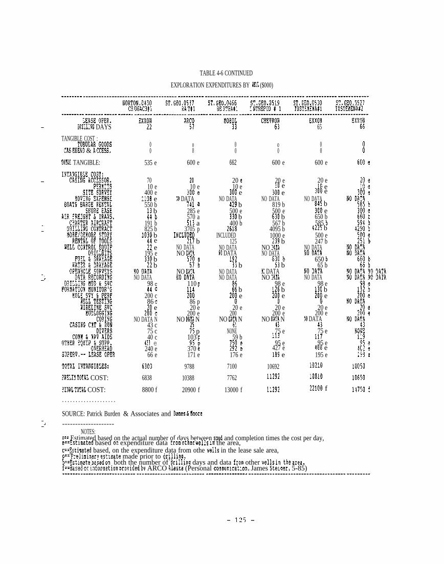
TABLE 4-6 CONTINUED
—
—
——
—.–~
—
—
—>—
EXPLORATION EXPENDITURES BY WZLL ($000)-------- ------------------------------------ ---------- ----------------- --------------------- ------------ ------------
NORTON,0430 s’T, !7do,0537 ST. GE0,0466 S’I,GE0,0519 ST, GEO.0530 ST, GE0,0!27--.---... ------. -.--. ----!! !!!!!!! ----.------!! !!!----. ---!! !!!!!! ----! !!!:!:!-!.!-----!!!!:!!!!!!-----!!?!!!!!!!!--
WE 0PE3,DRILLI!G DAYS
TANGIBLE COST :~uBoLAR Goofls
CM. EHEAI) & i? CCESS,
TOTAL TANGIBLE:
TOTAL ~N~ANG~~Lfls:
PRELIM TOTAL COST:
?INAL TOTAL COST:. . . . . . . . . . . . . . . . . . . .
SOURCE: Patrick Burden--------------------
EXXNJ
00
535 e
7010 e
400 e1108 e550 b
13 b44 b
191 b825 b
1010 bAA e21 e
195 e330 b
21 b!0 DA!%NO DATA
98 C44 c
200 c86 c20 e
200 cNO DATA N
43 c75 c40 c
413 e240 e66 e
6303
6838
8800 f
AR;;
o0
600 e
2010 e
joo ~NO DATA
741 a285 e570 a513 a
3705 pINCISJDED
211 bNO DATANO DATiI
5nJ ~
NO DATANO DATA
110 p;;;
86 p20 e
200 eNO DA~~ N
75 p103 p
95 D370 &171 e
9788
10388
20900 f
& Associates and Danes & Hoore
MOBIL33
00
662
20 e10 e
300 eNO DATA
429 b500 e110 b400 b
2618INCLUDED
125NO DATANO DATA
19211 b
NO DATANO DATA
t; b20~ e
20 e200
NO DA~~ N
NONE59 b
~jj :
176 e
7100
7762
13000 f
CHE?RMJ
o0
600 e
20 e!0 e
JOO eNO DATA
819 b500 e630 b567 b
4095 b1000 e
219 bNO DAT1NO DATA
630 b63 b
NO DATANO DATA
98 e126 b20~ e
20 e200 e
NO DA;! N
75 e11395 e
427 e189 e
1069211292
11292
EXXON65
00
600 e
20 elG e
joo eNO DATA
845 b~00 e650 b585 b
4225 b500 e247 b
NO DATA!0 DATA
650 b65 b
NO gA!lNO DATA
98 e130 b20~ e
20 e200 e
!0 DATA!375 e
11795 e
Ao8 e195 e
lo~l(l
JOglo
~z~oo f
NOTES:a== Estimated based on the actual number of days between spud and completion times the cost per day,e==!stimated based Ot expenditure data from other Wel]s in the area,c==listirnated based, on the expenditure data from othe wells in the lease sale area,o== Prsllmlnary est~mate made prior to drll~lng.h==tstimate ljased on, both the number of drllllng days and data from other wells in, the area,f==aased on lnfornatlon provuied by ARCO Alaska (Personal communlcatlon, James Steluer, 5-85)---------------------------- -------------------------- ---------------- -------------------------------------

—
exploratory
This figure
$14 million
well cost average rises from $10.2 million to $16.2 million.
is consistent with the total average exploratory well cost of
reported by Shell (Bernard, 1985 and Boytim, 1985). The ‘-
higher expenditures associated with COST wells are due to their unique
character. With the exception of the St. George No. 2 COST well, each of
these wells was the first well drilled in their respective lease sale e
area. The oil field support, and transportation infrastructure in these
remote frontier regions ranges from minimal to nonexistent. Logistical
and administrative costs are, to some extent, included in the COST well *
expenditure estimates but not in the exploration well data. These costs
are monitored so that they can be divided (along with the direct expend-
itures) among all participants.——
Exploratory well logistics, although complex, were somewhat simpler than
those of the COST
showing what would
wells, since the latter wells served as prototypes, @
and would not work in these remote areas. The COST
well programs
providing the
area. On the
also resulted in reduced costs to the exploratory wells by
well drilling and service contractors with experience in the .:
basis of this experience, the contractors were able to bid
more competitively, allowing less margin
contractors gained working experience
contractors drove down prices.
for uncertainty. Also, as more
in the area. competition among @
A further reason COST wells are more expensive than exploratory wells is *
the length of time between spud and completion dates. In general, COST
wells take more time because of the greater depth of drilling and the
larger amount of coring and sampling which is conducted. The purpose of

the COST wells is to obtain stratigraphic information in a new exploration
region. This information can only be gained by extensive coring and.-.
sampling programs.
Table 4-5 also provides a comparison between the cost of exploration wells
in the Norton Basin and those of the St. George Basin. On the average,
the Norton wells were about 18 percent less expensive than those
St. George. This difference is due in part to the shallower waters
in the
in the-\
-?
Norton Basin and the :nuch shorter drilling period required. The cost
difference would have been even greater were it not partially offset by
the higher costs of transporting the rig and materials to the more distant
Norton Sound. Although the well sites in Norton Basin are located much
closer to a coastal city (Nome) than the drilling locations in other
basins, the shallow draft of the port of Nome makes it expensive to
provide marine support.
The total costs of the Navarin and North Aleutian COST wells stand out as
much higher than the other COST wells. This is due to the longer period
of time necessary to complete these wells, and to the high mobilization,
demobilization, and standby costs.
4.1.2.2 Major drilling phase expenditures
Table 4-6 shows a detailed estimate of the expenditures for each Bering
Sea COST and exploratory well by cost categories. The cost categories are
based on the Authorization For Expenditure (AFE) forms used by major oil
companies in estimating the cost of drilling activities. These categories

differ somewhat from the contractor type categories used in Section 4.2.
The data used in Table 4-6 were obtained either directly from the lease
operators or by extrapolation and interpretation of known data. Although ‘-
these data are based on the best available info”rmation, they are only
estimates. Individual entries within this table should be used with
discretion. As noted above, estimates were often necessary since some
lease operators and service contractors considered certain data to be
confidential.
Estimates in several of the cost categories are based on the duration of
the drilling period. These cost categories include drilling day rates,
air charter, fuel usage, and marine support. For wells with these types e
of data, expenditures were calculated using the day rates times the actual
number of days between the spud and completion dates. (Estimates based on
this method are indicated by a footnote “a” in Table 4-6.) If data for an .@
expenditure which is normally day-rated were not available for a given
well but were available for another well in the same lease sale area, such
data were estimated using the day rate from the known well times the
actual number of days for the well in question. (Footnote “b” was used in
this case in Table 4-6.)
Expenditures for non-day-rated items (such as casing, tubulars, cement.
etc.) were based on cost estimates from lease operators, or from other
wells in the area. (Footnote “e” was used in this case.) If data were -
unavailable for an expense category in the same lease sale area, but were
available from another lease sale area, a “c” footnote was used in the
table. Finally, preliminary estimates of non-day-rated items are indi- *
cated by footnote “p”.
—

The reliability of data on the COST wells is generally much
that on the exploratory wells since COST wells are subject to
tive confidentiality measures. In general the reliability
greater than
less restric -
of footnoted
data is less than that of unfootnoted data. Among the footnoted items,
those footnoted “b” or “c” should be regarded as rough approximations,
useful only in generating the averages shown in Table 4-5.
The first column in Table 4-5 shows the magnitude of total expenditures by
contractor type. Rig mobilization and demobilization and moving expense
was the largest single expense-- $72 million of the total $295 million
expenditure. Mobilization and demobilization costs were incurred mainly
during the COST well program when there were very long standby periods
between wells. The total expenditure for this category is underestimated
since data on this expense type were incomplete.
Contract drilling expenditures
costs were the largest average
Day rates for the jack-up rigs
ranked second in total expense, and these
cost component for the exploratory wells.
used in the Norton Basin were usually in
excess of $50,000 per day. The large semisubmersibles used in the other
Bering Sea lease sale areas had day rates as high as approximately
$100.000. The drilling rates between the Norton
also different, and the average number of days
in the St. George Basin was greater.
and St. George basins were
required to complete wells

Boat and
costs in
than for
barge rentals represent another large cost category. Again,
this category for the Norton Basin wells are generally higher
wells in the other planning areas. This higher cost results from
barges being used as a staging area i.n the Norton Basin+ with the b“arges
and their crews adding to the expense of marine support. However, the _
shorebase expense for this basin was less than for other areas, since the
barges to some extent substituted for shore bases. The $22,000 average
expense reported for the Norton exploration wells (Table 4-5) was based on
a single data point and may be low.
Charter aircraft service-- almost exclusively helicopter service--is the
next largest expense category. This expense was especially significant in -
the case of the Navarin COST well. Due to the extreme remoteness of that
well, twin rotor craft specially equipped for extended range flights were●
based in Nome. The cost of this operation was reported as $6 million,
although some sources indicated that the actual cost was even higher.
Another major expense category includes costs of operator supervision and -
overhead. Operators typically maintained two supervisors on the rig at all
times, as well as additional onshore supervision dedicated to the drilling.
operation as long as it was in progress. Overhead, largely administering ‘-
the numerous contract activities and logistic support, was generally based
on 4 percent of the out-of-pocket expense of the operation.
*
- 130 -

4 . 1 . 2 . 3 M a j o r s u p plies
Major consumables represent a significant expense during exploration
drilling. Total estimated expenditures for all wells in the Bering Sea
during the study period are presented below in order of decreasing cost.
- fuel and drayage = $14.3 million
- tubular goods = $6.7 million
- drilling mud and service = $4.0 million
- cement and run casing = $2.3 million
- water and drayage = $1 million
Fuel is typically supplied by the lease operator for all marine
operations, and at least a portion of the helicopter support operations.
During the study period, almost all fuel was purchased locally in either
Dutch Harbor or Nome. A small portion was brought from the Lower 48
during marine mobilization. The same supply situation applied to water.
Cement was obtained from suppliers in the Anchorage area, and drilling
muds, chemicals, and tubulars were obtained principally from Lower 48
suppliers.
4.1 .2.4 Local and statewide expenditures
As discussed in the introductory statements in Section 4.1, estimating
expenditures within Alaska and within the local Bering Sea area is
difficult due to data limitations. Order-of-magnitude estimates of these
expenditures are presented in Table 4-7. The Alaska expenditures take
- 131 -

into account the amount of supplies purchased in-state, the extent to
which the labor force consisted of Alaska residents, and the extent of
Alaska support services and facilities. The total expenditures were -
abstracted from Table 4-5 and include some consolidation. Based on these
data, approximately 30 percent of the total expenditures accrued to
Alaska. The data in Table 4-7 are based on preliminary exploratory well
COST data. As shown on the bottom of Table 4-6, final expenses for St.
George exploratory wells were significantly higher than the preliminary—
estimates. Therefore, local expenditures shown in Table 4-7 are low -
estimates.
The local expenditures are slightly more amenable to estimation, since *
they are more visible and limited geographically. Virtually all Bering
Sea expenditures during the study period were made in Dutch Harbor/
Unalaska, Cold
exclusively to
and groceries.
bases in Cold
Bay, and Nome. The local expenditures were limited aimost =
labor (see Section 4.2.2), lodging and meals, fuel, water,
A marine support base in Captain’s Bay and air support
bay and Nome were also major sources of local expenditures. ~.
An estimating procedure similar to that done for Alaska-wide expenditures
indicates that about 7 percent of total drilling phase expenditure can be
considered local to the Bering Sea Region, Local expenditures represent ●
approximately 27.8 percent of the drilling phase expenditures made within
the State of Alaska.

T’ABLIZ 4-7
ALASKA AND LOCAL DRILLING EXPENDITURES
——
Total Percent Total Percent TotalAlaska Alaska Local Local
—.
Total Tangible:
Intangible Cost:
Casing Accessor.PermitsSite SurveyMoving ExpenseBoat & Barge RentalShore BaseAir Freight & Trans.Charter AircraftAll Drilling RigRental of ToolsFuel & DrayageWater & DrayageDrilling Mud & SVCMudloggingComm & Nav AidsCoringCasing Cmt & RunDiversOverheadSuperv. --Lease Oper.Other Equip. & Supp.
TOTAL
12767
1253160
50909242
3057931727035
16851141145
215714285
954395935502514135022832243
115223023
26444
10
10100102020905075107590953060755090
100505025
1277
125160509
1848611628553518
1263914115
161812857
906113321301886
67520552243576115126611
0
010
225
405
1020
9095
502022002
0
016
102135
15291269352
16852823
012857
906198
0500
464500
529
301579 27 81324 7 22591
Source: Patrick Burden & Associates and Dames & Moore
- 133 -

ARco
COST
The
Alaska estimated
well resulted in
estimates per
that the two
total direct
well were:
Norton S
Norton S
Navarin
Labor expenditures
lodging and meals,
and $420,000 (28%)
Norton Sound COST wells and the Navarin
expenditures of $1.5 million in Nome.
ound COST Well No. 1 $460,000
ound COST Well No, 2 $480,000
Basin COST Well No. 1 $560,000
—
accounted for $840,000 or 56 percent of the total, and “
and other local expenses accounted for $240,000 (16%).
respectively. This figure does not include vendors
with operations in Dutch Harbor or Cold Bay whose administrative address
is located elsewhere.
Similar data were not available for other communities in the Bering Sea. -
but a survey conducted by ARCO of vendor addresses and the amounts charged
to specific projects revealed that ARCO spends an average of $70.000 per
month per well, in the zip codes that comprise Dutch Harbor and Cold Bay.
This figure includes expenditures for labor, hardware, groceries, shore-
base support, and fuel for supply boats.
4 .2 EMPLOYMENT
Employment associated with both pre-lease
activities is addressed below in terms of
employment, employment by type of cent
activities and
the following
ractor, wages
drilling phase ~
figures: total
and salaries,
residency of employees, the effects of exploration activities on the local 1
labor force, and company hiring policies.
- 134 -

4 .2 .1 Pre-Lease Activities
This section presents employment-related data that were developed for the
pre-lease sale activities described in Section 3.2. These activities
●include regional and high-resolution geophysical surveys, regional
—
geological surveys, and navigation system installation and operation.
4.2.1.1 Total employment
Table 4-8 presents estimates of the total man-months of employment
e associated with pre-lease sale activities. These estimates were calcu-
lated by multiplying the estimates of man-months for each operation (or
vessel) of each contractor by the number of surveys conducted, or
navigation systems operated by that company during the year (see Table 3-1
for a listing of total operations per year).
Total employment is estimated at 39,559 man-months, or 3,297
during the 1980-1984 study period.
4,750 man-months (396 man-years) in
years) in 1982.
Annual employment estimates
1980 to 10,597 man-months
4.2.1.2 Employment by contractor type
man-years
range from
(883 man-
Vessels conducting regional marine surveys have the largest crews,
averaging 26 persons per vessel, with roughly half of the crew conducting
seismic and related studies, and the other half operating the ship. Other
- 135 -

persons on board the vessel include client representatives and agents.
Regional marine surveys provided an estimated 9,303 man-months of employ-
ment over the study period, or approximately 80 percent of the total
man-months of employment generated by operations in the Bering Sea.
High-resolution geophysical surveys use smaller crews and can be conducted
with smaller vessels. The total number of persons onboard averages 17
persons, with an equal split between ship’s crew and. survey crew. High-
resolution geophysical surveys accounted for an estimated 964 man-months
(80 man-years) of employment over the study period. This was
approximately 8 percent of total operational employment.
Geological surveys typically have a larger crew than high-resolution
geophysical surveys. Even though no geological operations were conducted
in 1984, this operational activity accounted for 1,000 man-months of
employment, or approximately
over the study period.
9 p e r c e n t o f t o t a l o p e r a t i o n a l e m p l o y m e n t
—
The number of persons required to operate the navigation systems used for
positioning by geophysical and geological surveys can vary according to
the area in which the system is operating. For example, navigation
systems for the St. George and North Aleutian basins can be supported from
Dutch Harbor by helicopter, while systems in Norton Sound are supported
from Nome. One person can maintain a navigation system with a helicopter-
supported program, although additional people are required during instal-
lation and removal of the stations, Systems in the Navarin Basin can be
supported by helicopter, but in recent years they have been vessel
- 136 -

TABLE 4-8
TOTAL PRE-LEASE ACTIVITY1980-1984
EMPLOYMENT
— Man-Months by Year
Pre-lease Activity 1980 1981 1982 1983 1984
Regional Marine Surveys 1,326 1,834 2,855 1,476 1.812
High Resolution Surveys 136 136 136 204 352
Geological Surveys 300 200 200 300 0
Navigation Systems 45 45 45 45 144—
Airborne Surveys o 2 4 4 0
Operational ActivitiesSubtotal 1,807 2,217 3,240 2,029 2,308
—xIndustry Evaluation 2,943 6,213 7,358 6,540 4,905
TOTAL MAN-MONTHS 4,750 8,430 10,597 8,569 7,213
Source: Patrick Burden & Associates and Dames & Moore.
NOTE : Totals may not add due to rounding.
- 137 -

supported for two main reasons: (1) the great distances between land
masses require the use of relatively expensive long-range helicopters, and
(2) to provide adequate coverage with the navigation chain, it was
necessary to install and service large buoys equipped with navigation sta-
tions. A vessel-supported installation program typically requires a*
maintenance person plus a crew of 4 for a large part of a month.
Navigation systems accounted for approximately 324 man-months of
employment from 1980 through 1984, with 14,4 man–months (44 percent) of
that occurring in 1984. Total navigation systems employment was about 3
percent of total operational employment during the
Airborne surveys are conducted with a crew of two persons
time ranging from several weeks to more than a month.
accounted for an estimated 10 man-months of total
study period.
for periods of
These surveys‘e
employment.
Regional marine surveys are conducted from sometime in May or June, to
September or early October when the weather worsens, with an average -.
operating time of 3 months in the Bering Sea. Mobilization and
demobilization time adds another month to the time the vessel and ships
ecrew are committed to the Alaska assignment.
High-resolution and geological surveys are conducted during the same
period of the year. Operating time for these vessels ranges from 1.5 to 3 *
months, and mobilization and demobilization requires an additional month
for the ship’s crew.
- 138 -

—
Navigation systems have to be in place before the first
operating and cannot be removed until the last survey
operation. The operational time for these systems is
vessel can start
vessel completes
about 4.5
during an average year, with mobilization and demobilization time
approximately 2 weeks. Mobilization and demobilization of airborne
crews and airplanes requires only a few days and is included
estimated operating time of 1 month.
months
adding
survey
in the
Most companies indicated that their staffs worked 60 days on and 30 days
off* Mobil indicated that their crew worked 56 days on and 28 days off,
while several firms conducting high-.resolution and geological surveys, and
navigation systems stated that their crews worked through the entire
season without a substantial number of days off, Airborne survey crews
also work until the survey is completed. These factors have been calcu-
lated into the man-month estimates.
The information presented in this section reflects the estimates of indus-
try representatives (where such data were provided), and professional
judgement based upon interpretation and extrapolation of
estimates shown in Table 4-8 do not include employment
support of pre-lease activities, such as air charter for
or shore bases. Only those persons directly involved in
known data. The
associated with
crew transport,
geophysical and
geological operations, navigation systems, charter of guide boats and
standby boats, and similar activities are included in these calculations.
- 139 -

Pre-lease activities in the Bering Sea have resulted in employment
estimates ranging from 395 man-years in 1980 to 883 man-years in 1982. AS _
shown in” Table 4-8, employment associated with pre-lease operations is
significantly smaller than the employment associated with the petroleum
industry’s evaluation of geologic prospects in the various basins. _
Manyears of employment for evaluation ranged from 245 in 1980 to 613 in
1982. These man-year estimates include employment for persons who were
generally located outside of Alaska, whereas employment figures generated .*_
for pre-lease operational activities in the Bering Sea reflect only those
persons that were physically present in Alaska and directly participated
in the operation.
4.2.1.3 Wages and salaries
Wage and salary data are generally
—
considered to be among the more confi- -
dential information that a company possesses. Responses to questions
concerning wages and salaries were limited, and even those firms that
answered these questions placed the answer in terms of a general industry
wage. The companies have different wage structures which makes analysis
difficult and, in addition, some firms hire contract labor for operational
To maintain confidentiality, *crews. wages paid per person per month by
all contractors for each type of activity were averaged and presented in
Table 4-9. In calculating the total wages and salaries paid by each
activity the actual wage data where available for each contractor were —
multiplied by employment estimates
salary data were not divulged the
were used to calculate total wages
for each contractor. Where wage
average wage rate shown in Table
paid by each firm. The wage and sa:
and
4-9
ary @
- 140 -

—
TABLE 4-9
AVERAGE MONTHLY PRE-LEASE ACTIVITY WAGE RATES
Pre-lease Activity Average Monthly Wage ($000),
Regional Marine Surveys $2.0
High Resolution Surveys 3.6
Geological Surveys 3.2
Navigation Systems 1“.~
Airborne
Industry
Surveys 2.8
Evaluation 4.0
Source: Patrick Burden & Associates and Dames & Moore
- 141 -
—

information presented in Table ”4-9 includes wages and salaries paid while
an employee was on leave rotation. For example, if an employee was paid
$3,000 per month for each month onboard a vessel, but was not paid while
on leave rotation, the monthly wage (assuming a standard 60 days on, 30
days off) was calculated as $2,000. This wage estimate does not include
fringe benefits. Table 4-10 presents data on total wages and salaries
attributable to pre-lease sale activities in the Bering Sea during the
study period.
Total annual wages and salaries paid for pre-lease operations in the
Bering Sea have ranged from approximately $3.5 million to $6.4 million
during the 5-year study period. Wages and salaries paid by the oil
industry for evaluation of prospects ranged from about $11.8 million in
1980 to $29.4 million in 1982. Total annual wages and salaries peaked at
almost $36 million in 1982. T o t a l w a g e s a n d s a l a r i e s p a i d by pre-lease
ac t iv i ty pa r t i c ipan t s ove r the 5 -yea r s tudy pe r iod to t a l ed $136 .3 mi l l ion .
The average wage on a regional seismic vessel was estimated to be $2,000
per month. According to one firm, the wages for an entry level position
onboard a vessel is roughly $1,200 per month. This entry level wage is
similar for the ship’s crew and seismic crew employees. Some geophysical
companies lease or contract for vessels, and wages for the ship’s crew on
board these vessels is generally less than for company-owned vessels.
Several firms indicated that Alaskan residents are generally hired at
entry-level positions. Regional marine surveys paid an estimated $15
million in wages and salaries during the 5-year study period. This
represented about 61 percent of total wages and salaries paid by surveys
and navigation activities during the same time frame.

—
TABLE 4-10
TOTAL PRE-LEASE ACTIVITY WAGES1980-1984
AND SALARIES
Wages and Salaries by Year ($000)
Pre-lease Activity 1980 1981 1982 1983 1984
Regional Marine Surveys S2,618 $3,632 $5,666 $2,862 $3,534
High Resolution Surveys 258 272 258 381 2,466
Geological Surveys 600 400 400 658 0
Navigation Systems 57 57 57 57 193
Airborne Surveys o 6 11 11 0
Operational ActivitiesSubtotal 3,534 4,367 6,393 3,968 6,193
Industry Evaluation 11,772 24,852 29,430 26,160 19,620
TOTAL WAGES & SALARIES $15,306 $29,219 $35,823 $30,128 $25,813
Source: Patrick Burden & Associates and Dames & Moore.
NOTE : Totals may not add due to rounding.
- 143 -

i.,Wage estimates for high-resolution geophysical survey crews ranged from
S2.500 to $3,200 per month. Contract personnel, who are not employees of
the company, received an average of about $200 per
$4,000 per month. The ship’s crew of Alaska-based
to $130 per day, or approximately $3,750 per month
($2,500 per month during a 3-month survey period).
day, or approximately
vessels averaged $120@
while working onboard
Crews of non-Alaska
based vessels were paid approximately $2,000 per month for the 3-month
survey period.
High-resolution surveys were conducted for a much longer period of time in
1984 than in previous years with the result that wages and salaries paid -
in 1984 were more than double the total amount of wages and salaries paid
in the previous 4 years. Wages and salaries amounted to approximately
$1.2 million for the first 4 years, and $2.5 million in 1984. Total wages -
and salaries paid during the time period amounted to $3.6 million, or
almost 15 percent of total operational wages and salaries.
A geological survey vessel generally carries the ship’s crew and
specialized data acquisition personnel such as geotechnical engineers,
geologists, geophysicists, geochemists, and drilling crews. Wages for *
geotechnical engineers, geophysicists, and geochemical specialists range
from $3,500 to $4,700 per month. Ship’s crew wages are similar to those
estimated for non-Alaska based high-resolution survey vessels. Wages and a
salaries paid for geological surveys are estimated at $2.1 million, or
about 8 percent of total operational wages and salaries.
- 144 -
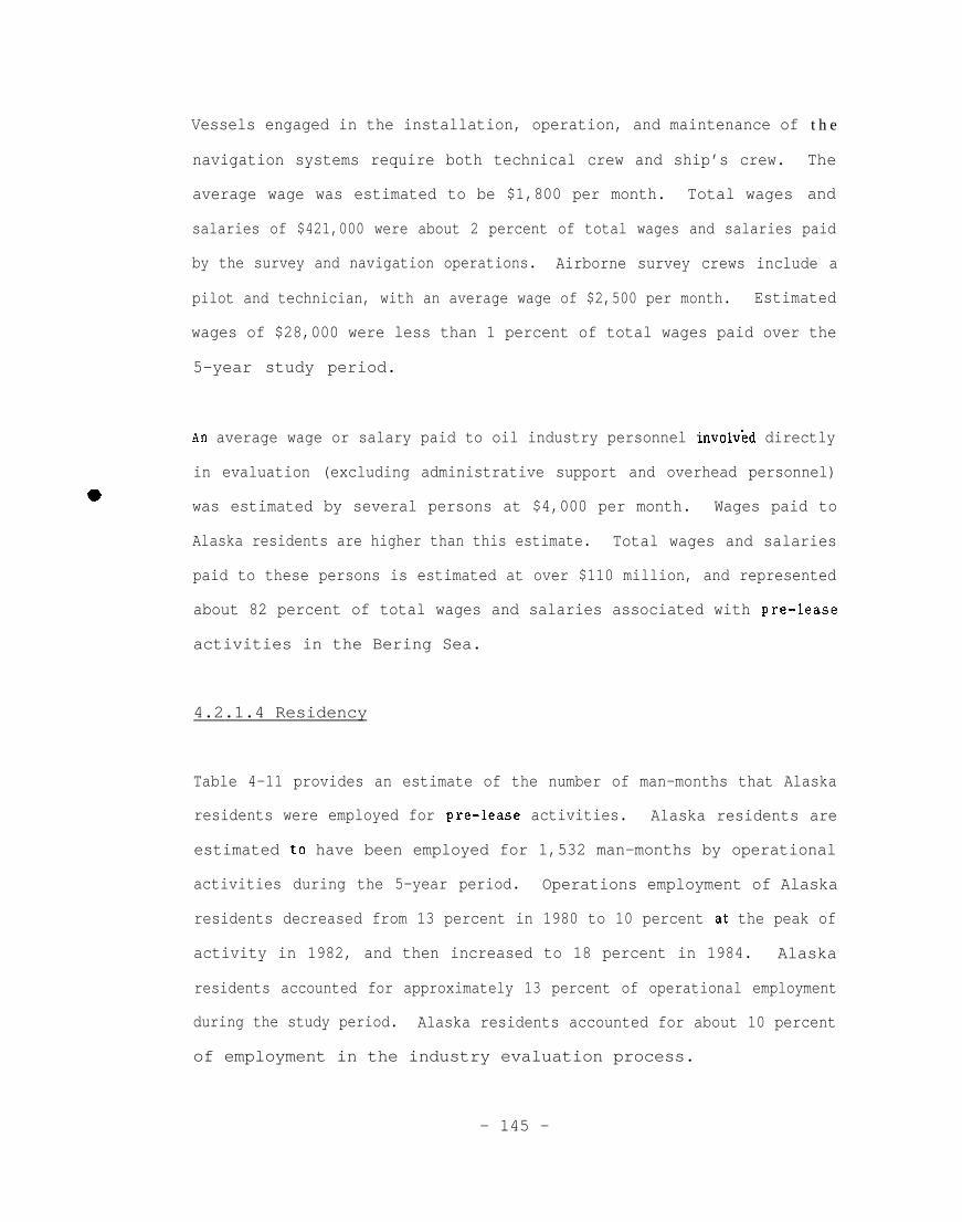
Vessels engaged in the installation, operation, and maintenance of
navigation systems require both technical crew and ship’s crew.
average wage was estimated to be $1,800 per month. Total wages
t h e
The
and
salaries of $421,000 were about 2 percent of total wages and salaries paid
by the survey and navigation operations. Airborne survey crews include a
pilot and technician, with an average wage of $2,500 per month. Estimated
wages of $28,000 were less than 1 percent of total wages paid over the
5-year study period.
An average wage or salary paid to oil industry personnel involv~d directly
in evaluation (excluding administrative support and overhead personnel)
was estimated by several persons at $4,000 per month. Wages paid to
Alaska residents are higher than this estimate. Total wages and salaries
paid to these persons is estimated at over $110 million, and represented
about 82 percent of total wages and salaries associated with pre-lease
activities in the Bering Sea.
4.2.1.4 Residency
Table 4-11 provides an estimate of the number of man-months that Alaska
residents were employed for pre-lease activities. Alaska residents are
estimated to have been employed for 1,532 man-months by operational
activities during the 5-year period. Operations employment of Alaska
residents decreased from 13 percent in 1980 to 10 percent at the peak of
activity in 1982, and then increased to 18 percent in 1984. Alaska
residents accounted for approximately 13 percent of operational employment
during the study period. Alaska residents accounted for about 10 percent
of employment in the industry evaluation process.
- 145 -

TABLE 4-11
ALASKA PRE-LEASE ACTIVITY MAN-MONTHS1980-1984
Man-Months by Year
Pre-lease Activity 1980 1981 1982 1983 1984
Regional Marine Surveys 116 171 227 116 235
High Resolution Surveys 59 66 33 59 85
Geological Surveys
Navigation Systems
Airborne Surveys
OperationalSubtotal
Activities
Industry Evaluation
TOTAL MAN-MONTHS
53 53 53 62 0
8 8 21 21 90
0 0 0 0 0
235 298 333 256 410
296 625 740 658 493
531 923 1,073 914 903
—
Source: Patrick Burden & Associates and Dames & Moore.
NOTE : Totals may not add due to rounding.
- 146 -

Members of marine geophysical survey crews must have technical training
to qualify for employment. Most major operators are headquartered in—
the Lower 48 and fill crew positions before the vessel departs for
Alaska. The result is that there are very few Alaska residents in
these jobs even though many Alaska residents participate in land-based
geophysical surveys on the North Slope and elsewhere in Alaska.
Another reason for low levels of Alaskan employment is that the
Norwegian flag ships of the Geophysical Company of Norway (G EC O), and
the Canadian flag ships of Digicon are required by the laws of their
countries to have all Norwegian or Canadian ship’s crew members.
Non-local residents who are marine geophysical survey crew members
generally live in the Anchorage, Kenai Peninsula, and Mat-Su Borough
areas of the state,
Vessel operators estimated that Alaska residents comprised from O to 35
percent of the crews of regional marine survey vessels.
geophysical firms indicated that while operating in
during the summer, two to three jobs in the ship’s crew
Several marine
Alaskan waters
were filled by
Alaska residents. However, most Alaskans hired during the summer quit
before completing 1 year of employment. The average entry-level pay
rate for the ship’s crew was about $1,200 per month (including time off
the vessel), and few Alaska residents appeared willing to remain in
these positions for that wage. These jobs offered an opportunity for
an individual to earn an airplane ticket to a location identified as
“home”, including locations claimed to be home previous to Alaska
residency. Those who wish to leave Alaska may have used these jobs to
do so, and several operators stated that a ticket out of the state was
- 147 -

the primary motivation for some Alaska residents to take these
positions.
High-resolution and geological survey firms tend to employ Alaska resi-
dents as members of ship’s crew when their vessels are from Alaska.
These persons generally resided at the port-of-call (Dutch Harbor,
Kodiak, etc) but some persons were hired from Seward, Homer, Kenai, and
other locations that were not a port-of-call. These firms also hire
Alaskans (typically Anchorage residents) as members of the professional
and drilling crews. Navigation systems employment includes Alaska resi-
dents; however, airborne surveys are conducted exclusively by non-
residents. About 15 percent of the Alaska residents employed in the
prelease operations activities are estimated to be local residents.
Table 4-12 presents estimates of the wages and salaries paid to Alaska
residents by each operational activity and by the petroleum industry for
lease evaluation work. Alaska residents received almost $4 million in
1982, about 11 percent of the total wages and salaries paid for pre-lease
activities in that year. In 1984, Alaska residents received approximately
20 percent of the wages, and salaries paid for operations activities
conducted in the Bering Sea, and about 10 percent of the wages and
salaries paid by the petroleum industry for evaluation.
Operational activities paid an estimated $4.5 million in wages and j
salaries to Alaska residents during the study period, and the petroleum
industry paid $11.2 million to its Alaska employees for evaluation of
petroleum prospects. Total wages and salaries paid to Alaska residents -
for pre-lease sale activities exceeded $15.7 million.

4 . 2 . 1 . 5 Employment effects on the local labor force
Pre-lease sale activities
supplies in any Bering Sea
pre-lease activities has
employment in the region.
have had detectable effect on local labor
community. Additional employment generated by
been marginally incremental to the existing
Expansion of pre-lease operations has occurred
at a time when commercial fishing operations have declined in the region.
Consequently, the effect of the increased survey vessel traffic has helped
to offset the decline in economic activity in the Dutch Harbor/Unalaska
area.
Pre-lease activities such as geotechnical and geophysical surveys require
high levels of expertise and knowledge, and few Aiiskans have had access
to training for this work. Most employees who’are sufficiently well
trained to perform this work are residents of Anchorage or other cities
where this training may be available.
4.2.1.6 Company hiring policies
With the exception of the ships crew of a few regional survey firms,
employment for pre-lease sale activities was non-union. Most employees
were from Texas, Louisiana, California, Oklahoma, and other states with
long histories of petroleum activity and large numbers of trained person-
nel. Some firms stated that their crews must reside in proximity to the
office where the company is based, but most firms would employ people from
anywhere in the world. Regional marine survey vessels conduct internat-
ional operations, while other survey vessels concentrate their operations
- 149 -

TABLE 4-12
ALASKA PRE-LEASE ACTIVITY WAGES AND SALARIES($000)
Salary by Year
Pre–lease Activity 1980 1981 1982 1983 1984
Regional Marine Surveys $378 $560 $730 $365 $781
High Resolution Surveys 150 177 88 150 353
Geological Surveys 140 140 140 158 0
Navigation Systems 10 10 26 26 109
Airborne Surveys o 0 0 0 0
Operational ActivitiesSubtotal 678 887 984 698 1,253
Industry Evaluation 1.184 2,499 2,959 2,630 1,973
TOTAL WAGES & SALARIES $1,861 $3,386 33,943 $3,328 $3,~~6
—
Source: Patrick Burden & Associates and Dames & Moore.
NOTE : Totals may not add due to rounding.
●
- 150 -

in the U.S. and along the west coast of North America. If a vessel is
conducting operations in a region and has need of a crew member, they may
hire a local person while in port. Most employment of Alaska residents
has been for ship’s crew.
4.2.2 DRILLING PHASE
Employment associated with drilling operations, including support activ-
ities, is addressed in the following portions of this section. Major
categories of discussion include total employment, employment by contrac-
tor type, wages and salaries, and employment of Alaska residents and
residents of the Bering Sea communities.
4 . 2 . 2 . 1 T o t a l E m p l o y m e n t
The total man-months of employment by contractor type and by well is
presented in Table 4-13. The total man-months of employment for all wells
drilled in the Bering Sea from 1980 through 1984 was approximately 7,550.
The total employment level per well in the Bering Sea ranged from about
1,260 man-months for the Navarin COST well to only 164 man-months for
Exxon’s Chugach No. 1 in Norton Basin. The difference in the two figures
can be directly attributed to the drilling time needed to achieve the
desired depth, and the level of testing and sampling required. The
Navarin COST well, spudded on May 26, 1983, and completed on October 24,
1983, involved nearly 5 months of drilling activity. COST wells involve
extensive coring and sampling programs which significantly increase the
time required to drill a well.
- 151 -

Exxon’s Chugach No. 1 in
completed just 23 days
formation. The well was
Norton Basin was spudded
later on August 17 after
plugged and abandoned as a
3,636 feet (1,112 meters) . This r e l a t i v e l y s h a l l o w
on July 25, 1984 and
reaching the target
dry hole at a depth of
drilling depth, com -
bined with the shallower water depths of Norton Sound and limited, if any,9
testing contributed to a short duration drilling effort.
The number of man-months required to drill exploration wells varied
significantly, even for wells completed in the same basin. AR CO’S Birch -
No. 1 well in Norton Basin showed significantly higher
man-months) when compared with the total man-months for
(242 man-months) and Chugach No. 1 (164 man-months).
labor effort (351
Exxon’s Teton No.1
ARGO’S Rat No. 1 -
well in St. George Basin required 666 man-months while Mobil’s Bertha No.
1 was completed with 259 man-months. Exxon’s Intrepid No. 1 and Tustumena
No. 1 required slightly less than 600 man-months each and Chevron’s —
Endeavor No. 1 was completed for under 500 man-months. Comparison of the
level of effort data for these wells indicates that the primary difference
is the amount of labor used by the drilling and
contractors.
4.2.2.2 Employment by contractor type
Table 4-13 also presents data on
contractor type during drilling.
the number of man-months
These data indicate that
marine support
of employment by
four contractor ●
types accounted for about 75 percent of employment during the drilling
phase. These include (in descending order) the drilling operator (43
percent), marine support (16 percent), the lease operator (9 percent), and _
- 152 -

—
TAIILE 4-13 ‘—TOTIL DRILLING EMPLOYMENT (YIN-MONTHS)
------------------------ ------------------------ ------------------------ ------------------------ ------------------------CO?iT9hCTOR TYPE NORTON S~jT.;O~G; ?lOR?ON N,ALEUTIA}i NAVARIN NORT;;i~j;~ NORTON,04!1
COST i 1 COST # 2 COST # 1 COST # 1 . ww)};$ii.. .------------------------ ------------------------ ------------------------ -------------------------- ----------------------58,1 57,7 54$9 71,7 82,9 30,2 44,9
— LE1$E oPER, ARCO flRCO ARCO ARCO ARCO AFtCO Ef;Oj— 249,6 177,7 235,2 469,3 542,7 129.6
DRILLER DANT~X; SE~C: [EY~#\ Sulco SEOCO [EYDRIL ?o#i?i
ROUSTABOUT iyke Iok VEtO ~;N; NONE ~;N~ y;q41,2 32,7
AIR SOPPORT E~A ERA ERA EiA COLOMBIA/~ji~G - “AIR7jO~ ‘~iA138.7 137.3
iARINE SUPPoRT B;jH; BIEEL BIEliL BIEiL— 170*7
$E&;
~JRI~E slJppoRT CRO@~ BIEaL. . . ..-. ,..il, u
BARGE SUPPORT OFFSEORE L~~I;,13,7
SHoRE BASE CRolLE’f/N;~~; CR09f~Y~
DIVERS MART~ilj MART;~;
KUDDER BAR~i] BAROiD
CEMENT HALL190R~dlj 5ALLIBUR~6~
?LIJG ~ELL TRIS;~!~ TRIS;]!~
MOD LOGGING ExM~; E;)i;
IIRE LOGGING SCBLOi4BER~E!j SC6LUHBERGiR
PAPER STUDIES liOODRARD-CL;ij; iOOD#AFIO-CL~fi~
CORE ANALYSIS CORE LiB CORE” Li9
iELL TESTIIG ;;N~ ~;N;
CATERING UNIVERji~ UNIVERSiL
NAVIGATION I;~~J IT~~~27,5
IEATEER NOR;~; NORTEC
MEDICAL NORTiC NORk!
SECURITY O ‘ NE!i O’NEfi/
flET oC!AN SsA,~:~ E G &li~ICE ?oRCAS! ARC;i; NONE
IELLHEAD EQUIP ??’e 6UGEES OF#~~
—TOTAL FOR liEU 692,6 777,4 488,3---------------
SOURCE: PATRICK BURDEN & ASSOCIATES AND DAKE$ & BOORE--------------------- ---------------------- ----------
e==llSTIMATED USING DATA FROM OTHER CONTRACTORS------------------------------ - . ------- . -------------------,
N;N;
BUGBES OFFiH
:,LYOM ~p~?~c
2.0BECB;i! BECETEL
988,9 1256,2 350.7 242,1
--------------------------- --------------------- -------------
. . - 153 -

TABLE 4-11 CONTI!40ED
TOTAL DRILLING EMPLOYMENT (MAN-MONTHS)---------------- .+ ------ --------------------------- ------------------------ -------------------------- --------------------CONTRACTOR TYPE NORTON,0430 ST. GE0,0537 ST, GF!0,0466 ST, GE0,0519 ST, GE0,0530 iT.GEO.0527 TOm BY TYPE
C80GlCH/1 RAT#l BER!HA#l INTREPIl)#l l’USTEME!lA$l TOS1’EMENA#2--------------------------- ------------------------- ------------------------ ------------------------ --------------------29*O
LEASE OPER, EXXON46.9
DRILLER ROiliiN
ROUSTABOUT tifN~
AIR SUPPORT EiA19,3
YARINE SUPPORT SEAEORSE
!ARINE SiJPPoRT
BARGE SUPPORT
SHORE BASE
DIVERS
llUDDER
CEMENT
PLUG lELL
MUD LOGGING
!41RE LOGGING
PAPER STUDIES
COW ANALYSiS
?ELL TESTING
CATERING
!iAVAGATION
liEAT8ER
H!llICAL
SECURITY
MET OCEAN
ICE FoRCAST
‘dELLHEAD EQUIP
TOTAL FOR IELL---------------
48,7 11,2 36,0 91,0 92s4ARCO fy.j CEEVRON EXXON EXXON
319.0 231,0 238*J lbl,rjsErlco SED1O su)co liESTERNe KESTERNe
36,90,S,1,
11,6!iART~C;
BJEIUGHS/MIL~bj!4
BALLIBUR~bj
TRIS;~i;
BAROI~e11,6
SCHLUM8ERGER
BOOKS McCLO;~!e
14,00.s,1,
MART~~~
MAGCOBiR
BJ KUGH~j;
TRIST;!j
EXLO~e4,4
SCHLUMBER;E;
NORTiC
CORE !i!
28.00,S,1,
N~i~
MAGCOiiR
A.B i.{]. . .80 J , HUGHES
. . .NORALCO NORAIiCO
13*2 2!’7? 26.0 26,4UNIVERSAL UNIVER~A~ UNIVERSAL UNIVERSAL
NCS INT~i~ OC!3ANEER, I#j OCEINEER, Ii/\;\ OCEANEER,l$;,
NORTiC NOhiC NORTiC
NONE N;Nj NONE N;N; N;N;
HUGHES OFh! HUGHES OFFh HUGHES OFii! NATIONAL SJi, NATIONAL S0$,
665.5 258,5 493,7 584,7 593*2
SOURCE: PATRICI BURDEN & ASSOCIATES AND DAMES & MOORE.-.---.--------
e== ESTIMATED USING DATA FRO!! OTHER CONTRACTORS.
—
710,8 _
J274*9 -
1603
506,8
1195,2 -
118.9 -
12.0
257.1
lsd,rl
69,3 ~
67,0
3*3
!97,8
13A*O =
21s6
7,8
24,0
341,2 ~
25,0
244,8
13,5
67.0 ~~
18,2
32,6
26,0
;\;:,; -
---------------------------- ------------------------ ----------------------------- --------------------- ------------------
- 154 -

air support (7 percent). All of these groups employed personnel both
onshore and offshore in the Bering Sea, as well as
Anchorage and outside Alaska.
Drilling opera to r s
explorat ion in the
accounted for over 3,200 man-months
Bering Sea during the study period.
large numbers in
of employment for
Marine support was
the next largest employer, accounting for over 1,300 man-months. Lease
operators and air support used 710 and 507 man-months of labor between
1’380 and 1985. Catering, weather forecasting, shorebases, mudlogging, and
wire logging were also significant components.
4.2.2.3 Wages and salaries
~ The wages contractors paid to their employees was sensitive topic. To
— maintain confidentiality, wages paid per person per month by each type of
contractor were averaged and then applied to all contractors of that
type. Many contractors did not wish to divulge wage data. In those
cases, wages were averaged for the contractors of that type who did
provide data, and the average was assumed to be applicable to all
contractors of that type. These average monthly wage rates are presented
in Table 4-13.
The wage rates presented in this section are gross pay for position.
Thus, if a $4,000 per month position involves a leave rotation of 2 weeks
on and 2 weeks off, each individual would receive $2,000 per month
employed ($24,000 per year), and would be on duty for half of the year.
The wages do not include fringe benefits, overhead, or profit.
- 155 -

Wages paid per person per month ranged from $5,700 for divers to $2,000 —
for core analysts. The non-weighted average monthly payment to employees—
was $3,800. Divers receive a relatively high wage as a result of their
high-risk work and their status as union employees. Other contractor
types with high average wage rates include well plugging contractors
($5,000) and navigation contractors ($4,500).
As noted above, drilling contractors used a greater amount of labor than
any other type of contractor. Since the wage rate for drilling contractor
employees ($4,000 per man-month) was higher than the average wage rate for
all contractor employees ($3,800 per month), the total wage expenditure
($13 million) for this category exceeded that of all other contractor
activities (See Table 4-15). Shorebase operators provided the second
highest wage expenditures at $4.4 million in total wages. Note that Table
4-15 refers to gross wage expenditures only. In addition, contractors
paid for fringe benefits and overhead.
A comparison of wage expenditures per well indicates that the ARCO Navarin
COST well had the largest total wage expenditure ($4.8 million) and the
highest wage expenditure for Alaska employment ($1.4 million). This was
due to the extended length of time required to drill the well, nearly 5
months. Exxon’s Chugach No. 1 Well in Norton Sound had the lowest total
wage expenditure ($0.6 million). T h i s w a s a d i r e c t r e s u l t o f t h e
r e l a t i v e l y s h o r t a m o u n t o f t i m e ( 2 3 d a y s ) s p e n t d r i l l i n g .
—
- 156 -

AVERAGE( PER
TABLE 4-14
MONTHLY DRILLING WAGE RATESPERSON BY CONTRACTOR TYPE)
Average MonthlyContractor Type Wage Per Person ($000)
Lease OperatorDrillerRoustaboutAir SupportMarine SupportShorebase
DiversMudderCementPlug WellMu,d LoggingWire Logging
Paper StudiesCore AnalysisWell TestingCateringNavigationWeather
MedicalSecurityMet OceanIce ForecastingWellheacl EquipmentNon-Weighted Average
4 . 44 .23.82.62.83.0
5.75.04.25.55.03.9
3.32.04.53.24.53.2
3.23.23.23.73.33.8
Source: Patrick Burden & Associates and Dames & Moore.
- 157 -
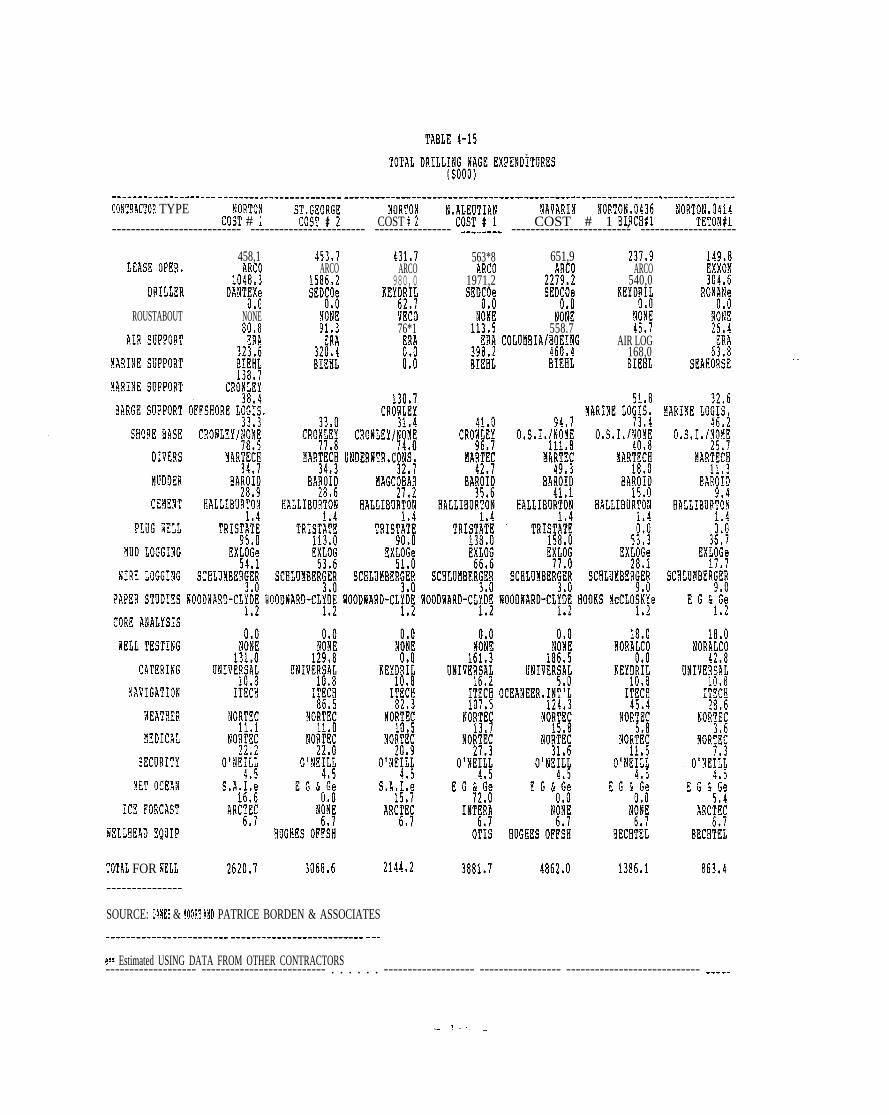
-------------------- ------------------------ -------------------------- ----e--- --------------------------- ---------------
COiT9ACT08 TYPE NORTO! S;i;;O:G; iiORTON N.~;U]T;A~ ?IAVARI!A iORTW;f !!O!ITON,0A14COST # ; COST $2 COST # 1 , TETON$l--------------------------- ------------------------ ---------------- ---c---- ------------------------- --------------------
458,1LEASR oPER, ARCO1048,3
DRILL~R DANT~X~U*U
ROUSTABOUT NONE
45].7 431’7ARCO ARCO
1586,2 980,0SED~O; KEY~~I;
NOiE vEto91,3 76*1
ER1 ERA320.4BIEHL ;:1
1,4
563*8 651,9ARCO ARCO
1971,2 2219*2SED~O; S?D~O;
tiOliE NOtiE113.5 558.7
ERA COLUUBIA/M~IjG198,2BIHiL fiIEfiL
2J7,!IARCO
540,0flEYDjI;
tioiE45.7
AIR LOG168,0BIEKL
‘TOTAL FOR flELL 2620,1 3068.6 2144,2---------------
SOURCE: DAMS & MOORE AND PATRICE BORDEN & ASSOCIATES------------------------ -------------------------- ---
861,4
. .
e== Estimated USING DATA FROM OTHER CONTRACTORS------------------- -------------------------- . . . . . . ------------------- ----------------- ---------------------------- -----

----------------------- -------------------------- -------------------- --------------------------- ------------------------CONTRACTOR TYPE !40RTON,0410 ST, Gi10,05j7 ST, GE0,0466 ST, GEII,0519 ST, GEO)0530 ST, GE0,0527 TO’IAL BY TYPE
CE(lGICH#l 8/!!$1 BERTEll#l ENOEAVOR$I INTREPID#i TUSTEiEYiil----------------------------- -------------------------- ------------------------ ------------------------ -----------------
96,9 383,1EXXON ARCO197,1 1339,8
ROfl~N; SEDCOe
y; N:~;81,1
Eh ~RA45,1 270.7
SEAHO!ISE BIEEL
217,5CHEVRON
970.2SEDIO;
(#l:
Eii176,4oc~aN flA~#;
?FSHORE LOiIS ARCTIC ALASKA INT“L tiOORING
44,g0,s,1,
26,9!4AR~~C~
MAGCOBiR
BJ 8UGHi!:
85,6O,s!10
47,6!!AR;fC~
BA~~~;
BJ liUGEESe
TRISTii!60,8
EXLOG32,8
SCFWJMEERGER
BOOKS ticCLO#~e
88830.S,1.
49,1RONE21,1
!4AGCOBAR18.1
DO!iELL1,4
l,L
18,0NORALCO
109.6UNIVERjAj
NCS I!/?’~e
FAIRWAT!i;
NO$~
O’wqq
E G koi;
0,0
N:N;
HUGEES OFFkBECETEL HUGHES 0FF5E EUGEES OFiW! flATIONAL SUP. NATIONAL SOP,
TOTAL FOR 8ELL 583,7 2636,7 ‘ 1031,2 1947*2 2081.5 IE2. I---------------
SOUR(X: DAHES & MOORE AND PATRICK BURtIEN & ASSOCIATES.----.-..---.--
e== ESTH!A’!ED USING DATA FROM OTHER CONTRACTORS
292!9,2
-------------------------- ---------------------------- --------------------------- ---------------------------------------
,-

Table 4-16 presents data on the employment of Alaskan residents by
4.2.2.4 Residency
contractor type. The bottom row indicates the weighted average percent of
Alaska resident employment by well. These data indicate that the
employment of Alaskans (expressed as a percentage of total employment)
ranged from 45 percent during drilling of the second Norton Basin COST
well to 22 percent for the ARCO Rat No. 1 well. These percentages
indicate a very significant level of Alaskan participation in the well
drilling phase of exploration.
The extent of Alaska resident hire is dependent on several factors.
First, the amount of skill required to perform the majority of the
contractors’ work plays an important role in determining whether or not
Alaskans will be hired. If the expertise required by a job is difficult
to find in Alaska, employees are brought up from outside of Alaska to
perform that job.
A second major consideration involved in determining the level of Alaska
resident hire is the location of the contractor’s office. Often,
contractors do not have offices in Alaska and the employment data show
little or no hiring of Alaska residents for these firms. Conversely,
contractors with offices in Alaska tend to show a higher percentage of
Alaska residents as employees. Some examples of these latter types of
contractors include lease operators (70 percent Alaska residents), divers
(Martech 100 percent), electrical logging (Schlumberger 100 percent), and
weather forecasting (Nortech 100 percent). The rightmost column on Table
4-15 reports the average percent Alaska resident hire by contractor type.
- 160 -

ALASKA DRILLING MPLOMENT(Percentage)
------------------------ -------------------------- ------------------------ ------------------------ ----------------------CONTRACTOR TYPE IORTON ST, GE09GE NORTON N, AL! NTIAN NAVARIN NORTON ,0436 !lORTO!i ,0414
COST # 1 COST # 2 COST # 2 COST # 1 COST t 1 BIRCBfl TE?Oli#l--------------------- ---------------------- ------------------------- ------------------------ -------------------------- ---
LEASE OPER,
DRILLER
ROUSTIBWIT
AIR SUPPORT
MARINE SUPPORT
MARI!IE SUPPORT0,6 0.0 0,0 0,0 0,0
BARGE SOPPORT
S80RE BASE
DIVERS
iKIOOER
CEMENT
PLUG W?LL
MUD LOGGING
BIRE LoGGING
PAPER STUDIES
CORE ANALYSIS
flELL TESTING
CITERING
IAVAGATION
IEATHER
MEDICAL
SECURITY
MET oCE~N
ICE FORCAST
9ELL8EA0 EQUIP
. . .OFFSHORE LOG IS.
. .MARINE LOGIS.
—
1!0EG&Ge
N;+
EOGHES OFFiH—
---------------
---------- ------------------------ -------------------
------------------------ ---------------- --------------------- -------------- -------------------- -------------------------
- 161 -

TABLE 4-16 CONTINUED
ALASKA DRILLING EMPLOYMENT(Perc6nta9e)
--------------------------------------------------------- ------------------------ --------------------------- -------- ----COYT9ACTOR TYP! NORTON,0410 ST,GEOi~;j~ $T,G!30,0466 ST, GE0,0519
C80GAC!l#lST, GE0,0530 ST. Gi?0,0527 TOTAL BY TY?E
BERT flA#l INTREPID#l ToSTEBENA#l TUS1’EMENA#2------------------------- ------------------------- ------------------------ ------------------------ ----------------------
LEASE OPER,
DRILLER
ROOSTIBOOT
AIR SUPPORT
iiARINE SGPPORT
!IA!!IIE SUPPORT
BARGE SUPPORT
SEORE BASE
DIVERS
MUDDE!i
cE~ENT
PLUG SELL
IUD LOGGI!G
IIRE LOGGING
PAPER STUDIES
CORE ANALYSIS
WtJ TESTING
CATERING
!iAVAGATION
IEAT9ER
!IEDICIL
SECURITY
YET ocEAlj
ICE PORCAST
RELLEEAO EQUIP
fiEIGETltD AVG,
SCELOMBERGER
E G k;i~
o+;
!iARTEiE
BJEUGES/!41L;i[l!
BALLIBURTiN
TRIST~i~
BARO~i;
0’0
UNIVER!ii
OCEANEER, IN~:\
NORTiC
NOR~i;
O’NE~i~
EG&\e
N!ii
HUGHES OF!;!
?lORA)~
UNIVERSiL
OCEANEER, IN!:1,0
26% 31% 26%---------------
SO~RCE: PATRICK BORDEN & ASSOCIATES AND DAMES & MOORE---------------
e== ESTIilATED USING DATA FROM OTHER CONTRACTORS--------------------------- -------------------------- . . . . . . . ------------------ ---------------------------- ----------
0,7
,0
0’1
0,8
0,1
O*1
0,0
!,0~,o
1,0
0,2
0!8
0,5
i,O
O*5
1,0
0,2
0.3
0!3
0,9
i.o
i,o1),~
0,2
O*O
i3,0
-----
—
—
—
—
- 162 -

Lease operators paid the highest wages to employees residing in Alaska.
Although lease operators appear to have fewer employees involved in
drilling activities than the drilling contractors, they have more
employees that are residents of Alaska. Other contractor types with high
wage expenditures for Alaska residents include air support, shorebase
support, and divers (see Table 4-17).
Table 4-17 reports the approximate wages paid to Alaskan residents during
the drilling operations, Table 4-17 is based on the average wage rate by
contractor type shown in Table 4-14. Thus, although special contractors
are named, the wage rate and actual wages paid reflect the industry
average to protect confidentiality. Table 4-16 was calculated as the
product of Table 4-15
This implicitly assumes
(Total Wages) and percent of Alaska employment.
that Alaskans working in a given industry are paid
the same as all workers in that industry. To the extent that more highly
skilled workers may have been ‘Lower 48 residents, this Table may
overestimate Alaska wages.
4 . 2 . 2 . 5 Effect on local labor
The following paragraphs present an evaluation of the degree to which
local labor was used in the exploration activities in the Bering Sea.
Each of the four lease sale areas is addressed, ,with the hiring of local
residents discussed by lease sale area and in relation to the location
where employment took place (Nome, Dutch Harbor, St. Paul or Cold Bay).
- 163 -

TABLE 4-17
ALASKA RESIDENT DRILLING !i?IGES ANO SALARIES ($000)------------------------- --------------------------- ------------------------- --------- ------------------------ ----------COI’IRACTOR TYPE NORTON .S7, GEORGE /lORTON N, ALEU!IAN NAYARIN NORTON,0436 NoRToN,0414.--. ---.-.. --------. -!!!!-!-!--. ---.! !!!-! .!----. --!!!!-!-:----. --!!!!-! .!---.---!!!!-!-!--------!!!!!!!---.---.!!!!!!!-
d58, ! 453*7 431,7 561,8 651,9 237,9 74,9LEA$fl oPER, A;C; A~C; A~cj A~c~ A~C~ A~C~ E;~o~
DRILLER DAN~i~ s~:i; KEY~~i; SE!;; SE]?; IEYD~i~ ~o~i~
ROllSTABOUT NOiE NOiE VEiO NOliE ;;ij72,7
jfq ;li/82,2 68,5
AIR SoPPoRT ERA ERA102,1
ERA ERA COLUMBIA/B~~i~G AI!l~~~ E~A12,4 32,0 39,8
BI;li!0,0~A~lYE $,oPPoRT BIEEL BIEEL BIEEL BIEilL E~EljL SEA!IORS!
~A]I~E .$uppoR~
BARGE SUPPORT
SHORE BASE
D~vERs
~~~DER
CENENT
PLUG IELL
MOD LOGGING
MIRE LOGGING
?APER $TDDIES
CORE ANALYSIS
HELL TESTING
CATERING
NIVAGJTION
!JEATIIER
~EDIc)Jj
SECURITY
~fl~ 0CEA%
ICE FORCAS’I
lEIJHEAD EQUIP
1.2
TRIS;~i’~
EXLiG53.6
SCELU!!BERGER
ROODIARD-CL~h~I,L l,L
1,10.0
18,3HLOG17,7
SCllLUiiilERGER
E G &;i;
TOTAL FOR !4ELL 909,7 970.8 1020,6 1291,5 1446,2 548,3 308)9---------------
SOURCE: PATRICK BURDEN & ASSOCIATES ANO DAMES & MOORE--------------------- ------------------------ ---..---
e== ESTIMATEil USING DATA PROM OTHER CONTRACTORS--------------------- -------------------------- ------------------------ ------------------------ -------------------------
—
—
- 164 - —

TABLE 4-17 CO!A’!INUED
ALASKA RESIOENT DRILLING RAGES AND SALARIES (S000)---------------------------- ----------------------------------- ------------------ ---------------------------------------CONTRACTOR TYPE 80 RTOfl ,0430 ST> GEO.0537 ST, GE0,0!66 ST GiiO 0519
IiiTRE;ID#i i!jfi]ki;;;5T,GE0,0527 TOTAL BY TYPE
cfluGkcHil RAT#l h3RT9A#l .,4 T!MEli?lAi2-------------------- -------------------- -------- ----------------------------- -------------------------- -----------------
—— L~As~ o~~~,
DRILLER
ROOSTABOUT
AIR SUPPORT
MARINE SUPPORT
]A~iY1 S~PPoRT
51RGE SUPPORT
S90RE BASE
DIVERS
NODDER
CEilE!iT
PLUG XELL
IUD LOGGI!?G
IIRE LOGGING
PAPER STUDIES
CORE ANALYSIS
iELL TESTIYG
CA! ERING
!i;VAGATION
HEATHER
MEDICAL
SECURITY
lET OCEAN
ICE ?IIRCAST
8ELL!JEAD EQUIP
TOTAL FOR RELL
N~N;
EUGEES OFP~R
207,1 543,1
Mel);
SEDiO
~~i~
EiA18,5
OCEAN MARINE
TRIS;~!~
ExL~G17,2
SCELUMBER~Ef/
!?ORTiC
---------------
SOURCI: PATRICK BURDEN & ASSOCIATES AND DAMS & MOORE---------------
222,0CHEVRON
SEit~
f;i~
Ei/A35,3
OCEAN !!A~;N;
ARCTIC ALAStA
1A]*2~xxofl
AMS?M
Nil!71,2
AI1 LOG
SEAEOi#
IIT’L i100RIiG INT
80,4 83,0 84,30,S,1, O,s!l$ 0’s,1.
47,6 49,1 49,8MARTECE NONE NONE
21,0 21.7 22*OBARON y~GcoBaR HAGCOBAR
BJ KUGR~;; DO!4~t~ DOK~i~
1.2 1$2 1,2
0.0
N~N~
EOGIIES OFF~fl
635.8
!?;!f
NATIONAL SUi,
514,4
e=: ESTIMATED USING DATA FROM OTBER CONTRACTORS-------- ------------------------- -------------------------- ---------------------------- ------------------------ --
3469,2
50,2
62,7
755,6
2J7,~
95*7
0,0
765,2
758.9
336,5
48, $Ib,q
521,6
“522,6
32s9
15,65h,(j
268,740, ?
681,8
107,2214,4
22.4
89,9
0,0
9180,2
-------
— - 1!?)5 -

A local resident is defined as a resident of a community located on or
near the Bering Sea. If an Alaskan resident living in Dutch Harbor was
hired to do OCS-related work in Dutch Harbor, this individual was included
in the local employment figure, If a person residing in Anchorage was
hired to perform OCS-related work in Dutch Harbor, this individual was
included in the state employment estimate but not in the local employment
estimate.
Data on local hiring during drilling by contractor type are presented in
Table 4-18. These data indicate 495 man-months (6.5 percent of the 7,550
total man-months) were attributed to local employees.
—
—
This total figure
referred to in the
——
for employment of local Alaska residents is also
tables for this section as local level of effort. The
local level of effort by well ranged from 13.3 man-months on the North —
Aleutian COST well to 77.9 man-months for Chevron’s Intrepid No. 1 well.
Of the 1,930 total man-months of employment for COST and exploration wells
drilled in Norton Sound, 174 man-months (9
local employees. Most employment of local
to the air support activities at the
Drilling activities in St. George Basin
man-months of employment. Of this amount,
identified as local. The majority of
in marine support activities in Dutch
Cold Bay.
this
percent) can be attributed to
residents in Nome was related
City of Nome Airport.
required approximately 3,375
250 man-months (7 percent) were
local employment was involved
Harbor and air support activities in
- 166 -

—3—
.
TA9U 4-!8
L~~AL DR]LL]tjLl EMpLo~&E~~ ( lf~&lJ(JNTEs)------------------------ ---------------------- ------------------------ ------------------------ -------. ------------------CONTRACTOR TIPE NORTON ST, GEORGE NORTON N. M!TIAN NAVARIN NORTON,0436 !ON’0?4,0414..-.--.-.-------. --.-! !!!.! .!-------!!!!-!-!------.!!!!-!-!...-.--!!!!-!-!----.--!!!!.!-!-------.!:!!!!:..---.--!!!!!!!.
@LEAsE opER, A~j[ Ah! I&! ill! hkl! A;f !??;~~
DRILLER DANT;i~ SE~t~ iEIDii! SM SM KEY~RiL RO~ii16,3
ROUSTABOUT N~ii; NOiE VBCO N:N~ NONE N[R: !y!ij0,0 0,0
@ AIR SUPPORT $! ERA ERA EliA COUM81A/80~i~G AIR LiG $!
tiARINE SUPPORT BIEiL d! OCEAN MARi: d!! BIEiL gi~~~ SEAE02i~
—
—.
—–.
MARINE SOPPORT
BARGE SOPPORT
SHORE BASE
!lIVERS
!HIDDERcEflE)JT
PLUG IEU
MD LOGGING
!IAIRE LOGGING
PAPER STUDIES
CORE ANALYSIS
REM TESTING
CATERING
!AAVIGATION
‘AEATEER
MEDICAL
SECURITY
MT OCEA!J
ICE FORCAST
MJdEAD EQUIP
TOTAL FOR ilELL
. .ARC~E; Y~N; ARCTEC
*HOGEES OFF!H
49,2 62,7
INT~i~ N;N~ N~ti;
OTiS HUGHES OFFh BECHTiL
13,3 26,6 15,5 21,6---------------
● SOURCE: PATRICX BORDEN & ASSOCIATES AND DAA!ES & MOORE----------------------- ------------------------- -----
e==llSTIKATED USING DATA FROM OTHER CONTRACTORS-------------------- -------------------------- --------------------------- ------------------------------------ -----------
— - lCT _

—
‘MM 4-M CONTINOED
~OCAl D!WLING E!!PLO!MNT ( MIN-HONTHS)------------------------ ------------------------ ------------------------ ------------------------ ------------------------CONTRACTOR TYPE NORTON,0430 $T,GEOi::;; S T , GE0,0466 S T , GE0,0519 ST, GE0,0530 ST, GE0,0527 TOTAL B Y TYPE
CMlGAC8#l BERTE?I#l INTRt?PIO#l TfJSTEMNA#l TusTEtiENAt2-------------------------- ------------------------ ------------------ .---:-- ------------------------ -------- -------------
MARINE SUPPORT INT’L MOOR~N~ “
BARGE SOPPORT
SHORE BASE
DIVERS
MDDER
CEMENT
PLUG WELL
MUD LOGGING
‘iIRE LOGGING
PAPER STUDIES
CORE ANAL!SIS CORE ~i~ CORE ~i~
BELL TESIING NORALtO NORALtO
CATERING ONIVER~ii UNIVER~i!
NAVIGATION IT1$ NCS INT?t:
!IEATKER NORTiC FAIRREITHER
MEDICAL NORk~ NORhg
SECURITY O’NE# O’NE$i~
W OCEAN E G f+ E G hoi:W.L
ICE FORCAST ARC;E; NONE
WJLLF!EAD EQUIP BECETiL HUGHES OFh:
25.10,S.1.
MART~
BAR~i~
BJ OUGH$;
TRIST~i~
EX~i;
SCHLUNBERGiR
HOOKS McCLO#\e
CORE LiB
NATIONAL SUP,
TOTAL FOR ~ELL 15s4 38,7 22,0 77,9 56,8 57.6---------------
SOURCE: PATRICK BURDEN & ASSOCIATES AND DABES & MOORE---------------
e== ES? IllATED USING DATA FROM OTHER CONTRACTORS
51.2
0,0
16,3
0.0
0.0.40, !
0,0~2~,7
40,7
20,36,4
0.0
0,0
0,0
O*O
0,0
~d,o
0,0
0!0
60,5
0,0
0,0
0!0
6,5
0.0
495.0A95,11
--------------------------- ------------------------ ------------------------ ------------------------ ----------------------
,-—

The level of local hiring for the Navarin and North Aleutian COST wells
was from 1 to 3 percent of the total man-months associ.a.ted with those
wells. Most of the employment of local residents was in Dutch Harbor,
Cold Bay, and Nome where marine and air support was provided,
Although the amount of local labor used during drilling is low, there will
probably be an increase in local employment as the oil industry moves
toward the development and production of the oil resource, and as the
local labor force gains experience in oil-related employment. So far, a
relatively high level of skill and expertise has been needed during
exploration, and in general this need could not be met. on a local basis.
The types of employment required in the development and production of
offshore oil resources tends to be less skilled, allowing for more hiring
of local residents in the future.
4.2.2.6 Company hiring policies
Only 3 contractors involved in the OCS Bering Sea activity hired union
employees. These included Martech, Crowley Maritime, and Columbia/
Boeing. The point of hiring for Martech?s union divers was Anchorage.
Most of Crowley ’s union employees were from Anchorage with a few employed
as barge workers in the Dutch Harbor area. Columbia/Boeing hired its
pilots and maintenance crews from union halls in the Lower 48.
Non-union employees were primarily hired at the location of a company’s
offices. If a company maintained an office in Alaska a significant number
of employees could be Alaska residents. If the firm did not have an
- 169 -

L——
office in Anchorage or elsewhere in the state, the employees were
generally non-resident.
4.3 SUMMARY
1-
Exploration activity in the Bering Sea during the study period has ‘-
required a substantial commitment by the petroleum industry. Operating in
these remote OCS waters with a limited infrastructure in place to support
the pre-lease and drilling activities has required the industry to commit—
substantial levels of personnel and m“oney to explore the region. This
section summarizes the expenditures and employment for pre-lease and
drilling activities from 1980 through, to the extent possible, 1984. @
4.3.1 Expenditures
Table 4-19 presents annual expenditure data for pre-lease activities and
the drilling phase activities for the study period. These are order-of-
magnitude estimates and, as discussed in Section 4.0, the data used to
develop these estimates were often estimates as well.
The levels of intensity of exploration activities were varied during the ~
study period, reflecting the early stages of exploration in the Bering
Sea. Drilling activities prior to 1984 were solely COST wells, and the
absence of any COST well drilling program in 1981 resulted in a low level *
of expenditures for exploration
in Table 4-19 is a conservative
there are costs such as lease
which are not contained in this
activities. The $470 million figure shown
estimate of exploration expenditures since
purchases, overhead, and administration .:
analysis. It can be safely assumed that
- 170 - ——

total expenditures related to exploration activity in the Bering Sea OCS
exceeded half a billion dollars during the 5-year study period.
Table 4-20 shows the geographic distribution of the total $470 million
exploration expenditures. Exploration expenditures made in the State of—
Alaska, including wages and
$126 million for the period
made in communit ies on or
salaries and goods and services, were about
1980 through 1984. Local expenditures, those
near the Bering Sea, approached $44 million
during the study period. In-state expenditures were about 27 percent of
total expenditures, and local expenditures accounted for about 9 percent
of total expenditures and 35 percent of those expenditures made within the
State of Alaska.
4.3.2 Employment
Petroleum exploration in the Bering Sea has involved a large number of
personnel. With the exception of oil industry efforts in evaluating
survey data, most of the pre-lease and drilling phase activities occurred
during the relatively short summer operating season. Estimated labor
months for exploration activities are shown in Table 4-21. These esti-
@ mates are for direct employment in exploration activities and do not
include employment generated in secondary industries (i.e., the
“multiplier” concept). Pre-lease activities accounted for a larger number
of man-months of employment than drilling phase activities for all 5
years. The evaluation of prospects by the oil industry is the largest
labor component of pre-lease activities. Except for 1984 when 11 wells
were drilled, pre-lease operational activities (principally surveys]
accounted for a larger number of man-months than drilling activities.
- 171 -

TABLE 4-19
TOTAL ANNUAL EXPLORATION1980-1984
EXPENDITURES—
Expenditure by Year ($000),.
Exploration Activity 1980 1981 1982 1983 1984 Total
Pre-lease $20,206 $35,143 $44,82’3 $36,441 $32,421 $169.040
Drilling 21,449 0 135,498 68,664 75,967 301,578 :
TOTAL EXPENDITURES $41,655 $35,143 $180,327 $105,105 $108,388 $470,618
Source: E’atri.ck Burden & Associates and Dames & Moore. —
GEOGRAPHIC
TABLE 4-20
DISTRIBUTION OF EXPLORATION EXPENDITURES —.—.
Expenditure Amount (million $) Percent of Total
Total 470 100Alaska 126 27Local 44 9
Source: Patrick Burden & Associates and Dames & M“oore
- 172 -
—

—
TABLE 4-21
TOTAL ANNUAL EXPLORATION EMPLOYMENT1980-1984
—
—
.—
Man-Months by Year
Exploration Activity 1980 1981 1982 1983 1984 Total
Pre-lease
Operations 1,807 2,217 3,240 2,029 2,308 11.601
Evaluation 2,943 6,213 7,358 6,540 4,905 27,959
Drilling 690 0 2,254 1,256 3,350 7,550
TOTAL MAN-MONTHS 5,440 8,430 12,852 9,825 10,563 47,110
Source: Patrick Burden & Associates and Dames & Moore.
TABLE 4-22
GEOGRAPHIC DISTRIBUTION OF EXPLORATION EMPLOYMENT
Employment Number of Man-Years Percent of Total
Total 3,926 100AlaskaLocal
510 1360 2
Source: Patrick Burden & Associates and Dames & Moore.—
—
- 173 -

Total man-years of labor associated with explorat ion in the Bering Sea O C S
ranged from 453 in 1980, to 1,071 in 1982, the peak Year of exploration .—
activity. Total man-years of employment during the study period are
estimated at 3,’326. Approximately 13 percent (510 man-Years) of all
employment related to exploration activities in the Bering .Sea OCS went to*
A l a s k a r e s i d e n t s , a n d 2 p e r c e n t ( 6 0 m a n - y e a r s ) w e n t t o l o c a l r e s i d e n t s
(see Table 4-22).
—.
- 174 -

5.0 REFERENCES AND CONTACTS
——
Information used to prepare the estimates and evaluations presented in
this report were obtained from published and unpublished documents and
interviews with representatives of lease operators, support contractors.
and government agencies. Information on these sources is presented in the
following sections.
5.1 DOCUMENTS
—
Alaska Consultants, Inc. , 1976. Marine service bases for offshore oildevelopment. Department of Community and Regional Affairs, Juneau,Alaska.
— Alaska Department of Labor, 1985. Wage rates for selected occupations,1984. Juneau, Alaska.
Alaska Oil and Gas News, 1984. St. Paul pegs hopes on harbor. October.Anchorage, Alaska.
The Anchorage Times, 1984. H e l i c o p t e r s d i s r u p t i n g r e f u g e g e e s e .September 21. Anchorage, Alaska.
, 1984. Black geese in flutter over copters. October 10.Anchorage, Alaska.
, 1984. Geological and operational summary, Navarin Basin COST “No. 1 Well Bering Sea, Alaska. Anchorage, Alaska.
Becker, Chuck , Marc Hellenthal, and Bob Richards, 1984. A survey of thesocio-economic impact of Alaska’s petroleum industry on the private &public sectors of the State of Alaska and its political subdivisions.Alaska Oil and Gas Association, Anchorage, Alaska.
Berger, Bill, and Kenneth Anderson, 1978. Modern petroleum, a basicprimer of the industry. The Petroleum Publishing Company, Tulsa,Oklahoma.
Berger, Louis and Associates, 1983. Navarin Basin (Sale 83)transportation systems impact analysis. Alaska OCS Social andEconomic Studies Program. Minerals Management Service, Anchorage,Alaska.
,-z

, 1984. Unimak Pass vessel analysis. Alaska OCS Social andEconomic Studies Program. Minerals Management Service, Anchorage,Alaska, ●
Bernard, Bruce, 1985. Shell Western Exploration and Production. PersonalCommunication. May, 1985.
Boytim, Ray, 1985. Shell Western Exploration and Production. PersonalCommunication. May, 1985. —
Champion, Dennis, 1985. Port Manager, City of Nome. PersonalCommunication. May 14, 1985.
Cook , Thomas, 1984. Chevron USA, Inc. Personal Communication. November16, 1985. —
—
Dames & Moore, 1982. An economic analysis of concurrent development ofo u t e r c o n t i n e n t a l s h e l f o i l and gas leases in the Bering Sea.Minerals Management Serv ice , Alaska OCS Socioeconomic StudiesProgram. Anchorage, Alaska.
Deis , J e f f r e y , R o b e r t P i e r s o n , a n d F r e d e r i c k Kurz, 1983. Bering Sea “-
summary r e p o r t . Rogers, G o l d e n & Halpern, Inc. , P h i l a d e l p h i a ,Pennsylvania. Prepared for the Outer Continental Shelf Oil and GasInformation Program, Minerals Management Service, Anchorage, Alaska.
Dornbusch, David M. and Company, Inc., 1976. Management of OCS-related _industrial development, a guide for Alaskan coastal communities. ‘ -Alaska Department of Community and Regional Affairs, Anchorage,Alaska.
Environments 1background
Services Limited, 1981. Nome Coastal Management Programreport. Nome, Alaska.
*, 1983. City of Bethel Draft Coastal Management Plan. Nome
Alaska.
Hammon, Gary, 1984. ARCO Alaska, Inc. Personal Communication. November14, 1984.
●.Hutcheson, A.M., and A. Hogg, 1975. Scotland and oil. Oliver and Boyd,
Edinburgh, Scotland.
Jones, Dan, 1984. Exxon Company, USA. Personal Communication. November16, 1984 and June 2, 1985.
Kennedy, John L., 1983. Fundamentals of drilling. Pennwell PublishingCompany, Tulsa, Oklahoma.
Kramer: Chin, and Mayo, Inc. 1983. Bristol Bay Borough Coastal ManagementProgram. Anchorage, Alaska. —
1 -(c

—.
*
..—
Kramer, Lois, Veronica Clark, and George Cannelos, 1978. Planning foroffshore oil development, Gulf of Alaska handbook. Alaska Departmentof Community and Regional Affairs, Juneau, Alaska.
Minerals Management Service, 1982. Final environmental impact statement,proposed Outer Continental Shelf Oil and Gas Lease Sale, St. GeorgeBasin. Anchorage, Alaska.
, 1983. Final environmental impact statement, proposed NavarinBasin Lease Offering . Anchorage, Alaska.
, 1983. Geologic and operational summary, Norton Sound COSTWell No. 1 (Open File Report 83-124). Anchorage, Alaska.
, 1983. Geologic and operational summary, Norton Sound COST No.2 Well Norton Sound, Alaska. Anchorage, Alaska.
1984. Geologic and operational summary, Navarin Basin COST No.1 Well Aering Sea, Alas”ka. Anchorage, Alaska.
, 1984. Geological and operational summary, St. George BasinCOST No. 1 Well Bering Sea, Alaska. Anchorage, Alaska.
, 1984. Geological and operational summary, St. George BasinCOST No. 2 Well Bering Sea, Alaska. Anchorage, Alaska..
, 1985. North Aleutian draft environmental impact statement,OCS proposed Oil and Gas Lease Sale 92. Anchorage, Alaska.
Nome, City of, 1983. Nome Coastal Management Program. Nome, Alaska.
The Nome Nugget, 1980. Chamber hears ARCO basin oil presentation. June3. Nome, Alaska.
, 1980. New COST well? September 23. Nome, Alaska.
, 1991. Alaska OCS environmental statement paints grimpicture. July 2. Nome, Alaska.
, 1981. DNR provides info to Nomites at meeting. July 16.Nome, Alaska.
, 1981. Unalakleet residents express their views on OCS sale.October 15. Nome, Alaska.
, 1983. Navarin lease sale opposed. August 18, Nome, Alaska.
Oil/Fisheries Group of Alaska, 1983. A manual for geophysical operationsin fishing areas of Alaska. Sohio Alaska Petroleum Company.Anchorage, Alaska.
Petroleum Extension Service, 1979. A Primer of oilwell drilling. FourthEdition. University of Texas. Austin.
t .-.,

, 1981. Fundamentals of petroleum. University of Texas,Austin, Texas.
Terry, Scolis, Larson, 1980. Technical Report Number 51, western Alaskaand Bering-Norton petroleum scenarios: commercial fishing industryanalysis. Bureau of Land Management, Alaska Outer Continental ShelfOffice. Anchorage, Alaska..
U s . Department of Commerce, National Oceanic and AtmoshpericAdministration, 1975. Coastal management aspects of OCS oil and gasdevelopment. Office of Coastal Zone Management. Juneau, Alaska.
U.S. Department of the Interior, Bureau of Land Management, 1982. NortonSound final environmental impact statement, OCS Proposed Oil and GasLease Sale 57. Anchorage, Alaska.
Wade, W,, and M. Feldman, 1985. Exploration activity and transportationalternatives for Bering Sea OCS oil discoveries. Dames & Moore, SanFrancisco, California.
Waring, Kevin and Associates, 1984. Draft final technical report BeaufortSea area monitoring study. Prepared for Minerals Management Service,Alaska Outer Continental Shelf Office. Anchorage, Alaska.
Wheeler, Robert, and Maurine Whited, 1975. Oil from prospect to pipeline.Gulf Publishing Company, Houston, Texas.
—
,-
*
.

—
5.2 CONTACTS
C o n t a c t s m a d e w i t h r e p r e s e n t a t i v e s of agencies and f irms involved in or
f a m i l i a r wi th exp lo ra t ion a c t i v i t i e s a r e l i s t e d i n T a b l e 5 - 1 .

TABLE 5-1CONTACT PERSONS
COMPANY/AGENCY CONTACT-------------------------- --------------ADF&GADF&GAEROSERVICESAIR LOGAIR PACAIRBORNE SYSTEMSAJIT SHAH -.ALASCOMAMOCO PRODUCTIONAC)GAARcoARcoARcoARcoARcoARcoARCTECARCTIC ALASKAARCTIC LIGHTERAGEBAKER PACKERSBAROIDBI EHLBJ HUGHESCHEVRONCHRISTIANSONCIRICOLD BAY AIRPORTCOLD BAY, CITYCOMAPCOMAPCORE LABCROWLEYDAMES & MOOREDIGICONDIGICONDIGICONDOWELLDUTCH HARBOR, CITY
JIM MAGDANZJUDY MORRISBUCK MATEKERANDY l?ALLETTOBRIAN WICKRICHARD SUMMERFELTAJIT SHAHLOU GERIKEJIM PITCHFORDE. GALBRAITHD. HONEYMANGARY HAMMONJ. STEGERRICHARD OGARDARREL HUMPHREYSUSAN ANDREWSJOE COBURNTERRY BAKERRICHARD ROTHPAT MULCAHYJOHN ROSERC GRINDELANDMICHAEL BROWNTOM COOKDAVIDKIRK MCGEEBOB LEEJESS BURTONDON BOWMANDWIGHT WILLARDWINTON PARKERBOB ZIEGLERTHOMAS KREWINSKIALISTAIR CARRELGLENN AVILAJOHN MUELLERBILLY JOHNSONARNE ERICKSON
DUTCH HARBOR,HARBOR BYRON RIORDANEG&G FRANK ROSEENERGY ANALYSTS STEVE MOBLEYENGINEERING EQ BOB HANSONEPA KERRI SCHURRERA JOHN McCAMISHERTEC LARRY MAHAREXLOG BERNIE LEASEXXON DAN JONESEXXON FRANK McCOLLUMFAIWEATHER BRUCE WEBSTERG.S.I. GARY BARTLETTGECO OLAF EINSTATGECO TOPPE ENGEBRITGEOCUBIC BOB ADELSACK
*
—

GS I JOHN CLINK
●GS I REED JOHNSONGULF OIL JERRY LAYTONHALLIBURTON PAUL PRESTONHARDING-LAWSON LARRY TOIMILHUGHES OFFSH. FRED BEEBEINT’L MOORING LARRY VIATORINTERA RAY LOWERYITECH STAN KINGJOE’S CASING LAYFAYETTE LA OR NEW ORLEANSKEYDRIL JOE PEKAREKMAGCOBAR ROGER SEIBERTMARINAV OCEANEER KEN BROWNMARINE LOGIS. NORM DAVISMARTEC INT’L BEN TISDALEMILCHEM DEREKMMs BOYD BENNETTMMs JEFF WALKERMMs JERRY SHEARERMMs JOE LEVINEMMs LEROY STRINGFELLOWMMs NANCY MORRISMm PHYLLIS CASEYMOBIL GEO ANDERSONMOBIL PHILLIP BPAITHWITEMOBIL RAY FLURRYMOBIL ROGER TAYLORMOBIL R.V.GUENTHERMUNTZ RICH GALLIGHERMcCLELLAN ARSHUD MAHMOODNCS INT’L REX WOOLENNEKTON DEAN GOODMAN
● NMFS BYRON MORRISNOME, CITY OF CHUCK COYLENOME, CITY OF TIM HOLDERNOME, CITY OF LYLE LARSONNORALCO INT’L ERWIN DEWALDNORTEC JOE OSTRAMNORTEC PAUL RASANOWSKIO’NEILL SECURITY MIKE O’NEILLOCEAN MARINE JOHN DECKEROCEANEERING INT DICK FREESBIEOFFSHORE LOGIS BILL BRIGHTOFFSHORE NAVIGATION JOSEPH DELERNOOTIS STEVE HOLLANDPELAGOS CHUCK CHAMBERLAINPETTY RAY NANCY NEELREEVE AIR ALEUTIAN JACK BUSCHMANROWAN VM BRIDGESSCHLUMBERGER ELTON HEADSEAHORSE RICH CARLINESEDCO BOBBY LYNCHSHELL WESTERN DAVE YESLANDSITNASAUK JACK CARPENTERSOHIO PETER HANLEYST.PAUL IRA COUNCIL MAX LESTENKOFTART CONSULTANTS RUPERT TART13TH REG.CORP. KATHLEEN—

●
TRISTATE TtIOLUNIVERSAL SERVUS COAST GUARDVECOWEATHERFORD TOOWESTERN GEOPHYWESTERN OCEANICWOODWARD-CLYDEWOODWARD-CLYDEZAPATA
JOHN DAVISJIM McGWWED PAGEVAL MOLYNEAUXROD BAXTERORVILLE BRANNONFRANCIS KUEHNJ.M. COLONELLMIKE JOYCESTEVE BRADSHAW

—
APPENDIX A——
EXCERPTS FROMLEASE SALE STIPULATIONSAND CLARIE’ICATIONS FOR
ARCOIS BIRCH WELL(No. 1-OCS-Y-0436)
●

13. Lease Terms and Stipulations:
● a . All leases issued as a result of this sale will be for an initialterm of 10 years. Leases issued as a result of this sale will be on FormMMS-200!j (August 1982), available from the Regional Manager, Alaska OuterContinental Shelf Region, at the first address stated in paragraph 2.
b. For leases resulting from this sale for tracts offered on a cash—bonus basis with fixed sliding scale royalty, listed in paragraph 4(a),Form MMS-2005 will be amended as follows:
Sec. 6. Royalty on Production. The lessee agrees to pay the lessor aroyalty of that percent in amount or value of production from the leasedarea as determined by the sliding scale royalty formula as follows. Whenthe quarterly value of production, adjusted for inflation, is less than orequal to $16.697566 millionj a royalty of 12.50000 percent in amount orvalue of production will be due on the unadjusted value or amount ofproduction. When the adjusted quarterly value of production is equal to orgreater than $16.697567 million, but less than or equal to $11822.537759million, the royalty percent due on the unadjusted value or amount ofproduction is given by
Rj = b[Ln [Vj/S)] where
Rj = the percent royalty that is due and payable on the unadjustedamount or value of production in quarter j. . . . . . .
b = 8.0
Ln = na tu ra l l oga r i thm
Vj = the value of production in quarter j, adjusted for inflation, inmi l l ions o f do l l a r s
s = 3.50
W h e n t he” ad jus t ed qua r t e r ly va lue o f p roduc t ion i s equa l to o r g rea te r than$11822.537760 million, a r o y a l t y o f 6 5 . 0 0 0 0 0 p e r c e n t in amount o r value o fproduction will be due on the unadjusted quarterly value of production. ‘ T h u s ,i n n o i n s t a n c e will t h e q u a r t e r l y r o y a l t y d u e e x c e e d 6 5 . 0 0 0 0 0 p e r c e n t i namount or value of quarter ly production.
In de te rmin ing the quar t e r ly pe rcen t roya l ty due , R j , the ca lcu la t ion w i l lb e c a r r i e d t o f i v e d e c i m a l p l a c e s ( f o r e x a m p l e , 1 8 . 5 6 2 2 4 p e r c e n t ) . T h i sca lcu la t ion wi l l i ncorpora te the ad jus ted qua r t e r ly va lue o f p roduc t ion , V j ,i n m i l l i o n s o f d o l l a r s , rounded to the sixth digitt i.e., to the neatestdollar (for example, 35.624831 millions of dollars). Gas of all kinds(except helium) is subject to royalty. The l e s so r sha l l de te rmine whe the rproduction royal ty shal l be paid in amount or value.
.
0 .
A-1

L-. Except as otherwise noted, the following stipulations will beincluded in each lease resulting from this sale. In the following .sEipu-lations and information to lessees in paragraph 14, below, the term RS refersLO the Regional Supervisor, Offshore Field Operations, Minerals Management 9
Service, formerly Deputy Conservation Manager, Field Operations, U.S. Geo-logical Survey.
Stipulation No. 1:
If the RS has reason to believe that a site, structure or object of historical *or archaeological significance, hereinafter referred to as a “culturalresource”Y may exist in the leased area and gives the lessee written noticetha~ che lessor is enforcing Che provisions of this stipulation, the lesseeshall, upon receipt of such notice$ comply with the following requirements:
(1) Prior to any dredging or drilling activity or the construction orpJacemenL of any structure for .explorat.ion or development on the lease,including, but not limited to, well drilling, and pipeline and platformplacement, hereinafter in this stipulation referred to as “operation”, thelessee shall conduct remote sens%ng surveys and/or prepare a report$ asspecified by the RS, to determine the potential existence of any culturalresource Lhat may be affected by such operation. All data produced as well asother pertinent natural and cultural environmental data shall be examined byan archaeologist and geophysicist to determine if indicators are presentsuggesting the existence of a cultural resource that may be adversely affectedby any lease operation. A report of such surveys and assessments prepared byan archaeologist and geophysicist shall be submitted by the lessee to the RS.
(2) If they determine such cultural resource indicators are present, thelessee shall: (a) locate the site of the lease operation so as not to adv-ersely affect the identified location; or (b) establish to the satisfactionof the RS, on the basis of further archaeological investigation conducted byan archaeologist and geophysicist using such survey equipment and techniwes .as deemed necessary by the RS, either that such operation will not adversely -affect the location identified or that the potential cultural resourcesuggested by the occurrence of the indicators does not exist.
(3) A report of the latter investigation prepared by the archaeologistand geophysicist shall be submitted to the RS for review. Should the RSdetermine that the existence of a cultural resource which may be adversely aaffected by such operations is sufficiently established to warrant protection,the lessee shall take no action that may result in an adverse effect on suchcultural resource until the RS has given directions as to its protection.
‘In addition, the lessee agrees that if any cultural resource should bediscovered during the conduct of any operations on the lease area, he shall ~report immediately such findings to the RS and make every reasonable effort toprotect the cultural resource until the RS gives directions as to itsprotection.
Stipulation No. 2:,.
The lessee shall include in any explorationunder 30 CFR 250.34 a proposed environmental
~+p
oand development plans submittedtraining program for all person-=

nel involved in exploration or development activities (including personnel ofehe lessee’s contractors and subcontractors) for review and approval by theRS. . The program shall be designed to inform each person working on the pro- .ject of specific types of environmental, social, and cultural concerns whichrelate to the individual’s job. The program shall be formulated by qualifiedinstructors experienced in each pertinent field of study, and shall employeffective methods to insure that personnel are informed of archaeological,geological, and biological resources including bird colonies and sea mammalhaul-out areas, to insure avoidance and non-harassment of wildlife resources.The program shall also be designed to increase the sensitivity and under-standing of personnel to community values, customs, and lifestyles in areas inwhich such personnel will be operating.
The lessee shall also submit for review and approval a continuing technicalenvironmental briefing program for supervisory and managerial personnel of thelessee and its agents, contractors, and subcontractors.
Stipulation No. 3: (To be included onlysale for the fixed sliding scale royaltyof this notice.)
(a) The royalty rate on production
in the leases resulting fromtracts identified in paragraph
from this lease is subject to
this4(a)
con-sideration for reduction under the same authority that applies to all otheroil and gas leases on the Outer Continental Shelf (30 CFR 250.21]. The I)irec-tor, Minerals Management Service, may grant a reduction for only one year at atime and, reduction of royalty rates will not be approved unless production hasbeen under way for one year or ❑ ore.
(b) Although the royalty rate specified in section 6(a) of this lease oras subsequently modified in accordance with applicable regulations and stip-ulations is applicable to all production under this lease, not more than16-2/3 percent of the production from the lease area may be taken as royaltyin amount, except as provided in sec. 15(d); the royalty on any portion of theproduction from the lease in excess of 16-2/3 percent may only be taken invalue of the production from the lease area.
Stipulation No. 4:
Exploratory drilling and other downhole activities above a predeterminedthreshold depth, as determined by the RS, will be allowed year-round areawide ~(subject to the limitations of other applicable stipulations).
Exploratory drilling and other downhole activities below a predeterminedthreshold depth, with the exception of testing through casing, are prohibitedin broken and pack ice conditions unless the lessee first demonstrates to thesatisfaction of the RS, with concurrence of the State of Alaska, thetheoretical, experimental and physical capability to detect, contain, clean upand dispose of spilled oil in broken and pack ice conditions.
Stipulation No. 5:0’
The RS has the authority to suspend oil and gas drilling operations wheneverbowhead whales are near enough to be affected by oilspills or other distur-bances which would be likely to adversely affect the species. If bowhead
—— A-3

Wha 1(2s are east of St.. Lawrence Island, the RS may prohibit exploratorydrilling and other downhole activities below a prede~ermined threshold depth(except testing through casing), as determined by the RS. Such prohibitionwtjl;ld rontinue until i~ is de~ermined that the whales are outside the zone of})1,11) :11)1{. ill( ltlelJc-e or arr no longer sqb.ject to likely risk from disturbances(}r [Ii I S~}jjisT U!lilos!i Lhe 1{S (lc~c’rmim!s Lhat. continued operations are neces-sary t.o preven~ a loss of well control or to ensure human safety. The periodwhen bowhead whales. are most likely to migrate through or be present in thearea is generally$ but not limited to? April 15 through June 15 and November 1through January 1.
Stipulation No. 6:——
Pipelines will be required (a) if pipeline rights-of-way can be determined andobtained; (b) if laying such pipelines is technically and economicallyfeasible and environmentally preferable; and (c) if, in the opinion of thelessor, pipelines can be laid without net social loss, taking into account anyincremental costs of pipelines over alternative methods of transportation andany incremental benefits in the form of increased environmental protection orreduced multiple use conflicts. The lessor specifically reserves the right torequire that any pipeline used for transporting production be placed incertain designated management areas. In selecting the means of transpor-tation, including any loading facilities, consideration will be given to anyrecommendation of the Regional Technical Working Group or other similaradvisory group with participation of Federal, State, and local government andi ndus t ry . .
—
All pipelines, including both flow lines and gathering lines for oil and gasjshall he designed and constructed to provide for adequate protection fromwat-er currents, storm”s and ice gouging, subfreezing conditions, and otherhazards as determined on a case-by-case basis.
Following the development of sufficient pipeline capacity, no crude oil willbe transported by surface vessel from offshore production sites, except in thecase of emergency. Determinations as to emergency conditions and appropriateresponses to these conditions will be made by the RS.
Where the three criteria set forth in the first sentence of Chis stipulationarr not met and surface transportation must be employed, all vessels used fortransporting hydrocarbons from the leased area must conform with all standardsestablished for such vessels, pursuant to the Ports and Waterways Safety Actfor 1972 (46 U.S.C. 391a), and the Port and Tanker Safetyamended (33 U.S.C. 1221).
~tipulation No. 7: (This stipulation will be included intracts 57-317 through 57-366, and 57-374 through 57-377.)
[n order to protect the wildlife and subsistence resources ofoffshore loading on this tract of produced oil, except during
Act of 1978, as
leases only for .
the Yukon Delta,testing for well
producibility or in the case of an emergency, is prohibited if such a prohibi-tion on offshore loading is technically and economically feasible, safe, and
eenvironmen~ally preferable.

—
——
Stipulation No. 8:
In Ll]e event of production, dischargecovered water areas of less than 10
of produced waters into open or ice-meters is ‘prohibited, unless the RS
de Lf’rmlllf”f J , wj~h Lhe concurrence of the SLate of Alaska, that such producedwaters are non-polluting, in the following tracts: 57-350 through 57-358,57=-365, 57-366, and 57-374 through 57-377.
The following restrictions apply on all tracts: the discharge of oil-based oroil contaminated drilling muds and/or cuttings into the mariue environment isprohibited. The discharge of non oil-contaminated drilling muds and cuttingsshall be consistent with National Pollutant Discharge Elimination System(NPDES) permit conditions.
14. Information to Lessees: a) Bidders are advised that during theconduct of all activities related to leases issued as a result of this leasesale, the lessee and its agents, contractors, and subcontractors will besubject to the provisions of the Marine Mammal Protection Act of 1972, theEndangered Species Act of 1973, as amended, and International Treaties.
The lessee or its contractors should be aware that disturbance of wildlifecould constitute harassment and could thereby be in violation of existinglaws. Violations of these Acts and Treaties may be reported to the NationalMarine Fisheries Service or U.S. Fish and Wildlife Service, as appropriate.
Behavioral disturbance of most birds and mammals found in or near the Sale 57area would be unlikely if ocean vessels and aircraft maintained at least al-mile distance from observed wildlife or known wildlife concentration areassuch as bird colonies, marine mammal haul-out areas, and peregrine falconnests. Therefore, in concurrence with the National Marine Fisheries Serviceand the U.S. Fish and Wildlife Service, it is recommended that aircraft orvessels operated by lessees maintain at least a l-mile distance from observedor known wildlife concentration areas. Human safety will take precedence atall times over these provisions. Major wildlife concentration areas aredepicted on Graphics Nos., 4A, 4B, and 5A of the Final Environmental ImpactStatement for this sale and additional maps available from the RS and appro-priate resource agencies.
b] Some of the tracts offered for lease may fall in areas which may beincluded in fairways, precautionary zones, or traffic separation schemes whichmay be established, among other reasons, to protect maritime commerce.Bidders are advised that the United States reserves the right to designatenecessary fairways through leased tracts pursuant to the Ports and Water WaysSafety Act, as amended (33 U.S.C. 1221 et seq.).
c) Bidders are advised that portions of the Iditarod Trail, from Kaltag toNome, following along Norton Sound and crossing the ice between Shaktoolik andBald Head and between Ungalik and Bald Head, are managed by the Bureau of LandManagement, U.S. Department of Interior. The management and protection of theHistoric Trail is subject to the following laws:
(1) the National Trails System Act, as amended (16 U.S.C. 1241 et seq.];
(2) the National Historic Preservation Act, as amended (16 U.S.C. 470 etseq.);

[3) the lfis~~ric Sites Aci Of 1935 [16 U.S.C, 461 et s e q . ) ;
(4) the Antiquities Act of 1906 (I6 U.S.(3. 431=-433); and,
(5) other Stabs and Federal laws.
d) Lessees are advised Chat oil and gas exploration and production opera-tions should be conducted so as to minimize interference with subsis~enceharvests.
●e) Lessees ace notified that adequate oilspill contingency plans are
required under Alaska OCS Operating Order No. 7, under 30 CFR 250.11 and250.43, prior to approval of Exploration or Development and Production Plans.In accordance with 30 CFR 250.34-1 the Minerals Management Service is requiredto review oilspill contingency plans. Lessees are advised that the YukonDelta is an area of special Biological Sensitivity under Alaska OCS OperaEing -
Order No. 7 and will require protection in oi.lspill contingency plans. Review -
of oilspill contingency plans under 30 CI?R 250.34-1 for tracts 57-317 through57-366 and 57-374 through 57-377 may result in the requirement of specialmeasures to protect Che biological resources and associated subsistence valuesof the Yukon Delta. Also, the leads and polynyas close to St. Lawrence Islandare areas of Special Biolgical Sensitivity under Alaska OCS Operating Order *No. 7, and will require protection in oilspill contingency plans. Such pro-tection should not include dispersant usage unless such usage has beenapprnved in advance.
f) Lessees are advised that, after identifying potential OCS-relatedfacility sites” and activities, they should consult with the local and Stateplanning agencies involved in coastal zone area review in order to providecoordination on coastal zone development and the siting of energy facilities.The State has indicated that State approval of Coastal Management %og~ams(CMP’S) for Nome, Bethel, and the Yuko”n-Kuskokwim Coastal Resource ServiceArea (CRSA) is expected in 1983 and that the Bering Straits CRSA Programshould be completed and receive State approval sometime in 1984. Federalapproval of CMP’S may require as much as one addit ional year after Stateapproval. Early coordination with these planning groups will assist in theidentification of suitable facility siting.
.
—
g) Bidders are advised that drilling or emplacement of bottom-foundedstructures will noe be allowed on tract 57=-387 unless or until the lessee has ●demonstrated to the RS’S satisfaction &hat drilling or bottom-founded struc-tures can be safely designed to control possible high-pressure, themogenicgas at the proposed lGcation or that the hazard is not present at the site.
h) Corps of Eng ineers pe rmi t - s a r e r e q u i r e d f o r c o n s t r u c t i o n o f a n ya r t i f i c i a l i s l a n d s , i n s t a l l a t i o n s a n d o t h e r d e v i c e s p e r m a n e n t l y o r t e m p o r a r i l y -
attached to the seabed located on the Outer Continental Shelfwith Section 4(e) of the Outer Continental Shelf Lands Actamended.
i) Bidders are advised that the Departments of tbe Interior. . . . . tation have entered into a Memorandum of Understanding, dated
in accordanceof 1953$ as
and Transpor-May 6, 1976, -
concerning the design, installation, operation and maintenance of offshorepipelines. Bidders should consult both Departments for regulations applicableto offshore pipelines.

.i) Bidders are also advised—— offered at this sale, the lessor
that in accordance with Sec. 16 of each leasemay require a lessee to operate under a unit,
pooling or drilling agreement, and that the lessor will give particular con-sideration to requiring unitization in instances where one or more reservoirsunderlie two or more leases with either a different royalty rate or a royaltyrate based on a sliding scale.
k) Revisions of Department of Labor regulations OLI Affirmative Actionrequirements for gover~e”nt contractors (including lessees) have been defer-recl, penalng review of those rexular.zons (see Federal Register of August 25,J981, at 46 F.R. 42865 and 42968). Should those changes become effective atany time before the issuance of leases resulting from this sale, Section 18 ofLhe lease form, Form MMS-2005 (August 1982), would be deleted from leases re-su]~ing f r o m t h i s s a l e . In a d d i t i o n , e x i s t i n g stocks of the affirmativeaction forms described in Section 5 of this notice contain language that wouldbe superseded by the revised regulations at 41 CFR 60-1.5(a)(l) and 60-1.7(a)(l). Pending the issuance of revised versions of Forms 1140-7 and 1140-8,submission of Form 1140-7 (June 1982) and Form 1140-8 (June 1982) will notinvalidate an otherwise acceptable bid, and the revised regulations’ require-ments will be deemed to be part of the existing affirmative action “forms.
1) Easements for the use of sand and gravel on oil and gas leases may begran~ed by the Secretary. The appropriate vehicle for this is approval ofexploration plans and development and production plans requiring these ease-men~s . These easements may extend across tract boundaries to any leaseholdcovered by a plan. Such plans may apply to more than one lease held by alessee or by a group of lessees acting under a unitization, pooling, or drill-ing agreement.
Where sand and gravel sources exist on tracts not leased for oil and gas ornot appropriately included in an exploration plan or development and produc-tion plan, the right to use sand and gravel from these tracts can only beobtained through competitive leasing under Section 8(k) of the OCS Lands Act,iis amended.
C)!] tracts where the oil and gas lessee and the sand and gravel lessee are notthe same, the correlative rights of the holder of an easement to use sand andgravel in connection with an oil and gas lease, and a lessee of the sand andgravel itself, have yet to be determined. Either the regulations concerningeasements , or the Notice of Sale for a sand and gravel lease sale, or both,could define the rights of those parties.
m) Bidders are advised that pursuant to 30 CFR 250.34-l(a)(3), the lesseeshall submit to Minerals Management” Service either an exploration plan or ageneral statement of exploration intentions prior to the end of the ninthlease year.
n) Lessees are advised that the RS has the authority to suspend oil andgas exploratory drilling activities on any lease whenever grey whales arepresent in the migratory corridor or sale area and are near enough to besubject to probable oilspill risk or probable risk from other disturbances. -The Department of the Interior has determined that grey whales migrate throughor are jn the vicinity of Norton Sound generally from late May through Julyand from September through October. If grey whales are east of St. Lawrence
.
.

Island, the RS may order the cessation of exploratory drilling below a thres-hold prede~ermined by the RS until it is determined that the whales are out.- .side the zone of likely influence or no longer subject to risk from probableoilspills or other disturbances.
o) In addressing biological concerns the FM will receive recommendationsfrom a Bering Sea Biological Task Force (BTI?). The BIT’ will be composed o%designated representatives of Ehe MMS, U.S. Fish and Wildlife Service, the .National Marine Fisheries Service$ and the Environmen~al Protection Agency.
. The Bering Sea BTF should consult with representa~ives of the State of Alaskabefore making recommendations to the RS.
P) Lessees should design the environmental training program required byStipulation No. 2 to incorporate the views and concerns of local individuals .._—.an~—c%iiii-ti~i “t<&s. Lessees are encouraged to provide opportunities to local -
individuals , organizations and governments, including local coastal districtsto participate in the development of the environmental training programs.
q) Lessees are encouraged to hire Alaska residents to perform work done byand f o r t h e m w i t h i n t h e State of A l a s k a . Lessees are advised that there is .considerable local interest in employment associated with petroleum explora-tion, development and production activities. Lessees are encouraged throughaffirmative action programs or otherwise, to provide opportunities to localindividuals and organizations to acquire the skills necessary to participatein exploration, development and production activities and are encouraged toprovide, through affirmative action programs or otherwise, employment oppor-tunities “for qualified local individuals and organizations. Lessees are also ‘-
. advised that employment of local individuals and organizations may be onemethod of mitiga~ing certain local “social and economic impacts.
r) Lessees are advised that exploration, development and productionactivities may directly and indirectly have significant social and economicimpacts on local individuals and communities. Lessees are encouraged coconsult with local individuals, organizations and governments, including localcoastal districts, to identify direct and indirect social and economic impactsof exploration, development and production activities prior to undertakingthose activities. Lessees are encouraged to consult with and enter intoagreements with local individually organizations and governments to compensatefor direct and indirect social and economic impacts of exploration, develop-ment and production activities. Lessees are advised khat this may include,among others, support to or provision of local community recreation facil-=ities, mental health, drug and alcohol treatment services and facilities, orcommunity safety services and capital improvement projects.
s] Lessees are informed that, pursuant to 15 CJ?R 930.70 et seq., the Statehas the authority to review for concurrence or objection consistency certifi-cations for all federal license and permit activities described in detail inOCS plans and which affect the coastal zone. Lessees are reminded that theState has permitting authority for activities in its coastal zone pursuant tothe provisions of the approved Alaska Coastal Management Program.
A-8

.. .. . .
Lessees
The Information to Lessees, subpart (n), identifies similar restrictionson activities which might be imposed during gray whale migration.
MMS intends to have, or require lessees to have, a monitoring programin place to determine the status of bowhead and gray whale migration inthe Sale 57 area if operations are proposed during those periods whenwhales are expected to be present.
Stipulations Nos. 6 and 7 (Pipelines and Offshore Loading of Produced011 and Gas): lhese stipulations address the use of plpel~nes andoffshore loading in the Sale 57 area. The NIOA between the Departmentof the Interior (001) and the State provides that the DOI willcoordinate and consult with the State and obtain its concurrence to theextent permitted by law on decisions regarding the method oftransportation of produced oil and gas. The procedures and guidelinesfor coordinating these activities with the State will be developed asnecessary.
Stipulation No. 8 (Discharge of Produced Waters): This stipulationprovides that the discharge of produced,waters into water depths ofless than 10 meters is prohibited in tracts 57-350 through 57-358,57-365, 57-366, and 57-374 through 57-377, unless the RS-FO, withconcurrence of the State of Alaska, determines that such producedwaters are nonpolluting. The MMS will develop guidelines to implementState concurrence responsibilities prior to activities reaching theproduction stage. This stipulation is also addressed in the MOAbetween the DOI and the State of Alaska.
Biological Surveys/Biological Task Force: Item “O” under theInformat~on to Lessees, recognizes the Bering Sea Biological Task Force(BTF). This BTF will include representatives of the MMS, U.S. Fish andWildlife Service (USFWS), the National Marine Fisheries Service (NMFS),and the Environmental Protection Agency (EPA). The notice alsorecommends that the BTF consult with the State of Alaska before makingrecommendations to the RS-FO. The MOA between the DOI and the Statefurther states that the DOI will notify at least three Staterepresentatives and designated representatives from local communitiesin the sale area and encourage their participation in all of the BTFdeliberations. State and local representation on the BTF arenonvoting. State representatives to the BTF have been designated fromthe Division of Minerals and Energy Management (DMEM), Department ofFish and Game (DF&G), Department of Environmental Conservation (C)EC),and Division of Governmental Coordination (DGC). Local representationwill be provided from the Nome City Council, Bering Straits CoastalResource Service Area, Cenaliulriit Coastal Resource Service Area, andKawerak Inc.
A-11

Lessees
The need to conduct biological surveys will be reviewed on acase-by-case basis. The following leases have not been cleared of thebiological survey requirements at this time:
0CS-% 03820384038503870388038903900402
OCS-Y 04030412042304350437043804390440
Current regulations, Notices to Lessees, and guidelines issued by thisoffice are listed below and can be obtained from the office of theRS-FO (any reference to USGS should now be read as MMS).
o
0
0
0
0
0
0
0
0
Alaska Outer Continental Shelf Orders Governing Oil and GasOperations, November 1982.
30 Code of Federal Regulations, Part 250.34, Federal RegisterVolume 44, No. 180, September 14, 1979,
Guidelines for Outer Continental Shelf Exploration Plans,Environmental Reports, and Application for Permit to OrillExploratory Wells, March 30, 1982.
Notice No. 80-1 NTL on Furnishing Food, Quarters, andTransportation to USGS [MMS] Personnel, February 5, 1980.
Notice 80-2 NTL on Guidelines for Preparing Outer ContinentalShelf Environmental Reports, June 13, 1980.
Notice 83-2 NTL on Preliminary Activities Conducted on LeasedAreas - Bering Sea, April 21, 1983.
Notice No. 83-5 NTL on Minimum Requirements, Shallow DrillingHazards Survey, Alaska OCS Area.
Notice No. 82-1 NTL on Inter im Minimum Requirements for Markinq ofEquipment, August 2, 1982.
Guidelines on Collection ofApril 29, 1983.
Meteorological/Oceanographic Data,
A-12

—
—
&ea Code -907Regional Manager 271-4304Kesource Evaiuacion 271-4361Field Operations 271-4303800 A StreetAeschorage , AK
UNITED STATES
DEPARTMENT OF THE lfUTERIOR
MINERALS MANAGEMENT SERVICE
ALASKA OCS REGION
Mailing Adclrcss: l’.{). Box 101159Anchorage, AK 99510
In reply refer to:
~ S~~2819~3Leasing & Environment620 E. 10th. Ave.Anchorage, AKPh: 907-276-2955
-1-0: Lessees in Sale 57 Area [Norton Sound)
Subject: Clarification of Information Listed in the Notice of Sale for Oiland Gas Lease Sale 57
Gentlemen:
The following information further clarifies some of the stipulations andinformation to lessees and lease terms as outlined in the Notice of Sale forOil and Gas Lease Sale 57:
Stipulation No. 1 (Cultural Resource Survey): The Regional Supervisor,}leld O p e r a t i o n s (RS-1-0), has determined h a t t h i s s t i p u l a t i o n w i l l n o tbe invoked on leases in-the Sale 57 area. It is the opinion of theRS-FO that cultural resources have low probability of occurrence, - “survivability, or detectability in the Sale 57 area. The State ofAlaska, through the State Historic Preservation Officer, has beenadvised that this stipulation will not be invoked, and concurs with ourdecision.
Geohazard surveys will be required for proposed exploration activitiesand, when possible, will include side-scan sonar and subbottomp r o f i l e r s . Such surveys will be reviewed by the Minerals ManagementService (MMS) for any object which might indicate the presence ofcultural resources.
The above stipulation will not release the lessee from reporting anysite, structure, or object of historical or archeological significancediscovered during the conduct of any operations and immediately ceasingsuch operations until the RS-FO has made a determination as to thedisposition of the cultural resource.
Stipulation No. 2 (Environmental Training Program): All drillingpersonnel, support personnel, and contractor and subcontractorpersonnel involved in Outer Continental Shelf (OCS) activities,conducted under an approved exploration plan, must have environmentaltraining. Stipulation No. 2 requires the lessee to provide anenvironmental training program before drilling activities commence.The program shall inform each person of specific types ofenvironmental, social, and cultural concerns which relate to theindividual’s job. The program shall be formulated by experienced andqualified personnel. Input into the program from local sources is
A-9

Lessees
encouraged. Lessees should submit the program for MMS review anda p p r o v a l along w i t h t h e i r E x p l o r a t i o n P l a n p a c k a g e . Lessees maydevelop a cooperative training program such as has been done for the BFand LCI sale areas.
Stipulation No. 2 also requires the lessee to provide a continuingenvironmental briefing program for its supervisory and managerialpersonnel, agents, contractors, and subcontractors. The intent of thisrequirement is to provide a vehicle by which supervisory and managerialpersonnel can continue to develop knowledge of and sensitivity for theprotection of the environment. The program should be more detailedthan the environmental training program and should be be updated atleast once a year.
Stipulation No. 4 {Suspension of Exploratory Drilling and DownholeActivities Below Predetermined hreshold Depth During Broken Ice and
o~n ga% ot;~r %wnho%sa~tivit!~sabe%w ~“pre%~errnined threshold depthduring periods of broken ice cover, unless the lessee/operatordemonstrates to the RS-FO, with the concurrence of the State of Alaska,his ability to clean up and dispose of spilled oil in broken and pack‘ice conditions. Downhole testing activities through casingperforations in cased holes are permitted year-round. The Tier 11demonstrations recently completed for demonstrating broken icecontingency technology for the BF Sale area may be applicable indemonstrating broken-ice and pack-ice technology as required by thisstipulation. However, different types of ice conditions and durationof various ice conditions will also have to be taken intoconsideration.
The MMS is developing guidelines with the State of Alaska to implementthe State “concurrence” responsibilities identified in the stipulation.A copy of the Memorandum of Agreement (MOA) between the State of Alaskaand the Secretary of the Interior for implementing the stipulation isenclosed. The MOA further delineates State involvement in OCSactivities.
Stipulation No. 5 (Exploratory l’)rilling and Downhole Activities DuringBowhead hale Migration Periods): Stipulation No. 5 grants the RS-FOth e authority to urohlblt exploratory drillincl and other downholeactivities, ;xcept testing through casing, below a predeterminedthreshold depth during the bowhead whale migration periods (generallyfrom April 15 through June 15 and November 1 through January 1), unlessthe RS-FO determines that continued operations are necessary to preventa loss of well control or to ensure human safety. It should be notedthat timing of the bowhead whale migration is a floating period and,based upon actual migration status, may not necessarily be the datesindicated.
A-10
—

. . ..,’
Lessees
o
0
0
0
0
0
MMS booklet on “Use of Best Available and Safest Technologies(BAST) During Oil and Gas Drilling and Producing Operations on theOuter Continental Shelf,” April 1980.
Training and Qualifications of Personnel in Well Control Equipmentand Techniques for Drilling on Offshore Locations, MMSS-OCS-Tlsecond edition, May 1982.
Planning Guidelines for Approval of Oilspill Contingency Plans,July29, 1982.
Booklet Copies of Operating Orders Governing Oil and Gas LeaseOperations in the Alaska Outer Continental Shelf, November 22,1982.
OCS Oil and Gas Operations; Personnel Safety and Protection inHydrogen Sulfide-Prone Areas, Federal Register Vol. 47, No. 127Jllly 1, 1982.
Outer Continental Shelf Standard MMSS-OCS-l formerly (GSS-OCS-1),“Safety Requirements for Drilling Operations in a Hydrogen “-
Sulfide Environment.” First Edition, February 1976.
As a matter of record, the following titles have been authorized for use inthe Alaska OCS Region Office:
Regional Manager, Alaska OCS Region . . . . . . . . . . . . . ..Alan D. Powers(Formerly Minerals Manager, Alaska OCS Region)800 A Street, Suite 201Anchorage, Alaska 99501Phone: 907-271-4304
Deputy Regional Manager . . . . . . . . . . . . . . . . . . . . . . . . . ..Irven F. Palmer, Jr.800 A Street, Suite 201Anchorage, Alaska 99501Phone: 907-271-4304
Regional Supervisor, Field Operations . . . . . . . . . . . ..Rodney A. Smith(Formerly Deputy Minerals Manager, Offshore Field Operations)800A Street, Suite 205Anchorage, Alaska 99501Phone: 907-271-43031
Supervisor, District Office . . . . . . . . . . . . . . . . . . . . . ..Brian Schoof411 West Fourth AvenueAnchorage, Alaska 99501Phone: 907-272-94632

,0,.”,”. e
i .-
Lessees <
Regional Supervisor, Resource Evaluation . . . . . . . . . .Robert 1-1. McMullin(Formerly Deputy IWnerals Manager, Offshore Resource Evaluation) -800A Street, Suite 200 —
Anchorage, Alaska 99501Phone: 907-271-4361
Regional Supervisor, Leasing & Environment . . . . . . ..Robert J. Brock(Formerly Deputy Ml nerals Manager, Offshore Leasing)620 East 10thAnchorage, Alaska 99510Phone: 907-276-2955
Sincerely~
y&_#as.AL-”
if-Rodney A. SmithRegional Super~isorField Operations
I Use t h i s n u m b e r f o r i n f o r m a t i o n o n s u b m i t t i n g E x p l o r a t i o n plans.Z ~5e this number for information on submitting APO’S.
—A-14

APPENDIX B
GEOPHYSICAL AND GE OTECHNICALPERMITS ISSUED BY BASIN

PERMIT
80-0780-1880-2580-2980-37a80-3981-0981-10a81-2881-33a81-3681-3981-4681-5482-1682-2182-2382-3682-5082-5482-6282-6582-7082-7582-76a82-7882-7983-1383-4684-2784-2984-63
1980 - 1984 GEOLOGICAL AND GEOPHYSICAL PERMITSISSUED BY MINERALS MANAGEMENT SERVICE
IN THE NORTON BASIN
PERMITTEE
ARcoSHELLGS IWGCAMocoARcoAMocoMCCLELLANDSHELLCITIES SERENERGY ANAEXXONSOHIOCHEVRONARcoPHOTOGRAVENERG ANALGS ICHEVRONARcoWGCSOHIOSHELLINTEROCEANTEXACOAEROSERVICAEROSERVICI.NTEROCEANARcoWGCARcoEXXON
CONTRACTOR
TETRA TECHGECOGS IWGCGECONEKTONMILE-HIMCCLELLANDGECOWGCENERGY ANAGS IGS IAEROSERVICARcoCHEVRONENERG ANALGS IDIGICONGECOWGCGSIGECOINTEROCEANDIGICONAEROSERVICAEROSERVICINTEROCEANARcoWGCGECOGSI
TYPE
COST WELLCDP MARINECDP MARINECDP MARINECDP, GR, MAGGEOLOGICALCDP HWGEOLOGICALCDP MARINECDP MARINECDP MARINECDP, GR, MAGCDP MARINEMAGNETICGEOLOGICALGRAVITYCDP MARINECDP MARINECDP MARINECDP, GR, MAGCDP, GR, MAGCDP MARINECDP, MAG
CDP, MAGMAGNETfCMAGNETICGEOLOGICALCI)P, GRCDP, GR, MAGCDP, GR, MAGCDP, GR, MAG

80-1180-1280-2080-3081-15a81-16a81-2681-30a81-31a81-3881-40a81-42a82-10a82-1982-25a82-2982-39“82-4282-45gz_Aba82-4982-56a82-6182-6382-7283-1583-2583-3283-4.383-5183-5583-5983-63a83-9583-10884-0484-0784-0984-1284-3184-3484-5284-5684-6484-71
1980 - 1984 GEOLOGICAL AND GEOPHYSICAL PERMITSISSUED BY MINERALS MANAGEMENT SERVICE
IN THE ST. GEORGE BASIN
EXXONEXXONSHELLWGCMCCLELLANDMCCLELLANDSHELLEXXONEXXONEXXONMOBILMCCLELLANDMCCLELLANDARcoMCCLELLANDSHELLMOBILINTEROCEANEXXONARcoCHEVRONARcoSOHIOWGCGS IINTEROCEANGSISHELL‘ARC(3GEOCUBICGEOCUBICGEOCUBICAEROSERVICNEKTONMTSMTSMTSHARDING LACOMAPAMocoWGCCHEVRONEXXONDIGICONARco
MCCLELLANDMCCLELLANDGECOWGCMCCLELLANDMCCLELLANDGECOMTSMTSGS IWGCMCCLELLANDMCCLELLANDARcoMCCLELLANDGECOMOBILINTEROCEANWGCGECODIGICONGECOGS IWGCGS IINTEROCEANGS IGECOARcoGEOCUBICGEOCUBICGEOCUBICAEROSERVICNEKTONMTSMTSMTSHARDING LACOMAPWGCWGCDIGICONGS IDIGICONWGC
HRDGEOLOGICALCDP, MAGCDP MARINEHRDGEOLOGICALCDP MARINE
GEOLOGICALCDP, GR, MAGCDP, GR, MAGGEOLOGICALGEOLOGICALGEOLOGICALHRDCDP, MAGCDP, GRHRIICDP, GR, MAGCDP, GR, MAGCDP MARINECDP, GR, MAGCDP MARINECDP, GR, P@GCDP MARINEHRDCDP MARINECDP, MAGCDP MARINEGEOLOGICALHRDGEOLOGICALMAGNETICCDP MARINEHRDCDPHRDHRDCDPCDP, GR, MAGCDP, GR, MAGCDP MARINECDP, GR, MAGCDP, GR, MAGCI)P
—
B-2 —
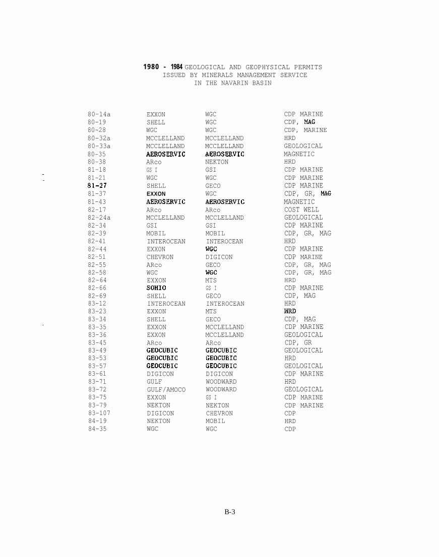
80-14a80-1980-2880-32a80-33a80-3580-3881-1881-2181-2781-3781-4382-1782-24a82-3482-3982-4182-4482-5182-5582-5882-6482-6682-6983-1283-2383-3483-3583-3683-4583-4983-5383-5783-6183-7183-7283-7583-7983-10784-1984-35
1980 - 1984 GEOLOGICAL AND GEOPHYSICAL PERMITSISSUED BY MINERALS MANAGEMENT SERVICE
EXXONSHELLWGCMCCLELLANDMCCLELLANDAEROSERVICARcoGS IWGCSHELLEXXONAEROSERVICARcoMCCLELLANDGSIMOBILINTEROCEANEXXONCHEVRONARcoWGCEXXONSOHIOSHELLINTEROCEANEXXONSHELLEXXONEXXONARcoGEOCUBICGEOCUBICGEOCUBICDIGICONGULFGULF/AMOCOEXXONNEKTONDIGICONNEKTONWGC
IN THE NAVARIN BASIN
WGCWGCWGCMCCLELLANDMCCLELLANDAEROSERVICNEKTONGSIWGCGECOWGCAEROSERVICARcoMCCLELLANDGSIMOBILINTEROCEANWGCDIGICONGECOWGCMTSGS IGECOINTEROCEANMTSGECOMCCLELLANDMCCLELLANDARcoGEOCUBICGEOCUBICGEOCUBICDIGICONWOODWARDWOODWARDGS INEKTONCHEVRONMOBILWGC
CDP MARINECDP, MAGCDP, MARINEHRDGEOLOGICALMAGNETICHRDCDP MARINECDP MARINECDP MARINECDP, GR, MAGMAGNETICCOST WELLGEOLOGICALCDP MARINECDP, GR, MAGHRDCDP MARINECDP MARINECDP, GR, MAGCDP, GR, MAGHRDCDP MARINECDP, MAGHRD
CDP, MAGCDP MARINEGEOLOGICALCDP, GRGEOLOGICALHRDGEOLOGICALCDP MARINEHRDGEOLOGICALCDP MARINECDP MARINECDPHRDCDP
B-3

80-2181-lla81-1481-1781-19a81-2581-5282-1882-2882-3382-4082-4382-5282-57a82-6782-6883-1483-2683-2983-3083-3183-3383-39a83-40a83-4483-4783-6283-7884-2384-2584-2884-3084-62 .
1980 - 1984 GEOLOGICAL AND GEOPHYSICAL PERMITSISSUED BY MINERALS MANAGEMENT SERVICE
IN THE N. ALEUTIAN BASIN
SHELLARcoGECOGS IWGCSHELLEXXONARcoSHELLGS IMOBILINTEROCEANCHEVRONMCCLELLANDSOHIOSOHIOINTEROCEANGS IMCCLELLANDMCCLELLANDPHOTOGRAVSHELLMCCLELLANDMCCLELLANDARcoARcoWGCSOIiIONEKTONWGCARcoAMocoARco
GECOWESTERNGECOGSIWGCGECOGS IARcoGECOGSIMOBILINTEROCEANDIGICONMCCLELLANDGS IGS IINTEROCEANGSIMCCLELLANDMCCLELLANDBERRY DATAGECOMCCLELLANDMCCLELLANDARcoAR(2OWGCNEKTONNEKTONWGCGECOWGCARco
CDP, MAGCDP MARINECDP MARINECDP MARINECDP MARINECDP MARINECDP MARINECOST WELLCDP MARINECDP MARINECDP, GR, MAGHRI)CDP MARINEGEOLOGICALCDP MARINECDP MARINEGEOLOGICALCDP MARINEGEOLOGICALGEOLOGICALGRAVITYCDP, MAGCDP MARINEGEOLOGICALCDP, GRCDP, GRCDP, GR, MAGCDP MARINEHRDCDP, GR, MAGCDP, GR, MAGCDP, GR, MAGCDP, GR
B-4

1980 - 1984 GEOLOGICAL AND GEOPHYSICAL PERMITSISSUED BY MINERALS MANAGEMENT SERVICE
IN THE ST. MATTHEW HALL BASIN82-31 GS I GS I CDP MARINE83-85 GS I GS 1 CDP MARINE93-96 MCCLELLAND MCCLELLAND CDP MARINE
B-5