u.s. geological survey open-file report £ v- prepared in ... · effort of the geological survey of...
TRANSCRIPT

DEPARTMENT OF THE INTERIOR U.S. GEOLOGICAL SURVEY
National coal exploration plan /Pakistan/
by
Geological Survey of Pakistan
and
U.S. Geological Survey
Open-File Report £ V-
Prepared in collaboration with the U.S. Geological Surveyunder the auspices of the Government of Pakistan and
the U.S. Agency for International Development
This report is preliminary and has not been reviewed for conformity with U.S. Geological Survey editorial standards and stratigraphic nomenclature,
1988

CONTENTS
Page
PREFACE.................................................................. 1
EXECUTIVE SUMMARY........................................................ 3Conclusions and Recommendations..................................... 3Recommended Coal Exploration by Priority and Area................... 3Demand, Utilization, and Limitations................................. 8Known Coal Resources of Pakistan.................................... 10
INTRODUCTION............................................................. 12Background Studies.................................................. 14
PAST AND FUTURE DEMAND AND UTILIZATION OF COAL........................... 15Past Demand and Uses of Coal........................................ 15Future Demand and Potential Uses of Coal............................ 16
Electric Power................................................. 18Bri cks......................................................... 19Cement......................................................... 20Briquettes..................................................... 21Other Potential Uses........................................... 21Total Demand Projections....................................... 22
Limitations on Utilization.......................................... 23Location....................................................... 23Quantity....................................................... 23Quali ty........................................................ 24Ownership Limitations.......................................... 24
COAL RESOURCE EVALUATION................................................. 26National Summary Assessment......................................... 26Regional Synthesis.................................................. 28Local Exploration Projects.......................................... 31Coal Resource Classification........................................ 35
FUNDING, PERSONNEL, AND INSTITUTIONAL REQUIREMENTS....................... 39Funding............................................................. 39Personnel........................................................... 40Institutional Requirements.......................................... 41
EXPLORATION PROJECTS BY PRIORITY......................................... 43Cost Estimates...................................................... 43Priority I Projects................................................. 43
South Sind Coal Area........................................... 46Lakhra Coal Field......................................... 48Northwest Lakhra Coal Area................................ 49Meting-Jhimpir Coal Field................................. 50Sonda Coal Field.......................................... 50Indus East Coal Area...................................... 51
Baluchistan.................................................... 51Khost-Sharig-Harnai Coal Field............................ 53Sor Range-Daghari Coal Field.............................. 53

CONTENTS Continued
Punjab......................................................... 54Salt Range Coal Field..................................... 54
Punjab and Northwest Frontier.................................. 55Makarwal/Kurd-Sho Area.................................... 55
Priority II Areas................................................... 55Punjab......................................................... 55
Punjab Plains Area........................................ 55Northwest Frontier............................................. 58
Cherat Area............................................... 58Baluchistan.................................................... 58
Mach and Ab-E-Gum Coal Field.............................. 58Pir-Ismail-Ziarat Coal Field.............................. 58Chamalong Area............................................ 59Duki Aoal Field........................................... 59
Low Priority Areas.................................................. 59
SELECTED BIBLIOGRAPHY.................................................... 61
APPENDIXES A, B, AND C................................................... 65Coal Resource Classification........................................ 66Coal Exploration Techniques......................................... 77Acknowledgments..................................................... 79
ILLUSTRATIONS
Figure 1. Location of Pakistan coal fields and occurrences.............. 42. Indus East Coal Area.......................................... 52
TABLES
Table 1. Summary information on known coal fields...................... 52. Relationship between Geologic Assurance Programs.............. 63. Coal Demand Projections....................................... 174. Geologic Assurance Program I.................................. 365. Geologic Assurance Program II................................. 376. Geologic Assurance Program III................................ 387. Priority I Areas.............................................. 448. Estimated exploration costs and time for GAP I in
Priority I Areas .......................................... 459. Priority II Areas............................................. 56
10. Estimated exploration costs and time for GAP I inPriority II Areas.......................................... 57

NATIONAL COAL EXPLORATION PLAN
By
Geological Survey of Pakistan
and
U.S. Geological Survey
PREFACE
Indigenous coal supplies about 7 percent of the commercial energy
requirements of Pakistan. Oil, mostly imported, supplies about 40 percent,
indigenous gas about 35 percent, hydropower about 17 percent, and the
remaining 2 percent is supplied mainly by non-commercial fuels--such as
fuelwood or cowdung. As the energy requirements of Pakistan increase, coal
could and should be an increasingly larger portion of the energy-supply mix of
the country.
In order for coal to be able to supply more of the needed energy, more
coal exploration is required as the necessary prelude to its development and
utilization. The National Coa-1 Exploration Plan (NCEP) provides a framework
for increased coal exploration in Pakistan. It is based on what is known or
can be inferred about the coal-resource potential of the country, the possible
forms of utilization of Pakistan's coal from geographic and quantitative and
qualitative factors, and the perceived information requirements necessary to
allow rational long-range planning for increased coal energy use. Program
elements to meet basic data needs are summarized along with estimated funding
requirements and timeframes.
Appendix A is a description of the coal classification system used by the
U.S. Geological Survey. Appendix B is an introduction to coal exploration
techniques for the benefit of the non-geologist. Appendix C provides
acknowledgments to those involved in development of this plan.

The data herein is intended for use by planners as Pakistan's Seventh
Five-Year Plan is prepared, and for early planning use by international
assistance agencies. The report, of which this is the 4th version, is a joint
effort of the Geological Survey of Pakistan (GSP) and the United States
Geological Survey (USGS), under the auspices of the joint Government of
Pakistan-United States Agency for International Development (USAID) Energy
Planning and Development Project.

EXECUTIVE SUMMARY
Conclusions and Recommendations
An investment of small amounts of time, money and manpower in increased
coal resource assessment and exploration can have a very large impact on the
energy future of Pakistan. The present effort to assess the coal resources of
Pakistan should be accelerated. A modern coal exploration program of the type
needed in Pakistan will require funding support from both national and foreign
sources. Exploration for coal should be started or accelerated in various
parts of the South Sind coal area, and in the Khost-Sharig-Harnai, Sor Range-
Daghari, and Salt Range coal fields as soon as possible so that the
contribution of coal to the energy balance of Pakistan can be significantly
increased in the near future. To assure sufficient production of coal to meet
increased demands, leasing and licensing must follow practical guidelines that
encourage the formation of efficient production units.
Recommended Coal Exploration by Priority and Area
A coal exploration strategy involves investigation of all sedimentary
basins in order to delineate all major potential coal deposits and to evaluate
the national resource base. Until this is done, it will be difficult to carry
out rational energy planning for the country. Figure 1 shows location of
Pakistan coal fields and table 1 lists summary information on known coal
fields.
This NCEP describes individual local coal resource projects that are
underway or proposed, and groups coal-bearing areas by priorities according to
the perceived opportunity for economic exploitation. Detailed proposals for
Geologic Assurance Programs (GAP) are presented for seven coal fields. Table
2 summarizes a few important factors about the GAP. The total cost of
exploration seems large but the cost benefits on a per-ton basis are extremely

32'
^_________________64'_____ |
1 INDUS EAST
2 SONDA3 METING-JHIMPIR
4 LAKHRA5 DUREJI
6 BALGOR
7 SANNI8 JOHAN9 MACH/AB-E-GUM
10 ABI-GUL11 MARGAT
12 PIR-ISMAIL-ZIARAT
13 SOR RANGE-DAGHARI
72°
CHINA
24*
.Xs/Northern *-v Areas \
North-Wes
rontieAFGHANISTAN
Fed.Admin. Tribal Areas 32'
14 KACH
15 KHOST-SHARIG-HARNAI16 DUKI17 CHAMALONG
18 BADINZAI19 MAKARWAL/KURD-SHO
20 CHERAT21 CHOI
22 SALT RANGE23 AZAD KASHMIR
200 KM
I
200MI
64° 72"
Figure 1. Location of Pakistan coal fields and occurrences

Tab
le
1.--
Sum
mar
y in
form
atio
n
on
know
n co
al
fie
lds
Pro
vinc
e an
d co
al
field
Sin
d Lakh
raM
etin
g-J
him
pir
Sond
a
Pun
jab
(and
NW
FP)
Mak
arw
alS
alt
Ran
ge
Ba
luch
ista
n
Sor
R
ange
-Dag
hari
Kh
ost
-Sh
arig
-Ha
rna
iM
ach
Pir-I
sm
ail
-Zja
rat
Duk
i
Tota
ls
Are
a (s
q.
km)
200 90 650 75 260 50
200 45 20 100
1,69
0
Ave
rage
m
i ned
th
ickn
ess
(m
)
1.5 .5
---
- 1
.5 .75
1.2
5.7
5.7
5.5 .5
Dem
onst
rate
d re
cove
rable
re
serv
es
(10
b to
ns)
100 8
124 7 17 18 24 9 6 8
321
Infe
rred
reco
vera
ble
re
serv
es
(10
b to
ns)
200 17 156 12 58 16 23 6 5 5
498
To
tal
reco
vera
ble
re
serv
es
(10
b to
ns)
300 25 280 192
/75 34 47 15 11 13
819
Coa
l ra
nk!/
(AST
M)
ligA
-subC
ligA
-subC
ligA
-su
bB
hvC
b-hv
Bb
hvC
b
subB
-sub
Ahv
Bb-
hvA
bsu
bC-s
ubB
hvC
bsu
b.C
-sub
A
Ave
rage
re
po
rte
d
annu
al
pro
duct
ion
(10
J to
ns)
300 40 ---
225
225
460
100
125
115
-25
0
1,8
40
'L
igA
=
lig
nite
A,
su
bC
= su
bbitu
min
ous
C,
subB
b
itum
ino
us,
hv
Bb
= h
igh
vo
latile
B
bitu
min
ous,
hv
Ab
Ma
teria
ls,
1982
).
I/In
clu
de
s
Kur
d-S
ho
area
o
f NW
FP.
subb
itum
inou
s B
, su
bA
= su
bbitu
min
ous
A,
hvC
b =
high
vo
latile
C
hig
h vo
latile
A
bitu
min
ou
s (A
mer
ican
S
oci
ety
fo
r T
est
ing
an
d
Tabl
e 2. Relationship be
twee
n Geologic As
sura
nce
Prog
rams
GAP
I (1
d
ata
poin
t p
er
4 sc
[C
oal
fie
ld
Son
da
Lakh
ra
Salt
Ran
ge
Kh
ost
-Sh
arig
-Ha
rna
i
Son
Ran
ge-D
agha
ri
Pi r
-Ism
ail-Z
iara
t
Mac
h-A
b-E
-Gum
Tota
ls
Exp
lora
tio
n
cost
(1
06
Rs.)
116.
5
56
.2
34.5
57.5
43.7
17.3
69 394.
7
Po
ten
tia
l re
sou
rce
s!/
(1
06
ton
s)
500
425 75 47 35 11 21
1,1
14
. km
)C
ost
benefit
(Rs»
/ton)
0.2
3
.13
.46
« 1
.22
1.2
5
.;
1.57
»' 3
. 29
0.3
5
GAP
II
(1
da
ta poin
t p
er
2 sq
.E
xp
lora
tio
n
cost
(1
06
Rs)
305
160 98 245
128 48 197
1,1
81
Po
ten
tia
l re
sour
ces-
?-'
(10
6 to
ns)
500
425 75 47 35 11 21
1,11
4
. km
)C
ost
benefit
(Rsy
ton)
0.6
1
.30
1.31
5.2
1
3.6
6
4.2
6
9.3
8
1.06
GAP
III
(1
data
poin
t p
er
1 sq
.E
xp
lora
tio
n
cost
(1
06
Rs.)
447
216
132
331
173 66 266
1,63
1
Po
ten
tia
l re
sourc
es^
/ (1
05
tons)
500
425 75 47 35 11 21
1,1
14
. km
)C
ost
be
ne
fit
(RsY
ton
)
0.8
9
.51
1.76
7.0
4
4.9
4
6 12.6
7
1.4
6
'Po
tent
ial
reso
urce
s:
13 p
ercent measured,
13 pe
rcen
t indicated, 74 pe
rcen
t inferr
ed.
71 'Potential
reso
urce
s:
50 percent
measured,
50 percent
indicated.
o /
'Potential
reso
urce
s:
100
perc
ent
measured.

favorable. There is a wide range of exploration costs per ton as a result of
a wide range of differences in such factors as location, accessibility, and
geologic setting of the coal-bearing rocks.
Priority I areas for exploration are those where present planning for
utilization requires coal-resource information to establish the feasibility of
supplying the necessary energy. The South Sind coal areas, the Khost-Sharig-
Harnai and Sor Range-Daghari coal fields of Baluchistan, and the Salt Range
coal field of Punjab are major Priority I.
The South Sind area has a large but unproven resource potential and
encompasses the area considered as a site of future major electricity-
generating installations that could supply a significant share of Pakistan's
long-term energy needs. The presence and quality of large quantities of
recoverable resources remains to be demonstrated. The GAP I would require
about 173 million Rupees (Rs.) over a period of about 3.25 years.
The Khost-Sharig-Harnai coal fields have a railway line to Sind, and
proposed segments of the national electricity grid are in and near the fields,
with a 321-KV station tentatively proposed for construction near Sharig. The
coal is of variable rank but is generally higher in rank than most coals of
Pakistan, and some might be of value for blending with imported coal to make
metallurgical coke for which higher rank coals are desirable. The fields
never have been adequately mapped and explored, and a complete study of the
geologic nature of the fields and.the quantity and quality of coal should be
initiated. The GAP I would cost about Rs. 57.5 million over a period of about
3 years.
Sor Range-Daghari is one of the most productive coal fields in the
country. The extent of the field and quality of the coal are reasonably well
known, but if the field is to remain productive, exploration is required to
demonstrate the quantity of coal, particularly in the deeper parts of the
7.

field, that would be available for future recovery. The information will
satisfy quantity and quality information needs and allow preliminary planning
of realistic development and recovery programs. The GAP I would requ'ire a
minimum of Rs. 43.7 million and about 2 years.
The Salt Range coal field is strategically located relative to the brick-
making centers of Punjab Province and probably can continue to produce
substantial quantities of coal for the short-term future. However, the large
number of small mine operators will eventually recover the available coal
reserves in the parts of the field near the outcrops where most present mine
entries are located. Future mining by shafts, at greater depths, and by more
efficient methods will be required. The information to guide future
development and recovery activities and to justify required investment must be
created by geologic study of the present mine areas and the available
subsurface information, and by exploration drill holes. The GAP I would cost
about Rs. 34.5 million and require 3 or more years.
Other areas of lesser priority also deserve exploration research, and
some are now being studied or are scheduled for study in the near future. If
the resource potential of an area improves, or if new utilization proposals
are made, any area may advance to a higher priority.
Demand, Utilization, and Limitations
The annual coal production of Pakistan is now estimated to be as much as
2.3 million tons or more, and about 7 percent of the commercial energy used
annually in Pakistan is contributed by coal. In contrast, coal production in
1947 was only about 350 thousand tons, but this amount supplied about 50
percent of the country's energy. Since then, the vastly increased energy
demands of Pakistan have been satisfied by other energy sources, and the
increased production of coal has been based on the increased demand for coal
by the brick industry. The brick industry uses an estimated 80-90 percent of
8

the annual coal production, and demand is expected to continue and increase at
an annual rate of 2-5 percent as the economic development of the country
continues. The projected growth in demand could be accomodated by an increase
in annual coal production of 0.3 to 1 million tons by 1993 and 3 to 9 million
tons by 2015.
The total electrical-generating capacity of the country is about 5,000 MW
but only 15 MW is based on coal. As much as 9,000 MW electrical energy could
be needed in Pakistan by the end of the Seventh Five Year Plan in 1993, and by
2015 the electrical energy needs of the country could approximate 20,000 MW
per year. Domestic coal could supply the energy for 10 to 25 percent of such
an increase in generating capacity if annual coal production increased by 2 to
6 million tons annually by the end of 1993 and 8 to 21 million tons by 2015.
Substitution of coal for other fuels in existing, and potential new,
industrial applications has been studied and seems to be a viable option for
such uses as briquetting and for process and industrial heat. Use in the
cement industry is presently under study.
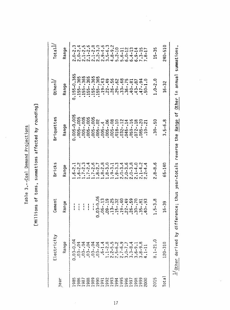
The following table summarizes coal demand projections through the year
2015 A.D. (also see details on table 3, page 17).
Year Electricity
1993 2.2-5.5
2000 4.1-11
2015 8.1-21
Total 120-310
Coal Demand Projections
[millions of tons]
Cement Bricks Briquettes
0.1-.3 1.9-3.1 0.005-.08
.4-.9 2.2-4.4 .1-.2
1.5-3.8 2.8-8.6 .3-.5
16-39 65-140 3.5-6.8
Other
0.3-.6
.5-1
1-2
16-32
Total
5-9
8-17
15-35
240-510

Production of large quantities of coal of consistent quality is best
accomplished from large, safe, efficient mines. Development of these mines
will require large amounts of money, and the availability of funds is
contingent upon demonstration of an adequate quantity and quality of coal that
is producible over a specified period of time. These demonstrations are
difficult to provide in the older coal fields of Pakistan because of the small
areas (2 sq. km average) under a large number of license (500) and lease (240)
tracts that are held by a large number of owners. A public sector company,
Pakistan Mineral Development Corporation (PMDC), and only a few private
companies are the only coal producers with reasonably large areas under
license or lease. The license and lease ownership problem must be solved if
the coal productive capability of Pakistan is to substantially increase.
The coal of Pakistan is largely lignite A to subbituminous C in rank,
though small quantities reach a rank of high volatile A bituminous. The coals
characteristically have high ash and sulfur contents. Beneficiation studies
to date have not produced economically acceptable results. Combustion in
fluidized beds is a relatively new technology that promises to allow use of
such coals with no environmental or efficiency problems. As long as the
quality is usable, the significant future use for coal in Pakistan is as fuel
for thermal-electric-power generation and brick-making. The large quantities
of coal required for these purposes have not yet been demonstrated by
exploration.
Known Coal Resources of Pakistan
Coal is known in 23 different coal fields, areas, and occurrences in
Pakistan (fig. 1). Some of the known coal fields have been exploited for more
than 100 years, and some of the fields that are expected to be increasingly
important in Pakistan's energy future are still in the early stages of
10

exploration. The total potential coal resources of Pakistan are estimated as
1,000 to more than 2,000 million tons, and recoverable reserves as
approximately 800 million tons (table 2). Both estimates are conservative but
cannot be significantly improved without large amounts of definitive
information that can be created only by well planned exploration activities.
11

INTRODUCTION
In the world as a whole, coal is second only to oil as a major energy
source and supplies 28 percent of its needs. In Pakistan, however, coal
furnishes only 7 percent of the commercial energy used by the country. Oil,
most of it imported at a cost of about $1.4 billion in foreign exchange per
year, supplies almost 40 percent of the nation's energy, and indigenous gas, a
diminishing and subsidized resource, supplies about 35 percent. The energy
requirements of the country are swiftly exceeding, by larger factors each
year, the presently available energy supply. The energy future of Pakistan
will be bleak and expensive unless the energy supply mix is changed.
Changes in the energy supply mix will have direct beneficial effects on
Pakistan's economy. Decreasing the relative amount of energy supplied by
imported oil (the cost of which is equivalent to half of the total export
earnings of the country) while increasing the relative amount supplied by
indigenous coal would favorably affect the country's foreign exchange and
international loan situation while increasing employment and creating
opportunities for business expansion in and near the nation's coal fields,
which are widespread throughout the country and generally are not close to
existing urban areas. Even at the present low production rate, as many as
40,000 people are directly employed in the coal-mining industry and as many as
200,000 people are indirectly benefitted.
Whether these changes take place or not is dependent on the Government of
Pakistan's coal policy. Until the Sixth Five-Year Plan, no such policy
existed. The Sixth Five-Year Plan expressed a national energy policy that
included the objectives of arranging inter-fuel adjustments so as to minimize
import dependence, preparing for growing self reliance in energy in the
Seventh Five-Year Plan and beyond, developing indigenous resources of energy,
intensifying the search for undiscovered resources, and evolving mechanisms
12
for greater participation of the private sector in meeting the energy
requirements of the nation. The Sixth Plan recognized that increased use of
indigenous coal could assist in the attainment of these objectives. To date,
these objectives have not been fulfilled, although advances have been made due
to national awareness of the benefits of using indigenous coal. A consensus
was recently reached at the First Pakistan National Coal Conference in Karachi
(February 1986) to promulgate new legislation which would promote coal as a
major energy source in Pakistan.
An impediment to utilization of coal is the absence of a reliable data
base on the location, quantity, quality, and other factors of the indigenous
coal resources. Further coal exploration is required to remedy this
information deficiency, so that development and utilization of this vital
energy source may proceed.
This report attempts to provide a framework for a national coal
exploration plan. The broad objectives are:
1. Preliminary assessment, based on available information, of the
geologic nature and economic potential of known coal areas of
Pakistan with emphasis on determination of the amount, type, and
distribution of information needed to allow planning for development
and utilization.
2. Preparation of preliminary and/or detailed geologic exploration plans
to remedy the identified data deficiencies. To the extent possible,
plans will be proposed in the normal sequential exploration stages so
that creation of information proceeds in an orderly manner with
built-in review and decision points.
3. The exploration plans will include preliminary estimates of overall
cost implications, manpower needs, and timeframes for the required
investigations.
13
4. The plan will identify required needs in personnel training,
institutional support, and governmental practices so the plan may
produce the desired results.
5. Facets of coal-use planning that require further action or study
beyond the scope of this document will be noted. Included are such
problems as fragmented mineral rights and transportation needs.
6. The necessary divisions of responsibility for exploration and
development activities between various types of organizations and
agencies will be addressed. The necessary roles of basic and applied
research in exploration activities will be described.
7. The plan will be presented in a format usable to those with
responsibility for planning and managing the energy future of
Pakistan.
Background Studies
Two major studies bearing on the expressed objectives of the national
energy policy have recently been completed. Chemical Consultants (Pakistan)
Limited of Lahore and Karachi completed a comprehensive "Feasibility study on
the utilization of coal in substitution of other fuels" in January 1985 for
the Ministry of Petroleum and Natural Resources, Government of Pakistan. The
six-volume study included summary-type estimates of the theoretical and
recoverable resources of the Pakistan coal fields, all based on existing
information and not categorized by thickness or overburden except in a general
way. The results of other studies, such as the potential for coal
substitution in industry, the minability of the coal in different fields, coal
beneficiation, analyses of samples collected during the investigation, and
consideration of various utilization, storage, handling, and transport
possibilities also were presented.
14
In February 1985, Energy Development International/Price Waterhouse
completed a study of "The coal industry in Pakistan: requirements for
growth." A wide range of considerations, from concerns about the state of
resource knowledge and exploration activities to assessments of economic,
technologic, and institutional factors, is addressed, and proposed actions to
assist in solutions of the perceived problems are presented.
The Proceedings Volume of the First Pakistan National Coal Conference
contains the texts of 52 formal papers and addresses, plus rapporteurs
reports, that were presented during the meeting of February 22-26, 1986, in
Karachi (see Khan and Pelofsky, 1986). This highly successful conference was
attended by more than 600 people representing government, industry, and
financial and educational institutions from 23 countries. Some of the
individual contributions presented in the Proceedings Volume are subsequently
cited in this report and the reader is urged to consult this relevant volume.
The three cited reports, plus many others that are available, address in
depth coal-related considerations and problems that are only briefly
addressed, summarized, or alluded to in this report, either because they are
not within the direct scope of this report or because detailed discussion
would be repetitive and redundant.
PAST AND FUTURE DEMAND AND UTILIZATION OF COAL
Past Demand and Uses of Coal
In 1947, when Pakistan became an independent nation, the annual coal
production was about 350,000 tons. The main producing areas were the
Makarwal, Salt Range, Sor Range-Daghari, Khost-Sharig-Harnai and Mach
fields. Much of the coal produced today is still coming from the same fields
but significant quantities are now also being produced in the Lakhra, Duki,
Meting-Jhimpir, and Pir-Ismail-Ziarat fields.
15

Small shifts in utilization have occurred over the years. For example,
20 years ago coal was used to make fertilizer, and production of briquettes
was about six times as large as today. However, the loss of these markets was
probably scarcely felt because the brick-making industry has increased
severalfold over that same timeframe and the demand for coal increased with
that growth. Total coal production in Pakistan in fiscal year 1984-85 was
estimated to be about 2 to 2.3 million tons. Brick-making presently uses 80
to 90 percent of the annual production. As much as 140 thousand tons of coal
are supplied to railroads, 5 thousand tons or so are used to make briquettes,
30 to 40 thousand tons are used in the 15 MW electric-generating complex in
Quetta, and the remainder is used for lime-burning and other process heat and
domestic and industrial heating.
Future Demand and Potential Uses of Coal
The Sixth Five-Year Plan and many subsequent policy expressions stress
the need to meet rapidly increasing energy requirements of the country and the
need to satisfy the increased energy requirements from indigenous energy
sources to the extent possible. Coal is recognized as an indigenous energy
source that might meet some, or many, of the energy requirements of the near-
and long-term future.
Table 3 presents projections of possible coal demands based upon
forecasts and reasonable assumptions, which are discussed and described in
following sections of this report. The basic assumptions used to create table
3 are believed to be realistic and the results are presented in ranges that
should encompass the future coal requirements of the country. The table shows
that generation of electricity could require half of the countries coal
production by 1993 and for the foreseeable future beyond that, and that by
1993 Pakistan's coal demands could exceed the present annual production by 2.5
to 4 times.
16
Table
3.-
-Coal
Dem
and
Pro
jections
[Millio
ns
of
ton
s,
sum
mat
ions
a
ffe
cte
d
by
fou
nd
ing
]
xYear
1985
1986
1987
1988
1989
1990
1991
1992
1993
1994
1995
1996
1997
1998
1999
2000
2015
Total
Elec
tric
ity
Range
0.03
-0.0
4.03-. 04
.03-
. 04
.03-
. 04
.03-. 04
.03-
. 04
.6-1
.41.1-2.8
2.2-5.5
2.5-
6.2
2.7-6.9
3.0-
7.7
3.3-8.4
3.6-
9.1
3.8-
9.8
4.1-
11
8.1-21.0
120-310
Ceme
nt
Rang
e
_ _ _
___
___
___
___
0.03
-0.0
6.06-
. 13
.09 -.
19.13-
. 25
.15-. 32
.19-. 40
.22-. 49
.26-. 59
.30-. 70
.35-. 81
.40-. 93
1.5-3.8
16-39
Bric
ks
Range
1.6-
2.1
1.6-
2.2
1.7-
2.3
1.7-2.4
1.7-
2.6
1.8-2.7
1.8-2.8
1.8-3.0
1.9-3.1
1.9-3.3
2.0-3.4
2.0-
3.6
2.0-3.8
2.1-4.0
2.1-4.2
2.2-4.4
2.8-8.6
65-1
40
Briquettes
Range
0.00
5-0.
005
.005-. 005
.005-. 005
.005-. 005
.005-. 005
.005-. 02
.005-. 4
.005-. 06
.005-. 08
.018-. 10
.032-. 12
.045-. 14
.059-. 16
.072-. 18
.085-. 20
.10-
. 21
.30-. 50
3.5-6.8
Other!/
Range
0.15
5-0.
365
.155-. 365
.155-. 365
.155
-. 365
.155-. 365
.155
-. 365
.19-
143
.22-. 49
.26-. 56
.29-. 62
.33-
. 68
.36-. 75
.40-
. 81
.43-
. 87
.47-. 94
.50-
1.0
1.0-2.0
16-32
Total!/
Range
2.0-
2.3
2.0-2.4
2.1-2.5
2.1-2.6
2.1-
2.8
2.2-
3.0
2.9-
4.6
3.5-
6.3
4.8-
9.2
5.2-10
5.6-11
6.0-
126.4-13
6.9-14
7.3-15
7.8-
17
15-3
5
240-
510
' O
ther
d
erive
d
by diffe
rence;
thus
ye
ar-
tota
ls
reve
rse
th
e
Ran
ge
of
Oth
er
in
annu
al
sum
mat
ions
.

Two other scenarios of coal demand in 1993 have been developed
independently by the Task Force on Coal for the 7th Five Year Plan (written
communication, March 1987). Comparison of the estimates for 1993 shown in
table 3 and created by the Task Force show a general agreement on future total
demand.
Comparison of 1993 coal demand projections
(thousands of tons)
Electrical Power
Cement Manufacture
Brick Manufacture
Other uses
Total
Task Force
Scenario 1
(constrained)
1,365
250
4,445
526
6,586
Task Force
Scenario 2
(recommended)
2,157
100
5,434
804
8,495
Table 3
Average
3,850
190
2,500
450
7,OOQl/
I/Range 4,800-9,200.
The obvious differences are in projections for electrical power
generation and brick manufacture but the totals are not significantly
different.
Electric Power
Electrical energy need exceeds the available supply in some parts of
Pakistan now, and "load shedding" with all its deleterious industrial and
social effects is now a routine occurrence in those areas.
Table 3 assumes that the electrical generation capacity of Pakistan will
increase from its present 5,000 MW to about 9,000 MW by the end of 1993, to
18

about 12,500 MW by the year 2000, and to about 20,000 MW by 2015. It is
further assumed that a 1,000 MW generating station requires about 5.5 million
kilocalories of heat energy annually, and that 10 to 25 percent of the
required heat energy will be supplied by indigenous coal after 1993. While
these assumptions are deliberately crude, refinement would not significantly
alter the basic relationships shown in table 3. Regardless of the exact
magnitude of future thermal energy needs, it is inevitable that the electric
generating capacity of the country must increase. If coal is to supply even
as little as 10 percent of the future energy requirement, large sources of
minable and usable coal will have to be identified by exploration activities
prior to development and utilization.
Consequently, quantity of coal is the major consideration as long as the
quality is acceptable and predictable. The average (presumably run-of-mine)
coal quality predicted by Water and Power Development Authority for use in the
proposed Lakhra power-plant complex is 32 percent moisture, 24.7 percent ash,
5 percent sulfur, and 5120 Btu/lb. If the Lakhra complex can operate
successfully on coal of this quality, the basic quality factors for coal to be
used in new steam-electric generating installations in Pakistan will have been
established.
Bricks
There appears no reason to forecast a change in the energy needs of the
brick industry. Coals of relatively poor quality (high ash and high sulfur,
both in a wide range) can apparently be used successfully, and it is probable
that the major requirement for this use is the need for the largest amount of
lump coal possible. However, the brickmakers do recognize quality differences
and the price they will pay for coal depends on the heating value, "age", and
"source". According to Energy Development International/Price Waterhouse
(1985), heating value is presumedly related directly to origin of the coal,
" 19

with Baluchistan coal regarded as highest; "age" means time in stockpiles
since mining, because low rank coals fall into small pieces and dust and may
decrease in heating value; and "source" because coals from different areas
produce differently colored bricks, and some particular colors may be required
by a particular market. There is no obvious alternative fuel to coal even
though small amounts of natural waste and other plant material are reportedly
being used in some places where the economics allow such substitution.
In response to the general economic growth of the country, the demand for
coal to make bricks is expected to continue to grow at a 2 to 5 percent annual
rate over the foreseeable future. Based on this assumption, table 3 shows
that the brick industry will continue to require a substantial portion, from
20 to 80 percent, of future coal production.
Cement
Most of the coals of Pakistan are of high sulfur content and much run-of-
mine product has a high to very high ash content. Pakistan coal, from such
disparate sources as the Sor Range and Salt Range coal fields, was used for
cement manufacture in the past. With the present plants and requirements for
high-quality cement, local coal would probably have to be blended with low-
sulfur imported coal or oil in a ratio of 40 to 60 before it could be used in
the cement industry (Nawaz, 1986) unless beneficiation of these coals becomes
feasible and economical.
Table 3 embodies the following assumptions; the annual production of
cement clinker will remain at about 5 million tons through the year 1993 and
no coal will be used until 1990; cement clinker production will increase to
about 10 million tons by the year 2004 and to about 15 million tons by about
2015; indigenous coal will supply about 10 to 20 percent of the required heat
energy in 1993, 25 to 60 percent in 2004 and 40 to 100 percent in 2015; the
heat energy required per ton of cement clinker is about one million
20

kilocalories and the coal used has about 4 million kilocalories per ton.
Table 3 shows that coal used for cement production could eventually comprise
as much as 10 percent of annual production. The fact that the coal would be
substituting for other fuels such as gas or oil is perhaps of more significant
importance.
Qureshi and Rizvi (1986) list seven factors of prime importance to
precede coal-firing in cement plants. The first three, which are directly
dependent on the success of this exploration plan, are: at least 20 years
reserves of the prospective coal, based on detailed geological exploration and
assessment; assured, predictable quality with minimum variance in chemical and
physical characteristics; and development of the mines needed to supply the
additional coal.
Briquettes
Briquettes have been produced for over 40 years in a plant at Quetta,
primarily for the use of the armed forces. Production has declined to
approximately 5 thousand tons annually and the plant operates only a few
months of the year. The coal used is from the Khost-Sharig-Harnai field, is
weakly caking and is briquetted without binders using heat and pressure with
the assistance of superheated steam. Tests show that other coals such as that
from Lakhra can be used to make briquettes. Market and other potentials are
being studied by PCSIR, PMDC, and private organizations (see Sabadell and
others, 1986; Asifullah, 1986; and Ahmad and others, 1986).
Table 3 is based on the assumption that briquette production will not
increase noticeably until 1990 or 1994 and that the coal required by the year
2015 will approximate 300 to 500 thousand tons annually.
Other Potential Uses
Other potential uses are as substitutes for gas as raw material and
thermal energy in the fertilizer industry and for process heat in sugar mills

and other such processing plants. A recent survey by Chemcon, Ltd. 1985,
stated that coal cannot economically replace gas as a raw material but could
be used in practically all process heat and direct industrial heat
applications that were surveyed.
The amounts of coal used for "other", unspecified, purposes historically
represent the difference between the total of specified uses (such as brick-
making) and the estimated annual coal production. For the demand projections
listed in table 3, it was assumed that unspecified uses would approximate 0.5
to 1 million tons in the year 2000 and 1 to 2 million tons in 2015, with no
increase until the year 1991.
Because of the manner in which table 3 had to be created, the largest
"other" coal demand estimate was combined with the smaller estimates of
specified demand to derive the smaller estimated total annual production
demand figures, and conversely.
Total Demand Projections
The total demand projections shown in table 3 include projected annual
demand for every year between 1985 and 2015, even though not all years are
listed individually in the table. Consequently, the totals shown for
specified and other uses represent the amount of coal that would be required
to satisfy the assumptions discussed in preceding parts of this report. The
total/total shown, 240 to 510 million tons, represents a large part of the
recoverable reserves that have been estimated to be present in Pakistan on the
basis of incomplete coal resource investigations to date.
In general, because of the many limitations on minability and
utilization, a large ratio of coal reserves to annual production is
required. For example, the ratio of estimated identified reserve base tonnage
to annual production in the United States is about 480 to 1. In Pakistan, if
the recoverable reserves figure cited previously was completely equivalent
22

(and it is not) to identified reserve base of the USA, the ratio would be less
(350 to 400) with present-day producton and would be hopelessly inadequate to
support a viable mining industry if the annual coal production of Pakistan is
to increase by factors of 2 to 3 times by 1993 or 7 to 15 times by 2015.
Limitations on Utilization
Location
At present, coal from Baluchistan and Punjab is used mostly to supply the
brick-making industry, which is largely centered in Punjab Province.
Obviously, transportation is possible over the existing railroad and highway
system. However, if the electric-generating needs of the country increase as
predicted, the location of the required large coal sources relative to the
point of utilization, such as a powerplant, becomes a major factor in
evaluating the economics of proposed facilities. Though the electricity
distribution gridwork of Pakistan can presumably allow establishment of
generating stations at most places in the country for use nationwide, the
desirable situation puts the large electric-generating plants near major use
areas or adjacent to large capacity grid segments and as close as possible to
the coal source to minimize the costs and problems of transport and storage.
In all other uses, the location of the coal supply relative to the
utilization point will increase in importance as the quantity of coal required
increases. The factor of location becomes particularly important as new
utilization installations are planned.
Quantity
Total demand projections show that, regardless of the exact estimated
quantities of demonstrated recoverable (reserve base) coal and this is the
part of estimated resources that is required for development and utilization
planning and studies the coal fields of Pakistan require much study to
23

determine quantities of coal available to supply increasingly large quantities
of coal required.
Quality
Quality factors for electric power generation and brick-making were
briefly addressed in preceeding paragraphs. A search for coals of less sulfur
content than is commonly present in most Pakistan coals might lead to
identification of coals in certain areas, or coals in certain beds in certain
areas, that could be selectively mined for use in such industries as cement-
making or briquetting where the sulfur content is of extreme importance.
Beneficiation studies of Pakistan coals indicate that the ash and sulfur
content cannot be reduced to desired levels without bringing about
unacceptable low coal recovery rates. In general, plans should proceed on the
basis of using the coal in the expected run-of-mine quality. Combustion in
fluidized-bed furnaces seems to be a technology applicable to the high-ash and
high-sulfur Pakistan coals because the fluidized bed functions with high-ash
material and can be operated so as to retain most or all of the sulfur in the
fluidized bed material instead of expelling it from the furnace as gases or
very fine solids.
Ownership Limitations
The complicated interrelationships between the public- and private-sector
financing, production, and marketing practices are addressed in the 1985
report by Energy Development International/Price Waterhouse. Many of the
identified problems relate to the relative size of areas under prospecting
license and mining leases. As pointed out in that report, 70 percent of the
242 coal mining leases in the country are less than 750 acres (3 sq. km) in
size, averaging about 347 acres (1.4 sq. km). The situation for prospecting
licenses (coal is produced in license areas as well as lease areas) is
24
similar, with almost 73 percent of the 501 licenses being of less than 1,000
acres (4 sq. km) in size with an average of 600 acres (2.4 sq. km).
The following table shows the coal-bearing area required to supply
various sized electric-generating plants. The assumptions are: coal with an
average heating value of 5120 Btu/lb, so a 100 MW plant would require about
0.6 million tons per year; a recoverability ratio of 60 percent, so the in-
place coal requirement would be about 1 million tons per year; a plant-life of
30 years; and a coal bed averaging 1 meter in thickness underlying 1 sq. km
would have about 1 million tons of coal in-place.
Generating
capacity
(Megawatts)
Coal-bearing area (reserves) needed
(square kilometers)
Average coal thickness mined
0.5 m 1.0 m 1.5 m
15
25
50
100
300
9
15
30
60
180
4.5
7.5
15
30
90
3
5
10
20
60
All of the assumptions are conservative; if the run-of-mine coal supplied
to the powerplant has more heating value, the area required will be less; if
recoverability is greater than 60 percent, the area required will be less; and
so on. However, regardless of the exact assumptions, two facts are clearly
shown: 1) mining leases and prospecting licenses of the average size (1.4 sq.
25

km and 2.4 sq. km) are too small to supply any but the smaller size electric-
generating installations; and 2) blocks of identified resources of useful size
should be preserved, and perhaps granted, as a single unit and not fragmented
as in present leasing and licensing practice. A system employing an approach
like the "logical mining unit" concept used in the United States should be
considered for future leasing in areas now undergoing exploration, such as
Sonda, or to be explored, such as Indus East and parts of the Salt Range.
The limitations placed upon "utilization potential" by the small size of
lease range from inability to enter into long-term contracts, because of lack
of resources, to the inability to justify the costs of improving mining
methods and health and safety standards. The problems caused by fragmented
inefficient-size license and lease-holdings will increase in the future as the
need grows for large assured quantities and qualities of coal for individual
installations, such as powerplants.
COAL RESOURCE EVALUATION
Coal resource evaluation goals are attained in a variety of ways. The
necessity for reliable, credible, internationally acceptable overall resource
evaluation is met with national summary assessment programs. The need for
geologically coherent resource understanding of coal regions is met with
regional syntheses that are based on available data supplemented by geologic
studies. The need for local resource information for planning specific
utilization projects is met by localized investigations that may start with
geologic reconnaissance and proceed through a series of increasingly detailed
exploration and development stages.
National Summary Assessment
Coal resource assessment has been defined as "A critical analysis based
on integrating, synthesizing, evaluating, and interpreting all available data
26

aimed at judgment of the geologic nature or economic potential of the coal
resources and reserves of an area, field, district, basin, region, province,
country, state, nation, continent, or the world. An assessment differs from
an estimate, which is a determination of the amount of coal in an area. An
estimate or estimates may be the principal data used to assess the coal
resources and reserves of an area" (Wood and others, 1983).
The work plan for the Coal Resource Exploration and Assessment Program in
Pakistan recognized the necessity for coal resource assessment in a national
and international context by specifying that the principal goal of the
exploration and assessment element of the program (see Work Plan) "...is a
modern, comprehensive, internationally acceptable assessment of the coal
resources of Pakistan." In addition, description of the proposed plan for a
coal analytical system (See Work Plan) addresses the need to adhere to
standards acceptable to international banks, donor organizations, and resource
development entities and companies. In both cases, .the expressed concerns
reflect the need for coal resource assessments that are acceptable to planners
and financial managers in Pakistan and in the international funding agencies.
A national summary assessment of the coal resources of Pakistan should be
initiated as soon as possible. On a regional, field, and area basis all
available information should be gathered, organized, synthesized, and
summarized so as to allow systematic production of assessments (which usually
include detailed resource/reserve base estimates) that would be comprehensive,
detailed, and nationally and internationally comparable, and that were created
using philosophy, methods, techniques, criteria, definitions, and parameters
that are internationally understood, and accepted.
The summary assessment would be aided by up-to-date contributions from
exploration projects underway or planned for the near future. However,
initiation of a national summary assessment should not be dependent on
27

completion of particular local exploration projects. The summary assessment
would be as complete as possible as of a certain date and, like all progress
reports, would be supplemented or succeeded by newer summary assessments at
some future date.
A national summary assessment focuses on gathering, organizing, and
synthesizing available data with the objective of producing a critical
analysis involving economic factors leading to an understanding of the
national resource/reserve base/reserve situation as of a certain date. As
such, it ordinarily delineates poorly understood geologic relationships and
identifies geologic problems that affect overall assessment. However, such
studies generally cannot be designed to actively contribute to understanding
of the relationships or solution of the problems they identify.
Regional Synthesis
Coal is found as a component of sedimentary rocks that accumulated as
unconsolidated sediments on the surface of the earth under particular physical
and chemical depositional conditions. The type of sedimentary rocks that
contain coal are generally very thin compared to the length and breadth of the
rock sequence. Consequently, areal considerations are pre-eminent and
assessment activities are commonly generalized as national, regional, or
local, depending on the size of the area and the scale and intensity of the
proposed investigation.
A coal region may be defined as a geologically and/or geographically
distinct area in which coal-bearing, or potentially coal-bearing, rocks are
known or believed to be present. A region ordinarily includes two or more
areally smaller entities that might be called areas or fields. To date,
relative terminology for the different coal-bearing areas of Pakistan has not
been standardized; most discussions are by fields, parts of fields, or
undefined areas, and by national political subdivisions. As knowledge of
28

Pakistan's coal resources increases, it may be desirable to formalize an areal
hierarchy to facilitate appreciation of the relations of national, regional,
and local resource data.
Regional geologic studies are intended, and are so designed, to gather
and integrate both existing and new information about the coal geology of a
region so as to result in an increased understanding of the coal resource
potential of the region and provide guidance for subsequent local exploration,
development, and utilization activities.
Ideally, regional studies are done in accompaniment to local studies.
Information produced by local exploration, development, and extraction
activities is integrated with other local information, and continuing
guidance, support, and active collaboration is provided by the regional study
to the local investigations.
Our present understanding of the coal geology of Pakistan indicates that
investigations of three coal regions should be initiated as soon as
possible. These three regions are: 1) the part of southern Sind Province
known or projected to be underlain by coal-bearing rocks of Paleocene or
Eocene age, 2) the part of Baluchistan underlain by the coal-bearing Ghazij
Formation of Eocene age, and 3) the part of the Punjab Plains that is
potentially underlain by coal-bearing rocks of Permian age. Regional study of
the large Salt Range coal field might be desirable as further exploration is
proposed. In addition, regional study of the Makarwal field and Kurd-Sho area
should be undertaken as soon as feasible.
The part of southern Sind Province that includes much of the Hyderabad
Division is underlain by the coal-bearing Ranikot Group of Paleocene age and
the Laki Formation of Eocene age. The distribution, both areally and
stratigraphically, of the coal-bearing parts of these rock units is
29

imperfectly known. Surface studies, particularly limited geologic mapping at
large scales and stratigraphic section measurement, description, and
interpretation with associated detailed paleontologic study, are needed over
large areas west of the Indus River, and subsurface studies based on
interpretation of samples and geophysical logs of coal-exploration drill holes
and oil-and-gas exploration drill holes are needed in the part of the region
east of the Indus River. The coal resource potential of this region is very
large, and a regional understanding of the geologic history of the coal-
bearing and associated rocks is necessary so that the resources of the region
can be adequately assessed.
A very large area in Baluchistan is known to be underlain by coal-bearing
rocks of the Ghazij Formation wherever the Ghazij has not been removed by
erosion. The area extends westward from the Chamalong area through the Duki
field and Kach-Khost-Sharig-Harnai fields to the Sor Range-Daghari field and
then south through the Pir-Ismail-Ziarat and Mach and Ab-E-Gum fields through
the small occurences at Abi-Gul and Margat to Johan. The known boundaries of
the region containing coal are not well defined at present. A thorough
integration and synthesis of existing information followed by surface and
subsurface geological exploration might greatly increase the understanding of
the distribution and internal character of the coal-bearing part of the Ghazij
Formation and, more importantly, might allow guidance of local exploration
activities to define areas of best resource potential for future utilization.
Parts of the Punjab Plains of eastern Pakistan (part of the Five Rivers
area) are underlain by rocks of Permian age that may be coal bearing. The
distribution and stratigraphic subsurface position of these rocks is poorly
known from very widely spaced oil-and-gas exploration drill holes and the coal
resource potential is particularly unknown. Information about the
30
location and depth of possible exploration targets for drilling must be
gathered and synthesized so that coal-exploration activities can be reliably
planned. Geophysical studies must be the basis of the development of geologic
understanding of the coal resource potential of this large strategically
located region. A proposal for study of this area is included herein as a
local resource project but could actually be viewed as a regional research
project because of the breadth, depth,, and scale of analysis involved.
The Salt Range coal field of Punjab should be regionally analyzed as
information is obtained from proposed drill programs.
The important Makarwal coal field of Punjab and Northwest Frontier
Provinces (NWFR) and its probable extension into the Kurd-Sho area of NWFP
should be analyzed in a regional manner in conjunction with surface studies of
critical areas and exploration drilling in areas where the potential coal-
bearing rocks are covered by younger rocks.
These regional projects, each the responsibility of an experienced
geologist in a GSP regional office, would be conducted concurrently with
related local projects. In addition to the primary project chief, a number of
other GSP earth scientists and specialists, as needed and available, would be
required to accomplish the regional objectives.
Local Exploration Projects
Exploration has been defined as "searching through or into, penetrating
or ranging over for discovery, examining thoroughly, striving to attain by
search." In analogy with research, exploration may be basic with few or no
preconceptions about that which may be found, or, more commonly, designed to
yield information of certain types about particular subjects. In
31

practice, exploration consists of a great number and variety of physical and
mental activities conducted over a broad spectrum of data fields.
National resource assessment and regional synthesis are dependent on
exploration to provide the data that is required. Exploration is the early
part of a continuous sequence of activities that begins when the presence of
coal is reported or believed geologically possible and extends through
exploration, development, extraction, and utilization. Between these broad
categories of related activities, the demarcation of exploration activities
from development activities is sometimes difficult to define because in many
cases the same methods, techniques, and equipment are used. In general, if
the motive for the activity is geologic; that is, for example, to determine
the extent of a coal field or an individual coal bed, to allow most estimated
resources in the area to fall into the demonstrated (measured plus indicated)
category, or to determine significant differences in coal quality related to
location, the activity would be classed as exploration. If, however, the
motive for the activity was to provide information needed for mine planning or
for detailed economic analyses, or similar information needs that are
necessary preludes to extraction, the activity would be classed as
development. Obviously, data obtained an exploration reason can also be
useful for development and extraction purposes.
Within the category of investigation designated here as "local
exploration projects" there is much diversity in size of area and intensity of
analysis.
The coal-bearing parts of Pakistan subsequently discussed as fields and
areas range widely in size. Their distinguishing characteristic is their
definition and distinction on the basis of geographic and/or geologic
boundaries. In some cases, such as the Lakhra field, even those boundaries
are not precise because of lack of information about the extent of the coal-
32

bearing area, and the defined boundaries are subject to considerable change as
exploration proceeds.
Intensity of analysis is judged on such parameters as scale of geologic
mapping, and distribution and number of desired data points relative to the
size of the area being studied. These factors are established by the amount
and type of information required to satisfy a need for particular resource
information. The range of information needs is broad from "Is there coal
present in the area?" to "How much of the coal of a particular quality is
present in a particular category of bed thickness, overburden depth, and
geologic assurance?"
Methods and techniques used to provide answers to such a wide range of
questions necessarily are many and varied. The same technique, such as
drilling coal-exploration holes, may be used in different analyses but the
intensity of analysis in this case the number and spacing of drill holes can
be very different.
Exploration activities are performed as parts of a continuous sequence of
activities. For convenience, the continuum is commonly divided into a series
of exploration steps or stages. One of the criteria for distinguishing the
stages from each other is, commonly, the degree of geologic assurance about
resource evaluation that is expected in each step.
Geologic Assurance Is defined as "State of sureness, confidence, or
certainty of the existence of a quantity of resources based on the distance
from points where coal is measured or sampled and on the abundance and quality
of geologic data as related to thickness of overburden, rank, quality,
thickness of coal, areal extent, geologic history, structure, and correlations
of coal beds and enclosing rocks. The degree of assurance increases as the
nearness to points of control, abundance, and quality of geologic data
increases" (Wood and others, 1983).
33

Though there is no universally recognized system of exploration steps or
stages, a sequence such as described by Landis (1986) can be used in
Pakistan. A three-tiered program based upon different degrees of geologic
assurance of potential identified resources has been proposed by S.N. Khan and
G. Abbas of GSP (Ahmed, 1986). The three sequential exploration programs,
herein called Geologic Assurance Program (GAP) I, II, and III, differ in the
number of data points required. GAP I calls for one data point for every 4
sq. km of the particular coal-bearing area, GAP II calls for one data point
for every 2 sq. km of the coal area, and GAP III requires one data point for
every 1 sq. km of the coal area. The data points would be almost completely
exploration drill holes, though mine or outcrop measurements might be useful
in some areas.
The GAPs are exercises in geologic and resource logic based on objective
but conservative assumptions about the average thickness of coal beds in
different fields and areas, the depth to which mining might be feasible now or
in the near future, and.experienced estimates about the costs and progress
rates of exploratory drilling in the various parts of Pakistan.
In actual practice, GAP I would be completed, the data evaluated,
resource estimates made, and an assessment made based on the available
information. Decisions would then be made about the desirability of
proceeding to GAP II and the possibility or necessity of modifying the GAP II
in order to produce desired results more expeditiously and cost-effectively.
The same procedure would be followed at the end of GAP II. The sequence has
built-in stops and decision points. In addition, because all assumptions are
conservative, in essence "worst case" situations, it is probable that the
actual cost of proposed projects using the GAP system would be conducted at
less expense than originally estimated.
34

Tables 4, 5, and 6 show the GAP I, II, and III, respectively, for
different local exploration project areas in Pakistan. These data will be
cited later in individual area discussions but are here summarized for
comparison. All of the included assumptions are based on presently available
knowledge geologic, engineering, and fiscal and could readily be modified as
more, or newer, information becomes available.
In actual practice, organizations such as the Geological Survey of
Pakistan (GSP) and the U.S. Geological Survey are responsible for the GAP I
studies, are sometimes responsible for GAP II studies, but are rarely involved
in GAP III studies. GAP II is commonly regarded as largely of benefit for
development and mining feasibility studies and GAP III is definitely
development and mine-planning studies. Ideally, GAP I would be conducted by
GSP; GAP II by organizations like Pakistan Mineral Development Corporation
(PMDC) or private parties and, in some cases, by GSP; and GAP III definitely
by PMDC, other similar organizations, and private parties.
Two points are obvious. The total cost of comprehensive programs to
produce results with a great degree of geologic assurance is fairly high. At
the same time, the cost of such exploration evaluated on a per ton basis is
very smal1.
Coal Resource Classification
The coal resources of Pakistan are unknown. Many resource estimates have
been made of the quantity and quality of coal in specific parts of the
country. However, because of differences in the philosophy and methodology of
estimation and the resulting differences in systems of classification of
resource estimates, there is little or no comparability between estimates in
different areas. Summations of such data are almost meaningless.
In Pakistan, as in many other countries, resource classification
terminology and methods are undefined and unspecified. It is possible that
35

Tabl
e 4.
--Ge
olog
ic Assurance
Program
I
[One
data
point
per
4 sq
km]
Prov
ince
an
d co
al field
Area
Number of
(sq
km)
dril
l ho
les
Sind
Son
da
Lakh
ra
Pun
jab
Salt
Ran
ge
Balu
chis
tan
900
650
400
Average
Tota
l Co
st pe
r Dr
illi
ngdepth
mete
rage
mete
r co
st(m
eter
s)
(Rs. )
(106
Rs.)
225
163
100
Geo
logi
c T
ota
l su
pport
co
stco
st
(10
6 Rs
.) (1
06
Rs)
300
200
200
67,5
0032
,600
20,0
00
1,50
01,
500
1,50
0
101.
348
.9
30.0
15.2
7.
3
4.5
116.
556.2
34.5
Khost
-Sharig-H
arn
ai
Sor
R
ange
-Dag
hari
Pi r
-Ism
ail-
Zia
rat
Mac
h/A
b-E
-Gum
Pro
vin
ce
and
coal
fie
ld
Sin
d Son
da
Lakh
ra
100 50
18
80
25
13 5
20 Ta
ble
800
1,0
00
1
,00
0
1,0
00
20
,00
0
13
,00
0
5,0
00
20
,00
0
2,
3,
3,
3,
500
000
000
000
50.0
3
8.0
15
.0
60
.0
7.5
5
.7
2.3
9
.0
57.5
43.7
17
.3
69.0
4. c
on
tin
ue
d
Po
ten
tia
l id
entified
reso
urc
es
(10
6 to
ns)
Mea
sure
d
65 55
Tim
e m
on
ths/
N
o.
of
rigs
Ind
ica
ted
In
ferr
ed
T
ota
l
65
5537
0 31
550
042
526/8
13/8
Mea
sure
d
1.79
1.
02
Cos
t (R
sb
en
efit
ratio
.
per
ton)
Ind
ica
ted
1.79
1.
02
Infe
rred
0.31
.1
8
To
tal
0.2
3
.13
Punj
ab Sa
lt R
ange
Balu
chis
tan
Khost
-Sharig-H
arn
ai
Sor
R
ange
-Dag
hari
Pi r
-Ism
ail-
Zia
rat
Mac
h/A
b-E
-Gum
in 6 4.5
1.5
2.5
10 6 4.5
1.5
2.5
55 35 2.6
8 16
75 47 35 11
36/2
36/2
24
/2
10/2
34
7?
3.4
5
9.58
9.
71
11.5
3 ?7
.fi
3.4
5
9.58
9.71
11.5
3
.62
1.64
1.68
2.16
.46
1.22
1.25
1.57
1 90

Tab
le
5.-
-Geolo
gic
A
ssur
ance
P
rogr
am J
l
[One
d
ata
poin
t per
2 sq
km
]
Pro
vin
ce
and
coal
field
Sin
d Son
da
Lakh
ra
Pun
jab
Salt
Ran
ge
Balu
chi s
tan
Khost
-Sharig-H
arn
ai
Sor
R
ange
-Dag
hari
Pi r
-Ism
ai
1 -Z
i ara
t M
ach/
Ab-
E-G
um
Are
a N
umbe
r of
Ave
rage
T
ota
l C
ost
per
Drillin
g
Geolo
gic
T
ota
l (s
q.
km)
drill
hole
s d
ep
th
met
erag
e m
ete
r co
st
support
co
st
(me
ters
) (R
s.)
(10
6 Rs
.) co
st
(10
6 Rs
.) (1
06
Rs)
900
650
400
100 50
18
80
589
300
176,
700
1,50
0 26
5 40
46
4 20
0 9
2,8
00
1,
500
139
21
284
200
56,8
00
1,50
0 85
13
71
1,00
0 71
,000
3,
000
213
32
37
1,00
0 37
,000
3,
000
111
17
14
1,00
0 14
,000
3,
000
42
6 57
1,
000
57,0
00
3,00
0 17
1 26
305
160 98 245
128 48
19
7
Ta
ble
5, c
on
tin
ue
d
Pro
vin
ce
and
coal
fie
ld
Si n
d Sond
a La
khra
Pun
jab
Sa 1
t R
ange
Ba 1
uchi
sta
n
Kh
ost
-Sh
arig
-Ha
rna
i S
or
Ran
ge-D
agha
ri Pi
r-I
sma
i 1 -
Zi a
rat.
M
ach/
Ab-
E-G
um
Pote
ntial
identified
reso
urc
es
Tim
e m
on
ths/
C
ost
be
ne
fit
ratio
^10
6 to
ns)
No.
of
rig
s
(Rs
pe
r to
nj
Mea
sure
d
250
212.
5
37.5
23.5
17
.5 5.5
1 n
R
Indic
ate
d
Infe
rred
Tota
l M
easu
red
Ind
ica
ted
In
ferr
ed
250
---
500
18/1
0 1.
22
1.22
2
12
.5
---
425
9/1
0
.75
.75
37.5
--
- 75
18
/4
2.61
2.
61
23.5
--
- 47
2
4/3
10
.42
10.4
2 17
.5
35
12/3
7.
31
7.31
5
.5
---
11
12/1
8
.73
8.7
3
m.R
.-
- 21
3
M
18.7
6 1
8.7
6
Tota
l
0.61
.3
8
1.31
5.21
3.
66
4.3
6
9.3
8

Tab
le
6. -
-G
eo
log
ic
Ass
uran
ce _
Pro<
2£a
m__
IJJ_
[One
d
ata
poin
t per
1 sq
, km
]
Pro
vin
ce
and
coal
field
Are
a N
umbe
r of
(sq
km)
drill
hole
s
Sind
Ave
rage
d
ep
th
(me
ters
)
To
tal
met
erag
eC
ost
per
mete
rD
rillin
g
cost
(in6
RS.)
Geol
ogic
support
cost
(in6
RS)
Total
cost
(i
n6 Rs
.)
Sond
a La
khra
Pun
jab
Salt
Ran
ge
Balu
chi s
tan
Kh
ost
-Sh
arig
-Ha
rna
i S
or
Ran
ge-D
agha
ri Pi
r-I
smai
1 -Z
iara
t M
ach/
Ab-
E-G
um
Province and
coal
field
900
650
400
100 50 18 80
864
627
384
300
200
200
259,
200
125,40n
1,500
1,50
0
76,8
00
1,500
Table 6. continued
Pote
ntia
l identified resources
____(in
6 tons)
Time
mon
ths/
No
. of
ri
gs
389
188
115
58 28 17
96 5n 19 77
'
1,00
01,
000
1,00
01,
000
96,0
0050,000
19,000
77,o
on
3,oo
n3,000
3,000
3,onn
288
150 57 231
43 23 9 3fi
447
216
132
331
173 66 266
Cost
be
nefi
t ra
tio
(Rs
per
ton)
Measured
Indicated
Inferred
Tota
l"MeasuredIndicatedInferredTotal
Sin
d Sonda
Lakhra
Punj
ab Salt
Ran
ge
Ba
luch
i sta
n
Kh
ost
-Sh
arig
-Ha
rna
i S
or
Ran
ge-D
agha
ri P
ir-I
sm
ail-
Zia
rat
M
ach/
Ab-
E-G
um
500
42R 75 47 35 11 21
5on
426 75 47 35 11 21
24/i
n
12/i
n
18/4
18/4
18/3 9/2
27/3
n.89
.5
1
1.76
7.04
4.94
6.00
12.6
7
0.89
.5
1
1.76
7.04
4.94
6.00
12.6
7

estimates of "recoverable reserves" are largely in the reserve base category,
but it is also certain that some estimates of "reserves" or "recoverable
reserves" made in the past included some of the "reserve" category as economic
producibility was perceived at the date of the estimate.
A modern detailed summary of known data and estimates of coal resources
of Pakistan are needed for planning of the future energy budget of Pakistan.
The USGS coal resource classification system, or one similar, should be
applied so that the results are credible, comparable, and acceptable both
nationally and internationally.
FUNDING, PERSONNEL, AND INSTITUTIONAL REQUIREMENTS
Funding
Exploration costs are insignificant compared to development, extraction,
and utilization costs. For example, the proposed powerplant at Lakhra and the
proposed mine to supply coal for the plant could cost as much as Rs. 30,000
million, whereas the exploration that justified planning for utilization
cannot (no matter what range of costs are included) exceed more than about 0.5
percent of that total.
Cost-benefit ratios of this magnitude are not uncommon, but funding for
exploration is not popular with the short-term viewer because of the long
lead-time between exploration and utilization. The exploratory drill program
that led to the realization that the Lakhra coal field contained a major
portion of the identified coal resources of Pakistan was done in the early
1960s. Although coal has been produced from the field in increasing
quantities since 1959, truly large-scale production from the field is still at
least a few years away.
The Government of Pakistan has long known that indigenous coal could and
should supply a larger portion of the energy needed for the country's
growth. Pakistan's Sixth Five-Year Plan gave energy the highest priority
39

among all sectors of the economy in terms of the budget allocations and stated
that basic objectives of the plan included:
--preparation for increased self-reliance in energy in the
Seventh Plan and beyond;
development of indigenous resources of energy, intensification of
the search for yet undiscovered resources, development of nuclear
and renewable resources, and acquisition of technology relating to
energy substitutes.
The plan recognized that coal should play an increasingly important role
in meeting national energy needs, but both policy and funding support have
lagged.
Under provisions of the joint GOP-USAID Energy Planning and Development
Project, the Geological Survey of Pakistan was to be allocated Rs. 41 million
for coal exploration during fiscal years 1986 through 1989. The exploration
would be conducted in cooperation with the U.S. Geological Survey under a Work
Plan that calls for assistance, technology transfer, training, and equipment
acquisition under the auspices of--and with over $5 million funding support
from USAID. The funding supplied by GOP to GSP to date (February 1987)
totals Rs. 5.1 million during 1986-87.
Personnel
Seventeen GSP earth scientists completed training in coal geology and
resource assessment at Southern Illinois University (SIU) in June 1986. An
additional 16 are scheduled to complete similar training in June 1987. This
training is intended to provide a cadre of competent GSP personnel to work
with USGS counterparts in the coal exploration program. Technology transfer
between GSP personnel who have received training and other GSP personnel is
very important. It is desirable for additional GSP personnel to receive this
summary assessment and regional synthesis training. The need for

familiarization in the use of new, unfamiliar exploration equipment or
techniques will be identified as the program progresses.
Institutional Requirements
Even though the number of GSP personnel may be adequate for the planned
coal resource program, and necessary specialized training is envisaged, other
institutional and organizational changes may be desirable so the mandates of
coal resource assessment may be accomplished in the most efficient,
productive, and cost-effective manner.
The problem of funding is primary and cannot be rectified by GSP
itself. Work plans and programs that have been prepared, evaluated, and
approved at the highest management and planning levels can be effectively
aborted by not allocating agreed-upon, necessary funding or by delaying
allocation so late that necessary work, especially in the field, cannot be
completed in required timeframes.
A major internal problem of GSP is the accelerated trend toward
regionalization of the organization. The creation and staffing of regional
offices for activities that can be most effectively carried on in a local
context is a standard management approach with much to commend it. However,
staffing of regional offices should be based on program needs, both in number
of staff and mix of required expertise. Program needs change and personnel
must be changed in response. In addition to flexibility in response to
program needs, a system of planned rotation of personnel between different
regional offices can result in well-rounded expertise. If personnel are
assigned to dispersed offices for major portions of their careers,
professional stagnation occurs, the national expertise of the agency
depreciates, and effective management becomes extremely difficult.
A well-conceived program of on-the-job training, foreign fellowships, and
long-term career planning is strongly recommended in scientific organizations
41

such as the GSP. To be effective in their overall scientific mandate to serve
their country in the broad, ever-expanding field of earth science,
organizations such as GSP must be able to encourage, assist, and reward their
personnel in continuing their education and increasing both the depth and
variety of their expertise and management skills throughout their professional
careers.
Training is a major element in the Coal Resource Exploration and
Assessment Program, and a training program for GSP personnel in coal geology
and resource assessment has been planned. In addition, several candidates
will participate in a long-term training program leading to advancded degrees
in earth sciences from U.S. universities. The program is open to all
Pakistanis possessing a basic degree in earth or related science and having
successfully passed the Graduate Record Examination and the Test of English as
a Foreign Language. Candidates for this long-term training will be evaluated
on the basis of selection criteria which include the candidate's demonstrated
ability and apparent potential capability to improve Pakistani institutions
upon completion of training.
42

EXPLORATION PROJECTS BY PRIORITY
The following discussions are arranged according to perceived priority or
need. Future re-appraisal of this exploration plan will result in changes,
additions, and deletions in the priorities.
Cost Estimates
The cost estimates presented herein are derived from the past experience
of the GSP in conducting exploration projects. Obviously, the costs of the
geologic assurance programs (GAPs) presented here are dependent on the costs
of drilling and the geologic guidance and support necessary to achieve the
exploration objectives.
A realistic sliding scale of drilling costs per meter is used. The
changes in the scale are based on comparative average depths of bore holes in
the different programs and experience in the relative costs incurred during
actual drilling programs in the different coal fields of the country.
Costs of geologic guidance and support are expected to approximate 13
percent of the total estimated costs.
It is expected that actual costs in the future may change in presently
unpredictable manners but the accompanying estimates are the best possible at
this time.
Priority I Projects
This priority includes exploration plans for those areas where planning
for utilization requires coal resource information to establish the
feasibility of use for particular purposes. The South Sind coal area, the
Khost-Sharig-Harnai and Sor Range-Daghari coal fields of the Baluchistan
region, the Salt Range coal field of Punjab, and the Mackerwal/Kurd Sho field
in Punjab/NWFP are in Priority I.
Table 7 summarizes pertinent information about the Priority I areas.
Estimated exploration costs and time required are summarized in table 8.
43

Table
7. Priority I Areas
[MT
=
millio
n
ton
s,
m
=m
ete
r,
oth
er
as
indic
ate
d]
SOUT
H S
IND
Est
imate
d
de
mon
stra
ted
re
cove
rab
le
rese
rves
Dep
th
of
deep
est
report
ed
coa
l
Dep
th
of
pre
sent
min
es
Ave
rage
an
nual
pro
duction
Coa
l Q
ua
lity
Ran
ge
Mo
istu
re
Ash
pe
rce
nt
Sulfur
perc
ent
Hea
t va
lue
-
KC
/Kg
Ra
nki
7
Pote
ntial
Utilization
Ele
ctr
icity
Brick
-ma
kin
g
Cem
ent
manufa
cture
P
roce
ss
and
direct
he
at
Briq
ue
tte
s
Oth
er
conve
rsio
ns
Lakh
ra
No
rth
we
st
Lakh
ra
100
MT
460
m
<130
m
0.3
M
T
13-3
9 7-
25
2-6
.5
2770
-420
0 lig
A-s
ubC
Yes
Yes
Yes
Yes
Met
in g
- Jh
imp
ir
8 M
T
500
m
<150
m
0.4
M
T
27-3
7 8
-17
3
-5
3470
-426
0 lig
A-s
ubC
Yes
Yes
Yes
Son
da
Indu
s E
ast
124
MT
260
m 55
0 m
---
---
9-4
0
5-3
9
0.4
-5.6
36
00-5
700
ligA
-su
bC
--
-
Yes
Yes
Yes
BALU
CH
ISTA
N
Khost-
Sharig-
Harn
ai
24
MT
7
250
m
0.1
M
T
1.7
-11
.4
9.3
-38
.0
1.4
-9.4
44
20-7
000
hvB
b-hv
Ab
Yes
Yes
Yes
Yes
Sor
R
ange
- D
agha
ri
18
MT
900+
m
650(?
) m
0.4
6
MT
5.1
-21.2
2
.7-1
4.3
0.4
-5
4830
-606
0 su
bB-s
ubA
Yes
Ye
s
Yes
Yes
PUN
JAB
PUN
JAB/
NW
FP
Salt
Ran
ge
17
MT
?
<200
m
0.2
25
M
T
3.2
-10.8
1
2.3
-44
.2
2.6
-10
.7
3760
-617
0 hv
Cb
Yes
Yes
Yes
Mak
erw
al /
Kur
d-S
ho
7 M
T
?
1,0
00(?
) m
0.2
60
M
T
2.8
-6.0
6.4
-30.8
2.8
-6.3
52
00-6
780
hvC
b-hv
Bb
Yes
Yes
Yes
L
igA
- li
gnit
e A, su
bC =
subb
itum
inou
s. C
, subB =
subb
itum
inou
s B,
subA =
subbituminous
A, hvCb = high vo
lati
le C
bituminous,
hvBb =
high vo
lati
le B
bitu
mino
us,
hvAb
=
high
vo
lati
le A
bitu
mino
us (A
meri
can
Soci
ety
for
Test
ing
and
Materials, 1982).

Table 8.--Estimated exploration costs and time for GAP I in Priority I Areas
Area or field
South Sind
LakhraGAP I
SondaGAP I
Indus EastGAP I
Baluchistan
Khost-Sharig-Harnai *" GAP I
Sor Range-Daghari GAP I
Dril ling
costs
(106 Rs.
48.9
101.3
?
50.0
38.0
(from table 4)
Geologic support Total cost
costs (106 Rs.)
) (106 Rs.)
7.3 56.2
15.2 116.5
? ?
7.5 57.5
5.7 43.7
Time
(months)
13
26
?
36
24
Punjab
Salt Range GAP I
Punjab/NWFP
Makerwal/Kurd-Sho GAP I
30.0 4.5 34.5 36
45

South Sind Coal Area
This large coal region in the Hyderabad Division of Sind Province should
best be studied as a unit. The following area description is presented here
to help define the relationship of the local resource areas subsequently
discussed. The area is Priority I status because of the need for definitive
information about the coal resource potential for supplying large electric
generating complexes, some of which are in the planning stage. It is not
known how much of the Hyderabad Division is underlain by potentially coal-
bearing rocks. The Division includes almost 90,000 sq. km; if only one-
quarter is underlain by rocks that contain coal, the potential tonnage is
still large.
Two rock units are known to contain coal in the area the Ranikot Group
of Paleocene age and the Sunhari Member of the Laki Formation of Eocene age.
The resource potential of the Ranikot Group is large because the unit is known
to be present, and to contain coal, over very large areas. The Sunhari Member
is known to contain coal only in the Meting-Jhimpir coal field though there
are ambiguous indications that coal may also be present in the Sunhari or
equivalent age units in other parts of the area.
The Ranikot Group is reportedly almost 1,000 m thick in an oil-
exploration drill hole on the Lakhra anticline but is generally thinner
elsewhere. The range in thickness is caused by differences in the original
depositional thickness, erosion prior to the deposition of the overlying
Sunhari Member, and erosion now and in the recent past. The Sunhari Member is
reportedly .only a few tens of meters thick in most of the area where it is
present. The regional distribution and geologic history of the Sunhari are
poorly understood and a regional study of the area would help understand the
distribution of Eocene age coal in Sind.
46

The Ranikot Group is known to contain coal at depths as much as 550 m
beneath the surface in the South Sind area. In the area where the Ranikot is
being actively mined at present, seldom is mining done at more than 100-m
depths. The Sunhari is also within 100 m of the surface in most or all of the
area where it is now mined.
The perceived coal resource potential of the area is based on scant and
very poorly distributed information. Much information has been developed for
mine planning in one small part of the area. The remainder of the area is
partly to very poorly explored and its total resource potential cannot yet be
evaluated to the degree of assurance necessary for further utilization
planning.
The quality of the coal in the area will probably be similar to that
which is now mined in the Lakhra field, that is, lignite A to subbituminous C
in rank, with high sulfur and medium to high ash contents. However, it is
possible that in an area so large some coals might be of better quality,
particularly in regard to sulfur content.
The area lies across the primary transportation artery of Pakistan, which
extends northeast from Karachi along the Indus River and eventually to
Lahore. Not only are the roads, railroads, people, irrigation systems, main
industries, and light industries concentrated along this major artery which is
a wide belt in the Five Rivers Area of eastern Punjab, but, of course, so are
major parts of the national electrical grid (see Survey of Pakistan, 1985).
The coal-bearing parts of the South Sind region potentially can supply the
needed thermal energy for a major portion of the future electrical energy
needs of the country. At this time, a project has been initiated to drill as
many as 50 exploratory drill holes, spaced about 4.8 km apart, to 1) gather
information about the extent and depositional setting of the known Lakhra coal
field, 2) determine the relationship of the Lakhra and Sonda coal fields, and
47

3) extend the existing information about the Sonda coal field to the west and
southwest of the known area. The proposed exploration would be conducted
under the auspices and funding of the USAID by personnel of the Geological
Survey of Pakistan, assisted by the U.S. Geological Survey. Also, GSP has
extended exploration of the Sonda coal field into the Indus East Area by
drilling two exploratory holes near the northeast corner of the area
previously proposed as Phase II of the Sonda coal field exploration program.
The holes have proved the existence of coal at.depths of less than 150 m in
the Indus East Area, and have provided the impetus for further exploration in
the area.
Five parts of the South Sind coal region are believed to merit further
exploration. The required data and exploration plans are discussed for each
part of the South Sind area in the following section of this report.
Estimated costs and time frames for planned and required exploration are
presented in table 8.
Lakhra Coal Field. The South Sind exploration program has been started,
and includes the drilling of as many as 30 exploratory drill holes in the
Lakhra field and is accompanied by limited surface studies of specific
geologic problem areas. The drill program will be initiated during calendar
year 1986 and a final report including detailed resource and reserve base
estimates will be completed about 1 year after completion of the drilling
program. Personnel involved are from the GSP, supported by GOP, and from the
USGS, supported by USAID. The actual drilling is being done by a private
Pakistani drilling contractor, and the geophysical logging is being done by a
private USA contractor in cooperation with GSP and WAPDA personnel, using USAID
equipment.
The drilling program will establish a loose grid, with about 4.8 km
drill-hole spacing, from north to south along the length of the known Lakhra
48

coal field and continue across the area between the Lakhra and Sonda coal
fields. The program is intended to help delineate the boundaries of the known
Lakhra and Sonda fields and identify those parts of the fields where coal is
present in minable thicknesses at minable depths so that further exploration,
development, and utilization studies may be considered.
The geologic assurance drilling program (GAP I) shown in table 4 would
require 163 drill holes at a total cost of Rs. 56.2 million to put 26 percent
of the potential identified resources in a demonstrated category. Thirteen
months with eight drill rigs would be required. However, when plans were made
for a GAP I program all the drilling up to that time would be considered, and
the eventual GAP I might be shorter in time, require fewer rigs, and be less
expensive.
Northwest Lakhra Coal Area.--The Northwest Lakhra coal area, which is
presently undefined, adjoins the known and explored northern part of the
Lakhra coal field. The area is separated from the main body of the field by
geologic factors, such as poorly understood faulting, and by sheer shortage of
information in the area compared to the adjoining part of Lakhra proper. The
area has been geologically mapped at a scale of 1:50,000 but no exploratory
holes have been drilled. Recently a mine, and perhaps more than one, has
opened and may have found coal at unexpectedly shallow depths. Some
preliminary site visits to parts of the area are needed as soon as possible to
re-establish geologic interpretations in the area, to gain some idea of the
extent of the area, and to examine those localities where coal has recently
been reported. For example, Ansari and Abassi (1985), present an analysis of
coal from a locality called Gaj and state that "Outcrops of coal have been
seen in every nallah from Laki [near the Indus River north of Hyderabad-
authors] to Ranikot [about 80 km northwest of Hyderabad]. There are coal
49

seams in the Bara formation as well as the Khadro formation which are being
worked by the private sector."
The exploration program now underway includes five exploratory drill
holes that will contribute data about coal in the southeastern part of the
Northwest Lakhra area. This information will be used for planning of further
activities in the area. A GAP I program may eventually be required.
Meting-Jhimpir Coal Field.--The coal of the Meting-Jhimpir field occurs
in the Sunhari Member, the basal unit of the Laki Formation. Generally only
one minable bed is present, and it averages about 0.5 m thick and is seldom
more than 1 m thick. Only about 40 thousand tons is produced in the field
annually. If the approved exploration program shows that the coal in the
Sunhari is persistent to the north and/or west of the present mining area,
further exploration may be justified. Further efforts would certainly be
planned if thicker coal is found at minable depths.
Sonda Coal Field.--This new and as yet unmined coal field has a large
resource potential (Husain, 1985). The coal beds are in the same rock unit as
the coals of the Lakhra field, and the 24-hole exploration program conducted
over the last 5 years by the GSP shows that the Sonda field may eventually be
at least as important in the energy future of Pakistan as the Lakhra field
promises to be.
To date, all but two exploration drill holes have been west of the Indus
River. Besides the 24 holes completed by GSP, an additional 20 drill holes
are included in the underway exploration program already discussed. These
additional points of information, plus the existing data, are expected to
allow the selection of specific targets for further exploration, development
and utilization studies. These targets should be selected following
completion of the 20-hole program.
50

The GAP I would require 225 drill holes at a total cost of Rs. 116.5
million to put 26 percent of the potential identified resources in a
demonstrated category (measured plus indicated).
Indus East Coal Area.--The Indus East coal area is here defined as the
part of the South Sind coal area that is east of the Indus River and generally
south of Hyderabad. As such, it includes the eastern extension of the Sonda
coal field.
The area is covered by surficial materials largely unconsolidated sands,
silts, clays and gravels deposited by the Indus River. Much of it is
irrigated farm land, and, to the authors' knowledge, there are no prospecting
licenses or coal mining leases in the area.
Approximately 60 oil-and-gas exploration and production wells have been
drilled, most of them in the western part of the area. Figure 2 is based upon
the stratigraphic records for 19 holes that were available in 1985. The
records for an additional 21 holes have been made available recently but have
not been synthesized and interpreted to date. This large area in which the
coal-bearing Ranikot Group is at reasonable depths should be explored at an
early date. GSP has completed two exploratory holes that have demonstrated
the presence of coal in the area east of the river.
Baluchistan
The Ghazij Formation of Eocene age is present over a very large area in
Baluchistan. Most of the unit is of marine origin and is non-coal-bearing.
However, a middle unit of the Ghazij is a mixture of marine, non-marine, and
transitional-environment rocks and does contain coal over a large, poorly
defined area in northern and eastern Baluchistan. Regional study of this area
is needed, as well as GAP I studies of two of the coal fields as Priority I
projects.
51

LEG
EN
D
30
0m
to
top
of
Ra
nik
ot
600m
to t
op o
f R
an
iko
t
600m
to t
op o
f R
anik
ot
Gr
Gr
Gr
+
Infe
rre
d a
rea
wh
ere
to
p
Ra
nik
ot
Gro
up
Is l
ess
3
00
m
deep
Indi
an
Shi
eld
than
Ln ro
0 LK
ilom
eter
s
QH
YD
ER
AB
AD
La
kh
ra'F
ield
J
O
f t V
O
r
V
r
Aft
er:
Lan
dis,
19
85
Fig
ure
2.
In
dus
Eas
t C
oal
Are
a.

Khost-Sharig-Harnai Coal Field.--This old coal field, with the highest
rank coal in Pakistan, has never had a complete detailed geologic study
designed to convert the potential resources of the field into demonstrated
resources and reserve base.
The GAP I shown in table 4 would require about 25 drill holes, cost about
Rs. 57.5 million, and take about 3 years.
Vertical aerial photography covering 2,750 sq. km, which the Baluchistan
Government has agreed to obtain, will be of great value in the study of the
region.
Sor Range-Daghari Coal Field.--This field is one of the most productive
coal fields in Pakistan, with an average annual production of about 460
thousand tons. Exploration is needed to identify more resources within the
depth range of currently operating mines and within the hypothesized depth
range of future mines.
The bulk of the Sor Range-Daghari production now is used for brick
making. However, serious consideration is being given to the possibility of
erecting a privately financed 25 MW (and perhaps eventually a second) thermal
powerplant to be fired by the Sor Range-Daghari coal. The known area of the
coal field is only about 50 sq. km, and it is unlikely that the area will
expand significantly even with diligent exploration. The exploration needs
are: 1) information about the quantity of recoverable reserves in the part of
the field that is accessible by present mining practice, 2) information about
the quantity of recoverable reserves in deeper parts of the field, and 3)
information concerning the quality of the coal.
The GAP I shown in table 4 would require about 13 drill holes averaging
1,000 m in depth, cost about Rs. 43.7 million, and take about 2 years time.
53

Punjab
Salt Range Coal Field.--The Salt Range coal field has been mined for many
years and is still one of the most productive field in Pakistan. There is
generally only one minable coal bed present and in places there is no coal.
Nearly all mining to date has taken place near the outcrop much block faulting
adversely affects mine planning and production. In addition, the past mining
activity has removed most mineable coal from a belt generally about 350 m in
from the outcrop and has rendered a large amount of coal unrecoverable in and
near abandoned mines.
The above-listed problems are outweighed by the established tradition of
coal mining in the field and, most importantly, by the field's location
immediately adjacent to centers of brick manufacturing.
The coal needs of the brick-making industry wax and wane with the general
economy of the nation but the overall trend is for increasing demand for coal
for brick making. Forecasts of increases in demand are generally 2 to 5
percent a year. The strategic location of the field has been a large
competitive advantage in the past but has also contributed to a continuation
of now-inefficient mining and labor practices.
In the past, very little detailed exploration was done prior to or during
mining and reliable quantification of recoverable reserves was seldom
attempted. The field is almost completely a private sector enterprise with a
large number of small operators.
The estimated recoverable reserves are large enough to allow a
continuation of present practices for some time, but eventually the coal mines
must be larger, more efficient, deeper (shafts instead of adits), and have
reliable detailed reserve estimates to justify the costs of improving the
mining methods, improving the health standardsfor the mine workers, and
increasing mechanization.
54

The GAP I shown in table 4 would require about 100 drill holes at a total
cost of Rs. 34.5 million to put 26 percent of the potential identified
resources in a demonstrated category.
Punjab and Northwest Frontier
Makerwal/Kurd-Sho Area.--The demonstrated recoverable reserves of this
field are on the order of 7 to 10 million tons. The present mines are getting
deeper and, reportedly, considerable investment in further mine improvements
may be required. Unless the resource and reserve position is improved,
justification of costly improvements may not be possible in the future.
No geologic assurrance programs have been proposed for this area to date.
Priority II Areas
Information about the Priority II areas is summarized in table 9, and
exploration costs and time are estimated in table 10.
These areas require exploration so the coal resources of Pakistan can be
understood in its entirety, but exploration activity now cannot be
justified. Certain areas may later merit a higher priority if new information
is developed or if new demand arises.
Punjab
Punjab Plains Area.--An oil-and-gas exploration drill hole at Sarai
Sidhu, about 60 km northeast of Multan, penetrated coal in rocks of Permian
age at a depth of about 2,685 m. Subsequently, the GSP, on the basis of
structural interpretation by geophysical methods, drilled an exploratory hole
near Jhang that was intended to penetrate the coal-bearing interval at a depth
of less than 1,000 m. However, the hole did not reach the target depth or the
potential coal-bearing unit because of mechanical problems. Further
investigations of this area could be considered a regional research project
rather than a local resource project.

Tabl
e 9.
--Pr
iori
ty II Ar
eas
[MT
= million
tons,
m = meters,
othe
rs as in
dica
ted]
PU
NJA
B
Pun
jab
Pla
ins
Est
imate
d
dem
onst
rate
dre
cove
rable
re
serv
es
---
Dep
th
of
deep
est
rep
ort
ed
co
al
1000
m
(?)
Dep
th
of
pre
sent
min
es
---
Ave
rage
an
nual
pro
duct
ion
---
Coa
l Q
ua
lity
Ran
geM
ois
ture
perc
ent
---
Ash
perc
ent
---
Sulfur
pe
rce
nt
---
Hea
t va
lue
-
KC
/Kg
Ra
nkl
/
Po
ten
tia
l U
tiliza
tio
nE
lectr
icity
?B
rick
-ma
kin
g
?C
emen
t m
an
ufa
ctu
re
?P
roce
ss
and
direct
heat
?B
riquettes
?O
ther
co
nve
rsio
ns
?
NORT
HWES
T FR
ON
TIER
Che
rat
0.0
10
M
T
70
m (?
)
20
m
0
0.5
-15.5
5.8
-62.4
2.3
-5.0
28
30
-75
60
sub
B(?
)
Yes
Yes ? Ye
s 7 ?
Pir-I
sm
ail-
Zia
rat
6 M
T
700+
m
200
m
0.1
15
MT
5.2
-10.0
13
.3-3
4.2
5353
-593
9hv
Cb
Yes
Yes 7 Yes 7 ?
BALU
CH
ISTA
N
Mac
h an
d A
b-E
-Gum
9+
MT
?
425
m
0.12
5+
MT
7.1
-12.0
*
9.6
-20.3
3.2
-7.4
5100
-573
0su
bC-s
ubB
Yes
Yes 7 Yes 7 7
Cha
mal
ong
5 M
T
7 ?
0.0
10
MT
7.9
-11.8
1.6
-29
.23.3
-4.5
? 7 Yes
Yes 7 Yes 7 7
Duki
8 M
T
?
365
m
0.2
50
M
T
4.8
-9.2
2.7
-22.3
2.7
-7.7
46
10
-63
80
subC
-subA
(?)
Yes
Yes ?
Yes ? ?
-1/L
igA
= li
gnit
e A, su
bC =
subbituminous
C, su
bB
bitu
mino
us,
hvBb =
high
volatile B
bitu
mino
us,
hvAb
Materials, 1982).
subb
itum
inou
s B,
subA =
subbit
uminous
A, hvCb =
high vo
lati
le C
high
volatile A
bituminous (A
meri
can
Soci
ety
for
Testing
and

Table 10.--Estimated exploration costs and time in Priority II Areas
General Specific Total costs Time requiredArea or field exploration exploration (106 Rs.) (years)
costs!' costs^'(105 Rs.) (105 Rs.)
PunjabPunjab Plains
Proposed 2.45 7.05 9.5 3
Northwest Frontier Cherat
Underway .33 .33 .8
BaluchistanPir-Ismail-Ziarat
Proposed --- GAP I 2.3 15.0 17.3 1
Mach and Ab-E-GumUnderway 1.0 1.0 2 GAP I 9.0 60.0 69.0 3
ChamalongProposed
DukiProposed ---
'Personnel, field expenses, travel, and administrative and technical support.
^/Internal or contractual drilling programs.
57

Northwest Frontier
Cherat Area.--The coal occurrences of the Cherat area were first
investigated by the GSP in 1952. Mining commenced soon after the discovery
but ceased shortly thereafter because frequent collapse of roofs and sides of
the mines was caused by the absence of overlying hard rocks and the presence
of water seepage. In 1984, the Cherat Cement Co., while drilling for
limestone, encountered coal in a faulted sequence with apparently better mine
roof conditions. If this coal is persistent over a wider area, then there can
be some hope for renewed mining activity. Mapping and detailed structural
studies have been proposed by the GSP. Two geologists, plus support for a
period of about 0.8 year, would be adequate for this preliminary study.
Baluchistan
Mach and Ab-E-Gum Coal Field. Despite complicated structure and problems
with water, this field continues to produce more than 125 thousand tons of
coal per year. The field possesses a location advantage because it is very
near the Sukkur-Quetta highway and railway line. Much of the production from
the field is apparently used in brick-making in Sind or Punjab. Geologic
mapping of the field has recently been completed and mine-site stratigraphic
studies are underway. The proposed GAP I would require 20 drill holes
averaging 1,000 m in depth, cost about Rs. 69 million, and take approximately
3 years (tables 4 and 10).
Pir-Ismail-Ziarat Coal Field.--Despite a disadvantage in location and a
relatively low perceived resource potential, this isolated coal field has now
reached an average annual production of 115 thousand tons. The area has
received almost no organized or planned exploration, and the true resource
potential will not be known until the needed studies are made. At this time,
no studies are underway or planned.
58

The proposed GAP I would require five drill holes at a total cost of Rs.
17.3 million to put 26 percent of the potential identified resources in a
demonstrated category. Drilling could be accomplished in 1 year.
Chamalong Area.--This large undefined coal-bearing area is one of the
least explored, potentially large, producing coal fields in the country.
Eventually, the field will require detailed exploration, but at this time no
proposals for exploration have been submitted because of land-ownership
problems.
Duki Coal Field. Exploration activities in this field were concluded in
1985. An exploration program by GSP that started in 1980 resulted in an
estimate of about 23 million tons of demonstrated remaining coal reserves.
Most, or all, of this estimated reserve is in the area intensively mined by
the private sector. Reportedly, there are insufficient resources in the
public-sector part of the field to support a proposed 50-MW electric-
generating powerplant in the area.
Neither proposed short-term programs nor the long-term resource
requirements have been identified. Despite the lack of interest in the field
for major new uses of coal, it is probable that 200 thousand tons or more will
be produced for the brick industry every year.
Low Priority Areas
Areas such as Johan, Choi, Margat, Abi-Gul, Badinzai, and Balgor will not
be considered for exploration unless some new information is obtained that
requires reevaluation of their resource potential.
The Kach area is geologically part of the Khost-Sharig-Harnai field. The
Sanni locality will remain unevaluated until an exploratory hole is drilled
near the old oil-and-gas exploration hole in which coal was reported. It is
possible that this reported coal was a coalified log, and the area would thus
have no coal resource potential (G. Abbas, 1986, oral commun.). The coal
59

occurrence near Dureji should be studied in reconnaissance to derive some idea
about the geologic setting and possible extent of the coal bed that was
sampled in Kirthar National P'ark.
60

SELECTED BIBLIOGRAPHY
Abbasi, F., Editor, 1985, Sind Coal Symposium, June 27-29, 1985: Proceedings
Volume; Mehran University of Engineering and Technology, Jamshoro, 146 p,
Ahmad, N., Raza, M.Z., Shah, S.K., and Sibtain, F., 1986, Briquettability of
coal with reference to Pakistan coals, in Khan and Pelofsky, 1986, Coal
development potential in Pakistan, p. 473-483.
Ahmed, W.A., Husain, F., Khan, I.A., 1984, Geology and subsurface details of
Sonda-Thatta coal field, Sind Pakistan: Geol. Survey Pakistan Geol. Map
Series No. 12.
Ahmed, W., 1986, Coal resources of Pakistan, in Khan and Pelofsky, 1986, Coal
development potential in Pakistan, p. 25-40.
Ahmed, W., Gauhar, S.H., Siddiqi, R.A., 1986, Coal resources of Pakistan:
Geological Survey of Pakistan Records Volume XXIII, 55 p. and appendix.
American Society for Testing and Materials, 1982, Standard classification of
coals by rank: ASTM Annual Book of ASTM Standards, pt. 26, D388-82,
p. 238-242.
Ansari, B.A., and Abbasi, F., 1985, Problems of Sind coal utility, in Abbasi,
1985, Proc. Vol., Sind Coal Symposium, p. 136-140.
Asifullah, Kh., 1986, Pakistan experience in coal briquettes production, in
Khan and Pelofsky, 1986, Coal development potential in Pakistan,
p. 463-472.
Averitt, Paul, 1975, Coal resources of the United States, January 1974: U.S.
Geological Survey Bull. 1412, 131 p.
Chao, E.C.T., MinKin, J.A., and Thompson, C.L., 1983, Recommended procedures
and methodology of coal description: U.S. Geological Survey Circ. 894,
31 p.
61

Chemical Consultants (Pakistan) Limited, 1985, Feasibility study on the
utilization of coal in substitution of other fuels: Vol. l--Coal
resources of Pakistan, 136 p.; Vol. II--Potential for coal substitution
in industry, 139 p.; Vol. Ill Mining of coal required for substitution
of other fuels, 71 p.; Vol. IV--Coal beneficiation tests, 22 p.; Vol.
V--Annexures Part I; Vol. VI--Annexures Part II; prepared for the
Ministry Petroleum and Natural Resources, Government of Pakistan.
Energy Development International/Price Waterhouse, 1985, The coal industry in
Pakistan: requirement for growth: Prepared under U.S. Agency for
International Development IQC No. PDC-0001-I-06-313, VI.0. No. 6, 168 p.,
4 appendixes.
Geological Survey of Pakistan, 1985, PC-II Form and Scheme-Energy Planning and
Development, Umbrella Project (Coal Resource Assessment) (1984-88), 25
p., 4 appendixes.
Geological Survey of Pakistan, U.S. Geological Survey, and U.S. Agency for
International Development, 1985, Coal resource exploration and
development programme, Component 2a, Energy Planning and Development
Project (391-0478), 38 p.
Hobbs, R.G., 1979, Guidelines for logging, describing and sampling cores and
cuttings of coal and associated rocks at the drill site: U.S. Geological
Survey Open-File Report 79-1522, 23 p.
Husain, Farhat, 1986, Sonda, the future coal field of Pakistan, in Khan and
Pelofsky, 1986, Coal development potential in Pakistan, p. 125-139.
Khan, M.N., and Pelofsky, A.H., Editors, 1986, Coal development potential in
Pakistan: Proc. 1st Pakistan National Coal Conference, Feb. 22-26, 1986;
sponsored by Ministry of Planning and Development and Ministry of
Petroleum and Natural Resources in cooperation with U.S. Agency for
International Development, 628 p.
62

Landis, E.R., 1986, Coal exploration techniques, in Khan and Pelofsky, 1986,
Coal development potential in Pakistan, p. 117-123.
Landis, E.R., Reinemund, J.A., Cone, G.C., Schlick, D.P., and Kebblish, W.,
1971, Analyses of Pakistan coals: U.S. Geological Survey Project Report
PK-58; Open-File No. 8, April 1973, 71 p.
Little, A.D., Inc., 1985, Preliminary energy sector manpower needs
assessment: Prepared for U.S. Agency for International Development and
ENERPLAN, May 1985.
Mining Engineer Pakistan, 1985, Special Issue on Sind Coal Symposium 1985:
Mining Engineer, Karachi, 79 p.
Nawaz, A.S., 1986, Use of Pakistan coals in industry, in Khan and Pelofsky,
1986, Coal development potential in Pakistan, p. 337-352.
Paracha, S.K., 1986, Private sector coal mining industry in Pakistan, in Khan
and Pelofsky, 1986, Coal development potential in Pakistan, p. 529-542.
Reinemund, J.A., Landis, E.R., and Simon, P.O., 1982, Coal resources
assessment: U.S. Geological Survey Project Report PK-66, 48 p., 5
attachments.
Sabadell, A., Sheldon, R., Stevenson, G., and Wilson, T., 1986, The
application of smokeless briquettes in developing countries: the cases
of Haiti and Pakistan, in Khan and Pelofsky, 1986, Coal development
potential in Pakistan, p. 445-462.
Shah, S.M.I., Editor, 1977, Stratigraphy of Pakistan: Mem. Geological Survey
Pakistan, vol. 12, 138 p.
Siemens Aktiengesellschaft, 1986, Coal fired powerplants at Quetta and
Kakhra: Feasibility study sponsored by Habibullah Mines, 30 p.
Survey of Pakistan, 1985, Atlas of Pakistan: Director Map Publication, Survey
of Pakisten, Rawalpindi, 129 p.
63

Swanson, V.E., and Huffman, Clande, 1976, Guidelines for sample collecting and
analytical methods used in the U.S. Geological Survey for determining
chemical composition of coal: U.S. Geological Survey Circ. 735, 11 p.
USAID and USGS, 1985, Energy Planning and Development Project, Coal Resource
Assessment Component 2a: Participating Agency Service Agreement (PASA),
IPK-0478-p-IC-5068-00.
U.S. Bureau of Mines and U.S. Geological Survey, 1980, Principles of a
resource/reserve classification for minerals: U.S. Geological Survey
Circ. 831, 5 p.
Wood, G.H., Jr., Kehn, T.M., Carter, M.D., and Culbertson, W.C., 1983, Coal
resource classification system of the U.S. Geological Survey: U.S.
Geological Survey Circ. 891, 65 p.

APPENDIXES A, B, AND C
NATIONAL COAL EXPLORATION PLAN
65

APPENDIX A
Coal Resource Classification
A detailed resource classification system should identify deposits of
coal by areal location, distance from points of information, thicknesses of
coal and overburden, quality, and estimates of quantity. Classes in the
system, furthermore, should impart some idea as to economic, technologic,
legal and environmental factors affecting the availability of coal (Wood and
others, 1983).
The classification system used by the U.S. Geological Survey and U.S.
Bureau of Mines provides a definitive coal resource classification system with
standard definitions, criteria, guidelines, and methods to be used in
estimating coal resources.
The following is extracted from USGS Circular 891, "Coal resource
classification system of the U.S. Geological Survey" by Wood and others, 1983.
The classification system presented herein employs a concept by which
coal is classified into resource/reserve base/reserve categories on the basis
of the geologic assurance of the existence of those categories and on the
economic feasibility of their recovery. Categories are also provided for
resources/reserve base/reserves that are restricted because of legal,
environmental, or technologic constraints. Geologic assurance is related to
the distance from points where coal is measured or sampled; thicknesses of
coal and overburden; knowledge of the rank, quality, depositional history,
areal extent, and correlations of coal beds and enclosing strata; and
knowledge of the geologic structure. Economic feasibility of recovery is
affected not only by such physical and chemical factors as thicknesses of coal
and overburden, quality of coal, and rank of coal, but also by economic
variables - such as price of coal, cost of equipment, mining, labor,
processing, transportation, taxes, and interest rates, demand for and supply
66

of coal, and weather extremes - and by environmental laws, restrictions, and
judicial rulings.
The classification system is designed to quantify the total amounts of
coal in the ground before mining began (original resources) and after any
mining (remaining resources). It is also designed to quantify the amounts of
coal that are known (identified resources) and the amounts of coal that remain
to be discovered (undiscovered resources). The system also provides for
recognizing amounts of coal that are (1) standard distances from points of
thickness measurements - measured, indicated, inferred, and hypothetical; (2)
similar to coal currently being mined (reserve base and inferred reserve
base); (3) economically recoverable currently (reserves and inferred reserves;
(4) potentially recoverable with a favorable change in economics (marginal
reserves and inferred marginal reserves); and (5) subeconomic because of being
too thin, too deeply buried, or lost-in-mining. Finally, the system allows
tabulation of coal amounts that are restricted from mining by regulation, law,
or judicial ruling.
Two factors have created difficulties in categorizing resources and
reserves in all classification systems. First, most geologists and engineers
who classify resources and reserves are not experts in the economics of
mining, transportation, processing, and marketing. Second, economic
conditions change with time, so that the economic viability of coal is
relatively fluid. For example, subeconomic resources of today can become
reserves of tomorrow as the price of coal rises; conversely, reserves can
become subeconomic resources as the price of coal drops. Finally, changing
regulations, laws, and judicial rulings can affect mining, transportation,
processing, and marketing, and thus the classification of coal resources. The
concept of a reserve base was developed to alleviate these difficulties (U.S.
Geological Survey, 1976, p. B2).
67

The reserve base is identified coal defined only by physical and chemical
criteria such as thickness of coal and overburden, quality, heat value, rank,
and distance from points of measurement. The criteria for thickness of coal
and for overburden have been selected so that the reserve base includes some
currently subeconomic coal. The concept of the reserve base is to define a
quantity of in-place coal, any part of which is or may become economic
depending upon the method of mining and the economic assumptions that are or
will be used. An additional purpose is to aid in long-range public and
commercial planning by identifying coal suitable for economic recovery.
Thus, resource specialists need not expend their time identifying the
component part of coal deposits that are currently economically recoverable
(reserves) because the reserve base category contains much of the coal that
will be classed as reserves in the foreseeable future. Those required to
classify coal as being economically recoverable, marginally recoverable, or
subeconomic can examine reserve base estimates to locate such coal.
Figures 1 and 2 are conceptual diagrams modified from Circular 831 (U.S.
Geological Survey, 1980) that show the relationships of the various classes of
coal resources, the reserve base, and reserves. The classes are categorized
in both figures according to their degree of geologic assurance (geologic
assurance or proximity to points of control increases to the left), and
according to their degree of economic feasibility of recovery (economic
feasibility of mining increases upward). The resource/reserve base/reserve
categories (classes) that can be used are not limited to those shown in
figures 1 and 2 nor to the categories described in succeeding pages. For
example, a particular bed of coal may be identified as being low-sulfur (0-1
percent), low-ash (0-8 percent), high-volatile A bituminous, and premium
coking coal; other beds of coal may be identified as medium-sulfur (1.1-3.0
percent), high-ash (>15 percent), high-volatile bituminous, surface-minable
68
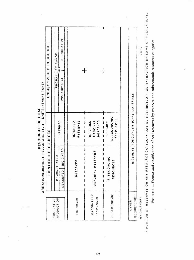
vD
RE
SO
UR
CE
S
OF
C
OA
LA
RE
A;(
MIN
E,D
IST
RIC
T,F
IEL
D.S
TA
TE
. E
TC
.)
UN
ITS
: (S
HO
RT
T
ON
S)
CU
MU
LA
TIV
E
PR
OD
UC
TIO
N
EC
ON
OM
IC
MA
RG
INA
LL
Y
EC
ON
OM
IC
SU
BE
CO
NO
MIC
IDE
NT
IFIE
D
RE
SO
UR
CE
S
DE
MO
NS
TR
AT
ED
ME
AS
UR
ED
IND
ICA
TE
D
RE
SE
RV
ES
MA
RG
INA
LR
ES
ER
VE
S
SU
BE
CO
NO
MIC
RE
SO
UR
CE
S
INF
ER
RE
D
INF
ER
RE
D
RE
SE
RV
ES
INF
ER
RE
D
MA
RG
INA
L
RE
SE
RV
ES
INF
ER
RE
D
SU
BE
CO
NO
MIC
RE
SO
UR
CE
S
UN
DIS
CO
VE
RE
D
RE
SO
UR
CE
S
PR
OB
AB
ILIT
Y
RA
NG
E_
__
__
__
__
__
__
__
_ C
or)
HY
PO
TH
ET
ICA
L
| S
PE
CU
LA
TIV
E
-h | 1
OT
HE
R
OC
CU
RR
EN
CE
S
I I
INC
LU
DE
S
NO
NC
ON
VE
NT
ION
AL
MA
TE
RIA
LS
BY
:(A
UT
HO
R)
DA
TE
:
A P
OR
TIO
N
OF
R
ES
ER
VE
S
OR
A
NY
R
ES
OU
RC
E C
AT
E G
OR
Y
MA
Y
BE
R
ES
TR
ICT
ED
F
RO
M
EX
TR
AC
TIO
N
BY
LA
WS
O
R
RE
GU
LA
TIO
NS
,
FIG
URE
1.
Fo
rmat
and
cla
ssif
icat
ion
of c
oal
reso
urce
s by
res
erve
s an
d su
beco
nom
ic r
esou
rces
cat
egor
ies.

RE
SO
UR
CE
S
OF
CO
AL
AR
EA
: C
MIN
E.D
ISTR
ICT.
FIE
LD.S
TATE
, ET
C.)
UN
ITS
: (S
HO
RT
TON
S)
CU
MU
LA
TIV
E
PR
OD
UC
TIO
N
EC
ON
OM
IC
MA
RG
INA
LLY
EC
ON
OM
IC
SU
BE
CO
NO
MIC
IDE
NT
IFIE
D
RE
SO
UR
CE
S
DE
MO
NS
TR
AT
ED
ME
AS
UR
ED
IND
ICA
TE
D
^
**
<&
S
SU
BE
CO
NO
MIC
R
ES
OU
RC
ES
INF
ER
RE
D
#
«T^/
&
/& $
INF
ER
RE
D
SU
BE
CO
NO
MIC
R
ES
OU
RC
ES
UN
DIS
CO
VE
RE
D
RE
SO
UR
CE
S
PR
OB
AB
ILIT
Y
RA
NG
E
(o
r)
HY
PO
TH
ET
ICA
L
j S
PE
CU
LA
TIV
E
+ -f
n
\
INC
LU
DE
S
NO
NC
ON
VE
NT
ION
AL
M
AT
ER
IAL
S_______I_
_______________I_
_______
OT
HE
R
.
OC
CU
RR
EN
CE
S
BY
:(A
UT
HO
R)
. ,
DA
Tf:
A P
OR
TIO
N
OF
R
ES
ER
VE
S
OR
A
NY
R
ES
OU
RE
C
AT
EG
OR
Y
MA
Y
BE
R
ES
TR
ICT
ED
.F
RO
M
EX
TR
AC
TIO
N
BY
LA
WS
O
R
RE
GU
LA
TIO
NS
.
FIG
URE
2.
Fo
rmat
and
cla
ssif
icat
ion
of c
oal
reso
urce
s by
res
erve
and
inf
erre
d re
serv
e ba
ses
and
sube
cono
mic
and
inf
erre
d su
b-
econ
omic
res
ourc
es c
ateg
orie
s

cannel coal, and so forth. The ability of the classification system to
precisely describe the characteristics of a body of coal allows the coal
resources of the United States to be divided into many hundred resource
classes or categories.
The hierarchy of coal resources shown in figure 3 illustrates the
conceptual relationships between the classes of resources as distinguished by
their definitions and criteria. Examination of figures 1, 2 and 3 makes clear
that each succeeding class in the hierarchy from original and remaining
resources to reserves is included in the overlying classes. Original
resources include remaining resources and cumulative depletion. Remaining
resources include identified and undiscovered resources (divisible into
hypothetical and speculative resources). Identified resources include
measured, indicated, inferred, and demonstrated resources. Measured and
indicated resources contain coal classed as reserve base, and inferred
resources contain coal classed as inferred reserve base. Some measured,
indicated, and inferred resources are subeconomic because they are too thin to
mine or are buried too deeply to be mined by current extraction techniques;
furthermore, parts of the reserve base and inferred reserve base are
potentially subeconomic because they will be lost-in-mining. Reserves and
inferred reserves are economically minable as of the time of classification.
The reserve base and inferred reserve base also contain some coal that is
believed to be potentially economic and which is classed as marginal and
inferred marginal reserves.
Of particular importance is the resource/reserve base/reserve
relationship.
71

HIERARCHY OF COAL RESOURCES'
ORIGINAL RESOURCES 7
CRITERIA
< 6OOO It 3Anlhocil.t Btiumwott* coal4 >'* in.Suttbilvminou. co«l » ligmie >X> «v
CUMULATIVE DEPLETION = CUMULATIVE PRODUCTION * LOST-IN-MINING
REMAINING RESOURCES S»m« CMI.CK » Original H««oufC««
IDENTIFIED RESOURCES
CRITERIA
<*000 M. _ <3 i~.*Anlhf«ctt« ft BilwiWMMi* co«l > 14 «.Subolluminous co»l ft Lioml. >3O in.
DEMONSTRATED RESOURCES
CRITERIA
<OOOO II < 3/4 mt
Subbituimnou* co.l I Ligniu>14in. >30 in.
MEASURED RESOURCES
<e<X>O It., <l/4 mi. Anlhr.clt. ( Bilumnou* coal > 14 m.SubbMumnotM co.l ft Ltgrwt* >3O In.
INDICATED RESOURCES
CRITERIA
<6OOO H. f > 1/4 mi.- <3/4 «L Anthr«cil« 1 BHumlnou* coal > 14 bi. SubbMuminous co*l ft UgiM* > 3O in.
INFERRED RESOURCES
<6OOO II. >3/4 m. -<3 mi.
AnihrccH* ftBiluminou* co«l >I4 in.
co«l ft LionH* >30 in.
SUBECONOMIC A MFERREO SUBECONOMIC RESOURCES
CRITERIA AnttirocM* ft .,._ in. <1OOO H.
> Z-»-<5 »t,<lOOO «iLlgnH* >2.S-<5 lt.,<5OO It.
Al coal >1000 ft - <6000 It «C*PI Ngnil* >4OO-<lOOO fl.
RESERVE BASECRITERIA
<3/4 rm
Anthr.c.l. tBllU<TM«>OU« CO*
Subtxlunvnous
>28 «. <1OOO «t.
> 5 tl. . < <OOO fl. >5 fl.. <5OO II.
MEASURED RESERVE BASE CRITERIA
Bitummou. co.l Subbriummou* co«l Lignrt*
>5 It , <IOOO tl. >S If. , < SCO n.
INDICATED RESERVE BASECRITERIA
>l/4 m. - <3/4m.
> 5 It. . < IOOO 11. >S It.. < SOO It.
SuMMIunvnow* co*lLlgnll*
RESERVES ft MARGINAL RESERVES
Ani«r.c,i. I >2, <1000 BllumMou* co.lSubbrtunrnxni. co.l >5 fl. <IOOO tl. LignM* >5 t1..'<5OO'fl.
MEASURED 4 MEASURED MARGINAL RESERVES
CRITERIA
>28 (1()00Amfv.cil. iStufmrtou. CO*tSubbilumtnou. co.1 > S II <*OOO IILH>~I. >S II <3OO II
I
INDICATED A INDICATED MARGINAL RESERVES
CRITERIA >l/4 <ni. - <3/4 tm.
«.c. |0001,B*1u«nmou. coal '3u<X>llu<nmou* coal )5 M. , < IOOO tlL>gml< >S 11., <SOO II
T^SUBECONOMIC RESOURCES
INFERRED RESERVE BASE
CRITERIA
>3/4 m - <3 im
*" "« BMunnous coal
>26 «..<,000,|.
>5(, <IOOO ,,
>5 fl . <5OO H.
INFERRED AINFERRED MARGINAL
RESERVES
CRITERIA
>3/4 mi - <3
>5 11 ,<3OO II
INFERRED SUBECONOMIC HESOURCES
Figure 1 3. Hoirarchy of coal resources and criteria for distinguishing resource categories.
7?

UNDISCOVERED RESOURCES
CRITERIA
< «OOO N. . >3 mi.Antnracila 1 Bltumwoua coal >14 m.SwMxtummoua coal I llgruta >3O n.
HYPOTHETICAL RESOURCES
CRITERIA
< eOOO M., > 3 mi. ' Anthracite 1 BitiHmnoua coal > 14 In. Suobituminowa coal I Lignite >30 m.
SPECULATIVE RESOURCES
.CRITERIA
<eooo n.
Other criteria not aet
I Cod resource t*rmi ar* defined m gloaaary.
2. R««ourc*« b«lof» mming.
3. SOO It.. 10OO II, and «OOO II. 0«plh ol burtal or ov*rburd«n Ihickn***.
4 Anthr*cil*. bilummou*. tubbitummoua. and Mgnit* *r« rank* ol coil S»» T«bt« I
5 14 n. . 28 in. . 30 «.. *nd S II. ' minimum lruckn««>«i of coil
8 1/4 m. 3/4 m. *nd 3 m. > dl*t*nc*» Irom point* of m«(*ur«<n*m ol co*l tlMckn«».
'. tocK»d«« coal left m room >nd pillar mining, in proo«rly barrier*, coal loo trxcK to b«
racovarad complalaly by convanllonal mining, and mina and praparai<on plant wa»ta.
NOTE
OTHER OCCURRENCES
Includaa coal:
a) laaa Itian minimum IMcknaaa a« any d*p«ti
b) containing mora Itvan 33 vvigM p*rcan« aar) on dry baaia
c) buriad at daplha ol mora man «.000 laal
Eallmaiad lomaoa. wnar*-ca*cu»at«< ka to fa* raoortad aa *Oth*r Occurr*nca«* and not aa raaourcoa. unataa minad. Wnat* mliia<l. lonnao* qwantfty ia Includad In raa*rva ba»* andraaatva aatimalaa.
Figure 3. continued.

Resources are naturally occurring concentrations or deposits of coal in
the Earth's crust, in such forms and amounts that economic extraction is
currently or potentially feasible. It is the total quantity of coal in the
ground within specified limits of bed thickness and overburden thickness
(Averitt, 1975). In the United States, tonnage estimates by the USGS for coal
resources are determined by summing the estimates for identified and
undiscovered deposits of coal that are 14 inches (35 cm) or more thick for
anthracite and bituminous coal and under less than 6,000 feet (1,800 m) of
overburden, and 30 inches (75 cm) or more thick for lignite and subbituminous
coal and under less than 6,000 feet (1,800 m) of overburden. The specified
limits can be modified or amended for particular purposes. For example, in
Pakistan it would be desirable to amend the lignite and subbituminous coal
specific limits to include coal thinner than 30 inches (75 cm) because coal
between 12 inches (30 cm) and 30 inches (75 cm) in thickness is mined in some
areas.
Reserve base is those parts of the identified resources that meet
specified minimum physical and chemical criteria related to current mining and
production practices, including those for quality, depth, thickness, rank and
distance from points of measurement. In the United States, the criteria used
by the USGS for the reserve base include anthracite and bituminous coal 28
inches (70 cm) or more thick, subbituminous coal 5 feet (1.5 m) or more thick
that occurs at depths to 1,000 feet (300 m), and lignite 5 feet (1.5 m) or
more thick that occurs at depths to 500 feet (150 m). As mentioned
previously, these specific criteria would need to be amended for Pakistan
coals. Assignment of coal to a reserve base is controlled by physical and
chemical criteria such as categories of reliability, thicknesses of coal and
overburden, rank of coal, and knowledge of depositional patterns of coal beds,
and associated structural features. Changing economic, technologic, and
74
environmental considerations do not control assignment of coal to a reserve
base (compare with following description of reserves).
Reserves (Wood and others, 1983) are the parts of a coal reserve base
which could be economically extracted or produced at the time of determination
considering environmental, legal, and technologic constraints. Reserves
include only recoverable coal that is economically producible at the time of
classification and the term need not signify that extraction facilities are in
place or operative. Reserves can be categorized as measured and indicated, as
underground or surface minable, by thickness of overburden, by thickness of
coal in the bed, and by various quality factors. Reserves, which are derived
from reserve base coal, exclude coal thinner or deeper than that classified as
reserve base unless such coal is currently mined. Reserves are estimated by
determining the amount of coal in each reserve base category that can be
extracted at the time of classification. This amount plus the amount that
will be lost-in-mining or is otherwise unrecoverable are equal to the reserve
base.
Recovery factors are ideally determined and applied on a local basis
considering what method or methods of mining have been or will be used and the
legal or environmental factors that may affect recovery. For large areas,
local recovery factors may not be applicable or known, and the USGS recommends
applying a recovery factor of 50 percent to the reserve base.
In general, USGS estimates of resources and the derived reserve base are
intended for use by local and national planners and for use in delineating
further exploration, development and utilization activities. Resource and
reserve base estimates are of long-term value and are generally only changed
substantially by addition of new data.
75

In contrast, reserves are used primarily to determine economic
feasibility and are subject to application of changing criteria. A reserve
estimate may have little or no long-term credibility.
76

APPENDIX B
Coal Exploration Techniques
Exploration has been defined as "searching through or into, penetrating
or ranging over for discovery, examining thoroughly, striving to attain by
search." In analogy with research, exploration may be basic with few or no
preconceptions about that which may be found, and is, designed to yield
information of certain types about particular subjects. In practice,
exploration consists of a great number and variety of physical and mental
activities and involves a broad spectrum of information collection.
During the course of exploration, it almost always becomes necessary to
develop subsurface information about the coal and coal-bearing rocks. In most
parts of the world, subsurface information is most economically collected in a
timely manner by drilling exploration boreholes. The classical form of bore
hole drilling is done with drill rigs designed to recover cores of the
material penetrated by the borehole. Coring is commonly done from "the grass
roots" to total depth. In relatively recent years, much exploratory drilling
for coal has been done with rotary-type drill rigs designed to make a hole
while also yielding rock cuttings as drilling progresses, but not to recover
cores. In essence core drill rigs are designed to make a hole while
recovering a core sample of the material penetrated.
However, to complicate matters, core drill rigs can drill open holes and
not recover cores, and rotary drill rigs can recover cores. Both drill rigs
do produce cuttings of materials penetrated regardless of whether they are
coring or making open hole, and with both types of drilling, core-recovery is
seldom 100 percent and may be much less (particularly in coal). Both types of
drill rigs have advantages and disadvantages.
77
In modern practice, geophysical methods are used as supplements to both
forms of drilling. Geophysical borehole logging provides much information
about the rocks penetrated by the drill holes. For example, the geophysical
log can often identify where loss of core has taken place and also what rocks
were not recovered during coring. In rotary drilled open holes, the
geophysical borehole log can establish the location and thickness of
particular rocks in the sequence that was penetrated. Obviously, geophysical
logs can be of crucial importance in activities such as coal exploration where
"quantity" information presence, depth, thickness is vital. Geophysical
logs also can be used for prediction of some "quality" factors such as ash
content, and much research is underway for other applications. A great
variety of geophysical methods have been employed in coal exploration.
Electrical sounding and both high-resolution and conventional seismic methods
are used to help define the stratigraphic and structural setting of coal beds,
coal zones, and coal-bearing rocks. Magnetic methods have been applied with
considerable regional and local success in areas where coal beds have burned
in place, and both gravity and magnetic methods have been used to delineate
intrusive rock masses and buried hills. Satellite imagery, particularly with
computerized enhancement, has been widely used to determine the extent of
coal-bearing and related rock units, and to locate faults and fracture systems
that are not observable to their full extent in ground or lower-level
photographic studies. New techniques such as side-looking airborne radar
imagery may help in studies of structurally and stratigraphically complex
areas.
78

APPENDIX C
Acknowledgments
The authors are deeply indebted to a large number of people who were
consulted about all or parts of the NCEP. All the discussions were helpful.
Much of what was learned is not directly mentioned or attributed in the report
but forms part of the memory bank of background data that is of inestimable
value in an endeavour of this kind.
The following listing of individuals and organizations is not complete
but is presented to illustrate the breadth and depth of our interests in
connection with development of the NCEP. The listing is chronological
according to the sequence of interviews.
Pakistan Council of Scientific and Industrial Research (PCSIR):
Dr. Nisar Ahmed, Director of Fuel Research Center
Pakistan Mineral Development Corporation (PMDC):
K. Asifullah, Director (Technical)
Siddique, Planning Assistant
Energy Planning and Development Project (ENERPLAN):
S.H. Mir, Managing Director
A.M.I. Haque, Deputy Managing Director
I.A. Rizvani, Energy Specialist (Coal)
Ministry of Petroleum and Natural Resources:
M.N. Khan, Secretary, Mineral Coordination Board
M.S. Hasan, Deputy Secretary
Water and Power Development Authority (WAPDA):
G.M. Ilias, Chief Engineer, Coal Power Projects
79

Provincial Government of Punjab:
R.M. Sultan, Chief Inspector of Mines and President, Mining Engineers
Association of Pakistan
State Cement Corporation of Pakistan, Ltd., (SCCP):
G.A. Qureshi, Director, Research and Development
Z.H. Rizvi, Deputy General Manager
Punjab Mineral Development Corporation (PUNJMIN):
B.A. Gill, General Manager (Planning and Operations)
Katha Collieries, Ltd.:
M.R. Ahmed, Managing Director and President All Pakistan Mine Owners
Association
Punjab Directorate of Industrial and Mineral Development:
M.A. Beg, Joint Director (Mineral Development)
C.M. Naseeb, Director
I.V.H. Qureshi, Deputy Director
I.A. Khokhar, Deputy Director
Provincial Government of Baluchistan:
S.K. Paracha, Minister for Planning and Development Chairman, Private
Mine Owners Association of Pakistan, and Manager, Habibullah Mining
Limited
M. Afzal, Deputy Director, Mineral Development Cell, Directorate of
Mineral Development
Oil and Gas Development Corporation of Pakistan (OGDC):
A. Kemal, General Manager
N. Qazi, Exploration Manager
S.H. Rizvi, Senior Test Geologist
A.S. Khan, Deputy Chief Geologist
80
M. Sultan, Deputy Chief Geologist
V.N. Quadri, Manager, Offshore Development
S.M. Shuaib, Geologist, Offshore Development
Provincial Government of Sind:
B.A-. Ansari, Chief Inspector of Mines
Union Texas Petroleum (Union Texas Pakistan Incorporated):
F.A. Krieg, Exploration Manager
T. Hargreaves, Chief Geologist
We also wish to thank the large number of people who transferred
knowledge and inspiration to us during the First Pakistan National Coal
Conference in February 1986.
81