use of gis for planning visual surveillance – an analogy...
TRANSCRIPT

2005
CTS Research Seminars
Surveillance & Situational Awareness
Use of GIS for Planning Visual Surveillance – An Analogy to Maximal
Coverage Problem
Sanjay Rana

2005
CTS Research Seminars
Surveillance & Situational Awareness
© 2005 Sanjay Rana
TOPICS1. Background: Characteristics and Role of
GIS2. Visibility Analysis in urban open spaces3. Automated Observer Placement
Algorithms in GIS4. Examples5. Conclusions and Future Directions
2005
CTS Research Seminars
Surveillance & Situational Awareness
© 2005 Sanjay Rana
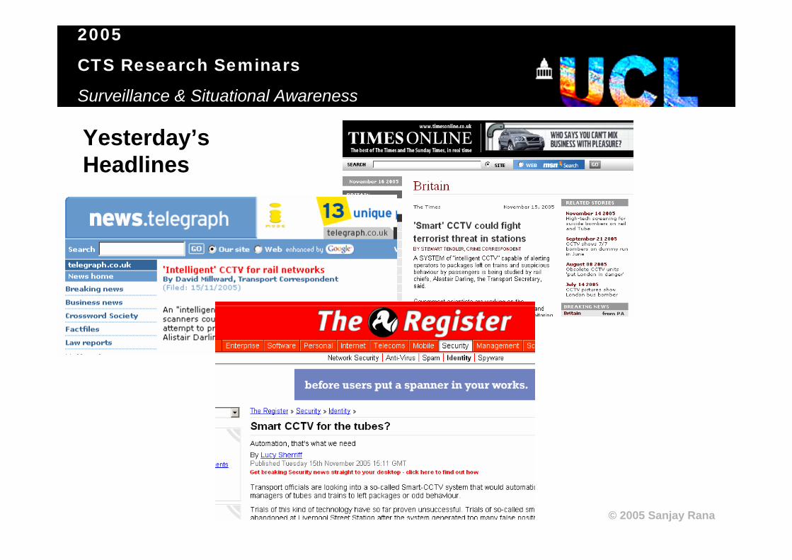
Yesterday’s Headlines

2005
CTS Research Seminars
Surveillance & Situational Awareness
© 2005 Sanjay Rana
1. Background• The use of visual surveillance has dramatically
increased in recent years, as demands arose for monitoring,• Suspicious behaviour in public spaces,• Traffic,• Employees in work places,• etc. etc.
• 1023 million GBP spent during 2004 on sales and rental of CCTV (source: MBD Press, 2005).

2005
CTS Research Seminars
Surveillance & Situational Awareness
© 2005 Sanjay RanaCCTV CAMERAS IN MANHATTAN

2005
CTS Research Seminars
Surveillance & Situational Awareness
© 2005 Sanjay Rana
1.1 Two types of visual surveillance:• Active or Artificial Visual Surveillance:
• Direct and intrusive remote monitoring via devices such as CCTV or human observers.
• Potentially more effective but costly.• Passive or Natural Visual Surveillance
• Design of open spaces so as to ensure that occupants can self-regulate themselves.
• Cheap, long lasting but involves a risk.

2005
CTS Research Seminars
Surveillance & Situational Awareness
© 2005 Sanjay Rana
1.1.1 Artificial Visual Surveillance• The aim is to ensure complete/maximum
visual coverage of an open space.• It involves an iterative, manual and gut-feel
process of trying various CCTV layouts until a satisfactory solution has been found.
• Traditionally done by architects, security consultants and urban planners using CAD software.

2005
CTS Research Seminars
Surveillance & Situational Awareness
© 2005 Sanjay Rana
EXAMPLE OF ARTIFICIAL VISUAL SURVEILLANCE: IDENITIFICATION OF THE FOUR SUSPECTS IN LONDON TRANSPORT NETWORK BOMBINGS (JULY, 2005)

2005
CTS Research Seminars
Surveillance & Situational Awareness
© 2005 Sanjay Rana
1.1.2 Natural Visual Surveillance• The aim is to create the perception of being
observed or safety by suitable architectural design of an open space:
• Occupants can see other occupants and entry/exist points in space, so that they can self-regulate themselves, e.g., in public spaces,
• Occupants always feel being watched by an invisible observer.
• Measures include removal of blind spots, dark alleys, installing one-way screens (Venetian blinds) etc.

2005
CTS Research Seminars
Surveillance & Situational Awareness
© 2005 Sanjay Rana
FAMOUS EXAMPLE OF NATURAL VISUAL SURVEILLANCE: THE PANOPTICON PRISON DESIGN BY JEREMY BENTHAM
• A central guard tower, surrounded by prison cells but the prisoners can neither see each other nor the prison guards therefore creating the perception of being under constant invisible observation.
•Examples include Twin Towers Correctional Facility (LA) and Pentonville Prison (England).

2005
CTS Research Seminars
Surveillance & Situational Awareness
© 2005 Sanjay Rana
• Aim of the talk is to demonstrate:
• GIS-based automated observer placement algorithms that ensure complete visual coverage (artificial visual surveillance),
• Measures to characterise the quality of visibility in open spaces (natural visual surveillance).

2005
CTS Research Seminars
Surveillance & Situational Awareness
© 2005 Sanjay Rana
2. Visibility Analysis in urban open spaces
• Intellectually challenging and multi-purpose with applications including accessibility evaluation, pedestrian behaviour modelling, surveillance, aesthetics etc.
• Architecture surrounding urban open spaces is geometrically quite complex for analysis.
• Void or open space between architecture is a sort of template (or mirror image) and can be easily characterised.

2005
CTS Research Seminars
Surveillance & Situational Awareness
© 2005 Sanjay Rana
2.1 Isovist• Concept proposed by Michael Benedikt (1979).• It is the space visible from a location, basically similar
to the idea of viewshed in terrain analysis and visibility polygon in computer graphics.
• Most commonly derived using 2D building plans and street networks. Hence, unlike viewshed in terrains, isovists do not have gaps in visibility.
• The shape of an isovist can be described in 2D morphological measures.

2005
CTS Research Seminars
Surveillance & Situational Awareness
© 2005 Sanjay Rana
2.1.1 Some isovist shape descriptors:
Area: Amount of visible space
r d
Radial (r) and Diametric (d)length: Length of line of sight from the viewpoint
Circularity: Level of resemblance of the isovist polygon to a circle

2005
CTS Research Seminars
Surveillance & Situational Awareness
© 2005 Sanjay Rana
• Perception of safety and well-being in an open space can be correlated to the visibility properties of the open space for instance, poorly lit (e.g., by natural light) areas generate fear,
• People follow cues (e.g., long corridors) in the space while exploring open spaces.

2005
CTS Research Seminars
Surveillance & Situational Awareness
© 2005 Sanjay Rana
Greene, M., and Greene, R., 2004, Urban safety in residential areas, Space Syntax Conference.

2005
CTS Research Seminars
Surveillance & Situational Awareness
© 2005 Sanjay Rana
3. Automated Observer Placement Algorithms in GIS
• Costs of installation and maintenance, and coverage of CCTV cameras need to be addressed.
• The problem of ensuring maximum visual coverage with a minimum number of CCTV/observers is broadly similar to Location-Allocation, Chinese Postman/Travelling Salesman problems in GIS, and closely similar to the Art Gallery Problem in Computer Science.

2005
CTS Research Seminars
Surveillance & Situational Awareness
© 2005 Sanjay Rana
Why use a GIS?• Planning of visual surveillance is essentially a geospatial
problem, involving cartographic maps of street networks and building plans,
• Determination of visual accessibility is crucial to visual surveillance. Vast GIS literature exists on viewshed in terrain and visibility analysis in urban environments,
• Topological analysis of physical accessibility in open spaces isessential for monitoring navigation. Topology remains the most basic property of objects in spatial analysis and thus most GIS handle topology very well.
• Despite the obvious potentials above, there are no in-built functions in most GIS for something even basic as visibility computation in urban environments (mostly 2D building plans).
2005
CTS Research Seminars
Surveillance & Situational Awareness
© 2005 Sanjay Rana
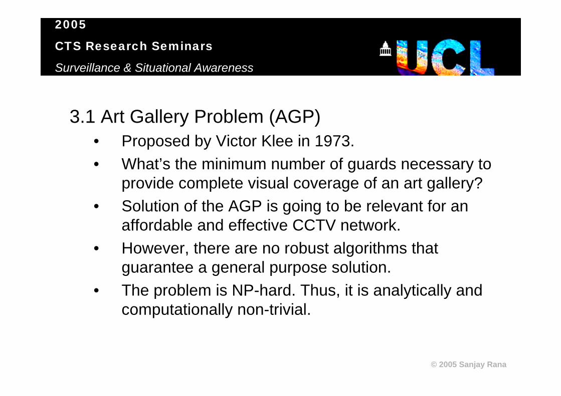
3.1 Art Gallery Problem (AGP)• Proposed by Victor Klee in 1973.• What’s the minimum number of guards necessary to
provide complete visual coverage of an art gallery?• Solution of the AGP is going to be relevant for an
affordable and effective CCTV network.• However, there are no robust algorithms that
guarantee a general purpose solution.• The problem is NP-hard. Thus, it is analytically and
computationally non-trivial.
2005
CTS Research Seminars
Surveillance & Situational Awareness
© 2005 Sanjay Rana
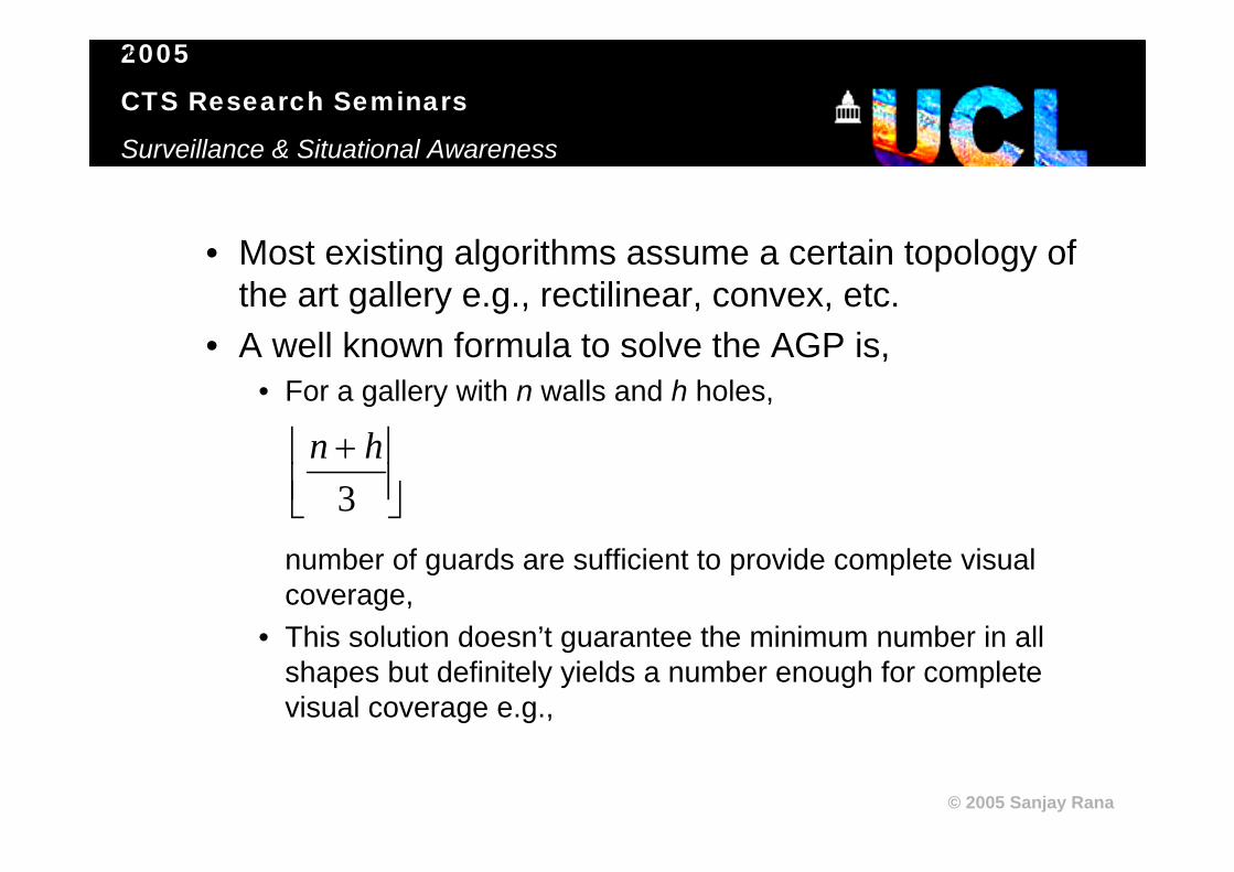
• Most existing algorithms assume a certain topology of the art gallery e.g., rectilinear, convex, etc.
• A well known formula to solve the AGP is,• For a gallery with n walls and h holes,
number of guards are sufficient to provide complete visual coverage,
• This solution doesn’t guarantee the minimum number in all shapes but definitely yields a number enough for complete visual coverage e.g.,
⎥⎦⎥
⎢⎣⎢ +
3hn
⎥⎦⎥
⎢⎣⎢ +
3hn

2005
CTS Research Seminars
Surveillance & Situational Awareness
© 2005 Sanjay Rana
HOW MANY GUARDS ARE SUFFICIENT TO
COVER THE GALLERY ?
71 WALLS
(n+h)/3 = 23? But really need:9

2005
CTS Research Seminars
Surveillance & Situational Awareness
© 2005 Sanjay Rana
3.1.1 Rank and Overlap Elimination (ROPE)• It is essentially a greedy-search method.• The open space is discretised with a dense
mesh of potential observers.• Each observer is assigned a rank based on the
number of other observers seen by it. Higher rank means higher visibility.
• Starting with the highest ranking observer, an iterative process selects the optimal observers:

2005
CTS Research Seminars
Surveillance & Situational Awareness
© 2005 Sanjay Rana
START
Pick highest ranking observer remaining in potential observers
Remove all potential observers visible to highest ranking observer
Potential observers left in open space ?
STOP
No
Yes
ROPE SELECTION PROCESS FLOWCHART

2005
CTS Research Seminars
Surveillance & Situational Awareness
© 2005 Sanjay Rana
Dense Mesh of Potential Observers
Isovist of the highest ranking observer
Two optimal observers

2005
CTS Research Seminars
Surveillance & Situational Awareness
© 2005 Sanjay Rana
ROPE technique doesn’t guarantee the minimum number of observers.
Optimal Observers
ROPE Observers
But it’s not worse than the (n+h)/3 solution:
(10 walls + 0 holes) / 3 = 3 observers

2005
CTS Research Seminars
Surveillance & Situational Awareness
© 2005 Sanjay Rana
3.1.2 Stochastical ROPE (S-ROPE)• Output of greedy-search depends upon initial
solution,• Similarly, ROPE output could be improved by
starting the overlap elimination with randomly chosen observers and choose the solution with least number of optimal observers.
• An exhaustive approach would be to start once with each potential observer.
2005
CTS Research Seminars
Surveillance & Situational Awareness
© 2005 Sanjay Rana
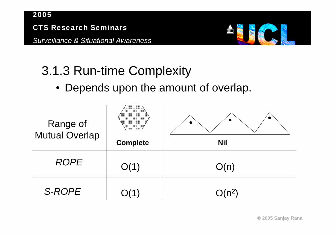
3.1.3 Run-time Complexity• Depends upon the amount of overlap.
Range of Mutual Overlap
ROPE
S-ROPE
O(1)
O(1)
O(n)
O(n2)
Complete Nil

2005
CTS Research Seminars
Surveillance & Situational Awareness
© 2005 Sanjay Rana
3.1.4 Isovist Analyst extension for ArcView• Allows computation of isovist and shape
measures,• Open space can be of arbitrary topology (e.g.,
with/out holes) and geometry (e.g., lines, polygons).
• Integration of urban visibility analyses in GIS.• Available free for non-commercial, non-
profitable, and personal use.

2005
CTS Research Seminars
Surveillance & Situational Awareness
© 2005 Sanjay Rana
Software Demonstration

2005
CTS Research Seminars
Surveillance & Situational Awareness
© 2005 Sanjay Rana
4. Examples
1. Arbitrary closed polygon (complicated shape)
2. Tate Britain Gallery (an indoor open space)
3. Aldwych area (an outdoor street network)

2005
CTS Research Seminars
Surveillance & Situational Awareness
© 2005 Sanjay Rana
4.1 Arbitrary Polygon – Visual Coverage
ROPE observers (13)
S-ROPE observers (11) based on 5177 initial solutions
(n+h) / 3 solution:
71 walls = 23 observers

2005
CTS Research Seminars
Surveillance & Situational Awareness
© 2005 Sanjay Rana
Dense Mesh of 4298 Observers
Isovist Area
Maximum Diametric Length
Circularity
4.2 Tate Britain Gallery - Shape
High
Low

2005
CTS Research Seminars
Surveillance & Situational Awareness
© 2005 Sanjay Rana
4.1 Tate Britain Gallery – Visual Coverage
ROPE observers (90)
S-ROPE observers (86) based on 100 random initial solutions

2005
CTS Research Seminars
Surveillance & Situational Awareness
© 2005 Sanjay Rana
4.3 Aldwych Street Network - Shape
Dense Mesh of 8427 Observers Isovist Area
Maximum Diametric Length Circularity
High
Low

2005
CTS Research Seminars
Surveillance & Situational Awareness
© 2005 Sanjay Rana
4.2 Aldwych Street Network – Visual Coverage
ROPE observers (33)
S-ROPE observers (27) based on 100 random initial solutions

2005
CTS Research Seminars
Surveillance & Situational Awareness
© 2005 Sanjay Rana
5. Conclusions and Future Directions5.1 This work demonstrates:
• Visual Surveillance has become a necessary aspect of modern society,
• Planning of Visual Surveillance is essentially a geospatial exercise.
• Most GISs do not provide in-built functions for planning visual surveillance.
• Automated algorithms for evaluating the structure of open spaces and planning visual coverage, in relation to planning visual surveillance can be easily developed in a GIS.

2005
CTS Research Seminars
Surveillance & Situational Awareness
© 2005 Sanjay Rana
5.2 Future Directions
5.2.1 What’s the Big Picture??
URBAN VISUAL
SURVEILLANCE SYSTEMIncorporating real-time distributed GeoSpatial Intelligence in CCTV

2005
CTS Research Seminars
Surveillance & Situational Awareness
© 2005 Sanjay Rana
“Sci-Fi” about the operation of UVSS
WitnessPolice Car with GPS
Incidence at crossing X,Y,
vehicle x420, etc.
Driver Licensing Agency
Que
ry
Face Recognition
Criminal RegisterCom
man
d C
entre
CCTV on viewCCTV on standbySuspect
Automated Tracking by CCTV
Locate Suspect

2005
CTS Research Seminars
Surveillance & Situational Awareness
© 2005 Sanjay Rana
5.2.2 Accessibility related applications:• Ensuring relevant signs (exit, no smoking,
fire points) are always in view.• Planning the stops in a guard’s patrol (pers.
comm. James Paskins).

2005
CTS Research Seminars
Surveillance & Situational Awareness
© 2005 Sanjay Rana
Acknowledgements:• Discussions:
– Ed Pegg Jr., Andy Chow, Puff Addison, and James Paskins.• Software:
– Yiorgos Chrysanthou for the visibility computation.• Images:
– www.eprison.us for CCTV and command centre images.– www.nhslothian.scotland.nhs.uk for the crowd image.– Ordnance Survey (UK) for Landplan map image (crown copyright).– www. isee.com for the CCTV coverage of Manhattan image.– Conroy and Dalton (1999) for the Tate Gallery outline.– Ed Pegg Jr. for the arbitrary polygon.– www.mda.ca for the police vehicle image.– www.imcb.org.uk for the man on the phone image.– uucboulder.org for the city map.
• ESRI and UCL Graduate School for the expenses support in relation to the conference presentation.