user awareness & training: emergency bucharest, romania – 8 th november 2013 agata priolo
DESCRIPTION
User Awareness & Training: EMERGENCY Bucharest, Romania – 8 th November 2013 Agata Priolo. This presentation includes material courtesy of DG ENTR and DG JRC. Content. Module 1: INTRODUCTION to GIO EMS Services [40 mins ] Overview of the GIO Emergency services - PowerPoint PPT PresentationTRANSCRIPT

User Awareness & Training:EMERGENCY
Bucharest, Romania – 8th November 2013Agata Priolo
This presentation includes material courtesy of DG ENTR and DG JRC

Content
Module 1: INTRODUCTION to GIO EMS Services [40 mins]
Overview of the GIO Emergency services Overview of Operational Services Description of RUSH and Non-RUSH services workflowPresentation of EMS Portfolio Description of a typical EMS activation
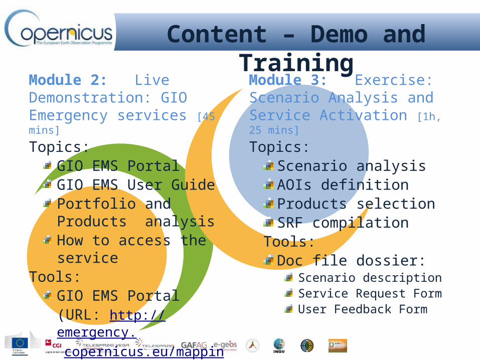
Module 2: Live Demonstration: GIO Emergency services [45 mins]Topics:
GIO EMS Portal GIO EMS User GuidePortfolio and Products analysisHow to access the service
Tools:GIO EMS Portal (URL: http://emergency.copernicus.eu/mapping/)Printed map packageGIO EMS USER GUIDE
Module 3: Exercise: Scenario Analysis and Service Activation [1h, 25 mins]
Topics:Scenario analysis AOIs definitionProducts selection SRF compilation
Tools:Doc file dossier:
Scenario descriptionService Request FormUser Feedback Form
Content – Demo and Training

Copernicus EMS Service OverviewRUSH Service
High level of urgencyActive 24/7
Mapping Validation
NON RUSH Service Low level of urgency
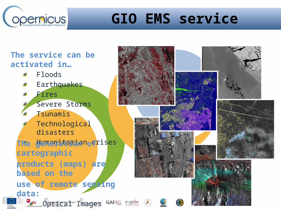
The service can be activated in…FloodsEarthquakesFiresSevere StormsTsunamisTechnological disastersHumanitarian crises
GIO EMS service
The generation of cartographic products (maps) are based on the use of remote sensing data:
Optical ImagesSAR images

GIO EMS RUSH mode
On-demand provision of geo-spatial information based on satellite data analysisActive H24 / 7D Focus on Emergency response phase Providing standardized Products
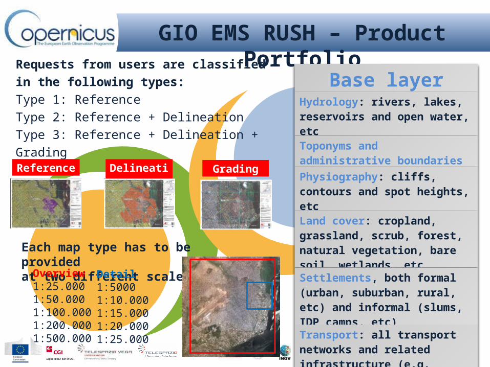
GIO EMS RUSH – Product Portfolio
Requests from users are classified in the following types:Type 1: ReferenceType 2: Reference + DelineationType 3: Reference + Delineation + Grading
Each map type has to be provided at two different scales:
Delineation Grading
Overview 1:25.0001:50.0001:100.0001:200.0001:500.000
Detail 1:50001:10.0001:15.0001:20.0001:25.000
Base layerHydrology: rivers, lakes, reservoirs and open water, etc
Toponyms and administrative boundaries
Physiography: cliffs, contours and spot heights, etc
Land cover: cropland, grassland, scrub, forest, natural vegetation, bare soil, wetlands, etc
Settlements, both formal (urban, suburban, rural, etc) and informal (slums, IDP camps, etc)
Transport: all transport networks and related infrastructure (e.g. roads, tracks, trails, railways, bridges, harbours, and airfields)
Industry and Utilities: industrial facilities and power stations
Reference

Reference Map
Pre-Event cartographic product showing:Basic topography information (roads, land cover, hydrological features and tailored information) for pre-disaster analysis e.g. potential gathering areas, potential helicopter landing areas

Delineation Map
Post-Event cartographic product showing:Information on affected area (i.e. flooded area) coupled with basic topography information as per Reference Map

Grading Map
Post-Event cartographic product highlighting: Effects of the event on the specific affected area and structures (i.e. level of damage, affected buildings/roads, etc.) combined with Reference & Disaster Extent Maps

The Authorized Users (AU) are the main beneficiaries of the GIO-EMS services
The ERCC is the operational coordinator of the GIO EMS
The DG JRC is the technical and administrative coordinator of GIO-EMS
The ESA GSC-DA is responsible for EO data provision
Service Provider
Involved Actors during an Activiation
The On Duty Operator (OdO) is responsible for taking charge of the activation from the trigger to the delivery and the management of the overall process of GIO-EMS RUSH service production
The Production Site (PS) takes charge of the EO data elaboration and the production of services required by the AU
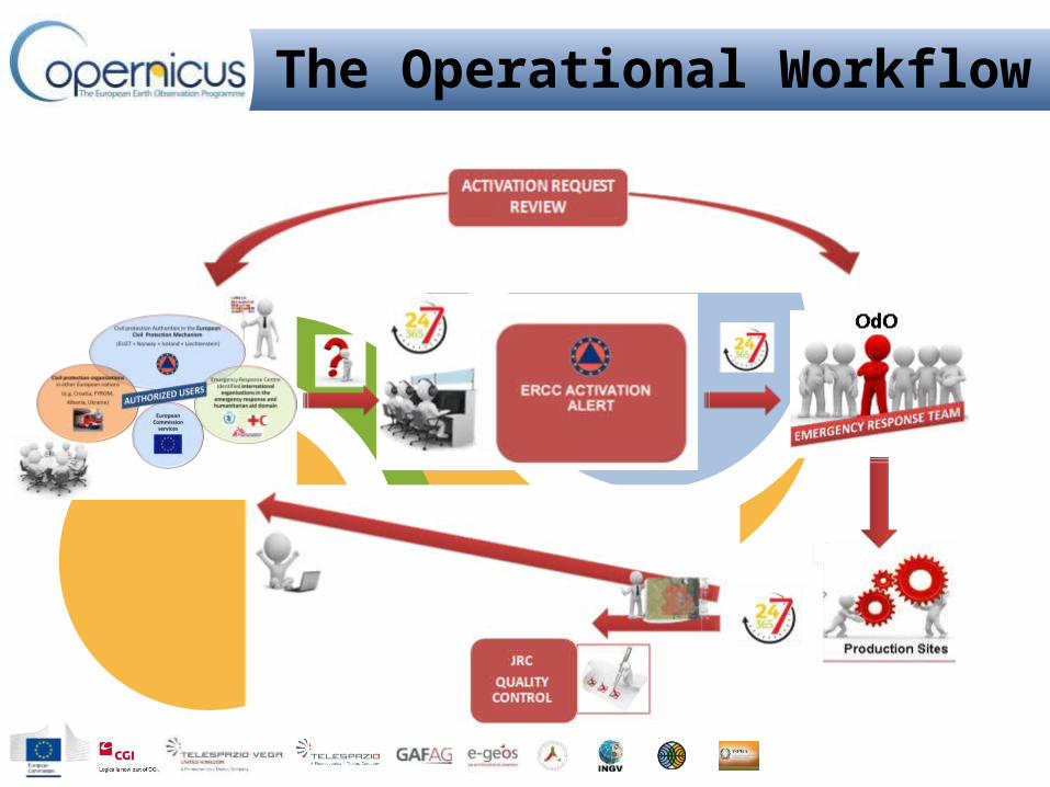
The Operational Workflow

1.
3.
4.
5.
Service Request
The AU selects products and fills the Service Request Form (SRF)
Service Request authorization
Authorized User
ECHO ERCC
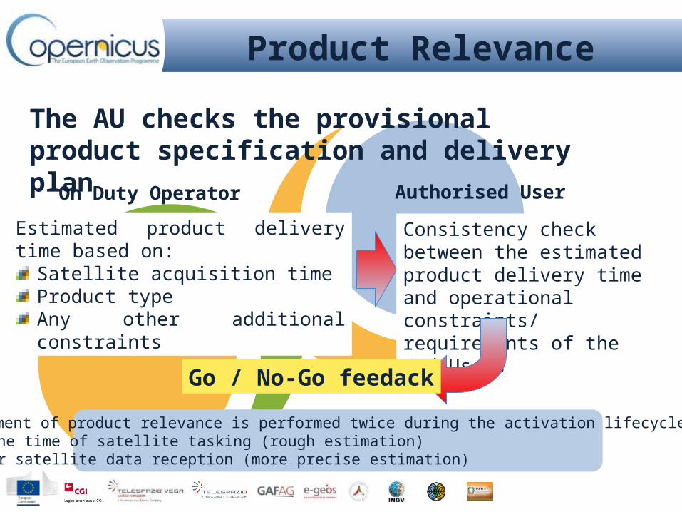
Product Relevance Authorized User
The User checks provisional product specification and delivery plan
Product Generation and Delivery Service Provider
Quality Check and feedback Authorized User EC JRC
2. Activation FeasibilitySatellite data tasking; provision of Satellite Resource Table
Service ProviderESA
Operational Workflow

AU’s trigger the service by compiling a Service Request Form
Editable pdf version to be sent as an e-mail attachment to ERC at: [email protected]
The SRF Compilation and delivery is followed up with a phone alert to ERC: +32 229 21112
Service Request Completion

Activation Feasibility
Check the event age to assess if it is still possible to extract meaningful information
Check the feasibility of using satellite imagery to map the event
Check the event extent in order to select the most appropriate image swath/resolution
Check the level of mapping detail requested vs the extent of the event area
Check the feasibility of the requested delivery time compared to the satellite systems ‘ acquisition capabilities
Product Relevance
The AU checks the provisional product specification and delivery plan
Estimated product delivery time based on:Satellite acquisition timeProduct typeAny other additional constraints
Consistency check between the estimated product delivery time and operational constraints/ requirements of the End Users
Go / No-Go feedack
On Duty Operator Authorised User
Assessment of product relevance is performed twice during the activation lifecycle:1. At the time of satellite tasking (rough estimation)2. After satellite data reception (more precise estimation)

Product Generation and Delivery
GIO-EMS mapping delivers by default, information as feature data setsProduct dissemination foresees complete set of defined deliverables (including printable maps)The Service Provider delivers products:
Via JRC SFTP site Via GIO EMS Portal
(not-yet-quality-reviewed)AU is alerted after upload with access details JRC performs an offline quality review and independent “evaluation” of delivered products
Reference
Delineation
Grading

Event date
Triggering by authorized users
Satellite programming
Image acquisition
Map production
Products Delivery to AU/ASCUT0
EARLY WARNING SYSTEMS
Courtesy of JRC
How the Service Works: A Typical Timeline
T1 = T0 + 1 day
T2 = T0 + T1 + 1/2 days
T3 = T0 +T2 + 3/8 hours
Factors affecting service timeliness:User triggering delaySatellite image availability latencyWeather conditions, when optical images are needed

Timeline of RUSH activations
The duration of an activation is mostly defined by the time needed for EO data tasking and acquisition
Average values observed for each main phase of an activation through the whole service provision
First Available Map:- 3hrs (flood, fire, special request)- 8hrs (all other cases)
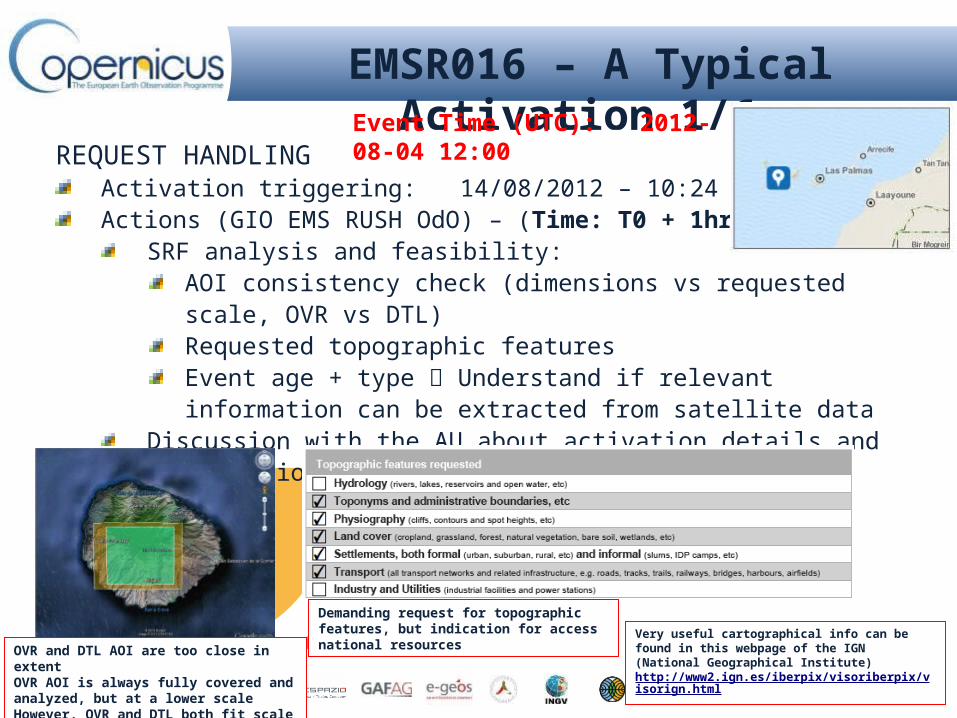
EMSR016 – A Typical Activation 1/6
REQUEST HANDLINGActivation triggering: 14/08/2012 – 10:24 CET (T0)Actions (GIO EMS RUSH OdO) – (Time: T0 + 1hr):
SRF analysis and feasibility: AOI consistency check (dimensions vs requested scale, OVR vs DTL)Requested topographic featuresEvent age + type Understand if relevant information can be extracted from satellite data
Discussion with the AU about activation details and modifications (if any)
OVR and DTL AOI are too close in extentOVR AOI is always fully covered and analyzed, but at a lower scaleHowever, OVR and DTL both fit scale limits.
Demanding request for topographic features, but indication for access national resources Very useful cartographical info can be found in this webpage
of the IGN (National Geographical Institute) http://www2.ign.es/iberpix/visoriberpix/visorign.html
Event Time (UTC): 2012-08-04 12:00

EMSR016 – A Typical Activation 2/6
SATELLITE TASKING AND ACQUISITION
Actions (OdO + ESA) – (Time: T0 + 2hrs T0 + 36 hrs)
Satellite tasking forms submission (OdO ESA) – T0+ 2hrs
Satellite tasking plan proposal (ESA OdO) – T0+ 10hrs
Archive imagery DEIMOS
New acq. imagery WorldView-2
Satellite tasking plan confirmation (OdO ESA) – T0 + 10hrs
Satellite new acquisition / Archive delivery:
DEIMOS: 09-13/08/2012 (from archive)
WorldView-2: 15/08/2012 12:11 UTC
Actions (OdO + AU) - Orthoimages from Spanish PNOA
Satellite data plan, containing information about planned satellite acquisitions and updated according to delivered satellite images.

EMSR016 – A Typical Activation 3/6
SATELLITE RECEPTION AND VALIDATION
ARCHIVE
Actions (GCM + OdO + PS) – (Time: T0 + 9hrs T0 + 11 hrs)
Satellite data delivery (GCM OdO/PS) – T0 + 9hrs
Satellite data download (PS) – T0 + 10hrs
Satellite data quality validation (PS) – T0 + 11hrs
POST EVENT
Actions (GCM + OdO + PS) – (Time: T0 + 36hrs T0 + 49 hrs)
Satellite data delivery (GCM OdO/PS) – T0 + 47hrs
Satellite data download (PS) – T0 + 48hrs
Satellite data quality validation (PS) – T0 + 49hrs

EMSR016 – A Typical Activation 4/6
MAP PRODUCTION AND DELIVERYREFERENCE MAP
Actions (PS) – (Time: T0 + 8hrs T0 + 20 hrs)Archive reference image geometric correctionRequested topographic feature extractionMap layout compilationQC
DELINEATION / GRADING MAPActions (PS) – (Time: T0 + 49hrs T0 + 58 hrs)
Post event image geometric correction (respect to reference)Damage assessment information extractionMap layout compilationQC

EMSR016 – A Typical Activation 5/6 La Gomera – Reference Map Overview

EMSR016 – A Typical Activation 6/6 La Gomera – Delineation Map Overview

GIO RUSH Activations
2012 2013
April May June July Aug Sept Oct Nov dec Jan Feb March April May June July Aug Sept Oct Nov DEC
No. activations 1 3 2 6 5 1 0 3 0 4 2 3 10 2 6 2 0 0 2
No. Maps 21 53 10 60 43 10 0 33 0 32 7 16 67 16 148 14 0 0 26
TOT. ACTIVATIONS (April 2012 – Oct 2013) 51
Event type
FLOOD 37%
FIRE 18%
EARTHQUAKE 4%
INDUSTRIAL 4%
OTHER 37%
TRIGGERING ENTITIES
MS Civil 69%MIC 27%JRC 4%

COUNTRIES (EC)
NUMBER OF ACTIVATIONS EVENT TYPE TRIGGERING
ENTITIES
Poland 1 EURO-2012 MS Civil
Hunagry 2 Fire, Flood MS Civil
Italy 5 Earthquake, Fire, Landslide, Flood
MS Civil
Bulgaria 2 Earthquake, Industrial accident
MS Civil
Spain 4 Fire, Flood MS CivilSweden 1 Flood MS Civil
Portugal 2 Fire MS Civil
Romania 1 Fire MS Civil
Slovenia 2 Flood MS Civil
United Kingdom 2 Flood, Fire MS Civil
Croatia 1 Flood MS Civil
Netherland 1 Coronation MS Civil
Germany 2 Flood MS Civil
Czech Republic 1 Flood MS Civil
France 1 Flood MS Civil
COUNTRIES (NOT EC)
NUMBER OF ACTIVATIONS EVENT TYPE
TRIGGERING ENTITIES
Myanmar 2 Refugees camp MIC
Jordan 6 Refugees campMS Civil (5), MIC
(1)
Congo 1 Refugees camp MIC
Turkey 1 Refugees camp MIC
Lebanon 1 Refugees camp MIC
Syria 3 Refugees campMS Civil, MIC,
JRC
Philippines 1 Flood
Niger 1 Flood MIC
Cameroon 1 Flood JRC
Madagascar 1 Industrial accidentMIC
India 2 River bed detection, Flood
MS Civil, MIC
Bangladesh 1 Tropical Cyclone MIC
Mozambique 1 Flood MIC
Cambodia 1 Flood MIC
GIO RUSH ActivationsInside Europe Outside Europe

The GIO EMS TEAM on duty operatorMail: [email protected] WEB: http://emergency.copernicus.eu/mapping Phone: +39 06 4069 4500
The ECHO duty officersMail: [email protected] Phone: +32 229 21112
The Geospatial Emergency Management TEAMMail: [email protected]
After the activation receipt and authorization from MIC
Operational Functional Contacts

GIO EMS Non-RUSH mode
On-demand provision of geo-spatial information based on satellite data analysisResponding to similar event types as RUSH mode but in a different time frame:
Focus on preparedness and post-response phase (non-critical time and delivery requirements)
Tailored products designed to satisfy various specific user needs

The Operational Workflow
EMSN TENDER

Service Timeline Parameters
Service availability for requests: 10 hours / 5 working days (RUSH: 24 hours / 7
days) Tender for contractCompetition between 3 Qualified consortia of Service Providers
Based on best financial and technical offer criteriaService delivery time: normally 30 calendar days (from service contract)Quality Check by JRC
Target delivery time: 8 weeks (RUSH: hours to days, 3h, 24h)

Service Providers
Involved Actors
Service Providers (SPs)Bid in tendersEO data elaboration and productionMap delivery to JRC for Quality Check Updating maps in case of JRC request
The Authorized Users (AU) are the main beneficiaries of the GIO-EMS services
The ERCC is the operational coordinator of the GIO EMS
The DG JRC is the technical and administrative coordinator of GIO-EMS – Responsible of Tender calls for mapping activations
The ESA GSC-DAP is responsible for EO data provision

Technical Specification:Overview maps
Scale 1:25.000 – 1:500.000Area approx. 200 – 100.000 km2
Detail mapsScale 1:5.000 – 1:25.000Area approx. 10 – 200 km2
Product types:Reference Maps
Pre-disaster Situation Maps
Post-disaster Situation Maps
Reference Maps
Service Portfolio
Reference
Pre-Disaster
Reference Post-Disaster

REQUESTED MAPS: OVERVIEW at the 1:25k scale DETAILED over the 2 AOIs at the 1:15k scale
EMSN-001: a Non-RUSH Activation 1/5USER: Greek Emergency Planning and Response Service, Ministry of Citizen Protection/General Secretariat for Civil ProtectionOBJECTIVES: Determination of the impact of a wild forest fire that occurred in the island of Chios (Greece)
DISASTER EVENT: Large fire occurred on August 18th, 2012Severity: Fire burned large areas of high forest and shrub landHeavy environmental and economical damages: unique specie of Pistacia lentiscus var. Chia, cultivated for centuries, providing strong contribution to island’s economy, were mostly
burnt
Reference mapsDelineation/Grading maps Land cover/land use maps with identification of the Pistacia lentiscus var. Chia

Examples of Pistacia Lentiscus cultivation to be identified and classified in the Land-Use maps
Pistacia Lentiscus
Land Use was required CORINE Level3 for Overview maps and Level4 for Detailed Maps.In addition, the delineation of the areas where Pistacia lentiscus var. Chia is cultivated was included as a separate class.
The specific class, Pistacia Lentiscus, identification was performed with support of Ortophotoes
EMSN-001: a Non-RUSH Activation 2/5
Tailored Land Cover

28th Aug EMSN-001 service was triggered 26th Oct EMSN-001 activation starts
5th Dec Overview maps were provided to JRC
13th Dec Detailed maps were provided to JRC
20th Nov The 2 AOIs for detailed Maps were provided by JRC to Provider
11th Jan 2012 the activation was closed
19th Dec After their quality check, JRC sent some updating requirements to the Provider that were implemented
04th Jan 2012 All the EMSN-001 Maps, Overview and Detailed, were provide to JRC and from JRC to the end User, as a final delivery
30th Oct – 06th Nov Availability of EO data (PRE and POST disaster)
EMSN-001: a Non-RUSH Activation 5/5Activation timeliness

EMSN-001: a Non-RUSH Activation 3/5Reference MapDelineation and Grading map with burnt area grading in subcategories : “completely burnt” “partially burnt” “not burnt”Land Use Maps Overview Map Examples
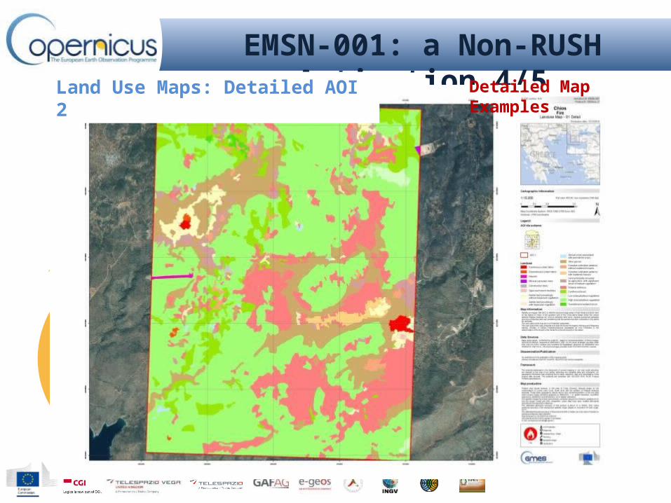
EMSN-001: a Non-RUSH Activation 4/5Reference Maps: Detailed AOI 2 Delineation and Grading Maps: Detailed AOI 2Land Use Maps: Detailed AOI 2 Detailed Map Examples
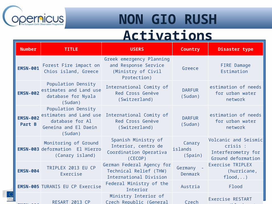
NON GIO RUSH Activations
Number TITLE USERS Country Disaster type
EMSN-001 Forest Fire impact on Chios island, Greece
Greek emergency Planning and Response Service (Ministry of Civil
Protection)Greece FIRE Damage Estimation
EMSN-002Population Density estimates
and Land use database for Nyala (Sudan)
International Comity of Red Cross Genève (Switzerland) DARFUR (Sudan) estimation of needs for
urban water network
EMSN-002Part B
Population Density estimates and Land use database for Al Geneina and El Daein (Sudan)
International Comity of Red Cross Genève (Switzerland) DARFUR (Sudan) estimation of needs for
urban water network
EMSN-003Monitoring of Ground
deformation El Hierro (Canary island)
Spanish Ministry of Interior, centro de Coordination Operativa (CECOP)
Canary islands (Spain)
Volcanic and Seismic crisis : Interferometry for Ground
deformation
EMSN-004 TRIPLEX 2013 EU CP Exercise German Federal Agency for Technical Relief (THW) International Division
Germany - Denmark
Exercise TRIPLEX (hurricane, flood,..)
EMSN-005 TURANIS EU CP Exercise Federal Ministry of the Interior Austria Flood
EMSN-006 RESART 2013 CP ExerciseMinistry Interior of Czech Republic (General Directorate of the Fire
Rescue Service) Czech Republic Exercise RESTART
(black-out, windstorm)
EMSN-008 TWIST 2013 EU CP Exercise Italian Presidency of the Council of Ministries, DPC Italy Exercise TWIST
(Landslide and tsunami)
EMSN-010Forest fire damage assessment
Planning and Recovery Serra de Caramulo
ANPC - Autoridade Nacional de Proteccao Civil Portugal Fires - damage estimation of
series of 8 fires

The ECHO duty officersMail: [email protected]: +32 229 21112
The Geospatial Emergency Management TEAMMail: [email protected]
Operational Functional Contacts

GIO EMS RUSH Portal
The portal hosts the catalogue of map outputs and web services : http://emergency.copernicus.eu
Catalogue for dissemination of Quality reviewed outputs;Platform to test alternative access to data, e.g. via WMS, WFS.

Thanks for your attention!

Overview of the portal and its generalities [15 mins]Access to GIO EMS Portal (URL:http://emergency.copernicus.eu/mapping/)
Use of PortalActivision Catalogue and Products download
PRESENTATION of GIO EMS USER GUIDE [10 mins]Including SRF and UFF
PRESENTATION of Service Portfolio and Products characteristics [20 mins]Printed maps package will be distributed through the audiencesDigital maps full resolution will be used to present details of Service products
Product portfolio descriptionMaps: Identification of Products needs and technical characteristics
Module 2: Live Demo of the GIO EMS

Triggering the GIO EMS ServiceScenario Analysis and activation Exercise [1 hour 25 mins]
All the attendees will be provided with printed copy of:Disaster Scenario descriptionService Request FormUser feedback Form
The exercise with the attendees will go through the following steps:Scenario Analysis – Need identificationAOI selection – Area for Overview and Detailed maps identificationProduct selection and technical specification identificationAccess to the service – SRF compilation Service Triggering User Feed back – UFF compilation
Module 3: Scenario Exercise

GIO EMS RUSH Portal
The portal hosts the catalogue of map outputs and web services : http://emergency.copernicus.eu
Catalogue for dissemination of Quality reviewed outputs;Platform to test alternative access to data, e.g. via WMS, WFS.

Authorized Users