using remote sensing and gis techniques for
TRANSCRIPT
Faculty of Science Bulletin, 26 (2014) 21-33 © 2014 Sana’a University ISSN 1684-100X
21
USING REMOTE SENSING AND GIS TECHNIQUES FOR
DETECTING LAND COVER CHANGES OF MANGROVE
HABITATS IN GOA, INDIA
Hisham. M. Nagi1*
, Rouchelle S. Rodrigues2,
Mani Murali R.2 and Tanaji G. Jagtap
2
(1) Department of Earth Sciences and Environment, Faculty of Science, Sana’a
University. (2) National Institute of Oceanography, Dona Paula, Goa 403 004, India. * Corresponding Author: [email protected]
Received: 10 October 2013
ABSTRACT
Ecologically Sensitive Marine Habitats (ESMH), including mangroves ecosystems, is of
immense ecological and socioeconomic values. Goa, a tourist destination, has limited cover of
such habitats and has been intensively subjected to anthropogenic pressures during the past decade. Time lapse (1997, 2001 and 2006) satellite data (IRS-1C LISS III, IRS-1D LISS III and
IRS-P6 LISS III) indicated alterations in land use patterns. The present study showed that
mangrove habitats in Goa have increased by 22 % in area between 1997 and 2006. The increase in mangrove cover could be attributed to rehabilitation as well as invasion by mangroves of
agricultural farms, inundated due to breach of embankments. Present findings may be of a great
help in understanding the changes in ESMH and for formulating effective strategies for their conservation and rehabilitation.
Key words: Remote sensing, Mangrove, land use pattern, change detection, conservation and rehabilitation.
INTRODUCTION
Coastal areas around the world are currently experiencing the impact of human activities
dealing with economic, land use, and resource development. India in particular is facing
increasing stress as a result of cumulative environmental changes driven by urbanization,
industrialization, unsustainable growth, and ever increasing population leading to
degradation of coastal zones and ecosystems (Jagtap et al., 2003).
The land cover change is a complex environmental indicator from regional to
global level, and an important aspect of resource management and environmental
mitigation. Therefore, any unplanned interference can prove detrimental to its inherent
value. Trends in vegetation cover dynamics, is an important aspect as it provides
information about landscape processes and ecological status. Remote Sensing data having
good spectral and spatial resolution are found to be very effective in evaluating and
monitoring land use and land cover changes (Lillesand et al., 2004). Beach and estuarine
habitats are vulnerable to alteration due to constant human interferences of various natures.
USING REMOTE SENSING AND GIS TECHNIQUES FOR…… H. NAGI, et al.
22
Classifying the marine habitats would be of help in formulating effective management
strategies and environmental policies, which is useful in mitigating the impacts of natural
hazards.
Preparing and upgrading vegetation inventories for certain regions, in different
times, used for detecting the vegetation changes in those regions. This is more easily
obtainable using satellite imageries and thematic mapper techniques. However, ground
truth data collection, literature reviews, visual map interpretation, and collateral and
ancillary data are most significant in confirmation and substantiate the satellite data
interpretation and production of final maps.
The mangrove cover in Goa is estimated to be about 0.3 to 0.5% (≈ 2,000
hectares) of the total mangrove cover of India (Untawale et al., 1982; Jagtap & Nagle,
2007). Mangroves in Goa are mostly fringing type and occur densely along all the
estuarine banks. Major formations occur along Mandovi-Zuari-Cumbarjua estuarine
complex, which is approximately 80% of the total mangrove cover in Goa (Jagtap, 1985).
Marine vegetation, particularly mangrove, plays a significant role in stabilizing the shores
by preventing soil erosion. They serve as breeding grounds for various types of fauna, and
also increase the productivity of the region and near shore waters. During recent years, Goa
has been undergoing tremendous changes in its land use patterns (Murali et al., 2006). The
present investigations were aimed at understanding the changes in mangrove habitats of
Goa during the past decade. The data generated would be of importance in protecting and
conserving mangrove habitats, which are limited in the state.
METHODOLOGY
Satellite imageries of January/ February months of the years 1997, 2001 and 2006 were
selected for the study, based on less cloud cover, bright sunlight, luxuriant growth of
vegetation and favorable sea conditions.
Time lapsed False Color Composites (FCC) imageries of IRS-1C LISS III, IRS-
1D LISS III and IRS-P6 LISS III with resolution of 23.5 m, obtained from the National
Remote Sensing Agency (NRSA), Hyderabad (Figure 1). Survey of India topographical
sheets pertaining to Goa (48E/9, 48E/10, 48E/13, 48E/14, 48E/15, 48E/16, 48I/1, 48I/2,
48I/3, 48I/4 and 48J/1) in the scale of 1:50,000 scale for the years 1962-1979 were used as
ancillary data for extracting terrain features and also for registering and geocoding the
satellite imageries.
Imageries were resampled using the nearest neighborhood method. The projection
applied in this study was geographic with spheroid Everest. The geo-referenced satellite
imageries were then subjected to digital image processing techniques for enhancement,
which involved brightness/contrast technique. Various land cover classes were identified
and delineated recognizing spectral pattern (Chandra & Gosh, 2006). A supervised
classification process was followed selecting homogeneous training areas for different
features of interest. The training data sets were evaluated for separability to determine the
distinctiveness of the class signatures.
Supervised classification performed using maximum likelihood classifier and
resultant thematic maps were utilized for accuracy assessment. It is essential to incorporate
the other related ground information on the manually interpreted map (Ramachandran et
al., 1998); therefore, the relevant ground truth information was collected from different
locations using GPS.

Faculty of Science Bulletin, 26 (2014) 21-33
23
Figure 1: Time lapsed satellite data used in the study.
Different layers of mangrove location maps, and calculation of mangrove areas in each
location in the three years were performed using GIS techniques, and results were
expressed in hectares (ha).
RESULTS
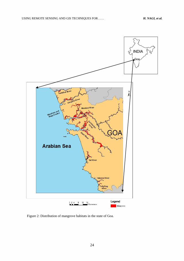
Mangrove habitats are mainly confined to the intertidal region along banks of the nine
major rivers and minor creeks of Goa (Figure 2). The distribution and area changes in
major formations have been described in the following text.
Terekhol River
The Terekhol River represents the border between Goa and the State of Maharashtra in the
north. It is about 26 km in length, and covers approximately 349 ha of water area. During
1997, mangrove cover was estimated to be 27.2 ha. It increased by 12.82% (30.7 ha) along
the river banks and islands from the year 1997 to 2001. However, it slightly decreased
(1.96%) to 30.1 ha during 2006. The overall increase of 2.89 ha in the mangrove cover was
observed from 1997 to 2006 with an increase of 10.60%.
Chapora River
Chapora River runs about 30 km in length, covering ~ 711 ha of water area. The present
investigation revealed reduction in mangrove area from 220.1 ha in the year 1997 to 219.3
ha in 2001, with a slight loss of 0.36% of its area. It was further decreased to an area of
218.5 ha in the year 2006 to add 0.38% of its loss. Thus, the total loss in mangrove area
between 1997 and 2006 was estimated to be 0.74%.
11th
Feb. 1997
IRS-1C LISS III
5th
Feb. 2001
IRS-1D LISS III
19th
Jan. 2006
IRS-P6 LISS III
USING REMOTE SENSING AND GIS TECHNIQUES FOR…… H. NAGI, et al.
24
Figure 2: Distribution of mangrove habitats in the state of Goa.

Faculty of Science Bulletin, 26 (2014) 21-33
25
Mandrem and Baga Creeks
Mandrem and Baga represent relatively very small creeks 3.3 km and 5.4 km in length,
respectively. Mangroves of Mandrem creek showed a slight increase (0.01 ha) in area cover
from in 1997 (1.18 ha) to 2001 (1.19 ha) and further increased up to 1.20 ha in 2006. The
overall increase was 0.02 ha.
The satellite imageries showed steep decrease from 6.6 ha in the year 1997 to 5.0
ha in 2001 with a loss of 1.63 ha (24.58%) of its area. However, it was further reduced to
4.48 ha in 2006 with an overall loss of 32.36% during 1997 to 2006.
Mandovi River
Mandovi River forms one of the major rivers in Goa. It covers about 5564 ha of water area
along its 58 km length. Satellite data showed mangrove cover of about 811.1 ha in 1997,
which increased by 244.57 ha (30.15%) to cover an area of approximately 1055.7 ha during
2001, and continued to increase further between 2001 and 2006 by 51.47 ha (4.88%). The
2006 mangrove was estimated to an area of about 1107.2 ha. Overall increase in mangrove
cover from 1997 to 2006 was found to be approximately 296.1 ha (36.50 %) from 1997 to
2006.
Zuari River
Zuari River occupies approximately 5790 ha of water body, along about 145 km stretch of
which 64 km is navigable. Mangrove vegetation cover decreased by 2.54% from about
693.9 ha in the year 1997 to around 676.3 ha in 2001. However, it showed increase of
8.71% accounting to 735.2 ha in the year 2006, with overall addition of about 41.3 ha
(5.95%) from 1997.
Cumbarjua Canal
Cumbarjua Canal is an interconnection between Mandovi and Zuari Rivers, which form
what so called “Mandovi-Zuari-Cumbarjua estuarine complex”. Cumbarjua Canal is about
15 km in length and 30 - 40 m in width. It covers about 375 ha of water area. The area of
mangrove shows increase by 8.88% from the year 1997 (~ 224.3 ha) to the year 2001
(244.2 ha). The area continued to increase extensively by 40.23% to reach an area cover of
342.4 ha in the year 2006, with overall increase of 52.68% (118.15 ha).
Sal River
Sal River, in southern Goa, has an area of about 302 ha of water body, and it is about 16.13
km in length. The mangrove area decreased from 57.6 ha in the year 1997 to 54.9 ha in the
year 2001. The area then increased by 20.78% to 66.3 ha. The results show overall increase
by 15.04% (8.67 ha) between the years 1997 and 2006.
Talpona River
Talpona River covers about 40 ha of water body, and It has a length of 9 km. Mangrove
cover did not show much difference in the time lapsed imageries. The area in 1997 was
14.6 ha; it changed slightly to about 14.7 ha in the year 2001 and then decreased to about
14.6 ha in 2006.
Galgibag River
Galgibag River covers about 26 ha of water area, with a length of 3.77 km. the mangrove
vegetation showed a decrease between the year 1997 and 2006. The satellite imageries
show an area of about 26.7 ha in the year 1997 which decreased to 22.9 ha in the year 2001.
The area decreased further to 18.8 ha in the year 2006. The overall loss in mangrove
vegetation between the years 1997 and 2006 was 29.44% (7.86 ha).

USING REMOTE SENSING AND GIS TECHNIQUES FOR…… H. NAGI, et al.
26
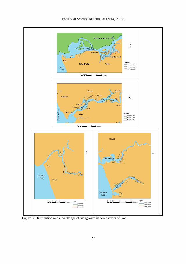
Table 1 summarizes the details of mangrove area change in Goa’s rivers. Figure 3
illustrates area change of mangroves in some rivers of Goa.
Table 1: Details of mangrove area change in Goa’s rivers.
Year 1997 2001 2006
River Area (ha) Area (ha) Area (ha)
Terekhol 27.22 30.70 30.10
Chapora 220.08 219.28 218.46
Mandrem 1.18 2.20 1.20
Baga 6.63 5.00 4.48
Mandovi 811.12 1055.69 1107.17
Cumbarjoa 224.27 244.18 342.42
Zuari 693.94 676.29 735.22
Sal 57.63 54.89 66.30
Talpona 14.58 11.69 14.60
Galgibag 26.71 22.90 18.85
Total 2083.35 2322.73 2538.79
DISCUSSION The State of Goa, along the Central West coast of India, lies between 14º55' to 15º45' N,
and 74º40' to 74º10' E, with a coastline of 105 Km long. Physiographically, it is divided
into the coastal tract consisting of recent broad alluvial plains, estuaries, cliffs, river
mouths, beaches and dunes, the tract between the coast and the Ghats (sub-ghats region)
and the Western Ghats (Wagle, 1982). The coast trends NNW – SSE more or less in a
straight line. The coastal zone of Goa is traversed by seven major dynamic estuarine rivers
and four minor river systems where the tidal effect can be felt up to above 50 Km in the
hinterland (Shetye et al., 2007).
The climate of Goa is warm and humid and distinguished by three
seasons, pre-monsoon (February to May), the southwest monsoon (June to September) and,
the post-monsoon (October to January). The region receives an average rainfall of
approximately 3000 mm/yr. The coast is micro tidal (tidal height <2m) in nature (Ahmed,
1972) and tidal currents always remain stronger than estuarine flow.
Faculty of Science Bulletin, 26 (2014) 21-33
27
Figure 3: Distribution and area change of mangroves in some rivers of Goa.

USING REMOTE SENSING AND GIS TECHNIQUES FOR…… H. NAGI, et al.
28
Marine wetlands support highly productive and dynamic ecosystems, such as mangroves,
coral reefs, seagrasses and sand dunes. Mangroves habitats harbour characteristic flora and
fauna of marine as well as terrestrial origin, and also include endangered and endemic
species (Clark, 1998). They play a vital ecological role by dissipating energies from waves
as well as speedy run from terrestrial water, thus protecting shorelines from various natural
coastal hazards (Kathiresan & Qasim, 2005). However, during recent years these important
habitats have been subjected to tremendous pressures from increased anthropogenic
activities, particularly land conversion, grazing and habitat fragmentation. The mangroves
habitats along the west coast of India are generally fringing in nature because of narrow
coastal belts resulting from stiff topography (Wagle, 1982). The state of Goa, being a
tourist destination, is heavily pressurized from economical activities, leading to
deterioration of these habitats.
Different land cover categories give various types of reflections and produce
peculiar spectral signatures of individual form. The desired information could be achieved
from satellite imageries in an efficient and effective manner by using several basic
interpretation keys. Mangrove vegetation gives bright red (if dense) or pale red (if sparse)
or orange color tune; they are irregular in shape with a smooth texture on satellite data, and
hence can be easily interpreted. Their location are in the intertidal areas associated with
estuaries, creeks and low lying flats, which are subjected to weak waves and currents
(Anon, 1992).
During recent past, the mangrove cover from Goa was estimated to be
approximately 2,000 ha (Untawale et al., 1982; Jagtap, 1985 and Jagtap et al., 2003). The
major mangrove formations (~ 80%) exist along the Mandovi-Zuari-Cumbarjua estuarine
complex (Jagtap, 1985). Present observations revealed a total increase of approximately
455.4 ha in mangrove areas of Goa from 2083.35 ha in the year 1997 to 2538.79 ha in 2006
(~ 22 %). Mangrove habitats showed increase in some of the rivers, whereas it showed
decrease in others (Figure 4). Mangrove cover has been predominantly increased along
Chapora, Mandovi, Cumbarjua and Sal Rivers (Table 1), adding over 538 ha since last
three decades; comparing with data of 1973 (Jagtap, 1985).
National Mangrove Committee (NATCOM) was established during 1989 by
Ministry of Environment and Forest (MoEF). The major role of NATCOM was to promote
protection, conservation, rehabilitation and sustainable management of mangroves.
Individual coastal states in the country followed action plans in safeguarding these
ecologically sensitive habitats since then. The increase in mangrove areas from the study
region may be attributed to conservation and reforestation efforts by the state government.
Chorao Island in the Mandovi Estuary was declared as a bird sanctuary in 1987
encompassing more than 187 ha. The State Social Forestry Division has proposed to
develop approximately 50 ha of mangrove plantation per year, as follow-up of the National
Mangrove Plan for the sustainable management of mangrove resources (Jagtap et al.,
2003). The mangrove flora is represented by 15 species (Jagtap, 1993), dominated by
Rhizophora mucronata Lamk., Avicennia alba (Blume) Bathkh, A. officinalis L. ,
Sonneretia alba J. Sm. and S. caseolaris (L.) Engler. This sanctuary has been witnessing a
steady increase in mangrove cover during the past decade, until it reached approximately
242 ha during the year 2006, and contributed about 22.9% of the total area cover of
mangrove in the Mandovi estuary.

Faculty of Science Bulletin, 26 (2014) 21-33
29
Changes in Mangroves in Goa's Rivers
27.2
2
220.0
8
1.1
8
6.6
3
811.1
2
224.2
7
693.9
4
57.6
3
14.5
8
26.7
1
30.7
0
219.2
8
1.1
9
5.0
0
1055.6
9
244.1
8
676.2
9
54.8
9
14.6
9
22.9
0
30.1
0
218.4
6
1.2
0
4.4
8
1107.1
7
342.4
2
735.2
2
66.3
0
14.6
0
18.8
5
0
200
400
600
800
1000
1200
Terek
hol
Chap
ora
Man
drem
Bag
a
Man
dovi
Cum
barjoa
Zuari
Sal
Talpo
na
Galjib
ag
Rivers and Creeks
Are
a (
Hecta
rs)
1997
2001
2006
Figure 4: Changes in mangroves areas in the rivers of Goa.
The intertidal expanse of muddy substratum in the some undisturbed areas such as
Cumbarjua Canal and river islands, along with feeble wave action and currents, forms
suitable features for establishment of mangrove seedlings to grow undisturbed and the
habitat to develop further (Figure 5a). The present study showed an increase of
approximately 52.7% in the mangrove habitat. The increase in mangrove cover in the
Mandovi estuary could also be attributed to the reduction in agricultural area adjacent to
mangroves due to abandonment of farming activities. Old bonds have been broken and
agriculture areas have been infested by mangroves.
Although ground truth data indicated new formations and rehabilitation by
mangrove plantations, loss of mangrove habitats have been also observed in certain
localities. Recently, mangrove habitats have been subjected to tremendous pressures from
increased anthropogenic activities, particularly land conversion, grazing and habitat
fragmentation. The state of Goa, being a tourist destination, is heavily pressurized from
economical activities, leading to deterioration of these habitats. The most degraded habitats
exist along the Baga creek in North Goa, which is major tourist hub. Baga and Mandrem
creeks have been subjected to massive destruction of sensitive habitat due to construction
activities relevant to tourism industries, that have been taken place in the area (Nairy et al.,
2003), These anthropogenic activities strict mangroves from developing and expanding
their areas (Figure 5b). Moreover, tourism-based urbanization, reclamation of mangrove
areas for agriculture, mushrooming of saltpans and aquaculture farms in the mangrove
areas (Figure 5c), illegal felling for firewood, construction of roads and railway tracks,
mining activities, construction of buildings and utilization as dumping sites for garbage and
construction waste (Figure 5b), have caused considerable damage to mangrove habitats in
particular locations.

USING REMOTE SENSING AND GIS TECHNIQUES FOR…… H. NAGI, et al.
30
Figure 5: (a) Mangrove nursery, as a conservation and management measure; (b) Mangroves area
used as dumping grounds and road construction; (c) Salt pans adjacent to mangrove area. (d) Mining
activities, showing iron ore transportation in estuarine areas.
Intensive mining practices during last four decades have resulted in deteriorating terrestrial
and marine ecosystems. The increase in open mudflats (Figure 5d) from the low lying
regions influenced by estuaries and backwaters could also be attributed to the intensive
contribution of sediments derived from mining and deforestation. In addition to this, heavy
rainfall (~ 3000 mm/yr) and steep topography has also lead to severe erosion of topsoil and
mining rejects, resulting in shallowing of low-lying wetlands. However, over the period the
stabilized mudflat with pioneer vegetation of various algae, Halophila beccarii (Aschers)
and Porteresia coaratata (Roxb) Tateoka favours the new formations of mangroves, which
helps land building at climax stage during succession (Jagtap, 1985; Untawale & Jagtap,
1999). Ground truth observations revealed that new mangrove formations have been
established on recent mudflats between the existing mangroves and open mudflats along
the waterways.

Faculty of Science Bulletin, 26 (2014) 21-33
31
Mangroves have shown steady increase in their areas during past three decades,
indicating improvement and healthy situation. Increase in local and migratory human
population and their demands, for urbanization and infrastructure, is constantly pressurizing
low laying areas, particularly marine wetlands. Considering ecological and socio-economic
significance of mangrove, the limited distribution and issue of global warming and sea
level rise, a top priority of the state should be conserving ecological sensitive marine
habitats (ESMH). Strict implementation of Coastal Regulatory Zone (CRZ) Act and
judicious development within the carrying capacity of the state would greatly help in
saving loss of natural habitats.
The present study would be of help to contribute towards effective and sustainable
management of ESMH, particularly mangroves. Data generated on the distribution of these
mangroves will help in decision-making and ecosystem restoration, which is of prime
importance for ecosystem functioning and sustainability.
ACKNOWLEDGEMENT
The authors are grateful to Director, NIO, Goa, for providing necessary facilities
to carry out this work. Thanks are also due to Dr. P. Vethamony for providing the satellite
data and Dr. A. Suryanarayana for supporting us with the softwares used.
REFERENCES
Ahmad, E. 1972. Coastal Geomorphology of India; Orient Longman Ltd., Bombay; 222 pp.
Anonymous. 1992. Coastal Environmental; Scientific Note; RSAM/SAC/COM/SN/11/92;
Space Application Centre (ISRO); Ahmedabad; 114 pp.
Chandra, A. M. and Gosh, S. K. 2006. Remote Sensing and Geographical Information
System; Narosa Publishing House Ltd., New Delhi; 298 pp.
Clark, J. R. 1998. Coastal Seas – The Conservation Challenge; Blackwell Science Ltd.,
London; 134 pp.
Jagtap, T. G. and Nagle, V. L. 2007. Response and Adaptability of Mangrove Habitats
from the Indian Subcontinent to Changing Climate; Ambio; 36(4): 328-334.
Jagtap, T. G.; Desai, K. and Rodrigues, R. 2003. Coastal Vegetation: Patterns in a Tourism
Region; [In: Coastal Tourism, Environment and Sustainable Local Development;
(Eds.) Noronha, L. et al.]; TERI, New Delhi; pp. 121-150.
Jagtap, T. G. 1985. Ecological Studies in Relation to the Mangrove Environment along the
Goa Coast, India; a Ph. D. Thesis Submitted to Shivaji University, Kolhapur.
Jagtap, T. G.; Chavan, V. S. and Untawale, A. G. 1993. Mangrove Ecosystems of India: A
Need for Protection; Ambio; 22(4): 252-254.
Kathiresan, K. and Qasim, S. Z. 2005. Biodiversity of Mangrove Ecosystem; Hindustan
Publishing Corporation (India), New Delhi; 251 pp.
Lillesand, T. M.; Kiefer, R. W. and Chipman, J. W. 2004. Remote Sensing and Image
Interpretation; 5th
edition; John Wiley & sons (Asia) Private Ltd., Singapore; 763 pp.
Murali, R. M.; Vethamony, P.; Saran, A. K. and Jayakumar, S. 2006. Change Detection
Studies in Coastal Zone Features of Goa, India by Remote Sensing; Current
Science; 91(6): 816-820.
Nairy, K. S.; Kazi, S.; Abraham, M. and Jorge, R. 2003. The Baga-Nerul Watersheds:
Tourism, Local Stakes, and Transformations; [In: Coastal Tourism, Environmental,
USING REMOTE SENSING AND GIS TECHNIQUES FOR…… H. NAGI, et al.
32
and Sustainable Local Development; (Eds.): Noronha, L. et al]; TERI; New Delhi;
pp. 61-93.
Ramachandran, S.; Sundaramoorthy, S.; Krishnamoorthy, R.; Devasenapathy, J. and
Thanikachalam, M. 1998. Application of Remote Sensing and GIS to Coastal
Wetland Ecology of Tamil Nadu and Andaman and Nicobar Group of Islands with
Special Reference to Mangroves; Current Science; 75(3): 236-244.
Shetye, S. R.; Suresh, I. and Sundar, D. 2007. Tides and Sea-Level Variability; [In: The
Mandovi and Zuari Estuaries; (Eds.): Shetye, S. R.; Kumar, M. D. and Shankar, D.];
National Institute of Oceanography, Goa; 29-38 pp.
Untawale, A. G. and Jagtap, T. G. 1999. Socioeconomic Significance of Mangroves for
Coastal People of India: A Changing Scenario; [In: Mangrove Ecosystems
Proceedings]; Proceedings of Symposium on Significance of Mangrove Ecosystems
for Coastal People; Thailand 19-21 Aug. 1996; pp. 91-101.
Untawale, A. G.; Wafar, S. and Jagtap, T. G. 1982. Application of Remote Sensing
Techniques to Study the Distribution of Mangroves along the Estuaries of Goa; [In:
Wetlands: Ecology and Management (Proceedings of the First International
Wetlands Conference) New Delhi, India, 10-17 Sep. 1980; (Eds.): Goapal, B.;
Turner, R. E.; Wetzel, R. G. and Whigham, D. F.]; National Institute of Ecology and
International Scientific Publications, Jaipur; pp. 51-67.
Wagle, B. G. 1982. Geomorphology of the Goa Coast; Proceedings, Indian Academy of
Sciences; 91(2): 105-115.

Faculty of Science Bulletin, 26 (2014) 21-33
33
إستخدام تقنيات اإلستشعار عن بعد ونظم المعلومات الجغرافية في تحديد التغيرات
الهند -في الغطاء النباتي لبيئات أشجار المانجروف في والية جوا
هشام ناجي1*
، روشيل رودريجز2
، ماني مورلي آر2
، تاناجي جاكتاب(2)
(1) قسم علوم األرض والبيئة، كلية العلوم، جامعة صنعاء
(2) ، الهنـد400004المعهد الوطني لعلوم البحار، دونا باوال، والية جوا
الملخصمة البيئية ألشجار المانجروف، ذات قيمة إيكولوجية تعتبر الموائل البيئية الساحلية الحساسة، بما فيها األنظ
لموائل، ولقد تعرضت خالل العقد وإجتماعية وإقتصادية هائلة. والية جوا، كوجهة سياحية، لديها غطاء محدود من هذه ا
( م2002 و 2001 و 1991بيانات األقمار الصناعية ألوقات مختلفة ما بين )الماضي لعدة ضغوط بشرية مكثفة.
راتتغيوضحت إلى حد كبير ال (IRS-P6 LISS III و IRS-1D LISS IIIو IRS-1C LISS IIIلألقمار التالية )
الفترة في٪ 22 بنسبة زادت قد واوالية ج في المانجروف موائل أن الدراسة هذه وأظهرت. األراضي استخدام أنماط في
لهذه التأهيل إعادةبيئات المانجروف إلى غطاء في الزيادة هذه تعزى أن ويمكن. م2002 و 1991 عامي بين ما الواقعة
قد ي غمرت بسبب إنشاء السدود.لألرضي الزراعية المجاورة، والت روفجالمان أشجار غزوالبيئات باإلضافة إلى
استراتيجيات وصياغة الموائل البيئية الساحلية الحساسة، في الحادثة التغيرات فهم في كبير بشكل الحالية النتائج ساعدت
.التأهيل وإعادة لصيانتها فعالة
وإعادة الحفظ ،اتالتغير تحديد األراضي، استخدام نمط روف،جناالم بعد، عن االستشعار :المفتاحية الكلمات
.التأهيل