using sensor-data collected by a meet rollator for
TRANSCRIPT

1
R.M. Aarsen
P5 Presentation
Using sensor-data collected by a meet rollator for deriving outdoor accessibility information
concerning mobility impaired people

2
Using sensor-data collected by a meet rollator for deriving outdoor accessibility information concerning mobility impaired people
P5 Presentation
Date: October 30th, 2015
Academic Year: 2015 - 2016
Author: Rosann Aarsen
Main mentor: Sisi Zlatanova
Second mentor: Edward Verbree
Third mentor: Alexander Wandl
Delegate of Board of Examiners: Egbert van der Zaag
Second mentor: Ron van Lammeren
AMS education programme leader – DUT: Remon Rooij
GEO
2000 T
hesi
s

3
Content G
EO
2000 T
hesi
s
Research Meet Rollator Review
Workflow Implementation
Storing Conclusions and
recommendations
Introduction & methodology
My research & results
Meet Rollator 2.0
Validating and put semantics to

4
Content G
EO
2000 T
hesi
s
Research Meet Rollator Review
Workflow Implementation
Storing Conclusions and
recommendations
Introduction & methodology
My research & results
Meet Rollator 2.0
Validating and put semantics to

5
Motivation
Wheelchairs, rollators and mobility scooters
Sensing rollator called meet rollator gathers data about the accessibility of the outdoor environment with 3 sensors:
1. Handheld Global Positioning System (GPS) Handheld GPS
2. Real-Time Kinematic (RTK) Global Positioning System (GPS) RTK GPS
3. Camera
Research G
EO
2000 T
hesi
s
Description of the problem
Not all pedestrian paths are accessible for every pedestrian
No geo-database exist in the Netherlands that provides insight in the accessibility of pavements
A meet rollator gathers data which is supplementary, new and different

6
Research questions
Main research question:
Does the current setting of the meet rollator provide insight into the accessibility of pedestrian routes for mobility
impaired people? If not, how can the current setting be improved?
Sub research questions:
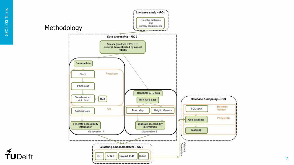
1. What are potential problems presented by the public space and primary requirements for people with mobility impairments
regarding the accessibility?
2. Which measure-method could be developed to generate accessibility information, by making use of the sensor (handheld Global
Positioning System (GPS), Real-Time Kinematic (RTK) GPS and camera) data collected by a meet rollator, software
package PhotoScan, Geographic Information System (GIS) analysis tools and the core-registration Large-scale Topography of
the Netherlands (BGT)?
3. How can the ground truth and results of the UMG algorithm be used to validate the generated accessibility information? And do
the AHN-2 and BGT+ provide more insight in and put semantics to the generated accessibility information?
4. In what way can the results best be stored in a geo-database in PostgreSQL?
GEO
2000 T
hesi
s
7
Methodology
GEO
2000 T
hesi
s

8
Research area
A part of Amsterdam in the province North-Holland
2 Districts: South and Centre (numbers 4 and 7)
South: 17 square kilometers, 132.000 residents
Centre: 8 square kilometers, 81.000 residents
The meet rollator was used in this research area
GEO
2000 T
hesi
s
9
Content G
EO
2000 T
hesi
s
Research Meet Rollator Review
Workflow Implementation
Storing Conclusions and
recommendations
Introduction & methodology
My research & results
Meet Rollator 2.0
Validating and put semantics to
10
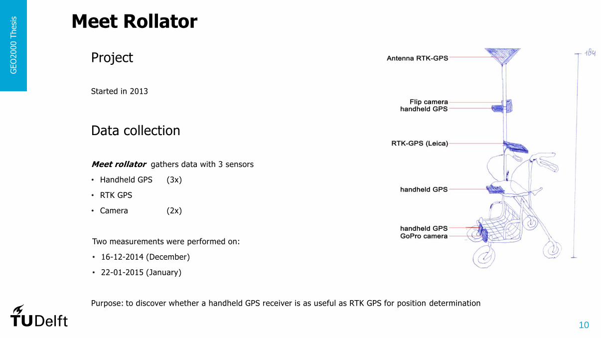
Project
Started in 2013
Meet Rollator G
EO
2000 T
hesi
s
Data collection
Meet rollator gathers data with 3 sensors
• Handheld GPS (3x)
• RTK GPS
• Camera (2x)
Two measurements were performed on:
• 16-12-2014 (December)
• 22-01-2015 (January)
Purpose: to discover whether a handheld GPS receiver is as useful as RTK GPS for position determination

11
Sensor-data
• Handheld GPS *.GPX file (also KLM files and Text document)
• RTK GPS Excel/CSV-document with x, y, z-coordinates
• Camera Video
2015 (January): distance 2.0 km
2014 (December): distance 6.3 km
** http://www.ams-institute.org/solution/roving-rollators-2/ (1:34 min)
GEO
2000 T
hesi
s
Handhelds GPS & Flip Camera
Handhelds GPS & GoPro Camera
RTK GPS Handhelds GPS

12
For this study the meet rollator sensor-data is used obtained in December 2014 and January 2015
I did not set up the setting of the meet rollator, this was done completely by somebody else
For my thesis I used the data derived from the 3 available sensors
GEO
2000 T
hesi
s
1. Fokke Simonszstraat 2. Nieuwe Looiersstraat 3. Reguliersgracht* 4. Vijzelgracht 5. Prinsengracht 6. Utrechtsestraat 7. Frederiksplein 8. Weteringschans 9. Pieter Pauwstraat 10.Nicolaas Witsenkade 11.Stadhouderskade 12.Eerste van der Helststraat 13.Ferdinand Bolstraat 14.Daniël Stalpertstraat 15.Gerard Douplein 16.Gerard Doustraat 17.Albert Cuypstraat 18.H.M.V. Randwijkplantsoen 19.Weteringlaan 20.Westeinde
13
Content G
EO
2000 T
hesi
s
Research Meet Rollator Review
Workflow Implementation
Storing Conclusions and
recommendations
Introduction & methodology
My research & results
Meet Rollator 2.0
Validating and put semantics to

14
GPS
For positioning
3 parameters of position
(latitude, longitude, height)
Time
Position is calculated by using trilateration
intersection of sphere surfaces
GEO
2000 T
hesi
s Review
15
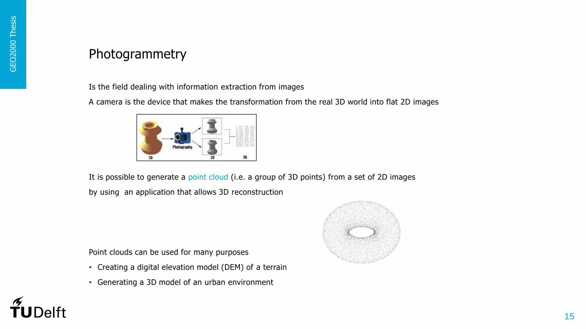
Photogrammetry
Is the field dealing with information extraction from images
A camera is the device that makes the transformation from the real 3D world into flat 2D images
It is possible to generate a point cloud (i.e. a group of 3D points) from a set of 2D images
by using an application that allows 3D reconstruction
Point clouds can be used for many purposes
• Creating a digital elevation model (DEM) of a terrain
• Generating a 3D model of an urban environment
GEO
2000 T
hesi
s

16
Requirements regarding accessibility
17 years ago 1st version of Manual-book of Accessibility - guidelines for outdoor spaces
Three geometrical demands for movement:
1. Suitable free passage – at least 0.9 meter wide
2. Minimum angle of inclination – not steeper than the ratio 1:6 (height:length)
3. Minimum threshold – a maximum height of 0.05 meter
This means that a pedestrian path forms an obstacle if it is narrower than 0.9 meter, steeper than 9.46° or/and if the height difference on the path is higher than 0.05 meter
It has to be noticed that one has to be critical with norms
** https://www.youtube.com/watch?v=aUhoetRYTBE (0:04 min & 1:25 min)
GEO
2000 T
hesi
s
Angle of inclination Ratio (height : length) ≤ 1:6 Max. length until (grid size) 0.3m Max. angle of inclination (rise) 9.46° Max. height until (rise) 0.05m

17
Content G
EO
2000 T
hesi
s
Research Meet Rollator Review
Workflow Implementation
Storing Conclusions and
recommendations
Introduction & methodology
My research & results
Meet Rollator 2.0
Validating and put semantics to
18
Workflow G
EO
2000 T
hesi
s
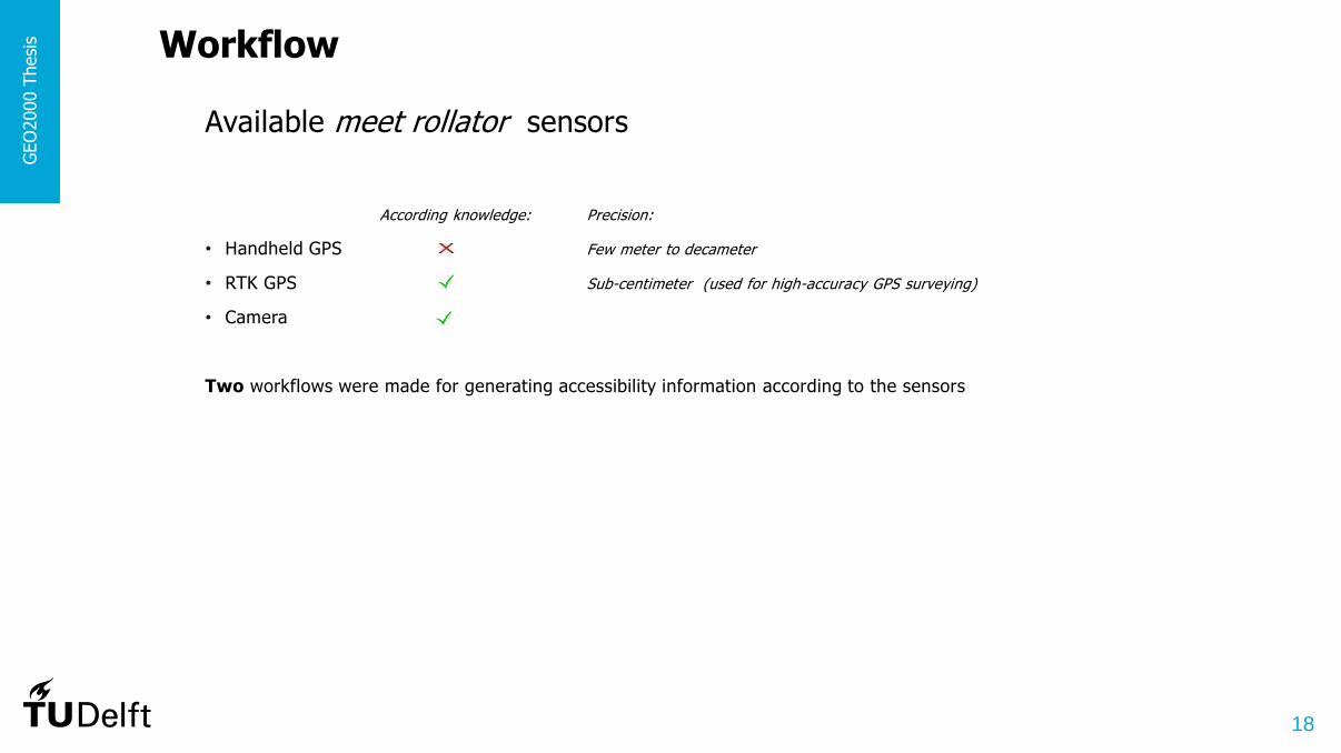
Available meet rollator sensors
According knowledge: Precision:
• Handheld GPS Few meter to decameter
• RTK GPS Sub-centimeter (used for high-accuracy GPS surveying)
• Camera
Two workflows were made for generating accessibility information according to the sensors

19
GEO
2000 T
hesi
s
Workflow RTK GPS data
HYPOTHESIS
RTK GPS data collected by a meet rollator & GIS analysis tools can be used to develop a methodology that generates and determines accessibility information
2 Geometrical demands for movement:
• Angle of inclination
• Threshold
HOW TO PROVE IT

20
GEO
2000 T
hesi
s
WORKFLOW
Four parts
(1)Computing 7 parameters
(2)Filtering Quality
(3)Filtering Threshold
(4)Analysing time delays

21
GEO
2000 T
hesi
s
Workflow Camera data
HYPOTHESIS
Video camera data collected by a meet rollator, the software Agisoft Photoscan Professional, GIS analysis tools and the BGT can be used to develop a methodology that generates and determines accessibility information
3 Geometrical demands for movement:
• Free passage
• Angle of inclination
• Threshold
HOW TO PROVE IT
22
GEO
2000 T
hesi
s
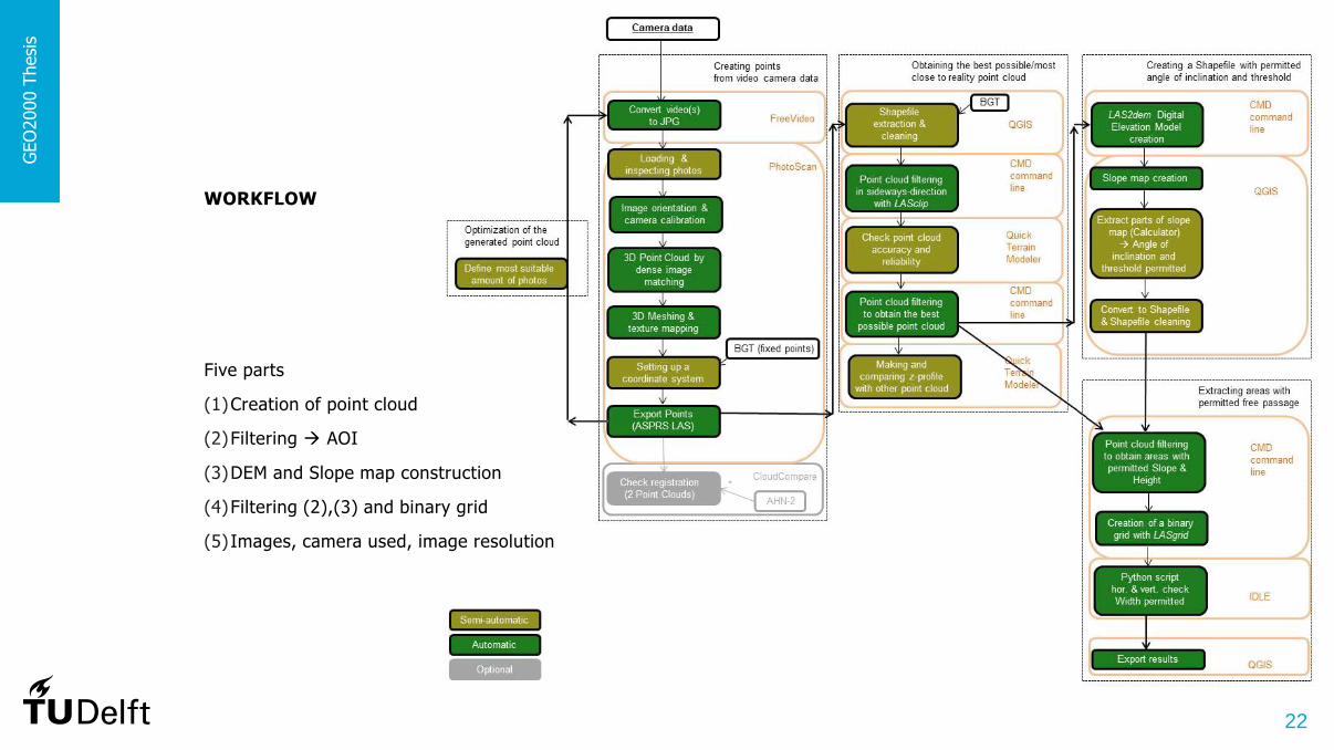
WORKFLOW
Five parts
(1)Creation of point cloud
(2)Filtering AOI
(3)DEM and Slope map construction
(4)Filtering (2),(3) and binary grid
(5) Images, camera used, image resolution

23
GEO
2000 T
hesi
s
Workflow conclusions
• Both workflows are useful
• A municipality will not be happy with workflows that consist of different types of software
• Both workflows differ in the representation
• The RTK GPS data processing is a kind of point-measurements. In a certain street mobility impaired people can or cannot pass. The generated accessibility information of RTK GPS data will consist of linestrings
• Camera data is modelled following a raster-based approach. This was done to limit complexity of the methodology. The derived accessibility information of camera data will consist of polygons
The workflow by making use of RTK GPS data is recommended to a municipality
• It takes less time to process RTK GPS data and fewer programs are needed

24
Content G
EO
2000 T
hesi
s
Research Meet Rollator Review
Workflow Implementation
Storing Conclusions and
recommendations
Introduction & methodology
My research & results
Meet Rollator 2.0
Validating and put semantics to

25
Used data
• RTK GPS data – measured with a Leica device in 2014
• Camera data – measured with a Flip camera in 2015
Focus street: Collected sensor-data:
Implementing the workflow G
EO
2000 T
hesi
s

26
Implementing workflow RTK GPS data
Input - CSV file of RTK GPS data 2014:
Output - Derived outdoor accessibility information:
Precision was for several places not good enough !
GEO
2000 T
hesi
s
Point Id Easting Northing NAP_m_ Date Hr Min Sec Quality Ant_Hgt
AM1 121317.264 485684.195 2.81 12/16/2014 14 14 54 0.825 1.84
AM2 121317.657 485685.318 0.958 12/16/2014 14 14 59 1.081 1.84
AM3 121317.451 485685.907 -0.019 12/16/2014 14 15 4 1.05 1.84
AM4 121316.262 485688.157 0.151 12/16/2014 14 15 9 0.032 1.84
AM5 121310.745 485688.697 0.457 12/16/2014 14 15 14 0.943 1.84
AM6 121305.295 485690.286 -0.432 12/16/2014 14 15 19 0.842 1.84
AM7 121299.946 485690.588 -0.091 12/16/2014 14 15 24 0.777 1.84
AM8 121300.098 485691.008 0.107 12/16/2014 14 15 29 0.019 1.84
AM9 121300.076 485691.002 0.106 12/16/2014 14 15 34 0.024 1.84
etc.
province municip_name district neighbourhood accessible line_id good_quality
North-Holland Amsterdam Zuid Oude Pijp YES 8 YES
North-Holland Amsterdam Zuid Oude Pijp YES 9 YES
North-Holland Amsterdam Zuid Oude Pijp YES 10 YES
North-Holland Amsterdam Zuid Oude Pijp YES 11 YESgeom point_id_one point_id_two data_year obtained_year
LINESTRING (121300.098 485691.008,121300.076 485691.002) AM8 AM9 2014 2015
LINESTRING (121300.076 485691.002,121299.903 485691.021) AM9 AM10 2014 2015
LINESTRING (121299.903 485691.021,121294.435 485691.591) AM10 AM11 2014 2015
LINESTRING (121294.435 485691.591,121288.982 485692.238) AM11 AM12 2014 2015
Point-measurement

27
Implementing workflow Camera data
Input - Videos of Camera data 2015:
17 photos
Output - Derived outdoor accessibility information:
GEO
2000 T
hesi
s
province municip_name district neighbourhood street accessible
North-Holland Amsterdam Centre De Weteringschans Nieuwe Looiersstraat Yes
North-Holland Amsterdam Centre De Weteringschans Nieuwe Looiersstraat No
geovlak data_year obtained_year
POLYGON (((121501.802 485949.410475, 121501.802 … ))) 2015 2015
POLYGON (((121498.416 485945.507241, 121498.416 … ))) 2015 2015
Raster-based-measurement

28
Evaluate fit for purpose
According implementing workflow:
• Handheld GPS
• RTK GPS
• Camera
Through data processing, more insight is gained into sensor data and about the usefulness of the different sensors
This research has shown that the used sensors did not provide the needed precision for deriving outdoor accessibility information concerning mobility impaired people
GEO
2000 T
hesi
s

29
Content G
EO
2000 T
hesi
s
Research Meet Rollator Review
Workflow Implementation
Storing Conclusions and
recommendations
Introduction & methodology
My research & results
Meet Rollator 2.0
Validating and put semantics to

30
Used data
Ground truth = the absolute truth
BGT+ = the Dutch key registry for large scale topography (BGT – Dutch: Basisregistratie Grootschalige Topografie)
AHN-2 = the second part of the Height model of the Netherlands (Dutch: Actueel Hoogtebestand Nederland)
Algorithm of Urban Modelling Group (Dublin)
Validating and put semantics to the accessibility information G
EO
2000 T
hesi
s
BGT+
AHN-2

31
Observations of RTK GPS data
Validate and put semantics to the generated accessibility information obtained by RTK GPS data by using:
• Ground truth
• BGT+
GROUND TRUTH
Validation
Direct visit
The generated accessibility information consists of 330 locations that cover an area of approximately 594m2
GEO
2000 T
hesi
s
Results after implementing workflow
After Survey
Total lines Accessible Not
accessible Accessible Not
accessible 1. Albert Cuypstraat 31 29 2 31 0
2. Ferdinant Bolstraat 13 6 7 13 0
3. Frederiksplein 57 31 26 53 4
4. Gerard Douplein 33 20 13 32 1
5. H.M.V. Randwijkplantsoen 14 7 7 13 1
6. Prinsengracht 78 51 27 62 16
7. Stadhouderskade 13 13 0 13 0
8. Vijzelgracht 42 24 18 35 7
9. Westeinde 28 12 16 28 0
10. Weteringschans 21 13 8 20 1
Total 330 206 124 300 30
A rollator needs to be lifted to bridge the height difference caused by different pavement material
32
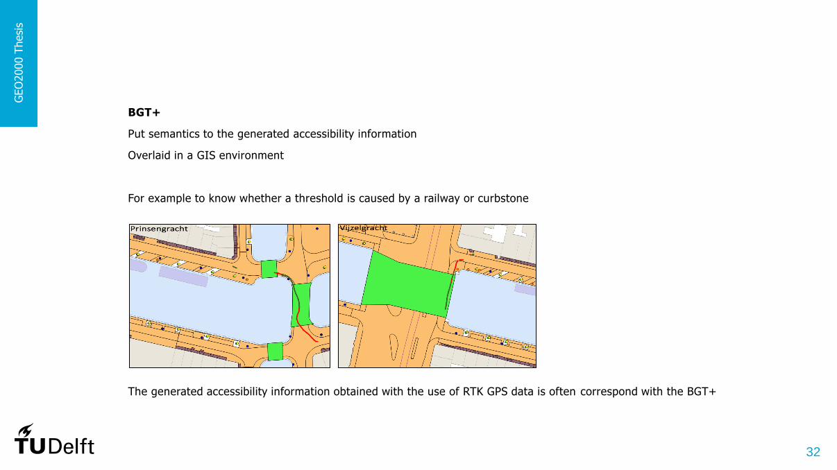
BGT+
Put semantics to the generated accessibility information
Overlaid in a GIS environment
For example to know whether a threshold is caused by a railway or curbstone
The generated accessibility information obtained with the use of RTK GPS data is often correspond with the BGT+
GEO
2000 T
hesi
s

33
Observations of Camera data
Validate and put semantics to the generated accessibility information obtained by RTK GPS data by using:
• Ground truth
• BGT+
• AHN-2
• Algorithm of Urban Modelling Group (Dublin)
GROUND TRUTH
Validation
Direct visit
The generated accessibility information consist of one location (approximately 77 m2)
in the focus street called ‘Nieuwe Looiersstraat’
The obstacles detected during the survey
-> row of poles
GEO
2000 T
hesi
s
Generated accessibility information
After validation

34
BGT+
Put semantics to the generated accessibility information
Overlaid in a GIS environment
At some places the generated accessibility information is in line with the BGT+, especially where building installations (in the BGT+) are located
GEO
2000 T
hesi
s

35
AHN-2
Put semantics to the derived observations
Overlaid -> visual comparison
This data is not completely coverage, even not close enough to be able to determine profile information
So the AHN-2 cannot be used for achieving more insight in and put semantics to the derived observations
GEO
2000 T
hesi
s

36
ALGORITHM OF URBAN MODELLING GROUP (DUBLIN)
Validation
Applied their algorithm on the same point cloud data
The road roughness (see letter A) including those caused by data imperfection (see letter B) showed up clearly
Regions around the street poles are excluded from the accessible path (see letter C)
The bottle necks are terminating the growing in the UMG result (see letter D). The growing does not go through the bottle neck
GEO
2000 T
hesi
s
Slope and height
The overall result
UMG results My results

37
GEO
2000 T
hesi
s
COMPARISON OF THE UMG RESULTS AND MY RESULTS
• Another way of computing height and slope changes is used (point/raster-based-measurement)
• The result of the UMG are able to pick up the surface changes better
• Also by using a smaller grid size for processing, the results of the approach of this thesis are still less precise than the UMG results
• However the results of this thesis are good enough for the generation of outdoor accessibility information

38
Conclusion
RTK GPS observations: Camera observations:
AHN-2 Put semantics to
BGT+ Put semantics to
Ground truth Validation
Algorithm of Urban Modelling Group (Dublin) Validation
The AHN-2 and BGT+ can be used for putting semantics to the observations
The ground truth and results of the algorithm made by the Urban Modelling Group can be used for the validation of the observations
The AHN-2 is not suitable for providing more insight in and put semantics to the observations
GEO
2000 T
hesi
s
39
Content G
EO
2000 T
hesi
s
Research Meet Rollator Review
Workflow Implementation
Storing Conclusions and
recommendations
Introduction & methodology
My research & results
Meet Rollator 2.0
Validating and put semantics to

40
Geo-database
A database is a digitally stored archive
UML class diagram
Storing the validated accessibility information G
EO
2000 T
hesi
s

41
Geo-database
A database is a digitally stored archive
UML class diagram
Storing the validated accessibility information G
EO
2000 T
hesi
s

42
UML class diagram conceptual
GEO
2000 T
hesi
s

43
Database: OUT_ACCESS
• an overview of all improvements that are necessary
• positions where problems occur and the suggestions for improvement
This table could be of importance for a municipality
It can be used as Spatial Decision Support Systems (SDSS) by road managers since it provide them with new information about the outdoor accessibility
GEO
2000 T
hesi
s

44
GEO
2000 T
hesi
s
Application of the geo-database
Querying the database
Link the data to other applications in order to make it more usable
According to a Teamleader of Process Unit at the Municipality of Amsterdam
This geo-database can be very useful for the management of the public space, specifically for the management of pavements/surfacing
If it appears that a public area is not sufficiently accessible, this information may be included in the deliberations of where a municipality commits their efforts
So this information is very useful for road managers
With this database the municipality can improve the mobility in the outdoor environment

45
Map
With QGIS no interactive map can be made & a
map cannot be made publicly available
Google Fusion Table map application
Neighbourhood: Oude Pijp, De Weteringschans, Grachtengordel-Zuid
To provide insight in the accessibility of pedestrian routes for mobility impaired people
GEO
2000 T
hesi
s
C:\Users\Rosann Aarsen\Desktop\Graduation project\+P4 presentatie\Map\Map\Map_gray.html
46
Content G
EO
2000 T
hesi
s
Research Meet Rollator Review
Workflow Implementation
Storing Conclusions and
recommendations
Introduction & methodology
My research & results
Meet Rollator 2.0
Validating and put semantics to

47
Conclusions G
EO
2000 T
hesi
s
Answering the sub research questions:
1. What are potential problems presented by the public space and primary requirements for people with mobility
impairments regarding the accessibility?
A pedestrian path forms an obstacle if it is narrower than 0.9 meter, steeper than 9.46° or if the height difference on the path is
higher than 0.05 meter
For this thesis is focused on the three most important parameters for mobility impaired people, namely:
• Suitable free passage
• Minimum angle of inclination
• Minimum threshold

48
GEO
2000 T
hesi
s
2. Which measure-method could be developed to generate accessibility information, by making use of the sensor
(handheld Global Positioning System (GPS), Real-Time Kinematic (RTK) GPS and camera) data collected by a
meet rollator, software package PhotoScan, Geographic Information System (GIS) analysis tools and the core-
registration Large-scale Topography of the Netherlands (BGT)?
For this thesis two measure-methods were made according to the available sensors
1. RTK GPS workflow: Software package PhotoScan, GIS analysis tools and the BGT (+ Quick Terrain Modeler, IDLE and Freevideo)
2. Camera workflow: QGIS (+ IDLE)

49
GEO
2000 T
hesi
s
3. How can the ground truth and results of the UMG algorithm be used to validate the generated accessibility
information? And do the AHN-2 and BGT+ provide more insight in and put semantics to the generated
accessibility information?
Additional data will provide more insight in and put semantics to the derived outdoor accessibility information
Ground truth is the best way to check whether the observations are complete, accurate and precise
The algorithm made by the UMG is suitable for validating the observations obtained by using camera data
Only the BGT+ provide more insight in and put semantics to the observations (not the AHN-2)

50
GEO
2000 T
hesi
s
4. In what way can the results best be stored in a geo-database in PostgreSQL?
The derived accessibility information obtained via Camera data can best be stored by using polygons, to represent complex areas
The derived accessibility information obtained via RTK GPS data can best be stored by using linestrings

51
GEO
2000 T
hesi
s
Answering the main research question:
Does the current setting of the meet rollator provide insight into the accessibility of pedestrian routes for mobility
impaired people? If not, how can the current setting be improved?
Yes, the current setting of the meet rollator provides insight into the accessibility of pedestrian routes for mobility impaired people
However, this research has shown that the used sensors did not provide the needed precision !
A part of the used sensors does not provide any insight into the outdoor accessibility information
The current setting of the meet rollator can be improved

52
GEO
2000 T
hesi
s
• A suggestion to improve the workflow by making use of Camera data, is to use more coordinates for georeferencing
• For comparing the measurements instead of the derived observations
a surveyor’s level (Dutch: Waterpasinstrument) can be used, which measures for a given test-path an accurate altitude profile
In this way the real truth could be compared with the RTK GPS data, and with the camera data
• It is advisable to further investigate the usefulness of other sensors to decide which sensors produce more precise measurements
It should be noticed that it is not easy to measure the needed information !
Recommendations

53
Content G
EO
2000 T
hesi
s
Research Meet Rollator Review
Workflow Implementation
Storing Conclusions and
recommendations
Introduction & methodology
My research & results
Meet Rollator 2.0
Validating and put semantics to

54
GEO
2000 T
hesi
s
They (from the University of Wageningen) have used the current setting of the meet rollator
However you can do it better this way !
By taking the same measurement platform
Sensor: 3D laser scanning system handheld laser mapping system: ZEB1
• allows fast data capturing
• result of a ZEB1 measurement is point cloud data which is directly available for further processing
Sensor: For the position determination RTK GPS
Another option: Directly measure the needed information instead of calculating it
By using a sensor that derives the needed information directly without sensor data processing
A little cart with (two) wheels that measures an angle of inclination and threshold directly
• To know the location of a sidewalk you have to use something with wheels that will run against a higher-situated pavement
In combination with: Accelerometer (a device that measures proper acceleration)
• it directly measures a stop when it drives against a curb
Meet Rollator 2.0 @ Designed by Rosann

55
Thank you