ute mountain ute indian reservation - us department of · pdf filein broad aspect the ute...
TRANSCRIPT

UTE MOUNTAIN UTE RESERVATIONCOLORADO, NEW MEXICO
Reservation Overview 1
WIND RIVERINDIAN
RESERVATION
W Y O M I N G
C O L O R A D O
UTE MOUNTAIN UTEINDIAN RESERVATION
SOUTHERN UTEIND RES
JICARILLAAPACHEIND RES
TAOSIND RESTAOS
IND RES
PICURISIND RESSAN JUAN I R
SANTA CLARA I R
POJOAQUE I RNAMBE I R
TESUQUE I RSAN ILDEFONSO I R
JEMEZ I R
COCHITI I R
SANTA DOMINGO I R
SAN FELIPE I RSANTA ANA I R
SANDIA I R
ZIAIND RES
MESCALEROINDRES
HOPI INDIANRESERVATION
NAVAJO INDIAN RESERVATION
NAVAJOIND RES
LAGUNANAVAJO I R
RAMAH NAVAJO IND RES
ZUNIIND RES ACOMA
I R
LAGUNA I R
CANONCITO I RISLETAIND RES
ALAMO NAVAJOIND RES
YSLETA DEL SUR I R
N E W M E X I C O
FT HALLIND RES
NORTHWESTERNSHOSHONI
IND RES
GREAT SALT LAKE
SKULL VALLEYIND RES
PAIUTE I R
PAIUTE I R
PAIUTE I R
GOSHUTEIND RES
UNITAH AND OURAYINDIAN RESERVATION
U T A H
FT APACHEINDIAN RESERVATION
SAN CARLOSINDIAN RESERVATION
PAYSON COMMUNITY I R
KAIBABIND RES
HAVASUPAI I R
HUALAPAIIND RES
YAVAPAI I RCAMP VERDE I R
SALT RIVER I R
FT MC DOWELLIND RES
GILA RIVER IND RES
GILA BENDIND RES MARICOPA
IND RESPAPAGOIND RES
PASCUA YAQUI I R
SAN XAVIERIND RES
PAPAGOINDIAN
RESERVATION
A R I Z O N A
COLORADONEW MEXICO
Oilfield
Gasfield
EXPLANATION
Oil pipelineGas pipeline
COLORADO
NEW MEXICO
R16W R15W R14W
T31N
T32N
T32N
R13 1/2W
T33N
T33 1/2N
R14W
R15W
T35N
T34N
T35N
T36N
R16W
R17WR18W
R19WR20W
UTA
H
CO
LOR
AD
O
R20W R19W R18W R17W R16W
M E S A V E R
D E
Horseshoe- Gallop
Verde-Gallop
U.S. BUREAU OF MINES 4-INCH PIPELINE (HELIUM)
Westwater Canyon
UteDome
SAN JUAN COUNTY
BarkerDome
LA P
LATA
C
OU
NTY
MO
NTE
ZUM
A
CO
UN
TY
River
MESA VERDE
NATIONAL
PARK
Cortez
McElmo
Canyon
Karle KeyMine Xu
XuXcu
Xcu
MABELMOUNTAIN
Little MoudeMine Xcu
UTEPEAK
BLACKMOUNTAIN
Indian Reservation boundary
Prospect cu- copper u- uranium
X
W Sand and gravel pit
SLEEPIN
G UTE M
OUNTAIN
HERMANO PEAK
Coche
Desert Canyon
Marble Wash
Towaoc
THE MOUND
SENTINEL PEAK
TowaocW
Nav
ajo
R
iver
Ramona
Chipeta
W
TEXAS PACIFIC
6-INC
H O
IL PIPELINE
San Juan River
MancosRiver Mancos
Farms
MONTEZUMA COUNTY
Aztec Wash
Mancos
T A N N E R M E S A
WW
INDEX MAP
10 MILES
20 KILOMETERS
0
0
5
5 10
N
32
666
666
789
41
Figure UM-1. Location of the Ute Mountain Ute Indian Reservation (modified after U.S. Department of the Interior, 1993).
Figure UM-2. Geographic map of the Ute Mountain Ute Indian Reservation.
Ute Mountain Ute Indian ReservationGeneral Setting
The Ute Mountain Ute Reservation is located in the northwestern portion of New Mexico and the southwestern corner of Colorado (Fig. UM-1). The reservation consists of 553,008 acres in Montezuma and La Plata Counties, Colorado, and San Juan County, New Mexico. All of these lands belong to the tribe but are held in trust by the U.S. Government. Individually owned lands, or allotments, are located at Allen Canyon and White Mesa, San Juan County, Utah, and cover 8,499 acres. Tribal lands held in trust within this area cover 3,597 acres. An additional forty acres are defined as U.S. Government lands in San Juan County, Utah, and are utilized for school purposes.The Allen Canyon allotments are located twelve miles west of Blanding, Utah, and adjacent to the Manti-La Sal National Forest. The White Mesa allotments are located nine miles south of Blanding, Utah, on Utah Highway 47. These lands belong to known members of the Tribe or their heirs; however, the titles are held in trust for these individuals by the U.S. Government. The Ute Mountain Ute Tribe also holds fee patent title to seven tracts of land located in Utah and Colorado totaling 595,647 acres. The topography of the reservation varies from approximately 4,600 feet near the Four Corners to approximately 10,000 feet at the peak of the Sleeping Ute Mountain. The eastern half of the reservation is characterized by a high mesa cut by the canyon of the Mancos River and numerous side canyons. The western half of the reservation, with the exception of the Sleeping Ute Mountain, is semi-desert grassland. The reservation ranges in elevations from about 4,600 feet along the San Juan River near Four Corners (the junction of the States of Arizona, Utah, Colorado, and New Mexico) to 9,977 feet on Ute peak. Most of the western part of the reservation is semi-arid, eroded grasslands with some “badlands” topography near the Utah boundary. North of the grasslands is the Sleeping Ute Mountain with a cover of scrub cedar, oak, and juniper. The eastern and southern parts of the reservation consist of the deeply-cut canyons and mesas of Mesa Verde and Tanner Mesa, and is covered by scrub cedar and juniper.The only paved highways in the reservation are U.S. Highways 160 and 666 and State Highways 41 and 789 (Fig. UM-2). Two maintained gravel roads cross the reservation: one follows the Mancos River Canyon to the eastern part of the reservation, then southward toward Farmington and the other goes westward from Towaoc to the Cache oilfield then on to Aneth, Utah. Other roads are generally trails passable only to four-wheel-drive vehicles or pickup trucks.Towaoc, the only town on the reservation, is the site of the Ute Mountain Indian Agency and the residence of most of the people on the reservation. Cortez, Colorado, 16 miles northeast of Towaoc, serves as the principal market center for the area. South of the
reservation in New Mexico are the towns of Shiprock, 30 miles from Towaoc, and Farmington, 29 miles east of Shiprock.
UTE MOUNTAIN UTE RESERVATIONCOLORADO, NEW MEXICO
3750
3000
2000
MONOCLINE1000
0
SOUTHUTE
DOME
BARKERDOME
-100
0
HOG
BACK
3000
MESA VERDEBASIN
UTE MOUNTAIN INDIAN RESERVATION
4000
5000
6000
SENTINEL PEAKDOME
UTEDOME
McELMODOME
6750
6000
5000
EXPLANATION
Structure contours - drawn on base of Dakota Sandstone. Contour interval 250 feet
2000
Near vertical fault
Anticline - showing plunge
Syncline - showing plunge
30'
108 15'
0 5 10 15 MILES
0 5 10 15 KILOMETERS
37 00'
37 15'
109 00' 45'
BLACK MESA
BASINCAMERON
BENCH
WUPATKI BENCHFLAGSTAFF
WINSLOW
LITTL E
COLORADO
HOLBROOM
UP
LIFT
KA
IBA
EC
HO
CLIF
FS U
PLIF
T
E
AS
T K
AIB
AB
SYN
CL
I NE
COCONINO
SALIENT
COLORAD O
PRESTON
BENCH
KAIBITO
SADDLE
KAIPAROWITS
BASIN
PIUTEFOLDS
NAVAJODOME
HEN
RY DO
MES
RIV
ER
HEN
RY
BASIN
CIR
CLE C
LIFFS UPLIFT
CAPITOL
REEF
FOLD BELT
UINTA
BASINRIV
ER
G RE
EN
UTA
HC
OLO
RA
DO
PRICE
SAN
RA
FAE
L S
WE
LL
CA
ST
LE V
ALL
EY
SA
G
GREENRIVER
UTAHARIZONA
BLANDING
BASIN
ABAJODOME
UNCOMPAHGRE UPLIFT
WILSONDOME
LA PLATADOME
JICODOME
D
OL
ORE
SR
IVE
LA SALDOME
MOAB
PARADOX FOLD
AND
FAULT BELT
MO
NU
ME
NT
UP
WA
R
WH
ITE
CA
NY
ON
SLO
PE
OLU
ETO
SA
G
HIG
H P
LATE
AUS
COLO
RADO
RIVE R
WHITE RIVER UPLIFT
CARBONDALE
BASIN
PICEANCE
BASIN
VERNALAXIAL
FOLDBELT
MEEKER
UINTA UPLIFT
WYOMINGCOLORADO
WYOMINGUTAH
DO
UG
LAS
AR
C
CARBONERA
SAG
JUNCTION BENCH
GR.JUNCTION
ELK UPLIF
T
GUNNISON
GUNNISON UPLIFT
MONTROSE SAG
SAN JUA N
RIV
ER
SA
N JU
AN
SA
G
ARCHULETA
SAN
JUAN
DOME
NEEDLEDOME
CH
AM
AB
AS
IN
IUC
IMIE
NTO
UP
LIFT
SAN JUAN
BASIN
COLORADONEW MEXICO
FARMINGTON
DURANGO
CORTEZ
FOUR CORNERS
PLATFORM
UTEDOME
TYENDESADDLE
CARRIEDDOME
RED ROCKBENCH
DE
FIAN
CE
UP
LIFT
AR
IZO
NA
NE
W M
EX
ICO
GALLUP
GALLUPSAG
CHAGO
SLOPE
ZUNI UPLIFT
ACOMA
SAG
RIO
GR
AN
DE
TR
OU
GH
ALBUQUERQUE
RIO
G
RANDEPU
ER
CO
FAU
LT B
ELT
LUC
ER
OU
PLI
FT
CO
LOR
AD
O R
OC
KIE
S
MOGOLLON SLOPERIV E R
EXPLANATION
Monocline or steep limb of foldwith direction of dip
Crestal line of anticline, arch, uplift, up-warp, or swell, with direction of plunge
Troughal line of syncline, basin, or sagwith direction of plunge
High-angle fault, with downthrown side
Thrust fault, with updrawn side
Boundary of tectonic division
Uplift
Basin
N
0 8 16 32 48 64 Miles
0 8 16 32 48 64 80 96 Kilometers
SCALE
11241
111 110 109 108 10741
40
39
38
37
36
35
40
39
38
37
36
35
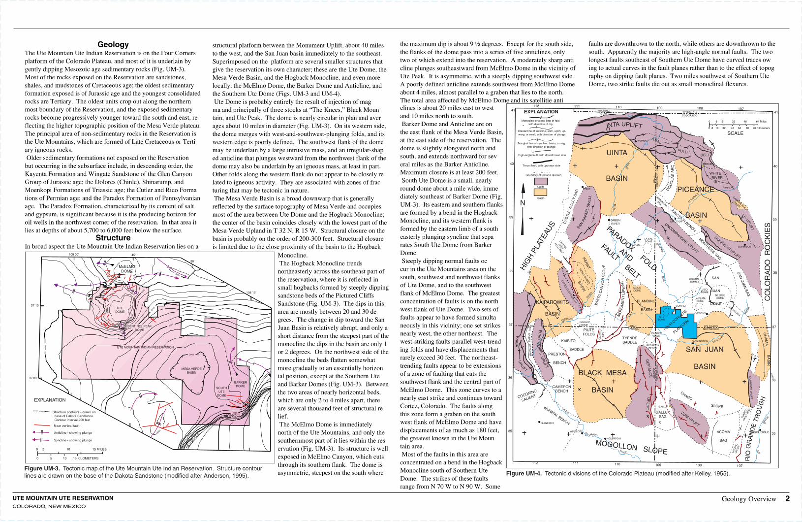
112 111 110 109 108 107Figure UM-3. Tectonic map of the Ute Mountain Ute Indian Reservation. Structure contour lines are drawn on the base of the Dakota Sandstone (modified after Anderson, 1995).
Geology Overview 2
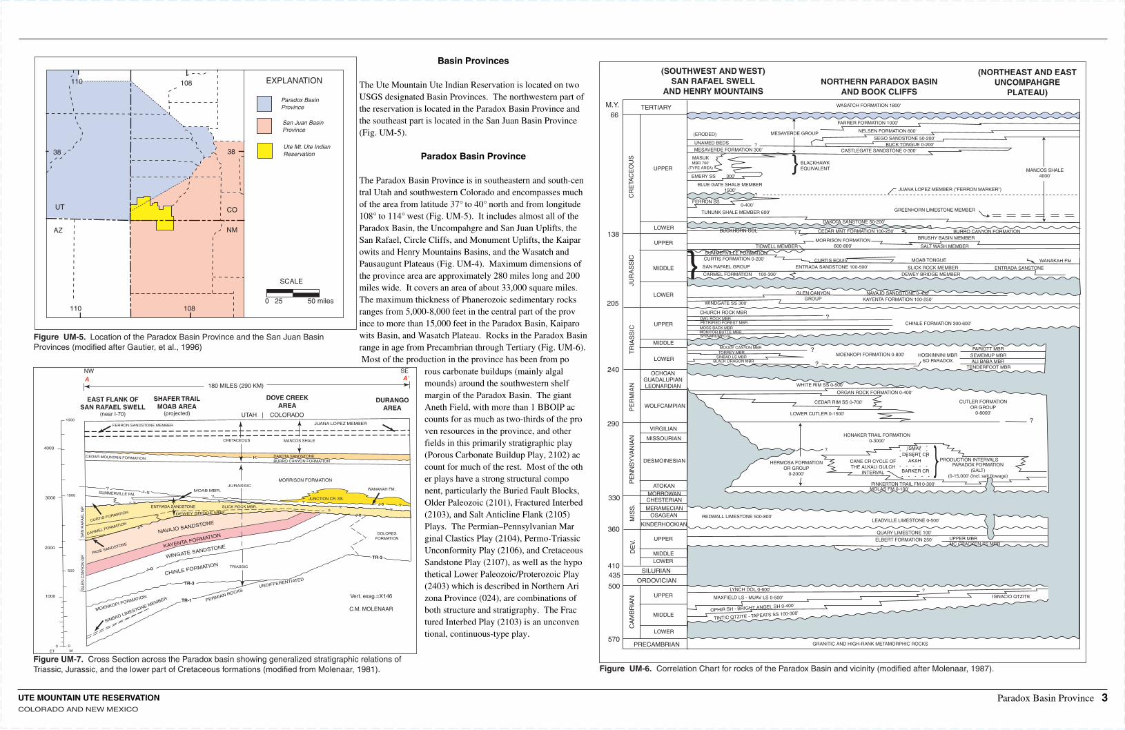
Figure UM-4. Tectonic divisions of the Colorado Plateau (modified after Kelley, 1955).
GeologyThe Ute Mountain Ute Indian Reservation is on the Four Corners platform of the Colorado Plateau, and most of it is underlain by gently dipping Mesozoic age sedimentary rocks (Fig. UM-3). Most of the rocks exposed on the Reservation are sandstones, shales, and mudstones of Cretaceous age; the oldest sedimentary formation exposed is of Jurassic age and the youngest consolidated rocks are Tertiary. The oldest units crop out along the northernmost boundary of the Reservation, and the exposed sedimentary rocks become progressively younger toward the south and east, reflecting the higher topographic position of the Mesa Verde plateau. The principal area of non-sedimentary rocks in the Reservation is the Ute Mountains, which are formed of Late Cretaceous or Tertiary igneous rocks.Older sedimentary formations not exposed on the Reservation but occurring in the subsurface include, in descending order, the Kayenta Formation and Wingate Sandstone of the Glen Canyon Group of Jurassic age; the Dolores (Chinle), Shinarump, and Moenkopi Formations of Triassic age; the Cutler and Rico Formations of Permian age; and the Paradox Formation of Pennsylvanian age. The Paradox Formation, characterized by its content of salt and gypsum, is significant because it is the producing horizon for oil wells in the northwest corner of the reservation. In that area it lies at depths of about 5,700 to 6,000 feet below the surface.
StructureIn broad aspect the Ute Mountain Ute Indian Reservation lies on a
structural platform between the Monument Uplift, about 40 miles to the west, and the San Juan basin immediately to the southeast. Superimposed on the platform are several smaller structures that give the reservation its own character; these are the Ute Dome, the Mesa Verde Basin, and the Hogback Monocline, and even more locally, the McElmo Dome, the Barker Dome and Anticline, and the Southern Ute Dome (Figs. UM-3 and UM-4).Ute Dome is probably entirely the result of injection of magma and principally of three stocks at “The Knees,” Black Mountain, and Ute Peak. The dome is nearly circular in plan and averages about 10 miles in diameter (Fig. UM-3). On its western side, the dome merges with west-and-southwest-plunging folds, and its western edge is poorly defined. The southwest flank of the dome may be underlain by a large intrusive mass, and an irregular-shaped anticline that plunges westward from the northwest flank of the dome may also be underlain by an igneous mass, at least in part. Other folds along the western flank do not appear to be closely related to igneous activity. They are associated with zones of fracturing that may be tectonic in nature.The Mesa Verde Basin is a broad downwarp that is generally reflected by the surface topography of Mesa Verde and occupies most of the area between Ute Dome and the Hogback Monocline; the center of the basin coincides closely with the lowest part of the Mesa Verde Upland in T 32 N, R 15 W. Structural closure on the basin is probably on the order of 200-300 feet. Structural closure is limited due to the close proximity of the basin to the Hogback
Monocline.The Hogback Monocline trends northeasterly across the southeast part of the reservation, where it is reflected in small hogbacks formed by steeply dipping sandstone beds of the Pictured Cliffs Sandstone (Fig. UM-3). The dips in this area are mostly between 20 and 30 degrees. The change in dip toward the San Juan Basin is relatively abrupt, and only a short distance from the steepest part of the monocline the dips in the basin are only 1 or 2 degrees. On the northwest side of the monocline the beds flatten somewhat more gradually to an essentially horizontal position, except at the Southern Ute and Barker Domes (Fig. UM-3). Between the two areas of nearly horizontal beds, which are only 2 to 4 miles apart, there are several thousand feet of structural relief.The McElmo Dome is immediately north of the Ute Mountains, and only the southernmost part of it lies within the reservation (Fig. UM-3). Its structure is well exposed in McElmo Canyon, which cuts through its southern flank. The dome is asymmetric, steepest on the south where
the maximum dip is about 9 ½ degrees. Except for the south side, the flanks of the dome pass into a series of five anticlines, only two of which extend into the reservation. A moderately sharp anticline plunges southeastward from McElmo Dome in the vicinity of Ute Peak. It is asymmetric, with a steeply dipping southwest side. A poorly defined anticline extends southwest from McElmo Dome about 4 miles, almost parallel to a graben that lies to the north. The total area affected by McElmo Dome and its satellitie anticlines is about 20 miles east to west and 10 miles north to south.Barker Dome and Anticline are on the east flank of the Mesa Verde Basin, at the east side of the reservation. The dome is slightly elongated north and south, and extends northward for several miles as the Barker Anticline. Maximum closure is at least 200 feet.South Ute Dome is a small, nearly round dome about a mile wide, immediately southeast of Barker Dome (Fig. UM-3). Its eastern and southern flanks are formed by a bend in the Hogback Monocline, and its western flank is formed by the eastern limb of a southeasterly plunging syncline that separates South Ute Dome from Barker Dome.Steeply dipping normal faults occur in the Ute Mountains area on the south, southwest and northwest flanks of Ute Dome, and to the southwest flank of McElmo Dome. The greatest concentration of faults is on the northwest flank of Ute Dome. Two sets of faults appear to have formed simultaneously in this vicinity; one set strikes nearly west, the other northeast. The west-striking faults parallel west-trending folds and have displacements that rarely exceed 30 feet. The northeast-trending faults appear to be extensions of a zone of faulting that cuts the southwest flank and the central part of McElmo Dome. This zone curves to a nearly east strike and continues toward Cortez, Colorado. The faults along this zone form a graben on the southwest flank of McElmo Dome and have displacements of as much as 180 feet, the greatest known in the Ute Mountain area.Most of the faults in this area are concentrated on a bend in the Hogback Monocline south of Southern Ute Dome. The strikes of these faults range from N 70 W to N 90 W. Some
faults are downthrown to the north, while others are downthrown to the south. Apparently the majority are high-angle normal faults. The two longest faults southeast of Southern Ute Dome have curved traces owing to actual curves in the fault planes rather than to the effect of topography on dipping fault planes. Two miles southwest of Southern Ute Dome, two strike faults die out as small monoclinal flexures.
ARC
H
UTE MOUNTAIN UTE RESERVATIONCOLORADO AND NEW MEXICO
UT
AZ
110 108
NM
CO
38 38
110 108 EXPLANATION
Paradox BasinProvince
San Juan BasinProvince
Ute Mt. Ute IndianReservation
SCALE
0 25 50 miles
TERTIARY
UPPER
LOWER
UPPER
CR
ETA
CE
OU
SJU
RA
SS
ICT
RIA
SS
IC
MIDDLE
LOWER
UPPER
MIDDLE
LOWER
PE
RM
IAN
OCHOANGUADALUPIANLEONARDIAN
WOLFCAMPIAN
PE
NN
SY
VA
NIA
NM
ISS
.D
EV.
CA
MB
RIA
N
VIRGILIAN
MISSOURIAN
DESMOINESIAN
ATOKANMORROWANCHESTERIAN
MERAMECIANOSAGEAN
KINDERHOOKIAN
UPPER
MIDDLELOWER
UPPER
MIDDLE
LOWER
SILURIAN
ORDOVICIAN
570
500
435410
360
330
205
240
290
138
66M.Y.
(SOUTHWEST AND WEST)SAN RAFAEL SWELL
AND HENRY MOUNTAINSNORTHERN PARADOX BASIN
AND BOOK CLIFFS
WASATCH FORMATION 1800'
(ERODED)
UNAMED BEDS ?MESAVERDE FORMATION 300'
MESAVERDE GROUP
FARRER FORMATION 1000'
NELSEN FORMATION 600'
SEGO SANDSTONE 50-200'BUCK TONGUE 0-200'
CASTLEGATE SANDSTONE 0-300'
MASUKMBR 700'
(TYPE AREA)
EMERY SS 300'
BLUE GATE SHALE MEMBER1500'
?FERRON SS
TUNUNK SHALE MEMBER 600'
0-400'
} BLACKHAWKEQUIVALENT
JUANA LOPEZ MEMBER ("FERRON MARKER")
MANCOS SHALE4000'
GREENHORN LIMESTONE MEMBER
BUCKHORN COL
DAKOTA SANSTONE 50-200'
? CEDAR MNT FORMATION 100-250' BURRO CANYON FORMATIONBRUSHY BASIN MEMBER
SALT WASH MEMBERMORRISON FORMATION
600-800'TIDWELL MEMBERSUMMERVILLE FORMATION
WANAKAH FMMOAB TONGUECURTIS EQUIV.} CURTIS FORMATION 0-200'
SAN RAFAEL GROUP
CARMEL FORMATION 100-300'ENTRADA SANSTONESLICK ROCK MEMBER
DEWEY BRIDGE MEMBER
ENTRADA SANDSTONE 100-500'
GLEN CANYONGROUP
NAVAJO SANDSTONE 0-450'KAYENTA FORMATION 100-250'
WINDGATE SS 300'
CHURCH ROCK MBROWL ROCK MBRPETRIFIED FOREST MBRMOSS BACK MBRMONITOR BUTTE MBRSHINARUMPCGL
?
?
?
CHINLE FORMATION 300-600'
MOODY CANYON MBRTORREY MBR
SINBAD LS MBRBLACK DRAGON MBR
MOENKOPI FORMATION 0-800' HOSKINNINI MBRSO PARADOX
PARIOTT MBRSEWEMUP MBRALI BABA MBR
TENDERFOOT MBR
WHITE RIM SS 0-500'
ORGAN ROCK FORMATION 0-400'
CEDAR RIM SS 0-700'
LOWER CUTLER 0-1500'
CUTLER FORMATIONOR GROUP
0-8000'
?
HERMOSA FORMATIONOR GROUP
0-2000'
?
HONAKER TRAIL FORMATION0-3000'
CANE CR CYCLE OFTHE ALKALI GULCH
INTERVAL
ISMAYDESERT CR
AKAH
BARKER CR
PRODUCTION INTERVALSPARADOX FORMATION
(SALT)(0-15,000' (Incl. salt flowage)
PINKERTON TRAIL FM 0-300'MOLAS FM 0-100'
REDWALL LIMESTONE 500-800'LEADVILLE LIMESTONE 0-500'
QUARY LIMESTONE 100'
ELBERT FORMATION 250' UPPER MBRMC CRACKEN SS MBR
ANETH FORMATION (SO. PARADOX)0-200'
LYNCH DOL 0-600' ?
MAXFIELD LS - MUAV LS 0-500' IGNACIO QTZITE
OPHIR SH - BRIGHT ANGEL SH 0-400'
TINTIC QTZITE - TAPEATS SS 100-300'
PRECAMBRIAN GRANITIC AND HIGH-RANK METAMORPHIC ROCKS
(NORTHEAST AND EASTUNCOMPAHGRE
PLATEAU)
NW
0 0ET M
A180 MILES (290 KM)
EAST FLANK OFSAN RAFAEL SWELL
(near I-70)
SHAFER TRAILMOAB AREA
(projected) UTAH | COLORADO
DOVE CREEKAREA
DURANGOAREA
SEA'
JUANA LOPEZ MEMBER
MANCOS SHALECRETACEOUS
FERRON SANDSTONE MEMBER
CEDAR MOUNTAIN FORMATION K
?
?
?
?
??
?
??
JURASSICMOAB MBR.J-5
MORRISON FORMATION
WANAKAH FM.
JUNCTION CR. SS.J-5
J-2
DOLORESFORMATION
SUMMERVILLE FM.
CURTIS FORMATION
J-3ENTRADA SANDSTONE SLICK ROCK MBR.
J-3
CARMEL FORMATION
DEWEY BRIDGE MBR.
PAGE SANDSTONE KAYENTA FORMATION
TRIASSIC
CHINLE FORMATION
MOENKOPI FORMATION
J-O
SINBAD LIMESTONE MEMBER
TR-3
TR-1 PERMIAN ROCKSUNDIFFERENTIATED
GLE
N C
AN
YO
N G
P.S
AN
RA
FAE
L G
P.
Vert. exag.=X146
C.M. MOLENAAR
TR-3
1500
4000
30001000
2000
500
1000
WINGATE SANDSTONE
NAVAJO SANDSTONE
DAKOTA SANDSTONEBURRO CANYON FORMATION
Paradox Basin Province 3
Figure UM-6. Correlation Chart for rocks of the Paradox Basin and vicinity (modified after Molenaar, 1987).Figure UM-7. Cross Section across the Paradox basin showing generalized stratigraphic relations of Triassic, Jurassic, and the lower part of Cretaceous formations (modified from Molenaar, 1981).
Figure UM-5. Location of the Paradox Basin Province and the San Juan Basin Provinces (modified after Gautier, et al., 1996)
Basin Provinces
The Ute Mountain Ute Indian Reservation is located on two USGS designated Basin Provinces. The northwestern part of the reservation is located in the Paradox Basin Province and the southeast part is located in the San Juan Basin Province (Fig. UM-5).
Paradox Basin Province
The Paradox Basin Province is in southeastern and south-central Utah and southwestern Colorado and encompasses much of the area from latitude 37° to 40° north and from longitude 108° to 114° west (Fig. UM-5). It includes almost all of the Paradox Basin, the Uncompahgre and San Juan Uplifts, the San Rafael, Circle Cliffs, and Monument Uplifts, the Kaiparowits and Henry Mountains Basins, and the Wasatch and Pausaugunt Plateaus (Fig. UM-4). Maximum dimensions of the province area are approximately 280 miles long and 200 miles wide. It covers an area of about 33,000 square miles. The maximum thickness of Phanerozoic sedimentary rocks ranges from 5,000-8,000 feet in the central part of the province to more than 15,000 feet in the Paradox Basin, Kaiparowits Basin, and Wasatch Plateau. Rocks in the Paradox Basin range in age from Precambrian through Tertiary (Fig. UM-6).Most of the production in the province has been from po
rous carbonate buildups (mainly algal mounds) around the southwestern shelf margin of the Paradox Basin. The giant Aneth Field, with more than 1 BBOIP accounts for as much as two-thirds of the proven resources in the province, and other fields in this primarily stratigraphic play (Porous Carbonate Buildup Play, 2102) account for much of the rest. Most of the other plays have a strong structural component, particularly the Buried Fault Blocks, Older Paleozoic (2101), Fractured Interbed (2103), and Salt Anticline Flank (2105) Plays. The Permian–Pennsylvanian Marginal Clastics Play (2104), Permo-Triassic Unconformity Play (2106), and Cretaceous Sandstone Play (2107), as well as the hypothetical Lower Paleozoic/Proterozoic Play (2403) which is described in Northern Arizona Province (024), are combinations of both structure and stratigraphy. The Fractured Interbed Play (2103) is an unconventional, continuous-type play.
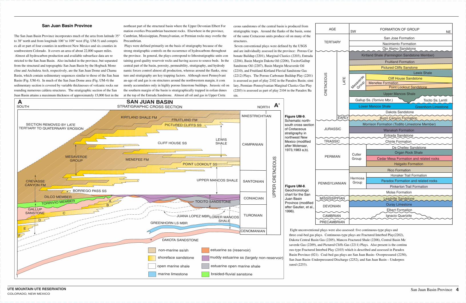
Figure UM-8. Geochronologic chart for the San Juan Basin Province (modified after Gautier, et al., 1996).
Figure UM-9. Schematic north-south cross section of Cretaceous stratigraphy innorthwest New Mexico (modified after Molenaar, 1973,1983 a,b).
SAN JUAN BASINSTRATIGRAPHIC CROSS SECTION
KIRTLAND SHALE FM
SOUTHA
A'NORTH
MAESTRICHTIAN
CAMPANIAN
SANTONIAN
FRUITLAND FM
PICTURED CLIFFS SS
CLIFF HOUSE SSLEWISSHALE
MENEFEE FMMESAVERDE
GROUP
SECTION REMOVED BY LATE TERTIARY TO QUATERNARY EROSION
CREVASSECANYON FM
BORREGO PASS SS
DILCO MEMBER
TORRIVIO MEMBER
GALLUPSANSTONE
AB
C
D
E
F
POINT LOOKOUT SS
UPPER MANCOS SHALE
TOCITO SANDSTONECONIACIAN
TURONIAN
CENOMANIAN
JUANA LOPEZ MBR.LOWER MANCOSSHALE
GREENHORN LS MBR
DAKOTA SANDSTONE
non-marine ss/sh
shoreface sandstone
open marine shale
marine limestone
estuarine ss (reservoir)
muddy estuarine ss (largely non-reservoir)
estuarine open marine shale
braided-fluvial sanstoneU
PP
ER
CR
ETA
CE
OU
S
San Juan Basin Province
San Juan Basin Province
The San Juan Basin Province incorporates much of the area from latitude 35°
to 38° north and from longitude 106° to 109° west (Fig. UM-5) and compris
es all or part of four counties in northwest New Mexico and six counties in
southwestern Colorado. It covers an area of about 22,000 square miles.
Almost all hydrocarbon production and available subsurface data are re
stricted to the San Juan Basin. Also included in the province, but separated
from the structural and topographic San Juan Basin by the Hogback Mono
cline and Archuleta Arch, respectively, are the San Juan Dome and Chama
Basin, which contain sedimentary sequences similar to those of the San Juan
Basin (Fig. UM-4). In much of the San Juan Dome area (Fig. UM-4) the
sedimentary section is covered by variable thicknesses of volcanic rocks sur
rounding numerous caldera structures. The stratigraphic section of the San
Juan Basin attains a maximum thickness of approximately 15,000 feet in the
northeast part of the structural basin where the Upper Devonian Elbert For
mation overlies Precambrian basement rocks. Elsewhere in the province,
Cambrian, Mississippian, Pennsylvanian, or Permian rocks may overlie the
Precambrian.
Plays were defined primarily on the basis of stratigraphy because of the
strong stratigraphic controls on the occurrence of hydrocarbons throughout
the province. In general, the plays correspond to lithostratigraphic units con
taining good quality reservoir rocks and having access to source beds. In the
central part of the basin, porosity, permeability, stratigraphy, and hydrody
namic forces control almost all production, whereas around the flanks, struc
ture and stratigraphy are key trapping factors. Although most Pennsylvani
an-age oil and gas is on structures around the northwestern margin, it com
monly accumulates only in highly porous limestone buildups. Jurassic oil on
the southern margin of the basin is stratigraphically trapped in eolian dunes
at the top of the Entrada Sandstone. Almost all oil and gas in Upper Creta
ceous sandstones of the central basin is produced from
stratigraphic traps. Around the flanks of the basin, some
of the same Cretaceous units produce oil on many of the
structures.
Seven conventional plays were defined by the USGS
and are individually assessed in the province: Porous Car
bonate Buildup (2201), Marginal Clastics (2203), Entrada
(2204), Basin Margin Dakota Oil (2206), Tocito/Gallup
Sandstone Oil (2207), Basin Margin Mesaverde Oil
(2210), and Fruitland-Kirtland Fluvial Sandstone Gas
(2212) Plays. The Porous Carbonate Buildup Play (2201)
is assessed as part of play 2102 in the Paradox Basin; simi
lary, Permian–Pennsylvanian Marginal Clastics Gas Play
(2203) is assessed as part of play 2104 in the Paradox Ba
sin.
Eight unconventional plays were also assessed: five continuous-type plays and
three coal-bed gas plays. Continuous-type plays are Fractured Interbed Play(2202),
Dakota Central Basin Gas (2205), Mancos Fractured Shale (2208), Central Basin Me
saverde Gas (2209), and Pictured Cliffs Gas (2211) Plays. Also present is the continu
ous-type Fractured Interbed Play (2103) which is described and assessed in Paradox
Basin Province (021). Coal-bed gas plays are San Juan Basin– Overpressured (2250),
San Juan Basin–Underpressured Discharge (2252), and San Juan Basin – Underpres
sured (2253).
FORMATION OF GROUPAGESW NE
TERTIARYSan Jose Formation
Nacimiento FormationOjo Alamo Sandstone
Kirtland Shale (Farmington Sandstone Member)
Fruitland Formation
Pictured Cliffs Sanstone
Lewis Shale
CR
ETA
CE
OU
S
LAT
E
EARLY
Mes
aver
de
Group
Cliff House SandstoneMenefee Formation
Point Lookout Sandstone
Upper Mancos Shale
Gallup Ss. (Torrivio Mbr.) Tocito Ss. Lentil
Lower Mancos Shale Greenhorn Limestone
Dakota Sandstone
Burro Canyon Formation
Morrison Formation (Todilto Limestone Member)
Wanakah Formation
Entrada Sandstone
JURASSIC
TRIASSIC
PERMIAN
Chinle Formation
CutlerGroup
De Chelley SandstoneOrgan Rock Shale
Cedar Mesa Formation and related rocks
Halgaito Formation
Rico Formation
PENNSYLVANIAN
MISSISSIPPIAN
DEVONIAN
CAMBRIAN
PRECAMBRIAN
HermosaGroup
Honaker Trail Formation
Paradox Formation and related rocks
Pinkerton Trail Formation
Molas Formation
Leadville Sandstone
Ouray Limestone
Elbert Formation
Ignacio Quartzite
UTE MOUNTAIN UTE RESERVATIONCOLORADO, NEW MEXICO
4
UTE MOUNTAIN UTE RESERVATIONCOLORADO, NEW MEXICO
0
100
200
300
400
500 feet
VERTICAL SCALE
PRODUCING FORMATIONS
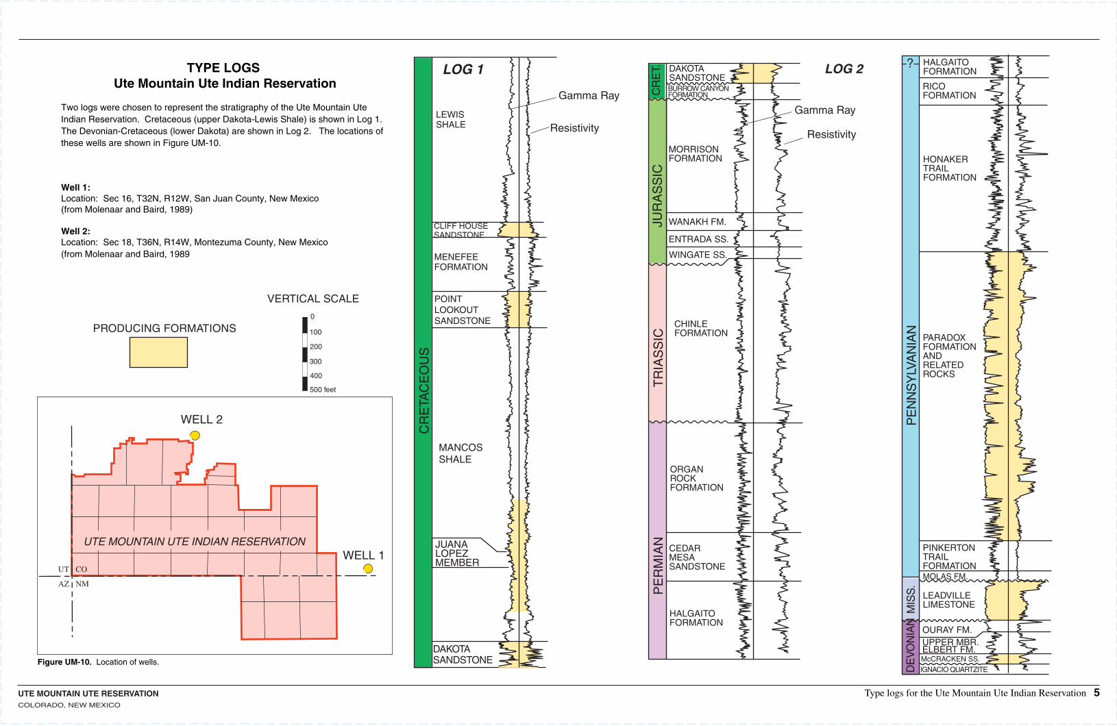
TYPE LOGS Ute Mountain Ute Indian Reservation
Two logs were chosen to represent the stratigraphy of the Ute Mountain Ute Indian Reservation. Cretaceous (upper Dakota-Lewis Shale) is shown in Log 1. The Devonian-Cretaceous (lower Dakota) are shown in Log 2. The locations of these wells are shown in Figure UM-10.
Well 1:Location: Sec 16, T32N, R12W, San Juan County, New Mexico(from Molenaar and Baird, 1989)
Well 2:Location: Sec 18, T36N, R14W, Montezuma County, New Mexico(from Molenaar and Baird, 1989
Figure UM-10. Location of wells.C
RE
T.JU
RA
SS
ICT
RIA
SS
ICP
ER
MIA
N
LOG 2DAKOTASANDSTONEBURROW CANYONFORMATION
MORRISONFORMATION
WANAKH FM.
ENTRADA SS.
WINGATE SS.
CHINLEFORMATION
ORGANROCKFORMATION
CEDARMESASANDSTONE
HALGAITOFORMATION
HALGAITOFORMATION
RICOFORMATION
HONAKERTRAILFORMATION
PARADOXFORMATIONANDRELATEDROCKS
PINKERTONTRAILFORMATIONMOLAS FM.
LEADVILLELIMESTONE
OURAY FM.UPPER MBR.ELBERT FM.McCRACKEN SS.
IGNACIO QUARTZITEDE
VO
NIA
NM
ISS
.P
EN
NS
YLV
AN
IAN
?
WELL 2
WELL 1UT CO
AZ NM
UTE MOUNTAIN UTE INDIAN RESERVATION
Type logs for the Ute Mountain Ute Indian Reservation 5
Gamma Ray
Resistivity
CR
ETA
CE
OU
S
MANCOSSHALE
JUANALOPEZMEMBER
DAKOTASANDSTONE
POINTLOOKOUTSANDSTONE
MENEFEEFORMATION
CLIFF HOUSESANDSTONE
LEWISSHALE
LOG 1
Gamma Ray
Resistivity
UTE MOUNTAIN UTE RESERVATIONCOLORADO and NEW MEXICO
1
Gas(4000, 6000, 14000)ft
Oil(2500, 6000, 14000)ft
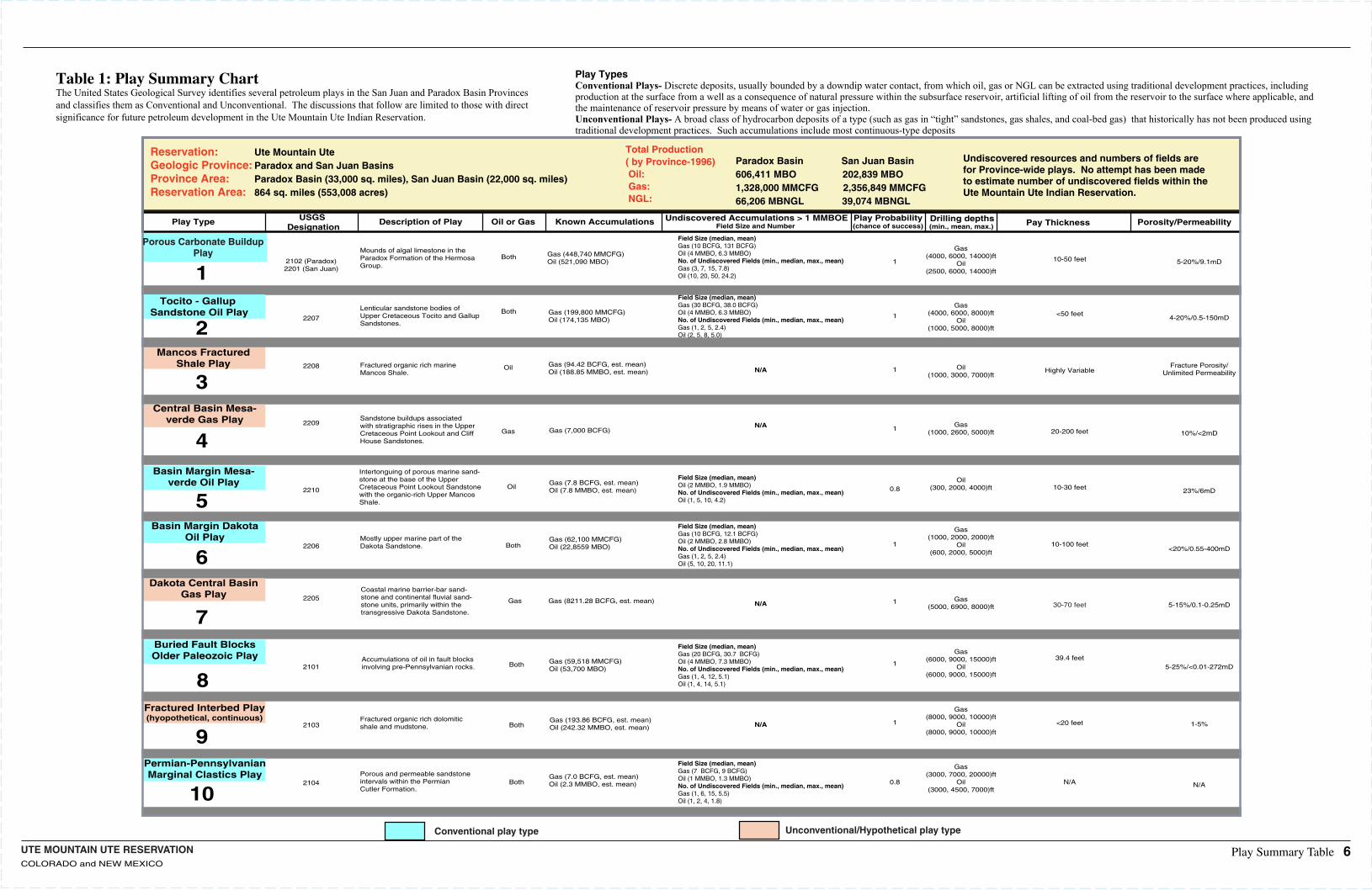
Reservation:Geologic Province:Province Area: Reservation Area:
Ute Mountain UteParadox and San Juan BasinsParadox Basin (33,000 sq. miles), San Juan Basin (22,000 sq. miles)864 sq. miles (553,008 acres)
Total Production ( by Province-1996)Oil:Gas:NGL:
Paradox Basin San Juan Basin606,411 MBO 202,839 MBO 1,328,000 MMCFG 2,356,849 MMCFG66,206 MBNGL 39,074 MBNGL
Undiscovered resources and numbers of fields arefor Province-wide plays. No attempt has been madeto estimate number of undiscovered fields within theUte Mountain Ute Indian Reservation.
Play Type USGS Designation
Porosity/PermeabilityPay ThicknessDrilling depthsPlay Probability(chance of success)
Undiscovered Accumulations > 1 MMBOEField Size and Number Known AccumulationsOil or GasDescription of Play
Mounds of algal limestone in the Paradox Formation of the HermosaGroup.
Gas (448,740 MMCFG)Oil (521,090 MBO)
Both
2
3
1
4
Play Summary Table 6
1
Tocito - Gallup Sandstone Oil Play Lenticular sandstone bodies of
Upper Cretaceous Tocito and GallupSandstones.
Gas (199,800 MMCFG)Oil (174,135 MBO)
Both
Mancos FracturedShale Play Fractured organic rich marine
Mancos Shale. 1Gas (94.42 BCFG, est. mean)Oil (188.85 MMBO, est. mean)
Oil
Central Basin Mesa-verde Gas Play
Mostly upper marine part of theDakota Sandstone.
1Gas (7,000 BCFG)Gas
5
6
7
0.8
Basin Margin Mesa-verde Oil Play
Intertonguing of porous marine sand-stone at the base of the Upper Cretaceous Point Lookout Sandstonewith the organic-rich Upper MancosShale.
Gas (7.8 BCFG, est. mean)Oil (7.8 MMBO, est. mean)Oil
Basin Margin DakotaOil Play
1Gas (62,100 MMCFG)Oil (22,8559 MBO)Both
Dakota Central BasinGas Play
Coastal marine barrier-bar sand-stone and continental fluvial sand-stone units, primarily within the transgressive Dakota Sandstone.
1Gas (8211.28 BCFG, est. mean)Gas
8
9
10
1
Buried Fault BlocksOlder Paleozoic Play Accumulations of oil in fault blocks
involving pre-Pennsylvanian rocks.Gas (59,518 MMCFG)Oil (53,700 MBO)
Both
Fractured Interbed Play(hyopothetical, continuous) Fractured organic rich dolomitic
shale and mudstone.1Gas (193.86 BCFG, est. mean)
Oil (242.32 MMBO, est. mean)Both
Permian-PennsylvanianMarginal Clastics Play
2102 (Paradox)2201 (San Juan)
2207
2208
2209
2210
2206
2205
2101
2103
2104Porous and permeable sandstone intervals within the Permian Cutler Formation.
0.8Gas (7.0 BCFG, est. mean)Oil (2.3 MMBO, est. mean)Both
Table 1: Play Summary ChartThe United States Geological Survey identifies several petroleum plays in the San Juan and Paradox Basin Provinces and classifies them as Conventional and Unconventional. The discussions that follow are limited to those with directsignificance for future petroleum development in the Ute Mountain Ute Indian Reservation.
Conventional play type Unconventional/Hypothetical play type
Porous Carbonate BuildupPlay
Sandstone buildups associated with stratigraphic rises in the UpperCretaceous Point Lookout and CliffHouse Sandstones.
Field Size (median, mean)Gas (10 BCFG, 131 BCFG)Oil (4 MMBO, 6.3 MMBO) No. of Undiscovered Fields (min., median, max., mean)Gas (3, 7, 15, 7.8)Oil (10, 20, 50, 24.2)
Field Size (median, mean)Gas (30 BCFG, 38.0 BCFG)Oil (4 MMBO, 6.3 MMBO) No. of Undiscovered Fields (min., median, max., mean)Gas (1, 2, 5, 2.4)Oil (2, 5, 8, 5.0)
N/A
N/A
Field Size (median, mean)Oil (2 MMBO, 1.9 MMBO) No. of Undiscovered Fields (min., median, max., mean)Oil (1, 5, 10, 4.2)
Field Size (median, mean)Gas (10 BCFG, 12.1 BCFG)Oil (2 MMBO, 2.8 MMBO) No. of Undiscovered Fields (min., median, max., mean)Gas (1, 2, 5, 2.4)Oil (5, 10, 20, 11.1)
N/A
N/A
Field Size (median, mean)Gas (20 BCFG, 30.7 BCFG)Oil (4 MMBO, 7.3 MMBO) No. of Undiscovered Fields (min., median, max., mean)Gas (1, 4, 12, 5.1)Oil (1, 4, 14, 5.1)
Field Size (median, mean)Gas (7 BCFG, 9 BCFG)Oil (1 MMBO, 1.3 MMBO) No. of Undiscovered Fields (min., median, max., mean)Gas (1, 6, 15, 5.5)Oil (1, 2, 4, 1.8)
(min., mean, max.)
Gas(4000, 6000, 8000)ft
Oil(1000, 5000, 8000)ft
Oil(1000, 3000, 7000)ft
Gas(1000, 2600, 5000)ft
Oil(300, 2000, 4000)ft
Gas(1000, 2000, 2000)ft
Oil(600, 2000, 5000)ft
Gas(5000, 6900, 8000)ft
Gas(6000, 9000, 15000)ft
Oil(6000, 9000, 15000)ft
Gas(8000, 9000, 10000)ft
Oil(8000, 9000, 10000)ft
Gas(3000, 7000, 20000)ft
Oil(3000, 4500, 7000)ft
10-50 feet
<50 feet
Highly Variable
20-200 feet
10-30 feet
10-100 feet
30-70 feet
39.4 feet
<20 feet
N/A
5-20%/9.1mD
4-20%/0.5-150mD
Fracture Porosity/Unlimited Permeability
10%/<2mD
23%/6mD
<20%/0.55-400mD
5-15%/0.1-0.25mD
5-25%/<0.01-272mD
1-5%
N/A
Play TypesConventional Plays- Discrete deposits, usually bounded by a downdip water contact, from which oil, gas or NGL can be extracted using traditional development practices, including production at the surface from a well as a consequence of natural pressure within the subsurface reservoir, artificial lifting of oil from the reservoir to the surface where applicable, and the maintenance of reservoir pressure by means of water or gas injection.Unconventional Plays- A broad class of hydrocarbon deposits of a type (such as gas in “tight” sandstones, gas shales, and coal-bed gas) that historically has not been produced using traditional development practices. Such accumulations include most continuous-type deposits
UTE MOUNTAIN UTE RESERVATIONCOLORADO AND NEW MEXICO
A
A'
38
110 108
38
o o
oo
108o110o
UT
AZ
CO
NM
EXPLANATION
Paradox BasinProvince
San Juan BasinProvince
Ute Mt. Ute. IndianReservation
Play Boundary
A
A'
Locationof CrossSection
SCALE
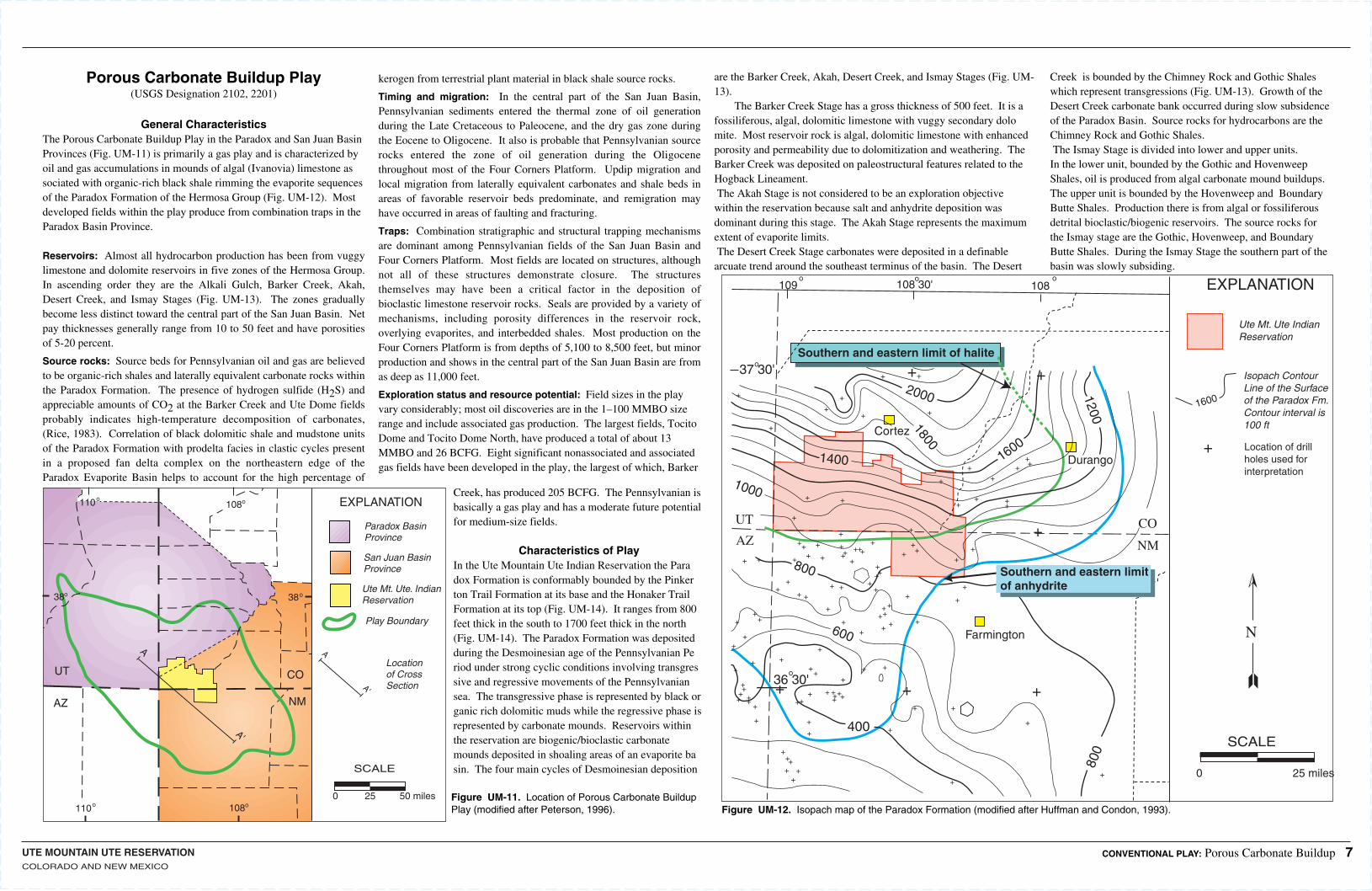
0 25 50 miles Figure UM-11. Location of Porous Carbonate Buildup Play (modified after Peterson, 1996). Figure UM-12. Isopach map of the Paradox Formation (modified after Huffman and Condon, 1993).
Porous Carbonate Buildup Play(USGS Designation 2102, 2201)
General CharacteristicsThe Porous Carbonate Buildup Play in the Paradox and San Juan Basin Provinces (Fig. UM-11) is primarily a gas play and is characterized by oil and gas accumulations in mounds of algal (Ivanovia) limestone associated with organic-rich black shale rimming the evaporite sequences of the Paradox Formation of the Hermosa Group (Fig. UM-12). Most developed fields within the play produce from combination traps in the Paradox Basin Province.
Reservoirs: Almost all hydrocarbon production has been from vuggy limestone and dolomite reservoirs in five zones of the Hermosa Group. In ascending order they are the Alkali Gulch, Barker Creek, Akah, Desert Creek, and Ismay Stages (Fig. UM-13). The zones gradually become less distinct toward the central part of the San Juan Basin. Net pay thicknesses generally range from 10 to 50 feet and have porosities of 5-20 percent.
Source rocks: Source beds for Pennsylvanian oil and gas are believed to be organic-rich shales and laterally equivalent carbonate rocks within the Paradox Formation. The presence of hydrogen sulfide (H2S) and appreciable amounts of CO2 at the Barker Creek and Ute Dome fields probably indicates high-temperature decomposition of carbonates, (Rice, 1983). Correlation of black dolomitic shale and mudstone units of the Paradox Formation with prodelta facies in clastic cycles present in a proposed fan delta complex on the northeastern edge of the Paradox Evaporite Basin helps to account for the high percentage of
kerogen from terrestrial plant material in black shale source rocks.
Timing and migration: In the central part of the San Juan Basin, Pennsylvanian sediments entered the thermal zone of oil generation during the Late Cretaceous to Paleocene, and the dry gas zone during the Eocene to Oligocene. It also is probable that Pennsylvanian source rocks entered the zone of oil generation during the Oligocene throughout most of the Four Corners Platform. Updip migration and local migration from laterally equivalent carbonates and shale beds in areas of favorable reservoir beds predominate, and remigration may have occurred in areas of faulting and fracturing.
Traps: Combination stratigraphic and structural trapping mechanisms are dominant among Pennsylvanian fields of the San Juan Basin and Four Corners Platform. Most fields are located on structures, although not all of these structures demonstrate closure. The structures themselves may have been a critical factor in the deposition of bioclastic limestone reservoir rocks. Seals are provided by a variety of mechanisms, including porosity differences in the reservoir rock, overlying evaporites, and interbedded shales. Most production on the Four Corners Platform is from depths of 5,100 to 8,500 feet, but minor production and shows in the central part of the San Juan Basin are from as deep as 11,000 feet.
Exploration status and resource potential: Field sizes in the play vary considerably; most oil discoveries are in the 1–100 MMBO size range and include associated gas production. The largest fields, Tocito Dome and Tocito Dome North, have produced a total of about 13 MMBO and 26 BCFG. Eight significant nonassociated and associated gas fields have been developed in the play, the largest of which, Barker
Creek, has produced 205 BCFG. The Pennsylvanian is basically a gas play and has a moderate future potential for medium-size fields.
Characteristics of PlayIn the Ute Mountain Ute Indian Reservation the Paradox Formation is conformably bounded by the Pinkerton Trail Formation at its base and the Honaker Trail Formation at its top (Fig. UM-14). It ranges from 800 feet thick in the south to 1700 feet thick in the north (Fig. UM-14). The Paradox Formation was deposited during the Desmoinesian age of the Pennsylvanian Period under strong cyclic conditions involving transgressive and regressive movements of the Pennsylvanian sea. The transgressive phase is represented by black organic rich dolomitic muds while the regressive phase is represented by carbonate mounds. Reservoirs within the reservation are biogenic/bioclastic carbonate mounds deposited in shoaling areas of an evaporite basin. The four main cycles of Desmoinesian deposition
are the Barker Creek, Akah, Desert Creek, and Ismay Stages (Fig. UM-13). The Barker Creek Stage has a gross thickness of 500 feet. It is a fossiliferous, algal, dolomitic limestone with vuggy secondary dolomite. Most reservoir rock is algal, dolomitic limestone with enhanced porosity and permeability due to dolomitization and weathering. The Barker Creek was deposited on paleostructural features related to the Hogback Lineament. The Akah Stage is not considered to be an exploration objective within the reservation because salt and anhydrite deposition was dominant during this stage. The Akah Stage represents the maximum extent of evaporite limits.The Desert Creek Stage carbonates were deposited in a definable arcuate trend around the southeast terminus of the basin. The Desert
Creek is bounded by the Chimney Rock and Gothic Shales which represent transgressions (Fig. UM-13). Growth of the Desert Creek carbonate bank occurred during slow subsidence of the Paradox Basin. Source rocks for hydrocarbons are the Chimney Rock and Gothic Shales.The Ismay Stage is divided into lower and upper units. In the lower unit, bounded by the Gothic and Hovenweep Shales, oil is produced from algal carbonate mound buildups. The upper unit is bounded by the Hovenweep and Boundary Butte Shales. Production there is from algal or fossiliferous detrital bioclastic/biogenic reservoirs. The source rocks for the Ismay stage are the Gothic, Hovenweep, and Boundary Butte Shales. During the Ismay Stage the southern part of the basin was slowly subsiding.
SCALE
0 25 miles
Cortez
Durango
Farmington
2000+ +
++
++
+
+
+
+ + + +
++
++
+
+
+
++
+++
++
+++++
+++
++
++ +
++
+ +++
+
++
+
+
+
+
+
+
+++
++
+ + +
+
+
+
+
+
++
++
+
++++ ++
+
+
+++
++
+
+
+
+++
+
+ + ++ +
+
++
+
+
++
+
+
+
++++
+
1400 16001800
1200
1000
UT
AZCO
NM
800
400
600
+
+ +
+
++
+
Southern and eastern limit of halite
109 108 30' 108o o
o
o
o
37 30'
36 30'
800
1600
Ute Mt. Ute IndianReservation
EXPLANATION
Isopach ContourLine of the Surfaceof the Paradox Fm.Contour interval is100 ft
N
Location of drillholes used forinterpretation
Southern and eastern limitof anhydrite
CONVENTIONAL PLAY: Porous Carbonate Buildup 7
UTE MOUNTAIN UTE RESERVATIONCOLORADO, NEW MEXICO
DeChelly Sandstone (Upper)DeChelly Sandstone (Lower)
A'A
Organ Rock Formation
Cedar MesaSandstone
HalgaitoFormation
Rico Formation
Honaker TrailFormation
Paradox Formation
DATUM
Pinkerton TrailFormation
Molas Formation
Mississippian and lower Paleozoic rocks1000Feet
00
10 Miles
R-14-W R-13-W
A
A A'
A'
-180
0'
-180
0'
-1800'
-200
0'
-200
0'
-200
0'
-200
0'
-220
0'
-220
0'
3136
11 4
7
7
6
21LA PLATA CO., COLO.
SAN JUAN CO., N.M. 12
3131 36
T32N
T32N
6
11
17
R-14-W
P A
R A
D O
XIS
MA
Y D
ES
ER
T A
KA
H B
AR
KE
R C
RE
EK
CR
EE
K
SW
EE
T Z
ON
ES
SO
UR
ZO
NE
S
7800 8000 8200 8400 8600
SP RES
3rd
3rd
2nd
2nd
1st
1st
E.P.N.G.No. 11 UteE.P.N.G.
No. 6 UteSO. UNIONNo. 17 Barker
3rd
3rd
2nd
2nd1st
1st
1600'
2000' (-2000')
2500'
G-W(-1840')
PA
RA
DO
X
Phi
Phdc
Pha
Phbc
Phag
G-W
CONTOURDATUM
G-W(-2300')
G-W(-2430')
G-W(-2630')
BARKER CREEKPARADOX FIELD
STRUCTURE MAPDATUM: TOP DESERT CREEK
SAN JUAN CO., N.M.LA PLATA CO., COLO.
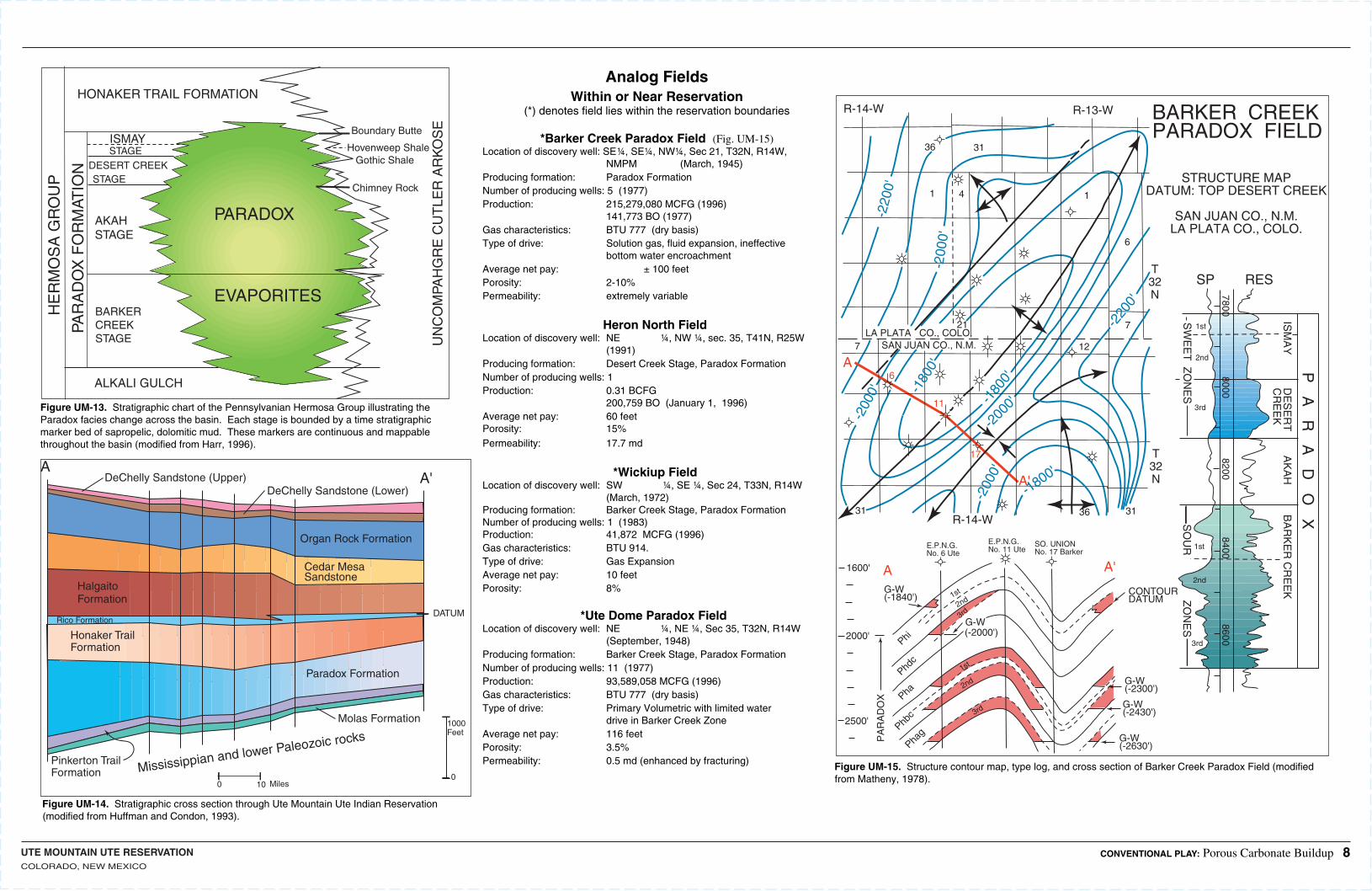
Figure UM-13. Stratigraphic chart of the Pennsylvanian Hermosa Group illustrating the Paradox facies change across the basin. Each stage is bounded by a time stratigraphic marker bed of sapropelic, dolomitic mud. These markers are continuous and mappable throughout the basin (modified from Harr, 1996).
Figure UM-14. Stratigraphic cross section through Ute Mountain Ute Indian Reservation (modified from Huffman and Condon, 1993).
Figure UM-15. Structure contour map, type log, and cross section of Barker Creek Paradox Field (modified from Matheny, 1978).
Analog FieldsWithin or Near Reservation
(*) denotes field lies within the reservation boundaries
*Barker Creek Paradox Field (Fig. UM-15)Location of discovery well:SE¼, SE¼, NW¼, Sec 21, T32N, R14W, NMPM (March, 1945)Producing formation: Paradox FormationNumber of producing wells:5 (1977)Production: 215,279,080 MCFG (1996) 141,773 BO (1977)Gas characteristics: BTU 777 (dry basis)Type of drive: Solution gas, fluid expansion, ineffective bottom water encroachmentAverage net pay: ± 100 feetPorosity: 2-10%Permeability: extremely variable
Heron North Field Location of discovery well:NE ¼, NW ¼, sec. 35, T41N, R25W (1991)Producing formation: Desert Creek Stage, Paradox FormationNumber of producing wells:1Production: 0.31 BCFG 200,759 BO (January 1, 1996)Average net pay: 60 feetPorosity: 15%Permeability: 17.7 md
*Wickiup Field Location of discovery well:SW ¼, SE ¼, Sec 24, T33N, R14W (March, 1972)Producing formation: Barker Creek Stage, Paradox Formation Number of producing wells:1 (1983)Production: 41,872 MCFG (1996)Gas characteristics: BTU 914.Type of drive: Gas ExpansionAverage net pay: 10 feetPorosity: 8%
*Ute Dome Paradox Field Location of discovery well:NE ¼, NE ¼, Sec 35, T32N, R14W (September, 1948)Producing formation: Barker Creek Stage, Paradox FormationNumber of producing wells:11 (1977)Production: 93,589,058 MCFG (1996)Gas characteristics: BTU 777 (dry basis)Type of drive: Primary Volumetric with limited water drive in Barker Creek Zone Average net pay: 116 feet Porosity: 3.5%Permeability: 0.5 md (enhanced by fracturing)
HONAKER TRAIL FORMATION
ISMAYSTAGE
DESERT CREEKSTAGE
AKAHSTAGE
BARKERCREEKSTAGE
PARADOX
EVAPORITES
HE
RM
OS
A G
RO
UP
PAR
AD
OX
FO
RM
ATIO
N
UN
CO
MPA
HG
RE
CU
TLE
R A
RK
OS
EBoundary Butte
Hovenweep Shale Gothic Shale
Chimney Rock
ALKALI GULCH
CONVENTIONAL PLAY: Porous Carbonate Buildup 8
UTE MOUNTAIN UTE RESERVATIONCOLORADO, NEW MEXICO
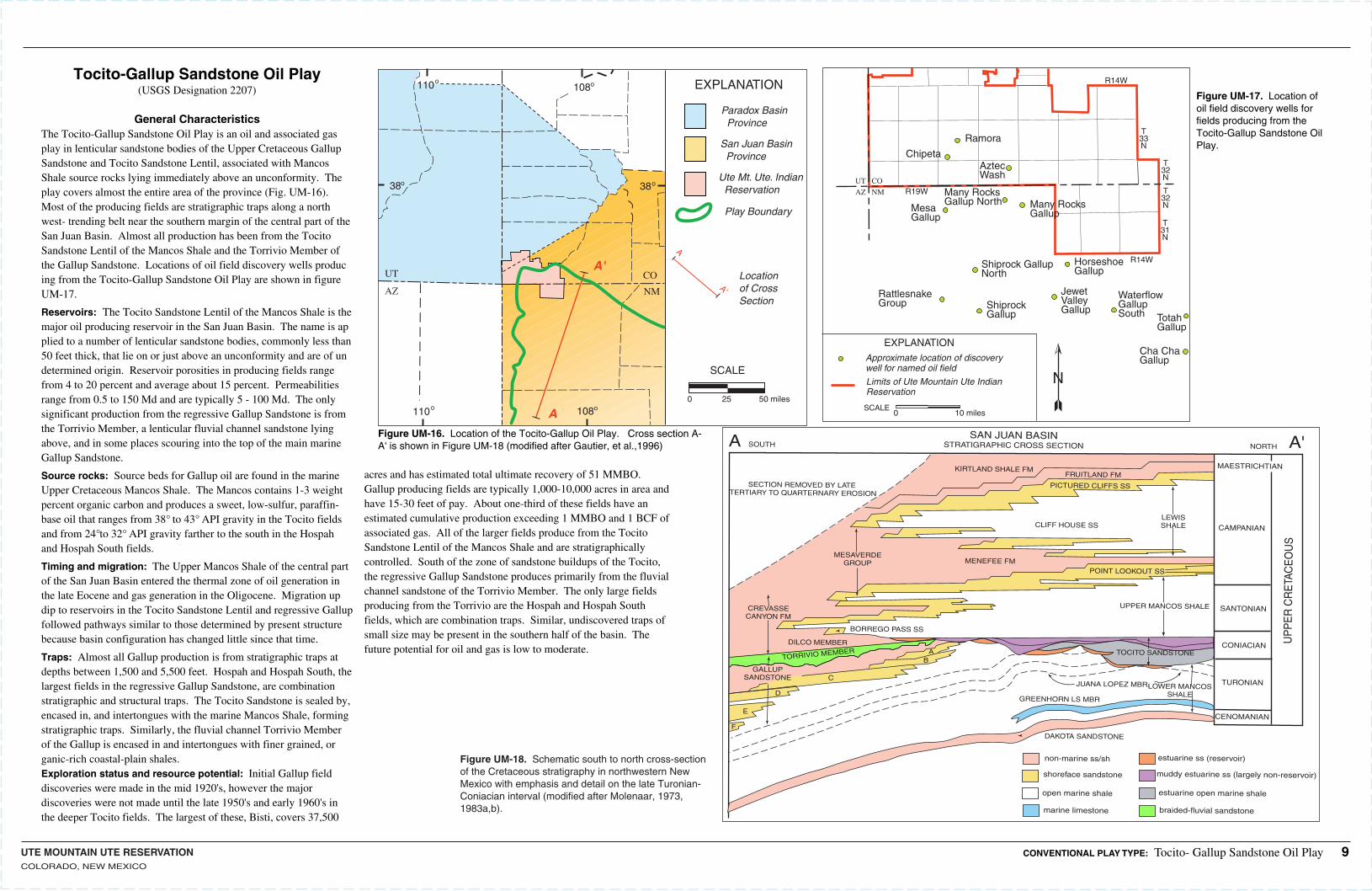
Figure UM-16. Location of the Tocito-Gallup Oil Play. Cross section A-A' is shown in Figure UM-18 (modified after Gautier, et al.,1996)
Figure UM-17. Location of oil field discovery wells for fields producing from the Tocito-Gallup Sandstone Oil Play.
38
110 108
38
o o
oo
108o110o
UT
AZ
CO
NM
EXPLANATION
Paradox Basin Province
San Juan Basin Province
Ute Mt. Ute. Indian Reservation
Play Boundary
A
A'
Locationof CrossSection
SCALE
0 25 50 miles
A
A'
Ramora
ChipetaAztecWash
MesaGallup
Many RocksGallup North Many Rocks
Gallup
Shiprock GallupNorth
HorseshoeGallup
RattlesnakeGroup Shiprock
Gallup
JewetValleyGallup
WaterflowGallupSouth Totah
Gallup
Cha ChaGallup
UT CO
AZ NM
T33N
T32N
T32N
T31N
R19W
R14W
R14W
EXPLANATION
Approximate location of discoverywell for named oil field
Limits of Ute Mountain Ute IndianReservation
SCALE0 10 miles
N
CONVENTIONAL PLAY TYPE: Tocito- Gallup Sandstone Oil Play 9
Tocito-Gallup Sandstone Oil Play(USGS Designation 2207)
General CharacteristicsThe Tocito-Gallup Sandstone Oil Play is an oil and associated gas play in lenticular sandstone bodies of the Upper Cretaceous Gallup Sandstone and Tocito Sandstone Lentil, associated with Mancos Shale source rocks lying immediately above an unconformity. The play covers almost the entire area of the province (Fig. UM-16). Most of the producing fields are stratigraphic traps along a northwest- trending belt near the southern margin of the central part of the San Juan Basin. Almost all production has been from the Tocito Sandstone Lentil of the Mancos Shale and the Torrivio Member of the Gallup Sandstone. Locations of oil field discovery wells producing from the Tocito-Gallup Sandstone Oil Play are shown in figure UM-17.
Reservoirs: The Tocito Sandstone Lentil of the Mancos Shale is the major oil producing reservoir in the San Juan Basin. The name is applied to a number of lenticular sandstone bodies, commonly less than 50 feet thick, that lie on or just above an unconformity and are of undetermined origin. Reservoir porosities in producing fields range from 4 to 20 percent and average about 15 percent. Permeabilities range from 0.5 to 150 Md and are typically 5 - 100 Md. The only significant production from the regressive Gallup Sandstone is from the Torrivio Member, a lenticular fluvial channel sandstone lying above, and in some places scouring into the top of the main marine Gallup Sandstone.
Source rocks: Source beds for Gallup oil are found in the marine Upper Cretaceous Mancos Shale. The Mancos contains 1-3 weight percent organic carbon and produces a sweet, low-sulfur, paraffin-base oil that ranges from 38° to 43° API gravity in the Tocito fields and from 24°to 32° API gravity farther to the south in the Hospah and Hospah South fields.
Timing and migration: The Upper Mancos Shale of the central part of the San Juan Basin entered the thermal zone of oil generation in the late Eocene and gas generation in the Oligocene. Migration updip to reservoirs in the Tocito Sandstone Lentil and regressive Gallup followed pathways similar to those determined by present structure because basin configuration has changed little since that time.
Traps: Almost all Gallup production is from stratigraphic traps at depths between 1,500 and 5,500 feet. Hospah and Hospah South, the largest fields in the regressive Gallup Sandstone, are combination stratigraphic and structural traps. The Tocito Sandstone is sealed by, encased in, and intertongues with the marine Mancos Shale, forming stratigraphic traps. Similarly, the fluvial channel Torrivio Member of the Gallup is encased in and intertongues with finer grained, organic-rich coastal-plain shales.Exploration status and resource potential: Initial Gallup field discoveries were made in the mid 1920's, however the major discoveries were not made until the late 1950's and early 1960's in the deeper Tocito fields. The largest of these, Bisti, covers 37,500
acres and has estimated total ultimate recovery of 51 MMBO. Gallup producing fields are typically 1,000-10,000 acres in area and have 15-30 feet of pay. About one-third of these fields have an estimated cumulative production exceeding 1 MMBO and 1 BCF of associated gas. All of the larger fields produce from the Tocito Sandstone Lentil of the Mancos Shale and are stratigraphically controlled. South of the zone of sandstone buildups of the Tocito, the regressive Gallup Sandstone produces primarily from the fluvial channel sandstone of the Torrivio Member. The only large fields producing from the Torrivio are the Hospah and Hospah South fields, which are combination traps. Similar, undiscovered traps of small size may be present in the southern half of the basin. The future potential for oil and gas is low to moderate.
SAN JUAN BASINSTRATIGRAPHIC CROSS SECTION
KIRTLAND SHALE FM
SOUTHA A'NORTH
MAESTRICHTIAN
CAMPANIAN
SANTONIAN
FRUITLAND FM
PICTURED CLIFFS SS
CLIFF HOUSE SSLEWISSHALE
MENEFEE FMMESAVERDE
GROUP
SECTION REMOVED BY LATE TERTIARY TO QUARTERNARY EROSION
CREVASSECANYON FM
BORREGO PASS SS
DILCO MEMBER
TORRIVIO MEMBER
GALLUPSANDSTONE
AB
C
D
E
F
POINT LOOKOUT SS
UPPER MANCOS SHALE
TOCITO SANDSTONECONIACIAN
TURONIAN
CENOMANIAN
JUANA LOPEZ MBR.LOWER MANCOSSHALE
GREENHORN LS MBR
DAKOTA SANDSTONE
non-marine ss/sh
shoreface sandstone
open marine shale
marine limestone
estuarine ss (reservoir)
muddy estuarine ss (largely non-reservoir)
estuarine open marine shale
braided-fluvial sandstone
UP
PE
R C
RE
TAC
EO
US
Figure UM-18. Schematic south to north cross-section of the Cretaceous stratigraphy in northwestern New Mexico with emphasis and detail on the late Turonian-Coniacian interval (modified after Molenaar, 1973, 1983a,b).
UTE MOUNTAIN UTE RESERVATIONCOLORADO AND NEW MEXICO
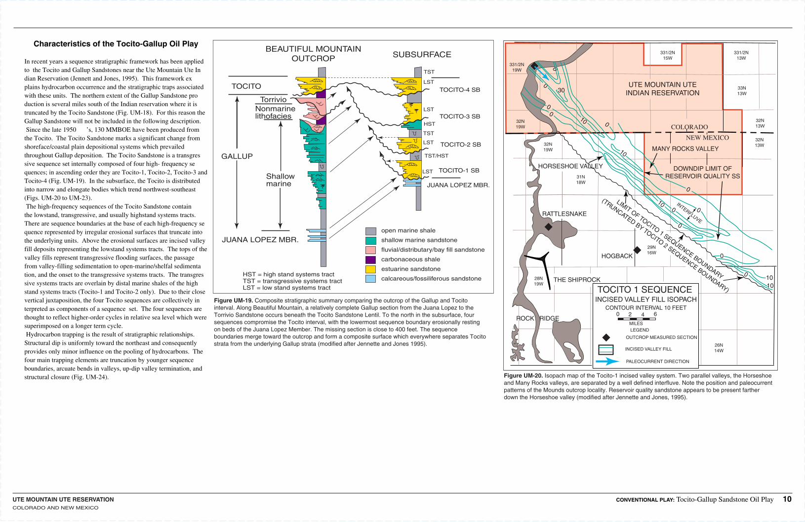
Figure UM-20. Isopach map of the Tocito-1 incised valley system. Two parallel valleys, the Horseshoe and Many Rocks valleys, are separated by a well defined interfluve. Note the position and paleocurrent patterns of the Mounds outcrop locality. Reservoir quality sandstone appears to be present farther down the Horseshoe valley (modified after Jennette and Jones, 1995).
Figure UM-19. Composite stratigraphic summary comparing the outcrop of the Gallup and Tocito interval. Along Beautiful Mountain, a relatively complete Gallup section from the Juana Lopez to the Torrivio Sandstone occurs beneath the Tocito Sandstone Lentil. To the north in the subsurface, four sequences compromise the Tocito interval, with the lowermost sequence boundary erosionally resting on beds of the Juana Lopez Member. The missing section is close to 400 feet. The sequence boundaries merge toward the outcrop and form a composite surface which everywhere separates Tocito strata from the underlying Gallup strata (modified after Jennette and Jones 1995).
31N18W
32N19W
33N13W
32N19W
331/2N19W
331/2N15W
331/2N13W
32N13W
32N13W
29N16W
26N14W
28N19W
THE SHIPROCK
ROCK RIDGE
RATTLESNAKE
COLORADO
NEW MEXICO
TOCITO 1 SEQUENCEINCISED VALLEY FILL ISOPACH
CONTOUR INTERVAL 10 FEET0 2 4 6
MILESLEGEND
OUTCROP MEASURED SECTION
INCISED VALLEY FILL
PALEOCURRENT DIRECTION
HORSESHOE VALLEY
MANY ROCKS VALLEY
DOWNDIP LIMIT OFRESERVOIR QUALITY SS
0
1010
0
00
0
0
0
0
010
10
10
0
LIMIT OF TOCITO 1 SEQUENCE BOUNDARY
(TRUNCATED BY TOCITO 2 SEQUENCE BOUNDARY)
HOGBACK0
30
INTERFLUVE
UTE MOUNTAIN UTEINDIAN RESERVATION
BEAUTIFUL MOUNTAINOUTCROP SUBSURFACE
TOCITO
GALLUP
JUANA LOPEZ MBR.
TOCITO-4 SB
TOCITO-3 SB
TOCITO-2 SB
TOCITO-1 SB
Nonmarinelithofacies
Torrivio
Shallowmarine
TST
TST
TST/HST
LST
LST
LST
LST
HST
JUANA LOPEZ MBR.
HST = high stand systems tractTST = transgressive systems tractLST = low stand systems tract
open marine shale
shallow marine sandstone
fluvial/distributary/bay fill sandstone
carbonaceous shale
estuarine sandstone
calcareous/fossiliferous sandstone
CONVENTIONAL PLAY: Tocito-Gallup Sandstone Oil Play 10
Characteristics of the Tocito-Gallup Oil Play
In recent years a sequence stratigraphic framework has been applied to the Tocito and Gallup Sandstones near the Ute Mountain Ute Indian Reservation (Jennett and Jones, 1995). This framework explains hydrocarbon occurrence and the stratigraphic traps associated with these units. The northern extent of the Gallup Sandstone production is several miles south of the Indian reservation where it is truncated by the Tocito Sandstone (Fig. UM-18). For this reason the Gallup Sandstone will not be included in the following description.Since the late 1950 ’s, 130 MMBOE have been produced from the Tocito. The Tocito Sandstone marks a significant change from shoreface/coastal plain depositional systems which prevailed throughout Gallup deposition. The Tocito Sandstone is a transgressive sequence set internally composed of four high- frequency sequences; in ascending order they are Tocito-1, Tocito-2, Tocito-3 and Tocito-4 (Fig. UM-19). In the subsurface, the Tocito is distributed into narrow and elongate bodies which trend northwest-southeast (Figs. UM-20 to UM-23).The high-frequency sequences of the Tocito Sandstone contain the lowstand, transgressive, and usually highstand systems tracts. There are sequence boundaries at the base of each high-frequency sequence represented by irregular erosional surfaces that truncate into the underlying units. Above the erosional surfaces are incised valley fill deposits representing the lowstand systems tracts. The tops of the valley fills represent transgressive flooding surfaces, the passage from valley-filling sedimentation to open-marine/shelfal sedimentation, and the onset to the transgressive systems tracts. The transgressive systems tracts are overlain by distal marine shales of the highstand systems tracts (Tocito-1 and Tocito-2 only). Due to their close vertical juxtaposition, the four Tocito sequences are collectively interpreted as components of a sequence set. The four sequences are thought to reflect higher-order cycles in relative sea level which were superimposed on a longer term cycle. Hydrocarbon trapping is the result of stratigraphic relationships. Structural dip is uniformly toward the northeast and consequently provides only minor influence on the pooling of hydrocarbons. The four main trapping elements are truncation by younger sequence boundaries, arcuate bends in valleys, up-dip valley termination, and structural closure (Fig. UM-24).
UTE MOUNTAIN UTE RESERVATIONCOLORADO, NEW MEXICO
30N20W
32N20W
32N20W
33N20W
331/2N20W
331/2N15W
331/2N13W
32N13W
32N13W
331/2N9W
33N9W
32N9W
32N10W
24N13W
26N17W
28N20W
23N17W
23N10W
29N10W
THE SHIPROCK
ROCK RIDGE
BEAUTIFUL MOUNTAIN
RATTLESNAKE
COLORADO
NEW MEXICO
TOCITO 2 SEQUENCEINCISED VALLEY FILL ISOPACH
CONTOUR INTERVAL 10 FEET
0 2 4 6
MILES
LEGEND
OUTCROP MEASURED SECTION
INCISED VALLEY FILL
0
0
0 00 0
0
00
0
0
0
0
0
20
10
10
0
10 10
TOCITO 2 TRUNCATED BY TOCITO 3
TOCITO 2 TRUNCATED BY TOCITO 3
TOCITO 2 TRUNCATED
BY TOCITO 3
TOCITO 2 TRUNCATED BY TOCITO 3
TOCITO 2 TRUNCATED BY TOCITO 3
HOGBACK
0
INTERFLUVE
INTERFLUVE
INTERFLUVE
INTERFLUVE
INTERFLUVE
VALLEY
CHA CHA VALLEY
WATERFLOW VALLEY
BISTI VALLEY
20
10
10
30
UTE MOUNTAIN UTEINDIAN RESERVATION
30N20W
31N20W
32N20W
32N20W
33N20W
331/2N20W
331/2N15W
331/2N13W
33N13W
30N13W
331/2N9W
33N9W
32N9W
31N10W
29N15W
24N13W
26N17W
28N20W
23N18W
23N10W
29N10W
THE SHIPROCK
BEAUTIFUL MOUNTAIN
RATTLESNAKE
COLORADO
NEW MEXICO
TOCITO 3 SEQUENCEINCISED VALLEY FILL ISOPACH
0 2 4 6
MILES
LEGEND
OUTCROP MEASURED SECTION
INCISED VALLEY FILL 0PARTIALLY TRUNCATED BYOVERLYING SEQUENCE
HOGBACKTOCITO 3 THINNED BY TOCITO 4 TRUNCATION
30
50
30
30
30
50
10
10
10
10
VERDE VALLEY
THINNED BY TOCITO 4 TRUNCATION
10
20
20
70
20
5050
10
10
10
20
20
20
UTE MOUNTAIN UTEINDIAN RESERVATION
WATERFLOW VALLEY
BISTI VALLEY
ROCK RIDGE
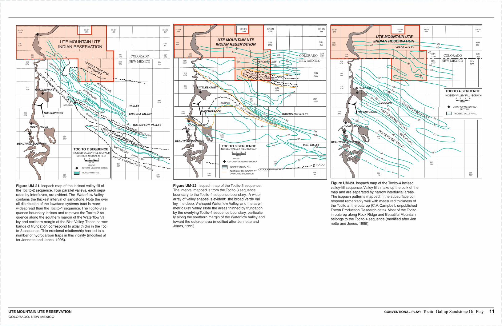
Figure UM-21. Isopach map of the incised valley fill of the Tocito-2 sequence. Four parallel valleys, each separated by interfluves, are evident. The Waterflow Valley contains the thickest interval of sandstone. Note the overall distribution of the lowstand systems tract is more widespread than the Tocito-1 sequence. The Tocito-3 sequence boundary incises and removes the Tocito-2 sequence along the southern margin of the Waterflow Valley and northern margin of the Bisti Valley. These narrow bands of truncation correspond to axial thicks in the Tocito-3 sequence. This erosional relationship has led to a number of hydrocarbon traps in this vicinity (modified after Jennette and Jones, 1995).
Figure UM-22. Isopach map of the Tocito-3 sequence. The interval mapped is from the Tocito-3 sequence boundary to the Tocito-4 sequence boundary. A wider array of valley shapes is evident: the broad Verde Valley, the deep, V-shaped Waterflow Valley, and the asymmetric Bisti Valley. Note the areas thinned by truncation by the overlying Tocito-4 sequence boundary, particularly along the southern margin of the Waterflow Valley and toward the outcrop area (modified after Jennette and Jones, 1995).
Figure UM-23. Isopach map of the Tocito-4 incised valley-fill sequence. Valley fills make up the bulk of the map and are separated by narrow interfluvial areas. The isopach patterns mapped in the subsurface correspond remarkably well with measured thickness of the Tocito at the outcrop (C.V. Campbell, unpublished Exxon Production Research data). Most of the Tocito in outcrop along Rock Ridge and Beautiful Mountain belongs to the Tocito-4 sequence (modified after Jennette and Jones, 1995).
30N20W
31N20W
32N20W
32N20W
33N20W
331/2N20W
331/2N15W
331/2N13W
32N13W
32N13W
331/2N9W
33N9W
32N9W
32N10W
24N13W
26N17W
28N20W
23N17W
23N10W
ROCK RIDGE
RATTLESNAKE
COLORADO
NEW MEXICO
TOCITO 4 SEQUENCEINCISED VALLEY FILL ISOPACH
0 2 4 6
MILES
OUTCROP MEASUREDSECTION
INCISED VALLEY FILL
ROCK RIDGE VALLEY
RATTLESNAKE VALLEY
WATERFLOW VALLEY
VERDE VALLEY
0 10
10
10
20
20
50
50
40
40
2020
20
0
01010
30
30
60
20
20
20
INTERFLUVE
HOGBACK
10
30
3040
40
40
40
4030
?
?
UTE MOUNTAIN UTEINDIAN RESERVATION
THE SHIPROCK
BEAUTIFUL MOUNTAIN
CONVENTIONAL PLAY: Tocito-Gallup Sandstone Oil Play 11
UTE MOUNTAIN UTE RESERVATIONCOLORADO, NEW MEXICO
INCISED VALLEY TRAPPING MECHANISM1. VALLEY CHANGES DIRECTION
Horseshoe Field 40 MOEBCha Cha Field 14 MOEBMany Rocks Field9 MOEBTotah Field 6 MOEB
Bisti Field54 MOEBGallagos Field10 MOEB
TOCITO-3 SEQUENCE ABOVEHorseshoe Field
2. VALLEY TRUNCATED BY YOUNGER SEQUENCE BOUNDARY
3. VALLEY TERMINATION
0'
15'
0'
5'
5'
5'10'
R16W
R17W
R18W
T32N
T31N
MANY ROCKS GALLUP NORTH
MESAGALLUP
MANY ROCKSGALLUP
HORSESHOEGALLUP
Many Rocks HorseshoeGallup Area
SAN JUAN COUNTY, NM
ISOPACH MAPUPPER PAY SANDISOPACH INTERVAL 5'
R16W
R18W
T32N
T31N
MANY ROCKS GALLUP NORTH
MESAGALLUP
MANY ROCKSGALLUP
HORSESHOEGALLUP
MANY ROCKSHORSESHOE GALLUP AREA
SAN JUAN CO., N.M.
ISOPACH MAPUPPER PAY SAND
ISOPACH INTERVAL 5', 10'
0'0'
10'
5'
15'
0'
0'
0'
0'
20'
40'
5'
10'
10'
30'
30'
20'
R16WR17W
UD
JUANALOPEZ
LOWER PAY SAND
SBLST
GR IND.
GR IND. GR IND. GR IND. GR IND.GR IND.
SKELLYSW 26-32N-17W
CURTIS - LITTLESE 27-32N-17W
CURTIS - LITTLESE 27-32N-17W
CURTIS - LITTLESE 27-32N-17W
CURTIS - LITTLESE 27-32N-17W
CURTIS - LITTLESE 28-32N-17W
MANY ROCKS GALLUP FIELDStratigraphic Cross Section
A'A
1700
1700
1600
1100
1100
1200
1200 17 00
Analog Fields Near the Reservation
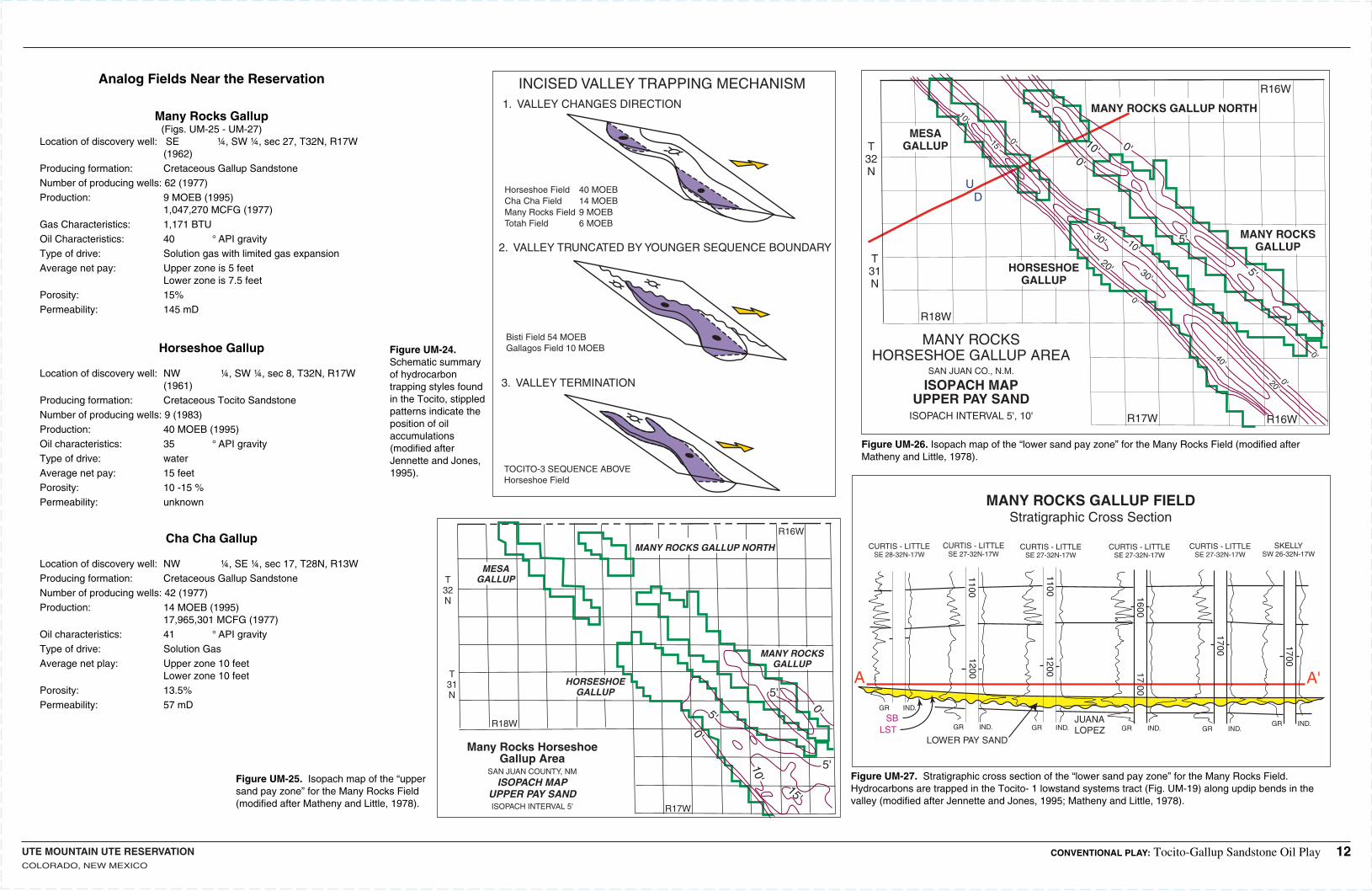
Many Rocks Gallup(Figs. UM-25 - UM-27)
Location of discovery well: SE ¼, SW ¼, sec 27, T32N, R17W (1962)Producing formation: Cretaceous Gallup SandstoneNumber of producing wells:62 (1977)Production: 9 MOEB (1995) 1,047,270 MCFG (1977)Gas Characteristics: 1,171 BTUOil Characteristics: 40 ° API gravityType of drive: Solution gas with limited gas expansionAverage net pay: Upper zone is 5 feet Lower zone is 7.5 feetPorosity: 15%Permeability: 145 mD
Horseshoe Gallup
Location of discovery well:NW ¼, SW ¼, sec 8, T32N, R17W (1961)Producing formation: Cretaceous Tocito SandstoneNumber of producing wells:9 (1983)Production: 40 MOEB (1995)Oil characteristics: 35 ° API gravityType of drive: waterAverage net pay: 15 feetPorosity: 10 -15 %Permeability: unknown
Cha Cha Gallup
Location of discovery well:NW ¼, SE ¼, sec 17, T28N, R13WProducing formation: Cretaceous Gallup SandstoneNumber of producing wells:42 (1977)Production: 14 MOEB (1995) 17,965,301 MCFG (1977)Oil characteristics: 41 ° API gravityType of drive: Solution GasAverage net play: Upper zone 10 feet Lower zone 10 feetPorosity: 13.5%Permeability: 57 mD
Figure UM-24. Schematic summary of hydrocarbon trapping styles found in the Tocito, stippled patterns indicate the position of oil accumulations (modified after Jennette and Jones, 1995).
Figure UM-25. Isopach map of the “upper sand pay zone” for the Many Rocks Field (modified after Matheny and Little, 1978).
Figure UM-26. Isopach map of the “lower sand pay zone” for the Many Rocks Field (modified after Matheny and Little, 1978).
Figure UM-27. Stratigraphic cross section of the “lower sand pay zone” for the Many Rocks Field. Hydrocarbons are trapped in the Tocito- 1 lowstand systems tract (Fig. UM-19) along updip bends in the valley (modified after Jennette and Jones, 1995; Matheny and Little, 1978).
CONVENTIONAL PLAY: Tocito-Gallup Sandstone Oil Play 12
UTE MOUNTAIN UTE RESERVATIONCOLORADO, NEW MEXICO
38
110 108
38
o o
oo
108o110o
UT
AZ
CO
NM
EXPLANATION
Paradox Basin Province
San Juan Basin Province
Ute Mt. Ute. Indian Reservation
Play Boundary
A
A'
Locationof CrossSection
SCALE
0 25 50 miles
A
A'
3000
MANCOS RIVER
VERDELAPLATAGALLUP
UT CO
AZ NM
6000
5000
4000
Man
cos
Creek
Mon
oclin
e
Ho
gb
ack
Mo
no
clin
e
EXPLANATION
Approximate location of discovery wellfor named oil field
Limits of Ute Mountain Ute Indian Reservation
Structure contour line drawn on base of Dakota Sandstone.
C. I. = 600 feet
0 10 miles
SCALE
N
T40S
T41S
T41S
T42S
R18W R17W
T33N
T32N
"Skelly zone"
Tocito Ss. lentil
Gallegos field
Bisti field
Gallup
Upper Mancos Shale
Dalton Ss.
Dilco
Borrego Pass lentil(Stray Ss)
200ft
00 10mi
A A'SW NE
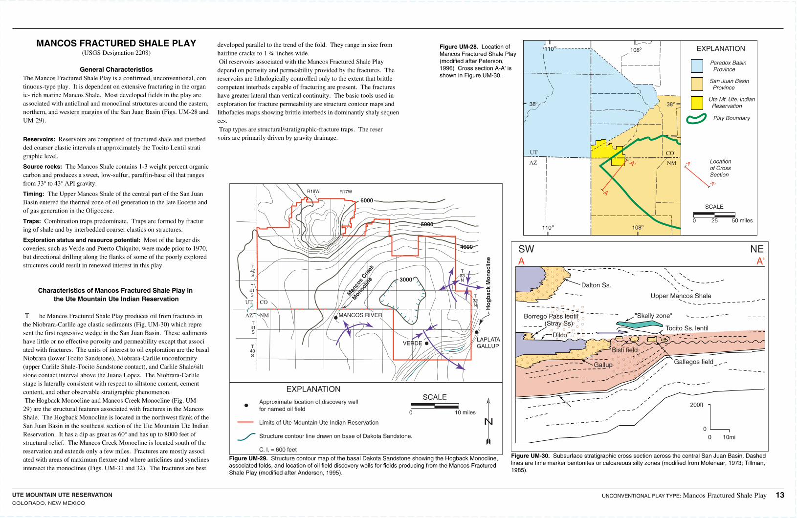
Figure UM-30. Subsurface stratigraphic cross section across the central San Juan Basin. Dashed lines are time marker bentonites or calcareous silty zones (modified from Molenaar, 1973; Tillman, 1985).
Figure UM-28. Location of Mancos Fractured Shale Play (modified after Peterson, 1996) Cross section A-A' is shown in Figure UM-30.
Figure UM-29. Structure contour map of the basal Dakota Sandstone showing the Hogback Monocline, associated folds, and location of oil field discovery wells for fields producing from the Mancos Fractured Shale Play (modified after Anderson, 1995).
UNCONVENTIONAL PLAY TYPE: Mancos Fractured Shale Play 13
MANCOS FRACTURED SHALE PLAY(USGS Designation 2208)
General CharacteristicsThe Mancos Fractured Shale Play is a confirmed, unconventional, continuous-type play. It is dependent on extensive fracturing in the organic- rich marine Mancos Shale. Most developed fields in the play are associated with anticlinal and monoclinal structures around the eastern, northern, and western margins of the San Juan Basin (Figs. UM-28 and UM-29).
Reservoirs: Reservoirs are comprised of fractured shale and interbedded coarser clastic intervals at approximately the Tocito Lentil stratigraphic level.
Source rocks: The Mancos Shale contains 1-3 weight percent organic carbon and produces a sweet, low-sulfur, paraffin-base oil that ranges from 33° to 43° API gravity.
Timing: The Upper Mancos Shale of the central part of the San Juan Basin entered the thermal zone of oil generation in the late Eocene and of gas generation in the Oligocene.
Traps: Combination traps predominate. Traps are formed by fracturing of shale and by interbedded coarser clastics on structures.
Exploration status and resource potential: Most of the larger discoveries, such as Verde and Puerto Chiquito, were made prior to 1970, but directional drilling along the flanks of some of the poorly explored structures could result in renewed interest in this play.
Characteristics of Mancos Fractured Shale Play in the Ute Mountain Ute Indian Reservation
T he Mancos Fractured Shale Play produces oil from fractures in the Niobrara-Carlile age clastic sediments (Fig. UM-30) which represent the first regressive wedge in the San Juan Basin. These sediments have little or no effective porosity and permeability except that associated with fractures. The units of interest to oil exploration are the basal Niobrara (lower Tocito Sandstone), Niobrara-Carlile unconformity (upper Carlile Shale-Tocito Sandstone contact), and Carlile Shale/siltstone contact interval above the Juana Lopez. The Niobrara-Carlile stage is laterally consistent with respect to siltstone content, cement content, and other observable stratigraphic phenomenon.The Hogback Monocline and Mancos Creek Monocline (Fig. UM-29) are the structural features associated with fractures in the Mancos Shale. The Hogback Monocline is located in the northwest flank of the San Juan Basin in the southeast section of the Ute Mountain Ute Indian Reservation. It has a dip as great as 60° and has up to 8000 feet of structural relief. The Mancos Creek Monocline is located south of the reservation and extends only a few miles. Fractures are mostly associated with areas of maximum flexure and where anticlines and synclines intersect the monoclines (Figs. UM-31 and 32). The fractures are best
developed parallel to the trend of the fold. They range in size from hairline cracks to 1 ¾ inches wide.Oil reservoirs associated with the Mancos Fractured Shale Play depend on porosity and permeability provided by the fractures. The reservoirs are lithologically controlled only to the extent that brittle competent interbeds capable of fracturing are present. The fractures have greater lateral than vertical continuity. The basic tools used in exploration for fracture permeability are structure contour maps and lithofacies maps showing brittle interbeds in dominantly shaly sequences. Trap types are structural/stratigraphic-fracture traps. The reservoirs are primarily driven by gravity drainage.
UTE MOUNTAIN UTE RESERVATIONCOLORADO, NEW MEXICO
R14WR15W
CI - 200ft
T30N
T31N
VERDEFIELD
0 1 2 3 4 miles
HOGBACK M
ON
OC
LIN
E
5400
2400
4400
5200
48005000
4000
540020
00
2200
3600
3000
E
D
B
A
C
BENSON- MONTIN-GREER DRLG. CORP.
se 31 - T32N - R13W
GAMMA RAY - INDUCTION
Elev - R.K.B. 6075
La Plata Mancos No. P-31
LA PLATA GALLUP FIELDSTRUCTURAL CONTOUR MAP
35 36
2 1
33
19 22
27
34
10
30
8
31
3
T32N
T31N
R13WR14W UT
E M
OU
NTA
IN T
RIB
AL
IND
IAN
RE
SE
RVA
TIO
N
-200
-100
+420
0+3
000+400
0
+4100
+100
0+2
000
-0-
P-31
CONTOURED ON ELECTRICLOG MARKER "E" WITHIN
MANCOS SHALE
CONTOUR INTERVALS:
1000'
100'
BOUNDARY OF LA PLATAGALLUP POOL
Producing Dakota and Pennsylvanianwells within mapped area are not shown.
Analog Fields inside or near Reservation(*) denotes field lies within the reservation boundaries
*Verde Oil Field (Fig. UM-31)Location of discovery well:se ¼,sec. 14, T31 N, R15W, NMPM (September 1955)Producing formation: Fractured interval in Niobrara age Mancos ShaleNumber of producing wells:27 (1978)Production: 7,789,304 bbl. (1977)Oil characteristics: 38 ° - 42° API GravityType of drive: Gravity drainage in entire field as a “unit”
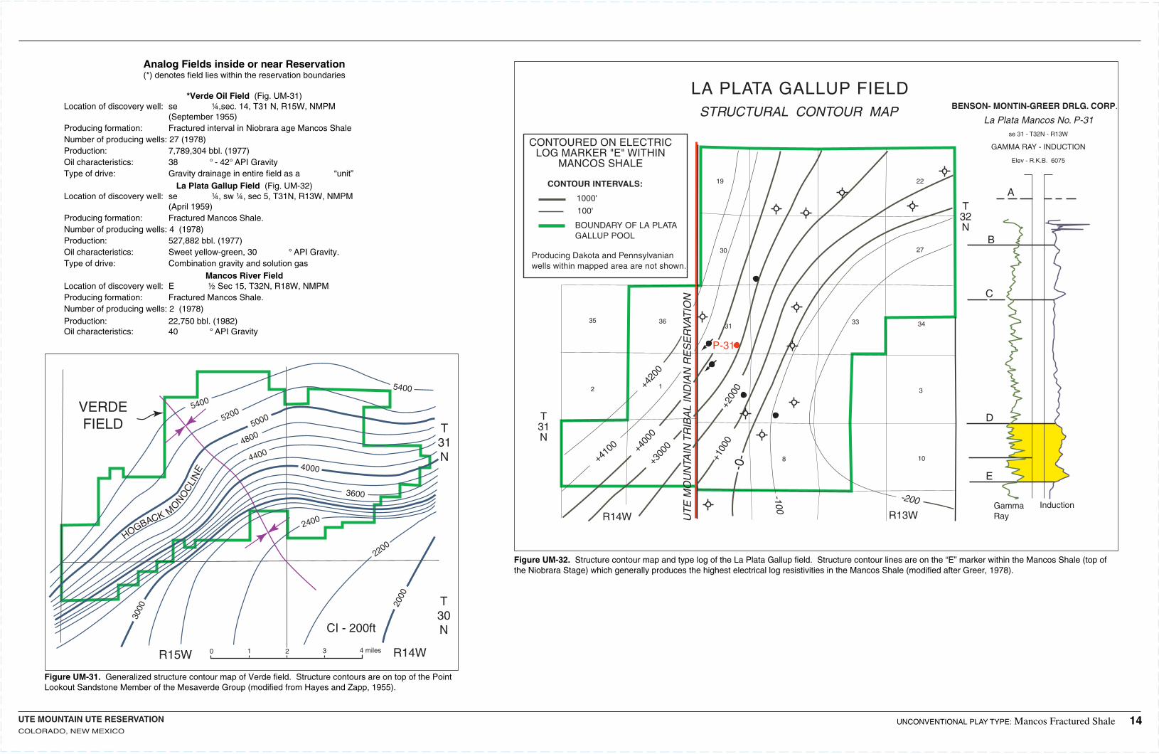
La Plata Gallup Field (Fig. UM-32)Location of discovery well:se ¼, sw ¼, sec 5, T31N, R13W, NMPM (April 1959)Producing formation: Fractured Mancos Shale.Number of producing wells:4 (1978)Production: 527,882 bbl. (1977)Oil characteristics: Sweet yellow-green, 30 ° API Gravity.Type of drive: Combination gravity and solution gas
Mancos River FieldLocation of discovery well:E ½ Sec 15, T32N, R18W, NMPMProducing formation: Fractured Mancos Shale.Number of producing wells:2 (1978)Production: 22,750 bbl. (1982)Oil characteristics: 40 ° API Gravity
Figure UM-31. Generalized structure contour map of Verde field. Structure contours are on top of the Point Lookout Sandstone Member of the Mesaverde Group (modified from Hayes and Zapp, 1955).
UNCONVENTIONAL PLAY TYPE: Mancos Fractured Shale 14
GammaRay
Induction
Figure UM-32. Structure contour map and type log of the La Plata Gallup field. Structure contour lines are on the “E” marker within the Mancos Shale (top of the Niobrara Stage) which generally produces the highest electrical log resistivities in the Mancos Shale (modified after Greer, 1978).
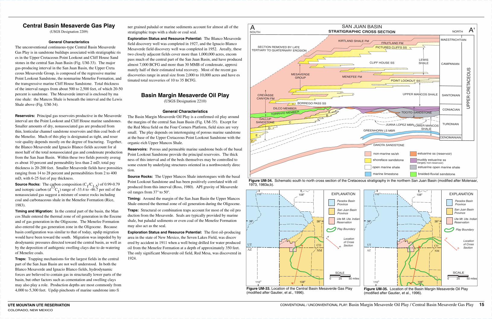
UTE MOUNTAIN UTE RESERVATIONCOLORADO, NEW MEXICO
SAN JUAN BASINSTRATIGRAPHIC CROSS SECTION
KIRTLAND SHALE FM
SOUTHA A'NORTH
MAESTRICHTIAN
CAMPANIAN
SANTONIAN
FRUITLAND FM
PICTURED CLIFFS SS
CLIFF HOUSE SSLEWISSHALE
MENEFEE FMMESAVERDE
GROUP
SECTION REMOVED BY LATE TERTIARY TO QUATERNARY EROSION
CREVASSECANYON FM
BORREGO PASS SS
DILCO MEMBER
TORRIVIO MEMBER
GALLUPSANDSTONE
AB
C
D
E
F
POINT LOOKOUT SS
UPPER MANCOS SHALE
TOCITO SANDSTONECONIACIAN
TURONIAN
CENOMANIAN
JUANA LOPEZ MBR.LOWER MANCOSSHALEGREENHORN LS MBR
DAKOTA SANDSTONE
non-marine ss/sh
shoreface sandstone
open marine shale
marine limestone
estuarine ss (reservoir)
muddy estuarine ss(largely non-reservoir)
estuarine open marine shale
braided-fluvial sandstone
UP
PE
R C
RE
TAC
EO
US
Figure UM-34. Schematic south to north cross section of the Cretaceous stratigraphy in the northern San Juan Basin (modified after Molenaar, 1973, 1983a,b).
Central Basin Mesaverde Gas Play(USGS Designation 2209)
General CharacteristicsThe unconventional continuous-type Central Basin Mesaverde Gas Play is in sandstone buildups associated with stratigraphic rises in the Upper Cretaceous Point Lookout and Cliff House Sandstones in the central San Juan Basin (Fig. UM-33). The major gas-producing interval in the San Juan Basin, the Upper Cretaceous Mesaverde Group, is composed of the regressive marine Point Lookout Sandstone, the nonmarine Menefee Formation, and the transgressive marine Cliff House Sandstone. Total thickness of the interval ranges from about 500 to 2,500 feet, of which 20-50 percent is sandstone. The Mesaverde interval is enclosed by marine shale: the Mancos Shale is beneath the interval and the Lewis Shale above (Fig. UM-34).
Reservoirs: Principal gas reservoirs productive in the Mesaverde interval are the Point Lookout and Cliff House marine sandstones. Smaller amounts of dry, nonassociated gas are produced from thin, lenticular channel sandstone reservoirs and thin coal beds of the Menefee. Much of this play is designated as tight, and reservoir quality depends mostly on the degree of fracturing. Together, the Blanco Mesaverde and Ignacio Blanco fields account for almost half of the total nonassociated gas and condensate production from the San Juan Basin. Within these two fields porosity averages about 10 percent and permeability less than 2 mD; total pay thickness is 20-200 feet. Smaller Mesaverde fields have porosities ranging from 14 to 28 percent and permeabilities from 2 to 400 mD, with 6-25 feet of pay thickness.
Source Rocks: The carbon composition (C1/C1-5) of 0.99-0.79 and isotopic carbon (d
13C1) range of -33.4 to -46.7 per mil of the
nonassociated gas suggest a mixture of source rocks including coal and carbonaceous shale in the Menefee Formation (Rice, 1983).
Timing and Migration: In the central part of the basin, the Mancos Shale entered the thermal zone of oil generation in the Eocene and of gas generation in the Oligocene. The Menefee Formation also entered the gas generation zone in the Oligocene. Because basin configuration was similar to that of today, updip migration would have been toward the south. Migration was impeded by hydrodynamic pressures directed toward the central basin, as well as by the deposition of authigenic swelling clays due to de-watering of Menefee coals.
Traps: Trapping mechanisms for the largest fields in the central part of the San Juan Basin are not well understood. In both the Blanco Mesaverde and Ignacio Blanco fields, hydrodynamic forces are believed to contain gas in structurally lower parts of the basin, but other factors such as cementation and swelling clays may also play a role. Production depths are most commonly from 4,000 to 5,300 feet. Updip pinchouts of marine sandstone into fi
ner grained paludal or marine sediments account for almost all of the stratigraphic traps with a shale or coal seal.
Exploration Status and Resource Potential: The Blanco Mesaverde field discovery well was completed in 1927, and the Ignacio Blanco Mesaverde field discovery well was completed in 1952. Areally, these two closely adjacent fields cover more than 1,000,000 acres, encompass much of the central part of the San Juan Basin, and have produced almost 7,000 BCFG and more than 30 MMB of condensate, approximately half of their estimated total recovery. Most of the recent gas discoveries range in areal size from 2,000 to 10,000 acres and have estimated total recoveries of 10 to 35 BCFG.
Basin Margin Mesaverde Oil Play(USGS Designation 2210)
General CharacteristicsThe Basin Margin Mesaverde Oil Play is a confirmed oil play around the margins of the central San Juan Basin (Fig. UM-35). Except for the Red Mesa field on the Four Corners Platform, field sizes are very small. The play depends on intertonguing of porous marine sandstone at the base of the Upper Cretaceous Point Lookout Sandstone with the organic-rich Upper Mancos Shale.
Reservoirs: Porous and permeable marine sandstone beds of the basal Point Lookout Sandstone provide the principal reservoirs. The thickness of this interval and of the beds themselves may be controlled to some extent by underlying structures oriented in a northwesterly direction.
Source Rocks: The Upper Mancos Shale intertongues with the basal Point Lookout Sandstone and has been positively correlated with oil produced from this interval (Ross, 1980). API gravity of Mesaverde oil ranges from 37° to 50°.
Timing: Around the margin of the San Juan Basin the Upper Mancos Shale entered the thermal zone of oil generation during the Oligocene.
Traps: Structural or combination traps account for most of the oil production from the Mesaverde. Seals are typically provided by marine shale, but paludal sediments or even coal of the Menefee Formation may also act as the seal.
Exploration Status and Resource Potential: The first oil-producing area in the state of New Mexico, the Seven Lakes Field, was discovered by accident in 1911 when a well being drilled for water produced oil from the Menefee Formation at a depth of approximately 350 feet. The only significant Mesaverde oil field, Red Mesa, was discovered in 1924.
Figure UM-35. Location of the Basin Margin Mesaverde Oil Play (modified after Gautier, et al., 1996).
Figure UM-33. Location of the Central Basin Mesaverde Gas Play (modified after Gautier, et al., 1996).
CONVENTIONAL / UNCONVENTIONAL PLAY: Basin Margin Mesaverde Oil Play / Central Basin Mesaverde Gas Play 15
38
110 108
38
o o
oo
108o110o
UT
AZCO
NM
EXPLANATION
Paradox BasinProvince
San Juan BasinProvince
Ute Mt. Ute. IndianReservation
Play Boundary
A
A'
Locationof CrossSection
SCALE
0 25 50 miles
A
A'
38
110 108
38
o o
oo
108o110o
UT
AZ
CO
NM
EXPLANATION
Paradox BasinProvince
San Juan BasinProvince
Ute Mt. Ute. IndianReservation
Play Boundary
A
A'
Locationof CrossSection
SCALE
0 25 50 miles
A
A'
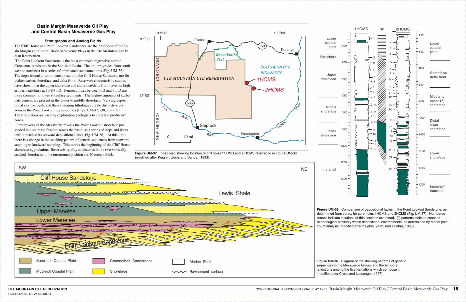
160
666
108o00'109o00'
37o30'
37o00'
0 10 mi
Cortez
Durango
Shiprock
FarmingtonAnim
as
Riv
erSan
Juan
River
NE
W M
EX
ICO
CO
LO
RA
DO
UTE MOUNTAIN UTE RESERVATION
Mesa Verde N.P.
SOUTHERN UTE
INDIAN RES.
1HCMS
2HCMS
Figure UM-36. Diagram of the stacking patterns of genetic sequences in the Mesaverde Group, and the temporal reflections among the five formations which compose it (modified after Cross and Lessenger, 1997).
Figure UM-37. Index map showing location of drill holes 1HCMS and 2 HCMS referred to in Figure UM-38 (modified after Keighin, Zech, and Dunbar, 1993).
Figure UM-38. Comparison of depositional facies in the Point Lookout Sandstone, as determined from cores, for core holes 1HCMS and 2HCMS (Fig. UM-37). Numbered arrows indicate locations of thin sections examined. (*) patterns indicate zones of mineralogical similarity within depositional environments, as determined by modal point-count analysis (modified after Keighin, Zech, and Dunbar, 1993).
1
1
2
2
3
3
4
4
5
5
6
6
7
7
8
8
9
9
10
10
11
11
12
12
13
13
14
14
15
15
16
16
17
17
18
18
19
20
21
22
1200
1150
1100
1050
1000
950
900
850
800
750
1300
1250
1200
1150
1100
1050
1000
950
900Lowercoastalplain
Shoreface/delta front
Middle toupper (?)shoreface
Distallowershoreface
Lowershoreface
Lowershoreface
Intershelftransition
Innershelf
Middleshoreface
Uppershoreface
Foreshore
Lowercoastal
plain
1HCMS 2HCMS*Basin Margin Mesaverde Oil Play
and Central Basin Mesaverde Gas Play
Stratigraphy and Analog FieldsThe Cliff House and Point Lookout Sandstones are the producers of the Basin Margin and Central Basin Mesaverde Plays in the Ute Mountain Ute Indian Reservation.The Point Lookout Sandstone is the most extensive regressive marine Cretaceous sandstone in the San Juan Basin. The unit progrades from southwest to northeast in a series of imbricated sandstone units (Fig. UM-36). The depositional environments present in the Cliff House Sandstone are fluvial/estuarine, shoreface, and delta front. Reservoir characteristic studies have shown that the upper shoreface and shoreface/delta front have the highest permeabilities at 10-80 mD. Permeabilities between 0.3 and 3 mD are more common to lower shoreface sediments. The highest amounts of carbonate cement are present in the lower to middle shoreface. Varying depositional environments and their changing lithologies create distinctive divisions in the Point Lookout log responses (Figs. UM-37, -38, and -39). These divisions are used by exploration geologists to correlate productive zones. Further work in the Mesaverde reveals the Point Lookout shoreface prograded in a staircase fashion across the basin, as a series of steps and risers until it reached its seaward depositional limit (Fig. UM-36). At this limit, there is a change in the stacking pattern of genetic sequences from seaward stepping to landward stepping. This marks the beginning of the Cliff House shoreface aggradation. Reservoir-quality sandstones in the two vertically stacked shorefaces at the turnaround position are 70 meters thick.
UTE MOUNTAIN UTE RESERVATIONCOLORADO, NEW MEXICO
CONVENTIONAL / UNCONVENTIONAL PLAY TYPE: Basin Margin Mesaverde Oil Play / Central Basin Mesaverde Gas Play 16
Upper Menefee
Lower Menefee
Cliff House Sandstone
Point Lookout Sandstone
Marine ShelfChannelbelt Sandstones
Shoreface Ravinement surface
Sand-rich Coastal Plain
Mud-rich Coastal Plain
Lewis Shale
SW NE
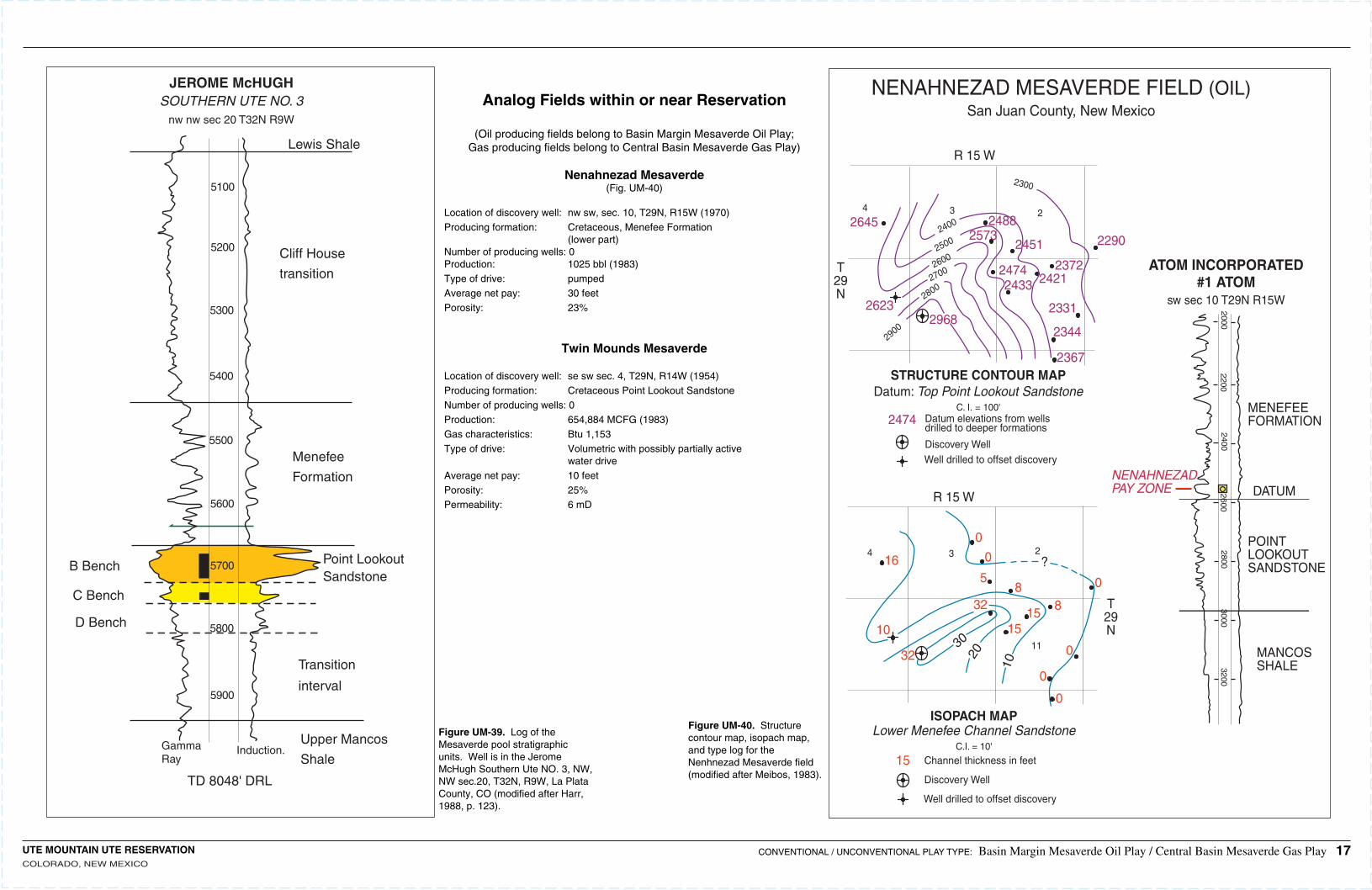
JEROME McHUGHSOUTHERN UTE NO. 3
nw nw sec 20 T32N R9W
Lewis Shale
Cliff House
transition
Menefee
Formation
Point LookoutSandstone
Transition
interval
Upper Mancos
Shale
B Bench
C Bench
D Bench
GammaRay
Induction.
TD 8048' DRL
5900
5800
5700
5600
5500
5400
5300
5200
5100
20002200
24002600
28003000
3200
MENEFEEFORMATION
DATUM
POINTLOOKOUTSANDSTONE
MANCOSSHALE
NENAHNEZADPAY ZONE
R 15 W
R 15 W
3
3 2
24
4
11
?
10
20
30
T29N
T29N
0
0
0
0
0
0
88
32
32
10
16
15
5
15
15
ISOPACH MAPLower Menefee Channel Sandstone
C.I. = 10'
Channel thickness in feet
Discovery Well
Well drilled to offset discovery
2474 Datum elevations from wellsdrilled to deeper formations
Discovery WellWell drilled to offset discovery
STRUCTURE CONTOUR MAPDatum: Top Point Lookout Sandstone
C. I. = 100'
2645
2367
2344
2331
2372
229024512573
242124742433
2488
29682623
2900
28002700260025002400
2300
NENAHNEZAD MESAVERDE FIELD (OIL)San Juan County, New Mexico
ATOM INCORPORATED#1 ATOM
sw sec 10 T29N R15W
Analog Fields within or near Reservation
(Oil producing fields belong to Basin Margin Mesaverde Oil Play;Gas producing fields belong to Central Basin Mesaverde Gas Play)
Nenahnezad Mesaverde(Fig. UM-40)
Location of discovery well:nw sw, sec. 10, T29N, R15W (1970)Producing formation: Cretaceous, Menefee Formation (lower part)Number of producing wells:0Production: 1025 bbl (1983)Type of drive: pumpedAverage net pay: 30 feetPorosity: 23%
Twin Mounds Mesaverde
Location of discovery well:se sw sec. 4, T29N, R14W (1954)Producing formation: Cretaceous Point Lookout SandstoneNumber of producing wells:0Production: 654,884 MCFG (1983)Gas characteristics: Btu 1,153Type of drive: Volumetric with possibly partially active water driveAverage net pay: 10 feetPorosity: 25%Permeability: 6 mD
Figure UM-39. Log of the Mesaverde pool stratigraphic units. Well is in the Jerome McHugh Southern Ute NO. 3, NW, NW sec.20, T32N, R9W, La Plata County, CO (modified after Harr, 1988, p. 123).
Figure UM-40. Structure contour map, isopach map, and type log for the Nenhnezad Mesaverde field (modified after Meibos, 1983).
CONVENTIONAL / UNCONVENTIONAL PLAY TYPE: Basin Margin Mesaverde Oil Play / Central Basin Mesaverde Gas Play 17UTE MOUNTAIN UTE RESERVATIONCOLORADO, NEW MEXICO
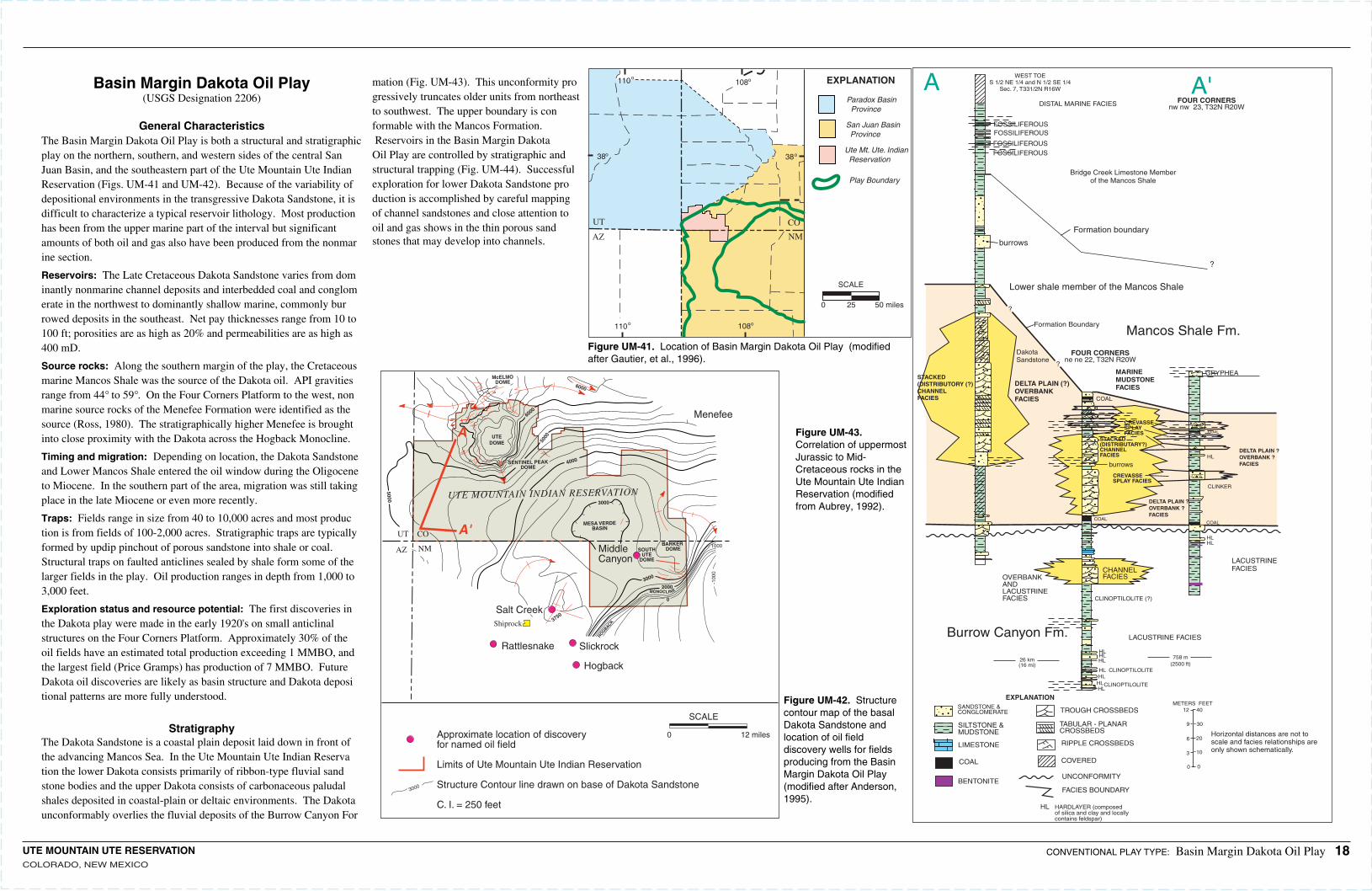
UTE MOUNTAIN UTE RESERVATIONCOLORADO, NEW MEXICO
burrows
burrows
DISTAL MARINE FACIES
FOSSILIFEROUSFOSSILIFEROUS
FOSSILIFEROUSFOSSILIFEROUS
Bridge Creek Limestone Memberof the Mancos Shale
?
?
Lower shale member of the Mancos Shale
Formation Boundary
MARINEMUDSTONEFACIES
DakotaSandstone
DELTA PLAIN (?)OVERBANKFACIES
STACKED(DISTRIBUTORY (?)CHANNELFACIES
Mancos Shale Fm.
A'A
GRYPHEA
CREVASSESPLAYFACIES
CREVASSESPLAY FACIES
STACKED(DISTRIBUTARY?)CHANNELFACIES
HL
HLHLHL
HLHL
HLHL
HL
HL
LACUSTRINEFACIES
LACUSTRINE FACIES
CLINKER
DELTA PLAIN ?OVERBANK ?FACIES
DELTA PLAIN ?OVERBANK ?FACIES
COAL
COAL
COALCOAL
CHANNELFACIES
CLINOPTILOLITE
CLINOPTILOLITE
CLINOPTILOLITE (?)
OVERBANKANDLACUSTRINEFACIES
Burrow Canyon Fm.
Formation boundary
?
WEST TOES 1/2 NE 1/4 and N 1/2 SE 1/4
Sec. 7, T331/2N R16W
26 km(16 mi)
FOUR CORNERSne ne 22, T32N R20W
FOUR CORNERSnw nw 23, T32N R20W
758 m(2500 ft)
SANDSTONE & CONGLOMERATE
SILTSTONE &MUDSTONE
LIMESTONE
COAL
BENTONITE
TROUGH CROSSBEDS
TABULAR - PLANARCROSSBEDS
RIPPLE CROSSBEDS
COVERED
UNCONFORMITY
FACIES BOUNDARY
HL HARDLAYER (composedof silica and clay and locallycontains feldspar)
METERS FEET12 40
9 30
6 20
3 10
0 0
Horizontal distances are not toscale and facies relationships areonly shown schematically.
EXPLANATION
38
110 108
38
o o
oo
108o110o
UT
AZ
CO
NM
EXPLANATION
Paradox Basin Province
San Juan Basin Province
Ute Mt. Ute. Indian Reservation
Play Boundary
SCALE
0 25 50 miles
UTEDOME
SENTINEL PEAKDOME
5000
6000
McELMODOME
5000 UTE MOUNTAIN INDIAN RESERVATION
MESA VERDEBASIN
3000
4000
3000
3000
2000MONOCLINE
0
1000
-100
0
BARKER DOMESOUTH
UTEDOME
3750
A
A'UT CO
AZ NM
6000
MiddleCanyon
Shiprock
Salt Creek
Rattlesnake Slickrock
Hogback
HOGBACK
Menefee
Approximate location of discoveryfor named oil field
Limits of Ute Mountain Ute Indian Reservation
Structure Contour line drawn on base of Dakota Sandstone
C. I. = 250 feet
0 12 miles
SCALE
Figure UM-41. Location of Basin Margin Dakota Oil Play (modified after Gautier, et al., 1996).
Figure UM-42. Structure contour map of the basal Dakota Sandstone and location of oil field discovery wells for fields producing from the Basin Margin Dakota Oil Play (modified after Anderson, 1995).
Figure UM-43. Correlation of uppermost Jurassic to Mid-Cretaceous rocks in the Ute Mountain Ute Indian Reservation (modified from Aubrey, 1992).
Basin Margin Dakota Oil Play(USGS Designation 2206)
General CharacteristicsThe Basin Margin Dakota Oil Play is both a structural and stratigraphic play on the northern, southern, and western sides of the central San Juan Basin, and the southeastern part of the Ute Mountain Ute Indian Reservation (Figs. UM-41 and UM-42). Because of the variability of depositional environments in the transgressive Dakota Sandstone, it is difficult to characterize a typical reservoir lithology. Most production has been from the upper marine part of the interval but significant amounts of both oil and gas also have been produced from the nonmarine section.
Reservoirs: The Late Cretaceous Dakota Sandstone varies from dominantly nonmarine channel deposits and interbedded coal and conglomerate in the northwest to dominantly shallow marine, commonly burrowed deposits in the southeast. Net pay thicknesses range from 10 to 100 ft; porosities are as high as 20% and permeabilities are as high as 400 mD.
Source rocks: Along the southern margin of the play, the Cretaceous marine Mancos Shale was the source of the Dakota oil. API gravities range from 44° to 59°. On the Four Corners Platform to the west, nonmarine source rocks of the Menefee Formation were identified as the source (Ross, 1980). The stratigraphically higher Menefee is brought into close proximity with the Dakota across the Hogback Monocline.
Timing and migration: Depending on location, the Dakota Sandstone and Lower Mancos Shale entered the oil window during the Oligocene to Miocene. In the southern part of the area, migration was still taking place in the late Miocene or even more recently.
Traps: Fields range in size from 40 to 10,000 acres and most production is from fields of 100-2,000 acres. Stratigraphic traps are typically formed by updip pinchout of porous sandstone into shale or coal. Structural traps on faulted anticlines sealed by shale form some of the larger fields in the play. Oil production ranges in depth from 1,000 to 3,000 feet.
Exploration status and resource potential: The first discoveries in the Dakota play were made in the early 1920's on small anticlinal structures on the Four Corners Platform. Approximately 30% of the oil fields have an estimated total production exceeding 1 MMBO, and the largest field (Price Gramps) has production of 7 MMBO. Future Dakota oil discoveries are likely as basin structure and Dakota depositional patterns are more fully understood.
StratigraphyThe Dakota Sandstone is a coastal plain deposit laid down in front of the advancing Mancos Sea. In the Ute Mountain Ute Indian Reservation the lower Dakota consists primarily of ribbon-type fluvial sandstone bodies and the upper Dakota consists of carbonaceous paludal shales deposited in coastal-plain or deltaic environments. The Dakota unconformably overlies the fluvial deposits of the Burrow Canyon For
mation (Fig. UM-43). This unconformity progressively truncates older units from northeast to southwest. The upper boundary is conformable with the Mancos Formation. Reservoirs in the Basin Margin Dakota Oil Play are controlled by stratigraphic and structural trapping (Fig. UM-44). Successful exploration for lower Dakota Sandstone production is accomplished by careful mapping of channel sandstones and close attention to oil and gas shows in the thin porous sandstones that may develop into channels.
CONVENTIONAL PLAY TYPE: Basin Margin Dakota Oil Play 18
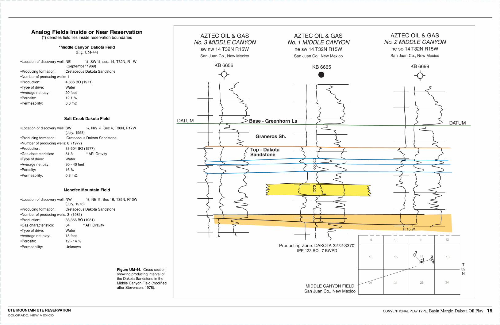
Analog Fields Inside or Near Reservation(*) denotes field lies inside reservation boundaries
*Middle Canyon Dakota Field(Fig. UM-44)
•Location of discovery well:NE ¼, SW ¼, sec. 14, T32N, R1 W (September 1969)•Producing formation: Cretaceous Dakota Sandstone•Number of producing wells:1•Production: 4,886 BO (1971)•Type of drive: Water•Average net pay: 20 feet•Porosity: 12.1 %•Permeability: 0.3 mD
Salt Creek Dakota Field •Location of discovery well:SW ¼, NW ¼, Sec 4, T30N, R17W (July, 1958)•Producing formation: Cretaceous Dakota Sandstone•Number of producing wells:6 (1977)•Production: 88,604 BO (1977)•Gas characteristics: 51.8 ° API Gravity•Type of drive: Water•Average net pay: 30 - 40 feet•Porosity: 16 %
•Permeability: 0.8 mD.
Menefee Mountain Field •Location of discovery well:NW ¼, NE ¼, Sec 16, T35N, R13W (July, 1978)•Producing formation: Cretaceous Dakota Sandstone•Number of producing wells:3 (1981)•Production: 33,356 BO (1981)•Gas characteristics: 34 ° API Gravity•Type of drive: Water•Average net play: 15 feet •Porosity: 12 - 14 %
•Permeability: Unknown
Figure UM-44. Cross section showing producing interval of the Dakota Sandstone in the Middle Canyon Field (modified after Stevensen, 1978).
DATUM Base - Greenhorn Ls DATUM
Graneros Sh.
Top - DakotaSandstone
Producting Zone: DAKOTA 3272-3370'IPP 123 BO. 7 BWPD
AZTEC OIL & GASNo. 3 MIDDLE CANYON
sw nw 14 T32N R15WSan Juan Co., New Mexico
AZTEC OIL & GASNo. 1 MIDDLE CANYON
ne sw 14 T32N R15WSan Juan Co., New Mexico
AZTEC OIL & GASNo. 2 MIDDLE CANYON
ne se 14 T32N R15WSan Juan Co., New Mexico
KB 6656 KB 6699KB 6665
T32N
12
13
24
11
14
23
109
16 15
21 22
R 15 W
MIDDLE CANYON FIELDSan Juan Co., New Mexico
32
41
UTE MOUNTAIN UTE RESERVATIONCOLORADO, NEW MEXICO
CONVENTIONAL PLAY TYPE: Basin Margin Dakota Oil Play 19
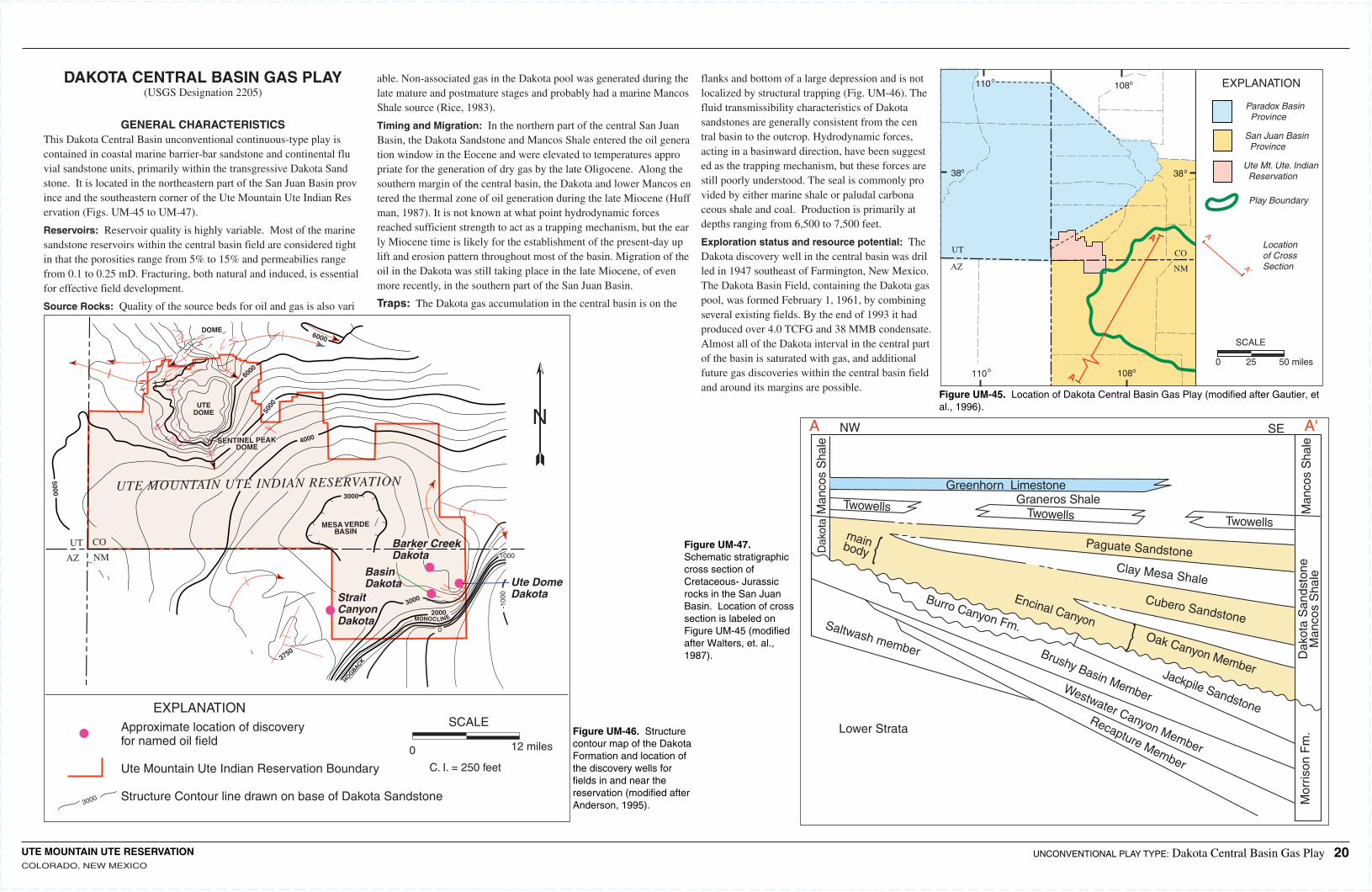
UTE MOUNTAIN UTE RESERVATIONCOLORADO, NEW MEXICO
38
110 108
38
o o
oo
108o110o
UT
AZ
CO
NM
EXPLANATION
Paradox Basin Province
San Juan Basin Province
Ute Mt. Ute. Indian Reservation
Play Boundary
A
A'
Locationof CrossSection
SCALE
0 25 50 milesA
A'
UTEDOME
SENTINEL PEAKDOME
5000
6000
DOME
5000 UTE MOUNTAIN UTE INDIAN RESERVATION
MESA VERDEBASIN
3000
4000
3000
3000
2000MONOCLINE
0
1000
-100
0
3750
UT CO
AZ NM
6000HOGBACK
EXPLANATIONApproximate location of discoveryfor named oil field
Ute Mountain Ute Indian Reservation Boundary
Structure Contour line drawn on base of Dakota Sandstone
0 12 miles
SCALE
N
StraitCanyonDakota
Barker CreekDakota
BasinDakota Ute Dome
Dakota
Figure UM-45. Location of Dakota Central Basin Gas Play (modified after Gautier, et al., 1996).
Figure UM-46. Structure contour map of the Dakota Formation and location of the discovery wells for fields in and near the reservation (modified after Anderson, 1995).
Figure UM-47. Schematic stratigraphic cross section of Cretaceous- Jurassic rocks in the San Juan Basin. Location of cross section is labeled on Figure UM-45 (modified after Walters, et. al., 1987).
UNCONVENTIONAL PLAY TYPE: Dakota Central Basin Gas Play 20
DAKOTA CENTRAL BASIN GAS PLAY(USGS Designation 2205)
GENERAL CHARACTERISTICSThis Dakota Central Basin unconventional continuous-type play is contained in coastal marine barrier-bar sandstone and continental fluvial sandstone units, primarily within the transgressive Dakota Sandstone. It is located in the northeastern part of the San Juan Basin province and the southeastern corner of the Ute Mountain Ute Indian Reservation (Figs. UM-45 to UM-47).
Reservoirs: Reservoir quality is highly variable. Most of the marine sandstone reservoirs within the central basin field are considered tight in that the porosities range from 5% to 15% and permeabilies range from 0.1 to 0.25 mD. Fracturing, both natural and induced, is essential for effective field development.
Source Rocks: Quality of the source beds for oil and gas is also vari
able. Non-associated gas in the Dakota pool was generated during the late mature and postmature stages and probably had a marine Mancos Shale source (Rice, 1983).
Timing and Migration: In the northern part of the central San Juan Basin, the Dakota Sandstone and Mancos Shale entered the oil generation window in the Eocene and were elevated to temperatures appropriate for the generation of dry gas by the late Oligocene. Along the southern margin of the central basin, the Dakota and lower Mancos entered the thermal zone of oil generation during the late Miocene (Huffman, 1987). It is not known at what point hydrodynamic forces reached sufficient strength to act as a trapping mechanism, but the early Miocene time is likely for the establishment of the present-day uplift and erosion pattern throughout most of the basin. Migration of the oil in the Dakota was still taking place in the late Miocene, of even more recently, in the southern part of the San Juan Basin.
Traps: The Dakota gas accumulation in the central basin is on the
flanks and bottom of a large depression and is not localized by structural trapping (Fig. UM-46). The fluid transmissibility characteristics of Dakota sandstones are generally consistent from the central basin to the outcrop. Hydrodynamic forces, acting in a basinward direction, have been suggested as the trapping mechanism, but these forces are still poorly understood. The seal is commonly provided by either marine shale or paludal carbonaceous shale and coal. Production is primarily at depths ranging from 6,500 to 7,500 feet.
Exploration status and resource potential: The Dakota discovery well in the central basin was drilled in 1947 southeast of Farmington, New Mexico. The Dakota Basin Field, containing the Dakota gas pool, was formed February 1, 1961, by combining several existing fields. By the end of 1993 it had produced over 4.0 TCFG and 38 MMB condensate. Almost all of the Dakota interval in the central part of the basin is saturated with gas, and additional future gas discoveries within the central basin field and around its margins are possible.
A A'SENW
Man
cos
Sha
le
Man
cos
Sha
le
Dak
ota
Greenhorn LimestoneGraneros Shale
Twowells Twowells
Twowells
Burro Canyon Fm.
mainbody {
} Oak Canyon Member
Encinal Canyon
Brushy Basin Member
Jackpile Sandstone
Westwater Canyon Member
Recapture Member
Cubero Sandstone
Clay Mesa Shale
Paguate Sandstone
Saltwash member Dak
ota
San
dsto
neM
anco
s S
hale
Mor
rison
Fm
.Lower Strata
C. I. = 250 feet
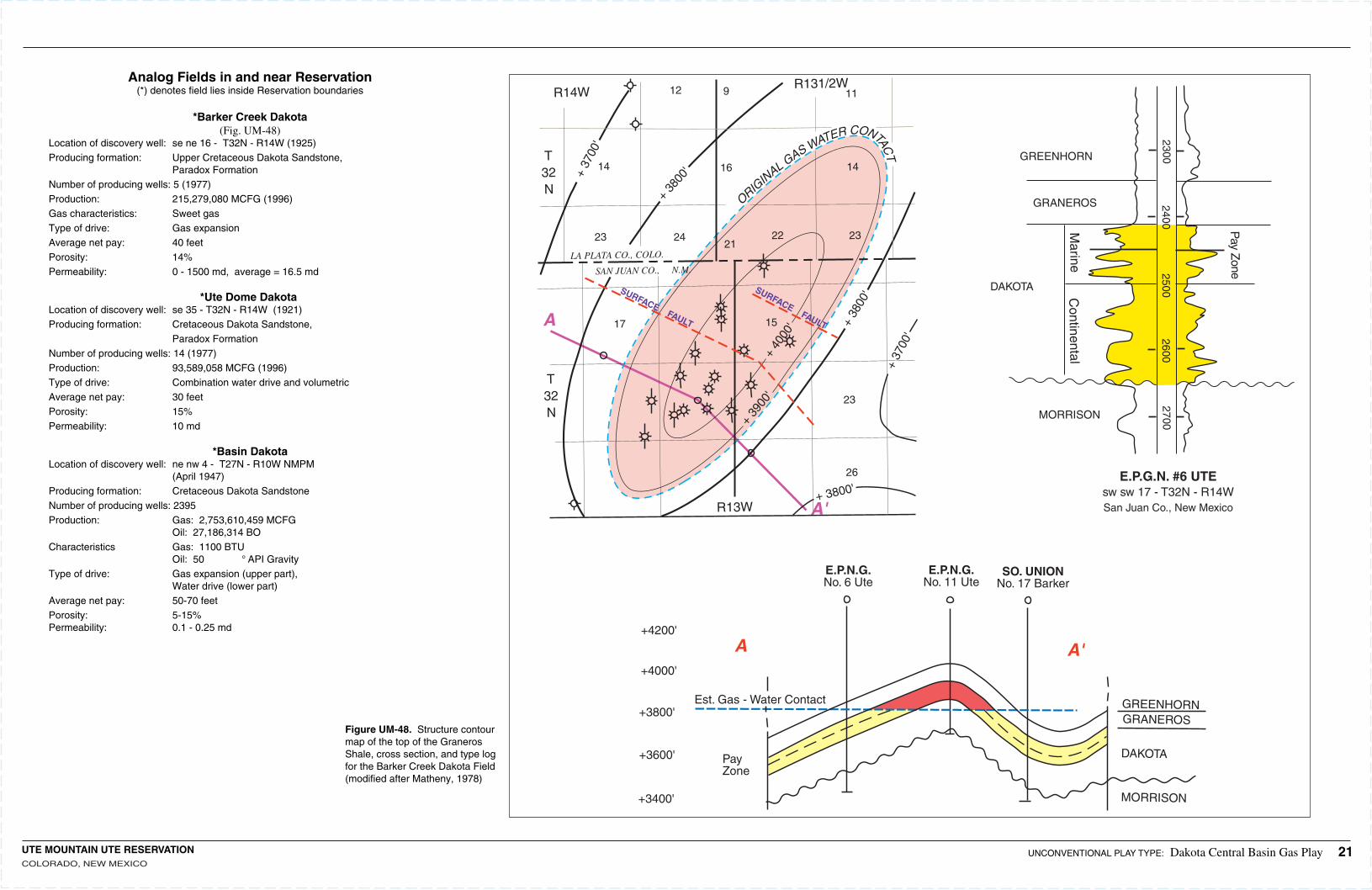
UTE MOUNTAIN UTE RESERVATIONCOLORADO, NEW MEXICO
ORIGIN
AL GAS WATER CONTAC
T
12 9 11
16
2323 2224
17
23
15
14
26
R14WR131/2W
R13W
T32N
T32N
+ 37
00'
+ 37
00'
+ 3800'
+ 38
00'
+ 38
00'
+ 39
00'
+ 40
00'
LA PLATA CO., COLO.
SAN JUAN CO., N.M.
14
SURFACE FAULT
SURFACE FAULTA
A
A'
A'
GREENHORN
GREENHORN
GRANEROS
GRANEROS
DAKOTA
DAKOTA
MORRISON
MORRISON
E.P.G.N. #6 UTEsw sw 17 - T32N - R14WSan Juan Co., New Mexico
27002600
25002400
2300
Marine
Continental
Pay Z
one
E.P.N.G.No. 6 Ute
E.P.N.G.No. 11 Ute
SO. UNIONNo. 17 Barker
Est. Gas - Water Contact
PayZone
+4200'
+4000'
+3800'
+3600'
+3400'
21
Analog Fields in and near Reservation(*) denotes field lies inside Reservation boundaries
*Barker Creek Dakota(Fig. UM-48)
Location of discovery well:se ne 16 - T32N - R14W (1925)Producing formation: Upper Cretaceous Dakota Sandstone, Paradox FormationNumber of producing wells:5 (1977)Production: 215,279,080 MCFG (1996)Gas characteristics: Sweet gasType of drive: Gas expansionAverage net pay: 40 feetPorosity: 14%Permeability: 0 - 1500 md, average = 16.5 md
*Ute Dome Dakota Location of discovery well:se 35 - T32N - R14W (1921)Producing formation: Cretaceous Dakota Sandstone, Paradox FormationNumber of producing wells:14 (1977)Production: 93,589,058 MCFG (1996)Type of drive: Combination water drive and volumetricAverage net pay: 30 feetPorosity: 15%Permeability: 10 md
*Basin DakotaLocation of discovery well:ne nw 4 - T27N - R10W NMPM (April 1947)Producing formation: Cretaceous Dakota SandstoneNumber of producing wells:2395Production: Gas: 2,753,610,459 MCFG Oil: 27,186,314 BOCharacteristics Gas: 1100 BTU Oil: 50 ° API GravityType of drive: Gas expansion (upper part), Water drive (lower part)Average net pay: 50-70 feetPorosity: 5-15%Permeability: 0.1 - 0.25 md
Figure UM-48. Structure contour map of the top of the Graneros Shale, cross section, and type log for the Barker Creek Dakota Field (modified after Matheny, 1978)
UNCONVENTIONAL PLAY TYPE: Dakota Central Basin Gas Play 21
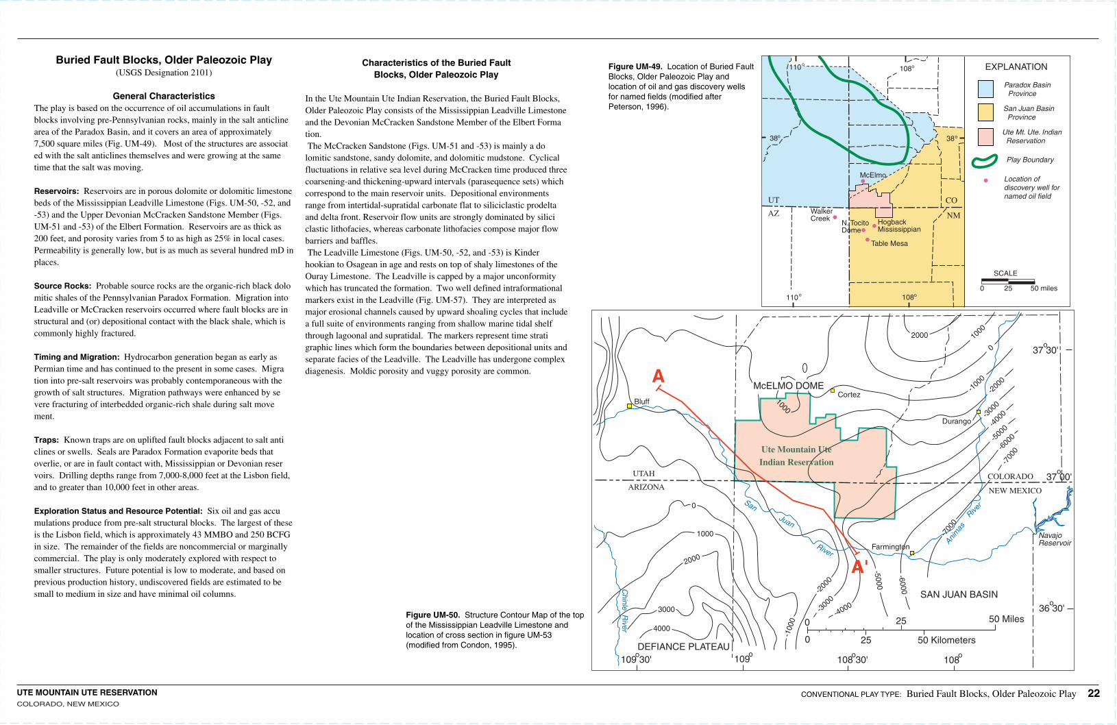
UTE MOUNTAIN UTE RESERVATIONCOLORADO, NEW MEXICO
McELMO DOME
SAN JUAN BASIN
COLORADO
NEW MEXICOARIZONA
UTAH
DEFIANCE PLATEAU
Farmington
Cortez
Durango
2000 1000
-200
0-1
000
-300
0
-300
0
-400
0
-500
0
-600
0
-700
0
-700
0
0
1000Bluff
0
1000
3000
-200
0
-100
0
2000
4000
109 30'o 109
o108 30'
o108
o
-4000
-5000
-6000
o37 30'
o36 30'
o37 00'
NavajoReservoirAni
mas
RiverSan
Juan
River
Ute Mountain UteIndian Reservation
A
A'
0
0
25
25
50 Kilometers
50 Miles
Chinle R
iver
Buried Fault Blocks, Older Paleozoic Play(USGS Designation 2101)
General CharacteristicsThe play is based on the occurrence of oil accumulations in fault blocks involving pre-Pennsylvanian rocks, mainly in the salt anticline area of the Paradox Basin, and it covers an area of approximately 7,500 square miles (Fig. UM-49). Most of the structures are associated with the salt anticlines themselves and were growing at the same time that the salt was moving.
Reservoirs: Reservoirs are in porous dolomite or dolomitic limestone beds of the Mississippian Leadville Limestone (Figs. UM-50, -52, and -53) and the Upper Devonian McCracken Sandstone Member (Figs. UM-51 and -53) of the Elbert Formation. Reservoirs are as thick as 200 feet, and porosity varies from 5 to as high as 25% in local cases. Permeability is generally low, but is as much as several hundred mD in places.
Source Rocks: Probable source rocks are the organic-rich black dolomitic shales of the Pennsylvanian Paradox Formation. Migration into Leadville or McCracken reservoirs occurred where fault blocks are in structural and (or) depositional contact with the black shale, which is commonly highly fractured.
Timing and Migration: Hydrocarbon generation began as early as Permian time and has continued to the present in some cases. Migration into pre-salt reservoirs was probably contemporaneous with the growth of salt structures. Migration pathways were enhanced by severe fracturing of interbedded organic-rich shale during salt movement.
Traps: Known traps are on uplifted fault blocks adjacent to salt anticlines or swells. Seals are Paradox Formation evaporite beds that overlie, or are in fault contact with, Mississippian or Devonian reservoirs. Drilling depths range from 7,000-8,000 feet at the Lisbon field, and to greater than 10,000 feet in other areas.
Exploration Status and Resource Potential: Six oil and gas accumulations produce from pre-salt structural blocks. The largest of these is the Lisbon field, which is approximately 43 MMBO and 250 BCFG in size. The remainder of the fields are noncommercial or marginally commercial. The play is only moderately explored with respect to smaller structures. Future potential is low to moderate, and based on previous production history, undiscovered fields are estimated to be small to medium in size and have minimal oil columns.
Characteristics of the Buried Fault Blocks, Older Paleozoic Play
In the Ute Mountain Ute Indian Reservation, the Buried Fault Blocks, Older Paleozoic Play consists of the Mississippian Leadville Limestone and the Devonian McCracken Sandstone Member of the Elbert Formation. The McCracken Sandstone (Figs. UM-51 and -53) is mainly a dolomitic sandstone, sandy dolomite, and dolomitic mudstone. Cyclical fluctuations in relative sea level during McCracken time produced three coarsening-and thickening-upward intervals (parasequence sets) which correspond to the main reservoir units. Depositional environments range from intertidal-supratidal carbonate flat to siliciclastic prodelta and delta front. Reservoir flow units are strongly dominated by siliciclastic lithofacies, whereas carbonate lithofacies compose major flow barriers and baffles.The Leadville Limestone (Figs. UM-50, -52, and -53) is Kinderhookian to Osagean in age and rests on top of shaly limestones of the Ouray Limestone. The Leadville is capped by a major unconformity which has truncated the formation. Two well defined intraformational markers exist in the Leadville (Fig. UM-57). They are interpreted as major erosional channels caused by upward shoaling cycles that include a full suite of environments ranging from shallow marine tidal shelf through lagoonal and supratidal. The markers represent time stratigraphic lines which form the boundaries between depositional units and separate facies of the Leadville. The Leadville has undergone complex diagenesis. Moldic porosity and vuggy porosity are common.
Figure UM-49. Location of Buried Fault Blocks, Older Paleozoic Play and location of oil and gas discovery wells for named fields (modified after Peterson, 1996).
Figure UM-50. Structure Contour Map of the top of the Mississippian Leadville Limestone and location of cross section in figure UM-53 (modified from Condon, 1995).
CONVENTIONAL PLAY TYPE: Buried Fault Blocks, Older Paleozoic Play 22
38
110 108
38
o o
oo
108o110o
UT
AZ
CO
NM
EXPLANATION
Paradox Basin Province
San Juan Basin Province
Ute Mt. Ute. Indian Reservation
Play Boundary
Location of discovery well fornamed oil field
SCALE
0 25 50 miles
Table Mesa
HogbackMississippian
McElmo
N. TocitoDome
WalkerCreek
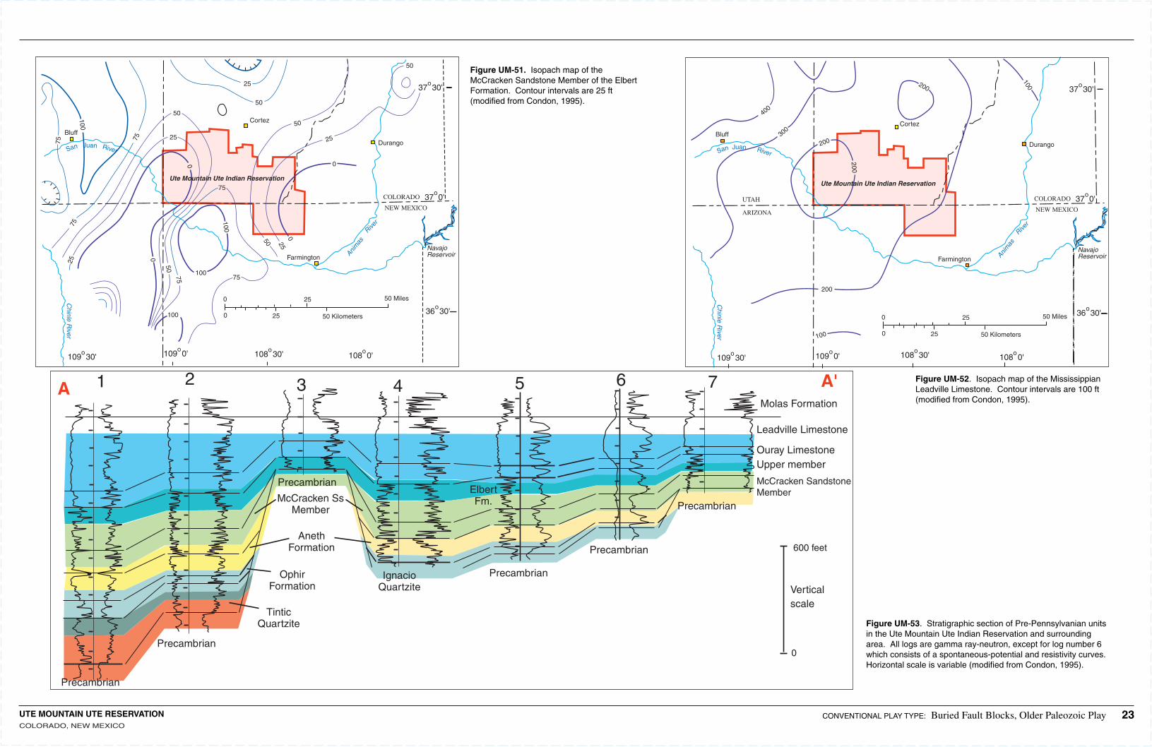
UTE MOUNTAIN UTE RESERVATIONCOLORADO, NEW MEXICO
Precambrian
Precambrian
Precambrian
Precambrian
Precambrian
Precambrian
McCracken SandstoneMember
McCracken SsMember
Molas Formation
Leadville Limestone
Ouray LimestoneUpper member
600 feet
0
Verticalscale
ElbertFm.
AnethFormation
OphirFormation
TinticQuartzite
IgnacioQuartzite
1 2 3 4 5 6 7A A'
NavajoReservoirAni
mas
River
Farmington
Durango
COLORADO
NEW MEXICO
Cortez
Bluff
San Juan River
108 30'o
109 30'o 108 0'
o109 0'o
50 Miles
50 Kilometers
25
25
0
0 36 30'o
37 30'o
37 0'o
Chinle R
iver
0
0
25
250
25
50
50
25
50
50
75
75
75
75
75
100
100
100
100
0
25
50
5075
Ute Mountain Ute Indian Reservation
Figure UM-51. Isopach map of the McCracken Sandstone Member of the Elbert Formation. Contour intervals are 25 ft (modified from Condon, 1995).
Figure UM-52. Isopach map of the Mississippian Leadville Limestone. Contour intervals are 100 ft (modified from Condon, 1995).
Figure UM-53. Stratigraphic section of Pre-Pennsylvanian units in the Ute Mountain Ute Indian Reservation and surrounding area. All logs are gamma ray-neutron, except for log number 6 which consists of a spontaneous-potential and resistivity curves. Horizontal scale is variable (modified from Condon, 1995).
NavajoReservoirAni
mas
River
Farmington
Durango
COLORADO
NEW MEXICO
Cortez
Bluff
San Juan River
108 30'o
109 30'o 108 0'
o109 0'o
50 Miles
50 Kilometers
25
25
0
0
36 30'o
37 30'o
37 0'o
100
200
200
200
200
Chinle R
iver
300
400
UTAH
ARIZONA
100
Ute Mountain Ute Indian Reservation
CONVENTIONAL PLAY TYPE: Buried Fault Blocks, Older Paleozoic Play 23
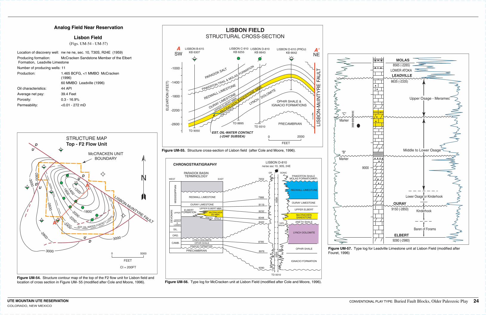
-1200
-2000-2200
-1400
-1600
-1800
-2400
-2800-2600
-2800-3000
3000
EST. OIL-WATER CONTACT (-2340
)
3000
U
U
U
U
D
D
D
D
A
A'
STRUCTURE MAPTop - F2 Flow Unit
McCRACKEN UNITBOUNDARY
LISBON-McINTYRE FAULT
CI = 200FT
0 5000
FEET
N
-2600
-2200
-1800
-1400
-1000
ELE
VAT
ION
(F
EE
T)
A A'SW NE
LIS
BO
N-M
cIN
TY
RE
FA
ULT
McCRACKEN SANDSTONE MBR.
UPPER ELBERT MBR.
OURAY LIMESTONEREDWALL LIMESTONE
PARADOX SALT
PINKERTON TRAIL & MOLAS FORMATION
ANETH SHALE
LYNCH DOLOMITE
PRECAMBRIAN
OPHIR SHALE &IGNACIO FORMATIONS
EST. OIL-WATER CONTACT(-2340' SUBSEA) 0 2000
FEET
TD 9050TD 9310
TD 8895
LISBON D-610 (PROJ)KB 6642
LISBON D-810KB 6643
LISBON C-910KB 6255
LISBON B-615KB 6307
LISBON FIELDSTRUCTURAL CROSS-SECTION
80009000
DATABREAK
McCRACKENSS MBR.
ANETH SHALE
ELBERTFORMATION
UPPER ELBERT MBR.
OURAY LIMESTONE
REDWALL LIMESTONE
LYNCH DOLOMITEOPHIR SHALE
IGNACIO FORMATION
UPPER
MIDDLE&
LOWER
SIL.
ORD.
CAMB.
DE
VO
NIA
N
MIS
SIS
SIP
PIA
N
WEST EAST 7659
7988
8119
8232
8348
8422
8785
8976
9280
IGNACIO FORMATION
OPHIR SHALE
LYNCH DOLOMITE
ANETH SHALE
McCRACKENSANDSTONE
UPPER ELBERT
OURAY LIMESTONE
REDWALL LIMESTONE
TD 9310
PINKERTON SHALEMOLAS FORMATION (P)P
GR SONIC
LISBON D-810ne/se ssc 10, 30S, 24ECHRONOSTRATIGRAPHY
PARADOX BASINTERMINOLOGY
PRECAMBRIAN
Lower Osage or Kinderhook
OURAY
9150 (-2850)
ELBERT9280 (-2980)
Kinderhook
Baren of Forams
Middle to Lower Osage
Upper Osage - Meramec
MOLAS8565 (-2265)
LOWER ATOKALEADVILLE
8635 (-2335)
"C"
Marker
"B"
Marker
9000
Analog Field Near Reservation
Lisbon Field (Figs. UM-54 - UM-57)
Location of discovery well:nw ne ne, sec. 10, T30S, R24E (1959)
Producing formation: McCracken Sandstone Member of the ElbertFormation, Leadville Limestone
Number of producing wells:11
Production: 1.465 BCFG, <1 MMBO McCracken (1996) 60 MMBO Leadville (1996)
Oil characteristics: 44 API
Average net pay: 39.4 Feet
Porosity: 0.3 - 16.9%
Permeability: <0.01 - 272 mD
Figure UM-54. Structure contour map of the top of the F2 flow unit for Lisbon field and location of cross section in Figure UM- 55 (modified after Cole and Moore, 1996).
Figure UM-55. Structure cross-section of Lisbon field (after Cole and Moore, 1996).
Figure UM-56. Type log for McCracken unit at Lisbon Field (modified after Cole and Moore, 1996).
Figure UM-57. Type log for Leadville Limestone unit at Lisbon Field (modified after Fouret, 1996)
UTE MOUNTAIN UTE RESERVATIONCOLORADO, NEW MEXICO
CONVENTIONAL PLAY TYPE: Buried Fault Blocks, Older Paleozoic Play 24
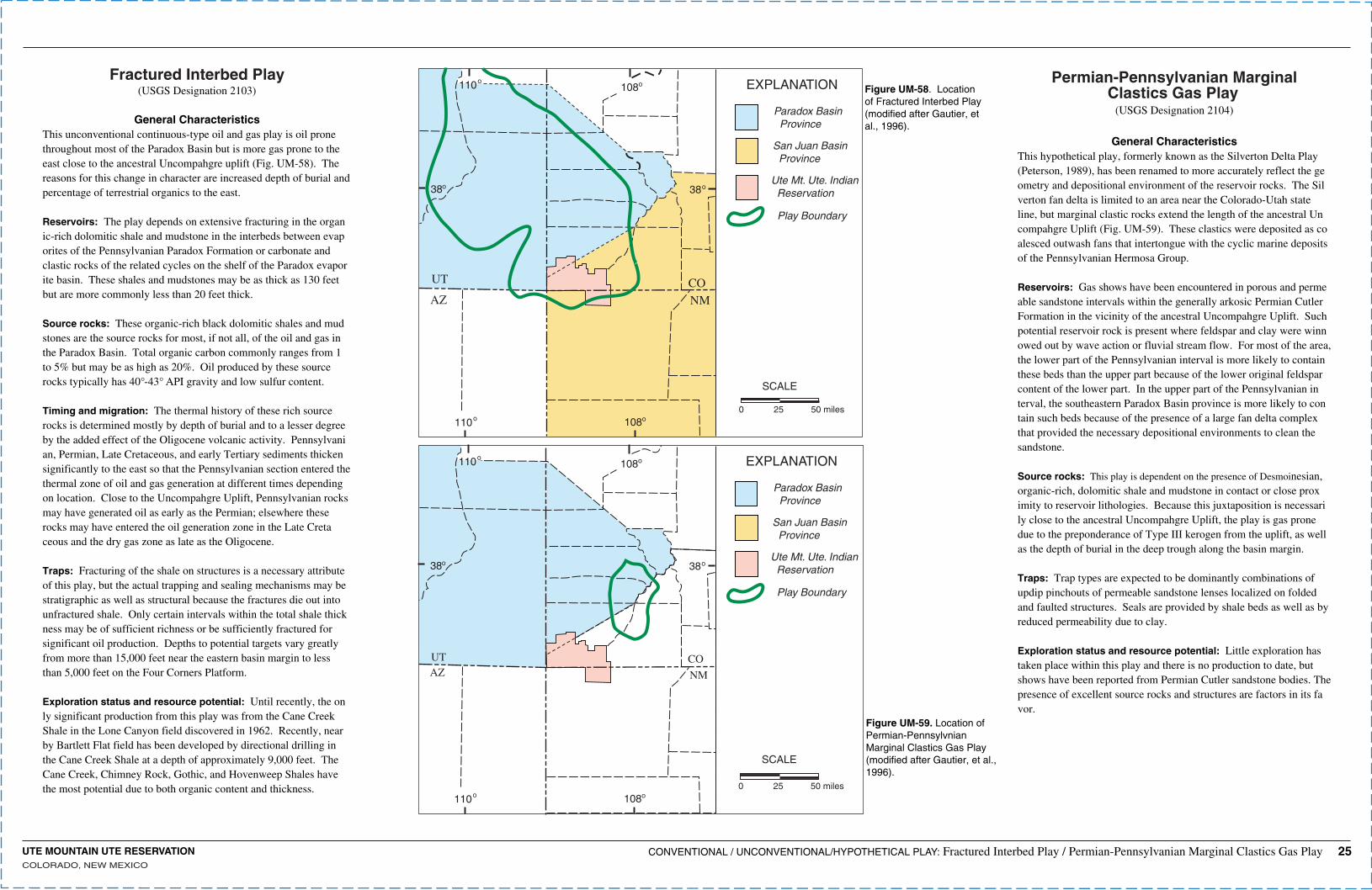
UTE MOUNTAIN UTE RESERVATIONCOLORADO, NEW MEXICO
38
110 108
38
o o
oo
108o110o
UT
AZCONM
EXPLANATION
Paradox Basin Province
San Juan Basin Province
Ute Mt. Ute. Indian Reservation
Play Boundary
SCALE
0 25 50 miles
38
110 108
38
o o
oo
108o110o
UTAZ
CO
NM
EXPLANATION
Paradox Basin Province
San Juan Basin Province
Ute Mt. Ute. Indian Reservation
Play Boundary
SCALE
0 25 50 miles
Fractured Interbed Play(USGS Designation 2103)
General CharacteristicsThis unconventional continuous-type oil and gas play is oil prone throughout most of the Paradox Basin but is more gas prone to the east close to the ancestral Uncompahgre uplift (Fig. UM-58). The reasons for this change in character are increased depth of burial and percentage of terrestrial organics to the east.
Reservoirs: The play depends on extensive fracturing in the organic-rich dolomitic shale and mudstone in the interbeds between evaporites of the Pennsylvanian Paradox Formation or carbonate and clastic rocks of the related cycles on the shelf of the Paradox evaporite basin. These shales and mudstones may be as thick as 130 feet but are more commonly less than 20 feet thick.
Source rocks: These organic-rich black dolomitic shales and mudstones are the source rocks for most, if not all, of the oil and gas in the Paradox Basin. Total organic carbon commonly ranges from 1 to 5% but may be as high as 20%. Oil produced by these source rocks typically has 40°-43° API gravity and low sulfur content.
Timing and migration: The thermal history of these rich source rocks is determined mostly by depth of burial and to a lesser degree by the added effect of the Oligocene volcanic activity. Pennsylvanian, Permian, Late Cretaceous, and early Tertiary sediments thicken significantly to the east so that the Pennsylvanian section entered the thermal zone of oil and gas generation at different times depending on location. Close to the Uncompahgre Uplift, Pennsylvanian rocks may have generated oil as early as the Permian; elsewhere these rocks may have entered the oil generation zone in the Late Cretaceous and the dry gas zone as late as the Oligocene.
Traps: Fracturing of the shale on structures is a necessary attribute of this play, but the actual trapping and sealing mechanisms may be stratigraphic as well as structural because the fractures die out into unfractured shale. Only certain intervals within the total shale thickness may be of sufficient richness or be sufficiently fractured for significant oil production. Depths to potential targets vary greatly from more than 15,000 feet near the eastern basin margin to less than 5,000 feet on the Four Corners Platform.
Exploration status and resource potential: Until recently, the only significant production from this play was from the Cane Creek Shale in the Lone Canyon field discovered in 1962. Recently, nearby Bartlett Flat field has been developed by directional drilling in the Cane Creek Shale at a depth of approximately 9,000 feet. The Cane Creek, Chimney Rock, Gothic, and Hovenweep Shales have the most potential due to both organic content and thickness.
Permian-Pennsylvanian MarginalClastics Gas Play
(USGS Designation 2104)
General CharacteristicsThis hypothetical play, formerly known as the Silverton Delta Play (Peterson, 1989), has been renamed to more accurately reflect the geometry and depositional environment of the reservoir rocks. The Silverton fan delta is limited to an area near the Colorado-Utah state line, but marginal clastic rocks extend the length of the ancestral Uncompahgre Uplift (Fig. UM-59). These clastics were deposited as coalesced outwash fans that intertongue with the cyclic marine deposits of the Pennsylvanian Hermosa Group.
Reservoirs: Gas shows have been encountered in porous and permeable sandstone intervals within the generally arkosic Permian Cutler Formation in the vicinity of the ancestral Uncompahgre Uplift. Such potential reservoir rock is present where feldspar and clay were winnowed out by wave action or fluvial stream flow. For most of the area, the lower part of the Pennsylvanian interval is more likely to contain these beds than the upper part because of the lower original feldspar content of the lower part. In the upper part of the Pennsylvanian interval, the southeastern Paradox Basin province is more likely to contain such beds because of the presence of a large fan delta complex that provided the necessary depositional environments to clean the sandstone.
Source rocks: This play is dependent on the presence of Desmoinesian, organic-rich, dolomitic shale and mudstone in contact or close proximity to reservoir lithologies. Because this juxtaposition is necessarily close to the ancestral Uncompahgre Uplift, the play is gas prone due to the preponderance of Type III kerogen from the uplift, as well as the depth of burial in the deep trough along the basin margin.
Traps: Trap types are expected to be dominantly combinations of updip pinchouts of permeable sandstone lenses localized on folded and faulted structures. Seals are provided by shale beds as well as by reduced permeability due to clay.
Exploration status and resource potential: Little exploration has taken place within this play and there is no production to date, but shows have been reported from Permian Cutler sandstone bodies. The presence of excellent source rocks and structures are factors in its favor.
Figure UM-58. Location of Fractured Interbed Play (modified after Gautier, et al., 1996).
Figure UM-59. Location of Permian-Pennsylvnian Marginal Clastics Gas Play (modified after Gautier, et al., 1996).
CONVENTIONAL / UNCONVENTIONAL/HYPOTHETICAL PLAY: Fractured Interbed Play / Permian-Pennsylvanian Marginal Clastics Gas Play 25