utilizing microcatchment systems to increase tree...
TRANSCRIPT
UTILIZING MICROCATCHMENT SYSTEMS TO INCREASE TREE ESTABLISHMENT RATES IN THE BOLIVIAN HIGH PLAINS
By
MATTHEW E. COHEN
submitted in partial fulfillment of the requirements for the degree of MASTER OF SCIENCE IN FORESTRY
MICHIGAN TECHNOLOGICAL UNIVERSITY 2002

ii
The thesis: “Utilizing Microcatchment Systems to Increase Tree Survival Rates in the
Bolivian High Plains” is hereby approved in partial fulfillment of the requirement for the
Degree of MASTER OF SCIENCE IN FORESTRY.
School of Forestry and Wood Products
Signatures:
Thesis Advisor:_____________________________________ Blair Orr
Dean:_____________________________________ Glenn D. Mroz
Date:_____________________________________

iii
PREFACE
In 1998 I graduated from the University of California, Davis with a Bachelor of Science degree in Wildlife, Fisheries, and Conservation Biology. During my last year at Davis, I decided that I wanted to spend some time working and living abroad in a completely different culture from the one I had grown up in. The Peace Corps Masters International Program offered at Michigan Technological University seemed to fit perfectly with my desire to have a unique cultural experience while continuing to further my education and career goals. Following a year of forestry related classes at Michigan Tech, I was assigned to serve in the Peace Corps Natural Resource Project as a forestry and soil conservation Volunteer in the country of Bolivia.
In my two years in the Peace Corps, I spent my time bouncing between two separate jobs. The site to which I was assigned to work at was a small university research station located in the high plains of Bolivia. As a Volunteer at this station I worked on a variety of different projects from soil conservation extension work with local Aymara farmers to teaching nursery management courses at the university. In the second year of my service, my counterpart Jesús Cárdenas and I implemented a UN funded project to construct 10 rainwater catchment ponds benefiting 40 farm families in a community near our station. While at this station, I experimented with a number of different water harvesting techniques to increase crop production. After repeated failures in establishing trees in our area, I decided to initiate a study whereby water-harvesting techniques were adopted to individual trees so as to increase their survival through the harsh high plains winters.
In my other capacity within the Peace Corps, I worked as the Roving Technical Assistant to the Associate Director of the Natural Resource Project in Bolivia. In this job I traveled throughout the country visiting other Volunteers within our project in order to assist them with project design and development. I also played an active role in organizing training activities for new Volunteers, helping with site development, and putting together various national workshops on the environment. While in my service, I was selected to participate on the Project Advisory Committee of Peace Corps Bolivia and helped reorganize and write the Natural Resource Project plan for the next five-year cycle.

iv
TABLE OF CONTENTS Page LIST OF FIGURES………………………………………………………… v LIST OF TABLES…………………………………………………………. vi ACKNOWLEDGEMENTS………………………………………………… vii ABSTRACT………………………………………………………………… viii CHAPTER 1 INTRODUCTION…………………………………………. 1 CHAPTER 2 BACKGROUND INFORMATION ON BOLIVIA General Description of Bolivia………..……………………………. 4 Geography of Bolivia………………………………………………. 7 Natural Resources………………………………………………….. 13 History of Bolivia………………………………………………….. 15 CHAPTER 3 BACKGROUND ON THE
AREA OF STUDY……………………………………….... 24 CHAPTER 4: DESCRIPTION OF MICROCATCHMENT SYSTEMS………………………………………………….. 38 CHAPTER 5 METHODOLOGY AND DATA …………………………… 44 Statistical Methods…………………………………………………. 45 Treatment Design…………………………………………………… 46 Soil Information…………………………………………………….. 51 Species Used in the Study………………………………………….. . 54 Data…………………………………………………………………. 60 CHAPTER 6 RESULTS AND DISCUSSION………………………….…. 65 CHAPTER 7 CONCLUSIONS……………………………………………. 72 LITERATURE CITED……………………………………………………… 77 APPENDIX 1……………………………………………………………….. 86
v
LIST OF FIGURES Page FIGURE 1. Map of South America……………………………………… 5 FIGURE 2. Political Map of Bolivia…………………………………….. 6 FIGURE 3. Geographic Map of Bolivia’s Three Zones…………..…….. 8 FIGURE 3. Pink Flamingos on Lake Poopo…………………………….. 10 FIGURE 4. Traditional Quechuan Dress………………………………… 17 FIGURE 5. Aymara Women Parade in Traditional Dress
Displaying the Aymara Flag………………………………… 18 FIGURE 6. Map of the Department of Oruro…………………………… 24 FIGURE 7. Map of Cercado Province, Oruro…………………………… 25 FIGURE 8. CEAC……………………………………………………….. 26 FIGURE 9. Soil Conservation Work in San Antonio de Condoriri……… 28 FIGURE 10. Sheep and Llama Grazing in Condoriri……………………… 31 FIGURE 11. Harvesting of “Thola” for Firewood………………………… 32 FIGURE 12. Farmhouse in Condoriri with Trees in Front Patios………… 33 FIGURE 13. Comparison of Normal Precipitation
vs. Precipitation for the Year 2001………………………….. 36 FIGURE 14. Comparison of Mean Normal Temp.
vs. Mean Temp. for the Year 2001………………………….. 37 FIGURE 15. Example of Microcatchment System for Trees………………. 39 FIGURE 16. Tree Microcatchments in Niger……………………………… 40 FIGURE 17. Tree Microcatchment in Niger………………………………. 41 FIGURE 18. Construction of Earth Bund to Harvest Rainwater for Plant Production……………………………… 42 FIGURE 19. Construction of Stone Walls in Gully for Plant Production……………………………………… 42 FIGURE 20. Treatment Design (Side View)……………………………… 48 FIGURE 21. Treatment Design (Top View)……………………………… 49 FIGURE 22. Treatment Design (Front View)…………………………….. 50 FIGURE 23. Water Level Height vs. Time……………………………….. 52 FIGURE 24. Residual Plot for Time Regression………………………….. 53 FIGURE 25. Polylepsis Tree……………………………………………… 55 FIGURE 26. Polylepsis Bark and Leaves Up-Close……………………… 55 FIGURE 27. Polylepsis Forest……………………………………………. 57 FIGURE 28. Large Cypress Tree in Oruro………………………………… 59 FIGURE 29. Cypress Tree in Treatment Two…………………………….. 59 FIGURE 30. Survival Totals According to Treatment……………………. 64 FIGURE 31. Tukey Test Results………………………………………….. 66

vi
LIST OF TABLES Page TABLE 1. Principle Crops of Oruro…………………………………… 29 TABLE 2. Oruro: Surface Area, Yield,
and Production/Crop 96-97………………………………… 30 TABLE 3. Monthly Climate Data for the Period of December 2000-November 2001………………………… 34 TABLE 4. Maximum and Minimum Precipitation Rates
from Various Weather Stations (in Millimeters)……………. 35 TABLE 5. Experiment Design………………………………………….. 61 TABLE 6. Survival Data from Experiment……………………………. . 62 TABLE 7. Treatment Survival Data by Species……………………….. . 63 TABLE 8. Mortality Data According to Month……………………….. . 63 TABLE 9. Analysis of Variance……………………………………….. . 65 TABLE 10. Analysis of Variance for Polylepsis tarapacana……………. 66 TABLE 11. Analysis of Variance for Cupressus macrocarpa………….. . 67

vii
ACKNOWLEDGEMENTS First and foremost, I would like to thank my advisor Blair Orr for his tireless
assistance and advice over the past three plus years. Without him, Peace Corps wouldn’t
have been the same. I would also like to thank the members of my graduate committee,
Bill Chapel, David Flaspohler, and especially Jim Pickens for their help and
encouragement throughout the writing of my thesis. Within Bolivia, a debt of gratitude is
owed to the Peace Corps Bolivia staff and especially APCD Remigio Ancalle, PTO
Charna Lefton, and Country Director Mimi Smith for their flexibility and patience toward
the Master’s International Program. I am forever indebted to all those at the Universidad
Tecnicá de Oruro and CEAC for their companionship and advice throughout my study.
Special thanks goes to my good friend and counterpart Jesús Cárdenas for all his efforts
in making my Peace Corps service a very special time.
To my parents, friends, and family I want to say thank you for allowing me to go
traipsing all over the world while letting me know that I always have a home to come
back to. Finally, I want to thank my grandfather Saul Cohen. You are an inspiration to us
all.
viii
ABSTRACT
The Bolivian high plains is an area where forestry production is limited. A
combination of high altitude, low rainfall, and variable climate all contribute to cause
extremely high mortality rates among tree species. The use of microcatchment systems
around the world has helped to significantly increase tree survival and establishment rates
over time in a number of dry areas. Through the harvesting and collection of rainwater
around a plant, these systems serve to moderate climate variations and increase the
amount of water available for plant uptake.
The purpose of this study was to examine whether microcatchment systems can
improve tree establishment rates in the Bolivian high plains. Five treatments were
selected and laid out in a randomized block design of ten blocks along a hillside located
on the Centro Experimental Agropecuaria Condoriri (CEAC) in the Bolivian Department
of Oruro. Two tree species, one native (Polylepsis tarapacana) and one introduced
(Cupressus macrocarpa), were planted in each of the treatments at the beginning of the
rainy season. Survival data was collected every two and a half-months throughout the
one-year study period.
Overall survival rates after the end of the study varied according to treatment.
Treatment number two, the pit planting method, showed 80% survival while the control
treatment had a survival of only 45%. Survival for the introduced species varied widely
among treatments. In the case of the native species, survival rates did not show
statistically significant variation among the treatments. Species adaptability and planting
treatment structure played a large part in the overall survival of tree species in this study.

1
Chapter 1: Introduction
When I first arrived to the Bolivian high plains as an agroforestry and soil
conservation volunteer, I had a lot of ambitious plans about stocking the entire region of
San Antonio de Condoriri with trees. Initial meetings with the farmers of this area had
convinced me that trees would be a valuable and highly desired resource. Farmers who
had successfully grown trees in their home patios displayed them to me with pride and
often asked me when they might be able to get some more trees to plant.
Although the previous volunteer at my site had planted thousands of trees, a large
number of them had died by the time of my arrival. I was positive that I could do better.
So, for the first year of my service I set to work undertaking traditional planting and
seeding methods in my nursery. I was confident that by the time the next rainy season
came, I would be ready to successfully transplant thousands of tree seedlings.
A year passed and the rainy season was returning. Knowing this, my counterpart
Jesús Cárdenas and I outlined an ambitious tree-planting program where over 6,000 trees
of two native and three introduced species would be planted in various locations around
the valley. In order to get the entire project done in time for the rainy season, we enlisted
the help of students, workers, farmers, and anybody else we could find to help with
digging holes and planting trees. By the end of November, all the trees were planted in
the ground and awaiting the rains to come.
Then, disaster struck. The rains which normally come in early December did not
arrive. Although we did our best to irrigate the trees we could, late frosts swept through
the valley and within less than a month, 90% of the trees we had planted were dead. Lack
of water and extreme cold had devastated our well-laid plans.

2
Prior to the initiation of this project, I had been reading up on studies of water
harvesting in arid lands. Since the previous fall, my counterpart and I had been busily
working at constructing and testing different methods to prevent soil erosion and capture
water runoff in cropping systems. After our failures in the first year’s plantation, I
decided to adapt water harvesting methods to tree systems using microcatchment
systems.
My objectives for this study are to examine ways in which tree establishment
rates on the Bolivian high plains can be improved upon. Through the application of
microcatchment systems, I hope to provide a viable option to farmers and extension
workers looking to promote forestry activities throughout this region.
In chapter two I will discuss the country of Bolivia where the study took place. I
will begin with an overview of the country by discussing its various geography, people,
and resources. Following this information, I will give a historical account of Bolivia up
through the present day.
Chapter three will discuss the background on this particular study. I will begin by
outlining the Department of Oruro and the Cercado province. I will then talk about the
community of San Antonio de Condoriri as well as the Centro Experimental
Agropecuaria, Condoriri (CEAC) where the actual trial took place. Finally, I will
continue with climate data for the calendar year.
In chapter four I will give background information on microcatchment systems.
This will include definitions, historical uses, and benefits associated with their use. I will
also briefly discuss their adaptability to the high plains region of Bolivia.

3
Chapter five will outline my methodology as well as present the data collected
during this experiment. I will begin with a discussion on experiment design and layout
followed by a description of the soil type and the species used in this study. I will then
present the various data I collected throughout the trial period
I will continue in chapter six with the results and discussion section of this
experiment. I will start with an analysis of my study followed by a comparison of my
results to other studies. Some discussion as to the results of my experiment will be
covered toward the end of this chapter.
Chapter seven will cover conclusions drawn from this experiment. In this chapter
I will define the results of this study as they relate to present day conditions in the
Bolivian high plains. I will also discuss possible further studies that could be conducted
based on the information gathered from this trial.
4
Chapter 2: Background Information on Bolivia
Few countries in the world are able to match the diversity that encompasses the
present day nation of Bolivia. Covering 1,098,591 km2 (INE, 2002), Bolivia is centrally
located in South America (Figure 1) and straddles a region encompassing the Andes
down through the lower valleys and foothills and eventually into the Amazon Basin.
Landlocked since the 1880s and bordering Argentina, Brazil, Chile, Paraguay, and Peru,
the varying ecosystems stretch over a territory slightly smaller than Alaska and more
diverse than many other nations in the world.
Politically, Bolivia is divided into nine states or departments. The departments are
La Paz, Oruro, Cochabamba, Beni, Pando, Tarija, Potosí, Santa Cruz, and Chuquisaca
(Figure 2). The most populated departments are La Paz, Cochabamba, Santa Cruz, and
Oruro. Largely due to their inaccessibility, Beni and Pando are the least populated
departments.

5
Figure 1: Map of South America, CIA, 2002

6
Figure 2: Political Map of Bolivia, INE, 2002
Bolivia is considered to be a country with a high birthrate (27.12 Births/1,000
individuals). Rural birthrates tend to be higher than those in urban areas (INE, 2002).
The average Bolivian home consists of 4.5 members with the male as the nominal head in
81% of the cases. The infant mortality rate has decreased significantly in the last twenty
years, down from 151 per 1000 live births in 1970 to and estimated 59 per 1000 births in
2001 (CIA, 2002; INE, 2002).
Bolivia has a young population. Of the total population of 8,300,463 people, those
under the age of fifteen number 3,192,446 (38.46%). The economically active age group
(ages 15-64) constitutes 4,727,085 people (57.07%) (CIA, 2002).
The official languages in Bolivia are Spanish, Quechua, Aymara, and Guarani.
Approximately 87.4% of the population over six years of age speak Spanish as their

7
primary language. Other languages spoken are Quechua (34.3%), Aymara (23%),
various foreign languages (3.1%), Guarani (1.0%), and various other indigenous
languages (0.6%) (INE, 1993). Albo (1989) estimates that within the overall population
of Bolivia there are approximately 2,500,000 Quechua speakers, 1,600,000 Aymara
speakers, and 60,000 Guarani speakers.
Women’s involvement in the economy has grown from 18% in 1976 to 38% in
1992. The number of women economically active has risen 300% during the intervening
period from 337,000 to 986,000 women. This increase has taken place in both rural and
urban areas, but especially in the rural areas where the percentage has risen from 15% in
1976 to 48% in 1992 (INE, 1993).
Of the economically active male population in Bolivia, the major fields of
employment are agriculture, business, clerical, forestry, machine operators, and manual
labor. In the case of women, agriculture, forestry, service industry, middle level
technicians and professionals, and manual labor are all sectors which serve as major areas
of employment (Montes de Oca, 1997; Valdivia, 1996).
Geography of Bolivia
Bolivia can be divided into three main geographic regions, the high plains
(altiplano), the valleys (including subtropical foothills), and the tropical lowlands (Figure
3). Although the lowlands of Bolivia cover approximately 60% of the surface area of
Bolivia, they remain relatively unpopulated as a result of their inaccessibility.
Approximately 74% of the current population is located in the valleys and high plains
regions (INE, 2002).
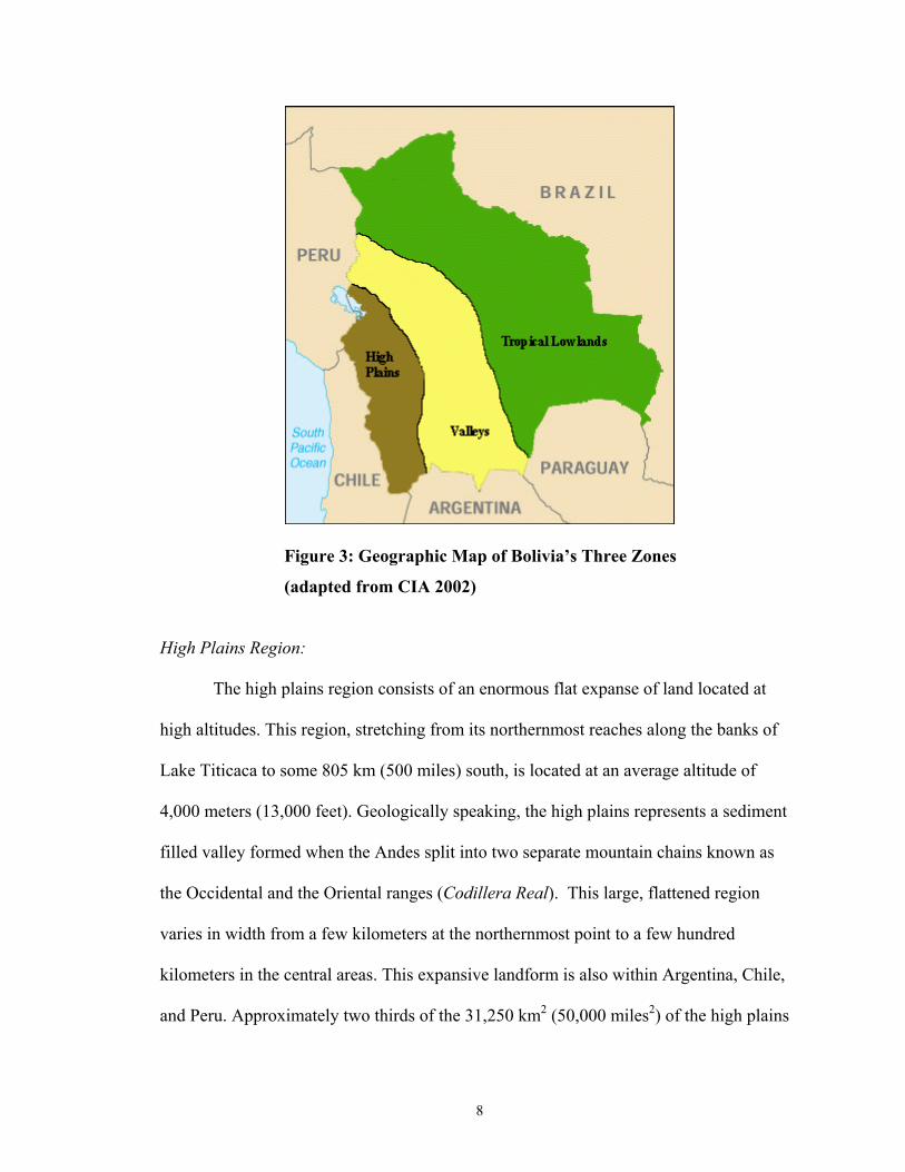
8
Figure 3: Geographic Map of Bolivia’s Three Zones
(adapted from CIA 2002)
High Plains Region:
The high plains region consists of an enormous flat expanse of land located at
high altitudes. This region, stretching from its northernmost reaches along the banks of
Lake Titicaca to some 805 km (500 miles) south, is located at an average altitude of
4,000 meters (13,000 feet). Geologically speaking, the high plains represents a sediment
filled valley formed when the Andes split into two separate mountain chains known as
the Occidental and the Oriental ranges (Codillera Real). This large, flattened region
varies in width from a few kilometers at the northernmost point to a few hundred
kilometers in the central areas. This expansive landform is also within Argentina, Chile,
and Peru. Approximately two thirds of the 31,250 km2 (50,000 miles2) of the high plains
9
fall within Bolivian territory (Hudson and Hanratty (ed.), 1989, 52; Sweaney 2001, 13-
15).
The high plains region is delineated by three major lake systems. Lakes Titicaca,
Poopo, and Uru Uru are connected to each other by the Desaguadero River which runs
from Lake Titicaca on the Peruvian border to Lake Poopo within the Department of
Oruro. Lake Titicaca, the more important of these three systems, has been the historical
focal point for most Bolivian Pre-Columbian civilizations. The highest navigable lake in
the world, its waters irrigate some of the most productive farming lands in the whole
region and moderates local weather patterns through the creation of a huge microclimate
resulting from evaporation of the Lakes’ vast surface area of 9,064 km2 (5,665 miles2).
Lake Titicaca has a depth of 457 meters (1,500 feet) with an approximate surface length
of 230km (144 miles) and width of 97 km (60 miles). The smaller Lakes Poopo (Figure
4) and Uru Uru are fed primarily from the Desaguadero River which functions as the only
outlet for Lake Titicaca. These two lakes represent an important fishing resource to the
people of the central and southern high plains region but are largely shallow, salty
puddles measuring at most only a few meters deep at their deepest points (Sweaney 2001,
15; Hudson and Hanratty (ed.), 1989, 53).

10
Figure 4: Pink Flamingos on Lake Poopo
Traditional agriculture and domestic systems in this area are based primarily on
potatoes (Solanum sp.) and other nutritional root crops (fam. Solanaceae). Potatoes were
originally domesticated in the Lake Titicaca region thousands of years ago and were
central to the development of the Andean civilization. Since they can be dehydrated and
naturally frozen so as to be available for consumption at a later date, these root crops
provide an important year round food source to local inhabitants. Some other important
crops to this area are quinua (Chenopodium quinoa Willd.), a high-protein grain, and
introduced grain crops such as wheat (Triticum sp.) and barley (Hordeum sp.).
Vegetables such as onions (Allium cepa L.) and carrots (Daucus carota L.) are also
widely planted. Andean cameloids have traditionally played an important role in the high
plains society and their wool and meat has provided sustenance to the inhabitants of the
region since time immemorial. The introduction by the Spanish of old world livestock
into this region has led to the widespread use of sheep and a more limited dispersal of
other animals such as cattle, pigs, and chickens. Today, the high plains farmers use most
11
of their production for subsistence with only 30% of their harvest going to markets in
cities and local towns. Cultivation is done on an annual basis during the fall months of
April-June. According to the 1992 census, 45.0% of the total population of Bolivia can
be found in this region (Montes de Oca, 1997, 75-78).
The western part of the high plains run into the Occidental range. This rather
narrow and relatively unbroken range averages around 5,000 meters (16,500 feet) in
altitude and rises to over 6,400 meters (21,000 feet). Moving westward, the Occidental
mountain range descends into the Atacama Desert, one of the driest deserts in the world,
along the coasts of Chile before disappearing in the Pacific Ocean. Lacking major water
sources, fertile soil, and any substantial mineral deposits outside nitrate and copper
concentrations in the Atacama Desert, the altiplano region leading up to this range is
relatively uninhabited (Cuzmar, pers. com., 2001).
Andean Inter-Mountain and Valley Regions:
At the eastern edge of the high plains the Oriental or Cordillera Real range begins.
This range, more broken and expansive than the Occidental range, consists of numerous
fertile valley systems and river drainages which run from an altitude of 4,300 meters
(14,000 feet) down to just a few hundred meters above sea level. A dry, temperate
climate, relatively stable water supply, and large open plains with fertile soils and
accessibility to the high plains region generally characterize the higher valleys. The
largest population concentrations are located in the areas of Cochabamba, Tarija,
Chuquisaca, and Western Potosi (Hudson and Hanratty, 1989, 55; Lopez Levy, 2001,88)

12
Traditional agricultural systems in these areas include crops such as corn (Zea
sp.), fish, fruits, tomatoes (Lycopersicon lycopersicum L.), and beans (fam. Fabaceae) as
well as a variety of introduced crops such as wheat, barley, and vegetables, particularly
onions. Livestock systems in this area rely predominantly on the use of old world species
such as sheep, goats, cattle, chickens, and pigs. In the valleys of Bolivia farmers cultivate
biannually in small plots averaging between five and ten hectares per family. According
to the 1992 census, 28.9% of the total population of Bolivia can be found in these regions
(Montes de Oca, 1997, 78).
Stretching down from these highland valley areas the Cordillera Real begins to
descend into sub-tropical and tropical foothill regions fed by rains and humid winds from
the Amazonian basin. These lush areas comprise a number of small, vertically oriented
ecosystems with high rates of biodiversity and have historically represented the frontier
of most highland human intrusions into the tropics. They are divided into two main
regions known as the Yungas and the Chapare.
The Yungas region extends from the north of the La Paz region. More easily
accessible by humans to the high plains regions, these areas provided important crops
such as coca and maize during Pre-Columbian times and coffee and citrus fruits
following colonization by the Spaniards. The Chapare region remained relatively
uninhabited until the late 20th century and is located as the interrogatory land space
between the high valleys of Cochabamba and the lowland areas of Santa Cruz. (Lopez
Levy, 2001, 13; Klein, 1992, 6-8)
13
Lowland and Amazonian Basin:
The lowland and Amazon Basin represent around 60% of the total landmass of
Bolivia. Yet until the twentieth century they remained largely unpopulated. This area
encompasses the present day Departments of Santa Cruz, Beni, and Pando and are
dominated by two great river systems which function to drain this vast area into
Amazonian tributaries in Brazil and also via Paraguay into the Atlantic Ocean.
Characterized by hot, flat, expanses of forested lands, these areas contain some of the
highest biodiversity in the world and the world’s eighth largest contiguous landmass of
natural forests according to the World Resources Institute (Mittermeier and Oates, 1985,
as cited in Mittermeier, 1988).
To the south of the country, the Chaco region hosts a variety of forest ecosystems
from the lush tropical regions of Monteagudo in the Chuquisaca department to the dry
shrubby forests near the Paraguayan and Argentine borders.
Agricultural systems in the lowland areas are generally more commercialized than
in other regions of the country with the extensive development and use of large
monoculture and mechanized agricultural systems. The principle crops of this region are
soy and sugar with production occurring on a year round basis. According to the 1992
census, 26.1% of the total population of Bolivia can be found in these areas (Montes de
Oca, 1997, 78).
Natural Resources:
The natural resources of Bolivia are the property of the Bolivian state which has a
duty to administer them for long-term sustainability. The state assumes the position of
14
principle regulator over the exploitation and use of these resources in order to guarantee
their proper use. The use of renewable natural resources within Bolivia cover agriculture,
livestock production, water, wildlife management, and forestry.
The forestry resources within Bolivia constitute forested lands and all the natural
resources that exist within it to form the forest ecosystem. In Bolivia in 1975 there was
564,684 km2 (352,865 miles2) of forested land (approximately 51.4% of its territory). In
1993 the total forested land consisted of 534,492 km2 (334,058 miles2). Deforestation
within Bolivia does not yet present a serious problem relative to other Latin American
countries as it accounts for less than one percent of its total lands per year (Montes de
Oca, 1997, 471). However, clearing of forested lands are becoming more and more
common and lead directly to land degradation in many cases. Forested lands range from
humid tropical forests in the Amazon basin to sparse open forests located at more than
5,000 meters (16,400 feet) above sea level in the high plains, the highest forests in the
world (Argollo et al., 2001). These forests cover more than 50% of the total landmass
and play central roles in the environmental and economic aspects of Bolivian life.
Bolivia contains some 20,000 species of plants and 10,000 species of animals
(Montes de Oca, 1997). Some 316 species of mammals from ten orders and 36 families
and representing 35.5% of the fauna species of South America have been described
(Ergueta and De Morales, 1996). According to Hershkovitz (1972 as cited in Ergueta and
Sarmiento, 1992) South America contains 810 species of mammals which represent 20%
of the species in the entire world. The eighteen species of primates found within Bolivia
place it within the top fifteen countries in the world for primate diversity (Anderson,
1985; Mittermeier, 1988).
15
Approximately 3,100 species of resident and migratory birds exist in South
America. Because of the diversity of its ecological regions, Bolivia has one of the richest
avifaunas in the world with more than 1,274 species recorded, representing 41% of the
total bird species in South America (Arribas et al., 1995). Bolivia has the sixth largest
number of birds in the Neotropics and seventh worldwide (Mac Neely et al., 1990, 90).
In addition to 112 species of amphibians, Bolivia contains 220 species of reptiles
including 125 species of snakes and five species of crocodiles. (Ergueta & Sarmiento,
1992; Ergueta & Pacheco, 1991; King & Videz-Roca, 1989; Fugler & De La Riva, 1990;
Fugler, 1989; Peters and Donoso-Baros, 1986; De La Riva, 1990).
History of Bolivia
Early Human Settlement:
The first humans came to the high plains of Bolivia more than 10,000 years ago.
It is presumed they had arrived via the Bering Strait from Siberia and migrated from
North and Central America or by boat via the Pacific Ocean. Due to the relative openness
and ease of travel that the high plains provide, as well as the fertile grasslands that
produced game in abundance, the high plains became an obvious point of settlement for
various nomadic groups. Beginning in 8,000 B.C. these people began to experiment with
the domestication of various plants (Roman, 1993).
Around 2,500 B.C. the first settlements and relatively urban areas arose in the
high plains region. Traditional agriculture was practiced for the first time on a more
permanent scale with crops such as potatoes (Solanum sp.) and Quinua (Chenopodium
quinoa Willd.) forming the basis of their diet. In order to improve agricultural production,
16
complex irrigation, soil conservation, and water catchment systems were developed and
widely used. During this time the first domestication of Andean cameloids began with
llama and alpaca (Klein, 1992, 12-13).
Around the year 1200 A.D., seven different kingdoms arose which were loosely
connected by a common language and origin. Presumably originating from the shores of
Lake Titicaca, the Aymara kingdoms were to become the dominant force in the high
plains region of Bolivia up to the time of the Spanish Conquest (Gisbert et al., 1996).
The class structure of the Aymara peoples was well defined into a number of
ayllus, or kin groupings with each grouping divided into nobility and commoner castes.
Slaves and serfs appeared outside of these classifications (Klein, 1992, 16-17).
Each group of ayllus had colonies working for them in the coast and valley
regions, supplying them with goods unobtainable in the high plains regions. Movement
within these various zones by the ayllus was common with a member having properties in
a number of the different zones. A barter system organized along kinship lines developed
between the colonists and high plains kingdoms in which llama meat, wool, potatoes, and
other products were exchanged for maize, coca, fish, and fruits. This barter system
formed an essential part of the Aymara culture and helped to establish their supremacy
within many different ecological zones (Klein, 1992, 15-17). Their distribution and
relationship of vertical trade was to remain the dominant system in Bolivia up through the
present day.
Around the beginning of the fifteenth century, a new group began to conquer the
high plains region of Bolivia. Arriving from the Peruvian region of Cuzco, these people
became known as the Incas, named after their king. Although they had existed as a
17
people since the twelfth century, their status up until the fifteenth century was one of a
minor chiefdom. At around the year 1440 the Incas began their conquest of neighboring
regions and within a span of 50 years managed to bring under control most of the central
Andes (Lopez Levy, 2001, 11) (Figure 5).
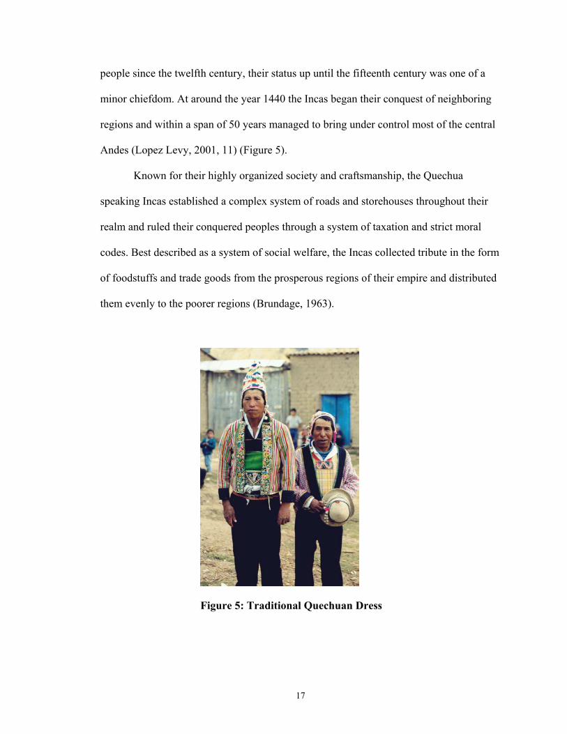
Known for their highly organized society and craftsmanship, the Quechua
speaking Incas established a complex system of roads and storehouses throughout their
realm and ruled their conquered peoples through a system of taxation and strict moral
codes. Best described as a system of social welfare, the Incas collected tribute in the form
of foodstuffs and trade goods from the prosperous regions of their empire and distributed
them evenly to the poorer regions (Brundage, 1963).
Figure 5: Traditional Quechuan Dress
18
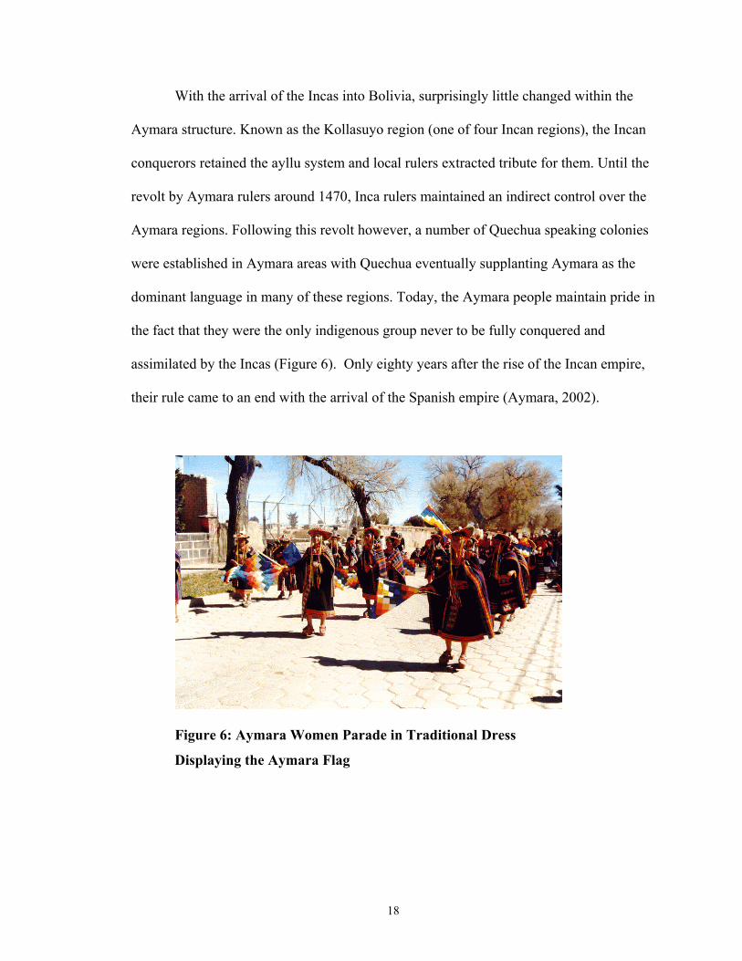
With the arrival of the Incas into Bolivia, surprisingly little changed within the
Aymara structure. Known as the Kollasuyo region (one of four Incan regions), the Incan
conquerors retained the ayllu system and local rulers extracted tribute for them. Until the
revolt by Aymara rulers around 1470, Inca rulers maintained an indirect control over the
Aymara regions. Following this revolt however, a number of Quechua speaking colonies
were established in Aymara areas with Quechua eventually supplanting Aymara as the
dominant language in many of these regions. Today, the Aymara people maintain pride in
the fact that they were the only indigenous group never to be fully conquered and
assimilated by the Incas (Figure 6). Only eighty years after the rise of the Incan empire,
their rule came to an end with the arrival of the Spanish empire (Aymara, 2002).
Figure 6: Aymara Women Parade in Traditional Dress
Displaying the Aymara Flag
19
Colonial Conquest and Society:
Without a doubt, the most profound impact on Bolivian society came in the year
1531 when the Spanish conquistadors, headed by Francisco Pizarro and Diego de
Almargo, arrived in present day Ecuador. Less than two years later the Incan Empire had
been defeated and dissolved with the spoils being divided up among the conquering
Spaniards.
The initial conquest of the Incan Empire came about rather easily. In the late
1520s a civil war had broken out in which an Incan nobleman named Atahuallpa
overthrew his king half-brother Huascar and assumed the throne as the descendent of the
Sun God. This led to massive civil war within the empire with the Aymara section of the
empire siding with the Huascar factions. Utilizing this knowledge and their superior
technological capacities, a few hundred Spanish soldiers were effectively able to
maneuver themselves into both camps and eliminate all organized resistance. This, tied
with local beliefs in white bearded gods, made conquest fairly easy. Consequently, a
population of around a million inhabitants was easily subdued (Brundage, 1967).
In 1572-1576 Lima Viceroy Francisco Toledo visited the region of Bolivia (then
known as Upper Peru) and completely reorganized the communal structure. Toledo
ordered all communities to be concentrated into fixed villages and town in order to
facilitate taxation. This style, evidently adapted from the Mediterranean system of
communal organization, had the effect of ending all vertical movement of peasants and
placed them more firmly under the control of the Spanish crown. Through these decrees,
Toledo created a system of rural and social organization which continues today (Klein,
1992, 38-39).

20
Revolution and the Formation of a Republic:
In 1809, with the Spanish empire waning, Bolivia became the first country to
formally declare independence from Spain. In the twenty years that followed, Bolivia
would be liberated and recaptured a number of times by armies from both sides of the
conflict with each change followed by massive destruction and looting. Finally, in
December of 1824, Bolivia was liberated by Simón Bolívar as the last remnants of the
Spanish Army were defeated in two decisive battles in the areas of Ayacucho and Junin
in Peru. On August 6, 1825 the Republic of Bolivia was formally established with the
capital located in the city of Sucre (then known as Chuquisaca). In honor of their liberator
Simon Bolivar, Upper Peru adopted the name Bolivia (Lopez Levy, 2001, 14; Van
Lindert and Verkoren, 1994, 13).
In the year 1879, Bolivia entered into the War of the Pacific with Chile over
nitrate rich fields in the Atacama Desert. Poorly led and trained, Bolivia was forced to
sue for peace in December 1879 leaving Chile all of Bolivia’s previous coastal territories.
Although Bolivia has lost an estimated 1,274,695 km2 (796,684 miles2) to Brazil, Chile,
Paraguay, and Peru, the 120,000 km2 (75,000 miles2) lost during this war to Chile
remains the hardest and most remembered. To this day, Bolivian school children sing
songs about reclaiming the coast, the country has a national day of remembrance for this
lost territory, and the department seal for that region remains on all national maps (Van
Lindert and Verkoren, 1994, 14).
Throughout the late nineteenth and early twentieth centuries, the Bolivian
government progressed into a more stable and democratically functioning body.
21
However, this transition was in no way inclusive of all sectors of society. The Bolivian
government grew to cater to the elite Spanish descendants (Creole) who lived in urban
areas and spoke Spanish. This effectively excluded the large rural Aymara, Quechua, and
other populations from all national participation and largely barred them from the
electoral process. Political parties were formed only to represent those Creole or Mestizo
(Spanish/Indian mixed descendant) elite who lived in the cities or functioned as
plantation or mine owners in the countryside.
On June 14, 1935, a devastating war with Paraguay ended that had resulted in
huge loses on both sides. As a result of the internal chaos imposed by this war, the
Bolivian military assumed power through a revolt. However, the excesses of the army
and discontent among the labor movements at the pace of government reform soon led to
open revolution and hostility. On April 9, 1952, the city armories were opened to the
public and the army led government met its defeat at the hands of the armed movement
(Hudson and Hanratty (eds.), 1989, xxix).
The revolution of 1952 brought about new long waited reforms for the indigenous
population. Led by president Victor Paz, the government seized and nationalized the
mining sector, instituted broad educational reforms, gave universal suffrage rights to all
its citizens, and took part in an aggressive agrarian reform program which distributed all
plantation land to its peasants. Until that point, most indigenous peasants lived and
worked on lands owned by wealthy men of Spanish descent. The seizure and
redistribution of this land led for the first time to widespread land tenure and freedom
from oppression for the long suffering indigenous population. The universal suffrage

22
further helped to vastly increase the political power of the revolutionary parties as the
voting public increased from 200,000 to just under 1,000,000 people (Molloy, 1970).
However, despite reforms initiated following the revolution, little economic and
social progress was made in Bolivia. In November 1964 the military performed a
relatively bloodless coup and placed power into the hands of Vice President General
Rene Barrientos. In the following eighteen years, a series of dictatorships and weak
military backed governments would vie for power while achieving little actual progress
in the area of economic or social development (Molloy, 1970).
Weary with long periods of authoritarian rule the populace began to demand a
return to democracy. In 1982, General Celso Torrelio Villa was forced to resign. Later in
the same year, Congress elected Harnan Siles Zuazo as the president of Bolivia. From
that point on, democracy and open market programs have steered Bolivian government
policy (Klein, 1992, 70-73).
Throughout the 1990s heavy foreign investment has helped spur development
programs. Although the economy suffered a recession and national protests as a result of
the U.S. imposed coca eradication programs, the country has maintained a democratic
process and developed its national economy. Large sectors of the economy became
privatized and in order to spur rural development, the law of popular participation
mandated that 51% of all profits from national industries would be steered toward
infrastructure development and the building of medical facilities and schools in rural
areas (Aguabolivia 2002).
Although recent widespread protests have hindered economic growth, Bolivia
nonetheless stands poised to maintain its progress and development well into the next

23
century. New programs aimed at educational reform and social development in the areas
of gender relations have recently begun. National free vaccination campaigns and yearly
pensions to the poor have helped to create greater stability.
Sectors of the government which have recently received much attention have been
those that deal with the environment and sustainable agriculture. Within the last ten
years, a flood of new laws including the Law of Popular Participation and the Law of the
Environment have provided new resources to farmers and technical trainers wishing to
promote greater environmental stewardship. New efforts aimed at reforestation of
degraded lands, reducing erosion and flooding, and land reclamation have begun to see
widespread use in rural areas. One such example where these methods are being
introduced is at the Centro Experimental Agropecuaria, Condoriri in the Department of
Oruro.
24
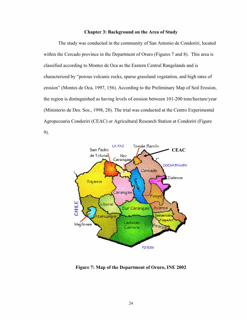
Chapter 3: Background on the Area of Study
The study was conducted in the community of San Antonio de Condoriri, located
within the Cercado province in the Department of Oruro (Figures 7 and 8). This area is
classified according to Montes de Oca as the Eastern Central Rangelands and is
characterized by “porous volcanic rocks, sparse grassland vegetation, and high rates of
erosion” (Montes de Oca, 1997, 156). According to the Preliminary Map of Soil Erosion,
the region is distinguished as having levels of erosion between 101-200 tons/hectare/year
(Ministerio de Des. Sos., 1998, 28). The trial was conducted at the Centro Experimental
Agropecuaria Condoriri (CEAC) or Agricultural Research Station at Condoriri (Figure
9).
Figure 7: Map of the Department of Oruro, INE 2002
CEAC

25
Figure 8: Map of Cercado Province, Oruro, Bolivia INE 2002
CEAC is located on the Bolivian central high plains region approximately 56 km
north-northeast of the capital city of Oruro (pop.183, 422) (INE, 1993). The center spans
approximately 2,084 hectares and is located at an altitude of 3,830 meters (12,562 feet)
above sea level. Average rainfall is approximately 350 mm/year (14 inches/year) and
average temperatures range from -18°C to 15 °C (0°F to 60°F). Rainfall is unimodal in its
distribution with the majority arriving in the summer months of December through
March. Natural vegetation consists largely of prairie grasslands intermixed with shrubs
and bushes.
The station is funded and operated by the Oruro Technological University
(Universidad Tecnicá de Oruro) as a research and extension center. A variety of
researchers (técnicos), students, and farm hands work at the center and focus their efforts
CEAC
26
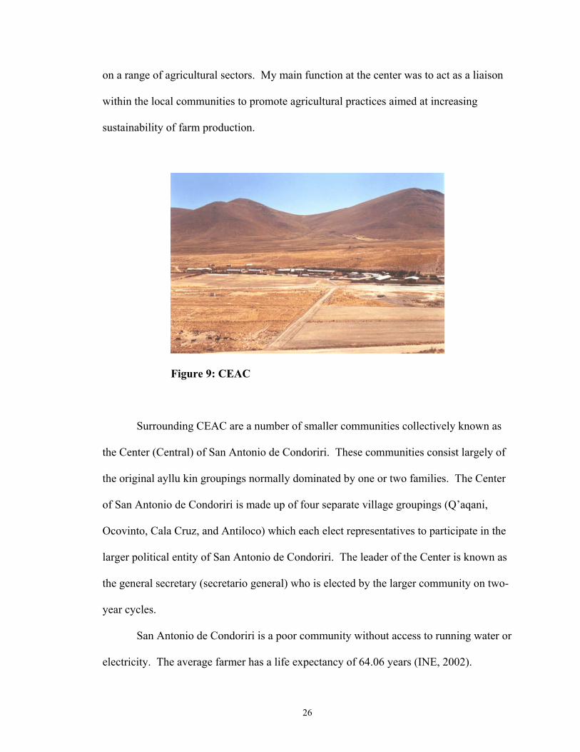
on a range of agricultural sectors. My main function at the center was to act as a liaison
within the local communities to promote agricultural practices aimed at increasing
sustainability of farm production.
Figure 9: CEAC
Surrounding CEAC are a number of smaller communities collectively known as
the Center (Central) of San Antonio de Condoriri. These communities consist largely of
the original ayllu kin groupings normally dominated by one or two families. The Center
of San Antonio de Condoriri is made up of four separate village groupings (Q’aqani,
Ocovinto, Cala Cruz, and Antiloco) which each elect representatives to participate in the
larger political entity of San Antonio de Condoriri. The leader of the Center is known as
the general secretary (secretario general) who is elected by the larger community on two-
year cycles.
San Antonio de Condoriri is a poor community without access to running water or
electricity. The average farmer has a life expectancy of 64.06 years (INE, 2002).
27
According the National Statistical Institute (INE, 1993), the population density for the
Cercado province is between 5.0 and 14.9 people per hectare with sparser populations
being located in the rural regions. The Cercado province has a population growth rate of
2.04% per year (Montes de Oca, 1997, pg. 89-95) and the sectional capital of Caracollo
has an estimated population of 11,547 inhabitants including the nearby Center of San
Antonio de Condoriri. The most widely spoken languages in this region are Aymara
(63%) and Spanish (71%) with most people speaking only Aymara until they reach
school around six years of age (INE, 2002).
Agricultural Production:
Of the 65,000 different family farms within the central high plains zone, 66% of
them are less than five hectares in size. The average farmer in this area earns around
$250 a year from his crops and animals with only ten percent of their total land
considered cultivable. The rest of their lands are dedicated to grazing systems (Cárdenas,
pers. com., 2000; Montes de Oca, 1997, pg. 406). Most farm production relies heavily on
animal draft systems for plowing as well as manual labor. Small family farms are the
norm with most families managing an integrated system of livestock and agriculture.
When possible, animal fertilizer from sheep, cattle, and llamas are added to the fields to
increase production. Green fertilizers are not commonly used in this area.
The majority of agricultural production in the surrounding area lies in seasonal
rain-fed crop systems that produce a limited variety of crops such as potatoes, wheat,
onions, barley, and quinua (Tables 1 and 2). These systems are small scale and limited to
areas where soil productivity remains relatively high. However, because of problems with

28
erosion and climate variability, this method gives variable yields depending on the
farming parcel and weather characteristics for that year.
The preferred but more costly system of farming in the area is irrigation. This
system relies on water pumps to remove water from sub-terranean aquifers or from a
nearby river system for watering in traditional furrow agriculture. This system allows for
larger and more variable crop production including carrots, beets (Beta vulgaris L.), lima
beans (Phaseolus lunatus L.), and alfalfa (Medicago sp.). However, given the cost of
running and obtaining the pump, this method is not available to all families. Only
approximately 1000 ha. of land within the Caracollo province are currently under
irrigation with a large portion of that number (400) falling under CEAC lands (Cárdenas,
pers. com., 2000). Local farmers rarely utilize soil conservation practices. However, in
recent years there has been a slight increase in the adoption of basic soil conservation
practices such as trenches and contour farming in the areas surrounding the research
station (Figure 10).
Figure 10: Soil Conservation Work in San Antonio
de Condoriri

29
Table 1: Principle Crops of Oruro
Crops 1995 (Metric
Tons)
Potato 31,582
Berza Barley 25,400
Alfalfa 20,300
Quinua 6,200
Lima Bean 5,600
Sweet Potato 3,100
Barley 2,290
Onion 2,000
Total 96,472
Source: Valdivia, 1996
30
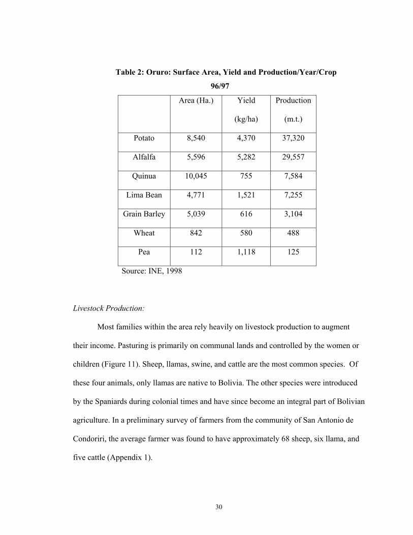
Table 2: Oruro: Surface Area, Yield and Production/Year/Crop
96/97
Area (Ha.) Yield
(kg/ha)
Production
(m.t.)
Potato 8,540 4,370 37,320
Alfalfa 5,596 5,282 29,557
Quinua 10,045 755 7,584
Lima Bean 4,771 1,521 7,255
Grain Barley 5,039 616 3,104
Wheat 842 580 488
Pea 112 1,118 125
Source: INE, 1998
Livestock Production:
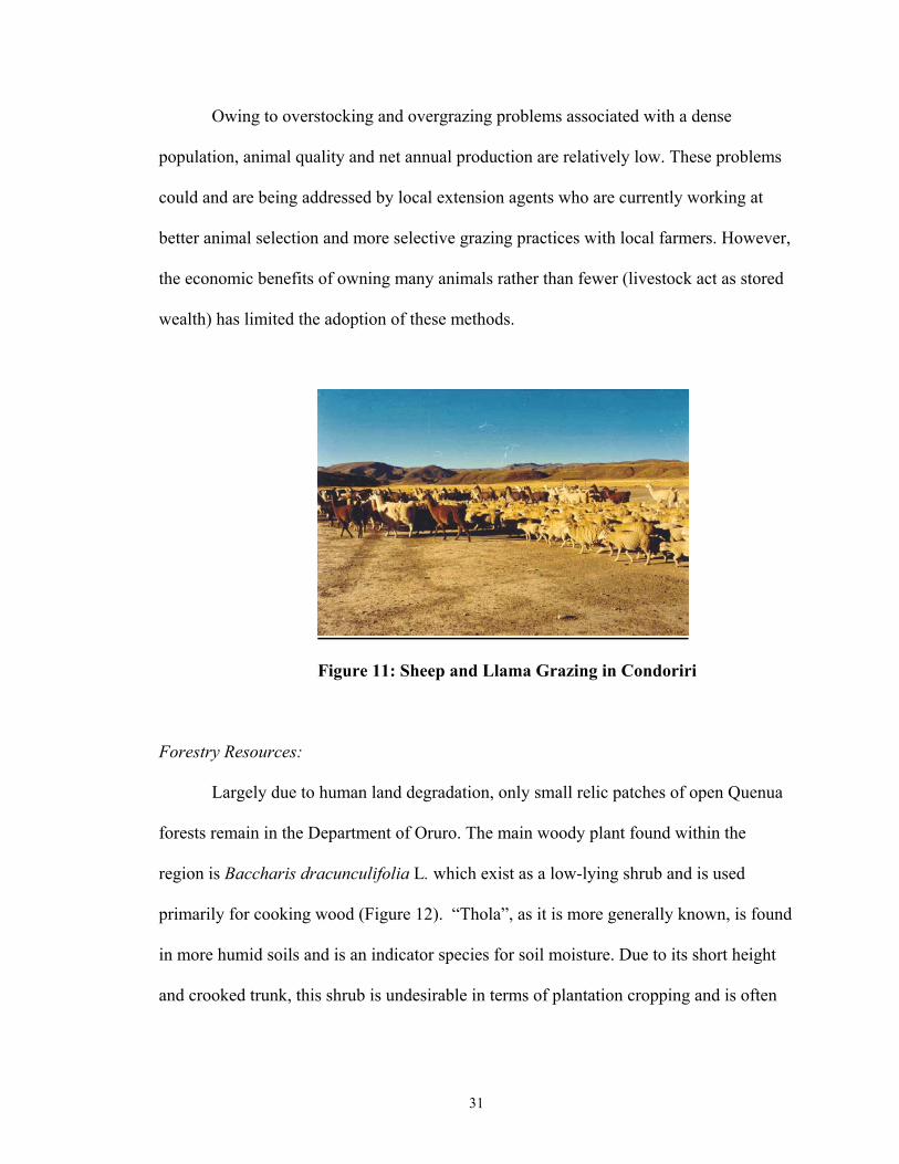
Most families within the area rely heavily on livestock production to augment
their income. Pasturing is primarily on communal lands and controlled by the women or
children (Figure 11). Sheep, llamas, swine, and cattle are the most common species. Of
these four animals, only llamas are native to Bolivia. The other species were introduced
by the Spaniards during colonial times and have since become an integral part of Bolivian
agriculture. In a preliminary survey of farmers from the community of San Antonio de
Condoriri, the average farmer was found to have approximately 68 sheep, six llama, and
five cattle (Appendix 1).
31
Owing to overstocking and overgrazing problems associated with a dense
population, animal quality and net annual production are relatively low. These problems
could and are being addressed by local extension agents who are currently working at
better animal selection and more selective grazing practices with local farmers. However,
the economic benefits of owning many animals rather than fewer (livestock act as stored
wealth) has limited the adoption of these methods.
Figure 11: Sheep and Llama Grazing in Condoriri
Forestry Resources:
Largely due to human land degradation, only small relic patches of open Quenua
forests remain in the Department of Oruro. The main woody plant found within the
region is Baccharis dracunculifolia L. which exist as a low-lying shrub and is used
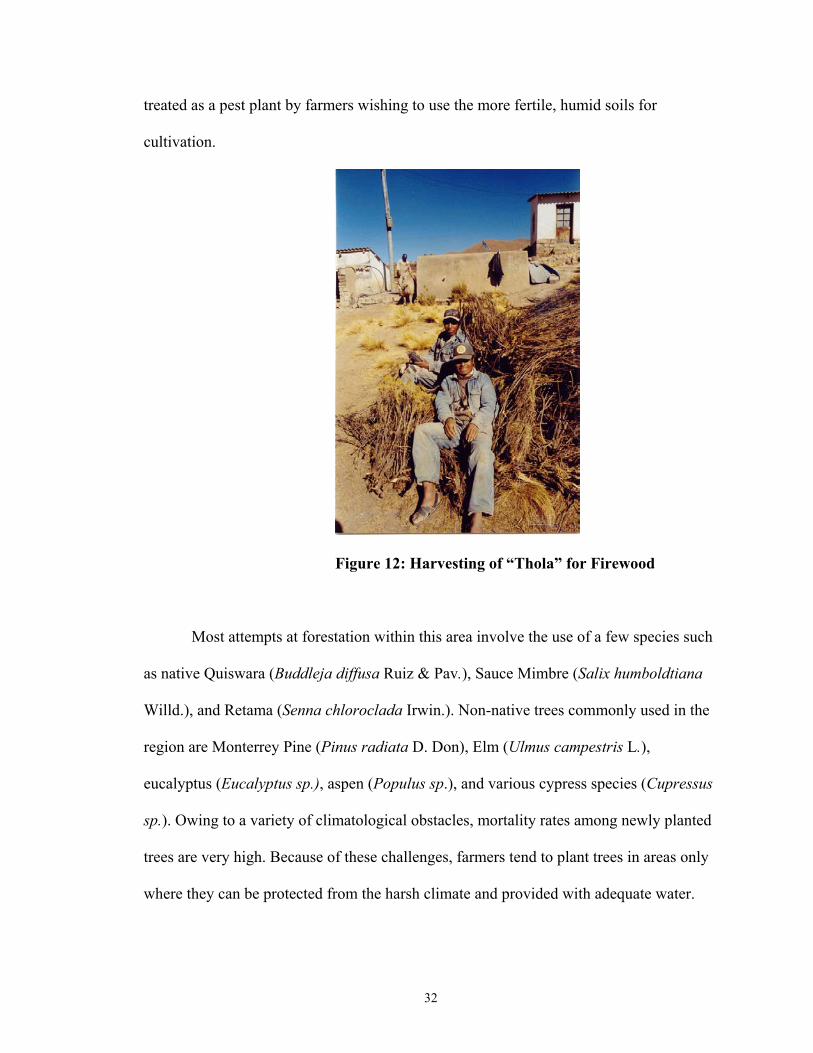
primarily for cooking wood (Figure 12). “Thola”, as it is more generally known, is found
in more humid soils and is an indicator species for soil moisture. Due to its short height
and crooked trunk, this shrub is undesirable in terms of plantation cropping and is often
32
treated as a pest plant by farmers wishing to use the more fertile, humid soils for
cultivation.
Figure 12: Harvesting of “Thola” for Firewood
Most attempts at forestation within this area involve the use of a few species such
as native Quiswara (Buddleja diffusa Ruiz & Pav.), Sauce Mimbre (Salix humboldtiana
Willd.), and Retama (Senna chloroclada Irwin.). Non-native trees commonly used in the
region are Monterrey Pine (Pinus radiata D. Don), Elm (Ulmus campestris L.),
eucalyptus (Eucalyptus sp.), aspen (Populus sp.), and various cypress species (Cupressus
sp.). Owing to a variety of climatological obstacles, mortality rates among newly planted
trees are very high. Because of these challenges, farmers tend to plant trees in areas only
where they can be protected from the harsh climate and provided with adequate water.
33
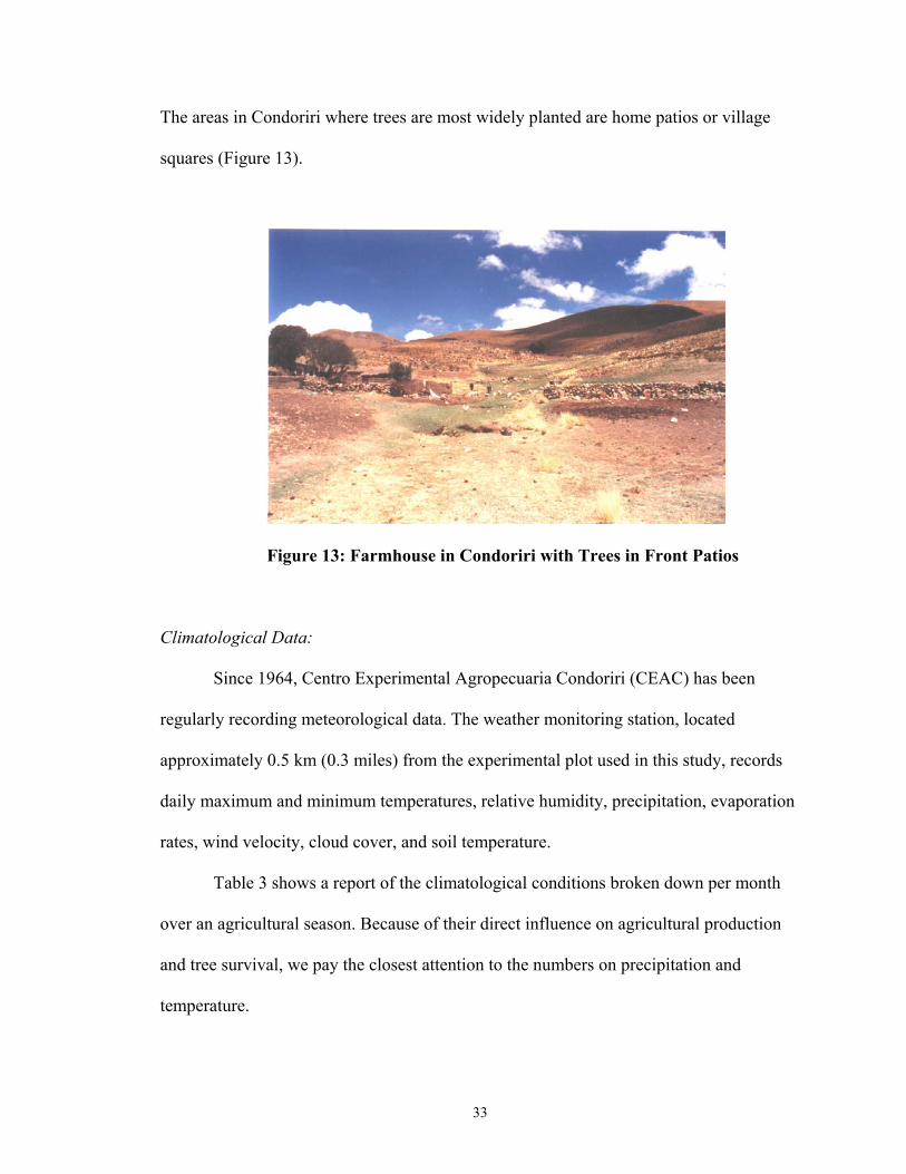
The areas in Condoriri where trees are most widely planted are home patios or village
squares (Figure 13).
Figure 13: Farmhouse in Condoriri with Trees in Front Patios
Climatological Data:
Since 1964, Centro Experimental Agropecuaria Condoriri (CEAC) has been
regularly recording meteorological data. The weather monitoring station, located
approximately 0.5 km (0.3 miles) from the experimental plot used in this study, records
daily maximum and minimum temperatures, relative humidity, precipitation, evaporation
rates, wind velocity, cloud cover, and soil temperature.
Table 3 shows a report of the climatological conditions broken down per month
over an agricultural season. Because of their direct influence on agricultural production
and tree survival, we pay the closest attention to the numbers on precipitation and
temperature.

34
35
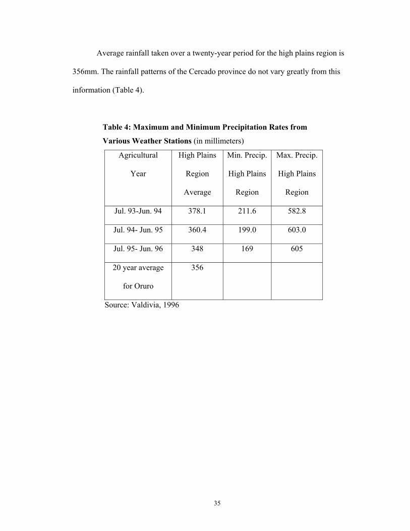
Average rainfall taken over a twenty-year period for the high plains region is
356mm. The rainfall patterns of the Cercado province do not vary greatly from this
information (Table 4).
Table 4: Maximum and Minimum Precipitation Rates from
Various Weather Stations (in millimeters)
Agricultural
Year
High Plains
Region
Average
Min. Precip.
High Plains
Region
Max. Precip.
High Plains
Region
Jul. 93-Jun. 94 378.1 211.6 582.8
Jul. 94- Jun. 95 360.4 199.0 603.0
Jul. 95- Jun. 96 348 169 605
20 year average
for Oruro
356
Source: Valdivia, 1996
36
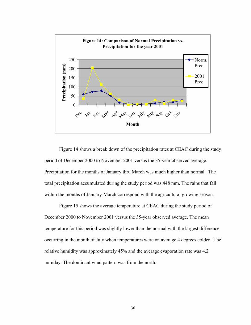
Figure 14 shows a break down of the precipitation rates at CEAC during the study
period of December 2000 to November 2001 versus the 35-year observed average.
Precipitation for the months of January thru March was much higher than normal. The
total precipitation accumulated during the study period was 448 mm. The rains that fall
within the months of January-March correspond with the agricultural growing season.
Figure 15 shows the average temperature at CEAC during the study period of
December 2000 to November 2001 versus the 35-year observed average. The mean
temperature for this period was slightly lower than the normal with the largest difference
occurring in the month of July when temperatures were on average 4 degrees colder. The
relative humidity was approximately 45% and the average evaporation rate was 4.2
mm/day. The dominant wind pattern was from the north.
Figure 14: Comparison of Normal Precipitation vs. Precipitation for the year 2001
0
50
100
150
200
250
Dec Jan Feb Mar AprMay Jun
eJul
yAug Sep Oct
Nov
Month
Prec
ipita
tion
(mm
)Norm.Prec.
2001Prec.

37
Climate factors such low rainfall, fluctuating temperatures, frost, high altitude,
and high winds all serve to inhibit the establishment of many non-native plants. In
addition to establishment, growth over the long term may be retarded by these factors
further serving to complicate agricultural and silvicultural efforts in this region. The
introduction of a technology that could help overcome such obstacles would benefit the
local communities.
Figure 15: Comparison of Normal Mean Temp. vs. Mean Temp. for the year 2001
0
2
4
6
8
10
12
14
Dec Jan Feb Mar AprMay
June
July
Aug Sep OctNov
Month
Tem
pera
ture
(°C
)
Norm.MeanTemp.2001MeanTemp.

38
Chapter 4: Description of Microcatchment Systems
The entire Cercado province and much of Bolivia are experiencing new
challenges resulting from land degradation and increased population pressures.
According to INE (1993), the overall population density for the high plains region has
increased from 4.86 to 9.44 per hectare since 1950. As a result of these population
pressures, land holding size is decreasing and previously marginal land is being
cultivated. A vast majority of these lands contain poor soils, low vegetative cover, and
slopes greater than or equal to 7% which lead to higher erosion rates. Coupled with low
annual rainfall and increased overgrazing, the Andean farmer has seen a steady drop in
soil quality and, as a result, farm production. In areas such as these, microcatchment
systems may prove effective in increasing production and improving land quality.
Microcatchment systems vary greatly in design and size but generally follow the
same basic principles. Beets (1990, 505) defines a microcatchment system as one in
which “run-off from a small plot is captured at one side where it infiltrates and directly
contributes to the available moisture in the rooted profile of an individual productive tree
or shrub”.
Many examples of microcatchments have been constructed all over the world.
Generally, they contain a catchment area in which rainwater is allowed to run off of a
sloped surface and be channeled down to a certain area where a plant has been placed.
Once channeled to that area, water begins pooling around an earthen bund or some other
structure constructed at the desired angle and height (Figure 16). As the water pools, it
then slowly infiltrates into the surrounding soil in order to provide more water to the
plant within the microcatchment system. These systems generally are small in design and

39
each support only a limited number of individual plants. They are relatively inexpensive
to construct and with proper maintenance can last for many years.
catchment area
earth bund
water flow
Figure 16: Example of Microcatchment System for Trees
Various microcatchment systems have been in use for thousands of years (Bruins
et al., 1986; Evenari et al., 1968; Harden, 1975; Meyer, 1975; Pacey and Cullis, 1986).
Important publications on water harvesting systems include Shannan and Tadmor (1979);
Dutt et al. (1981); Boers and Ben-Asher (1982); Rejj et al. (1988); Boers et al. (1985);
and Ben-Asher et al. (1985). However, while there are numerous studies on the
effectiveness of microcatchment systems in cropping systems (Anaya, 1988; Carmona
and Velasco, 1988; Ehrler et al., 1978; Flug, 1981; Hollick, 1982; Mielke and Dutt, 1981;
Sharma et al., 1986; Slayback and Cable, 1970; Tabor, 1995) fewer studies exist for
forestry catchments than for agricultural systems (Gupta, 1991; Gupta, 1995; Gupta and
40
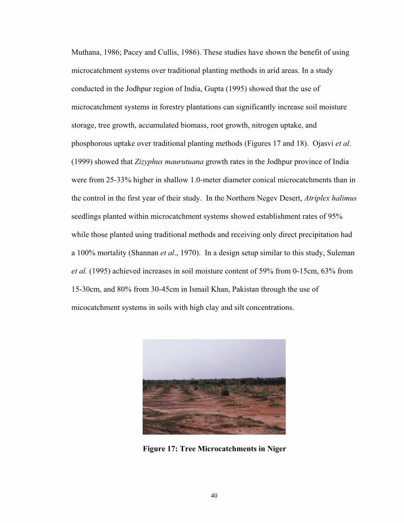
Muthana, 1986; Pacey and Cullis, 1986). These studies have shown the benefit of using
microcatchment systems over traditional planting methods in arid areas. In a study
conducted in the Jodhpur region of India, Gupta (1995) showed that the use of
microcatchment systems in forestry plantations can significantly increase soil moisture
storage, tree growth, accumulated biomass, root growth, nitrogen uptake, and
phosphorous uptake over traditional planting methods (Figures 17 and 18). Ojasvi et al.
(1999) showed that Zizyphus maurutuana growth rates in the Jodhpur province of India
were from 25-33% higher in shallow 1.0-meter diameter conical microcatchments than in
the control in the first year of their study. In the Northern Negev Desert, Atriplex halimus
seedlings planted within microcatchment systems showed establishment rates of 95%
while those planted using traditional methods and receiving only direct precipitation had
a 100% mortality (Shannan et al., 1970). In a design setup similar to this study, Suleman
et al. (1995) achieved increases in soil moisture content of 59% from 0-15cm, 63% from
15-30cm, and 80% from 30-45cm in Ismail Khan, Pakistan through the use of
micocatchment systems in soils with high clay and silt concentrations.
Figure 17: Tree Microcatchments in Niger
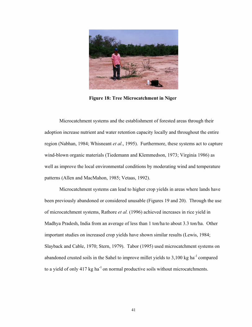
41
Figure 18: Tree Microcatchment in Niger
Microcatchment systems and the establishment of forested areas through their
adoption increase nutrient and water retention capacity locally and throughout the entire
region (Nabhan, 1984; Whisneant et al., 1995). Furthermore, these systems act to capture
wind-blown organic materials (Tiedemann and Klemmedson, 1973; Virginia 1986) as
well as improve the local environmental conditions by moderating wind and temperature
patterns (Allen and MacMahon, 1985; Vetaas, 1992).
Microcatchment systems can lead to higher crop yields in areas where lands have
been previously abandoned or considered unusable (Figures 19 and 20). Through the use
of microcatchment systems, Rathore et al. (1996) achieved increases in rice yield in
Madhya Pradesh, India from an average of less than 1 ton/ha to about 3.3 ton/ha. Other
important studies on increased crop yields have shown similar results (Lewis, 1984;
Slayback and Cable, 1970; Stern, 1979). Tabor (1995) used microcatchment systems on
abandoned crusted soils in the Sahel to improve millet yields to 3,100 kg ha-1 compared
to a yield of only 417 kg ha-1 on normal productive soils without microcatchments.
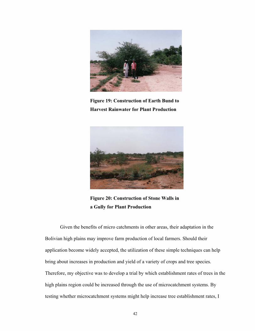
42
Figure 19: Construction of Earth Bund to
Harvest Rainwater for Plant Production
Figure 20: Construction of Stone Walls in
a Gully for Plant Production
Given the benefits of micro catchments in other areas, their adaptation in the
Bolivian high plains may improve farm production of local farmers. Should their
application become widely accepted, the utilization of these simple techniques can help
bring about increases in production and yield of a variety of crops and tree species.
Therefore, my objective was to develop a trial by which establishment rates of trees in the
high plains region could be increased through the use of microcatchment systems. By
testing whether microcatchment systems might help increase tree establishment rates, I

43
can evaluate whether promotion of this technology for broader purposes could be
undertaken. The original inspiration for this study came out of the work of Sheikh et al.
(1984) in the arid lands of Pakistan.
44
Chapter 5: Methodology and Data
This experiment was designed to determine the best way to increase tree
establishment rates in the Bolivian high plains. In order to overcome the climatological
challenges of the high plains, creative solutions are needed. The impetus to test
microcatchment systems came about after a long observation process in which various
failed tree establishment methods were attempted on CEAC lands. In a project
undertaken by my counterpart Jesús Cárdenas and former Peace Corps Volunteer Cotton
Randle, approximately 1,000 native and introduced tree seedlings were planted on lands
adjacent to the station. After a period of two years, less than 5% of those seedlings were
still surviving despite being surrounded by protective structures. Water shortages seemed
to be a critical factor in tree mortality.
The first part of this chapter will summarize the experiment. In this chapter I will
discuss the design of the experiment, the statistical formulas used, soil data, and I will
give a detailed history and description of the species chosen for this study. Following this
information, I will present the data collected throughout the trial.
Land located on the Centro Experimental Agropecuaria, Condoriri (CEAC) was
dedicated for use in this study. The experiment layout followed a randomized complete-
block design (Steele and Torrie, 1960, 135) of ten blocks with five planting treatments
each containing two commonly used species in this region, Polylepsis tarapacana
Hieron. and Cupressus macrocarpa Hart. The experiment was organized and planned to
begin at the start of the rainy season in Oruro and end at the end of the dry season. Data
were collected throughout the study period.

45
Statistical methods:
The randomized complete-block design is a useful way of analyzing data when no
external sources of variation (outside of treatment effects) are expected to interfere with
various individuals of the experiment. Using a randomized complete-block design allows
for larger levels of variation to occur within treatments within a certain block while still
maintaining the independence of each block from other blocks (Steele and Torrie, 1960,
132). The response variable (y) for this study was the number of surviving individuals.
The following formulas were used to analyze the statistical information from this study
(Freese, 1984):
Source of variation df Blocks n-1 Treatments t-1 Error (n-1)(t-1) Total (n-1)+(t-1)+ (n-1)(t-1)
Where n = the number of blocks and t = the number of treatments
1. The correction term
50
C.T. = (ΣX)2 n 50
2. Total SS = ΣX2 – C.T.
5
3. Treatment SS = Σ(Treatment totals2) _ C.T. # of plots per Treatment
10
4. Block SS = Σ(Treatment totals2) _ C.T. # of plots per block
5. Error SS = Total SS – Treatment SS – Block SS 32 df 45 df 4 df 9 df

46
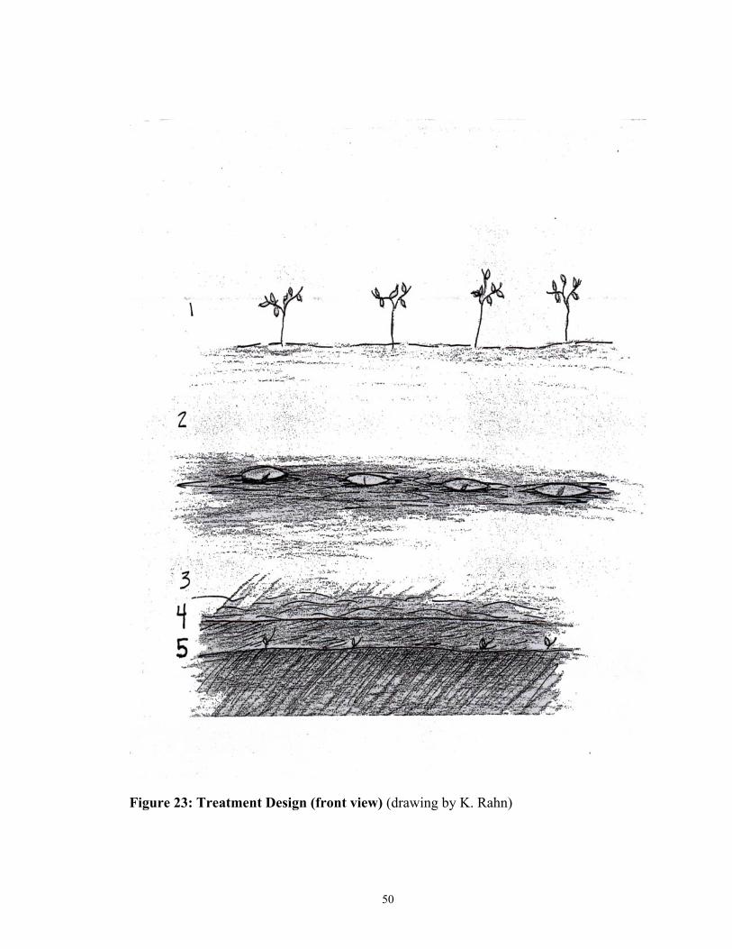
Treatment Design
Each treatment within each block contained three individuals of each species. Ten
blocks were laid out sequentially along on a hillside with a slope of approximately seven
percent. Each treatment within each block was spaced ten meters down slope from the
next treatment so as to provide for an adequate water catchment area (3:10). The trees
were spaced 1.5 meters (5 feet) apart from each other to provide for a good rainfall
catchment area. In order to exclude grazing animals from the study area, a barbed wire
fence was set up around the outside perimeter of the study area. The five treatments were
arranged within each block according to the following specifications:
1.) Treatment 1 was the control. There were no microcatchment systems used and the
trees were placed directly into the ground without any protection from the elements.
Holes were laid out in a transect line along a contour (Figures 21, 22, and 23).
2.) Treatment 2, known as the pit planting method, was a simple hole dug in the
ground with one hole dug per seedling. The hole was dug to an additional depth of 30
cm. The seedling was planted 30 cm below ground to provide protection from the
elements while still giving the seedlings access to sunlight. Holes were laid out in a
transect line along a contour (Figures 21, 22, and 23).
3.) Treatment 3 was a basic trench system dug to a depth of 30 cm and localized along
the contour to prevent excess water runoff. (Figures 21, 22, and 23).
4.) Treatment 4 consisted of a widened trench basin (approximately 60cm wide) with
the trench depth still maintained at 30cm and laid out along the contour. The

47
increased width of the trench was constructed to allow for a larger collection area of
runoff water within the microcatchments (Figures 21, 22, and 23).
5.) Treatment 5 consisted of a slanted trench system similar to trench number 4 with an
additional trench dug 30cm deeper inside to provide further water collection and
protection from the environment (Figures 21, 22, and 23).
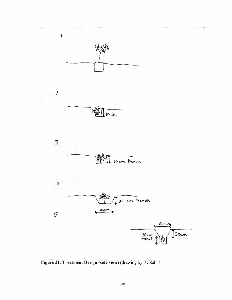
48
Figure 21: Treatment Design (side view) (drawing by K. Rahn)

49
Figure 22: Treatment Design (top view) (drawing by K. Rahn)
50
Figure 23: Treatment Design (front view) (drawing by K. Rahn)
51
At the time of planting, approximately 2.5 kg of sheep manure was applied to
each tree in order to improve nutrient availability during transplanting. No further
fertilization efforts were made throughout the remainder of the study and the trees were
never irrigated. Trees were checked on a two and a half month basis for survival rates
and perimeter fences were checked on a daily basis.
Soil information:
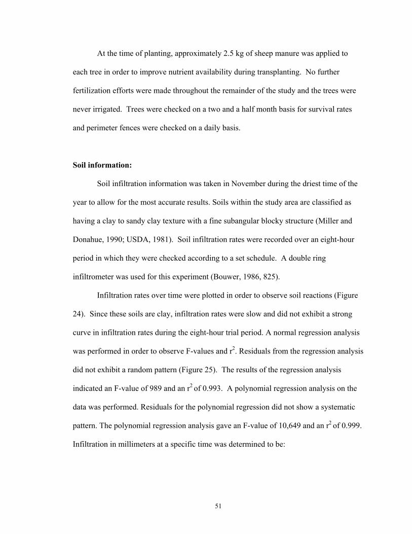
Soil infiltration information was taken in November during the driest time of the
year to allow for the most accurate results. Soils within the study area are classified as
having a clay to sandy clay texture with a fine subangular blocky structure (Miller and
Donahue, 1990; USDA, 1981). Soil infiltration rates were recorded over an eight-hour
period in which they were checked according to a set schedule. A double ring
infiltrometer was used for this experiment (Bouwer, 1986, 825).
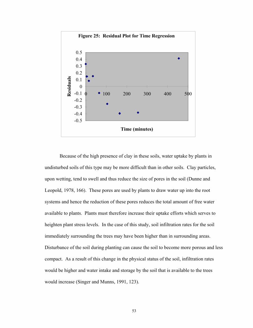
Infiltration rates over time were plotted in order to observe soil reactions (Figure
24). Since these soils are clay, infiltration rates were slow and did not exhibit a strong
curve in infiltration rates during the eight-hour trial period. A normal regression analysis
was performed in order to observe F-values and r2. Residuals from the regression analysis
did not exhibit a random pattern (Figure 25). The results of the regression analysis
indicated an F-value of 989 and an r2 of 0.993. A polynomial regression analysis on the
data was performed. Residuals for the polynomial regression did not show a systematic
pattern. The polynomial regression analysis gave an F-value of 10,649 and an r2 of 0.999.
Infiltration in millimeters at a specific time was determined to be:
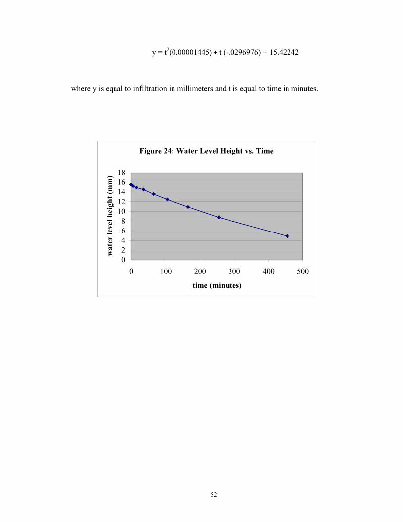
52
y = t2(0.00001445) + t (-.0296976) + 15.42242
where y is equal to infiltration in millimeters and t is equal to time in minutes.
Figure 24: Water Level Height vs. Time
02468
1012141618
0 100 200 300 400 500
time (minutes)
wat
er le
vel h
eigh
t (m
m)
53
Figure 25: Residual Plot for Time Regression
-0.5-0.4-0.3-0.2-0.1
00.10.20.30.40.5
0 100 200 300 400 500
Time (minutes)
Res
idua
ls
Because of the high presence of clay in these soils, water uptake by plants in
undisturbed soils of this type may be more difficult than in other soils. Clay particles,
upon wetting, tend to swell and thus reduce the size of pores in the soil (Dunne and
Leopold, 1978, 166). These pores are used by plants to draw water up into the root
systems and hence the reduction of these pores reduces the total amount of free water
available to plants. Plants must therefore increase their uptake efforts which serves to
heighten plant stress levels. In the case of this study, soil infiltration rates for the soil
immediately surrounding the trees may have been higher than in surrounding areas.
Disturbance of the soil during planting can cause the soil to become more porous and less
compact. As a result of this change in the physical status of the soil, infiltration rates
would be higher and water intake and storage by the soil that is available to the trees
would increase (Singer and Munns, 1991, 123).

54
Species Used in the Study:
For the purposes of this study, I decided to select two species of trees commonly
used or found in this area. In order to facilitate comparisons in survival rates, I selected
one native and one non-native species. The native species I selected was Polylepsis
tarapacana Hieron. while the non-native species I selected was Cupressus macrocarpa
Hart.. What follows is a general description of both species as well as their current uses
and values within the Bolivian high plains society.
Polylepsis tarapacana
P. tarapacana grows at the highest altitude in the world for any tree. Forests in
which these trees are the dominant species are considered to be some of the most
endangered forest ecosystems in South America (Hjarsen, 1998). P. tarapacana is
commonly known as Kehuiña, Kewiña, Queñua, Keuña or Q’iwiña and is typically found
in Bolivia along the central and southern high plains regions at altitudes ranging from
4100-5200 meters (13,500-17,000 feet) above sea level (Argollo et al., 2001; Loayza et
al., 2001; Rada et al., 2001). The species is described by Fjeldså (1992) as appearing in
either a bush or tree form with a twisted trunk, evergreen foliage, dense nanophyllus
leaves and often associated with a large amount of dead twigs and other organic material
at its base (Figures 26 and 27). The bark is generally easy to remove but is quite thick
and heavily laminated. Although generally small in height, some individuals have been
observed to reach up to twenty meters (65 feet). Cárdenas (2001) estimated that at higher
altitudes P. tarapacana has a height growth rate of only fourteen millimeters (0.55
inches) per year with the majority of that growth occurring in the summer months from
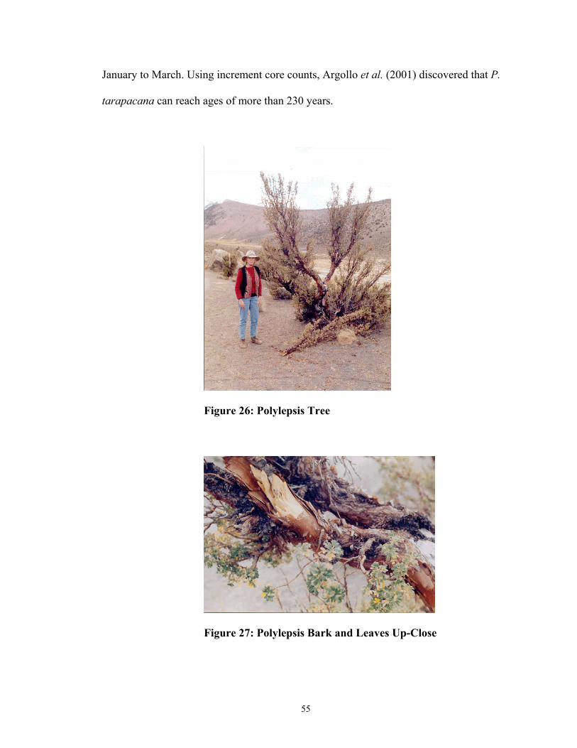
55
January to March. Using increment core counts, Argollo et al. (2001) discovered that P.
tarapacana can reach ages of more than 230 years.
Figure 26: Polylepsis Tree
Figure 27: Polylepsis Bark and Leaves Up-Close
56
Polylepsis sp. are presumed to have first appeared in the Plio-Pleistocene era
within the Andean region of Venezuela and Columbia and subsequently evolved within
the variable geographic and climatological zones which currently constitute the Andean
mountain regions (Baied, 2001). The nine species currently found within the borders of
Bolivia are relicts, isolated by human activity over the past millennia. Ellenberg (1958)
and Ruthsatz (1977) estimated that much of the present day high plains region was at one
time pristine P. tarapacana habitat. Today approximately ten percent of the P.
tarapacana forests survive in largely protected sites such as rock faces, rocky slopes or
along streams (Kessler, 2001). Along the eastern region of the Bolivian Andes, only one
to two percent of the original forest cover remains with most patches isolated in one to
two hectare plots (Kessler, 1995 as cited in Kessler, 2001).
Within forests where P. tarapacana are present, these species are generally the
dominant or only tree species found within the region although shrub vegetation may be
present (Baccharis sp., Berberis sp., Chuquiragua sp., Durantha sp.) (Fjeldså, 1992).
P. tarapacana are typically found in open forest habitats (Figure 28) and in climates
where they are subjected to environmental stresses. Approximately 40 species of birds
are found within P. tarapacana forests, with seven species being exclusively dependent
on them (Yensen and Tarifa, 2001). Local indigenous groups have discovered more than
100 medicinal uses for P. tarapacana treating a variety of ailments such as arthritis,
coughs, rheumatism, and urinary diseases (Loayza et al., 2001).
Researchers have found that P. tarapacana can withstand sharp temperature
variations and extremely high altitudes. Rada et al. (2001) observed that injury
temperatures for P. tarapacana ranged from -18°C to -23°C (0°F to -9°F). Among
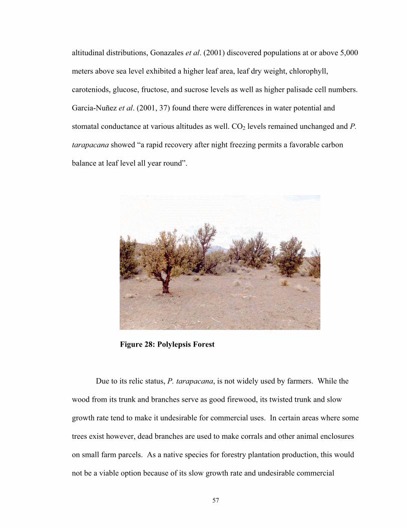
57
altitudinal distributions, Gonazales et al. (2001) discovered populations at or above 5,000
meters above sea level exhibited a higher leaf area, leaf dry weight, chlorophyll,
caroteniods, glucose, fructose, and sucrose levels as well as higher palisade cell numbers.
Garcia-Nuñez et al. (2001, 37) found there were differences in water potential and
stomatal conductance at various altitudes as well. CO2 levels remained unchanged and P.
tarapacana showed “a rapid recovery after night freezing permits a favorable carbon
balance at leaf level all year round”.
Figure 28: Polylepsis Forest
Due to its relic status, P. tarapacana, is not widely used by farmers. While the
wood from its trunk and branches serve as good firewood, its twisted trunk and slow
growth rate tend to make it undesirable for commercial uses. In certain areas where some
trees exist however, dead branches are used to make corrals and other animal enclosures
on small farm parcels. As a native species for forestry plantation production, this would
not be a viable option because of its slow growth rate and undesirable commercial
58
characteristics. From an ecological standpoint however, this species would be an
excellent choice for long-term rehabilitation of previously disturbed or degraded habitat.
Cupressus macrocarpa
C. macrocarpa, otherwise known as Monterey Cypress, originates from Monterey
Bay in the northern coast of California. Currently, there are only two native groves of C.
macrocarpa in the entire world with both occurring in the Monterrey region (Montara,
2002). C. macrocarpa ranges in height from 21-27 meters (70-90 feet) although when
transplanted from its native area it has been known to reach heights of more than 30
meters (100 feet) (Floridata, 2002; Gilman and Watson, 1993). Gilman and Watson
(1993) describes the species as having a columnar, pyramidal shape, straight trunk,
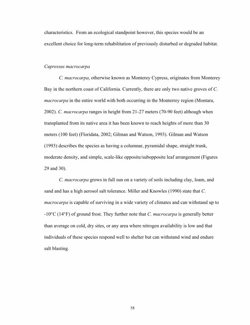
moderate density, and simple, scale-like opposite/subopposite leaf arrangement (Figures
29 and 30).
C. macrocarpa grows in full sun on a variety of soils including clay, loam, and
sand and has a high aerosol salt tolerance. Miller and Knowles (1990) state that C.
macrocarpa is capable of surviving in a wide variety of climates and can withstand up to
-10°C (14°F) of ground frost. They further note that C. macrocarpa is generally better
than average on cold, dry sites, or any area where nitrogen availability is low and that
individuals of these species respond well to shelter but can withstand wind and endure
salt blasting.
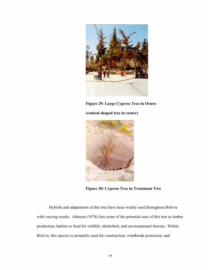
59
Figure 29: Large Cypress Tree in Oruro
(conical shaped tree in center)
Figure 30: Cypress Tree in Treatment Two
Hybrids and adaptations of this tree have been widely used throughout Bolivia
with varying results. Johnson (1974) lists some of the potential uses of this tree as timber
production, habitat or food for wildlife, shelterbelt, and environmental forestry. Within
Bolivia, this species is primarily used for construction, windbreak protection, and
60
ornamental purposes. In previous studies done by my counterpart Jesús Cárdenas and
myself at CEAC, C. macrocarpa has shown poor adaptability to the high plains
conditions. In one trial in which 150 individuals were planted above ground with adobe
protective walls, less than two percent were surviving at the end of two years. Those
individuals who have had some degree of success in growing C. macrocarpa have grown
them in areas such as their front patios. In one instance, a local farmer Epifanio Aroja R.,
had a cypress in his patio reach a height of nearly three meters (10 feet) in fifteen years.
Because of their long straight trunks and evergreen appearance most farmers prefer these
trees over more suitably adapted native species.
Data:
In this section I will first list the random experiment design layout (Table 5) and
then follow that with data on total survival (Table 6) as well as within species survival.
Data on mortality rates according to time of the year are given and will be discussed in
further detail in the results section.
Data for this study was collected at four times throughout the calendar year at
approximately two and one half month intervals. The dates for data collection are April
14, June 25, August 27, and November 12 of the year 2001. Trees were judged to be
surviving if they contained green leaves, and flexible, green trunks (underneath bark).
Trees considered to be on the edge of dying were still considered alive until at least the
next data collection period if they exhibited these characteristics.

61
Table 5: Experiment Design
Treatment Order Treatment Order Block 1 Tree Order Block 2 Tree Order
4 QCQCQC 3 CCQQCQ 2 QQCQCC 4 CCCQQQ 5 QCCQCQ 2 QCCQQC 3 QCQQCC 1 QQCCQC 1 CQQCQC 5 CQCQCQ
Block 3 Tree Order Block 4 Tree Order 5 CQQCCQ 2 CCCQQQ 3 QCQQCC 5 CCQCQQ 4 QCCQQC 1 QCCQCQ 1 CQCQQC 3 QCQQCC 2 QCQQCC 4 CQCQCQ
Block 5 Tree Order Block 6 Tree Order 4 CQQQCC 2 CQCQCQ 1 QQCCQC 1 QQCQCC 3 CQQQCC 4 QCCQQC 2 QCQCCQ 3 CCQQCQ 5 QCCQCQ 5 QQCCQC
Block 7 Tree Order Block 8 Unit Order 4 CQQCQC 4 QQQCCC 3 CQCQCQ 5 QCQCQC 2 QCQCQC 2 QQCCCQ 5 CQQCQC 3 CQCQQC 1 QCCQQC 1 CCCQQQ
Block 9 Tree Order Block 10 Tree Order 1 QCQCQC 2 CCQQQC 3 QCQCQC 4 QQCCCQ 5 QQQCCC 3 QQCQCC 2 QCCQCQ 1 CCQQCQ 4 QQCCCQ 5 CQCQQC
Legend: Q= Polylepsis tarapacana, C= Cupressus macrocarpa Treatments are listed according to numbers as described in the methods chapter
1=control, 2= pit planting, 3= basic trench system, 4= widened trench system, 5= slanted trench system

62
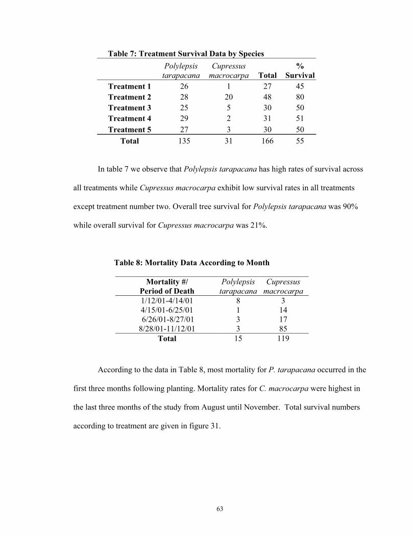
63
Table 7: Treatment Survival Data by Species
Polylepsis tarapacana
Cupressus macrocarpa Total
% Survival
Treatment 1 26 1 27 45 Treatment 2 28 20 48 80 Treatment 3 25 5 30 50 Treatment 4 29 2 31 51 Treatment 5 27 3 30 50
Total 135 31 166 55
In table 7 we observe that Polylepsis tarapacana has high rates of survival across
all treatments while Cupressus macrocarpa exhibit low survival rates in all treatments
except treatment number two. Overall tree survival for Polylepsis tarapacana was 90%
while overall survival for Cupressus macrocarpa was 21%.
Table 8: Mortality Data According to Month
Mortality #/ Period of Death
Polylepsis tarapacana
Cupressus macrocarpa
1/12/01-4/14/01 8 3 4/15/01-6/25/01 1 14 6/26/01-8/27/01 3 17 8/28/01-11/12/01 3 85
Total 15 119
According to the data in Table 8, most mortality for P. tarapacana occurred in the
first three months following planting. Mortality rates for C. macrocarpa were highest in
the last three months of the study from August until November. Total survival numbers
according to treatment are given in figure 31.
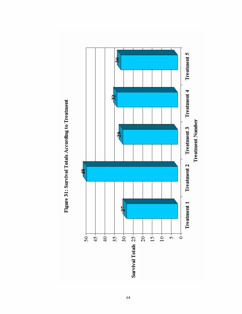
64
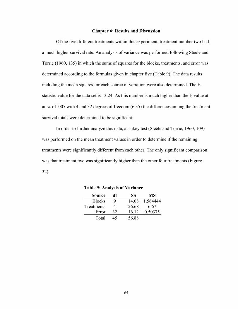
65
Chapter 6: Results and Discussion
Of the five different treatments within this experiment, treatment number two had
a much higher survival rate. An analysis of variance was performed following Steele and
Torrie (1960, 135) in which the sums of squares for the blocks, treatments, and error was
determined according to the formulas given in chapter five (Table 9). The data results
including the mean squares for each source of variation were also determined. The F-
statistic value for the data set is 13.24. As this number is much higher than the F-value at
an ∝ of .005 with 4 and 32 degrees of freedom (6.35) the differences among the treatment
survival totals were determined to be significant.
In order to further analyze this data, a Tukey test (Steele and Torrie, 1960, 109)
was performed on the mean treatment values in order to determine if the remaining
treatments were significantly different from each other. The only significant comparison
was that treatment two was significantly higher than the other four treatments (Figure
32).
Table 9: Analysis of Variance
Source df SS MS Blocks 9 14.08 1.564444
Treatments 4 26.68 6.67 Error 32 16.12 0.50375Total 45 56.88
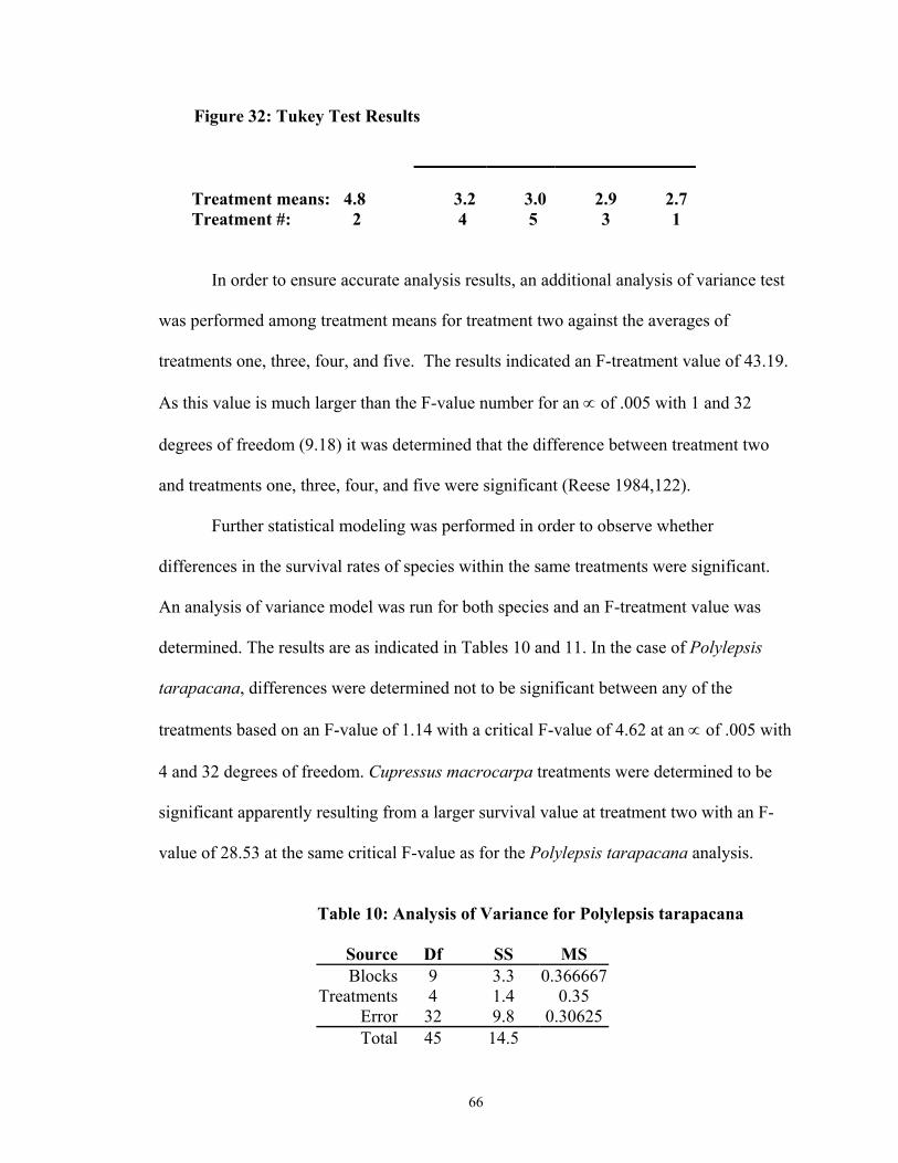
66
Figure 32: Tukey Test Results
Treatment means: 4.8 3.2 3.0 2.9 2.7 Treatment #: 2 4 5 3 1
In order to ensure accurate analysis results, an additional analysis of variance test
was performed among treatment means for treatment two against the averages of
treatments one, three, four, and five. The results indicated an F-treatment value of 43.19.
As this value is much larger than the F-value number for an ∝ of .005 with 1 and 32
degrees of freedom (9.18) it was determined that the difference between treatment two
and treatments one, three, four, and five were significant (Reese 1984,122).
Further statistical modeling was performed in order to observe whether
differences in the survival rates of species within the same treatments were significant.
An analysis of variance model was run for both species and an F-treatment value was
determined. The results are as indicated in Tables 10 and 11. In the case of Polylepsis
tarapacana, differences were determined not to be significant between any of the
treatments based on an F-value of 1.14 with a critical F-value of 4.62 at an ∝ of .005 with
4 and 32 degrees of freedom. Cupressus macrocarpa treatments were determined to be
significant apparently resulting from a larger survival value at treatment two with an F-
value of 28.53 at the same critical F-value as for the Polylepsis tarapacana analysis.
Table 10: Analysis of Variance for Polylepsis tarapacana
Source Df SS MS Blocks 9 3.3 0.366667
Treatments 4 1.4 0.35 Error 32 9.8 0.30625Total 45 14.5
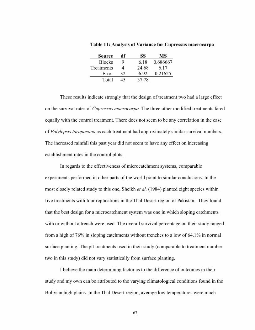
67
Table 11: Analysis of Variance for Cupressus macrocarpa
Source df SS MS Blocks 9 6.18 0.686667
Treatments 4 24.68 6.17 Error 32 6.92 0.21625Total 45 37.78
These results indicate strongly that the design of treatment two had a large effect
on the survival rates of Cupressus macrocarpa. The three other modified treatments fared
equally with the control treatment. There does not seem to be any correlation in the case
of Polylepsis tarapacana as each treatment had approximately similar survival numbers.
The increased rainfall this past year did not seem to have any effect on increasing
establishment rates in the control plots.
In regards to the effectiveness of microcatchment systems, comparable
experiments performed in other parts of the world point to similar conclusions. In the
most closely related study to this one, Sheikh et al. (1984) planted eight species within
five treatments with four replications in the Thal Desert region of Pakistan. They found
that the best design for a microcatchment system was one in which sloping catchments
with or without a trench were used. The overall survival percentage on their study ranged
from a high of 76% in sloping catchments without trenches to a low of 64.1% in normal
surface planting. The pit treatments used in their study (comparable to treatment number
two in this study) did not vary statistically from surface planting.
I believe the main determining factor as to the difference of outcomes in their
study and my own can be attributed to the varying climatological conditions found in the
Bolivian high plains. In the Thal Desert region, average low temperatures were much
68
higher (17.7°C, 63.9°F) than in Oruro (0°C, 32°F) and as a result, less overall stress was
placed on the trees in their establishment phase. It is my belief that frost and high winds
played a large role in the mortality of open trench treatments as they acted as a
desiccating factor on the unprotected trees. Most notably, the highest mortality rates of
trees in my experiment occurred during the months of September, October, and
November when nighttime temperatures can reach freezing and higher humidity levels
(43%) during this period resulting from early rains can create frost conditions.
In a study done by Whisenant et al. (1995), 32 trapezoidal shaped microcatchment
basins were constructed with varying catchment areas of 1:1 to 1:30 in Reagan County,
Texas. Survival of the species Leucaena retusa ranged from 100% within
microcatchment basins to only 50% in unmodified plantings in the first year of the study.
In the second year of the study survival was 98% and 45% respectively.
Ojasvi et al. (1999) conducted a study using Zisyphus mauritiana in western
Rajastan, Indian. The experiment was a complete randomized block design with five
treatments and three blocks with three trees per block surrounded by conical
microcatchments of one-meter radius. Treated plants within this experiment suffered
only one mortality while those in the fields suffered 48 mortalities. Ojasvi et al. (1999)
found that lining treatments with waste materials achieved better soil moisture status and
that trees with stone and marble linings within the catchments achieved an increase in
plant height by 40-48% more than in unlined catchments.
Rao (1989) conducted an experiment in Mchakos, Kenya using Leucaena
leucocephla L. where he compared two microcatchment systems in which some trees
were planted in sunken pits dug to 45 cm and others were planted normally. Ten months

69
later, stand mortality in sunken pit planting was only half (52%) the normal level planting
mortality rates.
These results, as well as previously discussed agricultural data on
microcatchments, strongly indicate that in most cases, micro catchments can significantly
increase tree establishment and long term survival in arid areas. This study found that as a
result of ecological constraints imposed on trees by the variable climate, those trees
sheltered from the wind and cold by way of some structure had an advantage in terms of
long term survivability. Treatment two provided a degree of such protection. In the
Bolivian high plains construction of windbreaks around each treatment may provide
additional protection to the more open trench microcatchment treatments.
The two species obtained different results with respect to establishment and
survival rates across the microcatchment treatments. Native P. tarapacana establishment
rates were independent of treatment effects as their survival rate was statistically equal
across all treatment levels. C. macrocarpa establishment and survival rates varied, and
survival in treatment two was much greater. Possible explanations for this discrepancy lie
in the evolutionary origins of each species. P. tarapaca is a species native to the high
plains region of Bolivia and as such has evolved to adapt to the challenging
environmental conditions which exist within the study area. It would seem that increases
in water had no effect on P. tarapaca survival through the first year. Growth rates may
have been greater but as this measurement was beyond the scope of this experiment, this
is only conjecture.
C. macrocarpa evolved along the coastal regions of northern California and does
not adapt well to the high plains. The high winds and sharp temperature variations acted

70
as a desiccating factor upon the trees and burned them. Observations of C. macrocarpa
leaves and stems showed discoloration and extreme dryness. Although more study would
be needed, it can be postulated based on prior field observations that many other of the
commonly used introduced tree species would exhibit similar establishment outcomes. In
other tree planting projects conducted at CEAC, introduced tree species planted without
protective structures exhibited similar characteristics of leaf burning and high mortality
regardless of their species. In some cases where frost and low temperatures were present,
newly planted native species had poor establishment rates as well.
The use of protective structures by farmers for aiding tree establishment is widely
practiced by foresters working in the high plains region. Currently, two methods are
adopted in order to protect a tree from the elements and animal intrusion. One method
involves building an adobe wall structure around the seedling. Construction of a circular
wall allows for protection from animal intrusions as well as from the environment. The
disadvantage of this method is that adobe structures are time consuming to build and the
adobe is difficult to transport. Because of these characteristics, adobe structures are not
economically feasible in cases where many trees must be planted. Another popular
method is to assemble a wall of grass around the plant in order to protect it from wind
and frost. While cheap and easy to build, these structures tend to last only one or two
seasons and are vulnerable to animal damage.
Attempts to protect tree seedlings from the surrounding environmental hazards
have been widely studied. In a trial conducted to increase tree establishment rates on
previously degraded mining land, Farley et al. (1995) found that tree shelters act as mini-
greenhouses which reduce water loss, increase humidity levels, and control temperature
71
variations. The inclusion of tree shelters in their study augmented the survival rates of red
oak seedlings (Quercus rubra L.) from 50 to 80% in the first year. Ponder (1995) found
that using tree shelters increased survival rates from nearly 50% to 82% in the first year
and from 62% to 92% after three years. In a study designed to increase desert shrub
establishment rates in California, Bainbridge and MacAller (1995) reported that in
addition to increased survival rates, the tree protection devices also served to improve
irrigation delivery, provide protection from wind, and moderate temperature changes.
When used in conjunction with microcatchment systems, protection devices have great
potential to increase non-native tree establishment rates on the high plains of Bolivia.

72
Chapter 7: Conclusions
The challenges imposed on Andean high plains farmers are daunting. Living
under harsh climatological conditions with little water and short growing seasons, these
robust souls have been able to successfully eek out an existence for millennia. The
accomplishments in the way of cultural adaptations to a changing society and triumph
over incredible odds have earned these individuals the admiration and respect of many
people who have come to this edge of the world.
Today, the Andean farmer faces numerous new challenges. Increased population
pressures coupled with degrading land quality and poor farming practices have led to a
crisis situation. Within the last twenty years, migration from the rural areas has increased
as a way of life that was once prosperous has become perilous. What is needed today in
the high plains of Bolivia are new solutions and low cost technologies to problems. This
study provides insight to potential solutions.
Two major ideas emerged from this study regarding the establishment rates of
trees in the high plains of Bolivia. The selection of appropriate species proved to be an
important aspect of this trial in that the species selected greatly affected the success rates
of tree establishments. Equally important, this study also showed that the introduction of
microcatchment systems to this region could help to greatly improve tree establishment
rates.
In an examination of species adaptability, there appeared to be a large difference
between the success rates of native versus non-native species. Evolutionary strategies of
different plants and their relative adaptability to the high plains climate are important
topics that need to be addressed more when determining which species to introduce to

73
this region. Historically, the species selection does not seem to be very good. Two
introduced species commonly used in this region are Monterrey Pine (Pinus radiata) and
Monterrey Cypress (Cupressus macrocarpa). Because both of these species originate in
the humid coastal areas of northern California, their low field establishment rates in the
high plains should not be surprising. However, despite their poor growth and survival
characteristics in this region, they are continually used in reforestation programs. Trees
are too often selected for their seed availability and production characteristics rather than
their adaptability.
If introduced species are to be used over native species, more emphasis on
adaptability of these introduced species is needed. Ideas such as these are slowly
beginning to take root. In a study done to determine the adaptability of forage crops to
the Bolivian Andes, Wheeler et al. (1999) used simulations to compare how various
agricultural species from around the world would match the climate found in the study
regions. Their findings indicate that in addition to the native species currently used, two
cover crops from Nepal could successfully be integrated into Bolivian farm systems
located at altitudes of around 3,000 meters (10,100 feet) above sea level.
Throughout the world, a number of climate zones exist which could compare well
with the Bolivian high plains. Examining tree species from areas such as the Himalayan
mountain ranges or the Sierra Nevada Mountains could yield species more adaptable to
the conditions that exist in the high plains. Trees could still be selected based on desired
characteristics but such selection should be restricted to certain geographical zones. The
introduction of these more suitable species, tied with the utilization of microcatchment
systems could greatly increase tree establishment rates.

74
While the use of microcatchment systems around the world is not new, its
introduction to this area of the world is only just beginning to take root. Increasing the
establishment rates of plant species through their early years and beyond has the potential
to become an important resource to many farmers as they struggle to improve their lands
and their production. The results of this experiment clearly indicate that while
challenging, reforestation efforts in this region are not impossible. Using
microcatchment systems is a viable option for farmers with modest resources as they cost
little to construct and provide a number of benefits in way of increased production.
Weather changes and problems associated with the high altitude still remain
difficult obstacles which must be dealt with in order to achieve significant progress.
However, the use of these microcatchment systems or some adaptation of them may
provide one answer. Casual observation of plants growth rates in all microcatchment
systems indicated that not only survival was increased, but also tree growth and vigor.
Treatment number two in this study, the pit planting method, shows great promise in
increasing tree establishment rates. This method can greatly aid trees through helping to
harvest rainwater and protecting them from the elements. Although farmers will still
need to protect their trees from animals, this system could provide partial answers to their
problems of chronic water shortages and climate fluctuations.
Adaptations to these treatments may serve to further increase the establishment
rates of trees. The other treatment methods used in this study need further research in
order to test their adaptability to this region. I believe that all of these systems, when used
in combination with a windbreak or other protective structure, may greatly help to harvest
rainwater and thus increase tree establishment rates. Small trenches may be easier and
75
more cost effective to build as they can be made using draft animals and a plow.
Modifications to the pit planting treatment are also possible and show potential. Such
additions as earthen bunds and larger catchment areas may serve to increase plant
viability and stimulate more growth and higher establishment percentages. In order to
maximize catchment quality, annual cleaning of all microcatchment structures is needed.
A combination of better species selection with the use of microcatchment systems
has the capacity to greatly increase forestry production in the Bolivian high plains. The
increase in water availability as well as the search for more productive species could lead
to greater tree establishment and growth rates over time. Since the financial investment
required to attain such goals would be relatively small, their adoption should be
encouraged.
Microcatchment systems and the goals of this trial should not stay limited to
forestry related activities. The adaptation of these systems to agricultural uses is already
being implemented on a small scale at CEAC and within the surrounding communities
comprising San Antonio de Condoriri. As part of my Peace Corps work with Jesús
Cárdenas and local farmers, we constructed a variety of trenching systems adapted from
Kenya called Fanya Juu. These trenches are designed so that water infiltrates into two
separate catchment zones to increase hillside soil moisture, thereby increasing crop
production. Promotion of this work from our experimental plots has already led to the
trial adoption of this method in at least one community and shows promise as an
inexpensive way to harvest rainwater for use in crop systems. Recently, acting as advisor
to an undergraduate thesis project, I helped design a trial testing the introduction of eight-
meter wide half moon microcatchment systems on CEAC lands for agricultural purposes.

76
While the initial results still await analysis, these systems also show promise in the area
of microcatchment systems for agricultural systems.
Cultural sensitivity must be taken in to account before any project of this type can
be successfully undertaken. In the case of the Aymara Indians, a subtle reminder that
these technologies were once widely utilized by their ancestors greatly served to motivate
the adoption of this technology. In this manner, outside influences served to only help
them recover their lost heritage rather than supplant it.
Much remains to be done. In order for the Andean farmer to maintain their way of
life in this ever-changing world, production must rise to meet demand and sustainability
and restoration of previously degraded lands must be promoted. The task is daunting.
However, I believe that with the proper assistance the Aymara people can and will rise up
to these challenges.
77
Literature Cited
Note: all graphics from web sites do not have copyright restrictions Aguabolivia, February 12, 2002. www.aguabolivia.org/legisaguasX/Leyes/Participacion%20POP.htm Ahmed, H.A. 1986. Some aspects of dry land afforestation in the Sudan with special references to Acacia tortilis (Forsk.) Hayne, A. senegal Wild. And Prosops chilensis (Molina) Stuntz. Forest Ecology and Management 16, pp. 209-221 Albo, Xavier et al. 1989. Para Comprender las culturas Rurales en Bolivia. Ministerio de Educación y Cultura- CIPCA-UNICEF. pp.298 Allen, M.F., and J.A. MacMahon, 1985. Impact of disturbance on cold desert fungi: comparative microscale dispersion patterns. Pedobiologia, 28, pp. 215-224 Anaya, G.M. 1988. Research on rainfall collection for agricultural proposes in México. pp. 264-266, In: Unger, PW., Jorden, W.R., Sneed, T.V. and Jensen, R.W. (Eds.), Proceedings of the International Conference on Dry Land Farming ‘Challenges in Dryland Agriculture- A Global Perspective’, Bushland Texas: Texas Agricultural Experiment Station, pp. 965 Anderson, S. 1985. Lista preliminar de mamíferos bolivianos. Cuadernos VI, Zoología: 3: pp. 5-16. Academia Nacional de Ciencias de Bolivia, La Paz. Argollo, J., Villalba, R., and Miranda G., 2001, The first chronology for Polylepsis tarapacana: the highest elevation tree-ring record worldwide, pp. 29, In: Centro Cultural Simón I. Patino, Resúmenes, I Congreso Internacional de Ecología y Conservación de Bosques de Polylepsis, 28 de Agosto al 1º de Septiembre de 2000, Cochabamba, Bolivia,.pp. 77 Arribas, M.A., LL. James y F. Sagot, 1995. Lista de Aves de Bolivia. ARMONIA, Santa Cruz, pp. 198 Aymara, January 25, 2002. web site www.aymara.org/english/histo.html Baied, C.A., 2001, Human influence or climate change? The environmental history of Polylepsis in the South-Central Andes: Connotations for protection and conservation, pp.43 In: Centro Cultural Simón I. Patino, Resúmenes, I Congreso Internacional de Ecología y Conservación de Bosques de Polylepsis, 28 de Agosto al 1º de Septiembre de 2000, Cochabamba, Bolivia,.pp. 77 Bainbridge, D.A., MacAller, R., 1995. Tree shelters improve desert planting success, pp. 58-59, In: Brissette J.C. (Ed.), Proceedings of the tree shelter conference, June 20-22, 1995, Harrisburg, Pennsylvania. pp. 78
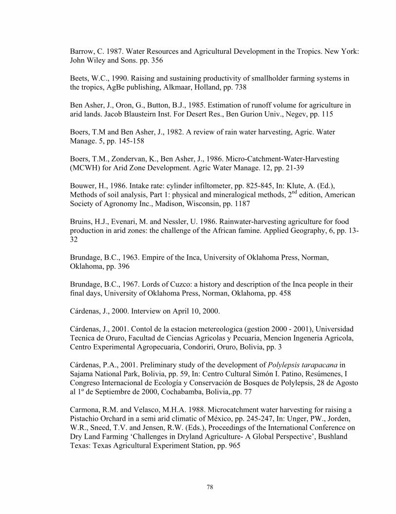
78
Barrow, C. 1987. Water Resources and Agricultural Development in the Tropics. New York: John Wiley and Sons. pp. 356 Beets, W.C., 1990. Raising and sustaining productivity of smallholder farming systems in the tropics, AgBe publishing, Alkmaar, Holland, pp. 738 Ben Asher, J., Oron, G., Button, B.J., 1985. Estimation of runoff volume for agriculture in arid lands. Jacob Blausteirn Inst. For Desert Res., Ben Gurion Univ., Negev, pp. 115 Boers, T.M and Ben Asher, J., 1982. A review of rain water harvesting, Agric. Water Manage. 5, pp. 145-158 Boers, T.M., Zondervan, K., Ben Asher, J., 1986. Micro-Catchment-Water-Harvesting (MCWH) for Arid Zone Development. Agric Water Manage. 12, pp. 21-39 Bouwer, H., 1986. Intake rate: cylinder infiltometer, pp. 825-845, In: Klute, A. (Ed.), Methods of soil analysis, Part 1: physical and mineralogical methods, 2nd edition, American Society of Agronomy Inc., Madison, Wisconsin, pp. 1187 Bruins, H.J., Evenari, M. and Nessler, U. 1986. Rainwater-harvesting agriculture for food production in arid zones: the challenge of the African famine. Applied Geography, 6, pp. 13-32 Brundage, B.C., 1963. Empire of the Inca, University of Oklahoma Press, Norman, Oklahoma, pp. 396 Brundage, B.C., 1967. Lords of Cuzco: a history and description of the Inca people in their final days, University of Oklahoma Press, Norman, Oklahoma, pp. 458 Cárdenas, J., 2000. Interview on April 10, 2000. Cárdenas, J., 2001. Contol de la estacion metereologica (gestion 2000 - 2001), Universidad Tecnica de Oruro, Facultad de Ciencias Agricolas y Pecuaria, Mencion Ingeneria Agricola, Centro Experimental Agropecuaria, Condoriri, Oruro, Bolivia, pp. 3 Cárdenas, P.A., 2001. Preliminary study of the development of Polylepsis tarapacana in Sajama National Park, Bolivia, pp. 59, In: Centro Cultural Simón I. Patino, Resúmenes, I Congreso Internacional de Ecología y Conservación de Bosques de Polylepsis, 28 de Agosto al 1º de Septiembre de 2000, Cochabamba, Bolivia,.pp. 77 Carmona, R.M. and Velasco, M.H.A. 1988. Microcatchment water harvesting for raising a Pistachio Orchard in a semi arid climatic of México, pp. 245-247, In: Unger, PW., Jorden, W.R., Sneed, T.V. and Jensen, R.W. (Eds.), Proceedings of the International Conference on Dry Land Farming ‘Challenges in Dryland Agriculture- A Global Perspective’, Bushland Texas: Texas Agricultural Experiment Station, pp. 965
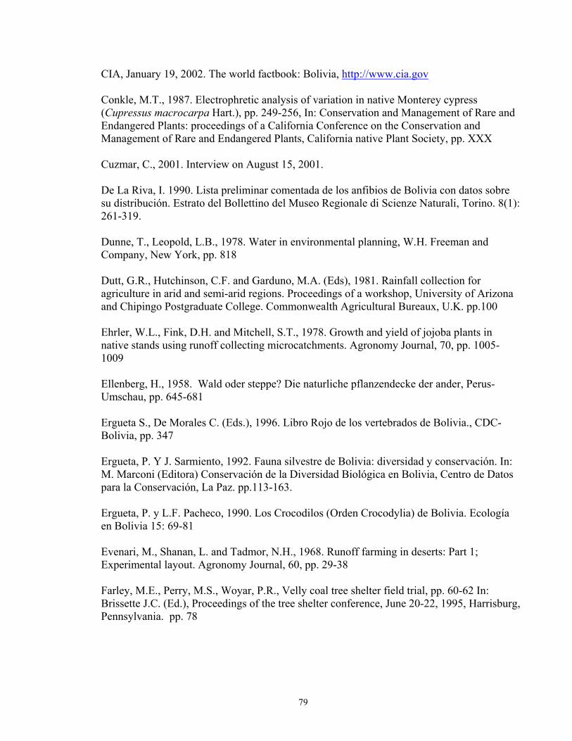
79
CIA, January 19, 2002. The world factbook: Bolivia, http://www.cia.gov Conkle, M.T., 1987. Electrophretic analysis of variation in native Monterey cypress (Cupressus macrocarpa Hart.), pp. 249-256, In: Conservation and Management of Rare and Endangered Plants: proceedings of a California Conference on the Conservation and Management of Rare and Endangered Plants, California native Plant Society, pp. XXX Cuzmar, C., 2001. Interview on August 15, 2001. De La Riva, I. 1990. Lista preliminar comentada de los anfibios de Bolivia con datos sobre su distribución. Estrato del Bollettino del Museo Regionale di Scienze Naturali, Torino. 8(1): 261-319. Dunne, T., Leopold, L.B., 1978. Water in environmental planning, W.H. Freeman and Company, New York, pp. 818 Dutt, G.R., Hutchinson, C.F. and Garduno, M.A. (Eds), 1981. Rainfall collection for agriculture in arid and semi-arid regions. Proceedings of a workshop, University of Arizona and Chipingo Postgraduate College. Commonwealth Agricultural Bureaux, U.K. pp.100 Ehrler, W.L., Fink, D.H. and Mitchell, S.T., 1978. Growth and yield of jojoba plants in native stands using runoff collecting microcatchments. Agronomy Journal, 70, pp. 1005-1009 Ellenberg, H., 1958. Wald oder steppe? Die naturliche pflanzendecke der ander, Perus- Umschau, pp. 645-681 Ergueta S., De Morales C. (Eds.), 1996. Libro Rojo de los vertebrados de Bolivia., CDC-Bolivia, pp. 347 Ergueta, P. Y J. Sarmiento, 1992. Fauna silvestre de Bolivia: diversidad y conservación. In: M. Marconi (Editora) Conservación de la Diversidad Biológica en Bolivia, Centro de Datos para la Conservación, La Paz. pp.113-163. Ergueta, P. y L.F. Pacheco, 1990. Los Crocodilos (Orden Crocodylia) de Bolivia. Ecología en Bolivia 15: 69-81 Evenari, M., Shanan, L. and Tadmor, N.H., 1968. Runoff farming in deserts: Part 1; Experimental layout. Agronomy Journal, 60, pp. 29-38 Farley, M.E., Perry, M.S., Woyar, P.R., Velly coal tree shelter field trial, pp. 60-62 In: Brissette J.C. (Ed.), Proceedings of the tree shelter conference, June 20-22, 1995, Harrisburg, Pennsylvania. pp. 78
80
Fjeldså, J., 1992. Biogeographic patterns and evolution of the avifauna of relict high-altitude woodlands of the Andes, Steenstrupia: Zoological Museum University of Copenhagen, 18(2): pp. 9-62 Floridata, Cupressus macrocarpa, January 26, 2002. www.floridata.com Flug, M., 1981. Production of annual crops on micro catchments. pp. 39-42, In: Dutt, G.R., Hutchinson C.F. and Anaya-Garduno, M. (Ed.), Rainfall Collection for Agriculture in Arid And Sermi-Arid Regions, Slough: Comonwealth Agricultural Bureaux, pp. 100 Freese, F., 1984, Statistics for land managers: an introduction to sampling methods and statistical analysis for foresters, farmers and environmental biologists, Paeony Press, Allerley Braem Jedburgh, Scotland, pp. 176 Fugler, C.M. e L. De La Riva, 1990. Herptologia boliviana: Lista preliminar de las serpientes conocidas en el pais. Mus. Nac. His. Nat. (Bolivia) Comunicacion 9: pp. 22-53 Fugler, C.M., 1989. Lista preliminar de los Saurios de Bolivia. Ecología en Bolivia 13: pp. 57-75 Garcia-Nunez, C., Rada, F., Boero, C., Gonzalez, J.A., Gallardo, M. Liberman-Cruz, M., Azocar, A., 2000. Gas exchange and water relation studies in Polylepsis tarapacana trees at Sajama, Bolivia, pp. 37, In: Centro Cultural Simón I. Patino, Resúmenes, I Congreso Internacional de Ecología y Conservación de Bosques de Polylepsis, 28 de Agosto al 1º de Septiembre de 2000, Cochabamba, Bolivia,.pp. 77 Gilman, E.F., and Watson, D.G., 1993. Cupressus macrocarpa Monterey Cypress, United States Forest Service, Southern Group of State Foresters, Fact Sheet ST-224, Washington, pp. 3 Gisbert, Teresa, J.C. Jemio, R. Montero, 1996. El senorio de los Charangas y los Chullpares del Rio Lauca. Revista No 70 Academia Nacional de ciencias de Bolivia. La Paz. Gonzales, J.A., Liberman-Cruz, M., Boero, C., Gallardo, M., and Prado, F.E., 2001. Carbohydrate biosinthesis, photosynthetic and protective pigments in Polylepsis tarapacana leaves in the highest open forest in the world, pp. 61, In: Centro Cultural Simón I. Patino, Resúmenes, I Congreso Internacional de Ecología y Conservación de Bosques de Polylepsis, 28 de Agosto al 1º de Septiembre de 2000, Cochabamba, Bolivia,.pp. 77 Gupta, G.N., 1991. Effect of mulching and fertilizer application on initial development of some tree species. Forest Ecology and Management, 44, pp. 211-221 Gupta, G.N., 1995. Rain-water management for tree planting in the Indian Desert, Journal of Arid Environments, 31: pp. 219-235
81
Gupta, J.P. and Muthana, K.D., 1986. Effect of integrated moisture conservation technology on early growth and establishment of Acacia tortilis in the Indian Desert. Indian Forester, 111, pp. 477-486 Harden, Al., 1975. Discussion session 1. In: Frasier, G.W. (Ed.), Proceedings Water Harvesting Symposium, U.S. Department of Agriculture, Agricultural Research Service, ARS W-22, pp. 329 Hjarsen, T, 1998, Biological diversity in high altitude woodlands and platations in the Bolivian Andes: Implications for development of sustainable land-use, pp. 145-149, In: III Sumposio Internacional de Desarollo Sustentable de Montanas: entendiendo las interfaces ecologicas para la gestion de los paisajes culturales en los Andes, Qurro, 9-14 de Diciembre de 1998, pp. 325 Hollick, M., 1982. Water harvesting in arid lands. In: Scientific Reviews on Arid Zone Research, Vol. 1, pp. 173-247. Jodhpur: Scientific Publishers. pp. 337 Hudson, R.A., Hanratty, D.M. (ed.), 1989. Bolivia a country study, 3rd edition, Library of Congress Cataloging-in-Publication Data, Washington, D.C., pp. 354 INE, 1993. Censo Nacional de Poblacion y Vivienda, Resultados Finales, La Paz INE, 1998. Encuesta Nacional Agropecuaria, 1997, Instituto Nacional de Estadistica, pp. 301 INE, 2002. Instituto Nacional de Estadistica, January 19, 2002, www.ine.gov.bo Johnson, L.C, 1974. Seeds of Woody Plants in the United States, Forest Service, U.S. Department of Agriculture, Agriculture Handbook No. 450, pp. 363-369 Kessler, M., 2001. Diversity, Evolution, and distribution of the Genus Polylepsis (Rosaceae), pp. 25, In: Centro Cultural Simón I. Patino, Resúmenes, I Congreso Internacional de Ecología y Conservación de Bosques de Polylepsis, 28 de Agosto al 1º de Septiembre de 2000, Cochabamba, Bolivia, pp. 77 King, F.W. y D. Videz-Roca, 1989. The caimans of Bolivia: A preliminary report on a CITES and Centro de Desarrollo Forestal sponsored survey of species distribution and status. pp. 128-155 In: Crocodiles. Preceedings of the 8th Working Meeting of the IUCN/SSC Crocodile Specialist Group. IUCN Publ., Gland, Switzerland Klein, H.S., 1992. Bolivia: the evolution of a multi-ethnic society, 2nd edition, Oxford University Press, Oxford, UK, pp. 343 Lewis, J., 1984. Baringo Pilot Semi-Arid Area Project (Summary of interim Report), Republic of Kenya, BPSAAP, PO Marigat, via Nakuru, Kenya (mimeo.), pp. 45
82
Loayza, I., Vilaseca, A., Ballivián, C., Lorenzo, D., and Dellacassa, E., 2001. Characterization of the essential oil from aerial part of Kehina (Polylepsis besseri Hieron. subsp. besseri), pp. 52, In: Centro Cultural Simón I. Patino, Resúmenes, I Congreso Internacional de Ecología y Conservación de Bosques de Polylepsis, 28 de Agosto al 1º de Septiembre de 2000, Cochabamba, Bolivia, pp. 77 Lopez Levy, M., 2001. Bolivia, OXFAM, Stylus Publishing LLC, Herndon, Virginia, pp. 92 MacNeely, J.A., K.R. Miller, W.V. Reide, R.A. Mittermeier & T.B. Wener , 1990. Conserving the worlds biological diversity. IUCN, WRI, WWF-US, World Bank. Malloy, J.M, 1970. Bolivia: the uncompleted revolution, University of Pittsburgh Press, Pittsburgh, Pennsylvania, pp. 396 Meyer, L.E., 1975. Water harvesting-2000 B.C.-1974 A.D. In: G.W. Frasier (ed.), Proceedings Water Harvesting Symposium, U.S. Department of Agriculture, Agricultural Research Service, ARS W-22, pp. 329 Mielke, E.A. and Dutt, G.R., 1981. Deciduous tree and vine fruit production using water harvesting techniques. pp. 31-37, In: Dutt, G.R., Hutchinson C.F. and Anaya-Garduno, M. (Ed.), Rainfall Collection for Agriculture in Arid And Sermi-Arid Regions, Slough: Comonwealth Agricultural Bureaux, pp. 100 Miller, J.T., and Knowles, F.B., 1990. Introduced forest trees in New Zealand: recognition, role, and seed source, 9: The Cypresses, Ministry of Forestry, Forest Research Institute, Roturua, New Zealand, pp. 33 Miller, R.W., and Donahue, R.L., 1990. Soils an introduction to soils and plant growth 6th edition, Prentice Hall, Englewood Cliffs, NJ, pp. 768 Ministerio de Desarrollo Sostenible, 1998. Mapa Preliminario de Erosion de Suelos, , La Paz, Bolivia, pp. 46 Mittermeier, R.A., 1988. Primate diversity and the tropical forest. En Wilson, E.O. & F.M. Peter (eds.) Biodiversity. National Academy Press, Washington D.C. Montara, January 26, 2002. Cupressus macrocarpa, www.plants.montara.com Montes de Oca, Ismael., 1997. Geografia y Recursos Naturales de Bolivia. Editorial Offset Boliviana (EDOBOL). 3ra Edición. Pp.614 Nabhan, G.P., 1984. Soil fertility renewal and water-harvesting in Sonoran desert agriculture, the Papao example. Arid Lands Newsletter, 20, pp. 21-38, Office of Arid Lands Studies, University of Arizona, Tucson.
83
Ojasvi P.R., Goyal R.K., Gupta J.P., 1999. The micro-catchment water harvesting technique for the plantation of jujube (Zizyphus mauritiana) in an agroforestry system under arid conditions, Division of Resources Management, Central Arid Zone Research Institute, Jodhpur 342003, India, pp. 8 Pacey, A., Cullis, A., 1986. Rainwater harvesting: The collection of rainfall and runoff in rural areas, Intermediate technology Publications, London, UK, pp. 216 Peters, J.A. y R. Donoso-Barros, 1986. Catalogue of Neotropical Squamata. Part II. Lizards and Amphibians. Smithsonian Institution, Washington, pp. 293 Ponder, F., 1995. Tree shelter effects on stem and root biomass of planted hardwoods, pp. 19-22, In: Brissette J.C. (Ed.), Proceedings of the tree shelter conference, June 20-22, 1995, Harrisburg, Pennsylvania. pp. 78 Rada, F., Garcia-Nunez, C., Boero, C., Gallardo, M., Hilal, M., Gonzalez, J.A., Prado, F., Liberman-Cruz, M., and Azocar, A., 2001. Resistance against low temperature in Polylepsis tarapacana, a tree growing at the highest altitudes in the world: Freezing avoidance or frost tolerance?, pp. 36, In: Centro Cultural Simón I. Patino, Resúmenes, I Congreso Internacional de Ecología y Conservación de Bosques de Polylepsis, 28 de Agosto al 1º de Septiembre de 2000, Cochabamba, Bolivia, pp. 77) Rao, M.R., 1989. ICRAF’s field station at Machakos. pp. 111-126, In: Rao MR (ed) Agroforestry Development in Kenya Proceedings of the Second Kenya National Seminar on Agroforestry held at Nairobi, Kenya 7-16 November 1988, ICRAF, Nairobi, pp. 165 Rathore A.L., Pal A.R., Sahu R.K., Chaudhary J.L., 1996. On-farm rainwater and crop management for improving productivity of rainfed areas, Agricultural Water Management, 31, pp. 253-267 Rejj, C., Mulder, P. and Begemann, L., 1988. Water-harvesting for Plant Production. The World Bank Technical Paper No. 91. Washington, pp. 123 Roman,P. Ch., 1993. Una Vision del México Prehispanizo. Universidad Autonoma México. México D.F. pp. 298 Rowland, J. and Whiteman, P., 1993. Principles of dryland farming, In: Rowland JRJ (ed), Dryland Farming in Africa, Macmillan, London, pp. 297 Ruthsatz, B., 1977. Pflanzengeselkehaften und ihre Lebensbedingungen in den Andinen Halbwusten Nord-west Argentiniens, Dissert Bot (Cramer, Vaduz) 39, pp. 1-168 Shanan, L., Tadmor, N.H., 1979. Micro-catchment Systems for Arid Zone Development: a handbook for design and construction. Jerusalem: Hebrew University. pp.73
84
Shanan, L., N.H. Tadmor, M. Evenari, and P. Reiniger, 1970. Runoff farming in the desert. III. Micro catchments for improvement of desert range. Agronomy Journal 62, pp. 445-449. Sharma, K.D., Pareed, O.P. and Singh, H.P., 1986. Micro-catchment water harvesting for raising jujube orchards in an arid climate. Transactions of the American Society of Agricultural Engineers, 29, pp. 112 Sheikh, M.I., Shah, B.I., Aleem, A., 1984. Effect of rainwater harvesting methods on the establishment of tree species. Forest Ecology and Management 8: pp. 257-263 Singer, J.M., Munns, D.N., 1991. Soils, an introduction, MacMillan Publishing Company, New York, pp. 473 Slayback, R.D., and D.R. Cable., 1970. Larger pits aid reseeding of semidesert rangeland. Journal of Range Management 23, pp. 333-335 Steele and Torrie, 1960. Principles and procedures of statistics, McGraw Hill Book Company Inc., New York, pp. 481 Stern, P.H., 1979. Small Scale Irrigation: A manual of low-cost water technology. Intermediate Technology Publications Ltd, and the International Irrigation Information Centre, London. Nottingham, England: Russel Press. pp. 247 Suleman, Sheikh, Wood, M. Karl, Shah, Bahir Hussain, Murray, Leigh, 1995. Development of a rainwater harvesting system for increasing soil moisture in arid rangelands of Pakistan, Journal of Arid Environments, 31, 471-481 Sweaney, D., 2001, Bolivia, 4th edition, Lonely Planet Publications, Hawthorne, Vic 3122, Australia, pp. 496 Tabor, J. A., 1995. Improving crop yields in the Sahel by means of water-harvesting, Journal of Arid Environments, 30, pp. 83-106 Tiedemann, A.R., and J.O. Kelmmedson., 1973. Effects of mesquite on physical and chemical properties of the soil. Journal of Range Management 26, pp. 27-29 USDA-Soil Conservation Service , 1981, Revised Soil Survey Manual, Transmittal 430-V, USDA-Soil Conservation Service, June 9, 1981, pp. 4-81 Valdivia, F. C., 1996. Anuario Estadístico del sector rural, Grupo Interinstitucional de Desarrollo Rural (G-DRU), Centro de Información para el Desarrollo. pp. 297 Van Lindert, P., Verkoren, O., 1994, Bolivia: a guide to the people, politics, and culture, Latin American Bureau, London, UK, pp. 74
85
Vetaas, O.R., 1992. Micro-site effects of trees and shrubs in dry savannas. Journal of Vegetation Science 3, pp. 337-344 Virginia, R.A., 1986. Soil development under legume tree canopies. Forest Ecology and Management 16, pp. 69-79 Wheeler, T.R., Qi, A., Keatinge, J.D., Ellis, R.H., Summerfield, R.J., 1999. Selecting legume cover crops for hillside environments in Bolivia, Mountain Research and Development, Vol. 19, pp. 318-324 Whisenant, Steven G., Thurow, Thomas L., Maranz, Steven J., 1995. Initiating autogenic restoration on shallow semiarid sites, Restoration Ecology, Vol. 3, No. 1, pp. 61-67 Yensen, E., and Tarifa, T., 2001. Conservation of Bolivian Polylepsis woodlands, pp. 41-42, In: Centro Cultural Simón I. Patino, Resúmenes, I Congreso Internacional de Ecología y Conservación de Bosques de Polylepsis, 28 de Agosto al 1º de Septiembre de 2000, Cochabamba, Bolivia,.pp. 77
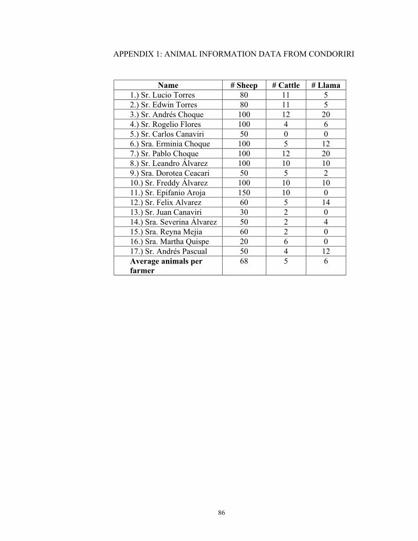
86
APPENDIX 1: ANIMAL INFORMATION DATA FROM CONDORIRI
Name # Sheep # Cattle # Llama 1.) Sr. Lucio Torres 80 11 5 2.) Sr. Edwin Torres 80 11 5 3.) Sr. Andrés Choque 100 12 20 4.) Sr. Rogelio Flores 100 4 6 5.) Sr. Carlos Canaviri 50 0 0 6.) Sra. Erminia Choque 100 5 12 7.) Sr. Pablo Choque 100 12 20 8.) Sr. Leandro Álvarez 100 10 10 9.) Sra. Dorotea Ceacari 50 5 2 10.) Sr. Freddy Álvarez 100 10 10 11.) Sr. Epifanio Aroja 150 10 0 12.) Sr. Felix Alvarez 60 5 14 13.) Sr. Juan Canaviri 30 2 0 14.) Sra. Severina Álvarez 50 2 4 15.) Sra. Reyna Mejia 60 2 0 16.) Sra. Martha Quispe 20 6 0 17.) Sr. Andrés Pascual 50 4 12 Average animals per farmer
68 5 6