uxbridge reconnaissance report - nps.gov … · uxbridge reconnaissance report ... due to its hilly...
TRANSCRIPT

UXBRIDGE RECONNAISSANCE REPORT
BLACKSTONE VALLEY / QUINEBAUG-SHETUCKET LANDSCAPE INVENTORY
MASSACHUSETTS HERITAGE LANDSCAPE
INVENTORY PROGRAM
Massachusetts Department of Conservation and Recreation
John H. Chafee Blackstone River Valley National Heritage Corridor
Quinebaug and Shetucket Rivers Valley National Heritage Corridor

PROJECT TEAM Massachusetts Department of Conservation and Recreation Jessica Rowcroft, Preservation Planner Division of Planning and Engineering John H. Chafee Blackstone River Valley National Heritage Corridor Commission Joanna Doherty, Community Planner Project Consultants Elizabeth Vizza, Elizabeth Vizza Consulting Electa Kane Tritsch, Oakfield Research Daniel Wells, Hyla Ecological Services Inc. Local Project Coordinator Gretchen Duffield, Uxbridge Conservation Commission Local Heritage Landscape Participants William Albin Wayne Beitler Tom Bentley Deb Carter Jon Dale Sara Jane Dale Tom Dietzel Gretchen Duffield Floyd Forman Michael Francis Herve Gazaille Ann Hanscom John Hanscom Roy Henry Russ Holden Rachel Landry William Leland Shirley Maynard Barry McCloskey
Faye McCloskey Shelly Merriam John Moraswski Mike Potaski Cari Robertson Harry Romasco Vic Sloan John Smedesly Phyllis Smyth Val Stegemoen Susan Treide Sandy Wedge Julie Woods B. Mae Wrona
June 2007 Cover Photographs: Happy Hollow Schoolhouse Trolley Bridge Abutments, West River Stanley Woolen Mill

CONTENTS Introduction .................................................................................................................. 1 Part I: Uxbridge’s Heritage Landscapes Uxbridge’s Landscape Through Time ................................................................... 2 Community-Wide Heritage Landscape Issues....................................................... 4 Uxbridge Priority Landscapes................................................................................ 5 Williams Hill Farms
An “Industrial Mile” on Mendon Street: Waucantuck Mill, Stanley Woolen Mill and Bernat Mill Arthur Taft Memorial Town Park Pout Pond and Legg Farm area Southern New England Trunkline Trail
Part II: Building a Heritage Landscape Toolkit Eight Toolkit Basics............................................................................................. 20 Uxbridge’s Toolkit: Current Status and Future Additions................................... 21 Conclusion and Implementation.................................................................................... 29 Appendix A: Uxbridge Heritage Landscapes ...................................................................... i Appendix B: Guide to Preservation and Planning Tools for Heritage............................... vi Landscapes

INTRODUCTION The 22 Massachusetts communities within the John H. Chafee Blackstone River Valley National Heritage Corridor (BRV) and the Quinebaug-Shetucket Rivers Valley National Heritage Corridor (Q-S) are linked by a common heritage of agriculture and industry powered by the rivers and streams that dominate the landscape of south central Massachusetts. River Corridor towns extend from Mendon on the east to Brimfield on the west. While they range in size from the city of Worcester to the compact town of Hopedale, each is equally shaped by the interaction of nature and culture over time. Heritage landscapes are special places created by human interaction with the natural environment that help define the character of a community and reflect its past. They are dynamic and evolving; they reflect the history of a community and provide a sense of place; they show the natural ecology that influenced land use patterns; and they often have scenic qualities. This wealth of landscapes is central to each community’s character, yet heritage landscapes are vulnerable and ever changing. For this reason it is important to take the first step toward their preservation by identifying those landscapes that are particularly valued by the community – a favorite local farm, a distinctive neighborhood or mill village, a unique natural feature or an important river corridor. To this end, the Massachusetts Department of Conservation and Recreation (DCR) and the two National Heritage Corridors (BRV and Q-S) have collaborated to bring the Heritage Landscape Inventory program to communities in south central Massachusetts. The goals of the program are to help communities identify a wide range of landscape resources, particularly those that are significant and unprotected, and to provide communities with strategies for preserving heritage landscapes. The methodology for the Heritage Landscape Inventory program was developed in a pilot project conducted in southeast Massachusetts and refined in Essex County. It is outlined in the DCR publication Reading the Land, which has provided guidance for the program since its inception. In summary, each participating community appoints a Local Project Coordinator (LPC) to assist the DCR-BRV/Q-S consulting team. The LPC organizes a heritage landscape identification meeting during which residents and town officials identify and prioritize the landscapes that embody the community’s character and its history. This meeting is followed by a fieldwork session including the consulting team and the LPC, accompanied by interested community members. This group visits the priority landscapes identified in the meeting and gathers information about the community. The final product for each community is this Reconnaissance Report. It outlines the community’s landscape history; discusses broader land planning issues identified by the community; describes the priority heritage landscapes and issues associated with them; and concludes with preservation recommendations. Two appendices include a list of all of the heritage landscapes identified at the community meeting and a reference listing of land protection tools and procedures.

PART I
UXBRIDGE’S HERITAGE LANDSCAPES

Heritage Landscape Inventory Uxbridge Reconnaissance Report 2
UXBRIDGE’S LANDSCAPE THROUGH TIME The town of Uxbridge sits on the Rhode Island border, with Douglas to the west, Northbridge to the north, and Mendon and Millville to the east. It is a town of rivers, at the confluence of the Blackstone, the Mumford and the West Rivers. The combined flood plain in the north part of town is over three and a half miles wide. A number of brooks, large enough to provide sources of waterpower, also drain into the Blackstone. The soils of the valley floor are rich and particularly well suited to agriculture while, on both sides of the central valley, hills underlain by granite topped with stony loam provided sources of sand, gravel and building stone in local quarries. This combination of natural resources attracted Native American inhabitants from at least the Late Archaic Period (c. 6000-2500 Before Present) onward, especially in the northeastern and southern areas, where the river corridor provided trail access and wetlands provided a rich array of food sources. By 1670, some of the local Nipmuc had settled in the Christian Indian town of Waentuck, probably located in the same area as an older, long-term settlement east of the present town center. Waentuck did not survive King Philip’s War (1675-1676). Uxbridge was part of the eight-mile Mendon grant in the 17th century, not initially used for settlement but rather as pasture and for the hay in its extensive fresh river meadow. Uxbridge – which included present-day Northbridge – was incorporated as a separate town in 1727, its first meetinghouse being built in the town’s present center. The new town immediately began to exploit its varied resources. Agriculture was Uxbridge’s chief economic base, as it was in every inland community during the colonial period. Farms produced grains, potatoes, apples, dairy and beef cattle. Despite its agrarian base, 60% of Uxbridge’s land was still wooded by the turn of the century, due to its hilly contours and its waterways. Good quality bog-iron ore was mined in the Ironstone area, and a forge and trip hammer operated there. Grist and saw mills, a distillery, a fulling mill and additional trip hammers took advantage of the numerous falls, especially on the town’s smaller rivers and streams, during the 1700s. Late in the Federal Period (1775-1830) the development of improved waterpower engineering in America made it possible for mills to tap the much greater power resources of major rivers such as the Blackstone. A major industrial complex grew at the junction of the Mumford River and the Hartford Turnpike, including the granite Crown and Eagle Mill, a large-scale water power system, and worker housing. Smaller textile mills and worker housing were built at six other waterpower sources in different parts of town. By the end of the period there were eight cotton and woolen mills, one fulling mill, a shuttle factory, a pail factory, two trip hammers, three gristmills and six sawmills on Uxbridge’s waterways. The Blackstone Canal opened in 1828 and, because Uxbridge was the halfway point between Worcester and Providence, it became an overnight stop for canal boats, further expanding economic and commercial opportunities in the town. The Blackstone Canal ceased operations in 1848, its function replaced by the Providence and Worcester Railroad (1847) and, seven years later, by the Boston and New York Railroad. After the canal closed, Moses Taft diverted a section of the flow as a power canal for the Central Woolen Mill (later Stanley Woolen Mill). Canal and railbed construction attracted a group of Irish immigrants to south central Massachusetts, many of whom remained in Uxbridge to work in the growing textile mills. Later the Irish would
Heritage Landscape Inventory Uxbridge Reconnaissance Report 3
be joined by a large group of French Canadians, as well as English, Swedes, Turks, Poles and Italians, who carved out distinct ethnic niches in the town’s mill villages. The textile industry was strong through the 19th century, and boot and shoe manufacturing, formerly a small business, increased in importance, with a tannery and currying shop in Ironstone. In 1865, Benjamin and Joseph Blanchard established two stone quarries which provided building material locally, as well as to Providence, Boston and New York. Agriculture continued to dominate the northwest part of town especially, with a major shift taking place from mixed farming to predominantly dairying and livestock operations. Consequently, although the number of acres under cultivation decreased, the value of Uxbridge’s agricultural products – chiefly whole milk, beef, pork and veal – increased, as did the amount of land put to hay. By the early 20th century orcharding and poultry farms replaced many of the dairy operations. The final years of the 19th century were a period of near-depression for local industry. Mills operated part-time or closed for months, and there were labor/management conflicts. But regional trolley service came to town from Worcester at the turn of the century, running to Wheelockville and from there to Milford and Millville. Following this, the First World War brought government contracts and the textile industry once again prospered through the 1920s. The 1920s also found streetcars being replaced by automobiles, and local roads were improved for traffic. Route 122 (Main Street) became the main north/south road; Route 146 (Ironstone Road) became an alternate route south of Uxbridge Center; and Route 16 and Hartford Avenue became the main east/west routes. Demand for road construction materials brought the opening of many sand and gravel pits in Uxbridge, which continue in use today. The Depression hit Uxbridge hard, but with the exception of the Hecla Mill, the textile industry survived and was revived by a spike in demand during World War II. A majority of the mills continued in operation until the 1970s (the Stanley Mill did not close until 1988). Following the departure of the textile industry, Uxbridge, like its Blackstone Valley neighbors, was faced with picking up difficult pieces: high unemployment, polluted rivers, empty industrial complexes and a decaying downtown. The past three decades have seen a dramatic turn-around of the town’s fortunes and a revaluation of the heritage landscape features that define its character and reflect its long and varied history.

Heritage Landscape Inventory Uxbridge Reconnaissance Report 4
COMMUNITY-WIDE HERITAGE LANDSCAPE ISSUES From a landscape perspective, Uxbridge is a town that “has it all”: broad river corridor and flood plain of three parallel rivers – the Mumford, Blackstone, and West; granite- bedded fertile uplands of the Williams Hill Ridge; falls high enough to support industry, but hills generally low enough to permit cultivation and transit. As a result of this combination of natural resources Uxbridge has had a long settlement history and a broadly successful industrial history – as a result, it has a wealth of heritage landscapes that reflect that use. Concern for these heritage landscapes is not new to Uxbridge, either. A historic resource survey, completed in 1981, documented many of the town’s varied resources, and more recent updates have been done at some locations. Uxbridge's Heritage Landscape Identification meeting, attended by interested residents including many representing town boards and regional non-profit organizations, was held on March 1, 2007. During the meeting, residents compiled a lengthy list of the town's heritage landscapes, which is included as Appendix A of this report. As the comprehensive list was being created, attendees were asked to articulate the value of each landscape and identify issues relating to its preservation. Residents emphasized broad issues related to heritage landscapes and community character. These issues are town-wide concerns that are linked to a range or category of heritage landscapes, not just to a single place. In Uxbridge, two issues stand out.
Riverways: Uxbridge is a town built on and shaped by rivers: the Mumford, Blackstone, West, and the numerous tributaries that feed them from the fertile watershed. There is more than one issue associated with the riverways. Residents expressed concern about:
limited protection in the face of development, lack of access, maintenance of vistas, responsibility for riverbank maintenance, and watershed and water quality.
The Uxbridge Town Common and Center Historic District: Approved as a
Local Historic District by town meeting in 2004, the district is a sprawling and complex area that includes eighty extremely diverse features. Its structures range from a 1710 first period settler’s house to late-20th century Colonial Revival dwellings; from an 1819 academy building to a 1993 war memorial. It includes the town’s major churches, many of its most distinguished residences, the town common, active commercial enterprises and the C.C. Capron Yarn Mill – the industry that “started it all” in Uxbridge. Added to this – but not actually included in the District inventory – is the open space of Capron’s Pond, which provided water power for the mill. (Much of the Capron Mill, renamed Bernat Mill, burned in July 2007.) There are significant issues concerning the oversight and management of this community core, and a lack of consensus concerning the Historic District Commission’s purpose, legal charge, and goals. It is recommended that the Historic District Commission seek out advice on these issues, including consultation and/or training with the Massachusetts Historical Commission about the District Commission’s responsibilities and authority.

Heritage Landscape Inventory Uxbridge Reconnaissance Report 5
PRIORITY HERITAGE LANDSCAPES Based on information gathered at the community meeting, attendees identified a group of priority landscapes for the consulting team to focus on, through field survey, documentation and planning assessment. Each of the priority landscapes is highly valued and contributes to community character. Only the Bernat Mill, recently gutted by fire, and Legg Farm are covered by any permanent form of protective mechanism. Uxbridge’s priority landscapes range from a small natural pond to the linear landscape of a railroad. Hillside farms with their vistas are indicative of the town’s strong agrarian roots, while an impressive mile of mill complexes echoes Uxbridge’s historic reliance on water-powered industry. The landscapes which were given priority status by Uxbridge’s community meeting represent a range of scales and types of resources. Each landscape is also representative of other, similar properties in the town and each demonstrates the multiple layers of significance that are common to most heritage landscapes. Natural and cultural features, individual and civic histories, combine to present property owners and concerned citizens with a complex combination of present-day issues and opportunities. The descriptions and recommendations that follow are intended to be first steps and constructive examples for what needs to be an ongoing process: to identify what is valued and irreplaceable in the community, and develop strategies that will preserve and enhance Uxbridge’s landscape heritage. Williams Hill Farms Description: The landscape known as Williams Hill, which actually includes Castle Hill to the north, is a long, north-south running ridge of land that slopes down to Lackey Pond where Uxbridge’s northwest corner meets Douglas and Sutton. The ridge has historically been the center of farming in the community, and today exhibits a rare extended area of agricultural land and mixed open-space habitat. A look at the town assessor’s map makes the rarity and endangered situation of Williams Hill immediately apparent. Parcels measuring from 25 to over 100 acres in area are not uncommon. At least eight large farms and estates were specifically identified in this area by local residents, including Castle Hill Hundred Acre Lot; Nydam farm; Arnold Baker Farm (corn & hay); Haringa/Dutch Hill Farm (horses); Vanderzicht Farm (dairy herd); Wassenar Farm (open fields), Bangma’s Farm. Many of the owners are engaged in small businesses such as animal boarding, while some that used to be dairy or mixed agriculture farms are now horse farms. Bangma’s Farm is the most public, or visible, of the farm operations still active on Williams Hill. Established in 1924 as a dairy farm, it is now run by a third generation of the Bangma family. The Bangmas reflect a modern adaptation of farming practice that is seen throughout central Massachusetts. They have responded to growing consumer demands by replacing their dairy herd with grass-fed, open-pastured Simmenthal beef cattle and selling high-quality organically grown meat. They have also replaced their

Heritage Landscape Inventory Uxbridge Reconnaissance Report 6
farm stand with a much larger “ice cream dairy bar”, which is becoming a popular venue for gatherings ranging from birthday parties to car meets and tractor pulls. The single largest parcel of land on Williams Hill is what is known as the “Hundred Acre Lot”. The parcel, part of Castle Hill Farm, was the southern half of an agrarian estate owned by the Whitin family, the other half of which is in Northbridge, and was selected as a high priority heritage landscape in that community as well. The Hundred Acre Lot was bought by the Town of Uxbridge a decade ago. Part of the land is leased to a local farmer who grows corn and hay on it; another area includes municipal soccer fields. The Lot is characterized by sloping open fields demarcated by six-foot-wide fieldstone walls – a network that defines all of Castle Hill Farm. The ridge itself is underlain by “Blanchard” granite that forms a solid ledge two feet below the surface. In addition to its agricultural heritage, the other valuable facet of the Williams Hill landscape is its extensive open space. Especially along the west slope from Rawson Street to the Douglas/Sutton line, large, uninterrupted pastures and hayfields, plus a mixed oak and pine forest, and the controlled successional habitat of two powerlines provide rich and varied upland wildlife habitat. At the bottom of the slope lies Lackey Pond, an Army Corps of Engineers flood control project. While Lackey Pond is beyond the scope of this landscape, its presence adjacent to Williams Hill further enhances the area’s natural resources.
Virtually all of the 300-plus-acre west slope is owned by multiple private owners. There are no Agricultural Preservation Restrictions on Williams Hill. Three hundred seventy-five acres are in Ch 61A, although the Bangma Farm recently withdrew its land from 61A status. Almost every year, a few parcels of land with street frontage are sold by farm owners or developed as houselots as a way of supplementing agricultural property income. Background: Williams Hill is named for a family of the area’s earliest settlers, Jacob and Charles Williams. Many of the farm properties on the ridge were developed by Dutch farmers who came to the Northbridge/Uxbridge area in the 1890s, originally to work at the Whitin family’s Castle Hill Farm. Names such as Nydam, Haringa, Vanderzicht,

Heritage Landscape Inventory Uxbridge Reconnaissance Report 7
Wassenar and Bangma all reflect that heritage and some of the farms are still owned by third-generation descendants. Issues
No permanent protection mechanisms in place for agricultural lands or open space.
Development pressure: farmers are offsetting rising taxes by piecemeal sale of individual lots
Hundred Acre Lot: differing opinions and interpretations concerning use limitations set by Article 97 (state Constitution) and subsequent Executive Order 193.
Hundred Acre Lot: safety issue at entrance by soccer fields, where the opening is too narrow for two-way traffic
Uxbridge has no Agricultural Commission. Recommendations
Share this report with Williams Hill landowners, to emphasize the high value placed on this landscape by Uxbridge residents.
Form a local Agricultural Commission, as a means to help support working farms in Uxbridge
Encourage landowners to explore permanent protective options for some or all of their property including Agricultural Preservation Restrictions and Conservation Restrictions.
See Part II of this report for further agricultural land protection suggestions. Work with local media to spotlight the heritage value of Williams Hill. Its long
history and the preservation of a significant parcel by the town should be a source of civic pride.
Seek out the advice of a historic landscape designer to address access, safety and improvement issues associated with the Hundred Acre Lot. Many practical improvements can be accomplished that are respectful of the character-defining historic features of the landscape.
An “Industrial Mile” on Mendon Street: Waucantuck Mill, Stanley Woolen Mill and Bernat Mill
Description: In the space of almost exactly one mile along Mendon Street (Route 16), three of Uxbridge’s most significant mills stand beside three different rivers, in three distinct stages of preservation and adaptive reuse planning. These three mills are “high-visibility” heritage landscapes for Uxbridge; the buildings’ deterioration, reuse, and

Heritage Landscape Inventory Uxbridge Reconnaissance Report 8
redevelopment are monitored by everyone driving along the major east-west route through town. The mills and their associated waterways and workers communities are important to the town’s self-image and the impression the town projects to visitors. The fact that all of these sites, no longer useful for their original functions, are being creatively adapted to modern uses should be a source of great civic pride in the community.
Waucantuck Mill, 325 Mendon Street on the West River. The Waucantuck Mill Complex was built in eight phases between 1838 and 1922, and was designated a National Register District in 1984. There is additional property across Mendon Street associated with the mill which is not within the district; it includes the West River dam, a mill dump, and land on the east bank of the river. Stone abutments from a late 19th century trolley bridge are just above the dam. Today the mill is in an advanced state of deterioration and is slated to be demolished, with new two-story condominium buildings constructed on the site. The developer has suggested he would be interested in constructing a footbridge across the river, using the extant bridge abutments, to provide pedestrian access from the condos to the Pout Pond Conservation Land. The Waucantuck project has been under development for a number of years.
Stanley Woolen Mill, also known as Central Woolen Mills, 146 Mendon Street on the Blackstone Canal and River. Built between 1852 and 1923, the complex, made up of 15 separate buildings and/or additions, is a contributing feature in the Blackstone Canal National Register District (1995) and constitutes the Central Woolen Mills National Register District (1984). The earliest sections of this mill are two-story brick buildings on granite foundations, while later additions are 4- and 5-story wood-frame shingled structures. A separate mid-19th century clapboarded house that served as the mill office stands between the mill complex and Mendon Street. Directly behind the mill on Cross Street, is a parking area for the Blackstone River & Canal Heritage State Park. Trails extend both north and south of Mendon Street, following the route of the canal towpath. Interpretive signage at the parking area outlines the mill’s history as well as that of the canal.
The Stanley Woolen Mill ceased operation in 1988, the last of Uxbridge’s textile factories to close. The complex is currently slated for redevelopment, with initial stabilization and upgrades already underway, including oil tank removal, roof repairs, asbestos removal and refenestration. Much of the work is still ahead.

Heritage Landscape Inventory Uxbridge Reconnaissance Report 9
Since the Bernat Mill fire in July 2007, however, there has been some emphasis on expediting plans and permitting for the build-out of this mill to provide alternative space for displaced businesses from the Bernat complex.
Bernat Mill Complex, also known as C.C. Capron Yarn Mill; J. R. and C. W.
Capron Mill; Uxbridge Worsted Company; 19 Depot Street on the Mumford River. Constructed between 1821 and mid-20th century. Between July 21 and July 23, 2007, over 80% of this complex was destroyed in a massive fire whose origin has yet to be determined. The fire, which began in the central portion of the complex, was blocked in its spread toward Mendon Street by a brick fire wall which preserved the oldest, wooden portion of the building more or less intact. The complex had been a contributing feature of the Uxbridge Town Common and Center Local Historic District (2004).
The approximately 9-acre complex located beside the Providence & Worcester
Railroad tracks in Uxbridge Center, included a core building, of which the earliest section was a three-story wooden structure with a subsequent brick addition. Later ells and additions were also brick, while 20th century storage bays at the rear of the complex were metal sided. The Bernat complex has been an unmistakable example of the close juxtaposition of civic, commercial, and industrial activity in throughout Uxbridge’s history: flanked on one side by the railroad, the site borders the town cemetery on the other side, and faces out toward Capron’s Pond, originally dammed to power the mill and now a significant green space through the center of town.
The mill complex was well maintained, with significant preservation work done to the oldest section. It was occupied by numerous small commercial and industrial enterprises, and the Town had been working toward passage of a mixed use overlay district for this mill, to encourage development of housing in part of the complex, as well as commercial uses. The future of the complex is still under discussion and involves state and federal, as well as local officials.
Issues
Uxbridge residents are often unaware of the attractive – or potentially attractive – sections of riverway beside the town’s mills, since these were private property and access to the water was closed off. An exception to this is the Stanley Mill

Heritage Landscape Inventory Uxbridge Reconnaissance Report 10
riverfront: since the State Park is directly behind the mill, residents have access to a walk over a mile in length along the canal and river to River Bend Farm.
Stanley Mill: Since State Park land immediately abuts rear of building, developer has negotiated with the Commonwealth for possible parking space on what is now state land. Owner’s only other choice is to locate parking between mill and Mendon Street, which would negatively impact the historic streetscape.
Stanley Mill: no mechanisms in place for protection of Centreville mill neighborhood; no Demolition Delay bylaw in town.
Bernat Mill: the recent destruction of much of this mill in the July 20 fire has raised a host of issues, including relocation of over 60 businesses and organizations, as well as architectural and structural evaluation of the site’s feasibility for building reconstruction and rehabilitation.
Recommendations
Overall: Town boards and planners need to bear in mind that all three of these mills are on the National Register of Historic Places. This honor is due in part to the significant role the mills played in New England’s industrial history. The honor is also due, however, to the architectural significance of the buildings and their integrity. The Uxbridge Planning Board, Historical Commission, Building Department and other permitting agencies are urged to remind developers of the honor and responsibilities associated with National Register designation, and encourage them to pursue tax credits for which they would be eligible if they preserve defining architectural features of the buildings in accordance with the Secretary of the Interior’s Standards and Guidelines for Rehabilitation. Such features include, but are not limited to: siding, treatment of windows and doors, scale of any additions or replacements.
Overall: Re-development of mills should take into account the entire mill village landscape, including landscape features and associated residential neighborhoods. The town planner, planning board members and historical commissioners need to emphasize the historic interconnectedness of these elements, and encourage site planning that sustains these connections.
Overall: maintain close communication with the owners and developers of these
properties in order to: encourage site-sensitive planning, explore potential for public access to riverways,

Heritage Landscape Inventory Uxbridge Reconnaissance Report 11
convey the high value placed by the town on these heritage-defining landscapes,
convey appreciation for these sites being creatively adapted and reused. Waucantuck: explore possibilities for public access to West River along the
required 50’ setback area on the river bank, and also public use of footbridge if constructed.
Stanley Mill:
conduct thorough inventory of worker housing and associated outbuildings and landscape features, especially on Cross and Mendon Street (aka Centreville), in accordance with MHC standards.
pursue enlargement of National Register District to include neighborhood. encourage establishment of Neighborhood Conservation District for this
larger, industrial and residential area (see Part II and Appendix B). Bernat Mill: a majority of the issues raised by the recent fire are beyond the
scope of this report to address, and are presently being evaluated by municipal, regional, state, and federal authorities. It would be advantageous, as planning goes forward, for Uxbridge to extend
application of its Adaptive Reuse Bylaw to the Bernat site, thereby facilitating the mill’s redevelopment as a mixed-use complex.
Tailoring the Adaptive Reuse overlay to Bernat’s situation necessarily involves coordinating it with the parameters of the Local Historic District. The Uxbridge Planning Board and other departments involved will need to be in close communication with the Local Historic District Commission to insure that the overlap of districts – and district requirements – is understood and agreeable to all concerned.
Arthur Taft Memorial Town Park Description: Taft Park is a 24.5-acre, long, narrow parcel of land located near Uxbridge’s town center, that includes open fields, woodland with walking trails, and Waterhouse Pond, a small, well-maintained pond near the Marywood Street entrance to the property. There is a turn-around and informal parking area at the end of the street. A second entrance to the park with newly installed signage and gravel parking lot is located at the other end of the main trail, on Carney Street. One local website described this landscape as “a nice park with wooden play structure, open fields, walking trails and a beautiful open, manicured pond.” It is often used by families, and is an active site for letterboxing – a popular outdoor family quest activity.
Adjacent to the Carney Street parking lot is an approximately 25’ x 25’ one-story wood-frame building on a poured concrete foundation. This is the Happy Hollow Schoolhouse, moved to the site from South Uxbridge in July 1946, and placed on a 1/3 acre parcel on the edge of the park donated to the Town for that purpose. For some time after being moved to Carney Street, the building was used as a scout house by the Narragansett Scout Council, and some minor updating was done during that time. At present the building exterior is in poor condition; the roof is covered with a blue tarp and many of the clapboards are failing. The Sons of Union Veterans supported the schoolhouse’s move to

Heritage Landscape Inventory Uxbridge Reconnaissance Report 12
the edge of Taft Park in order to provide the park with a visitor services building that might include restrooms and a small gathering room. The town-owned park is maintained by a trust fund that accompanied the original donation; the fund is administered by a 3-person board. The schoolhouse, also town-owned, is apparently not included within the park, so its situation vis-à-vis park funding is unclear. A preservation carpenter was recently engaged to prepare a preservation assessment of this building, and his report is expected to be reviewed in order to develop an action plan during Fall 2007.
Background: The park was established in 1917 from a portion of the Taft family estate, in memory of Arthur Reed Taft, who was elected Representative to the General Court in 1898. The schoolhouse is one of five 19th century one-room schoolhouses that still exist in Uxbridge; the others are: Ironstone in the Ironstone neighborhood, and three in private ownership on Aldrich, Elmdale, and West Streets. Issues
The schoolhouse building is in immediate need of architectural stabilization if it is to be saved. Funding sources need to be identified.
As an unstaffed public space, Taft Park faces problems with vandalism to park property. A recent incident (Fall 2006) resulted in burned equipment and graffiti damage. Fieldwork for this project noted that the rear entrance to the school building had been broken open.
Visual encroachment around the park’s perimeter. The natural woodland environment of this small urban park has been undermined, especially along the northwestern perimeter, by recent construction activity, especially development of a church parking area to the edge of a bluff that overlooks the park.
The church parking location also raises the issue of toxic run-off of oil, gasoline and chemicals from parked cars onto the park’s sloping landscape.
Recommendations
Bring the need for additional surveillance to the attention of Uxbridge Police with a request for more frequent after-hours patrols.
Investigate the history of the Taft family’s donation to the town, to clarify whether or not the trust funds can be expended on the schoolhouse.
Conduct a public awareness campaign:

Heritage Landscape Inventory Uxbridge Reconnaissance Report 13
Document the landscape features of the park and its original role in the context of the larger Taft estate property.
Prepare and file an MHC Building Inventory Form for the Schoolhouse. The preservation assessment should provide useful information.
Prepare a brief history of the Happy Hollow schoolhouse, in the context of Uxbridge’s educational history. Prior preparation of an MHC Building form will facilitate this.
Publicize these findings through the local media, to raise public awareness of the park’s special attributes. This awareness is the first step toward developing a broad-based sense of citizen stewardship for the park. It also provides a useful information base for funding efforts.
The volunteer park committee would do well to negotiate a formal arrangement with the town’s Public Works Department concerning clearing and maintenance requirements for the property. Examples of needed work include the judicious clearing and cutting of undergrowth and clearing of construction debris around the Carney Street entrance and schoolhouse lot, and reconstruction of the trail bridge over the outlet from Waterhouse Pond.
Involve the Park Commission, the Conservation Commission and the governing board of the neighboring church in a discussion of the issue of visual encroachment and potential toxic run-off. An evergreen planting screen, possibly installed in association with permanent run-off mitigation measures, will go a long way toward counteracting the problems.
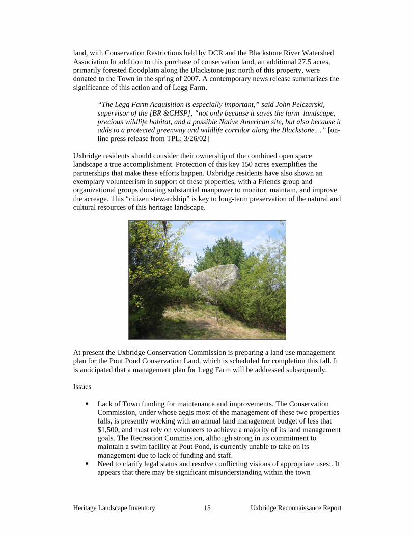
Pout Pond and Legg Farm Conservation Lands From precontact times until the late 19th century, this Uxbridge pond and contiguous ridge were closely associated in use. Pout Pond and Legg Farm ‘went separate ways’ during the 20th century. At present, despite the fact that there are mechanisms in place that protect both properties from development, management and communications issues persist. At the same time, these adjoining parcels of conservation land are an exemplary success story of public/private cooperative efforts, and leveraging small beginnings into large results. They will therefore be described here as one continuous landscape with a shared historical background. Description: The landscapes identified as Pout Pond and Legg Farm are adjacent town-owned parcels on the east side of the Blackstone River across from River Bend Farm, a part of the Blackstone Heritage State Park. They are located on a north-south ridge that separates the watersheds of the Blackstone and West Rivers. Legg Farm Conservation Land is located on a bluff overlooking the Blackstone Valley to the west and Pout Pond to the southeast. Its dominant feature is a massive boulder named Indian Rock, on the crest of the ridge or bluff. The property, roughly 60 acres, includes much of the upland pasture, hayfields and woodland of the former Henry Legg farm. There are no buildings on the property; the Legg house and outbuildings, originally located at the end of a small residential cul-de-sac named Henry Legg Road, do not survive. An old cart path leads from their site through the Legg Farm property, curving around Indian Rock and down the wooded western slope to over 2,000 feet of wetlands frontage along the river. The Legg Farm property also has more than 750 feet of frontage on the north shore of Pout Pond, across from the swimming beach.

Heritage Landscape Inventory Uxbridge Reconnaissance Report 14
Pout Pond is at the western edge of the Pout Pond Conservation Land property. The parcel as a whole consists of mature second-growth woodland dominated by white pine that extends eastward to West River Road. A network of trails traverses the woodlands and wetlands that include a unique shrub bog environment and a densely forested red maple swamp. A boardwalk, recently constructed as an Eagle Scout project, spans a marshy area between the shrub bog and the pond, allowing access to and observation of the bog habitat. The pond, indicated as 9.9 acres on 1966 survey, has a sandy beach and parking at the end of an access road, with a concrete block bathhouse facility near the water. The foundation of a storage shed is nearby. A hiking trail circles the pond, and at the north end, an early 20th century four-square cottage overlooks the water. The cottage is not presently in use, and is in need of repairs. In the southernmost section of the Pout Pond parcel, the Town maintains a number of ball fields under a cooperative arrangement between the Recreation Commission and the Conservation Commission. Background: Pout Pond, a spring-fed pond, was acquired by a nearby mill owner in the late 19th century and improved as a recreational facility for mill workers. As originally laid out, two separate beaches were developed, for male and female swimmers; the northern, ladies’ beach facilities included the small four-square building that is still standing, originally used as a bath house. In 1966 the Town of Uxbridge purchased Pout Pond from the Harold J. Walter estate. Only the southern beach is now in recreational use. For many years the Rotary Club provided sand for annual beach refurbishment; this practice has been taken on more recently by local gravel removal operators, who now donate sand on an as-needed basis. An active volunteer Friends group assists the Conservation Commission in patrolling and maintaining the parcel, and a Pout Pond Subcommittee of the Conservation Commission addresses management issues.
Legg Farm is thought to have been occupied during the precontact and early colonial eras by the Waentuc band of the Nipmuc Nation, who were attracted to the area by its rich riverine resources, protected fresh water pond, and long view over adjoining valleys. Indian Rock is thought to have been both a lookout point and a landmark for travelers. In more recent times there were a number of farms in the vicinity including Elmwood Farm, now a single-family subdivision, and Legg Farm. In 2002 the Town of Uxbridge, with assistance from the Massachusetts Department of Conservation and Recreation, the Trust for Public Land (TPL) and a broad coalition of residents and organizations, acquired Legg Farm as permanently protected conservation
Heritage Landscape Inventory Uxbridge Reconnaissance Report 15
land, with Conservation Restrictions held by DCR and the Blackstone River Watershed Association In addition to this purchase of conservation land, an additional 27.5 acres, primarily forested floodplain along the Blackstone just north of this property, were donated to the Town in the spring of 2007. A contemporary news release summarizes the significance of this action and of Legg Farm.
“The Legg Farm Acquisition is especially important,” said John Pelczarski, supervisor of the [BR &CHSP], “not only because it saves the farm landscape, precious wildlife habitat, and a possible Native American site, but also because it adds to a protected greenway and wildlife corridor along the Blackstone....” [on-line press release from TPL; 3/26/02]
Uxbridge residents should consider their ownership of the combined open space landscape a true accomplishment. Protection of this key 150 acres exemplifies the partnerships that make these efforts happen. Uxbridge residents have also shown an exemplary volunteerism in support of these properties, with a Friends group and organizational groups donating substantial manpower to monitor, maintain, and improve the acreage. This “citizen stewardship” is key to long-term preservation of the natural and cultural resources of this heritage landscape.
At present the Uxbridge Conservation Commission is preparing a land use management plan for the Pout Pond Conservation Land, which is scheduled for completion this fall. It is anticipated that a management plan for Legg Farm will be addressed subsequently. Issues
Lack of Town funding for maintenance and improvements. The Conservation Commission, under whose aegis most of the management of these two properties falls, is presently working with an annual land management budget of less that $1,500, and must rely on volunteers to achieve a majority of its land management goals. The Recreation Commission, although strong in its commitment to maintain a swim facility at Pout Pond, is currently unable to take on its management due to lack of funding and staff.
Need to clarify legal status and resolve conflicting visions of appropriate uses:. It appears that there may be significant misunderstanding within the town
Heritage Landscape Inventory Uxbridge Reconnaissance Report 16
government as to allowable uses for public land acquired for conservation purposes.
Legg Farm is in need of a Land Use and Management Plan: While significant improvements are being made by local volunteers, major site improvements need to be directed by a property-wide plan. Two such improvements identified as desirable by residents are:
improvement of public access to Legg Farm with a small designated parking area and trail improvements utilizing extant cartpaths;
improvement of Legg Farm vistas including limited clearing in immediate vicinity of Indian Rock, and perhaps downward toward Pout Pond.
Recommendations
The Conservation Commission should work closely with the Department of Planning and Economic Development to make sure that 1) overall town planning objectives support, rather than conflict with, the continued protection and appropriate use of conservation lands and 2) all town entities have a clear understanding of the Commission’s role and authority.
Funding: The planned completion of the Pout Pond Land Use Plan this fall provides an excellent opportunity to make the Commission’s case for additional land management funding in next year’s Town budget. Information from the Plan can be used to inform and educate the public well ahead of town meeting about the Commission’s role, about the public benefits of conservation and passive recreation, and about the financial needs for maintenance and improvements.
Legg Farm Resource Assessment: The proposed Legg Farm management plan presents an opportunity for a thorough natural and cultural resource inventory of the property, which should not be short-shrifted by a fast-track planning schedule. Regional organizations may be able to offer expert assistance for this part of the planning process.
Adaptive Reuse: Planning for Pout Pond should include plans for the future use of the historic cottage located on the pond’s north shore. Suggested uses include an environmental education center for Uxbridge schools and summer programs or a scout overnight cabin. Regular use of the cottage would provide an additional layer of monitoring for the town’s land, and would provide a good example of adaptive reuse options for historic structures. It might also be worthwhile to consider using DCR’s Historic Curatorship Program as a model for reuse of the cottage: under this model, the Town would enter into a long term lease with a tenant curator who would pay rent in the form of services such as ranger duty and building repairs.
Additional Protective Mechanisms: the Conservation Commission should consider placing a permanent Conservation Restriction on any of the parcels under its authority that are not already so protected.
Public Relations: The Conservation Commission has an opportunity to take an action step in keeping with the 2006 “Vision for Uxbridge’s Future” document, by using various public media. Local cable programming, the New Uxbridge Times, the Commission’s website are all low-cost avenues to use in support of the key “Vision” concepts of a restored and sustainable Pout Pond and the Commission’s part in improved stewardship of all town parks, while at the same time informing town residents of the positive aspects of passive recreation and conservation of lands in a natural state.

Heritage Landscape Inventory Uxbridge Reconnaissance Report 17
Southern New England Trunkline Trail Description: The Southern New England Trunkline Trail (SNETT) is a linear landscape comprised of the abandoned railbed of the former Boston, Hartford and Erie Railroad. Currently owned by DCR, it is a regional recreational resource whose future impacts not only Uxbridge, but neighboring towns of Douglas and Millville as well. Surfaced with gravel and ballast, the SNETT covers approximately 22 miles in Massachusetts, from Franklin State Forest on the east to Douglas State Forest on the west. It passes through the towns of Douglas, Uxbridge, Millville, Blackstone, Bellingham and Franklin. The Bay State Trail Riders Association (BSTRA), an equestrian group, has a great interest in the SNETT as a recreational resource. It has organized and conducted volunteer maintenance activities since the spring of 1989. A major effort over the years has been trash pick up and brush clearing along the trail. BSTRA has collaborated with the state and various community groups (i.e., high school students, rotary clubs) to organize work days, including many hours of work as in-kind match to grants from the state and the National Heritage Corridor. DCR has erected identification and trail crossing signs, and installed metal pipe gates to curb vehicular access, including ones at the trail crossings on Chocolog Road and West Street in Uxbridge. BSTRA has submitted plans to the state for construction of a bridge crossing over 146A in south Uxbridge.
Background: The railroad was built in stages, ultimately connecting towns in south central Massachusetts with Connecticut and operating for approximately a hundred years. The first leg of the railroad, from Franklin to Blackstone, was completed in 1849 and the leg from Blackstone to the Connecticut border was completed in 1854. Built by separate companies, both sections came under common ownership in 1854, passing to the New York, New Haven and Hartford Railroad Company. The railroad then extended into Connecticut along what was first a passenger rail line and later a freight line; the abandoned bed is now part of the Connecticut state park system. After a 1969 Blackstone bridge collapse, the route in Massachusetts all but shut down, the only continuing operation being a weekly freight run to East Douglas handling mostly grain and animal feed shipments. In 1984 the railroad right-of-way through all six Massachusetts towns was acquired by the former Department of Environmental Management (now DCR). It was designated a National Recreation Trail by the National Park Service in 1994. Issues:

Heritage Landscape Inventory Uxbridge Reconnaissance Report 18
Need for Ongoing Maintenance: Despite being owned by DCR and designated a National Recreation Trail, the SNETT gets relatively little agency support. There is a need for regular, periodic brush clearing and pruning, most of which is currently spearheaded by private interests.
Illegal Dumping: Illegal dumping has been a problem, which has been reduced with the installation of gates that prevent vehicular access.
Trail Connections and Extensions: Bikers and riders in the region are interested in developing links between the SNETT and the Grand Trunk Rail Road. Incorporating these two railbeds as a connected system would provide more interesting riding opportunities than the purely linear riding experience of the SNETT. In Uxbridge, the Grand Trunk closely parallels the SNETT, and is almost entirely on privately owned land.
Recommendations:
• Develop a Friends group, or encourage the BSTRA to form a SNETT subcommittee, to establish a formal dialogue with DCR to help promote a regional approach to restoration and maintenance of the SNETT, incorporating cooperative private and public support through mechanisms such as grants through EOEEA’s Office of Public Private Partnerships.
• Encourage DCR to construct additional gates at the Aldrich Street crossing, where there is evidence of 4-wheel drive vehicles accessing the trail.
• Work with DCR to study the feasibility of constructing loop trails or segments between the SNETT and the Grand Trunk, and open discussions with private landowners concerning rights-of-way where appropriate.
• Work with DCR to install interpretative signage at selected locations to enhance public understanding of the SNETT’s history and significance.

Heritage Landscape Inventory Uxbridge Reconnaissance Report 19
PART II
BUILDING A HERITAGE LANDSCAPE TOOLKIT

Heritage Landscape Inventory Uxbridge Reconnaissance Report 20
EIGHT TOOLKIT BASICS As our communities undergo rapid land use changes, heritage landscapes are particularly threatened because they are often taken for granted. There is a broad variety of resources that communities can call upon to protect these irreplaceable resources. Below is a checklist of the basics. Each is discussed in the sections that follow and in Appendix B. 1. Know the resources: Inventory We cannot advocate for something until we clearly identify it – in this case, the physical characteristics and historical development of the town’s historic and archeological resources. The necessary first step is to record information about the resources at the Massachusetts Historical Commission. 2. Gain recognition for their significance: National Register Listing The National Register of Historic Places is the nation’s official list of cultural resources worthy of preservation. Listing brings a number of benefits including recognition, consideration when federally-or state-funded projects may impact the resource, eligibility for tax credits, and qualification for certain grant programs. 3. Engage the public: Outreach, Education and Interpretation In order to create a community of advocates, we need to raise public awareness and broaden the base of support. This includes developing opportunities to learn about and celebrate the places and history of the town, as well as to care for them. 4. Think in context: Comprehensive and Open Space Planning It is important that Open Space Plans and Comprehensive or Master Plans address heritage landscapes as vital features of the community, contributing not only to unique sense of place but also to environmental, recreational and economic health. 5. Develop partnerships: The Power of Collaboration Protecting community character, respecting history, and promoting smart growth are interrelated concerns that impact heritage landscapes and require collaboration across a broad spectrum of the community. This includes communication among town boards and departments, as well as public-private partnerships. 6. Defend the resources: Zoning, Bylaw and Ordinance Mechanisms Effective and innovative preservation tools exist in the legal and regulatory realm. These range from a wide array of zoning, bylaw and ordinance mechanisms, to incentive programs and owner-generated restrictions on land use. 7. Utilize the experts: Technical Assistance Regulations and creative solutions for heritage landscapes are constantly changing and emerging. Public and private agencies offer technical assistance with the many issues to be addressed, including DCR, MHC, the Heritage Corridor and the Central Massachusetts Regional Planning Commission. 8. Pay the bill: Funding Preservation Funding rarely comes from a single source, more often depending on collaborative underwriting by private, municipal, and regional sources. Each town also has a variety of funding sources that are locally-based and sometimes site-specific.

Heritage Landscape Inventory Uxbridge Reconnaissance Report 21
UXBRIDGE’S TOOLKIT – Current Status and Future Additions
What follows is a review of the tools that Uxbridge already has in place, as well as a number of additional tools that fall within some of the categories noted above. The tools already in place for Uxbridge provide a good foundation for heritage landscape preservation, but their efficacy as protection for the town’s natural and cultural resources can be significantly improved by strengthening existing measures and putting others in place. Appendix B includes extended descriptions of preservation measures; the specific applications of those tools to Uxbridge’s resources are described below. In addition, the appendix contains a full description of additional avenues and creative approaches that Uxbridge can consider in developing a multi-pronged strategy for preservation. A tool that has been proven to be one of the single most valuable resources in protecting heritage landscapes has been the Community Preservation Act (CPA). Towns that have approved the CPA have been able to leverage funding for such activities as historic resource surveys, acquisition of conservation restrictions and open space, adaptive reuse of historic structures, and signage programs. More information about the CPA can be found in Appendix B under 6. Defend the Resources: Laws, Bylaws and Regulations and 8. Pay the Bill: Funding Preservation. Uxbridge has recognized the importance of the CPA in its Open Space and Recreation Plan, and should act on this to build a case for passage of the provision by the town.
These tools should be considered in combination with recommendations made in Part I for Uxbridge’s priority landscapes.
1. Know the resources: Inventory
Current: According to the Massachusetts Historical Commission, the town’s inventory includes documentation for 340 buildings, structures and sites, most of them within one of the town’s six National Register Districts (see below). In addition, Uxbridge has documented over 30 precontact Native American sites, and numerous historic archeological sites are included among the historic districts. Additions: The inventory process that documented many of Uxbridge’s resources for National Register nominations took place over 25 years ago, between 1971 and 1984. Since that time, documentation standards have risen. Additionally, it is important for Uxbridge to document its historic assets town-wide, rather than focusing on the industrial areas as has been done in the past. The survey should prioritize heritage landscapes such as those listed in this report. It should include representative and significant structures, features and landscapes from all periods of Uxbridge’s history and from all geographic areas. It is recommended that a similar, archaeological survey be completed for the community. Known and potential precontact Native American and historic archaeological sites should be documented in the field for evidence of their cultural association and/or integrity. Funding assistance for this effort would also be available from the MHC Survey and Planning grants, as well as CPA funding.
Heritage Landscape Inventory Uxbridge Reconnaissance Report 22
2. Gain recognition for their significance: State and National Register Listing
Current:: Uxbridge contains a wealth of resources that are listed in the National Register of Historic Places, including six districts encompassing approximately 140 properties: Rogerson’s Village Historic District (NRD 1971) Rivulet Mill Complex (NRD 1983) Central Woolen Mills District (NRD 1984) Waucantuck Mill Complex (NRD 1984) Uxbridge Common District (NRD 1984) Wheelockville District (1984) Blackstone Canal Historic District (NRD 1995)
In addition, 48 properties in Uxbridge are individually listed on the National Register. The Virginia Blanchard School in North Uxbridge, and the Root Farm Site are permanently protected by Preservation Restrictions. The Uxbridge Common National Register District, with somewhat revised boundaries, was approved as a Local Historic District (Uxbridge Town Common and Center Historic District) in 2004. All of these properties are listed on the State Register. Appendix B of this report identifies some of the distinctions between National Register District and Local District designations.
3. Engage the public: Outreach, Education and Interpretation
Current: The Blackstone River Valley National Heritage Corridor has published an excellent walking tour guide to Uxbridge Center that describes the history and significance of a number of central village sites, as well as providing brief historical background to the town as a whole.
DCR has published an annotated trail map of the Blackstone River and Canal Heritage State Park, showing its various properties in Uxbridge, Millville and Northbridge, including walking trails, parking areas and other features. Additions: Developing a variety of ways to reach out to the public through local media coverage, publications, interpretive tours and school programs is extremely effective in keeping these places in the public consciousness. A good source of support for advocacy is Preservation Mass, the statewide preservation advocacy organization. Specifically, Preservation Mass’ 10 Most Endangered program is a good avenue to advocate for resources that are imminently threatened.

Heritage Landscape Inventory Uxbridge Reconnaissance Report 23
4. Think in context: Comprehensive and Open Space Planning
Current: Master Plan: The Master Plan for the Town of Uxbridge is approximately 15 years old and in need of being updated. Current: Open Space Plan: The Open Space Plan, completed in 2004, addresses some of the mechanisms that need to be laid out in a Master Plan update. Specifically, it speaks about the critical role of zoning in protecting Uxbridge’s heritage landscapes, noting: “the ‘community character’ that people want to preserve is based on development patterns that are presently no longer allowed according to current zoning by-laws.” To change this situation, the Open Space Plan supports Flexible Zoning as a tool to minimize the negative impacts of new development and preserve open space. It also advocates for Village Center Zoning to encourage compact development. While the plan stresses acquisition of conservation land, it notes that other protection mechanisms are needed as well, many of which are identified below (see #6) and laid out in Appendix B. A number of heritage landscapes that were prioritized by Uxbridge during this survey have already been discussed in planning exercises and documents, including the SNETT, Pout Pond, and the Williams Hill farm landscapes. Additions: It is extremely important that updating Uxbridge’s Master Plan be given high priority in the town’s budget and planning calendar, in order to effectively guide development and growth while protecting valued qualities of the community. The Open Space Plan recommended a ranking system for wildlife corridor and trail development. It is important that such a clearly thought-out system be used to prioritize actions that will promote and protect landscapes identified as important to the town. It is also important, however, that Uxbridge integrate thinking about historic resource protection with natural resource protection in its ongoing planning efforts. It is vital that there be strong links between community economic development, open space, and recreation agendas in order to successfully address Uxbridge’s environmental and development challenges. There should be regular joint meetings of the town boards involved with land-based and cultural resource issues. This scheduled interaction will help to maintain communication, coordinate planning priorities, and advance programs that support and promote community character and heritage landscapes.
5. Develop partnerships: The Power of Collaboration
Current: Uxbridge has repeatedly shown that collaboration and public/private partnerships work to preserve the town’s heritage landscapes. From the single determined effort of the Bay State Trail Riders Association in maintaining the SNETT Trail, to the impressive coalition of individuals, local, regional and state organizations to save the Legg Farm property, and a range of partnerships between these two, the town has seen and learned from many examples of successful cooperative action and advocacy.

Heritage Landscape Inventory Uxbridge Reconnaissance Report 24
Additions: In general, it is essential for the Historical Commission, Conservation Commission and Planning Board to work closely together to successfully address the diverse natural and cultural issues of heritage landscape protection. More specifically, a number of misunderstandings and disagreements among town departments concerning authority and management for open space and conservation lands underscores the importance of consistent and thorough interdepartmental communications. The recent hiring of a Town Planner in Uxbridge provides an excellent opportunity to establish regular communication mechanisms among town boards and committees.
6. Defend the Resources: Zoning, Bylaw and Ordinance Mechanisms
Current Mechanisms
At present, Uxbridge bylaws are being reviewed and codified. The following is a brief listing of mechanisms that support heritage landscapes in the town.
Local Historic District: In 2004, Uxbridge established the Town Common and
Center Local Historic District. The Uxbridge Historic District Commission was organized “to protect and preserve the distinctive characteristics and architecture of the exterior of properties within the Historic District; to encourage new designs compatible within the District; and as a tool for maintaining property values.”
Historic Mill Adaptive Reuse Overlay Zoning Bylaw: In 2004, Special Town
Meeting adopted a Historic Mill Adaptive Reuse Overlay District Bylaw that supports the flexibility needed by developers to create an attractive mix of development options.
Growth Management Bylaw: The growth management bylaw runs for five
years, from 2005 to 2009. It sets a limit of 60 dwelling unit permits per year in the town. Low and moderate income housing, and all dwelling units established under a Conservation Design subdivision (see below) are exempted from the cap.
Conservation Design Bylaw: Last year, the Town passed a Conservation Design
Bylaw that requires all subdivisions with eight or more lots in the agricultural zoning district (which includes Williams Hill) to be built as conservation design subdivisions. This requires house lots to be one out of every two acres, with the remaining acre permanently protected as open space.
Additional Mechanisms Three basic strategies have consistently proven effective as basic preservation tools in communities throughout Massachusetts. Demolition Delay Bylaws provide a time period in which towns can explore
alternatives to demolition of historic structures. The Uxbridge Historical Commission should work with MHC staff to develop a bylaw that would best

Heritage Landscape Inventory Uxbridge Reconnaissance Report 25
suit Uxbridge’s needs. They should also work with other town groups to publicize the advantages of a demolition delay bylaw to the community. The most valuable aspect of this bylaw is that it creates space within which to have a conversation about how private and public needs can both be met in the service of preservation. Many towns have found that a delay of one year is the most effective time frame within which to negotiate alternatives to demolition. A majority of the bylaws apply to all structures built over 50 years ago, in accordance with federal standards.
Neighborhood Architectural Conservation Districts (NACD), further
explained in Appendix B, are local initiatives that recognize special areas within a community where the distinctive characteristics of buildings and places are preserved and protected. Centreville, the mill village surrounding Stanley Woolen Mills is a particularly appropriate neighborhood for this protective designation.
Local Historic Districts (LHD), further explained in Appendix B, are also local
initiatives and the strongest form of protection to preserve special areas with distinctive buildings and places. Uxbridge has a large, dense, and complex historic district that encompasses the traditional town common as well as the area defined as the “town center”. The Town is to be commended for taking this important step to preserve the character and desirability of the District. As Uxbridge has recognized, local designation often protects private investment by enhancing property values. The success of Local Historic District, however, depends on enforcement by the Historic District Commission, which must feel empowered and supported by other town boards and commissions. In addition, the Massachusetts Historical Commission can provide training to Historic District Commissions, so that they fully understand their role, responsibilities and authority.
Additional mechanisms specific to Uxbridge’s landscapes
The following recommendations are organized by resource type; they are measures that should be considered to strengthen protection for agricultural lands and scenic roads. Agricultural Lands Preservation of agricultural landscapes means preservation of the farming activities; otherwise, it simply is the preservation of land as open space. There are instances in which changing technology requires modifications to existing farm structures, or the addition of new ones. It is important to know what the features of an agricultural setting are and which features the community treasures in order to make a case for preservation of these settings. Appendix B has a full list of regulatory tools that should be considered to protect agricultural land; the following highlights important measures to meet the needs of agricultural protection in Uxbridge. 1. Create an Agricultural Commission, a standing committee of town
government created through vote at Town Meeting. This Commission would

Heritage Landscape Inventory Uxbridge Reconnaissance Report 26
represent the farming community, promote agricultural-based economic opportunities, and work to protect and sustain agricultural businesses and farmland.
2. Prioritize parcels presently under Chapter 61A for future acquisition. Should the land owner choose to sell land recently withdrawn from Ch 61, the town has only 120 days to act on its right of first refusal. The need to pay fair market value, combined with lack of readily-available funding from a program such as the Community Preservation Act, makes it difficult for the town to effectively act on this right.
3. Strengthen public-private partnerships to preserve farmland through purchase of APRs or CRs.
4. Develop partnerships to raise funds to purchase development rights on farms or to assist a farmer in the restoration of historic farm buildings for which the owner would be required to donate a preservation restriction (PR).
5. Make information about the Massachusetts Department of Agricultural Resources programs available to farmers, including the Farm Viability Enhancement Program (technical assistance, funding) and the Agricultural Environmental Enhancement Program (supports best management practices for agricultural operations to mitigate impacts on natural resources).
6. Document farms that are considered critical to the character of Uxbridge’s community using MHC survey forms.
7. Adopt a right-to-farm bylaw which allows farmers to carry on farming activities that may be considered a nuisance to neighbors. Refer to Smart Growth Toolkit at: http://www.mass.gov/envir/smart_growth_toolkit/bylaws/Right-to-Farm-Bylaw.pdf
8. Explore Community Supported Agriculture (CSA), a partnership between a farm and a community of supporters. Community members cover a farm’s yearly operating budget by purchasing a share of the season’s harvest. This relationship guarantees farmers a reliable market, while assuring the members high quality produce, often below retail prices.
Scenic Roads
Scenic roads are an integral part of the historic fabric of the community. They are highly valued by Uxbridge residents and visitors alike and were listed as a heritage landscape theme during the public meeting. Roads must also accommodate modern transportation needs and decisions regarding roadways are often made with travel and safety requirements as the only considerations. It appears that four roads were identified as potential “scenic roads” several years ago, but a bylaw was not passed for fear it might prevent development and impede road maintenance. The intent of a Scenic Roads Bylaw is to maintain the character of roads by requiring a public hearing when stone walls or trees that are located within the right-of-way may be affected by road work or construction of any sort. Without a Scenic Roads Bylaw, there is little the town can do to protect the qualities that are essential to the character of its roads. In addition, much of what we value about scenic roads –the views across open fields, historic buildings, and many stone walls – are not within the public right-of-way. The preservation and protection of scenic roads therefore requires more than one approach.

Heritage Landscape Inventory Uxbridge Reconnaissance Report 27
1. Complete an inventory with descriptions and photo documentation of each
of the roads in Uxbridge considered to be scenic, including the character-defining features that should be retained.
2. Adopt a Scenic Road Bylaw and designate specific town roads protected by the bylaw. (The designation cannot be applied to state numbered roadways.) Add design criteria to be considered when approving removal of trees and stone walls.
3. Post attractive road signs that identify the scenic roads in town. 4. Coordinate procedures between Department of Public Works and Planning
Board or Historical Commission. 5. Consider a Scenic Overlay District which may provide a no-disturb buffer
on private property bordering on scenic roads or adopt flexible zoning standards to protect certain views. Such bylaws would apply to the landscapes bordering state numbered roadways, which would not be protected under the scenic roads designation, as well as to landscapes bordering town roads.
6. Develop policies and implementation standards for road maintenance and reconstruction, including bridge reconstruction, which address the scenic and historic characteristics while also addressing safety. This is an important public process in which the community may have to accept responsibility for certain costs to implement standards higher than those funded by Mass Highway Department. Such standards should have a section addressing the way in which the local Highway Department maintains roads; for example, requiring a public hearing if any new pavement width is to be added to a town road during reconstruction or repair. Policies can be adopted by local boards having jurisdiction over roads, or can be adopted at Town Meeting through a bylaw. In developing policies consider factors such as road width, clearing of shoulders, walking paths and posted speeds. A delicate balance is required.
7. Utilize the Experts: Technical Assistance
There are many sources of technical assistance to which Uxbridge can turn for guidance on the varied issues associated with this cluster of priority landscapes. Staff from the Blackstone Heritage Corridor, from the Department of Conservation and Recreation, and from the Massachusetts Historical Commission, are knowledgeable and helpful in the areas of preservation and conservation planning, as well as being able to connect local proponents with other regional and governmental sources of support. A list indicating the wide range of available governmental and non-profit sources of technical assistance can be found in Appendix B.
8. Pay the Bill: Funding Preservation
Uxbridge’s Open Space Plan laid out a number of financial measures that can be utilized to protect heritage landscapes through purchase, including passage of the CPA and other means of funding preservation, such as bonding capacity, debt exclusion and annual appropriations, as well as state and federal grants.
Heritage Landscape Inventory Uxbridge Reconnaissance Report 28
Uxbridge has been designated a Preserve America community, which makes it eligible to receive technical assistance and matching grants related to heritage tourism. The recent purchase of the Legg Farm conservation area by the town exemplifies the partnerships that are available, and often work together, to protect community resources. Finding - and being – determined advocates is the essential first step to funding. More on the Preserve America designation and a full listing of the range of funding sources can be found in Appendix B.
Heritage Landscape Inventory Uxbridge Reconnaissance Report 29
CONCLUSION AND IMPLEMENTATION Uxbridge’s residents have a strong sense of place, defined by the town’s varied natural features and the historic land use patterns that grew out of them. The town has already begun to document and evaluate its most significant buildings and natural areas. It must now also look beyond these traditional resources to the landscapes, streetscapes, rural roads, neighborhoods and other natural and cultural assets that define the community’s character. Like most municipalities, Uxbridge is facing multiple pressures for change that will have permanent impact on land-based uses and natural resources, especially its remaining farming areas. Special places within the community that were once taken for granted are now more vulnerable than ever to change. The Uxbridge Reconnaissance Report is a critical tool in identifying the rich and diverse heritage landscapes in Uxbridge and in developing creative preservation strategies and partnerships. Uxbridge will have to determine the best ways and sequence in which to implement the recommendations discussed above. The town would do well to form a Heritage Landscape Committee, as described in DCR’s publication, Reading the Land. Landscapes identified in this report, especially the priority landscapes, will benefit from further documentation in accordance with MHC guidelines. The documentation in turn provides an information base for the local publicity needed to build consensus and gather public support for landscape preservation. Implementation of many recommendations in this report will require a concerted effort by, and partnerships among, municipal boards and agencies, local non-profit organizations, regional and state agencies organizations. There are no quick fixes for the challenges of managing growth and funding preservation. Many of the recommended tasks and approaches will require cooperation and coordination among a number of municipal, regional and state partners to be successful. They will require time and a good dose of patience, as volunteer schedules, legislative procedures, and funding cycles try to mesh. Circulating this Reconnaissance Report is an essential first step. The recommendations should be presented to the Board of Selectmen, who represented Uxbridge in its application to the Heritage Landscape Inventory program. Copies of the report should be available on the town’s web site and distributed to town departments and boards, particularly Uxbridge 's Historical Commission, Planning Board, and Conservation Commission, and will also be useful for the Uxbridge Historical Society, local land trusts, and other preservation organizations. A reference copy belongs in the town library. All of these circulation efforts will broaden citizen awareness, and result in increased interest and support for Uxbridge's heritage landscapes.
Finally, the project team suggests that the following recommendations be the top three priorities for Uxbridge as the town works to protect the character of its community:
1. Seek advice and training from the Massachusetts Historical Commission on the responsibilities and authority of Uxbridge's Historical and Historic District Commission.
2. Build communication and coordination among town departments, local boards, and committees to better identify and achieve common goals.
3. Work for passage of the Community Preservation Act.

Heritage Landscape Inventory Uxbridge Reconnaissance Report i
APPENDIX A
UXBRIDGE HERITAGE LANDSCAPES This list was generated by local participants at the Heritage Landscape Identification meeting held in Uxbridge on March 1, 2007 and follow-up fieldwork on May 10, 2007. There are undoubtedly other heritage landscapes that were not identified at the HLI meeting noted above. The chart has two columns, the name and location of the resource are in the first; notes about the resource are in the second. Landscapes are grouped by land use category. Abbreviations used are listed below. APR = Agricultural Preservation Restriction CR = Conservation Restriction NRHD = National Register Historic District PR = Preservation Restriction NRI = National Register Individual Property TTOR = Trustees of Reservations LHD = Local Historic District Bold = Priority Landscape Summary of Priority Landscapes Williams Hill Farms An “Industrial Mile” on Mendon Street: Waucantuck Mill, Stanley Woolen Mill and Bernat Mill Arthur Taft Memorial Town Park Pout Pond and Legg Farm Southern New England Trunkline Trail
Agriculture
Williams Hill Farms vicinity of. W. Hartford Ave, Rawson and Sutton Sts.
- Taft Farm & mill structures - Bangma’s Farm – beef cattle, dairy bar; a tourist destination - Vanderzicht Farm – working dairy farm - Wassenar Farm - Halls Farm, west from Wassenar—cut up by Rte. 146 - Arnold Baker Farm (especially barn) on Sutton St., already developed - Maple Shade Farm (was Harringer; barn deteriorating)
Cahill property Millville Rd.
APR on whole property – the only APR in Uxbridge
South Uxbridge Farms - King Farm - Herman Hathaway Farm - Talberg Farm - Alfred Johnson Farm - Richardson Farm (includes family cemetery)
Bolster Bros. barn Blackstone St.
“1750” carved on rafter
Grady (Gasser) Farm Chapin St.
Parker Farm Rockmeadow Rd.
raised cattle until about 15 years ago.

Heritage Landscape Inventory Uxbridge Reconnaissance Report ii
Frank Susskey Farm West & Paine Sts.
field still being hayed
Davis Farm Albee St.
built 1800s – still a working dairy farm
Archaeology
Scott Mill site West River
grist mill foundation near Skull Rock Rd.
Burial Grounds and Cemeteries
35 cemeteries all threatened for varied reasons (lack of funding, need restoration, some
threatened by development), except 2 in town center. The Norden Cemetery, located both in Millville and in Uxbridge, was identified as one of Millville’s heritage landscapes.
Civic / Institutional
Town Common & Center LHD
Includes Congregational (1833) & Unitarian (1834) churches, town hall, Thayer Memorial Library, Masonic hall, DAR house (Simeon Wheelock House), streetscape, phone company and busy roads. Town common has been recently improved but is not maintained; World War I memorial (Italian marble) deteriorating. A Local Historic District (2004) that includes 77 properties. There are concerns regarding bylaw enforcement.
Blanchard School 65 E. Hartford Ave.
North Uxbridge, built 1870; NRI (1983); PR (1987).
Fairlawn Christian Reform Church camp Hartford Ave.
camp buildings and mill ruins near base of quarry hill
Cornet John Farnum House
in Town Common LHD
Simeon Wheelock House built 1768; now DAR building – see Town Common LHD Friends Meetinghouse 479 Quaker Hwy.
NRI 1974
Ironstone Schoolhouse One-room schoolhouse; now South Uxbridge Community Association; only one-room schoolhouse in Uxbridge still on original site.
High School gymnasium includes the town’s World War II memorial
Commercial / Industrial
Bernat – Stanley – Waucantuck Mills
Historic cluster of industrial activity along 1-mile stretch of Mendon Street, including West River Dam (poor condition) and trolley bridge; all are included in NRHDs; Waucantuck slated for demolition; Stanley for adaptive reuse; Bernat mill burned July 2007.
Uxbridge Inn in LHD; built. 1882 as Hotel Wilson Lynch’s Package Store adjacent to Capron Park; in LHD
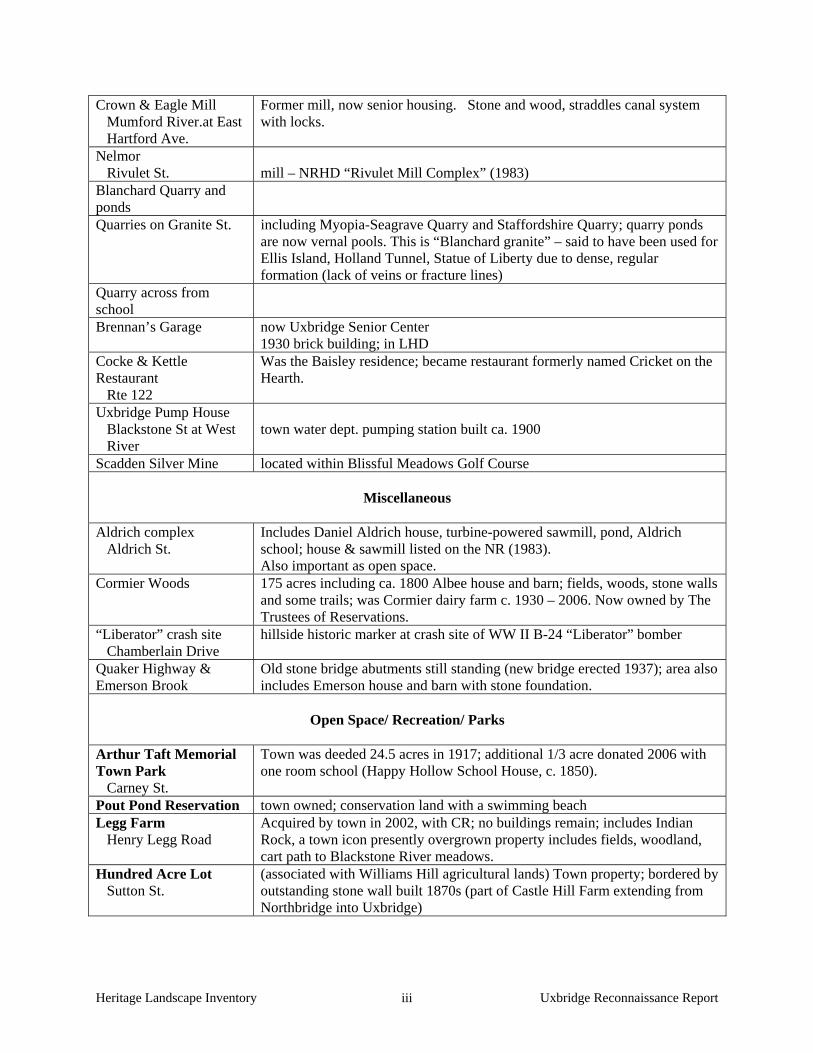
Heritage Landscape Inventory Uxbridge Reconnaissance Report iii
Crown & Eagle Mill Mumford River.at East Hartford Ave.
Former mill, now senior housing. Stone and wood, straddles canal system with locks.
Nelmor Rivulet St.
mill – NRHD “Rivulet Mill Complex” (1983)
Blanchard Quarry and ponds
Quarries on Granite St. including Myopia-Seagrave Quarry and Staffordshire Quarry; quarry ponds are now vernal pools. This is “Blanchard granite” – said to have been used for Ellis Island, Holland Tunnel, Statue of Liberty due to dense, regular formation (lack of veins or fracture lines)
Quarry across from school
Brennan’s Garage
now Uxbridge Senior Center 1930 brick building; in LHD
Cocke & Kettle Restaurant Rte 122
Was the Baisley residence; became restaurant formerly named Cricket on the Hearth.
Uxbridge Pump House Blackstone St at West River
town water dept. pumping station built ca. 1900
Scadden Silver Mine located within Blissful Meadows Golf Course
Miscellaneous
Aldrich complex Aldrich St.
Includes Daniel Aldrich house, turbine-powered sawmill, pond, Aldrich school; house & sawmill listed on the NR (1983). Also important as open space.
Cormier Woods 175 acres including ca. 1800 Albee house and barn; fields, woods, stone walls and some trails; was Cormier dairy farm c. 1930 – 2006. Now owned by The Trustees of Reservations.
“Liberator” crash site Chamberlain Drive
hillside historic marker at crash site of WW II B-24 “Liberator” bomber
Quaker Highway & Emerson Brook
Old stone bridge abutments still standing (new bridge erected 1937); area also includes Emerson house and barn with stone foundation.
Open Space/ Recreation/ Parks
Arthur Taft Memorial Town Park Carney St.
Town was deeded 24.5 acres in 1917; additional 1/3 acre donated 2006 with one room school (Happy Hollow School House, c. 1850).
Pout Pond Reservation town owned; conservation land with a swimming beach Legg Farm Henry Legg Road
Acquired by town in 2002, with CR; no buildings remain; includes Indian Rock, a town icon presently overgrown property includes fields, woodland, cart path to Blackstone River meadows.
Hundred Acre Lot Sutton St.
(associated with Williams Hill agricultural lands) Town property; bordered by outstanding stone wall built 1870s (part of Castle Hill Farm extending from Northbridge into Uxbridge)

Heritage Landscape Inventory Uxbridge Reconnaissance Report iv
Riverways
- Blackstone River - West River - Mumford River issues (apply to one or more rivers): lack of protection, access, views, riverbank maintenance, watershed & water quality
Wheelock Field Blackstone St.
privately owned
Mill Pond aka Lee Pond; adjacent to SNETT; with mill remains theme: stone walls throughout town; being removed/destroyed during development. Emerson Brook Excellent cold water fishery, especially brook trout; quality threatened by
development Chocolog Pond scenic; swimming site Ironstone Reservoir & Brook
Laurel Brook & Ponds includes clubhouse for private Sportsmen’s Club Coleman Brook & Pond vic. Elmwood St.
long association with farm family
Rice City Pond with bridge and dam (at risk in 100-yr. flood) – wonderful views and path along west side into Northbridge
Balm of Life Spring Balm of Life Spring Rd
excellent drinking water; in use until recently by townspeople
Capron Park waterfall and bridge in town center , with walkways, benches– wonderful views
Cold Spring Brook Douglas St., residential neighborhood
Residential
Samuel Taft House 87 Sutton St.
was tavern; NRI 1983; private residence.
Capron St area 2 block area including Cross and Oak Streets; civic buildings including high school; significant architecture including 18th and 19th century houses
Wayland Davis house Blackstone St.
across from Bolster Bros. farm
Rogerson’s Village Hartford Ave.
Whitin Estate brick mill housing including duplexes. NRHD (1971)
Centreville Stanley Woolen Mill housing, mid-19th to early 20th cen. single and duplex, with 20th cen. “auto barns”
Hecla district mill housing Taft House West & Douglas Sts.
brick.
Transportation
Southern New England Trunkline Trail
Owned by DCR, primarily maintained by Bay State Trail Riders Association (volunteers); railway established 1850s; landscape includes overpass bridges, railway trestles; Mill Pond (see open space) off to side. Grand Trunk line parallels SNETT.

Heritage Landscape Inventory Uxbridge Reconnaissance Report v
theme: stone bridges 6 stone arch roadway bridges; a few additional railway bridges
Chapin Street picturesque, winding
Blackstone Canal Canal operated 1828-1848. Skull Rock lock area includes portion of canal in pristine condition with gorgeous forest, stone locks, and foundation remnants of early grist mill. NRHD 1973 and 1995
Old Middle Turnpike Was Middle Post Road in 1700s; became turnpike c. 1800; section near West Hartford Ave. still visible
Grand Trunk Rail line Built 1912-1915; never completed; most of rail bed in private ownership; see SNETT
Cog Railway off W. Hartford Ave.
associated with Liberty Estates quarry; recent development may have eliminated some features.
Train Station Main St.
in LHD; privately owned; was depot for Providence & Worcester Railway.

Heritage Landscape Inventory Uxbridge Reconnaissance Report vi
APPENDIX B
GUIDE TO PRESERVATION AND PLANNING TOOLS FOR HERITAGE LANDSCAPES Preservation planning is a four-step process: identification, evaluation, education and protection. Within the realm of protection, there is a vast array of tools that communities can call upon and that are most effective when used in combination with one another. Stewardship of these resources involves education and community support, planning with a clear set of goals, and regulatory mechanisms. Three useful documents to consult when planning preservation strategies are: Department of Conservation and Recreation, Reading the Land
Massachusetts Historical Commission, Survey Manual
Massachusetts Historical Commission, Preservation through Bylaws and Ordinances
The following eight sections – based on the Toolkit Basics – detail the resources and strategies available for heritage landscape preservation—from documentation and evaluation, to public education, to regulating activities and finding the revenue necessary to fund the effort. 1. KNOW THE RESOURCES: INVENTORY The vital first step in developing preservation strategies for heritage landscapes is to record information about the resources on MHC inventory forms. One cannot advocate for something unless one knows precisely what it is – the physical characteristics and the historical development. Survey methodology has advanced since the early work of the 1980s. If a community had survey work done during that time period, it is time for an inventory update, looking at resources in a more comprehensive and connected way than may have been done at that time. Even if survey work is more recent, there may be a need to document more resources throughout the community. Using the Massachusetts Historical Commission survey methodology:
a. Compile a list of resources that are under-represented or not thoroughly researched, beginning with heritage landscapes.
b. Document unprotected resources first, beginning with the most threatened resources.
c. Make sure to document secondary features on rural and residential properties, such as outbuildings, stone walls and landscape elements.
d. Record a wide range of historic resources including landscape features and industrial resources.
e. Conduct a community-wide archaeological reconnaissance survey to identify patterns of prehistoric and historic occupation and to identify known and probable locations of archaeological resources associated with these patterns. Known and potential precontact and historic archaeological sites should be professionally field-checked to evaluate cultural associations and integrity. A professional archaeologist is one who meets the professional

Heritage Landscape Inventory Uxbridge Reconnaissance Report vii
qualifications (950 CMR 70.01) outlined in the State Archaeologist Permit Regulations (950 CMR 70.00).
NOTE: The Inventory of Archaeological Assets of the Commonwealth contains sensitive information about archaeological sites. The inventory is confidential; it is not a public record (G.L. c. 9, ss. 26A (1)). Care should be taken to keep archaeological site information in a secure location with restricted access. Refer to the MHC article "Community-Wide Archaeological Surveys" which appeared in Preservation Advocate, Fall 2005, and which can be found at the following MHC link: http://www.sec.state.ma.us/mhc/mhcpdf/pafall05.pdf.
2. GAIN RECOGNITION FOR THEIR SIGNIFICANCE: NATIONAL REGISTER LISTING Survey work includes evaluation of whether resources meet the qualifications for National Register listing. This will provide new information about the eligibility of properties. Using the information generated in the survey work and the accompanying National Register evaluations, expand your town’s National Register program.
Develop a National Register listing plan, taking into consideration a property’s or area’s integrity and vulnerability. Properties in need of recognition in order to advance preservation strategies should be given priority.
3. ENGAGE THE PUBLIC: OUTREACH, EDUCATION AND INTERPRETATION The best stewards and advocates for heritage landscape protection are members of the community. There are many ways to communicate the importance of these special places to the public, and to connect their preservation with the shared values and goals that community members have already expressed in various planning documents and forums. Think creatively about how to educate the community about the values and threats to heritage landscapes, and how each town resident benefits from these special places. Use a combination of strategies to get the word out about heritage landscapes and preservation of community character, including:
Festivals and Tours – Tours are a great way to draw attention to the history around us, and to engage more people in caring for it. Consider hosting a Heritage Celebration Day including tours and family-friendly activities, or plan a celebration around a particular place or area on a meaningful date. Make sure events are well publicized.
Signage and Banners – Signs are a very effective way to announce special historic sites and
districts. Banners can also bring attention to the significance of an area and make a celebratory statement about its contribution to the town.
Written Materials – Clear, concise and engaging written material with engaging illustrations is a
reliable way to relay information about community character and heritage landscapes. Make use of fact sheets and flyers to get the word out on particular issues such as a town ordinance that protects heritage landscapes, a threat that needs to be addressed, or an upcoming event.
School Curricula – Start teaching at a young age. Children are very receptive to engaging
stories, and there are no better stories to excite childrens’ imaginations and build pride of place than stories of their town’s past and present. Teachers have an opportunity to connect history

Heritage Landscape Inventory Uxbridge Reconnaissance Report viii
with environmental issues through classroom study, hands-on history projects, and field exploration of a town’s heritage landscapes. Subsequently, students have an opportunity to teach their parents that preservation is everybody’s business.
Lectures and Workshops – Use these forums to raise awareness, educate at a deeper level about
the community’s history and its resources, and broaden the base of interest. Website – Keep Historical Commission and local historical organizations’ entries on the town’s
website current, and include information about issues, proposals for preservation strategies, and upcoming events.
Press Releases – Use all avenues including press releases to keep the public informed when a
meeting or event is about to occur. Work with local reporters to develop special interest articles that highlight landscape resources.
Remember that bringing an issue or a heritage landscape to people’s attention once will have only short-term effect. Outreach, education and interpretation must be ongoing concerns that involve preservation and conservation interests, teachers and community organizations in repeated projects to attract and engage the general public. 4. THINK IN CONTEXT: COMPREHENSIVE AND OPEN SPACE PLANNING Communities use a variety of planning exercises and documents to define their goals and vision of the future, address community-wide issues, and recommend measures to respond to them. There are state mandates for towns to prepare Comprehensive or Master Plans and Open Space and Recreation Plans.
Comprehensive or Master Plans provide an important frame of reference for land use decisions, and incorporate all of a community’s issues including economic development, housing and transportation into an integrated plan. Heritage landscapes need to be seen through the lenses of community character, historic preservation, environmental health, and economic viability and growth. Their future and the values they contribute should be addressed within these multiple perspectives, not solely as historical assets of the community.
Like Comprehensive Plans, Open Space Plans look holistically at the community—its history, demographics and growth patterns, and current conditions—to make recommendations that protect open space and natural resources for ecological health and public benefits. The Heritage Landscape Inventory Program provides a framework for looking at these important resources, and this new understanding should be incorporated into Open Space Plans.
5. DEVELOP PARTNERSHIPS: THE POWER OF COLLABORATION Because heritage landscapes encompass such a broad range of resources and issues—from preservation of town centers, scenic roads and river corridors to promotion of smart growth and economic development – stewardship of these resources involves many interests in a community. It is essential that there be good communication between the many departments and committees that address issues related to heritage landscapes. Collaboration between public and private partners is also an essential element in a successful preservation strategy. National Heritage Corridor personnel are helpful guides to partnership opportunities for projects you may have in mind.

Heritage Landscape Inventory Uxbridge Reconnaissance Report ix
Broaden the base. Preservation, particularly preservation of landscapes, is not just for the Historical Commission. It is important that the cause not be marginalized by those who view preservation as opposed to progress, or to personal interests. A look at DCR’s Reading the Land shows the range of organizations and viewpoints that value heritage landscapes.
Nurture public-private partnerships. Friends groups, neighborhood associations, and local land trusts all have important roles to play to spread the word, and to expand the capacity of the public sector to care for heritage landscapes.
Take advantage of forums created to share issues and ideas. For instance, the Massachusetts Department of Agricultural Resources offers a “cluster” format for monthly discussion and information exchange meetings among area farmers.
Share resources across communities. Towns that lack funding for a town planner position, for instance, have found that “sharing” a planner with another community can be quite effective.
6. DEFEND THE RESOURCES; LAWS, BYLAWS AND REGULATIONS A wide range of laws, bylaws and regulations is available to protect heritage landscapes. Following are brief descriptions of some of the most widely used and/or most effective of these tools, arranged alphabetically. Adaptive Reuse Overlay District An Adaptive Reuse Overlay District is superimposed on one or more established zoning districts in order to permit incentive-based reuses of existing built properties. These districts can be created to allow for the adaptive reuse of properties of a certain kind, or within a specified area within a community. As an overlay zone, all regulations pertaining to the underlying zone apply, except to the extent that the overlay zone modifies or provides for alternatives to the underlying requirements. Agricultural Preservation Restrictions (APR) This program, managed by the Department of Agricultural Resources, offers to pay farmers the difference between the "fair market value" and the "agricultural value" of farmland located on prime agricultural soils, in exchange for a permanent deed restriction which precludes any use of the property that will have a negative impact on its agricultural viability. This program is different from the Chapter 61 program, which provides tax incentives for short term restrictions. Community Preservation Act The Community Preservation Act is statewide enabling legislation that allows communities to assemble funds for historic preservation, open space protection and affordable housing through a local property tax surcharge (up to 3%, with some allowable exemptions) and state matching funds. These funds can support a wide variety of activities, including inventory and documentation of historic resources, restoration and acquisition. Conservation Restrictions (CR) A permanent deed restriction between a landowner and a holder - usually a public agency or a private land trust; whereby the grantor agrees to limit the use of his/her property for the purpose of protecting certain conservation values in exchange for tax benefits. EOEEA’s Division of Conservation Services provides assistance to landowners, municipalities, and land trusts regarding conservation restrictions and has produced The Massachusetts Conservation Restriction Handbook as a guide to drafting conservation restrictions.
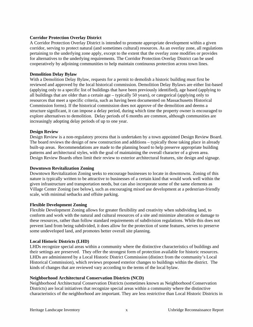
Heritage Landscape Inventory Uxbridge Reconnaissance Report x
Corridor Protection Overlay District A Corridor Protection Overlay District is intended to promote appropriate development within a given corridor, serving to protect natural (and sometimes cultural) resources. As an overlay zone, all regulations pertaining to the underlying zone apply, except to the extent that the overlay zone modifies or provides for alternatives to the underlying requirements. The Corridor Protection Overlay District can be used cooperatively by adjoining communities to help maintain continuous protection across town lines. Demolition Delay Bylaw With a Demolition Delay Bylaw, requests for a permit to demolish a historic building must first be reviewed and approved by the local historical commission. Demolition Delay Bylaws are either list-based (applying only to a specific list of buildings that have been previously identified), age based (applying to all buildings that are older than a certain age – typically 50 years), or categorical (applying only to resources that meet a specific criteria, such as having been documented on Massachusetts Historical Commission forms). If the historical commission does not approve of the demolition and deems a structure significant, it can impose a delay period, during which time the property owner is encouraged to explore alternatives to demolition. Delay periods of 6 months are common, although communities are increasingly adopting delay periods of up to one year. Design Review Design Review is a non-regulatory process that is undertaken by a town appointed Design Review Board. The board reviews the design of new construction and additions – typically those taking place in already built-up areas. Recommendations are made to the planning board to help preserve appropriate building patterns and architectural styles, with the goal of maintaining the overall character of a given area. Design Review Boards often limit their review to exterior architectural features, site design and signage. Downtown Revitalization Zoning Downtown Revitalization Zoning seeks to encourage businesses to locate in downtowns. Zoning of this nature is typically written to be attractive to businesses of a certain kind that would work well within the given infrastructure and transportation needs, but can also incorporate some of the same elements as Village Center Zoning (see below), such as encouraging mixed use development at a pedestrian-friendly scale, with minimal setbacks and offsite parking. Flexible Development Zoning Flexible Development Zoning allows for greater flexibility and creativity when subdividing land, to conform and work with the natural and cultural resources of a site and minimize alteration or damage to these resources, rather than follow standard requirements of subdivision regulations. While this does not prevent land from being subdivided, it does allow for the protection of some features, serves to preserve some undeveloped land, and promotes better overall site planning. Local Historic Districts (LHD) LHDs recognize special areas within a community where the distinctive characteristics of buildings and their settings are preserved. They offer the strongest form of protection available for historic resources. LHDs are administered by a Local Historic District Commission (distinct from the community’s Local Historical Commission), which reviews proposed exterior changes to buildings within the district. The kinds of changes that are reviewed vary according to the terms of the local bylaw. Neighborhood Architectural Conservation Districts (NCD) Neighborhood Architectural Conservation Districts (sometimes known as Neighborhood Conservation Districts) are local initiatives that recognize special areas within a community where the distinctive characteristics of the neighborhood are important. They are less restrictive than Local Historic Districts in

Heritage Landscape Inventory Uxbridge Reconnaissance Report xi
that they focus on a few key architectural elements and massing, scale, and setback in an effort to embrace overall neighborhood character. As in Local Historic Districts, changes are reviewed by a Neighborhood Architectural Conservation District Commission. Open Space Zoning Open Space Zoning – also known as Cluster Development Bylaw, Open Space Communities Zoning, Open Space Development Overlay District, Open Space Preservation Subdivision, or Open Space Residential Development – allows greater density than would otherwise be permitted on a parcel, in an effort to preserve open space. Typically, construction is limited to half of the parcel, while the remaining land is permanently protected under a conservation restriction. Rate of Development Bylaw A town may slow the rate of its growth within reasonable time limits to allow the community to engage in planning and preparation for growth. This measure must be used for the purpose of conducting studies and planning for rational development, and not for restraining the rate of growth for a period of unlimited duration. Right to Farm Bylaw A Right to Farm Bylaw asserts the rights of farmers to pursue agricultural activities, provides community support for farming activities and requires dispute resolution so that abutters cannot make nuisance claims. Agricultural landscapes are widely considered to be significant heritage landscapes for which there is constant concern of potential development. This bylaw serves to help active farmers remain just that - active. Scenic Overlay District Zoning Scenic Overlay District Zoning protects scenic vistas by providing for a no-disturb buffer on private lands, thereby helping to maintain specific viewpoints. This type of zoning is more far-reaching than a Scenic Roads Bylaw (see below) and may be applied to numbered routes. Scenic Roads Bylaw The Scenic Roads Bylaw requires that a public hearing be held prior to the removal of any trees or stone walls that fall within the public right of way on a designated scenic road. Depending on how it is written, the bylaw may apply to a predetermined list of roads or encompass all roads in a community (other than numbered routes). The bylaw applies whenever there is any public or private impact to trees or stone walls within the right of way, including activities such as road widening, utility company work or creating private driveways. Scenic Vista Protection Bylaw Scenic Vista Protection Bylaws require additional design criteria for any proposals for new construction in areas that are determined by the town to be a scenic vista. Vistas may encompass natural, cultural and historic features. Shade Tree Act The Shade Tree Act is a part of MGL Chapter 87, which defines all trees within the public way as public shade trees. The municipal Tree Warden is responsible for the care, maintenance and protection of all public shade trees (except those along state highways). Trimming or removal of any public shade trees greater than 1.5” in diameter requires a public hearing. Chapter 87 applies to all communities; however, some communities have adopted their own Shade Tree Act Bylaws that provide stricter regulations than those mandated in Chapter 87.
Heritage Landscape Inventory Uxbridge Reconnaissance Report xii
Site Plan Review Site Plan Review provides the planning board (and other boards and committees, depending how the bylaw is written) with an opportunity to consider a variety of community concerns – such as impacts to vehicular circulation, scenic vistas, topography and natural resources – during the permit process. Boards may comment on site plans and request changes to the design. Site Plan Review is typically limited to large scale projects and tied to the special permit process. Smart Growth Zoning – Chapter 40R Smart Growth Zoning (Chapter 40R) provides financial rewards to communities that adopt special overlay zoning districts allowing as-of-right high density residential development in areas near transit stations, areas of concentrated development, or areas that are suitable for residential or mixed use development. Such zoning can help direct compact growth to areas that are already developed – such as historic village centers – thereby discouraging growth in less suitable areas. Transfer of Development Rights (TDR) TDR is a regulatory technique that allows a landowner to separate building or development rights from the property and sell them, receiving compensation for preserving land and allowing for the development to occur in areas selected for higher density projects. In essence, development rights are "transferred" from one district (the "sending district") to another (the "receiving district"). As a result, development densities are shifted within the community to achieve both open space preservation and economic goals without changing overall development potential. Village Center Zoning The goal of Village Center Zoning is to meet the needs of a small-scale, mixed-use, pedestrian-friendly area by encouraging compact development. New construction is required to be built at a scale that is compatible with the neighborhood and to have a reduced (or no) setback from the street. Parking may be directed to discourage large lots in front of buildings. Village Center Zoning shares many similarities with Traditional Neighborhood Development, and the terms are sometimes used interchangeably. Wetlands Protection Act and Bylaws The Wetlands Protection Act (MGL Chapter 131, Section 40) protects wetlands by requiring a careful review by local conservation commissions of proposed work that may alter wetlands. The law also protects floodplains, riverfront areas, land under water bodies, waterways, salt ponds, fish runs and the ocean. Communities may also adopt their own Wetlands Protection Bylaw, providing stricter regulations than those mandated in Chapter 131. 7. UTILIZE THE EXPERTS: TECHNICAL ASSISTANCE Beyond DCR and the Heritage Corridor, technical assistance is available from many governmental and non-profit sources, most often free of charge to municipalities and non-profit organizations.
American Farmland Trust: Clearinghouse of information supporting farmland protection and stewardship.
Central Massachusetts Regional Planning Commission: The regional planning agency charged with assisting communities with local planning efforts in this region.
Citizen Planner Training Collaborative: Provides local planning and zoning officials with training opportunities and online information; they also hold an annual conference to support land use planning.
Heritage Landscape Inventory Uxbridge Reconnaissance Report xiii
Green Valley Institute: Provides technical assistance about land use planning to communities within the Quinebaug-Shetucket Heritage Corridor. Web site and publications contain information of use to communities throughout the region.
Massachusetts Historical Commission: Provides technical assistance as well as grants to municipalities and nonprofits for preservation planning and restoration projects.
New England Small Farm Institute: A non-profit dedicated to providing technical assistance, information and training to farmers.
The Trustees of Reservations: Offers conservation and landscape protection workshops, publications and connections through the Putnam Conservation Institute. The Trustees also manages a unique Conservation Buyer Program that links interested sellers with conservation-minded buyers and assists with establishing permanent property protection mechanisms.
Massachusetts Department of Agricultural Resources is the state agency dedicated to supporting the agricultural activities in the state through special initiatives, programs and technical assistance.
The Trust for Public Land is a national non-profit that assists municipalities with land conservation efforts.
University of Massachusetts Extension DCR’s Lakes and Ponds Program works with local groups and municipalities to protect,
manage and restore these valuable aquatic resources. They provide technical assistance to communities and citizen groups, help to monitor water quality at various public beaches to ensure public safety, and provide educational materials to the public about a range of lake issues.
Massachusetts Agricultural Commissions has recently launched a new website that includes helpful information both for communities with Agricultural Commissions and for those learning more about forming one.
UMASS extension (NREC) – Natural Resources and Environmental Conservation) can provide assistance on issues related to land and water resource protection, smart growth/sustainability measures and forestry and farming management.
8. PAY THE BILL: FUNDING PRESERVATION Funding for preservation projects is an important aspect of implementing strategies to protect heritage landscapes. There are local, state, regional, national and non-profit funding programs and resources that can assist communities in preservation and land conservation-related issues. The availability of such assistance varies from year to year and private property is not always eligible for funding. Examples include: Local Funding Assistance
Towns that have adopted the Community Preservation Act (CPA) find it to be an excellent funding source for many heritage landscape projects. While tricky to pass in lean economic times, the number and types of projects that are benefiting across the Commonwealth makes the CPA worthy of consideration. Such projects include MHC inventory, National Register nominations, cemetery preservation, open space acquisition and preservation and restoration of public buildings. The CPA (M.G.L. Chapter 44B) establishes a mechanism by which cities and towns can develop a fund dedicated to historic preservation, open space and affordable housing. Local funds are collected through a 0.5% to 3% surcharge on each annual real estate tax bill. At the state level, the Commonwealth has established a dedicated fund which is used to match the municipality’s collections under the CPA. The amount of the surcharge is determined by ballot vote at a local election.

Heritage Landscape Inventory Uxbridge Reconnaissance Report xiv
Adoption of the Community Preservation Act, by a majority vote on a ballot question, fosters partnerships among historic preservationists, conservationists and affordable housing advocates. At least 10% of the funds must be used to preserve historic resources; at least 10% must be used to protect open space; and at least 10% must be used to advance affordable housing. The remaining 70% must be used for one of these three uses as well as recreational needs and can be distributed in varying proportions depending upon the projects that the city or town believes are appropriate and beneficial to the municipality. Additional information about the CPA can be found at www.communitypreservation.org.
Municipalities can establish land acquisition funds, increasing their revenue from sources such as an annual fixed line item in the municipal budget; income from forestry, farming and leasing of town-owned land; gifts and bequests; grants and foundation funding; and passage of the CPA, detailed above.
State Funding Assistance
Funding for a variety of preservation projects, primarily for municipalities and non-profit, is available through the Massachusetts Historical Commission (MHC), the EOEEA Division of Conservation Services (DCS), the Department of Conservation and Recreation (DCR) and other state agencies. Further information on these programs is available on the agency websites.
MHC Survey and Planning Grants support survey, National Register and a wide variety of
preservation planning projects.
The Massachusetts Preservation Projects Fund (MPPF), administered through the MHC, funds restoration and rehabilitation projects.
Towns that have a local historic district bylaw may apply for Certified Local Government (CLG) status which is granted by the National Park Service (NPS) through the MHC. At least 10% of the MHC's yearly federal funding allocation is distributed to CLG communities through Survey and Planning matching grants. To become a CLG, the town completes an application; after being accepted as a CLG, it files a report yearly on the status of applications, meetings, and decisions; in return the town may apply for the matching grant funding that the MHC awards competitively to CLGs annually. Presently 18 cities and towns in Massachusetts are CLGs. NOTE: CLG status is dependent in part on a municipality having at least one Local Historical District as evidence of the community’s commitment to historic preservation.
Open Space Plans, with a requirement of updating the plan every five years, make a community eligible for Executive Office of Energy and Environmental Affairs (EOEEA) grants and technical assistance programs through the Department of Conservation Services.
The Massachusetts Self-Help Program of DCS assists local conservation commissions in
acquiring land for the purposes of natural and cultural resource protection and passive outdoor recreation.
The Massachusetts Urban Self-Help Program, another DCS initiative, is geared toward assisting towns and cities in acquiring and developing land for park and outdoor recreation purposes.

Heritage Landscape Inventory Uxbridge Reconnaissance Report xv
DCS Conservation Partnership Grants assist non-profits in acquiring interests in land for
conservation or recreation, and have also been used in the past to help protect active agricultural lands.
The Federal Land and Water Conservation Fund, distributed through the DCS, can support heritage landscape protection by providing up to 50% of the total project cost for the acquisition or renovation of park, recreation or conservation areas. Municipalities, special districts and state agencies are eligible to apply.
The Department of Conservation and Recreation (DCR) administers a variety of grant programs that can help with heritage landscape preservation:
Urban and Community Forestry grants fund projects which will result in sustained
improvements in local capacity for excellent urban and community forestry management.
The Recreational Trails Grant Program provides funding on a reimbursement basis for a variety of recreational trail protection, construction, and stewardship projects.
The Department of Agricultural Resources Farm Viability Enhancement Program works with farmers to develop sound business plans and funding assistance to implement them.
Regional and Non-Profit Funding Assistance
The John H. Chafee Blackstone River Valley National Heritage Corridor Commission’s Heritage Partnership Program supports projects in corridor towns that further the Corridor goals of historic preservation, community revitalization, ecological restoration, land use planning, riverway development and educating people about the Valley’s heritage. Communities and organizations located within the Corridor are eligible to receive funding, subject to availability.
Quinebaug and Shetucket Rivers National Heritage Corridor provides mini-grants to member towns, supporting preservation of heritage landscapes including projects involving sustainable agriculture, river clean-ups, open space planning and natural resource conservation.
The Greater Worcester Community Foundation provides grants to non-profit organizations for community enhancements.
The Trust for Public Land (TPL) is a national, nonprofit, land conservation organization that conserves land for people to enjoy as parks, community gardens, historic sites, rural lands and other natural places. TPL helps communities identify and prioritize lands to be protected; secure financing for conservation; and structure, negotiate and complete land transactions. TPL’s New England Office recently launched the Worcester County Conservation Initiative, to accelerate the pace of land conservation in central Massachusetts by helping communities plan and finance conservation projects.
The National Trust for Historic Preservation offers a variety of financial assistance programs. Based on the availability of funding, the National Trust awards more than $2 million in grants and loans each year for preservation projects nationwide.

Heritage Landscape Inventory Uxbridge Reconnaissance Report xvi
The Central Massachusetts Regional Planning Commission (CMRPC) does not administer grants, but can work with communities to write grants or help them find funding.
Federal Funding Assistance
The Farmland and Ranchland Protection Program of the U.S. Department of Agriculture has protected 85 farms to date in Massachusetts on 6,335 acres with matching funds. Eligible organizations are federally recognized Indian tribes, states, local government, and non-governmental organizations. They are required to provide 50-50 matching funds for purchase of conservation easements in land with prime, productive soils that are subject to a pending offer, for the purpose of limiting conversion to non-agricultural uses of the land.
All of the communities within the Blackstone Heritage Corridor have been designated
Preserve America communities, making them eligible to receive technical assistance and matching grants related to heritage tourism. Eligible grant activities include research, documentation (e.g., historic resource surveys and National Register nominations), interpretation and education (e.g., signage, exhibits and itineraries), planning, marketing and training. (Communities within the Quinebaug and Shetucket Rivers Valley National Heritage Corridor may want to pursue Preserve America designation in order to take advantage of these funding opportunities.)
The National Park Service’s Rivers & Trails Program provides technical assistance to community groups and government agencies so they can conserve rivers, preserve open space, and develop trails and greenways. The program does not offer grants, but can provide staff to help identify needs, assist partners in navigating the planning process, and help with organizational development and capacity building. The program can serve as a catalyst for successful trail development and conservation efforts.