v · a list and descriptions of relatively pristine native wetlands. ... and john aho, science...
TRANSCRIPT

WESTERN WASHINGTON FRESHWATER WETLANDS
Phase V: Western Clallam County
Linda M. Kunze Wetland Ecologist
Washington Natural Heritage Program Division of Land and Water Conservation
Department of Natural Resources Olympia, Washington
Report to
Washington Department of Ecology Olympia, Washington
Contract No. 60090036
June 1990

ABSTRACT
This study identifies high quality native wetlands which occur in the lowlands '
of western Clallam County, Washington. It focuses on impounded sphagnum and non-sphagnum freshwater wet1 ands which have rooted vascular plant vegetation. The report i ncl udes:
1. A list and descriptions of relatively pristine native wetlands.
2 . A list and descriptions of wetlands which have been disturbed but have been or may be restored.
3 . A classification of native vegetated wetlands in the area.

ACKNOWLEDGMENTS
My thanks t o Robert Chandler, then Superintendent of t h e Olympic National Park, and John Aho, Science D i r ec to r , f o r permission t o inventory park l a n d s . Spec ia l thanks t o Kevin MacCartney, manager o f the Lake Oze t t e a r e a of the park, and park s t a f f who provided t r a n s p o r t a t i o n around Lake Oze t t e and va luab le information on se t t l emen t a c t i v i t y and landuse in t h e a r e a .
I app rec i a t ed t h e suppor t and i n t e r e s t of t h e Department o f Natural Resources, Olympic Region s t a f f . I was impressed with t h e i n t e r e s t i n wet lands shown by t h e t e c h n i c a l s t a f f and a p p r e c i a t e t h e s t a f f support provided me by t h e mechanics and o f f i c e workers.
Spec ia l r ecogn i t i on is due those brave s o u l s who spent t ime i n t h e f i e l d with me. F i r s t , B i l l Leonard who went wa i s t deep i n water looking f o r t h e e l u s i v e s p o t t e d f rog , then spent a day th ra sh ing through and crawling under evergreen huckl ebe r ry and s a l a1 i n s ea rch of equal l y e l us i ve f o r e s t e d wet1 ands. Second, t o Andy McMil l an, Washington Department o f Ecology c o n t r a c t o f f i c e r f o r t h i s p r o j e c t , who decided t o g e t h i s f e e t wet and ga in f i r s t h a n d knowledge o f t h e f i e l d e f f o r t f o r t h i s p r o j e c t . Thi rd , t o Mark Sheehan, Program Manager f o r t h e Washington Natural Her i tage Program, and John Gamon, t h e Program's r a r e p1 a n t spec i a1 i s t , who spent a day he1 ping me conduct r a r e p l a n t i n v e n t o r i e s .
I admir ingly acknowledge those r e sea rche r s whose work i n t h i s reg ion precedes mine. Although beau t i fu l and rewarding t o work i n , th is reg ion r e q u i r e s d e d i c a t i o n and perseverance t o survey. Pa r t i cul a r l y I acknowl edge t h e omnipresent Nel s a and Buck Buckingham.
My g r a t e f u l thanks t o J a n e t Anthony, Barry Troutman and Lisa Egtvedt f o r good company and conversa t ion a long way from home. And t o Gordon White, my husband, f o r h i s acceptance and support of my work and t r a n s i e n t f i e l d b i o l o g i s t ' s l i f e s t y l e .


TABLE OF CONTENTS
. . . . . . . . . . . . . . . . . . . . . . . . . . . Abstract i i
. . . . . . . . . . . . . . . . . . . . . . . Acknowledgments i i i
. . . . . . . . . . . . . . . . . . . . . . . T a b l e o f c o n t e n t s v
. . . . . . . . . . . . . . . . . . . . . . . List of Figures v i i
Introduction . . . . . . . . . . . . . . . . . . . . . . . . . 1
Study Area . . . . . . . . . . . . . . . . . . . . . . . . . . 1
Methodology . . . . . . . . . . . . . . . . . . . . . . . . . . 3 I n i t i a l S i t e Selection . . . . . . . . . . . . . . . . . . 3 Fie ldsurveys . . . . . . . . . . . . . . . . . . . . . . 4
. . . . . . . . . . . . . . . . . . . . . . Class i f i ca t ion 4 Final S i t e Selection Cr i t e r i a . . . . . . . . . . . . . . 5
S i t e L is t s . . . . . . . . . . . . . . . . . . . . . . . . . . 7
Condition . . . . . . . . . . . . . . . . . . . . . . . . . . 8
S i t e Descriptions F i r s t Tier S i t e Descriptions . . . . . . . . . . . . . . . 9
. . . . . . . . . . . . . . . . . . . A1 lens Slough 11 B igJoesLake . . . . . . . . . . . . . . . . . . . 15
. . . . . . . . . . . . . . . . . Cape Alava P ra i r i e 19 . . . . . . . . . . . . . . . . . . Ericsons Lagoon 21
. . . . . . . . . . . . . . . . . . . . IversonBog 25 . . . . . . . . . . . . . . . . . . . Mannys P ra i r i e 29
. . . . . . . . . . . . . . . . . . . . Murdock Bog 31 . . . . . . . . . . . . . . . . . . . Rooses P ra i r i e 33
Trout Creek Bog . . . . . . . . . . . . . . . . . . 37 . . . . . . . . . . . . . . . . . . . . . Tyee Bogs 41
Second Tier S i t e Descriptions . . . . . . . . . . . . . . 43 Ahlstrom's P ra i r i e . . . . . . . . . . . . . . . . . 45 Cub Creek . . . . . . . . . . . . . . . . . . . . . 49 Dickey F la t s . . . . . . . . . . . . . . . . . . . . 53 Elk Lake . . . . . . . . . . . . . . . . . . . . . . 55 Ericsons Pond . . . . . . . . . . . . . . . . . . . 59
. . . . . . . . . . . . . . . . . . . . . JamesPond 63 . . . . . . . . . . . . . . . . . . . . JoyceScour 67
. . . . . . . . . . . . . . North Fork Crooked Creek 69 OldRoyal Pond . . . . . . . . . . . . . . . . . . . 73
. . . . . . . . . . . . . . . . . . . . Quinn Creek 77 SooesMarsh . . . . . . . . . . . . . . . . . . . . 79
. . . . . . . . . . . . . . . . . . . . . South End 83 . . . . . . . . . . . . . . . . . . . . . . Swan Bay 87
. . . . . . . . . . . . . . . . . . . Thunder Bench 91 . . . . . . . . . . . . . . . . . . . . Thunder Lake 95 . . . . . . . . . . . . . . . . . . . . Umbrel laBay 99 . . . . . . . . . . . . . . . . . . Wentworth Lake 103 . . . . . . . . . . . . . . . . . Willoughby Lake 107 . . . . . . . . . . . . . . . . . Woo1.grassNarsh 109
. . . . . . . . . . . . . . . . . . . . . . . . . Glossary 111
. . . . . . . . . . . . . . . . . . . . . . . . Bibl iography 113
Appendix A . Pre l iminary C l a s s i f i c a t i o n o f Olympic . . . . . . . . . Peninsula Freshwater Wetlands 115
Appendix B . Olympic Peninsula Freshwater Wet1 and . . . . . . . . . . . . Community Descr ipt ions 119
. . . Appendix C . Plant Species S c i e n t i f i c and Common Names 151

LIST OF FIGURES
Figure Figure Figure Figure Figure Figure Figure Figure Figure Figure Figure Figure Figure Figure Figure Figure Figure Figure Figure Figure Figure Figure Figure Figure Figure Figure Figure Figure Figure Figure Figure
Study Area . . . . . . . . . . . . . . . . . . . . 2 Location of First and Second Tier Sites . . . . . 6 Allens Slough Location Map . . . . . . . . . . . . 10 Big Joes Lake Location Map . . . . . . . . . . . . 14 Cape A1 ava Prairie Location Map . . . . . . . . . 18 Ericsons Lagoon Location Map . . . . . . . . . . . 20 Iverson Bog Location Map . . . . . . . . . . . . . 24 Mannys Prairie Location Map . . . . . . . . . . . 28 Murdock Bog Location Map . . . . . . . . . . . . . 30 Rooses Prairie Location Map . . . . . . . . . . . 32 Trout Creek Bog Location Map . . . . . . . . . . . 36 Tyee Bogs Location Map . . . . . . . . . . . . . . 40 Ah1 strom' s Prairie Location Map . . . . . . . . . 44 Cub Creek Location Map . . . . . . . . . . . . . . 48 Dickey Flats Location Map . . . . . . . . . . . . 52 Elk Lake Location Map . . . . . . . . . . . . . . 54 Ericsons Pond Location Map . . . . . . . . . . . . 58 James Pond Location Map . . . . . . . . . . . . . 62 Joyce Scour Location Map . . . . . . . . . . . . . 66 North Fork Crooked Creek Location Map . . . . . . 68 Old Royal Pond Location Map . . . . . . . . . . . 72 Quinn Creek Location Map . . . . . . . . . . . . . 76 Sooes Marsh Location Map . . . . . . . . . . . . . 78 South End Location Map . . . . . . . . . . . . . . 82 Swan Bay Location Map . . . . . . . . . . . . . . 86 Thunder Bench Location Map . . . . . . . . . . . . 90 Thunder Lake Location Map . . . . . . . . . . . . 94 Umbrella Bay Location Map . . . . . . . . . . . . 98 Wentworth Lake Location Map . . . . . . . . . . 102 Willoughby Lake Location Map . . . . . . . . . . 106 Wool -grass Marsh Location Map . . . . . . . . . 108

INTRODUCTION
Over the last several years, the pub1 ic has become more aware of the values and functions of wetlands. At the same time, information has become available on the amount and rate of destruction of these systems. The result has been a heightened pub1 ic concern about the protection and rehabil itation of wet1 and systems.
The Washington Department of Ecology determined a need for wetland studies which would classify and describe wetl and types, identify high qua1 i ty native systems, and identify wetlands which, though disturbed, have the potenti a1 to be restored. To satisfy part of this need, the Department of Ecology con- tracted with the Department of Natural Resources, Natural Heritage Program to inventory wetlands located on the Olympic Peninsul a.
This study focuses on native, freshwater, sphagnum and non-sphagnum wetlands which are vegetated by rooted vascular plants. It concentrates on ponded and semi-impounded systems. The report provides a list and descriptions of "pristine" native wetlands (first tier), that is, those sites which most resemble wetlands which occupied the area prior to European settlement. It also provides a list and descriptions of wetlands which have been disturbed but which have been, or may be able to be restored (second tier) . These are wet1 ands which sti 11 resemble and function as presettl ement systems but have been altered or disturbed. The disturbance may affect only an isolated portion of the wetland, or the wetland may have recovered (or be in the process of recovering).
A classification of native, vegetated wetl and communities was developed based on a compilation of data in the Natural Heritage Information System, in the literature and from this field study.
Although a large percentage of the impounded wetlands located in western Cl a1 1 am County were reviewed, not a1 1 could be surveyed within the scope of this study. With further work, it is probable that more sites could be added to this list of high quality wetlands.
STUDY AREA
The study area includes the lands below 2,000 feet in western Clallam County. It includes state, private and National Park lands and excludes Indian and National Forest 1 ands (figure 1).
The study area falls within the Coast Range, which is defined as occurring between the Strait of Juan de Fuca to the north, and the Klamath Mountains to the south, the Pacific Ocean to the west, and the Puget-Willamette Lowlands to the east (McKee, 1972). This portion of the Coast Range is primarily different aged marine sedimentary rock, alluvium, differentiated gl aci a1 outwash, and undifferentiated glacial till. The terrain within the study area is uneven, composed of river valleys, terraces and roll ing to steep hi1 1 s. The northern and northwestern portions of Clallam County were overridden by

Figure 1 : Study Area 3

cont inenta l g l ac i e r s which terminated t o the south a t the Qu i l eu te River. South o f the cont inenta l g lac ie rs , the lowlands were a f fec ted by a lp ine g l ac i e r s (Tabor and Cady, 1978).
Western Jef ferson County has a m i l d marine cl imate. Annual average d a i l y minimum and maximum temperatures f o r Forks are 41" and 58" F respec t i ve ly (range 33" t o 72" F). It i s p a r t o f the wettest area i n the cont inenta l U.S., w i t h up t o 180 inches o f r a i n annual ly (average 118 inches). The eastern end o f the study area receives about 60 inches o f r a i n annually.
METHODOLOGY INITIAL SITE SELECTION:
Si tes f o r study were i n i t i a l l y selected by: 1) reviewing U.S.G.S. 7.5 and 15 minute quadrangle maps; 2) reviewing the l a t e s t ava i lab le a e r i a l photographs p r i n t ed a t a scale o f 1: 12,000; 3 ) r e t r i e v a l o f data already contained w i t h i n the Natural Her i tage Informat ion System; and 4 ) reviewing leads provided by researchers and know1 edgeabl e 1 andowners.
The c r i t e r i a t h a t were used i n t h i s i n i t i a l s i t e se lec t ion were:
1. The dearee o f human-re1 ated ~ h v s i c a l disturbances. Disturbances included: damming, d ik ing, d i tch ing, f i l l i n g , dra in ing, logging, o ther vegetat ion removal o r mining o f the substrate. A s i t e continued t o be considered f o r survey i f the disturbance appeared t o be r e l a t i v e l y minor o r iso la ted. Otherwise, the existence o f any o f these disturbances resu l ted i n the e l im ina t ion o f a s i t e from fu r the r considerat ion.
2. Ad-iacent land use. Some adjacent land uses are more d i s rup t i ve o f wetlands than are others. Adjacent land uses include: t imber production, pasture, agr icu l ture , industry, power1 i ne r ight-of-ways, roads, r a i 1 roads, recreat iona l devel opment, urban devel opment , and r u r a l development. I f an adjacent land use was h i gh l y d i s rup t i ve , the wet1 and may have been e l i m i nated from f u r t h e r considerat ion.
3. The Dresence and a u a l i t v o f an u ~ l a n d bu f fe r . Assessment o f the q u a l i t y o f a b u f f e r was based on 1) the wid th o f the b u f f e r i n r e l a t i o n s h i p t o adjacent land uses, 2) the composition and age o f t he bu f fe r , and 3) cur rent uses w i t h i n the bu f fe r . I f a b u f f e r d i d no t e x i s t between a wetland and a d i s rup t i ve adjacent land use, and t he wetland appeared disturbed, then the s i t e was usua l l y e l iminated from f u r t h e r considerat ion f o r f i e l d survey. If, on the other hand, the s i t e appeared undisturbed, i t continued t o be considered f o r f i e l d surveys, desp i te the absence o f a bu f fe r .
4. The minimum s ize f o r s i t e s t o be considered was a r b i t r a r i l y set a t two acres.
S i tes selected through t h i s process were then ranked according t o t h e i r ap- parent qua1 i ty , and scheduled f o r f i e l d surveys.

FIELD SURVEYS:
Field surveys were conducted during the summer of 1989. Existing data from the Natural Heritage Information System were collected in previous years. I
Upon visiting a site, a preliminary determination was made to include or eliminate the site from further consideration. Site inclusion was based on the cover and frequency values of non-native pl ant species, apparent hi stor- ical use of the wetland (for instance as pasture or for timber harvest), along with the criteria for initial site selection outlined above. Degraded sites were surveyed if they represented relatively better examples of wetland types that have been degraded throughout the region.
For all survey sites, data were collected on physical and biotic features, hydrology, soils, adjacent 1 and use, and historic use. Physical features included topography, elevation, exposure, speci a1 cl imati c conditions, kind or means of impoundment, and wetl and configuration. Data on hydro1 ogy included water depth, apparent water level fluctuation, drainage patterns within the wetl and's basin, and water source.
Soils generally were classified in the field as: sphagnum peat, fibrous peat, heath peat, woody peat, muck, clays, silts, sands, glacial till, or outwash. Soils data were also gathered from the U.S. Soil Conservation Service (1987). Peat soil definitions follow Rigg (1958).
Adjacent 1 and use and historic uses were determined through site observation, talking with owners of a site and adjacent areas, agency personnel, people involved with the timber industry, historical records, and aerial photographs. Of particular use were studies by the National Park Service of the settlement history of park lands on the Olympic Peninsula.
The biologic evaluation of a site included a detailed description of the vegetation. Assemblages of native plant species were identified during a reconnaissance of each wetl and. Lists of species and their percent cover val ues were recorded for each assembl age. Pl ant species nomencl ature fol 1 ows Hitchcock and Cronquist (1973). Wildlife species or their sign were noted.
CLASSIFICATION:
An initial classification of re1 atively undisturbed, native, wetl and vegetation was developed for the lowlands of the western Olympic Peninsula, between Grays Harbor and the Strait of Juan de Fuca (Appendix A). It synthesized the data from the field surveys, the Natural Heritage Information System, and the 1 i terature.
Species cover values were entered by stand in condensed format and analyzed using TWINSPAN (Hill, 1979). Stands were the assemblages identified in the reconnaissance surveys.
A wetland comuni ty was considered to be recurring in the 1 andscape if three or more stands had similar species composition and cover values. A wetl and

community was identified as not recurring in the landscape if 1) only two stands had similar species composition and cover values, 2) a stand had a species composition dissimilar from any other, or 3) two or more communities had similar dominant species but otherwise very different species composition '
and cover values. Communities identified in this way were compared with those described in the literature. Recurring and non-recurring communities are described in Appendix 6.
FINAL SITE SELECTION CRITERIA:
The following criteria were applied to "first tier" sites, that is, those sites which are the most pristine examples of native wetland systems:
1. No evidence of human-caused topographic or hydrologic alteration of the wetland.
2. Exotic plant species occurred infrequently if at all.
3 . Re1 atively 1 i ttle known or apparent human-caused disturbance of the native vegetation.
4. Existence of an adequate buffer at sites where adjacent land use was potentially degrading.
5. No known major water qua1 i ty problems.
If a site did not meet these criteria, it could still be listed as a "first tier" site if it was the highest quality known example of a community, or contained particularly important populations of plant or animal species 1 isted as endangered, threatened or sensitive in Washington (Washington Natural Heritage Program, 1990 and Washington Department of Wi 1 dl i fe, Nongame Program, 1988) ,
The following criteria were applied to "second tier" sites, that is, those sites which were disturbed but have good potential for restoration:
1. No, or isolated, human a1 teration of the wetland topography.
2 . No human caused a1 teration of the hydro1 ogy of the wetl and, or el se the wetl and appeared to have recovered from the a1 teration.
3. Low cover and frequency of exotic plant species.
4. Relatively 1 ittle human-related disturbance of the native vegeta- ti on, or excel lent recovery from past di sturbance.
5. If the wetland system was degraded, it still contained a viable and high quality example of a wetland community.
6. No known major water quality problems.

-------- -,----. - - - - - - - _ _ _ - - ,
Figure 2: Location o f F i r s t and Second T i e r S i t e s
6

SITE LISTS
FIRST TIER SITES:
Allens Slough Big Joes Lake Cape Alava P r a i r i e Ericsons Lagoon lverson Bog Mannys P r a i r i e Nurdock Bog Rooses P r a i r i e Trout Creek Bog Tyee Bogs
SECOND TIER SITES:
Ahlstrom's P r a i r i e Cub Creek Dickey F l a t s Elk Lake Eri csons Pond James Pond Joyce Scour North Fork Crooked Creek Old Royal Pond Quinn Creek Sooes Marsh South End Swan Bay Thunder Bench Thunder Lake Umbrella Bay Wentworth Lake Willoughby Lake Wool -g ra s s Marsh

CONDITION
The wetlands of western Clallam County have received a surprising degree of use. Most of the flood plains along the major rivers were settled and farmed "
or used to pasture livestock in the past. Many of the sphagnum bogs and "prairies" were also homesteaded and used for pasture. Most of the forested wetlands have been clearcut or selectively logged. As a result, there are few of these kinds of wetland systems which are in "pristine" condition.
The riparian and oxbow wetlands are in poor condition. Past uses introduced exotic (non-native) weedy plant species which are wide spread and persistent in the environment even where uses were discontinued as much as 30 years ago. Selected surveys of these wetlands indicate that very few still resemble native systems.
Sphagnum bogs and "prairies" were used for pasture and homesteads because they were some of the few natural clearings within a land of once vast forests of giant trees. Many of these homesteads were short lived and abandoned more than 30 years ago. Although there were physical disturbances to the bogs (grazing, tramp1 ing and attempted draining mostly), few exotic species were introduced. The lack of exotic species and the general failure to substantially a1 ter the hydrology of some of these wetlands leaves hope that they may recover. Recent logging activities have introduced and spread some tenacious exotic species which pose a threat to the wetlands in this area.
There are two general categories of forested wetlands: 1) those with commercial timber values; and 2) those without commercial value. Most of the former wetland forests have been logged. Many of the latter have been selectively logged. It maybe a century or more before it is known whether these systems can recover.
Most wetlands which are still in relatively good condition in western Clallam County are located within the National Park and blocks of land used for timber production. In most other areas, the wetlands have been highly disturbed through development and agriculture.
Wetlands within timber blocks have been affected by the introduction of exotic plant species, logging of small or forested wetlands, sedimentation, alteration of their hydrology, and application of biocides and nutrients.

Tier One Sites


ALLENS SLOUGH
LOCATION : Western Clallam County; Sections 31 and 32, Township 30 North, Range 15 West and Section 5, Township 29 North, Range 15 West, Willamette Meridian. Allens Slough is part of the Olympic National Park.
SIGNIFICANCE: Allens Slough is a first tier site. It is in excellent condition, contains populations of 3 state list plant species, and examples of 2 sphagnum bog and 3 freshwater wetland communities.
FEATURES : Sphagnum Bog:
1. Mvrica qale/Carex sitchensis-Sansuisorba officinalis/ S~hasnum spp. community.
2. Pi nus contorta-Thuja ~l icata/Mvri ca sal e/S~haqnum spp. community.
Freshwater Wet1 and: 1. Mvrica sale-S~iraea doualasii/Carex obnu~ta community. 2. S~iraea doualasii community. 3. Pvrus fusca community.
DESCRIPTION: Physical : Allens Slough is located at the southwest end of Lake Ozette at an elevation of about 40 feet. It occurs along most of the length of
. a low gradient stream and includes a small pocket bog adjacent to a tributary of the stream. The main wetland is composed of 27 acres of shrub dominated wetlands and 26 acres of bog forest. The pocket bog is about one acre.
The main wetland receives water from precipitation, groundwater di scharge and surface sheet flow. Seasonally, the area is flooded with a mixture of lake water and water from the immediate area. The pocket bog mostly receives water from precipitation. The whole system is wet year round.
The soils vary, but mostly are composed of sphagnum, fibrous and heath peat. The forested wetlands also have woody material and areas of muck.
Bioloqical: Most of the shrub dominated wetland is a mosaic of the tall and short forms of the Mvrica sa1elCarex sitchensis-Sansuisorba officinalis/S~haqnum spp. community. The short form of the community is about one foot tall, species rich and is dominated by Mvrica sale, Sanquisorba officinal is, Carex 1 ivida and S~hasnum spp. In areas, Carex sitchensis is tall, lush and codominant. The tall form reaches a height of six feet and is dominated by Mvrica sale and S~hasnum spp. consistently, and Sansuisorba officinal is, Triental is arctica, S~iraea doualasii and Carex sitchensis in places. The tall form grades into a community codominated by Pvrus fusca, Mvrica sale, Spiraea douqlasii, Carex sitchensis and S~hasnum spp.

Towards the mouth of the slough, the vegetation is a mosaic of the tall form of the Mvrica aale/Carex sitchensis-Sanauisorba officinalis/ S~hasnum spp. community and a non-sphagnum community codominated by tall, dense Soiraea doualasii and Carex obnuota. 1
Around most of the east and northwest sides of the wetland, the vegetation is dominated by Picea sitchensis, Pvrus fusca and Carex obnuota. Around the rest of the wetland the vegetation is a bog forest dominated by Thu.la pl icata, Pinus contorta, Mvrica sale, Gaul theri a shall on and Sohasnum spp. Vaccini um ovatum, Tsusa hetero~hyll a, tedum uroenl andi cum, Kalmi a occidental i s, Carex phvll omani ca and Lvsi chi turn americanum are abundant throughout and codominant in places.
CONDITION: Allens Slough is in excellent condition. There are almost no occurrences of non-native plant species and the only signs of human disturbance are three east-west lines of cut vegetation and shallow "ditches" attributed to surveys of the township line. Most of the drainage basin for this site falls within the National Park boundary and the wetland receives very 1 i ttle recreational use.


BIG JOES LAKE
LOCATION: Western Clallam County; Sections 28, 29, 32 and 33, Township 30 North, Range 14 West, Wil lamette Meridian.
SIGNIFICANCE: Big Joes Lake is a first tier site. Although the uplands along the east side of the lake were recently clearcut, a buffer was left and the wetland vegetation still appears to be in good condition. The site contains examples of 3 sphagnum bog and 1 freshwater wetland communities.
FEATURES : Sphagnum Bog:
1. Rhvnchos~ora albafS~haqnum spp. community. 2. Kalmia occidentalis-Ledum qroenlandicum-Vaccinium oxvcoccos/
S~haanum spp. community. 3. Tsuqa hetero~hvllafLedum groenlandicum/S~hasnum spp. community.
Freshwater Wet1 and: 1. Carex sitchensis community.
DESCRIPTION: Phvsical: Big Joes Lake is located at an elevation of 152 feet near the headwaters of a tributary of Squaw Creek. The site is composed of a 13- acre lake surrounded by a 6.5 acre band of herb and shrub dominated wet1 ands.
The system as a whole receives water from precipitation, sheet flow and channeled surface flow. The wetland is a floating bog mat that is perennially saturated and receives water from precipitation. The margin is in contact with minerotrophic water from the lake and inflow stream. The inflow stream is perennial and originates a short distance to the northeast of the lake. The water is very slow moving. The outflow stream exits the lake to the southwest.
Most of the wetland soils are composed of sphagnum, fibrous and heath peat. Along the inflow stream and the waterward edge of the bog mat the soils are mostly fibrous peat and are perennially flooded. The surrounding up1 and soi 1 s are mapped as Kl one-Ozette-Teal whi t complex and Ozette silt loam.
Bioloaical: The vegetation on the bog mat is dominated by Kalmia occidentalis, Ledum sroenlandicum and S~haanum spp. The shrubs are moderately low growing, up to about 3 feet tall, and form an open canopy. Vacci ni um oxvcoccos occurs throughout and i s codomi nant in pl aces. At the north end of the lake, near the inlet stream, is an area of very soft, supersaturated peat dominated by Rhvnchos~ora &. Inland from this area is an area of stunted Thu.ia plicata and Tsusa heterophvlla with Kalmi a occidental is and Ledum sroenl andicum dominating the understory.

The vegetation along the lake margin of the bog mat and along the in le t stream i s in contact with minerotrophic water. There i s no sphagnum in these areas and the vegetation i s codominated by Carex sitchensis and Potentil l a ~ a l u s t r i s . 1
CONDITION: The wetland vegetation i s in good condition. There are only minor occurrences of weedy plant species. The uplands along the ent i re east s ide of the lake were recently clearcut leaving a very narrow buffer from which t rees were removed. The uplands along the west side are mature second growth. Access into the lake i s d i f f i c u l t and the area appears to receive very l i t t l e human use,


CAPE ALAVA PRAIRIE
LOCAT I ON : Western Clallam County; Section 26, Township 31 North, Range 16 West, Willamette Meridian. Cape Alava Prairie is part of the Olympic National Park.
SIGNIFICANCE: Cape Alava Prairie is a first tier site. It contains examples of 3 sphagnum bog communities and populations of 2 state-listed plant species.
FEATURES : Sphagnum Bog :
1. Carex 1 ivida-Sansuisorba officinal i s/Sohasnum spp. community. 2. Kalmia occidentalis-Ledum qroenlandicum-Vaccinium oxvcoccos/
Carex obnu~ta/Sphaqnum spp. community. 3. Tsusa hetero~hvll a/Ledum sroenl andi cum/S~haqnum spp. community .
DESCRIPTION: Physical : Cape Alava Prairie is located on a moraine at an elevation of about 200 feet. It is rectangular, oriented north-south between two ridges. It is about 19 acres and is composed of a small drainage and a 1 arger re1 at i vely flat area.
The site receives most of its water from precipitation and a 1 ittle from sheet flow. There is no channeled inflow. The flat area is wet year round. The drainage area is supersaturated year round and seasonally flooded. It contains a discontinuous channel and carries water from the site to the south.
The soi 1 s are sphagnum, fibrous and heath peat with some woody materi a1 . The flat area has well developed peat hummocks.
Bioloaical : The drainage area has diverse vegetation. It is characterized by an abundance of Carex pluriflora, Carex livida and Rhvnchos~ora m. Low growing Em~etrum nisrum, Kalmia occidentalis and Ledum sroenl andicum are abundant in places. One small area that is permanently flooded is dominated by Erio~horum chamissoni s.
The flat area has highly stunted Tsusa hetero~hvlla and Thuja plicata scattered through a low growing shrub land dominated by Kalmia occidentalis, Ledum qroenlandicum and Carex obnu~ta. Em~etrum niqrum and Vaccinium ox~coccos have high percent cover values in places.
CONDITION: Cape Alava Prairie appears to be in good condition. The vegetation appears undisturbed and only one occurrence of an exotic plant species was found. The wetland and hillside to the northwest burned in the past. Burned snags and stumps occur in the bog as well as a few relictual big trees. The hillside to the northwest may have been logged in the past. This site is only one quarter mile from an old homestead, and it is possible that this area was used to graze sheep.


ERSCSONS LAGOON
LOCAT I ON : Western Clall am County; Section 8, Township 30 North, Range 15 West, Willamette Meridian.
SIGNIFICANCE: Ericsons Lagoon is a first tier site. Although there was a homestead in this area, there are no signs of disturbance to the site. The site contains populations of 6 state-listed plant species and has examples of 2 sphagnum bog and 5 freshwater wetland communities.
FEATURES : Sphagnum Bog:
1. Mvrica qale/Calamasrostis canadensis/S~hasnum spp. community. 2. Mvrica qale/Carex si tchensi s-Sansui sorba officinal is/ S~haqnum
spp. community.
Freshwater Wet1 and: 1. Carex obnu~ta-Juncus nevadensis-Ranuncul us fl ammul a community. 2. Carex sitchensis community, 3. Mvrica ~ale/Aster sp.-Bovkinia ma.ior-Deschamosia caes~itosa
community. 4. Pvrus fusca community. 5. Pvrus fusca/Calamasrostis canadensis community.
DESCRIPTION: Physical : Ericsons Lagoon is a small 1 agoon and wetl and system located at the northwest end of Ericsons Bay, on the northwest side of Lake Ozette. It occurs at an elevation of about 30 feet. The site consists of a shallow 1-acre pond flanked lakeward by two spits that combined are 0.5 acres. Landward, the pond is surrounded by 11 acres of wet1 ands which are a mixture of sphagnum and freshwater wetl and communities.
The wetland system is fed by three streams, water from the lake, precipitation and surface sheet flow. The water level fluctuates widely with the seasons. The pond is flooded year round, but is shallow during the summer. The northernmost stream is braided and keeps the wetlands it flows through flooded year round. The rest of the wetland appears to be flooded seasonally, but soils are wet year round.
The lagoon bottom is sand gravel and cobble overlain by varying depths of organic material and in some places soft muck. The spits and lake shore are mineral soil overlain with a thin discontinuous 1 ayer of peat. The rest of the wetland is a mixture of sphagnum, fibrous and heath peat with some woody material . Bioloaical : The pond is dominated by Scir~us subterminal is. The eastern 1 agoon margins and the waterward zone of seasonal ly flooded wetl ands along the lake shore have firm substrates and are dominated by Juncus bal ticus, Ranuncul us fl ammul a, Carex obnu~ta and Juncus nevadensi s . On

the west side of the lagoon, where substrates are soft silts and peat, the vegetation is dominated by Carex sitchensis and in places Menvathes trifoliata. Around the lagoon is a zone dominated by Mvrica sale, Calamaarostis canadensis and, in places, Sohaanurn spp.
The lower portion of the northern stream corridor is dominated by Carex si tchensi s. Farther upslope, the stream corridor is dominated by Calamaarostis canadensis. To the north, the wetland makes a sharp transition to a highly trampled area dominated by small Thu.ia 51 icata, Pvrus fusca, Carex sitchensis or Carex obnuota and S~haanum spp. To the northwest, the wetland shifts to vegetation dominated by Pvrus fusca and Calamaqrostis canadensis. On the west side of the wetland is an area o f low growing vegetation dominated by Mvrica sale, Carex 1 ivida, Dodecatheon .ieffrevi and either Carex si tchensi s or Carex rostrata. Although there is very little living sphagnum in this area, the soils are in part sphagnum peat.
The spits are species rich and characterized by stunted vegetation including Descham~si a caes~i tosa, Aster sp., Lvco~us unifl orus, Bovkini a ma-lor, Panicum occidental i s and Pl antaso macrocaroa.
CONDITION: Ericsons Lagoon appears to be in excellent condition. There are very few occurrences of non-native plant species and no signs of human disturbance except for one trail through a small portion of the area. There was a homestead in the general vicinity in the late 1800s and early 1900s, and it is probable that the area received some use. Some of the vegetation in the area is unusual, but may be due to the unusual physical characteristic of Eri csons Lagoon.
There is a campground nearby (boat access only). Activities of campground users are a small threat to the system at this time.


IVERSON BOG
LOCATION : Western Clallam County; Sections 9 and 16, Township 29 North, Range 13 West, Willamette Meridian.
SIGNIFICANCE: Iverson Bog is a first tier site. It is a good example of an unusual sphagnum bog system and contains examples of 2 sphagnum bog and 1 freshwater wetland communities.
FEATURES : Sphagnum Bog:
1. Kalmia occidental i s-Ledum sroenl andicum/ Xerio~hvll um tenax/ S~hasnum spp. community.
2. S~iraea douslasii/S~hasnum spp. community.
Freshwater Wetland: 1. Pvrus fusca community.
DESCRIPTION: Phvsical : Iverson Bog is located at an elevation of 240 feet on a bench above the Soleduck River. The wetland is oval shaped. The central portion of the wetland is raised above the surrounding perimeter. The wetland consists of a central 3 acre dry bog (on the raised portion of the wetland), a 1 acre S~iraea douslasii dominated lagg, and a surrounding 8 acre Pvrus fusca thicket.
The wetland receives water from precipitation and surface flow. There is neither a channeled inflow nor outflow. The lagg and part of the thicket are seasonally flooded and then remain wet year round. The rest of the wetland appears to be seasonally flooded and then seasonally dry.
The soils in the area are mapped as Klone-Ozette-Tealwhit complex. The wetland soils are composed of sphagnum, fibrous and heath peat and woody material throughout. There is evidence of fire at least in the central dry bog area.
Biolosical : The raised central portion of the wetland is dominated by Kalmia occidental is, Ledum qroenl andicum and Xerio~hv1l um tenax. There are dense patches of Pteridium aauilinum. There is very little living sphagnum, instead, several other species of moss dominate the cryptogam 1 ayer. Small Picea si tchensis are scattered throughout. This area burned in the past, and contains burned stumps and logs.
The lagg to the north is dominated by low growing S~iraea douslasii, Carex obnu~ta, Gentiana sce~trum and dead S~haanum spp.
Most of the wetland's perimeter is dominated by Pyrus fusca. In some places the understory is dominated by Ledum sroenlandicum. In others Gaultheria shallon, Maianthemum dilatata, S~iraea douglasii and pole size
Tsuqa he te rouhvl l a v a r i o u s l y codominate t h e unders tory . Th i s zone i s h igh ly trampled and grazed/browsed by w i l d l i f e .
CONDITION: *
Iverson Bog appears unusual l y undi s tu rbed by humans. The surrounding uplands have been r e c e n t l y c l e a r c u t , but a b u f f e r was maintained around t h e wetland edge. The f i r e wi th in t h e bog i s o f unknown o r i g i n , but may we11 have been a n a t u r a l f i r e . A t r a i l i n t o t h e wetland was f lagged du r ing t h e summer o f 1989, probably by bea rg ra s s p i c k e r s .


MANNYS PRAIRIE
LOCAT I ON : Western Clal lam County; Sec t ion 19, Township 31 North, Range 15 West, Wil lamette Meridian.
SIGNIFICANCE: Mannys P r a i r i e i s a f i rs t t i e r s i te . I t con ta in s examples of 2 sphagnum bog communities and a populat ion of 1 s t a t e - l i s t e d p l a n t s p e c i e s .
FEATURES : Sphagnum Bog:
1. Kalmi a occ iden ta l i s-Ledum groenl andi cum/Gaul t h e r i a s h a l l on/ Pter idium aaui 1 i numlsohaanum spp. community .
2 , Tsusa he te rophvl l a/Ledum qroenl andicum/Sohasnum spp. community.
DESCRIPTION: Physical : Mannys P r a i r i e i s l oca t ed on a g l a c i a l moraine a t an e l e v a t i o n between 200 and 240 f e e t . I t i s a 56-acre " p r a i r i e " with a combination of shrub dominated and s t u n t e d tree dominated sphagnum bog communities.
Mannys P r a i r i e i s l o c a t e d over compacted g l a c i a l t i l l . The s o i l s a r e mapped a s Kydaka s i l t y c l a y loam. S o i l s over most o f t h e a r e a a r e a mix ture o f sphagnum, f i b r o u s and heath pea t and have some woody mater i a1 . In a r e a s a long t h e c r e s t o f t h e s i t e , t h e s o i l s a r e t h i n and mineral s o i l s a r e v i s i b l e .
The s i t e r e c e i v e s water from p r e c i p i t a t i o n . ' Areas t h a t have moderately we1 1 developed pea t s o i l s a r e wet y e a r round. Areas t h a t have t h i n so i 1 s a r e s e a s o n a l l y dry . The s i t e may have a perched water t a b l e . There i s no inf low, but t h e s i t e f e e d s a t l e a s t one seasonal s t ream.
B i o l o a i c a l : Most o f t h e s i te has somewhat s t u n t e d Tsuaa h e t e r o o h ~ l l a and Thu.ia ~ l i c a t a and a few Picea s i t c h e n s i s . The shrub l a y e r i s l e s s than 2 feet t a l l i n most c a s e s but i n a few a r e a s reaches 4 feet. I t i s g e n e r a l l y dominated by Kalmia o c c i d e n t a l i s , Ledum aroenlandicum, P te r id ium aauilinum, Carex obnuuta and Suhagnum spp. Blechnum s o i c a n t and low growing Gau l the r i a sha l lon a r e abundant.
CONDITION: Mannys P r a i r i e appears t o be i n good cond i t i on . The vege t a t i on i s composed almost completely of n a t i v e p l a n t spec i e s . The a r e a burned i n t h e p a s t and t h e r e a r e burned snags up t o 18 inches dbh, There a r e a few stumps t h a t appear t o have been c u t . In 1989, a t r acked v e h i c l e was d r i v e n a c r o s s t h e nor thern end of t h e p r a i r i e , damaging t h e vege t a t i on and d i s t u r b i n g t h e s o i l . The p o s s i b l e i n t r o d u c t i o n and spread o f e x o t i c p l a n t s p e c i e s should be monitored c a r e f u l l y a long t h e v e h i c l e ' s p a t h .


HURDOCK BOG
LOCAT ION : Western Clallam County; Section 30, Township 31 North, Range 9 West, Wi 11 amette Meridian.
SIGNIFICANCE: Murdock Bog is a first tier site, The site contains high quality examples of 1 sphagnum bog and 1 freshwater wetland plant communities, and a population of 1 state-listed plant species.
FEATURES : Sphagnum Bog:
1. Kalmia occidental i s-Ledum sroenl andicum-Vaccini um oxvcoccos/ S~hasnum spp. community.
2. Tsusa heteroohvll a/Ledum aroenl andi cum/S~hasnum spp. communi ty . Freshwater Wet1 and:
1. S~iraea douslasii-Salix spp./Carex obnu~ta community.
DESCRIPTION: Phvsical: Murdock Bog is the headwaters of a tributary of Murdock Creek. It is located in a basin between four hills at an elevation of about 775 feet. It consists of a 4-acre sphagnum bog and 1-acre lagg.
The site receives water from precipitation and surface runoff from surrounding slopes. The lagg surrounds the bog and is mostly permanently flooded. The bog shifts from a floating bog mat that is easily submerged and always supersaturated, to drier ground that is wet year round and may be seasonal ly flooded. The channeled outflow i s seasonal . The soils in the area are mapped as Mukilteo muck. The soils in the lagg are mostly very soft muck but there is also fibrous peat, heath material and large woody material. The soils in the bog are sphagnum, fibrous and heath peat and some large woody material.
Bioloaical : The lagg is dominated by Oenanthe sarmentosa throughout, and in places by S~iraea dousl asi i and Carex obnu~ta.
The floating bog mat is characterized by low growing, scraggly, scattered Ledum sroenl andicum, Vaccinium ox~coccos, Erio~horum chami ssoni s, Carex pluriflora and S~haanum spp. This shifts to firm ground dominated by somewhat stunted Tsuqa hetero~hvlla, Ledum sroenlandicum, Gaultheria shall on, Erio~horum chami ssoni s and S~haanum spp.
CONDITION: The wet1 and appears to be in excel lent condition, No exotic plant species were observed, and there were no signs of human-caused disturbance, The surrounding up1 ands are flagged, either for roads or logging activities, so this site is threatened.


ROOSES PRAIRIE
LOCAT ION : Western Clallam County; Sections 24 and 25, Township 31 North, Range 16 West, Willamette Meridian. Rooses Prairie is part of the Olympic National Park.
SIGNIFICANCE: Rooses Prairie is a first tier site. It is the highest quality example of this kind of system known to still exist in Washington. It contains examples of 4 sphagnum bog communi ties and populations of 2 state-1 i sted pl ant species.
FEATURES : Sphagnum Bog:
1. Carex livida-Sansuisorba officinalis/Sohasnum spp. community. 2 . Kalmi a occidental i s-Ledum groenl andi cum-Gaul theri a shall on/
Pteridium aauilinum/Sohaanum spp. community. 3 . Kalmia occidental is-Ledum groenl andicum-Vaccinium oxvcoccos/
Carex obnu~ta/Sohasnum spp. community . 4 . Tsuga heteroohvl 1 a/Ledum aroenl andicum/Sohasnum spp. community .
DESCRIPTION: Phvsical: Rooses Prairie is located on a glacial moraine at an elevation of about 160 feet. It is about 74 acres and includes a large flat terrace, an area of shallow troughs and ridges, and a small drainage area.
The area receives most of its water from precipitation. There is no channeled inflow or outflow. The drainage area also receives water from sheet flow and may receive some groundwater. The flat terrace is wet year round. The drainage area is supersaturated year round and seasonally flooded. The area of ridges is seasonally dry.
The ridge and trough area has thin soils, glacial till or outwash is visible at the ground surface. There is some sphagnum, fibrous and heath peat in this area. The terrace and drainage have well developed peat hummocks composed of sphagnum, fibrous and heath peat with some woody material . Biolosical: The drainage area is dominated by Carex phvllomanica and Sohaanum spp. Kalmia occidentalis, Sanauisorba officinalis and Carex pl uri fl ora are abundant.
The flat terrace has highly stunted Tsusa heteroohvlla and Thuja pl icata scattered through a low growing shrubland dominated by Emoetrum nisrum, Kalmia occidentalis, Ledum groenlandicum and Pteridium aauilinum.
The ridge area has somewhat stunted Tsusa heteroohvl la and Thu.ia ol icata. Kalmi a occidental i s, Ledum sroenl andicum, Emoetrum niarum, Gaul theri a
shallon, Pteridium aauilinum, Blechnum s~icant and Carex obnu~ta are variously codominant in this area.
CONDITION: Rooses Prairie appears to be in good condition. The flat terrace in particular appears to be in excellent condition. The drainage area is adjacent to Roose's homestead and outbuildings and received some use and effects from the homestead. The ridge area has cut stumps and was burned in the past, Roose grazed sheep in the area.
In the absence of fire, the ridge area may recover to an example of the Thu.ia 01 icata-Tsusa heteroohvll afGau1 theri a shal Ion-Vaccinium ovatum wet forest.


TROUT CREEK BOG
LOCAT ION : Western Clallam County; Sections 25, 26, 35 and 36, Township 31 North, Range 15 West, Willamette Meridian.
SIGNIFICANCE: Trout Creek Bog is a first tier site, but if further disturbed, would need to be reduced to a second tier site. It contains examples of 3 sphagnum bog communities .
FEATURES : Sphagnum Bog:
1. Rhvnchosoora a1 bals~haqnum spp. community . 2. Kalmi a occidental i s-Ledum groenl andi cum-Vaccini urn oxvcoccos/
Sphasnum spp. community . 3. Tsusa heteroohvll a/Ledum proenl andicum/Sohaqnum spp. community .
DESCRIPTION: Phvsical : Trout Creek Bog is located on an old alluvial terrace along Trout Creek. It occurs at an elevation of about 70 feet and is oval in shape. The bog is about 12 acres total : Four acres are dominated by herbaceous plant species and low growing shrubs; the remainder is dominated by stunted conifers.
The wet1 and receives water from precipitation and possibly groundwater or surface sheet flow. It has no channeled inflow or outflow, but the main stream channel and a tributary channel of Trout Creek flow along its southern downstream margin. The site is supersaturated year round, and may be flooded seasonally.
Soils in the area are mapped as Tealwhit silt loam, The wetland soils are sphagnum, fibrous and heath peat with some woody material.
Biolosical: The central portion of the bog is dominated by Vaccinium oxvcoccos and Sohasnum spp. Rhvnchosoora a1 ba, Carex 1 ivida, Carex rostrata and Emoetrum nisrum are alternately dominant species. Kalmia occidentalis and Ledum uroenlandicum, less than 2 feet tall, are abundant throughout the site and are codominant in places.
The stunted bog forest is dominated by Tsusa heterophvll a, Ledum sroenl andicum and S~haqnum spp. Gaul theria shal lon, Lvsichi tum americanum, Drosera rotundifol ia and stunted Thu.ia pl icata have high percent cover val ues .
CONDITION: Trout Creek Bog is in good condition. Livestock from property to the south, occasionally cross Trout Creek and enter the southern edge of the bog. They have highly degraded a portion of Trout Creek, but the creek appears to deter most animals. Exotic and weedy plant species are

abundant south of t h e c r eek but t h u s f a r a r e 1 imi ted t o t h e southern edge o f t h e bog and a r e no t abundant,
A second bog, l o c a t e d s o u t h e a s t of Trout Creek, has been p a r t i a l l y converted t o c r anbe r ry f i e l d s . There i s a p o t e n t i a l t h a t c u l t i v a t e d c r a n b e r r i e s could spread t o t h e nor thern bog, bu t t h e g r e a t e r t h r e a t i s t h a t t h e nor thern bog may be converted f o r growing c r a n b e r r i e s .

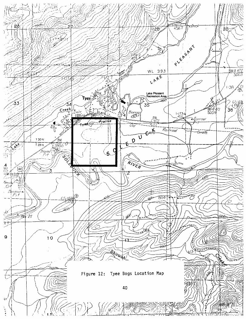

TYEE BOGS
LOCATION : Western Clallam County; Sections 2 and 3, Township 29 North, Range 13 West, and Section 34, Township 30 North, Range 13 West, Willamette Meridian.
SIGNIFICANCE: Tyee Bogs is a first tier site. It consists of three small wetlands, which have examples of 3 sphagnum bog communities and 3 freshwater wetland communities.
FEATURES : Sphagnum Bog:
1. Kalmi a occidental i s-Ledum sroenl andi cum-Vacci ni um oxvcoccos/ Sohasnum spp. community.
2. Soiraea douslasii/Sohasnum spp. community. 3. Tsusa heteroohvlla/Ledum ~roenlandicum/Sohasnum spp. community.
Freshwater Wet1 and: 1. Carex obnuota community. 2. Soiraea dousl asi i community. 3. Pvrus fusca community.
DESCRIPTION: Phvsical: Tyee Bogs is located at about 340 feet elevation on a terrace above the Soleduck River. It is composed of three small wetlands: a 3- acre sphagnum bog, a 4-acre sphagnum bog and a 1-acre freshwater wetland.
The wet1 ands receive water mostly from precipitation. There are no channeled inflows or outflows, and the wetlands have no surface connection with each other. The 3-acre sphagnum bog is wet year round and may be flooded seasonally. The 4-acre bog is composed of a lagg and sphagnum bog. The lagg is flooded most of the year and then supersaturated. The sphagnum bog is wet year round and may be flooded seasonally. The 1-acre freshwater wetland is in a shallow basin that is flooded seasonally. There may be a moisture gradient with the center of the wetland remaining flooded the longest. The remainder of the year, the site is supersaturated to wet.
The soils in the area are mapped as Klone-Ozette-Tealwhit complex. The sphagnum bog soils are a mixture of sphagnum, fibrous and heath peat with some woody material. The freshwater wet1 and soi 1 s are a mixture of fibrous and heath peat and muck.
Biolosical: The 3-acre bog is dominated by Ledum sroenlandicum, Kalmia occidentalis, Pteridium aauilinum and Sohasnum spp. Gaultheria shallon and stunted Tsusa heteroohvlla have high percent cover values.
The main body of the 4-acre bog is dominated by Ledum aroenlandicum, Kalmia occidentalis and Sohaanurn spp. Gaultheria shallon, Vaccinium

oxvcoccos and stunted Tsusa hetero~hvlla have high percent cover values. The lagg is dominated by Carex obnu~ta, S~haqnum spp. and Ledum sroenlandicum. S~iraea douqlasii, Carex sitchensis, Kalmia occidentalis and Gentiana sce~trum have high percent cover values.
The freshwater wetland has distinct zones, The center is dominated by Carex obnu~ta and has high percent cover of Carex vesicaria. The next zone is dominated by S~iraea douqlasi i . The landward margin of the wetland is a thicket of Pvrus fusca.
CONDITION: Tyee Bogs appears to be in excellent condition. There are no signs of human disturbance in the sphagnum bogs, and the uplands within the basin are mature second growth. The freshwater wetland has old cut logs within the S~iraea douqlasii zone, but the vegetation appears in good condition.
The site is threatened with cl earcutting and devel opment. The forests are flagged for cutting, and the site is close to a small but developing community.

Tier Two Sites

AHLSTROM'S PRAIRIE
LOCAT ION : Western Clallam County; Sections 25, 26 and 36, Township 31 North, Range 16 West, Willamette Meridian. Ahlstrom's Prairie is part of the Olympic National Park.
SIGNIFICANCE: Ahlstromis Prairie is a second tier site. It contains recovering examples of 4 sphagnum bog communities and populations of 2 state-1 isted pl ant species .
FEATURES : Sphagnum Bog:
1. Carex obnu~ta/Sehaqnum spp. community. 2. Kalmia occidenta l is-Ledumgroenlandicum-Gaul ther ia shallon/
Pteridium aauilinum/Sehasnum spp. community. 3 . Kalmi a occidental i s-Ledum groen1 andicum-Vacci ni um oxvcoccos/
Carex obnueta/Sohaanum spp. community. 4 . Tsusa heteroehvl 1 a/Ledum sroenl andi cum/S~hasnum spp. community .
DESCRIPTION: Physical : Ahlstrom's Prairie is located on a moraine at an elevation of about 160 feet. The site occupies 81 acres of ridges and troughs.
Ahlstromis Prairie is mostly fed by precipitation. The troughs receive water from sheet flow as well. Depressions within the ridges and the troughs are flooded seasonally, and the rest of the year their soi 1 s are wet. One trough is supersaturated year round and seasonally flooded. The ridges are seasonally dry. There are signs of past fire throughout the site.
The site is composed of ridges and troughs generally oriented north- south. The ridges are uneven and have small depressions and hummocks. The soils on the ridges are thin exposing underlying glacial ti1 1 or outwash. The soils are sphagnum, fibrous and heath peat with woody material. The main trough's soils are mostly composed of sphagnum and f i brous peat.
Biolosical: The ridges are recovering from fire and past grazing. The upper story is characterized by young, somewhat stunted Tsusa heterophvlla, Thu.ia elicata and Picea sitchensis. The shrub layer is dominated by Ledum qroenl andi cum, Gaul theri a shall on and usual 1 y Pteridium aauilinum. Kalmia occidentalis and Calamaarostis nutkaensis are abundant but not always codominant. S~haqnum spp. have 0-40% cover.
The troughs are dominated throughout by Sohasnum spp. Some areas are also dominated by Ledum sroenlandicum, Kalmia occidentalis, Vaccinium oxvcoccos and Carex obnu~ta. Other areas are dominated by low growing Sansuisorba officinalis and/or Carex livida, Carex obnu~ta, or Carex rostrata.

CONDITION: Ahlstrom's Prairie is the site of a historic homestead. The area was used to graze sheep and there are cut stumps throughout. The whole area burned in the past and may have been purposely burned to create pasture. I
Given this history, Ahlstrom's Prairie is in good condition. The vegetation is dominated by native plant species and exotic and weedy species are limited in numbers and abundance. However, the pre- settlement character of the site is not documented and it's not clear if the current and future dynamics of the system mimic those of the native system. It is possible, that in the absence of fire, the ridges, and perhaps the troughs, will shift to a wet Thu.ia plicata-Tsuaa hetero~hvlla/Vaccinium ovatum-Gaultheria shallon community.


CUB CREEK MARSH
LOCAT ION : Western Clallam County; Section 3, Township 30 North, Range 13 West, and Sections 34 and 35, Township 31 North, Range 13 West, Willamette Meridian.
SIGNIFICANCE: Cub Creek Marsh is a second tier site. It is a riparian wetland recovering from past logging activities and contains examples of 3 freshwater wetland communities.
FEATURES : Freshwater Wet1 and:
1. Carex sitchensis community. 2. S~iraea dousl asi i community. 3. Picea sitchensis-Alnus rubra/Lvsichitum americanum community.
DESCRIPTION: Physical: Cub Creek Marsh occurs at an elevation of about 680 feet along the uppermost reach of Cub Creek. It lies within a narrow valley that has moderately steep slopes. The wetland is about 30 acres.
The wetland soils are saturated to supersaturated year round and flooded seasonally. The stream channel is well defined and has steep banks overhung with sedges and shrubs. At the time of the survey, water in the channel was moving slowly.
The soils in the wetland are mapped as Klone-Ozette-Tealwhit complex and the surrounding up1 ands are mapped as Ozette si 1 t 1 oam. The soi 1 s contain areas of fibrous peat, heath peat, muck and large organic materi a1 . Biolosical : The wet1 and vegetation genera1 ly shifts 1 andward from a community dominated by Carex si tchensi s and Oenanthe sarmentosa near the stream channel to a mosaic of that community and S D ~ raea dousl asi i . Near the headwaters, the vegetation appears to be dominated by S~iraea doual asi i thickets.
Landward of the previously described vegetation are areas of wet forest that were at least selectively cut in the past. These appear to be recovering towards an example of a Pi cea si tchensi s-A1 nus rubra/ Lvsichi tum americanum community but are currently dominated by A1 nus rubra, Soiraea doualasii, Carex obnu~ta and Lvsichitum americanum.
CONDITION: The wetland appears to be recovering well from past disturbance. The forested wetland was at least selectively logged in the past. Alnus rubra, Picea sitchensis, Tsusa hetero~h~lla and Thuja plicata are all -- reproducing and, except for Juncus effusus, there are no exotic plant species .

A logging road crosses the upper end of the drainage and marks the upper end of the wetland. The logging road runs parallel to the wetland on the east, and in places, fill and road maintenance activities have intruded into the wetland. I
The second growth forest to the east side of the wet1 and was being prepared for logging at the time of the survey,


DICKEY FLATS
LOCAT I ON : Western Clallam County; Section 14, Township 28 North, Range 15 West, Willamette Meridian.
SIGNIFICANCE: Dickey Flats i s a second t i e r s i t e . I t was recently disturbed and i s threatened with fur ther degradation b u t s t i l l contains good examples of 3 freshwater wetland communities.
FEATURES : Freshwater Wetland:
1. Nu~har pol v s e ~ a l um community. 2. Carex obnu~ta community. 3 . Carex sitchensis community.
DESCRIPTION: Physical: Dickey Flats i s a 4-acre wetland on a terrace above the Dickey River. I t occurs a t 20 fee t elevation near the confluence of the Dickey and Quillayute Rivers. The wetland consists of a small impoundment, stream channel and herb dominated wetlands.
The wetland area i s permanently flooded. I t receives water from precipi ta t ion, sheet flow and groundwater discharge. The wetland drains t o the southwest into the Dickey River, but the outflow i s dammed by beaver.
Soi ls are muck and fibrous peat. Most of the wetland vegetation grows on the pedestaled bases of sedges.
Biolosical : The center of the wetland, along the impounded stream channel, i s dominated by Nu~har pol vseoal um. In1 and the vegetation i s dominated by Carex s i tchensi s perched on the i r pedestaled bases. Landward ye t , the vegetation i s dominated by Carex obnuota, also extending above water on pedestaled bases.
CONDITION: The wetland s t i l l appears t o be in good condition but may not be for much longer. The uplands and some of the wetland system north and upslope of the wetland were recently clearcut. No buffer was l e f t adjacent t o the wetland and the wetland edge was disturbed. Exotic plant species are newly established i n the wet ground within the clearcut tha t feeds into the s i t e , and will probably spread into the s i t e .


ELK LAKE
LOCAT I ON: Western Clallam County; Sections 1, 2, 11 and 1 2 , Township 31 North, Range 15 West, Willamette Meridian.
SIGNIFICANCE: Elk Lake i s a second t i e r s i t e . I t i s hoped that the lake and wetland system will recover from recent clearcutting of the en t i r e upstream drainage and the outflow stream and riparian system. The area s t i l l contains remnants of 1 sphagnum bog and 2 freshwater wet1 and communities.
FEATURES: Sphagnum Bog:
1. Erio~horum chamissonis/S~ha~num spp. community.
Freshwater Wetland: 1. Carex s i tchensi s community. 2. Thu.ia plicata/L~sitchitum americanum community.
DESCRIPTION: Phvsical : Elk Lake i s the headwaters of Umbrella Creek and i s located a t about 420 fee t elevation. I t i s a north-south oriented system which consists of a 45-acre lake, about I1 acres of sphagnum bog, and 62 acres of freshwater wetl ands.
The system receives water from precipitation, seeps, sheet flow and several small seasonal streams. I t has a large channeled outflow which i s pa r t i a l ly blocked, e i the r by beaver, or as a resu l t of logging a c t i v i t i e s . The current water level i s high. Most of the forested wetland areas around the lake have been flooded, k i l l ing the t rees . The en t i r e wetl and system i s flooded year round.
The wetl and s o i l s are mapped as Kydaka s i l t y clay loam. The wetland soil s are a mixture of fibrous peat, muck and 1 arge woody materi a1 . The sphagnum bog area has a thin floating mat composed of sphagnum, fibrous and heath peat. Downed t rees provide a substrate elevated above the water level . Biolosical: The sphagnum bog areas are located along the waterward edge of the wetland, mostly a t the southeast end of the lake. These areas appear t o be dominated by Erio~horum chammisonis, and have some scraggly Kalmia occidental i s , Ledum aroenlandicum and bccinium ox~coccos.
The freshwater wetland appears t o be divided into three zones: The waterward zone i s mostly composed of dense, t a l l Carex sitchensis growing on t h e i r pedestaled bases. Landward of t h i s are areas of Thuja 01 icata snag forests . These areas are species r ich, but the understory i s s t i l l dominated by Carex s i tchensis . There are areas, that were inaccessible, which appear t o be l iving Thu.ia ~ l i c a t a wet fores ts .

CONDITION: It i s hoped t h a t t h i s wetland system w i l l recover t o something resembling i t s presett lement cond i t ion , The e n t i r e drainage basin f o r t h i s l ake has r ecen t l y been c lea rcu t . The out f low channel and i t s associated wetlands ' were a lso logged. No b u f f e r was maintained, and logs and woody debr is occur throughout the stream and wetland system. The water l e v e l i n the system i s elevated, f l ood ing most of what were fores ted wetlands, and inundat ing the sphagnum bog communities. There was no way t o get i n t o the area t o determine why the water l eve l o f the lake was so high. Exot ic p l an t species were not abundant.


ERICSONS POND
LOCAT ION : Western Clallam County; Section 8, Township 30 North, Range 15 West, Willamette Meridian. Ericsons Pond is part of the Olympic National Park
SIGNIFICANCE: Ericsons Pond is a second tier site. The site is recovering from past disturbance. It contains populations of 1 state-listed plant and 1 state-listed animal species as we11 as examples of 1 sphagnum bog and 2 freshwater wet1 and community.
FEATURES : Sphagnum Bog :
1. Myrica qale/Carex sitchensis-Sanquisorba officinalis/ S~hasnum spp. community.
Freshwater Wet1 and: 1. Nuohar pol vse~al um community . 2. Carex sitchensis community.
DESCRIPTION: Physical : Ericsons Pond is located at an elevation of about 40 feet on the west side of Lake Ozette. The site is composed of an 8-acre shallow pond surrounded by 4.5 acres of wetlands, and a 2-acre sphagnum bog to the south.
The wetland system as a whole has no channeled inflow, and probably receives water from precipitation and surface sheet flow. The pond system is separated from Lake Ozette by a berm. The water level in the pond is elevated above the lake and water seeps through the berm to the lake. It looks as if there was in the past at least a seasonal outflow from the pond to Lake Ozette. There is a channeled inflow from the bog to the pond.
The pond is very shallow and most of it is permanently flooded. The surrounding wetland is seasonally flooded, and the substrate is wet year round. The bog to the south is wet year round, and portions may .be seasonal 1 y f l ooded . The soils in the area are primarily sphagnum and sedge peat, with heath peat and some woody material. The pond bottom is a mixture of peat and muck over1 ayi ng sand.
Biolosical: Most of the pond and wetland vegetation appears to be in transition. The pond is dominated by Nuohar polvseoalum, but there are hummocks of peat with emergent vegetation and remnants of trees and drier site vegetation, The wetlands surrounding the pond are dominated by Carex sitchensis on soft peat soils mostly with living Sphagnum spp. but in areas without. Small areas are dominated by Kalmia occidental is.

The bog to the south is codominated by Mvrica qale and Carex sitchensis. The vegetation is low growing and there are openings which are dominated by Carex livida, Carex interior complex, Vaccinium oxvcoccos and Dodecatheon jeffrevi. There is very little living sphagnum.
CONDITION: Ericsons Pond is almost exclusively composed of native plant species and appears to be in good condition. However, the area was the site of a homestead and may be recovering from past use. Remnants of a pier are still visible in the north end of the shallow pond. Peat development, remnants of wetland vegetation and tree stumps in the pond indicate that the water level has changed. The wetland vegetation around the pond appears to be in flux, apparently in response to elevated water level.


JAMES POND
LOCATION: Western Clallam County; Section 23, Township 28 North, Range 15 West, Willamette Meridian. Part of James Pond is within the Olympic National Park.
SIGNIFICANCE: James Pond is a second tier site. A portion of it is in good condition and contains examples of 1 sphagnum bog and 3 freshwater wetland communities.
FEATURES : Sphagnum Bog :
1. S~iraea dous1asiifS~hasnum spp. community.
Freshwater Wet1 and: 1. Nu~har pol vse~al um community . 2. Carex obnu~ta communi ty. 3. Picea si tchensis-Alnus rubra/Lvsichi tum americanum community.
DESCRIPTION: Physical : James Pond is an oxbow of the Quillayute River. It is located on the north side of the current river channel at an elevation of about 20 feet, near the river's mouth. The site is composed of 13 acres of herb and shrub dominated wetl ands and ponds, 5 acres of forested wetl and, and 14 acres of logged wetlands.
The wetland receives water mostly from precipitation and sheet flow. The pond and some of the herb dominated areas are flooded year round, although the water is shallow. Some of the fringing herb dominated wetlands are flooded most of the year and then supersaturated. The shrub and uncut forested wetlands are seasonally flooded and then saturated to supersaturated. The logged wetlands are wet to supersaturated year round and may be flooded seasonally.
The soils are variable. In the ponded area, the substrate is firm muck and peat probably over sand. There are pockets of deep, soft muck along the pond margins. The seasonally flooded herb and shrub zones are sphagnum, fibrous and/ or heath peat. The forested wetl ands grade from very soft fibrous peat and muck, to shallow muck and 1 itter. Large woody material provides an elevated substrate throughout the portion of the site that is within the National Park.
The portion of the site outside of the park is highly disturbed and hard to characterize. But there is significant amounts of living S~hasnum spp. and some sphagnum peat.
Biol osical : The ponded area grades shoreward from rooted aquatic vegetation dominated by Nu~har pol vse~alum to a zone codominated by Nu~har pol vse~al um, Potamoqeton natans and an aquatic Sparsani um emersum

and HiDDuris v u l s a r i s a r e abundant. Landward, Carex v e s i c a r i a and t h e a q u a t i c bryophyte a r e dominant, and N u ~ h a r p o l v s e ~ a l u m i s abundant. The next landward zone i s dominated by Carex o b n u ~ t a , the a q u a t i c bryophyte, and Carex v e s i c a r i a . The landwardmost community i n this progress ion i s codominated by S D ~ r a e a doual a s i i , Carex o b n u ~ t a and S~hasnum spp.
The permanently f looded/supersa tura ted f o r e s t e d wetland a r e a i s dominated by Pvrus f u s c a , Carex o b n u ~ t a and Lvsichitum americanum, S ~ i r a e a doual a s i i and Gaul t h e r i a s h a l l on on 1 ogs . Tsusa h e t e r o ~ h v l 1 a and Picea s i t c h e n s i s trees and snags a r e abundant. A d r i e r wet f o r e s t a r e a is dominated by Picea s i t c h e n s i s , Pvrus f u s c a , Rhamnus ~ u r s h i a n a , Gaul t h e r i a s h a l l o n and Lvsichitum americanum.
CONDITION: The p o r t i o n o f t h e oxbow which 1 i e s wi th in t h e National Park i s i n excel l e n t cond i t i on . The po r t i on o u t s i d e o f t h e Park was r e c e n t l y c l e a r c u t , both wetland and upland. A logging spu r was b u i l t a c ros s t h e wetland i n t h r e e p l a c e s and a grave l p i t was excavated ad j acen t t o i t . Hopefully e x o t i c p l a n t s p e c i e s w i l l no t e s t a b l i s h i n t h e logged p o r t i o n o f t h e oxbow and spread i n t o t h e high qual i t y po r t i on . Appl ica t ion of b ioc ides and f e r t i l i z e r s i n t h e logged a r e a i s a t h r e a t t o t h e high qual i t y po r t i on .


JOYCE SCOUR
LOCAT ION : Western Clallam County; Section 33, Township 31 North, Range 8 West, Will amette Meridian.
SIGNIFICANCE: Joyce Scour is a second tier site. It has been disturbed in the past and is threatened with further degradation, but is one of the higher quality wetlands in the area. It contains examples of 3 freshwater wetland communities.
FEATURES : Freshwater Wet1 and:
1. Carex obnupta community. 2. Carex rostrata community. 3. Soi raea dousl asi i community .
DESCRIPTION: Physical : Joyce Scour is 1 ocated in a northwest-southeast oriented glacial trough or scour adjacent to the Strait of Juan de Fuca. It is about 8 acres and occurs at about 300 feet elevation.
The site appears to have neither an inflow nor outflow. It receives water from surface sheet flow and precipitation. Some areas appear to be flooded year round while others are seasonally flooded and then wet to supersaturated.
'
The soils are mapped as Mukilteo muck. They are a mixture of muck, fibrous peat and heath peat, and there is some woody material . Biolosical: The wetland is a mosaic of Spiraea douslasii thickets, openings dominated by Carex obnupta and Oenanthe sarmentosa and seasonal ponds dominated by Carex rostrata, Carex vesicari a, Oenanthe sarmentosa and Nuphar pol vseoal um.
CONDITION: Joyce Scour is of questionable qual ity for inclusion in this report. The wetl and is still dominated by native plant species. However, Phal ari s arundinacea is scattered throughout the site and may spread uncontrollably, degrading the wetl and to an unacceptable level. The site is included mostly because there are very few relatively high qual ity native wetlands remaining in the lowlands along the Strait of Juan de Fuca.
The wetland has been disturbed in the past. There are signs of past vehicle use through the wetland and Phalaris arundinacea is scattered throughout. Dead P~rus fusca and Salix sp. plants indicate water level fluctuation of unknown cause. The uplands are about to be logged for the second time.


NORTH FORK CROOKED CREEK
LOCATION : Western Clallam County; Section 7, Township 30 North, Range 14 West, Will amette Meridian.
SIGNIFICANCE: North Fork Crooked Creek is a second tier site. The wetland was disturbed in the past but appears to have recovered well and contains exampl es of 2 freshwater wet1 and communities.
FEATURES : Freshwater Wet1 and:
1. Carex rostrata-Carex sitchensis community. 2. Tsusa hetero~hvlla/Lvsichitum americanum community.
DESCRIPTION: Phvsical: North Fork Crooked Creek is the headwaters of a tributary of North Fork Crooked Creek. It occurs at an elevation of 200 feet and is composed of a 2-acre sedge dominated wetland and 5-acre forested wetland.
The wet1 and receives water from precipitation, sheet flow, channeled surface flow and probably groundwater seepage. The tributary channel is braided through the the forested wetland and is a deep, well defined channel through the sedge wetland. The wetland is seasonally flooded and supersaturated year round. There are signs of past beaver activity including decrepit dams at the outflow end of the wetland.
Soils in the sedge portion of the wetland are a mixture of fibrous and sphagnum peat. Those in the forested wetland are very soft muck. Large woody debris provides an elevated surface on which typically upland plants grow. The surrounding upland soils are mapped as Kydaka-Zeeka complex and Ozette silt loam.
Biolosical : The sedge dominated portion of North Fork Crooked Creek appears to be in transition. It is dominated by a mixture of Carex rostrata, Carex si tchensi s and Scir~us mi crocar~us, species which are typical of high nutrient wetlands. But it also has areas with high percent cover of S~hasnum spp. and some other plant species typical of low nutrient sphagnum bogs.
The forested wetland is dominated by Tsusa heterophvfla and Lvsichitum americanum. There is high percent cover of Thuja plicata, Picea sitchensis, Rubus spectabilis, Vaccinium sp., Oenanthe sarmentosa and Gaul theria shal lon.
CONDITION: North Fork Crooked Creek appears to be recovering from past disturbance. Past disturbance is suggested by an abundance of Juncus effusus, the presence of other exotic plant species and an odd mix of sphagnum bog and freshwater wetland plant species. It is possible that the main stream

channel once flowed i n t o t h e sedge po r t i on of t h e wet land , A de1 t a i n t h e wetland and t h e s o i l survey map sugges t t h i s s cena r io .
The f o r e s t e d wetland was s e l e c t i v e l y logged i n t h e p a s t . I t i s composed "
o f n a t i v e p l a n t s p e c i e s and appears t o be recover ing we1 1 . The f o r e s t e d uplands t o t h e south o f t h i s s i t e have been surveyed and f l a g g e d , sugges t ing t h a t t hey w i l l soon be logged f o r t h e second time.


OLD ROYAL POND
LOCAT ION : Western Clallam County; Sections 22 and 23, Township 31 North, Range 14 West, Willamette Meridian.
SIGNIFICANCE: Old Royal Pond is a second tier site. It is a diverse wetland system containing examples of 3 freshwater wetl and communities and a popul at i on of 1 state-1 isted species. The wetland appears to be recovering we11 from past logging activity.
FEATURES : Freshwater Wet1 and:
1. Carex sitchensis community. 2. Spiraea dousl asi i community . 3 , Picea sitchensis-Alnus rubra/Lvsichitum americanum community.
DESCRIPTION: Physical: Old Royal Pond is a 14-acre wetland system located just west of the town site of Old Royal. It occurs at an elevation of 240 feet and is the headwaters of a tributary of the Hoko River.
The wetland system is composed of a shallow, permanent pond, permanently flooded shrub and herb dominated wetland communities, and a forested wetland that is a mosaic of permanently flooded and permanently supersaturated areas. The outflow is dammed by beaver, and the pond level is about 3 feet above the outflow stream channel.
Soils are mapped as Ozette silt loam. They are a mixture of fibrous peat, heath peat and muck. Large woody material provides a substrate elevated above the soil surface.
Biolosical : The wetl and vegetation generally shifts from a community dominated by Carex sitchensis near the pond margin, to a Soiraea douslasi i thicket, to a forested wetland dominated by Alnus rubra, Rubus soectabil is, Lvsichi turn americanum and Oenanthe sarmentosa. The wet forest was logged in the past and Tsusa heteroohvlla, Picea sitchensis and Thu.ia ~licata are reproducing.
There is a large area near the pond that is dominated by Scirpus c~oerinus. Waterward of the wet forest is an area codominated by Carex rostrata, Carex obnupta and Scirous microcarpus. There are traces of sphagnum bog vegetation along the wetland-upland interface on the south side o f the pond.
CONDITION: Old Royal Pond is recovering from past logging activities. There are cut stumps and logs throughout the wetland, including in the pond. The stumps have spring board notches indicating that logging took place many years ago. A logging road was built across the outlet and was either

removed or washed .away. This is the current site of a beaver dam. The water level is high, due to the beaver dam.
Given its disturbance history, the wetland appears to be recovering well. It is dominated by native plant species, and appears to be developing definable wet1 and plant communities. Juncus effusus is the only observed exotic plant species.


QUINN CREEK
--'
LOCAT ION : Western Clallam County; Section 23, Township 30 North, Range 15 West, Willamette Meridian. A portion of Quinn Creek i s located within the Olympic National Park.
SIGNIFICANCE: Quinn Creek i s a second t i e r s i t e . Although disturbed in the past , the wetland appears t o be recovering, and contains nat ive freshwater wetland vegetation.
FEATURES : Freshwater Wetl and:
1. Carex obnuota community.
DESCRIPTION: Physical : Quinn Creek i s located a t an elevation of about 40 f e e t on the e a s t s i de of Lake Ozette. I t occurs along the lower reach of Quinn Creek, a t t he southeast end of Boot Bay. The wetland i s about 15 acres.
The wetland occurs along e i t he r s ide of t he creek channel. The water in the channel flows very slowly and may be p a r t i a l l y blocked by beaver dams. The creek overflows i t s channel during the winter and spring and floods the wet1 and. Wetl and so i l s remain supersaturated t he r e s t of t he year.
So i l s along Quinn Creek a re mapped as ~ e a l w h i t s i l t loam. The wetland s o i l s contain f ibrous peat , muck and large woody debr is .
B i 01 os ical : The wetl and vegetation a1 ong Quinn Creek i s current ly dominated by Carex obnuota, and has high percent cover of Scirous microcarpus, Athvrium fi l ix-femina, Lvsichitum americanum and Phvsocar~us caoi ta tus .
CONDITION: Quinn Creek wetland was once a forested wetland system dominated by Picea s i t chens i s . The wetland was logged and i s now composed of species typical of the understory of forested wetl ands. Picea s i tchensi s , Thu.ia pl i c a t a and Tsuqa heteroohvl l a a re reproducing within t he wetl and, suggesting t h a t the system may recover. There a re no exot ic plant species.


SOOES MARSH
,-
LOCATION : Western Clallam County; Sections 15, 16, 21 and 22, Township 32 North, Range 15 West, Willamette Meridian.
SIGNIFICANCE: Sooes Marsh is a second tier site. It contains 4 freshwater wetland communities and, in particular, contains a large example of a forested wet 1 and commun i ty .
FEATURES : Freshwater Wet1 and :
1. Carex obnu~ta community. 2. Carex si tchensi s community. 3. Soi raea dous1 asi i community. 4. Picea sitchensis-Alnus rubra/Lvsichitum americanum community.
DESCRIPTION: Phvsical : Sooes Marsh is 1 ocated at an elevation of about 40 feet on a terrace along the Sooes River. It lies between the Sooes River to the southwest, Grimes Creek to the northwest, Miller Creek to the southeast and a ridge to the northeast. The wetland is about 80 acres: 59 acres of forested wetlands, 17 acres of shrub and herb dominated wetlands and 4 acres of disturbed wetlands.
Most of the wetl and is supersaturated year round and flooded seasonally. . The disturbed wetland is flooded year round: The wetland receives water
from precipitation, small unnamed streams, surface sheet flow and possibly groundwater discharge. The system drains to the northwest into Grimes Creek.
The soils are mapped as Tealwhit silt loam. The wetl and soils are a mixture of fibrous and heath peat in the shrub and herb dominated area and some sphagnum peat. The forested wetland has very soft muck soils as well as areas of peat. It has large woody debris which provides a substrate elevated above the soil surface. Soils in the disturbed area were not checked.
Bioloqical: The herb dominated area is species rich. Low growing Carex obnu~ta, Carex rostrata, Potentill a ~ a l ustri s, Lvsichi tum americanum and Hv~ericum anaqalloides codominate the southeast end of the herb dominated area. Juncus balticus and Juncus effusus are abundant in parts of this area. Tall, lush Carex sitchensis dominates the majority of the herbaceous wetl and area. Potenti 11 a ~alustri s and Lvsichi turn americanum are codominant and tivoeri cum anaaall oides i s abundant in p1 aces.
The shrub wetland is dominated by Spiraea douslasii and Lvsichitum americanum. The shrub 1 ayer is re1 at i vely open. Carex si tchensi s, Potenti 11 a palustri s , Carex rostrata, Athvrium fil ix-femina, Ledum qroenlandicum, Sal ix spp. and small Alnus rubra are abundant in places.

The forested wetland along the margin of the shrub and herb dominated areas is generally dominated by Alnus rubra, Carex obnuota and Carex sitchensis, and has high percent cover of Calamasrostis nutkaensis and Lvsichitum americanum, This grades into the primary wet forest community which is dominated by Picea sitchensis, Carex obnuota and Lvsichitum americanum. Alnus rubra and Pvrus fusca are codominant to abundant. Thuja ~l icata, Tsusa hetero~hvll a, Oenanthe sarmentosa, Gaul theri a shallon and Glvceria sp. are abundant in places. Forested wet1 ands to the northeast are similar in composition, but are scrubby, more open, and are codominated by Thu.ia ~l icata, Alnus rubra, Picea si tchensis, Lvsichi tum americanum and Gl vceria sp. Spiraea dousl asi i , Gaul theri a shall on, Oenanthe sarmentosa, Sci raus mi crocar~us, Carex obnuota, Athvrium fil ix-femina and Carex rostrata are abundant and in places some are codominant. This may be a groundwater discharge area.
CONDITION: Sooes Marsh has been disturbed in the past, but currently appears to be in good condition, The forested wetland appears in particularly good condition. The herb and shrub dominated wetland communities appear to be in transition. There are remnants of sphagnum bog vegetation, and an unusual mixture of species which suggest that water and/or nutrient levels have shifted.
A mainline logging road crosses all of the streams which flow into the wetland. A road crosses the main outflow, and the outflow appears to have been diverted and partially impounded by the road. All of the adjacent uplands and portions of the wetlands have been logged in the past. A large cedar shake mill was located directly north of the wetland. Feral cattle roam this area, and although it would be difficult for them to access the wetland, it is possible.


SOUTH END
LOCAT I ON : Western Clallam County; Section 10, Township 29 North, Range 15 West, Willamette Meridian. South End is part of Olympic National Park.
SIGNIFICANCE: South End is a second tier site. It contains a population of 1 state- 1 isted plant species and 5 freshwater wetl and communities,
FEATURES : Freshwater Wetl and :
1, Carex obnu~ta-Juncus nevadensi s-Ranuncul us fl ammul a community . 2. Eauisetum fluviati le community. 3. Mvrica salelAster sp.-Boykinia major-Deschamosia caes~itosa
commun i ty . 4 , Mvrica sale-S~iraea doualasii/Carex obnu~ta community. 5. Pvrus fusca community.
DESCRIPTION : Physical : South End is located along the southeastern shore of Lake Ozette. About 4 acres of wetlands line the shore at an elevation of about 30 feet. The wetland profile inclines shoreward from shallowly flooded areas (< 3 feet deep) to a bank which, for the most part, marks the upland-wetland boundary. In one area the bank is relatively low and i s topped by i rregul arly flooded wetl ands . The wetland receives water from Lake Ozette, precipitation and South Creek, Wetl and hydro1 ogy ranges from the shall owly but permanently flooded zone (< 3 feet deep during the summer) to an ecotonal area that is seasonally flooded but swept by most waves the rest of the year. Farther inland the wetland continues to be seasonally flooded, but is swept by waves less frequently the rest of the year.
The substrates are predominantly silty sand with areas of very soft silts and organic matter, There are narrow layers of peat soils visible in the area ecotonal between the permanently and sesonal ly flooded wetl ands. Some heath and fibrous material has built up in the seasonally flooded zone, Surrounding uplands are mostly mapped as Klone-Ozette-Tealwhit complex and Kydaka-Zeeka complex with an area of Ilwaco silt loam.
Biolosical: The vegetation in the permanently flooded zone is characterized by the presence of Eauisetum fluviatile, Lobelia dortmana, S~arqanium eurvcaroum and Polyqonum sp.
The seasonally flooded wetlands generally shift from a narrow band characterized by Carex obnu~ta, Ranuncul us f1 ammul a, Carex si tchensi s and Carex lenticularis, to fairly open, low growing, species rich M~rica sale and Carex sitchensis dominated communities. Thickets of Mvrica sale with Salix spp. and Pwrus fusca are located adjacent to the uplands,

Pvrus fusca, Carex obnu~ta and Bovkinia major dominate an area that at least receives water from waves and storms during the winter,
CONDITION: The wetland communities in this area are in good condition. Phalaris arundinacea is begining to spread from an area to the east that appears to have been disturbed in the past. The uplands that lie outside of the Park boundary and adjacent to the wetlands have recently been clearcut, including the entire drainage of South Creek which flows into the wetland. Little or no buffer was left along the creek. A trail is maintained between the wetland and the end of a logging spur. Spent gun shells suggest that the area is used for hunting.


SWAN BAY
LOCATION : Western Clallam County; Sections 10, 11, 14 and 15, Township 30 North, Range 15 West, Willamette Meridian. Swan Bay is part of Olympic National Park.
SIGNIFICANCE: Swan Bay is a second tier site. It contains populations of 5 state- 1 isted plant species and 9 freshwater wetland communities.
FEATURES : Freshwater Wet1 and:
1. Eauisetum fluviatile community. 2. Sci r ~ u s acutus communi ty. 3. Sparuanium eurycarpum community. 4 . Carex obnu~ta-Juncus nevadensis-Ranunculus flammula community. 5. Carex sitchensis-Potentilla ~alustris community. 6. Mvrica gal e/Aster sp. -Bovki ni a ma.ior-Deschampsi a caes~i tosa
community. 7. Mvri ca qal e-Spi raea douql asi i/Carex obnu~ta community . 8. Picea sitchensis-Alnus rubra/Lv.sichi tum americanum community. 9. Pvrus fusca community.
DESCRIPTION: Phvsical : The Swan Bay-Boot Bay area is located along the northeastern shore of Lake Ozette. The wetlands occur at an elevation of about 30
. feet. The wetland profile progresses shoreward from the shallowly flooded lake shore to an abrupt bench edge 1 to 2 feet high which marks the waterward edge of the seasonally flooded zone. The elevation of the bench gradual increases shoreward either to above the extreme high water mark or to a second bench. Both benches are eroding.
The wetlands receive water mostly from the lake, but also from precipitation and surface flow. Wet1 and hydrology ranges from the shallowly but permanently flooded zone (< 3 feet deep during the summer) to the waterward edge of the first bench that is seasonally flooded and then swept by waves the rest of the year. Farther in1 and the wetland continues to be seasonally flooded, but is swept by waves less frequently the rest of the year. Above the second bench, at probably the landward edge of the Pvrus fusca zone, the area is flooded by waves and storm events during the winter. The forested wetlands receive wave and storm water well into their lakeward margin, but most of the water is from a perched water table, groundwater and surface water.
The substrates are predominantly sand with some organic matter in the permanently f1 ooded and seasonal ly flooded wet1 ands. There are areas with a 1 i ttle peat development, including sphagnum peat. Forested wetlands and surrounding uplands are mostly mapped as Klone-Ozette- Tealwhit complex and Ozette silt loam with areas of Kydaka-Zeeka complex and Tealwhit silt loam.

B i o l o s i c a l : The vegeta t ion i n t h e permanently f looded zone i s charac ter ized by t h e presence o f Eauisetum f l u v i a t i l e and Lobe l i a dortmana. Patches o f S c i r ~ u s acutus i n t h i s zone have many o f t h e same species as found i n t h e Eauisetum f l u v i a t i l e community bu t i nc lude ,
species t y p i c a l o f more pro tec ted areas. Protected areas, landward o f t h e f c i r o u s acutus community, and margins o f backwater areas are dominated by Carex s i t chens is . Areas dominated by S~araan ium eurvcarpum seem t o occur i n s l i g h t l y p ro tec ted p o r t i o n s o f t h e bay and tend t o have s i l t i e r s o i l s than t h e previous two communities. Th is community was no t surveyed we11 because o f water depth and t h e sof tness o f t h e substrate.
The seasonal ly f looded wetlands genera l l y s h i f t f rom a narrow band charac ter ized by low growing herb dominated vegeta t ion w i t h Juncus nevadensi s, Carex o b n u ~ t a , Ranuncul us f l ammul a and Carex 1 e n t i c u l a r i s, t o t h i c k e t s o f Mvr ica aale. Landward o f t h e t h i c k e t s are more open, species r i c h areas dominated by Mvr ica s a l e w i t h Aster sp. and Bovkin ia major. W i th in t h i s are small areas w i t h on ly scattered, low growing shrubs, some sphagnum and a species r i c h f l o r a l assemblage.
The landward edge o f t h e seasonal ly f looded area genera l l y coinc ides w i t h t h e beginning o f t h e Pvrus fusca/Carex o b n u ~ t a community. Th is i s a c losed canopy community w i t h sparse understory vegeta t ion which i s charac ter ized by Carex o b n u ~ t a and inc ludes a m ix tu re o f t y p i c a l l y upland and wet l and species .
CONDITION: The wetland communities i n t h i s area have been a f f e c t e d by past logg ing and homestead a c t i v i t i e s , bu t a re s t i l l i n reasonable c o n d i t i o n i n most
, places, The fo res ted wetlands have a l l been a t l e a s t s e l e c t i v e l y c u t i n t h e past b u t seem t o be recover ing.
The pr imary t h r e a t t o t h e herb and shrub dominated seasonal ly f looded wetlands and t h e backwater areas i s t h e spread o f Pha la r i s arundinacea. Pha la r i s arundinacea i s t h e dominant species i n l a r g e areas o f Swan Bay and i s sca t te red throughout t h e area. There are a l s o concerns about the e f f e c t s o f s i l t a t i o n o f t h e permanently f looded we t l ands around t h e l ake due t o l ogg ing a c t i v i t i e s w i t h i n t h e drainage basin.


THUNDER BENCH
LOCAT ION : Western Clallam County; Section 26, Township 28 North, Range 15 West, Willamette Meridian, Most, if not all, of Thunder Bench is in the Olympic National Park.
SIGNIFICANCE: Thunder Bench is a second tier site. It is recovering from past disturbance and contains examples of 3 freshwater wetl and communities.
FEATURES : Freshwater Wet1 and:
1. Nu~har pol vseoal um community . 2. Carex obnu~ta community. 3. Picea sitchensis-Alnus rubralLvsichitum americanum community.
DESCRIPTION: Phvsical: Thunder Bench is 1 ocated in the old flood plain of the Quillayute River, near the river's mouth. It is located at an elevation of about 20 feet at the base of a steep, north facing slope. The site consists of 8 acres of ponds and herb dominated wetlands, and 10 acres of forested wetl ands.
The site receives water from sheet flow and possibly groundwater discharge. The herb dominated areas grade from areas which are permanently flooded and have open water, to .areas that are seasonally flooded and then supersaturated. The water level appears to be control led by beavers. The forested wetl ands are supersaturated year round and may be flooded seasonally . The soils are muck and fibrous peat. Large woody debris provide substrates elevated above the soil and water surfaces.
Biolosical : The ponded areas are characterized by the presence of Nu~har pol vseoal um and Potamoseton natans. The shall ower permanently to seasonally flooded areas are dominated by Carex obnu~ta and Lvsichitum americanum. Small A1 nus rubra, Picea si tchensis and Tsusa heteroohvll a are abundant, Gaultheria shallon is abundant on fallen logs. There are lots of snags and a few half-dead trees.
The forested wetl and is dominated by Picea si tchensi s, Tsusa hetero~hvll a and Lvsichi tum americanum.
CONDITION: The herb dominated wetlands and ponds appear to be in excellent condition. Exotic plant species are scarce and there are no obvious signs of human disturbance. The forested wet1 ands were sef ect ively logged in the past but are recovering well.

The greatest th rea t t o t h i s area i s spread of Phalar is arundinacea i n t o t h i s wet1 and from nearby wetlands. The forested wet1 ands may not be threatened, but the herb dominated wetlands and pond margins are prime hab i ta t . 1
Most o f t h i s s i t e l i e s w i t h i n the Olympic National Park, but the western t i p l i e s w i t h i n the Qu i l eu te Indian Reservation.


THUNDER LAKE
LOCAT ION : Western Clallam County; Sections 1 and 2 , Township 29 North, Range 14 West, and Section 30, Township 30 North, Range 14 West, Willamette Meridian.
SIGNIFICANCE: Thunder Lake i s a second t i e r s i t e . The shrub and herb dominated wetlands adjacent t o the lake are in good condition, b u t the forested wet1 ands have been select ively logged and clearcut. The s i t e contains examples of 3 freshwater wetl and communities.
FEATURES : Freshwater Wet1 and:
1. Carex rostrata-Carex sitchensis community. 2 . S ~ i r a e a dousl asi i community. 3 . Picea ssi tchensis-Alnus rubra/Lvsichitum americanum community.
DESCRIPTION: Phvsical: Thunder Lake i s located a t 280 fee t elevation near the headwaters of Thunder Creek. I t i s located in a narrow valley within h i l l y te r ra in . The s i t e consists of a 9-acre lake, 4 acres of herb and shrub dominated vegetation encircling the lake, 3 acres of wetland vegetation along the outflow stream, and several acres of disturbed forested wetl and.
There i s both an inflow and outflow from the lake. Both have broad channels, 10 fee t or more wide, which carry very slow moving brown colored water. There i s another channel which may be a r t i f i c i a l and that has been dammed by beaver. There are signs of beaver ac t iv i ty par t icular ly along the outflow channel. The wetland areas are permanently t o seasonally flooded. Seasonal l y flooded areas appear to remain supersaturated year round.
The so i l i n the area i s mapped as Klone-Ozette-Tealwhit complex. The wetland s o i l s are very sof t organic material. There i s some fibrous and heath peat. Within the forested wetland zone, substrates are a mosaic of very so f t , anoxic, muck, firmer mesic so i l s and large woody material.
Biolosical: Along the outflow channel i s a broad riparian zone dominated by Rubus s ~ e c t a b i l i s , Carex obnu~ta and Lvsichitum americanum. The vegetation i s low growing, apparently kept cropped by wild1 i f e .
Vegetation around the l ake s h i f t s from a pemanently flooded zone dominated by Carex ros t ra ta and Carex sitchensis t o a seasonally t o permanently flooded zone dominated by S ~ i r a e a dousl asi i , Carex ros t ra ta , Carex s i tchensis and Lvsichitum americanum. In places, t h i s zone i s composed of nearly pure stands of S ~ i r a e a dousl asi i . The forested wetland appears to be an example of the Picea sitchensis-

Alnus rubra/Lvsichitum americanum community. It i s codominated by Picea s i tchensi s, Tsuqa heteroohvl l a, A1 nus rubra, Rubus s ~ e c t a b i 1 i s , and- Lvsichitum americanum. Carex obnuota and Oenanthe sarmentosa are codominant i n places,
CONDITION: The herb and shrub dominated por t ions o f the wetland appear t o be i n good condi t ion. Nost o f the forested wetland has been c learcut . One area of forested wet1 and on the northwest side o f the 1 ake was se lec t i ve l y logged i n the past, A narrow l i n e o f t rees was l e f t between the shrub dominated wetland and recent c learcuts, Exot ic p l an t species establ ished i n wet areas i n the c learcuts may spread i n t o the undisturbed wetlands.
An odd channel f lanked by berms i s located on the northwest s ide o f the lake. A de l ta -1 i ke area extends out i n t o the lake from near the channel's mouth. The area has an unusual d i v e r s i t y and high percent cover o f exo t i c p l an t species. This area appears t o receive human use i n the form o f hunting and f i sh ing , and may be a human-made feature.


UMBRELLA BAY
LOCATION : Western Clallam County; Sections 3, 4 and 10, Township 30 North, Range 15 West, Willamette Meridian. Most of Umbrella Bay is within the Olympic National Park.
SIGNIFICANCE: Umbrella Bay is a second tier site. The area contains examples of 8 freshwater wetland communities, and a population of 1 state-listed plant species.
FEATURES : Freshwater Wet1 and:
1. Eauisetum fluviatile community. 2. Nu~har pol vse~al um community. 3. Saaraanium eurvcaraum community. 4. Carex obnu~ta-Juncus nevadensis-Ranuncul us fl ammul a community . 5 . Carex sitchensis-Potentill a aalustris community. 6. Mvri ca sal e-SD~ raea dousl asi i/Carex obnu~ta community . 7. S~iraea doual asi i communi ty. 8. Pvrus fusca community.
DESCRIPTION: Physical: Umbrella Bay is located at the northeast end of Lake Ozette, at an elevation of about 30 feet. It is a very shallow bay oriented northeast-southwest . There are about 8 acres of permanently fl ooded emergent wetlands and 44 acres of seasonally flooded wetlands around the bay.
Water in the permanently flooded wetland area varies from a few inches to 3 or 4 feet deep during the summer. The herb and shrub dominated areas are seasonally flooded. The herb dominated areas receive water from waves year round. The shrub dominated areas stay moist, but generally do not receive water from waves during the summer. The tree dominated areas are flooded at least occasionally during the winter, and the soils stay wet year round.
The bay bottom appears to be sandy near the bay's mouth, and grades to soft silts and organic matter at the northeast end. The seasonally flooded wetlands appear to be underlain by sand, and have fibrous and heath peat layers.
Biol oaical : The permanently flooded area is dominated by S~arsani um eurvcaraum. It occurs in the northeast half of the bay on silty soils. Intermixed with it are patches of Nu~har polvsepalum. Towards the bay mouth are small areas of the Eauisetum fluviatile community.
The lakeward margin of the seasonally flooded wetlands is dominated by Carex sitchensis. In areas, this community occurs as hummocks in the ecotone between seasonally and permanently flooded zones. Near the bay's

mouth, this zone is occupied by the Carex obnu~ta-Juncus nevadensis- Ranuncul us fl ammul a comuni ty . The shrub dominated wetlands that ring the bay are a mixture of Mvrica
and Soiraea douulasii dominated communities. These typically are dense, tall thickets. Intermixed with, and landward of the shrub zone, the vegetation is composed of dense thickets of Pvrus fusca. The most extensive thicket is at the east end of the bay.
The 1 andwardmost wet1 and community i s dominated by Picea si tchensi s and Alnus rubra, and has Carex obnuota in the understory. Most of this community has been logged recently and it is not known if i t will recover.
CONDITION: Umbrella Bay is in questionable condition. It was the site of early settlement activity and at least the forested wetlands have been effected by logging activities. Phalaris arundinacea is establ ished within the seasonally flooded wet1 and communities, and exotics are abundant in the recently logged wet forest areas. A private boat launch area is a conduit for exotic plant species.


WENTWORTH LAKE
LOCATION : Western C l a l lam County; Sect ions 17 and 20, Township 29 North, Range 14 West, Wi l lamet te Mer id ian.
SIGNIFICANCE: Wentworth Lake i s a second t i e r s i t e . Most o f t h e fo res ted wetlands have been logged and t h e o u t f l o w wetland has been d is tu rbed, b u t t h e herb and shrub dominated wetlands are i n r e l a t i v e l y good cond i t i on . The wet l and conta ins exampl es o f 2 sphagnum bog and 5 f reshwater we t l and communities.
FEATURES : Sphagnum Bog:
1. Kalmi a occ identa l i s-Ledum qroenl andicum-Myrica qa l e/Sphasnum spp. community.
2. Kalmia occidental is-Ledum groenlandicum-Vaccinium oxvcoccos/ S~hasnum spp. community.
Freshwater Wet1 and: 1, Brasenia shreber i community. 2. N u ~ h a r p o l vseoal urn community . 3. S c i r ~ u s acutus community. 4 . Myrica s a l e/Ca1 amaqrosti s canadensi s communi t y . 5. Picea s i tchens is -A lnus rubra/Lvsichi tum americanum community.
DESCRIPTION: Phvs ica l : Wentworth Lake i s loca ted a t an e l e v a t i o n o f about 150 f e e t and i s t h e headwaters o f a t r i b u t a r y o f t he West Fork Dickey River . The s i t e c o n s i s t s o f a 41-acre l a k e (29 acres o f open water and 12 acres o f roo ted aquat ic vegeta t ion) , surrounded by 3.5 acres o f shrub dominated vege ta t i on which i n t u r n i s surrounded by 27.5 acres o f d i s t u r b e d fo res ted wet l ands,
The 1 ake and wetland rece i ve water from p r e c i p i t a t i o n , sheet f l o w and probab ly ground water. The area i s mapped as ove r lay ing compacted g l a c i a l t i l l and having a perched water t a b l e . There i s no channeled i n f l o w . The o u t f l o w channel i s loca ted a t t he northwest end o f the lake . The o u t f l o w i s dammed by beavers i n several l o c a t i o n s and t h e water moves very s lowly .
The roo ted aquat ic zone appears t o co inc ide w i t h a submerged peat bench which surrounds t h e open water area bu t i s broadest near t h e northwest end o f t h e lake. Adjacent t o t h e submerged bench i s a zone e levated above t h e l a k e sur face composed o f p e r e n n i a l l y wet sphagnum, f i b r o u s and heath peat . Some p o r t i o n s o f t h i s zone a re seasonal ly f looded. The f o r e s t e d wetland s h i f t s from p e r e n n i a l l y supersaturated t o seasonal ly f looded. The fo res ted we t l and s o i l s are probably Kydaka-Zeeka complex. The s o i l s i n t h e surrounding uplands are mapped as Kydaka-Zeeka complex.

Bio los ica l : Veget'ation over the submerged bench s h i f t s landward from Brasenia shreberi t o N u ~ h a r polvsepalum t o P o t e n t i l l a ~ a l u s t r i s . Carex l a s i o c a r ~ a extends out from the bog margin i n places and patches o f S c i r ~ u s acutus and some sedge tussocks are scat tered i n t h i s zone.
Mvrica sa le i s dominant over the shrub zone surrounding the submerged bench. Ledum groenlandicum, Spiraea dous las i i and Vaccinium oxvcoccos along w i t h Mvrica sa le are i nd i ca t i ve o f areas t h a t have Sphasnum spp. Cal amaarosti s canadensis, Carex s i tchensi s and P o t e n t i l l a pa l u s t r i s are i n d i c a t i v e o f areas which do not have S~haanum spp.
The wet f o res t has been disturbed i n the past, most o f i t was c l ea rcu t and other por t ions se lec t i ve l y logged. One small area may have been l e f t untouched. Thuja ~ l i c a t a and Tsuqa heterophvl la are the dominant t r e e species although there i s some Picea s i tchens is and Alnus rubra. The understory o f the wettest areas o f fo res t are dominated by Lvsichi tum americanum and Carex obnu~ ta . D r i e r areas are dominated by Gaul t h e r i a shal l o n and Lvs ich i tum americanum and contain more t yp i ca l l y up1 and p l ant species.
CONDITION: The lake, submerged bench and shrub dominated wetlands are i n good condi t ion. There i s a populat ion o f Nvmphaea odoratum tha t was probably introduced i n t o the lake by humans. A d i lap ida ted hunterf s cabin i s located i n the shrub zone on the southeast s ide o f the 1 ake, and a boat launch i s located on the south s ide o f the lake.
The forested wet l ands and wetl ands along the out f low stream have been badly damaged by logg ing and road bu i l d i ng a c t i v i t i e s . The forested '
wetland areas appear t o be dominated by na t i ve p l an t species and may recover. Exot ic p1 ant species, p r ima r i l y Phal a r i s arundi nacea, have become establ ished i n the wetlands along the out f low stream, most ly where a logging road crosses the stream.


WILLOUGHBY LAKE
LOCAT I ON : Western C la l lam County; Sect ion 31, Township 32 North, Range 15 West, Wi l lamette Meridian. Wil loughby Lake i s p a r t o f t he Olympic Nat ional Park.
SIGNIFICANCE: Willoughby Lake i s a second t i e r s i t e . The s i t e i s composed o f a small l a k e and bog which has examples of 2 sphagnum bog communities. The s i t e i s recover ing from past disturbance.
FEATURES : Sphagnum Bog:
1. Kalmia occidenta l i s-Ledum sroenl andicum-Vaccinium ox~coccos/ S~hasnum spp, community.
2. Tsuqa h e t e r o ~ h v l l a/Ledum sroenl andi cum/Sohaanum spp. communi t y . DESCRIPTION:
Physical : Willoughby Lake i s located i n a saddle between two h i l l s a t an e l e v a t i o n of 210 fee t . I t i s composed o f a 5-acre oval 1 ake and about a 1/2-acre shrub dominated and almost 2-acre stunted t r e e dominated sphagnum bog located a t t h e n o r t h end o f t h e lake.
The we t l and receives water from p r e c i p i t a t i o n and may be in f luenced by l a k e water. There doesn't appear t o be a channeled i n f l o w t o t h e system, b u t t h e l a k e d ra ins t o t h e nor theast . The wetland s o i l s are wet t o supersaturated year round.
The bog s o i l s are composed o f sphagnum, f ib rous , heath and woody peat. F a l l e n t rees , e levated above t h e peat, p rov ide an a d d i t i o n a l substrate.
B i o l o s i c a l : Kalmia occ iden ta l i s , Ledum sroenlandicum and S~haanum spp. dominate t h e shrub zone. Vaccinium oxvcoccos, Gentiana sce~ t rum, low growing Gaul ther ia sha l l on and h i g h l y s tunted Thuja p l i c a t a are abundant.
Somewhat s tun ted Tsusa heteroohv l la and Thuja o l i c a t a dominate t h e ove rs to ry i n t h e fo res ted wet l and. Ledum sroenl andicum, Gaul t h e r i a shal lon , P ter id ium a a u i l inum and S~hasnum spp. dominate t h e understory. Kalmia o c c i d e n t a l i s and Cornus canadensis are abundant.
CONDITION: Wil loughby Lake appears t o be i n good cond i t ion . There are c u t stumps o f po le s i z e c o n i f e r s over much o f t he wetland. The s i t e receives low l e v e l s o f rec rea t iona l use, a path leads from a logg ing spur t o the east and f o l l o w s t h e l a k e margin. The d is turbance t o t h e s i t e i s expected t o go down as the c l e a r c u t t o t h e east and the logg ing spur become over grown.


WOOL-GRASS HARSH
LOCATION : Western Clal lam County; Sec t ion 21, Township 30 North, Range 14 West, Wil lamette Meridian.
SIGNIFICANCE: Wool-grass Marsh i s a second t i e r s i t e . The wetland appears t o be recover ing from p a s t d i s tu rbance , and con ta in s remnants o f 3 sphagnum bog communities.
FEATURES : Sphagnum Bog:
1. Carex rostrata/Sohasnum spp. community. 2. S P ~ r a e a dousl a s i i /Sohaanurn spp. community . 3 . Thu-ia p1 ica ta -Tsusa h e t e r o ~ h v l l a / G a u l t h e r i a sha l lon / Lvsichi t u m
americanum/Sohasnum spp. community.
DESCRIPTION: Phvsical : Wool -g ra s s Marsh i s l oca t ed a t an e l e v a t i o n o f about 280 f e e t i n a narrow, s t eep - s ided , north-south o r i e n t e d t rough. I t i s approximately 17 a c r e s and i s t h e headwaters o f a small s t ream which f lows i n t o Dickey Lake.
The wet land r e c e i v e s water from p r e c i p i t a t i o n , s u r f a c e f low and seasonal s t reams. The outf low stream i s blocked, e i t h e r by a beaver dam o r a l og jam. The wetland has a mois ture g r a d i e n t from a shal low, vege ta ted pond t o s u p e r s a t u r a t e d herb and shrub dominated wetlands t o mesic f o r e s t e d wet1 ands.
The wet land s o i l s a r e a mixture o f f i b r o u s pea t and anoxic muck near t h e ou t f low. To t h e south s o i l s a r e sphagnum, f i b r o u s and heath pea t and muck. To t h e sou th , t h e s o i l s a r e f i r m e r and t h e r e i s more woody m a t e r i a l . Logs a r e s c a t t e r e d throughout t h e s i t e p rovid ing h a b i t a t f o r t y p i c a l 1 y up1 and s p e c i e s . Biol oa i c a l : The w e t t e s t a r e a s a r e domi nated by Sci rpus cvoer i nus. The next wettest a r e a s a r e codominated by Carex r o s t r a t a and P o t e n t i l l a p a l u s t r i s and have high percent cover o f Sohasnum spp. A l a r g e po r t i on o f t h e wetland i s a mosaic o f Carex r o s t r a t a and So i r aea d o u a l a s i i and i s codominated by Sohaanurn spp. The southern po r t i on o f t h e wetland i s a r ecove r ing f o r e s t e d wet land. I t has high percent cover of Thuja ~ l i c a t a , Tsusa he t e roohv l l a , Picea s i t c h e n s i s , Alnus rubra , Sp i r aea dous l a s i i , Lvsichitum americanum, Gau l the r i a s h a l l o n , Carex obnuota and Sohasnum SPP
CONDITION: Although logged i n t h e p a s t , Wool -g ra s s Harsh is dominated by n a t i v e p l a n t s p e c i e s . Juncus e f f u s u s i s t h e on ly problem s p e c i e s found, and occu r s i n f r equen t ly . The s i te has a mixture o f high and low n u t r i e n t wet land s p e c i e s sugges t ing t h a t i t may be i n t r a n s i t i o n .

Logging has had an impact on t h e system. Trees c u t w i th in t h e wet1 and have spr ingboard notches. The uplands were c l e a r c u t a s much a s 40 y e a r s ago, l e av ing no b u f f e r around t h e wet land. Logs and d e b r i s from t h e uplands a r e l oca t ed w i th in t h e wet land. Logs a r e s c a t t e r e d th roughout a
t h e wetland and many a r e massed a t t h e no r th end n e a r t h e ou t f low. A road p a r a l l e l s t h e wet land, c u t t i n g ac ros s seasona l s t ream channels t h a t f low i n t o t h e wet land.

GLOSSARY
Dominant - a plant species which covers at least 20 percent of an area. Exotic - a non-native species. Fibrous Peat - peat composed of the remains of herbaceous plants, mostly sedges. It contains 1 ittle if any S~haunum spp.
Freshwater - water with less than 0.5 parts per thousand marine derived salt.
Heath Peat - peat composed of the remains of shrubby plants. Humock - a small mound. Hummocky microtopography consists of small mounds, usually composed of sphagnum moss.
Impounded - backed-up or accumul ated behind an obstruct ion. An impounded wetland is one in which water has backed-up or accumulated behind an obstruction such as a beaver dam.
Lagg - the mineral -rich drainage area surrounding a sphagnum bog.
Minerotrophic Water - water that has been in contact with mineral soil.
Muck - peat decomposed to such a degree that plant parts can not be distinguished.
Native - indigenous to, or originating naturally in, Washington; remaining or groki ng in an unal tered natural condition.
Peat - the remains of plants which have accumulated in water or in wet places. Pristine - having never been disturbed or altered from the native condition.
Sphagnum Bog - a wetland with a well developed S~haanum moss or peat 1 ayer and resultant distinctive flora.
Sphagnum Peat - peat composed primarily of Sphaanum spp. Woody Peat - peat composed of particles of partially decomposed wood.


BIBLIOGRAPHY
Alt, D.D. and D.W. Hyndman. 1984. Roadside Geology of Washington. Mt. Press Pub. Co., Missoula, Montana. 282p.
Damman, A.W.H. 1986. Hydrology, development, and biogeochemistry of ombrogenous peat bogs with special reference to nutrient relocation in a western Newfound1 and bog. Can. J. Bot. 64:384-394.
Hill, M.O. 1979. Twinspan - A FORTRAN program for arranging multivariate data in an ordered two-way table of classification of individuals and attributes. Cornell Univ. N.Y. 14850. 90p.
Hitchcock, C.L. and A. Cronquist. 1978. Flora of the Pacific Northwest: an illustrated manual. University of Wash. Press. 730p.
McKee, B. 1972. Cascadia. Stuart Press, Seattle, Wash. 394p.
Rigg, G.B. 1958 Peat Resources of Washington. Wash. Division of Mines and Geol ogy, Bull . No. 44. 272p.
Tabor, R.W. and W.M. Cady. 1978. Geologic map of the Olympic Peninsula, Washington. U.S.G.S. Misc. Invest. Series, Map 1-994
United States Department of Agriculture. 1987. Soil Survey of Cl a1 1 am County Area, Washington. U.S.D.A. Soil Conservation Service. 213p.
Washington Natural Heritage Program. 1990. Endangered, Threatened and Sensitive Vascular Plants of Washington. Wash. Dept . Nat . Resources, Div. of Land and Water Conservation, Olympia Wash. 51p.


APPENDIX A
PRELIMINARY CLASSIFICATION OF
OLYMPIC PENINSULA FRESHWATER WETLANDS
This is an initial classification of native freshwater wetland vegetation found on the western coast of the Olympic Peninsula, Washington, between Grays Harbor and the Strait of Juan de Fuca. The study area extends east to Joyce along the north side of the peninsula. The classification includes sphagnum and non-sphagnum impounded wetl ands occurring be1 ow 1,500 feet el evat i on.
The classification is intended to assist in the characterization and comparison of native wetlands on the coastal lowlands of the Olympic Peninsula. It was developed following a review of the literature and three years of reconnaissance level field surveys of relatively undisturbed wetlands. Species cover data were analyzed using Twinspan (Hill, 1979). The resulting classification should be treated as preliminary, ready for quantitative field testing.
During field surveys, each site was characterized by describing its apparent physical characteristics and plant communities. The communities were identified by: 1) dominant species, 2) presence or absence of key indicator species, and 3) observable differences in envi ronmental conditions, such as soil characteristics or hydrology. A range of percent cover was recorded for a1 1 observed species in re1 ati vely undisturbed and accessible wetl ands . Wetl and plant communities are difficult to define. Discrete communities are not typical. Instead, continua and mosaics of species appear to be the norm Some of the recognized communities recur throughout the inventory area. Others do not recur or are not consistent in their associated species or environmental characteristics.
The classification below has been divided into two parts. The first includes recurring communities, that is, those for which at least three examples were found. The second includes communities observed to occur two or fewer times, or which occurred more frequently but were highly variable in their associated species composition.
The classification is similar to that used for the May, 1986 Northwest Wetl ands Technical Conference convened by the Washington Department of Ecol ogy in Port Townsend, Washington. The classification differs from that used at the conference in that it does not include information on soils. It also provides one finer 1 eve1 of resolution than did the conference cl assi fi cat i on; the plant community level. The classification is compatible with Cowardin j& a1 1979. -. ?

CLASSIFICATION OF RECURRING COMMUNITIES:
I, Low Elevation Sphagnum Bog
A . Non-macrophyte I . bog pond.
B. Herb Dominated 1. Carex 1 ivida-Sansui sorba officinal i s/Sohaanum spp. community . 2. Carex rostrata/S~hasnum spp . community . 3. Carex rostrata-Carex si tchensi s-Sanquisorba officinal is/
Sohasnum spp. community . 5. Juncus suoini formi s/S~hasnum spp. community . 6. Rhvnchosoora a1 ba/Sohaqnum spp, community .
C. Shrub Dominated 1. Kalmia occidentalis-Ledum aroenlandicum/Xero~hvllum tenax/
Sohasnum spp. community . 2. Kalmia occidentalis-Ledum uroenlandicum-Gaultheria shallon/
Pteridium aauilinum/Sohasnum spp. community. 3 . Kalmi a occidental i s-Ledum aroenl andicum-Mvri ca sal e/Sohaqnum
spp. community. 4. Kalmia occidentalis-Ledum groenlandicum-Vaccinium oxvcoccos/
Sohaanum spp. community. 5. Kalmi a occidental i s-Ledum qroenl andi cum-Vaccini um oxvcoccos/
Carex obnuota/Sohasnum spp. community. 6. Mvrica aale/Carex rostrata-Ne~hro~hvllidium crista-aalli-
Sanaui sorba officinal i sf Sohasnum spp. community . 7. Mvrica sale/Carex sitchensis-Sanquisorba officinalis/ Sohaanum
spp. community. 8. Soi raea dousl asi i/Sohasnum spp. community.
D. Tree Dominated 1. Pinus contortalLedum aroenlandicum/Sohasnum spp, community. 2. Pinus contorta-Thuja ol icata/Mvrica aal e/Sohaqnum spp.
comun i ty . 3. Thu,ia p1 i cata-Tsu~a heteroohvl 1 a/Gaul theri a shall on/
Lvsichi tum ameri canum/Sohasnum spp, community . 4. Tsusa heteroohvll a/ Ledum sroenl andicumlSohaonum spp.
community.
I I, Low Elevation Freshwater Wet1 and A. Permanently Fl ooded
1. Non-macrophyte a. pond.
2. Macrophyte a. Eauisetum fluviatile community. b. Nu~har ool vseoal um comuni ty . c. Scirous acutus comunity. d . S~arsani um eurvcaroum comuni ty .

B. Saturated Soils or Seasonally Flooded 1. Herb Dominated
a. Carex obnupta community. b. Carex obnupta-Juncus nevadensi s-Ranuncul us fl ammul a
community. c. Carex sitchensis-Potentill a ~alustri s community.
2. Shrub Dominated a. M~rica qalelAster sp. -Bovkinia ma.ior-Deschampsia
caes~itosa community. b. M~rica sale]Lvsichitum americanum community. c. Mvrica ale-Spiraea douslasii/Carex obnu~ta community. d . S D ~ raea dousl asi i community .
3. Tree Dominated a. Picea si tchensis-Alnus rubrafL~sichitum americanum
community.

CLASSIFICATION OF NON-RECURRING COMMUNITIES:
I. Low Elevation Sphagnum Bog
A. Non-macrophyte none
B. Herb Dominated 1. Carex obnu~ta/S~hasnum spp. comuni ty . 2. Erio~horum chamissonis/Sohasnum spp. community.
C. Shrub Dominated 1. M~rica sal e/Cal amasrosti s canadensi s/S~hasnum spp. community .
D. Tree Dominated 1. none
11. Low Elevation Freshwater Wetland
A . Permanent1 y Fl ooded 1. Non-macrophyte
a, none
2. Macrophyte a. Brasenia schreberi community. b. Scir~us subterminal is community.
B. Saturated Soils or Seasonally Flooded 1. Herb Dominated
a. Carex rostrata community. b. Carex rostrata-Carex si tchensi s community . c. Carex sitchensis community.
2. Shrub Dominated a. S D ~ raea dousl asi i -Sal ix spp ./Carex obnu~ta communi ty .
3 . Tree Dominated a . Pvrus fusca community. b. Pvrus fusca/Cal amasrosti s canadensi s community. c. Thu.ia PI icata/Lvsichi tum americanum community.

APPENDIX B
OLYMPIC PENINSULA FRESHWATER WFTLAND COMMUNITY DESCRIPTIONS
The following wet1 and community descriptions provide information on physical and floristic characteristics of each community 1 isted in the preceding classification. Included are species lists which distinguish between the dominant or characteristic species ("Indicator Species"), and those which are mi nor or uncharacteristic ("Other Species").
The community descriptions are presented in two major groups, the first includes those communities which were observed to recur in the landscape, while the second includes those which were not observed to recur. Within each of these major categories are two subheadings: sphagnum bog and freshwater (non-sphagnum) wetland communities. The descriptions are listed in the same order as in the classification (Appendix A).
RECURRING COMMUNITIES
LOW ELEVATION SPHAGNUM BOG COMMUNITIES
A sphagnum bog is characterized by the presence of sphagnum moss species (Suhasnum spp. ) and sphagnum peat. Bogs have low pH and low nutrient avail a- bil ity. They typically are fed by precipitation, which is low nutrient water. This set of conditions gives rise to an unusual flora, many species of which are unique to sphagnum bogs.
Throughout most of the western Washington lowlands, sphagnum bogs occur in depressions or basins. Their surfaces are flat to convex and they receive water only from precipitation. However, on the west side of the Olympic Mountains bogs occur on slopes as well as in basins. The abi 1 ity to develop sloping bogs is due to the high precipitationlevaporation ratio found on the west side of the Olympic Peninsula. These sloping bogs are probably in contact with some minerotrophic water (water that has been in contact with mineral soil) and have higher nutrient levels than bogs fed exclusively by rain water (Damman, 1986).
Bog Pond: Typically these are small ponds or lakes located in small basins and bounded on at least one side by sphagnum peat. The pH of the water is 5.5 or less. The water is usually brown to red brown in color. Often these ponds are surrounded by mats of sphagnum which slowly extend out over the water's surface and finally fill the basin. These ponds frequently overlay fibrous, heath, woody, and sphagnum peat.
Small seasonal to permanent ponds also occur within sloping bogs on the west side of the Olympic Peninsula. These ponds typically 1 ie perpendicular to the slope and catch water flowing over the bog surface and seeping downhill through the peat. They are typically oblong and only a few square feet in area. The seasonal ponds often support populations of Juncus su~iniformis.

Carex 1 ivida-Sansuisorba officinal isfS~haqnum spp, communi ty: Thi s communi ty occurs mostly in western Jefferson and Clallam Counties. It occurs on supersaturated peat along seeps and seasonal drainages, Soil s are a mixture of sphagnum, fibrous and heath peat, and often contain some woody material. ,
This is a difficult community to characterize. Cover of vascular plants is often sparse, and woody species are highly stunted. S~haqnum spp. are the only consistently dominant species in the community. Kalmia occidental is, Ledum sroenlandicum, Vaccinium ox~coccos, Sanauisorba officinalis, Carex 1 ivida and Carex interior complex a1 1 occur in most stands but with wide ranging cover values. Carex obnu~ta, Rhvnchosoora alba and highly stunted Thu.ia ol icata are frequent associated species. El atanthera di 1 atata, Tofieldia sl utinosa and Gentiana dousl asiana have high fidel i ty to this community but have low percent cover values and are not always present.
This community is similar to the Kalmia occidentalis-Ledum groenlandicum- Vaccinium ox~coccos/S~ha~num spp. communi ty, but i s wetter, has 1 ower percent cover of woody species, and higher frequency and percent cover of herbaceous species typical of sl ightly wetter environments, speci f ical ly Sansui sorba officinalis, Rhvnchos~ora alba, Carex livida, Carex interior complex and Carex obnuota.
Indicator Species : Carex interior complex Carex 1 ivida Kalmia occidental is Ledum groenl andi cum Sanguisorba officinalis Sphagnum spp. Vaccinium oxycoccos
Other Speci es : Agrostis sp. Agrostis aequivalvis Agrostis oregonensis Agrostis scabra Anemone oregana var. fel ix Bl echnum spi cant Boyki n i a spp. Calamagrostis nutkaensis Camassia sp. Carex obnupta Carex pl uri fl ora Carex rostrata Cl adina rangiferina Cornus canadensi s Deschampsia caespitosa Drosera rotundifolia Empetrum nigrum Eriophorum chamissonis Gaul theria shal Ion Genti ana dougl asi ana Gentiana sceptrum
Linnaea borealis Lysichi tum ameri canum Menyanthes tri fol iata Nephrophyll idium crista-gall i Panicum occidental is Picea sitchensis Pi nus mont i col a Pl atanthera di 1 atatum Pteridium aquil inum Pyrus fusca Rhamnus purshi ana Rhynchospora a1 ba Spiraea dougl as i i Spi ranthes romanzoff i ana Thuja pl icata Tofieldia glutinosa Tri ental is arct i ca Trisetum canescens Tsuga heterophylla Vaccinium cf uliginosum Veratrum sp.

Hyperi cum anagall o.ides Juncus ensifolius Juncus supiniformis
Viola palustris Xerophyllum tenax
Carex rostratafS~haqnum spp, comuni ty: This community occurs in western Jefferson and Clallam Counties. It occurs on mixed sphagnum and fibrous peat soils which are permanently flooded with a few inches of water, or are supersaturated. Typically it occurs in a shaded portion of a site.
This is a low growing, species rich community The Thu.ia plicata are highly stunted, usually reaching only a few feet tall.
This community intergrades with the Carex 1 ivida-Sansui sorba officinal is/ S~haanum spp. community. It is easily distinguished from the latter by the predominance of Carex rostrata.
Indicator Species: Carex rostrata Sphagnum spp.
Other Speci es : Agrostis sp. Agrostis scabra Anemone oregana var. fel ix Blechnum spicant Boykini a cf el ata Camassia sp. Carex interior compl ex Carex livida Deschampsia caespitosa Drosera rotundi fol i a Gentiana sceptrum Hypericum anagalloides Kalmi a occidental is
Ledum groenl andi cum Li nnaea boreal i s Nephrophyll idium crista-gall i Pinus contorta Pi nus mont i col a Pteridium aquilinum Rhamnus purshi ana Rhynchospora a1 ba Sanguisorba officinalis Thuja pl icata Trientalis arctica Vaccinium oxycoccos Viola sp.
Carex rostrata-Carex si tchensi s-Sanqui sorba officinal i s/SDhaqnum spp. community: Surveyed examples of this community are located in Grays Harbor County in Mvrica sale bogs. The community is often associated with slow, seasonally flowing water, and may be affected by minerotrophic water. It is wet year round and seasonally flooded. Soils are a mixture of sphagnum and fibrous peat,
The vegetation is lush and forms tall dense stands dominated by sedges. Carex rostrata is always a dominant species. Carex sitchensis is usually codominant, but occasionally can have very low percent cover. Gentiana sce~trum, Sansui sorba officinal is and S~hasnum spp. are usual ly present and can be codominant. A subset of stands have an abundance of Carex obnu~ta.
This comuni ty is similar to the Mvrica salelcarex si tchensi s-Sansui sorba officinalislS~hasnum spp. community. It differs in not having Mvrica sale and in being less species rich.

Indicator Species : Carex rostrata Carex sitchensis Gentiana sceptrum Sanguisorba officinalis Sphagnum spp.
Other Species : Carex obnupta Deschampsia caespitosa Drosera rotundi fo1 i a Eriophorum chamissonis
Juncus bal ti cus Hyrica gale Triental is arctica Vaccinium oxycoccos
Juncus su~iniformis/S~ha~num spp, community: This community occurs in western Jefferson County and one site in western Clallam County. It is found in small seasonally flooded depressions or ponds. The surface layer of peat dries during the summer in most cases, but the underlying peat is saturated. The substrate is a mixture of decomposed fibrous and sphagnum peat.
The community is clearly identified by the abundance of Juncus su~iniformis and lack of other vegetation. Carex 1 ivida and Rhvnchos~ora alba typically occur around the margins of this community within the study area. A1 though the depressions/ponds occur within sphagnum peat, there is seldom any living S~hasnum spp. These areas may be elk wallows.
Indicator Species: Juncus supi ni formi s
Other Species : Carex livida Carex rostrata
Hyperi cum anagall oides Rhynchospora a1 ba
Rhvnchos~ora a1 ba/S~ha~num spp, community: Thi s community occurs throughout the study area. It is typically found in a band along the quaking margin of a sphagnum mat adjacent to open water, in wet depressions or along seeps. Soils are supersaturated sphagnum peat, and may be seasonally flooded. The substrate is soft and often sinks when stepped on.
Rhvnchos~ora alba is dominant in this community. Kalmia occidentalis and Vacci ni um oxvcoccos frequently occur. Shrub species, when found, have a short growth form, usually not exceeding 2 feet. Frequently there are no living S~hasnum spp. Along seeps, this community is usually in a mosaic with other communities.
This community is most similar to the Carex livida-Sansuisorba officinalis/ Sohaanum spp. community, but is easily distinguished by its dominance by Rhvnchos~ora a1 ba.

Indicator Species : Rhynchospora a1 ba
Other Species: Agrostis sp. Agrostis scabra Boykinia cf major Carex interior complex Carex 1 ivida Carex rostrata Drosera rotundi fol ia Empetrum nigrum Eriophorum chami ssoni s Gentiana sceptrum Juncus acuminatus
Kalmia occidental is Ledum groenlandicum Lysichitum americanum Nephrophyll idium crista-gall i Nuphar polysepal um Sanguisorba officinalis Sphagnum spp. Thuja pl icata Tofieldia glutinosa Vaccinium oxycoccos
Kalmi a occidental i s-Ledum qroenl andi cum/Xerophvll um tenax/Sphaqnum spp. community: This is a dry bog community which occurs in western Jefferson and Clallam Counties. It is seasonally dry and seasonally saturated. It can be seasonally flooded. Substrates are a mixture of heath, fibrous and sphagnum peat, and there is large woody material in some sites. Mineral soil is sometimes visible at the soil surface and there are often signs of past fire.
The vegetation in this community is not lush. The shrubs are generally scraggly and form an open canopy 2-4 feet tall . The cornmuni ty i s depauperate. Kalmia occidentalis, Ledum sroenlandicum and Xero~hvllum tenax are codominant. Pteridium aauilinum is always present and sometimes codominant. Gaultheria shallon is usually present but low growing and not codominant.
This community is most similar to the Kalmia occidentalis-Ledum sroenlandicum- Gaul theri a shall on/Pteridi um aaui 1 inum/S~haanum spp. community . It differs from that community in the presence of Xero~hvllum tenax and paucity of its flora.
Indicator Species : Gaul theri a shal lon Kalmi a occidental is Ledum groenl andi cum Pteridium aquil inum Xerophyl 1 um tenax
Other Speci es : C1 adina rangiferina Cornus canadensis Gentiana sceptrum Maianthemum dilatatum Picea si tchensi s Pinus contorta
Pyrus fusca Sphagnum spp. Trientalis arctica Tsuga heterophyl 1 a Vaccinium oxycoccos

Kalmia occidentalis-Ledum groenlandicum-Gaultheria shallon/Pteridium aauil inum/S~haqnum spp. communi ty: This community is found in western Cl a1 1 am County, mostly in "prairies". It occurs in areas that are relatively dry seasonally, The soils remain moist year round and are seasonally supersaturated. Typically it occurs on slopes or ridges. The soils tend to be very thin, overlaying mineral soil. It is possible that it is associated with past burning.
The vegetation typically is stunted but the shrub layer can be tall and dense. There are scattered somewhat stunted Thu.ia PI icata and Tsusa hetero~hvll a and sometimes Picea sitchensis. Ledum sroenlandicum is always a dominant species. Kalmia occidental is, Gaul theria shal lon, Pteridium aaui 1 inum, Blechnum s~icant and S~hasnum spp. are usually codominant,
This community is most simi 1 ar to the Tsusa hetero~hvll a/ Ledum sroenl andicuml S~hasnum spp. community. It differs physically from the latter community by occurring on slopes, being seasonally drier and having a thinner layer of peat. Vegetationally, this community has far less stunted trees, but the shrub and herbaceous vegetation is more stunted. This community may be a sera1 stage of the Thu.ia plicata-Tsusa hetero~hvlla/Vaccinium ovatum- Gaultheria shallon wet forest community, the other does not appear to be.
Indicator Species: Bl echnum spi cant Calamagrostis nutkaensis Gaul theri a shal lon Kalmia occidental is Ledum groenl andi cum Pteridium aquilinum Sphagnum spp.
Other Species: Agrostis spp. Carex interior complex Carex livida Carex obnupta Cladina rangiferina Cornus canadensis Danthonia spicata Drosera rotundifolia Empetrum nigrum Gent i ana dougl asi ana Gentiana sceptrum Hypericum anagal 1 oi des Linnaea boreal is
Lycopodi um cl avatum Maianthemum dilatata Pani cum occidental i s Picea sitchensis Pyrus fusca Sanguisorba officinal is Spiraea dougl asi i Thu ja pl i cata Tofieldia gl utinosa Triental is arctica Tsuga heterophyl 1 a Vaccinium ovatum Vaccinium oxycoccos
Kalmia occidentalis-Ledum groenlandicum-Mwica aale/S~haanum spp. community: This community occurs throughout the study area. It occurs in areas that are wet year round and seasonally flooded. The community may be influenced seasonally by minerotrophic water. Soils are a mixture of sphagnum, fibrous and heath peat.

The vegetation is lush. Mvrica sale is always a dominant species. In most cases, either or both Kalmia occidentalis and Ledum sroenlandicum are also dominant. S~hasnum spp. are usually dominant too. Stunted Thu.ia pl icata and/or Pinus contorta are common but not dominant.
Thi s community is similar to the Kalmia occidental is-Ledum groenl andicum- Vaccinium oxvcoccos/S~hasnum spp. community. They differ in that Mvrica sale is present in this community. Vaccinium oxvcoccos is more consistently present and has higher percent cover values in the latter community.
Indicator Species : Kalmia oceidentalis Ledum groenlandicum Myrica gale Sphagnum spp.
Other Speci es : Agrostis sp. Agrostis aequivalvis Agrostis oregana Agrostis scabra Blechnum spicata Boykinia sp. Cal amagrosti s nutkaensi s Carex canescens Carex interior complex Carex 1 as i ocarpa Carex 1 eptal ea Carex 1 ivida Carex obnupta Carex rostrata Carex sitchensis Cornus canadensis Deschampsia caespitosa Dodecatheon jeffreyi Drosera rotundi fol i a Dulichium arundinaceum Gaul theri a shall on Gent i ana dougl asi ana Gentiana sceptrum Hypericum anagal 1 oides Juncus ensi fol i us Juncus supiniformis
Li nnaea boreal i s Lycopus uni fl orus Lysichitum americanum Maianthemum dilatatum Menyanthes tri fol iata Nephrophyllidium crista-galli Nuphar polysepalum Picea sitchensis Pinus contorta Pi nus mont i col a Pl antago macrocarpa Platanthera dilatata Potentil la palustri s Pteridium aquilinum Pyrus fusca Rhamnus purshiana Rhynchospora a1 ba Rubus pedatus Sangui sorba officinal is Senecio triangularis Thuja plicata Tsuga heterophyll a Triental is arctica Vaccinium ovatum Vaccinium oxycoccos Viola palustris
Kalmia occidental i s-Ledum ciroenl andicum-Vaccini urn ox~coccos/Spha~num spp. comunity: This community occurs throughout the study area. The community i s wet year round and often seasonally flooded. Substrates are a mixture of heath, fibrous and sphagnum peat.
The community is species rich. Shrubs are moderately 1 ow-growing, reaching about 4-feet tall, and form an open canopy. Kalmia occidentalis, Ledum

aroenl andicum and Sohaanum spp. are codominant. Vacci ni um oxvcoccos is present in a11 stands and has an average range of cover values between 5% and 15%.
This community is similar to the Carex livida-Sanauisorba officinalis/S~haqnum spp. community, The latter tends to be wetter and have higher frequency and cover of Sanaui sorba officinal i s, Rhvnchosoora m, Carex 1 i vida, Carex interior complex and Carex obnuota. It also has higher frequency and cover of Thu.-ia ~l icata, Pl atanthera di 1 atata and Gentiana dous1 asi ana often occur in the latter community and do not occur in this community. The shrub layer in the latter community tends to be lower growing and have a more open canopy than does this community.
Indicator Species: Kalmia occidentalis Ledum groenl and i cum Sphagnum spp. Vaccinium oxycoccos
Other Species : Agrostis sp. Agrostis scabra Anemone oregana var. fel i x Blechnum spicant Boykinia spp. Calamagrostis canadensis Calamagrostis nutkaensis Camassia sp. Carex canescens Carex cusicki i Carex interior complex Carex 1 ivida Carex obnupta Carex pl uri fl ora Carex rostrata Carex si tchensi s Cladina rangiferina Cornus canadensi s Deschampsia caespitosa Drosera rotundi fol i a Empetrum n i grum Eriophorum chami ssoni s Gaul theri a shall on Gentiana sceptrum Wypericum anagalloides Juncus acuminatus
Juncus ensi fol ius Li nnaea boreal i s Lycopus uni fl orus Lysichi tum ameri canum Maianthemum dilatatum Nephrophyl 1 idi um cri sta-gal 1 i Nuphar polysepal um Picea sitchensis Pinus tontorta Pi nus mont i col a Potenti 11 a pal ustri s Pteridium aquilinum Pyrus fusca Rhamnus purshiana Rhynchospora a1 ba Sanguisorba officinalis Spiraea dougl asi i Spiranthes romanzoffiana Thu ja pl i cata Tof i el di a gl ut i nosa Trientalis arctica Tsuga heterophyll a Vaccinium uliginosum Veratrum sp. Veronica scutel 1 ata Xerophyl 1 um tenax
Kal mi a occidental i s-Ledum groenl andi cum-Vacci ni um ox~coccos/Carex obnu~ta/ S~haqnum spp. community: Examples of this comuni ty are located in western Clallam County. It occurs in sphagnum bogs and "prairies" in which the soils remain wet to saturated year round and may be flooded seasonally. The soils

are a mixture of heath, fibrous and sphagnum peat, and often have some woody debris. Peat hummocks often are well developed within this community.
The shrubs are usually 2 to 4 feet tall and form an open canopy. Kalmia occidentalis, Ledum sroenlandicum and Sehaqnum spp. are codominant. Vaccinium ox~coccos and Carex obnueta are usually present and often codominant. Carex pluriflora and Em~etrum niqrum have high fidelity to this community.
This comunity is most similar to the Kalmia occidentalis-Ledum groenlandicum- Vacci ni um oxvcoccos/Sehaanum spp. community , Rhvnchoseora a1 ba/S~haanum spp. community and Kalmia occidental i s-Ledum aroenl andicum-Gaul theri a shal lon/ Pteridium aauilinumfSehasnum spp. community. It is distinguished from the Kalmi a occidental i s-Ledum aroenl andicum-Gaul theri a shall on/ Pteridium aaui 1 i num/Sehaanum spp. community by being wetter and general ly not having Pteridium aauilinum, Gaultheria shallon or Calamasrostis nutkaensis. It is distinguished from the Rhvnchoseora alba/S~hasnum spp. community by having no or low percent cover of Rh~nchos~ora a1 ba and Lysichitum americanum, in having Carex obnuota and generally having Li nnaea boreal i s, Bl echnum sei cant and higher percent cover of Thu-ia el icata. It is distinguished from the Kalmia occidentalis-Ledum sroenlandicum-Vaccinium ox~coccos/~~haanum spp. community by the paucity of species in the latter and particularly the lack of Carex obnueta.
Indi cator Speci es : Carex obnupta Kalmi a occidental is Ledum groenl andi cum Sphagnum spp.
. Vaccinium oxycoccos
Other Species: Agrostis spp. Agrost i s aequival vi s Bl echnum spicant Boyki ni a cf major Cal amagrost i s nutkaensi s Carex interior complex Carex livida Carex pl uri fl ora Carex sitchensis Cl adina rangiferina Cornus canadensi s Drosera rotundifolia Empetrum nigrum Eriophorum chamissonis Gaul theri a shall on Gent i ana dougl as i ana
Gentiana sceptrum Hyperi cum anagal 1 oi des Linnaea borealis Lysichitum americanum Nuphar polysepal um Picea sitchensis Pi nus mont i col a Pl atanthera di 1 atata Pteridium aquilinum Rhynchospora a1 ba Sanguisorba officinalis Spiraea dougl asi i Thuja pl icata Tofieldia glutinosa Tsuga heterophyll a Triental is arctica
Myrica sa1 e/Garex rostrata-Ne~hro~hvll idium crista-sall i -Sansuisorba officinalis/S~haqnum spp. community: This community is known from northwestern Grays Harbor County. The community is seasonally flooded, and

the soils remain wet year round. The community is seasonally flooded with minerotrophic water. Soils are a mixture of fibrous, heath and sphagnum peat.
This community has two subgroups easily distinguished by the height of Mvrica sale. The low growth form of the community occurs in openings within dense Mvrica sale dominated vegetation. Mvrica qal e is dominant within this community, and is typically less than 4 feet tall. S~hasnum spp. are a1 so dominant. Carex rostrata is always present and usual ly codominant. Ne~hro~hvll idium cri sta-aall i and Sansui sorba officinal is are a1 ways present and can be codominant but usually have lower cover values. Ne~hro~hvll idium crista-aalli has very high fidelity to this community.
In the tall growth form of this community, Mvrica sale is typically 5-7 feet tall. Carex rostrata occurs in most sites and is often codominant. Sphagnum spp occur in most sites but have 1 ow percent cover (4%) . This community is most similar to the Mvrica qale/Carex sitchensis-Sansuisorba officinalis/S~hasnum spp, community. It differs in its species composition, particularly in having Carex rostrata and not having Carex si tchensi s.
Indicator Species (1 ow growth form) : Carex rostrata Myrica gale Nephrophyll idium crista-gall i Sangui sorba officinal is Sphagnum spp.
Other Species (low growth form) : , Agrostis sp.
Agrostis scabra Carex interior compl ex Carex livida Deschampsia caespitosa Eriophorum chamissonis Gaul theria shal lon Gentiana sceptrum Hyperi cum anagall oides Juncus ensi fo1 ius Kalmi a occidental i s
Indicator Species (tall growth form) : Carex rostrata Myrica gale
Other Species (tall growth form): Cal amagrost i s canadensi s Deschampsia caespitosa Gentiana sceptrum Hypericum anagall oides Juncus ensi fol ius Kalmia occidental is Ledum groenl andi cum
Ledum groenl andi cum Picea si tchensi s Pinus contorta Pi nus mont i col a Pl atanthera dil atata Pteridium aquilinum Pyrus fusca Rhynchospora a1 ba Rubus pedatus Thuja pl icata Tsuga heterophyll a
Pyrus fusca Rhamnus purshi ana Rhynchospora a1 ba Rubus pedatus Sangui sorba officinal is Spiraea dougl asi i Sphagnum spp.

Picea sitchensis Pinus contorta
Viola palustris
M~rica gal elcarex sitchensi s-Sanaui sorba officinal i slSphasnum spp. comuni ty: This community is known to occur in northwestern Grays Harbor and western Clallam Counties. It is wet year round and seasonally flooded with minerotrophic water. Soils are a mixture of fibrous, heath and sphagnum peat.
This community has two subgroups easily distinguishable by height of Mvrica sale. One has low growing Mvrica sale, typically less than 1 foot tall. The other is dominated by Mvrica qale at least 4 feet tall. Mvrica sale is a dominant species in both cases. Both subgroups have high frequency of Sanuui sorba officinal is and Carex si tchensi s. The subgroup with the 1 ow growth form is more species rich than the tall growth form subgroup. The low growth form subgroup has a greater tendency to have present Descham~sia caespi tosa, Triental is arctica, Dodecatheon jeffrevi , Carex 1 ivida, Gentiana douslasiana and Gentiana sceptrum than does the tall growth form subgroup.
This community is most similar to the MvrSca salelCarex rostrata- Ne~hro~hvll idium crista-nall i -Sansuisorba officinal i s/Sohaunum spp. community. It is distinguishable by the lack of Nephro~hvllidium crista-qalli, and by the presence of Carex sitchensis.
Indicator Species : Carex si tchensi s Myrica gale Sanguisorba officinalis Sphagnum spp.
Other Species : Agrostis sp. Agrostis aequivalvis Agrostis oregonensis Agrosti s scabra Anemone oregana var. filix Bl echnum spicant Boyki ni a spp. Carex interior complex Carex 1 ivida Carex obnupta Carex rostrata Ca1 amagrost i s canadens i s Deschampsia caespitosa Dodecatheon jeffreyi Drosera rotundifolia Dulichium arundinaceum Eriophorum chamissonis Gal ium sp. Gent i ana dougl asi ana Gentiana sceptrum Glyceria elata
Juncus supiniformis Kalmia occidentalis Ledum groenl and i cum Lycopus uni fl orus Lysichi tum americanum Menyanthes trifoliata Nuphar polysepal um Picea sitchensis Pinus contorta PI antago macrocarpa Pl atanthera dil atata Potentill a pal ustri s Pteridium aquilinum Pyrus fusca Rhamnus purshiana Rhynchospora a1 ba Senecio triangul ari s Spiraea dougl asi i Thuja p1 icata Triental i s arctica Tri setum canescens

Hypericum anagalloides Juncus acuminatus Juncus ensi fol i us Juncus nevadensis
Tsuga heterophylla Vaccinium oxycoccos Viola palustris
S~iraea doual asi i fSDhaan~m spp, comunity: This community occurs infrequently in western Clallam County, but is common in other areas of western Washington. It occurs in areas that are at least seasonally flooded and supersaturated the rest of the year. Soils are a mixture of sphagnum, fibrous and sphagnum peat.
S~iraea doualasii and S~hasnum spp, are codominant. Typically the shrub layer is relatively low growing (2-4 feet tall) and forms an open canopy. Sedge species, particularly Carex obnu~ta, are common and can be codominant.
Indi cator Speci es : Carex obnupta Gentiana sceptrum Sphagnum spp. Spiraea dougl asi i
Other Species : Bl echnum spicant Carex canescens Carex rostrata Carex sitchensis Dulichium arundinacea Kalmia occidental is Ledum groenlandicum
Lycopus uni fl orus Maianthemum dilatata Menyanthes trifol i ata Nuphar polysepal um Pyrus fusca Sal i x spp. Triental is arctica
Pinus contortafLedum groenl andi cumfs~hasnum spp, community: Thi s community occurs in northwestern Grays Harbor and western Jefferson Counties within the study area. It typically occurs in seasonally dry areas, and in some cases there are signs of past fire.
The community varies from open shrublands with low-growing Kalmia occidentalis and Ledum aroenlandicum, and scattered stunted Pinus contorta, to stands of pole sized Pinus contorta with Ledum aroenl andicum and Gaul theri a shall on. Where there are signs of fire, there is 1 ittle or no 1 iving S~haanum spp. and there is high cover of Pteridium aauil inum. Substrates are a mixture of sphagnum and heath peat, with woody debri s . This comunity is most similar to the Pinus contorta-Thu-la ~1icatafMvrica sal e/S~hasnum spp. community. It differs in being drier, having greater abundance of Kalmi a occidental i s, Ledum groenl andicum and Pteridi urn aaui 1 i num, and less Blechnum soicant, Carex interior, Lvsichitum americanum, Mvrica sale, Vaccinium species, Picea sitchensis and Pvrus fusca.

Indicator species: Gaultheria shallon Kalmia occidentalis Ledum groenlandicum Pinus contorta Pteridium aquilinum Sphagnum spp. Thuja pl icata Tsuga heterophyll a
Other species : Agrostis scabra Anemone oregana var. fel ix Bl echnum spi cant Boykinia spp. Carex interior complex Carex rostrata Cladina rangiferina Cornus canadensis Empetrum nigrum Eriophorum chamissonis Gentiana sceptrum Hypericum anagal 1 oides Li nnaea boreal is Lysichitum americanum
Maianthemum dilatatum Myrica gale Nephrophyllidium crista-galli Picea sitchensis Pi nus mont icol a Rhamnus purshiana Rubus pedatus Sanguisorba officinalis Trientalis arctica Vaccinium sp. Vaccinium ovatum Vaccinium oxycoccos Xerophyl 1 um tenax
Pi nus contorta-Thuja ~l i cata/Myrica sal e/S~haanum spp. community : Thi s community occurs in Grays Harbor County and western Clallam County. The water table is from slightly below to slightly above the soil surface year round, and probably is seasonally flooded. Some areas have ground water discharge. Soils are organic, a mixture of fibrous, heath, woody and sphagnum peat. There is some woody debris which provides an elevated substrate for typically up1 and species . The community has an open canopy and is species rich. Trees generally obtain pole size diameters, Thu.ia pl icata, Pinus contorta, Mvrica sale and S~hasnum spp. are codominant in most cases. Ledum qroenlandicum, Gaultheria shallon, Lvsichitum americanum and Tsuqa hetero~hvlla occur in all or most stands and are sometimes codominant.
This community may be ecotonal between Mvrica sale comuni ties and the Thu.ia pl i cata-Tsuqa heterophvll a/ Gaul theri a shall on/ Lvsichi turn ameri canumls~hasnum spp. community. It differs from the Mvrica sale communities in having an abundance of trees. It differs from the Thuja ol icata-Tsuaa hetero~hvlf a/ Gaultheria shallon/Lvsichitum americanum/S~hasnum spp. community by being wetter and in having Mvrica sale and Carex interior complex,
Indicator Species : Blechnum spicant Carex interior compl ex Gaul theri a shall on

Ledum occidental i s Lysichitum americanum Myrica gale Pi nus contorta Sphagnum spp. Thuja plicata Tsuga heterophyll a
Other Species : Agrostis aequivalvis Agrostis exarata Athyrium fil ix-femina Boykinia spp, Cal amagrost i s nut kaensi s Carex 1 eptal ea Carex 1 ivida Carex obnupta Carex rostrata Carex sitchensis Cornus canadensi s Deschampsi a caespi tosa Dodecatheon jeffreyi Drosera rotundi fol i a Gent i ana dougl asi ana Gentiana sceptrum Juncus ensi fol i us Kalmia occidentalis Li nnaea boreal i s
Maianthemum dilatatum Oenanthe sarmentosa Picea sitchensis Pl atanthera dil atata Pteridi um aqui 1 inum Pyrus fusca Rhamnus purshiana Rhynchospora a1 ba Rubus pedatus Rubus ursinus Sangui sorba officinal is Senecio triangularis Spiraea dougl asi i Triental is arctica Vacci ni um oval i fol i um Vaccinium ovatum Vaccinium oxycoccos Vaccini um parvifol i um
Thuja ~l icata-Tsuqa hetero~hvl 1 a/Gaul theri a shall on/Lysichi tum ameri canurn/ S~hasnum spp, community: This community occurs throughout the study area. The ground ranges from being covered with shallow standing water to being saturated. The ground is a combination of sphagnum, fibrous and heath peat, and woody material. Large woody debris and fallen trees are typical, and provide an above ground substrate that supports up1 and species.
This community has an open canopy and at least some 1 iving S~haanum spp. Conifers reach 1 arge diameters, but often have broken tops. The mid- and understories are a mosaic of wetland and upland species, and of herb and shrub dominated assemblages. The community is codominated by Thuja plicata, Tsusa heteroohvlla and Gaultheria shallon. Rhamnus ~urshiana, Lvsichitum americanum, Blechnum soicant, Pvrus fusca, Picea sitchensis, Menziesia ferruainea and Vaccini um spp, frequently occur within the community.
This comunity is most similar to the Pinus contorta-Thu-ia plicata-Tsusa hetero~hvll a/Mvri ca sale/Sohasnum spp. comuni ty. It differs in not havi rig Pinus contorta, Mvrica sale or Carex interior complex and havS ng significantly less Ledum qroenlandicum, Kalmia occidentalis, S~hasnum spp. and Calamasrostis nutkaensis. It has significantly more Rhamnus ourshiana, Pvrus fusca and Vaccinium spp. than the other community. Nenziesia ferruainea occurs in this community and not in the other.

I n d i c a t o r Species: Blechnum sp icant Gaul t h e r i a s h a l l on Lys ich i tum americanum Menziesia fe r rug inea Rhamnus purshiana Sphagnum spp. Thuja p l i c a t a Tsuga he te rophy l l a Vaccinium spp.
Other Species: Abies amabil i s Ag ros t i s sp. Ag ros t i s oregonensis Anemone oregana var . f e l i x Boyk in ia e l a ta Calamagrostis canadensis Camassia sp. Carex i n t e r i o r complex Carex 1 i v i d a Carex obnupta Cornus canadensis Deschampsia caespitosa Drosera r o t u n d i f o l i a Gentiana sceptrum Hyperi cum anagal l o i des Juncus e n s i f o l i u s Juncus sup in i fo rm is Kalmia o c c i d e n t a l i s Ledum groenl andi cum Linnaea b o r e a l i s Luzula sp. Maianthemum d i l atatum
Menzi e s i a f e r r u g i nea Oenanthe sarmentosa Picea s i t chens i s Polystichum munitum Pseudotsuga menzies i i P ter id ium aqui l inum Pyrus fusca Rhamnus purshiana Rhynchospora a1 ba Rubus pedatus Rubus spectabi 1 i s Rubus urs inus Sanguisorba o f f i c i n a l i s Spiraea doug las i i Spi ranthes romanzoff i ana T r i e n t a l i s a r c t i c a Trisetum canescens Vaccinium ovatum Vaccinium oxycoccos Vaccinium p a r v i f o l i u m Veratrum sp. V io la pal u s t r i s
Tsuqa hetero~hv l la /Ledum groenlandicum/S~haanum spp. community: Th is community occurs i n western C l a l lam County w i t h i n t h e study area bu t i s more common elsewhere i n western Washington. Substrates are wet year round, bu t may never be f looded. The subst ra te i s composed o f sphagnum, o the r mosses, heath and woody peat.
The t r e e s are h i g h l y stunted. The canopy i s open. The shrub l a y e r i s moderately dense and u s u a l l y between 2 and 4 f e e t t a l l . Ledum sroenlandicum, S~haanum spp. and h i g h l y s tunted Tsusa h e t e r o ~ h v l l a are c o n s i s t e n t l y dominant i n t h i s community. Kalmia occ identa l is , Pter id ium aaui l inum, Gau l ther ia sha l lon and Blechnum sp icant usua l l y occur and are o f t e n dominant species.
This community i s most s i m i l a r t o the Kalmia occidental is-Ledum sroenlandicum- Gaul t h e r i a shal lon/Pter id ium aau i l inumfsphaanum spp. community. It d i f f e r s i n occur r ing i n basins r a t h e r than slopes, having g rea te r peat development, being we t te r and having more h i g h l y s tunted t rees . It appears t o be a sera1 stage
community which follows most Kalmia occidentalis-Ledum sroenlandicum/S~hasnum spp. communities, probably in the absence of fire.
Indicator Species : Gaul theri a shall on Ledum groenl andi cum Sphagnum spp. Tsuga heterophyll a Thuja plicata
Other Speci es : Bl echnum spi cant Carex interior complex Carex obnupta Carex rostrata Cl adina rangiferina Cornus canadensi s Drosera rotundi fol i a Gentiana sceptrum Kalmia occidental is Li nnaea boreal i s Lysichitum americanum Mai anthemum di 1 atata
Menziesi a ferrugi nea Picea sitchensis Pteridium aquil inum Pyrus fusca Rhamnus purshiana Spiraea dougl asi i Triental is arctica Vaccinium sp. Vaccinium ovatum Vaccinium oxycoccos Vaccini um parvifol ium
LOW ELEVATION FRESHWATER WETLAND COMMUNITIES
Freshwater wetlands are those which have no marine derived salts, and very little sphagnum, either living or in the soil. The pH is greater than 5.5, either circumneutral or basic. They may be high or low nutrient systems.
Eauisetum fl uviati le community: This community occurs around the margin of Lake Ozette, Clallam County. It occurs in areas that are permanently flooded, in water that isn't more than 3 feet deep during the summer months. Substrates are mostly sandy. In areas there are some silt or cobble-gravel substrates as we1 1.
The community is sparsely populated. Eauisetum fluviatile is the indicator and most consistently occurring species. This is the primary habitat for Lobe1 ia dortmanna and in places Lobe1 ia dortmanna is codominant with Eaui setum fluviatile.
This communi ty intergrades with the Scir~us acutus and S~araanium eurvcaroum communities. The three communities are easily distinguished by their dominant species.
Indicator Species : Equisetum fluviatile
Other Species : I soetes bo1 anderi Lobe1 i a dortmanna
Ranuncul us aquat i 1 i s Ranuncul us fl ammul a
Polygonum sp. Potamogeton epihydrus
Sparganium eurycarpum
Nu~har pol.~se~alum comunity: This community occurs throughout the study area. It occurs in shallow, permanently flooded areas in the rooted aquatic zone but extends into the emergent zone. Soils tend to be anoxic muck or peat. It is found in both sphagnum and non-sphagnum wetlands.
The community is monospecific or composed of several aquatic plant species. In a1 1 cases, Nuohar polvse~alum is a dominant species.
Indicator species: Nuphar polysepal um
Other species: Brasenia schreberi Carex sitchensis Elodea sp. Juncus supiniformis
Menyanthes tri fol iata Potamogeton natans Potenti 11 a pal ustri s Spargani um emersum
Scir~us acutus community: Thi s communi ty occurs around Lake Ozette, Cl a1 1 am County. It occurs in the permanently flooded zone in water (3 feet deep during the summer. Soils are mostly firm sand with some organic material and pockets of soft silts. Wave action is reduced within the stand by the Scirpus acutus stems.
The community is clearly identified by the presence of Scirpus acutus, which fohs large circular colonies. There appears to be an energy, substrate and species composition gradient which runs through the Scir~us acutus stand from the open water to the shore. Energy and particle size decrease shoreward as species richness increases.
The understory of this community is similar to the Eauisetum fluviatile community but has Utri cul ari a i ntermedi a and more Ranuncul us fl ammul a. Shoreward, on soft silty soils, this community intergrades with the Carex sitchensis-Potentil la ~alustris community.
Indicator Species: Ranuncul us fl ammul a Scirpus acutus
Other Species : Carex sitchensis Carex vesicaria Dul i chi um arundi naceum El eochari s pa1 ustri s Equisetum fluviatile Isoetes bol anderi
Ludwigia palustris Menyanthes tri fol i ata Nuphar polysepal um Potentil la palustris Utricul ari a intermedi a

S~araanium eurycarDum comunity: This community occurs mostly in bays around Lake Ozette, Clallam County. It was not surveyed well because the water was too deep and the substrate too soft. It occurs in water at least 1 foot deep. The substrates are usually soft silt and organic debris or muck. The soft ,
substrates sometimes overlay sand.
The comunity is easily identified by prominent stands of Sparqanium eurvcarDum. Associated species were not well surveyed except in the rare cases where the community occurred in shallow water and on firm substrates.
In places, this community forms a mosaic with the Nu~har polvse~alum community. On firm substrates, the community has associated species sirni 1 ar to the Eauisetum fluviatile community,
Indicator Species : Spargani um eurycarpum
Other Speci es : Equi setum fl uvi at i 1 e Lobe1 i a dortmanna
Nuphar polysepal um Ranuncul us fl ammul a
Carex obnu~ta community: This community occurs occasional 1y in western Clal lam County and is common el sewhere in western Washington. It occurs in areas that are flooded year round or nearly year round. Soils are organic muck with some fibrous material.
The community often is solely composed of Carex obnu~ta. The vegetation is lush. Where it is flooded year round, Carex obnu~ta forms pedestal led bases.
This community is not very similar to other wetland communi ties, but intergrades with several, forming mosaics or ecotonal vegetation. Common associates are Carex vesicaria, Carex sitchensis and Spiraea douslasii communities.
Indicator Species : Carex obnupta
Other Species : Carex si tchensi s Carex vesicaria
Nuphar polysepal um
Carex obnuuta-Juncus nevadensis-Ranunculus flamula comunity: This community occurs around the margins of Lake Ozette, Clallam County. It is located along the waterward edge of the seasonally flooded zone, usually on a low bench up to 2 feet above the lake bed. Soils remain wet year round. It is seasonally flooded and waves carry water over the community year round. It is abraded by waves and possibly winter ice. Substrates are sandy and have fibrous peat and roots.

The vegetation is low growing, somewhat mat forming, and is immediately recognizable within the landscape. It lies between the permanently flooded lake bed and shrub dominated communities of the seasonally flooded lake shore wet1 ands, The most prevalent species are Juncus nevadensi s, Carex obnu~ta and Ranunculus flammula. Additional indicator species include Eauisetum fluviatile, Mentha arvensis and Carex lenticularis, Species which are sometimes abundant but not indicators are Carex si tchensis, low growing Mvrica &, low growing Salix spp. and Potentilla oalustris.
This community is very similar to the Carex sitchensis-Potentilla ~alustris community and perhaps they should be lumped together, The latter occurs in slightly more protected areas, or slightly inland of the former. The latter is clearly dominated by tall sedges.
Indicator Species: Carex lenticularis Carex obnupta Equisetum fluviatile Juncus nevadensis Mentha arvensi s Ranuncul us f1 ammul a
Other Species: Aster sp. Carex sitchensis Carex vesicaria Deschampsia caespitosa Drosera rotundifolia El eochari s pal ustri s Gentiana sceptrum Juncus bal ti cus Juncus covi 11 ei Juncus supiniformi s
Lobe1 i a dortmanna Lycopus uni fl orus Myosot i s 1 axa Potenti 11 a paci fica Potenti 11 a pal ustri s Sal ix spp. Spiranthes romanzoffiana Utricul aria intermedia Veronica scutell ata Viola palustris
Carex si tchensi s-Potenti 11 a pal ustri s community: Thi s community occurs around Lake Ozette, Clallam County. It is located on the lakeward margin of the seasonally flooded zone in some embayments and in small backwater ponds within the seasonally flooded zone. It is seasonally to permanently flooded and receives water from waves year round. Soils are silty with sedge peat, and in the backwater areas are soft silt and muck. The community sometimes occurs as closely spaced hummocks in the ecotone between permanently and seasonally flooded areas. The sedge hummocks provide a peat substrate elevated above the permanently flooded zone.
The community is dominated by lush Carex sitchensis. Potentilla oalustris is consistently present and occasionally is codominant, Eauisetum fluviatile is usually present. Carex vesicaria and Dulichium arundinacea are often present.
This community is closely re1 ated to the Carex obnuota-Juncus nevadensi s- Ranuncul us fl ammul a community. It occurs in sl ightly more protected areas, or
slightly inland of the ,latter. It is clearly dominated by tall sedges as opposed to the low mat like growth form of the latter,
Indicator Species: Carex sitchensis Carex ves i cari a Equisetum fl uviatile Potentilla palustris
Other Speci es : Aster sp. Boyki n i a cf major Carex 1 asi ocarpa carex 1 ent i cul ari s Carex obnupta Carex oederi Deschampsia caespitosa Dulichium arundinaceum El eochari s pal ustri s Juncus nevadensis Juncus supi ni formi s
Ludwigi a pal ustri s Mentha arvensi s Menyanthes tri fol iata Myosot i s 1 axa Myrica gale Nuphar polysepal um Ranuncul us fl ammul a Sal ix sp. Utricul aria intermedia Veronica scutel 1 ata Viol a pal ustris
M~rica sale/Aster sp. -Boykinia major-Descham~sia caespi tosa community: Thi s community occurs around Lake Ozette, Cl a1 1 am County. It occurs near the landward end of the seasonally flooded zone around the lake margin. It is seasonally flooded and is abraded by waves and possibly ice during the winter. Substrates are mostly sand with some heath and fibrous peat.
Most species within this community are stunted. The shrub layer is usually less than 1 foot tall but can be as much as 4 feet high and have an open canopy. The herb layer is unusually species rich and is composed of many species which have high fidelity to the community. It contains some species typical of sphagnum bogs.
This community is easily distinguished from the surrounding vegetation by its low growth form. However, it does intergrade with the M~rica sale-Soiraea douslasii/Carex obnuota community which is located waterward of it.
Indicator Species: Aster sp. Boykinia cf major Carex obnupta Deschampsi a caespi tosa Myrica gale Panicum occidental is
Other Species: Agrost i s a1 ba Agrostis oregonensis Agrostis scabra Athyrium fil ix-femina
Lycopus uni fl orus Maianthemum dilatatum Mentha arvensis Physocarpus capitatus

Botrychium multifidum Calamagrostis canadensis Calamagrostis crassiglumis Carex buxbaumii Carex interior complex Carex 1 ent i cul ari s Carex 1 ivida Carex oederi Carex sitchensis Dodecatheon jeffreyi Drosera rotundi fol i a Dulichium arundinaceum Equi setum fl uviatil e Galium sp. Gentiana sceptrum Hypericum anagalloides Juncus bal t i cus Juncus covi 11 ei Lonicera involucrata Lycopodium inundatum
Pl antago macrocarpa Pl atanthera dil atata Potentilla pacifica Prune1 1 a vul gari s Pteridium aquil inum Pyrus fusca Ranuncul us fl ammul a Rhynchospora a1 ba Rosa nutkaensi s Salix spp. Sanguisorba officinalis Sisyrinchium sp. Sphagnum spp. Spiraea dougl asi i Spi ranthes romanzoff i ana Tofieldia glutinosa Trientalis arctica Vaccini um ul iginosum Viola palustris
Myrica 4ale/L~sichitum americanum community: This community occurs in northwestern Grays Harbor County. It was found associated with springs, seeps and very slow moving streams. It is seasonally to permanently flooded. Soil s are a mixture of fibrous and heath peat.
This is a lush community codominated by Mvrica sale and Lvsichitum americanum. The Mvrica sale is 6-8 feet tall. S~iraea dou~l asi i is codominant in p1 aces. Stunted, scraggly Picea sitchensis are often scattered through the community. Pvrus fusca and Gaul theria shallon are common. There are no S~hasnum spp. in this community.
This community differs from other Mvrica sale communities in its species composition, particularly its lack of SDhasnum spp. and generally combined abundance of S~iraea douslasii and Lvsichitum americanum.
Indi cator Species : Gaultheria shallon Lysichitum americanum Myrica gale Picea sitchensis Pyrus fusca Spiraea dougl asi i
Other Speci es : Blechnum spicant Carex obnupta Garex si tchensi s Epi 1 obi um sp. Ledum groenl andi cum Lonicera involucrata
Rhamnus purshiana Rubus ursinus Salix sp. Thuja plicata Tsuga heterophyll a Typha 1 at i fol i a

Menziesia ferruginea Oenanthe sarmentosa Physocarpus capitatus
Vaccinium ovatum Vaccinium parvifolium
M~rica cia1 e-Spiraea doucrl asi i/Carex obnupta comuni ty: Thi s community occurs around Lake Ozette, Clallam County, It is seasonally flooded, but receives water from waves year round. It is abraded by waves and possibly seasonally by ice. The shrub layer is 4 to 6 feet tall and forms a nearly closed canopy. The substrate is mostly sand, but there is some heath and fibrous peat.
This community is the dense, tall Mvrica sale zone that dominates the seasonally flooded wetlands around Lake Ozette. There is a gradient from the edge of the permanently flooded lake shore to higher and drier areas shoreward. The former areas are constantly scoured by waves and generally depauperate, often with Mvrica sale the dominant species and any others having low abundance. The latter areas are less often affected by wave action, tend to have more soi 1 development, and are more species rich. S D ~ raea dousl asi i , Carex sitchensis and Carex obnu~ta can be codominant in the latter.
Waterward this community can intergrade with the Carex obnu~ta-Juncus nevadensis-Ranuncul us fl ammula and Carex sitchensis-Potentill a ~ a l ustri s communities. Landward it can intergrade with the Mvrica sal efAster sp. - Bovkinia major-Descham~sia caes~itosa community. The former two communities form a fairly sharp edge with this community and are easily distinguished by the lack of or low growth form of shrubby species. The later integration is the most difficult to sort out. This community is not as species rich as the other and there are a number of species which do .not occur in it that do occur in-the other,
Indicator Species : Carex obnupta Carex sitchensis Myrica gale Spiraea dougl asi i
Other Species: Aster sp. Boykinia cf major Carex 1 ent i cul ari s Carex vesicaria Dodecat heon j ef f reyi Equisetum fl uviatil e Juncus nevadensi s Mentha arvensis
Myosot i s 1 axa Panicum occidental is Potentilla pacifica Potenti 11 a pal ustri s Ranuncul us fl ammul a Sal i x spp. Scirpus acutus
S~iraea doual asi i comuni ty: This community occurs throughout the study area. It can be either seasonally or permanently flooded. Soils are organic muck, fibrous peat and heath peat.
S D ~ raea douql asi i typical ly forms dense nearly monospeci f i c stands, 6- 10 feet tall. In areas, the community is less dense and can have a variety of herbaceous species (usually sedges) in the understory.
This community is easily distinguished from other communities. It often forms mosaics with other communities, particularly communities dominated by Carex spp. It is easily distinguished from the S~iraea dous1 asi ilsohasnum spp. community by its tall growth form and 1 ack of S~hasnum spp. It is distinguished from the S D ~ raea douql asi i -Sal ix spp./Carex obnu~ta community by its dense canopy dominated by S~iraea douql asi i , 1 ack of Sal ix spp. and more depauperate flora.
Typical species : Spiraea dougl asi i
Other species : Carex obnupta Carex rostrata Oenanthe sarmentosa Picea sitchensis
Pyrus fusca Rhamnus purshi ana Salix spp.
Picea sitchensis-Alnus rubrafLysichitum americanum community: This community commonly occurs throughout the study area. Soils are wet year round and in places are permanently flooded. Fallen trees and soil mounds provide drier microsites. Soils are organic, ranging from soft muck to firm fibrous, heath and woody peat.
Ni crotopographi c differences are correlated with 'differences in hydro1 ogy and plant species composition: Depressions are usually permanently flooded and dominated by Carex obnupta and Oenanthe sarmentosa. Seasonally flooded areas usually have high percent cover of Pvrus fusca, Rubus s~ectabilis, Lonicera i nvol ucrata, Sal ix spp., Lvsi chi tum americanum and Carex obnu~ta, Dry microsites are dominated by Gaul theria shal lon.
Several species have high affinities with this community: Alnus rubra, Rubus s~ectabil is, Athvrium fil ix-femina and Oenanthe sarmentosa.
Indicator Species : Alnus rubra Athyrium fil ix-femina Carex obnupta Gaul theri a shall on Lysichi tum americanum Oenanthe sarmentosa Picea sitchensis Rubus spectabilis Tsuga heterophyll a

Other Species : Agrostis exarata Angel i ca genufl exa Bl echnum spicant Botrychium multifidum Calamagrostis nutkaensis Carex rostrata Carex sitchensis Carex vesicaria Cornus canadensis Cornus st01 oni fera Epi 1 obi um sp. Gal i um sp. Gl yceri a el ata Hypericum anagalloides Juncus bal ti cus Ledum groenl andi cum Loni cera i nvol ucrata Mai anthemum dil atata Menziesi a ferruginea Myrica gale
Nuphar polysepal um Physocarpus capitatus Pol ygonum sp . Puccinellia sp. Pyrus fusca Rhamnus purshiana Rubus ursinus Salix spp. Scirpus microcarpus Sparganium emersum Sphagnum spp. Spiraea dougl as i i Typha latifolia Vaccinium sp. Vaccinium ovatum Vaccinium parvifolium Veronica americanum Viburnum edul e Viol a pal ustri s

NON-RECURRING COMMUNITIES
LOW ELEVATION SPHAGNUM BOG COMMUNITIES
Carex obnuota/Sohaqnum spp. community: This community is known from one location in western Clall am County. It occurs in a trough that is supersaturated year round and seasonally flooded. The soils are a mixture of sphagnum and fibrous peat.
This community occurs in the same habitat as the Carex livida-Sanquisorba officinal i s/S~haqnum spp, commun i ty . The occurrence appears to have burned in the past, and was used as pasture for livestock.
Indicator Species: Carex obnupta Sphagnum spp.
Other Species : Agrosti s spp . B1 echnum spicant Boykinia major Cal amagrosti s nutkaensi s Eriophorum chamissonis Gal i um sp.
Gentiana sceptrum Hypericum anagalloides Lysichitum americanum Sangui sorba officinal i s Viol a pal ustri s
Erio~horum chamissonis/S~haqnum spp. communi ty: This community occurs once in the study area and infrequently throughout western Washington. The communi ty occurs on floating sphagnum peat mats that sink when stepped on. The water level is at the soil surface year round.
The vegetation is characterized by high percent cover of Erio~horum chamissonis. Ledum groenlandicum is common, but is less than a foot tall and is scraggly. In many cases, the water level of the wetland is higher than it was in the past.
Thi s community is re1 ated to the Rhvnchos~ora a1 ba/S~haqnum spp. community but occurs i n wetter areas.
Indicator Species: Eriophorum chamissonis Sphagnum spp.
Other Species : Carex pl uri fl ora Ledum groenl andi cum
Lysichitum americanum Vaccinium oxycoccos

MYrica qal e/Cal amasrosti s canadensi s/S~haclnum spp. comuni ty: There are two known occurrences of this community, both in western Clallam County. In both cases, the soils are seasonally flooded. In one the soils remain supersaturated the rest of the year and in the other they are saturated to , wet. The soils are a mixture of heath, fibrous and sphagnum peat.
The vegetation is characterized by the codominance of Mvrica sale and Calamasrostis canadensis.
Indicator Species: Calamagrostis canadensis Hyrica gale
Other Speci es : Agrostis oregonensis Boykinia cf major Carex obnupta Carex rostrata Carex sitchensis Gentiana sceptrum Lycopus uni f 1 orus
Lysichitum americanum Pl atanthera dil atata Potenti 11 a pal ustri s Pyrus fusca Sphagnum spp. Spi raea dougl as i i
LOW ELEVATION FRESHWATER WETLAND COMMUNITIES
Brasenia schreberi community: This community is known from one site in western Cl a1 1 am County and one in northwestern Grays Harbor County, but is more common elsewhere in western Washington. It is not we1 1 studied. It occurs in shall ow, permanently flooded port ions of 1 akes, often waterward of peat wet1 ands . Within the study area, it is found in proximity to S~haanum spp. mats and adjacent to Nu~har polvse~alum community. The lake water is tea colored and may be acidic.
Indicator Species: Braseni a schreberi
Other Speci es : Dulichium arundinaceum Nuphar polysepal um
Sci rpus subterminal is
Scirpus subterminalis community: This community is known from one site in Grays Harbor County within the study area, but is more common elsewhere in western Washington. It occurs in shallow ponds which can be permanently flooded or occasional ly flooded most of the year and supersaturated seasonally. The soils are a mixture of peat and muck.
The community is often solely composed of Scir~us subterminalis. Nu~har pol yseoal um i s sometimes present.

This community occurs adjacent to Nuphar polvsepalum and sometimes Brasenia schreberi communities.
Indicator Species: Scirpus subterminalis
Other Species : Nuphar polysepal um
Carex rostrata comuni ty: This community occurs mostly in northwestern Grays Harbor County but a1 so occurs in western Clal lam County. It is either seasonally or permanently flooded and affected by minerotrophic water seasonally. Substrates are typically fibrous peat, but may contain some sphagnum.
This community is dominated by Carex rostrata. It is usually either in a mosaic with Mvrica sale communities, in which case some S~hasnum spp, are usually present, or it is in a mosaic with Carex sitchensis dominated vegetation. It is not a clearly defined community but may be ecotonal between low and high nutrient conditions.
Typical species: Carex rostrata
Other species: Angel i ca genuf 1 exa Glyceria elata Calamagrostis canadensis Mimulus guttatus Carex cusicki i Myosot i s 1 axa Carex sitchensis Oenanthe sarmentosa Cicuta douglasi i Potentil la palustris Epi 1 obi um sp. Puccinellia pauciflora Gal i um spp.
Carex rostrata-Carex sitchensis community: This communi ty occurs throughout the study area. It occurs in areas that are permanently flooded, associated with ponded water or slow moving streams. Soils are mostly fibrous peat and muck, and can be very soft.
The vegetation is lush but composed of few species. Carex si tchensi s and Carex rostrata are codominant. Potenti 11 a ~ a l ustri s is abundant in some stands.
This is a poorly defined community and may be split into more than one community upon further study.
Indi cator Speci es : Carex rostrata Carex sitchensis

Other Species: Agrostis scabra Alnus rubra Angel i ca genufl exa Athyrium fil ix-femina Cal amagrost i s canadensi s Carex obnupta Carex canescens Carex cusickii Carex obnupta Epilobium watsonii Gal i urn spp . Gentiana sceptrum Glyceria el ata Hyperi cum anagal 1 oi des Juncus bal t i cus Ledum groenl and i cum Lycopus un i f 1 orus Lysichitum americanum
Myosot i s 1 axa Myrica gale Nuphar polysepal um Nephrophyllidium crista-galli Oenanthe sarmentosa Picea sitchensis Potentill a pal ustri s Pyrus fusca Rhamnus purshi ana Sanguisorba officinalis Scirpus microcarpus Sphagnum spp. Spiraea dougl asi i Stel 1 aria 1 ongipes Veronica americana Veronica scutell ata Viola palustris
Carex sitchensis community: This community occurs throughout the study area. It occurs in areas that are permanently flooded, along the margins of ponds or slowly flowing water. Soils are composed of fibrous peat and muck. The pedestalled bases of the sedge and logs provide elevated substrates for typically upland species.
The vegetation is lush. Carex sitchensis is dominant. Oenanthe sarmentosa is codominant along some stream channels. Potentilla ~alustris is codominant along some pond margins.
lndi cator Species : Carex sitchensis
Other Species : Agrostis exarata Alnus rubra Angel i ca genufl exa Athyrium filix-femina Epi 1 obi um sp. Equi setum fl uviatile Gal i um spp. Glyceri a el ata Loni cera. i nvol ucrata
Lysichi tum americanum Oenanthe sarmentosa Physocarpus capitatus Picea si tchensis Potentilla palustris Spi raea dougl as i i Stel 1 aria calycantha Veronica americana Veronica scutell ata
S~iraea dou~lasii-Salix spp./Carex obnu~ta community: This community occurs in northwestern Grays Harbor and western Clal lam Counties. It occurs in areas that are seasonally to shallowly and permanently flooded. The soils are very soft muck and organic material, with large organic debris.

These areas may be in transition to forested wetlands, or may be areas of forested wetlands that have raised water levels and are being invaded by more hydrophytic vegetation.
The canopy is more open than in the Soiraea douslasi i community, resulting in a species rich understory.
Indicator Species: Carex obnupta Sal i x spp. Spiraea dougl asi i
Other Species: Agrostis scabra Alnus rubra Athyrium fil ix-femina Blechnum spi cant Carex canescens Carex cusicki i Carex sitchensis Carex vesicaria Cornus st01 oni fera Drosera rotundi fol i a Equisetum fluvi atile Galium sp, Gaul theri a shall on Ledum groenlandicum Lonicera involucrata
, Lycopus uniflorus Lysichitum americanum Menyanthes trifol iata
Nuphar polysepal um Oenanthe sarmentosa Physocarpus capitatus Picea sitchensis Polypodium glycyrrhiza Potentil la palustris Pyrus fusca Rhamnus purshi ana Sci rpus cyperi nus Scirpus microcarpus Sparganium sp. Sphagnum spp. Thuja pl icata Typha latifol ia Vaccinium sp. Veronica scutel 1 ata Viola palustris
P~rus fusca comunities: This community occurs throughout the study area. It typically forms the uppermost edge of wetlands. It is seasonally flooded. Some examples have supersaturated soils the rest of the year, while others are seasonally wet. Soils range from black anoxic muck, to peat, to sand with organic matter.
The species composition of this community varies with the composition of the adjacent wetland community but is always dominated by Pvrus fusca. Pyrus fusca forms a closed to nearly closed canopy. Understory vegetation is absent to sparser than the adjacent associated community. Carex obnu~ta commonly occurs in the understory.
Indicator Species : Pyrus fusca
Other Speci es : Agrostis oregonensis Alnus rubra Athyrium fil ix-femina
Lysichi tum americanum Mai anthemum dilatatum Mentha arvense
147
Bl echnum spicant Boykinia cf major Carex obnupta Carex sitchensis Cornus canadensi s Gal i um sp. Gaul theri a shall on Gentiana sceptrum Ledum groenl andi cum Lonicera involucrata
Menziesia ferruginea Rhamnus purshiana Physocarpus capitatus Picea sitchensis Rosa nutkaensis Salix sp. Spi raea dougl asi i Vaccinium sp. Vaccinium parvifolium
P~rus fusca/Cal amacirosti s canadensis communi ty: Thi s comuni ty i s known to occur at one site in western Clallam County. It occurs on a low rise and is wet year round. It may be flooded seasonally. Soils are fibrous and woody peat over sand.
Pvrus fusca forms an open canopy over a dense understory of Calamaqrostis canadensis.
Indi cator Speci es : Cal amagrosti s canadensi s Pyrus fusca
Other Species: Agrostis oregonensis Bl echnum spicant Boykinia cf major
, Carex obnupta Carex rostrata
Carex sitchensis Gentiana sceptrum Lycopus uni fl orus Myri ca- gal e Trisetum canescens
Thuja pl icata-Tsuua heterophvl 1 a/Lysi chi tum ameri canum community: Thi s community occurs throughout the study area. The water table is slightly above to slightly below the soil surface. It occurs in areas with perched water tables, groundwater discharge areas, headwater areas and adjacent to nearly still streams. The soils are soft organic muck and peat. Large woody debris and fallen logs provide a substrate elevated above the soil surface.
The community is characterized by re1 atively 1 arge Tsusa heterophvll a and candelabra Thu.ia ~l icata. S~haanum spp. may be present but don't exceed 15% cover. Microtopographic differences are correlated with differences in hydro1 ogy and plant species composition: Depressions are usually permanently flooded and have high percent cover of Lvsichi tum ameri canum. Rai sed ground, or fallen logs have high percent cover of Gaultheria shallon.
This community intergrades with the Thu.ia ~licata-Tsuaa hetero~hvllal Gaultheria shallon/Lvsichitum americanum/S~hasnum spp. community. This comunity appears to be influenced by higher nutrient water, and the trees tend to be larger than the latter. The two communities seem to intergrade and may prove to be different forms of the same community.

Indicator Species: Gaultheria shallon Lysichitum americanum Thuja pl icata Tsuga heterophyll a
Other Species: Agrost i s aequi val vi s Athyrium fi1 ix-femina Blechnum spicant Cal amagrost i s nutkaensi s Carex interior complex Carex obnupta Cornus canadensis Ledum groenl and i cum Maianthemum dilatatum Menzi esi a ferruginea Myrica gale
Oenanthe sarmentosa Picea sitchensis Pyrus fusca Rhamnus purshi ana Rubus spectabi 1 is Rubus ursinus Sphagnum spp. Spi raea dougl as i i Vaccinium ovatum Vaccini um parvi fol ium


APPENDIX C
PLANT SPECIES SCIENTIFIC AND COMMON NAMES
S c i e n t i f i c Name
Abies amab i l i s Agros t i s sp. Agrost i s aequival vi s Agros t i s a1 ba Agros t i s e x a r a t a
Agros t i s o regonens is Agros t i s s cab ra Alnus rub ra Angel i c a genuf 1 exa Anemone oregana va r . f e l i x
As te r sp . Athyrium f i l i x - f e m i n a Blechnum s p i c a n t Botrychium mult i f idum Boykinia e l a t a
Boykinia major Ca1 amagrost i s canadensi s Calamagrost is c r a s s i g l u m i s Ca1.amagrosti s nutkaensi s C a l l i t r i c h e spp.
Camassia sp. Carex buxbaumi i Carex canescens Carex c u s i c k i i Carex i n t e r i o r complex =
Carex i n t e r i o r Carex mur ica ta Carex phyl l omani ca
Carex 1 a s i ocarpa Carex 1 e n t i cul a r i s Carex 1 e p t a l e a Carex l i v i d a Carex obnupta
Carex oede r i Carex pl u r i f l o r a Carex r o s t r a t a Carex si t c h e n s i s Carex v e s i c a r i a
Common Name
P a c i f i c s i l v e r f i r ben tgrass A1 aska bentgrass r ed top s p i k e ben tg ra s s
Oregon bentgrass w in t e r ben tg ra s s red a l d e r kneel ing ange l i ca Oregon anemone
a s t e r 1 ady-fern d e e r - f e r n 1 ea the ry grape- fe rn sl ender boyki ni a
mountain boykinia bl u e j o i n t r eedg ra s s thickglume r eedg ra s s P a c i f i c reedgrass water -s ta rwor t
camas Buxbaum's sedge g ray sedge Cusick 's sedge
in1 and sedge mur ica te sedge c o a s t a l stel 1 a t e sedge
s1 ender sedge 1 e n t i cul a t e sedge b r i s t l e - s t a l ked sedge p a l e sedge s lough sedge
green sedge seve ra l -flowered sedge beaked sedge S i t k a sedge i n f l a t e d sedge

Cicuta douglasii Cl adina rangiferina Cornus canadensis Cornus stoloni fera Danthoni a spicata
Deschampsia caespitosa Dodecatheon jeffreyi Drosera rotundi fol i a Dul i chi um arundi naceum Eleocharis pal ustri s
Elodea sp. Elodea canadensi s Empetrum nigrum Epilobium cf watsonii Equisetum arvense
Equisetum fluviatile Eriophorum chamissonis Gal i um spp. Gal ium cymosum Gaul theri a shall on
Genti ana dougl asi ana Gentiana sceptrum Glyceri a el ata Hol cus 1 anatus Hypericum anagall oides
Isoetes bol anderi Juncus acuminatus Juncus bal ti cus Juncus covi 11 ei Juncus effusus
Juncus ensi fol i us Juncus nevadensis Juncus supiniformis Kalmi a occidental is Ledum groenl andi cum
Li nnaea boreal i s Lobe1 i a dortmanna Loni cera i nvol ucrata Ludwigia pal ustri s Luzul a sp.
Lycopodi um cl avatum Lycopodium inundatum Lycopus uni fl orus
Doug1 as' water-hem1 ock reindeer 1 i chen bunchberry red-osi er dogwood poverty danthonia
tufted hai rgrass Jeffrey's shooting star sundew du1 i chi um creeping spi ke-rush
waterweed Canadian waterweed crowberry willow-herb field horsetail
water horsetai 1 Chamisso's cotton-grass bedstraw Pacific bedstraw sa1 a1
swamp gent i an king's gentian tall mannagrass common velvet-grass bog St. John's-wort
Bol ander ' s qu i 11 wort tapered rush Baltic rush Coville's rush soft rush
dagger-1 eaf rush sierra rush spreading rush western bog laurel Labrador- tea
western twinfl ower water 1 obel i a black twin-berry fa1 se loosestrife woodrus h
el k-moss bog clubmoss northern bug1 eweed

Lysichitum americanum Maianthemum dilatatum
Mentha arvensis Menyanthes trifoliata Menziesia ferruginea Mimul us guttatus Myosot i s 1 axa
Myrica gale Nephrophyll idium crista-gall i Nuphar pol ysepal um Oenanthe sarmentosa Panicum occidentale
Phal ari s arundi nacea Physocarpus capi tatus Picea sitchensis Pi nus contorta Pinus monticol a
Pl antago macrocarpa Pl atanthera di 1 atata Polygonurn sp. Polypodi urn gl ycyrrhi za Polystichum muni turn
Potamogeton epi hydrus Potamogeton natans Potent i 11 a paci f i ca Potenti 11 a pal ustri s Prune1 1 a vul gari s
Pseudotsuga menziesi i Pteridium aquilinum Puccinell i a sp, Puccinell i a pauci fl ora Pyrus fusca
Ranuncul us aquat i 1 i s Ranuncul us fl ammul a Rhamnus purshi ana Rhynchospora a1 ba Rosa nutkana
Rubus pedatus Rubus spectabi 1 is Rubus ursinus Sal ix spp Sanguisorba officinalis
skunk cabbage beadruby
corn mint buckbean fool ' s huckl eberry ye1 1 ow monkey- fl ower small -flowered forget-me-not
sweet gale deer-cabbage Indian pond lily Pacific water-pars1 ey western witchgrass
reed canarygrass Pacific ninebark Sitka spruce 1 odgepol e pi ne western white pine
Alaska plantain white bog-orchid knotweed 1 icorice-fern sword- fern
r i bbon - 1 eaf pondweed f 1 oat i ng-1 eaved pondweed Pacific silverweed purple ci nquefoi 1 sel f - heal Doug1 as fir bracken a1 kal igrass weak a1 kal igrass western crabappl e
, white water- buttercup 1 esser spearwort cascara white beakrush Nootka rose
f i ve- 1 eaved brambl e sal monberry Pacific bl ackberry willow garden burnet

Sc i rpus acu tus Sc i rpus cyper inus Sc i rpus f l u v i a t i l i s Sc i rpus microcarpus Sc i rpus s u b t e r m i n a l i s
Senecio tri angul a r i s Sisyr inchium sp. Sol idago canadens is Sparganium sp . Sparganium emersum
Sparganium eurycarpum Sparganium cf minimum Sphagnum spp. Sp i r aea dougl a s i i Sp i r an thes romanzoffiana
S t e l 1 a r i a ca lycantha S t e l l a r i a l ong ipes Thuja pl i c a t a Tof i e l d i a g l u t i n o s a T r i e n t a l i s a r c t i c a
Trisetum canescens Tsuga he te rophyl l a Typha 1 a t i f o l i a U t r i cu l a r i a intermedi a U t r i cu l a r i a vu lga r i s
Vacci ni um a1 askaense Vaccinium de l ic iosum Vacci n i um oval i f o l i um Vaccinium ovatum Vaccinium oxycoccos
Vacci n i um parv i f o l i um Vaccinium uliginosum Veratrum sp . Veronica americana Veronica scutel 1 a t a
Viburnum edul e Viola p a l u s t r i s Xerophyl 1 um t enax
hardstem bul rush wool - g r a s s r i v e r bu1 rush small - f r u i t bul rush water c1 ubrush
arrow1 e a f groundsel bl ue-eyed g r a s s Canadian go1 denrod bur-reed simp1 estem bur-reed
b road f ru i t ed bur-reed small bur-reed sphagnum s p i r e a 1 a d i e s - t r e s s e s
nor thern s t a r w o r t l o n g s t a l k s t a r w o r t western red cedar s t i c k y t o f i e l d i a nor thern s t a r f l ower
t a l l t r i setum western hemlock c a t - t a i 1 mountain bl adderwort common. bl adderwort
A1 a s kan bl ueberry bl ue-1 eafed huckleber ry e a r l y bl ueberry evergreen huckleber ry wild c r anbe r ry
red b i l be r ry bog b lueber ry fa1 s e he1 1 ebore American brook1 ime marsh speedwell
moosewood v i burnum marsh v i o l e t ind ian baske t -g ra s s