v i-5 at chemawa road interchange area … · 1. brainstorm alternatives 2. qualitative evaluations...
TRANSCRIPT

v
Volume I:Plan
I-5 at Chemawa RoadInterchange Area Management Plan
Oregon Department of Transportation
FINAL DRAFT June 2012

F in a l D r a f t V o lum e I
Chemawa Road Interchange Area Management Plan
Prepared for
Oregon Department of Transportation
Prepared by:
June 2012


TBG100610173834CVO iii
Contents
Section Page
Executive Summary ............................................................................................................... ES-1
1.0 IAMP Purpose and Background ............................................................................... 1-1 1.1 Purpose and Intent .......................................................................................... 1-1 1.2 Background ...................................................................................................... 1-1 1.3 Problem Statement .......................................................................................... 1-4 1.4 Interchange Classification and Function ...................................................... 1-4 1.5 IAMP Goals and Objectives ........................................................................... 1-7
1.5.1 Goal 1: Mobility .................................................................................. 1-7 1.5.2 Goal 2: Safety ....................................................................................... 1-7 1.5.3 Goal 3: Economic Development ....................................................... 1-7 1.5.4 Goal 4: Livability ................................................................................ 1-7 1.5.5 Goal 5: Environmental Protection .................................................... 1-8 1.5.6 Goal 6: Cost ......................................................................................... 1-8
1.6 Study and Management Area ........................................................................ 1-8
2.0 Existing Conditions Inventory and Data Analysis ............................................... 2-1 2.1 Regulatory Framework ................................................................................... 2-1
2.1.1 Background ......................................................................................... 2-1 2.1.2 State Plans and Policies ..................................................................... 2-1 2.1.3 Regional and Local Plans and Policies ............................................ 2-2
2.2 Existing Land Use ............................................................................................ 2-4 2.3 Transportation Facilities and Traffic Operations ........................................ 2-6
2.3.1 Roadways .......................................................................................... 2-11 2.3.2 Operational Conditions ................................................................... 2-12 2.3.3 Crash Analysis Results .................................................................... 2-13 2.3.4 Interchange Geometric Conditions ................................................ 2-13 2.3.5 Freight ................................................................................................ 2-13 2.3.6 Bicycle and Pedestrian Facilities .................................................... 2-14 2.3.7 Transit ................................................................................................ 2-14
2.4 Natural and Cultural Resources .................................................................. 2-15
3.0 Future Conditions Analysis ....................................................................................... 3-1 3.1 Land Use Analysis ........................................................................................... 3-1 3.2 Forecast Traffic Operations ............................................................................ 3-2
4.0 Alternatives Development and Analysis ................................................................ 4-1 4.1 Alternatives Considered ................................................................................. 4-1 4.2 Evaluation Criteria and Results ..................................................................... 4-2 4.3 Operational Analysis of Five Short-Listed Alternatives ............................ 4-3
4.3.1 Analysis under Existing Land Use Plan .......................................... 4-3 4.3.2 Analysis under Expanded Urban Growth Boundary Scenario . 4-30

CONTENTS CONTINUED
iv TBG100610173834CVO
4.4 Development of Hybrid Alternatives ......................................................... 4-31 4.5 Quantitative Evaluation of Four Hybrid Alternatives ............................. 4-33
4.5.1 Mobility Analysis .............................................................................. 4-33 4.5.2 Other Evaluation Consideration ..................................................... 4-34
5.0 Interchange Area Management Plan ........................................................................ 5-1 5.1 Recommended Alternative and Findings..... Error! Bookmark not defined.
5.1.1 Recommended Alternative ................ Error! Bookmark not defined. 5.1.2 Required Additional Right-of-Way .................................................. 5-6 5.1.3 Environmental Issues ......................................................................... 5-7 5.1.4 Design Exceptions and Interchange Modifications ........................ 5-7 5.1.5 Cost Estimate ....................................................................................... 5-7
5.2 Projects for Future Consideration .................................................................. 5-8 5.3 Access Management Plan ............................................................................... 5-8
5.3.1 Intersection and Driveway Spacing Issues ...................................... 5-9 5.3.2 Access to Individual Properties ...................................................... 5-11 5.3.3 Area Circulation ................................................................................ 5-13
6.0 Adoption and Implementation .................................................................................. 6-1 6.1 Policies and Actions ......................................................................................... 6-1
6.1.1 Local Adoption Process.................................................................... 6-12 6.1.2 State Adoption Process .................................................................... 6-13
6.2 Cooperative Plan Implementation .............................................................. 6-13 6.2.1 Authority ............................................................................................ 6-13 6.2.2 Costs .................................................................................................... 6-14 6.2.3 Other Anticipated Issues.................................................................. 6-15
7.0 IAMP Monitoring and Updates ................................................................................ 7-1
Tables 2-1 Primary Roadway Classifications and Characteristics 3-1 Chemawa IAMP Traffic Analysis Results: Intersections 3-2 Chemawa IAMP Traffic Analysis Results: Freeways 4-1 Chemawa Interchange IAMP Evaluation Framework Goals, Objectives, and
Evaluation Criteria 4-2 Chemawa IAMP Freeway Operations 4-3 Mobility Analysis for Intersections of Tier 1 Best Alternatives 4-4 Mobility Analysis at Intersections of Tier 2 Alternatives 6-1 Alternative Mobility Targets for ODOT Facilities 6-2 Alternative Mobility Standards for Keizer Facilities

CONTENTS, CONTINUED
TBG100610173834CVO v
Figures ES-1 Interchange Management Area ES-2 Recommended Alternative – All Phases 1-1 IAMP Project Study Area 1-2 Interchange Management Area 2-1 Keizer Station Plan Map 2-2a Chemawa Road IAMP Study Area Intersections 2-2b Chemawa Road IAMP Study Area Intersections 3-1 Comprehensive Plan Designations 4-1 Draft Alternative 1 4-2 Draft Alternative 6 (Sheet 1 of 2) 4-3 Draft Alternative 6 (Sheet 2 of 2) 4-4 Draft Alternative 12 4-5 Draft Alternative 13 (Sheet 1 of 2) 4-6 Draft Alternative 13 (Sheet 2 of 2) 4-7 Draft Alternative 14A 5-1 Recommended Alternative Appendixes – Volume II A Policies and Plans Review, Comp Plan and Zoning Maps B Existing and Future No-Build Traffic Operations C Possible Future Land Use and UGB Expansion D Evaluation Framework Notes for Alternatives 1–15 E Alternatives 1, 6, 12, 13, and 14 Drawings F Future Baseline and Build Analysis for Alternatives 1, 6, 12, 13, and 14 G Future Build Analysis for Alternatives 1, 6, 12-18, and 21-23: Intersection and
Freeway Volumes, Channelization, Delay, LOS, V/C Ratio H Design Refinements and Operational Results for Alternatives 1, 6, 21-23: Intersection
and Freeway Mobility and Queuing I Recommended Alternative 10 Percent Design Package Drawings J Recommended Alternative Traffic Analysis by Phases K Environmental Issues of Recommended Alternative L Design Exceptions M Interchange Modification Request N Traffic Analysis for Projects for Future Consideration O Public and Stakeholder Involvement Summary P Local Agency Code Amendments Q Alternative Mobility Targets R Local Agency Letters of Consistency and Ordinance Adoption Volume I Attachments (inside cover): CD of Volumes I and II

TBG100610173834CVO ES-1
Executive Summary
This Interchange Area Management Plan (IAMP) for the I-5 at Chemawa Road interchange addresses issues of purpose and need, the built and natural environment, existing and future traffic operations and land use, access management in the short-, medium, and long-term, highway design exceptions, interchange modifications, alternative mobility targets, estimated costs, and interagency cooperation and implementation.
The purpose this IAMP is to:
• Help protect the function of the interchange by recommending improvements to provide sufficient capacity for safe travel from I- 5 to other highways and local areas
• Recommend actions and improvements to provide safe and efficient travel between connecting roadways
• Establish and manage travel and access expectations over the next 20 years in the Interchange Management Area
The Chemawa Interchange was added to I-5 at milepost 260 in the 1970s and was modified in the 1980s when the Salem Parkway was constructed. The Chemawa Interchange connects Pacific Highway (I-5) with crossroads, Lockhaven Drive to the west, and Chemawa Road to the east. The Salem Parkway also connects to I-5 within the Chemawa Interchange.
The most recent and major change to the interchange area has been the 225-acre Keizer Station commercial development, including the Salem-Keizer Volcanoes baseball stadium, constructed in 1997. The majority of the Keizer Station development is in the NW quadrant of the interchange. Two smaller, future elements of this development are in the SW quadrant. Most of the property in the NE quadrant is zoned Exclusive Farm Use (EFU); however, there are 55 acres that have been annexed by public vote into the City of Salem and are currently designated commercial, industrial and developing residential. The federal government entirely owns approximately 300 acres in the SE quadrant of the interchange and approximately 6 acres north of Chemawa and east of the railroad tracks. This property includes the Chemawa Indian School, operated by the Bureau of Indian Education, which is part of the U.S. Department of the Interior. (The Bureau of Indian Education is now separate from the Bureau of Indian Affairs.) Much of this federally owned property is available for developing additional educational facilities.
The Chemawa IAMP management area, depicted in Figure ES-1 is where policy, code, and transportation facility changes have been determined to have the most significant effect on the interchange, as determined according to guidelines of the Oregon Highway Plan (page 195).
The future traffic operations analysis for this IAMP forecast unacceptable congestion and the increased crash rates in 20 years. Results from the operational analysis showed that 18 of the 24 study intersections in the management area are not meeting jurisdictional mobility standards for the 2031 Future Baseline scenario. Several of those intersections are forecast to

CHEMAWA ROAD INTERCHANGE AREA MANAGEMENT PLAN FINAL DRAFT –JUNE 2012
ES-2 TBG100610173834CVO
experience queue lengths that extend to the previous intersection. Results from the freeway analysis show that 10 of the 14 Chemawa Study area freeway segments fail to meet ODOT mobility targets.
Alternative solutions to address these operational problems were developed and evaluated in a five-step process:
1. Brainstorm alternatives 2. Qualitative evaluations of Tier 1 alternatives 3. Operational analysis of five alternatives 4. Development of hybrid alternatives 5. Qualitative evaluation of four hybrid alternatives
The evaluation of alternatives was done at two points in the IAMP process. The first evaluation of the fifteen Tier 1 projects is described as “qualitative” because it was done with relatively little development work related to these alternatives. Tier 2 included evaluation of another nine modified and hybridized alternatives.
Figure ES-2 shows an overview of the recommended alternative, which includes three phases:
• Phase 1: Chemawa/Lockhaven limited widening (OR 99E to Verda Lane)
• Phase 2: Tepper overcrossing and extension, Indian School Road realignment, 35th Avenue realignment and I-5 auxiliary lanes
• Phase 3: Chemawa northbound off-ramp (Parclo B)
While the full widening of the Chemawa/
These improvements are intended to serve growth that has already been authorized in the local Comprehensive Plans. They are not intended to encourage rezoning of parcels for uses that generate greater volumes of traffic. The IAMP recognizes that the City of Keizer is beginning an update of its Comprehensive Plan, its Urban Growth Boundary (UGB), and land use and zoning designations to accommodate its adopted 20-year population and employment forecasts. The implementation measures account for the possibility that this update may either precede or follow construction of the improvements in the Recommended Alternative.
Lockhaven corridor provides benefits, the limited widening is considered more feasible because of local concerns regarding property impacts from the widening. Because it is a local issue, recommending the limited widening does not preclude the full widening to River Road if the local priorities change in the future. The recommended alternative features widening of this corridor by one lane in each direction from OR 99E to McLeod Lane and widening by one lane in only the westbound direction from McLeod to Verda Lane. This compromise will protect the function of the Chemawa Interchange and limit the widening so that it can mostly be provided within the existing right of way. The addition of auxiliary lanes in both directions along I-5 has been a part of all alternatives since early in the project, and they are a part of the recommended alternative.

CHEMAWA ROAD INTERCHANGE AREA MANAGEMENT PLAN FINAL DRAFT – JUNE 2012
TBG100610173834CVO ES-3
The recommended alternative also includes a number of minor network refinements such as lane geometry modifications and turn pockets. Additional details on these refinements can be found in the appendix of this IAMP, which includes project technical memorandums as well as the 10 percent design drawings.
Some improvements recommended in this IAMP are not reasonably likely to be constructed within the 2031 planning horizon; as such, they are not planned improvements that can be relied upon to support subsequent land use changes. Therefore, ODOT and the City of Keizer have established alternative mobility targets for these intersections to make their expected performance through 2031 consistent with the existing adopted land use plans.
The total cost of the identified recommended improvements in the Chemawa IAMP, except for right-of-way costs, is estimated at approximately $134 million. Funding for any of these improvements has not been secured as of the writing of this IAMP. A breakdown of very rough and preliminary costs by phase is as follows:
Phase 1 Lockhaven/Chemawa Limited Widening $42 million
Phase 2 Tepper/35th/Indian School Road Extensions $80 million
Phase 3 Chemawa Partial Cloverleaf $12 million
This document also includes recommended policies and actions as the appropriate means by which to implement the Chemawa IAMP. Jurisdictional adoption responsibilities are identified with each recommended policy and action, and are also summarized in the Implementation/Adoption Responsibility Matrix. These actions ensure compatibility and consistency between the IAMP and the appropriate elements of the local plans and regulations. ODOT shall coordinate the update of the IAMP within 5 to 10 years after its adoption.


CHEMAWA ROAD INTERCHANGE AREA MANAGEMENT PLAN FINAL DRAFT – JUNE 2012
TBG100610173834CVO ES-5
FIGURE ES-1 Interchange Management Area
Not in management Area


CHEMAWA ROAD INTERCHANGE AREA MANAGEMENT PLAN FINAL DRAFT – JUNE 2012
TBG100610173834CVO ES-7
FIGURE ES-2 Recommended Alternative – All Phases
Phase 1: Verda Extension to I-5 Widening
Phase 3: NB Ramps Partial Cloverleaf “B”


TBG100610173834CVO 1-1
1.0 IAMP Purpose and Background
The Chemawa Interchange Area Management Plan (IAMP) will determine interchange and land use management actions needed to ensure appropriate interchange function and acceptable interchange operations through 2031. The adoption of this plan by local government and the Oregon Transportation Commission will establish a partnership for managing this interchange and the surrounding area into the future. Figure 1-1 illustrates the project study area specific to the IAMP.
1.1 Purpose and Intent Oregon Administrative Rule (OAR) 734-051-0155(6) requires that an IAMP be prepared for any new or significantly reconstructed interchange. However, the existence of a project or pending project is not necessary to justify developing an IAMP. OAR 734-051-0155(5) and the Oregon Highway Plan (OHP) also encourage the development of IAMPs to plan for and manage grade-separated interchange areas to ensure safe and efficient operation between connecting roadways. The purpose of IAMPs is to protect the function of interchanges by maximizing the capacity of the interchanges for safe movement from the mainline facility, to provide safe and efficient operations between connecting roadways, and to minimize the need for major improvements of existing interchanges. When a project is involved, the IAMP must be completed before the start of construction or significant reconstruction of the interchange, and must be developed in accordance with the Oregon Highway Plan (OHP) Policy 3C (Interchange Access Management Areas). The purpose of an IAMP is also to protect the function of the interchange over time and, consequently, the State’s investment in the facility. Because new interchanges are very costly, state and local governments and citizens have an interest in ensuring that they function as intended and for as long a period as possible, while still supporting planned land use.
1.2 Background The Chemawa Interchange was added to I-5 at milepost 260 in the 1970s. When the freeway was first constructed 20 years earlier, it included a Chemawa Road overcrossing but no connecting interchange ramps.
The interchange was modified in the 1980s when the Salem Parkway was constructed. The southbound off-ramp to Chemawa Road is a standard diamond configuration. The southbound off-ramp to Salem Parkway exits just south of the Chemawa Road overcrossing with the southbound on-ramp from Chemawa Road passing over the top and entering I-5 south of this point. In the northbound direction, the off-ramp from I-5 merges with the northbound off-ramp from Salem Parkway before intersecting with Chemawa Road. The northbound on-ramp from Salem Parkway merges into I-5 just north of the Chemawa Road overcrossing and just south of the merge by the northbound Chemawa Road on-ramp.

CHEMAWA ROAD INTERCHANGE AREA MANAGEMENT PLAN FINAL DRAFT – JUNE 2012
1-2 TBG100610173834CVO
The northeastern portion of Salem and all of Keizer have experienced very significant growth over the last couple of decades, putting much heavier pressure on this interchange. The population of Keizer is now 35,000, compared to 20,000 when it was incorporated in 1982. The interchange today serves as a gateway to recent development in Keizer and would benefit from additional landscaping.
One of the most significant and recent developments has been the 225-acre Keizer Station commercial development. The first facility in this complex to open was Volcanoes Stadium, home of the Salem-Keizer Volcanoes minor league baseball team, in 1997. The first retail store opened in 2005, with new openings ongoing since then, with others to come in the next few years.
As part of the Keizer Station development, Chemawa Road, Lockhaven Drive, and the I-5 interchange have undergone major revisions. Chemawa Road west of the interchange has been expanded to five lanes with a new signalized intersection west of the railroad crossing. This new intersection includes access to the north into Keizer Station. Additionally, a grade-separated access to Keizer Station has been constructed under Chemawa Road just west of the southbound ramp terminal intersections. Both I-5 off-ramps have been expanded to three lanes at the intersection with Chemawa Road.
The majority of the Keizer Station development is in the NW quadrant of the interchange. Two smaller, future elements of this development are in the SW quadrant.
Most of the property in the NE quadrant is zoned Exclusive Farm Use (EFU); however, there are 55 acres that have been annexed by public vote into the City of Salem. While this property is currently designated commercial, industrial and developing residential (City of Salem Comprehensive Plan), no changes to these designations can occur until at least 5 years following the positive annexation vote (not before 2012). The EFU property to the north and east of this annexed property is in Marion County and is also largely in floodplain.
The federal government entirely owns approximately 300 acres in the SE quadrant of the interchange and approximately 6 acres north of Chemawa and east of the railroad tracks. This property includes the Chemawa Indian School, operated by the Bureau of Indian Education, which is part of the U.S. Department of the Interior. (The Bureau of Indian Education is now separate from the Bureau of Indian Affairs.) Much of this federally owned property is available for developing additional educational facilities.

CHEMAWA ROAD INTERCHANGE AREA MANAGEMENT PLAN FINAL DRAFT – JUNE 2012
TBG100610173834CVO 1-3
FIGURE 1-1 IAMP Project Study Area Chemawa IAMP Study Area (Map source: Google Earth Pro©)

CHEMAWA ROAD INTERCHANGE AREA MANAGEMENT PLAN FINAL DRAFT – JUNE 2012
1-4 TBG100610173834CVO
1.3 Problem Statement The purpose of the I-5 Chemawa IAMP is to:
1. Describe various recommended improvement actions that would be desirable to implement and would enhance safe and efficient transportation operations under forecast traffic conditions for the freeway and local street intersections in the year 2031.
2. Establish management actions and transportation system performance expectations based on the assumption that the recommended improvements are not reasonably likely to be constructed during the 20-year planning horizon.
The area served by this interchange has seen considerable growth over the last 20 years and is expected to experience more development in the future. The Keizer Station commercial development west of I-5 is still under construction with the ultimate build-out doubling the store size currently open for business. Land northeast of the interchange has been annexed by the City of Salem and is also expected to support urban-level development over the next 20 years. A large tract of land southeast of the interchange is owned by the federal government, where the Bureau of Indian Education operates the Chemawa Indian School; the future use of that land will be determined by updating the school’s master plan, but continued educational use is expected. A large residential subdivision east of the interchange in the north section of Salem has been approved, and those residents will use the Chemawa interchange for I-5 access. The City of Keizer is currently updating its Comprehensive Plan, and expansion of the urban growth boundary near I-5 is a possibility. The current transportation infrastructure is not sufficient to support the area’s planned and approved development in a way that meets adopted state and local mobility standards. State access safety spacing standards are also not met by the current roadway design. Thus, because of the anticipated development in the interchange vicinity and lack of adequate transportation facilities based on current adopted access and mobility standards, there is a need to identify and implement policy and code measures to adjust performance expectations. Such measures will help manage land uses and transportation facilities in the interchange area, and support planning for future transportation improvements to maintain mobility and help ensure safe and efficient regional and local travel.
1.4 Interchange Classification and Function The Chemawa Interchange connects Pacific Highway (I-5) with crossroads, Lockhaven Drive to the west and Chemawa Road to the east. The Salem Parkway also connects to I-5 within the Chemawa Interchange.
Pacific Highway (I-5) is classified as an Interstate Highway on the National Highway System, a State Freight Route and a Federally Designated Truck Route. According to the Oregon Highway Plan (OHP), the primary function of an Interstate Highway (NHS) is to provide connections to major cities, regions of the state, and other states. A secondary function in urban areas is to provide connections for regional trips within the metropolitan area. The Interstate Highways are major freight routes and their objective is to provide mobility. The management objective is to provide for safe and efficient high-speed continuous-flow operation in urban and rural areas.

CHEMAWA ROAD INTERCHANGE AREA MANAGEMENT PLAN FINAL DRAFT – JUNE 2012
TBG100610173834CVO 1-5
Lockhaven Drive is a City of Keizer Major Arterial, connecting I-5 to River Road. Major Arterials serve as the supporting framework for the city’s road network, providing the highest level of mobility and primarily serving regional traffic. Major Arterials typically have traffic volumes from 15,000 to 50,000 vehicles per day.
In the City of Salem’s Comprehensive Plan, Salem Parkway (OR 99E Business) and Chemawa Road are designated Parkways. Salem Parkway provides access to north Salem (including Salem’s north industrial area), downtown Salem and OR 22 leading to Polk County and the Oregon Coast. Chemawa Road connects I-5 to Portland Road (OR 99E). Parkways are high-capacity, high-speed highways that serve regional and intra-city travel with daily traffic volumes between 30,000 and 60,000 vehicles. Ultimately, the roadway design would be a divided highway with a minimum of 2–4 travel lanes with a non-traversable center median. Bicycles lanes or separate paths are allowed, as are sidewalks. On-street parking is not permitted. Access is limited, but available through at-grade intersections or grade-separated interchanges with selected arterial and collector streets.
Salem Parkway is also a state highway and in ODOT’s designation, it is a Regional Highway and Freight Route. Regional Highways typically provide connections and links to regional centers, statewide or interstate Highways, or economic or activity centers of regional significance. The management objective is to provide safe and moderate- to high-speed operation in urban and urbanizing areas. A secondary function is to serve land uses in the vicinity of these highways.
• The Chemawa Interchange is the primary access to I-5 for the City of Keizer. Keizer’s land use is predominately residential with supporting commercial and relatively few industrial land uses. Keizer Station is a developing commercial area located in the NW and SW quadrants of the interchange, has an overlay district of “Activity Center” to encourage a mix of intensive land uses, emphasizing transit and pedestrian activity, and allowing flexibility of development regulations. Volcanoes Stadium is located within Keizer Station and is home to a minor league professional baseball team. The stadium hosts other sporting and recreational events throughout the year.
• The area to the southeast of the interchange is within the City of Salem. Immediately adjacent to this quadrant of the interchange is a large parcel owned by the federal government, where the Bureau of Indian Education operates the Chemawa Indian School. The School administrative staff has expressed a strong intention to keep this land committed to educational uses. The rest of this area is dominated by residential and a mix of commercial developments along the northern portions of Portland Road and Lancaster Drive.
• There is a relatively small, privately-owned parcel in the NE quadrant of the interchange that is also within the City of Salem. This parcel is currently zoned for a mix of residential and institutional uses, and is subject to the Chemawa/I-5 Northeast Quadrant Gateway Overlay Zone. This zone sets forth particular development standards to guide development, redevelopment, and changes in land use within the overlay district to provide a “gateway” to Salem.

CHEMAWA ROAD INTERCHANGE AREA MANAGEMENT PLAN FINAL DRAFT – JUNE 2012
1-6 TBG100610173834CVO
• Besides the small, privately-owned parcel in the NE quadrant, there is also a very small parcel that is owned by the federal government and part of the Chemawa Indian School historic campus. All of the rest of the land to the northeast is outside of the Urban Growth Boundary and is zoned Exclusive Farm Use within Marion County.
The recommended interchange and transportation network improvements in the Chemawa IAMP are intended to serve the increased travel demand expected from planned and forecasted growth in Salem and Keizer. This demand will come largely from residential and commercial development.
There is a possibility, as of Autumn 2011, that the Keizer portion of the Urban Growth Boundary (UGB) may expand to the north in the future. While this Interchange Area Management Plan is based on the existing, adopted land use plans and not any potential UGB expansions, the recommended improvements would also prove necessary and beneficial if that expansion occurs.
As mentioned earlier, Salem Parkway serves the industrial areas of north Salem, but the Chemawa/Lockhaven corridor is not expected to see significant industrial traffic.
Although the Volcanoes facility generates significant event traffic, stadium events generally do not coincide with routine peak traffic periods; therefore, they are not a factor in determining future roadway improvement needs.
This interchange also serves a large agricultural land base that extends from Salem to Silverton along the Hazelgreen Road corridor, which is an extension to the east of the intersection of Oregon 99E and Chemawa Road.
This interchange serves as the northern gateway to the Salem/Keizer Metropolitan Area. As discussed above, this interchange serves a wide range of land uses and a very large geographic area. Accordingly, it is the primary function of this interchange to serve statewide travel through the Salem/Keizer Metropolitan Area, and regional travel; that is, travel with one trip end in the Salem/Keizer Metropolitan Area and one outside of the area. An operationally functional Chemawa Interchange is also essential to the area’s growth and economic development. Consequently, it is also a primary function of this interchange to serve the wide range of adopted land uses within Salem, Keizer, and Marion County that depend on the interchange for access to Interstate 5. These land uses are primarily residential, commercial, educational services, and agricultural.
While traveler services are available within Keizer, few are located in the immediate vicinity of the interchange and, as a result, provision of services for I-5 travelers is only a secondary function for this interchange. Industrial land uses in the area are primarily served by the Salem Parkway partial interchange and the Hayesville/Portland Road interchange (exit 258). Aside from trips that serve the agricultural industry and industrial land uses in outlying small cities in Marion County (e.g., Silverton), it is not a primary function of the Chemawa Interchange to serve industrial development. Beyond the current adopted commercial land uses in Salem and Keizer, it is not the function of this interchange to serve additional commercial development within the defined interchange management area to the extent that such uses would increase trip generation during periods of peak demand.

CHEMAWA ROAD INTERCHANGE AREA MANAGEMENT PLAN FINAL DRAFT – JUNE 2012
TBG100610173834CVO 1-7
1.5 IAMP Goals and Objectives 1.5.1 Goal 1: Mobility Maintain proper operation and safety of the interchange and the local street network in the interchange area for all users over time.
Objectives: • Design for the projected 2031 traffic volumes.
• Consider impacts of future growth and land use changes.
• Minimize congestion and optimize traffic flow in the interchange area.
• Provide transportation improvements that are well connected and effectively serve all travel modes, including but not limited to, bicycles, pedestrians, motor vehicles, freight, transit, commuter rail, and freight rail.
• Provide reasonable access to the interchange area businesses.
• Evaluate alternatives for the degree to which solutions can reduce congestion at, or avoid concentration on, the Chemawa Interchange.
1.5.2 Goal 2: Safety Provide a transportation network that is safe for all modes.
Objectives: • Provide for operational safety for all modes. • Provide for emergency response.
1.5.3 Goal 3: Economic Development Support the viability of area businesses and industries.
Objectives: • Serve planned land uses (commercial, industrial and agricultural). • Accommodate freight movement. • Serve regional recreational attractions.
1.5.4 Goal 4: Livability Support community livability and protect the quality and integrity of residential areas within and adjacent to the corridor.
Objectives: • Consider growth and land use changes over time.
• Support local and regional goals for mode choices.

CHEMAWA ROAD INTERCHANGE AREA MANAGEMENT PLAN FINAL DRAFT – JUNE 2012
1-8 TBG100610173834CVO
• Support existing and planned residential and associated development.
• Protect neighborhoods.
• Provide for appropriate land use policy that seeks to maintain interchange functionality over time.
1.5.5 Goal 5: Environmental Protection Provide a facility that minimizes and effectively mitigates adverse impacts to natural and cultural resources and the built environment within the project area.
Objectives: • Protect high quality adjacent farm lands.
• Avoid impacting cultural sites and resources.
• Avoid or minimize impacts to habitat systems including streams and water bodies, riparian zones, and wetlands.
• Provide strong environmental stewardship for the built environment (noise, air quality, socioeconomic, etc.).
1.5.6 Goal 6: Cost Provide fundable solutions that distribute the responsibilities equitably among partner jurisdictions.
Objectives: • Provide fundable solutions.
• Provide timely and cost-effective project solutions that perform as designed throughout their expected design life.
• Demonstrate equitable distribution of responsibility for identified transportation improvements.
1.6 Study and Management Area The initial IAMP study area of the Chemawa Road interchange (Figure 1-1) included three different jurisdictions: the City of Keizer, the City of Salem, and Marion County. The boundary of the study area extended generally along Lockhaven Drive to River Road to the west. Along Salem Parkway, the general area boundary extended south to the intersection with Verda Lane and Hyacinth Street, and along Portland Road it extended southerly to Ward Drive. Hayesville Drive roughly defined the southerly boundary east to Cordon Road. The boundary followed Cordon Road north to about one property north of Hazelgreen Road, where it turned west, eventually following Lakeside Drive. Between OR 99E and I-5, Brooklake Road defined the northern boundary of the study area. The initial study area was defined to better understand the traffic impacts that might occur as a result of potential

CHEMAWA ROAD INTERCHANGE AREA MANAGEMENT PLAN FINAL DRAFT – JUNE 2012
TBG100610173834CVO 1-9
improvements to the interchange or the effect that possible improvements elsewhere might have on the interchange.
The ultimate IAMP management area, depicted in Figure 1-2, is smaller than the initial study area. The management area is where policy, code, and transportation facility changes have been determined to have the most significant effect on the Chemawa Interchange. According to the Oregon Highway Plan (page 195), the interchange management area is defined by a distance along both the mainline and crossroads in all directions extending beyond the end of the interchange ramp terminal intersections, or the end of the ramp merge lane tapers, as shown in OHP Appendix C, Tables 16-19.


CHEMAWA ROAD INTERCHANGE AREA MANAGEMENT PLAN FINAL DRAFT – JUNE 2012
TBG100610173834CVO 1-11
FIGURE 1-2 Interchange Management Area (Aerial photo source: City of Salem, 2008)
Not in management area


TBG100610173834CVO 2-1
2.0 Existing Conditions Inventory and Data Analysis
2.1 Regulatory Framework Appendix A includes a technical memorandum that summarizes the applicable state, regional, and local plans and policies to the Chemawa Road Interchange Area Management Plan (IAMP). This section condenses the main points of that plan and policy review, and identifies the most important relevant policies that affect the context and requirements for the IAMP.
2.1.1 Background The primary purpose of an IAMP is to establish and protect the function of an interchange to avoid premature degradation of its traffic carrying capacity, operations, and safety. (OAR 734 Division 51 requirements for IAMPs are discussed below.) To achieve this, IAMPs address access management, local traffic circulation, and land use in the vicinity of an interchange. Each IAMP is unique and must balance the need for efficient interstate and state travel with local use.
2.1.2 State Plans and Policies
Oregon Administrative Rules 660-012 – Transportation Planning Rule The State of Oregon has established 19 statewide planning goals to guide local and regional land use planning. The Transportation Planning Rule (TPR) (Oregon Administrative Rule [OAR] 660-012) implements Oregon Statewide Planning Goal 12, which encourages construction of transportation facilities that are safe and efficient and designed to reduce automobile reliance. The objective of the TPR is to define planning process and products needed to ensure regional and local plan compliance with Goal 12.
The TPR requires the preparation of regional Transportation System Plans (TSPs) by Metropolitan Planning Organizations (MPOs) or counties, and local TSPs by counties and cities. TSPs identify long-range (20-year) strategies for local transportation facilities and services for all modes, integrate transportation and land use, provide a basis for land use and transportation decision-making, and identify projects for the State Transportation Improvement Program (STIP). TSPs need to be consistent with the Oregon Transportation Plan (OTP) and its modal elements.
If changes to a functional plan, comprehensive plan, or land use/zoning regulation would significantly affect an existing transportation facility, a local jurisdiction needs to provide for measures to assure that allowed land uses are consistent with the affected facility(s). If an amendment has a significant effect on an existing facility inside an interstate interchange area (property within one-half mile of an existing interchange on an Interstate Highway), ODOT needs to provide a written statement that the proposed mitigation measures are

CHEMAWA ROAD INTERCHANGE AREA MANAGEMENT PLAN FINAL DRAFT – JUNE 2012
2-2 TBG100610173834CVO
reasonably likely to be funded within the designated planning horizon (if they are on a state facility) and, when implemented, will avoid a significant adverse impact on the Interstate Highway system. Local governments may also rely on those improvements, or an adopted interchange area management plan.
The four applicable TSPs to the study area, the MPO Regional Transportation System Plan (RTSP), the Marion County Rural Transportation Systems Plan, Salem Transportation Systems Plan, and Keizer Transportation Systems Plan, comply with the TPR.
Oregon Administrative Rules 734-051 – Access Management Standards The intent of ODOT’s access management standards (OAR 734-051), commonly referred to as Division 51 or the Access Management Rule, is to balance the safety and mobility needs of travelers along state highways with the access needs of property and business owners. ODOT’s rule is intended to manage access to state highways to maintain functional use, safety, and to preserve public investment consistent with the 1999 Oregon Highway Plan (OHP) and local comprehensive plans.
Interchange improvements and interchange area access spacing projects should move in the direction of the access management spacing standards, with the goal of meeting or improving compliance with the access management spacing standards (derived from Tables 2 and 5 of the Division 51 Guidelines).
Oregon Highway Plan (OHP) The Oregon Highway Plan (OHP) discusses highway classifications and describes the functionality and applicable policies for roadways in the state. I-5 is an Interstate Highway. There are access management standards, safety thresholds, local road connectivity requirements, and proscribed functionality for the system that any IAMP must address. OR 99E and I-5 are designated as truck routes and will need to meet OHP performance measures. ODOT has identified I-5 at milepost 260 and Chemawa Road in Keizer as having various condition deficiencies that adversely affect tractor-trailer travel. OR 99E is identified as heavily trafficked by freight with increasing congestion.
2.1.3 Regional and Local Plans and Policies
SKATS 2031 Regional Transportation Systems Plan The Salem-Keizer Area Transportation Study (SKATS) Regional Transportation Systems Plan (RTSP), adopted in June 1996 and updated as recently as 2007 by the metropolitan planning organization (aka SKATS), provides a regional, multimodal framework for local transportation plans. The overall goal of the Plan is to provide an adequate level of mobility while maintaining or improving the overall quality of life in the region. Toward that end, the Plan strives to develop a more balanced multimodal transportation system. One of the major goals for the Salem-Keizer urban area is to provide an adequate system of regional highway facilities to serve the vehicular movements of people and goods into, out of, across, and through the area. To do this, SKATS recommends identifying, designating, and adopting the regionally significant highway system facilities, as part of the RTP. Another goal is to ensure adequate levels of service on the regional road system for the regional movement of people and goods. Chemawa Road and Lockhaven Drive (from River to

CHEMAWA ROAD INTERCHANGE AREA MANAGEMENT PLAN FINAL DRAFT – JUNE 2012
TBG100610173834CVO 2-3
Portland Road) and Cordon Road (from Kuebler Boulevard to Chemawa Road) are listed as Congestion Management Process Corridors in the RTSP.
Keizer Comprehensive Plan The City of Keizer has adopted its own Comprehensive Plan as a guide to the conservation and development of the City through 2005. Marion County has also adopted the City of Keizer’s plan as it applies to that portion of the Keizer Urban Area outside the City of Keizer. The plan states that new development should be either infill in existing residential or commercial areas or new growth in designated areas, including the area along Radiant Drive just north of the Chemawa Road interchange, which has been designated for future commercial and industrial uses.
Keizer Transportation System Plan (TSP) The Keizer TSP (April 2009) is a long-range plan that provides the City of Keizer with the goals and polices to guide development of the transportation system for the next 20 years. The City’s TSP must be consistent with the Regional Transportation Systems Plan (RTSP).
Previous studies summarized in the TSP and relevant to the study area are described below:
• The North River Road Alternative Modal Opportunity Study was completed by SKATS in 1995 to encourage walking, bicycling, and transit use along the North River Road commercial corridor.
• The River and Chemawa Design Study (1995) was part of an economic development opportunity assessment for the northeast, southwest, and southeast corners of Chemawa Road and River Road. The purpose of the study was to encourage the development of a revitalized commercial area for this part of Keizer.
• The area surrounding the I-5/Chemawa Road interchange was identified by the cities of Keizer and Salem as needing a Transportation Land Use and Facilities Plan (1995). The main goal of this plan is to preserve the existing interchange level of service and design for future travel demand. Multi-modal transportation systems and mixed land uses, which could reduce the reliance of single-occupant vehicles, are the main policies to enact this goal. Through the next 20 years, the anticipated levels of service for the intersections and roads, remains below a volume-to-capacity (V/C) ratio of 0.87.
• The Chemawa Activity Center Plan (1997) identified multiple uses, including industrial, commercial, and residential. A standardized signalized intersection level on Lockhaven Drive and Chemawa Road (between River Road and the eastern I-5 ramp) was set to not fall below 0.87 V/C. This V/C ratio was formalized with the adoption of the Keizer Station Plan (2003). A high emphasis on alternative transportation modes such as bicycle (local and regional), pedestrian access, safety and efficiency, transit services, and connection to the regional trail system will help ensure that this V/C ratio is maintained under future growth conditions.

CHEMAWA ROAD INTERCHANGE AREA MANAGEMENT PLAN FINAL DRAFT – JUNE 2012
2-4 TBG100610173834CVO
Salem Area Comprehensive Plan The Salem Area Comprehensive Plan is a long-range plan for guiding development in the Salem urban area (adopted in 1992, last amended January 2005). The jurisdictions of City of Salem, Marion, and Polk Counties have adopted this plan. The Comprehensive Plan provides a general framework for urban elements and issues including natural resources, growth management, and jurisdictional authority. The land use patterns indicated on the Comprehensive Plan map imply the types of land uses that exist on lands that are committed to development and the type of development and growth that can be expected on vacant or underdeveloped land. Existing and future land uses imply trips on the transportation system. These trips need to be anticipated and included in assumptions for transportation analysis to ensure a balance between land use and the transportation system, as required by Statewide Planning Goal 12.
Salem Transportation System Plan The Salem Transportation System Plan, adopted in 1998 and amended in 2007, provides a framework of goals, objectives, and policies with the intent to achieve and maintain acceptable mobility standards and meet anticipated travel demand. Several of the plan’s guiding principles apply to the Chemawa interchange project, and numerous committed and recommended projects in the TSP are within the management area.
Marion County Comprehensive Plan The Marion County Comprehensive Plan was developed to guide the development and conservation of Marion County’s land resources, both urban and rural areas. This is a generalized, long-range policy guide and land use map that provides the basis for decisions on the physical, social, and economic development of the county. The County completed a multi-year urban growth management project in 2002 in an effort to address the County’s basic planning goals and coordinate planning activities with its cities regarding urban growth and expansion issues.
Marion County Rural Transportation System Plan For rural areas outside of an UGB, the Marion County Rural Transportation System Plan (December 2005) serves as the framework for transportation planning. This is the County’s 20-year plan to provide mobility, address safety needs, accommodate planned growth, facilitate economic development, and maintain a high standard of livability for county residents.
2.2 Existing Land Use Land use was examined in the interchange management area, which is where built and natural resources could be impacted by solutions recommended in the Chemawa IAMP. Appendix A includes comprehensive plan and zoning maps for jurisdictions with portions of the interchange management area.
There are a variety of land uses immediately surrounding the Chemawa/I-5 interchange. Just northwest of the interchange lies Keizer Station, within the City of Keizer. The Keizer Station area is designated by the City of Keizer as a Special Planning District. Immediately northeast of the interchange, the land is within the City of Salem, and though designated

CHEMAWA ROAD INTERCHANGE AREA MANAGEMENT PLAN FINAL DRAFT – JUNE 2012
TBG100610173834CVO 2-5
commercial, industrial and developing residential (City of Salem Comprehensive Plan), the land is mostly vacant or used for agricultural uses. This land is located within the City of Salem’s Chemawa Road/I-5 NE Quadrant Gateway Overlay Zone, which includes development requirements related to ensuring the area is a gateway to the northeast Salem community. Immediately southwest of the interchange, the land is a mix of light industrial, mixed use and public land (Keizer Little League Park, Mike Whittam Park, and a church) within the City of Keizer. This area includes residential housing. Southeast of the interchange, the land within the City of Salem is largely in residential or institutional use. The land closest to the interchange is owned by the federal government, where the Bureau of Indian Education operates the Chemawa Indian School. The portion of the Chemawa Indian School land that is west of the Union Pacific Railroad (UPRR) line and immediately adjacent to the I-5 right-of-way was the historic site of the school’s campus. This portion is currently fenced-off and undeveloped, although some evidence of structures and street lighting remain.
The majority of land in the study area is within the Keizer Urban Growth Boundary (UGB) and in residential use. There are also six schools and one cemetery within the study area. Newer development in the study area proximate to the interchange includes Keizer Station and the Keizer Volcanoes baseball stadium. Keizer Station is an employment area service center within the study area that attracts traffic from Keizer, Salem, and I-5. The City of Keizer has designated Keizer Station as a Special Planning District. The Keizer Station Plan was adopted by Keizer City Council in February 2003, amended in July 2007. The activity center is divided into four areas which correspond to specific sections from the north to the south of Chemawa Road and Lockhaven Drive. The five areas, as depicted in Figure 2-1, are:
• Area A – Village Center • Area A – Sports Center • Area B – Retail Service Center • Area C – Keizer Station Center • Area D – Commerce Center
The Plan features a new zoning district called Employment General (EG) that develops standards to promote an employment center with the opportunity for a mix of industrial and commercial uses.
Commercial office properties are located along Chemawa Road and near the intersection of Lockhaven and River Road. Commercial mixed-uses are located along Chemawa Road, west of the I-5 interchange, and along River Road. The Chemawa Specific Area Boundary incorporates much of the land to the north and south of Chemawa Road around the I-5 interchange. Around Portland Road (OR 99E), land uses include industrial business parks, multi-family residential, and agriculture.

CHEMAWA ROAD INTERCHANGE AREA MANAGEMENT PLAN FINAL DRAFT – JUNE 2012
2-6 TBG100610173834CVO
FIGURE 2-1 Keizer Station Plan Map
2.3 Transportation Facilities and Traffic Operations The existing Chemawa interchange has a conventional diamond configuration. The posted speed limit through the interchange area is 60 mph.
A total of 24 study intersections and 14 individual freeway segments were analyzed as part of the Chemawa IAMP existing conditions analysis. Figure 2-2A,B shows the intersection locations and other transportation facilities in the area. All I-5 freeway basic, merging, and diverging segments within the vicinity of the Chemawa Road interchange were analyzed as part of the existing conditions analysis.

CHEMAWA ROAD INTERCHANGE AREA MANAGEMENT PLAN FINAL DRAFT – JUNE 2012
TBG100610173834CVO 2-7
FIGURE 2-2A Chemawa Road IAMP Study Area Intersections Map Source: Microsoft Live Maps


CHEMAWA ROAD INTERCHANGE AREA MANAGEMENT PLAN FINAL DRAFT – JUNE 2012
TBG100610173834CVO 2-9
FIGURE 2-2B Chemawa Road IAMP Study Area Intersections Map Source: Microsoft Live Maps


CHEMAWA ROAD INTERCHANGE AREA MANAGEMENT PLAN FINAL DRAFT – JUNE 2012
TBG100610173834CVO 2-11
2.3.1 Roadways The Chemawa Road IAMP study includes primary roadways that are within the jurisdictions of the City of Keizer, City of Salem, Marion County, and ODOT. A brief description of each primary roadway (Table 2-1) and a discussion on the secondary roadways in the study area are included below.
TABLE 2-1 Primary Roadway Classifications and Characteristics
Roadway Jurisdiction Classification Posted Speed
Bike Lanes Shoulder Sidewalk
Interstate-5 ODOT Interstate 60 mph No Yes No
OR 99E: Hyacinth to Quinaby
ODOT Principal Arterial
40-55 mph Yes No Intermittent
OR 99E: North of Quinaby
ODOT Minor Arterial 40-55 mph No Yes No
OR 99E Business* ODOT Principal Arterial
55 mph Yes Yes No
Lockhaven Drive City of Keizer Principal Arterial
35 mph Yes No Yes
Chemawa Road: East of Lockhaven
ODOT & City of Salem
Principal Arterial
45 mph Yes Intermittent Intermittent
Chemawa Road: Southwest of Lockhaven
City of Keizer Minor Arterial 30 mph Yes Intermittent Intermittent
River Road: Outside Keizer City Limits
Marion County Minor Arterial 55 mph No Yes No
River Road: Inside Keizer City Limits
City of Keizer Principal Arterial
35-40 mph Yes Intermittent Intermittent
Portland Road: Southwest of Hyacinth
City of Salem Principal Arterial
40 mph Yes Intermittent Yes
Hyacinth Street City of Salem Principal Arterial
25-35 mph Intermittent Intermittent Intermittent
Hazelgreen Road City of Salem & Marion County
Principal Arterial
50 mph No Yes No
Cordon Road Marion County Principal Arterial
55 mph No Yes No
NOTE:
*This section of OR 99E Business is an expressway
There are several secondary roadways traveling north-south off of Lockhaven Drive. Verda Lane is an urban collector that changes to a minor arterial south of Chemawa Road. It extends from Lockhaven on the north to Salem Parkway on the south. McLeod Lane and Trail Avenue are also urban collectors extending north from Lockhaven. Kafir Drive and 14th Avenue are both local roads that extend off of Lockhaven Drive.

CHEMAWA ROAD INTERCHANGE AREA MANAGEMENT PLAN FINAL DRAFT – JUNE 2012
2-12 TBG100610173834CVO
The secondary roadways that extend from Chemawa include Keizer Station Boulevard and Indian School Road, which are urban collectors, and a local road, Stadium Drive, which serves the new Keizer Station development. Ulali Drive is also a local road that extends south from Chemawa Road and then turns north, passing under Chemawa Road into Keizer Station.
The roadways extending off OR 99E include Lancaster Drive, which is a principal arterial; Astoria Street, Hayesville Drive, and Blossom Drive, which are all urban collectors; Kale Street, which is a minor arterial; and Ward Drive, which starts as a minor arterial and changes to an urban collector east of Lancaster Drive.
2.3.2 Operational Conditions The freeway analysis results show that all of the 14 freeway segments analyzed operate at an acceptable mobility standard. Appendix B includes figures showing the existing operations for the freeway segments as well as the intersections that are listed below.
The following intersections located in the Chemawa study area fail to meet jurisdictional mobility standards:
• Brooklake Road/OR 99E • Brooklake Road/I-5 NB Ramps • Brooklake Road/I-5 SB Ramps • Chemawa Road/I-5 NB Ramps • Chemawa Road/OR 99E • OR 99E/Lancaster Road • OR 99E Business-Salem Parkway/Verda Lane • OR 99E/Hyacinth Street • Lockhaven Drive/River Road • Brooklake Road/River Road • Lockhaven Drive/Trail Avenue • Chemawa Road/Verda Lane • Hazelgreen Road/Cordon Road
The following key roadway segments currently have 95th percentile queue lengths that exceed storage capacity.
• Westbound Lockhaven Drive between McLeod Lane and River Road • Westbound Chemawa Road between Indian School Road and I-5 SB ramps • Northbound and southbound ramps at I-5/Chemawa Road Interchange • Westbound Brooklake Road between the I-5 NB and SB ramps • Northbound and southbound ramps at I-5/Brooklake Road Interchange • Westbound Hyacinth Street between OR 99E and Salem Parkway
The intersections of Lockhaven Drive/River Road, Chemawa Road/Verda Lane, OR 99E Business (Salem Parkway)/Verda Lane-Hyacinth Street, OR 99E/Hyacinth Street, OR 99E/Astoria-Ward Street, OR 99E/Chemawa Road, and OR 99E/Brooklake Road also experience queuing problems.

CHEMAWA ROAD INTERCHANGE AREA MANAGEMENT PLAN FINAL DRAFT – JUNE 2012
TBG100610173834CVO 2-13
2.3.3 Crash Analysis Results The Chemawa IAMP crash analysis consisted of three parts: 1) Corridor Segment Crash Rates, 2) Intersection Crash Rates, and 3) Safety Priority Index System (SPIS) Analysis. The four corridors were I-5 (Pacific Highway No. 1), OR 99E (Pacific Highway East No. 81), OR 99E Business (Salem Highway No. 72), and Lockhaven Drive/Chemawa Road (River Road to OR 99E). The corridors were separated into segments based on AADT (Annual Average Daily Traffic. Appendix B includes the crash analysis results in a technical memorandum on existing transportation conditions.
Only the roadway segment along OR 99E between Hayesville Drive to Hyacinth Street (MP 45.64 – MP 46.49) had a 5-year average crash rate (2.69) that was higher than the 5-year statewide average crash rate for other non-freeway principal arterials on the urban highway system in urban cities (2.51). In addition, four segments within the study area appear in the top 10 percent SPIS scoring within ODOT Region 2. One SPIS site within the study area is located along OR 99E Business (Salem Parkway): beginning north of Verda Lane/Hyacinth Street at MP 1.45 and ending south of Verda Lane/Hyacinth Street at MP 1.63. The other three SPIS sites are located along OR 99E north and south of Kale Street (MP 44.92 - MP 45.02), Lancaster Drive (MP 45.15 – 45.92), and Ward Drive (MP 45.80 – MP 45.97).
2.3.4 Interchange Geometric Conditions The following intersections fail to meet access management standards as outlined in the Oregon Highway Plan (OHP) and the Oregon Highway Design Manual (HDM):
• Chemawa Road/Stadium Drive-Ulali Drive • Chemawa Road/Indian School Road
The interchange spacing does not meet standards as outlined in the Oregon Highway Plan at the following locations:
• Chemawa Road/Portland Avenue Interchanges – Urban • Chemawa Road/Brooks Interchange – Rural
The following geometric sub-standard geometric conditions have been identified at the Chemawa interchange.
• I-5 SB M.P. 258.5-261.0 & I-5 NB M.P. 259.02-261.00: Outside shoulder is only 10 feet
• I-5 NB/SB M.P. 258.58: Vertical clearance at structure is less than 17.5 foot standard
• I-5 SB M.P. 260.25: Vertical clearance at structure is less than the 17.5 foot standard
• 300 foot sight distance from I-5 NB Ramp to Chemawa Road prior to joining with Salem Parkway ramp
2.3.5 Freight OR 99E and I-5 are designated as truck routes. ODOT has identified I-5 (milepost 261) and Chemawa Road in Keizer as having various condition deficiencies that adversely affect tractor-trailer travel. The following geometric sub-standard geometric conditions have been identified at the Chemawa interchange.

CHEMAWA ROAD INTERCHANGE AREA MANAGEMENT PLAN FINAL DRAFT – JUNE 2012
2-14 TBG100610173834CVO
• I-5 SB M.P. 258.5-261.0 & I-5 NB M.P. 259.02-261.00: Outside shoulder is only 10 feet.
• I-5 NB/SB M.P. 258.58: Vertical clearance at structure is less than 17.5 foot standard
• I-5 SB M.P. 260.25: Vertical clearance at structure is less than the 17.5 foot standard
• 300 foot sight distance from I-5 NB Ramp to Chemawa Road prior to joining with Salem Parkway ramp
OR 99E is identified as heavily trafficked by freight with increasing congestion. Existing transportation conditions are further discussed in Appendix B.
Besides trucked freight, there are two freight-carrying railroad lines through the project area. The northern portion of the Portland & Western Railroad line is on the west side of I-5 north of Chemawa Road, and a short distance south of Chemawa Road it crosses to the east side of Salem Parkway. This line has two train trips per day. The train travels south in the beginning of the day and then returns to the north later in the day. The Union Pacific Railroad line runs along the east side of I-5. This is a high speed corridor line that has six Amtrak passenger trains per day and 25 to 30 freight trains per day.
2.3.6 Bicycle and Pedestrian Facilities The City of Keizer and City of Salem share similar goals to create a continuous safe, convenient, and accessible bicycle and pedestrian network to schools, parks, activity centers, and transit facilities.
However, the majority of the bicycle facilities in Keizer lack connectivity with other routes and have a substandard design (i.e., only one side of street having facilities). Sidewalks are required along arterials, collectors, and local streets in urban areas. However, areas in Keizer that were developed prior to those requirements, and those that have not yet been developed, are missing a total of 22 miles of sidewalks from one or both sides of the streets.
Bike lanes exist along OR 99E-Portland Road north of Hyacinth, Lockhaven Drive, and Chemawa Road. Bike lanes partially exist along Hyacinth Street between OR 99E-Portland Road. Sidewalks exist along the full distance of Lockhaven Drive and Portland Road (SW of Hyacinth Street). Partial sidewalks exist along OR 99E, Chemawa Road, and Hyacinth Street. A multi-use path that accommodates both bicycles and pedestrians is located on the west side of OR 99E Business-Salem Parkway. This multi-use path extends north from Cherry Avenue to the Keizer Station development located to the north of Chemawa Road.
2.3.7 Transit The project study area west of I-5 is serviced by several routes (Routes #4, 15, 18, and 19) operated by Salem-Keizer Transit (Cherriots). East of I-5, no service is provided north of the Oregon 99E and Kale Street intersection (Route #15). All of these routes currently operate on a 30-minute headway schedule. Salem-Keizer Transit provides public transportation services within the urban growth boundary of the cities of Salem and Keizer.
To enhance mobility and reduce reliance on the single-occupant automobile, the public transportation system provides options for all Keizer area residents, including the transportation disadvantaged. Salem-Keizer Transit is working with the City of Keizer to develop a transit hub in the northeast corner of the Chemawa and Keizer Station Boulevard

CHEMAWA ROAD INTERCHANGE AREA MANAGEMENT PLAN FINAL DRAFT – JUNE 2012
TBG100610173834CVO 2-15
intersection, through which several routes serving Keizer will connect to the Downtown Salem Station.
2.4 Natural and Cultural Resources Inventories undertaken for Keizer as part of the Salem Area Comprehensive Plan (refer to Chapter 3 for more detail) have identified the following potentially sensitive natural resources in the study area:
• Open Spaces – City parks, the Willamette River and Claggett Creek corridors, McNary Golf Course, flood plains at the northwestern edge of the city, and school grounds.
• Vegetation – Willamette River, Labish Ditch, and Claggett Creek corridors.
• Labish Ditch is an excavated drainage ditch, mostly void of natural vegetation. An in-depth analysis of the issue of flooding in the areas around Labish Ditch and Claggett Creek is found in the Keizer Comprehensive Plan.
• The flood boundary includes parts of the study area, primarily to the north of Chemawa Road.
One of the most significant findings is the presence of highly-valued prime farmland, farmland of statewide importance, and farmland of unique importance throughout the study area, including all of the undeveloped agricultural land. Approximately 85 percent of the underlying soil in the scan study area supports high-value farmland, although a significant portion has been urbanized. Statewide Goal exceptions could be required if transportation improvements are eventually implemented that impact this land.
Other unique features in the study area that require consideration when formulating alternatives include the Labish Ditch, Keizer Station, the Volcanoes Stadium, city parks located southwest of the interchange, Bonneville Power Administration (BPA) substation and transmission lines (some adjacent to the I-5 right-of-way), Chemawa School property southeast of the Chemawa interchange, wetlands associated with the Labish Ditch and other drainages, observed wetlands immediately southwest of the interchange, and two north-south rail lines (Portland & Western Railroad west of, and Union Pacific Railroad east of I-5).
Stormwater management will be important during the design of any alternative, because of the existing high water tables and soil conditions of the scan area, constituents in road runoff, and potential effects of additional impervious surfaces on local hydrology.
Historical sites in the study area include several historic buildings and the Chemawa Cemetery. It should be noted that archaeological survey has been performed on less than half of the environmental scan study area. Additional archaeological survey is needed in the unsurveyed portion of the area of potential effect to determine whether archaeological sites might be located there.
Examination of 2000 census data shows concentrations of minority populations and low-income populations within the environmental scan area. Further development of Chemawa IAMP alternatives should consider potential impacts on these populations.


TBG100610173834CVO 3-1
3.0 Future Conditions Analysis
3.1 Land Use Analysis The quadrants of the interchange area are characterized as follows:
• Chemawa Interchange is the primary access to I-5 for the City of Keizer. Keizer’s land is predominately residential with relatively little industrial use. Keizer Station, the developing commercial area located in the NW and SW quadrants of the interchange, has an overlay district of “Activity Center” to encourage a mix of intensive land uses, emphasizing transit and pedestrian activity, and allowing flexibility of development regulations. Volcanoes Stadium is located within Keizer Station and is home to a minor league professional baseball team and hosts numerous other sporting and recreational events throughout the year.
• The area to the southeast of the interchange is within the City of Salem. Immediately adjacent to this quadrant of the interchange is a large parcel owned by the federal government, where the Bureau of Indian Education operates the Chemawa Indian School. The School administrative staff has expressed a strong intention to keep this land committed to educational uses. The rest of this area is dominated by residential and a mix of commercial developments along the northern portions of Portland Road and Lancaster Drive.
• There is a relatively small, privately-owned parcel in the NE quadrant of the interchange that is within the City of Salem and is currently zoned for a mix of residential and institutional uses. This could be proposed for commercial development in the future. This parcel is subject to the Chemawa/I-5 Northeast Quadrant Gateway Overlay Zone. This zone sets forth particular development standards to guide development, redevelopment, and changes in land use within the overlay district to provide a “gateway” to Salem.
• In addition to the small, privately-owned parcel in the NE quadrant, there is also a very small parcel that is part of the federally owned land that is part of the Chemawa Indian School historical campus. All of the rest of the land to the northeast is outside of the Urban Growth Boundary and is zoned Exclusive Farm Use.
The proposed interchange and transportation network improvements are, in large part, to serve the projected increase principally in residential and commercial trips associated with the growth provided for in the existing comprehensive plans of Salem, Keizer and Marion County. These trips will be generated in both Keizer and Salem as in-fill and new developed properties come on line. Figure 3-1 is the map of the land use designations for these three jurisdictions. (For a larger version, see Appendix A.)
As of this writing, the City of Keizer is exploring the need to expand its portion of the Salem-Keizer Urban Growth Boundary. If this occurs, it is likely to expand to the north due to the constraints posed by the City of Salem and Willamette River which make expansion

CHEMAWA ROAD INTERCHANGE AREA MANAGEMENT PLAN FINAL DRAFT – JUNE 2012
3-2 TBG100610173834CVO
to the south, east, or west impossible or impractical. The recommendations in this document are solely based on the growth associated with the existing adopted comprehensive plans and not any speculative expanded land use scenarios. However, based on the development and analysis of a hypothetical land use scenario (extending the UGB farther north of Keizer and adding approximately 8,000 new residents), which is described in Appendix C, it should be noted that the improvements recommended to serve the existing adopted land use plans would also have great value in serving additional growth in this area.
3.2 Forecast Traffic Operations Forecast traffic operations are shown on figures in Appendix B.
The 2031 Future Baseline scenario is based upon adopted land use plans from the local jurisdictions as well as all financially constrained projects expected to be built by the year 2031. Financially constrained projects are those that can be reasonably expected to have projected transportation funds available during the 20-year planning period. The 2031 baseline analysis provides an overview of expected future traffic conditions with minimal improvements made to the transportation infrastructure. The 2031 forecast volumes were developed using the SKATS EMME2 travel demand model. Land use assumptions were as represented in the SKATS 2031 Action (Build) network.
The average vehicle delay, 95th percentile queue length, Level of Service (LOS), and volume to capacity (V/C) ratio were collected from the existing Synchro and SimTraffic simulation models for the 24 study area intersections. The post processed 2031 balanced volumes for each intersection were utilized in the analysis.
The “no-build” scenario assumed that all of the projects in all of the local Transportation System Plans (TSPs) would be constructed by the time that the 2031 projected traffic volumes were applied to the road network. A project to improve Portland Road from Pine Street to Hyacinth Street was mentioned, but it would not impact these forecasts because it is not in a TSP and additional lanes will not be added. The analysis of the future condition showed that 17 of the 24 study intersections will not meet established mobility standards. Additionally, 10 of the 14 freeway segments will also fail to meet mobility standards in 2031.
Only one segment along OR 99E (Hayesville Drive to Hyacinth Street, MP 45.64 – MP 46.49) has a crash rate higher than its statewide average, so the needs are really focused on expected congestion and the increased crash rates that would likely result, rather than current safety concerns.
Results from the operational analysis results showed that 18 of the 24 study intersections are not meeting jurisdictional mobility standards for the 2031 Future Baseline scenario (Table 3-1). The following study intersections fail to meet the mobility standards for the jurisdictions that they are located within.
• Lockhaven Drive/River Road (City of Keizer) • Lockhaven Drive/Trail Avenue (City of Keizer) • Lockhaven Drive at 14th Avenue-Kafir Dr. (City of Keizer) • Chemawa Road at Stadium Drive-Ulali Drive (City of Keizer) • Chemawa Road/I-5 NB Ramps (ODOT)

CHEMAWA ROAD INTERCHANGE AREA MANAGEMENT PLAN FINAL DRAFT – JUNE 2012
TBG100610173834CVO 3-3
• Chemawa Road/I-5 SB Ramps (ODOT) • Chemawa Road/OR 99E (ODOT) • Hazelgreen Road/Cordon Road (Marion County) • OR 99E/Lancaster Road (ODOT) • OR 99E/Blossom Drive (ODOT) • Chemawa Road/Verda Lane (City of Keizer) • OR 99E Business-Salem Parkway/Verda Lane (ODOT) • OR 99E/Hyacinth Street (ODOT) • OR 99E at Astoria Street-Ward Street (ODOT) • Brooklake Road/OR 99E (ODOT) • Brooklake Road/I-5 NB Ramps (ODOT) • Brooklake Road/I-5 SB Ramps (ODOT) • Perkins Road at 35th Avenue NE (Marion County)
The analysis shows that several intersections within the Chemawa IAMP study area are experiencing queue lengths that extend to the previous intersection. Key roadway segments impacted by queuing include:
• Westbound Lockhaven Drive between McLeod Lane and River Road • Westbound Chemawa Road between Indian School Road and I-5 SB ramps • Westbound Chemawa Road between OR 99E and Indian School Road • Northbound and southbound ramps at I-5/Chemawa Road Interchange • Westbound Brooklake Road between the I-5 NB and SB ramps • Northbound and southbound ramps at I-5/Brooklake Road Interchange • Westbound Hyacinth Street between OR 99E and Salem Parkway
In addition to the key roadways segments listed above, the following intersections also experience queue lengths that exceed queue storage: Lockhaven Drive/River Road, Lockhaven Drive/14th Avenue-Kafir Drive, Lockhaven Drive/McLeod Lane, Lockhaven Drive/Chemawa Road, Chemawa Road/Stadium Dr.-Ulali Dr., Hazelgreen Road/ Cordon Road, OR 99E/Kale Street, OR 99E/Lancaster Drive, Chemawa Road/Verda Lane, OR 99E Business (Salem Parkway)/Verda Lane-Hyacinth Street, OR 99E/ Hyacinth Street, OR 99E/ Brooklake Road, OR 99E/Astoria-Ward Street, OR 99E/ Chemawa Road, and OR 99E/
All I-5 freeway basic, merging, and diverging segments within the vicinity of the Chemawa Road interchange were analyzed for the 2031 Future Baseline scenario. Results from the freeway analysis show that 10 of the 14 Chemawa Study area freeway segments fail to meet ODOT mobility standards. Table 3-2 shows the results of the 2031 Future Baseline freeway operational analysis.
Brooklake Road.

CHEMAWA ROAD INTERCHANGE AREA MANAGEMENT PLAN FINAL DRAFT – JUNE 2012
3-4 TBG100610173834CVO
FIGURE 3-1 Comprehensive Plan Designations

CHEMAWA ROAD INTERCHANGE AREA MANAGEMENT PLAN FINAL DRAFT – JUNE 2012
TBG100610173834CVO 3-5
TABLE 3-1 Chemawa IAMP Traffic Analysis Results: Intersections
ID Intersection
Control Type (Existing/ Future) Jurisdiction
Existing Conditions (2008) Future Baseline (2031)
Mobility Standard Average Vehicle
Delay (sec) Level-of-
Service 1, 4 V/C Ratio Mobility Standard Average Vehicle
Delay (sec) Level-of-
Service 1, 4 V/C Ratio
1 Lockhaven Drive at River Road Signal City of Keizer 0.87 77.3 E 0.99 0.87 155.4 F 1.31
2 Lockhaven Drive at Trail Avenue TWSC City of Keizer 0.87 68.7 F (SB) 0.47 LOS E 0.87 645.7 F (SB) 0.72 2.15
3 Lockhaven Drive at 14th Avenue-Kafir Dr. Signal City of Keizer 0.87 32.9 C 0.94 0.87 139.0 F 1.32
4 Lockhaven Drive at McLeod Lane Signal City of Keizer 0.87 12.4 B 0.63 087 25.3 C 0.86
5 Lockhaven Dr. at Chemawa Rd.-Keizer Station Signal City of Keizer 0.87 26.7 C 0.62 0.87 42.5 D 0.97
6 Chemawa Road at Stadium Drive-Ulali Drive Signal ODOT 0.90 12.7 B 0.62 0.90 85.7 F 1.19
7 Chemawa Road at Southbound I-5 ramp Signal ODOT 0.80 12.4 B 0.75 0.80 52.2 D 1.13
8 Chemawa Road at Northbound I-5 ramp Signal ODOT 0.80 46.2 D 0.88 0.80 103.8 F 1.16
9 Chemawa Road at Indian School Road TWSC ODOT 0.90 2 0.90 3 14.0 B 0.34 0.18 0.90 2 0.90 3 26.9 D 0.42 0.60
10 Chemawa Road at OR 99E Signal ODOT 0.80 52.7 D 0.83 0.80 65.9 E 1.05
11 Hazelgreen Road at Cordon Road AWSC/Signal Marion County LOS E 0.85 45.5 E 1.03 LOS E 0.85 9.3 A 0.66
12 Cordon Road at Kale Street TWSC Marion County LOS D 0.90 12.6 B 0.22 0.18 LOS D 0.90 23.5 C 0.42 0.44
13 OR 99E at Kale Street Signal ODOT 0.80 11.7 B 0.50 0.80 31.0 C 0.98
14 OR 99E at Lancaster Drive TWSC ODOT 0.80 2 0.90 3 143.8 F (WB) 0.55 2.66 0.80 0.90 1000.0 F (WB) 1.88 1.86
15 OR 99E at Blossom Drive TWSC ODOT 0.80 2 0.90 3 24.4 C 0.23 0.45 0.80 0.90 1000.0 F (EB) 0.39 4.13
16 Chemawa Road at Verda Lane AWSC City of Keizer LOS E 92.2 F 1.22 LOS E 330.6 F 1.89
17 OR 99E Business at Verda Lane-Hyacinth St. Signal ODOT 0.85 67.0 E 0.97 0.85 174.3 F 1.46
18 OR 99E at Hyacinth Street Signal ODOT 0.80 108.8 F 1.06 0.80 135.8 F 1.29
19 OR 99E at Astoria Street-Ward Street Signal ODOT 0.80 38.3 D 0.66 0.80 55.5 D 1.03
20 Brooklake Road at OR 99E Signal ODOT 0.70 65.4 E 0.85 0.70 199.3 F 1.46
21 Brooklake Road at I-5 NB Ramps TWSC ODOT 0.75 2 0.70 3 1000.0 F (NB) 0.33 3.19 0.75 2 0.70 3 1000.0 F (NB) 0.79 5.00
22 Brooklake Road at I-5 SB Ramps TWSC ODOT 0.75 2 0.70 3 1000.0 F (SB) 0.70 4.38 0.75 2 0.70 3 1000.0 F (SB) 0.83 5.00
23 Brooklake Road at River Road AWSC/Signal Marion County LOS E 0.85 3 29.3 D 0.90 LOS E 0.85 33.1 C 0.56
24 Perkins Road at 35th Avenue NE TWSC Marion County LOS E 0.90 10.4 B 0.11 0.03 LOS E 0.90 38.7 E 0.19 0.70
NOTES: 1 LOS = Level of Service. Gray highlighting indicates intersection does not meet mobility standards. 2 Indicates OHP Mobility Standard V/C ratio for uncontrolled roadway approach 3 Indicates OHP Mobility Standard V/C ratio for stop controlled roadway approach 4 Failing movement is shown in parentheses for TWSC intersections Signal = Signalized Intersection AWSC = All-Way Stop controlled TWSC = Two-Way Stop controlled


CHEMAWA ROAD INTERCHANGE AREA MANAGEMENT PLAN FINAL DRAFT – JUNE 2012
TBG100610173834CVO 3-7
TABLE 3-2 Chemawa IAMP Traffic Analysis Results: Freeways
ID # Location Segment
Type Facility*
Existing Conditions (2008) Future Baseline (2031)
Mobility Standard V/C Ratio
Mobility Standard V/C Ratio
N1 NB I-5 Mainline South of Off-Ramp to Chemawa Road Basic Mainline 0.80 0.59 0.80 0.80
N2 NB Off-Ramp to Chemawa Road Diverge Ramp 0.80 0.20 0.80 0.40
Mainline 0.80 0.53 0.80 0.68
N3 NB I-5 Mainline South of On-Ramp from OR 99E Business Basic Mainline 0.80 0.54 0.80 0.70
N4 NB On-Ramp from OR 99E Business/Salem Parkway Merge Ramp 0.80 0.60 0.80 0.84
Mainline 0.80 0.61 0.80 0.84
N5 NB I-5 Mainline South of On-Ramp from Chemawa Road Basic Mainline 0.80 0.60 0.80 0.83
N6 NB On-Ramp from Chemawa Road Merge Ramp 0.80 0.61 0.80 0.79
Mainline 0.80 0.64 0.80 0.85
N7 NB I-5 Mainline North of On-Ramp from Chemawa Road Basic Mainline 0.80 0.64 0.80 0.84
S1 SB I-5 Mainline North of Off-Ramp to Chemawa Road Basic Mainline 0.80 0.72 0.80 0.99
S2 SB Off-Ramp to Chemawa Road Diverge Ramp 0.80 0.30 0.80 0.33
Mainline 0.80 0.63 0.80 0.89
S3 SB I-5 Mainline South of Off-Ramp to Chemawa Road Basic Mainline 0.80 0.63 0.80 0.89
S4 SB Off-Ramp to OR 99E Business Diverge Ramp 0.80 0.54 0.80 0.77
Mainline 0.80 0.47 0.80 0.66
S5 SB I-5 Mainline South of Off-Ramp to OR 99E Business Basic Mainline 0.80 0.48 0.80 0.68
S6 SB On-Ramp from Chemawa Road Merge Ramp 0.80 0.65 0.80 0.96
Mainline 0.80 0.61 0.80 0.89
S7 SB I-5 Mainline South of On-Ramp from Chemawa Road Basic Mainline 0.80 0.60 0.80 0.88
NOTES: * Mainline and Ramp v/c ratios reported at merge and diverge segments per ODOT traffic analysis guidelines. Gray highlighting indicates spacing does not meet standards.


TBG100610173834CVO 4-1
4.0 Alternatives Development and Analysis
The alternatives development and evaluation process comprised five steps:
1. Brainstorm alternatives 2. Qualitative evaluations of Tier 1 alternatives 3. Operational analysis of five alternatives 4. Development of hybrid alternatives 5. Qualitative evaluation of four hybrid alternatives
The evaluation of alternatives was done at two points in the IAMP process. The first evaluation of the fifteen Tier 1 projects is described as “qualitative” because it was done with relatively little development work related to these alternatives.
4.1 Alternatives Considered The following 15 alternatives were initially considered:
• Alt 1 – Chemawa Widening
• Alt 2 – Chemawa Parclo A (Parclo stands for partial cloverleaf and denotes a loop ramp exit or entry—“A” stands for ahead of the structure as a driver approaches the crossroad—a Parclo A in this case is a northbound to westbound loop ramp exit with the loop ramp ahead of the Chemawa overcrossing.)
• Alt 3 – Chemawa Parclo B—“B” stands for behind the structure as a driver approaches the crossroad—a Parclo B in this case is a northbound to westbound loop ramp exit with the loop ramp behind the Chemawa overcrossing.)
• Alt 4 – Chemawa Flyover Ramp
• Alt 5 – Split Diamond Perkins
• Alt 6 – Split Diamond East Tepper Drive1
• Alt 7 – Chemawa Roundabouts
• Alt 8 – Modified Roundabout
• Alts 9 – 12: Brooks Improvements
• Alt 13 – Quinaby/Perkins
• Alt 14 – Verda/Hyacinth
1At the beginning of this project, the historical name “Radiant Drive” was used for the roadway between Volcanoes Stadium and the retail area of Keizer Station. Since the historical roadway no longer exists, it was later decided to use “Tepper Lane” to designate this roadway. Because Tepper Lane has been terminated at the Portland & Western Railroad crossing, it was even later decided to designate this roadway as “East Tepper Drive” to not give the impression that this roadway would be reconnected to the neighborhood on the west side of the railroad crossing.

CHEMAWA ROAD INTERCHANGE AREA MANAGEMENT PLAN FINAL DRAFT – JUNE 2012
4-2 TBG100610173834CVO
• Alt 15 – Keizer Road
Alternatives 1-8 are located in the Chemawa/Lockhaven corridor. Alternatives 9–13 are located north of the Chemawa interchange. Alternatives 14–15 are located south of the Chemawa interchange.
The alternatives analysis modeling was conducted in multiple stages, with each stage building upon information from the previous stages. The “first level” of alternatives analyzed included the original five alternative concepts that were selected through a qualitative evaluation framework. The “second level” and “third level” of alternatives included additional refinements to sub-set of the previous stages’ alternatives. The recommended alternative was then further refined from a sub-set of the “third level” alternatives.
Established ODOT, City of Salem, and City of Keizer mobility standards were used at this point in the project to evaluate alternatives. Later in the project, it was decided to use the alternative mobility standard that was established for the Keizer Station Plan for the intersections along Chemawa Road and Lockhaven Drive from River Road to the northbound I-5 ramps. This minor revision would have no effect how well any of these early alternatives addressed the future operation within the interchange area.
4.2 Evaluation Criteria and Results Earlier in the IAMP process, six project goals were established: mobility, safety, economic development, livability, environmental and cost. Additionally, a number of objectives were established to support the fulfillment of these goals. Each of the goals is supported by a number of objectives (see Section 1.5). Alternatives were evaluated using the criteria listed in Table 4-1 for the respective goals and objectives. Notes from a work session to develop an evaluation framework and rate the 15 alternatives are included in Appendix D.
There can be a number of ways that each of these objectives can be met, and they formed the basis for the evaluation criteria in the evaluation framework. Some of the evaluation criteria apply to more than one objective, so some duplication can be found. This framework is used to determine generally how well each alternative meets the project goals, rather than determining a mathematical score at the end to determine the selected alternative. Therefore, some redundancy with the criteria is acceptable. For example, an improvement that is good for mobility may also be good for economic development. The five alternatives that best met project goals—Alternatives 1, 6, 12, 13, and 14—were advanced for further consideration, and for an analysis of existing and future freeway operations. Figures 4-1 through 4-5 show these alternatives in single-line drawings. Appendix E provides double -line drawings for these five shortlisted alternatives.
The analysis of future operations for these alternatives showed:
• Alternative 1: Chemawa widening makes some improvement, but does not solve all locations.
• Alternative 6: East Tepper Drive (formerly “Radiant Drive”) Interchange option provides some relief to Chemawa, but does not solve all locations.

CHEMAWA ROAD INTERCHANGE AREA MANAGEMENT PLAN FINAL DRAFT – JUNE 2012
TBG100610173834CVO 4-3
• Alternative 12: Brooks improvements does not divert from Chemawa.
• Alternative 13: The Quinaby Interchange does not divert from Chemawa.
• Alternative 14: Hyacinth improvements draw some traffic from the south, but does not divert traffic from Chemawa.
The results of the ramp and mainline operations analysis are shown in Table 4-2. Appendix F includes tables of intersection operations for these five alternatives and analysis of 2031 future baseline conditions.
4.3 Operational Analysis of Five Short-Listed Alternatives 4.3.1 Analysis under Existing Land Use Plan The next step was to model the five shortlisted alternatives under 2031 traffic conditions. Appendix G provides the detailed mobility analysis results for all of the study intersections and the I-5 freeway segments for each alternative.
The study area included a large number of intersections, because there was interest in knowing what effect various interchange improvements might have on these intersections. The scope of the IAMP is to address the projected congestion issues at the Chemawa Interchange, so the most important intersections to focus on are the 10 intersections along the Chemawa/Lockhaven corridor from River Road to OR 99E. Other, more remote, intersections would be addressed under other projects. Under all of the alternatives, there are intersections that do not meet established mobility standards, but those intersections along the Chemawa/Lockhaven corridor are the ones that will determine which alternative best addressed the Chemawa Interchange needs.
Table 4-3 summarizes the mobility analysis for 11 intersections; Alternative 6 added an additional intersection (East Tepper Drive) on Chemawa Road. The letter notations are Level of Service indications and the numerical notations are volume to capacity ratios. The letter or number in parenthesis (x) is the established mobility standard for the intersection.


CHEMAWA ROAD INTERCHANGE AREA MANAGEMENT PLAN FINAL DRAFT – JUNE 2012
TBG100610173834CVO 4-5
TABLE 4-1 Chemawa Interchange IAMP Evaluation Framework Goals, Objectives, and Evaluation Criteria
KEY: + = Good
O = Neutral – = Bad P = Premature A
ltern
ativ
e 1
Alte
rnat
ive
2
Alte
rnat
ive
3
Alte
rnat
ive
4
Alte
rnat
ive
5
Alte
rnat
ive
6
Alte
rnat
ive
7
Alte
rnat
ive
8
Alte
rnat
ive
9
Alte
rnat
ive
10
Alte
rnat
ive
11
Alte
rnat
ive
12
Alte
rnat
ive
13
Alte
rnat
ive
14
Alte
rnat
ive
15
Goals Objectives Evaluation Criteria Scoring Parameters Che
maw
a W
iden
ing
Che
maw
a Pa
rclo
A
(EB
-NB
) & (W
B-S
B)
Che
maw
a Pa
rclo
B
(NB
-WB
)
Flyo
ver R
amp
(N
B-W
B)
Split
Dia
mon
d –
Che
maw
a/Pe
rkin
s
Split
Dia
mon
d -
Che
maw
a/E.
Tep
per D
r.
Che
maw
a
Rou
ndab
outs
Che
maw
a M
odifi
ed
Rou
ndab
out
Bro
oks
Dia
mon
d Im
prov
emen
t
Bro
oks
Parc
lo A
or
B fo
r Hea
vies
t Lef
ts
Bro
oks
Flyo
ver f
or
Hea
vies
t Lef
ts
Bro
oks
SPU
I
Qui
naby
/Per
kins
I/C
Verd
a/H
yaci
nth
C
orrid
or Im
prov
emen
t
Kei
zer R
oad
Ex
tens
ion
to E
ast
No.
1: M
obili
ty
1.1 Design for the projected 2031 traffic volumes
1.1.1 Freeways: Mobility of freeway segments with 2031 projected traffic compared to standard of 0.80 V/C
Good: V/C = 0.80 or less; Neutral: V/C = 0.81 - 1.00; Bad: V/C = Above 1.0 O O O O O O O O + + + + + + O
1.1.2 Interchange: Mobility of ramps and ramp terminal intersections with 2031 projected traffic compared to standard of 0.80 V/C
Good: V/C = 0.80 or less; Neutral: V/C = 0.81 - 1.00; Bad: V/C = Above 1.0 + – O O O O – – + + + + + + O
1.1.3 Chemawa Road/Lockhaven Drive: Mobility of lineal segments and intersections with 2031 projected traffic compared to standard of LOS E
Good: LOS = D or better; Neutral: LOS = E; Bad: LOS = F + – – – O O – – + + + + + + O
1.1.4 Local circulation system: Mobility of lineal segments and intersections with 2031 projected traffic compared to standard of LOS E in Keizer and Salem and in Marion County compared to standard of LOS E or D or a V/C ratio of 0.85 or 0.90, depending on the configuration of the intersection
Good: V/C = 0.80 or less; Neutral: V/C = 0.81 - 1.00; Bad: V/C = Above 1.0 Good: LOS = D or better; Neutral: LOS = E; Bad: LOS = F + + + + + + + + + + + + + + –
1.2 Consider impacts of future growth and land use changes
1.2.1 Degree of consistency of transportation solutions relative to future land use patterns and density
Good: Solutions are consistent with plans and allow future flexibility; Neutral: Solutions are consistent with plans; Bad: Solutions are not consistent with plans
+ O O O – O O O + + + + – O –
1.3 Minimize congestion and optimize traffic flow in the interchange area
1.3.1 Number of deviations from mobility and safety standards under 2031 traffic and land use conditions
Good: There are no deviations; Neutral: Deviations are minor, requiring no special signing or other measures, likely to be approved; Bad: Major deviations, requiring special signing, striping or other measures, questionable whether approval could be obtained
+ P P P – O – – + + + + + + –
1.4 Provide transportation improvements that are well connected and effectively serve all travel modes, including but not limited to, bicycles, pedestrians, motor vehicles, freight, transit, commuter rail and freight rail
1.4.1 Degree to which system hierarchy is maintained
Good: The freeway is connected only to Interstates or parkways; Neutral: The freeway is connected to arterials; Bad: The freeway is connected to at least one collector or local street O O O O – – O O O O O O O O O

CHEMAWA ROAD INTERCHANGE AREA MANAGEMENT PLAN FINAL DRAFT – JUNE 2012
4-6 TBG100610173834CVO
TABLE 4-1 Chemawa Interchange IAMP Evaluation Framework Goals, Objectives, and Evaluation Criteria
KEY: + = Good
O = Neutral – = Bad P = Premature A
ltern
ativ
e 1
Alte
rnat
ive
2
Alte
rnat
ive
3
Alte
rnat
ive
4
Alte
rnat
ive
5
Alte
rnat
ive
6
Alte
rnat
ive
7
Alte
rnat
ive
8
Alte
rnat
ive
9
Alte
rnat
ive
10
Alte
rnat
ive
11
Alte
rnat
ive
12
Alte
rnat
ive
13
Alte
rnat
ive
14
Alte
rnat
ive
15
Goals Objectives Evaluation Criteria Scoring Parameters Che
maw
a W
iden
ing
Che
maw
a Pa
rclo
A
(EB
-NB
) & (W
B-S
B)
Che
maw
a Pa
rclo
B
(NB
-WB
)
Flyo
ver R
amp
(N
B-W
B)
Split
Dia
mon
d –
Che
maw
a/Pe
rkin
s
Split
Dia
mon
d -
Che
maw
a/E.
Tep
per D
r.
Che
maw
a
Rou
ndab
outs
Che
maw
a M
odifi
ed
Rou
ndab
out
Bro
oks
Dia
mon
d Im
prov
emen
t
Bro
oks
Parc
lo A
or
B fo
r Hea
vies
t Lef
ts
Bro
oks
Flyo
ver f
or
Hea
vies
t Lef
ts
Bro
oks
SPU
I
Qui
naby
/Per
kins
I/C
Verd
a/H
yaci
nth
C
orrid
or Im
prov
emen
t
Kei
zer R
oad
Ex
tens
ion
to E
ast
No.
1: M
obili
ty
1.4.2 Number of impediments to freight travel
Good: Movements within the system are free flowing and the routes are direct; Neutral: Traffic signals control the movements within the system and the routes are as direct as the current condition; Bad: There are stop signs within the system or the routes are more circuitous than the current condition
– – – – – – – – O + O O – + –
1.4.3 Number of gaps in bicycle and pedestrian system
Good: There are no gaps in the pedestrian and bicycle facilities; Neutral: Any gaps in the pedestrian facilities are in areas where pedestrians are not usually expected (i.e. freeway interchange ramps) and roadway shoulders are available to accommodate riders in the areas where there are bicycle facility gaps; Bad: There are significant gaps in the pedestrian or bicycle facilities in locations those movements are expected and roadway shoulders are not available or acceptable
+ O O O + + + + + O O + + + +
1.4.4 Compatibility with transit service Good: Increases opportunities for transit service; Neutral: Does not impede transit connections; Bad: Makes transit connections more difficult
O O O O O O O O O O O O O O O
1.5 Provide reasonable access to the interchange area businesses
1.5.1 Change in distance from I-5 ramps to major access points
Good: The distance is shorter than the current condition; Neutral: The distance is the same as the current condition; Bad: The distance is considerably longer than the current condition
O O O – – O O O O O – O O O O
1.5.2 Volume of traffic diverted to residential streets
Good: No traffic is diverted to residential streets; Neutral: No traffic is diverted to residential streets, but there are connections that could be used by an occasional through truck or a minor amount of arterial traffic; Bad: Arterial traffic or through truck traffic is diverted to residential streets
+ O O O – – O O O O O O O O –

CHEMAWA ROAD INTERCHANGE AREA MANAGEMENT PLAN FINAL DRAFT – JUNE 2012
TBG100610173834CVO 4-7
TABLE 4-1 Chemawa Interchange IAMP Evaluation Framework Goals, Objectives, and Evaluation Criteria
KEY: + = Good
O = Neutral – = Bad P = Premature A
ltern
ativ
e 1
Alte
rnat
ive
2
Alte
rnat
ive
3
Alte
rnat
ive
4
Alte
rnat
ive
5
Alte
rnat
ive
6
Alte
rnat
ive
7
Alte
rnat
ive
8
Alte
rnat
ive
9
Alte
rnat
ive
10
Alte
rnat
ive
11
Alte
rnat
ive
12
Alte
rnat
ive
13
Alte
rnat
ive
14
Alte
rnat
ive
15
Goals Objectives Evaluation Criteria Scoring Parameters Che
maw
a W
iden
ing
Che
maw
a Pa
rclo
A
(EB
-NB
) & (W
B-S
B)
Che
maw
a Pa
rclo
B
(NB
-WB
)
Flyo
ver R
amp
(N
B-W
B)
Split
Dia
mon
d –
Che
maw
a/Pe
rkin
s
Split
Dia
mon
d -
Che
maw
a/E.
Tep
per D
r.
Che
maw
a
Rou
ndab
outs
Che
maw
a M
odifi
ed
Rou
ndab
out
Bro
oks
Dia
mon
d Im
prov
emen
t
Bro
oks
Parc
lo A
or
B fo
r Hea
vies
t Lef
ts
Bro
oks
Flyo
ver f
or
Hea
vies
t Lef
ts
Bro
oks
SPU
I
Qui
naby
/Per
kins
I/C
Verd
a/H
yaci
nth
C
orrid
or Im
prov
emen
t
Kei
zer R
oad
Ex
tens
ion
to E
ast
No.
1: M
obili
ty
1.6 Evaluate the situation of Chemawa Interchange being the sole focus of access to I-5 for the study area, and assess the degree to which solutions away from the interchange might reduce congestion in the interchange area
1.6.1 Number of alternative elements that accommodate traffic away from Chemawa Interchange
Good: Improvements are made at other locations so that Chemawa Interchange can accommodate 2031 traffic with no further improvements; Neutral: Some improvements are made at other locations and Chemawa Interchange can handle 2031 traffic with only moderate improvements; Bad: No other routes are improved, resulting in major reconstruction of Chemawa Interchange, Chemawa Road and Lockhaven Drive
– – – – – – – – + + + + + + –
No.
2: S
afet
y
2.1 Provide for operational safety for all modes
2.1.1 Degree of compliance with interchange spacing standards along I-5 and Salem Parkway and access spacing standards along Chemawa Road and Lockhaven Drive
Good: All spacing requirements are met; Neutral: Some interchange or access spacing is less than standard, but equal to or better than the current condition; Bad: Any interchange or access spacing that is less than standard and less than the current condition
O O O O – – O O O O O O – O O
2.1.2 Number of deviations from mobility and safety standards under 2031 traffic and land use conditions
Good: There are no deviations; Neutral: Deviations are minor, requiring no special signing or other measures, likely to be approved; Bad: Major deviations, requiring special signing, striping or other measures, questionable whether approval could be obtained
+ – – – – O – – + + + + + + –
2.1.3 Degree to which signal spacing is optimized
Good: Signal progression can be provided at posted speeds for all directions; Neutral: Signal progression at posted speeds can be provided for only the peak direction; Bad: Signal progression cannot be provided
+ + + + + + + + + + + + + O +

CHEMAWA ROAD INTERCHANGE AREA MANAGEMENT PLAN FINAL DRAFT – JUNE 2012
4-8 TBG100610173834CVO
TABLE 4-1 Chemawa Interchange IAMP Evaluation Framework Goals, Objectives, and Evaluation Criteria
KEY: + = Good
O = Neutral – = Bad P = Premature A
ltern
ativ
e 1
Alte
rnat
ive
2
Alte
rnat
ive
3
Alte
rnat
ive
4
Alte
rnat
ive
5
Alte
rnat
ive
6
Alte
rnat
ive
7
Alte
rnat
ive
8
Alte
rnat
ive
9
Alte
rnat
ive
10
Alte
rnat
ive
11
Alte
rnat
ive
12
Alte
rnat
ive
13
Alte
rnat
ive
14
Alte
rnat
ive
15
Goals Objectives Evaluation Criteria Scoring Parameters Che
maw
a W
iden
ing
Che
maw
a Pa
rclo
A
(EB
-NB
) & (W
B-S
B)
Che
maw
a Pa
rclo
B
(NB
-WB
)
Flyo
ver R
amp
(N
B-W
B)
Split
Dia
mon
d –
Che
maw
a/Pe
rkin
s
Split
Dia
mon
d -
Che
maw
a/E.
Tep
per D
r.
Che
maw
a
Rou
ndab
outs
Che
maw
a M
odifi
ed
Rou
ndab
out
Bro
oks
Dia
mon
d Im
prov
emen
t
Bro
oks
Parc
lo A
or
B fo
r Hea
vies
t Lef
ts
Bro
oks
Flyo
ver f
or
Hea
vies
t Lef
ts
Bro
oks
SPU
I
Qui
naby
/Per
kins
I/C
Verd
a/H
yaci
nth
C
orrid
or Im
prov
emen
t
Kei
zer R
oad
Ex
tens
ion
to E
ast
No.
2: S
afet
y
2.1.4 Number of gaps in bicycle and pedestrian system
Good: There are no gaps in the pedestrian and bicycle facilities; Neutral: Any gaps in the pedestrian facilities are in areas where pedestrians are not usually expected (i.e. freeway interchange ramps) and roadway shoulders are available to accommodate riders in the areas where there are bicycle facility gaps; Bad: There are significant gaps in the pedestrian or bicycle facilities in locations those movements are expected and roadway shoulders are not available or acceptable
+ O O O + + + + + O O + + + +
2.1.5 Protection of pedestrian and bicycle crossings
Good: Crossings are at signalized locations; Neutral: Crossings are unsignalized, but otherwise at safe locations and properly signed; Bad: Crossings are required at locations where the vehicle interface is difficult to manage
+ – – – + + O O + – – + + + +
2.2 Provide for emergency response
2.2.1 Change in response time for emergency vehicles
Good: 10% or more improvement over current conditions; Neutral: Within 10% of current conditions; Bad: More than 10% longer than current conditions
+ O O O – – O O + + + + + + O
No.
3: E
cono
mic
Dev
elop
men
t
3.1 Serve planned land uses (commercial, industrial and agricultural)
3.1.1 Number of businesses displaced or negatively impacted
Good: None; Neutral: Up to two displaced or left with a much more indirect or congested access route; Bad: More than two displaced or left with a much more indirect or congested access route
+ – O + – – + – + + – + + + +
3.1.2 Change in distance from I-5 ramps to major access points
Good: The distance is shorter than the current condition; Neutral: The distance is the same as the current condition; Bad: The distance is considerably longer than the current condition
O O O – – O O O O O – O O O O
3.1.3 Mobility of access routes compared to standards stated in Goal 1
Good: All access routes meet mobility standards; Neutral: Major access routes have a V/C ration 0.81 - 1.0 or a LOS approaching the E/F dividing line; Bad: Major access routes have a V/C ratio greater than 1.0 or level of service greater then LOS F
+ – – – O O – – + + + + + + O

CHEMAWA ROAD INTERCHANGE AREA MANAGEMENT PLAN FINAL DRAFT – JUNE 2012
TBG100610173834CVO 4-9
TABLE 4-1 Chemawa Interchange IAMP Evaluation Framework Goals, Objectives, and Evaluation Criteria
KEY: + = Good
O = Neutral – = Bad P = Premature A
ltern
ativ
e 1
Alte
rnat
ive
2
Alte
rnat
ive
3
Alte
rnat
ive
4
Alte
rnat
ive
5
Alte
rnat
ive
6
Alte
rnat
ive
7
Alte
rnat
ive
8
Alte
rnat
ive
9
Alte
rnat
ive
10
Alte
rnat
ive
11
Alte
rnat
ive
12
Alte
rnat
ive
13
Alte
rnat
ive
14
Alte
rnat
ive
15
Goals Objectives Evaluation Criteria Scoring Parameters Che
maw
a W
iden
ing
Che
maw
a Pa
rclo
A
(EB
-NB
) & (W
B-S
B)
Che
maw
a Pa
rclo
B
(NB
-WB
)
Flyo
ver R
amp
(N
B-W
B)
Split
Dia
mon
d –
Che
maw
a/Pe
rkin
s
Split
Dia
mon
d -
Che
maw
a/E.
Tep
per D
r.
Che
maw
a
Rou
ndab
outs
Che
maw
a M
odifi
ed
Rou
ndab
out
Bro
oks
Dia
mon
d Im
prov
emen
t
Bro
oks
Parc
lo A
or
B fo
r Hea
vies
t Lef
ts
Bro
oks
Flyo
ver f
or
Hea
vies
t Lef
ts
Bro
oks
SPU
I
Qui
naby
/Per
kins
I/C
Verd
a/H
yaci
nth
C
orrid
or Im
prov
emen
t
Kei
zer R
oad
Ex
tens
ion
to E
ast
No.
3: E
cono
mic
Dev
elop
men
t
3.2 Accommodate freight movement
3.2.1 Number of impediments to freight travel
Good: Movements within the system are free flowing and the routes are direct; Neutral: Traffic signals control the movements within the system and the routes are as direct as the current condition; Bad: There are stop signs within the system or the routes are more circuitous than the current condition
– – – – – – – – O + O O – + –
3.2.2 Appropriateness of freight traffic routing
Good: Freight is not routed through residential neighborhoods; Neutral: NA; Bad: Freight is routed through residential neighborhoods.
+ + + + – – + + + + + + + + –
3.3 Serve regional recreational attractions
3.3.1 Number of alternative elements that accommodate major destinations
Good: Most of the major attractions have access routes that are better than the current condition; Neutral: All attractions are served in the same manner as the current condition with comparable congestion; Bad: Access to any of the major attractions is more difficult than the current condition
O – – – – O – – O O O O O O –
No.
4: L
ivab
ility
4.1 Consider growth and land use changes over time
4.1.1 Degree of consistency of transportation solutions relative to future land use patterns and density
Good: Solutions are consistent with plans and allow future flexibility; Neutral: Solutions are consistent with plans; Bad: Solutions are not consistent with plans
+ O O O – O O O + + + + – + O
4.2 Support local and regional goals for mode choices
4.2.1 Degree to which system hierarchy is maintained
Good: The freeway is connected only to Interstates or parkways; Neutral: The freeway is connected to arterials; Bad: The freeway is connected to at least one collector or local street
O O O O – – O O O O O O O O O
4.2.2 Number of gaps in bicycle and pedestrian system
Good: There are no gaps in the pedestrian and bicycle facilities; Neutral: Any gaps in the pedestrian facilities are in areas where pedestrians are not usually expected (i.e. freeway interchange ramps) and roadway shoulders are available to accommodate riders in the areas where there are bicycle facility gaps; Bad: There are significant gaps in the pedestrian or bicycle facilities in locations those movements are expected and roadway shoulders are not available or acceptable
+ O O O + + + + + O O + + + +

CHEMAWA ROAD INTERCHANGE AREA MANAGEMENT PLAN FINAL DRAFT – JUNE 2012
4-10 TBG100610173834CVO
TABLE 4-1 Chemawa Interchange IAMP Evaluation Framework Goals, Objectives, and Evaluation Criteria
KEY: + = Good
O = Neutral – = Bad P = Premature A
ltern
ativ
e 1
Alte
rnat
ive
2
Alte
rnat
ive
3
Alte
rnat
ive
4
Alte
rnat
ive
5
Alte
rnat
ive
6
Alte
rnat
ive
7
Alte
rnat
ive
8
Alte
rnat
ive
9
Alte
rnat
ive
10
Alte
rnat
ive
11
Alte
rnat
ive
12
Alte
rnat
ive
13
Alte
rnat
ive
14
Alte
rnat
ive
15
Goals Objectives Evaluation Criteria Scoring Parameters Che
maw
a W
iden
ing
Che
maw
a Pa
rclo
A
(EB
-NB
) & (W
B-S
B)
Che
maw
a Pa
rclo
B
(NB
-WB
)
Flyo
ver R
amp
(N
B-W
B)
Split
Dia
mon
d –
Che
maw
a/Pe
rkin
s
Split
Dia
mon
d -
Che
maw
a/E.
Tep
per D
r.
Che
maw
a
Rou
ndab
outs
Che
maw
a M
odifi
ed
Rou
ndab
out
Bro
oks
Dia
mon
d Im
prov
emen
t
Bro
oks
Parc
lo A
or
B fo
r Hea
vies
t Lef
ts
Bro
oks
Flyo
ver f
or
Hea
vies
t Lef
ts
Bro
oks
SPU
I
Qui
naby
/Per
kins
I/C
Verd
a/H
yaci
nth
C
orrid
or Im
prov
emen
t
Kei
zer R
oad
Ex
tens
ion
to E
ast
No.
4: L
ivab
ility
4.2.3 Compatibility with transit service Good: Increases opportunities for transit service; Neutral: Does not impede transit connections; Bad: Makes transit connections more difficult
+ O O O O O O O O O O O O O O
4.3 Support existing and planned residential and associated development
4.3.1 Degree of acceptability of recommended land use management actions by local governments
Good: Supported by PMT and SAC, with no controversy expected; Neutral: Supported by PMT and SAC, but public controversy is expected; Bad: Not supported by PMT and/or SAC
O – O – – O O – + O – + O O –
4.3.2 Degree to which alternatives fit development plans
Good: In compliance with all development plans; Neutral: Not applicable; Bad: Not in compliance with all development plans
+ – + – – – + – + + + + + + +
4.3.3 Degree to which alternatives fit comprehensive plans
Good: In compliance with all comprehensive plans; Neutral: Not applicable; Bad: Not in compliance with all comprehensive plans
+ + + + – – + + + – – + – – –
4.4 Protect neighborhoods 4.4.1 Appropriateness of freight traffic routing
Good: Freight is not routed through residential neighborhoods; Neutral: NA; Bad: Freight is routed through residential neighborhoods.
+ + + + – – + + + + + + + + –
4.4.2 Number of residences displaced or negatively impacted
Good: None; Neutral: Up to four residential units displaced or left with a much more indirect or congested access route; Bad: More than four residential units displaced or left with a much more indirect or congested access route
– + + + – – + + + + + + – – –
4.4.3 Visual impacts (walls, hardscape vs. landscaping, lighting, etc.)
Good: Better than existing conditions; Neutral: Same as existing conditions; Bad: Worse than existing conditions
– O O O – – O O O O O O – – –
4.4.4 Desirability of residential access changes
Good: Residential access is improved; Neutral: Residential access is unchanged; Bad: Residential access is much less direct or is congested
+ O O O O O O O O O O O + + +
4.4.5 Change in noise impacts on residential areas
Good: Residential noise levels are decreased; Neutral: Residential noise levels are unchanged; Bad: Residential noise levels are increased
– O O O – – O O O O O O – – –

CHEMAWA ROAD INTERCHANGE AREA MANAGEMENT PLAN FINAL DRAFT – JUNE 2012
TBG100610173834CVO 4-11
TABLE 4-1 Chemawa Interchange IAMP Evaluation Framework Goals, Objectives, and Evaluation Criteria
KEY: + = Good
O = Neutral – = Bad P = Premature A
ltern
ativ
e 1
Alte
rnat
ive
2
Alte
rnat
ive
3
Alte
rnat
ive
4
Alte
rnat
ive
5
Alte
rnat
ive
6
Alte
rnat
ive
7
Alte
rnat
ive
8
Alte
rnat
ive
9
Alte
rnat
ive
10
Alte
rnat
ive
11
Alte
rnat
ive
12
Alte
rnat
ive
13
Alte
rnat
ive
14
Alte
rnat
ive
15
Goals Objectives Evaluation Criteria Scoring Parameters Che
maw
a W
iden
ing
Che
maw
a Pa
rclo
A
(EB
-NB
) & (W
B-S
B)
Che
maw
a Pa
rclo
B
(NB
-WB
)
Flyo
ver R
amp
(N
B-W
B)
Split
Dia
mon
d –
Che
maw
a/Pe
rkin
s
Split
Dia
mon
d -
Che
maw
a/E.
Tep
per D
r.
Che
maw
a
Rou
ndab
outs
Che
maw
a M
odifi
ed
Rou
ndab
out
Bro
oks
Dia
mon
d Im
prov
emen
t
Bro
oks
Parc
lo A
or
B fo
r Hea
vies
t Lef
ts
Bro
oks
Flyo
ver f
or
Hea
vies
t Lef
ts
Bro
oks
SPU
I
Qui
naby
/Per
kins
I/C
Verd
a/H
yaci
nth
C
orrid
or Im
prov
emen
t
Kei
zer R
oad
Ex
tens
ion
to E
ast
No.
4
4.5 Provide for appropriate land use policy that seeks to maintain interchange functionality over time
4.5.1 Degree of acceptability of recommended land use management actions by local governments
Good: Supported by PMT and SAC, with no controversy expected; Neutral: Supported by PMT and SAC, but public controversy is expected; Bad: Not supported by PMT and/or SAC
O – O – – O O – + O – + O O –
No.
5: E
nviro
nmen
tal
5.1 Protect high quality adjacent farm lands
5.1.1 Number of farm land acres required for right-of-way
Good: Less than 2 acres; Neutral: 2-10 acres; Bad: More than ten acres + + + + – O + + O O O O – + +
5.1.2 Degree of acceptability of recommended land use management actions by agricultural community
Good: No change regarding agricultural properties; Neutral: Some changes to agricultural properties, but supported by PMT and SAC with no public controversy expected; Bad: Controversial changes regarding agricultural properties, regardless of support by PMT and SAC
+ + + + – – + + – – – – – + +
5.2 Avoid impacting cultural sites and resources where practicable
5.2.1 Number of historical sites impacted Good: None; Neutral: Not applicable; Bad: Any sites + – – – + + + + + + + + + + +
5.2.2 Number of archaeological sites impacted
Good: None; Neutral: Not applicable; Bad: Any sites + + + + + + + + + + + + + + +
5.3 Avoid or minimize impacts to habitat systems, including streams and water bodies, riparian zones, and wetlands
5.3.1 Number of acres and quality of habitat impacted
Good: None; Neutral: Up to two acres that can be mitigated; Bad: More than two acres or any Threatened or Endangered Species habitat
+ O + – – – + + O – – O + + O
5.3.2 Surface waterways impacted Good: None; Neutral: Impacts can be easily mitigated; Bad: Impact is difficult to mitigate + O + O – – + + + + + + + + O
5.3.3 Floodways impacted Good: None; Neutral: The project will be a net "no-fill"; Bad: Additional earthwork and right-of-way will be required for stormwater storage
+ + + + + + + + + + + + + + +
5.4 Provide strong environmental stewardship for the built environment (noise, air quality, socioeconomic, etc.)
5.4.1 Number of residences displaced or negatively impacted
Good: None; Neutral: Up to four residential units displaced or left with a much more indirect or congested access route; Bad: More than four residential units displaced or left with a much more indirect or congested access route
– + + + – – + + + + + + – – –
5.4.2 Change in noise impacts on residential areas
Good: Residential noise levels are decreased; Neutral: Residential noise levels are unchanged; Bad: Residential noise levels are increased
– O O O – – O O O O O O – – –

CHEMAWA ROAD INTERCHANGE AREA MANAGEMENT PLAN FINAL DRAFT – JUNE 2012
4-12 TBG100610173834CVO
TABLE 4-1 Chemawa Interchange IAMP Evaluation Framework Goals, Objectives, and Evaluation Criteria
KEY: + = Good
O = Neutral – = Bad P = Premature A
ltern
ativ
e 1
Alte
rnat
ive
2
Alte
rnat
ive
3
Alte
rnat
ive
4
Alte
rnat
ive
5
Alte
rnat
ive
6
Alte
rnat
ive
7
Alte
rnat
ive
8
Alte
rnat
ive
9
Alte
rnat
ive
10
Alte
rnat
ive
11
Alte
rnat
ive
12
Alte
rnat
ive
13
Alte
rnat
ive
14
Alte
rnat
ive
15
Goals Objectives Evaluation Criteria Scoring Parameters Che
maw
a W
iden
ing
Che
maw
a Pa
rclo
A
(EB
-NB
) & (W
B-S
B)
Che
maw
a Pa
rclo
B
(NB
-WB
)
Flyo
ver R
amp
(N
B-W
B)
Split
Dia
mon
d –
Che
maw
a/Pe
rkin
s
Split
Dia
mon
d -
Che
maw
a/E.
Tep
per D
r.
Che
maw
a
Rou
ndab
outs
Che
maw
a M
odifi
ed
Rou
ndab
out
Bro
oks
Dia
mon
d Im
prov
emen
t
Bro
oks
Parc
lo A
or
B fo
r Hea
vies
t Lef
ts
Bro
oks
Flyo
ver f
or
Hea
vies
t Lef
ts
Bro
oks
SPU
I
Qui
naby
/Per
kins
I/C
Verd
a/H
yaci
nth
C
orrid
or Im
prov
emen
t
Kei
zer R
oad
Ex
tens
ion
to E
ast
No.
5: E
nviro
nmen
tal
5.4.3 Change in air quality condition Good: Improvement in air quality compared to existing condition; Neutral: No change in air quality compared to existing conditions; Bad: Deteriorization in air quality compared to existing conditions
P P P P P P P P P P P P P P P
5.4.4 Effect on greenhouse gases Good: Reduction in greenhouse gases compared to existing condition; Neutral: No change in greenhouse gases compared to existing conditions; Bad: Increase in greenhouse gases compared to existing conditions
P P P P P P P P P P P P P P P
5.4.5 Degree to which minority or Title 6 populations are impacted
Good: None; Neutral: Impacts are consistent with those of the general population; Bad: Impacts are greater than those to the general population
O + + + + + + + + + + + + O –
No.
6: C
ost
6.1 Provide fundable solutions
6.1.1 Cost of the project ($) Good: Less than $10 million; Neutral: $10-50 million; Bad: Greater than $50 million O O O – – – + O O O – O – – O
6.1.2 Ability to be constructed in phases Good: Project lends itself well to phasing with significant benefit from early phases; Neutral: Project can be phased, but complete construction would be desirable; Bad: No potential for phasing
+ O – – O O O – O – – – O + –
6.2 Provide a timely and cost-effective project solution that performs as designed throughout its expected design life
6.2.1 Cost/Benefit ratio Good: Greater than 1.10; Neutral: 0.90-1.10 Bad: Less than 0.90
P P P P P P P P P P P P P P P
6.3 Demonstrate equitable distribution of responsibility for identified transportation improvements
6.3.1 The transportation solution is properly balanced between both sides of I-5
Good: Project is operationally balanced and financial responsibility is equitably distributed among public and private entities considering past and future investments; Neutral: Not applicable; Bad: Elements of the road network are significantly out of balance or financial responsibility is not shared equitably considering past and future investments
+ + + + + + + + + + + + + + +
P = Premature – = Bad O = Neutral + = Good

CHEMAWA ROAD INTERCHANGE AREA MANAGEMENT PLAN FINAL DRAFT – JUNE 2012
TBG100610173834CVO 4-13
FIGURE 4-1 Draft Alternative 1


CHEMAWA ROAD INTERCHANGE AREA MANAGEMENT PLAN FINAL DRAFT – JUNE 2012
TBG100610173834CVO 4-15
FIGURE 4-2 Draft Alternative 6 (Sheet 1 of 2)

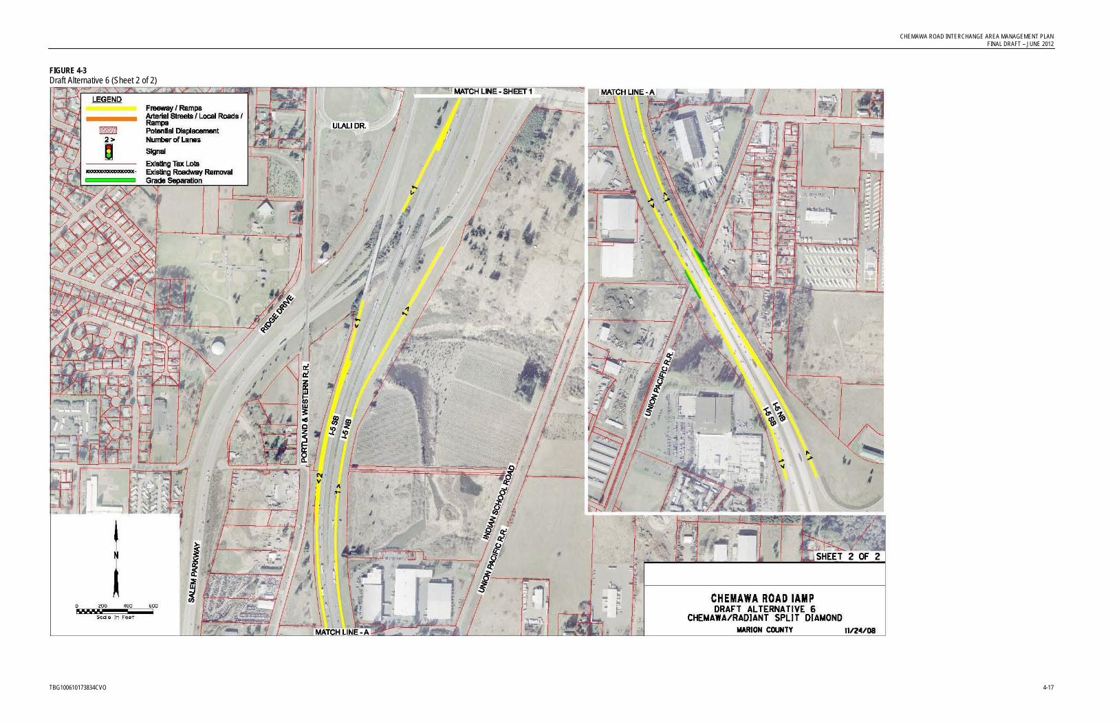
CHEMAWA ROAD INTERCHANGE AREA MANAGEMENT PLAN FINAL DRAFT – JUNE 2012
TBG100610173834CVO 4-17
FIGURE 4-3 Draft Alternative 6 (Sheet 2 of 2)


CHEMAWA ROAD INTERCHANGE AREA MANAGEMENT PLAN FINAL DRAFT – JUNE 2012
TBG100610173834CVO 4-19
FIGURE 4-4 Draft Alternative 12


CHEMAWA ROAD INTERCHANGE AREA MANAGEMENT PLAN FINAL DRAFT – JUNE 2012
TBG100610173834CVO 4-21
FIGURE 4-5 Draft Alternative 13 (Sheet 1 of 2)


CHEMAWA ROAD INTERCHANGE AREA MANAGEMENT PLAN FINAL DRAFT – JUNE 2012
TBG100610173834CVO 4-23
FIGURE 4-6 Draft Alternative 13 (Sheet 2 of 2)


CHEMAWA ROAD INTERCHANGE AREA MANAGEMENT PLAN FINAL DRAFT – JUNE 2012
TBG100610173834CVO 4-25
FIGURE 4-7 Draft Alternative 14A


CHEMAWA ROAD INTERCHANGE AREA MANAGEMENT PLAN FINAL DRAFT – JUNE 2012
TBG100610173834CVO 4-27
TABLE 4-2 Chemawa IAMP Freeway Operations
ID # Location Segment
Type Facility
Existing Conditions (2008) Future Baseline (2031)
Future Adopted Alt. 1 (2031)
Future Adopted Alt. 6 (2031)
Future Adopted Alt. 12 (2031)
Future Adopted Alt. 13 (2031)
Future Adopted Alt. 14 (2031)
Mobility Standard V/C Ratio
Mobility Standard V/C Ratio
Mobility Standard V/C Ratio
Mobility Standard V/C Ratio
Mobility Standard V/C Ratio
Mobility Standard V/C Ratio
Mobility Standard V/C Ratio
N1 NB I-5 Mainline South of Off-Ramp to Chemawa Road
Basic Mainline 0.80 0.59 0.80 0.80 0.75 0.63 0.75 0.63 0.75 0.64 0.75 0.64 0.75 0.62
N2 NB Off-Ramp to Chemawa Road Diverge Ramp 0.80 0.20 0.80 0.40 Does Not Exist Does Not Exist Does Not Exist Does Not Exist Does Not Exist
Mainline 0.80 0.53 0.80 0.68
N3 NB I-5 Mainline South of On-Ramp from OR 99E Business
Basic Mainline 0.80 0.54 0.80 0.70 0.75 0.71 0.75 0.71 0.75 0.72 0.75 0.73 0.75 0.71
N4 NB On-Ramp from OR 99E Business/Salem Parkway
Merge Ramp 0.80 0.60 0.80 0.84 Does Not Exist Does Not Exist Does Not Exist Does Not Exist Does Not Exist
Mainline 0.80 0.61 0.80 0.84
N5 NB I-5 Mainline South of On-Ramp from Chemawa Road
Basic Mainline 0.80 0.60 0.80 0.83 Does not Exist Does not Exist Does not Exist Does not Exist Does not Exist
N6 NB On-Ramp from Chemawa Road Merge Ramp 0.80 0.61 0.80 0.79 0.75 0.90 0.75 0.91 0.75 0.90 0.75 0.92 0.75 0.90
Mainline 0.80 0.64 0.80 0.85 0.75 0.85 0.75 0.86 0.75 0.86 0.75 0.88 0.75 0.86
N7 NB I-5 Mainline North of On-Ramp from Chemawa Road
Basic Mainline 0.80 0.64 0.80 0.84 0.75 0.85 0.75 0.86 0.75 0.86 0.75 0.88 0.75 0.85
S1 SB I-5 Mainline North of Off-Ramp to Chemawa Road
Basic Mainline 0.80 0.72 0.80 0.99 0.75 1.00 0.75 1.00 0.75 0.99 0.75 0.87 0.75 1.00
S2 SB Off-Ramp to Chemawa Road Diverge Ramp 0.80 0.30 0.80 0.33 0.75 0.97 0.75 0.98 0.75 0.68 0.75 0.58 0.75 0.71
Mainline 0.80 0.63 0.80 0.89 0.75 0.71 0.75 1.11 0.75 0.97 0.75 0.95 0.75 0.97
S3 SB I-5 Mainline South of Off-Ramp to Chemawa Road
Basic Mainline 0.80 0.63 0.80 0.89 Does not Exist Does not Exist Does not Exist Does not Exist Does not Exist
S4 SB Off-Ramp to OR 99E Business Diverge Ramp 0.80 0.54 0.80 0.77 Does Not Exist Does Not Exist Does Not Exist Does Not Exist Does Not Exist
Mainline 0.80 0.47 0.80 0.66
S5 SB I-5 Mainline South of Off-Ramp to OR 99E Business
Basic Mainline 0.80 0.48 0.80 0.68 0.75 0.72 0.75 0.69 0.75 0.71 0.75 0.60 0.75 0.72
S6 SB On-Ramp from Chemawa Road Merge Ramp 0.80 0.65 0.80 0.96 Does Not Exist Does Not Exist Does Not Exist Does Not Exist Does Not Exist
Mainline 0.80 0.61 0.80 0.89
S7 SB I-5 Mainline South of On-Ramp from Chemawa Road
Basic Mainline 0.80 0.60 0.80 0.88 0.75 0.71 0.75 0.68 0.75 0.70 0.75 0.61 0.75 0.70


CHEMAWA ROAD INTERCHANGE AREA MANAGEMENT PLAN FINAL DRAFT – JUNE 2012
TBG100610173834CVO 4-29
TABLE 4-3 Mobility Analysis for Intersections of Tier 1 Best Alternatives
Intersection
Alt 1, Chemawa Widening
Alt 6, Chemawa-
Tepper Split Diamond
Alt 12, Brooks SPUI
Alt 13, New Interchange at Quinaby Road
Alt 14, Verda/Hyacinth Improvements
Lockhaven @ River 1.33 (0.87) 1.36 (0.87) 1.39 (0.87) 1.31 (0.87) 1.36 (0.87)
Lockhaven @ Verda (Trail)
LOS F (LOS D) LOS F (LOS D) LOS F (LOS D) LOS F (LOS D) LOS F (LOS D)
Lockhaven @ 14th 0.87 (0.87) 1.44 (0.87) 1.42 (0.87) 1.35 (0.87) 1.42 (0.87)
Lockhaven @ McLeod
0.70 (0.87) 0.94 (0.87) 0.95 (0.87) 0.88 (0.87) 0.88 (0.87)
Lockhaven @ Chemawa/Keizer Station
0.82 (0.87) 0.87 (0.87) 0.87 (0.87) 0.84 (0.87) 0.84 (0.87)
Chemawa @ Ulali/Stadium
0.99 (0.85) 1.17 (0.85) 1.26 (0.85) 1.24 (0.85) 1.24 (0.85)
Chemawa @ southbound ramps
1.09 (0.75) 1.09 (0.75) 1.19 (0.75) 1.12 (0.75) 1.12 (0.75)
Chemawa @ northbound ramps
1.11 (0.75) 1.17 (0.75) 1.25 (0.75) 1.20 (0.75) 1.18 (0.75)
Chemawa @ Indian School Road
0.27 (0.85) 0.30 (0.85) 0.47 (0.85) 0.48 (0.85) 0.46 (0.85)
Chemawa @ Tepper
NA C (D) NA NA NA
Chemawa @ OR 99E
1.08 (0.75) 1.04 (0.75) 1.10 (0.75) 1.10 (0.75) 1.07 (0.75)
NOTES: The letter notations are Level of Service indications and the numerical notations are Volume to Capacity ratios. The letter or number in parenthesis () is the established mobility standard for this intersection. Gray shading indicates intersections that would fail the mobility standard.
The shaded cells indicate those intersections that would fail the mobility standard for each of the alternatives. Although failing the mobility standard, the intersections are considerably better than the no-build scenario under Alternative 1. This table shows that neither Alternative 1 nor Alternative 6 alone solves the projected congestion issues at the Chemawa Interchange. This summary also shows that projected conditions at the interchange are significantly worse with any of the improvements north or south of the interchange (Alternatives 12, 13, and 14) instead of Alternatives 1 or 6. In other words, improvements at Brooks, Quinaby, or Hyacinth do not draw enough traffic away from the Chemawa Interchange to address the projected congestion issues.
With all alternatives, four of the eight I-5 freeway segments meet the mobility standards and the other four are under capacity. The impact upon these segments is very similar for all alternatives. The northern end of the proposed auxiliary lane creates a bottleneck because of the expected future volumes relative to the freeway’s capacity. That same bottleneck would

CHEMAWA ROAD INTERCHANGE AREA MANAGEMENT PLAN FINAL DRAFT – JUNE 2012
4-30 TBG100610173834CVO
exist no matter where this additional lane was stopped unless it was extended all of the way north into the Portland area. Carrying this lane any further north would be outside of the scope of the Chemawa Interchange IAMP.
4.3.2 Analysis under Expanded Urban Growth Boundary Scenario ODOT policies governing the adoption of Interchange Area Management Plans state that, as ODOT Facility Plans, they must be based on the land use assumptions in existing adopted local comprehensive plans. However, at the time of preparation of this IAMP, the City of Keizer is in the very early stages of investigating the expansion of the Urban Growth Boundary and updating its Comprehensive Plan. This will be a lengthy process and there is no guarantee what the outcome of that process will be. The recommended alternative of this IAMP is based on the adopted UGB and not on speculation about a future expanded Keizer UGB.
Nevertheless, there was an interest by the City of Keizer to use this IAMP process to test a hypothetical UGB expansion growth scenario. Keizer cannot expand to the south because it is adjacent to the City of Salem. It cannot expand to the west because of the Willamette River. It is unlikely to expand to the east because it is partially adjacent to the City of Salem or it would mean jumping over I-5 into EFU land north of Chemawa Road. So the assumption used for this hypothetical scenario was that any future expansion would be to the north of Keizer and west of I-5.
For this effort, it was assumed that this expansion would include all of the land south of Quinaby Road and west of I-5. That would bring 920 acres into the UGB and it was assumed that 680 of these acres would be residential, 120 acres would be retail land use and 120 acres would be non-retail. This is consistent with the land use mix within the existing UGB. Marion County’s mid-level population forecast was used to determine that this would mean a population increase of 8,000 people in 3,100 new households.
For the local road network, it was assumed that in the east-west direction, Quinaby Road and Perkins Street would be improved and a new road would be constructed between Perkins Street and Labish Ditch. In the north-south direction, 35th Avenue would be improved from Keizer Station to Brooklake Road and a new road would be constructed parallel to the Portland & Western Railroad from Quinaby Road to the new east-west road.
The modeling analysis from all of these assumptions showed that Alternative 1 (Widening) provided the most benefit to the Chemawa Interchange under this expanded UGB scenario. It also showed that Alternative 6 (Chemawa/Tepper split diamond) and Alternative 13 (new Quinaby Interchange) would provide improved operation under this scenario, but would not provide acceptable operation without being integrated with Alternative 1. The least beneficial were Alternatives 12 (Brooks SPUI) and 14 (Verda/Hyacinth).
Appendix C of this IAMP includes more detailed information about this alternative land use investigation regarding the UGB expansion.

CHEMAWA ROAD INTERCHANGE AREA MANAGEMENT PLAN FINAL DRAFT – JUNE 2012
TBG100610173834CVO 4-31
4.4 Development of Hybrid Alternatives On the basis of the operational analysis process, the stakeholders advised and the management team directed that Alternative 1 (Chemawa/ Lockhaven widening) and Alternative 6 (Chemawa/ Tepper split diamond interchange) were the alternatives that should be considered further as projects that benefit future operations at the Chemawa Interchange. The improvements at the Brooks Interchange, a new interchange at Quinaby Road, and improvements to the Verda/
This operational analysis also made it clear that neither Alternative 1 nor Alternative 6 would fully address the future congestion as standalone projects. These two alternatives are complementary, and the direction was to combine them into a hybrid alternative. However, there were modifications to both of these alternatives that needed to be analyzed in addition to just combining the two base alternatives.
Hyacinth corridor proved to not significantly address the future congestion and operational issues at the Chemawa Interchange.
A small “sub-team” was formed with representatives from the partner agencies, stakeholders, and technical team for the purpose of refining these two Tier 1 alternatives into hybrid alternatives. These hybrids were further evaluated through the quantitative process using the SKATS regional model. The result was evaluation of the following hybrid alternatives:
• Alternative 1A: Full Chemawa/Lockhaven widening from Indian School Road to River Road
• Alternative 1B: Limited Chemawa/Lockhaven widening from Indian School Road to Keizer Station Boulevard.
• Alternative 6A: Chemawa/Tepper Half Diamond Interchange
• Alternative 6B: Chemawa/Tepper Split Diamond Interchange
• Alternative 6C: East Tepper Drive Overcrossing, with no interchange ramps
The next step was to mix and match these multiple scenarios into a number of new, hybrid alternatives that were also evaluated with the SKATS regional model. These six alternatives were evaluated:
• Alternative 15: Full Chemawa/Lockhaven widening plus the Chemawa/Tepper Half Diamond (Alt. 1A + Alt. 6A)2
• Alternative 16: Full Chemawa/Lockhaven widening plus the Chemawa/Tepper Split Diamond (Alt. 1A + Alt. 6B)
• Alternative 17: Full Chemawa/Lockhaven widening plus the Tepper Overcrossing (Alt. 1A + Alt. 6C)
2 One of the original Tier 1 alternatives was previously given the number 15. That was overlooked when these additional alternatives were assigned a number. The numbering of this set of six alternatives was not revised because information had been distributed with this numbering scheme. This Alternative 15 is not the same as the Tier 1 Alternative 15.

CHEMAWA ROAD INTERCHANGE AREA MANAGEMENT PLAN FINAL DRAFT – JUNE 2012
4-32 TBG100610173834CVO
• Alternative 18: Limited Chemawa/Lockhaven widening plus the Chemawa/Tepper Half Diamond (Alt. 1B + Alt. 6A)
• Alternative 19: Limited Chemawa/Lockhaven widening plus the Chemawa/Tepper Split Diamond (Alt. 1B + Alt. 6B)
• Alternative 20: Limited Chemawa/Lockhaven widening plus the Tepper Overcrossing (Alt. 1B + Alt. 6C)
Next, a mobility analysis was again conducted for the same eleven intersections along the Chemawa/Lockhaven corridor that were summarized for the original Tier 1 Alternatives. On the basis of this analysis (see Appendix F), the sub-team suggested several refinements to enhance these alternatives. These refinements were:
• Realignment of the East Tepper Drive/Chemawa Road intersection
• Closure of the Indian School Road/Chemawa Road intersection and realignment of Indian School Road to East Tepper Drive
• Extend the widening of Chemawa Road to OR 99E
• Extend Verda Lane to River Road (as addressed in the Keizer TSP)
• Reconstruct the Chemawa northbound off-ramp to a loop ramp (Parclo B) configuration (Tier 1 Alternative #3)
The sub-team then added these alternatives to the most promising Alternatives 17, 18, and 20 to create four final, fully enhanced alternatives. The improvements east of the Chemawa Interchange consist of the revisions to Indian School Road and East Tepper Drive and extending the widening to OR 99E. These four new alternatives listed below were then modeled with the SKATS regional travel demand model.
• Alternative 21: Alternative 17 (full widening with overcrossing) plus improvements east of the Chemawa Interchange (revisions to Indian School Road and East Tepper Drive and extending the widening to OR 99E)
• Alternative 22: Alternative 20 (limited widening with overcrossing) plus improvements east of the Chemawa Interchange (revisions to Indian School Road and East Tepper Drive and extending the widening to OR 99E)
• Alternative 23: Alternative 18 (full widening with half diamond) plus improvements east of the Chemawa Interchange (revisions to Indian School Road and East Tepper Drive and extending the widening to OR 99E)
• Alternative 24: Alternative 17 (full widening with overcrossing) plus improvements east of the Chemawa Interchange (revisions to Indian School Road and East Tepper Drive and extending the widening to OR 99E) plus Chemawa northbound off-ramp improvements (Parclo B)

CHEMAWA ROAD INTERCHANGE AREA MANAGEMENT PLAN FINAL DRAFT – JUNE 2012
TBG100610173834CVO 4-33
4.5 Quantitative Evaluation of Four Hybrid Alternatives The Evaluation Framework matrix was used again to “quantitatively” evaluate Alternatives 21 through 24. This is the same matrix that was used to qualitatively evaluate the Tier 1 alternatives earlier in the process (Table 4-1). The project information available for this quantitative evaluation included the modeling and mobility analysis information and information from the partially completed 10-percent design process. This information had not yet been produced at the time of the qualitative evaluation.
Appendix H includes information regarding the mobility analysis of Alternatives 21–23 (Alternative 24 included hand modifications to Alternative 22 for the northbound parclo B ramp) and the Evaluation Framework for Alternatives 21-24. Due to the similarity between the “third level” alternatives and the recommended alternative’s phasing, demand modeling results from the “third level” analysis were used as the basis for the recommended alternative Synchro operational traffic analysis.
4.5.1 Mobility Analysis TABLE 4-4 Mobility Analysis at Intersections of Tier 2 Alternatives
Intersection
Alt 21, Full Widening,
Overcrossing & Improvements East
of Chemawa I/C
Alt 22, Limited Widening,
Overcrossing & Improvements East
of Chemawa I/C
Alt 23, Full Widening, Half
Diamond & Improvements East
of Chemawa I/C
Alt 24, Full Widening, Overcrossing,
Improvements East of Chemawa I/C &
Parclo B Ramp
Lockhaven @ River 1.11 0.87) 1.13 (0.87) 1.11 (0.87) NA
Lockhaven @ Verda (Trail)
LOS F (LOS D) LOS F (LOS D) LOS F (LOS D) NA
Lockhaven @ 14th 0.75 (0.87) 1.10 (0.87) 0.75 (0.87) NA
Lockhaven @ McLeod
0.75 (0.87) 0.73 (0.87) 0.72 (0.87) NA
Lockhaven @ Chemawa/Keizer Station
0.91 (0.87) 0.85 (0.87) 0.81 (0.87) NA
Chemawa @ Ulali/ 0.96 (0.85)1 Stadium
0.96 (0.85) 0.98 (0.85) NA
Chemawa @ southbound ramps
0.97 (0.75) 0.97 (0.75) 1.05 (0.75) NA
Chemawa @ northbound ramps
1.06 (0.75) 1.06 (0.75) 1.05 (0.75) 1.03(0.75)
Chemawa @ Tepper D (D) D (D) D (D) NA
Chemawa @ OR 99E 1.14 (0.75) 1.11 (0.75) 1.12 (0.75) NA
NOTES: The letter notations are Level of Service indications and the numerical notations are Volume to Capacity ratios. The letter or number in parenthesis () is the established mobility standard for this intersection. Gray shading indicates intersections that would fail the mobility standard.

CHEMAWA ROAD INTERCHANGE AREA MANAGEMENT PLAN FINAL DRAFT – JUNE 2012
4-34 TBG100610173834CVO
Table 4-4 summarizes the mobility analysis for 10 of the 11 intersections along the Chemawa/
The queuing analysis showed that the Parclo B ramp reduced the projected queues at this intersection and that the Parclo B ramp would be a beneficial element of a recommended alternative.
Lockhaven corridor that were summarized for the original Tier 1 Alternatives. The Indian School Road intersection with Chemawa Road would be eliminated and rerouted to the new East Tepper Drive with all of these alternatives.
The analysis also showed that the limited widening element would not deteriorate the function of the immediate interchange area as compared to the full widening element. The limited widening alleviated the same problems as the full widening and the goal was to widen only as far as necessary to ensure acceptable operation in the interchange area.
While all of these alternatives result in intersections that fail to meet the mobility standards, those intersections at or very near to the interchange would operate under capacity or only slightly over capacity and all were much improved over the baseline scenario.
Because of shifts in traffic patterns, the model determined that some of the intersections were slightly worse mobility wise with the half diamond as compared to only the overcrossing at Tepper. On the other hand, mobility to the north Keizer area would be enhanced with the half diamond element.
4.5.2 Other Evaluation Consideration The evaluation matrix has different values for these alternatives for only a few of the evaluation criteria.
The volume at the interchange ramp intersections is above the available capacity for Alternatives 21-23. For Alternative 24, the loop ramp for the northbound off-ramp, with the addition of the eastbound double-lane left turn, results in a volume to capacity ratio that is over the established mobility standard, but under the capacity level. This highlights the advantage of the parclo B ramp.
Alternative 22 scored higher with several criteria because the limited widening did not conflict local plans.
Alternative 23, with the half diamond, scored slightly lower regarding interchange spacing guidelines along I-5 because the new ramps are a little closer to the Brooks Interchange.
This level of quantitative evaluation did not so much point to one alternative over others as it pointed out which elements were feasible and beneficial.

TBG100610173834CVO 5-1
5.0 Interchange Area Management Plan
An IAMP is an agreement between ODOT and the local government on how to manage transportation facilities and associated land uses. An IAMP is also a plan for how best to protect the future function of an interchange and meet the goals and objectives for both state and local governments (see Sections 1 and 2 for background information and existing conditions). In Sections 3 and 4, this IAMP has examined the forecast future conditions, and developed and evaluated transportation and land use alternatives for the plan. This section identifies the Recommended Alternative and provides findings about interchange function, the local street network, existing and planned land uses in the interchange management area, and access management. Appendix I provides drawings (from the 10-percent Design Package) of the proposed improvements to transportation facilities, which comprise the Recommended Alternative for the interchange study area. The drawings found in Appendix I are conceptual and will be refined during the development of engineered final project plans.
It is important to note that the projects on the state highway system described herein as the Recommended Alternative and illustrated in Figure 5-1 and Appendix I, are not currently included in the Salem-Keizer Area Transportation Study (SKATS) 2031 Regional Transportation System Plan (RTSP). Until adequate funding is specifically identified for all or a component of the Recommended Alternative in the RTSP, ODOT shall not consider them (all or any component) “planned improvements” or “reasonably likely” to be constructed within the 20-year (2031) planning horizon pursuant to the Oregon Transportation Planning Rule (TPR), Oregon Administrative Rules (OAR) 660-012-0060.
Because the Recommended Alternative is not considered reasonably likely to be constructed during the 20-year planning horizon, the actual management strategy for this interchange is based on the no-build or baseline condition described earlier in Chapter 3. Based on the travel demand associated with the expected 2031 build out of the existing adopted comprehensive land use plans of the City of Keizer, City of Salem, and Marion County and the capacity provided by the existing transportation network [2031 SKATS forecast model, circa Summer 2009], ODOT has determined that the existing alternative mobility standards, as well as the other OHP and Highway Design Manual (HDM) mobility targets at the intersections listed in Table 6-1, will be exceeded at the end of the 2031 planning horizon. ODOT has jurisdictional responsibility for these intersections.
Given that ODOT has determined that the improvements recommended in this IAMP are not reasonably likely to be constructed within the 2031 planning horizon, and are therefore not planned improvements that can be relied upon to support subsequent land use changes, it is necessary for ODOT to update the alternative mobility standards for these intersections to make their expected performance through 2031 consistent with the existing adopted land use plans. These alternative targets shall supersede the alternative standards previously adopted. Appendix Q is a technical memorandum presenting alternative mobility targets for consideration.


CHEMAWA ROAD INTERCHANGE AREA MANAGEMENT PLAN FINAL DRAFT – JUNE 2012
TBG100610173834CVO 5-3
FIGURE 5-1 Recommended Alternative


CHEMAWA ROAD INTERCHANGE AREA MANAGEMENT PLAN FINAL DRAFT – JUNE 2012
TBG100610173834CVO 5-5
For the East Tepper Drive portion of the recommendation, the half diamond performs better overall than the split diamond configuration. But, the overcrossing alone with a connection to Chemawa Road without any connecting ramps to I-5 provides almost as much benefit as the half diamond, at least with the current Keizer UGB. ODOT design staff and FHWA staff determined that the ramp connections that would create this half diamond interchange could not be supported at this time and the half diamond was removed from the recommended alternative. The East Tepper Drive overcrossing remains part of the recommended alternative. The objections to the added connections to I-5 were that the half diamond interchange would provide very little added benefit over just the overcrossing structure, would not connect directly to an arterial roadway such as the existing Chemawa Interchange, and would not meet spacing standards or driver expectations. Since future conditions may change, the half diamond interchange element of the recommended alternative was grouped with other work for potential future consideration.
The current Chemawa Road/Indian School Road intersection will be problematic in any future scenario because it is already located too close to the interchange ramps. The recommended alternative includes the closure of this intersection and the relocation of Indian School Road to East Tepper Drive. The alignments shown for the East Tepper Drive and for Indian School Road are merely illustrative at this point. This property is currently not developed for urban use, but may be further developed in the relatively near term. The final alignments of these roadways will need to be determined in concert with the property development plans and local development process.
With all of the early alternatives, the intersection of Chemawa Road with the northbound I-5 ramps would be taxed to over capacity according to the 2031 traffic modeling. While still not meeting current standards, Alternative 24 with the inclusion of the loop ramp for the northbound to westbound turning movement would bring the anticipated condition down below the full capacity level. The recommended alternative includes this Parclo B ramp. Landscaping would enhance the image of the interchange as a gateway to Keizer. All projects shall be required to provide design elements to enhance the visual aspects of the interchange area.
Appendix J includes the traffic analysis results for the recommended alternative by phases. The proposed recommendation will improve traffic operations in the interchange area by addressing exiting and entering congestion on I-5, increasing capacity of the Chemawa/
These improvements are intended to serve growth that has already been authorized in the local Comprehensive Plans. They are not intended to encourage rezoning of parcels for uses that generate greater volumes of traffic.
Lockhaven corridor, providing an additional route for travel through the interchange area, and providing improved intersection spacing from the ramp terminals.
The recommended alternative also includes a number of minor network refinements such as lane geometry modifications and turn pockets. Additional details on these refinements can be found in other project technical memorandums as well as the 10-percent design drawings (Appendix I).
The City of Keizer TSP was developed at about the same time as this IAMP. The TSP calls for a westbound right turn lane on Lockhaven Drive NE at 14th Avenue NE, but does not

CHEMAWA ROAD INTERCHANGE AREA MANAGEMENT PLAN FINAL DRAFT – JUNE 2012
5-6 TBG100610173834CVO
include an additional westbound through lane. The widening of the Chemawa/Lockhaven corridor called for by the IAMP would provide a second westbound through lane at 14th Avenue NE. This configuration will adequately accommodate the turning movements, making the separate right turn lane unnecessary.
5.1.1 Required Additional Right-of-Way Generally speaking, the improvements in the Chemawa/Lockhaven corridor can be constructed within the existing right-of-way.
In the segment of Lockhaven Drive between Verda Lane and McLeod Lane, one lane in the westbound direction is recommended to be added. Engineering maps were obtained for the existing section from McLeod Lane to 14th Avenue. These maps show that there is 10 feet from the back of the sidewalk to the right-of-way line on the north side of Lockhaven Drive and 5 feet in this similar location on the south side. The current three-lane section is wider than normal and an expanded four-lane section could be constructed using only 7 feet more than the existing section. The combined 15 feet of area behind the two sidewalks should provide sufficient space for this expansion.
The right-of-way in the section from Verda Lane to 14th Avenue appears to be the same width, so it also appears that the additional lane could be constructed within the existing right-of-way in that section.
Additional right-of-way may or may not be needed just west of McLeod Lane depending on how the transition from four to six lanes is designed with a future project. The 10 percent design plans show the westbound lane ending just west of McLeod Lane and that would require some right-of-way along the north side of Lockhaven Drive. If this lane were dropped as a mandatory right turn lane at McLeod, additional right-of-way would not be required to the west. These same drawings show the additional eastbound lane beginning just east of McLeod Lane. That design would not require new right-of-way west of McLeod, but if the lane were started west of McLeod, some new right-of-way would be required in that area.
With one exception, it is expected that the current right-of-way between McLeod Lane and the Portland & Western Railroad crossing is wide enough to construct the expanded recommended section. That one exception is along the north side of Lockhaven Drive from McLeod Lane to about half way to Keizer Station Boulevard where approximately one lane worth (12 to 15 feet) of new right-of-way would be required.
Between this at-grade railroad crossing and the currently drawn location of the new Chemawa Road/East Tepper Drive intersection, the existing right-of-way is adequate to construct the recommended wider section. This extra wide right-of-way comes, in part, from the fact that Chemawa Road has historically been in multiple locations at the point where it crosses over I-5.
In the section, from the proposed East Tepper Drive intersection to the existing Indian School driveway, the existing right-of-way is 105-feet wide. Without doing a design, it is expected that width would be adequate to contain the recommended four-lane section.

CHEMAWA ROAD INTERCHANGE AREA MANAGEMENT PLAN FINAL DRAFT – JUNE 2012
TBG100610173834CVO 5-7
From the Indian School driveway to OR 99E, the existing right-of-way is even wider at approximately 170 feet. This also should be adequate for the construction of the recommended alternative.
5.1.2 Environmental Issues The recommended alternative has very few environmental and permitting implications. Most of the roadway improvements of the recommended alternative are to existing streets through already developed urban areas. The alignments of new roadways do not appear to cross any critical habitat, wetlands, or 303(d) streams identified in the SKATS 2031 RTSP (see figures in Appendix K). However, wetlands and hydric soils are known to exist in the vicinity of the alignments, which would require a field investigation at potential sites prior to final design and permitting. Some of the proposed new roadways are outside of the Urban Growth Boundary of Salem and Keizer and would cross into EFU-zoned land in Marion County. Permitting of these sections of new roadway outside of the cities’ UGBs will require a Statewide Planning Goals exception.
5.1.3 Design Exceptions and Interchange Modifications There are three issues of the recommended alternative that need to be addressed as design exceptions. Appendix L is a draft Design Exceptions Request for the project. The first issue of the design exception is the interchange spacing. The Chemawa Interchange is the middle of three relatively closely spaced interchanges. The interchange to the south is Portland Road and the interchange to the north is Brooklake Road (Brooks Interchange). Measuring from crossroad to crossroad, the Portland Road and Brooklake Road Interchanges are only 4.81 miles apart.The second issue is the Ulali/Stadium intersection that is located approximately 800 feet west of the Chemawa Interchange. The third issue is the Chemawa overcrossing structure.
In addition, FHWA will need to approve an Interchange Modification Request (Appendix M). The request is to modify the Chemawa interchange to a partial cloverleaf-B (northbound loop ramp beyond the overcrossing structure of I-5) with the embedded directional interchange for Salem Parkway. As part of the project, the Chemawa Road overcrossing of I-5 would be widened. In addition, an overcrossing of I-5 for East Tepper Drive would also be provided a short distance north of the Chemawa structure. The project would preserve and enhance the function of the interchange. Although the project would not increase or reduce the number of access points, it would spread these points out by constructing auxiliary lanes and lengthening some of the ramps.
The draft Design Exceptions Request and draft Interchange Modification Request are intended to assist in the development of final construction documents. It is likely that the final engineering process will identify additional details that will need to be addressed in the Design Exception and/or the Interchange Modification Request.
5.1.4 Cost Estimate The recommended alternative has an added benefit in that it can be constructed in phases. Funding has not been identified, but the ability to phase will make it much more feasible to implement the recommendations over time as opposed to having to build the entire

CHEMAWA ROAD INTERCHANGE AREA MANAGEMENT PLAN FINAL DRAFT – JUNE 2012
5-8 TBG100610173834CVO
recommended alternative at one time. Reconnaissance level cost estimates have been developed for these phases:
• Phase 1: Chemawa/Lockhaven limited widening (OR 99E to Verda Lane), $42 million
• Phase 2: Tepper overcrossing and extension, Indian School Road realignment, 35th Avenue realignment and I-5 auxiliary lanes, $80 million
• Phase 3: Chemawa northbound off-ramp (Parclo B), $12 million
These estimates are in 2009 dollars and do not include any right-of-way costs, which are expected to be minimal. These estimates were developed with a template that utilizes unit costs for major items such as pavement and earthwork and percentages for other items such as temporary signing and mobilization. Because these are planning level estimates, a large (30 percent) contingency was used. A further breakdown by project element is not provided because of the planning nature of these estimates.
5.2 Projects for Future Consideration As mentioned earlier, there could be a future decision to widen Lockhaven Drive all of the way westerly to River Road as a future phase.
The recommended alternative includes the East Tepper Drive overcrossing. Expanding this overcrossing to a half diamond interchange with the construction of ramps to and from the north at some future time could be considered if warranted by future Keizer growth and demonstrable benefits to the state and local transportation system. Appendix N provides a traffic analysis for projects for future consideration.
5.3 Access Management Plan Measures to address access management and the local circulation system are incorporated into the recommended alternative for the Chemawa Road Interchange Area Management Plan. Actions are proposed in two phases, for the short-term and the medium-/long-term.
The first phase of the recommended alternative, widening of the Chemawa/Lockhaven corridor, could be considered short-term if it were built within its recommended 10-year timeframe. This widening would provide circulation benefits outside of the interchange area and likely some access and circulation changes west of the Lockhaven/Chemawa intersection. However, there would be no specific interchange area access management actions associated with this widening as all appropriate actions(closures, consolidations, channelization, etc.) were implemented with the Keizer Station development.
All other circulation and access management actions addressed by the IAMP are associated with Phase 2 of the recommended alternative. These various elements of this phase are recommended for implementation beyond 10 years into the future, making them all at least medium-term actions.
There are two elements to be discussed specifically in regard to access management. First is the spacing concerns associated with interchange ramp intersections. Second is the management of access for individual properties within the interchange influence area. The

CHEMAWA ROAD INTERCHANGE AREA MANAGEMENT PLAN FINAL DRAFT – JUNE 2012
TBG100610173834CVO 5-9
Access Management Plan also includes a discussion of changes to the local circulation system, including the integration of regional elements (Section 5.3.3)
5.3.1 Intersection and Driveway Spacing Issues ODOT’s current access management policy, in the 1999 Oregon Highway Plan (amended in 2006), stipulates that the desired distance between an interchange ramp terminal and the first major (full movement) highway approach (public or private) is 1,320 feet ( OHP Appendix C, Tables 16 and 17). The desired distance for a right-in/right-out (RI/RO) intersection is 750 feet. The OHP recognizes that these desired minimums may not always be achievable in a real world context and directs ODOT to do the best that can be reasonably done increasing spacing towards the desired minimums. There are a number of elements of the recommended alternative to be discussed concerning this issue.
Chemawa/Lockhaven Corridor Constructing the recommended parclo-B ramp at the Chemawa Interchange would move the eastside ramps a relatively short distance farther to the east. East of the interchange, the East Tepper Drive intersection on Chemawa Road is recommended at an approximate distance of 1,500 feet from these new ramp locations. This location would satisfy the spacing requirement. However, the alignment of Tepper and therefore, the location of its intersection with Chemawa, are very tentative at this time (late 2010). Final alignment could be determined in the future as development plans for the larger, recently annexed private parcel in the northeast quadrant are solidified and/or if a public road is initiated before the adjoining property is developed. To reduce the number of access points along Chemawa east of I-5, it is also recommended that the driveway to the Chemawa Indian School be realigned to become the south leg of the Chemawa/Tepper intersection.
Indian School Road currently passes under Chemawa Road, loops around north of Chemawa, and connects to Chemawa Road approximately 500 feet from the northbound ramps. This connection location is already too close to the existing ramp intersections compared to the 1,320-foot spacing standard for full-movement intersections. This is also closer than the 750-foot standard for RI/RO out intersections. With the construction of the parclo-B ramp, the current Indian School Road connection would be only about 200 feet from the ramp intersection.
To eliminate this substandard situation, the recommended alternative includes realigning Indian School Road to connect to East Tepper Drive north of Chemawa Road when it is constructed. The Indian School Road traffic would then access Chemawa at the new East Tepper Drive intersection that is recommended approximately 1,500 feet from the nearest ramp intersection. The realignment of Indian School Road is also conceptual as of this writing (late 2010) and the final alignment, along with East Tepper Drive would be determined in concert with the development plans for the recently annexed property and/ or as part of a publicly initiated road project. Until or unless changes to the land uses that currently use Indian School Road to access Chemawa Road are proposed, until the parclo-B phase of the recommended project is initiated, or until safety concerns develop with continued use of this access in its present form, no changes are proposed for Indian School Road intersection with Chemawa Road. In the meantime, a deviation to the access spacing

CHEMAWA ROAD INTERCHANGE AREA MANAGEMENT PLAN FINAL DRAFT – JUNE 2012
5-10 TBG100610173834CVO
standards for this intersection, under the conditions described above, will be provided through this IAMP.
On Chemawa Road, the intersection with Ulali Drive and Stadium Drive is only 800 feet from the southbound ramp intersection. The movements at this intersection are limited to right-in/ right-out and left-in. Left outs, the movements with the most conflicts, are not allowed. This is a new intersection that resulted from extensive study and negotiation involving ODOT, the City of Keizer and the Keizer Station property owners and developers. The Portland & Western Railroad is immediately west of this intersection, making any relocation to the west impractical. In discussions related to widening Chemawa Road across this railroad grade crossing, the possibility of eliminating the eastbound left turn into Stadium Drive has been discussed. The entry into Keizer Station at Chemawa Road and Stadium Drive is not redundant but is an access to the west section of Area A. Ulali Drive accesses the center part of the area and Keizer Station Boulevard accesses the east side. The spacing deviation allowing the left-in movement was approved through the Keizer Station development process. The right-in
The next intersection to the west, Keizer Station Boulevard, is 1,500 feet from the southbound ramp terminal intersection and exceeds the spacing standard guideline.
/ right-out movements at 800 feet do not require a deviation.
East Tepper Drive Prior to the completion of the Draft IAMP, ramps connecting East Tepper Drive to and from I-5 to the north were part of the initial phased project recommendation. Those ramps were removed from the recommended solution.
Because a future consideration (beyond the 2031 planning horizon) may add these ramps, the 1,320- and 750-foot access safety spacing standards along East Tepper Drive may eventually need to be addressed.
As drawn in the recommended alternative, the East Tepper Drive/Indian School intersection is approximately 1,150 feet from the location of the eliminated northbound ramp intersection on East Tepper Drive. This distance is slightly less than the OHP safety spacing standard and could very well be considered acceptable, but as stated above, the alignments of East Tepper Drive and Indian School Road in this northeast quadrant are very conceptual and could also change. In any case, the objective should be to come as close to meeting the OHP safety spacing standards as possible if such a ramp is ever developed. To the extent that the spacing standard is not met, a deviation will have to be justified.
Along East Tepper Drive west of I-5, the intersection with Keizer Station Boulevard would be only 800 feet from the location shown for the eliminated southbound off-ramp intersection in the conceptual alternative. This is also less than the 1,320 foot standard. Tepper would have only one lane in each direction, so drivers’ decision-making between the off-ramp and Keizer Station Boulevard would be much less complex than if East Tepper Drive were multi-lane. For eastbound traffic moving away from Keizer Station Boulevard, the only interruption before reaching the northbound on-ramp location (which would be 1,300 feet from Keizer Station Boulevard) would be the left-turn movement coming from the southbound off-ramp. In addition to these mitigating factors, relocating Keizer Station Boulevard westerly to gain the desired spacing would require demolition of the new Keizer

CHEMAWA ROAD INTERCHANGE AREA MANAGEMENT PLAN FINAL DRAFT – JUNE 2012
TBG100610173834CVO 5-11
Station commercial buildings on the south and going through the Bonneville Power Administration substation on the north. All of these factors combined would need to be considered to justify a deviation that would allow an intersection 800 feet from the interchange ramp.
5.3.2 Access to Individual Properties
Chemawa/Lockhaven Corridor West ODOT has previously acquired access control along both sides of Chemawa Road from I-5 westerly through the Ulali/Stadium intersection to the UPRR tracks. There are no individual property accesses in this section and there will be none in the future.
The City of Keizer and Salem-Keizer Transit desire to establish a transit center on the property north of Chemawa Road immediately west of the railroad crossing. Construction of a transit station in Keizer Station is anticipated to start in 2012. There are negotiations under way regarding a potential access onto Chemawa Road. As discussed to date, this driveway, if developed, would allow right-in movements for buses only and no access for other vehicles. This driveway would be about 1,100 feet from the southbound ramp intersection. This driveway restriction is based on operational considerations, rather than the spacing, which exceeds the 750-foot standard for right-in, right-out intersections; therefore, no deviation would be needed. It is also outside of ODOT’s jurisdictional control, which ends at the railroad crossing. This driveway would be very near the railroad grade crossing and the major intersection with Keizer Station Boulevard. Additionally, Chemawa Road would be six lanes wide at this location, making other turning movements unsafe in any case.
The rest of the property adjacent to Chemawa/Lockhaven between the railroad and McLeod is part of future Keizer Station development. The City of Keizer will work with the Keizer Station developers to allow no more than one right-in/right-out driveway to that property on either side of Lockhaven Drive.
There are numerous driveways to Lockhaven Drive west of the McLeod Lane intersection. These are all beyond the 1,320-foot spacing standard, fall under local jurisdiction, and are not specifically addressed by this IAMP. However, consolidating and reducing these accesses to the extent practicable will improve operations throughout the entire corridor.
Whiteaker Middle School and Dayspring Church are located along the north side of Lockhaven in this section west of McLeod Lane. Although not explicitly addressed by this IAMP, there have been discussions of the possibility of revising access for Whitaker Middle School to use McLeod Lane or 14th Avenue or both, instead of directly accessing Lockhaven. Dayspring Church already has a driveway onto McLeod Lane. The City of Keizer and the parties may discuss this issue further in the future, and it could be a short-term or longer action depending on the outcome of those discussions.
Whether vehicular access to Whiteaker School changes or not, sufficient provisions for safe pedestrian crossings of Lockhaven Drive near the school must be part of any future improvements.

CHEMAWA ROAD INTERCHANGE AREA MANAGEMENT PLAN FINAL DRAFT – JUNE 2012
5-12 TBG100610173834CVO
Chemawa/Lockhaven Corridor East Moving east from I-5, ODOT has acquired access control along the north side of Chemawa Road from I-5 to the midpoint of the Indian School Road loop as it moves up to Chemawa Road. There is no individual property access in this section, and there will be none in the future. Along the south side of Chemawa Road, ODOT has acquired access control from I-5 to the west right-of-way line of the UPRR. There is no individual property access in this section, and there will be none in the future.
Between the UPRR tracks and the new East Tepper Drive intersection, the property on both sides of Chemawa Road is owned by the federal government and operated by Chemawa Indian School. Access to these parcels should be provided by East Tepper Drive on the north and the Indian School internal road system on the south with no direct access to Chemawa Road. It is expected that this internal system would be connected to Chemawa Road via the school’s main driveway in its current intersection with Chemawa. Alternatively, the connection could be at a new intersection with Chemawa should a new East Tepper Drive intersection with Chemawa be constructed and the main driveway relocated opposite the new intersection. ODOT should purchase access rights along both sides of Chemawa Road easterly to the new East Tepper Drive intersection to ensure this occurs.
There are several driveways to Chemawa Road east of the proposed East Tepper Drive intersection. These are all beyond the 1,320-foot spacing standard. These driveways will fall under local jurisdiction and are not specifically addressed by this IAMP. However, as is the case west of I-5, consolidating and reducing these accesses to the extent practicable will improve operations throughout the entire corridor.
East Tepper Drive The location of the East Tepper Drive/Indian School Road intersection and its relationship to a hypothetical (but not recommended at this time) northbound on-ramp at East Tepper Drive was discussed previously. Even though the exact location of that hypothetical intersection is not known, pending land or road development plans, there should be no individual property access to East Tepper Drive between I-5 and the recommended realignment of the Indian School Road intersection. ODOT will acquire access control along Tepper between I-5 and Indian School Road in order to ensure optimum spacing of all future accesses.
Along East Tepper Drive west of I-5, there should be no individual property access between I-5 and Keizer Station Boulevard. If the overcrossing is constructed and ramps are eventually added, ODOT will acquire access control along Tepper to Keizer Station Boulevard in order to ensure that no new accesses are developed.
The Target store located south of East Tepper Drive has three access points onto Keizer Station Boulevard that can serve customer traffic, although the loading dock located at the northeast corner of the building will have to be served via internal circulation.
The main access point for Volcanoes Stadium is on East Tepper Drive within this section. This driveway would be about 500 feet from a hypothetical (but not recommended at this time) southbound off-ramp location. In an urban area with a two-lane crossroad, a right-in/right-out connection meets OHP safety spacing standard at 750 feet from the ramp terminal. A deviation would be needed to authorize a right-in/right-out intersection for

CHEMAWA ROAD INTERCHANGE AREA MANAGEMENT PLAN FINAL DRAFT – JUNE 2012
TBG100610173834CVO 5-13
stadium events when a majority of the traffic stream is going to the stadium. Other parking lot access would need to be provided via the relocated 35th Avenue.
Other Access Management Tools The individual property access issues are very limited in this interchange area because of previous development requirements and related actions. Therefore, other access management tools such as driveway consolidation, driveways onto side streets, driveway sharing, backage roads, and so on are not applicable and do not need to be employed.
5.3.3 Area Circulation There are several circulation elements of the recommended alternative that are considered more relevant to regional circulation than local. The regional and local elements are often integral to the function and operations of the interchange area. For example, the integration of the Chemawa Interchange with the Salem Parkway Interchange and the close spacing to the Portland Road Interchange will overload the right lanes of I-5 with the exiting and entering movements. To address this expected congestion in the right lanes, auxiliary lanes on I-5 in both directions are recommended. These lanes will extend from the Portland Road Interchange to the Chemawa Interchange.
Along with these lanes, the Chemawa southbound off-ramp and northbound on-ramp are recommended to be lengthened. The lengthening would improve the operation of the exiting and entering movements to and from Chemawa Road and Salem Parkway by increasing spacing between the entrance and exit points.
A loop ramp in the northeast quadrant of the Chemawa Interchange is part of the recommended alternative. This loop ramp, a parclo-B ramp, will carry the northbound to westbound traffic, converting this left-turning traffic into right turns.
The recommended alternative also includes widening Chemawa Road by one lane in each direction through the interchange. This widening is needed to improve the operation of the interchange ramp intersections. Additional widening is recommended on the Chemawa/
Chemawa/Lockhaven Corridor
Lockhaven corridor outside of the interchange area. The additional widening would improve the local circulation and overall function of this corridor, but is not strictly needed to support operations in the interchange area.
As mentioned above, Chemawa Road is recommended for widening through the interchange to improve operations at the ramp terminal intersections.
To improve the local circulation function of Chemawa Road east of the interchange, an additional lane in each direction is recommended from the interchange easterly to Portland Road (OR 99E). Left-turn lanes are recommended at Portland Road and at a new intersection with East Tepper Drive, which is discussed below.
West of the interchange, Chemawa Road and Lockhaven Drive are recommended to be widened by one lane in each direction from the interchange westerly through the McLeod Lane intersection. This would improve the operation of the Stadium/Ulali, Keizer Station

CHEMAWA ROAD INTERCHANGE AREA MANAGEMENT PLAN FINAL DRAFT – JUNE 2012
5-14 TBG100610173834CVO
Boulevard, and McLeod intersections on this corridor. Left-turn lanes are recommended at all of these intersections.
From just west of McLeod to Verda Lane, one additional westbound lane is recommended for Lockhaven, improving the operation of the westbound movement along this corridor. Left-turn lanes are recommended at 14th Avenue and Verda Lane as well as restriping the east approach of Lockhaven at River Road to provide double left-turn lanes.
The traffic analysis showed that to meet adopted Keizer mobility standards away from the interchange area, Lockhaven would need to be widened by one lane in both directions all the way from McLeod to River Road. There were local concerns expressed regarding the impacts to adjacent properties that would result from more extensive widening. While not meeting Keizer’s adopted mobility standards, the limited widening that is recommended does not adversely impact the operation or function of the Chemawa Interchange. The City of Keizer Transportation System Plan does not preclude the more extensive widening, so that option is open for future consideration, but is not part of the IAMP recommended alternative.
East Tepper Drive A major local circulation element is the recommendation of an overcrossing over I-5 at East Tepper Drive and the extension of Tepper to a new intersection with Chemawa Road east of the I-5 interchange. This local circulation element would provide a route for some local traffic to bypass the Chemawa Interchange. This overcrossing is recommended for construction without connecting ramps to and from I-5. In the future, a southbound off-ramp and a northbound on-ramp could be considered to be added to the East Tepper Drive overcrossing, if warranted by future development and shown to provide a benefit to the state highway system.
East Tepper Drive currently runs east-west between the Target store and the Volcanoes Stadium parking lot. Near the I-5 west right-of-way line, this roadway turns north and becomes 35th Avenue. Constructing the Tepper overcrossing with the fill required to cross over I-5 would make it necessary to realign 35th Avenue. The recommended alternative includes a realignment of 35th Avenue around the north and west sides of the stadium parking lot; thus, 35th Avenue and Keizer Station Boulevard would connect to East Tepper Drive at the same intersection.
The east end of East Tepper Drive would connect to Chemawa Road east of I-5. Should this occur, it is also recommended that the current main driveway into the Chemawa Indian School be realigned opposite this new intersection. This will reduce the number of accesses to Chemawa Road. In addition, the realignment will benefit the Indian School by reducing nearby access conflicts with its main access. Another benefit would be an increased likelihood of their main driveway warranting a traffic signal, because it would become the fourth leg of a major intersection.

TBG100610173834CVO 6-1
6.0 Adoption and Implementation
As an ODOT Facility Plan, this IAMP must be consistent with the State Agency Coordination (SAC) Agreement which defines the process to comply with Oregon’s Statewide Planning Goals and Land Use Planning Program in accordance with Oregon Administrative Rule 731-0015. This document must also comply with Oregon Administrative Rule 734-0051, ODOT’s administrative rule that defines how to develop IAMP’s and how to implement ODOT’s access control policies and spacing standards. Policies and actions that are needed to be adopted in order to implement this IAMP by ODOT and the City of Salem, City of Keizer, and SKATS are presented below. Public and stakeholder involvement was an ongoing part of developing this IAMP and is summarized in Appendix O.
The IAMP recognizes that the City of Keizer is beginning an update of its Comprehensive Plan, its Urban Growth Boundary (UGB), and land use and zoning designations to accommodate its adopted 20-year population and employment forecasts. The implementation measures account for the possibility that this update may either precede or follow construction of the improvements in the Recommended Alternative.
The purpose of the Chemawa/I-5 Interchange, as stated in the Interchange Function Statement and the Goals and Objectives of the Chemawa IAMP (Sections 1.4 and 1.5), has shaped the following policies and actions. These proposed policies and actions are intended for adoption by the City of Keizer, the City of Salem, Marion County and the Oregon Transportation Commission (OTC), as appropriate. The OTC adoption will amend the Oregon Highway Plan (OHP), as necessary, and serve as the basis for ODOT’s implementation of the IAMP policies and actions. Recommended language for local plan policy and/or code amendments is provided in Appendix P.
6.1 Policies and Actions The following policies and actions are recommended as the appropriate means by which to implement the Chemawa IAMP. Jurisdictional adoption responsibilities are identified with each recommended policy and action and are also summarized in table matrixes preceding each of the numbered policies and actions below.
Policy/Action Implementation/Adoption Responsibility Matrix Jurisdiction
Policy/ Action # Responsibility Type ODOT/OTC
Marion County
City of Salem
City of Keizer SKATS
1 Implementation
Adoption
Analysis/Support
Coordination

CHEMAWA ROAD INTERCHANGE AREA MANAGEMENT PLAN FINAL DRAFT – JUNE 2012
6-2 TBG100610173834CVO
1. ODOT, Marion County, Salem, and Keizer shall recognize the Chemawa/I-5 Interchange Management Area as shown in Figure 1-2. This area shall be established as an overlay zone by each local jurisdiction within the scope of their respective jurisdictional authorities and/or otherwise acknowledged through the local determination that the IAMP is compatible with the local comprehensive plan.
ODOT, Marion County, Salem, and Keizer shall adopt the Interchange Function Statement in IAMP Section 1.4 or confirm in writing its compatibility and consistency with their existing adopted comprehensive plans. Any future amendments to any element of the IAMP, or to the local land use plans and regulatory codes upon which the IAMP is based, shall demonstrate how they are consistent with the Interchange Function Statement or shall be preceded or accompanied by an amendment to the Interchange Function Statement that reflects updated conditions and is mutually approved by each jurisdiction that adopts or confirms the local comprehensive plan compatibility and consistency of the initial Interchange Function Statement. Recommended changes to local regulatory codes that are needed to implement this IAMP are presented in Appendix P.
Policy/Action Implementation/Adoption Responsibility Matrix Jurisdiction
Policy/ Action # Responsibility Type ODOT/OTC
Marion County
City of Salem
City of Keizer SKATS
2 Implementation
Adoption
Analysis/Support
Coordination
2. ODOT, Marion County, Salem, and Keizer shall pursue funding for the recommended
improvements described herein as the Recommended Alternative. It is expected that these improvements will be funded by some combination of City funds, County funds, transportation system development charges, development exactions, potential local improvement districts, transportation utility fees, and/or state and federal funds. Negotiations about proportional “fair share” contributions to the eventual financing strategies shall (1) reflect that the improvements benefit each jurisdiction involved in this IAMP, even when an improvement is not located within a jurisdiction’s boundaries; and (2) recognize previous financial contributions to improve the interchange area transportation system.
Policy/Action Implementation/Adoption Responsibility Matrix Jurisdiction
Policy/ Action # Responsibility Type ODOT/OTC
Marion County
City of Salem
City of Keizer SKATS
3 Implementation
Adoption
Analysis/Support
Coordination

CHEMAWA ROAD INTERCHANGE AREA MANAGEMENT PLAN FINAL DRAFT – JUNE 2012
TBG100610173834CVO 6-3
3. The potential projects described herein as the Recommended Alternative and illustrated in Figure 5-1 and Appendix I, are not currently included in the Salem-Keizer Area Transportation Study (SKATS) 2031 RTSP. Until adequate funding is specifically identified for all or a component of these recommended improvements in the RTSP, ODOT shall not consider them (all or any component) “planned improvements” or “reasonably likely” to be constructed within the 20-year (2031) planning horizon pursuant to the Oregon Transportation Planning Rule (TPR), Oregon Administrative Rules (OAR) 660-012-0060.
Policy/Action Implementation/Adoption Responsibility Matrix Jurisdiction
Policy/ Action # Responsibility Type ODOT/OTC
Marion County
City of Salem
City of Keizer SKATS
4 Implementation
Adoption
Analysis/Support
Coordination
4. The City of Keizer, City of Salem, and Marion County will coordinate with ODOT before
amending their respective Transportation System Plans (TSPs), proposing transportation improvements that could affect the function of the Chemawa/I-5 Interchange Area, or considering other land use plan or ordinance changes that are inconsistent with the adopted IAMP or the assumptions upon which it is based.
Policy/Action Implementation/Adoption Responsibility Matrix Jurisdiction
Policy/ Action # Responsibility Type ODOT/OTC
Marion County
City of Salem
City of Keizer SKATS
5 Implementation
Adoption
Analysis/Support
Coordination
5. Based on the travel demand associated with the expected 2031 build out of the existing
adopted comprehensive land use plans of the City of Keizer, City of Salem, and Marion County and the capacity provided by the existing transportation network [2031 SKATS forecast model, circa Summer 2009], ODOT has determined that the existing alternative mobility standards, as well as the other OHP and Highway Design Manual (HDM) mobility standards at the intersections listed in Table 6-1 will be exceeded at the end of the 2031 planning horizon. ODOT has jurisdictional responsibility for these intersections.
Given that ODOT has determined that the improvements recommended in this IAMP are not reasonably likely to be constructed within the 2031 planning horizon and are therefore not planned improvements that can be relied upon to support subsequent land use changes, it is necessary for ODOT to establish alternative mobility standards for

CHEMAWA ROAD INTERCHANGE AREA MANAGEMENT PLAN FINAL DRAFT – JUNE 2012
6-4 TBG100610173834CVO
these intersections to make their expected performance through 2031 consistent with the existing adopted land use plans. These alternative standards shall supersede any alternative standards previously adopted. Appendix Q is a technical memorandum presenting alternative mobility targets for consideration.
TABLE 6-1 Alternative Mobility Targets for ODOT Facilities3
Intersection
Existing Mobility
Standard
Forecasted 2031 V/C Ratio Applying AMT
Alternative Mobility Target (AMT) Assumptions and Thresholds
Chemawa @ I-5 southbound ramps
V/C 0.874 0.89 • Apply Average Annual PM Peak Volumes for Analysis • Apply Hourly Peaking instead of 15-minute Peaking
• Increase mobility target to V/C < 0.90
Chemawa @ I-5 northbound ramps
V/C 0.87 0.86 • Apply Average Annual PM Peak Volumes for Analysis
• Apply Hourly Peaking instead of 15-minute Peaking • Increase mobility target to V/C < 0.90
Chemawa @ Ulali/Stadium
V/C 0.87 0.85 • Apply Average Annual PM Peak Volumes for Analysis
• Apply Hourly Peaking instead of 15-minute Peaking • Increase mobility target to V/C < 0.90
Chemawa @ OR 99E
V/C 0.85 0.90 • Apply Average Annual PM Peak Volumes for Analysis
• Apply Hourly Peaking instead of 15-minute Peaking • Increase mobility target to V/C < 0.90
Policy/Action Implementation/Adoption Responsibility Matrix
Jurisdiction
Policy/ Action # Responsibility Type ODOT/OTC
Marion County
City of Salem
City of Keizer SKATS
6 Implementation
Adoption
Analysis/Support
Coordination
6. Privately initiated, quasi-judicial plan amendments within the IAMP Management Area
that would result in an increase in travel demand and would cause the alternative mobility standards in Table 6-2 to be exceeded must be mitigated as provided for under OAR 660-012-0060 or OAR 731-017. Legislative plan amendments initiated by the City of
3 These Alternative Mobility Targets are based upon analysis procedures that use a peak hour factor (PHF) of 1.0 and average annual weekday PM peak hour traffic counts. Subsequent analyses of these intersections for the purpose of evaluating proposed land use or transportation system changes shall also use this procedure. 4 The 0.87 V/C is an alternative mobility standard at the I-5 ramps and Ulali that was previously agreed to between ODOT and Keizer with the approval of the Keizer Activity Center land use changes and was based on a typical 30th highest hour methodology.

CHEMAWA ROAD INTERCHANGE AREA MANAGEMENT PLAN FINAL DRAFT – JUNE 2012
TBG100610173834CVO 6-5
Keizer, City of Salem, and/or Marion County that will result in an increase in travel demand that would cause these alternative mobility standards to be exceeded shall require mutual agreement between the local jurisdictions and ODOT. Such agreement may be predicated upon improvement or other mitigation agreements and must be instituted through amendments to the IAMP and relevant local plans and ordinances.
Policy/Action Implementation/Adoption Responsibility Matrix Jurisdiction
Policy/ Action # Responsibility Type ODOT/OTC
Marion County
City of Salem
City of Keizer SKATS
7 Implementation
Adoption
Analysis/Support
Coordination
7. Based on the travel demand associated with the expected 2031 build out of the existing
adopted comprehensive land use plans of the City of Keizer, City of Salem, and Marion County and the capacity provided by the existing transportation network [2031 SKATS forecast model, circa Summer 2009], it has been determined that the existing alternative mobility standards, as well as the other established local jurisdiction mobility standards at the intersections listed in Table 6-2 will be exceeded at the end of the 2031 planning horizon. The City of Keizer has jurisdictional responsibility for these intersections.
Given that the City of Keizer has determined that the improvements recommended in this IAMP are not reasonably likely to be constructed within the 2031 planning horizon and are therefore not planned improvements that can be relied upon to support subsequent land use changes, it is necessary for Keizer to establish alternative mobility standards for these intersections to match their expected performance through 2031 to the existing adopted land use plans. These alternative standards shall supersede any alternative standards previously adopted.
TABLE 6-2 Alternative Mobility Standards for Keizer Facilities
Intersection
Existing Mobility
Standard
Forecasted 2031 V/C Ratio Applying AMS
Alternative Mobility Standard (AMS) Assumptions and Thresholds
Lockhaven @14th V/C 0.875 0.97 • Apply Non-Seasonally Adjusted Volumes for Analysis
• Apply Hourly Peaking instead of 15-minute Peaking
• Increase mobility standard to V/C < 1.0
Lockhaven @McLeod
V/C 0.87 0.76 • Increase mobility standard to V/C < 1.0
Lockhaven@ Chemawa/Keizer Station
V/C 0.87 0.85 • Increase mobility standard to V/C < 1.0
5 The 0.87 V/C is an alternative mobility standard that was previously adopted by the City of Keizer with the approval of the Keizer Activity Center land use changes.

CHEMAWA ROAD INTERCHANGE AREA MANAGEMENT PLAN FINAL DRAFT – JUNE 2012
6-6 TBG100610173834CVO
TABLE 6-2 Alternative Mobility Standards for Keizer Facilities
Intersection
Existing Mobility
Standard
Forecasted 2031 V/C Ratio Applying AMS
Alternative Mobility Standard (AMS) Assumptions and Thresholds
Lockhaven @ River V/C 0.87 0.87 • Increase mobility standard to V/C < 1.0
Lockhaven @ Verda V/C 0.87 0.69 • Increase mobility standard to V/C < 1.0
Policy/Action Implementation/Adoption Responsibility Matrix
Jurisdiction
Policy/ Action # Responsibility Type ODOT/OTC
Marion County
City of Salem
City of Keizer SKATS
8 Implementation
Adoption
Analysis/Support
Coordination
8. Privately initiated, quasi-judicial plan amendments within the IAMP Management Area
that would result in an increase in travel demand and would cause the alternative mobility standards in Table 6-2 to be exceeded must be mitigated as provided for under OAR 660-012-0060. Legislative plan amendments initiated by the City of Keizer, City of Salem, and/or Marion County that would result in an increase in travel demand that causes these alternative mobility standards to be exceeded shall require mutual agreement between the local jurisdictions and ODOT. Such agreement may be predicated upon improvement or other mitigation agreements and must be instituted through amendments to the IAMP and relevant local plans and ordinances.
Policy/Action Implementation/Adoption Responsibility Matrix Jurisdiction
Policy/ Action # Responsibility Type ODOT/OTC
Marion County
City of Salem
City of Keizer SKATS
9 Implementation
Adoption
Analysis/Support
Coordination
9. If all or a component of the Recommended Alternatives identified in this IAMP are
included in the SKATS RTSP and become planned improvements that are therefore considered reasonably likely to be funded during the 2031 planning horizon, ODOT and the City of Keizer shall reassess the alternative mobility standards established in Tables 6-1 and 6-2 and, if necessary, adjust them (to be either more or less stringent) to support the land uses and travel demand associated with the existing adopted comprehensive

CHEMAWA ROAD INTERCHANGE AREA MANAGEMENT PLAN FINAL DRAFT – JUNE 2012
TBG100610173834CVO 6-7
plans at the time the specific improvements have been determined to be reasonably likely.
Policy/Action Implementation/Adoption Responsibility Matrix Jurisdiction
Policy/ Action # Responsibility Type ODOT/OTC
Marion County
City of Salem
City of Keizer SKATS
10 Implementation
Adoption
Analysis/Support
Coordination
10. When the City of Keizer, City of Salem, and/or Marion County legislatively update their
comprehensive plans and/or UGBs in a manner that increases the future travel demand above the level assumed in this IAMP, the affected jurisdictions shall coordinate with ODOT to update this IAMP, as mutually determined to be appropriate by ODOT and the affected jurisdictions. This kind of update may address land use assumptions, changes to recommended improvements, alternative mobility standards, and other relevant plan policies or ordinances.
Policy/Action Implementation/Adoption Responsibility Matrix Jurisdiction
Policy/ Action # Responsibility Type ODOT/OTC
Marion County
City of Salem
City of Keizer SKATS
11 Implementation
Adoption
Analysis/Support
Coordination
11. The Cities and County shall notify and coordinate with ODOT in the review of proposed
land use actions within the Interchange Management Area overlay boundary. Land use actions within the Interchange Management Area that may increase the future travel demand above the level assumed in this IAMP, such as zone changes, land development applications, non-land use actions such as requests for access to facilities under ODOT’s jurisdictional authority, and other changes to the transportation system within the management area must be found to be consistent with the adopted IAMP. Actions that are not consistent with the IAMP may only be approved by also amending the IAMP and related TSPs in compliance with OAR 660-012-0050 and -0055.

CHEMAWA ROAD INTERCHANGE AREA MANAGEMENT PLAN FINAL DRAFT – JUNE 2012
6-8 TBG100610173834CVO
Policy/Action Implementation/Adoption Responsibility Matrix Jurisdiction
Policy/ Action # Responsibility Type ODOT/OTC
Marion County
City of Salem
City of Keizer SKATS
12 Implementation
Adoption
Analysis/Support
Coordination
12. In order to protect transportation facilities in the Interchange Management Area, the
Cities and Counties shall require Traffic Impact Analyses (TIAs) for land use changes and development applications in the area, consistent with provisions in their adopted Development Codes and in coordination with ODOT Region 2 staff, as appropriate, to determine the extent of the impact analysis.
Policy/Action Implementation/Adoption Responsibility Matrix Jurisdiction
Policy/ Action # Responsibility Type ODOT/OTC
Marion County
City of Salem
City of Keizer SKATS
13 Implementation
Adoption
Analysis/Support
Coordination
13. This IAMP serves as the Access Management Plan for the Interchange Management
Area. All proposed new approach roads and changes to approaches must be consistent with this plan.
Policy/Action Implementation/Adoption Responsibility Matrix Jurisdiction
Policy/ Action # Responsibility Type ODOT/OTC
Marion County
City of Salem
City of Keizer SKATS
14 Implementation
Adoption
Analysis/Support
Coordination 14. In the event that the refined alignment of the recommended Tepper Lane extension,
connecting from the Keizer Station area, across I-5, and to Chemawa Road east of the interchange needs to be partially sited on resource land outside of the Salem UGB due to engineering considerations, the City of Salem and Marion County will address that issue by applying the appropriate statewide planning goals. This process could result in an exception to Goals 2 and 3 or application of Goal 14 and an amendment to the Salem UGB. The sole purpose of this process would be to facilitate construction of the Tepper Lane extension as an alternative route to Chemawa Road that will enable local traffic to

CHEMAWA ROAD INTERCHANGE AREA MANAGEMENT PLAN FINAL DRAFT – JUNE 2012
TBG100610173834CVO 6-9
bypass the interchange intersections and overpass to provide the other traffic operational benefits described in Section 4 of the IAMP in a manner that minimizes and balances potential impacts to adjacent properties.
Policy/Action Implementation/Adoption Responsibility Matrix Jurisdiction
Policy/ Action # Responsibility Type ODOT/OTC
Marion County
City of Salem
City of Keizer SKATS
15 Implementation
Adoption
Analysis/Support
Coordination 15. If and when the Tepper Lane extension is constructed, ODOT shall acquire full access
control on both sides of the new roadway and shall not allow any access to the EFU lands within Marion County from the new roadway.
Policy/Action Implementation/Adoption Responsibility Matrix Jurisdiction
Policy/ Action # Responsibility Type ODOT/OTC
Marion County
City of Salem
City of Keizer SKATS
16 Implementation
Adoption
Analysis/Support
Coordination 16. Notwithstanding the consideration of a minor UGB amendment to facilitate future
construction of the recommended Tepper Lane extension, Marion County shall otherwise adopt a policy and overlay zone to designate the resource lands within the Interchange Management Area as a low priority for conversion to non-resource uses (excepting the possible Tepper UGB adjustment) in order to support its continuing use as resource land and to aide in the preserving the function and capacity of the Chemawa/I-5 Interchange.
Policy/Action Implementation/Adoption Responsibility Matrix Jurisdiction
Policy/ Action # Responsibility Type ODOT/OTC
Marion County
City of Salem
City of Keizer SKATS
17 Implementation
Adoption
Analysis/Support
Coordination 17. The improvements and management strategies described in the IAMP anticipate and
support the continued use of the Chemawa Indian School site for educational uses.

CHEMAWA ROAD INTERCHANGE AREA MANAGEMENT PLAN FINAL DRAFT – JUNE 2012
6-10 TBG100610173834CVO
Policy/Action Implementation/Adoption Responsibility Matrix Jurisdiction
Policy/ Action # Responsibility Type ODOT/OTC
Marion County
City of Salem
City of Keizer SKATS
18 Implementation
Adoption
Analysis/Support
Coordination
18. ODOT and the City of Keizer, City of Salem, and Marion County support the expansion
of transit service in the Interchange Management Area. The jurisdictions support the development of a transit center in Keizer in the Interchange Management Area as well as a potential future commuter rail connection, when and/or if warranted.
Policy/Action Implementation/Adoption Responsibility Matrix Jurisdiction
Policy/ Action # Responsibility Type ODOT/OTC
Marion County
City of Salem
City of Keizer SKATS
19 Implementation
Adoption
Analysis/Support
Coordination
19. The Cities of Keizer and Salem agree to notify and coordinate with the local public
transit service provider (Salem-Keizer Transit, “Cherriots”) when land use applications are made.
Policy/Action Implementation/Adoption Responsibility Matrix Jurisdiction
Policy/ Action # Responsibility Type ODOT/OTC
Marion County
City of Salem
City of Keizer SKATS
20 Implementation
Adoption
Analysis/Support
Coordination
20. The City of Keizer shall establish a transportation demand management (TDM) program
in the Interchange Management Area. The program may include but is not limited to the following elements, which are based on regional TDM program elements adopted by the City of Salem in its TSP.
a. Rideshare hotline
b. Carpool and vanpool formation and matching services

CHEMAWA ROAD INTERCHANGE AREA MANAGEMENT PLAN FINAL DRAFT – JUNE 2012
TBG100610173834CVO 6-11
c. Information for the public about transit service, vanpools, bicycle and pedestrian routes, teleworking, park-and-ride facilities, ridesharing organizations, and special needs transportation services that is available online, on a hotline, and in materials at public institutions
d. Person-to-person outreach at community events, at community group events and meetings, and in schools, including K-8 bicycle and walking safety programs
e. Services to employers, including commuting surveys and trip reduction plans
f. Targeted marketing of alternative transportation modes to groups with the greatest potential for reducing single-occupancy vehicle (SOV) trips including employers and employment sites, students, and community members identified through neighborhood and localized surveys
g. Coordination with other agencies and organizations with similar goals
Policy/Action Implementation/Adoption Responsibility Matrix Jurisdiction
Policy/ Action # Responsibility Type ODOT/OTC
Marion County
City of Salem
City of Keizer SKATS
21 Implementation
Adoption
Analysis/Support
Coordination
21. The Cities, County, and ODOT shall support walking and bicycling in the Interchange
Management Area consistent with existing plan policies, ordinances, or design standards. Existing street design standards consistently require sidewalks and bicycle lanes on both sides of streets with functional classifications of collector and higher.6
In addition, ODOT and jurisdictions will encourage enhanced treatments and facilities in the Interchange Management Area such as the existing pedestrian and bicycle undercrossings at Keizer Station in order to establish a safe, convenient, and continuous walking and bicycling system within the Interchange Management Area that is connected to the existing and recommended surrounding transportation system.
In areas with environmental or other right-of-way constraints, the jurisdictions will consider other ways to provide safe and accessible pedestrian and bicycle facilities.
6 NOTE: However, the Salem Collector C (60’ ROW and 34’ pavement) does not include bike lanes (TSP pp. 3-11). Existing policies require safe and accessible multi-modal street design and intersection design and connections to major activity centers (e.g. Keizer TSP Goal 5, Policy 16, and Salem TSP Policies 2.1 and 2.2).

CHEMAWA ROAD INTERCHANGE AREA MANAGEMENT PLAN FINAL DRAFT – JUNE 2012
6-12 TBG100610173834CVO
Policy/Action Implementation/Adoption Responsibility Matrix Jurisdiction
Policy/ Action # Responsibility Type ODOT/OTC
Marion County
City of Salem
City of Keizer SKATS
22 Implementation
Adoption
Analysis/Support
Coordination
22. The Cities and County will continue to explore ways to improve local road systems in
order to relieve traffic on Chemawa Road and Lockhaven Road including improvements that are consistent with the IAMP Recommended Alternative in Section 5.7
6.1.1 Local Adoption Process
. The jurisdictions will confer with ODOT about opportunities for state funding to be secured for local circulation improvements, pursuant to OHP Policy 2B, Off-System Improvements.
Hearings to adopt the locally relevant portions of this IAMP as amendments to the Marion County, the City of Salem, and City of Keizer Comprehensive Plans/Transportation System Plans (TSP) and local ordinances must be conducted prior to final adoption by the Salem and Keizer City Councils and the Marion County Commissioners. Recommended language for local plan policy and ordinance amendments is presented in Appendix P.
8
It is understood that the City of Salem is currently developing amendments to its TSP policies and Development Code. The recommended IAMP actions will be incorporated into that process as necessary and appropriate. The IAMP will be consistent with the applicable local plans (1) once it has been adopted by reference into the respective TSPs and/or (2) after policy and/or ordinance language that supports key IAMP provisions has been adopted into their respective Comprehensive Plans/TSPs and development codes. When the local adoption process is complete, ODOT will request that the Planning Directors of the City of Keizer, City of Salem, and Marion County prepare letters to ODOT that confirm that the provisions of this IAMP are compatible and consistent with the their respective Comprehensive Plans/TSPs and development codes. A letter of compatibility shall also be requested from the SKATS policy board to affirm consistency with the SKATS Regional TSP. These letters will be included in this IAMP as Appendix R and shall serve as findings of compatibility with ODOT’s State Agency Coordination Agreement for the OTC as part of the OTC’s IAMP adoption process.
7 There is existing policy in the Keizer TSP that through-traffic must be minimized in residential neighborhoods (Keizer TSP, Goal 3, Policy 7). While improving local circulation may involve distributing traffic onto existing roads or new roads of lower functional classifications than state highways and other arterials, it is acknowledged that improving local circulation would not be directed at roads classified as local in residential neighborhoods. 8 NOTE: Final code amendments as adopted locally will be included in the Final IAMP prior to adoption by the OTC.

CHEMAWA ROAD INTERCHANGE AREA MANAGEMENT PLAN FINAL DRAFT – JUNE 2012
TBG100610173834CVO 6-13
6.1.2 State Adoption Process The Chemawa IAMP is an ODOT Facility Plan As such, OTC adoption of this IAMP as a Facility Plan is required to fully institute the IAMP recommendations. Prior to taking this IAMP to the OTC for adoption, it first must be submitted to the City of Salem, City of Keizer, and Marion County so that any needed changes to their local plans and/or ordinances to support IAMP implementation can be adopted. After local adoption, letters from the Cities, Marion County, and SKATS will be requested to affirm the IAMP’s compatibility and consistency with local and regional plans. These letters serve as findings of compatibility with ODOT’s State Agency Coordination Agreement for the OTC as part of the OTC’s IAMP adoption process.
6.2 Cooperative Plan Implementation This section clarifies IAMP implementation consequences. Prior to final adoption by the OTC, appropriate elements of City of Salem, City of Keizer, and Marion County Comprehensive Plans and TSPs and/or local ordinances will need to be amended as described in the IAMP. These actions ensure compatibility and consistency between the IAMP and the appropriate elements of the local plans and ordinances. If or when the City of Salem, City of Keizer, or Marion County seeks to amend the policies or ordinance provisions that support or implement this IAMP, it will be necessary for ODOT to review the proposed changes to ensure that these amendments remain consistent with the IAMP. If ODOT finds that proposed plan or code amendments are not consistent with the IAMP, then ODOT and the appropriate local jurisdiction must work together to reach agreement on methods and mechanisms to resolve the identified conflicts. Implementation of the agreed upon solution(s) may require amendments to local plans and/or ordinances, or to this IAMP, or both.
6.2.1 Authority Regulatory authority determines how this IAMP is developed, adopted, and implemented. Local agency authority comes through state statutes, and city and county comprehensive plans and development codes. State of Oregon authority as exercised by ODOT comes in the form of policy expressed through the Oregon Transportation Plan and its associated modal and topic plans (like the Oregon Highway Plan, Public Transportation Plan, Bicycle and Pedestrian Plan, etc.) and administrative rules governing authority over federal and state systems, as provided for by statute and primarily detailed through the following:
• Transportation Planning Rule (OAR 660-012) – The TPR implements Statewide Planning Goal 12 and is one of several statewide planning rules that promotes protection of the long-term livability of Oregon’s communities. The rule requires multi-modal transportation plans to be coordinated with land use plans. State and local governments must develop a transportation system that is consistent with and supportive of planned land uses, and designations of land uses that are supportive of existing and planned transportation facilities.
• State Agency Coordination Rule and Agreement (OAR 731-015, SAC 1990) – This rule defines what ODOT actions are land use actions and how ODOT will meet its responsibilities for coordinating these activities with the statewide land use planning

CHEMAWA ROAD INTERCHANGE AREA MANAGEMENT PLAN FINAL DRAFT – JUNE 2012
6-14 TBG100610173834CVO
program, other state agencies, and local government. ODOT’s State Agency Coordination Program also defines ODOT’s Planning Program to include the Transportation Policy Plan (the Oregon Transportation Plan—OTP), the Modal Plans (including the Oregon Highway Plan, Transit Plan, Bike and Pedestrian Plan, etc.), Facility Plans (like the Chemawa IAMP or any system-level plan for an ODOT facility), and Project Plans (plans for specific projects that are prepared in accordance with the requirements of the National Environmental Policy Act—NEPA).
• Access Management Rule (OAR 734-051) – The Access Management Rule, commonly referred to as Division 51, regulates the location, construction, maintenance, and use of approaches to state highway rights-of-way and properties under the jurisdiction of ODOT. These rules also govern the closure of existing approaches, spacing standards for approaches and driveways, medians, deviations from standards, appeal process, grants of access, and indentures of access. Of particular importance for this project, Division 51 Section -0155 establishes the criteria with which an IAMP must comply. The criteria focus on the safety and operations of an interchange.
6.2.2 Costs The total cost of the identified recommended improvements in the Chemawa IAMP, except for right-of-way costs, is estimated at approximately $134 million. Funding for any of these improvements has not been secured as of the writing of this IAMP. A breakdown of very rough and preliminary costs by phase is as follows:
Phase 1 Lockhaven/Chemawa Limited Widening $42 million
Phase 2 Tepper/35th/Indian School Road Extensions $80 million
Phase 3 Chemawa Partial Cloverleaf $12 million
Assumptions: • Estimates are expressed in 2009 dollars.
• Alignments are conceptual, and do not represent final roadway alignments.
• Contingency assumed 30 percent due to <10 percent design level for identified improvements.
• New pavement assumes new full depth construction for widening and new roads and minimum plane and overlay for existing roadway.
• Grade of ramps and roadways are estimated to be between 3 percent and 5 percent where necessary.
• Abutment slopes and fill slopes are assumed to not exceed 2:1.
Assumptions were made based on historical information of similar freeway interchange projects to determine the cost of items such as earthwork, drainage, traffic, utilities, landscaping, construction surveying, maintenance of traffic, mobilization, design, and services during construction based on the amount of new pavement and pavement removal required.

CHEMAWA ROAD INTERCHANGE AREA MANAGEMENT PLAN FINAL DRAFT – JUNE 2012
TBG100610173834CVO 6-15
6.2.3 Other Anticipated Issues
At-Grade Rail Crossing The Recommended Alternative for the Chemawa IAMP includes adding an additional lane in both directions on Chemawa Road at the grade crossing with the Portland & Western Railroad. The ODOT Rail Division would need to grant permission to expand this crossing for the widening phase of the project. Thus, the following recommendation is made:
• ODOT Rail should be given early access to the “10 percent design” drawings for the project so that they can begin evaluating the potential issues with a grade crossing expansion with Region 2 in ample time to coordinate with the recommended future project.
The ramifications of grade separating this railroad crossing are complicated. The Ulali/
The access strategy in the IAMP for Keizer Station directly impacts this crossing today. The eastbound left turn into Stadium Drive impacts the railroad grade crossing. The entry into Keizer Station at Chemawa Road and Stadium Drive is not redundant but is an access to the west section of Area A. Ulali Drive accesses the center part of the area and Keizer Station Boulevard accesses the east side.
Stadium intersection would also have to be grade separated. It is likely that the profile could not be brought down to the natural grade before reaching the Keizer Station Boulevard intersection, so it would likely have to be grade separated as well. If that were the case, the same would probably be true for McLeod Lane, which means the profile would not come down to the natural grade until approximately the location of the Whiteaker Middle School. The City of Keizer’s proposed transit center would probably have no access from Chemawa Road. Therefore, the cost and right-of-way impacts would be extremely high. More specific documentation of these potential impacts would likely be needed to possibly justify widening the grade crossing to six lanes. In addition, this rail line is being considered for Amtrak passenger rail service, and perhaps extension of commuter rail services from Wilsonville.
There is a concrete raised island in the middle of Chemawa Road at this crossing today. If the left turns could be removed, the six-lane section would then be a pair of three-lane roadways on either side of the raised island. There are crossing drop arms and signals on the island now. It would seem that three-lane roadways would not be any different than the three-lane, one-way roadways that cross tracks today. State and Court Streets in downtown Salem are examples of this possible configuration.
Tepper Lane Extension Interchange Ramps During the alternatives analysis phase of the development of this IAMP, the possible addition of a southbound off ramp and northbound on ramp from the recommended Tepper Lane extension to I-5 was studied. ODOT, in conjunction with the Federal Highway Administration (FHWA) has determined that there is insufficient justification to support recommending that such ramps be developed during the 20-year planning horizon. Constructing these ramps would present a variety of justification challenges. These challenges include:

CHEMAWA ROAD INTERCHANGE AREA MANAGEMENT PLAN FINAL DRAFT – JUNE 2012
6-16 TBG100610173834CVO
• They would not meet current urban or rural interchange spacing standards.
• FHWA and ODOT strongly discourage development of “half” interchanges (those that connect with local road but only serve partial movements).
• Any operational benefit they would provide in serving the existing land use plan would occur very late in the planning horizon and would be marginal, at best.
It is possible that the ability to justify the exceptions needed to construct these ramps may increase in the future, depending on the future growth in Keizer, demands on the transportation system that result from as yet unidentified future growth patterns, and possible changes to the Salem-Keizer UGB. The potential operational benefit of these ramps can be reassessed, as appropriate, if or when the Tepper Lane extension is constructed, changes to the area transportation and land use plans are proposed, and further assessment is found to be warranted by ODOT, FHWA, and the local governments.

TBG100610173834CVO 7-1
7.0 IAMP Monitoring and Updates
It is the responsibility of ODOT to monitor the effectiveness of this IAMP in meeting mobility and safety objectives established for the IAMP. This IAMP shall be updated in the manner and under the conditions described below.
ODOT shall coordinate the update of the IAMP within 5 to 10 years after its adoption. In addition, an update to the IAMP will be initiated when:
• Comprehensive plan amendments are legislatively initiated by City of Keizer, City of Salem, or Marion County and are determined to have a significant effect pursuant to the TPR or to otherwise significantly affect the interchange. In such case, the local agency shall coordinate their amendment process with a possible ODOT update of the IAMP.
• Any other changes or conditions specified or anticipated in the IAMP Policies and Actions occur and have the potential to change the operational or functional expectations of the current IAMP.
If the proposed change would result in the need for additional capacity at the interchange, the initiating party also shall prepare a mitigation plan for ODOT and local jurisdiction review. This plan may involve funding, policy changes, or both.