valley forge national historical park, montgomery … forge national historical park, montgomery and...
TRANSCRIPT

VALLEY FORGE NATIONAL HISTORICAL PARK,
MONTGOMERY AND CHESTER COUNTIES THE GEOLOGIC HISTORY
Published in honor of the centennial of the Pennsylvania State Park System, which began in 1893 with the opening of Valley Forge State Park.
Valley Forge National Historical Park is steeped in American history. The park has a rich geologic history as well. Over the course of hundreds of millions of years, the earth’s internal and surface forces have combined to produce a resource of practical value and scenic beauty. The lush, fertile hills have supported agriculture for most of our nation’s history. Topographic features furnished protection from attack for General George Washington and his troops during the long winter of 1777–78. Rocks within the park have been the source of industrial raw materials and scientific specimens. Valley Forge National Historical Park preserves both the historic and geologic heritage for present and future generations. No rock specimens may be collected without prior written approval from the park superintendent.
While examining rocks, you should practice a few basic safety precautions. Care must be exercised around steep rock surfaces. Falling rocks can inflict serious injury. Be alert to snakes and poison ivy. Rock outcrops and talus slopes are home to both. Finally, check yourself for ticks when leaving the field. Observance of these guidelines will ensure an enjoyable and safe field experience.
How to Use This Guide
* The information in this booklet is organized in this way: -Geologic history of the region. -Geologic formations present in the park.
-Landforms seen in the park and their origins. -Geology and Washington’s encampment.
* Refer to the geologic map for the locations of geologic formations, sites, and geographic features discussed in the text.
* Visit the three best sites where rocks can be observed directly. See the latter part of this guide.
History of the Rocks
The rocks now exposed in Valley Forge National Historical Park began forming about 580 million years ago. At this time, the coastline of the ancient North American continent was flooded by rising seas. Sand accumulated along beaches, and muds and limy sediments were deposited offshore. Over time, the continued rise in sea level produced
Trail of Geology16–008.0
Supersedes Park Guide 8
a layered stack of sedimentary rocks having sandstone at the base and carbonates on the top.
The early period characterized by sediment accumulation began to change about 480 million years ago. For the next 200 million years, the Valley Forge area experienced pulses of mountain-building activity that subjected the rocks to deforming forces accompanied by increases in temperature and pressure. The most intense event to affect the region occurred near the beginning of this period when a volcanic island chain collided with the North American continent. The collision caused originally horizontal layers of sedimentary rocks to be compressed into folds and to be thrust inland along large faults.
At the end of this period, all of the earth’s continents were assembled into a single landmass called Pangea. Africa had collided with North America, producing the Appalachian Mountains in central Pennsylvania. Once the mountain-building activity ceased, natural weathering processes began wearing down the mountains.
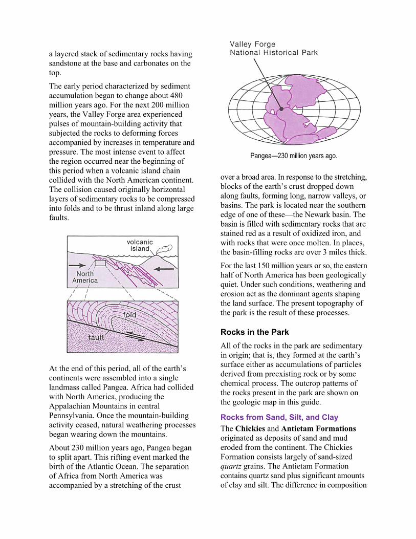
About 230 million years ago, Pangea began to split apart. This rifting event marked the birth of the Atlantic Ocean. The separation of Africa from North America was accompanied by a stretching of the crust
Pangea—230 million years ago.
over a broad area. In response to the stretching, blocks of the earth’s crust dropped down along faults, forming long, narrow valleys, or basins. The park is located near the southern edge of one of these—the Newark basin. The basin is filled with sedimentary rocks that are stained red as a result of oxidized iron, and with rocks that were once molten. In places, the basin-filling rocks are over 3 miles thick.
For the last 150 million years or so, the eastern half of North America has been geologically quiet. Under such conditions, weathering and erosion act as the dominant agents shaping the land surface. The present topography of the park is the result of these processes.
Rocks in the Park
All of the rocks in the park are sedimentary in origin; that is, they formed at the earth’s surface either as accumulations of particles derived from preexisting rock or by some chemical process. The outcrop patterns of the rocks present in the park are shown on the geologic map in this guide.
Rocks from Sand, Silt, and Clay
The Chickies and Antietam Formations originated as deposits of sand and mud eroded from the continent. The Chickies Formation consists largely of sand-sized quartz grains. The Antietam Formation contains quartz sand plus significant amounts of clay and silt. The difference in composition
is a reflection of the environment in which the two rocks formed.
Currents and wave action keep smaller particles suspended in water. As a result, clay and silt do not collect on beaches. Sand grains, on the other hand, are large and heavy enough that they do accumulate in the beach environment. Suspended particles are carried offshore, where quieter water allows them to settle to the bottom.
Carbonates
Calcite (calcium carbonate) and dolomite (calcium and magnesium carbonate) are the most common carbonate minerals. Calcite is the major constituent of limestone, the predominant rock type of the Elbrook and Conestoga Formations, which underlie the valley to the south of the park. Dolostone is a rock largely composed of dolomite. The Ledger Formation, a dolostone, underlies the area east and south of Mount Joy. Some carbonates form as chemical precipitates directly from seawater. Others are formed by marine organisms, such as coral, that extract calcium and carbonate from seawater to construct their shells.
Carbonates have many uses in society. Limestone is used in concrete, agricultural lime, and as a flux in the manufacture of steel. During the nineteenth century, Port Kennedy was an important industrial center supported by local limestone quarries. Dolostone is used as a lining in high-temperature furnaces, for pharmaceuticals, and as a source of magnesium. The Ledger Formation, a high-purity dolostone, supported a magnesium-mining operation in the park until 1976. Several quarries are all that remain of these industries today (see discussion of geologic sites 1 and 2 in this guide).
Red Beds
The red sandstones and shales of the Stockton Formation, which underlie the northern and eastern parts of the park, were
deposited around 200 million years ago in the Triassic Period. During this time, Pangea was breaking apart and the Newark basin was being formed. The area around the park was very different then. During rainy periods, rivers carried sediment from the surrounding highlands into the long, narrow valley. Particles of clay and silt settled in lakes occupying the valley floor. During dry spells, the lakes dried up, leaving exposed mudflats. Periodically, earthquakes and volcanic eruptions jarred the region.
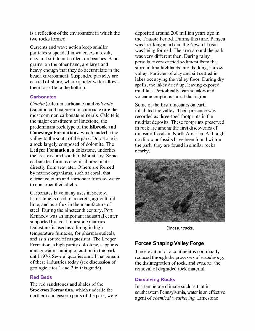
Some of the first dinosaurs on earth inhabited the valley. Their presence was recorded as three-toed footprints in the mudflat deposits. These footprints preserved in rock are among the first discoveries of dinosaur fossils in North America. Although no dinosaur fossils have been found within the park, they are found in similar rocks nearby.
Dinosaur tracks.
Forces Shaping Valley Forge
The elevation of a continent is continually reduced through the processes of weathering, the disintegration of rock, and erosion, the removal of degraded rock material.
Dissolving Rocks
In a temperate climate such as that in southeastern Pennsylvania, water is an effective agent of chemical weathering. Limestone
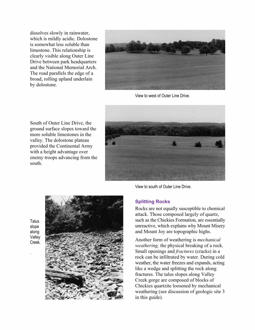
dissolves slowly in rainwater, which is mildly acidic. Dolostone is somewhat less soluble than limestone. This relationship is clearly visible along Outer Line Drive between park headquarters and the National Memorial Arch. The road parallels the edge of a broad, rolling upland underlain by dolostone.
South of Outer Line Drive, the ground surface slopes toward the more soluble limestones in the valley. The dolostone plateau provided the Continental Army with a height advantage over enemy troops advancing from the south.
Talus slope along Valley Creek.
.
View to west of Outer Line Drive.
View to south of Outer Line Drive.
Splitting Rocks
Rocks are not equally susceptible to chemical attack. Those composed largely of quartz, such as the Chickies Formation, are essentially unreactive, which explains why Mount Misery and Mount Joy are topographic highs.
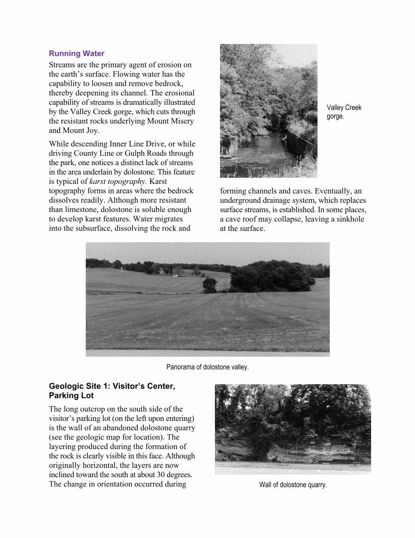
Another form of weathering is mechanical weathering, the physical breaking of a rock. Small openings and fractures (cracks) in a rock can be infiltrated by water. During cold weather, the water freezes and expands, acting like a wedge and splitting the rock along fractures. The talus slopes along Valley Creek gorge are composed of blocks of Chickies quartzite loosened by mechanical weathering (see discussion of geologic site 3 in this guide).

Running Water
Streams are the primary agent of erosion on the earth’s surface. Flowing water has the capability to loosen and remove bedrock, thereby deepening its channel. The erosional capability of streams is dramatically illustrated by the Valley Creek gorge, which cuts through the resistant rocks underlying Mount Misery and Mount Joy.
While descending Inner Line Drive, or while driving County Line or Gulph Roads through the park, one notices a distinct lack of streams in the area underlain by dolostone. This feature is typical of karst topography. Karst topography forms in areas where the bedrock dissolves readily. Although more resistant than limestone, dolostone is soluble enough to develop karst features. Water migrates into the subsurface, dissolving the rock and
Valley Creek gorge.
forming channels and caves. Eventually, an underground drainage system, which replaces surface streams, is established. In some places, a cave roof may collapse, leaving a sinkhole at the surface.
Panorama of dolostone valley.
Geologic Site 1: Visitor’s Center, Parking Lot
The long outcrop on the south side of the visitor’s parking lot (on the left upon entering) is the wall of an abandoned dolostone quarry (see the geologic map for location). The layering produced during the formation of the rock is clearly visible in this face. Although originally horizontal, the layers are now inclined toward the south at about 30 degrees. The change in orientation occurred during
Wall of dolostone quarry.
the mountain-building activity that started about 480 million years ago (see “History of the Rocks” on the first two pages).
Thin, irregular to wavy laminations up to an inch thick are common in some of the rock layers. These stromatolites were formed by mats of interlayered algal colonies and fine sediments on the seafloor. Similar structures in older rocks represent some of the first recorded life on earth. Stromatolites are forming today in Shark Bay on the west coast of Australia.
Stromatolites.
Geologic Site 2: Port Kennedy Quarry
The Port Kennedy quarry is 500 feet north of the lower parking lot of the Visitor’s Center, across County Line Road (see the geologic map for location).
Angular Unconformity: The Missing Layers
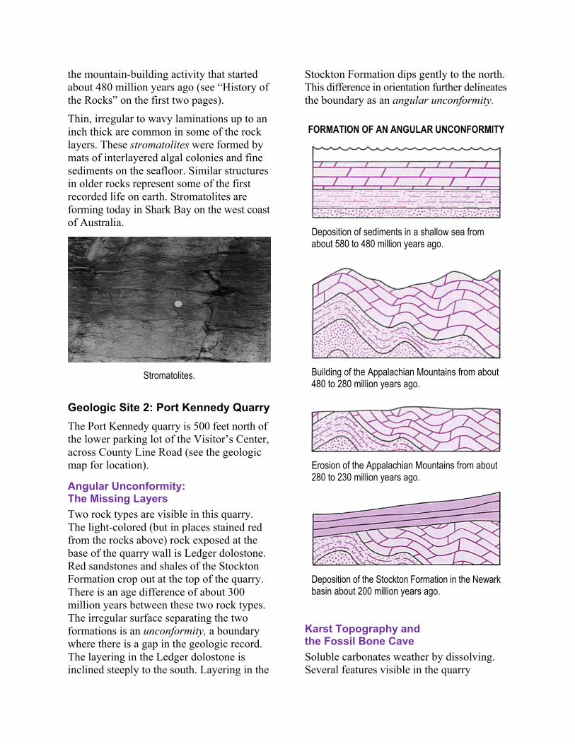
Two rock types are visible in this quarry. The light-colored (but in places stained red from the rocks above) rock exposed at the base of the quarry wall is Ledger dolostone. Red sandstones and shales of the Stockton Formation crop out at the top of the quarry. There is an age difference of about 300 million years between these two rock types. The irregular surface separating the two formations is an unconformity, a boundary where there is a gap in the geologic record. The layering in the Ledger dolostone is inclined steeply to the south. Layering in the
Stockton Formation dips gently to the north. This difference in orientation further delineates the boundary as an angular unconformity.
FORMATION OF AN ANGULAR UNCONFORMITY
Deposition of sediments in a shallow sea from about 580 to 480 million years ago.
Building of the Appalachian Mountains from about 480 to 280 million years ago.
Erosion of the Appalachian Mountains from about 280 to 230 million years ago.
Deposition of the Stockton Formation in the Newark basin about 200 million years ago.
Karst Topography and the Fossil Bone Cave
Soluble carbonates weather by dissolving. Several features visible in the quarry
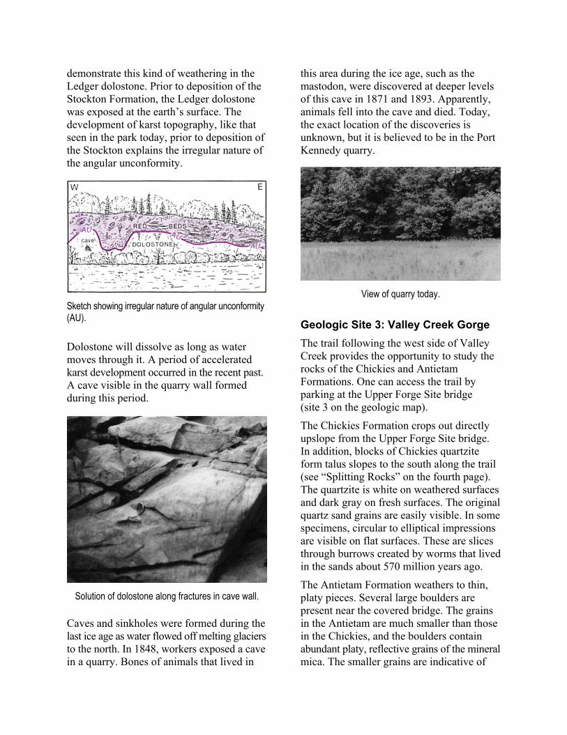
demonstrate this kind of weathering in the Ledger dolostone. Prior to deposition of the Stockton Formation, the Ledger dolostone was exposed at the earth’s surface. The development of karst topography, like that seen in the park today, prior to deposition of the Stockton explains the irregular nature of the angular unconformity.
Sketch showing irregular nature of angular unconformity (AU).
Dolostone will dissolve as long as water moves through it. A period of accelerated karst development occurred in the recent past. A cave visible in the quarry wall formed during this period.
Solution of dolostone along fractures in cave wall.
Caves and sinkholes were formed during the last ice age as water flowed off melting glaciers to the north. In 1848, workers exposed a cave in a quarry. Bones of animals that lived in
this area during the ice age, such as the mastodon, were discovered at deeper levels of this cave in 1871 and 1893. Apparently, animals fell into the cave and died. Today, the exact location of the discoveries is unknown, but it is believed to be in the Port Kennedy quarry.
View of quarry today.
Geologic Site 3: Valley Creek Gorge
The trail following the west side of Valley Creek provides the opportunity to study the rocks of the Chickies and Antietam Formations. One can access the trail by parking at the Upper Forge Site bridge (site 3 on the geologic map).
The Chickies Formation crops out directly upslope from the Upper Forge Site bridge. In addition, blocks of Chickies quartzite form talus slopes to the south along the trail (see “Splitting Rocks” on the fourth page). The quartzite is white on weathered surfaces and dark gray on fresh surfaces. The original quartz sand grains are easily visible. In some specimens, circular to elliptical impressions are visible on flat surfaces. These are slices through burrows created by worms that lived in the sands about 570 million years ago.
The Antietam Formation weathers to thin, platy pieces. Several large boulders are present near the covered bridge. The grains in the Antietam are much smaller than those in the Chickies, and the boulders contain abundant platy, reflective grains of the mineral mica. The smaller grains are indicative of
the quieter environment in which the Antietam accumulated compared to that in which the Chickies accumulated.
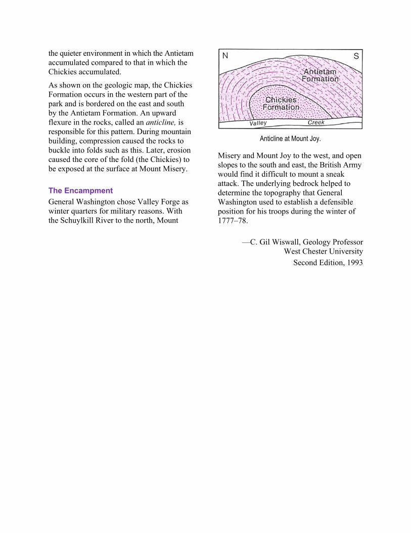
As shown on the geologic map, the Chickies Formation occurs in the western part of the park and is bordered on the east and south by the Antietam Formation. An upward flexure in the rocks, called an anticline, is responsible for this pattern. During mountain building, compression caused the rocks to buckle into folds such as this. Later, erosion caused the core of the fold (the Chickies) to be exposed at the surface at Mount Misery.
The Encampment
General Washington chose Valley Forge as winter quarters for military reasons. With the Schuylkill River to the north, Mount
Anticline at Mount Joy.
Misery and Mount Joy to the west, and open slopes to the south and east, the British Army would find it difficult to mount a sneak attack. The underlying bedrock helped to determine the topography that General Washington used to establish a defensible position for his troops during the winter of 1777–78.
—C. Gil Wiswall, Geology Professor West Chester University
Second Edition, 1993

PREPARED BY
Department of Conservation and Natural Resources Bureau of Topographic and Geologic Survey
LOCATION MAP
Valley Forge National Historical Park 1400 North Outer Line Drive King of Prussia, PA 19406
Phone: 610–783–1099
Modified to page-size format in 2012. Series updated in 2016.