valuation report - city of gladstone 5.3.01... · valuation report vacant land 380 old tannum sands...
TRANSCRIPT
VALUATION REPORT
Vacant Land
380 Old Tannum Sands Road, Tannum Sands QLD 4680
As At 5 June 2012
Prepared For Ergon Energy - Property Acquisition Group
On Behalf Of Gladstone Regional Council
Our Ref GDS044841
Gladstone
Herron Todd White
(Central Queensland) Pty Ltd
ABN 80 556 398 008
ACN 010 463 073
Level 3 / 100 Goondoon Street
PO Box 5102
Gladstone Qld 4680
Telephone: (07) 4972 3833
Facsimile: (07) 4972 5005
Email: [email protected]
Web: www.htw.com.au
Mackay Whitsunday
Rockhampton Bundaberg
Emerald Hervey Bay
Page 1
360 TANNUM SANDS RD, TANNUM SANDS
GDS044841 5 June 2012
Date of Valuation 5 June 2012
Ergon Energy - Property Acquisition Group P O Box 308
Prepared For
Rockhampton QLD 4700
Purpose of Valuation Assessment of Compensation.
Definition of Market Value
Market Value Vacant LandVacant Land
The estimated amount for which an asset should exchange on the date of valuation between a willing buyer and a willing seller in an arm’s length transaction after proper marketing wherein the parties had each acted knowledgeably, prudently and without compulsion.
Applicant Ergon Energy - Property Acquisition Group.
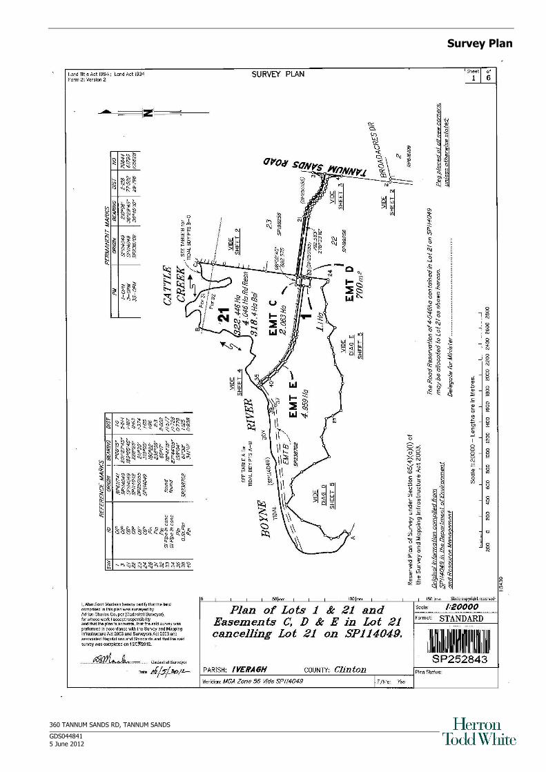
Real Property Description
No
20 McCarthy Rd, Wurdong Heights
Lot 21 SP252843 Parish: Iveragh County: Clinton
Should any encumbrance (apart from Easement B SP238702)not noted within this report be discovered, the valuer should be consulted to reassess any effect on the value stated in this report.
A Local Authority search has not been carried out and it is assumed the property is free of requisitions.
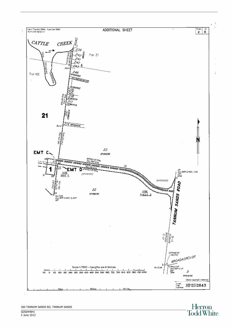
Land Area ha 322.446 hectares exclusive of 4.046 hectares of road reservation Approximate site dimensions: Frontage: Irregular; Depth: Irregular.
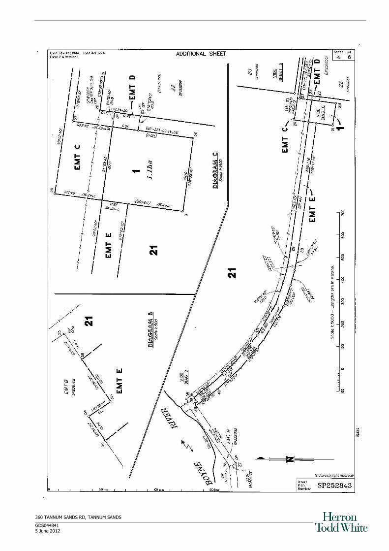
Area to be Resumed Freehold Lot 1 SP252843 1.100 hectares
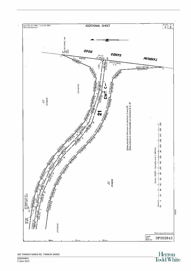
Easement C in Lot 21 SP252483 2.063
Easement D in Lot 21 SP252483 0.070
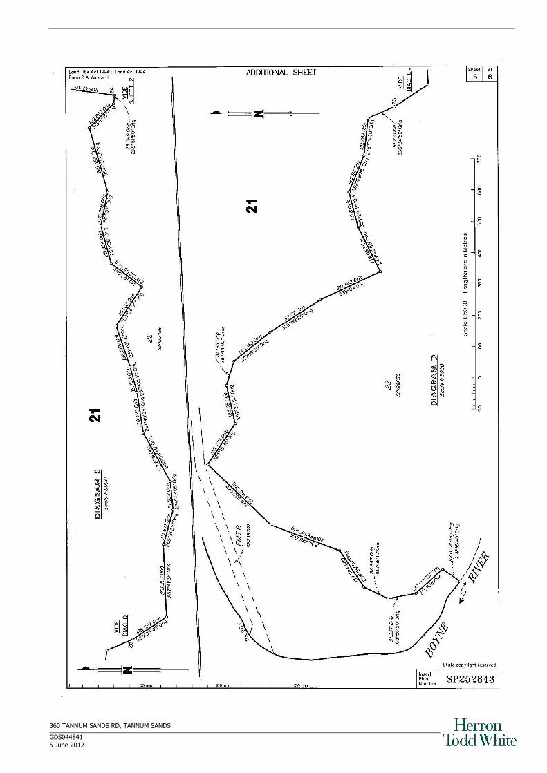
Easement E in Lot 21 SP252483 4.959
Registered Proprietor Calliope Shire Council (now Gladstone Regional Council).
Local Authority Gladstone Regional Council.
Town Planning` The property lies within the “Community Use” zone under the Calliope Shire Council Town Plan.
The existing improvements and current use appear to conform with the intentions of this “Community Use ” zone.
It should be noted that we have not sighted any town planning approvals for the subject property. Our valuation is based on the assumption that all of the improvements have been fully approved by the Council.
Services Electricity, sewerage, telephone and town water are connected to the property. Old Tannum Sands Rd is a bitumen road.
City centre/Regional shops – 30 kilometres (Gladstone) Shops: Suburban shops – 6 kilometres (Tannum Sands)
Amenities
Schools: 3.7 kilometres (Tannum Sands)
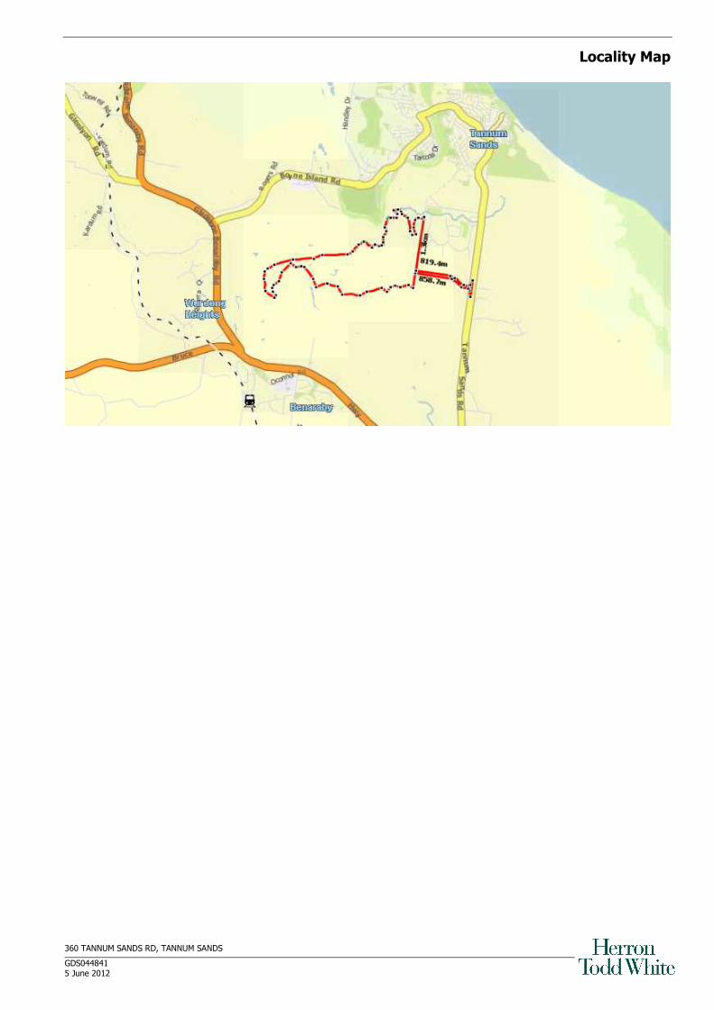
Location Pacific Ranch is a small, average, rural residential suburb of Tannum Sands situated approximately 30 kilometres south of Gladstone. Small sub-regional shopping centres, primary school and high school are within 6 kilometres at Boyne Island/Tannum Sands. Major facilities are located at Gladstone.
We have identified the property from the Cadastral Map attached.
Neighbourhood Located in an established rural/residential and rural area of Tannum Sands. Surrounding development comprises highset and lowset dwellings of an average to good quality standard, vacant rural residential lots and land used for stock grazing.
Page 2
360 TANNUM SANDS RD, TANNUM SANDS
GDS044841 5 June 2012
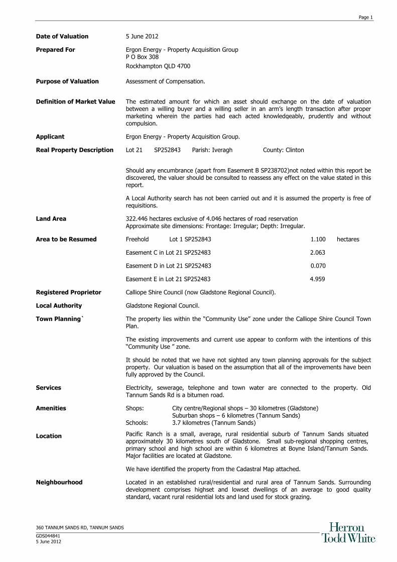
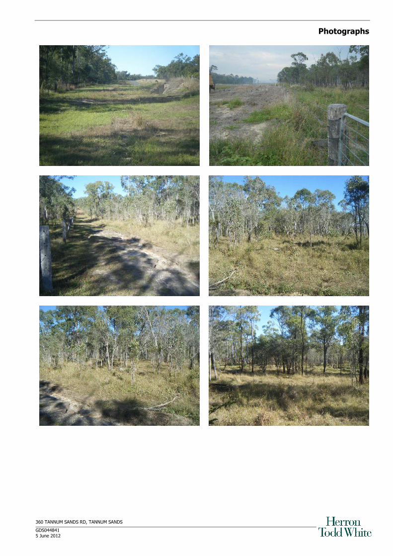
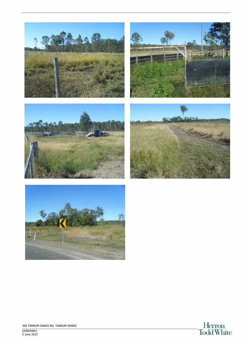
Site Description Irregularly shaped inside lot comprising gently undulating partly developed bluegum, gumtop box and mahogany forest flats fronting the Boyne River rising to low tea tree, bluegum, narrow leaf ironbark, bloodwood and quinine forest ridges. That part over which the easement is to be acquired comprises fair to fairly good selectively cleared flats to old rung flats and low ridges which have been rung/tordoned with nil to heavy regrowth. Parts established to improved pasture. Some Giant Rats Tail Grass infestation, significant in some areas.
Improvements That part which is to be acquired is improved with:
- stock fencing which crosses the easement areas at a 90 degree angle,
- bitumen 2 lane road (private Council access to sewerage plant)
A set of portable cattle yards may encroach slightly onto the easement area. We are informed by Mr G Kelsey, Ergon, that the lessee who owns the yards can be given notice to vacate at any time by the owner. We therefore consider that the lessee does not have a compensable interest in the land. All of the above improvements are located on the easement areas. Lot 1 (freehold) is unimproved
The balance (retention area) is improved with the Tannum Sands Sewerage plant, a private 2 lane bitumen sealed road stock and fencing. Those improvements are not adversely affected by the easement.
Environmental Statement To the best of the valuer’s knowledge, the land is not affected by unstable, hazardous or toxic soil material; however, no searches have been undertaken in this regard. If you have any concerns, we recommend that you appoint a contamination consultant to confirm the state of the land inspected.
The easement area, except for a small section on the eastern end, is subject to flooding from the Boyne River. The whole of the area to be acquired has a risk of containing acid sulphate soils.
The right is reserved to review and, if necessary, vary the valuation figure if any contamination or other environmental hazard is found to exist.
Restrictions/Limitations
To the best of the valuer’s knowledge the subject property is not affected by heritage, landslip or resumption matters, however, no searches have been undertaken in this regard.
We have not undertaken a formal search to confirm whether or not the property is subject to flooding or other impediments caused by excess water saturation and/or flood.
Valuation Rationale The Direct Comparison Approach is considered the most appropriate method of valuation. In this approach the property to be valued is directly compared to recent sales of similar property to establish a current market value.
Sales Evidence The property is zoned “Community Use”. We are not aware of any sales of property with a comparable zoning. The uses to which the site can be put are very restricted. We are not aware of any sales of lots with similar restrictions . We have relied on sales of grazing lands in more remote areas ( allowing a significant premium for the location of the subject) and sales of well located but much smaller lots with superior zoning. Recent sales in the area include:
Address Sale Date Sale Price
Lot 50 Wooderson Rd, Wooderson 09/03/2009 $620,000
Brief Comments: Comprises partly cleared partly rung forest ridges and hollows. Access to water board
pipeline, seasonal creek. Improved with yards and shed. Land Area 242.76 ha. Reflects $2,472 per ha as cleared fenced and watered. In Comparison to Subject: Smaller lot, inferior location, superior improvements. Overall inferior.
` 1000 Tableland Rd, Wooderson 06/01/2010 $750,000
Brief Comments: Comprises bluegum hollows, part cleared and cultivated back to old rung, gently to moderately undulating ridges. Watered by 3 dams and semi-permanent creek. Improved with an older 3 bedroom dwelling, timber yards and 4 sheds. Land Area 259 ha. Reflects $2,394 per ha as cleared fenced and watered. In Comparison to Subject: Smaller lot, inferior location, inferior quality country, far superior improvements. Overall inferior.
Page 3
360 TANNUM SANDS RD, TANNUM SANDS
GDS044841 5 June 2012
Sales Evidence Contd Lot 68 Tableland Rd, Wooderson 08/01/2010 $430,000
Brief Comments: Comprises old rung gently undulating forest ridges. Watered by 2 dams and permanent creek. Improved with timber yards in good condition. Approx. 161 ha (Lot 102) is held under a term lease. Land Area 298.53 ha. After deduction of the term lease and timber yards the sale reflects $2,921 per hectare for the freehold land. In Comparison to Subject: Smaller lot, inferior location, superior lot improvements. Overall inferior.
89 Diamintina Dr, Wurdong Heights 03/02/2012 $450,000
Brief Comments: Elevated moderately to steeply sloping forest ridges and ranges. Very good ocean views to north and east. Good rural views for balance. Severed by easement in the west. Vacant. Land area 63.79 ha. Reflest $7,055 per hectare. In Comparison to Subject: Smaller lot, similar location, superior zoning, inferior quality country. Overall inferior.
Lot 8 Deep Creek Rd, Wooderson 19/03/2012 $260,000
Brief Comments: Moderately to part steeply sloping forest ridges, old rung with some regrowth. Rural views. Vacant. Land area 77.07 ha. Reflects $3,373 per hectare. In Comparison to Subject: Smaller lot, infgerior location, superior zoning, inferior quality country. Overall inferior.
Effect of the Resumption The resumption is being undertaken as part of the power line to service Boyne Island and Tannum Sands. The construction will comprise an overhead 66kV line with concrete poles and an overhead 11kV line with timber poles.
The parent parcel is the site of the Tannum Sands sewerage treatment plant. A large part of the site (and part of Easement E) falls within the buffer zone of the plant.
Mr Mark Larney, Gladstone Regional Council, has advised us that:
• The site is used as a sewerage treatment plant with a 1 kilometre buffer around the plant
• Other potential uses for the site would be for sporting purposes
The easement area to be acquired is currently used for cattle grazing. It has potential for sporting fields as demand requires. The 1 kilometre buffer zone detracts.
It appears the resumption will result in:
• Loss of 1.1 ha of freehold
• Encumbrance of 7.092 ha (2.2%) of the site with easements for overhead power lines
• Severance of the lot though an existing bitumen road (existing access to the sewerage plant) already severs the site on the same alignment as the easements though offset from the easement areas by between 5 and 25 metres.
Page 4
360 TANNUM SANDS RD, TANNUM SANDS
GDS044841 5 June 2012
Calculation of Compensation
Based on the sales above we consider the property has a value of $7,000 per hectare. Our calculations are as follow: Loss of freehold land 1.1 ha @ $7,000 per ha $ 7,700 Loss of value to easement area 7.092 ha @ $7,000 per ha at 33% diminution 16,383 Total Loss in Value $24,083 Adopt $24,000
We assess compensation payable as a result of the resumption of Lot 1 SP252843 and Easements C-E SP252483 at $24,000 (Twenty Four Thousand Dollars).
ASSESSMENT
In addition will be reasonable valuation and legal fees incurred in preparation of the claim for compensation.
Chris Roffey Certified Practising Valuer AAPI/1189
Certification and Qualifications:
Improvements We advise that this valuation assumes that all improvements have been constructed in accordance with the appropriate planning and building regulations in force at the time of construction, and that all appropriate approvals have been obtained from the relevant authorities. The valuation inspection and report does not constitute a structural survey and is not intended as such. The valuer has carried out an inspection only of the exposed and readily accessible areas of the improvements. The valuer is not a construction nor a structural engineering expert and is therefore unable to certify the structural soundness of the improvements. Readers of this report should make their own enquiries. This valuation has been based on the known and assumed condition of the structural improvements and the property in general as at the inspection date, and if the property has to be sold in circumstances where its condition has deteriorated and/or essential fixtures/fittings removed there is likely to be a significant write down in the asset value when compared to the current assessment. Under these circumstances the valuer will be not be responsible for any reduction in value. Should any adverse improvement concerns become apparent, the valuer should be consulted and reserves the right to reassess any affect on the value stated in this report. Land Dimensions / Area We advise that we been provided with a copy of the Survey Plan and that any dimensions or land areas quoted in this report have been obtained from that source and whilst endeavours have been made to verify such information we accept no responsibility for inaccuracy of any information provided and relied upon. Site Survey / Encroachments We advise that a survey report has not been sighted and our inspection has revealed that there do not appear to be any encroachments upon or by the property. Survey pegs were not located and this valuation assumes correct boundary alignment. This valuation is made on the assumption that there are no encroachments by or upon the property and that this should be confirmed by a current survey report and/or advice from a registered surveyor. We are not surveyors. Should any encroachments or other affectations be noted by the survey report, the valuer should be consulted and reserves the right to reassess any affect on the value stated in this report. Easements and Encumbrances We advise that this valuation is based on the assumption that there are no easements (apart from Easement B SP238702)or encumbrances or other title defects which would have any adverse effect on the value or marketability of the property. We recommend that a full title search be carried out and that until such time as that search is undertaken and considered by the valuer, no reliance should be placed on the valuation report. Should any such easement or encumbrance or other like affectation on title become apparent, the valuer should be consulted and reserves the right to reassess any affect on the value stated in this report.
Page 5
360 TANNUM SANDS RD, TANNUM SANDS
GDS044841 5 June 2012
Town Planning, Building and Other Searches We advise that a search with the appropriate Council or other relevant authorities has not been carried out or has not been obtained and therefore this valuation has been undertaken on the assumption that all necessary and appropriate town planning and/or building, consents, approvals and certifications have been issued for the use and occupation of the improvements as more fully described in this report. It is recommended that all appropriate consents, approvals and/or certifications as referred to above be obtained. Should any affectations become apparent, the valuer should be consulted and reserves the right to reassess any affect on the value stated in this report. Pest & Termite Infestation We advise that the inspection of the subject property did not reveal any obvious visible pest or termite infestation within reasonably accessible areas to the valuer. The client acknowledges and recognises that the valuer is not a pest inspector / pest expert. The absence of pests, including termites, can only be confirmed by a suitably qualified expert after a comprehensive inspection and the use of specialist equipment. Should any pest or termite infestation concerns become apparent, the valuer should be consulted and reserves the right to reassess any affect on the value stated in this report. Utility Services We advise that the valuer has not tested any of the services. Should any utility service concerns become apparent, the valuer should be consulted and reserves the right to reassess any affect on the value stated in this report. Flood Search We advise that we have not undertaken a formal search to confirm whether or not the property is subject to flooding or other impediments caused by excess water saturation. Should any flooding or other impediments caused by excess water saturation concerns become apparent, the valuer should be consulted and reserves the right to reassess any affect on the value stated in this report. Environmental / Contamination We advise that the inspection of the subject property did not reveal any obvious visible environmental or contamination concerns to the valuer. The client acknowledges and recognises that the valuer is not an expert in identifying environmental or contamination hazards and compliance requirements affecting properties. The valuer will not be held liable nor responsible for his/her failure to identify all such matters of environmental or contamination concern and the impact which any environmental or contamination related issue has on the property and its value including loss arising from site contamination; or the non-compliance with environmental laws; or costs associated with the clean up of the property to which an environmental hazard has been recognised, including action by the Environmental Protection Agency to recover clean up costs pursuant to the relevant Environmental Protection Act. Should any environmental or contamination concerns become apparent, the valuer should be consulted and reserves the right to reassess any affect on the value stated in this report. Reliance and Disclosure The report has been prepared for the private and confidential use by the party to whom it is addressed. This valuation is for the use of and may be relied upon only by the party/parties to whom it is addressed. No other parties are entitled to use or rely upon it and Herron Todd White does not assume any liability or responsibility to any other party who does so rely upon the valuation without the express written authority of Herron Todd White. Neither the whole nor any part of this valuation or any reference thereto may be included in any published documents, circular or statement, nor published in part or full in any way, without the written approval from Herron Todd White including the form and context in which it may appear. Market Movement & Report Expiry This valuation is current as at the date of valuation only. The value assessed herein may change significantly and unexpectedly over a relatively short period (including as a result of general market movements or factors specific to the particular property). We do not accept liability for losses arising from such subsequent changes in value. Without limiting the generality of the above comment, we do not assume any responsibility or accept any liability where this valuation is relied upon after the expiration of 3 months from the date of the valuation, or such earlier date if you become aware of any factors that have any effect on the valuation. Comparative Sales Evidence The comparative sales used in this valuation report are considered the most relevant sales based on our research, both in terms of physical comparability to the subject property and allowing for market changes between comparable sales and valuation date. In many cases, we have not physically inspected the interior of the sales evidence quoted and have relied on sales evidence as recorded in available property sales databases. We therefore cannot guarantee the accuracy of the information provided. Full Disclosure & Reasonably Available Information The instructing party acknowledges its responsibility for full disclosure of relevant information and undertakes to provide all documents in its possession that may have an affect on the service to be provided. This valuation is based upon information reasonably available to the valuer as at the date of issue in accordance with usual valuation practices. GST Our valuation is on the basis the property is input taxed and free of GST. We are not privy to the financial circumstances of the current owner(s) nor previous transactions upon the property which may impact upon the status of the property in relation to GST. Should the property not qualify as GST free, our assessment is inclusive of GST. Definition of Market Value The estimated amount for which a property should exchange on the date of valuation between a willing buyer and a willing seller in an arm’s-length transaction after proper marketing wherein the parties had each acted knowledgeably, prudently, and without compulsion. Service-Providing Entity The entity which has provided this valuation is solely the entity named on this report (with its associated ACN/ABN). No other entity forming part of or associated with the Herron Todd White Group is liable. From time to time, the associated invoice for services may be issued by another Herron Todd White entity other than the service-providing entity named on this report. If this occurs, no professional liability is extended to the entity named on the invoice.
Page 6
360 TANNUM SANDS RD, TANNUM SANDS
GDS044841 5 June 2012
Conflict of Interest Neither the valuer, nor to the best of their knowledge, any member of this firm, has any conflict of interest, or direct, indirect or financial interest in relation to this property that is not disclosed herein. Liability Limited by a Scheme Liability limited by a scheme approved under Professional Standards Legislation. The scheme does not apply within Tasmania. Full Payment The instructing party will not rely or be able to rely on the valuation until payment is made in full, or if it does so rely without our express consent, then it warrants that in doing so it does rely at its own risk on the basis that it accepts that we do not accept or assume responsibility for the valuation, and that in doing so there is a total failure of consideration in respect to that valuation service in respect to that retainer.
Annexures
Photographs Locality Map Survey Plans
360 TANNUM SANDS RD, TANNUM SANDS
GDS044841 5 June 2012
Photographs
360 TANNUM SANDS RD, TANNUM SANDS
GDS044841 5 June 2012
360 TANNUM SANDS RD, TANNUM SANDS
GDS044841 5 June 2012
Locality Map
360 TANNUM SANDS RD, TANNUM SANDS
GDS044841 5 June 2012
Survey Plan
360 TANNUM SANDS RD, TANNUM SANDS
GDS044841 5 June 2012
360 TANNUM SANDS RD, TANNUM SANDS
GDS044841 5 June 2012
360 TANNUM SANDS RD, TANNUM SANDS
GDS044841 5 June 2012
360 TANNUM SANDS RD, TANNUM SANDS
GDS044841 5 June 2012
360 TANNUM SANDS RD, TANNUM SANDS
GDS044841 5 June 2012
360 TANNUM SANDS RD, TANNUM SANDS
GDS044841 5 June 2012