values of protected landscapes and seascapes - cbd of protected... · 2013-06-28 · values of...
TRANSCRIPT

Protected Landscapes and Agrobiodiversity Values1
Values of Protected Landscapes and Seascapes
Edited byThora Amend, Jessica Brown, Ashish Kothari, Adrian Phillips and Sue Stolton
A series published by
the Protected Landscapes Task Force of IUCN´s World Commission on Protected Areas


Values of Protected Landscapes and Seascapes

ISBN 978-3-92506448-7
Bibliographic information published by the Deutsche NationalbibliothekThe Deutsche Nationalbibliothek lists this publication in the
Deutsche Nationalbibliografie; detailed bibliographic data
are available in the Internet at http://dnb.d-nb.de
CitationAmend T., Brown J., Kothari A., Phillips A. and Stolton S.
(eds.) 2008. Protected Landscapes and Agrobiodiversity
Values. Volume 1 in the series, Protected Landscapes and
Seascapes, IUCN & GTZ. Kasparek Verlag, Heidelberg.
AddressesIUCN – The World Conservation Union
Rue Mauverney 28
Gland 1196, Switzerland
www.iucn.org
Deutsche Gesellschaft für Technische
Zusammenarbeit (GTZ) GmbH
Postfach 5180
65726 Eschborn, Germany
www.gtz.de

Protected Landscapes and Agrobiodiversity Values
Values of Protected Landscapes and Seascapes
Edited byThora Amend, Jessica Brown, Ashish Kothari, Adrian Phillips and Sue Stolton
A series published by
the Protected Landscapes Task Force of IUCN´s World Commission on Protected Areas
Publisher Published on behalf of GTZ and IUCN by:
Kasparek Verlag
Mönchhofstr. 16
69120 Heidelberg
www.kasparek-verlag.de
Layoutkunse.com
Printedand bound in Germany on PlanoArt, a paper certified by the
Forest Stewartship Council (FSC).
Copyright© IUCN & GTZ, 2008. All rights reserved. Reproduction for
non-commercial purposes is permitted provided the source
is fully acknowledged. It is requested to send a copy of any
reproduction made to GTZ.

5
Preface by Thora Amend, Jessica Brown, Ashish Kothari, Adrian Phillips and Sue Stolton
Protected landscapes and biodiversity values: an overview by Adrian Phillips and Sue Stolton
Agrobiodiversity in the farmscapes of the Quijos River in the tropical Andes, Ecuador by Fausto O. Sarmiento
The impact of native versus introduced livestock in the Chimborazo Faunal Production Reserve, Ecuador by Julie S. Rosenthal
Agrobiodiversity conservation in the Garrotxa Volcanic Zone Natural Park, Spain: Experience and recommendations for future directions by Emili Bassols Isamat, Jordi Falgarona Bosch, Josep M. Mallarach Carrera and Bernat Perramon Ramos
The Potato Park, Peru: Conserving agrobiodiversity in an Andean Indigenous Biocultural Heritage Area by Alejandro Argumedo
Conservation by consumption: in situ conservation of agrobiodiversity in the Rhön UNESCO-Biosphere Reserve, Germany by Doris Pokorny
Evolving culture, evolving landscapes: The Philippine rice terraces by Cristi Nozawa, Melissa Malingan, Anabelle Plantilla and Je-el Ong
Agrobiodiversity in the Stara Planina Mountain Nature Park, Serbia by Sergej Ivanov
Conserving agrobiodiversity on the Gaspé Peninsula of Québec, Canada: A potential role for Paysage Humanisé designation by Adrienne Blattel, Gilles Gagnon, Jessica Brown and Jean-Claude Côté
The Borana conserved landscape, Ethiopia by Marco Bassi and Boku Tachi
Conserving agrobiodiversity in England’s Protected Landscapes by Lyndis Cole in co-operation with Adrian Phillips
Community conservation of agrobiodiversity in and around protected areas: Experiences from western Nepal by Resham Gautam, Bimal Raj Regmi, Pitamber Shrestha, Diwakar Poudel and Pratap Shrestha
Canyon de Chelly National Monument, USA: Navajo farming traditions and agrobiodiversity by Jessica Brown, adapted from Rolf Diamant et al 2007
7
22
31
33
45
59
71
94
96
105
116
129
138
8
6
About the Editors
Thora AmendThora Amend, ethnologist and geographer, has more than 20
years of working experience in Latin America as a university
teacher and international consultant. She coordinates various
initiatives in the field of development oriented conservation,
mainly for German development cooperation (GTZ). Thora
is a member of the World Commission on Protected Areas
(WCPA), TILCEPA, the Task Force on Protected Landscapes,
and of different working groups on protected area manage-
ment, equity and governance. She is co-editor of two series:
“Parques Nacionales y Conservación Ambiental” (National
Parks and Environmental Conservation) and “Sustainability
has many faces”, and founding member of the NGO
“Aprender con la Naturaleza” (Learning with Nature).
Thora Amend
Bahnhofstr. 9
79725 Laufenburg, Germany
Email: [email protected]
Jessica BrownJessica Brown is Senior Vice President for International
Programs at the Quebec- Labrador Foundation/Atlantic Center
for the Environment (QLF), a bi-national NGO working in rural
areas the northeastern United States and eastern Canada,
with international exchange programs in the Caribbean, Latin
America, Central and Eastern Europe, and the Middle East.
Her work focuses on landscape stewardship, private land con-
servation, and community involvement in protected areas. She
is Chair of the Protected Landscapes Task Force of IUCN's
World Commission on Protected Areas (WCPA) and serves
as WCPA‘s Deputy Vice Chair for North America. She has
edited and/or contributed to a variety of publications on top-
ics related to protected landscapes, most recently serving as
lead editor for The Protected Landscape Approach: Linking
Nature, Culture and Community.
Jessica Brown
Quebec-Labrador Foundation/Atlantic Center for the
Environment (QLF)
55 South Main Street
Ipswich, MA 01938, U.S.A.
Email: [email protected]
Ashish KothariAshish Kothari is the founder of Kalpavriksh Environmental
Action Group in 1979, Ashish taught at the Indian Institute of
Public Administration, and has participated in several grass-
roots movements. He heads TILCEPA, the IUCN WCPA-CEESP
Strategic Direction on Governance, Equity, Communities, and
Livelihoods. He has coordinated India’s National Biodiversity
Strategy and Action Plan process, and helped draft the
National Wildlife Action Plan. He has also served on the
Board of Directors of Greenpeace International, and has
authored or edited over 20 books on environmental issues.
Ashish Kothari
Apt. 5 Shree Dutta Krupa
908 Deccan Gymkhana
Pune 411004, India
Email: [email protected]
Adrian PhillipsAdrian Phillips trained as a planner and geographer. He
worked in London, Kenya and Switzerland for the gov-
ernment, the United Nations Environment Programme
and IUCN. He was later Director General of the UK
Countryside Commission (1981-1992), and then profes-
sor at Cardiff University until 2000. He chaired the IUCN
World Commission on Protected Areas (1994-2000), and
has worked closely with the World Heritage and European
Landscape Conventions. He wrote the Category V
Management Guidelines (published in 2002) and was the
series editor for the first 12 publications in the WCPA Best
Practice Guidelines series. He is a member of the Category
V Task Force of WCPA. He has written and lectured on land-
scape and now serves on the boards of several major con-
servation NGOs in the UK.
Adrian Pillips
2 The Old Rectory
Dumbleton, Evesham, WR11 7TG, United Kingdom
Email: [email protected]
Sue StoltonSue Stolton is an environmental consultant. Her work cur-
rently focuses mainly on issues relating to protected areas,
in particular with respect to international conventions,
and biodiversity and organic agriculture. She established
Equilibrium Research in partnership with Nigel Dudley in
1991. Equilibrium promotes positive environmental and social
change by linking targeted research to field application. She
works with groups ranging from local communities to United
Nations agencies in countries worldwide. Sue is a member
IUCN’s World Commission on Protected Areas (WCPA).
Sue Stolton, Equilibrium
47 The Quays, Cumberland Road
Spike Island, Bristol, BS1 6UQ, United Kingdom
Email: [email protected]

7
Preface: Introducing a new series
Some lived-in landscapes are so important for conserva-tion and sustainable development that they deserve special protection. Where effective national or local conservation measures are in place, many of these lived-in landscapes have been recognised by IUCN as Category V protected areas – Protected Landscape and Seascapes. As protected areas based on the interactions of people and nature over time, they play an important role in sustaining biological and cultural diversity.
The many different kinds of values that such places can provide need to be better understood so that the full potential of the Protected Landscape approach can be realised around the world. The Protected Landscapes Task Force of IUCN’s World Commission on Protected Areas (WCPA) has begun to document these values through Category V Management Guidelines (Phillips 2002), a special number of PARKS on Category V Protected Areas (Beresford 2003), and a book, The Protected Landscape Approach (Brown et al 2005). This work has been under-taken in concert with WCPA’s broader effort to encourage the wider adoption of all six protected area management categories.
But there is a need for more detailed examination, explanation and advocacy to promote a wider understand-ing of the range of benefits that Category V protected areas can offer, especially as some of these cover matters that are not always familiar territory for IUCN.
This is why we are launching a new series of publica-tions, in partnership with other organisations, on the values of Protected Landscapes and Seascapes. The series as a whole is intended to document and spell out the various environmental, economic, social and cultural values that this category can provide. Individually each publication will illustrate the respective value by use of a number of case studies, preceded by a synthesis section that will draw out the lessons learnt.
The first volume addresses the topic of agrobiodiver-sity. We believe that Category V protected areas should provide a way of conserving agrobiodiversity in situ, supported by the efforts of local communities and, at the same time, contributing to the protection of landscape and wild biodiversity. We intend soon to follow this with two further volumes on the significance of Category V: the conservation of ‘wild’ biodiversity values; and the con-servation of cultural and spiritual values. Further volumes will follow, at a pace largely dictated by the availability of resources.
This publication would not have appeared without the sustained support and interest provided by the Deutsche Gesellschaft für Technische Zusammenarbeit
(GTZ) GmbH. We are indeed indebted to them and to a consortium of statutory conservation agencies in the United Kingdom: The Countryside Council for Wales, Natural England and Scottish Natural Heritage. Together with GTZ these agencies have provided the funding to launch this series with the present volume.
We also wish to thank Tejaswini Apte for her continu-ous support in editing this publication.
Thora Amend, Jessica Brown, Ashish Kothari, Adrian Phillips and Sue Stolton (the Editorial Team)
ReferencesBeresford, M (ed.), 2003. PARKS, Vol. 13(2), Category V.
Brown, J., Mitchell N. and Beresford M. (eds.) 2005. The
Protected Landscape Approach. Linking Nature, Culture and
Community. IUCN, Gland & Cambridge.
Phillips, A. 2002. Management Guidelines for IUCN Category
V Protected Areas – Protected landscapes/seascapes. IUCN,
Gland & Cambridge.

8
Category V protected areas – Protected Landscapes and Seascapes – are defined by IUCN as areas “of land, with coasts and seas as appropriate, where the interaction of people and nature over time has produced an area of dis-tinct character with significant aesthetic, ecological and/or cultural value, and often with high biological diversity. Safeguarding the integrity of this traditional interaction is vital to the protection, maintenance and evolution of such areas” (IUCN 1994).
Since they are lived-in, working landscapes, this category of protected areas would appear to provide a potential mechanism for conserving agrobiodiversity. This is the thesis that this volume sets out to test through the use of case studies. In particular, this volume seeks to determine the value of Category V protected areas in the conservation of agrobiodiversity, and what lessons can be learnt from experience in this regard.
This introductory chapter is in three parts:• We ask, and try to answer, three basic questions about
agrobiodiversity and protected areas. • We discuss the wider context for the conservation of
agrobiodiversity.• We present an overview of our findings based on an
analysis of the case studies that follow.
Some basic questionsWhat is agrobiodiversity?1
The Food and Agriculture Organization of the United Nations (FAO) defines ‘agrobiodiversity’ as the variety and variability of animals, plants and micro-organisms that are important to food and agriculture, and which result from the interaction between the environment, genetic resources and the management systems and practices used by people (FAO 1999). It includes, therefore, two groups in particular: (1) the wild relatives of domesticated species (for example crop wild relatives from which cultivated crops originated, or which are closely enough related to provide useful breeding material); and (2) individual breeds of domesticated species of livestock and crops2 (in the case of crops, known as landraces).
Does biodiversity include agrobiodiversity?The Convention on Biological Diversity (CBD) is explicit that biodiversity includes varieties of livestock and crops as well as wild biodiversity,3 and thus conservation action under the convention includes the conservation of agrobio-diversity. Moreover, it defines in situ conservation in these terms: “the conservation of ecosystems and natural habitats and the maintenance and recovery of viable populations of species in their natural surroundings and, in the case of domesticated or cultivated species, in the surroundings where they have developed their distinctive properties” (United Nations 1992, Article 2, with emphasis added).
IUCN has so far focused mainly on the conservation of wild biodiversity. But it has nonetheless recognised the importance of conserving agricultural genetic resources for at least 25 years, since the publication of the World Conservation Strategy in 1980. So when IUCN uses the term ‘biodiversity’, it is to be presumed that it uses it with the normal scientific meaning attached to it by the CBD, and that it does not mean only wild biodiversity. While there are differing views among IUCN members about the inclusion of agrobiodiversity within the Union’s aims, it appears that in practice IUCN has not challenged the CBD definition of biodiversity and therefore that it recog-nises agrobiodiversity as a constituent part of biodiversity.
Is agrobiodiversity conservation a legitimate purpose of protected areas? While the conservation of agrobiodiversity is important, its place among the purposes of protected areas has been questioned (Locke and Dearden 2005). However, since the CBD’s concept of biodiversity includes agrobiodiversity, it would seem logical that the reference to the protection and maintenance of biological diversity in the IUCN definition of a protected area4 should be interpreted as including agrobiodiversity, just as it clearly is in the CBD’s definition of a protected area5.
There remains a question about what types or proportion of agrobiodiversity might be included within a protected area. If protection of all agrobiodiversity were included as a legitimate purpose for protected areas, then in theory the world’s entire agricultural estate could be classified as a protected area, which is clearly not the intention. So we assume that protection of agrobiodiversity is a legitimate
Protected landscapes and biodiversity values: an overviewAdrian Phillips and Sue Stolton

9
objective for a protected area where it is intended to conserve:• Important crop wild relatives6; • Traditional and threatened landraces, particularly those
reliant on traditional cultural practices; and/or• Traditional and threatened livestock races, especially
if they are reliant on traditional cultural management systems and if such systems are compatible with ‘wild biodiversity’.
The wider context for agrobiodiversity Cultural landscapes and agrobiodiversity Landscapes rich in agrobiodiversity are often the product of complex farming systems that have developed in response to the unique physical conditions of a given loca-tion, such as altitude, slopes, soils, climates and latitude, as well as cultural and social influences. Some systems long managed by indigenous and other traditional people, such as home and spice gardens, may not look like conventional farmland at all, resembling ‘wilderness’ to outsiders. The loss of these diverse systems and related agrobiodiversity has important impacts on human society and on other species (Altieri 1999).
The traditional cultural systems that have often developed over millennia can be closely linked to social stability and food security. For farmers across the world, agrobiodiversity is an insurance against disease and extreme climatic f luctuations, as a coping mechanism in times of scarcity, as a means to enhance overall productivity of their farms, pastures and wetlands, as a source of critical nutrition and medicine, and as a culturally important resource. For example, in Kenya, indigenous seeds have been shown to perform better in harsh drought conditions and thus increase food security (Wairegi 2000). Crop-breeders rely on traditional varie-ties and wild relatives to adapt crops to changing climatic conditions, new diseases and environmental stresses. The loss of traditional systems and their associated species can therefore have a wide range of impacts, including reducing the ability of human communities to survive extreme weather conditions or crop disease, lowering breeding potential, and generally eroding the resilience of agricultural systems.
Trends in agrobiodiversityTraditional land-use patterns, crops and animal breeds are disappearing for a variety of reasons. In most ‘developing’ countries, traditionally home to much of the world’s
agrobiodiversity, monoculture models of agricultural ‘development’ have for decades pushed out diverse traditional systems and encouraged or coerced farmers to switch to a smaller number of varieties. FAO estimates that about 75% of the genetic diversity of agricultural crops has been lost during the last century. A survey of 75 US crop species, carried out by the Rural Advancement Fund International (RAFI), found that 97% of the varieties listed in old United States Department of Agriculture catalogues are extinct (Fowler and Mooney 1990). Equally dramatic losses have been recorded in Europe: in Germany about 90% of the historical diversity of crops has been lost and in Southern Italy about 75% of crop varieties have disappeared (Hammer et al 2002). Even the genetic diversity within these species has declined dramatically. For example, 75% of rice varieties grown in Sri Lanka are descended from one maternal parent, along with 62% in Bangladesh, and 74% in Indonesia (Groombridge 1992).
Animal breeds are also being lost, and around 20% are at risk of extinction. 190 of some 7,600 breeds in the FAO global farm animal genetic resources database have become extinct in the past 15 years; a further 1,500 are considered at risk of extinction (Rischkowsky and Pilling 2007). Some countries have been especially badly hit; in India, for instance, all 18 indigenous breeds of poultry are considered threatened.
The destructive trends in relation to agrobiodiversity have recently been summarised in the Millennium Ecosystem Assessment (MEA): “Genetic diversity has declined globally, particularly among domesticated species. Since 1960 there has been a fundamental shift in the pattern of intra-species diversity in farmers’ fields and farming systems as a result of the ‘Green Revolution’. Intensification of agricultural systems, coupled with specialization by plant breeders and the harmonizing effects of globalization, has led to a substantial reduction in the genetic diversity of domesticated plants and animals in agricultural systems” (MEA 2005, p55).
These losses matter. As the MEA puts it: “Such declines in genetic diversity lower the resilience and adaptability of domesticated species. Some of these on-farm losses of crop genetic diversity have been partially offset by the maintenance of genetic diversity in seed banks. In addition to cultivated systems, the extinction of species and loss of unique populations (including commercially important marine fishes) that has taken place has resulted in the loss of unique genetic diversity contained in those species and populations. This loss reduces overall fitness and adaptive potential, and it limits the prospects for recovery of species whose popula-tions are reduced to low levels” (ibid, p15). It follows that the conservation of agrobiodiversity, both ex situ and in situ, is a priority.
10
Agrobiodiversity and wild biodiversityAs farming practices change, the cultural landscapes that have developed from them are also eroded or abandoned. Such systems often contain much wild biodiversity. Extensive grazing systems on grasslands and prairies (Bradley and Wallis 1996), in savannah lands (Rockström and Steiner 2006), and in open woodland or heath (Webb 1998) can maintain habitats in a state very similar to the original, supporting high levels of biodiversity (West 1993). Artificial habitats such as hedgerows (Green et al 1994), agro-forestry systems (Donald 2004), and remnant natural habitat on farmland (Dover 1997) can all support high wildlife populations in some situations. Large proportions of the species living in a region are likely to be found in agricultural systems (Pimentel et al 1992). Many of the ancient agricultural and agroforestry production systems have associated high wild biodiversity values. In Europe, for example, the thousand hectares of managed chestnut woods that occur in the Parnon mountain range in the eastern Peloponnese (Greece) are an area of extraordinary wildlife diversity with 12 endemic plants and many threatened and rare species (Moussouris and Regato 1999; Beaufoy et al 1995).
Thus, just as varieties of domesticated plants and animals depend on the continuation of traditional farming systems, so many wildlife species are equally reliant on such forms of land management. Indeed in many long-inhabited and long-utilised landscapes, there is a spectrum from ‘cultivated’ to ‘wild’ biodiversity, with occasionally some blurring between the two. It is interesting in this respect that many traditional societies do not make a clear distinction between ‘wild’ and ‘domesticated’. These are seen as forming a continuous spectrum, all being conceived of as part of the web of life.
Conserving agrobiodiversity The Millenium Ecosystem Assessment referred to above provides many good reasons for including agrobiodiversity amongst the forms of biodiversity to be conserved. The homogenisation of food production systems and globalisa-tion of markets marginalises many traditional producers, undermines agrobiodiversity, and degrades landscapes. So the conservation of agrobiodiversity also addresses issues of food security, traditions, culture and identity, as well as the conservation of nature for its intrinsic values. Often, conservation can only be successfully pursued through an approach that involves the whole landscape and associated management systems. These may not necessarily require conserving whole farmed landscapes in their entirety, but at least their essential qualities need to be considered in developing management strategies.
Following lobbying from signatory countries, particu-larly in the developing world, the Third Conference of
Parties (COP) of the CBD in 1996 set up a ‘Programme of Work on Agricultural Biological Diversity’ and at the Fifth COP in 2000 it was agreed that agrobiodiversity must be addressed in National Biodiversity Strategies and Action Plans. The issue of agrobiodiversity also fits well into the CBD’s ‘three pillars’, i.e. biodiversity conservation, sustain-able use, and benefit sharing. However, agrobiodiversity remains a poorly understood concept by most CBD signa-tory countries (Gemmill 2001). Furthermore, agrobiodi-versity and its associated components were not mentioned in the CBD’s ‘Programme of Work on Protected Areas’. Questions arise, such as: Does a threatened livestock breed equate in terms of conservation importance with a sub-spe-cies of a wild animal or plant? How should conservation of livestock and crop varieties be pursued, and who should be involved in this? Is there a positive correlation between conservation of agrobiodiversity and conservation of wild diversity, or are the two mutually contradictory or in competition? The answers to some of these questions may be highly site specific.
Tools for the conservation of agrobiodiversityWhile the potential of Category V protected area models to protect both wild and domesticated biodiversity has been identified (see below), this is not the only internationally recognised means that is available for in situ conservation. It is useful to review other mechanisms before considering the place of Category V protected areas in detail. Table 1 therefore summarises a number of other tools at the international level which are about managing and protecting sites where important resources of agrobio-diversity might occur. One or more of these mechanisms are relevant to nearly all the case studies in this volume7.
Agrobiodiversity and protected areasIn general, the idea that the conservation of agrobiodiver-sity is a potentially valuable function of a protected area is as yet little recognised. For example, it would appear from the case studies that it hardly ever appears explicitly in protected area legislation, and rarely in management plans. Indeed, a study by WWF found that the degree of protection in places with the highest levels of crop genetic diversity is significantly lower than the global average; and even where protected areas did overlap with areas important for crop genetic diversity (i.e. landraces and crop wild relatives), little attention was given to these values in the management of the area (Stolton et al 2006). However, there are some signs in the analysis of the case studies that follows, that things are changing and that some protected area managers are beginning to see an important role for protected areas in this regard, even if this is not yet formally recognised. One reason for the slow development

11
of awareness in this area may be that there is little contact in general between scientists and others working on agrobiodiversity, and scientists and others working on the conservation of wildlife in protected areas.
However, the potential for using the Category V type of protected area for the conservation of agrobiodiversity has been identified in the IUCN guidelines of 2002 on the management of Protected Landscapes/Seascapes. Indeed the guidelines identify the conservation of agrobiodiversity as a distinguishing purpose of this category. Thus while other categories may be just as effective in conserving crop wild relatives, Category V is also suited to the conservation of landraces and domesticated livestock varieties8. The guidelines also explain why this category of protected area might – prima facie – be expected to be particularly rich in landraces and traditional livestock varieties: “In general, farming systems in remoter regions, and in more rugged terrain, have been less subject to ‘improvement’ through the use of modern varieties. Because these physical charac-teristics are also a feature of many Protected Landscapes, Category V protected areas tend to be among the last strongholds of rare and endangered domesticated breeds of cattle, sheep, goats, pigs, fowl etc., and varieties of crops, such as cereals, vegetables and fruit. They survive because farming methods in such places are less likely to have suc-cumbed to the use of modern, highly productive varieties. Often, too, their use is associated with cultural traditions. Therefore, though few – if any – Protected Landscapes have yet been created primarily in order to safeguard such valuable resources, many existing Category V protected areas can be considered as a means of protecting ‘hot spots’ for agrobiodiversity. This means that they could have potential application in the centres of agrobiodiversity and important gene pools…” (Phillips 2002).
The next section of this chapter explores the extent to which this claim is borne out in practice.
Overview of the case studiesThere are twelve case studies in this volume: two from Asia, four from Europe, one from Africa, two from North America and three from South America. The information that these case studies contain, has been drawn on in writ-ing this overview. Though a still wider set of case studies would have been desirable, it was outside the scope of this volume. We consider that those described here provide a wealth of data from which valuable lessons can be drawn. Collectively, the case studies provide evidence that pro-tected areas can be used to achieve effective conservation of agrobiodiversity.
It should be noted that all the case studies in this vol-ume are about sites that not only conserve agrobiodiversity, but also protect landscapes, important wildlife, and natural ecosystem values, as well as associated cultural values – a point that is brought out in several of the case studies themselves. So all these sites protect multiple values and play an important role in the conservation of biological and cultural diversity.
The case studies represent a wide range of situations in respect of their protected area status. Several of them are already on the UNEP/WCMC World Database on Protected Areas (WDPA) as Category V protected areas. In other cases, part of the area has been assigned to another category. Many, however, have not been recognised as a Category V protected area under the IUCN system because the national protected area systems of which they are a part have not yet gone through a process of clas-sification according to the IUCN system of management categories. Some of these sites have, or could have, other forms of international recognition or protection. The different situations are summarised in table 2.
Fruit trees in Canyon de Chelly National Monument, USA.
Photo: Jennifer Lavris

12
Table 1
Complementary forms of international recognition that might help conserve agrobiodiversity at site level
Mechanism Status and geographical application
Basic purposes Relevant Measure Potential outcome in respect of agrobiodiversity
Relevant case study(ies)
World Heritage (WH) Convention Global treaty under UNESCO
auspices, adopted in 1972.
Identify and protect places of
‘outstanding universal value’ (OUV).
Relevant category is ‘Cultural
landscapes – continuing, organically
evolved’ type.
The protection of the area’s OUV
could be relevant to agrobiodiversity
conservation.
Philippines rice terraces WH Cultural
Landscape.
Biosphere Reserves Global programme under UNESCO
auspices, inaugurated in 1976.
To innovate and demonstrate
approaches to conservation and
sustainable development.
Creates individual Biosphere Reserves
with core, buffer and transition zones.
These have 3 functions: conservation,
development and logistical support
(incl. education, training, research).
The conservation of genetic variation
is a specific aim of Biosphere
Reserves, and this should receive
support through research, monitoring,
education and training.
Rhön (Germany), and could be
relevant to other case studies, e.g.
Nepal and Ecuador.
Globally Important Agricultural
Heritage Systems (GIAHS)
A global programme of FAO, adopted
in 2002.
To establish the basis for the global
recognition, conservation and
sustainable management of GIAHS, as
well as their associated landscapes,
biodiversity, knowledge systems, and
cultures.
For the period 2007-2014, pilot sites
will implement dynamic conservation
management to help national and local
stakeholders protect and sustainably
conserve the systems and their
components.
While initially focused only on pilot
sites, the GIAHS could eventually have
global implications for agrobiodiversity.
Pilot sites include Philippines rice
terraces and Andean agriculture
(Peru) – latter includes potato-growing
landscapes of the Southern Andes.
In the long term, it might be relevant
to other case studies in Ethiopia and
Ecuador.
Indigenous Biocultural Heritage Area Proposal debated at a side event at
the CBD (COP8, 2006).
A means to identify and value
traditional knowledge systems related
to agrobiodiversity.
None yet proposed. From this initiative should eventually
emerge the better protection of
traditional knowledge systems that
conserve agrobiodiversity.
Potato-growing landscapes of the
Southern Andes.
Latin American Ethno-botanical Sister
Garden Network
Informal network (Latin America)
established at the VIIth International
Congress on Ethno-biology, 2000.
To support community-driven
conservation efforts in ethno-botany.
Inclusion of a garden as a scientific
research and educational centre.
The provision of a stronger scientific
basis for the conservation of ethno-
botany.
Quijos Valley, Ecuador and potato-
growing landscapes of the Southern
Andes.
Natura 2000 A European network with common
standards, recognition procedures,
etc., established under European
Union law, based on the 1979 Birds
Directive and 1991 Habitats Directive,
and aiming to conserve species and
habitats.
To establish a Europe-wide network of
effective protected areas to conserve
habitats and species.
Establishes Special Areas of
Conservation and Special Protection
Areas (for birds).
Could be used to conserve
agrobiodiversity where this in turn
helps to protect habitats and wild
species.
Rhön (Germany) and the Garrotxa
Natural Park (Spain).
European Landscape Convention A Europe-wide treaty adopted in 2000
under the auspices of the Council of
Europe.
To promote the importance of
landscapes in Europe.
Encourages authorities to protect,
manage and plan landscapes
throughout Europe.
Could be used in association with
other measures to conserve traditional
agricultural landscapes.
All three European case studies
(Germany, Spain and England).
The Programme of Work on Protected
Areas of the CBD
A global initiative of the CBD
(COP 7, 2004).
To support the establishment and
maintenance of a comprehensive,
effectively managed, and ecologically
representative system of protected
areas.
Sets out a detailed programme of
action for parties to the CBD.
While there is no specific reference
to agrobiodiversity, measures to
strengthen protected areas could help
where conservation of agrobiodiversity
is a management objective.
All case studies that include protected
areas.

13
Table 1
Complementary forms of international recognition that might help conserve agrobiodiversity at site level
Mechanism Status and geographical application
Basic purposes Relevant Measure Potential outcome in respect of agrobiodiversity
Relevant case study(ies)
World Heritage (WH) Convention Global treaty under UNESCO
auspices, adopted in 1972.
Identify and protect places of
‘outstanding universal value’ (OUV).
Relevant category is ‘Cultural
landscapes – continuing, organically
evolved’ type.
The protection of the area’s OUV
could be relevant to agrobiodiversity
conservation.
Philippines rice terraces WH Cultural
Landscape.
Biosphere Reserves Global programme under UNESCO
auspices, inaugurated in 1976.
To innovate and demonstrate
approaches to conservation and
sustainable development.
Creates individual Biosphere Reserves
with core, buffer and transition zones.
These have 3 functions: conservation,
development and logistical support
(incl. education, training, research).
The conservation of genetic variation
is a specific aim of Biosphere
Reserves, and this should receive
support through research, monitoring,
education and training.
Rhön (Germany), and could be
relevant to other case studies, e.g.
Nepal and Ecuador.
Globally Important Agricultural
Heritage Systems (GIAHS)
A global programme of FAO, adopted
in 2002.
To establish the basis for the global
recognition, conservation and
sustainable management of GIAHS, as
well as their associated landscapes,
biodiversity, knowledge systems, and
cultures.
For the period 2007-2014, pilot sites
will implement dynamic conservation
management to help national and local
stakeholders protect and sustainably
conserve the systems and their
components.
While initially focused only on pilot
sites, the GIAHS could eventually have
global implications for agrobiodiversity.
Pilot sites include Philippines rice
terraces and Andean agriculture
(Peru) – latter includes potato-growing
landscapes of the Southern Andes.
In the long term, it might be relevant
to other case studies in Ethiopia and
Ecuador.
Indigenous Biocultural Heritage Area Proposal debated at a side event at
the CBD (COP8, 2006).
A means to identify and value
traditional knowledge systems related
to agrobiodiversity.
None yet proposed. From this initiative should eventually
emerge the better protection of
traditional knowledge systems that
conserve agrobiodiversity.
Potato-growing landscapes of the
Southern Andes.
Latin American Ethno-botanical Sister
Garden Network
Informal network (Latin America)
established at the VIIth International
Congress on Ethno-biology, 2000.
To support community-driven
conservation efforts in ethno-botany.
Inclusion of a garden as a scientific
research and educational centre.
The provision of a stronger scientific
basis for the conservation of ethno-
botany.
Quijos Valley, Ecuador and potato-
growing landscapes of the Southern
Andes.
Natura 2000 A European network with common
standards, recognition procedures,
etc., established under European
Union law, based on the 1979 Birds
Directive and 1991 Habitats Directive,
and aiming to conserve species and
habitats.
To establish a Europe-wide network of
effective protected areas to conserve
habitats and species.
Establishes Special Areas of
Conservation and Special Protection
Areas (for birds).
Could be used to conserve
agrobiodiversity where this in turn
helps to protect habitats and wild
species.
Rhön (Germany) and the Garrotxa
Natural Park (Spain).
European Landscape Convention A Europe-wide treaty adopted in 2000
under the auspices of the Council of
Europe.
To promote the importance of
landscapes in Europe.
Encourages authorities to protect,
manage and plan landscapes
throughout Europe.
Could be used in association with
other measures to conserve traditional
agricultural landscapes.
All three European case studies
(Germany, Spain and England).
The Programme of Work on Protected
Areas of the CBD
A global initiative of the CBD
(COP 7, 2004).
To support the establishment and
maintenance of a comprehensive,
effectively managed, and ecologically
representative system of protected
areas.
Sets out a detailed programme of
action for parties to the CBD.
While there is no specific reference
to agrobiodiversity, measures to
strengthen protected areas could help
where conservation of agrobiodiversity
is a management objective.
All case studies that include protected
areas.

14
Table 2
The status of the areas covered by the case studies
Case study Is the area recorded by a Category V protected area on the UNEP/ WCMC database?
Is the area covered by another category of protected area?
Are there other forms of protection that are, or might become, internationally recognised?
Does the author offer additional commentary on status?
Farmscapes of the Quijos river,
Ecuador
No. There are no Category V protected
areas in Ecuador.
No, but the area lies between three
established protected areas: one
Category II and two Category VI
areas.
The site is a member of the Latin American Ethno-botanical
Sister Garden Network.
The author considers that the area meets the criteria of
Category V; and implies that Biosphere Reserve status
might also be relevant.
Agrobiodiversity and conservation in
the Garrotxa Natural Park, Spain
Yes. The entire area is a Category V
protected area.
No. No; the area is affected by the European Landscape
Convention (see Table 1).
No.
Potato-growing landscapes of
Southern Andes, Peru
No, though there are Category V
protected areas in Peru.
No. There is a proposal to recognise the area as an ‘Indigenous
Biocultural Heritage Area’ (see Table 1).
The author strongly argues for Category V recognition by
the Peruvian authorities.
Rhön, Germany Yes, in the Thuringian part, which is a
Nature Park.
Some areas in Hessen and Bavaria
are Category IV; the case study site is
affected by the European Landscape
Convention (see Table 1).
The area is a UNESCO Biosphere Reserve and also
contains three Natura 2000 sites; the area is also affected
by the European Landscape Convention (see Table 1).
The author notes the different regional approaches to
landscape management and protected area classification,
which are a legacy of the area once being divided by the
‘Iron Curtain’.
Rice terraces of the Philippine
Cordilleras, Philippines
No, though there are Category V
protected areas in the Philippines.
No. Part of the area is a World Heritage Cultural Landscape
(see Table 1). The area is also a pilot site in FAO’s Globally
Important Agricultural Heritage System (GIAHS).
The author considers the area as fully meeting the criteria
for Category V.
Gaspé Peninsula, Quebec, Canada No. No. No. The local community seeks recognition of the area as a
‘paysage humanisé’, a new Quebec designation which
would be equivalent to Category V.
Borana pastoralist landscape, Ethiopia No. No. No. The authors consider that the area as a whole meets
Category V criteria (and that parts of it meet criteria for
Categories Ia, Ib and III).
Agrobiodiversity in England’s
Protected Landscapes (a national level
case study)
Yes, all areas discussed are Category
V.
Some (relatively small) areas within the
Category V areas are Category IV.
No, though one or two areas might be nominated as World
Heritage Cultural Landscapes; several areas contain Natura
2000 sites and all are affected by the European Landscape
Convention (see Table 1).
No.
Agricultural biodiversity around
protected areas in Nepal
No. No, but three mini case study sites are
near protected areas.
Possibly as a UNESCO Biosphere Reserve. The authors recommend that various protected area
categories be used, with Category V for Community
Conserved Areas.
Canyon de Chelly National Monument,
USA
No. A process to classify US protected
areas according to IUCN management
categories is currently underway.
Designated a National Monument
within the US National Park System.
Possibly could be considered as a candidate World
Heritage Cultural Landscape.
The author considers that this area meets the criteria
for Category V and should be listed accordingly when
classification of US protected areas is updated in the
database.
Chimborazo, Ecuador No. Chimborazo Faunal Production
Reserve is listed as Category VI in the
WDPA database.
No. The author notes that the presence of páramo landscapes
corresponds with Category V.
Stara Planina Nature Park, Serbia No (presumably too recently
designated to be included).
No. Efforts to create a transboundary Stara Planina Peace Park
are underway and a memorandum of understanding has
been signed by the Governments of Serbia and Bulgaria.
In Serbia’s national system the Nature Park designation
corresponds with Category V.

15
Table 2
The status of the areas covered by the case studies
Case study Is the area recorded by a Category V protected area on the UNEP/ WCMC database?
Is the area covered by another category of protected area?
Are there other forms of protection that are, or might become, internationally recognised?
Does the author offer additional commentary on status?
Farmscapes of the Quijos river,
Ecuador
No. There are no Category V protected
areas in Ecuador.
No, but the area lies between three
established protected areas: one
Category II and two Category VI
areas.
The site is a member of the Latin American Ethno-botanical
Sister Garden Network.
The author considers that the area meets the criteria of
Category V; and implies that Biosphere Reserve status
might also be relevant.
Agrobiodiversity and conservation in
the Garrotxa Natural Park, Spain
Yes. The entire area is a Category V
protected area.
No. No; the area is affected by the European Landscape
Convention (see Table 1).
No.
Potato-growing landscapes of
Southern Andes, Peru
No, though there are Category V
protected areas in Peru.
No. There is a proposal to recognise the area as an ‘Indigenous
Biocultural Heritage Area’ (see Table 1).
The author strongly argues for Category V recognition by
the Peruvian authorities.
Rhön, Germany Yes, in the Thuringian part, which is a
Nature Park.
Some areas in Hessen and Bavaria
are Category IV; the case study site is
affected by the European Landscape
Convention (see Table 1).
The area is a UNESCO Biosphere Reserve and also
contains three Natura 2000 sites; the area is also affected
by the European Landscape Convention (see Table 1).
The author notes the different regional approaches to
landscape management and protected area classification,
which are a legacy of the area once being divided by the
‘Iron Curtain’.
Rice terraces of the Philippine
Cordilleras, Philippines
No, though there are Category V
protected areas in the Philippines.
No. Part of the area is a World Heritage Cultural Landscape
(see Table 1). The area is also a pilot site in FAO’s Globally
Important Agricultural Heritage System (GIAHS).
The author considers the area as fully meeting the criteria
for Category V.
Gaspé Peninsula, Quebec, Canada No. No. No. The local community seeks recognition of the area as a
‘paysage humanisé’, a new Quebec designation which
would be equivalent to Category V.
Borana pastoralist landscape, Ethiopia No. No. No. The authors consider that the area as a whole meets
Category V criteria (and that parts of it meet criteria for
Categories Ia, Ib and III).
Agrobiodiversity in England’s
Protected Landscapes (a national level
case study)
Yes, all areas discussed are Category
V.
Some (relatively small) areas within the
Category V areas are Category IV.
No, though one or two areas might be nominated as World
Heritage Cultural Landscapes; several areas contain Natura
2000 sites and all are affected by the European Landscape
Convention (see Table 1).
No.
Agricultural biodiversity around
protected areas in Nepal
No. No, but three mini case study sites are
near protected areas.
Possibly as a UNESCO Biosphere Reserve. The authors recommend that various protected area
categories be used, with Category V for Community
Conserved Areas.
Canyon de Chelly National Monument,
USA
No. A process to classify US protected
areas according to IUCN management
categories is currently underway.
Designated a National Monument
within the US National Park System.
Possibly could be considered as a candidate World
Heritage Cultural Landscape.
The author considers that this area meets the criteria
for Category V and should be listed accordingly when
classification of US protected areas is updated in the
database.
Chimborazo, Ecuador No. Chimborazo Faunal Production
Reserve is listed as Category VI in the
WDPA database.
No. The author notes that the presence of páramo landscapes
corresponds with Category V.
Stara Planina Nature Park, Serbia No (presumably too recently
designated to be included).
No. Efforts to create a transboundary Stara Planina Peace Park
are underway and a memorandum of understanding has
been signed by the Governments of Serbia and Bulgaria.
In Serbia’s national system the Nature Park designation
corresponds with Category V.

16
It is thus clear that the current survey does not focus exclu-sively on those areas listed as Category V on the WDPA (in fact, they account for fewer than half the sites), but on protected areas whose landscape qualities and management objectives appear to the authors to be equivalent to or, in some cases, evolving towards, Category V approaches.
A more detailed analysis of the case studies reveals a number of consistent themes, relating to the significance of agrobiodiversity in each of the areas, the kinds of threats that both agrobiodiversity and the human communities that depend upon it face, and the kinds of solutions that are being worked out. While of course there are obvious differences, especially between conditions in Europe and Gaspé on the one hand and the developing country case studies on the other, there is also a remarkable degree of communality about the threats and solutions. The key issues are identified below, and some tentative conclusions are drawn.
The significance of agrobiodiversityThe case studies demonstrate a wide range of agrobiodi-versity: rare and locally adapted breeds of livestock of all kinds, diverse landraces of globally important crops like rice and potatoes, and diverse and often threatened varie-ties of fruit and vegetables. All the examples are associated with many years of human occupation of land, and genetic manipulation by selective breeding – as much as 7,000 years in the case of Peru, 2,500 years in the Canyon de Chelly and 2,000 years in the Philippines. In Nepal, Europe and Ethiopia there is evidence of many hundreds of years of adaptation; even in the case of Quebec, there are nearly 200 years of evolutionary history involved. As a result, these case study sites contain a storehouse of genetic material which cannot easily be replaced. On these grounds alone, there is a strong case for their conservation.
In many case studies, the traditional range of agrobio-diversity is important to the economic well-being of the population. A notable case is that of the Peruvian Potato Park, where the area’s economy is largely dependent on the potato and where there is now an interest in developing ‘agro-ecotourism’ around the story of potato cultivation. Equally, the people of the Philippines rice terraces are dependent on rice cultivation. In other examples, such as Quijos and the three European case study chapters, many local varieties of crops, fruit and livestock have been lost or are in decline (for reasons which we shall explore below), but there is a consensus that they could be an important element in reviving the rural economy.
Every case study shows that the value of agrobiodiver-sity is intimately associated with the social and cultural values of the human communities involved. In the Philippines, for example, complex rituals that bind the community together are associated with the cultivation
and harvesting of rice, and its preparation in the form of food and drink; the rearing of the cattle of the Borana is similarly at the heart of the local culture. In Nepal, there is a conscious effort to revive and maintain the richness of the agrobiodiversity heritage by holding ‘diversity fairs’; similar events are held in Garrotxa in Spain. And even where – as is the case in England, Rhön, Garrotxa and Gaspé – these locally-evolved varieties of livestock and fruits may be less important now in economic terms, they retain much of their social and cultural significance, and can still be used to restore a sense of cultural identity and of place, as well as being important features in the landscape.
In addition to direct and potential economic, social and cultural values, the systems of land use associated with agrobiodiversity described in the case studies often favour the conservation of wild biodiversity. In general, these systems involve less intensive interventions – for example, less drainage, less intensive tillage, less reliance on large machinery, and less use of artificial fertilisers, pesticides and fungicides. Such relatively low intensity systems of land use provide more room for nature alongside crops and livestock. And in many cases they create habitats – wet-lands, grasslands, remnant areas of scrub and woodlands, etc. – in which wildlife can thrive. This, indeed, is a point picked up in many of the case studies. Moreover, in exam-ples as varied as England and Chimborazo in Ecuador, the use of traditional breeds of livestock helps to create wildlife-friendly habitats. But while the conservation of wild biodiversity and the conservation of agrobiodiversity very often go hand in hand, it is important to note that there are many gaps in our knowledge about the precise relationship between traditional land use systems and wild-life conservation, as noted, for example, in the Ethiopian case study.
The basis for successful conservation of agrobiodiversityAt first sight, the nine case study chapters tend to tell two different stories. On the one hand, the five developing country examples emphasise the importance of a strong, coherent rural or agrarian society which can resist outside pressures, notably those from governments or globalised markets, which threaten agrobiodiversity. The Quijos case study, for example, reports on the vulnerability of the area to the impact of global influences; while the Peruvian Potato Park case study stresses the many self-help measures that are being taken to reinforce the traditional potato farming system. Most of these studies also stress the importance of strong community institutions and land tenure rules that protect farmers.
On the other hand, in the four case study chapters from the developed world (Gaspé and the three from

17
Europe), the emphasis is more on re-creating a market for the produce from traditional land use systems – for meat, cheese, fruit and so on. This needs to be based less on price and more on greater public awareness of the nutritional, health, environmental and food quality arguments for buying such products, as well as their link to conserving the cultural landscapes associated with their production.
But on closer examination, it is possible to see that in practice both sets of case studies identify the same pre-con-ditions for the successful conservation of agrobiodiversity. These include:• A social element – strong communities which value
traditional land use systems but are capable of adapting to changed circumstances.
• A governance element – systems of governance and land tenure that ensure that local people’s rights are protected, their customary laws respected and their views taken into account; and that they are able to have a meaningful say in determining their own futures through effective participation in appropriately constituted institutions.
• An economic element – a market for the products that come from systems of farming that rely on agrobio-diversity conservation, in which cost is not the only consideration.
• A degree of wider support – from international bodies, governments and the general public, which values the communities who depend on traditional systems of agriculture with their associated agrobiodiversity,
as well as the products where these enter the market economy.
Current trends and threatsThere is one theme that is common to all the case studies: the pressures from outside that undermine the ability of local communities to sustain the systems of land manage-ment that have helped to develop and conserve agrobiodi-versity. The effects of globalised markets have been almost entirely negative in this respect in every case. In some cases – Borana for example – government intervention has also been damaging.
In the three European case study chapters especially, the most obvious effects of globalisation are economic. Thus one can see a trend over the past 20 or 30 years in which globalised markets, involving the large scale production and long distance transport of foodstuffs, have created consumer expectations, such as for cheap food and all-the-year-round fruit and vegetables of standardised quality and appearance, which cannot be met by the kind of relatively small operators described in many of the case studies. In response, many of these communities are working to develop and promote niche markets, which give added value to the livestock, fruit and crops that they can produce.
In the case studies from developing countries, the economic effects of globalisation are often very evident – in Quijos for example. But social and cultural impacts may be even more devastating. For example, the life of
Chimborazo Volcano, Ecuador

18
a subsistence rice farmer in the Philippines is not easy, so the attractions of city life may tempt him (or more often his sons) away, leaving the farm systems, which are heavily dependent on labour, undermanned – and then undermined. Another recurring problem is that seasonal routes for livestock are often disrupted by infrastructure, intensive farming and urban development, thus undermin-ing traditional ways of life – as in Stara Planina in Serbia.
Other threats are reported too: population pressures, pollution, climate change, ethnic tensions, loss of cultural identity, lack of conservation funds and so on. To that extent, the issues faced by rural communities in the case study areas are no different from those faced elsewhere. But in the case study areas, these issues and problems come with a loss of landscape vales and biodiversity of all kinds that are associated with traditional forms of land management.
Emerging action to conserve agrobiodiversityThe case studies describe many problems but they also give an account of how communities, sometimes supported by official or semi-official bodies, have taken action to conserve agrobiodiversity and the production systems that depend on it. In the Potato Park and Gaspé, for example, there is a strong movement of community self help. In other cases, outside agencies (e.g. the World Heritage Convention in the case of the Philippines rice terraces) have been instrumental in helping to reinforce local efforts, though in the case of Borana not always with success. In the European examples, and in Nepal, protected area agen-cies have taken the lead, and in Quijos an ethno-botanical research centre has adopted this role.What are these bodies doing? A number of strategies seem to be emerging:• Reinforcing local institutions to improve governance
– e.g. Borana, Potato Park, Nepal• Supporting local groups dedicated to agrobiodiversity
conservation – e.g. Garrotxa, Gaspé, Nepal• Providing advice to local farmers, etc. – e.g. England,
Philippines rice terraces• Developing new markets for agrobiodiversity products
– e.g. Rhön, England, Garrotxa, Gaspé (including branding and standard setting)
• Developing international networks – e.g. Quijos• Supporting scientific research – e.g. Garrotxa, Quijos,
Nepal• Promoting supplementary economic activity, such as
tourism – e.g. Potato Park, Gaspé, Garrotxa• Developing public support – e.g. Rhön, Garrotxa,
Gaspé, Potato Park, Nepal • Supporting landscape-scale programmes and initiatives
– e.g. Nepal, Quijos, Rhön.
The use made of Category V statusTable 2 may be viewed as representing a progression – thus, in some countries systems of Category V protected areas are already well established in legislation, and the contribution to the conservation of agrobiodiversity is understood; while in others the importance of conserving agrobiodiversity is becoming clearer but the potential that Category V offers in this regard is not yet widely appreci-ated. In a number of cases, one might expect that, in time, formal Category V protected areas will be established.
Thus in two cases the areas are formally designated as Category V protected areas, and the protected area agencies involved are engaged in supporting conservation programmes (Garrotxa and England); and they appear in the WDPA as Category V protected areas. In a third case, Rhön, part of the area is defined as Category V. In two other cases (Quijos and Nepal) the areas studied are part of a complex of protected areas; and four have not been formally recognised as protected areas at all (Borana, Gaspé, Potato Park, Philippines rice terraces) – in both situations, they do not appear as Category V protected areas in the database. While several of these are tradition-ally Community Conserved Areas (notably Borana and the Potato Park), and part of the Philippines rice terraces have achieved World Heritage status as a Cultural Landscape, all four remain outside the nationally recognised protected areas system. How far this matters is debatable; after all, the most important question is not into which particular box the area has been allocated on a global database, but whether the communities involved have access to effective conservation mechanisms.
The fact that some areas have been officially recognised as Category V and others have not, is often a measure of national governmental action (or inaction). Thus if a government considers that an area meets the criteria of Category V, it can put it forward for inclusion in the WDPA database and the United Nations List of Protected Areas. If it fails to do so, there was till now no other means by which an area could be added to these databases. As many governments have not yet fully appreciated the potential value of Category V as a conservation tool, this may explain why they have neither created national legisla-tion to identify and protect such areas, nor so far put for-ward Community Conserved Areas that meet the criteria. The WDPA structure is now being developed to include information (including data on Community Conserved Areas) that comes from non-governmental sources. With this innovation, it will become possible for communi-ties, NGOs, scientific institutions, or others to suggest Category V areas that have not been officially recognised for inclusion in the database. This will, however, not be possible for the UN List, which remains populated exclu-sively by sites that have been put forward by government

19
agencies. In some cases the position is further complicated by the government’s failure to classify its national system of protected areas using the IUCN categories.
A case can be made for the benefits that flow from a more formalised Category V status, and it is interesting that in several cases (Gaspé, the Potato Park and Nepal), local communities and others actively aspire to achieve this form of recognition. Taken as a whole, the case studies suggest that formal support and recognition for local efforts to conserve agrobiodiversity are highly desirable, provided these are sensitive enough to the diverse insti-tutional and customary arrangements that communities have evolved on their own. Governments could assist such areas by creating national legislation for the designation of Protected Landscapes, in ways that would sustain local community efforts, not replace them. More particularly, formal recognition of an area through Category V designa-tion could be helpful by:• Securing legal recognition of the value of the area and
its agrobiodiversity, and the need for its protection• Putting in place an effective agency that can lead,
or play a supportive role, in attempts to conserve agrobiodiversity
• Helping to secure the resources and staff needed for management and other services (e.g. education, research, public awareness) in support of agrobiodiver-sity conservation
• Achieving greater public recognition of the importance of the area.
The challengeSustaining agrobiodiversity in protected landscapes in the face of current challenges requires more than simply ‘protection’ in a conventional sense. There is a need for a more holistic, landscape approach. But in many cases it will also require a complex mixture of legal, policy and support mechanisms, including secure land tenure, secure access to critical agricultural inputs including water and seeds, facilitation of organic farming and animal husbandry, marketing and branding of local products with farmer-led quality control and certification, developing value-added products, agro-tourism, etc., all designed to underpin traditional land use systems and the agrobiodiversity that they depend on and support. An underlying practical issue is the need to re-establish the importance of local varieties of crops and livestock and locally developed food production systems. The value of such approaches is likely to increase as the need for adaptation to climate change, animal and plant disease etc. becomes better recognised.
Frequently the landscapes which help conserve agrobiodiversity are under multiple types of ownership; typically much of it is private land, but also state or community controlled areas and, increasingly, land owned (or at least controlled) by corporations. Rights over at least some of the land are often disputed. It follows that innovative governance mechanisms will be necessary: in government managed protected areas, the role of govern-ment protected area agencies must, in these cases, extend
The Rice Terraces of the Philippine Cordilleras

20
beyond ‘nature conservation’ in a traditional sense, and must include cooperation with the communities that are the traditional guardians of agrobiodiversity; and in the case of Community Conserved Areas and Private Protected Areas, the role of government agencies must include facilitating and supporting the local owners/managers. Often a greater sharing of rights and responsibilities will be needed than has been the case in the past. The question of who has intellectual rights over agrobiodiversity is also something that can be central to the survival of both crop or livestock varieties and the human communities that have developed and maintained them. Agrobiodiversity can ideally provide an incentive for protection in areas where land is already overstretched, and can be the spur to building alliances between conservation organisations and local communities.
All of which is fine in principle, but hard to achieve in practice. There are indeed many questions to which this volume can give only partial answers. How does the landscape approach work when traditions change? How can modern knowledge help, and synergise with, tradi-tional knowledge systems, rather than displace them as is currently the case? How can farmers and pastoralists be helped to face modern challenges, including those of cli-mate change and economic globalisation? How can mobile and nomadic lifestyles of many pastoral communities, so essential to conserving ecosystems and species/genetic diversity, be continued or revived? How do we create a balance between conserving traditional approaches and fossilising lifestyles that should be given the chance to grow and expand? How is success achieved, maintained, shared and measured across continents and cultures?
The current volume gives a tantalising glimpse of the potential to conserve agrobiodiversity as part of the Category V approach. It also demonstrates the legitimacy of agrobiodiversity conservation as an objective for this kind of protected area. And it contains some excellent examples, from which a number of initial lessons have been drawn above. But while we believe that there is much evidence among the case studies of the potential value of Category V in the conservation of agrobiodiversity, it is clear that this work is still at an early stage of development. Certainly there is much to be learnt about how Category V models can be used to support traditional approaches and conserve agrobiodiversity. Building on our preliminary study, we hope that IUCN and WCPA will support further work to deepen and widen knowledge about this important topic in the future.
1 The term ‘agrobiodiversity’ is sometimes written as
‘agri-biodiversity’.
2 We use ‘livestock’ here to mean all animals reared for
human use, including mammals and birds. We use
‘crops’ to mean all plants grown for human or animal
food. An alternative term for this kind of agrobiodiversity
is ‘domesticated biodiversity ’.
3 The term ‘wild biodiversity’ is used throughout this
volume to encompass wild species and sub-species
– the ‘natural’ form of biodiversity – as distinct from
domesticated species of livestock and crops.
4 The IUCN’s definition of a protected area is “an area of
land and/or sea especially dedicated to the protection
and maintenance of biological diversity, and of natural
and associated cultural resources, and managed though
legal or other effective means” (IUCN 1994).
5 The CBD’s definition of a protected area is a
“geographically defined area which is designated or
regulated and managed to achieve specific conservation
objectives” (United Nations 1992 Article 2).
6 See Stolton et al 2006 for a methodology that has been
developed for identifying conservation priorities with
respect to crop wild relatives, both nationally and for
individual protected areas.
7 There are other agreements that relate to site protection,
such as the Ramsar Wetlands Convention, but these are
not relevant to any of the case studies. Likewise there
are other agreements that relate to the conservation of
agrobiodiversity but are not concerned with site-specific
measures.
8 It should be noted that in a number of Category IV
protected areas, rare breeds of livestock are used as a
means of grazing to ensure the management of diverse
habitats that favour biodiversity conservation. But in such
cases, the conservation of agrobiodiversity is not an end
in itself, but a means to an end.
AcronymsCBD Convention on Biological Diversity
COP Conference of Parties of the CBD
FAO Food and Agriculture Organization of the
United Nations
GIAHS Globally Important Agricultural Heritage
Systems
MEA Millennium Ecosystem Assessment
OUV outstanding universal value
UNEP-WCMC The World Conservation Monitoring Centre of
the United Nations Environment Programme
WDPA World Database on Protected Areas
WH World Heritage
WCPA World Commission on Protected Areas

21
ReferencesAltieri, M. 1999. The ecological role of biodiversity in
agroecosystems. Agriculture, Ecosystems and Environment
74. p19–31.
Beaufoy, G., Baldock, D. and Clark, J. 1995. The Nature of
Farming – Low Intensity Farming Systems in nine European
Countries. Institute of European Environmental Policy, London
Bradley, C. and Wallis, C. 1996. Prairie Ecosystem
Management: An Alberta Perspective. Prairie Conservation
Forum Occasional Paper number 2. Lethbridge, Alberta.
Donald, P.F. 2004. Biodiversity impacts of some agricultural
commodity production systems. Conservation Biology 18.
p17-37.
Dover, J.W. 1997. Conservation headlands: effects on
butterfly distribution and behaviour. Agriculture, Ecosystems
and Environment 63. p31-49.
FAO. 1999. Sustaining Agricultural Biodiversity and Agro-
ecosystem Functions. FAO. Italy.
Fowler, C. and Mooney, P. 1990. The Threatened Gene
- Food, Politics, and the Loss of Genetic Diversity. The
Lutworth Press. Cambridge, UK.
Gemmill, B. (2001). Managing Agricultural Resources for
Biodiversity Conservation: A guide to best practices. Draft
version. UNEP/UNDP GEF Biodiversity Planning Support
Program.
Green, R.E., Osborne, P.E. and Sears, S.J. 1994. The
distribution of passerine birds in hedgerows during the
breeding season in relation to characteristics of the
hedgerow and adjacent farmland. Journal of Applied
Ecology 31. p677-692.
Groombridge, B. 1992. Global Biodiversity: Status of the
Earth’s Living Resources. WCMC with Chapman and Hall.
London.
Hammer, K., Gladis, T.H. and Diederichsen, A. 2002. In situ
and on-farm management of plant genetic resources. Europ.
J. Agronomy 19. p509-517.
IUCN 1994. Guidelines for Protected Area Management
Categories. IUCN. Gland and Cambridge.
Locke, H. and Dearden, P. 2005. Rethinking protected
areas categories and the new paradigm. Environmental
Conservation 32 (1). p1-10.
Millennium Ecosystem Assessment, 2005. Ecosystems and
Human Well-being: Biodiversity Synthesis. World Resources
Institute, Washington, DC.
Moussouris, Y. and Regato, P. 1999. Forest Harvest:
Mediterranean woodlands and the importance of non-
timber forest products to forest conservation. Arborvitae
supplement. WWF and IUCN. Gland.
Phillips, A. 2002. Management Guidelines for IUCN Category
V Protected Areas: Protected Landscapes/Seascapes. IUCN.
Gland and Cambridge.
Pimentel, D., Stachow, U., Takacs, D.A., Brubaker, H.W.,
Dumas, A.R., Meaney, J.J., O’Neil, J.A.S., Onsi, D.E. and
Corzilius, D.B. 1992. Conserving biological diversity in
agricultural/forestry systems. BioScience 42. p354-362.
Rischkowsky, B. and Pilling, D. (Eds.) 2007. The State of the
World’s Animal Genetic Resources for Food and Agriculture.
FAO. Rome.
Rockström, J. and Steiner, K. 2004. Conservation
Farming: a strategy for improved agricultural and water
productivity amongst small-holder farmers in drought prone
environments. GTZ. Eschborn.
Stolton, S., Maxted, N., Ford-Lloyd, B., Kell, S. and Dudley,
N. 2006. Food Stores: Using Protected Areas to Secure Crop
Genetic Diversity. WWF, Equilibrium and the University of
Birmingham. UK.
Wairegi, F. 2000. Biodiversity conservation of indigenous
food crops to improve household food security and poverty
alleviation. Alföldi, T., Lockeretz, W. and Niggli, U. (Eds.)
Proceedings 13th International IFOAM Scientific Conference.
IFOAM. Germany.
Webb, N.R. 1998. The traditional management of European
heathlands. Journal of Applied Ecology 35. p987-990.
West, N.E. 1993. Biodiversity of rangelands. Journal of
Range Management 46. p2-13.

22
Agrobiodiversity in the farmscapes of the Quijos River in the tropical Andes, EcuadorFausto O. Sarmiento
SummaryThe conservation of rural landscapes has become an important anchor for novel approaches towards sustainable mountain development around the world. Largely because of their anthropogenic nature and their dynamic processes, farmscapes of the Tropical Andes are used as an alternative, inclusive conservation model to the traditional, exclusive, national park model. In the Quijos river basin of Ecuador, a private ethnobotanical reserve is presented as an example of a new form of community conservation, based upon an ‘inverse’ biosphere reserve model, in which the core natural areas are located in the periphery, the private ethnobotani-cal reserve is the buffer, and the cultural landscape of the Quijos river basin in the centre is human-dominated. The many factors contributing to biodiversity protection of the surrounding protected areas are enhanced by the utilitarian function of ethnobotany, particularly ethnomedicine, and bioprospecting.
IntroductionWith the changing demographics of mountain regions, and the increased pressure on resources to satisfy the demands of growing cities in the lowlands, the rural areas of Latin America are experiencing worldwide dynamics that are transforming community-driven, subsistence-based econo-mies into a more global, urbanized and industrial-based economy (Sarmiento 2001). Human/environment interac-tions due to global climate change and necessary dynamic adaptation to economic and social transformations make mountain communities vulnerable to external forces, while environmental changes put the resilience of time-tested cultures under pressure (Sarmiento et al 2000). Biodiversity is also often put under stress by these changes. So novel conservation and development practices are required, and modern conservation approaches such as protected land-scapes need to be considered and applied where appropriate (Brown et al 2005).
The mosaic created in human-dominated forest areas of Papallacta, with volcano Antisana in the background.

23
Among the many ways in which culturally rich sites help to protect biodiversity, the Andean region shows potential to become an exemplar for places elsewhere. The protected landscape approach appears to be successful in generating poverty alleviation options associated with eco-tourism, non-traditional forest products, ethnobotany and ethnomedicine - and even helps meet spiritual and non-material needs (Sarmiento 2003; Sarmiento et al 2005). However, this trend has received minimum attention from social scientists in the Americas, particularly in the Andes, where little research has been done hitherto on the human dimension of global climate change (MRI 2006). It is pertinent to emphasize resilience, adaptation for resource allocation, and the human drivers of landscape change, in the context of globalization and sustainability. The realization of the cultural landscape approach, supported in social science research, should help end the debate as to whether nature or culture is responsible for highland Andean ecosystem development (Ellenberg 1979); and the new political ecology of conservation will include people as an integral element of protected areas, particularly when dealing with indigenous people and traditional economic practices.
For example, during the last two decades, structural reform projects and capital investment in the mountainous regions of the Ecuadorian Andes have helped to bring about a significant change in land use practices, away from the traditional, agriculturally based economy, and towards a new, industrially based one in which dairy farming and exotic cultivars (e.g. broccoli, asparagus) dominate. In the pre-montane and cloud forest belts of the Sierra region, change has taken the form of flower cultivation, and the mining of copper and gold. Such changes have led to a shift from the traditional rural landscapes created over long periods of time by generations of country folk, towards a landscape dominated by an aggressive pattern of resource exploitation containing mining operations, a transformed farmscape with new roads and increased traf-fic, the emergence of new cultural values, and the neglect of tradition (Sarmiento 2002).
Three sectors of the economy may be considered as being the driving forces behind these socioeconomic devel-opments, all indicative of a more aggressive, competitive globalized framework: tourism, agriculture and mining. But these sectors could also help alleviate the poverty of local communities in the region and assist the conservation of the rich biodiversity of the tropical Andes. In theory, by working with all stakeholders in assessing future scenarios for conservation and sustainable development, it should be possible to take advantage of the opportunities, and address many of the challenges, that are posed by this change; tourism, agriculture and mining interests could therefore be encouraged to become stewards of the
landscape (Brown et al 2000; Hamilton 1996). However, such a novel approach has not yet been fully implemented by provincial or state governments. And because of the complexity of Andean landscapes and the differential pressures of globalization upon the isolated, marginalized communities of campesinos and indigenous peoples, their ancestral practices and traditional ecological knowledge are at great risk of extinction.
Ethnobotanical Sister Gardens Network To compensate for the vacuum caused by the lack of state-oriented initiatives to conserve cultural diversity and its links to biodiversity conservation, an initiative to develop ethnobiological approaches emerged in the late nineties. A network of groups drawn from the local communities, and working with universities and non-governmental organizations (NGOs), has made a major contribution within the field of ethnobiology by setting up a network of ethnobotanical garden sites.
The VIIth International Congress of Ethnobiology at the University of Georgia in Athens (Georgia, USA) (UGA 2000) gave formal recognition to the Latin American Network of Ethnobotanical Sister Gardens. Members of the network agreed to comply with the Code of Ethics of the International Society of Ethnobiology, and with the notions of previous, informed consent of the members. The network initiated work to help establish private, community-driven, conservation efforts in ethnobotany,
Participants of the international IUCN-WCPA Mountain
Connectivity Workshop in 2006, representing countries of
every continent including New Zealand, Australia, Russia,
China, South Africa, Spain, Italy, Switzerland, Scotland,
England, the United States of America, Canada, Mexico,
Costa Rica, Colombia, Bolivia, and the host country,
Ecuador.

24
including ethno-medicinal knowledge and the application of such knowledge in educational efforts for conservation and development. At that time, several groups were already collaborating with the Latin American Ethnobotanical Garden at the University of Georgia; this is seen in the table, which shows the founding membership of the Latin American Ethnobotanical Sister Garden Project.
The ethnobotanical garden of ECOSUR, in Mexico, was originally a research-oriented unit, but later changed into a group of community-held gardens in the Chiapas highlands, working to maintain traditional knowledge of medicinal plants, with a heavy emphasis on outreach and conservation. The ethnobotanical garden of EARTH (Escuela de Agricultura de la Región Tropical Húmeda) University in Costa Rica included a learning-by-doing approach in the training of young students from the tropics, promoted ethnobotanical applications in their study programme on ecological agriculture, and developed a demonstration site for community use of ethnomedicinal and ornamental tropical plants. The Villa Ludovica Garden in Santa Marta, Colombia, contributed with the special collection of plants used by the communities of the Sierra Nevada de Santa Marta based on their ancestral knowledge of useful plants, other natural products (including clays and other soil materials), and organic, holistic agriculture. Dr. Miguel Culaciati in the Huerta Grande Garden, Argentina, had developed educational programmes and short-term enterprenurial projects for nutritional, medicinal, ornamental and perfume applica-tions of plant-based materials. The Cumanda Reserve in Baeza, Ecuador, had conserved an extensive sample of biodiversity-rich tropical montane cloud forest to secure the habitat of wild varieties of commonly used plant species. The Parque de las Papas, in the Pisac Valley of Peru, had been exemplifying community-driven practices in agrodiversity conservation, particularly on different
potato varieties (see also Case Study on this site, elsewhere in this book). Finally, in Chile the Omora group had developed ethnobotanical collections in Isla Navarino and had initiated scientific research on the biomedical potential of species known by natives of southern Chile, which was instrumental in the declaration of the Biosphere Reserve of Cape Horn.
Each of the garden sites is required to make contact with the local university to provide for academic and
1
2
3
4
5
6
8
9The Ethnobotanical Sister
Gardens Network.
Baeza and the river watershed, with evidence of cattle
ranging the understory of remnant montane forest patches;
not a single cow can be seen; however, the erosion gener-
ated by trampling attests to heavy usage.
The members of the protected landscapes workshop in
2002, representing Colombia, Peru, Bolivia, Argentina,
Chile, the United States of America, Canada, India, and the
host country, Ecuador.

25
scientific backing, as well as with local community groups to ensure the effectiveness of the operation. As a result, several NGOs have been brought into being with the mandate of including the ethnobotanical sister garden site in their target conservation efforts.
During the ensuing six years, the Sister Gardens network has progressed in developing infrastructure at the individual sites, and conducting training workshops at biannual meetings of the network held in different locations (e.g. in USA, Argentina and Costa Rica), thanks to the support received from their local hosts and the Exposition Foundation of Atlanta. Through a grant from the Exposition Foundation, work is being done to encour-age the network towards more tangible outcomes, such as field courses, normal university classes, study abroad opportunities, and research.
New members of the network include the Communal Gardens of the Highland Chiapas in Southern Mexico, the Dominga Garden at the Ecolodge San Luis in Costa Rica, and the Vilcabamba Garden in Highland Peru. New sites have been proposed in Tucumán, Argentina; Lima, Peru; Otavalo, Ecuador; Mérida, Venezuela; Cuchimatanes, Guatemala; Samana, Dominican Republic; Fajardo, Puerto Rico; and Minas, Honduras. The guidelines and protocols to join the Sister Garden Network are still managed from the Latin American and Caribbean Studies Institute (LACSI) of the UGA where the original effort started.
Cumandá Ethnobotanical Reserve as an exampleThe Quijos river basin is located on the eastern Andean slopes towards the Amazon, known as the CisAndean ecoregion of the Tropandean landscapes (Pugh and Sarmiento 2004). It has been traditionally used as the gateway to the Orient, ever since before the Europeans selected that route in their conquest of ‘El Dorado’ and the ‘discovery’ of the Amazon river. The mountain pass that opens between the Antisana and Cayambe snow-packed volcanoes, is astride the continental divide of the Andes. From this cold, wind-swept region of Páramo1, the water-shed starts with little mountain brooks and white water rapids to end further down the basin in the spectacular waterfall of San Rafael, after which the river Coca enters the Amazon flood plain.
The Quijos river basin comprises almost the entire alti-tudinal transition from lowland habitats to the highland Andean forests. Ecotonal properties that are noted with increased elevation include an augmented forb layer2, the diminishing heights of canopy trees, and the diminishing girth of tree and shrub boles. These habitats encompass most of the drainage basin and harbour its biological rich-ness. Different zones experience different climatic limits, reflecting a meteorological regime that is influenced by the Massenerhebung effect3. On the slopes, adiabatic winds
Table
Latin American Ethnobotanical Sister Garden Network: Founding membership, 2000
on Map Name Country Locality Group Target
1 LAE Garden USA Athens, GA University Research
2 Jardín EARTH Costa Rica Guácimo de Limón UniversityCommunity
Education
3 Jardín etnobotánico ECOSUR
Mexico San Cristóbal de las Casas, Chiapas
University Outreach
4 Jardín Villa Ludovica Colombia Santa Marta NGO Outreach
5 Reserva etnobotánica Cumandá
Ecuador Baeza NGO ResearchConservation
6 Parque de las Papas Peru Pisac NGO OutreachConservation
7 Jardín Nugkui Peru Santa María de Nieva, Jaén
NGOEcumenical
EducationOutreach
8 Jardín Miguel Culaciati Argentina Huerta Grande, Córdoba NGO Education
9 Jardín Botánico Omora Chile Isla Navarino NGO ResearchConservation
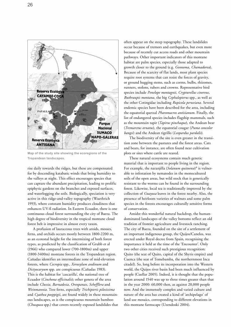
26
rise daily towards the ridges, but these are compensated for by descending katabatic winds that bring humidity to the valleys at night. This effect encourages species that can capture the abundant precipitation, leading to prolific epiphytic gardens on the branches and exposed surfaces, and waterlogging the soils. Biologically, speciation is very active in this ridge-and-valley topography (Wuethrich 1993), where constant humidity produces cloudiness that enhances UV-ß radiation. In Eastern Ecuador, there is one continuous cloud forest surrounding the city of Baeza. The high degree of biodiversity in the tropical montane cloud forest belt is impressive in almost every taxon.
A profusion of lauraceous trees with aroids, mosses, ferns, and orchids occurs mostly between 1800-2200 m, as an ecotonal height for the intermixing of both forest types, as predicted by the classification of Grubb et al (1966) who compared lower (700-1800m) and upper (1800-3400m) montane forests in the Tropandean region. Cañadas identifies an intermediate zone of mid-elevation forests, where Cecropia spp., Xeroxylum andinum and Dictyocaryum spp. are conspicuous (Cañadas 1983). This is the habitat for ‘cascarilla’, the national tree of Ecuador (Cinchona officinalis); other genera of the area include Clussia, Barnadesia, Oreopanax, Schefflera and Weinmannia. Tree ferns, especially Trichipteris pilosissima and Cyathea poeppigii, are found widely in these mountain-ous landscapes, as is the conspicuous mountain bamboo (Chusquea spp.) that covers recently exposed landslides that
often appear on the steep topography. These landslides occur because of tremors and earthquakes, but even more because of recently cut access roads and other mountain pathways. Other important indicators of this montane habitat are palm species, especially those adapted to growth closer to the ground (e.g. Geonoma, Chamadorea). Because of the scarcity of flat lands, most plant species require root systems that can resist the forces of gravity, or ground hugging stems, such as corms, bulbs, rhizomes, runners, stolons, tubers and crowns. Representative bird species include Penelope montagnii, Crypturellus cinereus, Buthraupis montana, the big Cephalopterus spp., as well as the other Cotingidae including Rupicola peruviana. Several endemic species have been described for the area, including the equatorial quetzal Pharomacros antisianum. Finally, the list of endangered species includes flagship mammals, such as the mountain tapir (Tapirus pinchaque), the Andean bear (Tremarctus ornatus), the equatorial cougar (Puma concolor bangsi) and the Andean tigrillo (Leopardus pardalis).
The biodiversity of the site is even greater in the transi-tion zone between the pastures and the forest areas. Cats and bears, for instance, are often found near cultivation plots or sites where cattle are reared.
These natural ecosystems contain much genetic material that is important to people living in the region. For example, the naranjilla (Solanum quitoense)4 is vulner-able to infestation by nematodes in the monocultured soils of the open areas, but wild stock that is genetically resistant to the worms can be found in the surrounding forest. Likewise, local tea is traditionally improved by the collection of Guayusa leaves in the forest nearby. Also, the presence of heirloom varieties of walnuts and some palm species in the forests encourages culturally sensitive forms of conservation.
Amidst this wonderful natural backdrop, the human-dominated landscapes of the valley bottoms reflect an old tradition of frontier agriculture and livestock ranching. The city of Baeza, founded on the site of a settlement of an important indigenous group, the Quijos/Canelos, was erected under Royal decree from Spain, recognising the importance it held at the time of the ‘Encounter’. Only two other cities received such prestigious recognition: Quito (the seat of Quito, capital of the Shyris empire) and Cuenca (the seat of Tomebamba, the northernmost Inca citadel). So, long before its incorporation into the Western world, the Quijos river basin had been much influenced by people (Cuellar 2005). Indeed, it is thought that the popu-lation around 1540 was up to three times greater than that in the year 2000: 60,000 then, as against 20,000 people now. And the immensely complex and varied culture and nature of the area has created a kind of ‘archipelago’ of land use mosaics, corresponding to different elevations in this montane farmscape (Uzendoski 2004).
Map of the study site showing the ecoregions of the
Tropandean landscapes.
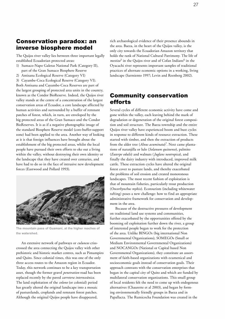
27
Conservation paradox: an inverse biosphere modelThe Quijos river valley lies between three important legally established Ecuadorian protected areas:1) Sumaco-Napo Galeras National Park (Category II),
part of the Gran Sumaco Biosphere Reserve 2) Antisana Ecological Reserve (Category VI) 3) Cayambe-Coca Ecological Reserve (Category VI).Both Antisana and Cayambe-Coca Reserves are part of the largest grouping of protected area units in the country, known as the Condor BioReserve. Indeed, the Quijos river valley stands at the centre of a concentration of the largest conservation areas of Ecuador, a core landscape affected by human activities and surrounded by a buffer of remnant patches of forest, which, in turn, are enveloped by the big protected areas of the Gran Sumaco and the Condor BioReserves. It is as if a negative photographic image of the standard Biosphere Reserve model (core-buffer-support zone) had been applied to the area. Another way of looking at it is that foreign influences have brought about the establishment of the big protected areas, whilst the local people have pursued their own efforts to eke out a living within the valley, without destroying their own identity or the landscape that they have created over centuries, and have had to do so in the face of intrusive new development forces (Eastwood and Pollard 1993).
The mountain pass of Guamani, at the higher reaches of
the watershed.
An extensive network of pathways or culuncos criss-crossed the area connecting the Quijos valley with other prehistoric and historic market centres, such as Pimampiro and Quito. Since colonial times, this was one of the only three access routes to the Amazon region in Ecuador. Today, this network continues to be a key transportation asset, though the former gravel penetration road has been replaced recently by the paved carretera interoceánica. The land exploitation of the colono (or colonial) period has greatly altered the original landscape into a mosaic of pasturelands, croplands and remnant forest patches. Although the original Quijos people have disappeared,
rich archaeological evidence of their presence abounds in the area. Baeza, in the heart of the Quijos valley, is the only city towards the Ecuadorian Amazon territory that holds the rank of National Cultural Patrimony. The life of mestizo5 in the Quijos river and of Cofan Indians6 in the Oyacachi river represents important samples of traditional practices of alternate economic options in a working, living landscape (Sarmiento 1997; Levin and Reenberg 2002).
Community conservation effortsSeveral cycles of different economic activity have come and gone within the valley, each leaving behind the mark of degradation or degeneration of the original forest composi-tion and soil structure. The Baeza township and the entire Quijos river valley have experienced boom and bust cycles in response to different kinds of resource extraction. These started with timber, and then the extraction of products from the alder tree (Alnus acuminata)7. Next came planta-tions of naranjilla or lulo (Solanum quitoense), palmito (Euterpe edulis) and walnuts (Juglans neotropica), and finally the dairy industry with introduced, improved milk cattle. These extraction cycles have altered the original forest cover to pasture lands, and thereby exacerbated the problems of soil erosion and created monotonous landscapes. The most recent fashion of exploitation is that of mountain fisheries, particularly trout production (Oncorhynchus mykiss). Ecotourism (including whitewater rafting) poses a new challenge: how to find an appropriate administrative framework for conservation and develop-ment in the area.
Because of the destructive pressures of development on traditional land use systems and communities, further exacerbated by the opportunities offered by the booming oil exploitation further down the river, a group of interested people began to work for the protection of the area. Unlike BINGOs (big international Non Governmental Organizations), SOMEGOs (Small or Medium Environmental Governmental Organizations) and NOCANGOs (National or Capital based Non Governmental Organizations), they constitute an assort-ment of faith-based organizations with ecumenical and socioeconomic goals instead of conservation goals. Their approach contrasts with the conservation enterprises that began in the capital city of Quito and which are funded by multilateral conservation organizations. This small group of local residents felt the need to come up with endogenous alternatives (Chaurette et al 2003), and began by form-ing environmentally friendly groups in Baeza and in Papallacta. The Rumicocha Foundation was created in the

28
higher parts of the Quijos Valley, whilst the Foundation for the Amazon Region of Ecuador (FundRAE) started to work with bottom-up approaches in the lowlands. The group within the FundRAE that started the Cumanda Ethnobotanical Reserve is native to Baeza, its members belonging to families that colonized the area in the early 1940s and 1950s.
To make this more personal: one of these people, Doña Virgilia Escobar de Rodríguez, recalls the time when a journey from Quito was a week-long expedition, and it was worth leaving a notarized will before departure; now it takes just two and a half hours on a paved road. Her son, Jack Rodríguez, an ecotourism entrepreneur and passionate conservationist of the area, records the efforts of his ances-tors in managing the area for the protection of landscape quality, including scenic beauty and diversity of biota and of culture.
Land belonging to FundRAE was converted into a private protective forest, adjacent to the Cayambe-Coca Ecological Reserve, thus providing an effective barrier to discourage further invasions from poachers and landless peasants. The forest reserve became Cumanda Ethnobotanical Reserve as it became increasingly common to recognise the importance of ethnobiology and its place in determining conservation priorities (Bennett 1992). The Cumanda Ethnobotanical Reserve became part of the Latin American Ethnobotanical Sister Gardens Network for the key role it plays in protecting aspects of colono culture, maintaining local and traditional practices and ecological knowledge, and maintaining its community driven processes for nature conservation and development.
The development of ecotourism in this valley has resulted in the revival of the old town of Baeza. Previously forgotten and neglected, it is now being rebuilt, with public offices and housing in the style of the colono architecture of a bygone era. Baeza is now a very tempting place to stay, with its decorated plaza and its library/information centre honouring the late legislator, Dr. Alberto Sarmiento, a pioneer in Amazonian conserva-tion in Ecuador (Sarmiento 1952; Sarmiento 1957). There are also some excellent restaurants, where the main dish is fresh fish from the many pisciculture projects around the area, with trout prepared in many different flavours at very attractive prices. And so, because of ecotourism, Baeza has become a magnet for people making a day trip from Quito. The Cumanda Ethnobotanical Reserve offers facilities for ecotourism connected not only with nature protection, but also an educational garden, and a restaurant serving organic foods produced on site, with the milk and derivatives produced on the farm. Ecotourists that choose an agro-tourism package can join in milking the cows, working in the garden, repairing the fences or labeling the nature trails. The Cumanda reserve is now
part of the International Agenda for Botanic Gardens in Conservation8, part of Botanic Gardens Conservation International (BGCI), which works for the conservation of endangered flora. The hostel in the reserve, overlooking the Quijos river, offers facilities for short or long stays, for family or group gatherings, and even for small conferences or international workshops. For instance, the Task Force on Protected Landscapes of the World Commission on Protected Areas (WCPA) of the IUCN met in Cumanda to help delineate the strategy for conservation of protected landscapes in the Andes, and to prepare the participation of the group organizing a workshop within the Vth Symposium of Sustainable Mountain Development of the Andean Mountains Association that took place in Jujuy, Argentina, in 2003. In November 2006, the International Workshop for Mountain Protected Area Connectivity Conservation of WCPA used Cumanda as a demonstration site for a field trip.
ConclusionThe creation of the Cumanda Ethnobotanical Garden has served conservation efforts in many ways. It has provided exemplars for local, grassroots organizations to incorporate the notion of conservation into their development efforts. It has also provided case studies on specific species or groups of species of interest in the area. It has generated employment and converted a transitory attraction into a tourism destination. It has empowered the local economy and, with that, raised the profile of Baeza nationally and even internationally. It is now known for first-rate kayaking and whitewater rafting in the Andes. Working with ethnobotanical applications, enhancing knowledge of tropical species, and recuperating traditional ecological knowledge of people associated with tropical montane cloud forest environments, the Cumanda Ethnobotanical Reserve is poised to become a good case study of the value of Category V protected areas.
1 The Paramo is a zone of tropical alpine grasslands,
located in the higher elevations of the northern Andes,
between the upper tree-line (about 3500 m altitude) and
the permanent snow line (about 5000 m). The ecosystem
consists mostly of glacier-formed valleys and plains with
many lakes, peat bogs and wet grasslands mixed with
shrublands and remnant forest patches.
2 A forb is a flowering plant with a non-woody stem that is
not a grass.
3 The Massenerhebung effect describes variation in
the tree-line based on mountain size and location.
In general, mountains surrounded by large ranges

29
will tend to have higher tree-lines than more isolated
mountains, due to heat retention and wind shadowing.
This effect is important for determining weather patterns
in mountainous regions, as regions of similar altitude and
latitude may nonetheless have much warmer or colder
climates based on surrounding mountain ranges.
4 The naranjilla (Ecuadorian Spanish, diminutive of
‘naranja’) or lulo (Colombian Spanish, from Quechua)
(Solanum quitoense Lam.) is a subtropical perennial
plant from northwestern South America. The juice of the
naranjilla is somewhat green and is used as a beverage.
Ripe naranjilla fruit is delicious, but it must be harvested
when fully ripe, otherwise it can be quite sour.
5 Mestizo is a term of Spanish origin used to designate
people of mixed European and indigenous non-European
ancestry. The term has traditionally been applied mostly
to those of mixed European and indigenous Amerindian
ancestry who inhabit Latin America. A colono is a
mestizo settler that occupies the valley in traditional
ways.
6 The Cofans are one of the oldest surviving indigenous
cultures of the Amazonian rain forest. They live in their
traditional homeland on the banks of the large rivers
of what is now northeastern Ecuador and southeastern
Colombia. Fewer than 1,000 Cofan remain, with most
living in Ecuador. Hunters, fishers, and subsistence
agriculturists, they are famous for their efforts to protect
their rain forest home from the oil industry, mining
companies, and colonists. Cofan are craftsmen and
naturalists, with a deep understanding and appreciation
of their environment.
7 Alnus acuminata wood is light brown-yellow to pink,
odorless, tasteless, and without differences between
the heartwood and the sapwood. The wood dries easily
and preserves well. It has even grain, seasons fairly
well, and is easy to work and finish by hand or machine.
Despite its light weight, it is tough and strong, and is
sometimes used for construction. Its timber is also used
for fuelwood, posts, poles, light lumber, boxes, broom
handles, domestic implements, plywood cores, particle
boards, musical instruments and match sticks.
8 The International Agenda for Botanic Gardens in
Conservation is a global policy framework for botanic
gardens worldwide to contribute to biodiversity
conservation, particularly as it relates to the
implementation of the Convention on Biological Diversity.
The Agenda was launched at the First World Botanic
Gardens Congress in Asheville, U.S.A. in 2000.
AcronymsECOSUR The College of the Southern Border, Mexico
EARTH Agricultural School of the Tropical Humid Regions
FundRAE Foundation for the Amazon Region of Ecuador
UGA University of Georgia, Athens, Ga. USA.
ReferencesBennett, B. 1992. Plants and people of the Amazonian rain
forests: the role of ethnobotany in sustainable development.
BioScience 42(8). p599-607.
Brown, J., Mitchel, N. and Beresford, M. (Eds.) 2005. The
Protected Landscape Approach: Linking Nature, Culture and
Community. World Conservation Union (IUCN). Gland and
Cambridge.
Brown, J., Mitchell, N. and Sarmiento, F.O. 2000. Landscape
Stewardship: New directions in conservation of nature and
culture. George Wright Forum, 17(1). Special Issue.
Cañadas, L. 1983. El Mapa Ecológico y Bioclimático del
Ecuador. Editorial MAG-PRONAREG. Quito.
Chaurette, E., Sarmiento, F.O. and Rodríguez, J. 2003. A
protected landscape candidate in the Tropical Andes of
Ecuador. Parks 13(2). p42-51.
Cuellar, A.M. 2005. The Organization of Agricultural
Production in the Emergence of Chiefdoms in the Quijos
Region, Eastern Andes of Ecuador. Ph.D. Anthropology
Dissertation. University of Pittsburg.
Eastwood, D.A. and Pollard, H.J. 1993. Amazonian
colonization in eastern Ecuador: land use conflicts in a
planning vacuum. Singapore Journal of Tropical Geography
13(2). p103-117.
Ellenberg, H. 1979. Man’s influence on tropical mountain
ecosystems of South America. The Journal of Ecology, 67.
p401-416.
Grubb, R. J., Lloyd, J.R., Pennington, T.D. and Whitmore,
J.C. 1966. A comparison of montane and lowland rain
forests in Ecuador. I: The forest structure, physiognomy and
floristics. Journal of Ecology, 51. p567-601.
Hamilton, L.S. 1996. The role of protected areas in
sustainable mountain development. Parks, 6(1). p2-13.
Levin, G. and Reemberg, A. 2002. Land use driven
conditions for habitat structure: A case study from the
Ecuadorian Andes. Danish Journal of Geography 102.
p79-92.

30
MRI 2006. Symposium on Climate Change – Organizing the
Science for the American Cordillera (CONCORD). Mendoza,
Argentina, 4-6 April. Book of abstracts. Mountain Research
Initiative. Bern.
Pugh, J. and Sarmiento, F. 2004. Selling the public on
sustainable watershed conservation. Bulletin of Latin
American Research 23(3). p322-337.
Sarmiento, C.A. 1952. Biografía del Río Napo. Editorial Fray
Jodoko Rike. Quito.
Sarmiento, C.A. 1957. Monografía Científica del Oriente
Ecuatoriano. Editorial Don Bosco. Quito.
Sarmiento, F. O. 1997. The Quijos River Valley: A protected
landscape as best management practice for conservation
and development in Tropandean Ecuador. The George
Wright Forum, 14(3). p59-66.
Sarmiento, F.O. 2001. Mountain Regions: Sustained
livelihood for an increasing population? Schwerpunkt: Berge.
Entwicklung und Ländlicher Raum 6. p16-18.
Sarmiento, F.O. 2002. Anthropogenic landscape change
in highland Ecuador. The Geographical Review 92(2).
p213-234.
Sarmiento, F.O. 2003. Protected landscapes in the Andean
context: worshipping the sacred in nature and culture.
Harmon, D. and Putney, A. (Eds.) The Full Value of Parks.
p239-249. Rowman & Littlefield Publishing Group. Lanham,
MA.
Sarmiento, F.O., Rodríguez, G. and Argumedo, A. 2005.
Cultural landscapes of the Andes: Indigenous and colono
culture, traditional knowledge and ethno-ecological heritage.
In Brown, J., Mitchell, N. and Beresford, M. (eds.) The
Protected Landscape Approach: Linking Nature, Culture and
Community. IUCN-The World Conservation Union, Gland &
Cambridge.
Sarmiento, F.O., Rodríguez, G., Torres, M., Argumedo, A.,
Muñoz, M. and Rodríguez, J. 2000. Andean stewardship:
Tradition linking nature and culture in protected landscapes
of the Andes. The George Wright Forum, 17(1). p55-69.
Uzendoski, Michael A. 2004. The Horizontal Archipelago:
The Quijos/Upper Napo Regional System. Ethnohistory 51(2).
p317-357.
Wuetrich, B. 1993. Forests in the clouds face stormy future.
Science News, 144:23.
About the AuthorFausto O. Sarmiento was founder of several conservation
organizations and became executive director of the National
Museum of Natural Sciences in his native Ecuador, when the
human dimension was incorporated into the design of small,
private protected areas. As a mountain scholar who bridges
ecology with sustainable development in Tropandean
landscapes, he emphasizes the role of culture in nature
conservation. He is Deputy Vice-Chair for Capacity Building
in the WCPA-Mountains Biome and is member of the WCPA
Protected Landscapes Task Force. He is Science Advisory
Board member, on behalf of the International Human
Dimension Program (IHDP), to the Mountain Research
Initiative (MRI). He is currently an associate professor
of mountain science at the Department of Geography,
University of Georgia.
Assoc. Prof. Dr. Fausto O. Sarmiento
Department of Geography
The University of Georgia, Georgia, USA
Email: [email protected]

31
The impact of native versus introduced livestock in the Chimborazo Faunal Production Reserve, EcuadorJulie S. Rosenthal
Ecuador’s Chimborazo Faunal Production Reserve is a protected area that not only allows, but actively encour-ages, the use of indigenous domesticated animals by the local population within its boundaries. The reserve was designated in 1987 and covers 58,560 ha, including large areas of high grasslands, or páramo, a landscape typical of the Andean region. The páramo landscape is the product of both the physical characteristics of these high altitude areas, and centuries of human intervention in the form of livestock grazing and other practices (Sarmiento 2002). While the Chimborazo Faunal Production Reserve is listed as a Category VI protected area in the World Database on Protected Areas, the presence of páramo landscapes that have been shaped by the interactions of people and nature over time, along with aspects of its management objectives, is arguably in keeping with those of Category V protected areas. With domestic animal diversity declining on a global scale (Rischkowsky 2007), the Chimborazo Faunal Production reserve serves as an important case study to examine the implications of promoting domestic animal diversity within a protected area. Lessons learned here will be of value to other Category V protected areas in the Andean region.
Domesticated llamas have been present in the Ecuadorian highlands for at least 1500 years. Alpacas were probably introduced during the Incan conquest, around 1470 AD. The arrival of the Spanish in the late 15th century, with their European cattle, horses, sheep and burros, led to the near disappearance of native camelids in Ecuador. While remnant populations of llamas have survived in the Chimborazo region until today, alpaca were last reported there in 1871. Recent efforts to augment the llama population in Ecuador and reintroduce alpacas included the establishment of the Chimborazo Faunal Production Reserve, which has a primary objective of protecting the habitat of native camelids (both wild and domestic) in order to promote their survival and recovery.
Although livestock grazing can be detrimental to natural landscapes, environments that have a long history of grazing can become tolerant, or even dependent, on the grazing system to retain their qualities. An examination of the literature on the effects of grazing on individual plants, soils and plant communities has revealed that grazing does not necessarily harm the environment and that, in some
cases, grazing by domesticated animals may even enhance soil conditions and plant production.
A recent study was undertaken to determine whether there were ecological benefits in encouraging the husbandry of native camelids in the Chimborazo Faunal Production Reserve, instead of the use of the exotic forms of livestock introduced by the Spaniards. An investigation of the pastures used by llamas, alpacas, sheep, cattle and horses examined the impact of each type of animal on plant diversity, sward height, pasture composition (in terms of bare ground, live plant cover, and dead plant cover), and palatability1 of the more abundant species, with respect to the animals grazing in each pasture. Analysis of this data revealed a significant difference in pasture condition between the llama pasture and pasture grazed by cattle and horses. The llama pasture, which had a higher stocking rate than the cattle and horse pasture, was in better condi-tion. Little difference between the alpaca and the sheep pastures was revealed in the data analysis; however, local informants indicated that they had observed remarkable improvements in the condition of the pasture utilized by

32
the alpacas since 2000, in areas which had previously been grazed by sheep.
On a species level, this study reveals that the domesti-cated animals that have inhabited the Chimborazo region for the longer period of time have the least ecological impact. Whether this is due to long-term co-evolution of these animals with the vegetation, or whether this is simply a function of the morphology and behaviour of the studied animals, is unclear. The results of this research suggest that the managers of the Chimborazo Faunal Production Reserve should continue to encourage llama production within the Reserve and to support initiatives that can increase the value of products from these animals, such as the use of llamas as pack animals in ecotourism services, the production of traditional riding chaps made from llama skins, and the improvement of llama fibre for gar-ment and handicraft production. While the study does not recommend that cattle and horses be eliminated entirely from the Reserve, it notes that if the value of the more ecologically benign llamas is increased, there may be a way to reduce the numbers of the introduced livestock without any net economic loss.
The use of highly productive, introduced breeds of livestock continues to be encouraged by national govern-ments and development agencies world-wide; a practice that has led to the disappearance of several indigenous breeds around the world. The loss of indigenous breeds can be prevented if their unique characteristics can be used to their fullest advantage. Reduced ecological impact on the environments in which such breeds evolved could very well be a strong incentive for the use of indigenous livestock instead of introduced breeds, especially in and around protected areas.
The report on this study (Rosenthal 2006) offers several potential explanations to account for these findings. Recommendations based on these findings, as well as economic and other concerns, are provided regarding the management of the Chimborazo Faunal Production reserve in particular, as well as regarding protected areas in general.
1 Palatability means how desirable each plant species was
to the livestock. If a pasture is predominantly comprised
of undesirable species, it is likely to be an indication that
grazing pressure here is higher than in pastures covered
by species that the livestock find desirable.
ReferencesCosyns, E., Claerbout, S., Lamoot, I., and Hoffmann, M. 2005.
Endozoochorous seed dispersal by cattle and horse in a spa-
tially heterogeneous landscape. Plant Ecology 178, p. 149-162.
Couvreur, M., Cosyns, E., Hermy, M. and Hoffmann, M. 2005.
Complementarity of epi- and ednozoochory of plant seeds
by free ranging donkeys. Ecography 28, p. 37-48.
Heady, H.F. 1975. Rangeland management. McGraw Hill.
New York.
McNaughton, S.J. 1979. Grazing as an optimization process:
Grass-ungulate relationships in the Serengeti. The American
Naturalist 113(5), p. 691-703.
Milchunas, D.G., and Lauenroth, W.K. 1993. Quantitative
effects of grazing on vegetation and soils over a global
range of environments. Ecological Monographs 63(4),
p. 327-366.
Rosenthal, J. 2006. The impact of native versus exotic
livestock in the Chimborazo Faunal Production Reserve,
Ecuador. Unpublished Master’s thesis. University of
Greenwich and International Centre for Protected
Landscapes. U.K.
Rischkowsky, B. and Pilling, D. 2007. The state of the world’s
animal genetic resources for food and agriculture. FAO. Rome.
Sarmiento, F.O. 2002. Anthropogenic landscape change in
highland Ecuador. The Geographical Review 92(2): 213-234.
AcknowledgementsThis work would not have been possible without the kind
support of the community of Pulingui San Pablo and the
Chimborazo Faunal Production Reserve.
About the AuthorJulie Rosenthal is a PhD candidate at Lakehead University in
Thunder Bay, Canada. Her research focuses on value-added
approaches to the conservation of rare and indigenous
breeds of livestock, including their use for vegetation
management in protected areas. The study described above
was undertaken as part of her MSc thesis for the Masters in
Protected Landscape Management programme offered by
the University of Greenwich and the International Centre for
Protected Landscapes.
Julie Rosenthal
Faculty of Forestry and the Forest Environment
Lakehead University,
Thunder Bay, Ontario, Canada P7B 5E1

33
Agrobiodiversity conservation in the Garrotxa Volcanic Zone Natural Park, Spain: Experience and recommendations for future directions Emili Bassols Isamat, Jordi Falgarona Bosch, Josep-Maria Mallarach Carrera and Bernat Perramon Ramos
SummaryThe Garrotxa Volcanic Zone Natural Park, Catalonia, one of the leading Category V protected areas in Spain, has been active in agrobiodiversity conservation since 1990. This paper summarizes the challenges that face the conservation of domesticated biodiversity in the European agrarian policy context, the accomplishments in the conservation of fruit trees and other local vegetable varie-ties, and the strategy for agrobiodiversity conservation in this Park, a strategy that could be extended to the natural areas system of Catalonia. Of note is the development of cooperation between farmers, growers, scientists, local schools and restaurants, to value, conserve and use the local plant varieties.
Main features and values of the Garrotxa Volcanic ZoneThe Garrotxa Volcanic Zone Natural Park is situated on the southern flank of the Pyrenees in Catalonia, in the northeast of Spain. This is a mid-mountain environment with altitudes that range between 200 and 1000 m. The valleys, where the greater part of human activity is concen-trated, are between 300 and 500 m above sea level. The Park has a surface area of some 14,000 ha, of which 980 ha are designated Nature Reserves (Category III).
The predominant climate is humid Mediterranean, with average annual rainfall of close to 1000 mm, fairly evenly distributed through the year, and without dry

34
summers. The orientation of the valleys favours tempera-ture inversion which results in an inverse distribution of the vegetation. The average annual temperature is 12.4º C in the valley bottoms, and the growing season for vegeta-tion lasts 8 to 9 months.
The distribution of land uses is the result of natural factors and of many hundreds of years of human activity. The predominant land cover is forest (65%), which occu-pies land with slopes greater than 20%, while the areas of cultivation (22%) and pasture (5%) are concentrated on land with less pronounced slopes. The remaining 8% in the valley bottoms is occupied by urban zones and the associated infrastructure, and by riparian forests. The surface area given over to farming has been in sustained decline over the last four decades as a result of the dimin-ishing value of agrarian products, the intensification and mechanization of agriculture, progressive rural depopula-tion, and other associated socio-cultural changes.
The Park contains the best-conserved volcanic zone in the Iberian Peninsula and one of the most representative in continental Europe. This is a prehistoric volcanism with well conserved forms, notably volcanic cones, lava flows and lacustrine and palustrine deposits associated with the barrages produced by lava emissions. The sedimentary record, spanning more than 300,000 years, is of great scientific interest in the study of the Quaternary (Pérez Obiol 1987).
Thanks to its situation in a zone of transition between two biogeographic regions, the Mediterranean and the Alpine, and the prevalence of a mosaic landscape with a variety of local climates, the Park has a high degree of bio-diversity. 1,125 taxa of vascular flora (Campos 2001) and 274 species of vertebrates have been identified, consisting of 185 species of nesting birds, 49 species of mammals, 18 species of reptiles, 13 species of amphibians, and nine spe-cies of fishes (Minuàrtia 2005). The other recognised value
is the beauty of the landscape which inspired a landscape painting school, a result of the harmonious adaptation of human activity in the environment. The cultural heritage comprises an extensive repertoire of rural buildings and some 25 small churches, for the most part Romanesque (11th-14th century AD), around half of which regularly host popular gatherings and festivities.
The population is concentrated in the urban areas, mostly in the valley of the river Fluvià. Despite being legally excluded from the protected area, the impact of these settlements, which form an urban continuum almost 10 km long, is very considerable especially as they lie within the boundaries of the protected area (see map). The total population of the Park is close to 40,000 people, of whom 2,850 live within the protected rural area and the remainder in the ten urban areas. The most important of the ten urban areas is Olot, the district capital, with a population of almost 30,000. Of the 18,650 people in paid employment, 47% work in the service sector, 39% in industry, 11% in construction and only 3% in the agrarian sector (Statistical Office of Catalonia 2004). Most of the industry is located in industrial estates. Tourism, almost non-existent when the Park was established 25 years ago, has experienced sustained growth since then, with a predominance of family-run restaurants and rural accommodation.
The legal situation of the Natural ParkThe volcanic zone was declared a protected area by a Law passed in 1982 by the Parliament of Catalonia, which created a Natural Area of National Interest and 26 Strict Nature Reserves of Geobotanical Interest. It was the first protected natural area established by an autonomous government in Spain. 1985 saw the introduction of the Law of Natural Areas of Catalonia, defining the instru-ments of protection and developing the autonomous legal framework. This law redefined the volcanic zone of the
Situation of the Garrotxa Volcanic Zone Natural Park in
South-western Europe
Mosaic landscape of the basaltic plateau of Batet, at the
centre of the park.

35
Garrotxa as a Natural Park, and the Strict Nature Reserves as Managed Nature Reserves.
In 1994, after a lengthy participative process, the management plan of the Park, known as the Special Plan for the Garrotxa Volcanic Zone, was approved by Decree. At present this Plan is under review and is expected to be approved in 2007.
The major part of the Park is under private ownership (95%). Communal woodlands are small in size and few in number. The other publicly-owned properties are the river beds and three Nature Reserves. The private ownership of the land is very fragmented, with over a thousand different proprietors. Ownership of the natural resources lies with the proprietors of the land, except for the water and the subsoil which are public property. Most of the forestry properties are privately owned, while the farms are gener-ally tenanted.
The Park is part of the system of natural areas of Catalonia, created by Decree of the Government of Catalonia in 1992. This system consists of 145 units cover-ing 21% of the territory of Catalonia. The Park is included in the World Database on Protected Areas (WDPA) as a designated Nature Park in Spain, with the name ‘Zona Volcànica de la Garrotxa’ (Site Code 15431), and is catego-rised as an IUCN Category V protected area.
In 2006 the Government of Catalonia presented its proposal for the inclusion of sites in the Natura 2000 network, which encompasses about 30% of Catalonia’s land. The network is a European initiative established by the Directive 92/43/EEC, based on bioregional criteria and aiming to protect habitats and species of European sig-nificance. The entire Park is included in the proposal and contains 16 habitats and 11 species of European interest.
The administrative situation of the ParkWithin the Spanish state, responsibilities for planning and management of protected spaces have been devolved to the autonomous governments. Direct responsibility for the Park lies with the Catalan government’s Department of the Environment and Housing, which provides the entire budget and chairs its governing body.
The remit of the Park’s governing body, the Park board, is established by a Decree of 1983. Its duties include: implementing the Law of Natural Spaces; propos-ing measures to improve the living conditions of the local population; drawing up a programme of action and a budget; preparing an annual report for publication; and giving prior notice to the responsible agencies of any type of works, operations and exploitation liable to affect the
protected area. The board has 11 members: 3 represent the local town councils, 3 represent the scientific community, and 5 represent the autonomous government.
There are 19 staff members on the management team which is structured in six sections: steering; rural improve-ment; natural heritage; public use; administration and supervision; and maintenance. In addition, there are regu-lar inputs from 15 people working in private companies which have an annual contract with the Park; they help in areas such as architecture, quality management systems and conservation of fauna, and also help at the Centre for the Conservation of Cultivated Plants (see below). The team works within a management system that received a UNE-EN ISO 9001:2000 compliance certificate in 2000. Garrotxa is the first Park in Spain to meet this Standard. In May 2007 it was also awarded EMAS Environmental Management System verification1.
Since 1991 the Park has operated with the help of the Cooperation Council, consisting of 40 members. The Council works to promote the participation of the local population by engaging with existing clubs and associa-tions. The Council has sector-specific working groups which include representatives from associations of local hunters, farmers and stock breeders
Main agrobiodiversity featuresAgriculture arrived in the area over 6,000 years ago (Burjachs 1987). However, the major agrarian transforma-tions did not take place until the Roman era, around 2,200 years ago (Alcalde and Burjachs 1991). The present system of rural population derives from the Benedictine model of colonization, which received a powerful impetus during the 10th-12th centuries AD. The Industrial Revolution took place here at the end of the 18th century and has had a great impact on agrarian activity. There is extensive fragmentation of land ownership; properties in the mountain areas tend to be 5 ha to 25 ha, while on the flatter land many properties are very small, of 1 ha or less. This pattern of fragmentation has given the landscape its mosaic-like quality. Currently there are about 650 isolated houses in the Park, almost all of them occupied, of which only 142 (21%) are estimated to be working farms, while 3% are engaged in rural tourism (Font 2006).
The current agrarian model dates from the 1960s and 1970s, involving mechanization using fossil fuels and the widespread application of pesticides and chemical fertiliz-ers. While arable and livestock farming in the Garrotxa Natural Park still reflects the characteristic structure of the Catalonian countryside, based on family units living in

36
traditional farmhouses, the dominant agrarian model in place today outside the Park is very intensive and consumes high levels of inputs (water, agrochemicals, plant material, nutri-ents, fossil fuel energy, etc.). This creates agricultural systems with low levels of autonomy, sustainability and stability.
While this model has served to produce a large volume of food, it has at the same time resulted in the degrada-tion of some of the area’s natural resources and a loss of agrobiodiversity. Thus some crops and livestock, including many varieties which are well adapted to local conditions, have been lost. The principal causes of this loss have been the conjunction of commercial interests, the difficulty that traditional varieties of crops and livestock have in adapting to the use of modern machinery and present-day systems of production, the demands of the workforce, and the loss of traditional trades and their replacement by more profitable alternatives.
Up to the end of the 18th century the traditional Mediterranean crops – wheat (Triticum sp.), vines (Vitis vinifera) and olives (Olea europaea) – predominated, but there were also fodder plants, garden vegetables, rye (Secale cereale), mixed crops of wheat and rye, oats (Avena sativa), barley (Hordeum vulgare), millet (Panicum miliaceum) and buckwheat (Fagopyrum esculentum). This last was typical of the district and was eaten by people and animals alike. During the 19th century vines and olives were ousted by potatoes and maize. Following the transition from a period of self-sufficiency (1939-59) to the period of mechaniza-tion, there was considerable expansion of stock farming, especially of cattle and pigs. In recent decades livestock farming has greatly intensified with fewer farms but larger numbers of livestock, while arable farming has in many cases assumed a subordinate role, mainly producing fodder and grain cereals for the livestock.
At present the main cultivated crops in the Park are winter cereals (wheat, barley, oats, rye, spelt (Triticum espelta), triticale), maize, sorghum (Sorghum sp.), ryegrass (Lolium sp.) and alfalfa (Medicago sativa). On a smaller scale some farmers continue to grow other crops not related to stock farming, such as legumes (haricot beans (Phaseolus vulgaris), chickpeas (Cicer arietinum), broad beans (Vicia fava), peas (Pisum sativum), etc.), garden vegetables, tubers and buckwheat.
Past and present agrarian practicesThe soil and climatic conditions of the Natural Park are optimal for the practice of agriculture on flat land. Some 27% of the surface area of the Park is given over to agri-culture, of which 80% is used to grow crops, the rest being
permanent pasture. Livestock farmers also exploit some of the wooded zones for mountain grazing. In recent years the area used for agriculture has declined, while the extent of the forested area has increased (Minuàrtia 2002). This is due to the abandonment of more marginal farmland that does not have the characteristics demanded by present-day agriculture. The result is natural regeneration of the forest, initially with a preponderance of scrub and thicket.
The diversity of uses of agricultural land, interspersed with different forest communities, has resulted in a rich and varied landscape in the form of a mosaic. This has a very positive effect on biodiversity. The relationship between the Park’s agrobiodiversity and its wild biodiver-sity is a product of the structure and variety of the rural landscape which has evolved over the centuries through the interaction of human activity with the different types of local vegetation, soil and climate.
The loss of agrobiodiversity will increase the instability of the agricultural system for two main reasons. First, a reduction in agrobiodiversity means that each crop species or variety that is still in use, has a higher representation among the total crops grown. Therefore a negative impact on one of these species or varieties will have a greater reper-cussion on the whole. Second, when one of the original species or varieties that is best adapted to local conditions is lost, production generally becomes less reliable; this is because locally-adapted crops and livestock, though producing lower yields on average, are less susceptible to negative conditions such as drought.
Agrarian lands of the Zona Volcànica de la Garrotxa
Natural Park and surrounding areas. Grey areas = agricul-
tural land. Triangles = location of CCCP at Can Jordà and
Can Passavent. Squares = location of buckwheat (Batet de
la Serra) and bean (Santa Pau) fairs. Circles = Farms that
cooperate with the Park in agrodiversity conservation.
37
The intensification of present-day agriculture and livestock farming has caused certain environmental problems, the most serious of which is the contamination of underground water by nitrates. At present, most of the agrarian soils and aquifers of the Park are affected by pol-lution from nitrates of agricultural origin (Bach 2005).
Another negative impact is that of wild fauna on crops. The species that causes the most problems for crops and pasture is the wild boar (Sus scrofa) which has grown in numbers because of the absence of natural predators and the abundance of dense woodland in which it can take refuge. At a more localized level there can also be plagues of nematodes, Diptera, Lepidoptera, etc., which damage crops and find refuge in wild biodiversity.
Opportunities and threatsIn recent years agriculture has tended to experience a progressive loss of social and economic importance in the Park. It seems probable that this tendency will continue in the years ahead, given that only 8% of the livestock farmers working in the Park are less than 40 years old and that more than 60% of the farmers’ children do not intend to take over the family farms in the future (Font 2006). This situation discourages investment in infrastructure, holds back economically efficient technical management, and generally makes it more difficult to improve production and increase, or even maintain, competitiveness.
It is difficult to improve profitability by direct retailing of agricultural products or by adding value through the processing of such products because the necessary facilities, such as slaughterhouses, do not exist. Moreover, established channels of commercialisation resist such innovation and there are very strict regulations that must be met in food production and processing. In addition, the agrarian sector has become highly controlled and bureaucratised, which does nothing to motivate the farmers. A further problem is the appearance of large, highly intensive livestock farms with little or no involvement in arable agriculture: little use is made of the animal manure from such farms, which poses an increasing threat of contaminating aquifers.
If, to all these factors, we add globalisation, which introduces lower-quality agrarian products into the market, bringing down prices and undermining the seasonal nature of production, then the expectations of improvement in the agrarian sector must be low. Nevertheless, there are factors that provide grounds for optimism.
The Park’s very existence confers an added value on the territory that, in turn, attaches to the products grown and processed there. This helps to add value to the farmed areas of the Park which are thus better protected from
the threat of transformations, such as being developed for residential use, than similar farmed areas elsewhere. Indeed, the Park already has characteristics that make it attractive to farmers: there are well-established agrarian associations, an extensive agro-business network, good cooperation between the agrarian sector and the restaurant sector, a model of environmentally friendly tourism, a rural cultural model with an identity of its own, extensive live-stock farming that maintains the landscape, an agrarian skills training centre, and the manufacture of local quality products. What is more, the recent upsurge of consumer interest in local quality products clearly helps the recovery and consolidation of a diverse farming economy and its agrobiodiversity which were in danger of being lost. In this context of new opportunities, the Park has a fundamental role to play in promoting and protecting these traditional products through certification of origin, quality and pro-duction processes, encouraging the growing of traditional crops and/or crop varieties, and supporting quality brands that serve to differentiate and enhance these local prod-ucts. The public authorities can also create incentives to manufacture local products by facilitating their processing, creating the necessary infrastructure, providing support for marketing, and other such services.
Over the last ten years civil society groups have taken a number of initiatives to address agricultural and related issues in the Park:• The key agrarian associations in the Park are the
Cooperativa del Camp d’Olot and the Associació Ramadera i Agrària per a la Defensa Ambiental. The latter was founded in 2003 to pool forces in conserving the quality of the environment in response to the prob-lem of contamination by nitrates of agrarian origin, especially in zones of great ecological value such as the Park.
• The bean fair of Santa Pau (Fira del fesol ) and the buckwheat fair (Fira del fajol ) of Batet are both very popular. The latter is a festive, fun event and a showcase for local products and producers. The 2007 fair included, for the first time, activities to encourage interest in the value of local products as well as various technical workshops on this theme.
• Since 1996, the Fundació Garrotxa Líder has been actively involved in developing a district-wide strategy to promote local agricultural produce of quality. The strategy is based on the conviction that a key element in promoting quality produce is the identification of products based on local agricultural varieties, and that this is a very effective means of differentiation from other products in the market. The foundation was set up to encourage local development, in association with the European Union’s Leader initiative, so as to involve all the social actors in the territory in a participative

38
and integrated way of working. In the last four years it has concentrated on developing and accrediting a Code of Sustainable Management for enterprises in the Garrotxa, with the aim of helping businesses adopt economic, social and environmental measures that respect the people and the habitat. The Park has been a patron and member of the Board of Management of this foundation since the outset.
• The Garrotxa Environment and Public Health Consortium launched its seed bank project in 2004 as a response to the loss of crop biodiversity. The objective was to recover and preserve the district’s historic varieties of domesticated edible plants, together with information on their cultivation and uses. The conservation of these seeds is both ex situ (in a seed bank and in experimental test fields) and in situ (on each of the participating properties). The consortium also cooperates with other bodies and works in close coordination with the Park.
• The Slow Food Association is an international associa-tion with over 80,000 members in more than a hun-dred countries. It seeks to protect certain traditional eating habits from the accelerated pace of modern life, and at the same time promote gastronomic culture, help us educate our palates, conserve agricultural biodiversity, and protect traditional foods in danger of extinction. There are now eleven Slow Food groups, or Convivia, in Spain. The aims of the Slow Food Association overlap considerably with the aims of the initiatives mentioned above, and at the start of 2007 the Garrotxa Slow Food group was set up with the aim of promoting local products and their utilization in the district’s restaurants. In this they are supported by the ‘Volcanic Cuisine’ association of local restaurateurs, founded in the Park itself.
Management policies and practices for maintaining or enhancing agrobiodi-versityAs the heritage of agrarian diversity comes under increas-ing threat, its conservation has become a greater concern. There are a number of reasons for this: historical, cultural, economic, biological, ecological, and an interest in land-scape and gastronomy. Of all Spain’s autonomous com-munities, Catalonia has introduced the most initiatives for the conservation of genetic resources in the widest sense. The most active agents here have been the different tiers of the administration, followed by professional associations and private initiatives (SEAE 1996).
The strategy of the Park in this respect can be summed up under the following categories:• Encouraging research into traditional varieties.• Promoting ecological and/or organic agriculture.• Introducing criteria for sustainability in livestock
farming.• Advising the owners of participating properties.• Carrying out schemes to improve and restore agrarian
habitats.• Developing a model of management of the rural
environment that favours the continuing presence of farms in the territory.
• Participating in actions for the conservation, promotion and marketing of local products.
• Establishing permanent lines of dialogue with the livestock sector.
Coordination with otherinstitutions
of
Duplicates in officialgerm plasma banks
SIGMA seed bank
Ecollavors exchange network
Santa Pau local bean growersassociation
Slow Food Garrotxa Convivium
Foundation Garrotxa Leader
Foundation Turisme Garrotxa
Relations with othercentres in Catalonia
Project for the creation of a networkPA conservation centres in Catalonia
Ethnobotanical survey
Collection of plant material
Identification of varieties
Promotion and revitalization
Technicalassessment
Plant materialdissemination
Participating farms
Centre for the Conservation of Cultivated Plants
Tasks developed from the Park CCCP, showing relation-
ships with other local institutions involved in agrodiversity
conservation.
The Park undertook direct actions to conserve agrarian diversity in 1990, in light of the first survey to identify and locate the traditional varieties of fruit trees in the district of the Garrotxa (Arribas 1989). This survey identified 53 traditional varieties of 8 species of fruit trees. Among these are 19 varieties of apple, many of which were in a critical situation in terms of conservation. Planting of the first fruit trees with grafts from those traditional varieties commenced during the same year in the Can Jordà fruit orchard, a public property managed directly by the Park, surrounded by a wooded Nature Reserve. A back-up orchard of fruit trees was established there, to be integrated

39
into the future Centre for the Conservation of Cultivated Plants (CCCP). The objectives of the CCCP are:• To contribute to the conservation of traditional varie-
ties of cultivated plants.• To improve understanding of these varieties.• To develop practical experience in ecological fruit
growing.• To encourage the cultivation of ecological fruit on
participating properties.• To boost biological agriculture.• To publicize the uses and possibilities of these varieties
and involve different social agents in their conservation and utilization.
At present, the CCCP occupies about 4 ha. It is run in accordance with the criteria and standards laid down by the Catalan Council of Ecological Agricultural Production, to which it adhered in 1999. The maintenance of the CCCP is carried out by workers from a local cooperative for mentally and physically handicapped people, thus aiding their access to paid employment.
The CCCP comprises a preservation fruit orchard and a show orchard, and also cultivates traditional varieties of herbaceous plants. Of these, the preservation orchard is the principal element, and the one that receives most input, devoted as it is to local varieties of fruit trees that are in urgent need of conservation and that are potentially the most useful for the Park. The preservation orchard cur-rently has 292 fruit trees of 8 species (apple, pear, cherry, plum, peach, apricot, medlar and persimmon) including 59 varieties. In addition, the show orchard has around 60 old and traditional fruit tree varieties of 7 different species, most of them from southern France.
Safeguard fruit orchard of Can Jordà, Garrotxa Volcanic
Zone Natural Park
A second survey was conducted in the Garrotxa district in 2005 with two objectives: to discover unknown traditional varieties of fruit trees in order to incorporate these into the CCCP and to revisit the properties surveyed in 1989 in order to evaluate the degree of genetic erosion. The findings were disturbing, indicating that in just 16 years almost 50% of the genetic material located in 1989 had been lost and, still more worrying, that two-thirds of
the respondents who had provided information on the uses of these varieties were no longer there, having since died or gone to live in the city (Arribas 2004). In this light, priority is now being given to collecting and processing information relating to the uses of these varieties and to their traditional processes of production and preparation. The disappearance of a variety brings with it the loss of a cultural heritage of great interest, as age-old tools, skills and facilities are abandoned.
With regard to traditional herbaceous crops, a survey conducted in the district in 1995 located 61 varieties of 21 different species of cultivated plants, including garden vegetables, many of which were found to be cultivated by only a few farmers and were in danger of disappearing (Arribas 1995). Accordingly, the CCCP cultivates varieties that are in evident regression such as: buckwheat of the ‘pota de gall’ and ‘arracada’ varieties; maize of the ‘creu’, ‘queixal’ and ‘blanca’ varieties; beans of the ‘tabella brisa’ variety; and potato of the ‘mora’ variety.
In order to draw greater public attention to the prob-lems associated with the loss of agrobiodiversity, in 2003 a small-scale replica of the CCCP was established on a plot by the side of a walking route near the Croscat volcano. The walking route is used by 40,000 people every year. The 30 fruit trees of 5 species planted here were selected on the basis of their historical and culinary interest and the real risk of their disappearance. This project won the European Day of the Parks award from Europarc-Spain in 2003.
Thus the CCCP has become a standard setter in the conservation of traditional varieties of fruit trees: it is the most important ex situ collection of its kind in Catalonia today, and one of the best in Spain.
The current focus of work is oriented primarily towards the dissemination and use of these traditional varieties, in the belief that the best way of conserving them is for other growers to plant them on their land. The Park thus establishes agreements with interested private landowners, whose holdings are recognised as participating properties; these owners receive advisory support from the Park for a period of time. In addition, the Park has established an agreement with a public company to cultivate trees that were grafted with traditional varieties from the CCCP nurseries.
At the same time, the Park works with local public and private organizations engaged in the conservation of plant genetic resources. For example, it has set up a seed bank with the Garrotxa Environment and Public Health Consortium to conserve the local varieties of cultivated plants and promote their uses to revitalize the agrarian sector. The Park is also co-operating with the Santa Pau Bean Growers Association, in a project involving the Higher School of Agricultural Engineering in Barcelona, to genetically improve the ‘tabella brisa’ bean, the variety

40
most characteristic of the volcanic zone. Other significant initiatives include work with the Ecollavors association, which contributes to the conservation of local plant genetic resources through the exchange of seeds among farmers engaged in ecological agriculture.
The recently created Slow Food Garrotxa Convivium is a direct consequence of the greater awareness created by some of the local initiatives mentioned above. One of its main objectives is to promote the use of local products in the context of a cuisine committed to authenticity and added value.
Various approaches are used to promote and publicise activities for the conservation of the agrarian diversity of the Park; these include the publication of articles in local magazines, participation in local fairs (e.g. the Saint Luke’s Fair (Fira de Sant Lluc) in Olot and the buckwheat fair (Fira del fajol ) of Batet de la Serra), and the strengthening of links with other centres around Catalonia. To this end the Park has established relations with other protected natural spaces that have shown an interest in initiating similar projects, such as the Alt Pirineu Natural Park, or which have adopted a more educational focus, such as the Metropolitan Park of Collserola. The Park also cooperates with a project run
Table:
List of the varieties of local fruit trees at the back-up orchard of fruit
trees of Can Jordà, Zona Volcànica de la Garrotxa Natural Park
Apricot
Del llop
Cherry
Aiguardent
Barregana
Blanca
Cor de colom
Sant Isidre
Medlar
Del país
Pear
Aigua
Bastons
Coure
Cuixa de dama
Hivern
Pell de galàpet
Pericot
Petita
Sant Jaume
Xata
Apple
Aiguardent
Aulines
Camosa
Camosa agre
Capçada
Cor glaçat
Cua llarga vermella
Del ciri
Ciri vermell
Eugènia
Gofia
Marge
Palau del bisbe
Pic de Pedris
Reineta
Reineta daurada
Sant Jaume àcida
Sant Joan
Sant Miquel
Sucre
Terrera
Totxa
Ull de nespre
Verda
Peach
Gavaitx
Melicotó groc
Mollar blanc
Préssec vermell
Vinya gavaitx
Plum
Camós
Clàudia
Clàudia
Falsa clàudia
Frare negre
Frare negre
Frare verd
Groga
Porc
Pruna d'assecar
Sant Joan
Sant Miquel
Pera decana
d’hivern
Protected areas system in Catalonia indicating the location
of areas and institutions that are cooperating with the Park
on agrobiodiversity conservation.
41
by the Fundació Alícia, centred on the monastery of Sant Benet del Bages, which will establish a replica of all of the local varieties conserved at the CCCP, combining a public-awareness exercise with a food and agriculture assessment.
Finally, the Park proposes to duplicate its materials and deposit these in official germ plasma banks, such as the bank at the Spanish National Institute of Agrarian Research and Technology. This measure should be seen as a safeguard against some potential phytosanitary problem or blight which could lead to the loss of very scarce genetic material.
Strategies and proposals for agrarian diversityThe Park has been active for more than 15 years in the conservation of agrobiodiversity through the CCCP, a pioneering venture in Catalonia with few equivalents anywhere in the Spanish state. The aim now is to raise the public profile of the CCCP and to boost its presence in the Catalonian livestock sector, above all in the district of the Garrotxa, since many people are still unaware of this initiative. The expansion of the number of participating farms offers a guarantee against the risks inherent in conservation on a single site.
In order to attract specialists studying domestic diversity to the CCCP, the Park has expanded, and will continue to expand, the collection of books, magazines and articles on genetic resources and sustainable agriculture held at its Documentation Centre. Indeed, two of the most frequently consulted works in the Documentation Centre are the surveys of traditional fruit trees and traditional horticultural plants carried out in the district.
Another proposal is to encourage research into animal breeds traditional to the Garrotxa district. As yet, there is no catalogue of these and all that is available is a small stock of bibliographical information on a few breeds. Only a small number of traditional domestic breeds now remain, and their situation is critical.
Two of the lines of work being pursued by the Park require urgent development: i) ensuring greater involve-ment of private landowners; and ii) consolidating a joint platform for working with other bodies in the district that are directly or indirectly involved in the conservation of domestic biodiversity. As we have seen, there are a number of interesting initiatives in the district of the Garrotxa relating to the conservation of plant genetic resources and the promotion of local products, and one of the emerging challenges is to enable all of these to advance together in the same direction by complementing initiatives, combin-
ing efforts and sharing responsibilities. The role of the Park should be to act as a catalyst and, at the same time, to take up such commitments as are agreed by all the agents involved, in particular the district office of the Department of Agriculture, Food and Rural Action of Catalonia, which has executive powers in this area. In order to link together all the different bodies and coordinate future actions, it is desirable to draw up a joint strategy for conservation of agrobiodiversity in the Garrotxa district. Such a joint strategy should include a diagnosis of the present situation and an action programme to set out responsibilities, avail-able resources and time scales. This strategy would also be useful in incorporating, at the local level, the conservation measures in the instruments of the European Union’s new Common Agricultural Policy (CAP), given that the CAP envisages a more sustainable, market-oriented agriculture that also seeks to promote rural development. In this context, contracts for land exploitation, which are managed by the Department of Agriculture, Food and Rural Action, envisage ongoing technical consultancy for the duration of the five years of the contract, and new grant funding for landscape and environmental improvement measures. These contracts offer another opportunity for introducing measures that directly favour domesticated biodiversity of crops and livestock.
Ecological agriculture can be viewed as a set of practices that are most in harmony with the conservation of the natural environment. Many people believe that this model of management should exclude the use of genetically modified crops.
Many of these considerations should have a place in the new law on biodiversity and the natural heritage of Catalonia, currently in process of elaboration, since the law aims to address the conservation of biological diversity in a comprehensive and multi-sectoral manner.
Another interesting perspective is the relationship of tourism with the conservation of agrobiodiversity. The Park has recently renewed its affiliation to the European Charter for Sustainable Tourism for 2006-2011, which will enable it to continue to support the development of tourism in the district according to criteria of quality and sustainability. This should lead to proposals that support and promote Garrotxa’s traditional local varieties of crops and livestock. The aim is to link sustainable tourism initiatives (including agro-tourism) throughout the district, so as to encourage greater interest in the conservation of agrobiodiversity.
Another initiative promoted from the manager of the Park is a proposal to compile the first catalogue of Catalonia’s traditional varieties of cultivated plants. Every district of Catalonia is more or less aware of its traditional species and varieties, but there is a real need to assess the degree of conservation and determine which varieties

42
are subject to genetic erosion. This proposal includes the creation of a network of centres for the conservation of agrobiodiversity in Catalonia’s Natural Parks and Natural Areas of National Interest. It seems clear that the effective conservation of the genetic heritage cannot be guaranteed by a single large centre containing all the country’s existing genetic material. Instead, there is a need for a number of local centres, distributed throughout the territory, more directly managed by local actors and closer to their immediate rural environment. So the plan is to locate these centres in a certain number of protected natural spaces, representing between them the country’s different agrarian habitats, each centre being responsible for its own maintenance. Several protected natural spaces in Catalonia have already begun to move in this direction: thus the Baix Llobregat Agrarian Park has an interesting collection of fruit trees comprising 62 traditional varieties; the Sant Llorenç del Munt Natural Park has a modest collection; and the Alt Pirineu Natural Park has commenced an ethno-botanical survey to locate historic varieties of fruit trees and intends to plant these on an estate managed by the Park itself. The above proposal is due to be presented by the Park’s managers to the directors of the protected natural spaces of Catalonia in order to canvass their views on the viability of the project.
The conservation of agrobiodiversity must be incor-porated into all decisions relating to the management of protected natural spaces in Catalonia. This strategy should
make a significant contribution to conserving the local domestic genetic resources and revealing the problems associated with their loss; it should also stimulate public awareness, involve more people, and so defend the valuable heritage we have inherited from our ancestors.
Other rural features of interestTraditional stock farming activities have had a great influ-ence on the landscape of the Park. Thus there are scattered farmhouses, dry stonewalls2 and other elements, many of which are now in decline, such as hedges, windbreaks and outbuildings thatched with straw (Aranda et al 1997)
The characteristic dwelling of the rural landscapes of the Park is the masia farmhouse: an organic complex of buildings, often of considerable size, consisting of the main house, stables for animals, and huts for storage, laid out around the farmyard. Many fields and plots are delimited by walls or hedgerows. The microhabitats that these create contribute to the diversity of the landscape and biota.
Over the course of the centuries a dense network of paths has been developed, linking the farmhouses and villages in the area. Although most of these paths are not passable for modern vehicles, they are (when kept up) passable for people on foot and pack animals. Another
Traditional hut

43
significant network of paths is made up of those that were established by the numerous transhumant herds that traversed this area up until the 1960s, moving between their alpine summer pastures in the Pyrenees and their winter pastures on the coastal plains.
Similarly, stonewalls are of great importance throughout the landscape of the volcanic region, where they constitute a network of many hundreds of kilometres. Constructed by hand over hundreds of years, these dry stonewalls help to shape the landscape. They are used for terraces, field and property boundaries, the edges of paths, etc. They are generally less than 2 m high and 1 m wide, but in some cases can be as tall as 5 m and as wide as 3 m (Aranda et al 1990). These constructions of un-mortared volcanic stone are a habitat for many species of fauna, especially reptiles and insects, and are particularly rich in bryophytes (lichens and mosses) of which almost 100 species have been identified (Solé 1987).
The hedgerows are formed of trees, mainly ash (Fraxinus excelsior) and field maple (Acer campestre), or bushes (box, whitethorn, bramble). At times they are backed by dry stonewalls. One of the most characteristic types is the maple hedgerow, since it can not only be pruned, but can also have its branches woven together horizontally, linking one tree with the next to form a very dense hedge of considerable aesthetic and biological inter-est, which is home to many species of birds and insects.
Rye (Secale cereale) was a common winter crop grown in stony volcanic soils that would not support richer cereals such as wheat. Ground into flour, rye was usually fed to the livestock, but could also be mixed with wheat for human consumption. A small portion of the hay, which can grow to 2 m, was used as thatch for the roofing of huts. The roofs had to be re-thatched each year, adding new hay and replacing damaged structural elements. A roof would be completely re-thatched only every ten years or so, and the whole job could be done with the hay from 0.2 ha of rye.
The traditional practices of thatching roofs and weav-ing windbreaks of maple began to go into decline in the 1940s with the general advent of paid employment, above all in industry, and the resulting loss of people working on the land. Only a few local people now possess these skills and can still create the traditional features of such interest for the landscape and its biodiversity.
1 EMAS (EU Eco Management and Audit Scheme) is a voluntary
EU-wide scheme which gives recognition to organisations
who have implemented ISO 14001 and produced a public
statement about their performance.
2 Traditional stone walls made without the use of mortar or
cement. The stones are secured by the skill of the wall builder.
AcronymsCAP Common Agricultural Policy
CCCP Centre for the Conservation of Cultivated Plants
WCPA World Commission on Protected Areas
ReferencesAlcalde i Gurt, G. and Burjachs i Casas, F. 1991. Els Primers
Mil·lenis. Quaderns d’història d’Olot 2. Ajuntament d’Olot and
Diputació de Girona.
Aranda, R., Pigem, C., Vilalta, R. and Falgarona, J. 1997.
Arquitectura volcànica. La casa de pagès al Parc Natural de
la Zona volcànica de la Garrotxa. Condicions d’implantació
i d’ordenació. Vitrina, 9. p53-64. Museu Comarcal de la
Garrotxa. Olot.
Aranda, R. Pigem, C., Vilalta, R., Grau, S. and Mallarach,
J.M. 1990. Les obres de pedra seca a la zona volcànica
de la Garrotxa. Aproximació sobre llurs característiques
constructives i ecològiques. Vitrina, 5. p13-24. Museu
Comarcal de la Garrotxa. Olot.
Arribas, G. 1989. Varietats velles dels arbres fruiters a la
Garrotxa. Beca Ciutat d’Olot. Unpublished report.
Arribas, G. 1995. Varietats velles de plantes hortícoles a la
Garrotxa. Parc Natural de la Zona Volcànica de la Garrotxa.
Unpublished report.
Arribas, G. 2004. Prospecció etnobotànica de varietats
tradicionals d’arbres fruiters a la comarca de la Garrotxa.
Unpublished report.
Bach, J. 2005. Tasques de control de les aigües
subterrànies al Parc Natural de la Zona Volcànica de la
Garrotxa. Parc Natural de la Zona Volcànica de la Garrotxa.
Unpublished report.
Burjachs i Casas, F. 1987. ‘Le dépôt lacustre du Pla
de l’estany (Olot, Catalogne)’. Palynologue et étude
paléoécologique du Pléistocène supérieur et du Holocène
dans le N.E. de la peninsule Ibérique. Travaux et Documents
de Géographie Tropicale, 59, 28. Xe Symposium de l’APPLF:
Palynologie, écologie, Paléoécologie. Bourdeaux-Talence.
Campos, M. 2001. ‘Catàleg de flora vascular de la zona
volcànica de la Garrotxa’. Dossier de recerca 2. Parc Natural
de la Zona Volcànica de la Garrotxa. Unpublished report.
Font i Turrats, J. 2006. Oportunitats de cooperació del
sector agropecuari en l’àmbit del Parc natural de la zona
volcànica de la Garrotxa. Fase inicial. Unpublished report
Traditional hut

44
Garrotxa Lider website: www.garrotxalider.com (last access
January 2007)
Garrotxa Lider website: www.garrotxalider.com//codi/codi_
gestio.php (last access January 2007)
Minuàrtia, Estudis Ambientals. 2002. El paisatge del Parc
Natural de la Zona Volcànica de la Garrotxa. Parc Natural de
la Zona Volcànica de la Garrotxa. Unpublished report.
Minuàrtia, Estudis Ambientals. 2005. Catàleg de vertebrats
del Parc Natural de la Zona Volcànica de la Garrotxa
2003/2004. Manteniment del mòdul de gestió de la fauna
del SIG Vulcà. Parc Natural de la Zona Volcànica de la
Garrotxa. Unpublished report.
Pérez Obiol, R. 1987. ‘Histoire Tardiglaciare et Holocène de
la vegétation de la région volcanique d’Olot (N.E. Peninsule
Ibérique)’. Pollen et Spores, XXX (2). p189-202.
Sociedad Española de Agricultura Ecológica (SEAE), coord.
1996. ‘Inventario de personas e instituciones activas en la
conservación, valoración y conocimientos sobre los recursos
genéticos domésticos y los saberes populares a los que
están ligados’. Quién apoya a nuestras razas y variedades.
Ekonekazaritza. Federación de Agricultura Ecológica de
Euskadi. www.ekonekazaritza.net/bibliografia/detalle_biblio.
asp?ID=141
Solé i Salas, LL. 1987. Els briòfits de la regió volcànica
d’Olot. Tesina Universitat Autònoma de Barcelona.
Unpublished report.
Statistical Office of Catalonia. 2004. www.idescat.net
All these unpublished reports are available at the
Documentation Centre of the Natural Park in Can Jordà,
Santa Pau.
About the authors
Emili Bassols IsamatSince 1990 he has been in charge of the Natural Heritage
Section of the Zona Volcànica de la Garrotxa Natural Park,
where he coordinates biodiversity conservation projects
such as the Centre for the Conservation of Cultivated Plants
at Can Jordà. He is a founder of the Slow Food Garrotxa
Convivium.
Jordi Falgarona BoschSince 1989 he has been a member of the management team
of the Zona Volcànica de la Garrotxa Natural Park and, since
1992, Head of the Park’s Management of Rural Improvement
section, responsible for agricultural and community policies.
He is a representative of the Catalonian agency in charge of
protected areas, at national and European levels as well as
at other international fora. He is also a member of WCPA and
CEESP.
Josep-Maria Mallarach CarreraDuring 1985-91 he was managing director of the Zona
Volcànica de la Garrotxa Natural Park, launching the
programme for conserving local tree varieties. Since then
he has been working in the planning and evaluation of
protected areas, strategic environmental assessment, and
ecological connectivity, in Europe and the USA. A member
of the WCPA, he currently works as an independent
consultant.
Bernat Perramon RamosDuring 2002-05 he worked in the Mas Badia agrarian
experimentation centre at the Institut de Recerca i
Tecnologia Agroalimentària, Girona, and as consultant to the
Agrarian Resources Evaluation section of the Department
of Agriculture, Food and Rural Action of the Government of
Catalonia. Since 2006 he has worked in the Zona Volcànica
de la Garrotxa Natural Park in the agriculture and stock
farming sector.
ContactJordi Falgarona Bosch
Parc Natural de la Zona Volcànica de la Garrotxa
Casal dels Volcans
Av. Santa Coloma, s/n
17800 Olot, Spain

45
SummaryThe Potato Park is a landscape conservation model focussed on the conservation and sustainable use of plant genetic resources through traditional Andean approaches to agrobiodiversity and landscape conservation. The Potato Park, as its name denotes, is an Indigenous Biocultural Heritage Area (IBCHA) that celebrates the tremendous diversity of native potato species and varieties characteristic of Andean food systems. As an IBCHA, the Potato Park has been proposed as a sui generis system for the protection of traditional knowledge because it aims to protect tradi-tional knowledge systems within their cultural, temporal and spatial dimensions using a combination of positive and defensive protection tools (www.andes.org.pe website).
The IBCHA model, which resulted from the process of establishing the Potato Park, describes a community-led and rights-based approach to conservation which protects and enhances local livelihoods and biocultural diversity using the knowledge, traditions, and philosophies of indigenous peoples related to the holistic and adaptive management of traditional agricultural landscapes. An IBCHA incorporates the best of contemporary protected area practice and rights-based governance approaches, including the approaches of IUCN’s Category V Protected Areas and Community Conserved Areas (CCAs).
Description of the protected landscapeThe Andean Mountains are among the most biologically and culturally diverse regions in the world. The region contains two recognised hotspots of biodiversity, two of the eight important centres of origin of major cultivated species (Vavilov Centres), and 20 of the 36 World Heritage Sites of South America. The Andean countries harbour more than 205 languages. This great diversity, however, is deteriorating rapidly in the face of global trends. Current conservation approaches in the region are deficient in that they have failed to comprehensively address socioeconomic, cultural, political and institutional challenges.
The Potato Park is located within this context of cultural and biological diversity nurtured by Andean farm-ers. Quechua communities in the Pisac, Cusco area of Peru have established the Potato Park as a community-based, agrobiodiversity-focused conservation area. This initiative has brought together 7,000 villagers from six indigenous communities (Amaru, Chawaytire, Cuyo Grande, Pampallaqta, Paru-Paru and Sacaca) to jointly manage their communal land for their collective benefit. Their aim is to conserve their landscape, livelihoods and way of life and to revitalize their customary laws and institutions.
The Potato Park, Peru: Conserving agrobiodiversity in an Andean Indigenous Biocultural Heritage AreaAlejandro Argumedo

46
Map of the Parque de la Papa

47
The Potato Park is located about 40 km from Cusco and about 3 km from the Pisac archaeological site. It includes 8,661 ha of community-managed land which ranges between 3,200 and 5,000 m above sea level. The Andean landscape of the park includes quechua and puna zones, with a season for gathering from the wild and for agriculture which coincides with the rainy season beginning in December. The area includes several high mountain lakes, rock paintings, a number of Inca historic sites and colonial churches.
The region is an important micro-centre of origin and diversity of the potato. The potato has been cultivated by Andean farmers for over 7000 years. This tradition continues today with over 900 varieties of native potatoes currently being grown in the park area, together with vari-ous other Andean food crops. Traditional farming includes raising domesticated animals such as guinea pigs and llamas. Many wild species are used for food, medicines and ritual purposes. Traditional farming techniques, including the use of traditional tools, complementary plantings and ritual offerings to Pacha Mama (Mother Earth), are commonly practiced by the indigenous people of the park. The ancestral ‘mita’, or community labour, is still widely practiced in the area.
Traditional Andean societies are based on principles of ecological, productive and social sustainability, leading the Inca society to be classified as an example of a sustainable society (Sponsel 2007). The society had, at its core, a profound respect for Pacha Mama (Mother Earth) and reverence for the power and fragility of the Apus, the Mountain Gods. These principles have historically been integrated into landscape conservation strategies which combined the management of agricultural spaces with natural and culturally important areas (huacas) in a holis-tic management system. The management and agricultural practices of the Potato Park are based on such principles including exchange, reciprocity and nurturing. As per the belief in reciprocity, the earth gives crops to the farmers and, in return, the farmers give elaborate ‘pagos’ (offerings or payments) to the earth. This approach to management of traditional agricultural systems is ecosystem based, and provides a nurturing environment for creating diversity and maintaining the health of domesticated and wild plant and animal species as well as diverse ecological formations.
The Andean potato farmers’ most important resources are local knowledge, their landscape and biodiversity. However, local knowledge may not be enough to respond to internationally regulated economies and new market opportunities. Using their resources to improve livelihoods requires developing new technologies using participatory techniques and improving linkages to international economic and food systems. Politicians and researchers are showing increasing awareness of the significance of biologi-
cal diversity in landraces and cultivated crops and of farm-ers’ traditional knowledge as the cornerstones of long-term food security. The Potato Park experience incorporates the maintenance of traditional knowledge and practices with adaptation to changing international economic relations to provide for the food security of Andean indigenous peoples (www.andes.org.pe website).
The models of protected areas and community conserved areas can provide direct benefits to farmers if their needs and priorities are recognised. Conservation approaches that focus on farmers’ needs and include sustainable community management of agrobiodiversity, can address a wide range of concerns including crops and seeds in the fields, marketing, empowerment, as well as institutional and policy issues.
Description of the agrobiodiversity features The Potato Park area is a centre of diversity for a wide range of Andean food crops including Quinoa (Chenopodium quinoa), Kiwicha (Amaranthus caudatus), Tarwi (Lupinus mutabalisis), Oca (Oxalis tuberosa), Mashua (Tropaeolum tuberosum) and, most importantly, the potato (S. tuberosum). The wealth of the area is based on the 1,200 traditional varieties or landraces of potato that are named, known and managed by the local people. A typical farm plot may contain 250-300 varieties.
The economy of the area around the Potato Park is largely dependent on the potato, both in terms of local consumption and the regional barter trade. This trade has important nutritional, as well as economic value, allowing the highlanders to exchange the carbohydrates and meat that they produce (in the form of potatoes, guinea pigs, llama and alpaca) for vegetable protein from the grains produced at middle altitudes, and for vitamins and essential fatty acids from the fruits and vegetables grown in sub-tropical gardens at lower altitudes that are nearer the Amazon. Vertical trade of this kind has been an integral part of the economy of the region since pre-Inca times. (Marti and Pimbert 2005)
The cultivation of this agrobiodiversity must be seen within the context of the traditional farming systems which have nurtured the diversity and continue to do so. One of the salient features of traditional farming systems throughout the developing world is their high degree of biodiversity. These traditional farming systems have emerged over centuries of cultural and biological evolution and represent accumulated experiences of indigenous farmers interacting with the environment using inventive self-reliance, experiential knowledge, and locally available

48
resources. In Latin America alone, more than two and a half million hectares under traditional agriculture in the form of raised fields, polycultures, agroforestry systems, etc. are evidence of successful adaptation to difficult environments by indigenous farmers (Altieri 1995). Many of these traditional agro-ecosystems, still found throughout the Andes, constitute major in situ repositories of both crop and wild plant germplasm. Plant resources are directly dependent upon management by human groups; thus, they have evolved in part under the influence of farming practices shaped by particular cultures and the forms of sophisticated knowledge they represent. The complexity of these production systems and the value of the indigenous knowledge upon which they are based must be recognised and appreciated as powerful resources and as complementary to western scientific knowledge. The study of agricultural biodiversity cannot be separated from the cultures that nurture it.
Legal status of the protected landscapeThe Potato Park is not officially recognised as a Category V Protected Area under the IUCN, or as part of the national protected areas system of Peru, although it has great potential to be considered as part of a complementary system of protected areas.
A proposal for legal recognition of the Potato Park as IBCHA is being developed, based on the following national and international legislation: FAO International Treaty (Article 9); Convention on Biological Diversity (Article 8(j) and 10(c)); Peruvian General Law on the Environment; Peruvian Constitution of 1993; and ILO 169 Convention (approved by the Peruvian Parliament). The following elements are being considered for inclusion in the proposal:• Introduce the concept of the Collective Biocultural
Heritage of indigenous peoples and include measures for its protection
• Based on Article 149 of the Peruvian Constitution, and Articles 3, 4, 5, 7 and 8 of the ILO Convention, establish that the Potato Park will be managed under customary laws and practices of the communities that reside in or depend on the Park
• Underline the importance of the Biocultural Heritage Area for the maintenance and protection of the culture and food security of Andean communities, as well as for the conservation and sustainable use of agrobiodiversity
• Declare and recognise the Potato Park landscape as a mega-centre of diversity of native potatoes
• Declare the Potato Park a GMO-free zone.A great obstacle for the Potato Park has been the lack of options for its official recognition within the National System of Protected Areas (SINANPE). To this day, the Potato Park enjoys no legal recognition in spite of
Pampallaqta and potato field

49
numerous meetings with government agencies like Consejo Nacional del Medio Ambiente (CONAM) and the Instituto Nacional de Recursos Naturales (INRENA). Largely due to the unfriendly policy and institutional environment on the national level, ANDES has looked primarily to the international level to build support for the Park. In 2001, for example, ANDES collaborated with the Rockefeller Foundation to test the viability of the Park as a sui generis system for the protection of traditional knowledge. This study, which emphasized that traditional knowledge could not simply be protected by laws, but had to be protected on the ground where people are part of a cultural process of protection and livelihoods, was meant for international audiences, especially the World Intellectual Property Organization where the results were presented in 2005. In 2003 the Fifth World Park’s Congress in Durban, South Africa, where Potato Park technicians arrived to present their new model of conservation, also contributed to build-ing international recognition for the Park.
Locally, the Potato Park is recognised as a conserva-tion area and is quickly becoming a popular ecotourism destination. Technicians from the Potato Park, along with ANDES staff, are currently working with organisations in three other areas to establish other Indigenous Biocultural Heritage Areas based on the Potato Park model and experience.
Administrative status of the protected landscapeThe Potato Park is a locally managed community con-served area using the model, developed by ANDES, of an Indigenous Biocultural Heritage Area. The IBCHA model describes a community-led and rights-based approach to conservation based on indigenous traditions and philoso-phies of sustainability, and the use of local knowledge systems, skills and strategies related to the holistic and adaptive management of landscapes, ecosystems and biological and cultural assets. An IBCHA incorporates the best of contemporary science and conservation models and rights-based governance approaches, including the approaches of IUCN’s Category V Protected Areas and Community Conserved Areas (CCAs). An IBCHA also includes positive and defensive protection mechanisms for safeguarding the Collective Biocultural Heritage (CBCH) of indigenous peoples.
CBCH includes the cultural heritage (i.e. both the tangible and intangible, such as customary law, folklore, spiritual values, knowledge, innovations, practices, and local livelihood and economic strategies) and the biological heritage (i.e. diversity of genes, varieties, species and ecosystem provisioning and regulating) of indigenous com-munities. Biological and cultural heritage are inextricably
Community registers
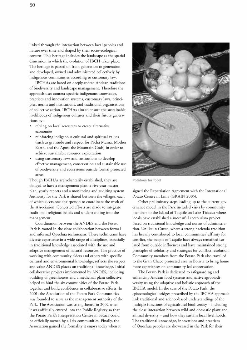
50
linked through the interaction between local peoples and nature over time and shaped by their socio-ecological context. This heritage includes the landscape as the spatial dimension in which the evolution of IBCH takes place. The heritage is passed on from generation to generation and developed, owned and administered collectively by indigenous communities according to customary law.
IBCHAs are based on deeply-rooted Andean traditions of biodiversity and landscape management. Therefore the approach uses context-specific indigenous knowledge, practices and innovation systems, customary laws, princi-ples, norms and institutions, and traditional organisations of collective action. IBCHAs aim to ensure the sustainable livelihoods of indigenous cultures and their future genera-tions by:• relying on local resources to create alternative
economies• reinforcing indigenous cultural and spiritual values
(such as gratitude and respect for Pacha Mama, Mother Earth, and the Apus, the Mountain Gods) in order to achieve sustainable resource exploitation
• using customary laws and institutions to develop effective management, conservation and sustainable use of biodiversity and ecosystems outside formal protected areas.
Though IBCHAs are voluntarily established, they are obliged to have a management plan, a five-year master plan, yearly reports and a monitoring and auditing system. Authority for the Park is shared between the villages, each of which elects one chairperson to coordinate the work of the Association. Concerted efforts are made to integrate traditional religious beliefs and understanding into the management.
Coordination between the ANDES and the Potato Park is rooted in the close collaboration between formal and informal Quechua technicians. These technicians have diverse experience in a wide range of disciplines, especially in traditional knowledge associated with the use and adaptive management of natural resources. The practice of working with community elders and others with specific cultural and environmental knowledge, reflects the respect and value ANDES places on traditional knowledge. Initial collaborative projects implemented by ANDES, including building of greenhouses and a medicinal plant collective, helped to bind the six communities of the Potato Park together and build confidence in collaborative efforts. In 2001, the Association of the Potato Park Communities was founded to serve as the management authority of the Park. The Association was strengthened in 2002 when it was officially entered into the Public Registry so that the Potato Park’s Interpretation Centre in Sacaca could be officially owned by all six communities. Finally, the Association gained the formality it enjoys today when it
signed the Repatriation Agreement with the International Potato Centre in Lima (GRAIN 2005).
Other preliminary steps leading up to the current gov-ernance model in the Park included visits by community members to the Island of Taquile on Lake Titicaca where locals have established a successful ecotourism project based on traditional knowledge and norms of administra-tion. Unlike in Cuzco, where a strong hacienda tradition has heavily contributed to local communities’ affinity for conflict, the people of Taquile have always remained iso-lated from outside influences and have maintained strong principles of solidarity and strategies for conflict resolution. Community members from the Potato Park also travelled to the Gran Chaco protected area in Bolivia to bring home more experiences on community-led conservation.
The Potato Park is dedicated to safeguarding and enhancing Andean food systems and native agrobiodi-versity using the adaptive and holistic approach of the IBCHA model. In the case of the Potato Park, the epistemological bridges prescribed by the IBCHA approach link traditional and science-based understandings of the multiple functions of agricultural biodiversity – including the close interaction between wild and domestic plant and animal diversity – and how they sustain local livelihoods. The traditional knowledge, innovations and practices of Quechua peoples are showcased in the Park for their
Potatoes for food

51
essentially modern significance and utility, including for the purposes of nutraceuticals, pharmaceuticals, biotech-nologies, agro-ecotourism activities and community-based conservation. In terms of the rights-based approach prescribed by the IBCHA approach, the Potato Park is concerned with indigenous peoples’ self determination and securing the Quechua people’s tenure and rights to agricul-tural biodiversity, local products, traditional knowledge, and related ecosystem goods and services (Argumedo and Pimbert 2005).
As an IBCHA, the Potato Park has been proposed as a sui generis system for the protection of traditional knowledge because it aims to protect traditional knowledge systems within its cultural, temporal and spatial dimen-sions using a combination of positive and defensive protec-tion tools (Argumedo and Pimbert 2005).
Past and current land/water use practicesThe natural environment of the Andean Mountains is characterized by a tremendous variation in vegetation, soils and climate over relatively short distances, creating significant reservoirs of species and ecosystem diversity. The Andes are also sacred landscapes, where ancient cultures have developed an intimate knowledge about their environment, guided by an ethic of respect for all forms and expressions of life.
A long line of human cultures has left significant traces of modification on the Andean landscape, both through intentional management and unintentional mismanage-ment. The result is a human created landscape, which in the past was even more intensively utilized than it is today.
Potato flowers

52
At the time of the Spanish conquest, the Incas cultivated almost as many species of plants as the farmers of all Asia or Europe. On mountainsides up to four kilometres high, and in climates varying from tropical to polar, they grew a wealth of roots, grains, legumes, vegetables, fruits and nuts. In Peru alone, an estimated one million hectares of steep slopes were converted into agricultural fields using terracing, irrigation canals, catchments and reservoir structures. Today over half of these terrace-covered slopes have been abandoned. A recognised centre of origin and diversity of more than 90 food crops and 5 animal breeds (Brack 2003), traditional agricultural landscapes continue to give the Andes its unique character.
The high Andean cultures thus constitute one of the best examples of long-term, large scale experimentation in sustainable land use. Over centuries of life in the Andes, Quechua and Aymara peoples have mastered the adaptive management of the complexity of their ecosystems by using diversity as a management principle to create the resilience needed to inhabit such a harsh environment. Their integrated management and land use planning systems maintained mosaics of land use types, including agricultural and natural areas and the maintenance of bor-der habitats for wildlife. Andean indigenous peoples have nurtured plants and animals to provide food, carefully selecting tastes and textures that make good food, resulting in a great diversity of genetic resources, varieties, breeds and sub-species. This diversity was developed as a result of the free-flow of genetic resources between food producers, i.e. women and men farmers who safeguarded agricultural biodiversity. Traditional farming systems also include the diversity of species that support production – soil biota, pollinators, predators, and so on – and those species in the wider environment that support diversity.
Agriculture and related land use continue to define Andean landscapes, provide for sustenance of local com-munities, and exert great influence on the environment, economy, society and culture of the mountains. Traditional Andean livelihood strategies are based on maximizing the value of biodiversity to increase security and to buffer shocks. The crops grown at the highest altitudes are tubers, including the potato (possibly the highest altitude crop in the world), as well as ulluco, oca and mashua. Yields are lower than maximum yields obtained with intensive agriculture as there is a trade-off between productivity, risk management, external subsidies and degradation. The Andean community approach to optimizing diversity is evidenced by the large numbers of potato varieties that farmers cultivate, the regular use and management of wild resources, and the importance of domesticated and semi-domesticated animals within the household economy and landscape. These diverse varieties, breeds and systems underpin food security and provide insurance against
future threats, adversity and ecological changes.The multiple functions of traditional agriculture in
the Andes extend beyond the production of food, fibre, medicines, timber and other goods for immediate benefit. Additional functions include food security, environmental sustainability, development and social and economic well-being.
Traditional agro-ecosystems are genetically diverse, containing populations of variable and adapted landraces as well as wild relatives of crops. The resulting genetic diversity confers at least partial resistance to diseases that are specific to particular strains of the crop and allows farmers to exploit different microclimates and derive multiple nutritional and other uses from within-species genetic variation. In the Potato Park, along with many other Andean crops and wild relatives, other species are regularly havested from the wild for foods, medicines and ritual purposes. Diversity, as a principle, has nurtured creativity among the local communities, along with a deep knowledge of species taxonomy, distribution, life cycles as well as ecological processes and natural resource management. Tools and techniques created to manage diversity include the practice of managing mountain verticality to enhance complementarity between life zones. Such a practice depends on cooperation among indigenous communities living in diverse biological environments with distinct cultural identities, and is responsible for the rich diversity of landscapes, ecosystems and biological and genetic resources in the Andes. Traditional barter markets continue to be used to facilitate the exchange of plant and animal material while minimizing vulnerability to market forces. This type of cooperation has resulted in a dynamic biocultural-ecological network through which a diversity of biological resources is shared, based on the principles of duality, reciprocity and equilibrium. These principles, three pillars of the Andean cosmovision, continue to guide the daily life of indigenous peoples and serve as the core principles of the agricultural and landscape management systems, customary laws, cultural and spiritual values, and socioeconomic organization that have allowed for coopera-tion among communities settled in different ecological zones.
Comprised primarily of collective landholdings, forests and small farms, the traditional Andean landscape con-tributes greatly to the country’s economy, albeit informally since no records in the national accounting books tabulate the exchange of goods and services flowing through the biocultural ecological networks that crisscross this landscape. An increase or decrease in GDP, therefore, does in no way reflect the role of these networks in cushioning the social impacts that rapid changes, brought about by globalization and trade liberalization, are producing in remote and neglected indigenous communities.

53
Conscious management policies and practicesAlthough the concepts of environmental protection and cultural preservation are arguably foreign to the Andean worldview, these concepts are nevertheless a consequence, identifiable by outsiders, of the interaction between indigenous communities and their natural environment. This interaction, embodied by the traditional Andean landscape, protects cultural and biological diversity and a wide array of ecosystem goods and services that provide for clean air, water, and soils, and help reduce the threat of cli-mate change. This protection is made possible, in no small part, by the spiritual values of indigenous peoples whose sacred relationship with the land constitutes spiritual capital and may be the key for achieving sustainability in the Andes. Thanks to the environmental protection offered by the traditional Andean landscape, the biocultural resources of the Andes are well-preserved and draw a large number of visitors, making tourism one of the largest and most dynamic sectors of the Peruvian economy.
Andean agricultural landscapes and their agricultural biodiversity can also provide the basis for biotechnologies (old and new), natural product development, ecotourism, and other activities important for income generation in the local, national and global economies. The establish-ment of the Potato Park is an attempt to use traditional agricultural systems for landscape conservation, firstly to maintain native plant and animal species in their original habitat, secondly to promote the conscious management of biodiversity in wild and cultivated species, and thirdly to provide sustainable livelihood opportunities for indigenous communities.
The development of the Potato Park took a major step forward in December 2004 with the Agreement on the Repatriation, Restoration and Monitoring of Agrobiodiversity of Native Potatoes and Associated Community Knowledge Systems, made between the Association of Communities of the Potato Park, repre-sented by ANDES, and CIP. The agreement is legal under Peruvian law, and is a legal sign of the restoration of rights that indigenous peoples once had.
The indigenous communities to whom the potatoes have been repatriated, will not seek patents over these varieties as they are against patents. Patents represent a model of property that does not fit into their worldview, as indigenous people are used to exchanging and sharing information in open ways. The agreement with CIP legally prevents anyone else from claiming intellectual property rights over the communities’ knowledge and resources. Under the CIP agreement, CIP scientists and local farmers are repatriating potato varieties from CIP’s collection of specimens (the agreement initially covers 206 varieties).
CIP has agreed to pay for the cost of reintroducing the varieties, as an acknowledgement of the benefits the organisation has derived from the indigenous knowledge of the region. The repatriated varieties have been distributed in the Potato Park and replanted in the area, where they are used for local food security, medicines and ceremonies. These varieties are also being distributed to other indig-enous communities in the area.
The repatriation of native potatoes is helping support the work of the Association of Communities of the Potato Park to develop alternative economic activities. Examples of local projects which are managed by economic collec-tives include:• the Sipaswarmi Medicinal Plants Women’s Collective
which develops and sells natural medicine and natural soaps using local resources and traditional and modern knowledge
• a landscape-based agro-ecotourism venture which includes a network of walking trails, a potato-oriented restaurant, and workshops and stores for the produc-tion and sale of local handicrafts
• the Arariwa, a native potato repatriation and seed development collective
• the Tijillay T’ika Women’s Audio-Visual Collective where members of a women’s cooperative are being trained in making and digitally editing videos in the local language, to record and share knowledge about local resources and how to manage them.
A database of traditional medicinal knowledge is also being established to protect against biopiracy. The Indigenous Biocultural Heritage Registers are a comprehensive approach to protection based not only on the intellectual components of traditional knowledge, but also on the distinct cultural, biological and ecological character of traditional knowledge systems (Argumedo and Pimbert 2005).
Managing data base

54
A network of barefoot technicians, who are elected by their communities because of their expertise in traditional knowledge, are developing a dynamic process of horizontal learning and knowledge exchange. For example, the barefoot technicians have been supporting other communities by providing information, supporting exchange of experiences and cross-community visits, offering participatory planning and evaluation methods at the community level, organising training courses and advocating for the needs, visions and rights of indigenous peoples and their knowledge systems. Organisations of col-lective action such as Local Learning Groups and experts in traditional knowledge spearhead community training as well as processes to gather, organise and apply traditional knowledge. Local Learning Groups have been trained as community facilitators and leaders to enhance indigenous knowledge and to strengthen the institutional capacity of communities to manage local knowledge and innovations in the Park’s conservation and development programmes.
As well as ensuring the conservation of potatoes, the communities plan to regenerate native forests, most of which were cut down in the 18th century to provide timber for Spanish silver mines. Currently, the main tree species on the hillsides is alien Eucalyptus, planted in the 1940s and 1950s; but though it is valued for being fast growing and is currently the main source of fuel wood, it negatively affects soil quality. Nurseries for growing thou-sands of seedlings of native species have been set up. By regenerating native forests, the villagers hope to promote greater biodiversity which will also help fulfil the objective of encouraging agro-ecotourism.
The Park is developing an autonomous programme for managing tourism and ensuring that local people benefit equitably. A new research and visitor’s centre is being established to help with administration, marketing and coordination. The Potato Park is also in discussion with the National Institute of Culture to agree on a system for co-management of archaeological sites and sacred sites in the area.
The new sense of unity that has been established between the communities of the park has brought other ancillary benefits. A history of (occasionally violent) land conflicts between the communities has been largely overcome, in part through the revival of the customary village boundary festival, in which each village’s links with the land are celebrated each year by walking the boundaries. As Association Chairman Wilbert Quispe has remarked, “Before this project we were divided and were losing our diversity, native potatoes, wildlife and many other things…We were also forgetting how to manage this variety. Our aim is to reunite our villages in order to restore our traditional ways of managing our landscape.”
Key challenges, threats and responses In spite of the enormous importance of Andean agri-cultural landscapes for the cultural and socioeconomic well-being of indigenous peoples and the ecological health of the Andes Mountains, conventional conservation and development initiatives have not focused on preserving these landscapes. On the contrary, neo-liberal policies of recent governments have all but neglected conservation of the traditional agricultural landscape and have favoured short-sighted agricultural policies promoting the use of new and foreign technologies for agricultural production. These technologies have included hybrid crops as well as new means for storage, transport and organization geared towards creating an export economy.
Such policies have deep implications for the cultural, biological and landscape diversity of the Andes as well as for the economy and livelihoods of indigenous peoples. In the last 50 years alone, a large amount of the genetic diversity of the most important Andean crops has disappeared from farmers’ fields. This has increased agricultural vulnerability, reduced the nutritional variety of rural people’s diets, and erected obstacles for the exchange of knowledge and resources within Andean ecological networks.
Agricultural policies have also systematically neglected native species and races of domesticated plants and animals, vital for the nutrition of the poorest people. The production of commercial-variety crops for the market requires high inputs of fertilizers and pesticides which are having a serious impact on numerous endemic and threat-ened species, medicinal and food plants, and sanctuaries for plants and animals. At the same time, global warming and natural resource extraction are having a measurable impact on mountain glaciers, the availability of water, and pollution.
In order to survive droughts and other climatic chal-lenges, indigenous people traditionally shared knowledge relating to the climate and remedial agricultural practices such as planting different crops or developing highly advanced irrigation systems. Such practices have historically enabled local resilience to outside forces which threaten food security. However, increasing preference for occidental technologies - caused by poorly conceived development efforts and national and international free market trade policy - has led to a marginalization of the indigenous way of life and the devaluation of indigenous practices.
The present policy environment threatens to forcibly alter the very essence of Andean culture and spirituality and the traditional landscapes it has enabled. Particularly alarming is that the maintenance of these traditional

55
landscapes is the only sensible strategy to preserve in situ repositories of crop germplasm. Unless such a strategy is adopted in Peru, the world could soon lose a centre of origin and diversity of important food crops which reinforce global food security. Furthermore, neglecting traditional landscapes will have deep implications for the survival of indigenous peoples, their traditional resource rights, ecosystem goods and services, biological and genetic diversity, food and health security, and ultimately the cultural identity and sustainable development of Peru. The steady erosion of wild and domestic biodiversity and the persistently high ranking of the rural Andes as the poorest region of the country has, nevertheless, not influenced government policy makers to enact measures in support of traditional agricultural landscapes.
Understanding links between farming communities and the use of natural resources is critical to fostering greater harmony between agriculture and ecosystems that support peoples and other species. Community-based approaches have been proposed as an alternative to top-down conservation and development models. Efforts towards decentralisation are recent and have yet to fully run their course. Current conservation and development thinking argues that community involvement is by no means easy, and nor is it guaranteed to succeed. Not all communities are small, homogeneous entities with shared values and qualities that facilitate collective decision mak-ing. Many are, in fact, heterogeneous in ways that often impede their ability to conserve resources.
Although the international community has begun to emphasize the need to involve farming and local communities more centrally in the management of agricultural biodiversity, there are huge gaps in knowledge and institutional constraints that limit national capacities to scale up these approaches. In order to help fill these gaps and constraints, ANDES, the ‘Sustaining Local Food Systems, Agrobiodiversity and Livelihoods’ Program of the International Institute of Environment and Development, and six Quechua communities of Pisaq, Cusco, Peru, undertook action research with local communities. This research indicates that a rights-based approach to conservation, which fully respects the cultural and spiritual values and practices of indigenous communities, can harness the best attributes and decision-making processes of local organizations in order to promote the objectives of conservation and sustainable use of biocultural resources (IIED website).
There is much to be learned from traditional Andean management philosophy and policy. However, this traditional knowledge is rapidly deteriorating with the synergistic effects of population and consumption growth, poverty, and free-market economies as they steamroll further and further into remote Andean valleys.
Agrobiodiversity for the future: Plans and recommendations
The Potato Park modelThe Potato Park experience is an inspiring example of how the six disparate Quechua communities converged in defence of their common biocultural heritage. The story of the Potato Park is about how the interests of these communities are worked out within a new organizational framework that demands cooperation and constant renegotiation. The communities have come to understand that only through cooperation will they be able to defend their rights in the face of imminent change brought on by the Peruvian state and the global market place.
The Potato Park has demonstrated that successful biodiversity and ecosystem management depends largely on the recognition of property rights, the dynamics of ecosystems, and indigenous knowledge. This ensures the conservation and sustainable use of biodiversity at all levels, contributing to the equity, opportunity, security and empowerment of local and indigenous communities, as well as to the sustainability of the biological resources and landscapes. The Potato Park is an excellent example of biocultural restoration, which has resulted in a wide range of biodiversity, agricultural and cultural benefits to the local communities, as well as safeguarding an important global resource for future generations. A long term goal of the Potato Park is to re-establish all the world’s 4,000 known potato varieties in the Park.
There is a great deal to be learned from the Park with regard to geographic issues such as:
globalization of food production; cultivation of local food economies, development and anti-development argu-ments; GMO policies and power; globalization-from-below (inter-local solidarity and resistance); the devaluation and revaluation of home-scale economy and domestic crafts/knowledge; and re-empowerment of rural communities. In short, the Potato Park heralds an important next chapter in the geographic story of agriculture, justice, and alternative ecological knowledge systems.
CIP Agreement: In situ and ex situ complementarityThe agreement with CIP is in many ways unprecedented. Its collaborative origin, as well as its language of repatriat-ing knowledge systems, is critical and inspiring. It can serve as a model for combining in situ and ex situ conserva-tion strategies.
In response to the alarming pace of crop genetic ero-sion, particularly in the South’s centres of diversity, FAO, the Consultative Group on International Agricultural

56
Research (CGIAR) and various national governments initi-ated global plant genetic conservation efforts in the early 1970s. Collecting missions were launched to Southern centres of diversity, and gene banks were constructed and expanded for safeguarding collected germplasm. To date, the storage of seeds in gene banks has been the standard approach to plant genetic resource conservation. The vast majority of attention, funds and scientific expertise has been devoted to ex situ collections, focusing particularly on major crop species.
Today, there is growing appreciation for the fact that in situ conservation is a crucial element in the conservation of agricultural biodiversity, and must be complementary to gene bank collections. The future of world food security depends not just on stored crop genes, but on the people who use and maintain diversity on a daily basis. After decades of neglect in official circles, the Convention on Biological Diversity, Agenda 21 and FAO’s Global Plan of Action aim to redress this imbalance by placing greater emphasis on in situ and farmer/community level manage-ment of genetic resources. The Global Plan of Action recognises the need for complementary conservation sys-tems, and aims to secure existing ex situ collections while
also strengthening in situ conservation and the capacity of farming communities.
Experience shows that diversity is only secure when diverse conservation strategies are employed. Ex situ and in situ approaches are not mutually exclusive; no single method of conservation is optimal for all situations, and no single method can succeed alone. Different conservation systems can complement each other and provide insurance against the shortcomings of any one method. Ultimately, the success of both in situ and ex situ approaches depends on forging strong links between the two. In practical terms this means conservation and utilization using both institu-tional scientific innovation and the community genius of farmers and indigenous peoples.
Agro-ecotourism and traditional agricultural landscapesThe Potato Park model includes incorporating agro-ecot-ourism as a complementary and effective economic activity within the framework of the traditional agricultural production of local people. The viability of this model for potential application within the framework of the Ruta Cóndor is considered in the section below. The
Potato varieties

57
economic activities proposed are the creation of communal businesses that develop and offer tourist products based on the utilization of genetic resources, native biodiversity, goods and services of the ecosystem, and the aesthetic and cultural values of the landscape. Through these activities, incentives will be established for the in situ conservation of genetic resources and for the creation of policies and poverty alleviation strategies based on the conservation and sustainable use of Andean biodiversity.
Cusco is important for tourism in Peru because it is the centre of the pre-Hispanic Inca culture. However, the rural population benefits only marginally from tourism. One source of income is through the sale of their produce, mostly derived from the unique biological resources of the region. In recent years there has been a loss of traditional conservation practices and other customs (food, dress, etc.).This has been mainly because of the increasing use of high-yielding species and varieties in commercial agriculture, climatic factors, pests, diseases, inappropriate agrarian policies and development activities, and poverty which increases the migration of indigenous youth (with their knowledge, experience and customs of traditional Andean agriculture).
In the communities of the Potato Park, it is the local farmers who have conserved the wide range of local varieties of Andean root crops on their farms. Rather than focusing on the maximisation of yield or income, they recognise the need to spread risks by planting mixtures of species on their small parcels of land to guarantee a harvest every year. The incentives provided by the development of agro-ecotourism could facilitate new mechanisms for promoting traditional conservation and sustainable use practices. During guided tours to the communities, tour-ists will see the remarkable morphological and agronomic variety of Andean plants and tubers in demonstration plots, a potato museum, and restaurants with menus based on traditional Andean produce. An educational programme about Andean crops and culture and the participation of young people in agro-ecotourism in order to reduce migration are also proposed.
Ecological networks and agrobiodi-versity corridors: The Ruta CóndorThe Potato Park is a pilot project for a larger initiative in landscape conservation in the Andes. Over the last 30 years, biodiversity conservation efforts have taken a more holistic approach by focusing on ecological networks. The World Summit on Sustainable Development recognised that a necessary action to achieve the 2010 biodiversity target is to “promote the development of national and regional ecological networks and corridors.” Furthermore Point 1.2 of the Program of Work on Protected Areas of the Convention on Biological Diversity calls for
establishing protected areas in a mosaic of habitats in order to maintain entire ecological processes (Bennet 2006). Corridors play a key role in ecological networks, conserv-ing the flows and linkages that exist between fragmented ecosystems. Many different types of corridors exist, rang-ing from biological corridors to sustainable development corridors (e.g. the MesoAmerican Sustainable Development Corridor). Based on this concept of connectivity, ANDES plans to link fragmented IBCHAs via a corridor that has the multiple, yet complementary, objectives of conservation and meeting local food needs. This food sovereignty corridor, the Ruta Cóndor, will link cultural and biological resources of Andean communities.
The Potato Park as sui generis systemThe livelihoods of indigenous communities worldwide depend on the preservation and protection of their exten-sive traditional knowledge relating to biodiversity manage-ment, that has been cultivated over many generations. The idea of sui generis protection of traditional knowledge and biological resources began with the debate on the Philippine accession to the World Trade Organization (WTO) in 1994. This debate led to the creation of one of the key agreements of the WTO, the TRIPS Agreement, which provided for sui generis protection of plant varieties as an exception to what may be considered as patentable subject matter.
Prior to 1994, there were discussions on issues related to the protection of traditional knowledge and the associated biological and genetic resources, but these were mainly among academic circles and NGOs. In 1994, MASIPAG and some scientists from the University of the Philippines at Los Banos held a workshop on the issue and proposed policy measures on community intellectual rights. This was aimed at stopping biopiracy, which was seen to result from the country’s accession to the WTO.
As a sui generis system, the Potato Park respects, preserves and maintains the knowledge, innovations and practices of indigenous Quechua communities, and recognises their right to control the use of their knowledge based on their own vision, needs, and customary laws and practices, for their primary benefit. Protection is not limited to knowledge. Other aims can be met with the IBCHA model, including protection of biodiversity, landscapes, cultural and spiritual values, and customary laws and practices. This kind of holistic protection can contribute to empowerment and alleviation of poverty among indigenous peoples.

58
AcronymsANDES Association for Nature and Sustainable
Development
CBCH Collective Biocultural Heritage
CCA Community Conserved Area
CIP International Potato Centre
FAO Food and Agriculture Organisation
GMO Genetically Modified Organism
IBCH Indigenous Biocultural Heritage
IBCHA Indigenous Biocultural Heritage Area
MASIPAG Farmer-Scientist Partnership for Development
TRIPS Agreement on Trade Related Aspects of
Intellectual Property Rights
WTO World Trade Organisation
ReferencesAltieri, Miguel A. 1995. Agroecology: The Science of
Sustainable Agriculture. Westview Press. Boulder.
ANDES website. www.andes.org.pe (accessed 05/01/07)
Argumedo, A. and Pimbert, M. 2005. Protecting Indigenous
Knowledge against Biopiracy in the Andes. IIED. London.
Bennet, G. 2006. Review of Experience with Ecological
Networks, Corridors and Buffer Zones. Convention on
Biological Diversity Technical Series No. 23.
Brack, Antonio. 2003. Perú: Diez Mil Años de Domesticación.
PNUD. Lima.
Colchester, M. and Argumedo, A. 2003. Peru: Visit to a
“Potato Park”. Document prepared for the IUCN World Parks
Congress www.tilcepa.org/themes/themes.asp?=3#titles
(accessed 10/01/07).
GRAIN 2005. ANDES-Potato Park-CIP Agreement. BIO-
IPR Docserver, 20 January 2005. www.grain.org/bio-ipr/
?id=429#-eng (accessed 15/12/06)
IIED website. www.iied.org (accessed 10/12/06)
Marti, N. and Pimbert, M. 2005. Barter Markets: Sustaining
People and Nature in the Andes. IIED. London.
Sponsel, Leslie (Lead Author) and Casagrande, David
(Topic Editor). 2007. Ecological anthropology. Cleveland,
C.J. (Ed.). Encyclopedia of Earth. Environmental Information
Coalition, National Council for Science and the Environment.
Washington, D.C. www.eoearth.org/article/Ecological_
anthropology (accessed 07/02/07)
Suri, S. 2005. Potato Capital of the world offers up new
recipe. Inter Press Service News Agency. 18 January 2005.
www.ipsnews.net/interna.asp?idnews=27069 (accessed
05/12/06).
About the AuthorAlejandro Argumedo is Director of the Association ANDES,
a Cusco-based indigenous peoples’ non-governmental
organization working to protect and develop Andean
biological and cultural diversity and the rights of indigenous
peoples of Peru. Alejandro is also the international
coordinator of the Indigenous Peoples’ Biodiversity Network
(IPBN), and Senior Research Officer for Peru of the
‘Sustaining Local Food Systems, Agricultural Biodiversity
and Livelihoods’ Programme of the International Institute
for Environment and Development of England. He was
formerly Executive Director of Cultural Survival Canada
and the Indigenous Knowledge Programme. He has
been a consultant for the UNDP, IDRC, GEF, IUCN and
other international institutions. He graduated from McGill
University, Montreal, Canada in Agriculture, and has
written extensively on diverse themes such as intellectual
property, access to genetic resources, community based
conservation, indigenous agriculture, tourism, etc. and
has served on expert panels of the UN and other relevant
bodies such as the World Business Council for Sustainable
Development.
Alejandro Argumedo
Calle Ruinas 451
Cusco, Peru

59
SummaryThe Rhön UNESCO-Biosphere Reserve has been com-mitted to conserving agrobiodiversity through product development and regional marketing since 1991. Important ecosystem types, such as species-rich grassland and traditional fruit orchards, have been effectively conserved through the in situ conservation of agrobiodiversity (Rhön sheep and apple varieties).
Driven by the common vision and enthusiasm of the main stakeholders in the region to preserve the traditional cultural landscape of the Rhön, many promising projects have emerged. Although still limited to a niche market, the experiences in the Rhön demonstrate that the conserva-tion of agrobiodiversity is possible if it is based on close cooperation and networking at a regional scale. Experience has shown that successful agrobiodiversity conservation is mainly dependent on economic self-sufficiency – since without a market, agrobiodiversity cannot be conserved in the long-term. Furthermore, agrobiodiversity conservation depends both on the commitment of farmers (land owners) and consumers’ attitude and willingness to pay ‘a little extra’ for the positive conservation outcomes. Adequate interpretation programmes are also important.
The Rhön Biosphere Reserve
The Rhön is situated in the centre of Germany, 150 km east of Frankfurt (see map) and was designated by UNESCO as a biosphere reserve in 1991. It is one of Germany’s 13 biosphere reserves and covers an area of 1,850 km². The Rhön is a rural area with a total popula-tion of 162,000 (as of 2004) living in numerous small villages and towns over 42 municipalities. The area covers five districts within three federal states or ‘Länder’: Bayern (Bavaria), Hessen (Hesse) and Thüringen (Thuringia). As biosphere reserves in Germany are within the jurisdiction of the individual ‘Länder’ governments, the Rhön has three independent, but closely co-operating, administrative units.
The Rhön is an area of low mountains, rolling hills and highlands reaching a maximum altitude of 950 m above sea level. The climate is both sub-continental and sub-oceanic. The mean annual temperature ranges from 5°C in the highlands to 8°C in the lower areas. The mean annual precipitation follows a gradient ranging from 1,000 mm in the west to 550 mm in the east.
Conservation by consumption: In situ conservation of agrobiodiversity in the Rhön UNESCO-Biosphere Reserve, GermanyDoris Pokorny
Typical rural settlement structure.
Photo: Vogel

60
The Rhön’s land use history can be traced back to the 9th century. For 40 years during the 20th century, however, the area was divided by the ‘Iron Curtain’; until German reunification in 1990, the Thuringian side was in the former German Democratic Republic. The major structural differences in land use on both sides of the former Iron Curtain are still apparent today.
Managed forests (mainly mixed forests or broadleaf beech-woodlands dominated by Fagus sylvatica) cover 40% of the area; 35% is grassland (both pasture and meadows including bogs and other landscape features), 18% is arable land and 7% is settlements, roads or other infrastructure. Due to the harsh climate and poor soils, large parts of the Rhön are regarded as marginal agricultural areas.
Although pristine or natural ecosystems have long since disappeared, the cultural landscape is very rich. Biodiversity conservation in the Rhön means preserving habitats, many of which are of European importance in the framework of the Fauna, Flora and Habitats Directive (92/43/EEC) (e.g. nardus grasslands, mountain hay mead-ows and semi-natural dry grasslands). These habitats are important for a range of endangered and rare animal and plant species which are protected on the regional, national and European level (e.g. Black stork - Ciconia nigra, Red kite - Milvus milvus, Corncrake - Crex crex and Bythinella compressa, an endemic snail species). The genetic resources of livestock and cultural crops are also a vital part of the man-made landscape, and last, but not the least, the landscape aesthetics are considered worthy of conservation.
The areas of high biodiversity values are mainly dependent on extensive grassland management. Conservation goals in the Rhön can thus only be achieved
with close cooperation between farmers and the nature conservation or agricultural authorities which provide grant schemes and programmes for adapted management.
Generally speaking, the aim of biosphere reserves is the conservation of abiotic resources and biodiversity (including agrobiodiversity) integrated within a sustain-able regional development approach. “Conservation by consumption” could be the motto which appropriately encompasses these objectives. Agrobiodiversity conserva-tion plays an important role in this context as, besides the need to conserve rare agricultural breeds and varieties, it can provide valuable habitats for wildlife and economic opportunities for niche products and markets.
The visions and goals of the biosphere reserve, developed through a comprehensive discussion process with stakeholders in the region, are laid out in the Management Framework for Conservation, Maintenance and Development of the reserve (Grebe et al 1995). The framework is not legally binding but is used as a ‘soft’ planning tool. It will be updated in the near future.
According to UNESCO’s Statutory Framework for Biosphere Reserves (UNESCO 1996), all biosphere reserves require this type of overall management concept as well as a zoning plan. Core and buffer zones and a transi-tion area need to be defined in order to spatially fulfil the different functions of a biosphere reserve. In the Rhön the most important zone is the buffer zone, locally known as the ‘maintenance zone’, which covers 40% of the reserve. It is not surprising that the core zone (i.e. wilderness area) is less than 3%, given the region’s long history of land use. The transition zone, which contains all the settled areas and infrastructure as well as a more intensive land use, covers 57% of the total area.
Legal status of the Rhön Biosphere ReserveThe three administration units of the Rhön differ in their structure and jurisdiction. Whereas in Thuringia the whole biosphere reserve area is designated as a protected area, in the Bavarian and Hessian regions the biosphere concept is considered as a planning tool and not a protected area designation.
Although the whole area does not have protected area status, there are a variety of protected areas within the biosphere reserve. These include: • Protected Nature Reserves (Naturschutzgebiet):
Protected areas according to Länder nature conserva-tion legislation. They are equivalent to the ‘mainte-nance zone’ of the biosphere reserve, which has legal status only in Thuringia.
Land of panoramic views – the Rhön is an old cultural
landscape.
Photo: Vogel

61
• Woodland Reserves (Naturwaldreservat): Protected areas according to Länder woodland legislation ‘Waldgesetz’. They are equivalent to the ‘core zone’, which again has legal status only in Thuringia.
• ‘Natura 2000’ sites (FFH/SPA-Gebiet): Protected areas according to EU legislation.
As the different categories of protection spatially overlap, the ‘net nature conservation area’ needs to be identified in order to reveal the area of the Rhön which is actually dedicated to conservation. In the trilateral Rhön biosphere reserve this makes up 46% of the total area; which means roughly 85,000 ha are legally considered as ‘priority areas’ for nature conservation. Except for the woodland reserves/core zones, all priority areas for nature conserva-tion are managed by local farmers as land owners or as leaseholders. Thus, conservation in the context of cultural landscapes remains mainly a question of adapted land use. It depends on negotiations with the landowners who are mostly eager to cooperate as long as adequate state subsidies are provided.
In addition to the above, the biosphere reserve in Hesse and Bavaria has the status of a Nature Park (Naturpark). This category spatially restricts the development for hous-ing areas, industrial areas and other built up areas in order to prevent urban sprawl. The nature park area exceeds the area of the biosphere reserve.
To sum up, the Rhön biosphere reserve for Thuringia may be considered as a protected area in the IUCN sense, whereas for Hesse and Bavaria it is in effect an umbrella for a conglomerate of different nature conservation categories which differ in their protection status. This may be the reason why, to date, only the Thuringian part of the biosphere reserve has been listed as an IUCN Category V area on the World Database on Protected Areas. Whether or not the Hessian and Bavarian parts of
Protected areas (national/EU categories) in the Rhön Biosphere Reserve
Protected Nature Reserves as parts of the buffer/maintenance zone of the Rhön BR
Woodland Reserves as parts of the core zone of the Rhön BR
‘Natura 2000’ as parts of the buffer/ maintenance and transition zone of the Rhön BR
Bavarian part 4902 ha 293 ha FFH 22.496 ha SPA 19.000ha
Hessian part 4558 ha 101 ha FFH 11.378 haSPA 41.984 ha
Thuringian part 5254 ha* 762 ha* FFH 13.066 haSPA 18.084 ha
* Since 28.04.2006 the term ‘protected nature reserve/woodland reserve’ has been formally adapted in the Thuringian part to comply with the wording for the UNESCO zones; thus the terms ‘maintenance zone’ and ‘core zone’ are used now.
The Lange Rhön Nature Reserve - one of the protected
areas which makes up the Rhön Biosphere Reserve.
Photo: Vogel

62
© Rhön Biosphere Reserve - Bavarian administration unit
Map
Rhön Biosphere Reserve

63
the Rhön, and thus the biosphere reserve altogether, would qualify as a Category V needs further examination and evaluation. However, technically the preconditions are basically fulfilled: the Rhön cultural landscape is an area which demonstrates, according to IUCN requirements, “the interaction of people and nature over time [which] has produced an area of distinct character with significant aesthetic, ecological and cultural value and with high biological diversity.” (IUCN 1994). The Rhön example is thus fairly typical of the challenges posed when it come to managing and categorising protected areas that extend beyond single administrative boundaries and jurisdictions.
Who makes the biosphere reserve work?Success or failure of the Rhön biosphere reserve idea depends upon the local people, on their commitment, creativity and preparedness to take economic risks or try out new ideas. Indeed, biosphere reserves rely on coopera-tion in many ways: they deliver action at the local level, are voluntary rather than regulatory, involve the co-ordination of numerous stakeholders rather than a single management agency, and have multiple benefits in terms of conservation goals, economic values and social well-being (e.g. through job opportunities). They are forward-looking, bring together disparate groups into new partnerships, and yet
seek to match action with the conservation of landscape qualities and the quality of life. They also solve conflicts through approaches that focus on win-win solutions.
In the Rhön, putting the biosphere reserve idea into practice is a question of facilitation, moderation and/or coordination, rather than a classic protected area manage-ment approach. The biosphere reserve coordinators’ tasks concern the integration of the biosphere reserve’s visions and goals into regional conservation and development concepts. Biosphere reserve coordinators motivate and bring partners together; moderate and mediate; coordinate projects and set thematic and spatial priorities; and assist in fundraising for model projects and accompany projects, e. g. through applied research.
The aim of biosphere reserve coordination is to bring together wider public responsibility for a biosphere reserve (‘top down’ in terms of financial and human resources), and local initiative (‘bottom up’ in terms of ideas and activity). The challenge for biosphere reserves in the Rhön, as well as in other areas, is to find the proper balance between the ‘top down’ and ‘bottom up’ approaches, so that appropriate resources from government, commit-ment of the private sector, and volunteer passion with a connection to local communities can be maximised. Coordination, rather than management techniques, seems to be the right tool, since biosphere reserves have a non-regulatory and consensus mandate.
In this sense, the Bavarian, Hessian and Thuringian administration units jointly care for the Rhön. However,
Local people have become proud of what their region has to offer.
Photo: Vogel

64
they differ decisively as to their jurisdictions and organi-sational levels. Whereas the Thuringian administration unit belongs to the provincial (Länder) government and is linked to the Ministry of the Environment, the Bavarian administration unit belongs to a lower level, the regional government, and the Hessian administration is part of the district council. The administration units work in close cooperation, and a trilateral technical advisory committee consists of representatives with science backgrounds, as well as representatives from various agencies and interest groups.
Unlike National Parks or other protected areas, the des-ignation of the Rhön as a biosphere reserve does not affect existing jurisdictions. Thus, for example, the responsibility for nature conservation in the reserve remains within the nature conservancy, for forest management it remains within the forest administration, for tourism development it remains within the tourism agencies, etc.
Besides the public administrations, not-for-profit organisations supporting the Rhön biosphere reserve exist in each part of the Rhön. A regional work group (ARGE Rhön) of the concerned five district councils was set up in 2000.
Agrobiodiversity features and conscious management practices in relation to maintaining or enhancing agrobiodiversityLand use in the Rhön biosphere reserve is mainly characterized by agricultural and forestry activities. Roughly 9.5% of the agricultural land in the reserve is farmed organically according to EU Guidelines. The conservation of agrobiodiversity focuses on the Rhön sheep (a regional breed), and regional fruit varieties (mainly apples) which have traditionally been cultivated in orchards (see below). Another traditional breed, Yellow Franconian Cattle (Gelbvieh), is also important in areas where conservation projects require low intensity grazing. This breed originated in Franconia (Northern Bavaria) in the early 19th century as a dual purpose animal for beef and milk production. It used to be quite common throughout the Rhön until the 1960s but, mainly for eco-nomic reasons, it almost disappeared in the region while becoming quite common overseas (e.g. in Canada, U.S. and South America). Although the breed is neither rare nor threatened, it can play an important role in conserving traditional agriculture.
Rhön apples, an economically successful resourceFruit orchards with high stem fruit trees are a typical feature of the Rhön landscape. They are found in the countryside, as orchard belts around villages and along footpaths and roads. In 1993-94 about 1,000 ha of fruit orchards were identified by remote sensing in the Rhön biosphere reserve, as well as an additional 180 km of fruit trees along roads and paths. Altogether it is estimated that there are 120,000 fruit trees.
Fruit orchards are culturally, historically, ecologically and economically important, as they:• provide additional income (through production,
processing) • contribute to the strengthening of regional marketing• contribute to the beauty of the landscape, especially in
the spring time and autumn• support the regional image of the Rhön as an eco-tour-
ism region• provide, when they are old, habitats for numerous
rare and endangered wild flora and fauna (Degenbeck 2003).
Apart from this, the intrinsic genetic value of the numerous fruit varieties is important in the context of conserving in situ agrobiodiversity. The conservation of old or traditional varieties may become increasingly important
Traditional apple orchards contribute to landscape
aesthetics and ecological values.
Photo: Vogel

65
for the fruit industry in general, even though many of the varieties would not meet today’s standards (with regard to size, appearance or yields). Old varieties often are more robust and resistant to diseases and pests and are better adapted to unfavourable climatic and soil conditions. Last, but not least, they have a more aromatic taste than their modern ‘relatives’.
The different varieties have a wide range of uses (as fresh fruit, making fruit juice or wine, or for cooking). Generations of farmers and land owners have propagated and selected the different varieties and have shared them with others, thus spreading the varieties throughout Europe and overseas. Fruit varieties are therefore not only an important genetic resource, but also a valuable cultural asset.
From 1960 onwards, fruit grown in plantations in other regions of Germany and abroad became widely, and cheaply, available. This made it less worthwhile for landowners to keep their own traditional orchards, which consequently decreased dramatically throughout the country. Until 1974, the EU even paid a bonus for every high stem fruit tree that was replaced by modern, intensively cultivated fruit varieties (Degenbeck 2003). This trend was, however, less marked in the Rhön due to the unfavourable climatic conditions.
The remaining fruit orchards in the Rhön were mainly preserved due to the rights of licensed private households to distil their own schnapps, rights which were passed on from generation to generation. Also, the tradition of
homemade fruit juice for private consumption was never fully given up and the commitment of local gardening associations helped to maintain the orchards. From the 1970s onwards the main threats to orchards were structural land reform and the increase in settlements as new housing and industrial areas were developed outside old village boundaries, and began gradually encroaching on the traditional orchard belts. Attempts to halt the loss of agrobiodiversity began in the mid-1980s when state subsidies were granted to landowners in order to keep their traditional orchards (ironically this was also co-financed by the EU). However, subsidies proved to be an insufficient motive for landowners to maintain and replant traditional fruit orchards. A suitable market was also needed.
In 1995, a transboundary apple initiative founded by local people for the conservation of orchards, was set up in cooperation with the biosphere administrations. With the financial help of the EU-funded LEADER programme of the European Community Initiative for Rural Development, and with seed money from a regional, bottled water enterprise, a comprehensive inventory of the genetic potential of fruit varieties was undertaken in the biosphere reserve. Every orchard owner was invited to have their varieties identified by fruit experts. To date, 176 apple, 38 pear and 12 plum varieties have been identified. The potential seems to be even greater as many varieties were unknown to experts and have not been clearly identi-fied yet.
Rhön apple market in Hausen offers more varieties than
any supermarket ever could.
Photo: Vogel
Organic Rhön apple juice – key product for the
conservation of apple orchards.
Photo: Vogel

66
Private enterprises joined the Rhön apple initiative and tried to find the best marketing potential for the different varieties. Today the initiative promotes organic fruit production in orchards and has about 2000 landowner and producer members, including a core of active members representing areas such as gastronomy, fruit pressing enterprises, breweries, garden centres, etc. Together they seek new strategies for processing and marketing fruit.
A wide range of organic apple products has emerged, and is sold in regional and even national markets. The main products are organic Rhön apple juice and a mixed drink of organic beer and apple juice called ‘Apfelbier’. Other products include dried apple chips, apple cham-pagne, cider, wine, vinegar, mustard and jam. A yearly apple fair and apple market, an apple interpretation trail, four in situ conservation sites for rare apple tree varieties, and the publication of a recipe book for regional apple dishes are further examples of how the conservation of agrobiodiversity can be marketed.
As a result, the price for apples from traditional orchards has increased four-fold since 1990. In fact the marketing strategy has worked so well that there is now a shortage of organic fruit in the region. Planting new organic apple orchards needs to be promoted among land owners. Since an orchard is a very long-term investment (high stem fruit trees need ten years to fully develop), incentives are neces-sary. This is why the Rhön apple initiative has launched a programme called “1000 Apple Trees” – indicating the amount of young trees that need to be (re-) planted each year. Landowners get a partial refund of the costs for the plants. An even bigger stumbling block is the time con-suming pruning of older orchards in order to keep them healthy, productive and long-lasting. Thus an incentive programme for pruning old trees may also be needed.
The main goal, which was to stop the decrease in fruit orchards in the region, has only partially been reached because of the still ongoing removal of orchards through settlement development (Bayerische, Hessische und Thüringer Verwaltungsstelle Biosphärenreservat Rhön 2007). Thus the future challenge is to not only stop this trend, but to increase the number of fruit trees through a different policy towards settlement development (e.g. though local land use planning). The biosphere reserve administrations can, however, only give advice on these issues – the action taken depends on the willingness of the community councils concerned.
To summarise, the apple project is a trans-disciplinary approach to conserving agrobiodiversity. It includes the involvement of people from many different professions and relies on cooperation between the private sector, NGOs and various administrative bodies. The approach corresponds perfectly to the idea of the biosphere reserve (Pokorny and Whitelaw 2000).
Rhön sheep, an important source of agrobiodiversityThe Rhön sheep is a traditional breed (landrace), well adapted to cold and wet climates (Sambraus 1986). It is resistant to diseases, lambs easily and is suitable both for transhumance and for keeping in paddocks – altogether it is a robust breed, suitable for rough grazing on poor grass land or fallow land in low mountain areas.
Rhön sheep – once a neglected breed has become the
region‘s mascot.
Photo: Vogel
It is estimated that the Rhön sheep dates back to the 16th century, though the breed was not recorded until 1844 (BN 2005). Napoleon is said to have discovered the breed when marching with his troops through the region, and exported it in large herds from the Rhön to France as “mouton de la reine” (Queen’s sheep). Around the 1850s, Rhön sheep were distributed throughout the former Deutsches Reich.

67
While in former times wool production (for personal use) was the main reason for farmers keeping small herds of Rhön sheep, it is the meat that is important today. The wool, due to its coarseness, has become a side product, suitable only for outer clothing or as insulating material. Furthermore, the market price of the wool does not cover the costs of shearing. The meat quality of this breed, however, is regarded as excellent, but the market for it has not developed as the animals are small, take too long to mature and provide a smaller amount of high quality meat per animal when compared to other breeds.
This is why the number of Rhön sheep dropped dra-matically in the first part of the twentieth century, so that by 1960 only 300 ewes were registered in herd books (BN 2005). In Thuringia the breeding of Rhön sheep stopped with the compulsory transformation of private farms to state-owned agricultural cooperatives in the 1960s; thus in 1975 less than 100 animals were registered. Eventually the Rhön sheep became listed in the national red data book for endangered domestic animal breeds.
In the mid-1980s the genetic value of traditional breeds was rediscovered, resulting in the setting up of a breeding programme in Thuringia. At the same time, on the other side of the former Iron Curtain, an initiative of a nature conservation NGO helped save a small herd of 40 Rhön sheep by buying them and leasing them to a farmer in the Bavarian Rhön for further breeding. Many years later this was repeated with a larger herd of 300 Rhön sheep which were leased to a farmer in the Hessian part of the Rhön.
This measure was a decisive first step in conserving the endangered breed. However, without the development of a market for the meat, it would not have been sustainable in the long-term. Economic sustainability was provided with the designation of the Rhön as a biosphere reserve in 1991, when the direct marketing of agricultural products become an important issue.
Since then, local initiatives have, step by step, suc-cessfully promoted the marketing of lamb cuts and lamb sausages via direct marketing. A cooking competition organised by the biosphere reserve association also raised the interest of regional restaurant owners in Rhön sheep products, and Rhön lamb dishes can now be found on the menus of selected restaurants. Producers have contracts with restaurants, while private consumers can buy Rhön sheep meat and sausages from farm shops. The cooperation with the gastronomic association, “From the Rhön – for the Rhön”, which promotes the consumption of local produce, is key to this success.
Between 1995 and 2005, the population of Rhön sheep more than tripled. Seed money from the LEADER Programme made this possible, together with long-term agro-environmental programmes for sheep grazing. By 2005 there were 3,324 ewes registered in herd books in the
three parts of the Rhön. Although there are still only three main breeders, the total number of breeders has increased to 33. However, even this greatly expanded population of sheep does not satisfy the increasing demand for Rhön sheep products in the region, with the result that the meat price has almost doubled since 1985.
The Rhön sheep has become a very successful regional niche market product through direct and/or regional mar-keting within the Rhön. However it remains outnumbered by other sheep species (e.g. Merino Landrace) that graze in the Rhön. Although it will never be competitive on the national lamb meat market, it is a successful product thanks to the value added by the local recognition of its tasty and high quality meat.
Today Rhön sheep are once more spread throughout Germany. The Rhön biosphere reserve plays a significant role in conserving this traditional breed, as 48% of the total herd book population in Germany (6,860) is found there. The ultimate indicator of success is that the Rhön sheep is no longer considered endangered (Lindner 2006).
Besides its contribution to the conservation of agrobiodiversity, the Rhön sheep has become the mascot of the region. It has become a symbol for sustainable rural development, linking the best possible management of agriculture, nature conservation, landscape maintenance, tourism, gastronomy and regional marketing. Activities linked to the breed include a Rhön sheep shop (opened in 1996), guided walks, a Rhön sheep festival (since 1994), a Rhön sheep hotel (since 1991) and a Rhön sheep recipe
The farmers Zita and Josef Kolb received the biosphere
reserve award 2005 for their commitment to the Rhön
sheep project.
Photo: Vogel
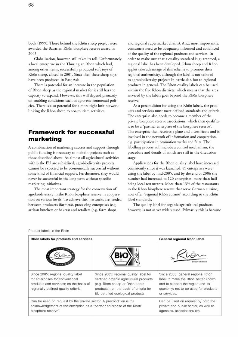
68
book (1999). Those behind the Rhön sheep project were awarded the Bavarian Rhön biosphere reserve award in 2005.
Globalisation, however, still takes its toll. Unfortunately a local enterprise in the Thuringian Rhön which had, among other items, successfully produced soft toys of Rhön sheep, closed in 2001. Since then these sheep toys have been produced in East Asia.
There is potential for an increase in the population of Rhön sheep as the regional market for it still has the capacity to expand. However, this will depend primarily on enabling conditions such as agro-environmental poli-cies. There is also potential for a more tight-knit network linking the Rhön sheep to eco-tourism activities.
Framework for successful marketingA combination of marketing success and support through public funding is necessary to maitain projects such as those described above. As almost all agricultural activities within the EU are subsidised, agrobiodiversity projects cannot be expected to be economically successful without some kind of financial support. Furthermore, they would never be successful in the long term without specific marketing initiatives.
The most important strategy for the conservation of agrobiodiversity in the Rhön biosphere reserve, is coopera-tion on various levels. To achieve this, networks are needed between producers (farmers), processing enterprises (e.g. artisan butchers or bakers) and retailers (e.g. farm shops
and regional supermarket chains). And, most importantly, consumers need to be adequately informed and convinced of the quality of the regional products and services. In order to make sure that a quality standard is guaranteed, a regional label has been developed. Rhön sheep and Rhön apples take advantage of this scheme to promote their regional authenticity, although the label is not tailored to agrobiodiversity projects in particular, but to regional products in general. The Rhön quality labels can be used within the five Rhön districts, which means that the area serviced by the labels goes beyond the Rhön biosphere reserve.
As a precondition for using the Rhön labels, the prod-ucts and services must meet defined standards and criteria. The enterprise also needs to become a member of the private biosphere reserve associations, which then qualifies it to be a “partner enterprise of the biosphere reserve”. The enterprise then receives a plate and a certificate and is involved in the network of information and cooperation, e.g. participation in promotion weeks and fairs. The labelling process will include a control mechanism, the procedure and details of which are still in the discussion stage.
Applications for the Rhön quality label have increased consistently since it was launched. 85 enterprises were using the label by mid-2005, and by the end of 2006 the number had increased to 120 enterprises, more than half being local restaurants. More than 13% of the restaurants in the Rhön biosphere reserve that serve German cuisine, now offer “regional Rhön cuisine” according to the Rhön label standards.
The quality label for organic agricultural products, however, is not as yet widely used. Primarily this is because
Product labels in the Rhön
Rhön labels for products and services General regional Rhön label
Since 2005: regional quality label
for enterprises for conventional
products and services; on the basis of
regionally defined quality criteria.
Since 2005: regional quality label for
certified organic agricultural products
(e.g. Rhön sheep or Rhön apple
products); on the basis of criteria for
EU-certified ecological products.
Since 2003: general regional Rhön
label to make the Rhön better known
and to support the region and its
economy; not to be used for products
or services.
Can be used on request by the private sector. A precondition is the
acknowledgement of the enterprise as a “partner enterprise of the Rhön
biosphere reserve”.
Can be used on request by both the
private and public sector, as well as
agencies, associations etc.

69
there are still not many organic enterprises in the Rhön and secondly, because many people do not see any extra value in a regional label as they are already certified for organic production. Many enterprises are also mainly sell-ing their produce on the national rather than the regional market.
One very important partner in promoting agro-biodiversity products is the NGO, Slow Food (www.slowfood.de). Founded in 1985, this worldwide association, which has its origin in Italy, has 80,000 members and promotes the protection of traditional food, recipes and agrobiodiversity in general. It is a counter movement to the idea of ‘fast food’. Members see themselves as conscious consumers and gourmets who wish to foster the culture of eating and drinking, and thus promote responsible farming and fisheries, animal friendly production and breeding, artisan food processing, and the safeguarding of regional diversity. Slow Food supports networks of producers, retailers and consumers to develop better transparency in the food sector and an increased awareness of food quality. The Ark of Taste is an international project run by Slow Food, aimed at saving local and regional food, domestic breeds and crop varieties from extinction. The Ark of Taste recognises products which meet strict criteria such as excellent taste, sustainable production, threat by extinction etc., and is a registered trademark of Slow Food International. The Rhön sheep as a breed has been acknowledged as ‘a passenger’ of the ark - alongside a local pork sausage type called ‘Ostheimer Leberkäs’.
Strong private sector involvement is needed in order to promote agrobiodiversity products. Numerous cooperation projects have evolved with the Tegut Foundation (www.tegut.com) which is the most important supermarket chain in the region, carrying quality and organic food. As its headquarters are in the Rhön, Tegut is especially committed to regional products, although this is still a niche market. Tegut is an important trading partner for the marketing of organic Rhön apple juice, and is interested in marketing the Rhön quality label (especially organically produced beef, pork, lamb and goat). Though the quantities produced are still too small to be stocked by the supermarket chain, there is much potential for future development.
The regional marketing idea also needs to be integrated with other tasks of the biosphere reserve, such as interpretation. In Germany people generally only spend 13% of their income on food, compared to France or Italy where people spend an average of about 23% (Hirschfelder 2006). This shows that quality food does not have a high standing in Germany as compared to luxury goods such as fast cars or fancy kitchens/kitchen utensils. When it comes to food, a cheap price is the main criterion for the
choice of products. In the Rhön, consumers’ knowledge and attitudes are developed through biosphere reserve interpretation programmes, especially for children. They learn about natural food and food processing, e.g. how to make fruit juice or bake bread, and what a healthy, regional, environmentally and socially responsible breakfast would consist of. Apart from the issue of agrobiodiversity, the ongoing trend towards increasingly processed food (novel food) and the concentration of the food industry on a few global players also needs to be pointed out, including the expected side-effects such as increased areas given over to monoculture, loss of the countryside, and consequently the loss of biodiversity in general.
Conclusions relating to agrobiodiversityThe following conclusions can be drawn from agrobiodi-versity projects in the Rhön biosphere reserve:• The success indicator for conserving agrobiodiversity is
mainly economic. Without a market, agrobiodiversity cannot be conserved in the long run, although the pro-vision of public grants is also important. Furthermore, agrobiodiversity conservation depends mainly on the consumers’ attitude and their willingness to pay ‘a little extra’ for the positive side-effects of the products linked to agrobiodiversity.
• A common vision for the management of the region is important; both through the process of development and as a basis for activities. Multilateral partnerships between and within administrations, the private sector and NGOs need to be fostered.
• Local actors with courage, vision and enthusiasm are needed, especially those who are prepared to cooperate in wide networks.
• Adequate logistical support is needed to set up a regional label for quality products and services in the agrobiodiversity sector. Business partners on various levels (e.g. producers, food processors, retailers, restau-rants) need to be linked.
• Consumers’ attitudes need to be addressed in inter-pretation programmes, with special attention given to agrobiodiversity and food quality.
• Agro-environmental grants focussing on agrobiodi-versity are necessary. This needs to be integrated into a consistent philosophy. Needless to say, traditional Rhön products would not be compatible with the use of genetically modified organisms (GMO), and the Rhön region has therefore been recognised as one of 68 GMO-free regions in Germany in 2005 (MLUV 2005).

70
ReferencesBayerische; Hessische und Thüringer Verwaltungsstelle
Biosphärenreservat Rhön. In press. Erster integrierter
Umweltbericht für das länderübergreifende UNESCO-
Biosphärenreservat Rhön. Abschlussbericht 10.12.2006.
BN - Bund Naturschutz in Bayern e.V. 2005.
Pressemitteilung. www.bund-naturschutz.de/presse/archiv/
meldung/661.html (Abruf: 07.06.06)
Degenbeck, M. 2003. Zur Situation der Streuobstbestände
in Bayern. In: Tagungsbericht „Streuobst in der
Kulturlandschaft“, Fachtagung des Institutes für
Agrarökologie, Ökologischen Landbau und Bodenschutz und
Bayerischen Landesanstalt für Weinbau und Gartenbau am
09./10.07.2003 in Kirchehrenbach, Landkreis Forchheim
Grebe, R. 1995. Biosphärenreservat Rhön. Rahmenkonzept
für Schutz Pflege und Entwicklung. Neumann. Radebeul.
Hirschfelder G. 2006. Interview in Rheinischer Merkur,
07.12.2006. www.rheinischer-merkur.de/index.php?id=17238.
IUCN. 1994. Guidelines for Protected Area Management
Categories. CNPPA with assistance from WCMC, IUCN.
Gland, Switzerland and Cambridge, UK
Lindner, A. 2006. Standort- und Vermarktungspotentiale
für traditionelle Nutztierrassen im Biosphärenreservat Rhön
im Kontext einer nachhaltigen Entwicklung. Diplomarbeit
im Fachbereich Umweltwissenschaften der Universität
Lüneburg.
MLUV (Ministerium für Ländliche Entwicklung, Umwelt
und Verbraucherschutz des Landes Brandenburg). 2005.
Gentechnik und Koexistenz in Brandenburg. Brochure.
Potsdam.
Pokorny, D. and Whitelaw, G. 2000. Sustainability through
Transdisciplinarity? The Biosphere Reserve Concept
as Opportunity and Challenge. In: Transdisciplinarity:
Joint problem solving among science, technology and
society. International Transdisciplinarity Conference 2000.
Proceedings (Workbook 1 Dialogue sessions and idea
market). p425-430. Swiss Federal Institute of Technology,
Zurich, Switzerland.
Sambraus H-H. 1986. Atlas der Nutztierrassen. Ulmer.
Stuttgart.
UNESCO. 1996. Biosphere reserves. The Seville Strategy
and the Statutory Framework of the World Network.
UNESCO. Paris.
Linkswww.biosphaerenreservat-rhoen.de
General information on the UNESCO biosphere reserves:
www.unesco.org/mab
About the AuthorDoris Pokorny, deputy head of the Bavarian administration
unit of the Rhön biosphere reserve, has a professional back-
ground as a landscape planner and landscape ecologist.
Since 1991 she has worked for the Rhön biosphere reserve
as research coordinator, in public relations work and in inter-
national cooperation. She has been regularly involved in the
worldwide network of biosphere reserves, e.g. the IVth World
Congress on National Parks and Protected Areas in Caracas
1992, the International Conference on Biosphere Reserves
1995 in Seville, as well as EUROMAB conferences and
many international and national workshops. From 2002-2006
she was appointed member of the UNESCO International
Advisory Committee for Biosphere Reserves. In the Rhön
she guides and consults international study groups visiting
the Rhön biosphere reserve.
Doris Pokorny

71
Evolving culture, evolving landscapes: The Philippine rice terraces1
Cristi Nozawa, Melissa Malingan, Anabelle Plantilla and Je-el Ong
SummaryRice is the second most widely consumed grain in the world and the main staple in Asia today. The Philippine rice terraces, as established thousands of years ago by the people of the Cordilleras, have enabled the conservation of the more than five-hundred varieties of rice suitable for high altitude wet paddy farming and associated inverte-brate and plant species. They have done so with very little soil erosion and optimal use of water resources. The local people and their rice culture and traditions are the living “genebanks” for highland rice varieties and “traditional research centers” for high altitude sustainable farming tech-nologies. The people of the Cordilleras and, in particular, local communities in Kalinga, Mountain Province and Ifugao lived their lives for thousands of years allowing the continued existence of a diversity of highland rice varieties and wild flora and fauna found only in this region to exist from the ice age through to current times. Some of these rice terraces have been inscribed as a World Heritage Site
in recognition of their outstanding beauty and value as an organically evolving cultural landscape.
The Philippine rice terraces and its people represent the Category V definition of Protected Landscape as follows: “an area of land where interaction of people and nature over time has produced an area of distinct character with significant aesthetic, ecological and/or cultural value. And often with high biological diversity.” However, there are great challenges to maintaining this interaction between nature and people in the Philippine rice terraces and of particular importance is the abandonment of many terraces for various reasons. Challenges include farming manage-ment problems such as controlling invasive alien species, repairing the damage to terraces by earthworms, disrupted waterflows, insufficient labour and role reversals, and mak-ing the farm economically viable. Other challenges include deforestation and introduction of exotic tree species; the decline of traditional practices such as the roles and rituals of the mumbaki in local community life; challenges from
72
tourism and maintaining the relevance of the local com-munities heritage at the local and international levels. The key recommendation from this case study is to implement a comprehensive multi-stakeholder programme with local peoples’ active participation to arrest the trend of abandonment of the terraces in the Cordillera region and the decline in use of traditional rice production practices. Some of the solutions include instilling pride and identity among the younger generation; conserving traditional rice varieties and sustainable farming practices; recognition of tenurial rights and strengthening governance; support for sustainable and culture sensitive livelihoods; and using environmental and heritage impact assessment processes for development projects and, lastly, an inventory of com-munity-conserved areas among the Philippine rice terraces and their respective communities.
DescriptionRice is the second most widely consumed grain in the world, and is the main staple in Asia today. At least 114 countries grow rice. In 2004 world rice production was around 600 million tons. The Philippines is among the top ten rice-producing countries in the world (IRRI website). Almost 100 million people belonging to the poorest sec-tion of society are believed to depend on upland rice.
Rice terraces are elevated paddies carved along the sides of mountains. The Philippine rice terraces are the most extensive in the world and occur at the highest elevation recorded, between 500 – 1,350m above sea level. They are maintained in a flooded condition, since water prevents the paddy from cracking and so checks landslides (Roxas 1996, Concepcion et al 2003).
The Philippine rice terraces are found in the North Central part of Luzon in the Cordillera Autonomous region of the Philippines. But the terraces are only found in the provinces of Benguet, Kalinga, Apayao, Mountain Province and Ifugao. Of these terraces, the ones in the Ifugao are more popularly known and were recognised as a World Heritage Cultural Landscape in 1994 for their out-standing universal value. The four clusters designated as World Heritage sites are in Banaue (Batad and Bangaan); Mayoyao (Mayaoyao Central); Kiangan (Nagacadan); and Hungduan. These four clusters of rice terraces were given World Heritage status because they are “outstanding examples of living cultural landscapes devoted to one of the world’s most important staple crops – rice, as noted in the nomination dossier submitted to the UNESCO World Heritage Committee”. The terraces represent living traditions and picturesque landscapes that have persisted over 2000 years in harsh mountainous conditions. Carbon dating of a post on the terraces of Ifugao shows that the
establishment of the terraces dates from the 7th to 16th century AD.
This study will present the rice terrace landscape as several units of a protected landscape that spreads over a wider area than the four clusters in the World Heritage list.2 It ably represents an IUCN Category V protected area where the way of life of the people of the Cordillera and their worldview of the natural environment has produced the magnificent landscapes of the rice terraces. By so doing they have evolved a diversity of upland rice varieties and conserved the surrounding forests and other associated flora and fauna.
Demography and Physical FeaturesThe region is characterized by very rugged mountainous terrain, with very steep slopes (more than half of the land surface has a slope above 50%) and fast flowing rivers. The climate has no pronounced wet or dry seasons (Alcala 1976) unlike most parts of the country, but the area is subject to typhoons like the rest of Luzon Island. Furthermore, the region is geologically unstable and prone to earthquakes and landslips.
The Cordillera contains 13 major river basins, making the region a major watershed for the island of Luzon. The main drainages of the Cordillera are the Agno, the Chico, and the Magat rivers. The latter two are the main tributar-ies of the Cagayan River which provides the water for the fertile soils of the Cagayan Valley, east of the Cordillera.
The area under rice production in the region totals 201,153 ha, or 11% of the region’s land area. The terraced areas are 22.7% of all agricultural lands, an area of 45,773 ha (National Statistics Coordination Board, NSCB, 1999). The most extensive areas of rice terraces are those in the Ifugao province (14,175 ha in 1999, and 17,000 ha in 2003) and in the Mountain Province (12,957 ha in 1999).
The region’s population stands at 1,365,412 and is considered the least populous region in the Philippines, based on 2000 data. Since 1980 it has also been the least densely settled region, with an average of 75 people per square kilometre.
Anthropologists believe the indigenous people of the Philippine Cordillera share cultural practices such as terrace field rice cultivation, the custom of headhunting and worshipping of skulls, animal sacrifice in rituals, feasts of merit, and building of stone circles or megalithic monu-ments (i.e. in burial grounds found in Mayaoyao, Ifugao). This includes the indigenous peoples of Tinguian, Isneg, Kalinga, Bontok, Kankana-ey, Ibaloi, Ibanag and Ifugao. There is debate among anthropologists as to the ‘ethnicity’ of groups in the Cordillera. As Goda puts it, “one can be a Kalinga, a Bontok and an Ifugao at the same time by tracing one’s kin or family lines”. The current ethnic cat-egorizations are based on historical and political reasons.

73
Different local communities are defined by their shared inheritance of terraces and forest areas. Traditionally, people decided local community boundaries based on natural features such as valleys, rivers and mountains, as well as through agreements with neighbouring communi-ties (Goda 2001).
BiogeographyGeological influences, which help to determine the biologi-cal provinces of the Philippines, indicate that “the life story of the Philippine (islands) begins in the tertiary period”, when uplifting of the lands shaped the mountains of the Cordillera (Dickerson 1928, Heaney 1998)
Forests in the Cordillera include mid-mountain and mossy forests. The forest flora is essentially characterized by the dominance of a species of pine, Pinus insularis. Dickerson noted that approximately 350 species of plants characteristic of temperate areas were endemic to the Philippines and known only from the Benguet-Bontoc region and nowhere else in the world. In general, the flora of the Cordillera is mainly of Formosan influence.
There are a number of endemic animals found in the Cordillera including the Philippine brown deer (Cervus marianus), the Luzon bushy tailed cloud rat (Phloemys pallidus) (Philippine Red Data Book 1997), two threatened butterfly species that are considered relicts of the ice ages (Papilio benguetanus and Papilio chikae or schoenigiand), and at least three globally threatened Philippine endemic birds, namely the Luzon water redstart (Rhyacornis bicol-our), the flame breasted fruit dove (Ptilinopus marchei), and the ground dwelling whiskered pitta (Pitta kochi) (Haribon Foundation 2001). The Cordillera region has been known to be a major route for some migratory birds, particularly forest migrants using the East Asian Flyway.
The Philippine rice terraces and their important agrobiodiversity featuresThe Philippine rice terraces are significant in terms of conservation of rice varieties and associated plants and animals. The terraces are also significant as a living example of sustainable forest, land and water use practices at high altitudes and on steep slopes. This section outlines the important agrobiodiversity features of the Philippine rice terraces.
The terraces as important repositories of highland rice varieties There are at least 565 known rice varieties grown in the Philippine Cordillera (International Rice Research
Institute, IRRI, 2006). Sources in IRRI indicate that all but five of the rice varieties that have been collected by researchers are traditional forms. Many more farmers may have kept their own rice varieties from researchers. Therefore the total number of rice varieties could be larger than the current collection in IRRI. Thus the rice terraces act as an in situ gene bank for traditional rice varieties suitable for conditions similar to the highlands of the Philippine Cordillera. The terraces are community-man-aged experimental rice paddies for generating different varieties of rice suitable for such conditions, and are based on the diverse cultural preferences of the farmers themselves. The terraces are traditional research centres for highland rice and high altitude sustainable farming technologies.
Each village has its own preference in terms of rice varieties. For example, in barangay Maligcong, Bontoc, Mountain Province, the native varieties of Tadlayan and Farsang are preferred because of their taste and because the other varieties are harder to thresh. In Hingyon, Ifugao, many farmers prefer the Imbú-ukan Tinawon rice variety, despite its once-a-year cropping, because of its aroma and fluffy texture when cooked. Meanwhile, the rice farmers of Hungduan, Ifugao, prefer the Pinidua varieties which give higher yields.
The generations of rice farmers in the Cordillera, particularly the women, are the primary holders of traditional knowledge on seed selection and conservation of traditional rice varieties. These traditional varieties have gone through generations of selection processes based on their suitability to the local micro-climates of each village, the elevation and the soil types of the terraces, the amount and seasonality of the water source, as well as particular family and community preferences for taste, texture, smell, and colour of the rice. Preferences are also based on other grain and plant qualities such as non-shattering panicles, resistance to birds and rats, etc. The diverse preferences of farmers have allowed the diverse rice varieties to evolve over time.
Farmers classify varieties through plant morphology and waxiness of the grain. Local people also classify rice according to gluten content. Local rice is classified as ipugo (non-glutinous) or daya’ot/dayakkot (glutinous). Non-glu-tinous rice is grown mainly for direct consumption, while glutinous rice is produced for wine (tapuy) and rice cakes for religious rituals (Roxas 1996).
Traditional rice varieties have a ‘low shattering’ characteristic so that they can be transported from the high terraces with limited loss of rice grains or seeds. Plant morphology separates local varieties into two classes, namely tinawon and pinidua/pidua (linawang in Banaue). Tinawon is known as the ‘yearly’ or ‘dry season’ crop, or winter rice. Tinawon type varieties are highly cold tolerant

74
and are suited to high elevations. The tinawon, which, according to the local people, belongs to the bulu type, is a version of japonica rice3. Tinawon is the dominant rice type in the Ifugao area, accounting for roughly 80% of the varieties and 95% of the quantity of rice grown. Seeding to maturity takes seven to nine months and the plants achieve a height of 120 to 160 cm.
In the lower elevations (less than 700 m above sea level) where two crops per year are possible, the ‘rainy season’ crop is pinidua. Pinidua is of the indica group 4. Pinidua accounts for 20% of the varieties grown in the region. They have more tillers, weaker stems and shorter panicles, and the grains have a ‘high shattering’ characteristic. Double cropping is possible due to a shorter growing sea-son (160 days). Pinidua or Pidua is called the ‘second crop’, ‘wet season crop’, or summer rice. Pinidua in the local dialect also refers to two-season cultivation where planting
can happen in both dry and wet seasons. Pinidua types are moderately cold susceptible and are therefore suited to medium and low elevations (Roxas 1996; interview with R. Bahatan 2006).
Similarly, Bontoc Mountain Province also has two general types of rice. These are the Chinakhon for the dry season or the first crop, and the Pak-ang for the wet season or the second crop of rice. The latter is planted in the fields along the Chico River and Agkhoyo River only, and not on the upland fields.
Traditional rice varieties are still the preferred varieties in many farms in the Cordillera, as per information from the municipal and provincial agriculture officers in the Mountain Province. Traditional farming practices have also persisted, but are under pressure.
Other plant and animal food sources in the existing land use mosaicTraditional rice is an important food crop but it is not often the main meal constituent in the Cordillera. It is supplemented by locally grown sweet potatoes or by rice bought from the lowlands. Rice is grown on the terraces in association with other crops like taro (Colocasia esculenta). Edible snails, bivalves (Lamellibranchiata) and mudfish (Channa striata) or dojo or yuyu fish are also collected from the fields. Weeds which grow on stonewalls are cut and used as green manure crops. Azolla ferns are collected from pondfields to construct mounds for onions (Allium cepa) and pechay (Brassica campestris) planting (Roxas 1996). Table 2 shows examples of the plants and animals found on the terraces in 2007.
Areas for sustainable forest and land management practicesThe rice terraces, forests and swidden farm complexes, and the associated traditional practices, represent sustain-able land management. The people of the Cordillera distinguish hundreds of terrain variations relating to forms and combinations of rock, soil, water and vegetation. In the Ifugao province, eight intermediate level categories of land use cover all major vegetation types and agriculturally significant landform types (Conklin 1980). The existing land uses in Ifugao normally include: public or communal forests (inalah/alah or hinu-ob); privately owned forests or woodlots (muyong or pinugo); swidden farms (uma/habal); cogon land or communal grasslands (magulun); cane grasses (mabilau); rice terraces or paddy fields (payo); settlement area (boble); and the outflow in river or brooks (wangwang).
In Bontoc, Mountain Province, the land use classifica-tion can be broadly divided into two: land used in daily life, and land unsuited for agriculture. The categories for land used for day-to-day living include the forest lands

75
(filig), the slash-and-burn fields or kaingin (oma), the area for settlements (sa-ad ), and the irrigated fields (payew). The land unsuited for agriculture can be subdivided further into at least seven categories.
Traditional rice production processTo understand the agrobiodiversity in the Philippine rice terraces, it is important to understand the whole traditional rice production process.
The main factors affecting the rice production cycle are the natural environment and environmental changes in the Cordillera. The climate limits the production. Sunlight received depends on which direction the terrace is facing. Rice varieties that are adapted to the topography grow slowly. The higher the elevation, the longer the growth period of the rice.
The exact end of an Ifugao year is determined not by the Gregorian calendar but by the conclusion of harvest rites. The location of the fields determine the rice produc-tion schedule.
The actual rice production activities are also affected by the availability of labour, particularly in barangay Maligcong in Bontoc, and in Amganad in Banaue. Sometimes the terrace walls are larger than the arable land areas, and maintenance of the terraces is required almost year round, requiring a great deal of labour. The elements of the rice production cycle are explained in Table 3, which includes a summarised description of the production phases, activities included in the phases, genders of the people involved, and associated rituals.
Changes in traditional practicesThe use of traditional rice varieties is continuously under siege. Government programmes that persistently introduce modern technologies, chemical fertilizers and pesticides may be adversely affecting agrobiodiversity on the terraces. The practice of integrating mudfish with rice-based farming systems seems to have greatly diminished. A lower percentage of the farmers now perform manual removal of pests. Organic fertilizer is widely used but not all the farm-ers practice the pingkol or inagoh/inado systems (organic mounds).
Many irrigation canals have been concrete-lined to reduce water loss in transit. However, nothing is known of the effect of the weight of concrete on the terrace struc-tures, especially on earthen walled terraces. Nor are there studies showing how the higher speed of water flow affects equity in water distribution across the paddies. Rubber hoses have to be used to move the water from farms on higher elevations to farms on lower elevations, thus allow-ing the farmers to skip abandoned paddies.
The increasing human population in some areas, and the resulting increase in demand for firewood and timber
products for housing and woodcarving, is contributing to deforestation, and therefore also affecting water supply and flow. The introduction of exotic tree species for reforesta-tion is also having an impact on the watershed functions of the muyong.
In some areas, especially those near urban centres, many rice terraces have been converted to settlement areas, some even into resorts and commercial establishments. There are no local land use plans that ensure the preserva-tion of the rice terraces. The farmers are increasingly dependent on the government for the maintenance and repair of their irrigation systems, whereas earlier they used to do the maintenance and repair work themselves. The management of the terraces has been removed from local communities and government agencies through the years by authority vested in them by different laws. Please refer to the section on legislation and management for further details.
Changing associated intangible heritage There is a ritual for almost every stage in the rice production cycle, as well as for major social events such as weddings and burials. Rituals are performed by the village priest (mumbaki) or by the landowners themselves. Rituals may last from a few hours to several days. Animals, usually chickens, pigs or carabaos (Bubalus bubalis, a domesticated species of water buffalo), are sacrificed as part of the ritual. Conklin documented 37 types of rituals of the Ifugaos (Conklin 1980). 17 of these are agricultural rites linked with rice production and consumption, while 16 are concerned with health, property and changes in family and individual status. The number of rituals linked to rice production has now been reduced drastically. Ana Habbiling and Manuel Dumulag, farmers from Banaue and Hungduan respectively, now perform less than seven rituals (Tables 4a, 4b). Some rituals are now practiced with a mix of traditional and Christian practices.
Law and governanceTraditional laws governing land and water useThe property laws pertinent to this case study are those relating to rice lands and forest lands. These property laws pre-date the current national laws relating to forest lands and private land ownership. The rice terraces are mainly community-conserved areas, but in some terraces a form of co-management is emerging with the decentralisation of local government.

76
Communal properties consist of rice lands, forest lands and heirlooms. In the Mountain Province there are three different types of communal property rights: land owned by kin groups, land used for men’s houses and land owned communally by the entire community. The lands and articles of value that have been handed down from genera-tion to generation are not seen as the property of any indi-vidual. Present holders are only transient, and have fleeting possession or occupation; this is insignificant in duration in comparison with the decades, and perhaps centuries, that have usually elapsed since the field or heirloom came into the possession of the family. So in place of ownership of property, it is more appropriate to think of the land as being held in trust for future generations. It is a great misfortune when family property, long in the possession of a family, has to be sold. It is never disposed of for light or trivial reasons, nor is it disposed of without exhausting every effort to keep it within the family (Barton 1969, Goda 2001).
Forest lands, valuable principally because of the woods that grow on them, are often the common property of a group of kinsmen and their families. Such ownership of the muyong or pinugo, and of the terraces, has been challenged by various national laws under which all public lands and natural resources, including forest lands (defined as any land above 18o slope), belong to the State (Presidential Decree No. 705 or the Forestry code of the Philippines). Land can only be owned through a Torrens land title5.
Legal status or designation of the rice terracesThere are a variety land designations covering different parts of the Philippine Cordillera and, in many cases, the rice terraces. Most parts of the Cordillera are designated by the government as forest land owned by the State, because most of it is above the 18o slope. Other parts of the Cordillera are covered under the designation of watersheds or parks. Examples of designations include the Magat watershed and the Balbalasang, Balbalan National Park.
The Philippine rice terraces, including those on the World Heritage List, were not included in the initial list of sites under the National Integrated Protected Areas Systems (NIPAS) Act of 1992 (Lim, pers. comm. 2007, Phillips 2005). Although it would be possible to place the terraces under this law it is not necessary to do so. Moreover, the Indigenous Peoples Rights Act (IPRA) of 1996 makes it possible for government agencies to recog-nise the ancestral domain covering land and water areas, based on customs and traditions of a local community.
Using IUCN-The World Conservation Union’s defini-tion of Category V protected areas, it is clear that the rice terraces of the Cordillera, whether or not they are part of
the World Heritage designation, are excellent examples of lived-in, working, and organically evolved landscapes. The site falls within Category V because it is an area where the local people of the Cordillera have produced a dramatic landscape with fantastic panoramas and unique traditional cultural practices that have not only attracted artists and tourists alike, but have maintained important biologically diverse systems through centuries of traditional management. Aside from the landscape’s aesthetic appeal, it has, through several generations, been managed as an integral part of the cultures of the people of the Cordillera. Through traditional knowledge systems, the communities have maintained an ecologically and biologically viable integration of natural and human created systems. The landscape of the Philippine rice terraces is defined by established integral patterns of mixed farming that include management of communal and private forests, swidden cultivation of sweet potatoes, paddy-field cultivation of rice, the multiple intercropping of many secondary domes-ticates, and the raising of pigs, chickens and other forms of livestock. In the process, the landscape has evolved and maintained a genetic pool of highland rice of more than 500 varieties, thereby assuring the world of genetic resources in a gene bank managed by local people. This

77
gene bank has the potential to contribute to sustaining rice farming for upland farmers even as climatic changes affect global agricultural patterns. The terraces fully illustrate all of the eight essential and five desired characteristics identi-fied in the guidelines for selection of Category V protected areas (Phillips 2005) (see Table 4).
Management status of the rice terraces that are part of the World Heritage SiteAs early as 1973 the rice terraces were officially recognised as being among the irreplaceable treasures of the country, through a Presidential decree. Subsequent national decrees created penalties for modifying or destroying the terraces. Most of these decrees focused on the physical aspect of the landscape.
On 18th February 1994, Executive Order No. 158 was issued creating the Presidential Commission called the Ifugao Terraces Commission (ITC) for the restoration and preservation of the Ifugao Rice Terraces. The Secretary of Tourism was the chair of the Commission, and the Secretary of Agriculture was the Vice Chair.
With a new president coming into power in 1999, the ITC became the Banaue Rice Terraces Task Force (BRTTF) through Executive Order Number 77 in 1999. A change in the presidency brought about the demise of the BRTTF with Executive Order No. 72 in 2002, and the BRTTF was replaced with the Ifugao Rice Terraces and Cultural Heritage Office (IRTCHO) under the Office of the Provincial Government of Ifugao. The IRTCHO’s initial reason for being was to manage a grant approved by the National Commission on Culture and Arts. Finally, in 2006, the provincial government created the more permanent Ifugao Cultural Heritage Office (ICHO).
The practical benefits of local institutions managing a local area that was traditionally managed by local people, are obvious. On the other hand, the three-year terms of local government officials pose a challenge to the continu-ity of programmes, particularly in the World Heritage Site. Today local people in the World Heritage Site expect local government units, particularly the barangay and the municipal government units, to help repair common struc-tures such as irrigation canals, terrace walls and footpaths (Ifugao Rice Terraces Masterplan 2004).
The rice terraces of the Philippine Cordillera were inscribed on the World Heritage List in 1995 under criteria (iii), (iv) and (v). The terraces were the first to be inscribed as a cultural landscape of the organically evolving type. In December 2001, the World Heritage Committee decided to include the rice terraces of the Philippine Cordillera on the List of World Heritage in Danger. The joint International Council for Monuments and Sites (ICOMOS)/IUCN mission in 2001 was alarmed at the
continuing trend of abandonment of the terraces. Their recommendations included strengthening institutional arrangements, funding, short-term work programmes, tourism development, programme planning, and inter-national outreach. To date, the sites remain on the list of World Heritage Sites in Danger. This listing has generated mixed reactions from the relevant national and local gov-ernment officials, ranging from hope that the government will increase its current level of support for this World Heritage Site, to anger from local communities. Some local community leaders think that being on the World Heritage list of sites in danger favours conservationists interest to “preserve the people and their living traditions” and does not allow for much needed development. The perception that the intention is purely preservationist has angered some local leaders.
Management of the rice terraces outside the World Heritage clusters In areas outside the World Heritage clusters, the manage-ment of the terraces and the related swidden and forest areas remains primarily with the private owners and the community. In the village of Maligcong in Mountain Province, for example, the community elders continue to decide on the important agricultural events in the commu-nity such as the beginning of planting and harvest season. In Balbalasang, the elders in the community continue to decide on matters that relate to the welfare of the village, including negotiating boundary conflicts and dealing with commercial mining interests.
For each village, the day-to-day decisions about the terraces, forests and swidden areas remain primarily in the hands of local people. With the advent of the Local Government Code in 1991, the barangay and municipal governments now take some major decisions. Decisions relating primarily to infrastructure support and other livelihood activities are expected from local government officials. The establishment of the ITC or BRTTF ran counter to the country’s push to decentralise most deci-sion-making processes to the lowest level of governance possible.
Key challenges and threatsNo people, no terraces. No rice, no terraces.The main challenge in the Cordillera is ensuring the continuity of traditional rice farming practices on the ter-races while meeting the development needs and aspirations of the local people. A single crop a year is not enough to meet their basic human needs. The rice terraces are not

78
spared from the menace of alien invasive species such as the golden kuhol (Pomacea caniculata); earthworms have also caused some terrace walls to collapse.
Research has shown decreasing interest among young people in rice production as contributing to the labour-related challenges (Villalon 2005). Between 1980 and 1998, the amount of time spent on agriculture has fallen by as much as 70%. More people, particularly men are migrating to find employment outside of the communities. One consequence is that “women (are) devoting more time on the farm than the men and assuming the primary role of securing supplemental food for the family and animals” (CECAP 2003). Women are having to take on what used to be the work of men in the farms such as preparing the fields for planting. This may take women away from their traditional role of being primary knowledge holders for rice seed selection on the terraces.
Deforestation and introduction of exotic tree speciesWith increasing population and consequent increase in demand for firewood and timber products, the density of trees in the communal forests has declined. The govern-ment has encouraged the planting of exotic tree species to replace the indigenous trees that have been cut down. In areas where significant numbers of exotic tree species were planted, lower water tables have been observed, as well as decreases in the volume of water supply.
The declining place of traditional ritualsMumbakis were very important in the rituals in the Cordillera, but few exist today and fewer people are being trained to become mumbakis. Becoming a mumbaki is very demanding. The “high cost associated with the conduct of the ritual, and rapid cultural change taking place…brought about mainly by urbanisation and modernization of cultural beliefs” may have contributed to the change (Concepcion et al 2003). The mumbaki may disappear in the next generation of people in the Cordillera. With them will vanish the rituals that allow the people to remember the names of their ancestors and the herbs associated with healing and pest control in the rice paddies.
Challenges in the maintenance of culture and heritageIs it important to save the terraces? At the global level, the designation of some of the terraces as a World Heritage Site indicates international recognition of the outstanding universal value of this cultural landscape. But the terraces have great local significance too. For local people, they symbolize their ancestors’ efforts and their connection to the land and the environment. Their identity as a
people is linked to the maintenance of the terraces. The terraces hold the families together; families do not sell their land as this usually runs the risk of being discredited by the community. While working in the fields has been equated in the past to a life of poverty, this perception is now beginning to be corrected by efforts to incorporate cultural practices into the formal school systems in Ifugao province, and by “the school of living traditions,“ a term used for the process of transferring knowledge on culture and tradition to the next generations. The province of Ifugao has initiated the school of living traditions where traditional practices are learned by young people from the Cordilleras at two levels: in schools and in the community, with approaches varying according to the most effective way of imparting these practices and traditions.
Challenges from tourismAlthough tourism has contributed to the local economy, it has also degraded many of the attractive rural settlements where the terraces are found. Most local people stress that tourism should not be the reason for preserving the terraces. The ineffective management of the tourist influx has resulted in a range of adverse environmental and land-use impacts. For example, hotels and inns, particularly in Banaue, have mushroomed; there are no standards to regulate design and location, and so modern structures stand out and do not blend with the terraced landscape; traditional homes are disappearing and some new homes are built on former terraces; and more people creates more garbage. Furthermore, the benefits from tourism have not trickled down to the terrace farmers themselves.
Tenurial claims on the terraces and in the forestsThe slow process of issuing Certificates of Ancestral Domain Title (CADT) and Certificates of Ancestral Land Title (CALT) is not unique to the Cordillera. While there is a national law recognising traditional rights, customs, traditions and properties of indigenous peoples, the implementation of this law is impeded by many factors. First, the cost of delineation of ancestral domains and the inadequate operations budget of the National Commission on Indigenous Peoples (NCIP) combine to slow down the rate of implementation. Second, there is the continuing challenge posed by the conflict between the implementa-tion of the IPRA and other laws, such as the Local Government Code and the Mining Act. Mining, as per the national government’s economic agenda, currently takes priority over the indigenous peoples’ concerns.
World Heritage Site managementSome local people claim that it is an additional challenge for them to manage a World Heritage Site; there is a common

79
perception that many proposed development actions were not implemented because they were considered inappropri-ate for a World Heritage Site. The question for experts and World Heritage managers, particularly those working in cultural landscapes such as this, is how to reconcile the need of local people for the continuing evolution of their living traditions, their demand to share in economic devel-opment, and the national and international requirement to conserve the outstanding universal values of the area, including its intangible heritage values. This challenge requires an environmentally and culturally sensitive path towards development in the rice terrace landscape area.
Some responses from government, civil society and the community
Repairing the terraces and irrigation canalsLocal government units have provided financial and material resources to some local communities in the Ifugao province for the repair of eroded terrace walls and damaged irrigation canals. But when the government offers resources in this way, it can generate further expectations
from the local community for the government to provide resources for activities that were formerly undertaken by the community as joint community work through ‘bayanihan’. In other provinces, the repair of terraces and irrigation remains a community responsibility.
Support for marketing of traditional rice varietiesThe local government office has also supported rice mar-keting, primarily that of the tinawon varieties. Organically grown, manually pounded and following strict guidelines, the rice has found its way into international markets. Some farmers have started to market their rice as ‘Heritage Rice’. However the supply of rice is not steady, and current prices are considered by producers to be too low.
Documenting and learning some of the rituals in modern timesWork to document specific Ifugao traditional practices, including pest management practices, is on-going. The ICHO has also encouraged local people to document their history, culture and traditions. Starting in the 1990s, the various rituals were re-enacted during town feasts. A school of living traditions has also been initiated in Ifugao by the local government unit with support from the National Commission for Culture and the Arts. Initially its aim was to educate young people on their traditional

80
songs and dances, but today it also teaches other important traditions such as the hudhud (one of 19 masterpieces of Oral Intangible Heritage of Humanity as recognised by the United Nations Education, Scientific and Cultural Organization (UNESCO). The National Commission on Culture and Arts of the Philippines and the Local Government Units support most of these initiatives.
Support from civil societyTwo local NGOs, the Save the Ifugao Terraces Movement (SITMO) and Revitalized Indigenous Cordilleran Entrepreneurs, Inc. (RICE), work in the area. SITMO is primarily working with selected communities on participa-tory community mapping, alternative livelihood activities, and documenting traditional rice farming practices and associated varieties of rice. RICE is focusing on facilitating the export of traditional rice varieties with the support of the local agriculture offices. This is to help increase revenue from selling traditional rice varieties. Church groups are also involved in various local projects in their own areas. Possibly the strongest civil society influence in the region today comes from the Christian churches.
Possible ways forwardThe issues and challenges faced in this living cultural heritage are complex. Working to understand and conserve the traditional knowledge system and the existing natural systems (forests and geology) should underpin all interven-tions in the Philippine rice terraces.
The key recommendation of this paper is to implement a comprehensive multi-stakeholder programme with local peoples’ active participation, to arrest the trend of abandonment of the terraces in the Cordillera region and the decline in use of traditional rice production practices. This key recommendation can include, but is not limited to, the following specific actions:
Instilling pride in culture and identity among the youth Actions that instil pride in the younger generation in their culture and identity, as well as activities that generate a positive experience of terrace farming traditions and rituals, may be critical to the survival of the terraces. The government, the formal education system, and even the church groups can play constructive roles in this. Some local government officials have shown an interest in the idea of expanding the scope of the school of living traditions beyond the re-learning of the hudhud, to include re-learning the practices of rice terrace farming. This could also include some support for terrace farming in schools and in the private sector (e.g. the tourist sector) on special
days when people could rediscover their ‘terrace farming roots’. Public acknowledgment of the unique national and global contribution of the terrace-farming people may also be helpful. Broad-minded church groups should be encouraged to recognise the relevance of continuing the rituals and practices (including the survival of the mumbaki) associated with rice farming, in an increasingly Christianised community in the Cordillera.
Conserving traditional rice varieties and farming practicesSupport is needed for research into traditional rice varieties, knowledge systems and land management practices. But more important is that the results of such research should be given back to the community for better-informed decision-making. As this traditional knowledge is documented, and its values determined, it needs to be brought together with the best available information from western knowledge systems. The current challenges from the golden kuhol and earthworms may be addressed by farmers using local knowledge as well as field observations and experimentation techniques. Research should be undertaken to increase productivity of the rice fields without damaging biodiversity and culture.
Recognition of tenurial rights and strengthening governanceThere is a need to accelerate the processing of ancestral domain claims and the development of the corresponding ancestral domain sustainable development and protection plan prepared under the IPRA. It will be important, though, to ensure that other management plans, such as the comprehensive land use plan (CLUP) of the local government units and the master plan of the World Heritage Sites (in the case of the villages in the World Heritage clusters), will complement ancestral domain plans. This will help ensure that efforts to strengthen community processes, including governance mechanisms, will have a ‘legal basis’ and be nationally recognised. A more relevant governance system is needed. Each village should be able to evolve its own governance mechanisms depending on its unique situation. In some cases it may mean the strengthening of traditional decision-making process, involving a group of elders. Other villages may opt for some co-management arrangements with their local government units, depending on the reliability of local government and peoples’ preferences.
Support for sustainable and culturally sensitive livelihoods Local communities should be properly compensated for their continued contribution to the conservation of the watershed of the Magat Dam, and for their contribu-

81
tion to providing living models of sustainable land use management practices. This will encourage the continued conservation of traditional rice farming practices on the terraces, by enabling the local farmers to meet their basic needs without sacrificing their traditional practices. The compensation system can also be used to support useful research, the school of living traditions, and the development of sustainable livelihood opportunities that are sensitive to the culture and practices of the people and their traditional rice production.
There is also scope to invest in sustainable livelihood options that provide added value to terrace produce and create employment. Such investment can also support the education of children of those farmers that continue to work the terrace farms, through a programme that encour-ages children to adhere to traditional methods of terrace farming, thus passing knowledge from one generation to the next. Government agencies should also encourage the planting of indigenous trees to help improve the timber stand and to reforest denuded areas.
Develop and implement an Environmental and Heritage Impact Assessment system (EHIA)The concept of impact assessment is often thought of as a modern and western concept. However, if one looks closely at Conklin’s 1980 account of the Ifugao worldview of the environment, culture and society, a critical part of this worldview is the concept of looking at the long term impact of making decisions that modify nature or culture (Conklin, 1980).6 It is therefore important for the people to look back at their traditions and rediscover the most relevant parts of their traditions that could be used to cope with present day conditions. The Ifugao (and probably most of the local communities in the Cordillera) have, within their own traditions, a way of looking at the modification of nature and culture through a long-term lens – exactly as modern day EHIAs should. EHIAs allow for the use of the best available knowledge to consider the long-term impact of a development project on the environ-ment and the people. By incorporating local knowledge systems into such assessments, it should be possible to identify the best available mitigation measures that are attuned to the heritage and culture of the community, and that minimise the adverse impacts that come with any proposed development.
Inventory of community-conserved areas or co-managed areas in the CordilleraIt was mentioned earlier that most of the rice terraces have historically been managed communally through a complex set of traditional laws. Considering the inclusion of the
rice terraces as a possible category V protected area should contribute to completing the network of protected areas in the country. It is also possible that other categories of protected areas may be nested (i.e. sacred sites as category 1a, but strictly managed for purposes of customs and traditions, and not for science per se) in the protected land-scape/seascape. Mapping of these community-conserved areas, or even in some cases co-managed areas, could help connect the Balbalasan-Balbalan National Park and the Mt. Pulog National Park.
1 The recent field work and research for this was done
with the support of the Australian Regional Natural
Heritage Programme to IUCN WCPA SEA through
BirdLife International’s project entitled “Strengthening
Protected Areas Management and Networks in the
ASEAN region”.
2 The information in this case study comes from farmers
from the local communities in Balbalasan-Balbalan in
Kalinga province, Maligcong, Bontoc in the Mountain
Province, the World Heritage clusters, and Amganad in
Banaue, Ifugao province.
3 Japonicas or Oryza sativa ssp japonica (particularly
temperate japonicas) are commonly grown in Japan,
South Korea, Northern China, Europe, the USA and
Australia. It has good grain qualities (glossy appearance,
considerable stickiness, soft and smooth textures)
preferred by consumers.They are tall, low tillering, and
long maturing, have large dark green leaves and long,
heavy, non-shattering and mostly awned grains (i.e.
grains with hair-like appendages).
4 Indica rice or Oryza sativa indica is usually grown in
hot climates. It is cold sensitive and found mainly in
the tropics, especially in Southeast Asia (Asia Rice
Foundation website and University of Nevada website).
5 A system of land titles put in place during the American
occupancy of the Philippines, over land “bought” from
the Spaniards but traditionally owned by the original
inhabitants of the islands.
6 Conklin cites four “general principles that underlie the
Ifugao interpretation of environment, culture and society”.
These are: “1) it is assumed that all resources and
units of time and space are distributed unequally; 2)
most of these differences are ranked; 3) many ranked
statuses of person, property and natural phenomena
are significantly modifiable by intentional human activity;
and 4) such modification is most effectively achieved by
skilled long-range calculation and competitive action”.
The first and last principles are especially useful and
relevant in the context of Environmental and Heritage
Impact Assessment.

82
Figure
Diagram of rice production cycle from Conklin (1980)
Periods Seasons Perios/Events Rituals

83
Table 1
Some of the plants and animals of importance found in the rice paddies.
Biodiversity Importance
1 Bagiw Water plant that allows farmers to plant pechay and beans. It is also the plant eaten by the battikul and is the habitat of ginga, u-ulhong and battikul.
2 Battikul (flask snail Pila luzonica) Food source
3 Ginga (pond snail Lymnaea viridis) Food source. The shell is coal-roasted for lime
4 Ú-ulhong (matures to dragon flies) Food source
5 Kallangga (native cricket) Food source
6 Luklukab (insect) Food Source
7 Mud fish Food source
8 Aggudung (white horned shells Potamides spp.) Food source. The shell is coal-roasted for lime
9 Tikkam (clam) Food source
10 Kulippo or ‘oleppo (round snail Vivipara burroughiana) Food source
11 Dojo / Yuyu (freshwater fish- Miagurnos anguillicaudatus) Food source. This is a fish introduced by the Japanese; adapted to the rice paddies without any observed adverse effect to the native species.
Source: Local farmers in Banaue and Hungduan 2007; Conklin, 1980; CECAP, 2004
Box
A brief description of the prevailing units of planning and governance in the
Philippines with particular reference to the Cordillera.
To understand the current administrative status of the rice
terraces, it is important to understand the units of planning
and governance in the Philippines today. The breakdown
of area planning units in the Philippines begins with a
region that is composed of provinces. Each province in
turn is made up of municipalities and each municipality is
made up of barangays or villages. Local communities in
the Cordillera do not have a one to one correspondence
to a barangay. Sometimes two traditional village units can
belong to one barangay. Neither are the community elders
equivalent with the local political leadership. Although the
region is the biggest planning unit next to the country, this
is not a political or governance unit and is not headed by
an elected official but rather an aggregate group of elected
officials from the provincial level that form the regional
development council or RDC. However, the national
development plans are based on the regional development
plans developed by the RDCs. The province after the
national level is the first political or governance level down
and each of the provinces have an elected executive
official that is the Governor of the province. A provincial
legislature is also elected as part of the provincial local
government unit. At the municipal level there is a parallel
system with the Mayor as the executive officer and a
corresponding municipal level legislature. At the barangay
level, the barangay council is the executive officer with the
barangay council as the legislature. However, in certain
areas where there is a group of community elders, this
does not equal to the local elected leaders at the barangay
level. The current administrative status does not necessarily
correspond to the traditional governance structures. This is
the existing governance context in which the rice terraces
and its people currently function. The prevailing planning
and governance units are based on the Local Government
Code passed in 1991 as Republic Act No. 7160. A more
recent law, the Indigenous Peoples Rights Act of 1997
(Republic Act No. 8371) recognises traditional governance
mechanisms of ancestral domains of indigenous peoples.
How these two laws are implemented in ancestral lands
remains to be seen in many parts of the Cordilleras.

84
Table 2
Summarised description of the phases, activities, people and rituals
of the rice production cycle (adapted from Conklin, 1980)
Phase I: Field Operation (payo ‘pond fields’)
Phases and Seasons Periods and Events Estimated Effort (gender Performing Work)
Rituals
A – Off Season (iwang)
This is the longest season. It begins after the last ritual
holiday of the preceding harvests. Agricultural efforts are
focused on preparing pond-field terraces for a new rice
crop. Token weeding is done and outlets are blocked to
raise water levels in the terrace. Pond fields are cleaned
and decaying vegetables are treaded to enhance fertility
of the soil. Maintenance and reshaping of terrace slopes
is done. It is also a time of illnesses, deaths, funerals and
prestige feasts, with wet cold days and occasional typhoons.
Woodlots are planted and swiddens are harvested and
replanted. There is abundance of shellfish, vegetables, wild
mushrooms.
This season lasts from late July/early August, until late
November/first part of December.
A1 Initial Postharvest Period (lu’luwah) a. district welfare ritual (ubaya)
A2 Early Off Season (‘iwa’iwang) b. initial agricultural rite (lu’at)
1 Weeding, treading and wet mulching time (‘ahilamun) ~30 workdays/ha of terraced land (women)
A3 Mid Off Season (ginawang-di-iwang) c. rice consumption rite (‘apuy)
2 Spading time (‘ahigaud) ~10 to several hundred workdays per ha. Depending on repairs and new constructions) (men)
A4 Late Off Season (na iwang) d. rice loaf ritual (ba’le)
3 Wall cleaning time (‘ahiloba) ~6 workdays/ha (women)
B. Planting Season (lawang)
The season of field work and rice planting. Terraces are
prepared for full inundated cropping. Marginal slopes
and sides of inundated terraces are cleaned of interstitial,
marginal slopes and sides of terraces. Nurseries are
prepared. All nurseries are fully seeded. Focus is also on
improving soil conditions and completing terrace dykes. It
is also during this season that fully seeded seedlings are
transplanted to inundated pond-fields.
This season lasts from late November/first part of December,
until March.
B1 Terrace Work Period (‘ahi’amu) e. seed bundle rite (lohwang)
4 Second weeding and wet mulching time (‘ahibalin) ~105 workdays/ha (women)
5 Margin cleaning time (‘ahidaluh) ~100 workday/ha (women)
6 Soil preparation time (’ahipaphod) ~12 workdays/ha (women*)
B2 Rice Planting Period (‘ahihopna’) f. seedbed declaration rite (‘opdah)
7 Rice panicle planting time (‘ahihopna’) ~4 workday/ha (women) g. construction completion ritual (‘ulpin-di-pa’aggaud)
B3 Soil Working Period (‘ahilawang) h. mature seedling rite (bage)
8 Green manuring time (‘ahibuluh) ~45 workday/ha (men *)
9 Dyke finishing time (‘ahibanong) Part of the ~45 workday/ha (men*)
B4 Rice Transplanting Period (‘ahiboge)
10 Seedling transplanting time (‘ahiboge) ~46 man days/ha (women, men help bring seedlings)
B5 Field Completion period (‘ahi’ulpi) i. field completion and marking rites (‘ulpi)
11 Field marking time (‘ahi’ulpi) No information available j. final field marking ritual (hagophop)
12 Second field marking time (‘ahihogophop) No information available

85
Table 2
Summarised description of the phases, activities, people and rituals
of the rice production cycle (adapted from Conklin, 1980)
Phase I: Field Operation (payo ‘pond fields’)
Phases and Seasons Periods and Events Estimated Effort (gender Performing Work)
Rituals
A – Off Season (iwang)
This is the longest season. It begins after the last ritual
holiday of the preceding harvests. Agricultural efforts are
focused on preparing pond-field terraces for a new rice
crop. Token weeding is done and outlets are blocked to
raise water levels in the terrace. Pond fields are cleaned
and decaying vegetables are treaded to enhance fertility
of the soil. Maintenance and reshaping of terrace slopes
is done. It is also a time of illnesses, deaths, funerals and
prestige feasts, with wet cold days and occasional typhoons.
Woodlots are planted and swiddens are harvested and
replanted. There is abundance of shellfish, vegetables, wild
mushrooms.
This season lasts from late July/early August, until late
November/first part of December.
A1 Initial Postharvest Period (lu’luwah) a. district welfare ritual (ubaya)
A2 Early Off Season (‘iwa’iwang) b. initial agricultural rite (lu’at)
1 Weeding, treading and wet mulching time (‘ahilamun) ~30 workdays/ha of terraced land (women)
A3 Mid Off Season (ginawang-di-iwang) c. rice consumption rite (‘apuy)
2 Spading time (‘ahigaud) ~10 to several hundred workdays per ha. Depending on repairs and new constructions) (men)
A4 Late Off Season (na iwang) d. rice loaf ritual (ba’le)
3 Wall cleaning time (‘ahiloba) ~6 workdays/ha (women)
B. Planting Season (lawang)
The season of field work and rice planting. Terraces are
prepared for full inundated cropping. Marginal slopes
and sides of inundated terraces are cleaned of interstitial,
marginal slopes and sides of terraces. Nurseries are
prepared. All nurseries are fully seeded. Focus is also on
improving soil conditions and completing terrace dykes. It
is also during this season that fully seeded seedlings are
transplanted to inundated pond-fields.
This season lasts from late November/first part of December,
until March.
B1 Terrace Work Period (‘ahi’amu) e. seed bundle rite (lohwang)
4 Second weeding and wet mulching time (‘ahibalin) ~105 workdays/ha (women)
5 Margin cleaning time (‘ahidaluh) ~100 workday/ha (women)
6 Soil preparation time (’ahipaphod) ~12 workdays/ha (women*)
B2 Rice Planting Period (‘ahihopna’) f. seedbed declaration rite (‘opdah)
7 Rice panicle planting time (‘ahihopna’) ~4 workday/ha (women) g. construction completion ritual (‘ulpin-di-pa’aggaud)
B3 Soil Working Period (‘ahilawang) h. mature seedling rite (bage)
8 Green manuring time (‘ahibuluh) ~45 workday/ha (men *)
9 Dyke finishing time (‘ahibanong) Part of the ~45 workday/ha (men*)
B4 Rice Transplanting Period (‘ahiboge)
10 Seedling transplanting time (‘ahiboge) ~46 man days/ha (women, men help bring seedlings)
B5 Field Completion period (‘ahi’ulpi) i. field completion and marking rites (‘ulpi)
11 Field marking time (‘ahi’ulpi) No information available j. final field marking ritual (hagophop)
12 Second field marking time (‘ahihogophop) No information available

86
Phase Ii: Grain Production (page ‘rice’)
Phases and Seasons Periods and Events Estimated Effort (Gender Performing Work)
Rituals
C. Dry Season (tiyalgo)
This is the season the rice seedlings are growing. It is also
the time for planting crops in swidden land areas. It is also a
time to maintain the fields. These are cleared of weeds that
have taken root in between tillering rice plants, as well as
larger plant pests; the weeds and plant pests are bunched
for deep treading into pond-field mud. Rice stems bulge with
developing panicles and demand for irrigation water peaks.
Irrigation channels are frequently checked.
The maturing rice is inspected. Weeding takes place, but the
focus is on preventing further build up of the rat population.
This season lasts about 3 months, from late March/early
April, until mid/late June.
C1 Early Dry Season (bo’bo’lana)
13 Seed planting time (‘ahi’oho’) ~6 workday/ha (women)
14 Swidden clearing time (‘ahi’uma) 80-90 days/ha (men)
C2 Height of Dry Season (tongtong-di-tiyalgo) k. general agricultural ritual (tinungul)
15 Swidden planting time (‘ahitanum) ~50 workday/ha of new swidden land (men) l. pond-field medicine ritual (tamol)
16 Rice weeding time (‘ahi’ago’o) ~36 work day/ha (women)
C3 Rice Booting Period (mumbiyah) m. irrigation works ritual (‘ulpin-di-ala’)
17 Irrigation tending time (‘ahipaliyan) 20 workday/ha (men) n. crop growth ritual, part one (‘alup)
C4 Rice Heading Period (‘ahibuhbuh) o. crop growth ritual, part two (topdad)
18 Wall weeding time (‘ahilupung) ~30 workday/ha (women) p. thunderstorm ritual (gito)
19 Margin weeding time (‘ahipadig) ~8 workday/ha (women) q. typhoon ritual (puwo’)
D. Harvest Season (‘ahitulu)
This is the shortest season in the Ifugao calendar. Prior
to harvesting, seed selection is done. It is a time of
homecoming, beer brewing, drinking, feasting, merrymaking,
and intense ritual and agricultural activity. It takes 7-10
days for the completion of repairs of granary roofs and for
the collection of bast for tying the bundles of grain. Rice is
brewed and final preparations for the harvest are made. The
last period is devoted to continuous religious observances
related to the constant direct handling of the new crop.
Rituals are more faithfully observed and more universally
participated in than at other seasons. This concludes the
agricultural year.
This season lasts for about 1 month, towards the end of June
or beginning of July.
D1 Rice Ripening Period (holdang) 4 workday/ha r. preharvest ritual (hanglag)s. early harvesting rite (lodah)
20 Rrice toasting time (‘ahihanglag)
21 Early reaping time (‘ahi’udol)
D2 Rice Harvesting Period (‘ahitulu) ~80 workday/ha t. main harvest rites (pumbot’an)u. joint kindred harvest (baddang)v. induction of ritualists (liyah)w. concluding harvest rites (tungo)
22 Rice bundling time (‘hiboto’)
References: *CECAP 2000

87
Phase Ii: Grain Production (page ‘rice’)
Phases and Seasons Periods and Events Estimated Effort (Gender Performing Work)
Rituals
C. Dry Season (tiyalgo)
This is the season the rice seedlings are growing. It is also
the time for planting crops in swidden land areas. It is also a
time to maintain the fields. These are cleared of weeds that
have taken root in between tillering rice plants, as well as
larger plant pests; the weeds and plant pests are bunched
for deep treading into pond-field mud. Rice stems bulge with
developing panicles and demand for irrigation water peaks.
Irrigation channels are frequently checked.
The maturing rice is inspected. Weeding takes place, but the
focus is on preventing further build up of the rat population.
This season lasts about 3 months, from late March/early
April, until mid/late June.
C1 Early Dry Season (bo’bo’lana)
13 Seed planting time (‘ahi’oho’) ~6 workday/ha (women)
14 Swidden clearing time (‘ahi’uma) 80-90 days/ha (men)
C2 Height of Dry Season (tongtong-di-tiyalgo) k. general agricultural ritual (tinungul)
15 Swidden planting time (‘ahitanum) ~50 workday/ha of new swidden land (men) l. pond-field medicine ritual (tamol)
16 Rice weeding time (‘ahi’ago’o) ~36 work day/ha (women)
C3 Rice Booting Period (mumbiyah) m. irrigation works ritual (‘ulpin-di-ala’)
17 Irrigation tending time (‘ahipaliyan) 20 workday/ha (men) n. crop growth ritual, part one (‘alup)
C4 Rice Heading Period (‘ahibuhbuh) o. crop growth ritual, part two (topdad)
18 Wall weeding time (‘ahilupung) ~30 workday/ha (women) p. thunderstorm ritual (gito)
19 Margin weeding time (‘ahipadig) ~8 workday/ha (women) q. typhoon ritual (puwo’)
D. Harvest Season (‘ahitulu)
This is the shortest season in the Ifugao calendar. Prior
to harvesting, seed selection is done. It is a time of
homecoming, beer brewing, drinking, feasting, merrymaking,
and intense ritual and agricultural activity. It takes 7-10
days for the completion of repairs of granary roofs and for
the collection of bast for tying the bundles of grain. Rice is
brewed and final preparations for the harvest are made. The
last period is devoted to continuous religious observances
related to the constant direct handling of the new crop.
Rituals are more faithfully observed and more universally
participated in than at other seasons. This concludes the
agricultural year.
This season lasts for about 1 month, towards the end of June
or beginning of July.
D1 Rice Ripening Period (holdang) 4 workday/ha r. preharvest ritual (hanglag)s. early harvesting rite (lodah)
20 Rrice toasting time (‘ahihanglag)
21 Early reaping time (‘ahi’udol)
D2 Rice Harvesting Period (‘ahitulu) ~80 workday/ha t. main harvest rites (pumbot’an)u. joint kindred harvest (baddang)v. induction of ritualists (liyah)w. concluding harvest rites (tungo)
22 Rice bundling time (‘hiboto’)
References: *CECAP 2000

88
Table 3a and 3b
Two examples of the rituals preferred by specific farmers in Ifugao (January 2007)
Table 3a
Rituals as per a Female Farmer in Banaue
Ritual Timing and Explanation
1. Loa This is done before sowing of seeds or seedbed preparation. A chicken
(male of female) is killed.
2. Bornat This is done before transplanting of seedlings. A chicken (male of female)
is killed.
3. Ulpi This is done 2-3 days after transplanting. Two or three chickens are killed.
4. Hagophop This is merrymaking that includes singing and chanting called liwliwa.
Feet are stomped to drive away the spirits. This lasts for 1-2 days.
5. Hanglad This is done before harvest when the palay is beginning to ripen. 2-3
chickens are killed. Two bundles of mature rice are roasted; this is called
tinukpi and is eaten only by the family that will harvest.
6. Po-or This is done on the day before the harvest. One chicken is killed in the
late evening and another 12 chickens are killed in the granary. The 12
chickens are for the 12 goddesses. (Nowadays only 3-4 chickens are
killed, which is enough for the people who join in the prayer.)
7. Ngilin This is done during harvesting. A pig, chickens or ducks are killed.
(Carabaos are not favored by the goddesses. On the other hand, black
pigs are used for sick people.)
8. Hu-kap This is done after every ricefield has been harvested usually during the
first part of August. This ends the one-year rice cycle.
Table 3b
Rituals performed by a male farmer in Hungduan
Ritual Timing
1. Hoka This is done before seedbed preparation to appease the goddess of
cereal. Rice from the granary is taken and brought to the field. A chicken
is killed for this ritual.
2. Tunod This is done before transplanting. A chicken is killed for this ritual.
3. Kulpi This is done 1 month after transplanting to appease the gods to protect
the seedlings from pests and natural calamities.
4. Kahipage This is done when seedlings already have grains. The ritual is performed
to make the harvest bountiful. A chicken is killed and the best grains are
placed in a wooden box together with the butchered chicken. The box is
placed in the granary.
5. Kahi-ani/Kahi-butok This is done during harvest.
6. Luwa This is a one-day recreation ritual, usually performed during the half
moon. The tug-o-war game is usually played. The grains are kept in the
granary after this ritual. A pig and a chicken are killed. (Nowadays, this is
commercialized by advertising it as a tourist event.)
7. Tungo This is a day of complete rest, immediately after the luwa. Noise is
prohibited on this day.

89
Table 4
Characteristics of the Philippine rice terraces vis-à-vis the selection criteria
for Category V protected areas (based on Phillips et al)
Selection criteria for Category V protected
areas
Essential Characteristics Characteristics in the Philippine Rice Terraces
Landscape and/or coastal and island
seascape of high/or distinct scenic quality
The diverse terraced landscapes which follow the contours (up to
50% slope) and elevation of the mountains of the Cordillera, present a
fantastic view of a landscape created by local people over thousands of
years until today.
Significant associated habitats, and flora and
fauna
The forests (either private or community forests) still harbour unique
species of plants that date back to the ice ages, and represent the
southern most representation of the Himalayan flora. Several faunal
species endemic to the island of Luzon are also found in the Cordillera.
Evidence that a harmonious interaction
between people and nature has endured over
time and still has integrity
A majority of the complex terrace system continues to function, and
still represents a working landscape that includes the rice paddies, the
irrigation systems and the forests (both for private and wider community
use).
Unique or traditional land use patterns e.g. as
evidenced in human settlements
The traditional land use patterns can be broadly divided into two: land
used for daily life and land unsuitable for agriculture. The first set of land
use patterns includes primarily those vegetation and land use types
associated with rice production or subsistence farming. These include the
public or communal forests (Inalah/hinu-ob); woodlots (muyong/pinugo/
filig); swidden farms (uma/habal); the communal grasslands (magulun);
the settlement areas (boble/sa-ad); and finally the rice terraces or paddy
fields (payo/payew). There are numerous categories of land unsuitable
for agriculture, describing the hundreds of variations that the people of
the Cordillera recognise in their natural environment.
Valued for the provision of environmental
services e.g. watershed protection
Estimated flood water conserved by the terraces in the Ifugao province
alone is 150 million cubic meters per year, worth U$0.75 million per year.
Valued for sustainable use of natural
resources
Estimated soil conserved by the terraces of the Ifugao province alone
is 422,315 tons per year, worth U$6.5 million per year. There is also
a complex system of water use, distribution and sharing among the
farmers. There is also a tradition of sustainable farming practices
developed and used by farmers.
Unique or traditional social culture as
evidenced by local customs, livelihoods and
beliefs
There are hundreds of traditional rituals practiced by the people of the
Cordillera, many of which are associated with the rice production cycle.
There is a ritual for every event in local community life, from weddings,
thanksgiving and burials, through to sickness and the period after a
death.
Opportunities for public enjoyment through
recreation and tourism consistent with lifestyle
and economic activities
Some of the more public events have attracted visitors from different
parts of the country and even from around the world. The beauty of the
rice terraces and its associated culture has provided an iconic symbol
or vision for tourism in the Cordillera. For example, the wooden figure of
the ‘bulol’ (the guardian of the rice granaries) is now a popular tourist
product, symbolic of the region.
Suitability for scientific research The biological diversity of the region is under-researched. Only the
ethnography of the people of the Ifugao province has been extensively
studied. The engineering marvel of the terraces have never been studied
scientifically. The wealth of topics for scientific research (biophysical,
socio-cultural, etc.) is enormous.

90
Important for education The people, their culture, and their environment are important for
educating not only the Filipino people, but the peoples of the world.
The ingenuity of the people of the Cordillera; the origins and history
of the Filipino people since pre-colonial times; the sustainable farming
and forest management practices; and the conservation of traditional
rice varieties, are all elements of the Cordillera that have educational
importance.
Recognition of artists of all kinds and cultural
traditions (new and from the past)
Filipino visual and musical artists have found inspiration in the terraces
of the Cordillera. Traditional Cordillera craft designs like woodcarvings
and woven clothes have been acknowledged in modern furniture, interior
design and fashion design.
Important for agro-biodiversity There are over 500 known highland varieties of rice collected by IRRI.
There may be many more in the hands of women farmers, not given to
IRRI researchers.
Potential for ecological and landscape
restoration
The key challenges are the abandonment of rice paddies and the
diminishing forest cover of the watershed areas. The potential and need
for restoring the terraces is unquestionable. Programmes to restore
the terraces through local government and community actions are now
underway. The need for forest restoration using indigenous tree species
is also very real and can generate local interest easily if supported by
some technical input.

91
GlossaryAggudung
A variety of shell with a cone pointed tip found in the rice
paddies that are harvested for food. The shells are later
made into lime, which is mixed with betelnut during betelnut
chewing (moma).
Baddang
Cooperation, assistance or help. In the rice production
cycle, baddang is normally done during the transplanting
and harvest period where relatives and neighbors volunteer
to help to ensure that the seedlings are planted, or that
the ripe palay are harvested, on time. Meals and snacks
are provided by the owner. During harvest time, baddang
provides a festive mood among the workers.
Barangay
The smallest local government unit in the Philippines.
Battikul
The native variety of kuhol that used to abound in the rice
ponds before the introduction of the golden kuhol.
Bayanihan
A Philippine tradition of community help or support for a
big task or amount of work that needs many people to
accomplish. These include helping a family in planting or
harvesting rice from their own fields and moving a whole
house from one location to another.
Bulu
A local term of a type of japonica rice in Banaue.
Chinakhon
A term in the Mountain Province pertaining to a class of rice
for the dry season or the first crop.
Filig
Mountain Province term for forest lands.
Ginga
A variety of edible shell found in the continually flooded rice
paddies of Ifugao. It is differentiated from the other edible
shells because of its very thin shell.
Hinu-ob/Hinoob
Ifugao term for a public forest. Also known as alah or inalah.
Hudhud
One of 19 masterpieces of Oral Intangible Heritage of
Humanity as recognised by the United Nations Education,
Scientific and Cultural Organization (UNESCO), in Ifugao.
Inado system
Also known as inagoh or pingkol in Ifugao. Practiced in
Ifugao, it is the post-harvest system of composting rice straw
and grasses on the rice paddies, by forming mounds of
these materials and covering them with soil. The water in the
rice pond is maintained. Vegetables, such as pechay and
beans, and other condiments such as onions, are planted on
these mounds while the organic matter decays underneath.
Instead of fallowing, this simply allows the rice pond to stay
idle and the organic matter to decay until the next planting
season. The inado is one means of supplementing the food
needs of the farmer. Excess produce is sold in the market.
A similar practice is found in the Mountain Province, called
baliling/asi-faliling.
Inagoh
Please refer to Inado system.
Kaingin
A shifting system of farming, involving slash and burn.
Low shattering
A characteristic of the rice plant to shed its flowers or
panicle during maturity at very low levels. The low shattering
characteristics of rice grown in the Cordilleras allows the
rice to be tied in bundles and carried at both ends of a pole
from the terraces by the farmers with very little grains lost
along the way.
Mabilau
Ifugao term for cane grasses.
Magulun
Ifugao term for cogon (Imperata cylindrical –common grass
found in South East Asia) land or communal grasslands.
Mumbaki
Village priest who usually performs rituals.
Muyong
Ifugao term for the privately-owned forest, grove, or woodlot
located on top of the rice paddies. Also called pinugo or
pinucho in Ifugao, tayan in the Mountain Province, and lakun
in Kalinga.
Oma
Mountain Province term for slash and burn fields or kaingin.
Pak-ang
A Mountain Province term pertaining to a class of rice for the
wet season or the first crop.
Panicle
Grouping or arrangement in which flowers are borne on a
plant.
Payew
Mountain Province term for irrigated fields.
Payo
Ifugao term for rice terraces or paddy fields.
Pingkol
Please refer to Inado system.
Pinidua
Ifugao term for a class of rice variety known as rainy season
crop.
Sa-ad
Mountain Province term for settlements.
Tadlayon
Mountain Province term for a class of rice variety.
Tinawon
Ifugao term for a class of rice variety known as dry season
crop.
Wangwang
Ifugao term for the outflow in rivers or brooks.

92
AcronymsADSDPP Ancestral Domain Sustainable Development and
Protection Plan
ASEAN Association of South East Asian Nations
BRTTF Banaue Rice Terraces Task Force
CADT Certificate of Ancestral Domain Title
CALT Certificate of Ancestral Land Title
CAR Cordillera Administrative Region
CECAP Central Cordillera Agricultural Programme
EHIA Environmental and Heritage Impact Assessment
ICHO Ifugao Cultural Heritage Office
ICOMOS International Council for Monuments and Sites
IPRA Indigenous Peoples Rights Act
IRRI International Rice Research Institute
IRTCHO Ifugao Rice Terraces and Cultural Heritage Office
ITC Ifugao Terraces Commission
IUCN International Union for the Conservation of Nature
and Natural Resources or World Conservation
Union
NCIP National Commission on Indigenous Peoples
RICE, Inc. Revitalize Indigenous Cordilleran Entrepreneurs,
Inc.
SITMO Save the Ifugao Terraces Movement
IntervieweesIfugao1. Cesar Pelagio from Hapao, Hungduan, Ifugao. He was
the former mayor of Hungduan in 1988-1990.
2. Manuel Dumulag, 72 years old from Hapao, Hungduan,
Ifugao
3. Donato Bittaol, Barangay Captain of Baang, Hapao
4. Fr. Valentin Dimoc, parish priest of Hungduan, Ifugao
5. Bgy. Captain of Hapao, Hungduan
6. Hon. Hilarion Bumangabang, Mayor of Hungduan
7. Mr. Raymund Bahatan, Provincial Agriculturist, Provincial
Agriculture, Environment, and Natural Resources Office
(PAENRO)
8. Ms Maribel D. Bimohya, Information Officer of Office of
Governor
9. Engr. Carmelita B. Buyuccan, Provincial Planning and
Development Coordinator, Provincial Planning and
Development Office (PPDO)
10. Ms. Rebecca W. Bumahit, Project Superintendent,
Kataguwan Center, Lagawe, Ifugao
11. Hon. Glenn Prudenciano, Governor of Ifugao
12. Ana Habbiling, farmer in Amganad, Banaue
13. Peter Dugninon, an agriculturist by profession and
currently employed as Community Facilitator, Special
Projects, Municipal Government of Asipulo, Ifugao. He
was the one who started experimenting on a local tree
as solution to the ¨kuhol¨ problem. His home experiments
(in basins) have been successful. He has received
positive feedback from local farmers who informally field
tested his experiment
14. Nora B. Luglug, Head, Ifugao Cultural Heritage Office
(ICHO). She is currently following up with a farmer who
claims to be using an indigenous tree species in solving
the giant earthworm problem in his rice paddies.
15. Martha N. Urbano, Municipal Agriculturist, Hingyon, Ifugao.
16. Jimmy Cabbigat, Municipal Agriculturist, Banaue, Ifugao.
17. Fr. John B. Habawel, an Ifugao Catholic priest, currently
the Rector of the Immaculate Mary School of Theology in
Vigan, Ilocos Sur.
Mountain Province1. Clayton Cobsilen, 69-70 years old from Malibcong,
Bontoc, Mountain Province
2. Julie and Nobel, 19 and 18 years old respectively from
Malibcong, Bontoc, Mountain Province.
3. Edith Osing, does not know her age and is from
Malibcong, Bontoc, Mountain Province
4. Laurence and Florence Cawaon, do not know their ages
and are from Malibcong, Bontoc, Mountain Province.
5. Genevieve E. Falag-ey, Agriculturist-Rice Crop, Provincial
Agriculture Office, Mountain Province
6. Emilia T. Magwa and Catherine Agcon, staff of the
Municipal Agriculture Office, Bontoc, Mountain Province.
93
ReferencesAlcala, A. 1976. Philippine land vertebrates and field biology: a
college textbook. New Day Publishers, Quezon City, Philippines.
Barton, R.F. 1969. Ifugao Law. University of California Press.
Berkeley and Los Angeles.
Concepcion, R. N.; Hernandez, L. G.; Samr, E.; Collado,
M.; and Gesite, A. 2003. The Philippine Report: Productivity
Improvement and Evaluation of the Multifunctionality of
the Ifugao Rice Terraces. ASEAN-Japan Project on the
Evaluation of Multifunctionality of Paddy Farming and its
Effects in ASEAN Member Countries. Bureau of Soils and
Water Management, Department of Agriculture, Diliman,
Quezon City.
Conklin, H.; Lupaih, P.; and Pinther, M. 1981. Ethnographic
Atlas of Ifugao: A Study of Environment, Culture, and Society
in Northern Luzon. Yale University Press.
Dickerson, Roy E. 1928. Distribution of Life in the Philippines.
Bookmark, Inc. Manila. Philippines.
Goda, T. 2001. Cordillera: Diversity in Culture Change, Social
Anthropology of Hill Peoples in Northern Luzon, Philippines.
New Day Publishers. Quezon City.
Haribon Foundation and BirdLife International 2001. Key
Conservation Sites in the Philippines. A directory of Important
Bird Areas. Bookmark, Inc. Makati City, Philippines.
NEDA-CAR, 2004. Regional Development Plan: 2004-2010.
National Economic and Development Authority – Cordillera
Administrative Region (NEDA-CAR).
Phillips, A. 2005. Landscape as a meeting ground: Category
V Protected Landscapes/Seascapes and World Heritage
Cultural Landscapes, Brown, J., Mitchell, N. and Beresford,
M. (Eds.) The Protected Landscape Approach: Linking
Nature, Culture and Community. IUCN. Gland, Switzerland
and Cambridge, UK.
Roxas, J.P. and Lapade, B.E. 1996. Isozyme Analysis,
Morpho-Agronomic Traits and Grain Quality of Traditional
Rice Varieties (Oryza sativa L.) of Ifugao. Araneta Research
Journal. Philippines.
Villalon, A. 2005. World Heritage inscription and challenges
to the survival of community life in Philippine cultural
landscapes. in: Brown, J., Mitchell, N. and Beresford, M.
(Eds.) The Protected Landscape Approach: Linking Nature,
Culture and Community. IUCN. Gland, Switzerland and
Cambridge, UK.
About the authors
Cristi Marie C. Nozawa Cristi Marie C. Nozawa is currently head of the Asia Division
of BirdLife International. She also acts as the Vice-chair for
IUCN WCPA in South East Asia.
Anabelle PlantillaAnabelle Plantilla is the Executive Director of Haribon
Foundation and is an environmental planner by profession.
She has worked with the Department of Environment and
Natural Resources as Head Executive Assistant to the
Secretary (Minister) of the Department.
Melissa MelinganMelissa Melingan is an Ifugao and is an engineer by
profession. She used to be the municipal planning officer for
Lagawe in Ifugao and a programme officer of the Friedrich
Ebert Stiftung in the Philippines.
Je-el Constantino OngJe-el Constantino Ong is the Head of the Organisational
Support Unit of Haribon Foundation and has been a regular
tourist to the Cordilleras since the 1970s. She is an engineer
by profession and was a manager at the biggest electrical
utility company in the Philippines before joining Haribon.
ContactCristi Marie Capati Nozawa
BirdLife International (Asia Division)
4F TM Suidobashi Bldg.
Misaki-cho 2-14-6 Chiyoda-ku
Tokyo 101-0061, Japan

94
The Stara Planina Nature Park is located in the northern part of the Balkan mountain system, a range running 560 km eastwards from Eastern Serbia, through central Bulgaria to the Black Sea. In Serbia, the Stara Planina massif extends over the south-eastern part of the country with significant variation in altitude ranging from 300 m to 2,168 m. The Stara Planina region is historically rich in agrobiodiversity, particularly indigenous varieties of sheep, goats and cattle which are adapted to the harsh conditions of the high grasslands. Traditional grazing patterns of these indigenous livestock varieties are, in turn, important to the wild biodiversity of these grasslands.
Due to its rich biological and geological diversity, as well as its cultural heritage, a significant portion of the region is managed under official nature conservation regimes.
On the Serbian side of the mountain, the Stara Planina Nature Park (SPNP) was established in 1997, encompass-ing a territory of 142,220 ha. It is part of a national system of Nature Parks, whose management objectives correspond with those of IUCN Category V protected areas. Since 1996 an effort has been underway to create a trans-bound-ary Stara Planina Peace Park between Serbia and Bulgaria, including a memorandum signed by the two governments, and active cross-border programmes supporting interaction among communities and local governments.
The park and large areas outside its boundaries host a great variety of landscapes, habitats, natural phenomena and cultural heritage. Extended semi-natural grasslands (which, together with the less predominant alpine natural grasslands, form a continuous belt along the mountain range) are among the most important values of the park
and the region. These grasslands are very rich in species (52 plant communities and about 1,190 plants), many of which have medicinal and aromatic properties and are important for honey production.
An important feature of the Stara Planina region is the indigenous varieties of sheep, goats and cattle which, until about 50 years ago, dominated the landscape in large flocks that moved seasonally between the lowlands and highlands. However, in recent decades many people have either left the area or shifted towards more intensive livestock-rearing of introduced higher-producing breeds. While there was a population of about 300,000 in the 1950s, there are now approximately 11,000 sheep found within the SPNP, most of which are either exotic or mixed breeds. Only a few very small herds of the pure breeds (e.g. Zackel sheep (Pirot strain, Karakachan strain, Bardoka and Svrljig strain) and Balkan goat) remain, mostly on isolated farms owned by old farmers who retain them because of emotional attachment or because they cannot afford to ‘upgrade’ to the exotic varieties.
Because the introduced breeds are unable to tolerate the harsh conditions of transhumance grazing, they are kept at the lower elevations near the larger villages. The result has been overgrazing in these areas and abandonment of high-land pastures. In the absence of moderate seasonal grazing in the highland pastures, natural succession processes speed up and valuable grassland species are replaced by tree species (e.g. Betula verrucosa, Crataegus spp., Populus tremula and Salix spp.), bushes (Juniperus nana, Juniperus communis, Rosa spp. and Vaccinium spp.) and herbaceous species (e.g. Veratrum album, Pteridium aquilinum and
Agrobiodiversity in the Stara Planina Mountain Nature Park, SerbiaSergej Ivanov

95
Verbascum spp.). The appearance of these species represents a significant change in the structure and botanical compo-sition of the grasslands. The absence of livestock flocks in the high pastures has also led to the decline, and in some cases disappearance, of birds of prey and other predators. The Egyptian and griffon vultures (Neophron percnopterus and Gyps fulvus) have disappeared because of the decrease in sheep flocks, which used to be an important component of their food base. Revival of grazing in high mountain grasslands is also of great importance for the protection of meadow birds, and mammal species like the ground squir-rel (Citellus citellus), marbled polecat (Vormela peregusna) and others.
For these reasons, increasing the practice of extensive livestock production has been identified as a key tool for reversing biodiversity loss and ecological degradation in mountain meadows in the Stara Planina Nature Park. This is being done by reviving high-mountain sheep-breed-ing, restoring local indigenous sheep, goat, cattle and horse breeds, and also restoring some of the traditional agricultural practices. Ensuring economic viability will be essential for increasing and maintaining these livestock.
The Transitional Agriculture Reform Project, a joint project of the International Bank for Reconstruction and Development (IBRD) and the Global Environment Facility (GEF), aims to assist the Government of the Republic of Serbia in establishing an efficient system for providing support to the agri-food sector. The Global Environment Objective for this project is to conserve ecological systems, agrobiodiversity and wild biodiversity in the production areas of the Stara Planina Nature Park. With the support of incremental GEF funds the project will help to integrate these global objectives into agriculture and rural development in the target area. A series of strategic public investments will aim to: (i) improve and strengthen the Government of Serbia system for delivering rural development measures in a manner consistent with IPA-RD (Instrument for Pre-accession Assistance for Rural Development) best practices; (ii) improve the knowledge and capacity of agricultural producers and processors to manage and implement rural development measures; and (iii) improve management of the Stara Planina Nature Park in partnership with local communities and other stakeholders.
The project plans to increase the awareness, capacity and incentives for people living in and around the globally significant Stara Planina Nature Park, to adopt agricul-tural, land use and natural resource use practices that help to maintain biodiversity in both natural and agricultural ecosystems. The project will particularly emphasise sup-port for sustainable rural tourism, and for the development of high value products based on locally adapted livestock and crop varieties (e.g. Stara Planina kachkaval cheese, Pirot kilim (wool carpets) etc.). Accessing premium
markets for environmentally friendly products and regional specialties is essential to compensate for the small scale and relatively high costs that are inevitably associated with this type of production. The development of financially viable economic activities and production systems is the key to maintaining a critical mass of livestock in the area and to countering trends towards agricultural intensification and unsustainable tourism development (e.g. infrastructure-intensive ski resorts and unplanned/illegal tourism-related construction). For maximum impact, the project will particularly target four livestock breeds and associated products which, preliminary assessments have indicated, are most likely to be commercially successful (e.g. organic pork from Mangalitsa pigs; a well known cheese made from the milk of Zackel and other local sheep). Focusing on a small number of products will enable the producers to achieve the production volume required for a viable commercial product.
The high mountain pasture “Muchibaba“ within the Stara
Planina Nature Park is one of three pilot sites where farm-
ers will receive special payment for bringing their sheep
flocks to graze.
About the AuthorSergej Ivanov is a doctor of veterinary medicine, and one
of the founders of “Natura Balkanika“ Nature Society, a
Serbian NGO engaged in argobiodiversity conservation
and sustainable rural development. He is working with the
Serbian Transitional Agricultural Reform Project (described
above) as a Technical Support Team Leader. Sergej was
born in Dimitrovgrad, in southeastern Serbia. Sergej and his
wife, Jovanka have a farm in Kamenica village, inside the
Stara Planina Nature Park, where they breed endangered
local breeds, including Balkan donkeys, Busha cattle,
Karakachan sheep and Balkan goats.
Dr. Sergej Ivano
Ministry of Agriculture, Forestry and Water Management
Balkanska Street 68
Dimitrovgrad, Serbia

96
Conserving agrobiodiversity on the Gaspé Peninsula of Québec, Canada: A potential role for Paysage humanisé designationAdrienne Blattel, Gilles Gagnon and Jean-Claude Côté
SummaryLocated on the northeastern coast of Québec’s Gaspé Peninsula, Estran is a region with a breathtaking landscape characterised by a string of coastal villages along the Gulf of St. Lawrence, with the abrupt plateaus of the Appalachian mountain range as a backdrop. Although fishing and forestry are currently the main industries, agriculture has developed as a complementary industry, tucked away in the pockets of warmer and more fertile river valleys. The complex land use practices in Estran, in which farming, forestry and fishing have historically been closely linked, have resulted in a unique rural landscape and a legacy of agricultural traditions that is surprising to find this far north.
Based on these distinctive landscape values and the associated biodiversity, including agrobiodiversity, the residents of Estran have recently considered the designation of the region as a paysage humanisé (translated as living landscape). This designation is a new kind of protected area in Québec, in keeping with the IUCN Category V management objectives, and is modelled after other pro-tected landscapes such as Regional Nature Parks in France and Belgium. The designation has been introduced by the province in an effort to increase biodiversity conservation, particularly on private lands, while encouraging sustainable rural development. There are currently no designated paysage humanisé protected areas in Québec; however, a number of nominations are being prepared. While efforts to pursue paysage humanisé status in the Estran region are currently on hold, this active, resident-driven process has great potential to increase local sustainability in general. As part of this process, communities have been inventorying biodiversity and identifying threats to biodiversity.
Introduction to Estran Estran, which stretches approximately 60 km along the shore of the Estuary and Gulf of St. Lawrence in Québec, Canada, covers 624 km2. The residents of Estran are studying the possibility of applying for the area to become a paysage humanisé (translated as living landscape), a new Québec-based landscape designation.
Located on the northeastern coast of Québec’s Gaspé Peninsula, the climate in Estran is characterised as subpo-lar and subhumid. The average growing season is tempered significantly by the proximity to the sea, affording coastal Estran between 120 and 140 growing days, versus only 80 to 120 growing days farther inland.1 Vegetation gener-ally falls within the temperate nordic zone, with mixed coniferous and deciduous forest. A milder microclimate in the valleys has played a crucial role in the distribution of vegetation, enabling vegetables, fruits, and Sugar Maple groves to thrive (Municipalities of Sainte-Madeleine-de-la-Rivière-Madeleine et al 2006).
Taking advantage of these mild valley microclimates, early settlers in Estran established subsistence agriculture in the 1840s, bringing with them species and practices from southern Québec. But primarily they came to fish and practice forestry, only cultivating the land to complement these activities. In recent decades, the collapse of primary resources such as fish, forests and mines has led to extremely high unemployment and youth outmigration. The collapse of the cod fisheries in the early 1990s, as well as recent mine closures, has exacerbated the problem of Estran’s plummeting population. The current population is under 2,800, down from over 4,000 in 1981 (Municipalities of Sainte-Madeleine-de-la-Rivière-Madeleine et al 2006).
Estran generally has a high level of biodiversity because of the varied terrestrial, aquatic and marine ecosystems. Over 180 birds have been reported within Estran, a wide variety due to the rivers and saltwater habitats. The region is also located along an important migration corridor for gannets. Atlantic Salmon, lobster, deer, moose and lynx are charac-teristic of the region. The dominant type of forest consists of mixed resinous and birch trees (Betula alleghaniensis or papyrifera, depending on the altitude) and includes old-growth forest of trees over 120 years old. This old growth forest makes up 12% of forested land (Municipalities of
The tiny village of Manche d'Épée.
Photo: Annie Bélanger

97
Sainte-Madeleine-de-la-Rivière-Madeleine et al 2006). Agricultural biodiversity occupies a spectrum that includes cultivars brought by early settlers, maple groves tended by residents, and wild biodiversity attracted by the cultivated and fallow fields. Of special interest are old orchards and fruit varieties that have adapted to the growing conditions that are unique to this part of Québec. The presence, use and selection of Sugar Maples (Acer saccharum) this far north, is exceptional and particularly noteworthy. Finally, the presence of rich and dynamic fallow and cultivated fields in close proximity to the forests has resulted in var-ied habitats that support a high level of wild biodiversity.
Significant agrobiodiversity features
The paysage humanisé model was designed to emphasise preserving anthro-biodiversity, and is likely to often focus on agrobiodiversity features. Initial findings suggest that there is a unique agrobiodiversity context in Estran, based on the agricultural history and specific climatic conditions of the region. Although very little research has been conducted on this topic to date, the regional organization, Estran Agenda 21, plans to inventory and characterise the agrobiodiversity as part of a potential paysage humanisé project (Municipalities of Sainte-Madeleine-de-la-Rivière-Madeleine et al 2006).
As noted above, the Sugar Maples of Estran are of particular importance. There are two types of Sugar Maple groves found in the area: the Sugar Maple-Yellow Birch forests, characterized by a forest strata dominated by Sugar Maple and with a significant presence of Yellow Birch; and Sugar Maple-White Birch forests, dominated by Sugar Maple and White Birch (Betula papyrifera). Both exist at the northern limit of their range, either as a result of a pre-Ice Age warming episode that allowed them to reach Estran’s temperate valleys, or because maple
Typical seaside cliffs in Estran.
Photo: Annie Bélanger

98
seeds were transported here by St. Lawrence River ice (Lepage 2005).
The warming episode scenario suggests that a geneti-cally unique strain of Sugar Maple might exist on the Gaspé Peninsula. Elsewhere in Québec, the Black Maple (Acer nigrum) has cross-fertilized with the Sugar Maple; natural selection has eliminated most of the intermediate species and favoured the characteristics of the Sugar Maple. However, the Black Maple never reached the Gaspé Peninsula and therefore the local Sugar Maples may consist of a rare genetic strain. In addition, it has been suggested that Sugar Maples at the northern limits of their range are genetically hardier than others (Lepage 2005).
Wild biodiversity in Estran is supported by the varied habitat, inextricably linked to agricultural practices. To date, research has focused on floristic biodiversity. In 2006, an inventory and mapping of agricultural land use identified various habitats and their dominant floral spe-cies (Bisaillon et al 2006) as follows: Cultivation: potatoes, strawberries, asparagus, oatsPasture: field thistle, white clover, goldenrod,
fireweedFodder: red clover, alsike clover, cleaversFallow fields: raspberry, red osier, mountain-ash,
willow, alder, poplar, grassesPlantations: White Spruce Wild forest species: Balsam Fir with Yellow and White
Birch, and with pockets of Sugar Maples growing in specific conditions; poplar, spruce, white cedar, willow, alder
Prairies and cultivated fields may contain unique vegeta-tion. They provide significant habitats for birds and many species of mammals that take advantage of the open spaces and nearby forest edges which offer shelter and food. Prairie species found during the inventory include timothy
or millet (Phleum pratense), alfalfa (Medicago sativa), oats (Avena sativa), red clover or field clover (Trifolium pratense), and Alsike clover or hybrid clover (Trifolium hybridum).
Legal status of the paysage humanisé protected area designationEstran’s four municipalities (Saint-Madeleine-de-la-Rivière-Madeleine, Grande-Vallée, Petite-Vallée and Cloridorme) submitted a formal request for designation as a paysage humanisé in 2006. This initiative has stalled recently, but paysage humanisé designation is still a strong possibility for the future. Paysage humanisé is a new type of designation in Québec that follows the guidelines for Category V Protected Landscapes. There are currently no designated paysage humanisé protected areas in Québec. Any municipalities, backed by resident groups, may apply to the Québec government to obtain this status through a process that involves garnering local support, inventorying biodiversity, and drafting a multi-stakeholder manage-ment plan. The paysage humanisé protected areas, once designated, are managed by municipal authorities through a conservation agreement with the local communities. It is the local communities that will be the driving force behind the designation (MDDEP 2002).
The paysage humanisé concept was developed over the past four years by the Province of Québec’s Ministry of Sustainable Development, Environment and Parks (MDDEP). MDDEP’s goal in creating the paysage human-isé status is to protect remarkable inhabited territories in order to maintain their attributes and harmony, while allowing human activities to continue in these ecological-cultural areas. Sustaining agrobiodiversity will therefore be an important objective of the paysage humanisé protected areas. Paysage humanisés will be officially recognised as protected areas under the Québec law that deals with the conservation of natural heritage; they will thus be part of Canada’s official protected area system.
The Category V protected area status would play an important role in the sustainable development of the Estran region. It would recognise and protect the distinctive cultural and natural values of Estran, by help-ing to preserve and promote Estran’s unique traditional agricultural practices and associated biodiversity. Category V status would help promote traditional, optimized forms of agriculture, and lead to the increased viability of such agriculture in the long term. It could also lead to more coordinated land-use planning, thus better protecting Estran’s landscapes, and helping to move toward greater economic sustainability.
Inventorying agrobiodiversity in an abandoned field in Estran.
Photo: Gilles Gagnon

99
Administrative status of the potential paysage humaniséIf Estran were to achieve the paysage humanisé designation in the future, its four municipalities would draft a collective agreement outlining the roles and responsibilities of each in implementing and managing the protected area (Municipalities of Sainte-Madeleine-de-la-Rivière-Madeleine et al 2006). The municipalities mandated a non-profit organisation, Estran Agenda 21, established in 2003, to investigate the possibility of Estran acquiring paysage humanisé status. At the time of publication, Estran Agenda 21 was undergoing internal restructuring; in principal, however, it consists of representatives of each of the four municipalities that make up Estran.
The mission of Estran Agenda 21 is to encourage the social, economic and environmental revitalization of Estran, and to facilitate a local action plan for the 21st century through public consultation and education. The plans of Estran Agenda 21 are based on the sustain-able development action programmes adopted during the United Nations Conference on Environment and Development (the Earth Summit) in 1992.
A short history of land use practices
Estran has been inhabited, although not continuously, for at least 6000 years. Mi’qmaq, Innu and Iroquois peoples variously inhabited or traded within Estran over the past centuries. Today, no Aboriginal groups live in Estran. The first settlers from Europe arrived in the late 17th century (Municipalities of Sainte-Madeleine-de-la-Rivière-Madeleine et al 2006).
Human presence has significantly altered the landscape, habitats and biodiversity in Estran. Prior to European settlement, the land was entirely forested with the exception of wetland areas. With settlement, valley ecosystems changed profoundly to include village centres, prairies and cultivated fields. Initially forests were cleared for agriculture, to provide locally consumed food. But in the 1870s, forestry began in earnest. Today forestry is the primary practice on public land, which accounts for over 75% of Estran. Private land, which covers 150 km2, is concentrated along a 2 km coastal strip (Municipalities of Sainte-Madeleine-de-la-Rivière-Madeleine et al 2006).
The effects of rapid land-use change in Estran raised concerns in the early 20th century. In 1938, local
innovators Esdras Minville and Father Bujold carried out an “experiment” in sustainable development that involved transforming the Grande-Vallée-des-Monts Seigneury into settlement lands with three complementary activities: forestry, fishing and agriculture. Minville correctly assumed that unchecked forestry would eventu-ally prevent any agricultural development, and that unplanned agriculture in the region would lead to the underharvesting of wood in some areas (Municipalities of Sainte-Madeleine-de-la-Rivière-Madeleine et al 2006). He argued that a new approach to agriculture was necessary to respond to the unique growing conditions and constraints in Estran. In particular, he felt that landowners should possess smaller parcels than elsewhere in Québec. He called for a forestry co-operative, working in tandem with fisheries or agriculture. Because of the absence of local markets and the distance from regional markets, Minville believed that agriculture in Estran needed to be oriented toward feeding families and sustaining the forestry co-operative.
Minville’s ideas had a profound effect on the region: agriculture developed in a varied and flexible way, used little land, and was productive. The landscape still reflects this mix. During the later 20th century, many people from larger centres moved to Estran to benefit from the economic boom linked to the mines and forestry. These “gentleman farmers” often brought horticultural species with them to remind them of home. Thus, a portion of the anthro-biodiversity in Estran stems from species introduced from more urban areas.
Today, only 250 hectares of land are cultivated in Estran (Municipalities of Sainte-Madeleine-de-la-Rivière-Madeleine et al 2006). Prairies and cultivated fields may contain certain species of interest, but they are significant mainly because they provide a crucial habitat for the many bird and mammal species that seek the combination of open spaces and nearby forest edges offering shelter and food.
Conscious management policies and practices
Three types of protected areas currently exist in Estran: an ecological reserve (Category 1a), protected faunic habitats for white-tailed deer, and protected riverbanks along salmon rivers. None of these protected areas specifi-cally protect agrobiodiversity, and nor do they address traditional management knowledge. The paysage humanisé project would focus on protecting agrobiodiversity, and would address the dearth of protected areas currently in Estran.

100
Key challenges and threats
Declining agricultureAgrobiodiversity is a fairly new concept in Canada and, as such, has not benefited from the same level of research as wild biodiversity conservation2. The lack of research on agrobiodiversity in Estran poses a challenge to preserving it. Many individual residents possess in-depth, hands-on knowledge of Estran’s agrobiodiversity and the presence of historic cultivated species, varieties and cultivars.
The need to capture traditional knowledge and undertake scientific research is even more urgent, given the decline of agriculture in Estran. Cultivated lands are being abandoned due to demographics. As other industries become more attractive, the workforce is turning away from agriculture. It is challenging to convince seasonal employees to participate in the labour-intensive, non-lucra-tive harvests, when they could earn higher seasonal wages through forestry, fisheries or mining. Young people are
leaving the region to seek post-secondary education and better job opportunities elsewhere. The farming popula-tion is ageing and not passing on land to their children, opting instead to sell it for other uses (Bisaillon et al 2006). Declining agricultural activity threatens the region’s
Inventorying Biodiversity
Estran Agenda 21 sees inventorying biodiversity as
the first step to conservation. Further studying local
biodiversity will help Estran Agenda 21 understand the
pressures exerted on various species and habitats,
determine conservation priorities, and inspire local
residents to protect habitat and species.
Estran Agenda 21 is in the process of inventorying forest,
aquatic, and anthro-biodiversity, including agricultural
biodiversity. Researchers have been conducting a
literature review, studying maps and aerial photos,
conducting site visits, and interviewing local landowners
and scientific experts. For forest habitats, Estran
Agenda 21 compares pre-industrial and contemporary
maps to determine the degree of change. Aerial
photographs from 1960 allow Estran Agenda 21 to track
changes in agricultural habitat.
A study of vegetational biodiversity linked to agriculture
was conducted in the summer of 2006. The study
evaluated the biodiversity of cultivated lands and
fallow fields within Estran. This will enable residents to
characterize current agrobiodiversity, map out pressures
and threats to species, and find solutions to protect
agrobiodiversity. The study involved a comprehensive
inventory and mapping of land use in agricultural
plots, as well as interviews with local landowners. The
land was divided into approximately 250 polygons,
each representing a homogenous use or occupation.
Researchers inventoried flora in each plot, noted structures
that encourage wild biodiversity (including hedgerows,
fences and old buildings), and inventoried vegetation in
the transition zone between different ecotones. Land cover
was classified as agricultural (cultivated, pasture or for
fodder), fallow fields, and plantations of resinous trees
(Bisaillon et al 2006).
For more information on inventorying biodiversity in Estran,
please consult: Bisaillon 2007.
Abandoned agricultural equipment in a field in Estran.
Photo: Gilles Gagnon

101
local food source, employment opportunities, economic development, and even potential paysage humanisé status.
Many abandoned plots are turning fallow, which is attracting rich wild biodiversity. However, with time, these plots will revert to forest and there will be an accompany-ing loss of wild biodiversity, including birds, small field mammals, pasture vegetation and prairies (Bisaillon et al 2006). If traditional agricultural practices are not maintained, agrobiodiversity will also be lost.
Although agriculture is unlikely to ever become a major activity in the region, the paysage humanisé project aimed to both protect and enhance agrobiodiversity by enabling research, supporting traditional practices, and attempting to render traditional practices economically viable (Municipalities of Sainte-Madeleine-de-la-Rivière-Madeleine et al 2006).
Reduced viabilityOne major challenge in maintaining agriculture in Estran lies in traditional land use patterns. Historically, cultivated lands were passed down within families and divided between children, resulting in increasingly tiny plots. Today, some plots suitable for reaping hay and sustaining livestock are owned by multiple landowners, making it complicated to continue raising livestock. For instance, one plot in Cloridorme covers less than one hectare of land and is owned by three different people. Thus, land fragmenta-tion is making agriculture inefficient in parts of Estran (Bisaillon et al 2006).
ReforestationBecause forestry practices on the Gaspé Peninsula are widely believed to be in need of major restructuring, forestry represents one of the most significant challenges to preserving the landscape, ecology and economy of the region. At the same time, Estran Agenda 21 considers for-estry as a key strategic resource for sustainable commercial activity.
In addition, much cultivated land is being reforested in White Spruce plantations. Reforestation may acidify the soil, rendering it unsuitable for cultivation or for deciduous trees such as maple groves (Bisaillon et al 2006).
Poor land-use planningThe lack of coordinated land-use planning in general could be threatening the viability of agriculture, forestry and tourism. As pastures and cultivated lands become reforested, the rural landscape itself is transforming. Forests growing along Highway 132 could potentially reduce panoramic views of the ocean, which attract visitors. Forestry is conducted without special regard for the landscape. Windmill parks are being built near Estran along the panoramic Highway 132 corridor. New buildings
are fragmenting the landscape as well, and existing urban and rural planning tools and legislation do not currently hold sufficient power to keep these developments at bay.
In Estran, despite its isolation, some land use conflicts occur that resemble those in more affluent, densely populated areas. New residents and visitors to Estran are changing the demographics of the region. Many are less interested in farming than the local population. They are able to purchase land for cottages and homes at high prices, which inflates the cost of land and makes it more difficult for local youth to purchase land. In addition, newcomers are building cottages and other property on potentially cultivatable lands (Bisaillon et al 2006).
Organizational challengesAs with any protected area, it will be necessary to convince local residents that the project belongs to them and could be driven by them, as much as it belongs to the provincial government, Estran Agenda 21 or the passionate volunteers who have spearheaded the process. As with many commu-nity-based conservation organizations, Estran Agenda 21 is currently experiencing complex internal politics which are proving to be the greatest challenge of all!
Recommendations relating to agrobiodiversity in Estran
Planning, policy and protected areasIn order to protect agrobiodiversity, there will need to be mechanisms for land-use planning and protection. Much of this would be achieved through the creation of a paysage humanisé, which would include a combination of voluntary conservation and flexible legislation. As part of a paysage humanisé, Estran Agenda 21 has recommended increasing the number of protected areas, safeguarding rare species and ecosystems under the highest level of protection available in Québec, and making use of all available con-servation mechanisms (Municipalities of Sainte-Madeleine-de-la-Rivière-Madeleine et al 2006).
The limited cultivatable land in the valleys should be protected by deliberate planning to mitigate impacts of incompatible land use. Estran Agenda 21 recommends actively pursuing the continuation of agricultural activities in the region in order to conserve agrobiodiversity. A first step of consolidating the 300 ha of available agricultural land through financial incentives and policy support could make it easier and simpler to lease or buy land. In order to maintain agrobiodiversity, preliminary studies have already identified land that could be readapted for agriculture.

102
Certain areas that have been left fallow are in varying states, ranging from grasslands to near-forests. Estran could easily adapt an additional 100 ha for agriculture (Municipalities of Sainte-Madeleine-de-la-Rivière-Madeleine et al 2006). In addition, the authors of this case study recommend regulating the practice of reforesting agricultural lands with White Spruce, through policy.
Similarly, maple groves should be maintained, restored and expanded through legislation that would encourage their long-term sustainability. Since maple groves are rarer and smaller than elsewhere in Québec, and are operated more for cultural tradition than for profit, perhaps they should not be subject to the same provincial legislation that governs maple groves throughout Québec. Since Estran’s maple groves are intrinsically valuable, both in terms of biodiversity and cultural tradition, Sugar Maples should be protected from excessive wood harvesting, and maple groves on private lands should be protected under municipal legislation (Lepage 2005).
The authors recommend adopting a charte du paysage, or landscape plan, to help integrate landscape preservation into all other local development plans.
Finally, there is great potential for biodiversity and ecosystem conservation on private lands. Yet, no support programmes to encourage voluntary conservation exist. A government-supported promotion of voluntary conserva-tion, through financial incentives, would lead to increased private conservation (Municipalities of Sainte-Madeleine-de-la-Rivière-Madeleine et al 2006).
Sustainable economic developmentThe 25-year vision of Estran Agenda 21 addresses a number of interrelated goals, including economic, social and environmental development (Municipalities of Sainte-Madeleine-de-la-Rivière-Madeleine et al 2006). Clearly, the sustainability of the regional economy must be a pre-requisite to any attempt to protect agrobiodiversity. If there is no one onsite on the farms to sustain the traditional practices that lead to agricultural biodiversity in the first place, this agrobiodiversity will be impossible to maintain.
Stemming the tide of migration out of the area, and ensuring that people can continue to live fulfilled lives in Estran, will require innovative, multi-disciplinary approaches. For example, Estran’s Agenda 21 suggests basing agriculture on collective models, such as coopera-tives, as one way of moving toward a sustainable economy. To truly address demographic challenges, it will also be necessary to look beyond industry, and rethink social issues faced by residents, such as access to post-secondary education (Municipalities of Sainte-Madeleine-de-la-Rivière-Madeleine et al 2006).
Diversifying agricultural production, including devel-oping local produits du terroir, will be one way to make
agriculture viable in Estran. Agriculture will, in turn, maintain the traditional landscape, which will help build a sustainable tourism industry. In order to maintain rich, yet transitional, fallow lands that support both forest and field species, Estran could consider using sheep or other livestock to establish a cycle that would keep the fallow lands from reverting to forest.
The rich ecological and cultural history associated with the maple industry merits preservation. Economically, exclusive labels and increasing tourism could lead to interesting opportunities, which would encourage producers to continue the practices that maintain the area’s unique Sugar Maple groves. Perhaps one day visitors will sample maple syrup in Estran, as they would wine in more southern climates. The legislation in Québec that governs appellation contrôlée status mentions protected areas and the products associated with them. Thus, the creation of a paysage humanisé in Estran could potentially make it easier for maple producers in the region to gain the prestigious limited appellation. Establishing an association of maple sugar producers could also help them gain limited appellation status (Lepage 2005). Maple producers could also harvest high quality wood for furniture as a way to diversify use of the maple groves.
Education and participationThe authors of this case study believe that encouraging ongoing traditional practices of agriculture will depend on improving its image, particularly among youth. Currently, agriculture has a somewhat negative image as a career choice for rural youth. Perhaps a slight reorientation of this already small-scale agriculture towards organic agriculture would help entice youth involvement (as it has elsewhere in Canada, albeit mainly around cities). Organic agriculture encourages the production of heirloom species. In addition, a system of organic food box distribution could help farm-ers reach local markets, and would have positive health impacts on the population.
Existing protected areas, such as the Manche d’Épée Ecological Reserve, could play a much greater role in educating the public about conserving both wild and agricultural biodiversity, and about the importance of the maple groves.
Part of Estran Agenda 21’s vision is to create a resident-managed protected landscape that would espouse the values of participatory democracy and solidarity. This would involve ongoing consultation and participation of residents in various public interest issues. Estran Agenda 21 could engage local participation by educating the public about how the paysage humanisé project could be of benefit to them. For instance, researchers found that when interviewed, landowners who practiced hunting were more supportive of the paysage humanisé concept when they learned how the

103
protected area could protect apple orchards that attract deer. In addition, landowners were receptive when presented with detailed maps of the land, which facilitated discussion and allowed them to share their knowledge of the land.
Further research As noted above, scientific research on Estran’s agrobiodiversity is woefully lacking. Further scientific research on the possibly distinct ecology and genetics of Estran’s Sugar Maples would support the development of protective policy and legisla-tion (Lepage 2005). Protected areas in Estran could play a role in this by monitoring the state of local maple groves.
Local ecological knowledge about species and cultivar distribution, as well as about traditional agricultural practices, should be inventoried and passed down from elders to youth. Such locality-centric education would place a high value on conserving both biodiversity and agriculture in Estran (Municipalities of Sainte-Madeleine-de-la-Rivière-Madeleine et al 2006).
1 Roy, Louis. Pers Comm. Ministère de l‘agriculture, pêcheries
et alimentation du Québec. January 2007. Baie-des-Chaleurs,
Québec.
2 Gerardin, Vincent. Pers Com. Formerly Direction des aires
protégées, Ministère de l’Environnement. January 2007.
Québec.
Abbreviations and glossaryappellation contrôlée
a guaranteed and controlled designation of a product’s
place of origin meeting specific conditions of production,
tradition and notoriety, linking a product with a place and
human know-how
Estran Agenda 21
A local non-profit organisation dedicated to the
implementation of Agenda 21 in the region of Estran on
Québec’s Gaspé Peninsula.
MDDEP
Ministry of Sustainable Development, Environment and Parks,
Province of Québec
paysage humanisé
living landscape
produits du terroir
high-quality products marketed based on their regional
specificity, made locally using traditional skills
ReferencesAnel, B. 2003. Caractérisation des potentiels agro-forestiers
de la MRC de la Haute-Gaspésie et de l’Estran. Unpublished
report. MAPAQ/SADC/Université Laval/MRC de la Haute
Gaspésie. Québec.
Audet, Véronique. April 2003. Le paysage humanisé: une
construction sociale qui reste à faire. Unpublished Master’s
thesis. Laval University, École supérieure d’aménagement et
de développement régional, Québec.
Audet, V., Bélanger, L. and Doucet, L. 2004. Un nouveau
type d’aire protégée pour le Québec, le paysage humanisé.
Le naturaliste canadien. Volume 128, p.112-118.
Benjamin, K. March 2006. Les friches herbacées et
arbustives du sud-ouest québécois étudiées par une
approche écologique et sociologique inspirée de l’écologie
du paysage. Unpublished doctoral thesis. University of
Montreal, Faculté des études supérieures en aménagement.
Montreal, Québec.
Bisaillon, V. 2007. Projet pilote de paysage humanisé: projet
de conservation de la biodiversité dans la trame aménagée
d’une aire protégée de type “paysage humanisé”: essai dans
le cadre du projet pilote de l’Estran. Proposal for a Masters
Thesis. Laval University. Québec, Québec.
Bisaillon, V., Gagnon, G. and Minville, A.P. 2006. Biodiversité
agricole anthropique. Unpublished report. Estran, Québec.
CDC Mairie-conseils - Fédération des Parcs naturels
régionaux de France. 1996. La charte paysagère,
outil d’aménagement de l’espace intercommunal. La
Documentation Française. Paris, France.
Desjardins, M., Frenette, Y., Bélanger, J. and Hétu, B.
1999. Histoire de la Gaspésie Second edition. Presses de
l’Université Laval / Institut québécois de recherche sur la
culture Québec. Québec.
Domon G., Beaudet, G., and Joly M. 2000. Évolution du
territoire Laurentidien. Université de Montréal / Isabelle
Quentin. Montréal, Québec.
Domon, G. and Ruiz, J. 2005. L’évolution du paysage du
bassin versant du ruisseau des Aulnages, 1950-2000. Report
to MAPAQ. Québec.
Lepage, A. W. 2005. L’érablière estranaise: Son histoire,
son écologie et son potentiel dans le cadre d’un paysage
humanisé. Unpublished academic report to Université Laval/
Corporation Estran-Agenda 21. Québec.
Michelin, Y. 2000. Le bloc diagramme: une clé de
compréhension des représentations du paysage chez les
agriculteurs? January 10. Cybergeo, no 118.
104
Ministère du Développement durable, Environnement et
Parcs du Québec (MDDEP). 2002. Paysage humanisé.
www.mddep.gouv.qc.ca/biodiversite/prive/paysage
Ministère du Développement durable, Environnement et
Parcs du Québec (MDDEP). 2002. Stratégie québécoise sur
les aires protégées: Plan d’action stratégique. Québec.
www.mddep.gouv.qc.ca/biodiversite/aires_protegees/
strategie/resultat-plan/aires_protegees.pdf
Municipalities of Sainte-Madeleine-de-la-Rivière-Madeleine,
Grande-Vallée, Petite-Vallée, Cloridorme, and MRCs La
Haute Gaspésie and La Côte-de-Gaspé. 2006.
Projet de Paysage humanisé de l’Estran: Demande de
reconnaissance auprès du Ministère du Développement
durable, de l’Environnement et des Parcs. Unpublished
report to government. Estran, Québec.
United Nations. 1992. Développement durable: Action 21.
Chapter 28. www.un.org/french/ga/special/sids/agenda21
Vanpeene Bruhier, S. November 1998. Transformation des
paysages et dynamique de la biodiversité végétale. Les
écotones, un concept clé pour l’étude des végétations post-
culturales. L’exemple de la commune d’Aussois (Savoie).
Unpublished doctoral thesis for ENGREF, Science de
l’environnement, Cemagref de Grenoble. France.
About the authors
Adrienne BlattelAdrienne Blattel obtained an undergraduate degree in
Arts and Science from McMaster University, a geography
diploma from the Université de Savoie, and a Masters
degree in Environmental Studies from York University.
She lived in southern Burgundy for two years where she
helped create a rural interpretation centre. Currently based
in Montreal, Adrienne Blattel has been working with the
Québec-Labrador Foundation (QLF) for five years. She is the
Associate Director of the Northern Gulf Culture and Heritage
Program, and manages QLF’s Montreal office. Adrienne
Blattel spearheaded a partnership between QLF and Estran
Agenda 21 that began with the placement of a QLF intern in
Grande-Vallée in the summer of 2006.
Adrienne Blattel
c/o QLF Canada
1253 McGill College Avenue, Suite 680
Montreal (QC), Canada, H3B 2Y5
Gilles GagnonGilles Gagnon holds a Masters degree in Philosophy and
a second Masters degree in Landscape Management
and Regional Planning. He has worked and volunteered
for numerous non-profit organizations, including Nature-
Québec/Union québécoise pour la conservation de la
nature. During an internship with the Québec-Labrador
Foundation, Gilles inventoried and mapped anthro-
biodiversity in Estran. Currently he is a landscape manager
for the region of Charlevoix in Québec, located on the north
shore of the St. Lawrence River.
Gilles Gagnon
13 Rue Donohue
Clermont (QC) G4A 1A5, Canada
Jessica Brownsee Editorial Team, page 6
Jean-Claude CôtéJean-Claude Côté obtained degrees in teaching and
pedagogy from Laval University in Québec City, as well as
a degree in public administration. He taught science and
mathematics in Montreal and on the Gaspé Peninsula, and
worked as an administrator for the Forillon School Board.
Jean-Claude Côté has presided over numerous citizens’
committees, and has been an active member of several local
organizations focusing on the local economy, leisure and
society. He was the mayor of Grande-Vallée and the prefect
of the Municipalité régionale de Comté of La Côte-de-
Gaspé. Since his retirement in 1993, he has started a small
garden vegetable and fruit farm and has taken an active role
with Estran-Agenda 21.
Jean-Claude Côté
98 Route de la Rivière, R.R. 1
Grande-Vallée (QC) G0E 1K0, Canada

105
The Borana conserved landscape, EthiopiaMarco Bassi and Boku Tache
SummaryThe Borana Conserved Landscape is a large and officially unrecognised community conserved area in Southern Ethiopia, managed according to indigenous governance. It includes diverse ecological zones and a variety of key natural and human-modified resources, and hosts a range of both domesticated and wild biodiversity of high international relevance. Within the broader landscape (IUCN Protected Areas Category V) certain zones are customarily managed under more restrictive rules of access and use, corresponding to the IUCN categories Ia (Strict Nature Reserve), Ib (Wilderness Area), and III (Natural Monument). In addition there is a government protected sanctuary and three government protected forests, the latter recently converted into co-managed protected forests by incorporating some elements of indigenous governance. A process is still needed to achieve a fuller recognition of the entire landscape, by empowering the indigenous community.
Community conserved areas and indigenous conservation In the Horn of Africa many pastoral and agro-pastoral groups have fully fledged and still operative systems of indigenous governance. These are often well-known because of classic anthropological studies, although their relation to the environment, and specifically to conserva-tion, is only recently receiving more attention, particularly since Community Conserved Areas are now recognised as a protected area governance type. Community Conserved Areas (CCAs) have been defined as “natural and modified ecosystems, including significant biodiversity, ecological services and cultural values, voluntarily conserved by indigenous peoples and local and mobile communities through customary laws or other effective mans” (Borrini-Feyerabend et al 2004).
Communities that, for centuries, have been living in a certain territory with specific identities must have

106
developed devices for their immediate survival and to ensure their long-term sustainability. Over time the natural landscape is shaped by eco-compatible human actions, while culture develops in strict association with the modified environment and the need to preserve the key resources.
Under these ideal conditions the implications for biodiversity are twofold. On the one hand, the need to preserve key resources induces a condition of ‘indigenous conservation’, defined as the direct or indirect action of environmental conservation based on culture and a collective identity (Bassi, in press). Conservation is achieved through norms and mechanisms of inclusion and exclusion, often operating at various collective levels. The savannah, arid lands, and forests that have been selected by State authorities as sites for special biodiversity protection from the colonial time onwards are not ‘natural’ habitats, but human modified environments providing the habitat for specific wild species. On the other hand, human beings select specific domesticated breeds capable of thriving in their ‘naturally’ modified environment. In relation to pas-toralism, the concept of agrobiodiversity should be centred on the interplay between wild and domesticated species, since pastoralism is based on a direct interplay between domesticated stock and wild plants, and is obviously heav-ily conditioned by the composition of wild grasses, bush species and trees. Also, as mobility and access to a variety of natural resources are a built-in feature of pastoralism, it is also necessary to consider the overall landscape where these activities take place.
In the Horn of Africa, CCAs are often totally informal and unrecognised. The imposition of statutory law and new tenure systems, the transfer of decision-making capac-ity to formal State officers, the economic marginalisation
of many local groups, protracted warfare, and processes of mass migration are progressively eroding the ideological base and legacy of indigenous conservation. Despite its decline, in many areas indigenous governance still provides an extraordinary conservation asset, as in the case of the Borana Conserved Landscape.
The Borana Conserved LandscapeThe Borana are part of the Oromo, the largest nation of the Horn of Africa. The Oromo were politically character-ized by their gadaa system of generational classes and the hereditary qaalluu (high priests). Being scattered over a large and diverse territory, the Oromo have established various gadaa centres in Ethiopia, each providing the governance structure for a certain portion of the territory. The Borana are a pastoral sub-group of about 400,000 people, with a distinctive territory in the semi-arid lands of Southern Ethiopia and Northern Kenya. In Ethiopia, their customary territory corresponds to the southern portion of the former Sidamo Region as demarcated during the impe-rial and Derg time, from the confluence of the Ganale and Dawa rivers in the East to Lake Chew Bahir in the West. Some portions of this land were jointly used with other pastoral and agro-pastoral groups. The area between the two rivers is Libaan, while the highlands to the west of the Dawa are known as Dirree. In Kenya the Borana are nowadays concentrated along the border in Moyyale Marsabit and Isiolo districts. The Borana have a single encompassing gadaa system and five recognised qaalluu. They have managed to maintain their governance system, although the political influence of gadaa is now confined to Ethiopia, especially Libaan and Dirre, with competences informally recognised by the local administrators, and limited to pastoral issues and Borana internal affairs.
The whole of the large territory of the Borana, and particularly the Ethiopian homelands still under gadaa governance, can be considered a community conserved landscape, due to the variety of specific rules and practices that have historically assured its sustainable and eco-com-patible use. It includes diverse ecological zones and a vari-ety of key natural and human-modified resources. This is fully compatible with IUCN Protected Areas Management Category V, Protected Landscape/Seascape (Phillips 2002). As described below, within the broader landscape certain zones are customarily managed under more restrictive rules of access and use. Taking into consideration the emerging trends in interpreting the IUCN categories (Borrini-Feyerabend et al 2004; Dudley et al 2004), the ceremonial grounds are compatible with IUCN categories
View of a traditional well site in the vicinity of a volcanic
lake, intensively used by livestock and humans, but kept
in a ‘natural’ state, free from settlement and agricultural
practices.
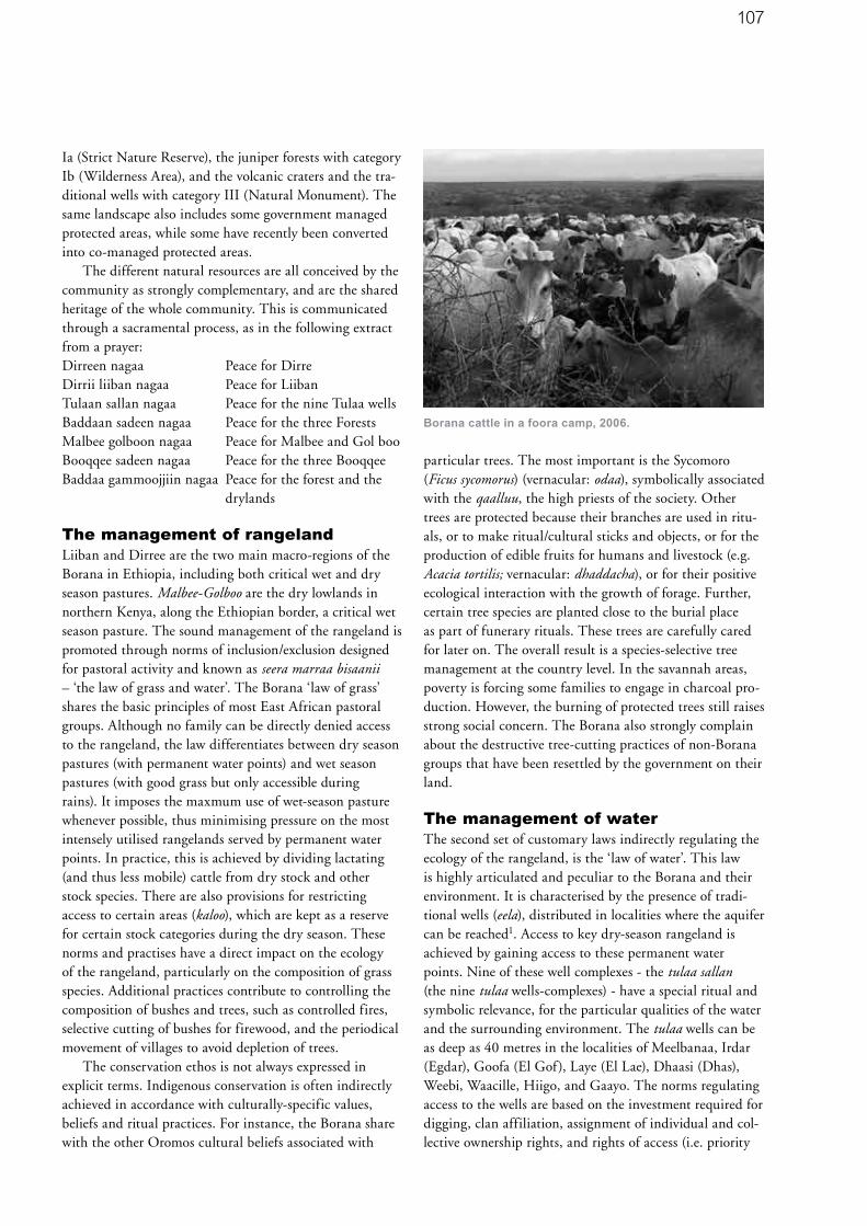
107
Ia (Strict Nature Reserve), the juniper forests with category Ib (Wilderness Area), and the volcanic craters and the tra-ditional wells with category III (Natural Monument). The same landscape also includes some government managed protected areas, while some have recently been converted into co-managed protected areas.
The different natural resources are all conceived by the community as strongly complementary, and are the shared heritage of the whole community. This is communicated through a sacramental process, as in the following extract from a prayer:Dirreen nagaa Peace for DirreDirrii liiban nagaa Peace for LiibanTulaan sallan nagaa Peace for the nine Tulaa wellsBaddaan sadeen nagaa Peace for the three ForestsMalbee golboon nagaa Peace for Malbee and Gol booBooqqee sadeen nagaa Peace for the three BooqqeeBaddaa gammoojjiin nagaa Peace for the forest and the drylands
The management of rangelandLiiban and Dirree are the two main macro-regions of the Borana in Ethiopia, including both critical wet and dry season pastures. Malbee-Golboo are the dry lowlands in northern Kenya, along the Ethiopian border, a critical wet season pasture. The sound management of the rangeland is promoted through norms of inclusion/exclusion designed for pastoral activity and known as seera marraa bisaanii – ‘the law of grass and water’. The Borana ‘law of grass’ shares the basic principles of most East African pastoral groups. Although no family can be directly denied access to the rangeland, the law differentiates between dry season pastures (with permanent water points) and wet season pastures (with good grass but only accessible during rains). It imposes the maxmum use of wet-season pasture whenever possible, thus minimising pressure on the most intensely utilised rangelands served by permanent water points. In practice, this is achieved by dividing lactating (and thus less mobile) cattle from dry stock and other stock species. There are also provisions for restricting access to certain areas (kaloo), which are kept as a reserve for certain stock categories during the dry season. These norms and practises have a direct impact on the ecology of the rangeland, particularly on the composition of grass species. Additional practices contribute to controlling the composition of bushes and trees, such as controlled fires, selective cutting of bushes for firewood, and the periodical movement of villages to avoid depletion of trees.
The conservation ethos is not always expressed in explicit terms. Indigenous conservation is often indirectly achieved in accordance with culturally-specific values, beliefs and ritual practices. For instance, the Borana share with the other Oromos cultural beliefs associated with
particular trees. The most important is the Sycomoro (Ficus sycomorus) (vernacular: odaa), symbolically associated with the qaalluu, the high priests of the society. Other trees are protected because their branches are used in ritu-als, or to make ritual/cultural sticks and objects, or for the production of edible fruits for humans and livestock (e.g. Acacia tortilis; vernacular: dhaddacha), or for their positive ecological interaction with the growth of forage. Further, certain tree species are planted close to the burial place as part of funerary rituals. These trees are carefully cared for later on. The overall result is a species-selective tree management at the country level. In the savannah areas, poverty is forcing some families to engage in charcoal pro-duction. However, the burning of protected trees still raises strong social concern. The Borana also strongly complain about the destructive tree-cutting practices of non-Borana groups that have been resettled by the government on their land.
The management of waterThe second set of customary laws indirectly regulating the ecology of the rangeland, is the ‘law of water’. This law is highly articulated and peculiar to the Borana and their environment. It is characterised by the presence of tradi-tional wells (eela), distributed in localities where the aquifer can be reached1. Access to key dry-season rangeland is achieved by gaining access to these permanent water points. Nine of these well complexes - the tulaa sallan (the nine tulaa wells-complexes) - have a special ritual and symbolic relevance, for the particular qualities of the water and the surrounding environment. The tulaa wells can be as deep as 40 metres in the localities of Meelbanaa, Irdar (Egdar), Goofa (El Gof), Laye (El Lae), Dhaasi (Dhas), Weebi, Waacille, Hiigo, and Gaayo. The norms regulating access to the wells are based on the investment required for digging, clan affiliation, assignment of individual and col-lective ownership rights, and rights of access (i.e. priority
Borana cattle in a foora camp, 2006.

108
is given to clans and families that have actually invested in the well. There is also a limited quota for outsiders, including members of other ethnic groups and wildlife) (Bassi 2005; Oba 1998). There are special provisions to ban any permanent or temporary human settlement in the vicinity of the wells. In the normal cycle of well excavation and collapse, wells serving over-exploited rangelands are abandoned and new ones are developed elsewhere.
The distribution of the well clusters has encouraged the Borana to select, over the centuries, their particular breed
of zebu cattle, internationally known as the ‘Boran breed’ after the attention received in several studies promoted by ILCA/ILRI (International Livestock Centre for Africa, later developed into the International Livestock Research Institutions). Borana cattle are able to walk long distances in hot and sunny climates, normally drink every third day, and are very efficient converters of pasture forage into body fat which is used during periods of drought. They have the capacity to put on weight easily after the dry season and provide an optimal balance of meat and milk production for market and household consumption. Because of their outstanding performance in hot and dry climates, the Boran breed has, from the 1920s onwards, been introduced in commercial schemes and cross-bred in Kenya, Tanzania, Uganda, the Democratic Republic of Congo, Zambia, Australia, the United States, Brazil and Mexico (ILRI website). Recently a proposal has been formulated to preserve the ‘pureness’ of the breed in Boranaland (Zander and Mburu 2005).
The three-day watering interval allows the Boran breed access to rangelands located up to one and a half days walking distance from the wells. This explains the exploi-tation of pastures not accessible by other breeds during the dry season, and a lower concentration of stock in the prox-imity of the wells, where over-exploitation tends to occur due to the convergence of herds from various directions.
Cross-section of a tulaa well
Gurracha Duuba shows a well where previously water was found at the surface.

109
This capacity, and the herding practice of separating stock types, has positive implications for the long-term grass composition of the different zones. The three-day rotation also allows well access to a larger number of pastoral units and the allocation of each day to different clans, thus fostering inter-clan cooperation and reducing the potential of inter-clan competition and conflict. In economic terms, the Borana cattle have been the main beef export from Ethiopia to the Gulf States, and a major source of foreign currency during the socialist period of Ethiopia.
The juniper forestsThe baddaa sadeen are the three largest juniper (Juniperus procera) forests in the Borana Conserved Landscape; Baddaa means ‘forest with tall trees’ and ‘a dark green forest’. As in several other forests in the Horn of Africa, the baddaa sadeen are too humid for permanent pastoral settlement. However, some open patches contain excellent pasture and provide permanent springs. Traditionally they were therefore used as dry-season pastures. The forests have an important function as a last refuge for grazing in case of drought, and are a reserve for medical and ritual plants. They were not subjected to special management provisions, apart from the very strict prohibition against starting fires in the forest.
The forests have a high symbolic value; they are conceived as something belonging to the ‘outside’ - the realm of nature, being close to God (the alolla) (Kassam and Megerssa 1994). They are also a metaphor for human society, hence highly valued in social terms. Gurracha Duuba, a Borana elder living outside the Manquubsa forest near Nagelle town, clearly articulated these values during an interview conducted in September 2002. The Manquubsa forest was nearly destroyed by a fire in 1999 and the remaining area was seriously affected by illegal and selective cutting of juniper trees for house construction in the town:
“The juniper trees are like the Borana elders (jaarsa): they stand taller than the others and have a long white beard (whitish lichen – arrii – is often hanging on the juniper’s leafy branches). Just as there cannot be Borana society without elders, the baddaa (forest) will follow into chaos when all the junipers are cut or destroyed. I was told long ago [referring to an oral prophetic text] that one day we would have seen a big light from very far and the baddaa would disappear…[referring to the great 1999 fire].”
The juniper trees are thus the elders and the forest is the Borana society, since there is a dynamic link between the two. This link is reflected in prophecy. The prophetic text the elder was referring to is well known by the community and provides a list of events representing the reverse of orderly social life. These events announce a cosmological
crisis, an apocalypse (Bassi and Boku 2005). The ‘light’ (i.e. the fire) destroying the forest is thus equated with the disappearance of orderly human society and is conceived as a step towards, when translated in western scientific lan-guage, an ecological disaster at a global level. The symbolic inter-dependence between the forest and human activity is further qualified in the rest of the interview:
“The forest attracts the clouds. It makes them stop and rain. It also produces rain: in the forest there is always humidity and mist. It produces rain. We can see it by the fact that it has springs and produces all-year-round high quality pasture. Due to the forest destruction now, the nearby plains (Diida Liiban) and other places do not receive enough rain anymore, and many of the permanent springs in the forest have dried up. But rain is still good in my place, Xuxxuffe, due to the remain-ing patch of forest nearby”.
Gurracha Duuba illustrated his points during a walk in the forest. He showed us several surface water points that have dried up during the last few years. He also showed us how deep they have to dig now to find the water in the same point, requiring a line of 10 standing men to draw water to the surface. The analogy with theories of global warming is clear, although the cause-effect relation between forest and climatic change here is at a local scale.
The volcano cratersThe Booqee sadeen are the three volcano craters found in Borana territory, providing different salts and high quality water for both human and cattle consumption. They are kept open and can be used by wildlife, but access by the community is regulated through a balance of customary and statutory laws, the latter imposing a tax on salt extracted by the local community. When the government announced, in national newspapers, a public bid for indus-trial mining in the craters, the entire community mobilised and managed to conserve the customary use of the Booqee.
Crater lake producing minerals for livestock (and wildlife)
consumption.

110
Borana governanceThe different resources discussed above, together ensure the maintenance of a viable pastoral system. They are common resources, in the sense that all pastoral units have the potential to use the territory and gain direct or indirect rights of access in response to unpredictable climatic patterns. However, both management and access are strictly regulated through practice, customary norms, belief systems, and laws of inclusion/exclusion, which protect the resources from outsiders and regulate the internal allocation between groups, sub-groups, individu-als and families.
This regulation is achieved through indigenous governance built on the highly complex gadaa system of generation classes (Legesse 1973). Every eight years a new generation class, represented by elected leaders from the major clan divisions, takes the leadership of the yaa’a, the mobile ritual villages of the Borana. Ceremonies are performed in different sacred sites scattered over the landscape, mostly in the shade of a Sycomoro tree. The tree and the surrounding area, known as ardaa jilaa, are fully protected and maintained in a natural state (Taddesse 1995). The representatives of the gadaa generation class are also responsible for the organisation of the Gumi Gayoo, the general assembly of the Borana held once in every eight years. The event lasts over a month and involves
thousands of people in democratic debates. The general assembly also serves as supreme court of the Borana and their legislative body. Formal customary laws (seera) are orally announced on these occasions. Law enforcement is assured by the Borana practice of discussing judicial cases and reaching binding decisions by consensus in a large variety of formal assemblies, held either locally by variously defined residential communities or at central level by each clan. Assemblies are led by different types of titled leaders. The abbaa gadaa, the qaalluu and the hayyuu are the most authoritative, having served for not less than 16 years in one of the Borana yaa’a. All titled leaders and influential men are called jaarsa-elders, a term implying political prestige (Bassi 2005).
This system illustrates the mechanisms of indigenous governance, based on the political philosophy of each group, and manifesting itself through a number of cor-related visible elements, including: • norms (customary law and practice) and procedures
regulating the decisional processes, including law mak-ing, conflict management and dispute settlement
• the settings where binding decisions are made, normally in various councils and meetings
• customary institutions, defining political and ritual roles, and political and juridical personnel
• ritual practices.
The Gumi Gayoo general assembly.

111
Symbolic constructs of social and economic groupings, norms, juridical and judicial procedures, culturally-specific sanctions, political and juridical personnel, and local or indigenous knowledge are all inter-connected elements taking shape in relation to the specific territorial asset.
A Sycomoro marking a ritual ground. The Borana only man-
age to protect the tree, while the surrounding area is now
cultivated by newcomers.
Agrobiodiversity and the state-induced decline of the conserved landscapeThe environmentally sound management of natural resources assured the development and conservation of a unique agrobiodiversity heritage in Borana territory.
To date, ecological studies have focused on the direct inter-relation of stock with wild species, and hence, prima-rily on vegetation dynamics and their response to grazing (Oba et al 2000; Coppock 1994), from the point of view of both indigenous and scientific knowledge (Oba and Kotile 2001). In addition to the Borana cattle breed, specific to this territory and later disseminated world-wide, there are several important breeds of goat, sheep, donkey, horse and camel. Very little is known on the relation between the pastoral-modified environment and other wild biodiversity; although it is documented that the Borana conserved landscape provides the habitat for a variety of important, globally-threatened, range-restricted and biome-specific wild species (EWNHS 1996).
The Acacia-Coommiphora open woodlands and bushlands of the area suppport 43 species of mammals, including the endemic Swayne’s Hartebeest (Alcelaphus buselaphus swayeni) and 283 species of birds, including the endemic Abyssinian Bush Crow (Zavattariornis stresemanni), the White-tailed Swallow (Hirundo megaensis)
and the Sidamo Lark (Heteromirafra sidamoensis). It is possible that the Abyssinian Bush Crow, found only in the land of the Borana, is actually dependent on a pastoral-modified ecology. This species, whose classification has been difficult, is in fact only found in a restricted range, in the middle of the tulaa wells area, which is locally known for having been intensively used by cattle-pastoralists for several centuries. The globally-threatened and little-known Sidamo Lark is found in a very small area southeast of Nagelle Borana (Robertson 1995).
Dry evergreen forests and patches of forests with Juniper procera are also important because they occur in low rainfall habitat (below 1,000 mm) and they host the restricted-range Prince Ruspoli’s Turaco (Tauraco ruspolii) (Borghesio 1997). Plants of wild coffee and chat (an evergreen shrub widely grown for its mild narcotic effect) are also found in the forests scattered through Boranaland.
From the 1970s onwards the Borana environment was confronted with major land use changes. The socialist gov-ernment limited mobility within the ethnic territory and promoted agriculture. The situation degenerated further after the change of government in 1991, with the political marginalization of the Borana. UN-backed returnees pro-grammes and other development initiatives supported by international funds meant that entire portions of Borana territory, including two tulaa localities, were entrusted to neighbouring groups. More land resources were lost by the Borana in the process of economic liberalisation and globalisation. Large ranches were acquired by international investors. Extensive portions of land around the towns, located in critical dry-season pastures, were assigned to town dwellers and to non-Borana immigrants, for small-holding cultivation. Since common property and indigenous land rights are not recognised in Ethiopia, the Borana’s territory has been treated as if their common property land were ‘no-man’s land’, to be assigned to whoever claimed it.
The Borana have been squeezed into the driest pockets where their grazing land was bound to deteriorate, and deprived of their drought grazing reserves (Oba 1998). The only possible survival strategy for the Borana has been to engage in farming in the remaining least suitable places, both to obtain some food during years of good rain, and to secure some land rights to the community in the long run.
The Borana institutions and norms appear increasingly unable to cope with the development and resettlement policies. Decisions on land allocation and land use are simply imposed upon them by the State administration. In addition, massive immigration of people who do not share the values attached to Borana governance, have made the traditional governance ineffective at the landscape-level, with a tremendous overall de-legitimizing effect. The impact on biodiversity conservation is also tremendous,

112
despite the establishment of some formal protected areas within the Borana territory by the Socialist government. The open woodlands, especially in the wetter zone provid-ing the habitat of the Abyssinian Bush Crow, are becoming smaller and fragmented. Unregulated overgrazing is turn-ing them into dense bushes. Agricultural encroachment and overgrazing are taking place even within the Yaballo sanctuary, established to protect this outstanding biodiver-sity complex. A recent road-side count of the Abyssinian Bush Crow by Borghesio and Giannetti indicates a popula-tion decline of 80% since 1989 (Borghesio and Giannetti 2005).
The juniper forests (baddaa) of the Borana conserved landscape are devastated. The smaller patches scattered over the landscape are almost completely destroyed. The three largest forests (baddaa sadeen) were classified as National Forest and accordingly protected and managed by the government. All were seriously affected by the fires in 1999, and all are seriously endangered by commercial timber extraction and agricultural encroachment by non-Borana newcomers. Of the three, the Manquubsaa Forest (Nagelle) has almost entirely disappeared. The Arero forest remains dense only in some blocks, having entirely disap-peared in the remaining parts, while the Yaaballo Forest is highly exploited with some remaining dense patches (Borghesio et al 2004).
During field-surveys conducted by the authors in 2002 with SOS Sahel-Ethiopia, it appeared that nearly all the ceremonial grounds, previously held in a natural state by the Borana, were affected by the development of new settlements and extensive farming, mostly practiced by non-Borana newcomers, or were incorporated into private ranches managed by external investors. The customary leaders have been forced to negotiate access to their holy grounds at the time of ceremonies.
Although international cooperation strongly supports the development of new boreholes, the Borana still manage to independently maintain those traditional wells that they can still access. However, the system of norms and the enforcing mechanisms that prevented settlement close to wells, are losing their efficacy. While most pastoralists still keep their mobile villages far from the tulaa wells, some wealthier Borana have started to construct permanent houses and shops in the vicinity of the wells, which could possibly develop into the rapid formation of a new town, being close to a water source.
Unfortunately, while this changing pattern of land use is destroying the sustainable pastoral management and dependent biodiversity, it is not producing any relevant economic gain. Boranaland is not suitable for agriculture due to low and irregular rainfall. Both the pastoralists and the immigrating farmers only manage to survive on food donations from abroad.
Valorizing and revitalizing Borana governanceIn the previous paragraphs we have shown a fundamental convergence of interests and a comparable conservation ethos between the Borana community and global conser-vationists, despite indigenous conservation being primarily motivated by sustainable livelihoods and ritual. We have also described how customary governance is under heavy external pressure, and is currently incapable of dealing with the new challenges. We are therefore challenged by the question of how to bridge global biodiversity conserva-tion goals with the values and practices of the local and indigenous communities, while respecting the basic principles of equity, and building on local cultural notions and models. In other words, what are the possibilities and constraints in applying a CCA approach to this region?
Applying CCAs in the Horn of Africa mainly means recognising, valorising and formalising indigenous (or customary) governance and customary tenure systems based on common property. The provisions for col-lective rights guaranteed under International Labour Organisation (ILO) Convention No. 169 and the Draft United Nations Declaration on the Rights of Indigenous Peoples – with their explicit reference to customary laws, customary leadership, customary legal and decisional procedures, customary land tenure, and self-determination – obviously provide paramount guidance. Unfortunately collective rights are hardly recognised in the legislation of Ethiopia or any other of the countries of the Horn of Africa. Collective rights may implicitly be considered or recognised as a secondary claim in some sectoral law or policy document, usually under the heading of ‘com-munity’ or ‘local community’. However, the concept of ‘community’ or ‘local community’, lacking any reference to the environment-specific cultural elements, is too generic for indigenous conservation to regain efficacy. Some recent guidelines and recommendations developed in the context of the IUCN and the CBD may provide more specific guidance to promote appropriate policies and legislation at national level, but more work in this area is clearly needed.
Even in the absence of specific country-level legisla-tions, some interesting attempts to realize the value of indigenous conservation have been made on the ground, mainly in relation to collaborative forest management. In a CCA approach, reference to customary leadership is crucial. The Borana Collaborative Forest Management Project was established in 1999 by SOS Sahel, with funds from the EU, to stop the process of serious degradation of the three largest juniper forest of Borana Zone. The project staff implemented action based on an in-depth analysis of tenure, resource use and customary governance. The project has been working to rebuild respect and recogni-

113
tion for the gadaa system as a legitimate governance struc-ture, and has acknowledged the gadaa leaders as primary stakeholders and key partners to the Forest Department (Boku and Irwin 2003). The main customary leaders have systematically been involved in the preparatory debates. However, the formal recognition so far achieved does not involve Borana governance as a whole, as only customary leaders and elders have been included in new, locally established management committees. This limits the relevance of the action to forests, which are only one component of the Borana conserved landscape. Even with this limited scope, there are problems of implementation. According to Borbor Bule, a well-known local elder, the sustainable management of the forest will be possible only when the management responsibility and authority are entrusted to elders who are the custodians of the resources. The elders should have the power to impose sanctions in case of damaging behaviours, based on explicit agreements where the traditional structure has a leading role, and the administrative structure a supporting one (Boku and Irwin 2003).
Customary tenure, collective rights and primary stakeholdersIndigenous conservation is primarily based on customary tenure and, especially for pastoralists, on communal use of resources. Once the customary tenure system is replaced, indigenous governance and customary law no longer make any sense and indigenous conservation is gone forever. Legitimizing customary tenure in the first place means recognising the collective rights of the indigenous commu-nities. But even if the legal environment is not conducive to this, there are a number of alternative solutions in the context of environmental protection and collaborative management. In the Borana Conserved Landscape the rapid environmental deterioration is associated with competing claims between the indigenous communities and other encroaching groups or opportunistic newcomers, all claiming access to the same natural resources. Both the indigenous communities and newcomers belong to the ‘local community’ category. They are simultaneously using the local natural resources. Both have claims and rights, though based on different legitimising principles. Dealing with conservation implies making choices about legitimate claims, and giving priority to those who have established long-standing associations with the natural resources. Hence, a culturally-grounded approach to environmental conservation requires a clear differentiation between primary and secondary rights. We propose, therefore, that
primary rights are ascribed to the communities and groups that, through an historical association with a territory, have developed cultural and functional devices for the conservation and sustainable use of natural resources in that territory.
It has rightly been observed that a superficial applica-tion of stakeholder analysis leads to a misleading sense of equality between stakeholders (Hughes 1996). Grazia Borrini-Feyerabend suggests criteria to differentiate between stakeholders in collaborative management, includ-ing existing rights to land or natural resources, continuity of relationship with the resource, unique knowledge, and historical and cultural relations with the resource at stake (Borrini-Feyerabend 1996). An ODA report suggests differentiating between ‘primary stakeholders’ who have rights, and ‘secondary stakeholders’, who simply have interests (ODA 1996). Putting theory into practice is not, however, so easy, and the identification of the rights-hold-ers in the Borana landscape was considerably complex. In the Borana Collaborative Forest Management Project, it was therefore decided to differentiate between primary and secondary stakeholders on the basis of direct or indirect use of the forest, whilst acknowledging the relevance of historical and social factors in determining rights over the resources (Boku and Irwin 2003). In order to overcome the difficulties of differentiating between stakeholders, it is advisable to clearly define ‘primary stakeholders’ with reference to cultural and historical criteria. Accordingly, we propose to recognise primary stakeholders as those members or sections of the local community that can legitimately claim primary rights on the resource at stake.
Need for institutional developmentThe process of recognition of customary governance implies a process of harmonisation with national and inter-national demands. This requires specific actions at national level, in terms of recognising the relevance of collective and cultural rights and customary tenure systems, through policy, legislation and guidelines. It also requires specific actions at a local level, in terms of re-contextualisation and innovation. The effective revitalisation of indigenous governance requires more than a simple codification of customary laws (i.e. directly incorporating them into the legal framework) or undertaking negotiations with the existing customary leaders. It requires attention to be given to all the interrelated elements of indigenous governance. In the case of Borana Conserved Landscape it is possible to rely on the variety of customary bodies and institutions to stimulate the revision of norms. However, customary
114
leaders and local actors, who may be marginal to modern processes and training, are often incapable of dealing with new threats and situations. It is therefore necessary to enhance the capacity of the customary leadership to deal with new challenges. This can be achieved by ad-hoc capacity development initiatives and also by institutional change at the local level, where there is an interface between indigenous and State institutions, and modern and indigenous knowledge.
1 The deep wells are known as the ‘singing wells‘ because of the way they are operated, giving the impression of songs coming directly from the earth.
Glossary of local termsabbaa gadaa
‘father of the gadaa’ the leader of the Borana nominated
every 8 year
Alolla
The ‘outside’ the realm of ‘nature’
ardaa jilaa
cerimonial ground
baddaa
forest with tall trees or a dark green forest
baddaa sadeen
the three largest juniper forests in the Borana Conserved
Landscape
booqee sadeen
the three volcano craters found in Borana territory
eela
traditional wells
Gumi Gayoo
the general assembly of the Borana held once in every eight
years
hayyuu
customary officers of the Borana with juridical functions
jaarsa-elders
titled leaders and influential men
kaloo
areas which are kept as a reserve for certain stock
categories during the dry season
qaalluu
high priests
seera
formal customary laws
seera marraa bisaanii
the law of grass and water
tulaa sallan
well complexes
yaa’a
the mobile ritual villages of the Borana
ReferencesBassi, M. 2007. Community Conserved Areas in the Horn of
Africa. Parks, 16 (1).
Bassi, M. 2005. Decisions in the Shade. Political and
Juridical Processes among the Oromo-Borana. Red Sea
Press. Trenton.
Bassi, M. and Tache, B. 2005. The Oromo Eschatology: the
Prophecy of Areeroo Boosaroo narrated by Borbor Bulee
and Guyyoo Dambii. The Journal of Oromo Studies, 12
(1&2). p174-222.
Borghesio L. and Giannetti, F. 2005. Habitat degradation
threatens the survival of the Ethiopian bush crow
Zavattariornis stresemanni. Oryx, 39 (1). p44-49, Addis Ababa.
Borghesio, L. 1997. Field observations on Prince Ruspoli’s
Turaco Tauraco ruspolii. Scopus 19 (2). p83-91.
Borghesio, L., Giannetti, F., Ndang’ang’a, K., Shimelis, A.
2004. The present conservation status of Juniperus forests
in the South Ethiopian Endemic Bird Area. African Journal of
Ecology, 42. p137-143.
Borrini-Feyerabend, G., Kothari, A. and Oviedo, G. 2004.
Indigenous and Local Communities and Protected Areas.
Towards Equity and Enhanced Conservation. Cardiff
University and IUCN. Gland, Switzerland and Cambridge,
UK.
Borrini-Feyerabend, G. 1996. Collaborative Management
of Protected Areas: Tailoring the Approach to the Context.
IUCN. Gland.
Coppock, L. 1994. The Borana Plateau of Southern Ethiopia:
Synthesis of pastoral research, development and change,
1980-91. Ilca. Addis Ababa.
Dudley, N., Harrison, J. and Rosabal, P. 2004. The future
development of the categories system. Parks, 14 (3). p72 81.
EWNHS. 1996. Important Bird Areas of Ethiopia. A first
Inventory. Ethiopian Wildlife and Natural History Society.
Addis Ababa.
Hughes, D.M. 1996. When Parks Encroach Upon People.
Expanding National Parks in the Rusitu Valley, Zimbabwe.
Cultural Survival Quarterly. 20(1), p36 –40.
ILRI (International Livestock Research Institute) website,
AGTR, http://agtr.ilri.cgiar.org/BreedInformation/breedpg/
cattle/Boran.htm 15/02/2007.

115
Kassam, A. and Megerssa, G. 1994. Aloof Alollaa. The
Inside and the Outside; Boran Oromo Environmental Law
and Methods of Conservation. Brokensha, D. (Ed.) A River
of Blessings. Essays in Honor of Paul Baxter. p86-96. Maxell
School of Citizenship and Public Affairs, Syracuse University.
Syracuse.
Legesse, Asmarom. 1973. Gada. Three Approaches to the
Study of African Society. Free Press. New York.
Oba G. and Kotile, D.G. 2001. Assessments of Landscape
Level Degradation in Southern Ethiopia: Pastoralists versus
Ecologists. Land Degradation & Development, 12. p561-75.
Oba, G. 1998. Assessment of Indigenous Range
Management Knoweldge of the Boran Pastoralists of
Southern Ethiopia. GTZ-Boran Lowland Pastoral Development
Program and Oromiya Regional Bureau for Agricultural
Development. Nagelle/Borana, Ethiopia.
Oba, G., Post, E., Syvertsen, P.O. and Stenseth, N.C. 2000.
Bush cover and range condition assessments in relation
to landscape and grazing in southern Ethiopia. Landscape
Ecology 15. p535-546.
ODA. 1996. Stakeholder Analysis. HMG. London.
Phillips, A. 2002. Management Guidelines for IUCN Category
V Protected Areas: Protected Landscape/Seascape. Cardiff
University and IUCN, Gland, Switzerland and Cambridge, UK.
Robertson, I. S. 1995. First field observations on the Sidamo
Lark? Heteromirafra sidamoensis. Bull. Brit. Orn. Club 115.
p241-243.
Tache, B. and Irwin, B. 2003. Traditional Institutions, multiple
stakeholders and modern perspectives in common property.
Accompanying change within Borana pastoral system. Securing
the commons. Working paper No. 4. IIED, SOS Sahel, London.
Taddesse Berisso. 1995. Deforestation and Environmental
Degradation in Ethiopia: the Case of Jam Jam Province.
Northeast African Studies, 2 (2). p139-155.
Zander, K. and Mburu, J. 2005. Determining Right Priorities
for Conserving Farm Animal Genetic Resources - The Case
of Borana Cattle in East Africa.
Tielkes, E., Hülsebusch, C., Häuser, I., Deininger, A.
and Becker, K (Eds.) The Global Food & Product Chain
- Dynamics, Innovations, Conflicts, Strategies. Book of
abstracts, Tropentag. p32. University of Hohenheim.
Stuttgart. www.tropentag.de/2005/proceedings
About the authors
Marco BassiMarco Bassi is adjunct professor of Political Anthropology,
Applied Anthropology and Methodology at Bologna
University. He has actively been collaborating with IUCN
CEESP and TILCEPA on the issues of equity and indigenous
governance.
Marco Bassi
African Studies Centre - University of Oxford
92 Woodstock Road, Oxford OX2 7ND
Boku TacheBoku Tache is a Research Fellow at Noragric, Department
of International Environment and Development Studies, the
Norwegian University of Life Sciences. He is also a member
of the Coordinating Committee of World Alliance of Mobile
Indigenous Peoples (WAMIP).
Boku Tache
Department of International Environment and Development
Studies, Norwegian University of Life Science
P.O. Box 5003, 1432 Aas, Norway

116
Conserving agrobiodiversity in England’s Protected Landscapes1 Lyndis Cole in co-operation with Adrian Phillips
SummaryThis case study has a national, rather than a site, focus. It recalls that traditional farming systems, based on locally-adapted breeds of livestock and varieties of fruit (agrobiodiversity), were once widespread throughout England. Since about 1940, many of these have been lost through the industrialisation of agriculture and the emer-gence of a consumer preference for cheap, standardised food, much of it traded internationally. This has led to the loss of landscape, cultural and biodiversity values in rural England. However, some traditional farming systems using local breeds and varieties survive. These traditional farm-ing systems often support valued wild species and habitats, and help to maintain important landscapes, many of which are designated as Category V Protected Areas (Protected Landscapes). While farming in these areas remains under pressure, the case study describes several recent conserva-tion initiatives within Protected Landscapes. Some aim to reinforce the viability of existing farming operations based on locally-adapted livestock and local varieties of fruit; others aim to re-introduce lost breeds and varieties. Their success will be good news for nature conservation, heritage landscapes, local communities, the welfare of farms and farming, and for the consumer
England’s Protected LandscapesEngland’s Protected Landscapes are of two kinds: National Parks (NPs), and Areas of Outstanding Natural Beauty (AONBs). There are nine NPs2 and 36 AONBs3; all are lived-in, working landscapes and are listed as Category V in the World Database on Protected Areas. The NPs cover 10,502 sq kms (8% of land area); the AONBs cover 19,595 sq kms (15%) – see map.
Seven NPs are to be found in upland areas, based on the older, harder rocks that occur in the South West and in the North, and where the landscape has been shaped by hill farming traditions adapted to a rugged terrain and a relatively harsh climate. The other two parks are focused respectively on an internationally important wetland ecosystem (the Broads) and an equally important forest and heathland system (the New Forest). Between them, the parks are home to over a quarter of a million people. Many
AONBs are in rather gentler country to the south and east of England, often on chalk, limestone and sandstone ridges. Other AONBs are designated along England’s varied coastline, and cover hills and upland areas of the North, the Welsh borders and the South West.
Together the NPs and AONBs constitute England’s finest landscape heritage and contain a large part of its most valued biodiversity. Most of the land within them is privately owned (including significant ownership by conservation NGOs), though some is owned and managed by public bodies. Farming is the dominant land use in all Protected Landscapes, though tourism and other activities are often more important economically.
Legal status of the Protected LandscapesNPs and AONBs owe their origins to legislation passed in 1949 (which applied also to Wales). The first park was established in 1951; the most recent in 2005. The first AONB was designated in 1956; the most recent in 1995. Legislation for NPs was last updated in 1995 and for AONBs in 2000. Landscape protection has the same status in law in both types of area, but the purposes of the two designations differ:
• NPs: a) conserving and enhancing natural beauty, wildlife
and cultural heritage; b) promoting understanding and enjoyment of the
area’s special qualities4. If there is a conflict between the first and second purpose, the national park authority (see below) must give precedence to the former. In addition, park authorities are required to help promote the economic and social well-being of local people.
• AONBs: - conserving and enhancing natural beauty, wildlife
and cultural heritage. Where an AONB board is set up (see below), it has a
duty to increase public understanding and enjoyment of the area, and to help promote the economic and social well-being of local people.

117
National Parks - England
Areas of Outstanding
NaturalBeauty - England
England’s Protected Landscapes
source: Natural England
Reproduced from Ordnance Survey information with the permission of the Controller of Her Majesty's Stationary Office, Crown Copyright, Land Use Consultants, Licence Number 100019265

118
Administrative status of the Protected LandscapesEach NP is administered by its own independent authority. The national park authorities’ membership is partly drawn from local government and local parishes (commune level), and partly appointed by the Environment Minister5. The governance of the parks, therefore, is broadly akin to the IUCN model of a government-run protected area, but with elements of a co-management system. The authorities’ remit reflects the purposes as set out above. To this end, they have powers to plan and control development and land use, assist landowners in the management of the area (which is relevant to the theme of this paper), and help people understand and enjoy the area’s qualities. They are required to prepare and keep up to date a park management plan. Each park employs a full team of office and field staff: there are about 1,000 staff in all nine parks. Most funding is provided by government, reflecting the areas’ special needs. All public bodies are required to have regard to the purposes of national parks in any work that they plan that may affect the conservation of the area. The national agency, Natural England6, maintains an oversight over the parks as a whole and can advise government and others about their needs.
Most AONBs are administered by the constituent local authorities in which they are located. While their conservation responsibilities are broadly similar to those of the parks, planning powers remain with the local authori-ties. In most AONBs, there is a joint advisory committee or partnership that brings together the local authorities and farming, environmental and other groups. Usually one local authority administers the staff team, although increasingly such teams have their own independent office. In two cases7, recent legislation has been used to establish AONB Boards, which operate in a similar way to national park authorities (but without planning powers). As with the parks, the work of public bodies must have regard to the AONBs’ purpose. Natural England maintains an oversight of the AONBs, and supplements the funding provided by local authorities.
The authorities that administer NPs and AONBs have a range of powers and resources that they can draw on to influence agricultural practice and, indeed, assist in marketing agricultural produce. This enables them to support projects relating to agrobiodiversity, as illustrated in the examples below.
Setting the scene8
Agriculture has had a fundamental influence over the creation and management of nearly all of England’s landscapes, including those that are now designated as Protected Landscapes. The response of agriculture over millennia to local conditions resulted in the rich diversity
of locally distinctive landscapes and biodiversity that used to characterise much of rural England.
But during the past two-thirds of a century, changes in agriculture have greatly altered and simplified the English rural landscape. First national policy, and then the EU’s Common Agricultural Policy (CAP), promoted the industrialisation of agriculture. These policies encouraged the intensive production of a limited number of major commodities, replacing traditional9 approaches where agriculture was adapted to local conditions.
On the consumption side, the early industrialisation of Britain broke the direct link between millions of people and food production. Later, years of food rationing during and after the Second World War produced a generation unacquainted with traditional local foods that reflected their locality. The result is a population that has become accustomed to standardisation in food and “the insidious monotony of apparent choice imposed by supermarkets” (Mason and Brown 2004). Generic foodstuffs (commodi-ties), marketed nationally and internationally and with an emphasis on price (and size and colour), have largely replaced traditional food production systems that used numerous different breeds and varieties suited to local con-ditions. Only more recently has a reaction developed, with a growing interest in the consumption of locally produced food and the production of regional (or locality) foods.
The industrialisation and intensification of agriculture led to a loss of those local, distinctive features and quali-ties that had helped to create a very diverse landscape, characterised by numerous local differences. Thus, much of the inherited patina of local landscapes, created and maintained through past centuries of local agricultural systems uniquely adapted to local conditions, has been rubbed out in the past 65 or so years. In short, increasing uniformity in English food has helped to bring about increasing uniformity in the English landscape.
Whilst it is dangerous to generalise, the remnants of these traditional farming systems, and the traditional landscapes and wild biodiversity that they support, are now largely (although not exclusively) concentrated in the more marginal areas of England. Precisely because they tend to be the areas of wilder landscapes and more remote from urban influence, many of these areas are also designated as NPs or AONBs. Here many old farming traditions and related traditional knowledge survive, along with land management practices that have helped create and sustain the rich variety of these Protected Landscapes. Here too are many of the repositories of native breeds and endangered varieties of fruit that have played their part in shaping the landscape and which are now being revived to assist in conserving wild biodiversity, expanding the local food economy, supporting farm viability, and diversifying the wider rural economy (see diagram over page). It is these aspects of agrobiodiversity that are the main focus of this paper.

119
Past and present land use The dependence of wildlife on traditional farming systemsWhile traditional forms of farming were associated with a wide range of agrobiodiversity in livestock and fruit (see below), farming of this type was often also associated with a rich wild biodiversity. Because traditional farming and associated land management practices used relatively low levels of inputs, tolerated the presence of ‘neglected’ areas on the farm, encouraged a mixture of land uses on one farm holding, and created a range of semi-artificial habitats, they produced a range of semi-natural environments that favoured a variety of wild fauna and flora. Often livestock ‘mimicked’ the role of large herbivores in controlling vegetation, browsing trees and grazing pastures. This is especially important where, as in England, most of the original large herbivores no longer exist. It is for this reason that several grazing projects are described below.
In looking at management needs today, the link between conserving wild biodiversity and conserving agrobiodiversity can be very direct: for example, hardy breeds of cattle and ponies can help to keep open scrub vegetation, which supports bird populations; and orchards of large, old varieties of fruit tree are ideal for creating a biodiverse-rich habitat of wood pasture. On the other hand, it is not always the case that a particular traditional breed of animal is needed to graze grassland, for example, to produce the desired benefits for wild biodiversity: some-times a modern breed will do the job as well, provided that the right intensity of grazing is secured.
Animal breeds Agricultural animals have evolved and were bred to suit local conditions. England has a significant number of distinctive native breeds of cattle and sheep – perhaps more than any
other country in the world relative to its size (National Steering Committee for Farm Animal Genetic Resources 2006).
Most of these breeds are linked to particular parts of the country where their characteristics were developed by selective breeding over the centuries. The place names associated with many traditional English breeds of cattle and sheep are testament to their local evolution and affiliation. The following cattle breeds, for example, are associated with Protected Landscapes: Lincoln Red, North Devon, South Devon, Sussex, and traditional Hereford; and these sheep breeds: the Cheviot, Cotswold Sheep or Cotswold Lion, the Dorset Horn and Poll Dorset, Exmoor Horn, Hampshire Down, Portland, Southdown, Wiltshire Horn, Whiteface Dartmoor and Greyface Dartmoor.
Each breed has a story to tell. The Cheviot sheep, once characteristic of the Northumberland National Park border country, was recognised as a hardy breed as early as 1372. Like other ‘longwool’ breeds, the Cotswold ‘Lion’, now the symbol of the Cotswold AONB, probably originated from sheep kept on large estates by the Romans; later it became a mainstay of the English wool trade, while creating and maintaining species-rich limestone grasslands, which are now of international importance for biodiversity and are a defining feature of the Cotswolds AONB. The Wiltshire Horn (now found in the North Wessex Downs AONB, and the Cranborne Chase and West Wiltshire Downs AONB) probably originated from sheep that grazed the downlands in the Stone Age. The Herdwick sheep, found only within the Lake District National Park, may have descended from a flock of 40 sheep washed ashore from a Norwegian vessel wrecked off the Cumberland coast in the tenth century (Denyer 1993).
In the past, livestock of both sexes had been kept together, breeding at random. Although there would have been significant variation between the types of livestock kept in the different regions of England, it would not have been possible to define the characteristics of the animals found in particular landscapes.
In the 18th and 19th centuries, pioneer breeders like the Leicestershire farmer, Robert Bakewell (1725-1795), described and developed pedigree herds and flocks with particular qualities, specially adapted to local circumstances. Many of the downland sheep breeds that were the product of this period, such as the Dorset Horn, Hampshire Down and Southdown, are now associated with Protected Landscapes. Amongst cattle, the Beef Shorthorn, characteristic of the Northumbrian Borders and Yorkshire Dales (both areas are in NPs), has evolved over the last two centuries from Teeswater and Durham Cattle; and the Lincoln Red, once characteristic of the Lincolnshire Wolds (now an AONB), is a cross between Durham and York Shorthorns and the local large and rugged Lincolnshire draught oxen.
Protected Landscapes and Areas of High Value for Wild
Biodiversity and Agrobiodiversity

120
Some of these new pedigree breeds were so successful that they were taken well beyond their original ‘home’ ter-ritory. During the 19th century, sheep breeds such as the Suffolk and Cheviot sheep, and Hereford and Aberdeen Angus cattle, became widely distributed across the UK. Indeed they were introduced into the Americas and Australasia, and further adapted to local conditions. Thus regional (even national) identities began to break down.
Orchard varieties Until the 1930s, nearly all parts of England had large areas of orchard, including many in the Protected Landscapes of today. There were also several thousand traditional English apple, pear, plum and cherry varieties suited to local conditions. Every county could boast varieties considered to be their own (although in reality many were shared with other areas under different names). Cumbria, including the Lake District, not widely known for its apple orchards, had its Hawthornden and Emperor Alexander, while Buckinghamshire had the Aylesbury Prune (plum), whose orchards once nestled at the foot of the Chiltern AONB scarp. These orchards supplied local markets with fruit and cider and, with the coming of the railway, the larger urban markets. They were also an essential element in the self-sufficiency of individual farm holdings: cider was made on virtually every farm in the country from the 1700s to 1940, and formed part of the agricultural wage.
Such orchards were once a defining characteristic of the English landscape, with their large fruit trees and grazed pasture beneath. Traditional orchard habitats can support up to 1,800 species of wild plants and vertebrate and invertebrate animals (Smart & Winnall, undated). Because of the great value of orchards for landscape, biodiversity and associated cultural values, they have recently become a focus of conserva-tion efforts, especially within Protected Landscapes.
Loss of wild biodiversity and agrobiodiversityAgricultural intensification has led to a massive loss of semi-natural agricultural habitats and the species that they supported. For example, 97% of lowland unimproved grassland was lost between 1930 and 1984 in England and Wales (English Nature 2004).
With these losses, the Protected Landscapes of England have become vital strongholds of nationally dwindling semi-natural habitats. Thus 40% of Dartmoor National Park, including much of its high moorland, is now covered by international nature conservation designations (Dartmoor National Park Authority 2001). Likewise, chalk grassland in the proposed South Downs National Park10 accounts for a significant proportion of the remaining British chalk grassland resource (South Downs Joint Committee 2006).
Yet even those marginal areas which are in designated Protected Landscapes have not been immune from habitat loss. Thus over-grazing by upland sheep, ploughing up of species-rich grasslands, drainage of wetlands, excessive use of chemical inputs, and other examples of intensive farming have all impacted negatively on biodiversity that is depend-ent on semi-natural habitats, both in Protected Landscapes and elsewhere. And amongst the semi-natural habitats that remain, there has been a significant decline in quality as a result of inappropriate agricultural management.
Reduced wild biodiversity has been matched by falling agrobiodiversity, with many native English breeds replaced by a few larger breeds often of continental origin. While the UK has over 130 native livestock breeds (poultry, cattle, sheep, goats, pigs, horses and ponies), approximately 100 of these are now considered to be at risk (National Steering Committee for Farm Animal Genetic Resources 2006). With this loss, many of the links between breeds and their traditional localities have been broken.
Traditional orchards have suffered a similar fate. There has been a dramatic decline, from 97,900 ha across England in the 1930s to some 17,000 ha (both traditional orchards and bush varieties) across England and Wales in 2004 (Defra 2004). There are many causes for this –fruit trees were grubbed up during the Second World War to make way for crops, grants were given post-war for orchard removal, subsidies favoured other crops, fruit harvesting and packaging is labour intensive, and there has been huge competition from imported fruit. With the rapid rise in the use of air freight and chilling of fruit, cheap produce can now be brought to English shops from around the world at all times of the year, removing seasonal changes in the availability of fresh food. At the production end, many of the traditional orchard varieties were disease prone, slow to mature and difficult to harvest because of the sheer size of the trees. So not only did the area of orchards fall dra-matically, but those commercial orchards that survive have almost all been converted to modern bush varieties, which are quicker to mature, more disease resistant, produce a much larger crop, and are very much easier to harvest.
To sum up, the effect of changes in food preferences and agriculture over the past 60 or so years has been a significant decline in agrobiodiversity, along with a loss of associated wild biodiversity, cultural values and tradi-tions, and a decline in the overall quality and diversity of the English farmed landscape. The Department of Environmental, Food and Rural Affairs (Defra), the English government department responsible for agriculture as well as the environment, has put a figure on this loss: “while agriculture generates significant environmental benefits (which studies have costed in the range £600 - £900 million per year) it also has significant negative impacts (which studies have costed at £1.15 billion per year)”.

121
Responses In response to such environmental losses, successive UK governments have, for the past 20 years or so, introduced incentives, regulations and legislation to reduce, or even reverse, the rate of environmental damage caused by agricultural intensification.
From 1987 onwards, agri-environment schemes, approved under the CAP, have provided support to environmentally sensitive farming. More dramatic changes came with the reform of the CAP, introduced in 2005, which ended agricultural production support payments. In their place came payments for keeping land in good agri-cultural and environmental condition. CAP also underpins a new agenda for farming in England, the main themes of which are: to re-link farming with the market; to produce safe, good quality food; and to ensure the sustainable management of land for environmental public goods. This last theme is being assisted by the introduction of a new agri-environment scheme – Environmental Stewardship.
The United Nations Convention on Biological Diversity (CBD) requires the UK to commit to conserving all aspects of biodiversity, in both its wild and domesticated forms. While there has been a strong political response in England to the conservation of wild biodiversity, the conservation of agrobiodiversity has not yet received much attention in national policy and support. The conservation of native regional and local agricultural breeds and of traditional fruit and vegetable varieties has largely depended on the work of NGOs, such as animal breed societies, the Rare Breeds Survival Trust, the National Trust and, in the case of fruit varieties, the lead-ing work of Common Ground, backed by the enthusiastic support of local communities, parish councils and local authorities.
While no national schemes for agrobiodiversity conservation have been specifically designed for Protected Landscapes, often the criteria of such schemes particularly favour such areas. Also the heightened awareness within NPs and AONBs of the value of traditional farming systems, the presence of appropriate conservation policies, and the existence of trained staff and administrative capac-ity, make them very suitable places to pioneer projects that are designed to restore lost land management traditions that also support the local economy and landscape/wildlife objectives. Not surprisingly, then, many Protected Landscapes have led the way with work in this area.
Management policies and practicesThere is now a growing awareness that the conservation of wild biodiversity and landscape quality to a large degree depends on the continuation of traditional agricultural practices, and often the conservation of agrobiodiversity as well (see diagram below). This is illustrated by a number of mini case studies below. These describe (i) efforts to con-serve and encourage past agrobiodiversity traditions, (ii) efforts to revive them, and (iii) the potential for more such initiatives in the future.
(i) On-going traditions
New Forest Pannage PorkOne of the best examples of a strong link between landscape, the conservation of wild biodiversity, and the maintenance of a long established land management system, are the pigs of the recently established New Forest National Park. The New Forest is a Royal Hunting Forest of eleventh century origin, still largely owned by the Crown. Over the past 900 years the open heathland and ancient woodland of the Forest have been managed as common land and grazed mainly by cattle, donkeys and a local breed of pony. As a result, the Forest is the largest site in western Europe where lowland heathland, grassland, mire, and pasture woodland habitats survive together in what is a functioning ecosystem based on a continuing practice of pastoralism. Most of it is designated as a European Special Area of Conservation. The survival of the area’s important ecology depends on the continuation of the grazing system.
New Forest pigs (which are traditional native breeds) play a critical part in this finely balanced management system. As part of their historic rights, commoners are entitled to put their pigs out on the Forest for the 60-day autumn ‘pannage’ season to forage acorns and beechmast. For centuries, these pigs have worn nose rings to prevent them uprooting vegetation which provides the food source for the other grazing commons animals.
The links between three kinds of conservation

122
Acorns and beech mast are poisonous to other grazing animals of the Forest, so the pigs ensure the continued safe grazing of the Forest. They also prevent the development of thickets of oak and beech saplings beneath the wood-land canopy, keeping open certain areas that are needed if the diverse flora of the forest floor is to survive.
In the 19th century up to 6,000 pigs were put out annually, but now the figure is nearer 200. In recognition of the pigs’ vital role, the New Forest National Park Authority aims to encourage more commoners to keep traditional pig varieties, in particular by developing a high value market for New Forest ‘pannage pork’, as part of a wider New Forest Friendly Farming Initiative. The ham from pannage pork has a very distinct bittersweet flavour, not dissimilar to Parma ham, reflecting the animal’s diet of acorns and beechmast.
Herdwick SheepThe Lake District National Park contains England’s largest lakes and highest mountains and open fell, and has been proposed as a World Heritage Cultural Landscape. The local sheep breed, the Herdwick11, is one of the hardiest British sheep breeds, able to survive on the scantiest of herbage and in the severest of weathers. Its grazing is vital to maintaining the open fells. In a sense, it created and maintains the Lakeland landscape that captured the imagi-nation of Wordsworth, Ruskin and Beatrix Potter. With its distinctive grey fleece, white head and sturdy white legs, the Herdwick is also a unique feature of the Lake District landscape.
Typical Lakeland farms have less than 35 ha of the lower lying, more productive land and have to rely on larger areas of common grazing on the high fells. The Herdwick is very territorial and the lambs that graze with their mothers on common land attached to their farm, known as the ‘heaf ’ (or heft), are instilled with a life long knowledge of where they should graze. So close are these bonds between locality and individual sheep that when a Lakeland farm changes hands, the ‘heafed’ (or hefted)
flock is sold along with the land or passed on to the incoming tenant.
In the mid 1800s, the Herdwick was found over much of Cumbria but is now confined to the central and western Lakeland fells. Its survival owes much to the children’s writer Beatrix Potter whose stories were inspired by the natural history of the Lake District. In collaboration with the National Trust, she acquired farms and their associated flocks of Herdwick sheep. At her death in 1943, she left 14 farms and over 1700 ha of land to the Trust, stipulating that the sheep run on these hill farms should be pure-bred Herdwick. The Trust has honoured these wishes and now owns 91 hill farms, many of which have mainly Herdwick flocks (approximately 21,000 sheep). This represents a significant total of the remaining 120 Lake District farms running commercial Herdwick flocks - most others having switched to more commercial sheep breeds.
Changes to the CAP, introduced in 2005, led to a sig-nificant fall in support for upland farming. If these upland farms are to survive, therefore, new high value markets for Herdwick products are essential. The National Trust has sought new markets for Herdwick wool (traditionally income from wool sales paid the tenant farmers’ rent). The Herdwick Breeders Association, the Friends of the Lake District, the National Trust and the Lake District National Park Authority have come together to form a direct marketing scheme for Herdwick meat (lamb and mutton) (National Trust 2006). The combination of the Herdwick’s frugal moorland diet, slow growth and slow lambing rate gives the meat a distinct, gamey flavour, now increasingly prized in specialist food markets. Producers under the scheme must be members of the Herdwick Sheep Breeders Association and must be signed up to a Lake District agri-environmental scheme as evidence of their environmental commitment. The National Trust has also appointed a Herdwick Project Officer to raise the profile of Herdwick products and to help expand the businesses of individual Trust tenants.
New Forest Pigs
Photo: Forest Friendly Farming Project
Herdwick Sheep on the Lake District Fells
Photo: The National Trust

123
Kentish cobnutsThe Kentish cobnut has been a long established feature of the Kent Downs AONB. Hazel (Corylus avellana) is a native, small multi-stem tree found throughout England in hedgerows and as part of the woodland understorey. Throughout history, it has been coppiced to provide woody stems for hurdle making and its hazelnuts have been harvested for food. Cultivation of hazelnuts from the 16th century, however, used a species from southern Europe – Corylus maxima – known as Filberts, which is distin-guished from the native hazel by the length of its husk. Kent was already famous for its Filberts by the 1650s and three or four varieties were grown. These were displaced about two hundred years ago by an improved variety: Lambert’s Filbert which (inaccurately) became known as the Kentish Cobnut.
By the early 20th century, nearly 2000 ha were under cobnut production, mainly in Kent, with the cobnuts grown in orchards, or ‘platts’, as 4 metre-high coppice trees planted in rows, often with grazed grassland beneath. These platts were a distinctive and attractive feature of the Kentish landscape but were already in decline by the Second World War because of the labour needed to pick and prune them by hand. Most of the platts that remain have been replanted with bush varieties that can be pruned and harvested mechanically.
Recognising the unique character and genetic impor-tance of the traditional platts, the Kent Downs AONB Unit is working with others to raise awareness of this traditional land management system and to bring derelict platts back under management. They have developed walks around some traditional platts and support the restoration of those in private ownership.
Lyth Valley DamsonOf equally long tradition is the Lyth Valley Damson12 which grows in profusion in just two valleys on the edge of the Lake District National Park, in the Lyth and Winster Valleys, giving both valleys a special sense of place. The
damson is a member of the plum family. It is smaller than other plums and damsons grown in the UK, but has an incomparable flavour. Known locally as Witherslacks (after the name of a local village), the fruit is used in many local recipes. Traditionally, damson trees were planted as linear orchards along field boundaries, with small orchards in field corners and near farmsteads. In April the orchards and hedgerows of the two valleys are filled with white blos-som which, at the height of damson growing in the 1930s, attracted people from all over Lancashire on ‘Damson Sunday’. Indeed, the whole community was involved in damson picking and the nearby town of Kendal was the centre of damson marketing. A shortage of sugar and manpower in the Second World War caused its demise. Decline set in: where there were maybe 40,000 damson trees 60 years earlier, only 4,000 had survived by 1995. Local people have now formed a Westmorland Damson Association to preserve the damson orchards. With EU support, the association is reviving local outlets for damson products, such as damson jams, preserves, ice cream, gin and beer. With the support of Natural England and funds from the new Environmental Stewardship scheme, it is helping to replant the linear and field corner damson orchards as a contribution to restoring the local landscape.
(ii) Return to traditionsSouth Downs LambThe late 18th century saw the introduction of the Southdown, a new breed of sheep, bred specifically for the South Downs13. This was the heyday of ‘New Farming’ – a sheep/corn husbandry system. By day, vast shepherded flocks grazed the eastern chalk downs and other sheep walks; at night, the sheep were taken down onto lower-lying crop fields to add manure. The resulting lowered fertility of the chalk pastures favoured a herb-rich grassland of great floristic variety. Thus the land use system created areas of great biodiversity value. It also created a highly distinctive landscape with the sward (expanse of short grass) revealing every fold and undulation
Lyth Valley Damsons in Blossom
Photo: Peter Burbridge (copyright Natural England)
Kentish Cobnuts
Photo: Tina Stellar (copyright: Natural England)

124
in the dramatic chalk topography, stretching for many miles, uninterrupted by hedgerows or any other form of enclosure.
Chalk grassland is one of the defining characteristics of the South Downs landscape. Yet most of it has been lost to arable production. By 2005, only 4,000 ha of semi-natural chalk grassland remained in the South Downs, largely as fragments on steeper slopes, and covering just 6% of the chalk outcrop. The draft Management Plan (South Downs Joint Committee 2006) for the South Downs has a target to revert 8,000 ha of arable land to chalk grassland over the next five years. Success will depend upon targeting agri-environment scheme payments, and on appropriate management through sheep grazing. The South Downs Joint Committee14 is promoting a premium market for lamb raised on the chalk grasslands, in order to to provide an economic rationale for the re-creation of chalk grassland and its subsequent management, thus re-establishing the links between wild biodiversity and agrobiodiversity, and the links between landscape, breed and place. All lambs sold through the scheme must be sired by either a Southdown or Hampshire Down ram. A practical dilemma facing this and similar schemes is that the traditional grazing systems were founded on wool production, with mutton as a by-product. But the wool market has declined and most consumers now prefer lamb. So the challenge is to emulate the extensive grazing of the past, monitor and refine grazing patterns to maximise biodiversity, and produce good quality lamb for the market.
Limestone Country BeefThe limestone karst landscapes of the Yorkshire Dales National Park contain an internationally important mosaic of semi-natural habitats, especially large expanses of limestone grasslands rich in lime-loving grasses and wildflowers, and limestone pavements. A mixture of sheep and hardy upland cattle breeds used to graze these landscapes, helping to maintain the rich biodiversity of the area. Over the last 40 years there has been a change from
cattle, the most suitable grazing stock for conservation management purposes, to more intensive sheep enterprises, combined with a general increase in stock numbers. This has resulted in a decline in the conservation value of the vegetation associated with karst and limestone pavements, with extensive colonisation by invasive grass species.The Limestone Country Project has been set up to counter this trend, initially with EU funding and covering 11,000 ha. The National Park Authority and Natural England are key project partners. The project aims to encourage local graziers to take on hardy traditional cattle breeds best suited to grazing regimes that help restore biodiversity: the Beef Shorthorn and Blue-Grey (which are traditional to the area) and other traditional English and Scottish breeds.
As a result, some 300 – 500 cattle from 16 farms now graze within the project area. They must spend at least one and preferably two years grazing within the project area. Grazing generally runs from July to December, after the most important plant species have flowered, though experimentation suggests that grazing throughout the winter can suppress invasive grasses. When not within the project area, the cattle are over-wintered on other pastures covered by agri-environment agreements. Following these strict requirements, the beef can be marketed as ‘Limestone Country Beef ’, promoting its superior and distinctive taste and depth of flavour. Although not all the breeds used cur-rently are traditionally local to the area, greater emphasis may be placed on this in the future if the project seeks European Protected Food Name Status, a designation that demands proof of the traditional nature and authenticity of the food, and promotes a strong link to locality.
Other grazing projectsOther examples of Protected Landscape projects that use traditional breeds to enhance biodiversity are: Northumberland Dune Grassland Lamb and Beef (Northumberland Coast AONB), Cotswolds Beef (grazing the limestone grasslands of the AONB), High Weald Lamb and Beef (grazing lowland heathland in the High
South Downs sheep grazing chalk grasslands
Photo: P. Greenhalf (copyright Natural England)
Limestone country beef: Blue-Grey Breed of cattle
Photo copyright Robert Goodison

125
Weald AONB), Three Harbours Beef (taking in the coastal grazing marshes of Chichester Harbour AONB ), and Wash Saltmarsh Beef (grazing salt marshes of international importance, including parts of the North Norfolk AONB). The Red Poll, a traditional cattle breed of Norfolk and Suffolk, is well suited to grazing salt marsh and wet pas-ture, and is being used for conservation grazing within the Norfolk and Suffolk Coast AONBs. Sussex Cattle, which are tough, all-year-round feeders, are once again grazing semi-natural pastures in the High Weald AONB and the remnant chalk grasslands of the Sussex Downs AONB.
Apple varietiesInspired by the charity Common Ground, which is dedicated to the celebration of locality, there are now many initiatives across England exploring and celebrating England’s traditional apple heritage, not least in many Protected Landscapes. Arnside and Silverdale AONB, Dorset AONB, Shropshire Hills AONB and South Devon AONB all support the conservation of local apple varieties through the development of nurseries for local varieties, grant and advice schemes to create and manage orchards, and training programmes on traditional orchard manage-ment. More recently, a not-for-profit company, Orchard Link, has been established to promote and celebrate local varieties through local festivals and ‘Apple Days’, to offer advice and training, to pool equipment, and to undertake group marketing of local apple varieties. The best example may be the Tamar Valley AONB in Cornwall. This area has a long tradition of market gardening and in its heyday was covered with orchards and plots growing daffodils, strawberries and cherries. Now several initiatives are underway to ensure the recording and conservation of the Tamar Valley’s unique orchard varieties. This includes the development of a reference database of Tamar orchard tree varieties and the establishment, in association with the National Trust, of a ‘Mother Orchard’ as a permanent home for varieties specific to the Tamar Valley such as the Blackamoor Red, Breadfruit, Colloggett Pippin, Improved Keswick, Onion Redstreak, Queenie, Snell’s Glass Apple and Tan Harvey.
(iii) Traditions waiting to be reawakenedThere are many other local agrobiodiversity traditions that could be reawakened. Aylesbury Ducks once grazed the plum orchards at the foot of the Chilterns. Pigs were once an equally common sight, foraging fallen fruit in orchards; the Gloucestershire Old Spot pig is said to taste of apples from eating the fallen fruit. There is a surge in interest in the keeping of geese, which were traditionally grazed in orchards and fattened on autumn stubbles. The authorities that run many AONBs and NPs could take a lead in
reinstating such local traditions that have the potential to help conserve agrobiodiversity and re-establish the link between farming and the conservation of valued landscape and wildlife.
Key challenges and threatsDifferent objectivesAs illustrated through the fruit examples above, there is now a strong effort to maintain the gene pool of traditional varieties and to recognise the unique landscape contribution of traditional orchards. With the exception of the Herdwick, which is being conserved for its own value, most Protected Landscape projects involving the conservation of animal breeds have been driven by a concern for wild biodiversity, since its conservation is often best achieved through the use of traditional cattle and sheep breeds.
The aims of breed societies are different. They wish to build up breed populations in different locations, outside their traditional range, to ensure that if one population is threatened, there are others to carry on the genetic line. The need for this was graphically illustrated by the effects of the Foot and Mouth Disease outbreak in England in 2001: the disease threatened to wipe out the Herdwick population of the Lake District, and with it the instinctive territorial behaviour of the individual farm flocks, as well as the basis of much land management within the Lake District National Park. Thus, while there is a need to con-serve breeds within their traditional range, especially where they have formed a part of traditional agrobiodiversity systems over generations, it may also be necessary to ensure their survival by breeding them elsewhere.
Traditional Apple Orchards in South Devon
copyright Jason Mitchell

126
For farmers, other issues arise. Thus the focus of agri-environment schemes on the conservation of wild bio-diversity and landscape (largely ignoring agrobiodiversity) has, in a number of upland Protected Landscapes, helped to undermine farming traditions that once sustained these landscapes and their biodiversity. For example, some agri-environment schemes required the complete removal of all stock from open moorland in winter. While this allowed the recovery of overgrazed vegetation, some graziers either gave up stock rearing altogether or sold their hardy tradi-tional cattle breeds, suited to grazing the moorland year round, and replaced them with continental breeds, which have to be kept indoors over winter. So the traditional stock was lost just when it was needed to help manage the recover-ing vegetation. Clearly the integration of farming with other land management objectives still has some way to go.
Changing cultural expectationsThe conservation of agrobiodiversity is threatened by the disassociation of most of the British population from the source of their food. Supermarkets dominate food sales, selling a higher proportion of imported foods and ready-made meals. Gone, therefore, are the associations between people, their local environment, and the produc-tion of local food suited to local conditions. There is poor understanding of how food production influences the quality of the environment both positively and negatively. Domestic cooking skills associated with many of these unique products have been largely lost. Yet, as the case studies show, many local projects are developing new niche markets for the products of traditional breeds and varieties that can help maintain both wild biodiversity and landscape, and revive local cultural tradition. Such markets are needed to provide an economic rationale for traditional forms of production.
Success, however, depends upon overcoming poor public understanding about the importance of local foods. Therefore many projects contain strong awareness-raising campaigns, focusing on the quality of the food product and the benefits it brings for the wider environment. There are now some signs that public opinion is becoming more conscious of the importance of local food, but the message needs to be seen to be coming more from mainstream eco-nomic bodies, such as the regional development agencies.
Technical and skills issuesCentralisation and industrialisation of agriculture have led to a loss of traditional agricultural skills such as shepherd-ing, and of the necessary support services, such as local vets and abattoirs suited to the slaughter of a relatively small number of animals at a time. In many Protected Landscapes this has become a serious concern; some national park authorities are working with other bodies
to secure the future of small and medium abattoirs and similar facilities.
As the number of people engaged in agriculture declines, rural traditions, cultures and ways of life passed on from generation to generation are put at risk. In the Lake District, the National Trust faces a dilemma in seeking new tenants for their hill farms: should they favour the few sons and daughters of local families that still want to go into farming, brought up in the traditions of the place but unlikely to have gone to agricultural college? Or should they prefer newcomers with business and environmental training more relevant to the agricultural agenda of today?
Some NPs and AONBs have sought to counter this loss of local cultural traditions by the development of oral his-tory projects. In the Tamar Valley AONB, for example, the Cornish Audio Visual Archive is creating an audio-visual history of the area that traces its horticultural past.
International changesWhile systems of local food production celebrate the differences borne of local environmental conditions and the use of local genetic livestock, fruit and crops, they are challenged by the forces of world trade in food commodi-ties that favour large scale production and standardisation. The effects of climate change may encourage the wider use of continental breeds and varieties acclimatised to warmer conditions. Yet it is important not to dismiss the genetic stock of English varieties and breeds: for example, the thick lanolin that is found in Herdwick wool helps protect this breed from the effects of wetter winters that will come with climate change.
RecommendationsIn 2004, the parties to the CBD adopted Decision COP VII/3 on Agricultural Biological Diversity, which, inter alia, called on governments to “…. consider and promote… the mainstreaming of agricultural biodiversity in their plans, programmes and strategies ….”. In response, the UK Government produced a UK National Action Plan on Farm Animal Genetic Resources (National Steering Committee for Farm Animal Genetic Resources 2006). Recommendation 20 of this Action Plan says that: “Defra ... should identify opportunities within existing and developing national and EU legislation, ... to encourage the use of farm animal genetic resources that are fit for purpose in delivering complementary policy objectives”. An example of this would be the use of traditional breeds that deliver biodiversity conservation and landscape protection in Protected Landscapes.
This sets the scene for the recommendations that fol-low. Although addressed to appropriate national and local bodies in England, potentially they have wider relevance:

127
Different objectivesI. Design conservation projects in Protected
Landscapes that focus on the links between the conservation of wild biodiversity and agrobiodiver-sity. Measures taken in support of landscape and wild biodiversity conservation should not jeopardise traditional farming systems on which the conserva-tion of wild biodiversity depends.
II. Ensure that Environmental Stewardship supports the conservation of agrobiodiversity where this is clearly needed to deliver the conservation of landscape and wild biodiversity.
III. Support local foods reliant on traditional breeds and varieties that also bring clear landscape and wider environmental benefits, especially within Protected Landscapes.
IV. Support action-focused research into the connection between the conservation of agrobiodiversity and wild biodiversity.
Changing cultural expectationsV. Raise public awareness of the links between the food
we eat and the landscapes we love, and especially the role of traditional agricultural practices in maintain-ing the English landscape.
VI. Help rekindle interest in traditional foods (strength-ening the economic rationale for agrobiodiversity), especially those that bring conservation benefits but have fallen out of fashion (mutton would be a case in point).
Technical and skills issuesVII. Support the infrastructure needed to maintain tra-
ditional agrobiodiversity, especially low throughput and mobile abattoirs.
VIII. Record and celebrate the cultural traditions associ-ated with agrobiodiversity and traditional forms of land management.
International changesIX. Support research into the likely effects of climate
change on the agrobiodiversity of England, especially the agrobiodiversity of the Protected Landscapes of England.
ConclusionThis national case study shows that the loss of local breeds and varieties reflects wider trends in society, affecting both the production and consumption of food. It shows too that the conservation of agrobiodiversity is a complex challenge with close links to the protection of landscape, wildlife and
cultural traditions. While Protected Landscapes are only a part of this wider story, they offer the potential to pioneer approaches to farming and land management that favour the conservation of agrobiodiversity as part of broader conservation strategies – and hence to be models from which lessons can be drawn for application elsewhere.
1 This case study is specific to England. No conclusions
are implied for other parts of the UK.
2 Including the Broads, a wetland area with status similar
to a national park.
3 One AONB is shared with Wales.
4 The Broads have an additional statutory duty for
navigation.
5 Again, different arrangements apply to the Broads.
6 Natural England was set up in 2006, formed by a merger
of the former English Nature, Countryside Agency and
part of the Rural Development Service.
7 The Cotswolds and the Chilterns AONBs.
8 Much of the remainder of this paper draws on material
collected for a major research study undertaken by Land
Use Consultants (2006) for the Countryside Agency (now
Natural England), looking at the relationship between
locality foods and landscape character in England.
9 ‘Traditional’ in this context refers to farming systems that
have developed over many centuries, are adapted to
local conditions, and are often operated at a small rather
than an industrial scale.
10 Subject to the outcome of a Ministerial decision.
11 The name Herdwick is thought to derive from Old Norse
herd-vik, meaning sheep farm.
12 The word damson derives from the Latin prunum
damascunum, “plum of Damascus”, as it was believed
to have originated from near that city. It is said that the
Crusaders brought back damson stones to try growing
them in England, though damson trees are often found
around Roman camp sites, suggesting an earlier date of
arrival.
13 Today this area is already in two AONBs and is now
proposed as a key part of a new South Downs National
Park.
14 The management body for the two AONBs that make up
the proposed South Downs National Park: the Sussex
Downs AONB and the East Hampshire AONB.
AcronymsAONB Area of Outstanding Natural Beauty
CAP Common Agricultural Policy (of the European Union)
CBD Convention on Biological Diversity
Defra Department of Environment, Food and Rural Affairs
NP National Park

128
Glossary of local termsBeechmast
the seed of the beech tree
Chalk
a soft, white limestone of the Cretaceous period, found in
southern and eastern England
Cider
an alcoholic drink made from apples
Cobnut
cultivated hazelnuts
Common
an area of privately or publicly owned grazing land and
/or woodland where surrounding farmers/small-holders
(commoners) have long established ‘common rights’ to graze
livestock, gather firewood etc.
Coppice
a traditional form of woodland management in which
understorey trees and shrubs are cut down to base on a
regular ‘coppice cycle’ of 7–25 years and allowed to re-
sprout to produce coppice poles suitable for fencing, fire
wood and many other uses
Downs
hills of chalk (q.v.)
Ewe
female sheep
Fells
the hills and mountains of Northern England
Heft/heaf
An area of upland common land that is traditionally used
by a particular farm, and on which the sheep of that farm
instinctively remain
Mutton
the meat of a mature sheep
Pannage
the practice of turning out domestic pigs in a wood or forest
to feed on fallen acorns, beechmast (q.v.), etc.
Platts
orchards of cobnuts (q.v.) or hazelnuts
ReferencesDartmoor National Park Authority. 2001. Dartmoor National
Park Management Plan. Dartmoor National Park Authority.
Devon.
Defra. 2004. Orchard Fruit Survey. Defra. London.
Denyer, S. 1993. Herdwick Sheep Farming. The National
Trust. London.
English Nature. 2004. State of Nature. Lowlands – future
landscapes for wildlife. English Nature. Peterborough.
Mason, L. with Brown, C. 2004. Traditional Foods of Britain:
A Regional Inventory. Prospect Books. Devon.
National Steering Committee for Farm Animal Genetic
Resources. 2006. UK National Action Plan on Farm Animal
Genetic Resources. Defra. London.
National Trust. 2006. The Meat Story. Unpublished note.
Smart, M. and Winnall, R. (Eds.) Undated. The biodiversity
of three traditional orchards within the Wyre Forest SSSI in
Worcestershire: a survey by the Wyre Forest Study Group.
English Nature Research Information Note No. 707. English
Nature. Peterborough.
South Downs Joint Committee. 2006. The South Downs
Management Plan Consultation Draft. South Downs Joint
Committee. West Sussex.
Bibliography
Defra. 2002. Strategy for Sustainable Farming and Food.
Defra. London.
Land Use Consultants in association with Mason, L. and
Trewin, C. 2006. Exploration of the Relationship Between
Locality Foods and Landscape Character. Countryside
Agency. Cheltenham.
National Trust. 2004, updated 2006. The Wool Story.
Unpublished note.
About the authorLyndis Cole is a Principal of Land Use Consultants - an
environmental, planning and landscape consultancy with
offices in London, Bristol and Glasgow. Lyndis leads on work
on Protected Landscapes and integrated rural development.
Recent work includes a review of the Welsh National Park
Authorities, a number of Protected Landscape Management
Plans, and a major study on behalf of the Countryside
Agency examining the links between locality foods and
landscape conservation. Research undertaken for this last
project was drawn on heavily in writing the present case
study.
Lyndis Cole
Land Use Consultants
14 Great George Street
Bristol BS1 5RH

129
SummaryConservation of forest and wildlife biodiversity has been the focus of the government within protected areas. The current conservation approach of biodiversity does not take account of the potential role of agricultural biodiversity. It is thus necessary to adapt landscape-level biodiversity conservation approaches to address the issues of increasing human pressure on the ecosystem and unsustainable exploitation of natural resources to meet their diverse livelihood needs. In this context, conservation is extended beyond the boundary of protected areas to cover larger landscapes with different land use systems. The role of communities in biodiversity conservation, especially in agrobiodiversity conservation, is vital. Western Terai Landscape Complex (WTLC) project has initiated com-munity based conservation of biodiversity in protected areas, buffer zones and productive landscapes of Bardiya, Kailali and Kanchanpur districts of Western Nepal. The agrobiodiversity component of the project has focused on empowering community-based organizations to take the lead in the conservation and sustainable management of
agrobiodiversity for sustained livelihoods. The experiences from this project suggest that the government should formulate policies regarding landscape-level conservation of biodiversity through collective community action.
BackgroundLandscape-level conservation is a new paradigm in the conservation of biodiversity and natural resource manage-ment, crafted to address the issues of increasing human pressure on the ecosystem and unsustainable exploitation of natural resources to meet their diverse livelihood needs. In this context, conservation is extended beyond the boundary of protected areas to cover larger landscapes with different land use systems.
The Western Terai Landscape Complex (WTLC) stretches from Bardia National Park in the east to Suklaphanta Wildlife Reserves in the west, covering a total area of 3,466 sq km in the three western districts (Bardia, Kailali and Kanchanpur) of the southern plain
Community conservation of agrobiodiversity in and around protected areas: Experiences from western NepalResham Gautam, Bimal Raj Regmi, Pitambar Shrestha, Diwakar Poudel and Pratap Shrestha
Grassland and forest interface.
Photo: Li-Bird

130
area of Nepal, sharing borders with India in the south and west (See page 132). The area lies in Terai Duar Savanna Grassland Ecoregion, one of WWF’s Global 200 eco-regions. The area comprises two distinct topographical zones: the lowland Terai in the south, where altitudes range from 100-300 m; and the Churia hills in the north, where the highest altitude is about 1800 m. Approximately 60% of the WTLC area is covered with tropical and sub-tropical forest, with the forests of the Churia range remaining largely undisturbed. The Churia hill range is the youngest component of the Himalayan chain and is particularly fragile and susceptible to erosion and landslides. It also harbours high biodiversity values, forms part of a habitat network of flagship species, and serves as a critical water catchments area for the lowland Terai. It also provides productive agricultural land for a population of over 1.3 million.
Slightly less than half of the total area of the WTLC is occupied by national parks, wildlife reserves and associated buffer zone areas. The two government-managed protected areas within the WTLC are: Bardia National Park and Suklaphanta Wildlife Reserve, which are classified as Category II of the IUCN classification of protected areas. However, the fact that many of these protected areas encompass landscapes with a long history of human management, including farmlands and settlements, and that management approaches are based on involving local people in conservation, indicates that at least portions of these protected areas are being managed in a manner con-sistent with Category V. Further, as Budhathoki has writ-ten, complex landscape-scale initiatives in Nepal, such as the WTLC, have adopted a protected landscape approach, relying on principles of inclusion, partnership and linkages in order to achieve large spatial coverage across a mosaic of land use practices (Budhathoki 2005). From the point of view of agricultural biodiversity conservation, the Churia hills in the north are highly critical. This is because continuous community management of the area’s agrobiodiversity is necessary to fulfil the requirements of the ever increasing human population, and the accelerated pressure on the natural resources.
With an aim to develop replicable landscape-level management models to safeguard the biological wealth and vital ecological functions, the Western Terai Landscape Complex project was launched in August 2005. This eight-year project is being implemented in partnership with the Global Environment Facility (GEF) of the United Nations Development Programme (UNDP), Ministry of Forest and Soil Conservation (MFSC) of the Government of Nepal, Netherlands Development Organisation (SNV) Nepal, World Wide Fund for Nature (WWF), Bioversity International, Nepal Agricultural Research Council (NARC), and Local Initiatives for Biodiversity,
Research and Development (LI-BIRD). The project is being implemented at the landscape-level covering three western Terai disctricts of Nepal, viz. Kanchanpur, Kailali and Bardia. The project intervention focuses on protected areas, government-managed forest and the productive land-scapes (i.e. landscapes with mainly agricultural activities). LI-BIRD, in partnership with Bioversity International and NARC, is leading the agricultural biodiversity component of the project.
Key features of Western Terai Landscape Complex areas
Wildlife diversityThe Western Terai Landscape Complex is a globally significant area with regard to both its faunal and floral diversity. It is home to many threatened wildlife species, including: tiger (Panthera tigris ), rhinoceros (Rhinoceros unicornis), Asian elephant (Elephas maximus), swamp deer (Cervus duvaucelli), black buck (Antilope cervicapra), four-horned antelope (Teracerus quadricornis), Indian fox (Vulpes bengalensis), wild dog (Cuon alpinus), sloth bear (Melursus ursinus), hispid hare (Caprolagus hispidus), Gangetic dol-phin (Platanista gangetica), lesser adjutant stork (Leptoptilos javanicus), lesser florican (Sypheotides indica), mugger crocodile (Crocodylus palustris), gharial (Gavialis gangeticus), and Asiatic rock python (Python molurus).
Forest diversityThe Western Terai Landscape Complex has various types of forest representation: the dominant and commercially valuable Sal (Shorea robusta) forest, tropical deciduous riverine forest, tropical evergreen forest (Terminalia forest, Dalbergia sisso, Acacia catechu forest), and subtropical deciduous hill forest (Pinus roxburghii forest).
It is estimated that the WTLC may have about 900 species of vascular plants, out of which 455 species have been recorded. There are 96 tree species, 82 shrub species, 14 species of climbers and 263 herb species. The forest is dominated by Sal and Saj (Terminalia alata). Extensive grasslands are another important vegetation type found here, particularly within Bardia National Park and Suklaphanta Wildlife Reserves, dominated by Imperata cylindrica and Heteropogon contortus species. Plant species which are at different levels of threat include: Shorea robusta, Pandanus nepalensis, Calamus acanthospathus, C. tenuis, Rauwolfia serpentina, Oroxylum indicum, Pterocarpus marsupium, Acacia catechu, Aerides multifolia, and Ascocentrum ampullaceum.

131
Wetlands and diversityThere are 79 wetlands in the Western Terai Landscape Complex. One of the most important is Ghodaghodi lake, a network of nine lakes with an area of 138 ha. The Ghodaghodi lake, also declared as a Ramsar site, is consid-ered internationally important as it harbours 34 species of mammals, 140 species of birds (including migratory birds), 27 species of fish and 244 plant species.
Agricultural biodiversityMore than 80% of the people in the project area are involved in agriculture. The landscape is rich in agricul-tural biodiversity, which is reflected in the prevalence of a wide range of food crops, vegetables, fruits and animal spe-cies and their varieties/breeds. The farming in the area is largely subsistence-oriented, characterised by small family farms, production mainly for household consumption and with little integration with the market economy, and wide use of local crop varieties/landraces and animal breeds. Locally adapted Tilaki, Kanakjeera, Anadi and Shyamjeera are popular high quality and unique rice landraces prevailing in the area. Seventeen different varieties of rice are found in the area. There are indigenous animals like dwarf pig, chicken, goats, buffalo, cow, etc. The area is also rich in wild food crop diversity and animal genetic resources (Table 1). However, population sizes of both crop species and livestock breeds are decreasing because of poor production potential, introduction of modern breeds and lack of policy and market incentives. Increased human population pressure, continuing poverty, land degradation, environmental change, and indiscriminate introduction of modern crop varieties, animal breeds and farming technologies have contributed to the erosion of genetic resources in the area.
Table 1
Key species and their diversity in the WTLC area
Crops Rice: 17 local varieties of rice including wild rice (Oryza rufipogan)Finger Millet (3 varieties of finger millet)Pigeon Pea (2 varieties)
Vegetables Potato, Cucurbits
Fruits Mango, Papaya, Banana
Wild fruits Aegle marmelos
Wild crops Mushroom, Asparagus
Animals Bampudke Sungur (Dwarf Pig), Local Chicken, Buffaloes and Cow
Medicinal Plants Amala (Emblica officinalis), Harro (Terminalia chebula), Barro (Terminalia bellerica)
Paddy field within the buffer zone of Bardiya National Park.
Photo: Li-Bird

132
Case study sites For the purpose of this case study, Belwa (Bardia), Gadaria (Kailali), and Shankarpur (Kanchanpur) of the western Terai area were identified. The criteria for identifying the study sites (see Map) were as follows:• Presence of protected forests, buffer zones and produc-
tive areas• Rich agrobiodiversity and associated genetic diversity• Proximity to corridors for forest connectivity • Community involvement in biodiversity conservation The site selection was jointly carried out by representatives of district-level government line agencies (DADO and DLSO) and the LI-BIRD team, with technical guidance from Biodiversity International (formerly known as International Plant Genetic Resources Institute - IPGRI). Before designing the site selection process, a joint meeting with the WTLC project personnel was held to capture
other aspects of the project besides agricultural biodiver-sity. The team then developed a checklist for collecting relevant information on agricultural biodiversity. More specifically, the checklist included questions that would elicit information about available local crops, vegetables, animals and fruits, as well as existing community initia-tives and actions taken towards biodiversity conservation.
Features of the study sitesEthnic compositionThe study sites are largely dominated by the Tharu community (except in Belwa, where all the ethnic groups are more or less evenly distributed), followed by Brahmin, Chhetri, and other ethnic groups (Table 2). Tharus are
Map
Biodiversity landscape in Western Terai Landscape Complex (Priority project intervention sites)
Table 2
Ethnic composition of study sites
District VDC Number of households by ethnicity Total number of Households
Tharu Brahmin/Chhetri Others
Bardia Belwa 739 (37) 635 (32) 609 (31) 1,983
Kailali Gadariya 1,099 (95) 35 (3) 23 (2) 1,157
Kanchanpur Shankarpur 609 (80) 76 (10) 76 (10) 761
VDC = Village Development Committee (the smallest political unit in Nepal)
Others = Bishwakarma, Kami, Damai, Sarki, Magar, Gurung, Newar, Tamang, etc.
Figures in parenthesis indicated the percentage of different ethnicities in the VDC.

133
an indigenous ethnic community; they dominate in the plain areas of western Nepal, and are dependent mainly on agriculture for their livelihoods. They have a rich food culture, and therefore maintain a high diversity of crops, vegetables, fruits, and domesticated mammals and birds. The agrobiodiversity is relatively higher in Tharu-domi-nated areas as compared to the areas with migrant people from the hills and elsewhere.
Land holdings and land use systemsThe agricultural production system in the area is largely crop-based, with different degrees of integration with livestock, forests, and other natural resources. The land is therefore regarded as the principal asset for local liveli-hoods. A majority of the farmers in the area, however, are smallholders with less than 1 bigha (0.66 ha) of landhold-ing (Table 3). Because of skewed land distribution, dif-ferent forms of land tenure systems (renting of cultivated land) also exist in the area. The major types of land use systems are Khet, Bari, forest land, and pasture land. The percentage of Khet is higher in most of the VDCs (Table 4).
Cropping patterns Farmers grow rice, wheat, maize, potato, lentil and vegeta-bles in combination, and have a minimum fallow period. There are different cropping patterns observed in Khet and Bari land at the study sites (Table 5).
Status of crop landracesAt all the study sites, crop landraces are still widely grown and maintained by farmers (Table 6), except in the case of wheat. The local crop varieties and landraces are well adapted to local production environments and practices. The on-farm conservation of these crops is also due to their high cultural and social values in local farming communities.
Livelihood strategiesMembers of most of the households in the study area depend on agriculture for their livelihoods. Besides agricul-ture, engaging in wage labour in India and Nepal is a com-mon livelihood practice in the area. Very few households are involved in business and government services (Table 7).
Since relying on agricultural production creates a food deficit, a large number of farming households are also dependent on wild foods, fruits and fodder. This is a commonly used coping mechanism in the area to tide over periods of food scarcity (Table 8).
Community actions for biodiversity conservationThe Western Terai Landscape Complex area includes protected forest areas as well as agricultural land areas that extend up to the fringes of the protected areas, known as buffer zones. The interaction of cultivated agricultural biodiversity and uncultivated forest biodiversity is highest in the buffer zone and the surrounding areas. Most of the agricultural production is confined to the private land outside the protected areas, and some is located within the buffer zones under government regulations. However, farming communities make use of the forest for resources such as fodder, fuel wood, timber and wild fruits.
Community interventions for the conservation and utilisation of agricultural biodiversity are centred on privately owned cultivated land around the protected forest areas (within the buffer zones). These areas do not fall directly under any of the IUCN-defined land use categories. The main objective of the agriculture-based interventions is to increase agricultural biodiversity on the private land, provide increased agriculture-based livelihood options, and reduce unsustainable exploitation of forest resources and other kind of pressures (grazing, encroach-ment) in the protected areas. In recent years, a wide range of community actions has been initiated to conserve and utilise agrobiodiversity, through agro-enterprise farmers’ groups, forest users’ groups, and other community-based organizations (Table 9). Building on these initiatives, LI-BIRD, in collaboration with Nepal Agricultural Research Council (NARC) and Biodiversity International, has been implementing the agrobiodiversity component of the WTLC project in the area since 2006, with funding support from GEF/ UNDP. One of the project objectives is to empower local communities to practice sustainable, biodiversity-friendly natural resource and land use manage-ment, and pursue diversified livelihoods through:• sustainable and biodiversity-friendly management of
land and natural resources, and practices to reduce pressures on wild biodiversity assets
• agrobiodiversity-oriented management of agricultural lands, and practices to maintain traditional crops and landraces
• the mainstreaming of biodiversity conservation values and practices among local communities.
A community-based biodiversity management (CBM) approach is being adopted to empower farming communi-ties to conserve and utilise their agricultural and forest bio-resources.
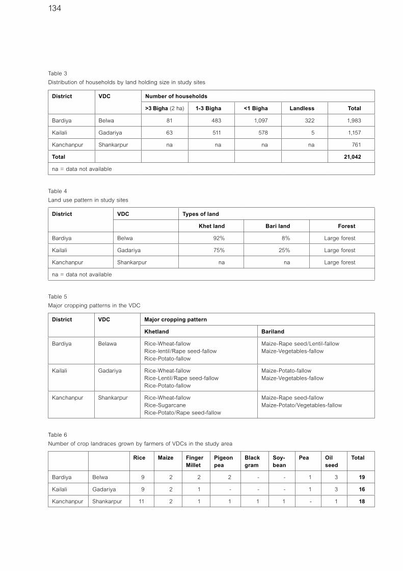
134
Table 3
Distribution of households by land holding size in study sites
District VDC Number of households
>3 Bigha (2 ha) 1-3 Bigha <1 Bigha Landless Total
Bardiya Belwa 81 483 1,097 322 1,983
Kailali Gadariya 63 511 578 5 1,157
Kanchanpur Shankarpur na na na na 761
Total 21,042
na = data not available
Table 4
Land use pattern in study sites
District VDC Types of land
Khet land Bari land Forest
Bardiya Belwa 92% 8% Large forest
Kailali Gadariya 75% 25% Large forest
Kanchanpur Shankarpur na na Large forest
na = data not available
Table 5
Major cropping patterns in the VDC
District VDC Major cropping pattern
Khetland Bariland
Bardiya Belawa Rice-Wheat-fallowRice-lentil/Rape seed-fallowRice-Potato-fallow
Maize-Rape seed/Lentil-fallowMaize-Vegetables-fallow
Kailali Gadariya Rice-Wheat-fallowRice-Lentil/Rape seed-fallowRice-Potato-fallow
Maize-Potato-fallowMaize-Vegetables-fallow
Kanchanpur Shankarpur Rice-Wheat-fallowRice-SugarcaneRice-Potato/Rape seed-fallow
Maize-Rape seed-fallowMaize-Potato/Vegetables-fallow
Table 6
Number of crop landraces grown by farmers of VDCs in the study area
Rice Maize Finger Millet
Pigeon pea
Black gram
Soy-bean
Pea Oil seed
Total
Bardiya Belwa 9 2 2 2 - - 1 3 19
Kailali Gadariya 9 2 1 - - - 1 3 16
Kanchanpur Shankarpur 11 2 1 1 1 1 - 1 18

135
Community biodiversity register (CBR)A CBR is a record of the genetic resources available in the community, including information on the community custodians, passport data, agro-ecological information, and culture and use values of the resources. This information is recorded in a register by community members. A CBR empowers the community and the local institutions to document and use information about their traditional knowledge and biodiversity, safeguards the community against bio-piracy, and helps to identify terms and condi-tions for benefit-sharing agreements with bio-prospectors. In all three study sites, communities have started main-taining CBRs for the above purposes.
Organisation of Diversity FairsTo create public awareness about the value of biodiversity, a fair is regularly organised by the community in the area. Through the fair, awareness is created about local crops; the location of prime areas of diversity; identification of the key custodians of biodiversity management; the reasons for supporting conservation; the value of exchanging germplasm and associated knowledge among community members; and the value of transferring knowledge about biodiversity, its management, and its specific use value to the younger generation. The community organises the diversity fair as a cultural event with a prize-giving: the prize goes to the group that exhibits the maximum biodiversity and the highest proportion of local genetic
Table 7
Distribution of households by livelihood occupation
District VDC Percentage of households
Agriculture Wage labour in Nepal
Wage labour outside Nepal
Business Service
Bardiya Belwa 65 30 3 1 1
Kailali Gadariya 80 13 3 3 1
Kanchanpur Shankarpur 85 8 5 1 1
Table 8
Wild foods, fruits, herbs and fodder
District VDC Foods Fruits Fodder Herbs
Bardiya Belwa Mushroom na Saj, Jamun, Asna, Karma, Forage (Imperata, Saccharum)
Asparagus
Kailali Gadariya Mushroom Kusum, Jamón (Syzizium cuminie), Amala
Asna, Gauja Amaro, Harro, Barro, Asparagus
Kanchanpur Shankarpur Mushroom, Kudkuda, Tat (Ficus)
Amala, Bayar (Zuzube), Kusum
Asna, Gauja Amaro, Harro, Barro, Asparagus
na = data not available
Table 9
Presence of functional Community Based Organisations (CBOs)
District VDC Name and scope of work
Bardiya Belwa Saving and credit cooperatives (5)
Kailali Gadariya Community forest users‘ groups (9), Mothers’ groups, youth clubs (15)
Kanchanpur Shankarpur Youth clubs (5), Mothers’ groups (9), Farmers’ groups (9)

136
resources, and shares the associated knowledge and use value of the biodiversity with the largest number of fellow community members. The incentive of such social recognition encourages farmers to grow and cultivate diverse crops, and also to share their knowledge with other community members.
Participatory planning of conservation actionAt each study project site, the community has formed a community biodiversity management group, chaired by an active member of the community. The community collectively identifies and assesses the biological resources available in its area through community biodiversity registration. Based on the assessment, the conservation and development activities are planned. During this process, the WTLC project staff facilitates community actions and organises a series of village-based training programmes to strengthen the capacity of community members and the community-based rural institutions. The community group actively participates in the implementation of the activity, as well as in its evaluation. The project has estab-lished a community biodiversity fund to provide incentives to the farmers so that it can support the implementation of the conservation action plans.
Utilisation of agricultural biodiversityThe WTLC project is planning to introduce the following strategies for the promotion of on-farm conservation of agricultural biodiversity in the area:• Provide conservation incentives to the community by
promoting value addition to local genetic resources (e.g. through breeding, linking with markets, awareness raising, product diversification and promotion, etc.).
• Improve the production and productivity of local genetic resources through enhancement of local genetic resources and also through development of new
varieties of crops by utilising one of the local varieties as a parent. This will not only help in the conservation of local genetic resources at a gene pool level, but will also provide economic incentives for the communities.
• Linking local resource-based products with markets, thus providing direct economic incentives to the communities. For this the project has planned to build the communities’ capacity for processing their products and packaging them with information on their nutri-tional and other values.
Key challenges and threatsDue to an ever increasing population, there has been increasing pressure on the flora and fauna of the western Terai region (WTLCP 2005). The over-extraction of forest resources has led to loss of significant biodiversity. The clearing of forests, illegal poaching and trade are the major causes of habitat destruction and decreasing wildlife populations.
The introduction of hybrid varieties has led to an excessive use of chemical fertilizers and pesticides. As a result, many local landraces are being replaced by high yielding crops. For example, the WTLC area is known for its wild paddy (Oryza rufipogan). Farmers know the wild rice by different names (e.g. Chingni, Chirni and Pasai), based on its morphological attributes. However, most of the government research and development activities are focused on promoting high yielding modern varieties and even hybrids. This has resulted in a sharp decline in the amount of locally adapted genetic material in the area.
There have also been increased instances of crops and houses being damaged by wildlife, and because the compensation is minimal, as compared to the damage caused, this has led to conflicts between the protected area authorities and community members in several cases. A practical and commonly agreed framework for conflict mitigation among the farmers and wildlife authorities is necessary. A number of projects have been implemented which have, to some extent, helped to raise awareness among the local communities, about the importance of protected areas. These projects have also provided some alternative livelihood options, including tourism, in the adjoining areas of the national park.
RecommendationsTo promote the conservation action taken by the com-munities, the authors offer the following suggestions:• Raise awareness among communities on the
importance of biodiversity. Target school children by
Many varieties of crops are offered on local markets.
Photo: Li-Bird

137
integrating this in the academic curriculum. Similarly, raise awareness among research and development workers.
• Give emphasis on value addition of local agricultural biodiversity through breeding (adapting participatory plant breeding, enhancement of important local geno-types, etc.) and non-breeding approaches (identification and promotion of local crops by establishing market linkages).
• Build the capacity of local communities to promote value addition to local resources (in breeding as well as non-breeding approaches).
• Establish network of farmers’ groups and rural institu-tions that are involved in conservation action, in order to institutionalise their efforts.
• Facilitate the mainstreaming of landscape-level approaches to agrobiodiversity conservation in district level planning.
• Formulate favourable government policy on agricul-tural biodiversity management to legalise community initiatives on biodiversity management. The project has already initiated conservation initiatives at the grassroots level. These initiatives should be legally recognised by the government.
• Conduct research to understand the links between agrobiodiversity and wild biodiversity (e.g. pollinators, pests, dispersal agents, etc.), and to strengthen such links.
• Encourage a landscape management approach, so that various elements such as forests, wetlands and agricul-tural systems are conserved and utilised in a holistic manner.
The government should recognise areas containing multiple governance arrangements, including government managed protected areas of Category II and VI, and com-munity conserved areas of various categories, as Category V protected areas. Unlike forest and wildlife diversity conservation, the conservation of agriculture biodiversity (other than of wild relatives of crops and livestock) is not possible without the active involvement of human beings. It cannot therefore be achieved in strictly protected areas, such as Categories Ia, Ib and II. Therefore, it is high time for the government to identify strategies to involve the communities in direct conservation of biodiversity at the landscape-level.
Acronyms and glossaryBari Terraced upland area mostly without irrigation
facility, not suitable for paddy cultivation
Bigha Unit of land measurement. One bigha is
equivalent to 0.66 ha.
CBO Community Based Organisation
CBR Community Biodiversity Register
DADO District Agriculture Development Office/Officer
DLSO District Livestock Development Office/Officer
GEF Global Environment Facility
IPGRI International Plant Genetic Resources Institute
Khet Bunded low land area suitable for paddy
cultivation with or without regular irrigation facility
LI-BIRD Local Initiatives for Biodiversity, Research and
Development
MFSC Ministry of Forest and Soil Conservation
SNV Netherlands Development Agency
UNDP United Nations Development Programme
VDC Village Development Committee
WTLC Western Terai Landscape Complex
WWF World Wildlife Fund for Nature
ReferencesBudhathoki, P. 2005. Landscape Conservation Initiatives
in Nepal: Opportunities and Challenges. In: Brown, J., N.
Mitchell and M. Beresford, (Eds.) (2005). The Protected
Landscape Approach: Linking Nature, Culture and
Community. IUCN, Gland, Switzerland and Cambridge, U.K.
WTLCP. 2005. Final project document submitted to
UNDP-GEF.
About the Authors
Resham GautamAgronomist with over ten years of experiences on on-farm
agricultural biodiversity conservation.
Bimal Raj RegmiSocial forester with over nine years of experiences on CBR
and forest biodiversity conservation.
Pitambar ShresthaAgriculturist with over four years of experience in agricultural
biodiversity conservation and community mobilisation.
Diwakar PoudelSocio-economist with over five years of experience in
participatory research and development.
Pratap ShresthaAgricultural economist with over 15 years of experience in
local knowledge documentation and participatory research
in agriculture and natural resources management.
ContactLocal Initiatives for Biodiversity
Research and Development (LI-BIRD)
PO Box 324, Pokhara, Nepal
www.libird.org

138
In Canyon de Chelly National Monument (Arizona, USA), a long history of farming by native peoples has created a rich legacy of agrobiodiversity, in particular fruit tree varieties. Native peoples – including ancestral Pueblo Indians, the Hopi, and the Navajo (Diné) – have lived in Canyon de Chelly for as long as 5,000 years. Within the steep sandstone walls of Canyon de Chelly are cliff dwellings, rock drawings, and other ancient sites that tell stories of what may be the longest continually inhabited place on the Colorado Plateau. Archeological remains and numerous pictographs illustrate and highlight a well-established livestock tradition, principally the raising of goats and sheep along with smaller numbers of cattle and horses. The ancestral Puebloan people began farming in the region 2,500 years ago. Through the centuries, native peoples cultivated a variety of fruits, some of which the Spanish introduced to the Southwest in the sixteenth and seventeenth centuries. While the agrobiodiversity values of this area have been affected by a number of factors over the
past two centuries, today the Canyon de Chelly National Monument, the Navajo Nation, and other partners, are working together to restore the canyon’s watersheds and other resources that support the Diné farming traditions and way of life.
Canyon de Chelly National Monument is an early example of shared stewardship and of collaborative man-agement within the US National Park System. Established as a unit of the System in 1931, all of the monument’s 83,840 acres lie within the lands of the Navajo Nation. The National Park Service and the Navajo work in partnership to manage the archeological, historical, and scientific resources and to help sustain the community of Navajo people who live and farm in the canyons today. Canyon de Chelly National Monument’s management objectives and the unique qualities of this cultural land-scape are in keeping with a Category V protected area.
Archeological evidence suggests that as early as the seventeenth century, the Hopi, and later the Navajo,
Canyon de Chelly National Monument, USA: Navajo farming traditions and agrobiodiversityJessica Brown, adapted from Rolf Diamant et al 2007
Canyon de Chelly National Monument (Arizona, USA) is an early example of collaborative management in which the United
States National Park Service is working closely with the Navajo Nation and other partners.
Photo: Jeffrey Roberts

139
planted orchards in the canyons, including peach, plum, apricot and apple trees as well as grapes. The Canyon de Chelly Navajo grew and preserved peaches for food and as a trade item. At various sites, peaches were harvested by the thousands, then pitted and dried. For example, at the Standing Cow site, thousands of small pits in long mounds parallel the rock walls of the canyon, suggesting the extent of the orchards and the dried fruit trade. These fruit tree varieties are specially adapted to the conditions of a canyon valley in this area of the Colorado Plateau.
The last 150 years have seen the tumultuous destruc-tion of the orchards, a gradual reestablishment of peach trees and, more recently, environmental deterioration and a decline in orchard productivity.
In 1864, the U.S. Cavalry removed nearly all of the Navajo from the Canyon de Chelly region in a brutal process, in which Navajo were forced to endure a 300-mile march to New Mexico. Hundreds died along the way and in the subsequent four years of Navajo incarceration. In addition, U.S. Cavalry troops destroyed the hogans, Churro sheep, and orchards that were the foundation of Diné agriculture. Army records document that approxi-mately 4,000 fruit trees were destroyed. Four years later, in 1868, when the Navajo were finally granted sovereignty, they returned to Canyon de Chelly. They brought with them Churro sheep and replanted the orchards which have become enduring symbols of cultural survival and renewal.
Today, well over a thousand Navajo live in the canyons and farm the canyon floor, while also working in sur-rounding communities and providing guide services for park visitors. They tend nearly 500 heirloom fruit trees, grow corn and alfalfa, and raise cattle and Churro sheep. However, this centuries-old agriculture is endangered by widespread soil erosion, the lack of a dependable water supply, and a proliferation of exotic plants including tamarisk and Russian olive, both of which were introduced by the Soil Conservation Service in the 1930s for bank stabilization.
Two related projects, the Watershed Restoration Project and the Canyon Farm Preservation Project, are being undertaken by the Navajo Nation, Canyon de Chelly National Monument, and other partners. The aim of these projects is to revitalize canyon ecology and agriculture by addressing problems associated with exotic vegetation, wildlife and water management, and soil conservation. The long-range vision is to renew, on a more environmentally friendly and sustainable basis, traditional Navajo agricultural practices – such as Churro sheep farming and the cultivation of fruit orchards – on one of the oldest cultural landscapes in the National Park System. Over time, other opportunities may arise for activities such as agro-tourism and small scale sales of value-added products. The efforts in Canyon de Chelly, and similar work being undertaken at the Hubbell Trading Post National Historic Site (New Mexico), reflect a commitment by the National Park Service to cooperative stewardship, as summarized by ethno-historian Tara Travis:
“Considering how closely the peach trees are tied to the histori-cal memory of the Diné at Canyon de Chelly, the National Park Service maintains a special obligation to ensure their environmental survival. These innovative projects demonstrate that efforts to document and preserve the historic farming landscape and orchards of Canyon de Chelly, can also embrace concepts that will sustain a way of life and environment well into the future.” (Travis 2005).
ReferencesRolf, et al 2007. Stewardship Begins with People: An Atlas
of Places, People and Handmade Products. Woodstock, VT:
Conservation Study Institute.
Travis, T. S. 2005. Didzétsoh: The Peaches of Canyon de
Chelly. Sustainability News. National Park Service. p18-21.
About the Authorsee Jessica Brown, Editorial Team, page 6
Planted by the Hopi, and later the Navajo people, the
orchards in Canyon de Chelly include fruit tree varieties
especially adapted to the conditions of the canyon valley.
Photo: Tara Travis


World Commission on Protected AreasIUCN
Rue Mauverney 281196 GlandSwitzerlandTel: +41 22 9990165Fax: +41 22 9990025www.iucn.org/themes/wcpa
Protected Landscapes are a strong option for the
conservation of biodiversity in landscapes and
seascapes that are significantly human-influenced
and inhabited. They often contain threatened or
endemic species of flora and fauna, and are also
critical areas for cultural sustenance. Recognized
as Category V in the protected area categorization
system of the IUCN, their existence is based
on the interactions of people and nature over
time. In many of these landscapes traditional
agricultural practices sustain wild biodiversity and
as well as a great range of agrobiodiversity.
The publication “Protected Landscapes and
Agrobiodiversity Values” presents case studies
from different parts of the world illustrating
the role Protected Landscapes are playing
in conserving agrobiodiversity and related
knowledge and practices. A synthesis focuses
on the key lessons to be learned from these case
studies, analyses the strengths and weaknesses
of these areas in achieving conservation goals,
identifies key gaps in knowledge, and presents
a glimpse of further work needed.
This publication is the first in a series on the
Values of Protected Landscapes, which will
explore and document the various environmental,
economic, social and cultural values that Category
V protected areas can provide. It is a project of the
Protected Landscapes Task Force of IUCN’s World
Commission on Protected Areas (WCPA).