van gogh, coniston and novara drilling and completions ... · ea-00-ri-10060.03 van gogh, coniston...
TRANSCRIPT

Level 9 100 St Georges Terrace Perth Western Australia 6000 T +61 8 6218 7100 Quadrant Energy Australia Limited PO Box 5624 St Georges Tce Perth WA 6831 F +61 8 6218 7200 ABN 39 009 301 964 quadrantenergy.com.au
Van Gogh, Coniston and Novara Drilling and Completions
Environment Plan Summary
EA-00-RI-10060.03
~ Quadrant \.Z Energy

EA-00-RI-10060.03
Van Gogh, Coniston and Novara Drilling and Completions 2 of 126
CONTENTS: 1. Introduction ................................................................................................................................... 8
1.1 Overview ....................................................................................................................................... 8
1.2 Environmental Management Framework ....................................................................................... 8
1.2.1 Existing approvals .................................................................................................................................. 8
2. Activity Location ........................................................................................................................... 19
3. Activity description ....................................................................................................................... 21
3.1 Schedule...................................................................................................................................... 22
3.2 Drilling and completions activities ................................................................................................ 22
3.3 Spill response .............................................................................................................................. 22
3.4 Change of activity ........................................................................................................................ 22
4. Environment description ............................................................................................................... 23
4.1 Overview of the Environment that May Be Affected (EMBA) ......................................................... 23
4.2 Environmental values and sensitivities in the EMBA ..................................................................... 23
4.2.1 Habitats ............................................................................................................................................... 23
4.2.2 Protected/ significant areas ................................................................................................................ 23
4.2.3 Marine and coastal fauna .................................................................................................................... 42
4.2.4 Socioeconomic receptors .................................................................................................................... 44
4.2.5 Windows of sensitivity ........................................................................................................................ 48
5. Stakeholder consultation .............................................................................................................. 55
5.1 Overview ..................................................................................................................................... 55
5.2 Stakeholder identification ............................................................................................................ 55
5.2.1 Environment plan consultation ........................................................................................................... 56
5.2.2 Historic consultation ........................................................................................................................... 56
5.3 Ongoing Consultation .................................................................................................................. 56
5.3.1 Well specific notifications.................................................................................................................... 57
5.3.2 Quarterly Project Update .................................................................................................................... 57
5.3.3 Conflict resolution ............................................................................................................................... 58
5.4 Summary ..................................................................................................................................... 58
5.5 OPEP consultation ....................................................................................................................... 61
6. Environmental impact and risk assessment ................................................................................... 63
6.1 Impact and risk assessment terminology ...................................................................................... 63
6.2 Summary of the environmental impact and risk assessment approach .......................................... 64
6.2.1 Overview .............................................................................................................................................. 64
6.2.2 Acceptability of impacts and risks. ...................................................................................................... 66
6.2.3 ALARP evaluation on impacts (planned events) and risks (unplanned events) .................................. 67
6.3 Environmental Risk Treatment Summary Planned Events ............................................................. 67

EA-00-RI-10060.03
Van Gogh, Coniston and Novara Drilling and Completions 3 of 126
6.3.1 Physical presence ................................................................................................................................ 67
6.3.2 Light Emissions .................................................................................................................................... 70
6.3.3 Noise Emissions ................................................................................................................................... 72
6.3.4 Air Emissions ........................................................................................................................................ 76
6.3.5 Operational Discharges ....................................................................................................................... 77
6.3.6 Drilling, completion and production appraisal discharges .................................................................. 79
6.3.7 Spill Response Operations ................................................................................................................... 86
6.4 Environmental Risk Treatment Summary Unplanned Events ......................................................... 97
6.4.1 Vessel collision with marine fauna ...................................................................................................... 97
6.4.2 Unplanned non-hydrocarbon release – liquid .................................................................................... 98
6.4.3 Unplanned non-hydrocarbon release – solid .................................................................................... 100
6.4.4 Unplanned hydrocarbon release – minor ......................................................................................... 102
6.4.5 Unplanned hydrocarbon release – vessel collision ........................................................................... 103
6.4.6 Unplanned hydrocarbon release – loss of well control ..................................................................... 106
6.4.7 Unplanned hydrocarbon release – damage to subsea infrastructure .............................................. 109
7. Hydrocarbon Spill Response Arrangements ................................................................................. 113
7.1 Preparedness and Implementation of Response arrangements ................................................... 113
7.2 Net Environmental Benefit Analysis ........................................................................................... 118
7.3 Oil Spill Response Resources ...................................................................................................... 118
8. Implementation Strategy and Management Approach ................................................................. 119
8.1.1 Audits and checks .............................................................................................................................. 119
8.1.2 Monitoring ......................................................................................................................................... 119
8.1.3 Review and improvement of environmental performance .............................................................. 119
8.2 Management and review of the EP ............................................................................................. 120
8.3 Stakeholder consultation ........................................................................................................... 120
8.4 Performance Review and Continuous Improvement ................................................................... 120
8.4.1 Stakeholder consultation .................................................................................................................. 121
8.4.2 Facility inspections ............................................................................................................................ 121
8.4.3 After action reviews (AARs) ............................................................................................................... 121
8.4.4 Changing science and technology ..................................................................................................... 121
8.4.5 Audits and management of non-conformance ................................................................................. 121
9. Contact Details ........................................................................................................................... 121
10. References ................................................................................................................................. 122
FIGURES:
Figure 2-1: Location of Defined Area (Permit Areas WA-35-L and WA-55-L) .................................................. 20 Figure 4-1: Defined Area overlap with the KEF of ‘Continental slope demersal fish communities’ ............... 43 Figure 4-2: Whale shark aggregation and migration areas ............................................................................. 49

EA-00-RI-10060.03
Van Gogh, Coniston and Novara Drilling and Completions 4 of 126
Figure 4-3: Possible pygmy blue whale foraging area off the Ningaloo coastline .......................................... 50 Figure 6-1: Environmental risk and impact assessment and treatment process ............................................ 64
TABLES: Table 1-1: Approval conditions for EPBC Act referrals associated with the Van Gogh, Coniston and Novara field development ........................................................................................................................................... 10 Table 3-1: Summary of activities provided for under this EP .......................................................................... 21 Table 4-1: Environmental values and sensitivities – protected/ significant areas within the EMBA .............. 24 Table 4-2: Socio-economic receptors in EMBA ........................................................................................... 44 Table 4-3: Environmental values and sensitivities – windows of sensitivity ................................................... 51 Table 5-1: Stakeholder list ............................................................................................................................... 55 Table 5-2: Consultation summary and feedback for this EP ........................................................................... 59 Table 5-3: OPEP Consultation summary ....................................................................................................... 62 Table 6-1: Impact and risk assessment terms ................................................................................................. 63 Table 6-2: Likelihood rankings used in the EP ................................................................................................. 66 Table 6-3: Quadrant Energy risk matrix used for risk rankings used in the EP ............................................... 66 Table 7-1: Assessment of spill response strategies ....................................................................................... 114
EA-00-RI-10060.03
Van Gogh, Coniston and Novara Drilling and Completions 5 of 126
ACRONYMS
Abbreviation Description
AFMA Australian Fisheries Management Authority
AIS Automatic Identification System
AHS Australian Hydrographic Service
ALARP As low as reasonably practicable
AMOSC Australian Marine Oil Spill Centre Pty Ltd
AMSA Australian Marine Safety Authority
APPEA Australian Petroleum Production & Exploration Association
AS/NZS Australian Standard/New Zealand Standard
BOP Blow-out preventer
CAMBA China-Australia Migratory Bird Agreement
CEO Chief Executive Officer
CFA Commonwealth Fisheries Association
CMR Commonwealth Marine Reserve
CRG Customer Reference Group
DAH Dissolved Aromatic Hydrocarbons
DC Drill Centre
DEWHA Department of the Environment, Water, Heritage and the Arts
DEWR Department of the Environment and Water Resources
DFaT Department of Foreign Affairs and Trade
DMP Department of Mines and Petroleum
DoD Department of Defence
DoE (Australian) Department of the Environment
DoF Department of Fisheries
DoT Department of Transport
DPaW Department of Parks and Wildlife
DSEWPaC Department of Sustainability, Environment, Water, Population and Communities
EHFL Electric Hydraulic Flying Lead
EMBA Environment that May Be Affected
EP Environment Plan
EPBC Environmental Protection and Biodiversity Conservation (Act)
EPO Environmental Performance Outcome
EPS Environmental Performance Standard
EA-00-RI-10060.03
Van Gogh, Coniston and Novara Drilling and Completions 6 of 126
Abbreviation Description
ESD Emergency Shut Down
FPSO Floating Production, Storage and Offtake
GHG Greenhouse Gas
Ha hectare
HEV High Environmental Value
HSE Health, Safety and Environment
IAPP International Air Pollution Prevention
IMDG International Maritime Dangerous Goods
IMS Invasive of Marine Species
IUCN International Union for Conservation of Nature
JACC Joint Agency Coordination Centre
JAMBA Japan Australia Migratory Bird Agreement
KEF Key Ecological Feature
LCM Lost Circulation Materials
MMA Marine Management Area
MNES Matters of National Environmental Significance
MOC Management of change
MODU Mobile Offshore Drilling Unit
MOU Memorandum of Understanding
MP Marine Park
MPRA Marine Parks and Reserves Authority
MTWA Marine Tourism WA
NAF Non-Aqueous Fluid
NEBA Net Environmental Benefit Analysis
NOPSEMA National Offshore Petroleum Safety and Environment Management Authority
NORMS Naturally Occurring Radioactive Materials
NOx Nitrous Oxide
NPNCA National Park and Nature Conservation Authority
NW Shelf Western Australia’s North West Shelf
ODS Ozone Depleting Substances
OPEP Oil Pollution Emergency Plan
OPGGS€R Offshore Petroleum and Greenhouse Gas Storage (Environment) Regulations 2009
OSCP Oil Spill Contingency Plan

EA-00-RI-10060.03
Van Gogh, Coniston and Novara Drilling and Completions 7 of 126
Abbreviation Description
OSMP Operational and Scientific Monitoring Program
OSRT Oiled Shoreline Response Team
OWA Oiled Wildlife Advisors
OWR Oiled Wildlife Response
PPA Pearl Producers Association
Q1 Quarter 1
RACON Radar Transponder
RCC Rescue Coordination Centre
ROV Remotely operated vehicle
SFRT Subsea First Response Toolkit
SIMOPS Simultaneous Operations
SOx Sulphur Oxide
VRASS Vessel Risk Assessment
VSP Vertical Seismic Profiling
WA Western Australia
WAFIC Western Australian Fishing Industry Council
WAOWRP Western Australian Oiled Wildlife Response Plan
WHA World Heritage Area
WBM Water based mud
WOMP Well Operations Management Plan

EA-00-RI-10060.03
Van Gogh, Coniston and Novara Drilling and Completions 8 of 126
1. INTRODUCTION
1.1 Overview
Quadrant PVG Pty Ltd (Quadrant Energy) is titleholder of the adjacent WA-35-L and WA-55-L permits (described herein as the Defined Area), and operates the Van Gogh, Coniston and Novara fields located in these permits via a floating production, storage and offtake (FPSO) facility. The southern boundary of the permits lies approximately 41 km north of the North West Cape (Figure 2-1).
In order to maintain and maximise the existing production from the Van Gogh, Coniston and Novara fields, Quadrant Energy proposes to carry out appraisal and production well drilling in the Defined Area using a mobile offshore drilling unit (MODU).
The Environment Plan (EP) includes the drilling and completion of six infill wells at existing drill centres (DC) in permit WA-35-L. Appraisal wells could also be drilled in permit WA-35-L (1 well) and WA-55-L (1 well) and completed for production dependant on exploration success. This plan includes all ancillary activities required to drill and complete a well successfully and safely.
1.2 Environmental Management Framework
The EP is written to meet the requirements of the Offshore Petroleum and Greenhouse Gas Storage (Environment) Regulations 2009 (OPGGS (E) Regulations) which fall under the Offshore Petroleum and Greenhouse Gas Storage Act 2006.
Section 6.3 evaluates impacts and risks from planned and unplanned events and provide control measures to ensure that relevant legislative requirements and the Quadrant Energy Environmental Management Policy is met.
1.2.1 Existing approvals
The activity proposed within this EP is a new stage of an existing brownfield development (the Van Gogh, Coniston and Novara field development) within the WA-35-L permit. The development of the Van Gogh, Coniston and Novara fields has been subject to approvals under the Commonwealth Petroleum (Submerged Lands)(Management of Environment) Regulations 1999 (P(SL)(E) Regulations), the Offshore Petroleum and Greenhouse Gas Storage (Environment) Regulations 2009 (OPGGS (E) Regulations) and the Environment Protection and Biodiversity Conservation Act 1999 (the EPBC Act).
The activity proposed within this EP is not considered to require an Offshore Project Proposal under Part 1A of the OPGGS (E) Regulations given that it is a new stage of an existing brownfields development (the Van Gogh, Coniston and Novara field development) that has been assessed and approved under the EPBC Act (refer details below). The activity proposed within this EP is a new drilling activity but is considered equivalent to actions previously assessed and approved.
Details of existing approvals under OPGGS (E) Regulations and the EPBC Act are provided below.
OPGGS (E) Regulations
Environment Plans related to the Van Gogh, Coniston and Novara fields development within the WA-35-L permit which have been accepted by, NOPSEMA under the OPGGS (E) Regulations are the:
• Ningaloo Vision Operations Environment Plan (TV-00-RI-003) – accepted (Revision 7) 5 May 2015. This is the current in-force EP for the operation of the Ningaloo Vision FPSO and all associated Van Gogh, Coniston and Novara field subsea infrastructure.
• Coniston-Novara Development Environment Plan (EA-00-RI-208.1) – accepted (Revision 2) 24 January 2013. This Is the EP for the Phase I drilling (tophole drilling, casing and xmas tree installation) of Coniston production wells. All activities completed.
• Coniston Novara Construction and Installation Environment Plan (EA-00-RI-232.1) – accepted (Revision 1) 25 March 2013. This is the EP for the installation of subsea infrastructure to allow production from Coniston Novara wells to flow to the Ningaloo Vision FPSO. All activities completed.

EA-00-RI-10060.03
Van Gogh, Coniston and Novara Drilling and Completions 9 of 126
• Coniston Novara Phase II Drilling Environment Plan for Commonwealth Waters (EA-00-RI-268.1) -accepted 13 December 2013. This is the EP for the Phase II drilling (drilling of intermediate and production sections and well completion) of Coniston and Novara production wells. All activities completed.
EPBC Act approvals
The following historical EPBC referrals for the Van Gogh, Coniston and Novara field development within the WA-35-L permit have been submitted and approved under the EPBC Act:
• Apache Northwest Pty Ltd Drilling Program (EPBC 2007/3495) - approved by the Department of the Environment and Water Resources (DEWR) on 25 July 2007. The drilling of 10 Van Gogh production wells, two water injection wells and one gas injection well was approved provided the action is undertaken in a particular manner (refer Table 1-1);
• Van Gogh Petroleum Field Development, North-west Shelf (EPBC 2007/3213) - approved by the Department of the Environment, Water, Heritage and the Arts (DEWHA) on 20 August 2008. The installation, connection, commissioning, production and decommissioning of Van Gogh subsea infrastructure (excluding drilling activities) was approved provided Ministerial conditions are complied with. The Ministerial conditions were amended by the Department of the Environment (DoE) on 18 September 2015 (refer Table 1-1); and
• Coniston/Novara Field Development Project (EPBC 2011/5995), approved by the Department of Sustainability, Environment, Water, Population and Communities (DSEWPaC) on 15 October 2012. The drilling, installation, connection, commissioning, production and decommissioning of six Coniston wells and one Novara well was approved provided Ministerial conditions are complied with (refer Table 1-1).
The conditions associated with these referral decisions, and the applicability of these conditions to the drilling and completion activities included in this EP, are detailed in Table 1-1.
From 28 February 2014 onwards a streamlined approval process for offshore petroleum activities took effect allowing NOPSEMA to assess and accept petroleum activities considered “approved classes of action” under the Environment Protection and Biodiversity Conservation Act 1999 (the EPBC Act), without the requirement for a separate referral process through the Department of the Environment (DoE). The activity proposed within this EP is considered an approved class of action under the streamlining process and therefore a new additional approval process under the EPBC Act is not applicable.

EA-00-RI-10060.03
Van Gogh, Coniston and Novara Drilling and Completions 10 of 126
Table 1-1: Approval conditions for EPBC Act referrals associated with the Van Gogh, Coniston and Novara field development
EPBC Act legislative control Applicable to the environmental management of this activity?
Apache Northwest Pty Ltd Drilling Program (EPBC 2007/3495) – this referral was approved provided the action is undertaken in a particular manner as listed below.
1. Apache must have an oil spill contingency plan for the Van Gogh region in operation before commencement of any drilling.
No – an oil spill contingency plan was in place prior to the Van Gogh drilling specified in the referral. While the activity included in this EP is a new drilling activity not included in this referral an accepted OPEP will be in place prior to drilling activities covered by this EP and therefore an equivalent spill response document will be in place.
2. Well closure and site restoration in accordance with current industry best practice must be undertaken for all abandoned appraisal and production drilling wells.
Yes – well abandonment of a Van Gogh production well included in the referral may occur as an activity covered by this EP. The standard for well closure will be outlined within a revised Van Gogh Well Operation Management Plan, submitted to and accepted by NOPSEMA prior to any well abandonment. This EP does not provide for full-field decommissioning or site restoration. These activities would be included in separate environment plan(s).
3. A report must be provided to the Department within two months of any well abandonment. The report should detail the extent of well closure and restoration actions carries out.
Yes – a report will be provided to the Department if a Van Gogh well, as specified in the referral, is plugged and abandoned
Van Gogh Petroleum Field Development, North-west Shelf (EPBC 2007/3213) – this referral was approved provided the following Ministerial conditions are met
1. The person taking the action must submit, for the Minister’s approval, a plan (or plans) for managing the offshore impacts of the action. The plan (or plans) must include measures for: a) Offshore construction and installation, including:
i. Design and construction that considers the decommissioning of all structures and components above the sea floor;
ii. Details of the anchor type and placements, methods for connection of mooring lines to the DTM buoy, installation of the risers and flowline paths;
iii. Measures to minimise seabed disturbance; iv. Hydrotest fluid type, handling and disposal methods; v. Cetacean interaction procedures for supply vessels and aircraft that are consistent with Part
8 of the Environment Protection and Biodiversity Conservation Regulations 2000;
No – this condition relates to construction, installation and operation of Van Gogh field infrastructure as defined in the referral which is not covered by this EP. This condition has been fulfilled by the submission and approval of the Van Gogh Oil Development Construction, Installation, Hook-up and Commissioning Environmental Plan (TV-00-RI-004) (now completed) and the Ningaloo Vision Operations Environment Plan (TV-00-RI-003).

EA-00-RI-10060.03
Van Gogh, Coniston and Novara Drilling and Completions 11 of 126
EPBC Act legislative control Applicable to the environmental management of this activity? vi. Cetacean and whale shark sightings reporting; and
vii. Measures for reporting environmental incidents. b) Operations, including:
i. Offtake tanker vetting procedures; ii. Ballast water management for international vessels arriving in Australia;
iii. Produced formation water and naturally occurring radioactive materials (NORMs) monitoring and management;
iv. Measures to reduce artificial lighting and noise associated with the development; v. Cetacean interaction procedures for support vessels and aircraft that are consistent with
Part 8 of the EPBC Regulations 2000; vi. Cetacean and whale shark sightings reporting; and
vii. Measures for reporting environmental incidents to the Department. The plan (or plans) for operations must be submitted at least two months prior to the commencement of these activities. Individual offshore activities may not commence until the plan (or plans) for that specific activity has been approved. The approved plan (or plans) must be implemented.
2. The person taking the action must submit for the Minister’s approval an Oil spill contingency plan (OSCP) to mitigate the environmental effects of any hydrocarbon spills. The OSCP must be for the North West Shelf and Exmouth Region and include:
i. A description of resources available for use in containing and minimising impacts in the event of an oil spill and arrangements for accessing these;
ii. A demonstrated capacity to deploy oil spill response equipment within 12 hours of a spill occurring
iii. Training of staff in oil spill response measures and identifying roles and responsibilities of personnel during a spill response;
iv. Identification of sensitive areas, in particular, Ningaloo Marine Park, and specific response measures for these areas;
v. Details of the insurance arrangements that have been made in respect of the costs associated with repairing any environmental damage arising from potential oil spills; and
vi. Procedures for reporting oil spill incidents to the Department. The approved plan must be implemented.
No - this condition has been fulfilled through the submission and approval of an OSCP for the construction and installation activities (now completed) and an OSCP for ongoing operations Ningaloo Vision Operations Oil Spill Contingency Plan (TV-00-RI-003.2). While the activity included in this EP is a drilling activity not included in this referral an accepted OPEP will be in place prior to drilling activities covered by this EP and therefore an equivalent spill response document will be in place.
3. The person taking the action must submit a decommissioning plan (or plans) for approval by the Minister one year prior to decommissioning of the FPSO vessel and three months prior to decommissioning of any subsea wells, flowlines or any associated infrastructure. The plan (or plans) must be able to accommodate the complete removal if all structures and components above the sea floor. The approved plan must be implemented.
Yes - plug and abandonment of a Van Gogh well(s) could occur by a MODU under this EP. If a plug and abandonment activity occurs, well infrastructure will be removed and the well permanently abandoned (i.e. decommissioned). However, this EP does not cover full field decommissioning and remediation and does not cover removal of any other infrastructure except

EA-00-RI-10060.03
Van Gogh, Coniston and Novara Drilling and Completions 12 of 126
EPBC Act legislative control Applicable to the environmental management of this activity? for that associated with a MODU plug and abandonment activity. Any other decommissioning activities would be included in a separate plan. The complete removal of all well structures above the seafloor during a plug and abandon is accommodated in this EP (refer Section 3). This EP will be submitted to and accepted by NOPSEMA in lieu of Ministerial approval as specified in Condition 14 below.
4. Between eight and twelve months after the commencement of offshore construction, the person taking the action must ensure that an independent audit of compliance with the conditions of approval is conducted. The independent auditor must be approved by the Minister. The audit criteria must be agreed by the Minister and the audit report must address the criteria to the satisfaction of the Minister.
No – the construction activity has been completed and this condition has been fulfilled.
-
5. Note: Condition 5 has been revoked. -
6. The person taking the action may choose to revise a management plan approved by the Minister under conditions 1 and 2 without submitting it for approval under section 143A of the EPBC Act, if the taking of the action in accordance with the revised plan would not likely to have a new or increased impact. If the person taking the action makes this choice they must:
i. Notify the Department in writing that the approved plan has been revised and provide the Department with an electronic copy of the revised plan;
ii. Implement the revised plan from the date that the plan is submitted to the Department; and iii. For the life of this approval, maintain a record of the reasons the person taking the action
considers that taking the action in accordance with the revised plan would not be likely to have a new or increased impact.
No – this EP is not considered a plan required under Conditions 1 or 2. This condition applies to the separate Ningaloo Vision Operations Environment Plan (TV-00-RI-003).
-
6A The person taking the action may revoke their choice under condition 6 at any time by notice to the Department. If the person taking the action revokes the choice to implement a revised plan, without approval under section 143A of the Act, the plan approved by the Minister must be implemented.
No – Condition 6 does not apply to this EP. This condition applies to the separate Ningaloo Vision Operations Environment Plan (TV-00-RI-003).
6B If the Minister gives a notice to the person taking the action that the Minister is satisfied that the taking of the action in accordance with the revised plan would be likely to have a new or increased impact, then:
i. Condition 6 does not apply, or ceases to apply, in relation to the revised plan; and ii. The person taking the action must implement the plan approved by the Minister
To avoid any doubt, this condition does not affect any operation of condition 6 to 6A in the period before the day the notice is given.
No – Condition 6 does not apply to this EP. This condition applies to the separate Ningaloo Vision Operations Environment Plan (TV-00-RI-003).

EA-00-RI-10060.03
Van Gogh, Coniston and Novara Drilling and Completions 13 of 126
EPBC Act legislative control Applicable to the environmental management of this activity?
6C Condition 6, 6A, and 6B are not intended to limit the operation of section 143A of the Act which allows the person taking the action to submit a revised management plan to the minister for approval
No – Condition 6 does not apply to this EP. This condition applies to the separate Ningaloo Vision Operations Environment Plan (TV-00-RI-003).
7. Note: Condition 7 has been revoked. -
8. If at any time after five years from the date of this approval, the Minister notifies the person taking the action in writing that the Minister is not satisfied that there has been substantial commencement of the development of the Van Gogh Petroleum Field, the development of the Van Gogh Petroleum Field must not thereafter be commenced.
No – this condition relates to the commencement of the activity within 5 years, which has occurred.
9. Within 3 months of the date of this notice, the person taking the action must arrange for a field test to be conducted to verify that the requirements of condition 2(b) (i.e. The capacity to deploy oil spill response equipment within 12 hours of a spill occurring) can be fulfilled. The test results must be provided to the department within 14 days of the test being conducted. Note. The date stated in condition 9 relates to the date of the variation decision (3 May 2012)
No – this condition was a one-off requirement to verify compliance with Condition 2b. Condition 2b is the ongoing requirement and has been addressed in the Ningaloo Vision Operations Oil Spill Contingency Plan (TV-00-RI-003.2)
10. Within three months of the date of this notice, the person taking the action must conduct an assessment to identify the following:
a. Any nonessential lighting on board the FPSO; b. Measures to minimise nonessential lighting on board the FPSO.
The person taking the action must implement the measures identified in condition 10b. Note. The date stated in condition 10 relates to the date of the variation decision (3 May 2012)
No – this condition was a one-off requirement related to operations activities to demonstrate compliance with Condition 1b (iv).
11. Within 3 months of the date of this notice, the person taking the action must ensure that all staff on board the FPSO have undertaken the environmental induction training referred to in the Van Gogh Operations Environmental Plan (Document Number. TV-00-RI-004 Revision 1) Note. The date stated in condition 11 relates to the date of the variation decision (3 May 2012)
No – this condition was a one-off requirement for operations that has been fulfilled.
12. The person taking the action must maintain accurate records substantiating all activities associated with or relevant to the conditions of approval, including measures taken to implement the management plans required by the approval, and make them available upon request to the Department. Such records may be subject to audit by the Department or an independent auditor in accordance with section 458 of the EPBC act, or used to verify compliance with the conditions of approval. Summaries of audits will be posted on the Department’s website. The results of audits may also be publicised through the general media.
Yes – this is applicable to that part of the action that may occur under this EP (i.e. the decommissioning of Van Gogh well infrastructure as part of a plug and abandon activity carried out by a MODU).
13. Within 6 months of the date of this notice, the person taking the action must ensure that an No – this condition was fulfilled. The independent audit has

EA-00-RI-10060.03
Van Gogh, Coniston and Novara Drilling and Completions 14 of 126
EPBC Act legislative control Applicable to the environmental management of this activity? independent audit of compliance with conditions 9, 10, 11 and 12 is conducted. The independent auditor and the audit criteria must be approved by the Minister at least 1 month before the audit and the audit report addressing the criteria must be submitted to the Minister within 2 months of the audit taken place. The audit report must be approved by the Minister. Note. The date stated in condition 13 relates to the date of the variation decision (3 May 2012)
been completed and submitted to DoE. No further action is required.
-
14. A plan required by condition 1, 2 or 3 is automatically deemed to have been submitted to, and approved by, the Minister if the measures (as specified in the relevant condition) are included in an environment plan (or environment plans) relating to the taking of the action that: a) Was submitted to NOPSEMA after 27 February 2014; and b) Either:
i. Is in force under the OPGGS Environment Regulations; or ii. Has ended in accordance with regulation 25A of the OPGGS Environment Regulations
Yes – refer Condition 3 above.
14A Where a plan required by condition 1 or 2 has been approved by the Minister and the measures (as specified in the relevant condition) are included in an environment plan (or environment plans) that: a) Was submitted to NOPSEMA after 27 February 2014; and b) Either:
i. Is in force under the OPGGS Environment Regulations; or ii. Has ended in accordance with regulation 25A of the OPGGS Environment Regulations
The plan approved by the Minister no longer needs to be implemented.
No – this EP is not considered a plan required by Condition 1 or 2.
14B Where an environment plan, which includes measures specified in the conditions referred to in conditions 14 and 14A above, is in force under the OPGGS Environment Regulations that relates to the taking of the action, the person taking the action must comply with those measures as specified in that environment plan.
Yes – refer Condition 3 above.
Coniston/Novara Field Development Project (EPBC 2011/5995) – this referral was approved provided the following Ministerial conditions are met
1. Within 30 days after the commencement of the action, the person taking the action must advise the department in writing of the actual date of commencement.
No – this condition is for a notification that must be made after commencement of the action. Notification was provided to DoE of the commencement of drilling in February 2013.
2. The person taking the action must maintain accurate records, substantiating all activities associated with or relevant to the conditions of approval, including measures taken to implement the management plans, required by this approval, and make them available upon request to the department. Such records may be subject to audit by the department or an independent auditor in accordance with section 458 of the EPBC Act, or used to verify compliance with the conditions of approval. Summaries of audits will be posted on the department’s website. The results of audits may
No – the conditions of this approval do not relate to the activities carried out under this EP. That is the action, as specified in the referral, have either been completed (construction, installation and drilling of six Coniston wells) or will not be undertaken as part of this EP. For noting, accurate records will be kept for the proposed

EA-00-RI-10060.03
Van Gogh, Coniston and Novara Drilling and Completions 15 of 126
EPBC Act legislative control Applicable to the environmental management of this activity? also be publicised through the general media. activity regardless of the applicability or this requirement.
3. Within three months of every 12 month anniversary of the commencement of the action, the person taking the action must publish a report on their website addressing compliance with each of the conditions of this approval, including implementation of any management plans as specified in the conditions. Documentary evidence providing proof of the date of publication and non-compliance with any of the conditions of this approval must be provided to the department at the same time as the compliance report is published.
No – the conditions of this approval do not apply to activities carried out under this EP (refer above).
4. If the person taking the action wishes to carry out any activity otherwise than in accordance with the plans or programs as specified in the conditions, the person taking the action must submit to the department for the Minister’s written approval a revised version of that plan or program. The varied activity shall not commence until the Minister has approved the varied plan or program in writing. The Minister will not approve a varied plan or program unless the revised plan or program would result in an equivalent or improved environmental outcome over time. If the Minister approves the revised plan or program, that plan or program must be implemented in place of the plan or program originally approved.
No – this EP is not a plan or program specified in these conditions.
5. If the Minister believes that it is necessary or convenient for the better protection of World Heritage properties (sections 12 & 15A), National Heritage places (sections 15B & 15C), Listed threatened species and communities (sections 18 & 18A), Listed migratory species (sections 20 & 20A) and/or Commonwealth marine areas (sections 23 & 24A), the Minister may request that the person taking the action make specified revisions to the plan or program specified in the conditions and submit the revised plan or program for the Minister’s written approval. The person taking the action must comply with any such request. The revised approved plan or program must be implemented.
No – this EP is not a plan or program specified in these conditions.
6. If, at any time after 5 years from the date of this approval, the person taking the action has not substantially commenced the action, then the person taking the action must not substantially commence the action without the written agreement of the Minister.
No – this condition imposes a timeframe within which the activity is to commence. The activity has substantially commenced.
7. Unless otherwise agreed to in writing by the Minister, the person taking the action must publish all plans or programs referred to in these conditions of approval on their website. Each plan or program must be published on the website within one month of being approved. Note: The Minister may agree in writing to exclude the requirement to publish information that is considered confidential.
No – this EP is not a plan or program referred to in conditions of this approval.
8. The Exmouth Gulf must not be used by support vessels during the period 15 September to 31 October.
No – this condition refers to the construction phase of the Coniston Novara development which has been completed.

EA-00-RI-10060.03
Van Gogh, Coniston and Novara Drilling and Completions 16 of 126
EPBC Act legislative control Applicable to the environmental management of this activity?
9. The person taking the action must implement cetacean and whale shark (Rhincodon typus) interaction procedures for support vessels and aircraft that are used to carry out the action, through all stages of the action from commencement. These procedures must be consistent with Part 8 of the Environment Protection and Biodiversity Conservation Regulations 2000 at a minimum, and must include provision of cetacean sightings reports to the department.
No – this condition has been fulfilled through EPs previously submitted and approved for the action. The action specified in the referral will not be undertaken under this EP. However, for noting, this EP has controls for reducing disturbance to whale sharks from vessels which are consistent with Part 8 of the Environment Protection and Biodiversity Conservation Regulations 2000.
10. The person taking the action must develop and submit to the Minister for approval, an Oil Spill Contingency Plan (OSCP) that demonstrates the response preparedness of the person taking the action for any spills, including from offshore wells and infrastructure, pipelines, construction and operation vessels. This must include the capacity to respond to a spill and mitigate the environmental impacts on World and National heritage values, the Commonwealth marine area and species listed as threatened or migratory under the EPBC Act. The OSCP must include, but is not limited to: a) Identification of sensitive areas, species or habitats that may be impacted by a potential spill, as
determined by site-specific modelling of worst case scenario spills; b) Specific response measures for those sensitive areas, species or habitats and prioritisation of
those areas during a spill response, including a net environmental benefit analysis of the response options;
c) A description of resources available for use in containing and minimising impacts in the event of a spill and arrangements for accessing them;
d) A demonstrated capacity to respond to a spill at the site. Identification of the response measures that can feasibly, and will, be applied within the first 48 hours of a spill occurring;
e) Details of the insurance arrangements that have been made in respect of paying the costs associated with operational and scientific monitoring, as outlined in the OSCP and Operational and Scientific Monitoring Program required under Conditions 10 and 11, and repairing environmental damage arising from potential spills, as determined from the results of the Operational and Scientific Monitoring Program;
f) Training of staff in spill response measures and identifying roles and responsibilities of personnel during a spill response;
g) Procedures for reporting spill incidents to the department; and h) A demonstrated procedure for testing, maintenance and review of the OSCP. The OSCP must be submitted at least three months prior to the commencement of the action, or as otherwise agreed to in writing by the Minister. The person taking the action must not commence the action until the OSCP is approved by the Minister. The approved OSCP must be implemented.
Note: If a legal requirement is held by the proponent that requires submission of a plan that meets the above requirements, that
No – this condition has been fulfilled through the submission and approval of the Ningaloo Vision Operations Oil Spill Contingency Plan (TV-00-RI-003.2). However, an equivalent NOPSEMA accepted spill response document (the OPEP) will be in place prior to this activity commencing.

EA-00-RI-10060.03
Van Gogh, Coniston and Novara Drilling and Completions 17 of 126
EPBC Act legislative control Applicable to the environmental management of this activity? plan may be submitted for the purpose of this condition.
11. The person taking the action must develop and submit to the Minister for approval, an Operational and Scientific Monitoring Program that will be implemented in the event of a spill to determine the potential extent and ecosystem consequences of such a spill, including, but not limited to: a) Triggers for the initiation and termination of the Operational and Scientific Monitoring Program,
including, but not limited to, spill volume, composition, extent, duration and detection of impacts;
b) A description of the studies that will be undertaken to determine the operational response, potential extent of impacts, ecosystem consequences and potential environmental reparations required as a result of the spill;
c) Details of the insurance arrangements that have been made in respect of the costs associated with operational and scientific monitoring and repairing any environmental damage arising from potential spills;
d) Inclusion of sufficient baseline information on the biota and the environment that may be impacted by a potential spill, to enable an assessment of the impacts of such a spill. This must include sufficient information to determine the impact on the Whale shark population that feeds in the Ningaloo Marine World Heritage Area, including the reliance of this population of Whale sharks on coral spawning in the World Heritage Area as opposed to other food sources.
e) A strategy to implement the scientific monitoring plan, including timelines for delivery of results and mechanisms for the timely peer review of studies; and
f) Provision for periodic review of the program. The OSMP must be submitted at least three months prior to the commencement of the action, or as otherwise agreed in writing by the Minister. The person taking the action must not commence the action until the OSMP is approved by the Minister. The approved OSMP must be implemented.
Note: If a legal requirement is held by the proponent that requires submission of a plan that meets the above requirements, that plan may be submitted for the purpose of this condition.
No – this condition has been fulfilled through the submission and approval of an OSMP relevant to the action. However, an equivalent scientific monitoring program will be included within the NOPSEMA accepted spill response document (the OPEP) which will be in place prior to this activity commencing.
12. In the event of a spill, the person taking the action must pay all costs associated with: a) All operational and scientific monitoring undertaken in response to the spill, as outlined in the
OSMP approved by the Minister under Condition 11; b) Any environmental management and remediation and/or equivalent determined necessary by
the results of the OSMP.
No – The action specified in the referral will not be undertaken under this EP.
13. The development must be designed and constructed to allow for the complete removal of all structures and components above the seafloor during the decommissioning phase.
No – this condition refers to the design and construction phase of the Coniston Novara development which has been completed.
14. The person taking the action must submit a Decommissioning Plan to the Minister for approval at No – The action specified in the referral will not be undertaken

EA-00-RI-10060.03
Van Gogh, Coniston and Novara Drilling and Completions 18 of 126
EPBC Act legislative control Applicable to the environmental management of this activity? least twelve months prior to commencement of the decommissioning phase. Appropriate consideration must be given to matters of national environmental significance as defined by the EPBC Act and the net environmental benefit analysis of pursuing the proposed plan.
Note: If a legal requirement held by the person taking the action requires submission of a plan that meets the above requirements, that plan may be submitted for the purpose of this condition.
under this EP. This EP is not considered a Decommissioning Plan for the decommissioning phase of the Coniston Novara development.

EA-00-RI-10060.03
Van Gogh, Coniston and Novara Drilling and Completions 19 of 126
2. ACTIVITY LOCATION
At its closest point, the Defined Area is located 32 km from the nearest landfall at North Muiron Island, 41 km from North West Cape and 56 km away from Exmouth (Figure 2-1). The nearest protected area is the Muiron Islands Marine Management Area (MMA), which forms part of The Ningaloo Coast World Heritage Area (WHA) (and Ningaloo Marine Park (MP)), and is located 24 km south east of the Defined Area. The water depth over the two permit areas ranges from approximately 250 m in the southeast to 650 m in the northwest.

EA-00-RI-10060.03
Van Gogh, Coniston and Novara Drilling and Completions 20 of 126
Figure 2-1: Location of Defined Area (Permit Areas WA-35-L and WA-55-L)

EA-00-RI-10060.03
Van Gogh, Coniston and Novara Drilling and Completions 21 of 126
3. ACTIVITY DESCRIPTION
A summary of the activities covered under the accepted EP is provided in Table 3-1.
Table 3-1: Summary of activities provided for under this EP
General Details
EP Expiry Date Five years from NOPSEMA-acceptance date (22/11/16)
Defined Area Petroleum permits WA-35-L and WA-55-L
Reservoir Target Oil
Campaign Drilling Yes
Campaign Lengths Not restricted to, but nominally 3 to 9 months.
Timing Restrictions No
Operational Activities
MODU Type Semi-submersible or drillship
In-field MODU No. One
Vessel Type Comparable to multiple purpose offshore support vessels
In-field Vessel No. Up to four (towing, supply, transfers), 1 on location near MODU at all times
Station Keeping Mooring (8-12 anchors) or dynamic positioning systems
Pre-lay Anchoring Yes
Vessel Mooring Yes (temporary vessel mooring)
Remotely Operated Vehicles (ROV) Yes
Helicopters Yes
SIMOPS Yes
Drilling and Completions Activities
No. Wells Eight wells in total – Quadrant Energy’s management of change (MoC) process will be implemented should more than six infill wells be drilled through established drill centres or more than two appraisal wells be drilled.
Drilling Fluid Type Water-based mud (WBM), with a contingency for Non-aqueous fluids (NAF) including synthetic-based muds (SBM).
Subsea Tree Installation Yes
Well Testing Yes
VSP Yes
Subsea Metrology Yes
Well workovers Yes
Well suspension and abandonment Yes
Infrastructure installation activities (other than drilling and completions-related), reservoir production, vessel-based seismic surveys and decommissioning (other than well infrastructure removal associated with a well abandonment) are not included.

EA-00-RI-10060.03
Van Gogh, Coniston and Novara Drilling and Completions 22 of 126
The operational requirements of this EP will commence from the time the MODU or vessels enter the Defined Area until the time of departure.
Drilling and completions activities described in this plan will occur simultaneously or concurrently with production and support activities associated with the operation of the Van Gogh, Coniston and/or Novara oil fields. Operations activities are covered under the NOPSEMA-accepted Ningaloo Vision Operations Environment Plan (TV-00-RI-003). Concurrent with activities covered under this EP, production operations will occur at the Ningaloo Vision FPSO and associated subsea infrastructure within the WA-35-L permit.
Drilling and production interface operations are specifically addressed within the NOPSEMA-accepted Ningaloo Vision Operations Safety Case Part 6 – Drilling Activities & SIMOPS (TV-91-RF-007.11). SIMOPS activities will be managed through a campaign-specific Interface Management Plan.
3.1 Schedule
Activities are scheduled to commence in Q1 2016 subject to obtaining all regulatory and business approvals. Impacts and risks have been assessed for all seasons, so not to limit the time of year in which activities described in this plan may occur.
For a typical well, the activity duration is expected to be between 60 to 80 days. It is possible that the activity duration may increase in the case of technical difficulties and interruptions (e.g. breakdowns, wait-on-weather, etc.). It is also possible that well activities may be completed over multiple campaigns, whereby the MODU moves off location for a period of time before returning.
3.2 Drilling and completions activities
Drilling and completions activities are planned, approved and executed in a systematic and controlled manner through Quadrant Energy’s management systems and programs. The systems and programs that will be in place to manage well integrity and well activities for the life of the wells covered by this EP are described in NOPSEMA-accepted well operations management plans (WOMPs).
Petroleum activities will be managed in accordance with the MODU’s NOPSEMA-accepted safety case, which provides an additional level of assurance that drilling and completions activities will be managed in a systematic and controlled manner without significant safety or environmental incident.
This environment plan includes drilling and completions activities for new wells and existing wells for the purpose of appraising and producing hydrocarbon reservoirs, and maintaining and abandoning wells.
3.3 Spill response
In the unlikely event of a hydrocarbon spill to the marine environment during the activity, spill response measures will be employed to mitigate environmental impacts (refer Section 7).
3.4 Change of activity
This EP describes drilling and completions activities that may be undertaken over a five-year period. Any change of circumstances or operations will be evaluated and documented in accordance with Quadrant Energy’s management of change (MoC) processes. These processes are designed, amongst other business objectives, to ensure Quadrant Energy complies with Regulations 7 and 17 of the OPGGS (E) Regulations. This process if further detailed in Section 8.2.

EA-00-RI-10060.03
Van Gogh, Coniston and Novara Drilling and Completions 23 of 126
4. ENVIRONMENT DESCRIPTION
4.1 Overview of the Environment that May Be Affected (EMBA)
The natural and socio-economic environment that could be impacted from the drilling activity is termed herein as the Environment that May Be Affected (EMBA). The spatial boundary of the EMBA has been defined as the largest spatial extent within which any planned or unplanned event associated with the activity may create an environmental impact.
For this activity, the greatest area within which an impact could occur is associated with an unplanned release of hydrocarbons from a loss of well control (well blowout). A worst-case loss of well control will result in floating oil, entrained (oil droplets) and dissolved aromatic hydrocarbons spreading into the environment and it is considered that these phases of oil may impact the environment.
4.2 Environmental values and sensitivities in the EMBA
Key environmental values and sensitivities within the EMBA have been defined in terms of sensitive habitats, protected/significant areas, sensitive marine fauna (threatened/migratory species) and socio-economic receptors. In particular, matters of national environmental significance (MNES) which are protected under the Environmental Protection and Biodiversity Conservation Act 1999 (the EPBC Act) have been identified within the EMBA using the Department of Environment’s online Protected Matters Search Tool.
4.2.1 Habitats
The benthic and shoreline habitats within the EMBA include:
• Coral reefs; • Seagrass; • Macroalgae; • Non-coral benthic; • Invertebrates; • Mangroves; • Intertidal mud / sand flats; • Intertidal platforms; • Sandy beaches; and • Rocky shorelines.
There are no threatened ecological communities as defined under the EPBC Act within the EMBA. The habitat within the Defined Area, where planned events and associated impacts will occur, is predominantly bare sediments with an infaunal community and a sparse epifaunal community.
Surveys undertaken previously in the defined area demonstrate that the seabed of the Van Gogh development area is comprised of soft sedimentary habitats only and does not contain any outcrops or deep-water reefs indicative of areas with high epibenthic diversity. The fauna observed was a typically sparse, deep-sea soft sedimentary and demersal fauna, of the expected types of organisms to be found at these depths and location (Enesar 2007).
4.2.2 Protected/ significant areas
Protected/significant areas identified in the EMBA are detailed in
Table 4-1. The distance of these protected areas away from the Defined Area is >24 km (with the exception of two Key Ecological Features (KEF)) and therefore there are no planned events with associated impacts that are expected to occur within the boundaries of these protected areas.

EA-00-RI-10060.03
Van Gogh, Coniston and Novara Drilling and Completions 24 of 126
The KEF of ‘Canyons linking the Cuvier Abyssal Plain with the Cape Range Peninsula’ lies in close proximity to the Defined Area (3 km away), however, there are no planned events which are expected to result in impacts to the values of this KEF.
The KEF of ‘Continental Slope Demersal Fish Communities’ overlaps the Defined Area (Figure 4-1), therefore planned events and associated impacts have the potential to affect this KEF.
Table 4-1: Environmental values and sensitivities – protected/ significant areas within the EMBA
Value/Sensitivity Distance to
Defined Area (km)
EMBA presence
Commonwealth Marine Reserves (CMR)
25 Gascoyne Commonwealth Marine Reserve
28 Ningaloo Commonwealth Marine Reserve
490 Abrolhos Commonwealth Marine Reserve
340 Carnarvon Canyon Commonwealth Marine Reserve
333 Shark Bay Commonwealth Marine Reserve
973 Jurien Commonwealth Marine Reserve
1140 Perth Canyon Commonwealth Marine Reserve
1340 South-west Corner Commonwealth Marine Reserve
125 Montebello Commonwealth Marine Reserve
457 Argo-Rowley Terrace Commonwealth Marine Reserve
728 Mermaid Reef Commonwealth Marine Reserve
864 Kimberley Commonwealth Marine Reserve
1369 Ashmore Reef Commonwealth Marine Reserve
State Marine Parks (MP) and Marine Management Areas (MMA)
31 Ningaloo Marine Park
24 Muiron Islands Marine Management Area
131 Barrow Island Marine Park
124 Barrow Island Marine Management Area
157 Montebello Islands Marine Park
637 Rowley Shoals Marine Park
390 Shark Bay Marine Park
960 Jurien Bay Marine Park
Commonwealth National Parks 1495 Christmas Island National Park
World Heritage Areas (WHA) 24 The Ningaloo Coast
393 Shark Bay
Wetlands of International Importance (Ramsar)
1369 Ashmore Reef National Nature Reserve
National Heritage Places 24 The Ningaloo Coast (see World Heritage)
393 Shark Bay (see World Heritage)
464 Dirk Hartog Landing Site1616 – Cape Inscription Area
1495 Christmas Island Natural Areas

EA-00-RI-10060.03
Van Gogh, Coniston and Novara Drilling and Completions 25 of 126
Value/Sensitivity Distance to
Defined Area (km)
EMBA presence
124 Barrow Island and the Montebello – Barrow Islands Marine Reserve (See State and Commonwealth reserves)
250 Dampier Archipelago (including Burrup Peninsula)
780 Batavia Shipwreck Site and Survivor Camps Area – Houtman Abrolhos
536 HMAS Sydney II and HSK Kormoran Shipwreck Sites
Commonwealth Heritage Places 28 Ningaloo Marine Area - Commonwealth Waters (see Commonwealth Marine Reserves)
1126 Scott reef and Surrounds – Commonwealth Area
1495 Christmas Island Natural Areas
1186 Seringapatam Reef and Surrounds
1369 Ashmore Reef National Nature Reserve (see Commonwealth Marine Reserves)
728 Mermaid Reef - Rowley Shoals (see Commonwealth Marine Reserves)
536 HMAS Sydney II and HSK Kormoran Shipwreck Sites
Key ecological feature (KEF) 0 Continental slope demersal fish communities
28 Commonwealth waters adjacent to Ningaloo Reef
3 Canyons linking the Cuvier Abyssal Plain with the Cape Range Peninsula
18 Ancient coastline at 125 m depth contour
55 Exmouth Plateau
697 Ancient Coastline at 90m-120m depth
1369 Ashmore Reef and Cartier Island and surrounding Commonwealth waters
936 Canyons linking the Argo Abyssal Plain with Scott Plateau
738 Commonwealth marine environment surrounding the Houtman Abrolhos Islands (and adjacent shelf break)
309 Glomar Shoals
628 Mermaid Reef and Commonwealth waters surrounding Rowley Shoals
721 Perth Canyon and adjacent shelf break, and other west-coast canyons
1186 Seringapatam Reef and Commonwealth waters in the Scott Reef complex
505 Wallaby Saddle
488 Western Demersal slope and associated fish communities (of the Central Western Province)
EA-00-RI-10060.03
Van Gogh, Coniston and Novara Drilling and Completions 26 of 126
Value/Sensitivity Distance to
Defined Area (km)
EMBA presence
696 Western rock lobster
1430 Cape Mentelle upwelling
740 Commonwealth Marine environment within and adjacent to the west-coast inshore lagoons.
4.2.2.1 Commonwealth Marine Reserves
Argo-Rowley Terrace Commonwealth Marine Reserve
The Argo-Rowley CMR (Multiple Use Zone – IUCN Category VI; Marine National Park Zone – IUCN Category II) covers an area of approximately 146,099km2 and protects the following conservation values (DoE 2014):
• Foraging areas that are important for migratory seabirds as well as the endangered loggerhead turtle; • Important habitat and foraging for sharks; • Protection for communities and habitats of the deeper offshore waters (220m to over 5,000m) of the
region; • Seafloor features including aprons and fans, canyons, continental rise, knolls/abyssal hills and the
terrace and continental slope; • Communities and seafloor habitats of the Northwest Transition and Timor Province provincial
bioregions; • Connectivity between the existing Mermaid Reef Marine National Nature Reserve and reefs of the
Western Australian Rowley Shoals Marine Park and the deeper waters of the region; and • Two key ecological features in the reserve.
Mermaid Reef Commonwealth Marine Reserve
The Mermaid Reef CMR (Strict Nature Reserve – IUCN Category Ia) has been re-named from the previous Mermaid Reef Marine National Nature Reserve and covers an area of approximately 540km2. During periods of high tide, Mermaid Reef is completely submerged underwater, and therefore, is under the legal jurisdiction of the Australian Commonwealth government (DSEWPaC 2012). The reef is listed on Australia’s Commonwealth Heritage List and protects the following conservation values (DoE 2014):
• National and international significant habitats including, coral formations, geomorphic features and diverse marine life;
• Key area for over 200 species of hard corals and 12 classes of soft corals with coral formations in pristine condition;
• Important areas for sharks including the grey reef shark, the white tip reef shark and the silvertip whaler;
• Important foraging area for marine turtles; • Important area for toothed whales, dolphins, tuna and billfish; • Important resting and feeding sites for migratory seabirds; • The reserve, along with nearby Rowley Shoals Marine Park, provides the best geological example of
shelf atolls in Australia; and • Examples of the seafloor habitats and communities of the Northwest Transition.

EA-00-RI-10060.03
Van Gogh, Coniston and Novara Drilling and Completions 27 of 126
Kimberley Commonwealth Marine Reserve
The Kimberley CMR (Multiple Use Zone – IUCN Category VI; Habitat Protection Zone – IUCN Category IV; Marine National Park Zone – IUCN Category II) covers an area of approximately 74,469km2 and protects the following conservation values (DoE 2014):
• Important foraging areas for migratory seabirds, migratory dugongs, dolphins and threatened and migratory marine turtles;
• Important migration pathway and nursery areas for the protected humpback whale; • Adjacent to important foraging and pupping areas for sawfish and important nesting sites for green
turtles; • Protection for communities and habitats of waters offshore of the Kimberley coastline (ranging in
depth from less than 15m to 800m); • Representation of continental shelf, slope, plateau, pinnacle, terrace, banks and shoals and deep
hole/valley seafloor features; and • Communities and seafloor habitats of the Northwest Shelf Transition, Northwest Shelf Province and
Timor Province provincial bioregions along with the Kimberley, Canning, Northwest Shelf and Oceanic Shoals meso-scale bioregions.
Two key ecological features included in the reserve are:
• Ancient coastline (an area of enhanced productivity attracting baitfish which, in turn, supplies food for migrating species); and
• Continental slope demersal fish communities (the second richest area for demersal fish species in Australia).
Montebello Commonwealth Marine Reserve
The Montebello CMR (Multiple Use Zone - IUCN Category VI) covers an area of approximately 3,413km2 and protects the following conservation values (DoE 2014):
• Foraging areas for migratory seabirds that are adjacent to important breeding areas; • Areas used by vulnerable and migratory whale sharks for foraging; • Foraging areas for marine turtles which are adjacent to important nesting sites; • Section of the north and south bound migratory pathway of the humpback whale; • Shallow shelf environments with depths ranging from 15m to 150m which provides protection for
shelf and slope habitats, as well as pinnacle and terrace seafloor features; • Seafloor habitats and communities of the Northwest Shelf Province provincial bioregions as well as the
Pilbara (offshore) meso-scale bioregion; and • One key ecological feature.
Gascoyne Commonwealth Marine Reserve
The Gascoyne Commonwealth Marine Reserve (Multiple Use Zone – IUCN Category VI; Habitat Protection Zone – IUCN Category IV-9272 km2; Marine National Park Zone – IUCN Category II) covers an area of approximately 81,766 km2 and protects the following conservation values (DoE 2014):
• Important foraging areas for: migratory seabirds threatened and migratory hawksbills and flatback turtles; and vulnerable and migratory whale shark;
• A continuous connectivity corridor from shallow depths around 15 m out to deep offshore waters on the abyssal plain at over 5,000m in depth;
• Seafloor features including canyon, terrace, ridge, knolls, deep hole/valley and continental rise. It also provides protection for sponge gardens in the south of the reserve adjacent to Western Australian coastal waters;

EA-00-RI-10060.03
Van Gogh, Coniston and Novara Drilling and Completions 28 of 126
• Ecosystems examples from the Central Western Shelf Transition, the Central Western Transition and the Northwest province provincial bioregions as well as the Ningaloo meso-scale bioregion;
Three key ecological features for the region:
o Canyons on the slope between the Cuvier Abyssal Plain and the Cape Range Peninsula (enhanced productivity, aggregations of marine life and unique sea-floor feature);
o Exmouth Plateau (unique sea-floor feature associated with internal wave generation); and o Continental slope demersal fish communities (high species diversity and endemism – the most
diverse slope bioregion in Australia with over 500 species found with over 64 of those species occurring nowhere else).
• The canyons in this reserve are believed to be associated with the movement of nutrients from deep water over the Cuvier Abyssal Plain onto the slope where mixing with overlying water layers occurs at the canyon heads. These canyon heads, including that of Cloates Canyon, are sites of species aggregation and are thought to play a significant role in maintaining the ecosystems and biodiversity associated with the adjacent Ningaloo Reef; and
• The reserve therefore provides connectivity between the inshore waters of the existing Ningaloo Commonwealth marine park and the deeper waters of the area.
Ningaloo Commonwealth Marine Reserve
Ningaloo Commonwealth Marine Reserve was previously named the Ningaloo Marine Park (Commonwealth Waters) and is approximately 300 km along the west coast of the Cape Range Peninsula near Exmouth, Western Australia (DSEWPaC 2012). Ningaloo Reef is the longest fringing barrier reef in Australia forming a discontinuous barrier that encloses a lagoon that varies in width from 200m to 7 km. Gaps that regularly intercept the main reef line provide channels for water exchange with deeper, cooler waters (CALM 2005). It is the only example in the world of extensive fringing coral reef on the west coast of a continent. It is included in the adjacent Western Australian Ningaloo Marine Park (State Waters), which lies between the Ningaloo Commonwealth Marine Reserve and the Western Australian coast (DSEWPaC 2012).
The Ningaloo Commonwealth Marine Reserve (Recreational Use Zone – IUCN Category II) covers an area of approximately 2,435 km2 and protects the following conservation values (DoE 2014):
• Important habitat (foraging areas) for vulnerable and migratory whale sharks; • Areas used for foraging by marine turtles adjacent to important nesting sites; • Part of the migratory pathway of the protected humpback whale; • Shallow shelf environments which provides protection for shelf and slope habitats, as well as pinnacle
and terrace seafloor features; and • Seafloor habitats and communities of the Central Western Shelf Transition.
Ashmore Reef Commonwealth Marine Reserve
The Ashmore Reef Commonwealth Marine Reserve (Sanctuary Zone – IUCN Category Ia; Recreational Use Zone – IUCN Category II) was re-named from Ashmore Reef National Nature Reserve and covers an area of approximately 583 km2 (DoE 2014). It forms part of the North-west Commonwealth Marine Reserves Network. Interim management arrangements apply until the management plan for the North-west Commonwealth Marine Reserves Network comes into effect. As the only oceanic reef in the north-east Indian Ocean with vegetated islands (East, Middle and West Islands), Ashmore is also the largest of three emergent, oceanic reefs in the region (DSEWPaC 2012). Both the Ashmore and Cartier Islands fall under the legal memorandum of understanding between Indonesia and Australia, as both areas are located within Australia’s external territory (DSEWPaC 2012).
Ashmore Reef Commonwealth Marine Reserve is located on Australia's North-West Shelf in the Indian Ocean, about 450 nautical miles (840 km) west of Darwin and 330 nautical miles (610 km) north of Broome. The reserve covers 583 km² and includes two extensive lagoons, shifting sand flats and cays, seagrass

EA-00-RI-10060.03
Van Gogh, Coniston and Novara Drilling and Completions 29 of 126
meadows, a large reef flat covering an area of 239 km2. Within the reserve are three small islands known as East, Middle and West Islands (DoE, 2002).
Ashmore was designated a Ramsar Wetland of International Importance in 2003 due to the importance of its islands providing a resting place for migratory shorebirds and supporting large seabird breeding colonies.
The proclaimed marine reserve will protect the following conservation values (DoE, 2014):
• Ecosystems, habitats and communities associated with; the North West Shelf; Timor Province; and emergent oceanic reefs;
• The island and reef habitats: o Contains critical nesting and internesting habitat for green turtles (including one of three
genetically distinct breeding populations in the North-west Marine Region). Low level nesting activity by loggerhead turtles has also been recorded;
o Large and significant feeding populations of green, hawksbill and loggerhead turtles occur around the reefs (it is estimated that approximately 11,000 marine turtles feed in the area throughout the year);
o Supports a small dugong population of less than 50 individuals that breed and feed around the reef. This population is thought to be genetically distinct from other Australian populations;
o Support some of the most important seabird rookeries on the North West Shelf including colonies of bridled terns, common noddies, brown boobies, eastern reef egrets, frigatebirds, tropicbirds, red-footed boobies, roseate terns, crested terns and lesser crested terns;
o Is an important staging points/feeding areas for many migratory seabirds; and o Is internationally significant for its abundance and diversity of sea snakes.
• The cultural and heritage sites include; • Indonesian artefacts; and • Grave sites.
Shark Bay Commonwealth Marine Reserve
The Shark Bay Commonwealth Marine Reserve (Multiple Use Zone – IUCN Category VI) covers an area of approximately 7,443 km2 and protects the following conservation values (DoE 2014):
• Foraging areas adjacent to important breeding areas for several species of migratory seabirds; • Part of the migratory pathway of protected humpback whales; • Waters that are adjacent to the largest nesting area for loggerhead turtles in Australia; • Protection to shelf and slope habitats as well as a terrace feature; • Examples of the shallower ecosystems of the Central Western Shelf Province and Central Western
Transition provincial bioregions including the Zutydorp meso-scale bioregion; and • Connectivity between the inshore waters of the Shark Bay World Heritage Area and the deeper waters
of the area.
Carnarvon Canyon Commonwealth Marine Reserve
The Carnarvon Canyon Commonwealth Marine Reserve (Habitat Protection Zone – IUCN Category IV) covers an area of approximately 6,177 km2 and protects the following conservation values (DoE 2014):
• The Carnarvon Canyon a single channel canyon with seabed features that include slope, continental rise and deep holes and valleys;
• The Carnarvon Canyon ranges in depth from 1500m to over 5,000m, thereby providing habitat diversity for benthic and demersal species; and
• Central Western Transition provincial bioregion ecosystem examples are found here, which are characteristic of the biogeographic faunal transition between tropical and temperate species.

EA-00-RI-10060.03
Van Gogh, Coniston and Novara Drilling and Completions 30 of 126
Abrolhos Commonwealth Marine Reserve
The Abrolhos Commonwealth Marine Reserve [Marine National Park Zone – IUCN Category II-2,54 km2; Habitat Protection Zone – IUCN Category VI-23,239 km2; Multiple Use Zone – IUCN Category VI-56,612 km2; Special Purpose Zone – IUCN Category VI-5,727 km2] covers an area of approximately 88,126 km2 and protects the following conservation values (DoE, 2014):
• Important foraging areas for the: o Threatened Australian lesser noddy; o Northernmost breeding colony of the threatened Australian sea lion; and o Migratory common noddy, wedge-tailed shearwater, bridled tern, Caspian tern and roseate tern.
• Important migration habitat for the protected humpback whale; • The second largest canyon on the west coast, the Houtman Canyon; • Examples of the northernmost ecosystems of the Central Western Province and South-west Shelf
Transition (including the Central West Coast meso-scale bioregion); • Examples of the deeper ecosystems of the Abrolhos Islands meso-scale bioregion; • Examples of the shallower, southernmost ecosystems of the Central Western Shelf Province provincial
bioregion including the Zuytdorp meso-scale bioregion; • Examples of the deeper ecosystems of the Central Western Transition provincial bioregion; • Examples of diversity of seafloor features including: southern most banks and shoals of the North-west
region; deep holes and valleys; slope habitats; terrace and shelf environments; and • Six key ecological features
Jurien Commonwealth Marine Reserve
The Jurien Commonwealth Marine Reserve [Marine National Park Zone (IUCN Category II) – 31 km2 Special Purpose Zone (IUCN Category VI) – 1,820 km2] covers an area of approximately 1,851 km2 and protects the following conservation values (DoE 2014):
• Important foraging areas for the: o Threatened soft-plumaged petrel; o Threatened Australian sea lion; o Threatened white shark; and o Migratory roseate tern, bridled tern, wedge-tailed shearwater, and common noddy.
• Important migration habitat for the protected humpback whale; • Examples of the ecosystems of two provincial bioregions: the central part of the South-west Shelf
Transition (which includes the Central West Coast meso-scale bioregion) and small parts of the Central Western Province;
• One key ecological feature; and • Heritage values represented by the SS Cambewarra historic shipwreck
Perth Canyon Commonwealth Marine Reserve
Perth Canyon Commonwealth Marine Reserve (Marine National Park Zone – IUCN Category II – 1,107 km2; Habitat Protection Zone – IUCN Category IV – 2,569 km2; Multiple Use Zone – IUCN Category VI – 3,733 km2) covers an area of approximately 7,409 km2 and protects the following conservation values (DoE 2014):
• Globally important seasonal feeding aggregation for the threatened blue whale; • Important foraging areas for the:
o Threatened soft-plumaged petrel;
o Migratory sperm whale; and

EA-00-RI-10060.03
Van Gogh, Coniston and Novara Drilling and Completions 31 of 126
o Migratory wedge-tailed shearwater.
• Important migratory areas for protected humpback whales; • Examples of the ecosystems of the southernmost parts of the Central Western Province and South-
west Shelf Transition (including the Central West Coast meso-scale bioregion), and the northernmost parts of the South-west Transition and Southwest Shelf Province (including the Leeuwin-Naturaliste meso-scale bioregion); and
• Three key ecological features.
South-west Corner Commonwealth Marine Reserve
The South-west Commonwealth Marine Reserve (Marine National Park Zone (IUCN II) – 128,676 km2; Habitat Protection Zone (IUCN IV) – 91,904 km2; Multiple Use Zone (IUCN VI) – 36,868 km2; Special Purpose Zone (IUCN VI) – 4,900 km2; Special Purpose Zone (Oil & Gas Exclusion) (IUCN VI) – 9,550 km2) covers an area of approximately 271,898 km2 and protects the following conservation values (DoE 2014):
• Important migratory area for protected humpback whales and blue whales; • Important foraging areas for the:
o Threatened white shark;
o Threatened Australian sea lion;
o Threatened Indian Yellow-nosed albatross and soft-plumaged petrel;
o Migratory sperm whale;
o Migratory flesh-footed shearwater, short-tailed shearwater and Caspian tern; and
o Seasonal calving habitat for the threatened southern right whale.
• Representation of three provincial bioregions (the South-west Transition and Southern Province in the off-shelf area, and the South-west Shelf Province on the continental shelf) and two meso-scale bioregions (southern end of the Leeuwin-Naturaliste meso-scale bioregion and western and central parts of the Western Australia South Coast meso-scale bioregion);
• Commonwealth marine environment surrounding the Recherche Archipelago (high biodiversity, breeding and resting aggregations, including the most extensive areas of reef on the shelf within the South-west Marine Region); and
• Representation of the Donnelly Banks, east of Augusta, characterised by higher productivity and including nursery habitats.
4.2.2.2 State Marine Parks and Management Areas
Rowley Shoals Marine Park
Lying approximately 300km north-north-west of Broome, the Rowley Shoals comprise three oceanic reef systems approximately 30–40km apart, namely Mermaid Reef, Clerke Reef and Imperieuse Reef. The Rowley Shoals Marine Park comprises the Clerke and Imperieuse Reefs which lie in State Waters. DPaW has lead management responsibility for the Marine Park, in accordance with the Rowley Shoals Management Plan (DEC 2007b).
The Rowley Shoals Marine Park was originally gazetted on 25 May 1990 as a Class A reserve and on 10 December 2004 the boundary was amended to extend the Park to the State Waters limit. The Park now covers approximately 87,632ha (DEC 2007b). Mermaid Reef lies in Commonwealth waters and comprises the Mermaid Reef Marine National Nature Reserve managed by the Commonwealth Department of Environment (DEWHA 2008).
The Rowley Shoals Marine Park is characterised by spectacular intertidal and subtidal coral reefs, exceptionally rich and diverse marine fauna and high water quality. These attributes and the low level of use of the area contribute to the Park’s unique wilderness qualities, which are a significant drawcard for visitors. Lying in the headwaters of the Leeuwin Current, the Shoals are thought to provide a source of

EA-00-RI-10060.03
Van Gogh, Coniston and Novara Drilling and Completions 32 of 126
invertebrate and fish recruits for reefs further south and as such are regionally significant. The remoteness of the Shoals and low use have ensured that the marine environment of the Shoals is in a near natural state, particularly relative to other reefs in the Indo-West Pacific region which are subject to intense ongoing human pressures and destructive fishing practices. The Rowley Shoals are of national and international significance and provide an important global benchmark for Indo-West Pacific reefs (DEC 2007b).
Montebello Islands Marine Park
The Montebello Islands MP is an ‘A’ Class Reserve (DEC 2007a) and its northern and western boundaries follow the seaward extent of Western Australian state waters (DEC 2007a). Zoning within the Montebello Islands MP is a combination of sanctuary, recreation, special purpose (benthic protection), special purpose (pearling), and general use (DEC 2007a).
The Montebello Islands comprise over 100 islands, the majority of which are rocky outcrops; rocky shore accounts for 81% of shoreline habitat (DEC 2007a). Other marine habitats within the marine park include coral reefs, mangroves, intertidal flats, extensive sheltered lagoonal waters, and shallow algal and seagrass reef platform extending to the south of the Montebello Islands to the Rowley Shelf.
Ecologically, the marine park’s values include important turtle nesting sites, feeding and resting areas for migrating shorebirds, seabird nesting areas, dugong foraging areas, globally-unique mangrove communities, and highly diverse fish and invertebrate assemblages (DEC 2007a). Also, the sediment and water quality of the marine park are considered pristine (DEC 2007a) and are essential to the maintenance of the marine ecosystems and associated biota.
Economic values within the Montebello Islands MP include commercial pearl culture, commercial line and trap fishing, and an increasing recreational usage (DEC 2007a). Special purpose zones for pearling are established for the existing leaseholder to allow pearling to be the priority use of these areas (DEC 2007a). Commercial fishing includes a trap fishery for reef fishes, mainly in water depths of 30–100 m, and wet lining for reef fish and mackerel. Fish trawling also occurs in the waters near to the Montebello Islands. A tourist houseboat operates out of Claret Bay, at the southern end of Hermite Island, during the winter months. The Montebello Islands are becoming more frequently used by recreational boaters for camping, fishing and diving activities.
Barrow Island Marine Management Area
The Barrow Island MMA is the largest reserve within the Montebello/Barrow Islands marine conservation reserves (DEC 2007a) and includes most of the waters around Barrow Island, the Lowendal Islands and the Barrow Island Marine Park, with the exclusion of the port areas of Barrow Island and Varanus Island.
The MMA is not zoned apart from one specific management zone: the Bandicoot Bay Conservation Area. This conservation area is on the southern coast of Barrow Island and has been created to protect benthic fauna and seabirds. It includes the largest intertidal sand/mudflat community in the reserves, is known to be high in invertebrate diversity and is an important feeding area for migratory birds.
As for the other reserves in the Montebello/Barrow Islands marine conservation reserves, the Barrow Island MMA includes significant breeding and nesting areas for marine turtles and the waters support a diversity of tropical marine fauna, important coral reefs and unique mangrove communities (DEC 2007a). Green, hawksbill and flatback turtles regularly use the island’s beaches for breeding, and loggerhead turtles are also occasionally sighted.
Barrow Island Marine Park
The Barrow Island MP covers 4,169 ha, all of which is zoned as sanctuary zone (the Western Barrow Island Sanctuary Zone) (DEC 2007a). It includes Biggada Reef, an ecologically significant fringing reef, and Turtle Bay, an important turtle aggregation and breeding area (DEC 2007a). Representative areas of seagrass, macroalgal and deep water habitat are also represented within the marine park (DEC 2007a). Passive recreational activities (such as snorkelling, diving and boating) are permitted but extractive activities such as fishing and hunting are not.

EA-00-RI-10060.03
Van Gogh, Coniston and Novara Drilling and Completions 33 of 126
Muiron Islands Marine Management Area
The Ningaloo Marine Park Management Plan (CALM 2005) created a MMA for the Muiron Islands, immediately adjacent to the northern end of the Park. This is managed as an integrated area together with the Ningaloo Marine Park, but its status as a MMA means that some activities, including oil and gas exploration, are still permitted under a strict environmental assessment process involving both the DMP and NOPSEMA.
The Muiron Islands, located 15 km northeast of the North West Cape comprise the North and South Muiron Islands and cover an area of 1,400 ha (AHC 2006). They are low limestone islands (maximum height of 18m above sea level (ASL)) with some areas of sandy beaches, macroalgae and seagrass beds in the shallow waters (particularly on the eastern sides) and coral reef up to depths of 5m, which surrounds both sides of South Muiron Island and the eastern side of North Muiron Island. The Muiron Islands MMA was WA’s first MMA, gazetted in November 2004. It covers an area of 28,616 ha and occurs entirely within state waters (CALM 2005).
Ningaloo Marine Park
The Ningaloo Marine Park was declared in May 1987 under the National Parks and Wildlife Conservation Act 1975 (Commonwealth). The Ningaloo Coast, incorporating both key marine and terrestrial values was later granted World Heritage Status in June 2011. In November 2012, the Ningaloo Marine Park (Commonwealth Waters) was renamed to be incorporated in the North-west Commonwealth Marine Reserves Network. The park covers an area of 263,343 km2, including both State and Commonwealth waters, extending 25 km offshore. It is vested in the Marine Parks and Reserves Authority (MPRA) and managed by the WA Department of Parks and Wildlife (DPaW) on behalf of the Commonwealth.
The park protects a large portion of Ningaloo Reef, which stretches over 300 km from North West Cape south to Red Bluff. It is the largest fringing coral reef in Australia, forming a discontinuous barrier that encloses a lagoon that varies in width from 200m to 7 km. Gaps that regularly intercept the main reef line provide channels for water exchange with deeper, cooler waters (CALM 2005). The Ningaloo Marine Park forms the backbone of the nature-based tourism industry, and recreational activities in the Exmouth region. Seasonal aggregations of whale sharks, manta rays, sea turtles and whales, as well as the annual mass spawning of coral attract large numbers of visitors to Ningaloo each year (CALM 2005).
The reef is composed of partially dissected basement platform of Pleistocene marine or Aeolian sediments or tertiary limestone, covered by a thin layer of living or dead coral or macroalgae. Key features that characterise the Ningaloo Reef include (CALM 2005):
• Over 217 species of coral (representing 54 genera); • Over 600 species of mollusc (clams, oysters, octopus, cuttlefish, snails); • Over 460 species of fish; • Ninety-seven species of echinoderms (sea stars, sea urchins, sea cucumbers); • Habitat for numerous threatened species, including whales, dugong, whale sharks and turtles; and • Habitat for over 25 species of migratory wading birds listed in CAMBA and JAMBA.
Shark Bay Marine Park
The Shark Bay Marine Park was gazetted on 30 November 1990 as A Class Marine Park Reserve No. 7 and vested in the National Park and Nature Conservation Authority (NPNCA) under the CALM Act. The marine park encompasses an area of 748,725 ha (CALM 1996).
The Bay is located near the northern limit of a transition region between temperate and tropical marine fauna. Of the 323 fish species recorded from Shark Bay, 83% are tropical species with 11% warm temperate and 6% cool temperate species. Similarly, of the 218 species of bivalves recorded in Shark Bay, 75% have a tropical range and 10% a southern Australian range, with 15% being endemic to the west coast (CALM 1996).
EA-00-RI-10060.03
Van Gogh, Coniston and Novara Drilling and Completions 34 of 126
Key features of Shark Bay Marine Park include (CALM 1996, DSEWPaC 2013):
• 12 species of seagrass making it one of the most diverse seagrass assemblages in the world; • Seagrass that covers over 4,000 km2 of the bay. The 1,030 km2 Wooramel Seagrass Bank is the largest
structure of its type in the world; • An estimated population of about 11,000 dugongs, one of the largest populations in the world; • Humpback and southern right whales use the bay as a migratory staging post; • Bottlenose dolphins occur in the bay, and green turtle and loggerhead turtle nest on the beaches; • Large numbers of sharks including whaler, tiger shark and hammerhead are present as well as an
abundant population of rays, including the manta ray; • Hamelin Pool in Shark Bay contains the most diverse and abundant examples of stromatolite forms in
the world, representative of life-forms which lived some 3,500 million years ago; and • Shark Bay Marine Park does not cover Bernier and Dorre Islands and only coastal waters inshore of
Dirk Hartog Island (east of eastern shoreline).
Shark Bay was included on the World Heritage List in 1991 primarily on the basis of three natural features: vast seagrass beds; dugong population; and stromatolites (microbial colonies that form hard, dome-shaped deposits and are among the oldest forms of life on Earth) (DSEWPaC 2013).
Jurien Bay Marine Park
The Jurien Bay Marine Park is located on the central west coast of Western Australia about 200 km north of Perth and covers an area of 82,375 ha. The marine park was gazetted on the 26 August 2003 as a Class A marine park.
The Jurien Bay region is dominated by five major marine habitat types: seagrass meadows; bare or sparsely vegetated mobile sand; shoreline and offshore intertidal reef platforms; subtidal limestone reefs; and reef pavement. Extensive seagrass meadows consisting of at least nine species of seagrass exist in the Jurien Bay Marine Park (DEC 2005). The densest and presumably the most productive seagrass meadows are between the Jurien Bay town site and Black Rock and these areas are dominated by Posidonia sinuosa and Amphibolis species. The marine flora and fauna of the Central West Coast region is a mixture of tropical and temperate species, the former carried south by the Leeuwin Current from tropical northern waters and the latter carried north by the Capes Current from the cool temperate waters of the south coast of Western Australia. The fauna is regarded as being predominantly temperate; however, a survey by CALM indicated that tropical species comprise a significant proportion (35%) of the marine fauna found in the region (DEC 2005).
4.2.2.3 Commonwealth National Parks
Christmas Island National Park and Commonwealth Reserve is an IUCN category II (national park and is the only declared nature conservation area on Christmas Island. Key features in the reserve include:
• uniquely structured and largely intact tropical rainforest habitat; • endemic fauna, including 254 endemic taxa and 165 taxa occurring nowhere else in Australia, and 110
species listed as threatened, migratory or marine under the Environment Protection and Biodiversity Conservation Act 1999 (EPBC Act);
• nesting colonies of large populations of various Indian Ocean seabird species; • diverse and abundant populations of land crabs; • largely intact fringing coral reefs and waters, supporting over 600 fish species, as well as hybrid fish; • notable geomorphological features including the island’s terraces and cave systems; and • The Dales and Hosnies Spring wetlands which are listed as Wetlands of International Importance under
the Ramsar Convention.

EA-00-RI-10060.03
Van Gogh, Coniston and Novara Drilling and Completions 35 of 126
Christmas Island’s fringing coral reefs and waters support a suite of marine species representative of Indian Ocean tropical reefs. The recorded marine species diversity includes 88 coral species, including the whale shark (Rhincodon typus) and several other shark species. Two marine turtles listed as vulnerable under the EPBC Act, the green turtle (Chelonia mydas) and hawksbill turtle (Eretmochelys imbricata), are found in the park’s waters and green turtles, occasionally nest on Dolly Beach (Director of National Parks 2014).
4.2.2.4 World Heritage Areas
The Ningaloo Coast
The Ningaloo Coast was included on the World Heritage List in 2011 and was inscribed for outstanding natural universal values:
• An example of superlative natural phenomena and areas of exceptional natural beauty and aesthetic importance;
• outstanding examples representing major stages of Earth’s history, including the record of life, significant on-going geological processes in the development of landforms, or significant geomorphic or physiographic features; and
• the most important and significant natural habitats for in situ conservation of biological diversity, including those containing threatened species of outstanding universal value from the point of view of science or conservation.
The Ningaloo Coast WHA includes (DEWHA 2010):
• Ningaloo Commonwealth Marine Reserve (previously named Ningaloo Marine Park – Commonwealth waters);
• Ningaloo Marine Park (Western Australia state waters); • Muiron Island Marine Management Area (including the Muiron Islands); • Jurabi Coastal Park; • Bundegi Coastal Park; • Cape Range National Park; and • Learmonth Air Weapons Range.
The Ningaloo Coast World Heritage Area (including the Muiron Islands) is managed under a plan that is consistent with the World Heritage Convention and Australia's World Heritage management principles. World Heritage Management principles are set out in regulations and cover matters relevant to the preparation of management plans, the environmental assessment of actions that may affect the property and community consultation processes.
The Australian World Heritage management principles are outlined under Schedule 5 of the EPBC regulations (2000). The objective is to ensure that any likely impact of an action on the World Heritage values of the property should be considered. Any action should be consistent with the protection, conservation, presentation or transmission to future generations of the World Heritage values of the property.
Shark Bay WHA
Shark Bay was included on the World Heritage List in 1991 and is one of the few properties inscribed for all four outstanding natural universal values:
• An outstanding example representing the major stages in the earth's evolutionary history; • An outstanding example representing significant ongoing ecological and biological processes; • An example of superlative natural phenomena; and • Containing important and significant habitats for in situ conservation of biological diversity.

EA-00-RI-10060.03
Van Gogh, Coniston and Novara Drilling and Completions 36 of 126
Since 1997, an agreement established the joint management of the Shark Bay WHA by the Australian Commonwealth government and the Western Australian state government, with the operational responsibility by the Western Australian agencies (DEWHA 2008). This agreement also created a Community Consultative Committee and a Scientific Advisory Committee, both of which provide advice as required. The entire WHA encompasses islands and peninsulas, with an area of approximately 2.2 million hectares (70% of which is marine waters), and includes the following areas (UNESCO 2014):
• Hamelin Pool Marine Nature Reserve; • Francois Peron National Park; • Shell Beach Conservation Park; • Monkey Mia Reserve; • Monkey Mia Conservation Park; • Zuytdorp Nature Reserve; • Bernier, Dorre and Koks Islands Nature Reserves; • Dirk Hartog Island National Park; and • Various pastoral leases.
The marine environment of the Shark Bay WHA is protected as a State Marine Reserve.
4.2.2.5 Wetlands of International Importance (Ramsar)
Ashmore Reef National Nature Reserve
In addition to being listed as a National Nature Reserve, Ashmore Reef has been designated a Ramsar Wetland of International Importance due to the importance of the islands in providing a resting place for migratory shorebirds and supporting large breeding colonies of seabirds (Hale and Butcher, 2013). The reserve provides a staging point for many migratory wading birds from October to November and March to April as part of the migration between Australia and the northern hemisphere (Commonwealth of Australia, 2002). Migratory shorebirds use the reserve’s islands and sand cays as feeding and resting areas during their migration.
Ashmore is the largest of the atolls in the Timor Province bioregion. The three islands within the site are also the only vegetated islands in the bioregion. Each of the wetland types present are in near natural condition and the site has the largest seagrass coverage in the bioregion. The reserve supports 64 species of internationally and nationally threatened species. This includes 41 species of hard reef forming coral, eight fish, six reptiles (including endangered and critically endangered sea turtles and seasnakes), five sea cucumbers, two giant clams, one soft coral and the dugong.
Ashmore Reef plays a primary role in the maintenance of biodiversity in reef systems in the region. The Reserve supports 275 species of reef building coral, 13 species of sea cucumbers, and high numbers of mollusc species. There are over 760 fish species, 13 species of sea snake, 99 species of decapod crustacean and 47 species of waterbird listed as migratory under international treaties. It supports breeding of 20 species of waterbirds including the brown booby, lesser frigatebird, crested tern, bridled tern, sooty tern and common noddy. The Ramsar site is also important for feeding for green turtles, hawksbill turtle and loggerhead turtle and critical nesting and inter-nesting habitats for green and hawksbill turtles.
Ashmore Reef regularly supports more than 20,000 waterbirds and has been known to support more than 65,000 waterbirds. The Ramsar site regularly supports more than one per cent of at least six species of waterbird including the sooty tern, bar-tailed godwit, grey-tailed tattler, ruddy turnstone, sanderling and greater sand plover.
4.2.2.6 National Heritage Place
HMAS Sydney II and HSK Kormoran Shipwreck Sites
EA-00-RI-10060.03
Van Gogh, Coniston and Novara Drilling and Completions 37 of 126
The naval battle fought in 1941 between the Australian warship HMAS Sydney II and the German commerce raider HSK Kormoran off the Western Australian coast during World War II was a defining event in Australia’s cultural history. The loss of HMAS Sydney II, along with its entire crew of 645 following the battle with HSK Kormoran, remains Australia’s worst naval disaster (DoE 2014d).
The shipwreck sites are comprised of two areas located approximately 290 km west-southwest of Carnarvon. The shipwrecks of the HMAS Sydney II and HSK Kormoran are located on the seabed approximately 22 km apart (DoE 2014d).
Dirk Hartog Landing Site 1616- Cape Inscription Area
The Cape Inscription Area was included on the National Heritage List in 2006. Cape Inscription is the site of the oldest known landings of Europeans on the western coast of the Australian continent, and is associated with a series of landings and surveys by notable explorers over a 250 year period (DoE 2014d).
Batavia Shipwreck site
The Batavia was included on the National Heritage List in 2006. This shipwreck is the oldest of the known Verenigde Oost-Indische Compagnie (VOC) wrecks on the WA coast and has a unique place in Australian shipwrecks. Because of its relatively undisturbed nature the archaeological investigation of the wreck itself has revealed a range of objects of considerable value to the artefact specialist and historian. The recovered sections of the hull of the Bataviathat have been reconstructed in the Western Australian Maritime Museum and provides information on 17th century Dutch ship building techniques, while the remains of the cargo carried by the vessel have provided economic, and social evidence of the operation of the Dutch port at Batavia (now Jakarta) in the early 17th century (DoE 2014d).
Dampier Archipelago (including Burrup Peninsula)
Dampier Archipelago was included on the National Heritage List in July 2007. Approximately 36,860 ha at Dampier were listed, comprising parts of the Burrup Peninsula and surrounding islands. Reefs, shoals and islands of the Dampier Archipelago provide important habitat for many native plant and animals. The Burrup Peninsula includes Aboriginal rock art where engravings provide an outstanding visual record of Australia’s history. The area contains one of the densest concentrations of rock engravings in Australia with some sites containing thousands or tens of thousands of images. There is a high density of stone arrangements on the Burrup Peninsula including standing stones, stone pits and more complex circular stone arrangements (Commonwealth of Australia 2007).
The Ningaloo Coast
See the Ningaloo Coast World Heritage Area above.
Shark Bay
See Shark Bay World Heritage Area above.
Christmas Island Natural Areas
See Christmas Island National Park above.
Barrow Island and the Montebello – Barrow Islands Marine Reserve
See State and Commonwealth reserves above.
4.2.2.7 Commonwealth Heritage Places
Ningaloo Marine Area - Commonwealth Waters
See Commonwealth Marine Reserves above
Ashmore Reef National Nature Reserve
See Commonwealth Marine Reserves above
Mermaid Reef - Rowley Shoals

EA-00-RI-10060.03
Van Gogh, Coniston and Novara Drilling and Completions 38 of 126
See Commonwealth Marine Reserves above
HMAS Sydney II and HSK Kormoran Shipwreck Sites
See National Heritage Sites above
Christmas Island Natural Areas
See Christmas Island National Park above.
Scott reef and Surrounds – Commonwealth Area
Scott Reef is a large, emergent shelf atoll located on the edge of the broad continental shelf, about 300 km from mainland north-western Australia. The listing comprises the areas of Scott Reef that are within Commonwealth waters to the 50 m bathymetric contour. This includes North Reef, an annular reef, 16.3 km long and 14.4 km wide; and parts of the lagoon of South Reef, a crescent shaped reef 17 km across (DoE 2014d).
The place is regionally significant both because of its high representation of species not found in coastal waters off Western Australia and for the unusual nature of its fauna which has affinities with the oceanic reef habitats of the Indo-West Pacific as well as the reefs of the Indonesian region (DoE 2014d).
Seringapatam Reef and surrounds
Scott and Seringapatam reefs are emergent, oceanic reefs on the north-west continental slope (Falkner et al. 2009). The reefs are located approximately about 300 km from the Kimberley Coast and 23 km apart.
Scott Reef consists of two separate reef formations: North Scott Reef and South Scott Reef. The key ecological feature encompasses only the waters beyond the 3 nautical mile limit at South Scott Reef, but includes the reefs and surrounding waters at North Scott and Seringapatam reefs.
Seringapatam Reef is a large, emergent shelf atoll located on the edge of the broad continental shelf, about 300 km from mainland north-western Australia. Seringapatam Reef is situated about 23 km northeast of the nearest shelf atoll, Scott Reef. The listed area comprises the emergent reef, the enclosed lagoon and the surrounding oceanic waters extending to the 50 m BSL bathymetric contour (DoE 2014d). The coral reef communities at Seringapatam Reef display highly developed zonation influenced by the unique combination of oceanic conditions and extreme tidal ranges (4.6 m; DoE 2014d).
Similar to Scott Reef, Seringapatam Reef is regionally important for the biological diversity. Studies at Seringapatam and Scott Reefs have recorded diverse fauna including corals (213 species in 56 genera); molluscs (279 species); decapod crustaceans (56 species); echinoderms (117 species) and fish (482 species) (Allen and Russell 1986, Berry and Morgan 1986, Marsh 1986, Veron 1986, Wells and Slack-Smith 1986, Hatcher 1988).
4.2.2.8 Key Ecological Features
Continental slope demersal fish communities
The Australian continental slope provides important habitat for demersal fish communities, characterised by high endemism and species diversity. Specifically, the continental slope between North West Cape and the Montebello Trough is the most diverse slope bioregion in Australia with more than 500 fish species, 76 of which are endemic (Last et al. 2005 in DSEWPaC 2012b). The Timor Province and Northwest Transition bioregions are the second-richest areas for demersal fish across the entire continental slope (DSEWPaC 2012b).
Commonwealth waters adjacent to Ningaloo Reef
The Ningaloo Reef extends almost 300 km along the Cape Range Peninsula to the Red Bluff. Commonwealth waters adjacent to the reef are thought to support the rich aggregations of marine species at Ningaloo Reef through upwellings associated with canyons on the adjacent continental slope and interactions between the Ningaloo and Leeuwin currents (Brewer et al. 2007, DEWHA 2008, DSEWPaC 2012b). The narrow continental shelf (10 km at its narrowest) means that the nutrients channelled to the

EA-00-RI-10060.03
Van Gogh, Coniston and Novara Drilling and Completions 39 of 126
surface via canyons are immediately available to reef species. Terrestrial nutrient input is low, hence this deepwater source is a major source of nutrients for Ningaloo Reef and therefore very important in maintaining this system (DEWHA 2008).
The Ningaloo Commonwealth Marine Reserve includes this Key Ecological Feature and is discussed above.
Canyons linking the Cuvier Abyssal Plain with the Cape Range Peninsula
Cape Range Peninsula and the Cuvier Abyssal Plain are linked by canyons, the largest of which are the Cape Range Canyon and Cloates Canyon. These two canyons are located along the southerly edge of Exmouth Plateau adjacent to Ningaloo Reef and are unique due to their close proximity to the North West Cape (DSEWPaC 2012).
The Leeuwin Current interacts with the heads of the canyons to produce eddies resulting in delivery of higher nutrient, cool waters from the Antarctic intermediate water mass to the shelf (Brewer et al. 2007). Strong internal tides also create upwelling at the canyon heads (Brewer et al. 2007). Thus the canyons, the Exmouth Plateau and the Commonwealth waters adjacent to Ningaloo Reef interact to create the conditions for enhanced productivity seen in this region (Sleeman et al. 2007 in DSEWPaC 2012). The canyons are also repositories for particulate matter deposited from the shelf and sides of the canyons and serve as conduits for organic matter between the surface, shelf and abyssal plains (DSEWPaC 2012).
The canyons that link the Cuvier Abyssal Plain with the continental slope off Cape Range Peninsula are believed to support the productivity and species richness of Ningaloo Reef (DSEWPaC 2012).
Ancient coastline at 125 m depth contour
The shelf of the North-west Marine Region contains several terraces and steps which reflect changes in sea level that occurred over the last 100,000 years. The most prominent of these features occurs at a depth of 125m as an escarpment along the North West Shelf and Sahul Shelf (DSEWPaC 2012). Where the ancient submerged coastline provides areas of hard substrate it may contribute to higher biological diversity. Little detailed knowledge is available, but the hard substrate of the escarpment is likely to support sponges, crinoids, molluscs, echinoderms (DSEWPaC 2012).
Parts of the ancient coastline are thought to provide biologically important habitats in areas otherwise dominated by soft sediments. The topographic complexity of these escarpments may also facilitate vertical mixing of the water column providing a relatively nutrient-rich environment for species present on the escarpment (DSEWPaC 2012).
Exmouth Plateau
The Exmouth Plateau covers an area of 49,310 km2 and is located approximately 150 km northwest of Exmouth. The plateau ranges in water depths from 800 to 4,000m (Heap & Harris 2008 in DSEWPaC 2012). The plateau’s surface is rough and undulating at 800–1,000m depth. The northern margin is steep and intersected by large canyons (e.g. Montebello and Swan canyons) with relief greater than 50m. The western margin is moderately steep and smooth and the southern margin is gently sloping and virtually free of canyons (Falkner et al. 2009 in DSEWPaC 2012).
The Exmouth Plateau is a regionally and nationally unique tropical deep sea plateau. It that may serve an important ecological role by acting as a topographic obstacle that modifies the flow of deep waters that generate internal tides, causing upwelling of deeper water nutrients closer to the surface (Brewer et al. 2007).
Ancient coastline at 90-120 m depth
This coastline is found in the South-west Marine Region and contains several terraces and steps reflecting a gradual increase in sea level across the shelf that occurred during the Holocene. The most prominent of these occurs close to the middle of the continental shelf off the Great Australian Bight at a depth of 90-120m. The area has important conservation value due to its potential for high productivity, biodiversity and aggregations of marine life. Benthic biodiversity and productivity occur where the ancient coastline forms a

EA-00-RI-10060.03
Van Gogh, Coniston and Novara Drilling and Completions 40 of 126
prominent escarpment of exposed hard substrates, where it is dominated by sponge communities of significant biodiversity and structural complexity (DSEWPaC 2012).
Ashmore Reef and Cartier Island and surrounding Commonwealth waters
Ashmore Reef and Cartier Island are emergent, oceanic reefs situated in the north-east Indian Ocean, approximately 350 km northwest of Australia’s Kimberley coast, 115 km south of the Indonesian island of Roti and 45 km apart (EA 2002). Ashmore Reef and Cartier Island are both Commonwealth Marine Reserves and are discussed above.
Canyons linking the Argo Abyssal Plain with Scott Plateau
The Scott Plateau connects with the Argo Abyssal Plain via a series of canyons, the largest of which are the Bowers and Oates canyons (DSEWPaC 2012). The canyons cut deeply into the south-west margin of the Scott Plateau and act as conduits for transport of sediments from an approximate depth of 2,000–3,000m to depths of more than 5,500m (DSEWPaC 2012). The water masses at these depths are deep Indian Ocean water on the Scott Plateau and Antarctic bottom water on the Argo Abyssal Plain. Both water masses are cold, dense and nutrient-rich (Lyne et al. 2006 in DSEWPaC 2012).
The canyons linking the Argo Abyssal Plain and Scott Plateau are likely to be important features due to their historical association with sperm whale aggregations (DSEWPaC 2012).
Commonwealth marine environment surrounding the Houtman Abrolhos Islands (and adjacent shelf break)
The Houtman Abrolhos Islands and surrounding reefs support a unique mix of temperate and tropical species, resulting from the southward transport of species by the Leeuwin Current over thousands of years. The Houtman Abrolhos Islands are the largest seabird breeding station in the eastern Indian Ocean (DSEWPaC 2012). They support more than one million pairs of breeding seabirds.
Glomar Shoals
The Glomar Shoals are a submerged feature situated at a depth of 33–77m, approximately 150 km north of Dampier on the Rowley Shelf (Falkner et al. 2009 in DSEWPaC 2012). They consist of a high percentage of marine-derived sediments with high carbonate content and gravels of weathered coralline algae and shells (McLoughlin & Young 1985 in DSEWPaC 2012). The area’s higher concentrations of coarse material compared to surrounding areas are indicative of a high energy environment subject to strong seafloor currents (Falkner et al. 2009 in DSEWPaC 2012).
Biological communities found at the Glomar Shoals have not been comprehensively studied, however the shoals are known to be an important area for a number of commercial and recreational fish species such as rankin cod, brown striped snapper, red emperor, crimson snapper, bream and yellow-spotted triggerfish. Catch rates at the Glomar Shoals are high, indicating that the area is a region of high productivity (Falkner et al. 2009, Fletcher & Santoro 2009 in DSEWPaC 2012).
The Glomar Shoals are regionally important for their potentially high biological diversity and localised productivity. Biological data specific to the Glomar Shoals is limited, however the fish of the shoals are probably a subset of reef-dependent species and anecdotal evidence suggests they are particularly abundant (DSEWPaC 2012).
Mermaid Reef and Commonwealth waters surrounding Rowley Shoals
The Rowley Shoals are a group of three atoll reefs—Clerke, Imperieuse and Mermaid reefs—located about 300 km north-west of Broome. Mermaid Reef lies 29 km north of Clerke and Imperieuse reefs and is totally submerged at high tide. Mermaid Reef falls under Commonwealth jurisdiction and forms the Mermaid Reef Commonwealth Marine Reserve. Clerke and Imperieuse reefs constitute the Rowley Shoals Marine Park, which falls under Western Australian Government jurisdiction (EA 2000). The Rowley Shoals are discussed with the Commonwealth and State Marine Reserves above.
Perth Canyon and adjacent shelf break, and other west-coast canyons

EA-00-RI-10060.03
Van Gogh, Coniston and Novara Drilling and Completions 41 of 126
The Perth Canyon is the largest known undersea canyon in Australian waters. Deep ocean currents rise to the surface, creating a nutrient-rich cold-water habitat attracting feeding aggregations of deep-diving mammals, such as pygmy blue whales and large predatory fish that feed on aggregations of small fish, krill and squid (DSEWPaC 2012).
Seringapatam Reef and Commonwealth waters in the Scott Reef complex
Scott and Seringapatam reefs are emergent, oceanic reefs on the north-west continental slope (Falkner et al. 2009). The reefs are located approximately about 300 km from the Kimberley Coast and 23 km apart.
Scott Reef consists of two separate reef formations: North Scott Reef and South Scott Reef. The key ecological feature encompasses only the waters beyond the 3 nautical mile limit at South Scott Reef, but includes the reefs and surrounding waters at North Scott and Seringapatam reefs.
Seringapatam Reef is a large, emergent shelf atoll located on the edge of the broad continental shelf, about 300 km from mainland north-western Australia. Seringapatam Reef is situated about 23 km northeast of the nearest shelf atoll, Scott Reef. The listed area comprises the emergent reef, the enclosed lagoon and the surrounding oceanic waters extending to the 50 m BSL bathymetric contour (DoE 2014d). The coral reef communities at Seringapatam Reef display highly developed zonation influenced by the unique combination of oceanic conditions and extreme tidal ranges (4.6 m; DoE 2014d).
Similar to Scott Reef, Seringapatam Reef is regionally important for the biological diversity. Studies at Seringapatam and Scott Reefs have recorded diverse fauna including corals (213 species in 56 genera); molluscs (279 species); decapod crustaceans (56 species); echinoderms (117 species) and fish (482 species) (Allen and Russell 1986, Berry and Morgan 1986, Marsh 1986, Veron 1986, Wells and Slack-Smith 1986, Hatcher 1988).
Scott Reef is listed as Commonwealth Heritage Places and is discussed above.
Wallaby Saddle
The Wallaby Saddle is an abyssal geomorphic feature located on the upper continental slope at a depth of 4,000–4,700m (DSEWPaC 2012). The feature connects north-west margin of the Wallaby Plateau with the margin of the Carnarvon Terrace (Falkner et al. 2009 in DSEWPaC 2012).
The Wallaby Saddle is situated within the Indian Ocean water mass and is thus differentiated from systems to the north that are dominated by transitional fronts or the Indonesian Throughflow (DSEWPaC 2012). Little is known about the Wallaby Saddle; however, the area is considered one of enhanced productivity and low habitat diversity (Brewer et al. 2007). The Wallaby Saddle is associated with historical aggregations of sperm whales (DEWHA 2008a).
Western demersal slope and associated fish communities
The western demersal slope provides important habitat for demersal fish communities, with a high level of diversity and endemism. A diverse assemblage of demersal fish species below a depth of 400m is dominated by relatively small benthic species such as grenadiers, dogfish and cucumber fish. Unlike other slope fish communities in Australia, many of these species display unique physical adaptations to feed on the sea floor (such as a mouth position adapted to bottom feeding), and many do not appear to migrate vertically in their daily feeding habits (DSEWPaC -2012).
Western rock lobster
This species is the dominant large benthic invertebrate in the region. The lobster plays an important trophic role in many of the inshore ecosystems of the South-west Marine Region. Western rock lobsters are an important part of the food web on the inner shelf, particularly as juveniles (DSEWPaC 2012).
Cape Mentelle upwelling
The Cape Mentelle upwelling draws relatively nutrient-rich water from the base of the Leeuwin Current, up the continental slope and onto the inner continental shelf, where it results in phytoplankton blooms at the
EA-00-RI-10060.03
Van Gogh, Coniston and Novara Drilling and Completions 42 of 126
surface. The phytoplankton blooms provide the basis for an extended food chain characterised by feeding aggregations of small pelagic fish, larger predatory fish, seabirds, dolphins and sharks (DSEWPaC 2012).
Commonwealth marine environment within and adjacent to the west-coast inshore lagoons
These lagoons are important for benthic productivity, including macroalgae and seagrass communities, and breeding and nursery aggregations for many temperate and tropical marine species. They are important areas for the recruitment of commercially and recreationally important fishery species. Extensive schools of migratory fish visit the area annually, including herring, garfish, tailor and Australian salmon (DSEWPaC 2012).
4.2.3 Marine and coastal fauna
EPBC listed threatened/migratory fauna which may occur within the Defined Area are all transient species which are expected to be temporary visitors to the area. These fauna include:
• Sharks and rays: white sharks, makos (shortfin and longfin), whale sharks and manta rays; • Whales (cetaceans): primarily humpback whales during migration season (June - September) but may
include pygmy blue whales, Bryde’s whale, Antarctic minke whale, killer whale and sperm whale; • Turtles: green, flatback, hawksbill, loggerhead and leatherback; and • Seabirds: various albatross and petrel species.
There are no resident threatened or migratory species within the Defined Area. Those species which are resident within the Defined Area are benthic species including invertebrates (infauna and epifauna) and demersal fishes. The Defined Area overlaps the Key Ecological Feature (KEF) of Continental Slope Fish Communities which is an indicative area of high diversity and endemism for continental slope demersal fishes. This KEF contains more than 500 species of demersal fish of which 64 are considered endemic (Last et al. 2005).
Key periods of sensitivity for marine and coastal fauna within the EMBA are provided in Table 4-3.
Whale Sharks
Whale sharks (Rhincodon typus) form seasonal aggregations along the Ningaloo Coast in close proximity to the fringing reef and migrate to and from this aggregation area (refer Figure 4-2 and Table 4-3 for activity areas and timing). These biologically important aggregations are well inshore from the Defined Area and impacts from planned events detailed within this EP are not considered to overlap these aggregations. However, whale sharks may transit the Defined Area during migration before or after the aggregation period (Figure 4-2). The Conservation Advice for Rhincodon typus (whale shark) (Threatened Species Scientific Committee, 2015a) identifies the northern migration corridor as along the 200 m isobath. The DoE National Conservation Atlas delineates an area for this migration corridor which is close to (<5 km) but does not overlap the Defined Area (Figure 4-2). Nevertheless there is potential for migrating whale sharks to pass through the Defined Area.
Control measures and performance standards for reducing the potential for whale shark disturbance have been included in the EP as outlined in Section 6.
Humpback and pygmy blue whales
Both humpback whales (Megaptera novaeangliae) and pygmy blue whales (Balaenoptera musculus brevicauda) may occur in the Defined Area during the migratory seasons for each species (refer Table 4-3).
The waters off the Ningaloo Coast, south of the Defined Area have been identified as a possible foraging area for the pygmy blue whales (Figure 4-3), although direct evidence of foraging has not been observed. This area is ~40 km south east of the Defined Area and therefore outside the range of planned activities and associated impacts included within the EP.

EA-00-RI-10060.03
Van Gogh, Coniston and Novara Drilling and Completions 43 of 126
Figure 4-1: Defined Area overlap with the KEF of ‘Continental slope demersal fish communities’

EA-00-RI-10060.03
Van Gogh, Coniston and Novara Drilling and Completions 44 of 126
For humpback whales, the Exmouth Gulf, inshore of the Defined Area, is a biologically important area for resting whales during the migration season, however given the considerable distance of this area from the Defined Area (>40 km), planned events and associated impacts from the activity are not considered to overlap with this area for resting whales. The activity is not considered to impact on any known calving or foraging areas, nor impact on a confined migration pathway.
Marine turtles
Marine turtle nesting beaches and foraging areas exist inshore of the Defined Area at Muiron Islands and the Ningaloo coastline, with other important nesting beaches and aggregation areas occurring throughout the EMBA. The Recovery Plan for Marine Turtles in Australia (Commonwealth of Australia, 2003) identifies the Muiron Islands and waters within a 20 km radius as critical habitat for nesting and internesting loggerhead turtles (Caretta caretta). The Defined Area lies >10 km offshore from the outer edge of this radius and planned impacts are not considered to overlap with this area. Marine turtles that may occur within the Defined Area are expected to be transient individuals but not aggregations.
Fish and invertebrates
Pelagic fish and invertebrates which are not listed as threatened or migratory will also be temporarily present within the Defined Area.
4.2.4 Socioeconomic receptors
Socioeconomic receptors identified in the EMBA include fishing, shipping, petroleum activities and cultural heritage values as summarised in below.
Table 4-2: Socio-economic receptors in EMBA
Receptor Description
Commonwealth Managed Fisheries
North west slope trawl A deepwater trawl fishery (>200 m) for Australian scampi with deepwater prawns and finfish making an important contribution in some years. The fishery extends from 114° E to approximately 125° E off the WA coast between the 200 m isobath and the outer limit of the Australian Fishing Zone (AFZ).
Western tuna and billfish fishery A longline and minor line fishery for striped marlin, broadbill swordfish, big eye tuna and yellowfin tuna. The fishery extends westward from Cape York Peninsula (142°30’ E) off Queensland to 34° S off the WA west coast. It also extends eastward from 34° S off the west coast of WA across the Great Australian Bight to 141° E at the South Australian–Victorian border.
Western skipjack tuna fishery Predominantly purse seine fishery skipjack tuna, The fishery extends throughout the areas of the Western tuna and billfish fishery.
The fishery is not currently active with management arrangements under review.
Western deepwater trawl fishery A deepwater trawl fishery (>200 m) historically dominated by finfish. The Western Deepwater Trawl Fishery (WDTF) operates in Western Australia between the western boundary of the Great Australian Bight Trawl Sector of the Southern and Eastern Scalefish and Shark Fishery in the south (115°08’E) and the western boundary of the North West Slope Trawl Fishery in the north (114°E). Fishing zone does not overlap Defined Area.
State managed fisheries
Marine Aquarium Fish Fishery The Marine Aquarium Fish Fishery is primarily a dive based fishery targeting

EA-00-RI-10060.03
Van Gogh, Coniston and Novara Drilling and Completions 45 of 126
fish species which operates in Western Australia’s State waters spanning the coastline from the Northern Territory border in the north to the South Australian border in the south
Specimen Shell Managed Fishery The Specimen Shell Managed Fishery targets shells primarily by diving or wading shallow waters and is permitted in Western Australian waters between the high water mark and the 200 m isobaths.
Beche-de-mer Fishery The Western Australian beche-de-mer fishery is primarily based in the northern half of the State, from Exmouth Gulf to the Northern Territory border, however fishers do have access to all Western Australian waters. It is a hand-harvest fishery, with animals caught principally by diving, and a smaller amount by wading
Mackerel Managed Fishery (Area 2 and 3)
The fishery uses near-surface trolling lines from boats and extends from the West Coast Bioregion to the WA/NT border, with most effort and catches recorded north of Geraldton, especially from the Kimberley and Pilbara coasts.
Developing Octopus Fishery A pot fishery for octopus within an area bounded by the Kalbarri Cliffs (26° 30’S) in the north and the South Australian border.
West Coast Deep Sea Crustacean Managed Fishery
Baited pots in waters >150 m for crystal (snow) crabs. Permitted in all waters lying north of latitude 34° 24' S (Cape Leeuwin) and west of the Northern Territory border on the seaward side of the 150m isobath out to the extent of the Australian Fishing Zone
West coast rock lobster managed fishery
Baited pot fishery for western rock lobster fished all year round. The fishery is situated along the west coast of Australia between Latitudes 21°44´ to 34°24´ S. The fishery is managed in three zones: Zone A – Abrolhos Islands, north of latitude 30° S excluding the Abrolhos Islands (Zone B) and south of latitude 30° S (Zone C).
Roe’s abalone fishery Dive fishery covering all WA waters. The Area 8 commercial fishery (north of Moore River) has been closed indefinitely for the 2011/12 season and beyond.
West coast demersal scalefish interim managed fishery
The West Coast Demersal Scalefish (Interim) Managed Fishery (WCDSIMF) is a handline and drop line fishery and it is the main commercial fishery that targets demersal species in the WCB. The WCDSIMF encompasses the waters of the Indian Ocean just south of Shark Bay (at 26°30’S) to just east of Augusta (at 115°30’E) and extends seaward to the 200 nm boundary of the Australian Fishing Zone (AFZ).
Abrolhos Islands and mid-west trawl managed fishery
The Abrolhos Islands and Mid West Trawl Managed Fishery (AIMWTMF) is based on the take of saucer scallops by trawl net, with a small component targeting the western king prawn in the Port Gregory area. The fishery is permitted in all the waters of the Indian Ocean adjacent to Western Australia between 27°51´ south latitude and 29°03´ south latitude on the landward side of the 200 m isobath’. To protect the spawning stock the season usually runs 1 April – 1 August each year but is dependent on a pre-season survey.
Shark Bay Scallop Managed Fishery Shark Bay Prawn Managed Fishery
The Shark Bay Prawn Managed Fishery (SBPMF) is the highest producing Western Australian fishery for prawns. It targets the western king prawn and brown tiger prawn using trawl nets. The Shark Bay Scallop Managed Fishery (SBSMF) catches the saucer scallop using trawl nets and is usually WA’s most productive scallop fishery.

EA-00-RI-10060.03
Van Gogh, Coniston and Novara Drilling and Completions 46 of 126
The boundaries of the Shark Bay Prawn Managed Fishery and the Shark Bay Scallop Managed Fishery are located in and near the waters of Shark Bay. Generally they are closed between November and April but depend on pre-season surveys and environmental conditions each year
Shark Bay crab interim managed fishery
The blue swimmer crab resource in Shark Bay is harvested commercially by the use of baited trap and also within the Shark Bay prawn trawl fisheries, with small amounts retained by the Shark Bay scallop fishery. The Shark Bay Crab Interim Managed Fishery covers the waters of Shark Bay north of Cape Inscription, to Bernier and Dorre Islands and Quobba Point. In addition, two fishers with long-standing histories of trapping crabs in Shark Bay are permitted to fish in the waters of Shark Bay south of Cape Inscription.
Gascoyne Demersal Scalefish Managed Fishery
Since 1 November 2010, the Gascoyne Demersal Scalefish Managed Fishery (GDSF) has incorporated the pre-existing pink snapper quota system from the Shark Bay Snapper Managed Fishery (SBSF) plus the previously open access area south of Coral Bay. Commercial vessels in these waters historically focussed on the oceanic stock of pink snapper during the winter months. The GDSF licensed vessels fish throughout the year with mechanised handlines and, in addition to pink snapper, catch a range of other demersal species.
The GDSF operates in the waters of the Indian Ocean and Shark Bay between latitudes 23°07’30”S and 26°30’S. Vessels are not permitted to fish in inner Shark Bay
Exmouth Gulf prawn managed fishery The Exmouth Gulf Prawn Managed Fishery uses low opening, otter trawls within the sheltered waters of Exmouth Gulf to target western king prawns, brown tiger prawns, endeavour prawns and banana prawns). The fishery is concentrated in the north-western part of the Exmouth Gulf (eastern part is a nursery ground). The Muiron Islands and Point Murat provide the western boundary; Serrurier Island provides the northern limit.
Season varies depending on environmental conditions and pre-season surveys. In 2011, season ran 1 May-30 November with other spatial closures April-July.
Pearl oyster managed fishery The Western Australian pearl oyster fishery is the only remaining significant wild-stock fishery for pearl oysters in the world. It is a quota-based, dive fishery, operating in shallow coastal waters along the North-West Shelf. The harvest method is drift diving, in which six to eight divers are attached to large outrigger booms on a vessel and towed slowly over the pearl oyster beds, harvesting legal-sized oysters by hand as they are seen. The species targeted is the Indo-Pacific, silver-lipped pearl oyster. Pearl Oyster Zone 1: NW Cape (including Exmouth Gulf) to longitude 119°30´ E. There are 5 licensees in this zone. This zone has not been fished since 2008. Pearl Oyster Zone 2: East of Cape Thouin (118°20´ E) and south of latitude 18°14´ S. The 9 licensees in this zone also have full access to Zone 3. This zone is the mainstay of the fishery. Pearl Oyster Zone 3: West of longitude 125°20´ E and north of latitude 18°14´ S. The 2 licensees in this zone also have partial access to Zone 2.
Pearl Oyster Zone 4: East of longitude 125°20´ E to the Western Australia/Northern Territory border. Although all licensees have access to this zone, exploratory fishing has shown that stocks in this area are not economically viable.

EA-00-RI-10060.03
Van Gogh, Coniston and Novara Drilling and Completions 47 of 126
Onslow prawn managed fishery The OPMF targets western king prawns, brown tiger prawns and endeavour prawns using otter trawls.
The boundaries of the OPMF are ‘all the Western Australian waters between the Exmouth Prawn Fishery and the Nickol Bay prawn fishery east of 114º39.9' on the landward side of the 200 m depth isobath’ however most prawning activities are concentrated in the shallower water off the main land.
Northern demersal scalefish managed fishery
The Northern Demersal Scalefish Managed Fishery (NDSF) operates off the northwest coast of Western Australia in the waters east of 120° E longitude. These waters extend out to the edge of the Australian Fishing Zone (200 nautical miles). The NDSF targets demersal scalefish (primarily red emperor and goldband snapper using fish traps.
Pilbara fish trawl (interim) managed fishery
The Pilbara Fish Trawl Interim Managed Fishery targets scalefish by trawling. The Pilbara Fish Trawl Interim Managed Fishery is situated in the Pilbara region in the north west of Australia. It occupies the waters north of latitude 21°35’S and between longitudes 114°9’36”E and 120°E. The Fishery is seaward of the 50 m isobath and landward of the 200 m isobath
The Fishery consists of two zones; Zone 1 in the south west of the Fishery (which is closed to trawling) and Zone 2 in the North, which consists of six management areas.
Pilbara trap managed fishery The Pilbara Trap Managed Fishery targets scalefish by fish trap. The fishery lies north of latitude 21°44´ S and between longitudes 114°9´36´´ E and 120° E on the landward side of a boundary approximating the 200 m isobath and seaward of a line generally following the 30 m isobath.
Pilbara Line Fishery The Pilbara Trap Managed Fishery targets scalefish by drop line. The Pilbara Line fishing boat licensees are permitted to operate anywhere within "Pilbara waters". This means all waters bounded by a line commencing at the intersection of 21°56’S latitude and the high water mark on the western side of the North West Cape on the mainland of Western Australia; thence west along the parallel to the intersection of 21°56’S latitude and the boundary of the Australian Fishing Zone and north to longitude 120°E.
Other marine users
Shipping The Defined Area is located 40 km southwest of a Shipping Fairway (shipping route designated by the Australian Maritime Safety Authority).
Shipping using NWS waters includes iron ore carriers, oil tankers and other vessels proceeding to or from the ports of Dampier, Port Walcott and Port Hedland; however, these are predominantly heading north from these ports. Large cargo vessels carrying freight bound or departing from Fremantle, transit along the WA coastline heading north and south in deeper waters.
Recreational and charter boat fishing
Within the Gascoyne and North Coast Bioregion, recreational fishing is experiencing significant growth, with a distinct seasonal peak in winter when the local population increases significantly from tourists visiting the Exmouth/Onslow area and Dampier Archipelago (Fletcher & Santoro 2013) Increased recreational fishing has also been attributed to those involved in the construction or operation of developments within the region. Charter boat fishing is popular from the locations of Broome, Dampier, Point Samson, Exmouth, Coral Bay, Canarvon and Denham.
Within the Defined Area there are no known natural seabed features that would aggregate fishes and which are typically targeted by recreational or

EA-00-RI-10060.03
Van Gogh, Coniston and Novara Drilling and Completions 48 of 126
charter boat fishers.
Oil and gas (other operators)
The North West Shelf is an active area for petroleum exploration and developments. Other than the existing Quadrant Energy facilities within the Defined Area, nearby activities of other operators include:
• Vincent Development (Maersk Ngujima-Yin FPSO) in WA-28-L, approximately 4 km south of Ningaloo Vision FPSO;
• Enfield Development (Nganhurra FPSO) in WA-28-L, approximately 12 km south west of Ningaloo Vision FPSO; and
Pyrenees Development (Pyrenees Venture FPSO) in in WA-42-L, approximately 15 km south of the Ningaloo Vision FPSO.
Tourism There are many sources of marine-based tourism within the environment that may be affected. Aquatic recreational activities such as boating, diving and fishing occur near the coast and islands off of the Pilbara and Ningaloo coasts. These activities are concentrated in the vicinity of the population centres such as Exmouth, Dampier and Onslow.
In the waters immediately surrounding the Defined Area, tourism activities are limited due to its distance from the coast.
Cultural Heritage No known sites of cultural heritage significance exist within the Defined Area. Areas protected as National Heritage Places on the basis of Maritime heritage within the EMBA are: • Batavia Shipwreck Site and Survivor Camps Area – Houtman Abrolhos • Dirk Hartog Landing Site1616 – Cape Inscription Area • HMAS Sydney II and HSK Kormoran Shipwreck Sites
Areas protected as National Heritage Places on the basis of Indigenous heritage within the EMBA are: • Dampier Archipelago (including Burrup Peninsula) • The Ningaloo Coast
In addition the following historic shipwrecks are located within the EMBA: • Fin shipwreck – Point Cloates, Ningaloo Coast • Perth shipwreck – Point Cloates, Ningaloo Coast • Rowley Shoals shipwreck – Rowley Shoals • Zvir shipwreck – Point Cloates, Ningaloo Coast • Trial shipwreck – Montebello Islands • Gudrun shipwreck – Shark Bay • Zuytdorp shipwreck – Zuytdorp cliffs • Fairy Queen – Exmouth Gulf.
4.2.5 Windows of sensitivity
Key temporal windows of sensitivity for receptors within the EMBA are provided in Table 4-3.

EA-00-RI-10060.03
Van Gogh, Coniston and Novara Drilling and Completions 49 of 126
Figure 4-2: Whale shark aggregation and migration areas

EA-00-RI-10060.03
Van Gogh, Coniston and Novara Drilling and Completions 50 of 126
Figure 4-3: Possible pygmy blue whale foraging area off the Ningaloo coastline

EA-00-RI-10060.03
Van Gogh, Coniston and Novara Drilling and Completions 51 of 126
Table 4-3: Environmental values and sensitivities – windows of sensitivity
Categories Receptors (critical life cycle stages) JAN FEB MAR APR MAY JUN JUL AUG SEP OCT NOV DEC
Physical environment and habitats
Coral (spawning periods)
Macroalgae growing shedding fronds growing
Other benthic habitats
All shoreline habitats
Marine Fauna (incl. threatened/ migratory species)
Fish/ Sharks and fisheries species
Whale sharks Aggregations at Ningaloo Coast
Fisheries species spawning/aggregation times 1
Baldchin groper
Blacktip shark
Crystal crab
Goldband snapper
King George whiting
Pink snapper
Rankin cod
Red Emperor
Spangled Emperor
Sandbar shark
Spanish mackerel
Marine Mammals
Dugong (breeding) breeding breeding
Humpback whale (migration) northern southern
Blue whale migration northern southern
Marine Reptiles

EA-00-RI-10060.03
Van Gogh, Coniston and Novara Drilling and Completions 52 of 126
Categories Receptors (critical life cycle stages) JAN FEB MAR APR MAY JUN JUL AUG SEP OCT NOV DEC
Hawksbill turtles resident adult and juveniles2
Widespread throughout NW Shelf waters, highest density of adults and juveniles over hard bottom habitat (coral reef, rocky reef, pipelines etc.)
Hawksbill turtle (mating aggregations2)
Hawksbill turtle (nesting and internesting2)
Hawksbill turtle (hatching1)
Flatback turtles (resident adult and juveniles2)
Widespread throughout NW Shelf waters, increased density over soft bottom habitat 10 – 60m deep, post hatchling age classes and juveniles spread across shelf waters
Flatback turtle (mating aggregations2)
Flatback turtle (nesting and internesting2)
Flatback turtle (hatching2)
Flatback turtle (nesting2)
Green turtles (resident adult and juveniles2)
Widespread throughout the NW Shelf waters, highest density associated with seagrass beds and macro algae communities, high density juveniles in shallow waters off beaches, amongst mangroves and in creeks
Green turtle (mating aggregations2)
Green turtle nesting and internesting2)
Green turtle (hatching2)
Loggerhead turtles (resident adult and juveniles2)
Widespread throughout the NW Shelf waters, increased density associated with soft bottom habitat supporting their bivalve food source, juveniles associated with nearshore reef habitat
Loggerhead turtle (mating aggregations2)
Loggerhead turtle (nesting and internesting2)

EA-00-RI-10060.03
Van Gogh, Coniston and Novara Drilling and Completions 53 of 126
Categories Receptors (critical life cycle stages) JAN FEB MAR APR MAY JUN JUL AUG SEP OCT NOV DEC
Loggerhead turtle (hatching2)
Leatherback turtles
Seabirds
Terns, shearwaters, petrels (nesting)
Socioeconomic receptors
Commercial Managed Fisheries
North West Slope Trawl Fishery
Western Deepwater Trawl Fishery
Western Tuna and Billfish Fishery
Southern Bluefin Tuna Fishery3
Western Skipjack Tuna Fishery4
State Managed Fisheries
Onslow Prawn Managed Fishery
Exmouth Gulf Prawn Fishery
Abrolhos Islands and mid-West trawl limited entry fishery
Shark bay Scallop Fishery and Shark bay prawn limited entry fishery
Exmouth Gulf Prawn Managed Fishery
Onslow Prawn Managed Fishery
Oil and gas
Shipping
Tourism/ recreational

EA-00-RI-10060.03
Van Gogh, Coniston and Novara Drilling and Completions 54 of 126
Categories Receptors (critical life cycle stages) JAN FEB MAR APR MAY JUN JUL AUG SEP OCT NOV DEC
KEY / NOTES Peak activity, presence reliable and predictable 1 Information provided from Department of Fisheries consultation
Lower level of abundance/activity/presence 2 Information provided by K. Pendoley
Activity not occurring 3 No activity in NW Marine Region recorded in 2012
Activity can occur throughout year 4 No recent (2011 or 2012) activity in Australia
Proposed timing of activity

EA-00-RI-10060.03
Van Gogh, Coniston and Novara Drilling and Completions 55 of 126
5. STAKEHOLDER CONSULTATION
5.1 Overview
Quadrant Energy recognises that its operating activities have the potential to impact the community and the environment, particularly in locations which feature or are near sensitive receptors, or that overlap with other economic, cultural or community uses. Quadrant Energy also understands that retaining a broad licence to operate depends on the development and maintenance of positive and constructive relationships with a comprehensive set of stakeholders in the community, Government, non-government and business sectors.
To facilitate informed assessment by stakeholders of the likely potential impacts of its activities, Quadrant seeks to establish long-term and meaningful dialogue with those stakeholders who have demonstrated an interest in its present and planned future activities in Australia.
To achieve this, Quadrant Energy clearly articulates engagement and consultation standards, goals, and mechanisms, seeks to effectively manage change during the life of its projects and activities, and strives to continuously improve all aspects of its stakeholder engagement processes. In addition to its operating presence off the NW Shelf, Quadrant Energy includes regular communication with relevant stakeholders, including those potentially affected by the operational activities detailed in this EP.
5.2 Stakeholder identification
Quadrant Energy maintains a comprehensive stakeholder database with stakeholders identified through the following mechanisms:
• Regular review of all legislation applicable to petroleum and marine activities;
• Identification of marine user groups and interest groups active in the area (e.g., recreational and commercial fisheries, other oil and gas producers, merchant shipping etc.);
• Active participation in industry bodies (e.g. APPEA and Australian Marine Oil Spill Centre, AMOSC); and
• Records from previous consultation activities in the area.
The key stakeholder set is summarised in Table 5-1.
The Exmouth Customer Reference Group (CRG) is Quadrant’s main community stakeholder reference group, as much of Quadrant’s exploration and production activity is centred on the remote town. The Exmouth CRG is convened at least twice a year in Exmouth for a project briefing session covering all activities forecast by Quadrant for a 3-6 month period. Members are also provided with project-specific information briefings at these meetings, to facilitate the raising of comments or concerns directly with Quadrant via email, telephone conversation or at the meetings. Quadrant Energy’s regular presence in Exmouth and attendance at community functions, such as the annual Whale Shark Festival, also supports communications with the wider community.
In 2015 the CRG met on March 25, July 29 and October 18 and the activities proposed in this EP were discussed, no concerns or objections with the proposal were raised. Stakeholders indicated the high level of consultation for activities in this permit including drilling of Coniston wells over a number of years and operation of the Ningaloo Vision FPSO, left them comfortable with future proposals for the permits.
Table 5-1: Stakeholder list
Group Stakeholder
Marine Conservation • Department of Fisheries (DoF) • Department of Parks and Wildlife (DPaW)

EA-00-RI-10060.03
Van Gogh, Coniston and Novara Drilling and Completions 56 of 126
Shipping safety and security • Australian Maritime Safety Authority (AMSA) • Department of Defence (DoD) • Department of Transport (DoT)
Adjacent regulator • Department of Mines and Petroleum (State)
Fishing groups • A Raptis and Sons • Austral Fisheries • Australian Fisheries Management Authority (AFMA) • Commonwealth Fisheries Association (CFA) • Marine Tourism WA • MG Kailis • Pearl Producers Association • Recfishwest • Shark Bay Seafoods • Western Australian Fishing Industry Council (WAFIC) • WestMore Seafoods
Exmouth Community Reference Group (CRG)
• Cape Conservation Group • Department of Parks and Wildlife (Regional) • Department of Transport (Regional) • Exmouth Chamber of Commerce • Exmouth District High School • Exmouth Game Fishing Club • Federal Member of Parliament • Gascoyne Development Commission • Member of the Legislative Assembly • North West Cape Exmouth Aboriginal Corporation • Ningaloo Station • Ningaloo Coast World Heritage Advisory Council • Shire of Exmouth Administration • Shire of Exmouth Council • Toll Exmouth
5.2.1 Environment plan consultation
A stakeholder consultation package outlining activities under this EP was distributed to all stakeholders on August 20, 2015. This included explanation of the five year nature of this EP and locations for each of the potential wells.
Stakeholders had adequate time (minimum four weeks) to respond to consultation and no concerns were raised during this process. Stakeholder responses are summarised in Table 5-2.
5.2.2 Historic consultation
Consultation has be conducted for a number of documents which cover activities in these permits, including the Ningaloo Vision Operations EP (TV-00-RI-003), Coniston Novara Development EP (phase one drilling) (EA-00-RI-208), Coniston Novara Phase II Drilling EP (EA-00-RI-268/1) and the Coniston Novara Construction and Installation EP (EA-00-RI-232/1). Consultation for these EPs occurred from September 2012 until March 2015.
5.3 Ongoing Consultation
Stakeholder consultation will be ongoing and Quadrant Energy will work with stakeholders to address any future concerns if they arise throughout the lifecycle of this project. Should any new stakeholders be identified, they will be added to the stakeholder database and included in all future correspondence as required, including specific drilling activity notifications.

EA-00-RI-10060.03
Van Gogh, Coniston and Novara Drilling and Completions 57 of 126
5.3.1 Well specific notifications
Based on the wider region potentially affected by the activity, stakeholders have been identified as described in Section 5.2. Quadrant Energy will provide notification to each relevant stakeholder identified specific to a planned, well specific activity. Stakeholders listed in Table 5-1 will be included in this notification process and any new stakeholders that arise over the five year validity of this EP will be added to Quadrant’s stakeholder database and updated in the Quadrant Energy Stakeholder Consultation Strategy.
Quadrant Energy will also draw upon historic consultation for drilling activities in these permits and relationships that have been developed with individual stakeholders in order to develop a notification framework prior to the commencement of the activity.
Generally stakeholders will be notified at least four weeks prior to a drilling activity commencing, or as otherwise agreed with individual stakeholders, with a well specific notification sent via email. Stakeholders will be provided return contact details so any queries or concerns can be addressed by email, phone or in face to face consultation if necessary.
Each well specific notification will include permit number, coordinates, necessary exclusion zone details, start date, approximate duration, water depth, distance to key regional features, a location map and contact details. If during Quadrant’s pre-activity risk assessment any change to impacts or risks to stakeholders is identified, this will be communicated in the stakeholder notification. For example if new Marine Park boundaries have been identified post-acceptance of this EP, this will be highlighted in the stakeholder notification on a map and by giving distances to the boundary. Stakeholders will have a four week opportunity to provide comment on this consultation and any concerns will be addressed as per Quadrant Energy’s Stakeholder Consultation Strategy.
Additionally Quadrant Energy will continue to input permits WA-35-L and WA-55-L into the DoF online assessment tool a minimum of three months prior to commencing any drilling activity under this EP, as requested by DoF, to ensure this advice remains valid through the lifecycle of the five-year EP.
Should any comments or feedback be raised by stakeholders prior to or during any drilling activity, that were not previously identified in the preparation of the EP, the impacts and risks will be assessed and documented in Quadrant Energy’s MoC process (refer Section 8). If any significant new environmental impact or risk, or increase in an environmental impact or risk, is identified during this assessment (using the criteria outlined in Regulation 17 (6)(a and b) of the OPGGS (E) Regulations), the EP will be revised and resubmitted to NOPSEMA for assessment under Regulation 17(6). If the MoC process does not trigger a resubmission to NOPSEMA as outlined within Regulation 17(6), the in-force EP may be revised internally for use. This process will ensure that impacts and risks from the activity on stakeholder’s activities or interests are continually reduced to ALARP. See Section 5.3.3 for addressing conflict resolution.
5.3.2 Quarterly Project Update
These regular, non-project oriented updates detail Quadrant Energy’s ongoing and proposed activities. Stakeholders are regularly updated on Quadrant Energy activities through Quadrant Energy Quarterly Project Updates, looking out three to nine months. Information provided in this way is intended to afford stakeholders an opportunity to request additional information on specific activities or elements that may be of interest to them, and voice any concerns. Should stakeholders request additional information or raise concerns this can then be incorporated into the relevant documentation, and dialogue with Quadrant Energy can continue during the preparation of the EPs, should the concerns or issues require further consultation.
The DoF fishing license holder database will be accessed annually and used to update the Quadrant stakeholder database. Any new license holders potentially affected by Quadrant’s offshore interests will be contacted annually, provided with a current summary of current Quadrant activities and asked to indicate their interest in receiving future consultation material outlining the impacts of Quadrant operations and projects.

EA-00-RI-10060.03
Van Gogh, Coniston and Novara Drilling and Completions 58 of 126
5.3.3 Conflict resolution
If individual stakeholders raise concerns regarding a well specific activity, whether following a stakeholder notification or outside the consultation period, Quadrant Energy will seek to address those concerns via email, phone or face to face consultation prior to commencing the activity. The issues raised from stakeholder consultation will be considered in a Management of Change (MoC) assessment described in Section 8. Records of consultation undertaken will be maintained by Quadrant Energy’s Stakeholder Coordinator.
5.4 Summary
Quadrant Energy considers that consultation with regulators and key stakeholders for this activity has been adequate; all stakeholders and relevant parties have been actively engaged by Quadrant Energy regarding its activities on the NW Shelf (including this activity) and also, where applicable the proposed oil spill response strategies for these activities.
No objections or concerns have been raised by stakeholders via this method of consultation.
Quadrant Energy has detailed communications procedures for the life of the activities proposed under this EP and will maintain two-way communications with stakeholders regarding the any well specific activity and all current or proposed activities undertaken on the NW Shelf. Many stakeholders have stated that they will contact Quadrant Energy by exception, that is, if upon receiving the Stakeholder Consultation Package they feel the activity poses a risk to them, they will contact Quadrant Energy.
EA-00-RI-10060.03
Van Gogh, Coniston and Novara Drilling and Completions 59 of 126
Table 5-2: Consultation summary and feedback for this EP
Stakeholder Assessment of Consultation Undertaken
Commercial Fishers
Australian Fisheries Management Authority
AFMA received the Van Gogh, Coniston and Novara Drilling Consultation Package and did not provide comment on the activity. AFMA receive all Quarterly Project Updates. Previous interaction with stakeholder has reassured Quadrant Energy that a response would only be received in the event of concern. No action arising from this consultation for this environment plan.
Department of Fisheries
DoF were provided the Van Gogh, Coniston and Novara Drilling Consultation Package and responded with advice for these permits on August 24, 2015, which is valid for six months from this marked date. Quadrant will continue to input permits WA-35-l and WA-55-L into the DoF online assessment tool a minimum of three months prior to commencing any drilling activity under this EP as requested by DoF, to ensure this advice remains valid through the lifecycle of the five-year EP. DoF’s advice is incorporated into all Quadrant Energy EPs. In particular fish spawning information for key fish species has been included within Table 3-6 ‘Environmental values and sensitivities –windows of sensitivity’ which is considered during the OPEP NEBA process. Quadrant Energy responded to consultation addressing all key issues raised on October 6, 2015. Quadrant Energy believes each of these key issues is addressed within the EP and all requirements have been met.
Western Australian Fishing Industry Council
WAFIC received the Van Gogh, Coniston and Novara Drilling Consultation Package and did not provide a response for this activity. WAFIC receive all Quarterly Project Updates and have not provided comment on this activity.
Commonwealth Fishing Association
The CFA received the Van Gogh, Coniston and Novara Drilling Consultation Package and did not provide comment on the activity. The CFA receive all Quarterly Project Updates and have not provided comment on this activity. Quadrant Energy continues ongoing and open consultation with the CFA.
A Raptis and Sons A Raptis and Sons received the Van Gogh, Coniston and Novara Drilling Consultation Package and did not provide comment on the activity. A Raptis and Sons receive all Quarterly Project Updates and have not provided comment on this activity. Stakeholder has previously confirmed that no response means ‘no concern’ with the given activity. No action arising from consultation for this EP.
Austral Fisheries Austral Fisheries received the Van Gogh, Coniston and Novara Drilling Consultation Package and did not provide comment on the activity. Austral Fisheries receive all Quarterly Project Updates and have not provided comment on this activity. Stakeholder has previously confirmed that no response means ‘no concern’ with the given activity. No action arising from consultation for this EP.
WestMore Seafoods & Shark Bay Seafoods
These fishers received the Van Gogh, Coniston and Novara Drilling Consultation Package and did not provide comment on the activity. These fishers receive all Quarterly Project Updates and have not provided comment on this activity. Gary Kessell at Westmore Seafoods also represents Shark Bay Seafood, and operates within the Western Deep Water Trawl Fishery, North West Slope Trawl Fishery, Shark Bay Prawn Fishery, Pilbara Fish Trawl, Nickol Bay Prawn Fishery and the Kimberley Prawn Fishery zones.
EA-00-RI-10060.03
Van Gogh, Coniston and Novara Drilling and Completions 60 of 126
Stakeholder Assessment of Consultation Undertaken No response received on this consultation. Stakeholder has previously confirmed that no response means ‘no concern’ with the given activity. No action arising from consultation for this EP.
MG Kailis MG Kailis responded to the Van Gogh, Coniston and Novara Drilling consultation on August 20, 2015 noting no issues with the project.
Pearl Producers Association
The PPA received the Van Gogh, Coniston and Novara Drilling Consultation Package and did not provide comment on the activity.
Individual fishing licence holders
Licence holders have received Quarterly Project Updates by post; no response has been received regarding activities in this region including the Ningaloo Vision operations and extensive drilling activities in permit WA-35-L. Quadrant Energy has trialled providing all license holders with the Quarterly Project Updates and license holders who came forward in consultation have been added to Quadrant Energy’s stakeholder database. License holders are represented by WAFIC, Recfishwest, The Charter Boat Association and DoF, who have all been consulted.
Recreational Fishers
Recfishwest Recfishwest received the Van Gogh, Coniston and Novara Drilling Consultation Package and did not provide comment on the activity. Recfishwest receive all Quarterly Project Updates and have not provided comment on this activity.
Marine Tourism WA MTWA received the Van Gogh, Coniston and Novara Drilling Consultation Package and did not provide comment on the activity. The MTWA receive all Quarterly Project Updates and have not provided comment on this activity. Previous interaction with stakeholder has reassured Quadrant Energy that a response would only be received in the event of concern.
Marine Conservation
Department of Parks and Wildlife
DPaW received the Van Gogh, Coniston and Novara Drilling Consultation Package and responded with advice on August 20, 2015, however noted they had no specific comment relating to this approval. DPaW have provided advice for all Quadrant Energy activities in relation to ecologically sensitive receptors in the general area of the proposed operations, but these are some distance from the proposed activities and are unlikely to be affected by Quadrant Energy’s proposed activities unless there is a significant hydrocarbon release. Quadrant Energy has open dialogue with DPaW and has previously closed out these comments including advice around oiled wildlife response and baseline surveys. Following review of annual environmental reporting DPaW’s advice has been incorporated into the preparation of Quadrant Energy EPs.
Shipping safety and security
Australian Maritime Safety Authority
AMSA responded to consultation on August 21, 2015, providing vessel traffic plots for these permits, advising local vessel traffic may be encountered and noted AMSA RCC and the AHS will need to be notified for vessel movements. Quadrant Energy replied on August 24, 2015, responding to key issues raised and committing to ongoing consultation. Quadrant Energy’s relationship with AMSA is clearly defined and Quadrant Energy is satisfied with the arrangements in place. AMSA continue to be communicated with as required during ongoing Operations. Quadrant Energy has an MOU in place which is the result of consultation between Quadrant Energy and AMSA, and sets out their

EA-00-RI-10060.03
Van Gogh, Coniston and Novara Drilling and Completions 61 of 126
Stakeholder Assessment of Consultation Undertaken understanding of their respective roles and responsibilities when responding to ship-sourced marine pollution incidents and non-ship sourced marine pollution incidents. Additionally AMSA receive all Quarterly Project Updates.
Department of Defence
Defence responded to consultation on Van Gogh, Coniston and Novara Drilling on September 9, 2015, and have no objection to this Environment Plan. JACC, AMSA and AHS notifications have been incorporated into this EP as requested.
Hydrocarbon spill response
Australian Marine Oil Spill Centre
AMOSC received the Van Gogh, Coniston and Novara Drilling Consultation Package and did not provide comment on the activity. AMOSC receive all Quarterly Project Updates and have not provided comment on this activity. Previous interaction with stakeholder has reassured Quadrant Energy that a response would only be received in the event of concern. No response received on this consultation. Roles and responsibilities of AMOSC have been clearly defined in prior consultation relating to Quadrant Energy OPEPs.
Department of Foreign Affairs and Trade
DFaT have been provided an activity summary for activities within this permit, with spill modelling map at their request to show potential impact to international waters. Information is provided to DFaT as a courtesy. DFaT have responded with thanks for the information on August 27, 2014, and provided advice on actions in the event of a spill. Quadrant notes DFaT would be engaged in a whole-of-government response coordinated by the Department of Industry if required. DFaT does not require direct contact from Quadrant in the event of a spill impacting international waters, this would be done by Quadrant as a courtesy only.
Department of Transport
The DoT received the Van Gogh, Coniston and Novara Drilling Consultation Package and did not provide comment on the activity. Additionally the DoT receives all Quarterly Project Updates.
Adjacent Regulators
State Department of Mines and Petroleum
DMP received the Van Gogh, Coniston and Novara Drilling Consultation Package and responded August 28, 2015, requesting no further information on this activity. Additional information was supplied to DMP on October 8, 2015, in line with DMP’s Consultation Guidelines. DMP responded October 19, 2015, accepting the additional information and referring Quadrant to information previously supplied for this activity. The DMP receive all Quarterly Project Updates and Quadrant commits to providing pre-start and cessation notifications as requested.
5.5 OPEP consultation
Appropriate and adequate consultation involves the consideration of stakeholders that could be impacted by the activity, including the spill response plans and stakeholders that support the spill response to reduce the impacts to ALARP.
Stakeholders for all Quadrant Energy Oil Pollution Emergency Plans (OPEP) including the Van Gogh, Coniston and Novara Drilling and Completions OPEP (EA-00-RI-10060.02) are identified through evaluation of the activity and spill potential.
Consultation, agreements or contracts have been put into place with agencies and organisations throughout the development of Quadrant Energy oil spill response strategies and tactics so that roles and responsibilities are understood and accepted as outlined in Table 5-3.

EA-00-RI-10060.03
Van Gogh, Coniston and Novara Drilling and Completions 62 of 126
Table 5-3: OPEP Consultation summary
Stakeholder Assessment of Consultation Undertaken
Australian Marine Oil Spill Centre (AMOSC)
Historically AMOSC reviewed OSCPs and OPEPs and are satisfied with the description of their support. AMOSC now request to only view OPEPs once they are accepted by the regulator and before the activity commences. Roles and responsibilities defined in the OPEP reflect the arrangements established under contract conditions as a Participating Member of AMOSC under the AMOSCPlan.
Australian Marine Safety Authority (AMSA)
Historically AMSA reviewed OSCPs and OPEPs and are satisfied with the description of their support. AMSA now request to only view OPEPs once they are accepted by the regulator and before the activity commences. Roles and responsibilities defined in the OPEP reflect the arrangements established within a Memorandum of Understanding between AMSA and Quadrant Energy.
Department of Environmental Regulation (Waste Management Branch)
The DER Waste Management Branch have reviewed and have had input in defining the Waste Management Plan contained in Quadrant Energy OSCP/OPEPs. The waste management processes do not change between OPEPs, so the original consultation is sufficient for this OPEP.
Department of Parks and Wildlife
DPaW were contributors to development of the WA Oiled Wildlife Response Plan (OWRP) defined in this OPEP. Descriptions of the Quadrant Energy interface with the WAOWRP contained within this OPEP are consistent with the intent of DPaW (and AMOSC) for oiled wildlife response. No further consultation is required.
Department of Transport (Hazard Management Authority)
The DoT are supplied Quadrant Energy OPEPs during development, and have opportunity to provide feedback on any area that they consider within their remit. All roles and responsibilities defined within this OPEP for DoT reflect the DoT Stakeholder Consultation Guidelines, and have been discussed and tested at many meetings between Quadrant Energy and DoT, and through the execution of exercises where DoT have participated playing their role in the mock incident.
The OPEP will be revised and updated should a stakeholder’s position change after acceptance of the Van Gogh, Coniston and Novara Drilling and Completions OPEP (EA-00-RI-10060.02), which will be identified through the ongoing engagement by the Quadrant Energy Emergency/Oil Spill Coordinator with all companies and agencies identified, and through the periodic testing of the response arrangements as defined in Quadrant Energy’s Oil Spill Response Arrangements Procedure (AE-91-IO-10097).
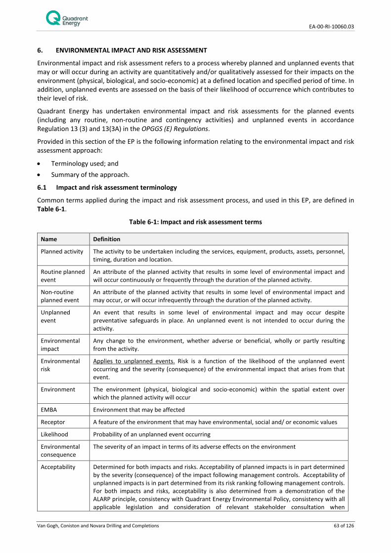
EA-00-RI-10060.03
Van Gogh, Coniston and Novara Drilling and Completions 63 of 126
6. ENVIRONMENTAL IMPACT AND RISK ASSESSMENT
Environmental impact and risk assessment refers to a process whereby planned and unplanned events that may or will occur during an activity are quantitatively and/or qualitatively assessed for their impacts on the environment (physical, biological, and socio-economic) at a defined location and specified period of time. In addition, unplanned events are assessed on the basis of their likelihood of occurrence which contributes to their level of risk.
Quadrant Energy has undertaken environmental impact and risk assessments for the planned events (including any routine, non-routine and contingency activities) and unplanned events in accordance Regulation 13 (3) and 13(3A) in the OPGGS (E) Regulations.
Provided in this section of the EP is the following information relating to the environmental impact and risk assessment approach:
• Terminology used; and • Summary of the approach.
6.1 Impact and risk assessment terminology
Common terms applied during the impact and risk assessment process, and used in this EP, are defined in Table 6-1.
Table 6-1: Impact and risk assessment terms
Name Definition
Planned activity The activity to be undertaken including the services, equipment, products, assets, personnel, timing, duration and location.
Routine planned event
An attribute of the planned activity that results in some level of environmental impact and will occur continuously or frequently through the duration of the planned activity.
Non-routine planned event
An attribute of the planned activity that results in some level of environmental impact and may occur, or will occur infrequently through the duration of the planned activity.
Unplanned event
An event that results in some level of environmental impact and may occur despite preventative safeguards in place. An unplanned event is not intended to occur during the activity.
Environmental impact
Any change to the environment, whether adverse or beneficial, wholly or partly resulting from the activity.
Environmental risk
Applies to unplanned events. Risk is a function of the likelihood of the unplanned event occurring and the severity (consequence) of the environmental impact that arises from that event.
Environment The environment (physical, biological and socio-economic) within the spatial extent over which the planned activity will occur
EMBA Environment that may be affected
Receptor A feature of the environment that may have environmental, social and/ or economic values
Likelihood Probability of an unplanned event occurring
Environmental consequence
The severity of an impact in terms of its adverse effects on the environment
Acceptability Determined for both impacts and risks. Acceptability of planned impacts is in part determined by the severity (consequence) of the impact following management controls. Acceptability of unplanned impacts is in part determined from its risk ranking following management controls. For both impacts and risks, acceptability is also determined from a demonstration of the ALARP principle, consistency with Quadrant Energy Environmental Policy, consistency with all applicable legislation and consideration of relevant stakeholder consultation when

EA-00-RI-10060.03
Van Gogh, Coniston and Novara Drilling and Completions 64 of 126
Name Definition determining management controls.
ALARP As Low As Reasonably Practicable The ALARP principle is that the residual impacts and risk shall be ‘as low as reasonably practicable’. It has particular connotations as a route to reduce risks when considering law, regulation and standards. For an impact or risk to be ALARP it must be possible to demonstrate that the cost involved in reducing the impact or risk further would be grossly disproportionate to the benefit gained. The ALARP principle arises from the fact that infinite time, effort and money could be spent on the attempt of reducing a risk to zero. It should not be understood as simply a quantitative measure of benefit against detriment. It is more a best common practice of judgement of the balance of impact or risk and societal benefit.
Grossly disproportionate
A computation whereby the quantum of impact or risk is placed on one scale and the sacrifice, whether in money, time or trouble, involved in the measures necessary to avert the risk is placed in the other. If it is shown that there is a gross disproportion between them, the sacrifice being significant in relation to the impact or risk, the person upon whom the duty (of care) is laid discharges the burden by proving that compliance was not reasonably practicable.
Aspect Element of an organisation’s activities or products or services that can interact with the environment.
Hazard Event which has the potential to threaten the surrounding natural environment and associated receptors.
6.2 Summary of the environmental impact and risk assessment approach
6.2.1 Overview
The impact and risk assessment approach is consistent with the requirements of AS/NZS ISO 31000:2009 Risk Management – Principles and guidelines and ISO/IEC 31010 Risk management – Risk management techniques. The approach can be mapped to the requirements of the OPGGS (E) Regulations for an EP, as described by NOPSEMA (N4700-GN1074 Rev 1 2013). The key steps are illustrated in Figure 6-1.
Figure 6-1: Environmental risk and impact assessment and treatment process
Describe the activity and hazards (planned and unplanned events) arising from the activity
Identify receptors in the environment for the activity that will or may be impacted and determine the nature and scale of impacts
EPO's and Controls Measures
Make evaluation on impacts (planned events) and risks (unplanned events) based on standard controls and implement further controls as needed to reduce to ALARP
Determine residual impact and risk ranking
Evaluate ALARP and Acceptability of impacts and risks .

EA-00-RI-10060.03
Van Gogh, Coniston and Novara Drilling and Completions 65 of 126
The Quadrant Energy Environmental Risk Identification and Analysis Procedure (EA-91-IG-004) includes consideration of the following key areas in a risk assessment and impact process:
• Description of the activity; • Description of the EMBA informed by oil spill modelling results and an EPBC Act MNES search; • Quadrant Energy’s High Environmental Value (HEV) scoring; • Consultation with stakeholders; • Consider Regulation and Legislation; • Corporate Policy; and • ESD Principles.
The risk workshop involves participants from other Quadrant Energy business units including:
• Drilling and Completions; • Compliance; • Marine Superintendent; and • Environmental Specialists.
The workshop actions are minuted and there is continual liaison with the business units to refine activity description, consequence assessments and determine suitable controls.
The consequence level of the impact is determined for each planned and unplanned event based on the severity of the impact to relevant receptors within the following categories:
• Fauna (including threatened/migratory fauna); • Physical environment/habitat; • Threatened ecological communities; • Protected areas; and • Socio-economic receptors.
This process determines a consequence level based on set criteria for each receptor category and takes into consideration the duration and extent of the impact, receptor recovery time and the effect of the impact at a population, ecosystem or industry level.
For unplanned events, a risk ranking is also determined using an assessment of the likelihood (likelihood ranking) of the event as well as the consequence level of the potential impact should that event occur.
The likelihood ranking system used for the risk assessment is included in Table 6-2.
The risk ranking matrix used to derive the risk rankings for each unplanned event during the initial risk assessment workshop is provided in Table 6-3.

EA-00-RI-10060.03
Van Gogh, Coniston and Novara Drilling and Completions 66 of 126
Table 6-2: Likelihood rankings used in the EP
Table 6-3: Quadrant Energy risk matrix used for risk rankings used in the EP
6.2.2 Acceptability of impacts and risks.
Quadrant Energy considers the impacts or risks associated with the activity to be acceptable if the following criteria are met:
1. A consequence from a planned event is ranked as A (No or Negligible consequence) or B (Minor consequence); or a risk of impact from an unplanned event is Tolerable or ALARP.
2. An assessment has been completed to determine if further information/studies are required to support or validate the consequence assessment.
3. Performance standards are consistent with legal and regulatory requirements.
4. Performance standards are consistent with Quadrant Energy Environmental Management Policy.
5. Performance standards are consistent with stakeholder expectations, and
6. Performance standards have been demonstrated to reduce the impact or risk to ALARP.
765432
1
Expected > 1 1 per year
Estimated rate of occuranceProbability Frequency Interval
Probable 0.1 to 1 1 to 10 yearsLikely 10-2 to 10-1 10 to 100 years
Unlikely 10-3 to 10-2 100 to 1000 yearsVery Unlikely 10-4 to 10-3 1000 to 10,000 years
Rare 10-5 to 10-4 10,000 to 100,000 years
Very Rare 10-6 to 10-5 100,000 to 1,000,000 years
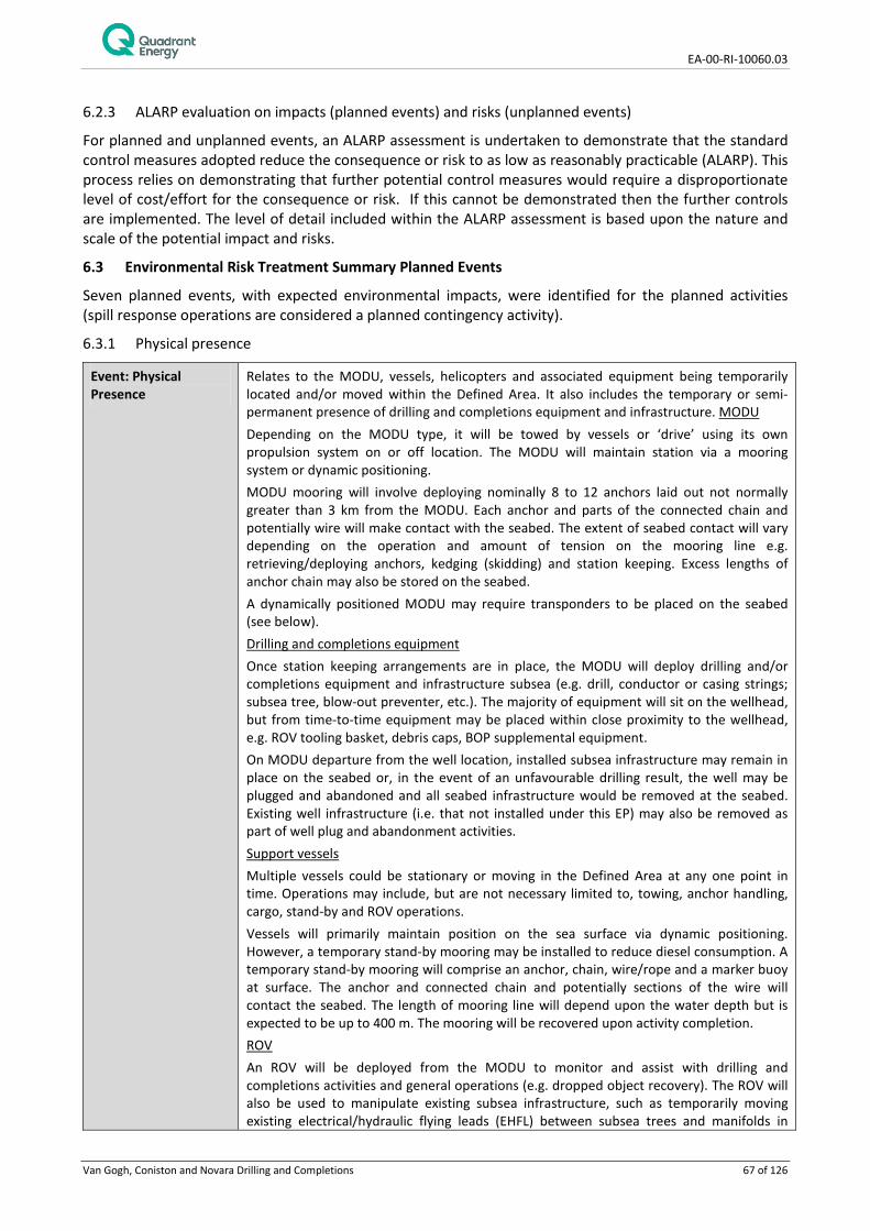
EA-00-RI-10060.03
Van Gogh, Coniston and Novara Drilling and Completions 67 of 126
6.2.3 ALARP evaluation on impacts (planned events) and risks (unplanned events)
For planned and unplanned events, an ALARP assessment is undertaken to demonstrate that the standard control measures adopted reduce the consequence or risk to as low as reasonably practicable (ALARP). This process relies on demonstrating that further potential control measures would require a disproportionate level of cost/effort for the consequence or risk. If this cannot be demonstrated then the further controls are implemented. The level of detail included within the ALARP assessment is based upon the nature and scale of the potential impact and risks.
6.3 Environmental Risk Treatment Summary Planned Events
Seven planned events, with expected environmental impacts, were identified for the planned activities (spill response operations are considered a planned contingency activity).
6.3.1 Physical presence
Event: Physical Presence
Relates to the MODU, vessels, helicopters and associated equipment being temporarily located and/or moved within the Defined Area. It also includes the temporary or semi-permanent presence of drilling and completions equipment and infrastructure. MODU Depending on the MODU type, it will be towed by vessels or ‘drive’ using its own propulsion system on or off location. The MODU will maintain station via a mooring system or dynamic positioning. MODU mooring will involve deploying nominally 8 to 12 anchors laid out not normally greater than 3 km from the MODU. Each anchor and parts of the connected chain and potentially wire will make contact with the seabed. The extent of seabed contact will vary depending on the operation and amount of tension on the mooring line e.g. retrieving/deploying anchors, kedging (skidding) and station keeping. Excess lengths of anchor chain may also be stored on the seabed. A dynamically positioned MODU may require transponders to be placed on the seabed (see below). Drilling and completions equipment Once station keeping arrangements are in place, the MODU will deploy drilling and/or completions equipment and infrastructure subsea (e.g. drill, conductor or casing strings; subsea tree, blow-out preventer, etc.). The majority of equipment will sit on the wellhead, but from time-to-time equipment may be placed within close proximity to the wellhead, e.g. ROV tooling basket, debris caps, BOP supplemental equipment. On MODU departure from the well location, installed subsea infrastructure may remain in place on the seabed or, in the event of an unfavourable drilling result, the well may be plugged and abandoned and all seabed infrastructure would be removed at the seabed. Existing well infrastructure (i.e. that not installed under this EP) may also be removed as part of well plug and abandonment activities. Support vessels Multiple vessels could be stationary or moving in the Defined Area at any one point in time. Operations may include, but are not necessary limited to, towing, anchor handling, cargo, stand-by and ROV operations. Vessels will primarily maintain position on the sea surface via dynamic positioning. However, a temporary stand-by mooring may be installed to reduce diesel consumption. A temporary stand-by mooring will comprise an anchor, chain, wire/rope and a marker buoy at surface. The anchor and connected chain and potentially sections of the wire will contact the seabed. The length of mooring line will depend upon the water depth but is expected to be up to 400 m. The mooring will be recovered upon activity completion. ROV An ROV will be deployed from the MODU to monitor and assist with drilling and completions activities and general operations (e.g. dropped object recovery). The ROV will also be used to manipulate existing subsea infrastructure, such as temporarily moving existing electrical/hydraulic flying leads (EHFL) between subsea trees and manifolds in

EA-00-RI-10060.03
Van Gogh, Coniston and Novara Drilling and Completions 68 of 126
preparation for MODU activities. It is also possible that a ROV may be deployed from a vessel. Helicopters Helicopters will be used for personnel and equipment transfers between the MODU and mainland. The Defined Area is under Restricted Airspace R854 used for Department of Defence training exercises, although petroleum activities and helicopters are permitted within the area. Transponders Subsea metrology, ROV positioning and spud location will be facilitated by the deployment of long baseline (LBL) transponders to the seabed, some or all of which will be mounted on small frames. An array of transponders, approximately 10, may be deployed at a time in the vicinity of existing subsea infrastructure (i.e. infrastructure between which measurements are to be made) with spacing of frames expected on a scale of 10s to 100s of metres. Placing of frames and transponders will be assisted by an ROV and/or crane. The installation of LBL array may occur prior to MODU arrival. The deployment will be temporary and the transponders and frames will be retrieved once all survey data has been obtained where practicable. In addition, several transponders may be temporarily deployed over a scale of 100s of metres around a drilling location to support a dynamic positioning MODU (e.g. drill ship) in the event that one is used. Drill cuttings Disturbance to the seabed from drill cuttings is covered under Section 6.6 – Drilling, completion and production appraisal discharges.
Potential receptors Physical Environment/ Habitat – Silt/clay seabed with a sparse epifauna and infauna Fauna (including Threatened/Migratory Fauna) – fish and sharks, turtles, marine mammals and seabirds within the Defined Area. The Key Ecological Feature of ‘Continental Slope Demersal Fish Communities’. Socio-economic Receptors – Shipping, oil and gas vessels, commercial fisheries and defence aircraft training.
Potential Impacts Benthic invertebrates Benthic epifauna and infauna may be damaged or smothered by placement of subsea infrastructure on the seabed. Observations of anchor scars in soft sediment environments at previous Apache drilling locations show a depression of approximately 0.4 m in depth below the surrounding seabed (Neptune Geomatics, 2012). Anchor scars in the Van Gogh and Coniston-Novara areas have been identified from previous surveys and varied in the length from 100 to 1000 metres (Tri-Surv 2007, Neptune Geomatics 2011). Once temporary equipment is removed the depression will begin to fill from movement and settlement of sediments and the infauna and epifauna community is expected to re-colonise quickly. Subsea equipment that may remain in place following the drilling of a well (i.e. wellheads and trees) will persist for the well’s production life providing hard substrate for attachment of sessile invertebrates and potentially increasing the diversity of epifaunal marine organisms. If the equipment is removed during well decommissioning as part of this EP’s activities, the biofouling community will be removed. Demersal Fish Communities Demersal fish which represent the Key Ecological Feature of ‘Continental Slope Demersal Fish Communities’ have the potential to be impacted from the initial deployment of equipment to the seabed with its associated noise and turbidity. Deployment may temporarily disturb demersal fish or attract fish from the stirring up of sediments and associated infauna. The footprint of subsea equipment will damage infauna/epifauna or make these fauna inaccessible to foraging demersal fish however the deployment of infrastructure over time scales of weeks to years will provide hard attachment points for sessile infauna which will form a biofouling community, increasing the epifaunal diversity. This community and the physical structure of subsea infrastructure is likely to attract
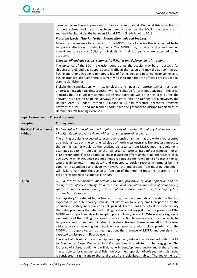
EA-00-RI-10060.03
Van Gogh, Coniston and Novara Drilling and Completions 69 of 126
demersal fishes through provision of prey items and habitat. Demersal fish attraction to obsolete subsea well heads has been demonstrated on the NWS in otherwise soft sediment habitat at depths between 85 and 175 m (Pradella, et al. 2013). Protected Species (Sharks, Turtles, Marine Mammals and Seabirds) Migratory species may be attracted to the MODU. For all species this is expected to be temporary alteration to behaviour only. The MODU may provide resting and feeding advantages to seabirds. Solitary individuals or small groups only are expected to be attracted. Shipping, oil and gas vessels, commercial fisheries and defence aircraft training The presence of the 500 m exclusion zone during the activity may be an obstacle for shipping and oil and gas support vessel traffic in the region and may disrupt commercial fishing operations through a temporary loss of fishing area and potential inconvenience to fishing practices although there is currently no indication that the affected area is used by commercial fisheries. Stakeholder consultation with stakeholders and industry representatives has been undertaken (Section 5). This, together with consultation for previous activities in the area, indicates that it is unlikely commercial fishing operators will be in this area during the activity. There are no Shipping Fairways through or near the Defined Area. However, the Defined Area is under Restricted Airspace R854 and therefore helicopter transfers between the MODU and mainland airports have the potential to disrupt Department of Defence aircraft training exercises.
Impact assessment – Physical presence
Receptor Consequence
Physical Environment/ Habitat
B - Detectable but localised and insignificant loss of area/function of physical environment / habitat. Rapid recovery evident within ~ 1 year (seasonal recovery). The drilling activity is expected to occur over benthic habitats that are widely represented at a regional scale on the continental slope of north-west Australia. The greatest impact to the benthic habitat would be the localised disturbance from MODU mooring equipment, estimated at 130 m2 from each anchor disturbance (1040 to 1560 m2 per campaign for an 8-12 anchor spread) with additional linear disturbance from anchor line depressions likely 100-1000 m in length. Once the moorings are removed the functioning of benthic habitat would begin to return immediately and expected to quickly recover in terms of benthic community abundance and diversity, however the impressions from mooring equipment will likely remain after the ecological function of the mooring footprint returns. On this basis the expected consequence is Minor.
Fauna A – Short term behavioural impacts only to small proportion of local population and not during critical lifecycle activity. No decrease in local population size / area of occupancy of species / loss or disruption of critical habitat / disruption to the breeding cycle / introduction of disease. For migratory/threatened fauna (sharks, turtles, marine mammals and seabirds) there is expected to be a temporary behavioural alteration to a very small proportion of the population (solitary individuals or small groups). There is not any critical life-cycle activity that takes place near the intended drilling locations that suggests that the presence of the MODU and support vessels will disrupt important life-cycle events. Whale sharks aggregate well inshore of the drilling locations and any attraction to whale sharks is expected to be temporary and to solitary migrating individuals to/from these aggregations. Likewise, while cetaceans (including humpback whales) may pass within close proximity to the MODU and support vessels during migration, the presence of MODU and vessels is not expected to disrupt this lifecycle event. The effect of infrastructure and equipment deployed/installed on the seabed under this EP to Continental Slope Demersal Fish Communities is predicted to be Negligible. The footprint of subsea equipment will damage infauna/epifauna and/or make these fauna inaccessible to foraging demersal fish, however the proportion of soft sediment disturbed is considered insignificant to the total area of this ubiquitous habitat. The deployment of

EA-00-RI-10060.03
Van Gogh, Coniston and Novara Drilling and Completions 70 of 126
equipment to the seabed over timescales of weeks to years will attract demersal fish through increased epifaunal abundance and diversity associated with biofouling, although the level of attraction from newly installed infrastructure under this EP is likely to be insignificant compared to attraction from the existing subsea infrastructure installed during development of the Van Gogh, Coniston and Novara fields (e.g. existing wellheads, flowlines, manifolds, risers etc). Likewise the removal of equipment and infrastructure (e.g. moorings, decommissioned well equipment and infrastructure) with an attached biofouling community is not expected to have a detectable effect on the local abundance or diversity of fishes that comprise the Continental Slope Demersal Fish Communities.
Socio-economic Receptors
A - No or negligible loss of value of the local industry; no or negligible reduction in key natural features or populations supporting the activity. A review of shipping data indicates that there will not be a significant disruption to commercial shipping due to the distance of the activity from the nearest shipping fairway (40 km). No commercial fisheries are currently active in the Defined Area however they may become active in the future. While oil and gas activities occur in surrounding permits there is expected to be Negligible interruption to support vessels of other oil and gas operators. Following notifications to the Department of Defence on helicopter transfer activities there is expected to be negligible disruption to defence training exercises that may occur within Restricted Airspace.
Overall Consequence Ranking
B - Minor
Management Control Effectiveness of Control
MODU move procedure
No accidental contact with the seabed and subsea infrastructure during the MODU move limiting seabed disturbance.
MODU station keeping system
Maintains the MODU at the desired location reduce risks to seabed habitat and petroleum infrastructure
Standby vessel mooring procedure
Mooring or moored standby vessel will not:
• Damage benthic habitat containing coral. • Be within a marine conservation reserve. • Be within 500-m of a listed shipwreck. Minimising seabed disturbance to planned locations away from sensitive receptors.
MODU identification system
MODU has a RACON (radar transponder) or Automatic Identification System (AIS) to aid in its detection at sea.
Standby vessel Support vessel equipped with an automatic identification system and radar to aid in vessel detection will stay in the field with the MODU.
Maritime notices Information provided on MODU arrival and departure so that the maritime industry is aware of petroleum activities.
Regulatory notices Regulatory authorities are notified prior to and commencement of activities
Department of Defence notices
Information provided on helicopter transfers so that the Department of Defence is aware of activities within restricted airspace.
6.3.2 Light Emissions
Event: Light Emissions Light emissions from lighting of the MODU and support vessels, and light associated with flaring will occur. During the activity, safety lighting on the MODU and support vessels will generate light emissions that may affect marine fauna behaviour. In the event of a well test, light may be generated from flaring activities
Potential Receptors Fauna (including Threatened/Migratory Fauna) – Pelagic fish and sharks, turtles, marine

EA-00-RI-10060.03
Van Gogh, Coniston and Novara Drilling and Completions 71 of 126
mammals and seabirds – Pelagic fish and sharks, turtles, marine mammals and seabirds
Potential Impacts Fish Increased predation associated with light attraction may result from artificial light emissions given that experiments using light traps indicate that some fish and zooplankton species are attracted to light sources (Meekan et al. 2001). Lindquist et al. (2005) concluded from a study that artificial lighting associated with a MODU resulted in an increased abundance of clupeids (herring and sardines) and engraulids (anchovies); these species are known to be highly photopositive. In a light trap study, Shaw et al. (2002) noted that juvenile tuna (Scombridae) and jack (Carangidae), which are highly predatory, may have been preying upon higher than usual concentrations of zooplankton that were attracted to a MODU’s light field. Marine turtles Given that no light sensitive nesting habitat is in the vicinity of the Defined Area, the most significant risk posed to marine turtles from artificial lighting (being disorientation of hatchlings following their emergence from nests) is not considered credible. Transient individuals may be exposed to the artificial light from the activity; however light is not known to disorientate or affect adult turtles. Seabirds Studies conducted between 1992 and 2002 in the North Sea confirmed that artificial light was the reason that birds were attracted to and accumulated around illuminated offshore infrastructure (Marquenie et al. 2008) and that lighting can attract birds from large catchment areas (Wiese et al. 2001). Birds may either be attracted by the light source itself or indirectly as structures in deep water environments tend to attract marine life at all trophic levels, creating food sources and providing artificial shelter for seabirds (Surman 2002). The light sources associated with the MODU and support vessels may also provide enhanced capability for seabirds to forage at night. Other marine fauna There is no evidence to suggest that artificial light sources adversely affect the migratory, feeding or breeding behaviours of cetaceans. Cetaceans predominantly utilise acoustic senses to monitor their environment rather than visual cues (Simmonds et al. 2004), therefore impacts are thought to be unlikely.
Impact assessment – Light emissions
Receptor Consequence
Fauna A – Short term behavioural impacts only to small proportion of local population and not during critical lifecycle activity. No decrease in local population size / area of occupancy of species / loss or disruption of critical habitat / disruption to the breeding cycle / introduction of disease. Light from flaring will not impact sensitive receptors on a long term basis. Continuous lighting from MODU and vessel lighting in the same location for an extended period of time may result in alterations to normal marine fauna behaviour. Given that the Defined Area is located 32 km from the nearest shoreline, impacts will be limited to short-term and localised behavioural effects to any threatened/migratory fauna and not during key life-cycle activities.
Overall Consequence Ranking
A - Negligible
Management Control Effectiveness of Control
None There are no safe alternatives to the use of artificial lighting on the MODU and the associated support vessels. A baseline level of artificial lighting is required on a 24 hour basis to alert other marine users of the activity, and additional light is required to provide safe working conditions
Well testing and associated flaring can provide valuable information on the types of

EA-00-RI-10060.03
Van Gogh, Coniston and Novara Drilling and Completions 72 of 126
products the well can produce, the pressure and flow rates of fluids and other characteristics of the underground reservoir. The flaring procedure ensures that gases are disposed of in a controlled manner. It is not possible to divert the gas produced by well tested to production facilities, as appraisal wells are not connected to the required infrastructure
6.3.3 Noise Emissions
Event: Noise Emissions Noise emissions will occur during the activity from the following sources: Support vessel operations, MODU operations (including drilling activities), Vertical Seismic Profiling (VSP), Subsea acoustic transducers/transponders and Helicopter operations. Ambient noise Guidance produced by APPEA (2013), reports ocean ambient subsea noise levels at 80 – 120 dB re 1μPa. Support vessel and MODU noise Typically, marine vessels produce low frequency sound (i.e. below 1 kHz) from the operation of machinery onboard; from hydrodynamic flow noise around the hull; and from propeller cavitation, which is typically the dominant source of noise (Ross 1987, 1993). Most sounds associated with vessels are broadband (i.e. contain a broad range of frequencies), though tones are also associated with the harmonics of the propeller blades (Ross 1987, 1993). Generally, noise increases with increasing vessel size and speed (Richardson et al. 1995); source levels can range from less than 160 dB (trawlers) to over 200 dB re 1µPa @1m (supertankers) (Simmonds et al. 2003). McCauley (1998) measured the noise from MODU support vessels (2,600 gross tonnage vessels) when underway, with measurements of 120 dB re 1mPa up to1 km away and audible noise out to 10 km. Support vessel noise is likely to be at highest levels when using bow thrusters for close positioning near the MODU (e.g. loading/backloading operations) which occurs for short durations. The use of thrusters by support vessels has been measured at 137 dB re 1mPa at 405 m away, levels of 120 dB at 3-4 km away (McCauley 1998). McCauley (1998) measured noise emissions from a semi-submersible MODU (Ocean General) in the Timor Sea. With the MODU at anchor (at depth of 3,600 to 3,700 m), but with no drilling undertaken, the highest noise level was measured at 117 dB re 1µPa at 125 m away and undetectable at 1-2 km away. Extrapolating this sound level to the MODU location provided a sound level of 157-160 dB re 1µPa at 1 m (McCauley 1998). For drilling operations the MODU was audible out to 11 km under low wind conditions. Noise levels from dynamic positioning MODUs (e.g. drill ships) are generally higher than for moored MODUs due to the use of dynamic positioning thrusters to maintain station. Drill ships also have greater coupling of the hull with water than semi-submersible MODUs which can increases noise levels. Drill ships typically utilise transducers on the ship’s hull and transponders at the seabed which communicate via pulsed sound signals and assist with dynamic positioning. Studies on drill ship noise have shown peak tones in frequencies below 600 Hz with sound above 120 dB re 1µPa measured out to 10 km (Richardson et al., 1995). Source levels for the operating Stena Forth drill ship have been interpreted as 184 dB re 1μPa during drilling and 190 dB re 1μPa during maintenance works (Kyhn et al., 2011). These measurements included noise emitted from transducers and transponders within the frequency spectrum of 20-35 kHz (Kyhn et al., 2011). Noise levels have been measured from the Ningaloo Vision FPSO on station within the Defined Area (Worley Parsons 2011). The mean source level of underwater noise from the FPSO estimated in the broad frequency band from 20 to 500 Hz during the observation period was about 183 dB re 1 μPa at 1 m (Worley Parsons 2011). The maximum broadband noise level observed was approximately 190 dB. These levels are similar to those recorded for drill ships and higher than typically recorded for moored semi- submersible MODUs. Based on these estimates and an acoustic propagation model, it was shown that the mean and maximum levels of the broadband noise produced by the FPSO would drop to the most probable level of ambient sea noise at distance of 3.5 and 5.5 km respectively (Worley Parsons 2011). In certain frequency bands, and under calm weather conditions,

EA-00-RI-10060.03
Van Gogh, Coniston and Novara Drilling and Completions 73 of 126
the underwater noise from the FPSO could be slightly higher than that of sea noise beyond 10 km; however, the excess should not be larger than 3- 4 dB (Worley Parsons 2011). Vertical Seismic Profiling Vertical Seismic Profiling (VSP) is carried out using geophones inside the wellbore and a seismic source that is hung over the side of the MODU. VSP is used for correlation with surface seismic data to produce images of higher resolution than surface seismic images. In addition to tying well data to seismic data, VSP also enables the conversion of seismic data to zero-phase data and distinguishes primary reflections from multiples. VSP typically takes in the region of hours to a few days. Although there are no immediate plans to conduct vertical seismic profiling (VSP) during the well activities, it is possible during the five year program that these techniques may be used to evaluate hydrocarbon bearing formations in the future. VSP generates higher intensity noise than routine drilling operations. VSP source generates a noise level around 190 dB re 1 μPa in the 5–100 Hz range, with this level decreasing rapidly with the distance from the source (Woodside 2008). Modelling undertaken by Woodside for its Torosa-6 drilling activity at Scott Reef modelled the VSP sound pressures in the vertical and horizontal planes. The results indicated that in the vertical plane, the maximum sound pressures would occur directly below the source, with 184 db re 1 μPa/Hz measured at five metres below the source and 168 db re 1 μPa/Hz measured at 25 m below the source. In the horizontal plane, maximum sound pressures were modelled to decrease to 160 db re 1 μPa/Hz within 20 m of the source. These results indicate that the distance required to achieve 120 db re 1 μPa is 3 km. Subsea transponders An array of long baseline (LBL) transponders will be deployed at the seabed to facilitate ROV positioning and subsea metrology. LBL transponders emit pulsed sound with a medium to high frequency (expected between 19 kHz and 34 kHz) and expected sound level of up to 202 dB re 1 µPa 1 m (peak level). The subsea transponders will be in the immediate vicinity of existing subsea infrastructure and are typically spaced on a scale of 10s to 100s metres. In addition, ultra-short baseline (USBL) transponders may be used near the sea surface on MODU/support vessels for crane operations (for example to facilitate deployments of LBL transponders). These transponders will emit pulsed sound with an expected frequency range within that of LBL transponders and a peak level no higher than for LBL transponders. In the event that a dynamic position MODU (e.g. drill ship) is used, seabed transponders, spaced at a scale of 100s of metres, may be utilised. Transponders will communicate with hull transducers by way of pulsed signals to assist with dynamic positioning. The frequency range of the pulsed signals from transducers/transponders is expected to be similar to the frequency range of transponders used for metrology/ROV operations. Field measurements of drill ship transducers/transponders have shown spectral peaks between 20 and 35 kHz out to 2 km (Kyhn et al., 2011). Helicopter noise Personnel transfer could occur daily dependent on the number of people onboard the MODU, progress during the activity and logistical constraints. The extent of helicopter noise impacts are limited to take off and landing at the MODU as they do not fly close to the ocean surface (with a typical cruising height of between approximately 1,000 to 1,400 m) except to undertake these tasks. Strong underwater sounds are detectable for only brief periods when the helicopter is directly overhead (Richardson et al., 1995). The received helicopter noise level underwater depends on source altitude and lateral distance, receiver depth and water depth. Sound emitted from helicopter operations is typically below 500 Hz and sound pressure in the water directly below a helicopter is greatest at the surface and diminishes quickly with depth. Reports for a Bell 214 (stated to be one of the noisiest) indicated that noise is audible in the air for four minutes before the helicopter passed over underwater hydrophones. The helicopter was audible underwater for only 38 s at 3 m depth and 11 s

EA-00-RI-10060.03
Van Gogh, Coniston and Novara Drilling and Completions 74 of 126
at 8 m depth (Greene, 1985a; cited in Richardson et al., 1995). Noise levels reported for Bell 212 helicopter during fly-over is 162dB re 1µPa and for Sikorsky-61 is 108 dB re 1µPa at 305 m (WDCS, 2003).
Potential receptors Fauna (including Threatened/Migratory Fauna) – Fish and sharks, turtles, marine mammals (particularly humpback whales and pygmy blue whales) and seabirds. The Key Ecological Feature (KEF) of Continental Slope Demersal Fish Communities. Socio-economic Receptors – commercial fisheries
Potential Impacts The use of sound in the underwater environment is important for some marine fauna species (particularly cetaceans) to navigate, communicate and forage effectively. Underwater noise generated from anthropogenic sources may impact on marine fauna by:
• Causing behavioural changes including displacement from biologically important habitat areas (such as breeding, feeding, calving and nursery sites);
• Masking or interfering with other biologically important sounds such as communication or echolocation systems used by certain cetaceans for location of prey and navigation; and
• Causing physical injury to hearing organs. The extent of the impacts from underwater noise on marine fauna will depend upon the frequency range and intensity of the noise produced and sensitivity of the animal affected. Causing behavioural changes Studies of baleen whale (e.g. humpback whales and blue whales) hearing apparatus suggest that their hearing is best adapted for low frequency sounds (McCauley 1994, Richardson et al. 1995), with peak sensitivity range for humpback whales being <10 kHz (Houser et al. 2001). Behavioural avoidance of baleen whales may onset from 140 to 160 dB re 1 μPa (Richardson et al. 1995, Southall et al. 2007). Baleen whales display a gradation of behavioural responses to noise, suggesting that acoustic signals are audible to whales at considerable distances from the source, but indicate that whales are not disrupted from normal activities even during migration (McCauley 1994). Sound levels of 140-160 re 1 μPa at a scale of 100s of metres from the MODU are possible but most likely during temporary activities which emit relatively high level and low frequency noise such as bow thruster use (in the case of support vessels and/or a drill ship) or VSP. Subsea transponders have relatively high sound levels but emit at high frequencies over a very narrow spectrum when compared to other noise sources. The frequency range of transducers or subsea transponders that may be used to support activities under this EP are above the upper sensitivity threshold for humpback whales (i.e. 10 kHz, Houser et al. 2001). Turtles have been shown to respond to low frequency sound, with indications that they have the highest hearing sensitivity in the frequency range between 100 – 700 Hz (Bartol & Musick 2003), that is within the range of vessel/MODU operations and VSP but not transducer/transponder use. Studies indicate that behavioural responses from turtles (alarm and avoidance responses in loggerhead and green turtles) occur above a range of 166 – 175 dB re 1 µPa rms (McCauley et al. 2003). Sounds at this level may be expected at very close range to MODU/support vessels, i.e. on a scale of metres to 10s of metres. Sharks are known to be highly sensitive to low frequency sounds between 40-800 Hz sensed solely through the particle-motion component of an acoustic field. Free ranging elasmobranchs (i.e. sharks) are attracted to sounds possessing specific characteristics – irregular pulse, broadband frequency and transmitted with a sudden increase in intensity (i.e. resembling struggling prey). Most fish can hear in the frequency range 100-1000Hz but there is significance variance according to species outside that range (McCauley, 1994). Studies indicate that fish may begin to show subtle behavioural responses (e.g. increased swimming) to an approaching seismic array at received sound levels of approximately 156 dB re 1 µPa (rms) and active avoidance at around 168 dB re 1 µPa (rms) (McCauley et al., 2000). At these sound levels, behavioural responses to MODU/support vessel noise and VSP from fish is most likely on a scale of 10s of metres. The effects of flaring from offshore installations on migrating birds has been monitored at

EA-00-RI-10060.03
Van Gogh, Coniston and Novara Drilling and Completions 75 of 126
the Dutch Continental Shelf (OSPAR Commission 2007), and suggest sound does not have any effect on seabirds or songbirds during migration. Masking or interfering with other biologically important sounds Baleen whales produce a rich and complex range of underwater sounds ranging in frequency from approximately 12 hertz (Hz) to 8 kHz, with the most commonly produced frequencies below 1 kHz (McCauley 1994). Studies of baleen whale hearing apparatus also suggest that their hearing is best adapted for low frequency sounds (McCauley 1994, Richardson et al. 1995). Hearing ranges in toothed whales (e.g. sperm whales, orcas) has been estimated at between 150 Hz and 160 kHz and these are considered mid-frequency cetaceans (Southall et al. 2007). Research has indicated that toothed whales are most sensitive to sounds above approximately 10 kHz (NRC 2003). Below about 10 kHz sensitivity deteriorates with decreasing frequency and below 1 kHz sensitivity appears to be poor. Causing physical injury to hearing organs Physiological damage to cetaceans from noise, such as hearing loss, is only likely to result from close proximity to intense sounds from high energy sources. This threshold is generally considered to be >200 dB re 1 μPa (McCauley 1994, Richardson et al. 1995) with physical injury leading to death only possible when peak pressure levels exceed 240 dB re 1 µPa (Parvin et al. 2007). Fish sensitivity and resilience to underwater noise varies greatly depending on the species, hearing capability, habits, proximity to the noise source, and the timing of the noise (i.e. the noise may occur during a critical part of the fish’s lifecycle) (McCauley & Salgado-Kent 2008). Most marine fish are hearing generalists (Amoser & Ladich 2005) with relatively poor hearing. Hearing generalists are not as sensitive to noise and vibration as hearing specialists, which have developed hearing specialisations and can be particularly vulnerable to intense sound vibrations because many possess an air-filled swim bladder (Gordon et al. 2004).
Impact assessment – Noise emissions
Receptor Consequence
Fauna A – Short term behavioural impacts only to small proportion of local population and not during critical lifecycle activity. No decrease in local population size / area of occupancy of species / loss or disruption of critical habitat / disruption to the breeding cycle / introduction of disease. Noise levels from the drilling activity, VSP and operation of vessels/MODU/helicopters are less than those expected to cause physical harm but may be within the range where behavioural responses to sensitive fauna (e.g. cetaceans) may occur on a scale of 100s of metres or less. It is expected that most migratory and transient cetaceans would move away from the noise impact. The Defined Area overlaps with the migration route of the humpback whale and to a lesser extent the blue whale but the area is not a known feeding or breeding ground, and as such any impacts to these threatened / migratory fauna are expected to be limited to temporary behavioural impacts. Subsequently the impacts expected to cetaceans are considered to be Negligible which is also the case for other marine fauna which are less sensitive to noise than cetaceans (e.g. turtles, fish). Whale sharks aggregate well inshore of the drilling locations and any disturbance to whale sharks is expected to be temporary and to solitary migrating individuals to/from these aggregations. While the Key Ecological Feature of Continental Slope Demersal Fish Communities overlaps the area within which noise will be above background levels, behavioural response to fish is likely to be on a scale of 10s of metres from the sound source. VSP and transponder noise are likely to be within the closest proximity to demersal fish, but these activities will be temporary and localised (around 12 hours total for VSP) and for transponder noise the frequency will be above typical fish hearing sensitivity. The proportion of the demersal fish population exposed to noise from activities under this EP, at a sound level where behavioural disturbance could occur, is considered to be very small. The effect of noise on

EA-00-RI-10060.03
Van Gogh, Coniston and Novara Drilling and Completions 76 of 126
Continental Slope Demersal Fish Communities is therefore expected to be Negligible.
Socio-economic Receptors
A- No or negligible loss of value of the local industry; no or negligible reduction in key natural features or populations supporting the activity. Given that no sensitive breeding or known fishing grounds for commercial fisheries have been identified within close proximity to the Defined Area, the noise and vibration levels from the activities are not expected to result in impacts populations of targeted commercial species and subsequently are expected to have a Negligible impact to socio-economic receptors.
Overall Consequence Ranking
A - Negligible
Management Control Effectiveness of Control
Procedures for interacting with cetaceans
Vessels maintain distance from cetaceans to reduce noise impacts from propellers. Helicopter complies with Part 8 of EPBC Regulations for interacting with cetaceans to reduce noise impacts.
MODU seismic survey procedures
Includes controls that reduce the risk of harm to marine fauna. The checklist includes standards for: • Marine fauna observation.
• Soft-start, operational and shut-down protocols. • Low visibility and night-time operations.
Procedures for interacting with whale sharks
Vessels maintain distance from whale sharks to reduce noise impacts from propellers.
6.3.4 Air Emissions
Event: Air Emissions Atmospheric emissions will occur from operating fuel combustion engines and machinery during the activity. Atmospheric emissions may also occur from incineration (waste disposal) and flaring during well testing. The use of fuel (specifically marine-grade diesel) to power MODU and vessel engines, generators and mobile and fixed plant and equipment will result in emissions of greenhouse gases (GHG) such as carbon dioxide (CO2), methane (CH4) and nitrous oxide (N2O), along with non-GHG such as sulphur oxides (SOx) and nitrous oxides (NOx). During well testing (over a number of days per well), hydrocarbons (oil and gas) and potentially formation water will be produced from the reservoir. Oil and gas hydrocarbons will be flared (combusted) using burners to alleviate the need to store produced hydrocarbons on board the drill rig, while providing a means of discharging hydrocarbons without contamination of surrounding waters. Other gasses (CO2 and H2S) may also be produced from the reservoir.
Vessels/MODU may utilise ozone-depleting substances (ODS) in closed-system rechargeable refrigeration systems.
Potential receptors Socio-economic Receptors – urban centres and human health
Potential Impacts Hydrocarbon combustion may result in a temporary, localised reduction of air quality in the environment immediately surrounding the discharge point during the activity. Non-GHG emissions, such as NOX and SOX, and GHG emissions can lead to a reduction in local air quality which can impact humans and seabirds in the immediate vicinity. As Quadrant Energy’s proposed drilling operations occur in offshore waters, the combustion of fuels in such remote locations will not impact on air quality in any population centres. The quantities of gaseous emissions are relatively small and will quickly dissipate into the surrounding atmosphere. Accidental release and fugitive emissions of ODS has the potential to contribute to ozone

EA-00-RI-10060.03
Van Gogh, Coniston and Novara Drilling and Completions 77 of 126
layer depletion. Maintenance of refrigeration systems containing ODS is conducted on a routine, but infrequent basis. When standard controls are implemented, the likelihood of an accidental ODS release of material volume is considered rare. Air emissions will be similar to other vessels and helicopters operating in the region for both petroleum and non-petroleum activities.
Impact assessment – Air emissions
Receptor Consequence
Socio-economic Receptors
A- No or negligible loss of value of the local industry; no or negligible reduction in key natural features or populations supporting the activity. As Quadrant Energy’s proposed drilling operations occur in offshore waters, the combustion of fuels in such remote locations will not impact on air quality in coastal towns. The quantities of gaseous emissions (including ODS in the event of an accidental release) are relatively small and are expected to quickly dissipate into the surrounding atmosphere. As such the consequence is considered to be negligible.
Overall Consequence Ranking
A - Negligible
Management Control Effectiveness of Control
Waste Incineration By meeting MARPOL Annex VI requirements air pollution is reduced from waste incineration
Fuel oil quality Sulphur content of fuel oil supplied during the activity will not exceed 3.5% m/m resulting in reduced sulphur emissions during the activity.
Air pollution prevention certification
MODU and support vessels will maintain a current International Air Pollution Prevention (IAPP) Certificate which certifies that measures to prevent ozone-depleting substance (ODS) emissions, and reduce NOx, SOx emissions during the activity are in place.
Ozone-depleting substance handling procedures
Ozone-depleting substances (ODS) managed in accordance with MARPOL Annex VI to reduce the risk of an accidental release of ODS to air.
Well test procedures Includes control measures that reduce the risk of poor quality burn of hydrocarbons entering the atmosphere.
6.3.5 Operational Discharges
Event: Operational Discharges
Operation of the MODU and supporting vessels require a number of operational discharges: • Putrescible waste and sewage; • Cooling water; • Desalination plant effluent (brine) and backwash water from the water maker; • Deck drainage; • Oily water; and • Ballast water. In addition to operational discharges, drilling and completion activity discharges are planned and are discussed in Section 6.6. Putrescible waste and sewage The volume of sewage and food waste is directly proportional to the number of persons onboard the MODU and support vessels. Approximately 30-40 L of sewage will be generated per person per day and approximately 40 kg of food waste will be produced in total per day. Cooling water Seawater will be used as a heat exchange medium for the cooling of machinery engines on

EA-00-RI-10060.03
Van Gogh, Coniston and Novara Drilling and Completions 78 of 126
the MODU and on support vessels. Cooling water temperatures vary dependent upon the vessels engines work load and activity. However, modelling of continuous waste water discharges (including cooling water) undertaken by Woodside for its Torosa South-1 drilling campaign in the Scott Reef complex found that discharge water temperature decreases quickly as it mixes with the receiving waters, with the discharge water temperature being less than 1°C above background levels within 100 m (horizontally) of the discharge point, and will be within background levels within 10 m vertically (Woodside 2008). Desalination plant effluent (brine) and backwash water discharge Effluents from the water supply systems on-board the MODU and support vessels will be discharged to the ocean at a salinity concentration higher than seawater. The volume of the discharge is dependent on the requirement for fresh (or potable) water and would vary between the vessels and the number of people on-board. The effluent may contain scale inhibitors such as Alpacon that controls inorganic scale formation, such as the formation of calcium carbonate and magnesium hydroxide, in water making plants. Other water purification chemicals such as chlorine may also be added to the portable water. Other water making plant cleaning chemicals such as Ameroyal or Saf Acid may be used and discharged to sea after completion of the cleaning process. Deck drainage Deck drainage from rainfall or wash-down operations will discharge to the marine environment. The deck drainage will contain particulate matter and residual chemicals such as cleaning chemicals, oil and grease. These are expected to dissipate quickly in the marine environment given the minor volumes and natural dispersion through ocean currents. Oily water While in the Defined Area, oily water from the MODU and support vessels may be discharged to sea following treatment through an oily water filter system. Ballast water When at location support vessels may take on ballast water when discharging deck cargo and/ or bulk products (liquid or dry). In the event that support vessels need to take on liquid cargo from the MODU, it is expected that vessels will need to discharge ballast water. Similarly, the MODU may need to exchange ballast water to maintain stability or adequate drilling draught, while keeping station.
Potential Receptors Fauna (including Threatened/Migratory Fauna) – Pelagic fish and sharks, turtles, marine mammals and seabirds within the Defined Area
Potential Impacts Operational discharges will be small and continuous, dependent on rainfall, the number of persons onboard and the machinery activity. Operational discharges have the potential to impact on environmental receptors through: Nutrient enrichment Discharge of food waste and sewage can cause eutrophication in the surrounding waters resulting in changes to plankton in the immediate area which could subsequently impact on fish and planktonic feeders. In a study of sewage discharge in deep ocean waters, Friligos (1985) reported no appreciable differences in the inorganic nutrient levels between the outfall area and background concentrations suggesting rapid uptake of nutrients and/or rapid dispersion in the surrounding waters. Similar studies (Parnell 2003) concluded similar results with rapid dispersion and dilution within hours of discharge. Nutrient enrichment is not expected to affect identified receptors. Toxicity In general, dilution after dumping at sea is rapid with results showing 1 in 1,000 dilution within 30 minutes (Costello & Read 1994). Subsequently acute toxicity to marine fauna is not expected to affect identified receptors. Water column turbidity Deposition of food waste and sewage may contribute to turbidity in the water column.
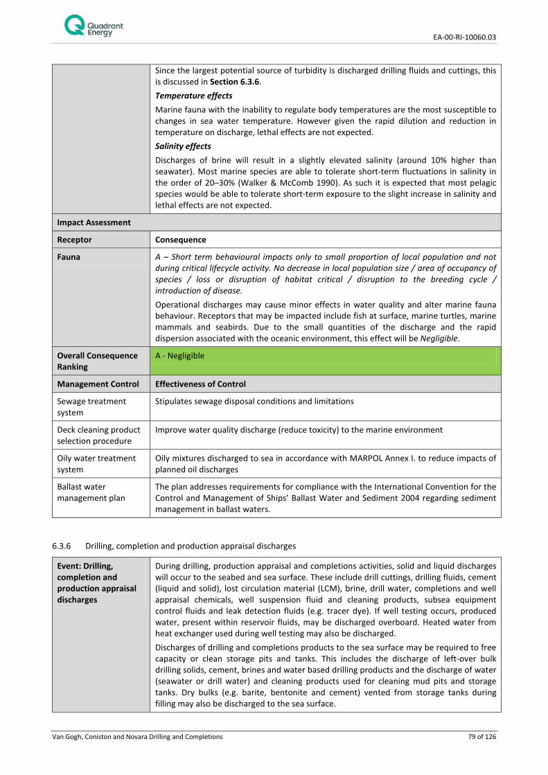
EA-00-RI-10060.03
Van Gogh, Coniston and Novara Drilling and Completions 79 of 126
Since the largest potential source of turbidity is discharged drilling fluids and cuttings, this is discussed in Section 6.3.6. Temperature effects Marine fauna with the inability to regulate body temperatures are the most susceptible to changes in sea water temperature. However given the rapid dilution and reduction in temperature on discharge, lethal effects are not expected. Salinity effects Discharges of brine will result in a slightly elevated salinity (around 10% higher than seawater). Most marine species are able to tolerate short-term fluctuations in salinity in the order of 20–30% (Walker & McComb 1990). As such it is expected that most pelagic species would be able to tolerate short-term exposure to the slight increase in salinity and lethal effects are not expected.
Impact Assessment
Receptor Consequence
Fauna A – Short term behavioural impacts only to small proportion of local population and not during critical lifecycle activity. No decrease in local population size / area of occupancy of species / loss or disruption of habitat critical / disruption to the breeding cycle / introduction of disease. Operational discharges may cause minor effects in water quality and alter marine fauna behaviour. Receptors that may be impacted include fish at surface, marine turtles, marine mammals and seabirds. Due to the small quantities of the discharge and the rapid dispersion associated with the oceanic environment, this effect will be Negligible.
Overall Consequence Ranking
A - Negligible
Management Control Effectiveness of Control
Sewage treatment system
Stipulates sewage disposal conditions and limitations
Deck cleaning product selection procedure
Improve water quality discharge (reduce toxicity) to the marine environment
Oily water treatment system
Oily mixtures discharged to sea in accordance with MARPOL Annex I. to reduce impacts of planned oil discharges
Ballast water management plan
The plan addresses requirements for compliance with the International Convention for the Control and Management of Ships’ Ballast Water and Sediment 2004 regarding sediment management in ballast waters.
6.3.6 Drilling, completion and production appraisal discharges
Event: Drilling, completion and production appraisal discharges
During drilling, production appraisal and completions activities, solid and liquid discharges will occur to the seabed and sea surface. These include drill cuttings, drilling fluids, cement (liquid and solid), lost circulation material (LCM), brine, drill water, completions and well appraisal chemicals, well suspension fluid and cleaning products, subsea equipment control fluids and leak detection fluids (e.g. tracer dye). If well testing occurs, produced water, present within reservoir fluids, may be discharged overboard. Heated water from heat exchanger used during well testing may also be discharged. Discharges of drilling and completions products to the sea surface may be required to free capacity or clean storage pits and tanks. This includes the discharge of left-over bulk drilling solids, cement, brines and water based drilling products and the discharge of water (seawater or drill water) and cleaning products used for cleaning mud pits and storage tanks. Dry bulks (e.g. barite, bentonite and cement) vented from storage tanks during filling may also be discharged to the sea surface.
EA-00-RI-10060.03
Van Gogh, Coniston and Novara Drilling and Completions 80 of 126
BOP fluid will be released during the function testing of the blow out preventer (BOP). Base oil may be used downhole to perform negative pressure test of casing sections but will not be discharged to sea in bulk volumes. Further detail on the nature and scale of these discharges is provided in sections below. Drill cutting and drilling fluid discharges Wells covered under this EP are planned to be drilled with water based muds (WBM). All wells drilled to date within the Van Gogh and Coniston fields have been drilled with WBM, with no requirement for Non Aqueous Fluids (NAF) such as Synthetic Based Mud (SBM). However, as a contingency, Non Aqueous Fluids (NAF) may be used for drilling of some well sections. NAF consist of all fluids where the major liquid phase as well as the wetting (external) phase is not water or brine. WBM’s used will typically consist of between 92–98% v/v fresh or saline water. The remaining 2–8% of the WBM is made up of drilling fluid additives that are either completely inert in the marine environment, naturally occurring benign minerals, readily biodegradable organic polymers with a fast rate of biodegradation in the marine environment or products in low concentrations with a very low potential for environmental impact. Currently the only NAFs used are synthetic oils which form the basis of SBM, however it is envisaged that other non-aqueous fluids could be used either for environmental or operational purposes. New wells will generally be drilled in three sections: surface, intermediate, and production. The top surface hole will be drilled without a riser using sweeps of seawater and gel (bentonite), with cuttings discharged directly at the seafloor. The wells may be suspended following drilling of each section. The surface sections will be suspended with inhibited seawater, intermediate sections with WBM and production sections with completion brine (cleaned up through FPSO). The intermediate and production sections will be drilled with a riser installed following installation of a cemented casing, which enables the use of recirculating drilling fluid systems. Cuttings and drilling fluid returned to the MODU are then processed using the MODU’s cuttings management system. Regardless of the fluid type used (i.e. WBM or NAF), cuttings are removed from the circulating mud system by the screening of fluids over shale shakers. The primary control used to minimise the amount of drilling fluid discharged with the cuttings is to run the shale shakers as efficiently as possible by optimal use of screens. A centrifuge may also be used if required to prevent the build-up of ultra-fine solids in the mud. The recovered mud from the shale shakers and centrifuge is returned to the mud tanks for reuse, while the cuttings and separated centrifuge solids are discharged overboard. If NAF is required as a contingency measure for intermediate section drilling, drill cuttings will be further processed through a cuttings dryer to reduce the synthetic oil on cuttings (SOC) concentration prior to cutting discharge overboard. This is measured to ensure SOC is <10% wt/wt (dry weight) average for the well section (interval). Whole WBM may be operationally discharged if no further use is needed but will be reused where possible depending on its properties, the MODU’s well schedule and logistical constraints. This may involve dosing the mud with biocide to carry over to a subsequent well. For NAF, no disposal of whole fluids will be discharged overboard, with left-over NAF returned to shore for disposal. Lost circulation material (LCM) discharges Lost circulation can occur in any hole section. For losses that have to be cured, there is a choice of options available. Conventional additives such as granular and fibrous material are usually pumped into the loss zone in the first instance. When conventional materials fail to plug the loss zones it may be necessary to pump speciality lost circulation materials such as cement or temperature activated cross link polymer pills to heal the loss zones. By design, the lost circulation material enters the loss zone thereby plugging it and allowing drilling operations to recommence; this material remains in the rock and does not return to surface. On some occasions the lost circulation is cured before all the material pumped enters the loss zone. When this occurs, the lost circulation material remains in the

EA-00-RI-10060.03
Van Gogh, Coniston and Novara Drilling and Completions 81 of 126
wellbore until it is circulated back to the surface where it is discharged along with the cuttings. Cement discharges Cement is used to support casing strings and isolate the annulus behind the string prior to drilling subsequent intervals, forming a seal between the casing and the formation. Cement may also be used to seal a lost circulation zone, plug an existing well from which a side-track will be drilled and for suspending or abandoning a well. The majority of cement remains downhole but minor volumes may be discharged at surface. For cementing operations where the annulus is open to the seabed (surface casings) or for final well abandonment cement may be discharged at the seabed. Tracer dye may be used to aid in cement detection at seabed. Fluorescein is a commonly used dye and has been risk assessed as acceptable by Quadrant Energy. Cement may also be discharged at the sea surface from circulating cement with the riser installed, or from commissioning and cleaning of cementing tanks and equipment on the MODU. Contingency discharges of cement may be required if a cementing job does not meet technical and safety standards. This may involve circulating out an entire cement job at sea surface or at seabed. Disposal of bulk cement is included in a description of bulk drilling product disposal below. Cement may also be discharged as vented cement during the filling of storage tanks, with the vented cement discharged to the sea surface. Completion and well test products Following drilling, well completions and production appraisal activities may occur. Wells cannot be completed or appraised without the use of brine and certain chemicals, and this is standard industry practice. Chemical types include, but are not limited to polymers, solvent cleaners, poly-amine inhibitors, biocide and hydrate inhibitors. Such chemicals would be discharged to sea over a short duration (hours to days). If well testing is required it will occur over a number of days per well. Hydrocarbons (oil and gas) and potentially formation water will be produced from the reservoir. Oil and gas hydrocarbons will be flared (combusted) using burners to alleviate the need to store produced hydrocarbons on board the drill rig, while providing a means of discharging hydrocarbons without contamination of surrounding waters (refer Section 6.4 - Air Emissions). If any formation water is produced will be discharged to the marine environment following filtration. A heat exchanger/heater will be used during well testing and heated water (fresh water or seawater) will be discharged to sea. It is estimated that approximately 100 m3 of heated water at a notional temperature of 60°C could be discharged to sea per well flow back. The discharge rate would be notionally 2 to 3 m3 per hour. Disposal of bulk drilling products and tank/mud pit cleaning The discharge of left-over bulk drilling powders, cements, brines and water based drilling products may occur. Flushing of bulk WBM storage tanks may be undertaken with brines or water to remove residual ‘dead volumes’ of drilling fluid and settled solids. This ‘dead volume’ would typically be approximately 5-10 m3. Mud pits may be required to be cleaned prior to or after a drilling activity. Seawater or drill water will be used with the addition of cleaning products. In the event of cleaning tanks or mud pits that have contained NAF, the cleaning water will be managed to minimise oil discharges. The volume of oil discharged is nominally around 1 m3. BOP fluid discharges A blow out preventer (BOP) will be installed prior to drilling the intermediate and production hole sections. The BOP will be routinely checked by completing pressure and function testing in line with safety case commitments. Each function test will release BOP control fluids (approximately 125 to 150 L) to the marine environment.

EA-00-RI-10060.03
Van Gogh, Coniston and Novara Drilling and Completions 82 of 126
Potential receptors Physical Environment/ Habitat – Silt/clay seabed with a sparse epifauna and infauna Fauna (including Threatened/Migratory Fauna) – Fish and sharks, turtles, marine mammals and seabirds within the Defined Area. The Key Ecological Feature (KEF) of Continental Slope Demersal Fish Communities.
Potential Impacts Environmental receptors have the potential to be impacted through seabed smothering, toxicological effects of contaminants at the seabed and through reduction to water quality (turbidity and toxicological effects). Turbidity Drill cuttings, fluids and cement discharged at sea surface during the activity will disperse through the water column. This is expected to result in a localised increase in turbidity from the finer particles and has the potential to impact on organisms present in the water column, particularly those in the surface layers. For example, increased particle load in the water column could adversely affect respiratory efficiency of fish. Most visual orientated fish species would likely relocate to an unaffected area or simply pass unaffected through turbidity present. WBM cuttings are likely to disperse more rapidly and create greater turbidity than SBM cuttings (Neff et al., 2000b), but significant effects from turbidity associated with cuttings discharge have not been demonstrated (Neff 2005). Seabed smothering The discharge of cuttings during riserless drilling will occur at the well opening on the seafloor until a riser is installed after cementing of the first casing. Riserless drilling will take place with seawater and bentonite sweeps. Localised turbidity near the seabed will occur, as will localised smothering of the seabed with cuttings around the well. ROV surveys of cuttings deposited around the Van Gogh 3 well at the DC1 drill centre have shown the extent of cuttings to rapidly reduce (on a scale of 2 months) to within approximately 50m of the well location (Sea Serpent, 2008). The dispersion of fine cuttings at the DC1 site was attributed to episodic turbulence at the sebed rather than through the effect of continuous currents. Impacts from the cuttings piles are the direct smothering and damage to epifauna, reduced oxygen exchange to infauna and change to the particle size of the surrounding sediments. Toxicological impacts from drilling mud contaminants are not predicted given the low toxicity of bentonite sweeps. Cement discharged at seabed associated with setting of surface casing will harden and become inert with very localise impacts at the well location through smothering of sediments. Cuttings returned to the MODU via a riser and discharged at the sea surface, either with residual WBM or NAF, will also settle to the seabed, although over a larger area than riserless cuttings due to the effect of dispersion through the water column. Other than in very shallow or low energy environments, distinct cuttings piles are unlikely to form from surface discharges (Neff et al., 2000b, Neff 2005). Components of WBM with potential toxicity to marine flora and fauna include metals associated with inorganic salt components, organic polymers and additional organic additives. However metals present in WBM generally resemble that of marine sediments, albeit with concentrations of some metals higher than clean marine sediments (Neff 2005). Metals associated with WBM have been shown to have a low bioavailability as they tend to remain in a non-ionic form, remaining bound to other compounds, presenting a low toxicity risk to marine fauna (Neff 2005). These findings are corroborated from findings at the previously drilled Van Gogh 3 well at the DC 1 location; heavy meatls were not found to be higher than ANZECC/ ARMCANZ (2000) guidelines, months after the well had been drilled (Sea Serpent, 2008) Due to the low toxicity of WBM, effects of WBM cuttings piles on bottom living biological communities are caused mainly by burial and low sediment oxygen concentrations caused by organic enrichment (Neff 2005). Recovery of benthic communities from burial and organic enrichment occurs by recruitment of new colonists from planktonic larvae and immigration from adjacent undisturbed sediments. Ecological recovery usually begins shortly after completion of drilling and often is well advanced within a year. Full recovery may be delayed until concentrations of biodegradable organic matter decrease through microbial

EA-00-RI-10060.03
Van Gogh, Coniston and Novara Drilling and Completions 83 of 126
biodegradation to the point where surface layers of sediment are oxygenated. Case studies on impacts of WBM on soft sediment and benthic fauna are outlined below: • For Quadrant Energy’s East Spar development, the area of impact from WBM
discharges was not more than 100 m from the drill site and short lived (recovery in less than 18 months) (Sinclair Knight Merz 1996, 1997; Kinhill 1997);
• Benthic monitoring at Quadrant Energy’s Stag production platform indicated that drilling-induced impacts had less of an influence on infaunal assemblages through time than small spatial scale natural variability (Kinhill 1998; CSIRO 2001; IRCE 2001). Two years after the initial production well drilling, the distribution of drill cuttings was mostly restricted to within 50 m of the platform, with minor traces out to 1,000 m;
• Benthic monitoring at the Van Gogh 3 well location months after the well had been drilled revealed than burrow forming worms and crabs still persisted within the area of sediment deposition (Sea Serpent, 2008). It was considered likely that the bioturbation from these invertebrates was contributing to re-oxygenation of the sediments.
Impacts from SBM cuttings have been demonstrated to be greater than those from WBM cuttings. Impacts typically include a reduced diversity of infauna. Synthetics are unlikely to accumulate to concentrations that are directly toxic to the benthic fauna (Neff et al., 2000b). Changes in benthic communities in sediments contacted by SBM are associated with a decrease in oxygen concentration in surficial layers of sediments which reduce the abundance of sensitive species (Neff et al., 2000b). They are typical responses to organic enrichment of the sediments. An increase in the concentration of biodegradable organic matter (the base fluid and other organic constituents of the SBM) in sediments stimulates growth of resident bacterial and fungal consortia that degrade the organic matter and consume available oxygen cuttings accumulate to high concentrations (Neff et al., 2000b). Total Petroleum Hydrocarbon levels of over 1,000 mg/kg typically are capable of creating anoxic sediment conditions (Neff et al., 2000b). Highest concentrations of synthetic base fluids are usually located in sediments 100 m out from drilling locations (Neff et al., 2000b). This range coincides with the range in which biological impacts to benthic have been shown to primarily occur (Neff et al., 2000b). Recovery of benthic communities from SBM cuttings discharges are likely to take longer than from WBM discharges, although recovery has also been observed on short timescales of months (Neff et al., 2000b). Quadrant Energy has monitored the impact from disposal of SBM coated cuttings on the seabed, infauna, macroalgae and coral in shallow (<10 m) and deeper (~25 m) locations on the NWS (IRCE 2001, 2003-2006; IRC, 2007, 2007a, 2007b; RPS Bowman Bishaw Gorham, 2003, 2004, 2005; URS 2008, Cardno 2011). Results to date and conclusions from these studies are summarised as follows:
• The comparison of impacts of SBM versus WBM from drilling operations in shallow water environments indicated that impacts were greater when SBM was used. Samples taken from WBM sites between one and five months after drilling indicated that no hydrocarbons were present (Total petroleum hydrocarbons (TPH) and Polycyclic aromatic hydrocarbons (PAH)) and that infauna composition resembled that from control locations. Samples taken from SBM sites had initial TPH concentrations around 100,000 mg/kg and the occasional very small concentration of one or two PAHs with changes to infaunal diversity and composition,
• Changes to the diversity of infauna at SBM sites were associated with sediment concentrations of TPH above 1,000 mg/kg, with organic enrichment indicated as the cause of the infaunal response,
• Reductions in sediment TPH levels of an order of magnitude were observed over eight to 13 months, suggesting that sediment TPH concentrations, below 1,000 mg/kg were achieved within one to two years,
• Three years after drilling, TPH levels in the sediments were below 1,000 mg/kg and at most sampling stations were below 100 mg/kg. PAH concentrations were only detected at one sampling station and at an order of magnitude less than previously,

EA-00-RI-10060.03
Van Gogh, Coniston and Novara Drilling and Completions 84 of 126
• Annual marine monitoring program indicated that macroalgal communities located 500 m north of an SBM site had not been impacted.
Formation water discharges Toxic impacts from the oil content in formation water is expected to be very localised following treatment by filtration to less than 30 ppm. Any toxic effects that might potentially would likely be restricted to small organisms such as plankton, larvae and potentially small fish that become entrained in discharged water resulting in relatively high exposure periods. The period of which formation water may be discharged is short, i.e. nominally 5 days per well test target. Given the very short duration of discharge, the depth of waters and the high degree of dispersal and dilution at the seabed at this depth, seabed loadings of contaminants are not predicted to reach levels of concern. Demersal Fish Communities Demersal fish which represent the Key Ecological Feature of ‘Continental Slope Demersal Fish Communities’ have the potential to be impacted from the initial turbidity of seabed cuttings discharges when riserless drilling and indirectly through the localised loss of diversity/abundance of epifaunal/infaunal prey items around the well location from the deposition of drill cuttings, cement and residual drilling fluids (likely on scale of up to 100 m). There is considered a low likelihood of contaminants at any level of concern passing from sediments to infauna/epifauna and then through to demersal fishes, given the discrete and temporary nature of drilling and completions discharges. Indeed, impacts to infauna and epifauna are believed more likely from the creation of anoxic sediment conditions than from accumulation of and toxicity to contaminants within drilling fluids (Neff et al. 2000b, Neff 2005).
Impact Assessment
Receptor Consequence Level
Physical Environment/ Habitat
B - Detectable but localised and insignificant loss of area/function of physical environment / habitat. Rapid recovery evident within ~ 1 year (seasonal recovery). A silt/clay seabed habitat supporting a sparse epifaunal community and a diverse infauna will be impacted in the vicinity of the drilling location from the smothering of sediments by cuttings and cement. The effect is likely to be most pronounced immediately adjacent to the well location with cuttings from seabed discharges potentially present out to a distance of ~50 m over time based on surveys around the Van Gogh 3 well. The key mechanism for impact to the epifauna and infauna is likely to be a reduction of oxygen in sediments from the breakdown of organic compounds within drilling fluids. Reduced infauna diversity and abundance may be noticeable out to a scale of 100 metres with typical recovery of 1-2 years for WBM cuttings discharges. For the drilling locations covered by this EP, recovery may be shorter; monitoring of the Van Gogh 3 well shortly after drilling found activity of burrow-forming macro-invertebrates persisted within the area affected by drill cuttings and this will likely increase the recovery rate of the benthic ecosystem (Sea Serpent, 2008). Recovery from NAF cuttings, where there may be residual synthetic oil on the cuttings, may take longer due to increased organic loading and greater potential for de-oxygenation. NAF would only be used as a contingency requirement in selected hole sections. Given the localised nature of impacts to the seabed and the ubiquitous nature of the habitat and within the region, the environmental consequence of the impact is considered to be Minor. While full recovery of the ecological function of the habitat may take longer than one year, the impact is not considered to fall into the higher category of Moderate which is described as a ‘significant loss of area/function of the local physical environment/habitat’ with ‘medium term recovery of 2-10 years’. This ranking is considered to hold true when the potential cumulative effects of drilling multiple wells in the Defined Area is considered. Temporal cumulative impacts may apply if more than one well is drilled in short succession at the same drill centre, where the cumulative smothering effect may support a greater persistence of anoxic conditions and slower recovery of infauna. When the spatial impacts of drilling up to 8 wells is viewed

EA-00-RI-10060.03
Van Gogh, Coniston and Novara Drilling and Completions 85 of 126
cumulatively over the Defined Area the proportion of impacted habitat is considered insignificant, and even more so on a regional scale, where the Defined Area habitat is considered ubiquitous.
Fauna A – Short term behavioural impacts only to small proportion of local population and not during critical lifecycle activity. No decrease in local population size / area of occupancy of species / loss or disruption of habitat critical / disruption to the breeding cycle / introduction of disease. Drilling discharges will reduce water quality and may alter marine fauna behaviour both in surface waters from discharge of drill cuttings at the MODU and at the seabed from riserless cuttings discharge. Plankton and small organisms are most likely to be impacted. Due to the short duration of discharges and the rapid dispersion associated with the oceanic environment, this effect is considered Negligible at a local population level of any affected fauna. The impacts of drilling and completions discharges to infauna and epifauna are intrinsically linked to the seabed habitat and have been described above. Demersal fish that comprise Continental Slope Demersal Fish Communities may be impacted by a localised decrease in abundance and diversity of epifaunal/ infaunal prey items, although activity of most of the epi-benthic community was not found to be significantly reduced from monitoring of the Van Gogh 3 well previously drilled at the DC1 drill centre (Sea Serpent, 2008). A temporary disturbance from turbidity at the seabed may also occur. Given that detectable impacts to epifauna and infauna will be on a predicted localised scale of within 100 m of the drilling location and the ubiquitous nature of the seabed habitat that supports these invertebrates, there is predicted to be a Negligible impact to local demersal fish populations.
Overall Consequence Ranking
B - Minor
Management Control Effectiveness of Control
Chemical selection procedure for drilling completions and well appraisal chemicals
Aids in the process of chemical management that reduces the impact of drilling discharges to sea. Only environmentally acceptable chemicals are used.
Cuttings management system
Reduces the concentration of drilling mud on cuttings prior to discharge.
Oil content measurement procedure
Reduces oil content within drilling and completion discharges as specified within the Quadrant Energy’s Operational Guidelines and Environmental Performance Measures for Handling and Usage of Drilling Fluids and Bulks (DR-91-ID-016)
Lost-circulation material procedures 11
Surface returns of hydrocarbon-based lost-circulation material (LCM) will be contained for onshore disposal if practical to isolate the circulating material to reduce drilling discharges to the marine environment.
Well test procedures Ensures production appraisal fluids are appropriately managed and that oil-water content in formation water, if produced, is below 30 ppm (as per other operating facilities produced water discharges on the North West Shelf).
Inventory control procedures
Reduce volume of left over powders, brines, and water based drilling fluids. Restricts overboard discharge of hydrocarbons.
1 Hydrocarbon-based lost-circulation material (LCM) will only be used if other available options have been tried and proven ineffective, and after following an MOC to ensure site-specific impacts and risks have been adequately assessed and reduced to ALARP and are Acceptable. Surface returns of hydrocarbon-based lost-circulation material (LCM) will be contained for onshore disposal if the circulating material can be isolated; however, this is unlikely to be possible given the small volumes anticipated relatively to the total circulating volume

EA-00-RI-10060.03
Van Gogh, Coniston and Novara Drilling and Completions 86 of 126
6.3.7 Spill Response Operations
Event: Spill Response Operations
In the event of a hydrocarbon spill, contingency spill response activities will be undertaken to reduce the level of impact to sensitive receptors within the environment. Those spill response strategies that will be employed in the event of a worse case hydrocarbon spill from the planned activity are: • Source control; • Monitor and evaluate; • Subsea chemical dispersant; • Surface chemical dispersants; • Containment and recovery; • Protection and deflection; • Shoreline clean-up; • Oiled wildlife response; and • Scientific monitoring. While the aim of undertaking these spill response activities is to reduce environmental impacts from the spill, there is the potential for these activities create additional impacts or to exacerbate existing oil spill impacts. Poorly selected or implemented spill response activities may therefore do more environmental harm than good.
Light emissions: Spill response activities will involve the use of vessels which are required at a minimum to display navigational lighting. Vessels may operate in close proximity to shoreline areas during spill response activities. Spill response activities will also involve onshore operations including the use of vehicles and temporary camps which may require lighting.
Potential receptors: Fauna (including Threatened/ Migratory/ Local Fauna) Protected Areas Socio-Economic Receptors
Lighting may cause behavioural changes to fish, birds and marine turtles which can have a heightened consequence during key life-cycle activities, for example turtle nesting and hatching. Turtles and birds, which includes threatened and migratory fauna, have been identified as key fauna susceptible to lighting impacts Section 6.3.2 provides further detail on the nature of impacts to fish, birds and marine turtles. Spill response activities which require lighting may take place in protected areas important to turtles and birds, for example shoreline locations of Ningaloo Reef and Muiron Islands are seasonally important for turtles. As a consequence of impacts to fauna, lighting has the potential to impact supported industries such as tourism.
Noise: Spill response activities will involve the use of aircraft and vessels which will generate noise both offshore and in proximity to sensitive receptors in coastal areas. Spill response activities will also involve the use of equipment on coastal areas during clean-up of shorelines (e.g. pumps and vehicles), for accessing shoreline areas (e.g. vehicles) and for supporting temporary camps (e.g. diesel generators).
Potential receptors: Potential receptors:
Underwater noise from the use of vessels may impact marine fauna, such as fish, marine reptiles and marine mammals in the worst instance causing physical injury to hearing organs, but more likely causing short term behavioural changes which may impact key life-cycle process (e.g. spawning, breeding, calving). Underwater noise can also mask communication or echolocation used by cetaceans. Section 6.3.3 provides further detail on these impacts from vessels. Cetaceans have been identified as the key concern for vessel noise within the EMBA. Spill response activities using vessels have the potential to impact fauna in protected areas, this includes the Ningaloo World Heritage Area. Noise and vibration from terrestrial activities on shorelines has the potential to cause behavioural disturbance to coastal fauna including protected and migratory species of shorebirds and turtles. Shoreline activities involving the
EA-00-RI-10060.03
Van Gogh, Coniston and Novara Drilling and Completions 87 of 126
use of noise generating equipment may take place in important nesting areas for turtles and/or roosting/feeding areas for shorebirds. As a consequence of impacts to fauna (including shorebirds, marine mammals and fish), noise has the potential to impact supported industries such as tourism and commercial fishing.
Atmospheric emissions: The use of fuels to power vessel engines, generators and mobile equipment used during spill response activities will result in emissions of greenhouse gases (GHG) such as carbon dioxide (CO2), methane (CH4) and nitrous oxide (N2O), along with non-GHG such as sulphur oxides (SOx) and nitrous oxides (NOx). Emissions will result in localised decrease in air quality.
Potential receptors Fauna (including Threatened/ Migratory/ Local Fauna) Physical Environment/habitat Protected Areas Socio-Economic Receptors
Atmospheric emissions from spill response equipment will be localised and while there is potential for fauna and flora impacts, the use of mobile equipment, vessels and vehicles is not considered to create emissions on a scale where noticeable impacts would be predicted. Emissions may occur in protected areas and/or areas where tourism is important however the scale of the impact relative to potential oil spill impacts is not considered great.
Operational discharges and waste: Operational discharges includes those routine discharges from vessels used during spill response which may include:
• Bilge water;
• Deck drainage; • Putrescible waste and sewage; • Cooling water from operation of engines; and • Desalination plant effluent (brine) and backwash water discharge.
In addition there are specific spill response discharges and waste creation that may occur, including:
• Decanting oily water in offshore containment and recovery operations; • Cleaning of oily equipment/vessels and vehicles; • Flushing water for the cleaning of shoreline habitats; • Sewage/putrescible and municipal waste at camp areas; and
Creation, storage and transport of oily waste and contaminated organics.
Potential receptors: Fauna (including Threatened/ Migratory/ Local Fauna) Physical Environment/habitat Protected Areas Socio-Economic Receptors
Operational discharges from vessels may create a localised and temporary reduction in marine water quality. Effects include nutrient enrichment, toxicity, turbidity, temperature and salinity increases as detailed in Section 6.3.5. These may impact a different set of receptors than previously described in that section given vessel use may occur in shallower coastal waters during spill response activities. Discharge could potentially occur adjacent to marine habitats such as corals, seagrass, macroalgae, and in protected areas (i.e. receptors anywhere within the EMBA), which support a more diverse faunal community, however discharges will be very localised and temporary. The decanting of oily water back into the marine environment during containment and recovery activities has the potential to impact marine organisms from the toxic effects from hydrocarbons, however, given the marine environment is already contaminated with hydrocarbons there is limited potential for an increase in impact, unless the discharge spreads the contamination to a previously uncontaminated area. Cleaning of oil contaminated equipment, vehicles and vessels, has the potential to spread oil from contaminated areas to those area not impacted by a spill, potentially spreading the impact area and moving oil into a more sensitive environment. Flushing of oil from shoreline habitats is a clean-up technique designed to remove oil from the receptor that has been oiled and remobilise back into the marine environment and result in further dispersion of the oil. The process

EA-00-RI-10060.03
Van Gogh, Coniston and Novara Drilling and Completions 88 of 126
of flushing has the potential to physically damage shoreline receptors such as mangroves and rocky shoreline communities, increase levels of erosion, and create an additional, and potentially higher, level of impact than if the habitat was left to bio-remediate. Sewage, putrescible and municipal waste will be generated from onshore activities at temporary camps which may include toilet and washing facilities. These wastes have the potential to attract fauna, impact habitats, flora and fauna and reduce the aesthetic value the environment areas, which may be within protected areas. The creation, storage and transport of oily waste and contaminated organics has the potential to spread impacts of oil to areas, habitats and fauna not previously contaminated.
Physical presence and disturbance: The movement and operation of vessels, vehicles, personnel and equipment and the set-up of temporary camp areas during spill response activities has the potential to disturb the physical environment and marine/coastal habitats and fauna, which may include those habitats and fauna within protected areas. Disturbance may also impact cultural values of an area. The movement of vessels could potentially introduce invasive marine species attached as biofouling to nearshore areas, while vehicle and equipment movement could spread non-indigenous flora and fauna. Oiled wildlife response activities may involve deliberate disturbance (hazing), capture, handling, cleaning, rehabilitation and release of wildlife which could lead to additional impacts to wildlife.
Potential receptors: Fauna (including Threatened/ Migratory/ Local Fauna) Physical Environment/habitat Protected Areas Socio-Economic Receptors
The use of vessels may disturb benthic habitats in coastal waters including corals, seagrass, macroalgae and mangroves. Impacts to habitats from vessels include damage through the deployment of anchor/chain, nearshore booms and grounding. Vessel use in shallow coastal waters also increases the chance of contact or physical disturbance with marine megafauna such as turtles and dugongs. Booms create a physical barrier on the surface waters that has the potential to injure or entangle passing marine fauna that are either surface breathing or feeding. Vehicles, equipment and personnel used during shoreline response activities have the potential to damage coastal habitats such as dune vegetation, mangroves and habitats important to threatened and migratory fauna including nests of turtles and birds and bird roosting/feeding areas. Shoreline clean-up may involve the physical removal of substrates that could cause impact to habitats and coastal hydrodynamics and alter erosion/accretion rates. The presence of camp areas, although relatively short-term may disrupt normal behaviour of coastal species such as shorebirds and turtles, and could potentially interfere with nesting and feeding behaviours. Oiled wildlife response may include the hazing, capture, handling, transportation, cleaning and release of wildlife susceptible to oiling such as birds and marine turtles. While oiled wildlife response is aimed at having a net benefit, poor response can potentially create additional stress and exacerbate impacts from oiling, interfering with life-cycle processes, hampering recovery and in the worst instance increasing levels of mortality. Impacts from invasive marine species released from vessel biofouling include out-competition, predation and interference with other ecosystem processes. The ability for a non-native species to establish is generally mitigated in deeper offshore waters where the depth, temperature, light availability and habitat diversity is not generally conducive to supporting reproduction and persistence of the invasive species. However, in shallow coastal areas, such as areas where vessel based spill response activities may take place, conditions are likely to be more favourable. Impacts from invasive terrestrial species are similar in that the invasive species can out-compete local species (e.g. weeds) and interfere with ecosystem processes. Non-native species may be transported attached to equipment, vehicles and clothing. Such an introduction would be especially detrimental to wilderness areas or protected terrestrial reserves which have a relatively undisturbed flora and fauna community. The disturbance to marine and coastal natural habitat, as well as the potential for disruption to culturally sensitive areas, which may occur in specially protected areas, may have flow on impacts to socio-economic values and industry (e.g. tourism, fisheries).
Chemical dispersant application: The application of chemical dispersants has the aim of enhancing oil dispersion and entrainment into the water column, thereby avoiding or reducing the volume of oil that could reach the shoreline. By entraining oil into the water column, chemical dispersants can aid the natural processes of biodegradation but can also increase impacts to subsea receptors.

EA-00-RI-10060.03
Van Gogh, Coniston and Novara Drilling and Completions 89 of 126
Potential receptors: Fauna (including Threatened/ Migratory/ Local Fauna) Physical Environment/habitat Protected Areas Socio-Economic Receptors
While the aim of chemical dispersants is to provide a net benefit to the environment, the use of dispersants has the potential to increase the impact to receptors under the sea surface, including coral, seagrass and macroalgae, by increasing entrained oil and dissolved aromatic hydrocarbon concentration. These sensitive receptors are generally located in shallow coastal areas of the mainland and offshore islands. Increased entrained and aromatic hydrocarbon concentration may also impact on marine fauna either directly or through impacts to subsea habitats. Direct impacts are most likely to be encountered by filter feeding invertebrates, fish and sharks. Fish and sharks include threatened/migratory species, which may ingest oil or uptake toxic compounds across gill structures. As a result of increased impact to marine fauna and subtidal habitats, including those that represent values of protected areas, socio-economic impacts may be felt through industries such as tourism and commercial fishing.
Disruption to other users of marine and coastal areas and townships: Spill response activities may involve the use of vessels, equipment and vehicles, and the establishment of temporary camps, in areas used by the general public or industry. The mobilisation of spill response personnel into an affected area may also place increased demands on local accommodation and other businesses.
Potential receptors: Socio-Economic Receptors
The use of vessels in the nearshore and offshore environment and the undertaking of spill response activities at shoreline locations may exclude general public and industry use of the affected environment. As well as impacting leisure activities of the general public this may impact on revenue with respect to industries such as tourism and commercial fishing. The mobilisation of personnel to small communities has the potential to affect the local community through demands on local accommodation and business, reducing the availability of services to members of the public.
Impact Assessment
Light emissions
Key receptors: Fauna (including Threatened/ Migratory/ Local Fauna): Seabirds, shorebirds and turtles Protected Areas.
Consequence ranking
Fauna (including Threatened/ Migratory/ Local Fauna): A (Negligible) – Short term behavioural impacts only to small proportion of local population and not during critical lifecycle activity. No decrease in local population size / area of occupancy of species / loss or disruption of habitat critical / disruption to the breeding cycle / introduction of disease. Protected areas: A (Negligible) – No or negligible impact on protected area values. No decline of species population within a protected area. No or negligible alteration, modification, obscuring or diminishing of protected area values.
The receptors considered most sensitive to lighting from vessel and shoreline operations are seabirds/shorebirds and marine turtles, particularly over summer months with respect to marine turtles where emerging hatchlings are sensitive to light spill onto beaches. Following restrictions on night time operations by spill response vessels, which will demobilise to mooring areas offshore with safety lighting only, impacts from vessels are considered to be Negligible. The positioning of temporary camps will be done in consultation with DPaW and any camp lighting will be restricted to minimum directional lighting of a colour that will reduce fauna disturbance. Following these controls, the consequence of shoreline lighting is considered Negligible. These species are likely to be values of the protected area they occur in (e.g Ningaloo Reef), and the impact to the protected area from light is also considered Negligible.
Noise
Key receptors Fauna (including Threatened/ Migratory Fauna): Cetaceans (particularly humpback whales), seabirds and shorebirds Protected Areas

EA-00-RI-10060.03
Van Gogh, Coniston and Novara Drilling and Completions 90 of 126
Consequence ranking
Fauna (including Threatened/ Migratory/ Local Fauna): A (Negligible) – Short term behavioural impacts only to small proportion of local population and not during critical lifecycle activity. No decrease in local population size / area of occupancy of species / loss or disruption of habitat critical / disruption to the breeding cycle / introduction of disease. Protected areas: A (Negligible) – No or negligible impact on protected area values. No decline of species population within a protected area. No or negligible alteration, modification, obscuring or diminishing of protected area values.
The receptor considered most sensitive to vessel noise disturbance are humpback whales during migration season season. However, following the adoption of controls to limit close interaction with cetaceans (i.e. EPBC Act Regulation 8), a temporary behavioural disturbance is expected only with a consequence of Negligible. With respect to noise from onshore operations (mobile equipment and vehicles), nesting, roosting or feeding birds are considered to be the most sensitive to noise, in particular shorebirds at locations such as Barrow Island, Ningaloo Coast and Muiron Islands. The equipment used is not considered to have excessive sound levels and following consultation with DoT and DPaW on the location of temporary camp areas, the consequence to birds from noise is expected to be Negligible. Shorebirds may be official values of the protected area they occur in, and the impact to the protected area from noise is also considered Negligible
Atmospheric emissions
Key receptors Fauna (including Threatened/ Migratory Fauna): seabirds an shorebirds Protected Areas
Consequence ranking
Fauna (including Threatened/ Migratory/ Local Fauna): A (Negligible) – Short term behavioural impacts only to small proportion of local population and not during critical lifecycle activity. No decrease in local population size / area of occupancy of species / loss or disruption of habitat critical / disruption to the breeding cycle / introduction of disease. Protected areas: A (Negligible) – No or negligible impact on protected area values. No decline of species population within a protected area. No or negligible alteration, modification, obscuring or diminishing of protected area values.
Atmospheric emissions from spill response equipment will be localised and impacts to even the most sensitive fauna, such as birds, are expected to be Negligible. Because of the localised and low level of emissions impacts to protected area values are predicted to be Negligible.
Operational discharges and waste
Key receptors Physical environment/habitat: coastal vegetation, intertidal and shallow habitats (corals, mangroves, seagrass, macroalgae) Fauna (including Threatened/ Migratory/ Local Fauna): Fish, marine reptiles, marine mammals, seabirds and shorebirds Protected areas
Consequence Ranking (Planned operational discharges)
Physical environment/habitat: A (Negligible) – No or negligible reduction in habitat area/function. Fauna (including Threatened/ Migratory/ Local Fauna): A (Negligible) – Short term behavioural impacts only to small proportion of local population and not during critical lifecycle activity. No decrease in local population size / area of occupancy of species / loss or disruption of habitat critical / disruption to the breeding cycle / introduction of disease. Protected areas: A (Negligible) – No or negligible impact on protected area values. No decline of species population within a protected area. No or negligible alteration, modification, obscuring or diminishing of protected area values.
Risk Ranking (Unplanned waste release)
Tolerable
Operational discharges from vessels may create a localised and temporary reduction in marine water quality, which has the potential to impact shallow coastal habitats in particular, however, following the adoption of regulatory

EA-00-RI-10060.03
Van Gogh, Coniston and Novara Drilling and Completions 91 of 126
requirements for vessel discharges, which prevent discharges close to shorelines, discharges will have a Negligible impact to habitats, fauna or protected area values. Furthermore, washing of vessels and equipment will take place only in defined offshore hot zones preventing impacts to shallow coastal habitats. Onshore, the use of flushing water has the potential to damage sensitive shoreline and intertidal habitats, e.g. mangroves, however low pressure flushing only will be used, preventing further damage to habitats or erosion of sediments. For sensitive habitats the deployment of booms will be considered to retain flushed hydrocarbons, if this presents a net benefit. Following these controls the use of flushing to clean shorelines and intertidal habitats is seen to have a Negligible additional impact to habitats, fauna or protected area values. The cleaning of contaminated vehicles and equipment onshore has the potential to spread oily waste and damage habitats if not contained. Decontamination units will be in used during the spill response thus containing waste and preventing any secondary contamination. The consequence of cleaning discharges is therefore ranked as Negligible in terms of impacts to habitats, fauna or protected area values. Sewage, putrescible and municipal waste generated onshore will be stored disposed of at approved locations. There will be no discharges of this waste to the marine or coastal environment and the likelihood of an unplanned discharge is considered Unlikely following the implementation of controls. In the event that those controls failed and secondary contamination or loss of municipal waste occurred the additional consequence to costal habitat has been assessed as Minor. The Risk ranking for an Unlikely event with a Minor consequence is Tolerable.
Physical presence and disturbance
Key receptors Fauna (including Threatened/ Migratory/ Local Fauna): Nesting and hatching turtles, nesting, roosting and feeding shorebirds/seabirds Protected Areas Physical environment/habitat: coastal vegetation, turtle nesting beaches, shorebird/seabird nesting, roosting and feeding areas, intertidal and shallow habitats (corals, mangroves, seagrass, macroalgae) Protected Areas
Consequence Ranking (Physical presence and disturbance)
Fauna (including Threatened/ Migratory Fauna): B (Minor) - Detectable but insignificant decrease in local population size. Insignificant reduction in area of occupancy of species. Insignificant loss/disruption of habitat critical to survival of a species. Insignificant disruption to the breeding cycle of local population Physical environment/habitat: B (Minor) -Detectable but localised and insignificant loss of area/function of habitat. Rapid recovery evident within ~ 1 year (seasonal recovery). Protected Areas: B (Minor) – Detectable but insignificant impact to on one or more of protected areas values.
Risk Ranking (Introduction of invasive species)
ALARP
The use of vessels and nearshore booms has the potential to disturb benthic habitats including sensitive habitats in coastal waters such as corals, seagrass, macroalgae and mangroves. A review of shoreline and shallow water habitats, and bathymetry, and the establishment of demarcated areas for access and anchoring (along with other controls in Section 6.3.1) will reduce the level of impact to Negligible. The use and movement of vehicles, equipment and personnel during shoreline response activities has the potential to disturb coastal habitats such as dune vegetation, samphire and mangroves, and important habitats of threatened and migratory fauna including nests of turtles and birds and bird roosting areas. Furthermore, clean-up can involve physical removal of substrates that could cause impact habitats, fauna and alter coastal hydrodynamics. As with vessel use, an assessment of appropriate vehicles and equipment to reduce habitat damage, along with the establishment of access routes/demarcation zones, and operational restrictions on equipment/vehicles use will limit sensitive habitat damage and damage to important fauna areas. The establishment of temporary camp areas will be done with consultation to DoT, DPaW and with a Heritage Advisor if access is sought to culturally significant areas. Following these and other controls the resultant consequence to the physical environment and habitat is assessed as Minor, indicating that there may be a detectable reduction in habitat area from response activities (as separate from spill impacts), but recovery will be relatively rapid once spill response activities cease. As with all spill response activities this disturbance will only occur if there is a net benefit to accessing and cleaning shoreline areas. The main direct disturbance to fauna would be the hazing, capture, handling, transportation, cleaning and release of

EA-00-RI-10060.03
Van Gogh, Coniston and Novara Drilling and Completions 92 of 126
wildlife susceptible to oiling impacts, such as birds and marine turtles. This would only be done if this intervention were to deliver a net benefit to the species, but may result in a Minor consequence following compliance with the WA Oiled Wildlife Response Plan and the Pilbara Region Oiled Wildlife Response Plan. These habitats/environments are likely to be values of the protected area they occur in, and the impact to the protected area from physical disturbance is also considered Minor. The mobilisation of vessels, vehicles and equipment into sensitive nearshore and coastal habitats brings the potential for non-indigenous and potentially invasive species, either attached as biofouling, in the case of vessels or as seeds/plant propagules or invasive fauna within equipment and vehicles. The release of such species is an unplanned event which is considered to have a likelihood of Rare following vessel risk assessments and pre-cleaning and quarantine inspections of onshore equipment. Furthermore no international vessels are required for spill response activities reducing potential for invasive species introduction. The consequence of an outbreak of an invasive marine species is considered Major in the nearshore/coastal environment, which is more conducive to establishment of invasive marine species than deeper offshore waters. Given the Rare likelihood the Risk Ranking is ALARP.
Chemical dispersant application
Key receptors Fauna (including Threatened/ Migratory/ Local Fauna): Fish, sharks and invertebrates (benthic and planktonic) Physical environment/habitat: Benthic habitats (corals, seagrass, macroalgae, filter feeding organisms) Socio-economic Receptors: Fisheries and Aquaculture
Consequence Ranking
Fauna (including Threatened/ Migratory Fauna): B (Minor) - Detectable but insignificant decrease in local population size. Insignificant reduction in area of occupancy of species. Insignificant loss/disruption of habitat critical to survival of a species. Insignificant disruption to the breeding cycle of local population Physical environment/habitat: B (Minor) -Detectable but localised and insignificant loss of area/function of habitat. Rapid recovery evident within ~ 1 year (seasonal recovery). Socio-economic receptors: B (Minor) - Detectable but insignificant short-term loss of value of the local industry. Detectable but insignificant reduction in key natural features or population supporting the local activity.
The use of chemical dispersants has the potential to increase the concentration of entrained oil within the water column above sensitive habitats such as corals, seagrasses, macroalgae and other filter feeding organisms. This increase in concentration could also impact fish and invertebrates (e.g. prawns, pearl oysters) which support fisheries and aquaculture in the region. The primary controls for reducing impacts to these receptors is in the selection of approved or environmentally risk assessed chemical dispersants and through the careful assessment of application areas such that sensitive receptor impacts are reduced to ALARP. It is important to note that dispersants will only be applied if the response is seen as having a net environmental benefit as per the overarching NEBA analysis of spill response strategies (Section 7.2). In the event dispersants are used there is the potential for a Minor additional impact, noting that even in the absence of dispersant use, a greater volume of oil may load onto shorelines adding to the level of impact on shoreline receptors.
Disruption to other users of marine and coastal areas and townships:
Potential receptors: Socio-Economic Receptors: Fisheries, Fisheries and Aquaculture, Tourism
Consequence Ranking
B (Minor) - Detectable but insignificant short-term loss of value of the local industry. Detectable but insignificant reduction in key natural features or population supporting the local activity.
The use of vessels in the nearshore and offshore environment and spill response activities at shoreline locations, and within townships, may exclude general public and industry use. It should be noted that this is distinct from the socio-economic impact of a spill itself which would have a far greater detrimental impact to industry and recreation. Following the application of controls it is considered that the additional impact of spill response activities on affected industries would be Minor.
Management Control Effectiveness of Control
Spill response Ensures the selection of spill response activities is having an overall net benefit to the

EA-00-RI-10060.03
Van Gogh, Coniston and Novara Drilling and Completions 93 of 126
activities selected on basis of a Net Environmental Benefit Analysis (NEBA)
environment.
OPEP Ensures the selection of spill response activities are implemented to an ALARP impact to the environment.
No night time operations (vessels stand-off at night with navigation lighting only)
Reduces potential for behavioural disturbance
Review shoreline lighting to a type (colour) that will reduce impacts to fauna.
Reduces potential for behavioural disturbance
Use of directional lighting for shoreline operations
Reduces potential for behavioural disturbance
Selection of temporary camp sites in consultation with DoT and DPaW
Prevents light spill to sensitive fauna areas
Support vessel and aircraft compliance with EPBC Act Regulation 8 (cetacean interactions)
Reduces potential for behavioural disturbance to cetaceans
Selection of temporary camp sites in consultation with DoT and DPaW
Reduce noise disturbance to sensitive fauna areas
If required under MARPOL, Vessels will maintain a current International Air Pollution Prevention (IAPP) Certificate.
Reduces level of air quality impacts
Selection of non-harmful deck wash chemicals
Reduces potential toxicity impacts to marine organisms
Vessels meet applicable MARPOL and Marine Park sewage disposal requirements
Reduces water quality impacts in nearshore environment
Vessel meet applicable MARPOL requirements for oily water (bilge) discharges
Reduces water quality impacts in nearshore environment
Decant oily water from offshore containment
Prevents spreading of oily water

EA-00-RI-10060.03
Van Gogh, Coniston and Novara Drilling and Completions 94 of 126
and recovery behind boom
Approval from DoT/AMSA prior to decanting oily water
Prevents spreading of oily water
Offshore Equipment washdown confined to hotzone
Prevents spreading of oily water
Use of environmentally friendly degreaser for offshore washdown
Reduces toxic impacts within water column
Onshore equipment washdown in decontamination unit
Prevents spreading of oily water
Competent personnel Prevents spreading of oily water Reduces habitat damage, penetration of oil into sediments and erosion
Low pressure flushing of shoreline habitats
Reduces habitat damage, penetration of oil into sediments and erosion
Selection of appropriate water (salinity/temperature) for flushing
Reduces habitat damage
Use of booms to contain shoreline flushing liquids
Reduces spread of oily water
Compliance with controlled waste, unauthorised discharge and landfill regulations
Prevents secondary contamination from oil waste
Compliance with WA Oiled Wildlife Response Plan and Pilbara Region Oiled Wildlife Response plan with respect to animal waste
Prevents secondary contamination
Use of no-leachate containers
Prevents secondary contamination
Competent personnel Prevents secondary contamination
Waste management plan
Prevents secondary contamination and litter
Municipal waste containers present onsite
Prevents litter
Compliance with local government municipal waste requirements
Prevents incorrect disposal

EA-00-RI-10060.03
Van Gogh, Coniston and Novara Drilling and Completions 95 of 126
Bioremediation assessment conducted by waste contractor
Reduces unnecessary waste collection
Use of shallow draft vessels for shoreline and nearshore operations
Reduce seabed and shoreline habitat disturbance
Vessel Risk Assessment Scoresheet (VRASS) completed for interstate and international vessels (only).
Reduce risk for introduction of invasive marine species as part of vessel biofouling
Use of competent vessel crew/personnel
Reduce seabed and shoreline habitat disturbance and coastal habitat fauna disturbance onshore.
Conduct shoreline/nearshore habitat/bathymetry assessment
Reduce seabed and shoreline habitat disturbance
Establish demarcation zones for vessel, boom and skimmer usage
Reduce seabed and shoreline habitat disturbance
Maintenance and inspection personnel assigned to boom sets
Reduce seabed and shoreline habitat disturbance
OSRT Team Leader assessment/selection of vehicles appropriate to shoreline conditions
Reduce coastal habitat and fauna disturbance
Establish demarcation zones for vehicle and personnel movement considering sensitive vegetation, bird nesting/roosting areas and turtle nesting habitat.
Reduce coastal habitat and fauna disturbance
Operational restriction of vehicle and personnel movement to limit erosion and compaction
Reduce coastal habitat erosion and compaction
Prioritise use of existing roads and tracks
Reduce coastal habitat and fauna disturbance
Use of competent personnel
Reduce coastal habitat and fauna disturbance
Use of Heritage Advisor if operational area overlapped with
Reduce disturbance to culturally significant sites

EA-00-RI-10060.03
Van Gogh, Coniston and Novara Drilling and Completions 96 of 126
potential areas of cultural significance
Selection of temporary camp sites in consultation with DoT and DPaW
Reduce coastal habitat and fauna disturbance
Pre-cleaning and inspection of equipment (quarantine)
Prevent introduction of invasive species
Soil profile assessment prior to earthworks
Reduce habitat disruption and erosion
Chemical dispersant selected from AMSA approved list or risk assessed through Quadrant Energy Chemical Selection, Evaluation and Approval Procedure (EA-91-II-10001).
Impacts on fauna / flora from toxicity of the dispersant
Dispersant application location and volume assessment undertaken
Reduces impacts from dispersant and oil (entrained and dissolved) to sensitive shallow water habitats
Selection of correct equipment for application
Ensures correct dosage
Use of competent personnel
Ensures correct application
Compliance with OPEP Reduces impacts from dispersant
Stakeholder consultation
Early awareness of spill response activities which reduces potential disruption
Utility resource assessment and support to be conducted if activity is of significant size in comparison to the size of the coastal community
Reduces strain on utilities
Accommodation assessment
Reduces strain on accommodation
Security Management Plan
Ensures site is secure and only authorised personnel are permitted
Transport Management Plan
Reduces additional impacts to communities due to increased vehicular traffic and road congestion
EA-00-RI-10060.03
Van Gogh, Coniston and Novara Drilling and Completions 97 of 126
6.4 Environmental Risk Treatment Summary Unplanned Events
Quadrant Energy’s environmental risk identification and analysis procedure identified seven unplanned (accidental) events, resulting in environmental impacts, associated with the planned activities covered under this EP.
6.4.1 Vessel collision with marine fauna
Event: Vessel collision with marine fauna
Support vessel and MODU movements has the potential to result in collisions with marine fauna (e.g. cetaceans, whale sharks).
Potential receptors Fauna (including Threatened/ Migratory Fauna) – sharks(whale sharks), marine turtles and marine mammals within the Defined Area
Potential Impacts Potential impacts comprise behavioural disturbance, injury or death. The presence of vessels may create behavioural disturbance such as localised displacement through avoidance behaviour or interruption of normal behaviour. The reaction of whales to the approach of a ship is quite variable. Some species remain motionless when in the vicinity of a ship while others are inquisitive and may approach ships that have stopped or are slow moving. Faster moving ships are generally not approached and are sometimes avoided (Richardson et al. 1995). In avoiding vessels, cetaceans may have longer dives times. All marine fauna species are likely to return to normal behaviour patterns when the interruption has passed (i.e. vessel has moved on). Cetaceans and whale sharks are regularly sighted near Quadrant Energy platforms and activities in the region. Collisions between vessels and cetaceans are most frequent on continental shelf areas where vessel traffic and cetacean habitat occur simultaneously (WDCS 2006). There have been recorded instances of cetacean deaths as a result of vessel collisions in Australian waters (e.g. a Bryde’s whale in Bass Strait in 1992) (WDCS 2006), though the data indicates this is likely to be associated with container ships and fast ferries. The Defined Area overlaps with blue and humpback whale migration routes. The whale shark migration route, as defined by the National Conservation Values Atlas, is located in the vicinity of the Defined Area (approximately 10 km inshore of the Defined Area). The Defined Area is located in deep waters and there are no navigational hazards that would prevent fauna from avoiding vessels.
Consequence A – Short term behavioural impacts only to small proportion of local population and not during critical lifecycle activity. No decrease in local population size / area of occupancy of species / loss or disruption of critical habitat / disruption to the breeding cycle / introduction of disease. A low number of vessel movements will be associated with operations during drilling activities and vessel activity will generally be at low speed (<5 knots). It is therefore unlikely that additional vessel traffic will have a significant impact on migratory cetacean species (such as pygmy blue whales and humpback whales) or other transiting marine fauna that may be present. As such the consequence is considered to be Negligible.
Likelihood Unlikely Fauna species are generally likely to avoid moving vessels that pose a threat to them and are considered at low risk of vessel collision.
Likelihood Ranking Unlikely Consequence Ranking Negligible
Residual Risk Ranking Tolerable
Management Control Effectiveness of Control
Procedures for interacting with cetaceans
Reduces risk of vessel collision with cetaceans (and causing harm) by limiting speeds and approach distances in the presence cetaceans.
Standby vessel (bridge watch)
Monitoring of surrounding marine environment to identify potential collision risks (and reducing harm) including with marine fauna cetaceans
Procedures for interacting with whale
Vessels maintain distance from whale sharks to reduce potential for collision

EA-00-RI-10060.03
Van Gogh, Coniston and Novara Drilling and Completions 98 of 126
sharks
6.4.2 Unplanned non-hydrocarbon release – liquid
Event: Unplanned non-hydrocarbon release – liquid
A unplanned release of liquids to the environment may include the following : • Overflow of tanks containing brine, muds and base fluids; • Mechanical failure of equipment; • Lifting failure - dropped objects; • Vessel collision damaging liquid containers; • Structural failure (tank or pipework failure or rupture); • Hose failure or rupture (including during bunkering); • Inadequate storage and/or bunding; • Insufficient fastening; and • Inadequate handling. A release of non-hydrocarbon liquids to the environment may comprise hazardous liquids including biocides, corrosion inhibitors, fluid loss control chemicals and miscellaneous chemicals (pipe dope, cleaning and cooling agents, cement, recovered solvents, stored or spent chemicals and leftover paint material. Ballast water discharges will occur during the activity. While ballast water discharges are planned discharges, the potential release of invasive marine species (IMS) within ballast water is considered an unplanned event and included here.
Potential receptors Fauna (including Threatened/ Migratory Fauna) – fish and sharks, marine reptiles and marine mammals within the Defined Area Physical Environment/ Habitat – Silt/clay seabed with a sparse epifauna and infauna
Potential Impacts Water quality If non-hydrocarbon liquid releases reach the marine environment, the extent and duration of marine receptor exposure would be limited due to the dilution and dispersion processes in the receiving environment. Marine receptors can be impacted from non-hydrocarbon liquid releases from direct contact with the release (toxicity) or a reduction in water quality (e.g. reduced dissolved oxygen concentrations). The susceptibility of marine receptors to non-hydrocarbon releases will be dependent on the nature of the liquid released, toxicity and other chemical properties such as biodegradation and bioaccumulation potential. The exposure duration is also a consideration in resultant acute and chronic toxicity effects. Introduced marine species Introduced marine species (IMS) are marine plants or animals that have been introduced into a region that is beyond their natural range but have the ability to survive, and possibly thrive (DAFF 2011). Some IMS pose a significant risk to environmental values, biodiversity, ecosystem health, human health, fisheries, aquaculture, shipping, ports and tourism (DAFF 2011, Wells et al. 2009). IMS can cause a variety of adverse effects in a receiving environment, including:
• Predation of native flora and fauna; • Competing with native flora and fauna for food; • Human illness through released toxins; • Depletion of viable fishing areas and aquaculture stock;
• Reduction of coastal aesthetics; and • Damage to marine and industrial equipment and infrastructure. The ability of IMS to colonise a habitat is dependent on environmental conditions such as water depth. Colonisation of marine pests depends upon the suitability of the recipient environment for establishing a viable community (i.e. breeding, growth and survival of the pest species). This depends upon the similarity of the environment between donor and

EA-00-RI-10060.03
Van Gogh, Coniston and Novara Drilling and Completions 99 of 126
host locations. Studies have identified that ecosystems with high species diversity will be more resistant to invasions by IMS (Tan & Moreton 2006). It has been found that highly disturbed environments (such as marinas) are more susceptible to colonisation than open water environments where the number of dilutions and the degree of dispersal are high (Paulay et al. 2002). If introduced, IMS may successfully reproduce to colonise areas beyond the point where they were originally released.
Consequence Water quality Threatened/ Migratory Fauna – marine mammals, marine reptiles and fish A – Short term behavioural impacts only to small proportion of local population and not during critical lifecycle activity. No decrease in local population size / area of occupancy of species / loss or disruption of critical habitat / disruption to the breeding cycle / introduction of disease. The volume of a liquid release is unlikely to be greater than 1 m3, the size of the largest storage container for non-hydrocarbon liquids. Exposures at concentrations that may result in toxic effects are expected to be of limited duration and extent. As such acute toxicity of marine fauna is not expected and the worst case impact is expected to be short term behavioural impact. The consequence is considered to be Negligible. Introduced marine species Physical Environment/ Habitats B - Detectable but localised and insignificant loss of area/function of physical environment / habitat. Rapid recovery evident within ~ 1 year (seasonal recovery). The Defined Area is located in deep waters (250 m to 650 m) that comprise bare soft sediments with no surveyed hard substrate for attachment of epifauna. It is unlikely that any invasive marine pests entering the Operational Area would establish on the natural benthic habitat (unconsolidated sediments at the seabed). The depth of the Operational Area (340-400 m), lack of available light at this depth and low ambient temperature provides a very different environment to that within port and shallow coastal areas which have historically been colonised by invasive marine pests. The mean seabed temperature at a depth of between 200 and 250 m offshore from Barrow Island has been reported as 10 °C (Chevron, 2005), suggesting seabed temperatures within the Operational Area will be at least as low due to the greater depth. In the event that a pest species is introduced into the Defined Area, they are not expected to reproduce and any presence would be expected to be short term only. On that basis a Minor consequence has been considered.
Likelihood Water quality As suitable controls are in place it is considered very unlikely that a release to the environment would occur. Introduced marine species The pathways for IMS introduction are well known, and standard preventative measures are proposed. The likelihood of introducing an IMS is very unlikely.
Likelihood Ranking Very unlikely Consequence Ranking Minor (IMS introduction)
Residual Risk Ranking Tolerable
Management Control Effectiveness of Control
Biofouling vessel risk assessment
Any international and domestic (interstate) MODU or support vessel has a completed biofouling vessel risk assessment (VRASS) to reduce the risk of introduced marine species.
Ballast water management plan
Reduce risk of introduced marine species.
Dropped object prevention procedures
Minimises drop object risk during MODU lifting operations that may cause secondary spill (discharges) resulting in reduction in water quality
Hazardous chemical management
Reduces the risk of spills and leaks (discharges) to the sea by controlling the storage, handling and clean up.
EA-00-RI-10060.03
Van Gogh, Coniston and Novara Drilling and Completions 100 of 126
procedures
Chemical selection procedure for drilling and completions chemicals
Only environmentally acceptable chemicals would be released in the event of an accidental discharge to sea Reduced toxicity to marine environment.
Bulk liquid transfer procedure
Reduces risk of accidental discharge to sea
Deck cleaning product selection procedure
Improve water quality discharge (reduce toxicity) to the marine environment
General chemical management procedures
Aids in the process of chemical management that reduces the risk of accidental discharge to sea.
Maritime Dangerous Goods Code
Dangerous goods managed in accordance with International Maritime Dangerous Goods Code (IMDG Code) to reduce the risk of an environmental incident, such as an accidental release to sea or unintended chemical reaction
MODU and support vessel spill response plans
Effective management of an accidental spill (discharge to sea) to reduce impact to the environment
6.4.3 Unplanned non-hydrocarbon release – solid
Event: Unplanned non-hydrocarbon release – solid
A non-hydrocarbon release of solid waste to the environment may include the following events:
• Accidental discharge of waste/dry bulk materials during operational activities (e.g. hose failure during bulk transfer, venting of powders);
• Failure in lifting operations resulting in items lost overboard during transfers between MODU and support vessels; and/or
• Poor stowage leading to items blown or washed overboard (e.g. overfull or uncovered bins).
Non-hydrocarbon solid materials that could be accidentally lost to the environment include bulk materials such as cement and dry chemicals. Hose failure or dropped objects are unlikely to result in volumes greater than 2 m3 being released. Wastes that could be accidentally lost to the environment include paper, plastics and packaging and hazardous items such as batteries, fluorescent tubes, medical wastes and aerosol cans.
Potential receptors Fauna (including Threatened/ Migratory Fauna) – marine mammals, marine reptiles, seabirds and fish Physical Environment/ Habitat – non coral benthic invertebrates

EA-00-RI-10060.03
Van Gogh, Coniston and Novara Drilling and Completions 101 of 126
Potential Impacts Fauna Non-hazardous solid wastes such as plastics have the potential to harm marine fauna through entanglement or ingestion. Marine turtles and seabirds are particularly at risk from entanglement. Marine turtles may mistake plastics for food. Once ingested, plastics can damage internal tissues and inhibit physiological processes, which can both potentially result in fatality. Hazardous solid waste release may result in the pollution of the immediate receiving environment, leading to detrimental health impacts to marine flora and fauna. Physiological damage can be through absorption or ingestion and could affect fish, cetaceans, marine reptiles or seabirds. Marine fauna encountered within the Defined Area are expected to be small numbers of transient individuals. The migration routes of blue whales, humpback whales and whale sharks intersect or lie in the vicinity of the Defined Area and a greater number of individuals may be encountered during the migration periods than at other times of year. Physical Environment/ Habitat Benthic habitats have the potential to be impacted with heavy loads resulting in potential loss of benthic invertebrate communities within the impact zone.
Consequence Fauna A – Short term behavioural impacts only to small proportion of local population and not during critical lifecycle activity. No decrease in local population size / area of occupancy of species / loss or disruption of critical habitat / disruption to the breeding cycle / introduction of disease. In the event of a solid discharge, the quantities would be limited. This event has the potential to result in fatalities to marine fauna, however given the limited quantity and size, it is expected that impacts would be limited to individuals only. As such local populations are not expected to be affected and the consequence is considered to be negligible. Physical Environment/ Habitat A – No or negligible reduction in physical environment/ habitat area/ function. In the event of a non-buoyant object, the seabed is expected to be damaged by the object. The extent of the impact will be limited to the size of the dropped object and given the size of standard materials transferred, any impact is expected to be limited to several square metres. No sensitive benthic habitats have been identified within the Defined Area, hence any impacts are not expected to result in the loss or disruption of habitat critical to survival of any marine species. Surveys of previous seabed disturbances from drilling activities indicate that recovery of benthic fauna in soft sediment substrates occurs between 6–12 months after the event (URS 2008). Subsequently any impacts are expected to be short term in duration. As such the consequence is considered to be negligible.
Likelihood As suitable controls are in place it is considered very unlikely that a release to the environment would occur.
Likelihood Ranking Very unlikely Consequence Ranking Negligible
Residual Risk Ranking Tolerable
Management Control Effectiveness of Control
Dropped object prevention procedures
Minimises drop risk during MODU lifting operations that may cause seabed disturbance. MODU objects dropped overboard are recovered to mitigate the environmental consequences from objects remaining in the marine environment, unless the environmental consequences are negligible or safety risks are disproportionate to the environmental consequences.
Waste (garbage) management procedure
Waste management procedure implemented to reduce the risk of unplanned release of waste to sea

EA-00-RI-10060.03
Van Gogh, Coniston and Novara Drilling and Completions 102 of 126
Hazardous chemical management procedures
Reduces the risk of spills and leaks (discharges) to the sea by controlling the storage, handling and clean up.
General chemical management procedures
Aids in the process of chemical management that reduces the risk of accidental discharge to sea.
Maritime Dangerous Goods Code
Dangerous goods managed in accordance with International Maritime Dangerous Goods Code (IMDG Code) to reduce the risk of an environmental incident, such as an accidental release to sea or unintended chemical reaction
Bulk solid transfer procedure
Bulk solids transferred in accordance with bulk transfer procedures to reduce the risk of an unintentional release to sea
Chemical selection procedure for drilling and completions chemicals
Only environmentally acceptable chemicals would be released in the event of an accidental discharge to sea Reduced toxicity to marine environment.
6.4.4 Unplanned hydrocarbon release – minor
Event: Unplanned hydrocarbon release – minor
Fuel and other hydrocarbons (e.g. diesel, lube oil, hydraulic fluids, base oil) are used or stored onboard the MODU and support vessels during the activity. Synthetic Based Muds (SBM) may be used during drilling as a contingency only. Accidental loss of hydrocarbons to the marine environment could occur from: • Human error (e.g. incorrect handling, storage, valve or pump operation); • Hose failure or rupture (including during bunkering); • Inadequate secondary containment and/or storage; • ROV hose failure; • Drop out from flaring; and/or • Breach of containment (i.e. dropped objects).
Potential receptors Fauna (including Threatened/ Migratory Fauna) –fish and sharks, marine mammals, marine reptiles and seabirds
Potential Impacts Marine fauna have the potential to be exposed to hydrocarbons through surface, entrained and dissolved exposures. A release of 2.5m3 is expected to result in a small area of hydrocarbon surface exposures. The duration of surface exposures is expected to be short as a large proportion diesel spills evaporate and entrain within several days, leaving a small proportion of surface oil. The release would not result in concentrations that have the potential to affect surface dwelling fauna such as marine mammals, marine reptiles and seabirds.
Consequence Fauna A – Short term behavioural impacts only to small proportion of local population and not during critical lifecycle activity. No decrease in local population size / area of occupancy of species / loss or disruption of critical habitat / disruption to the breeding cycle / introduction of disease. In the event of a minor hydrocarbon spill, the quantities would be limited to ~2.5 m3. The small volumes and dilution and dispersion from natural weathering processes indicate that exposure will be limited in extent and duration. The lack of sensitive habitat at the release point and the expectation that transient/ migratory individuals will occur within the Defined Area, it is unlikely that fauna would be present in the exact location of the release. In the event fauna were present, the worst case consequence associated with this event is expected to be short term behavioural (avoidance) impacts to a small number of individuals. Subsequently the consequence is considered to be negligible.

EA-00-RI-10060.03
Van Gogh, Coniston and Novara Drilling and Completions 103 of 126
Likelihood Given the controls that are in place, it is considered unlikely that a minor hydrocarbon release to the environment would occur.
Likelihood Ranking Unlikely Consequence Ranking Negligible
Residual Risk Ranking Tolerable
Management Control Effectiveness of Control
Dropped object prevention procedures
Minimises drop risk during MODU lifting operations that may cause secondary spill (discharges) resulting in reduction in water quality
Hazardous chemical management procedures
Reduces the risk of spills and leaks (discharges) to the sea by controlling the storage, handling and clean up.
MODU and support vessel spill response plans
Effective management of an accidental hydrocarbon spill (discharge to sea) to reduce impact to the environment
Remotely operated vehicle (ROV) inspection and maintenance procedures
Maintenance on ROV completed as scheduled to reduce the risk of hydraulic fluid releases to sea
Well test procedures Includes control measures that reduce the risk of hydrocarbons from entering the marine environment.
Well operations management system
Well integrity control measures reduce the risk of unplanned discharges to the marine environment.
Bulk liquid transfer procedures
Reduces risk of release accidental discharge to sea
6.4.5 Unplanned hydrocarbon release – vessel collision
Event: Unplanned hydrocarbon release – vessel collision
There is a risk of vessel collision occurring within the Defined Area. A collision could potentially occur between support vessels, between a support vessel and the MODU, between a passing vessel and the MODU/support vessel or between a support vessel/MODU and the Ningaloo Vision FPSO. A collision could result in the release of diesel from a vessel or MODU covered by this EP. The maximum credible spill volume from a collision is considered to be from a MODU rupturing a fuel tank and releasing diesel to the environment. There is no single MODU to be used for all drilling covered by this EP. A MODU with a large, single, double hulled tank of ~3,000 m3 was used to estimate a volume of ~1,500 m3; based 50% of the volume of the largest tank (AMSA 2013). Collision resulting in a spill from the FPSO or an offtake tanker engaged in FPSO berthing or offloading is covered in the NOPSEMA accepted Ningaloo Vision Operations Environment Plan WA-35-L (TV-00-RI-003) and is not considered here.
Potential receptors Fauna (including Threatened/ Migratory Fauna) – fish and sharks, marine reptiles, marine mammals, seabirds may be contacted by diesel in offshore surface waters and shallow coastal waters. Physical Environment/ Habitat – All shoreline, intertidal and shallow subtidal habitats included in Section 4.2 are present along the Ningaloo coastline and may be contacted. Protected Areas –Gascoyne Commonwealth Marine Reserve; Ningaloo Commonwealth Marine Reserve; Ningaloo Marine Park; Ningaloo Coast World Heritage Area. Socio-economic Receptors – commercial fisheries, recreational fisheries, oil and gas industry, tourism, cultural heritage
Potential Impacts Fauna and habitats

EA-00-RI-10060.03
Van Gogh, Coniston and Novara Drilling and Completions 104 of 126
Floating oil Impacts from floating diesel include those from the physical smothering of marine flora, fauna and intertidal/shoreline habitats or chemical effects from contact or ingestion of oil by marine organisms at the sea surface or on shorelines. The degree to which impacts could occur will depend upon the level of coating (concentration of oil on the sea surface and/or loading of oil on shorelines). For diesel floating on the sea surface a thickness equivalent to 10 g/m2 is considered the threshold for impact. Diesel floating on the sea surface above this threshold is predicted to remain mainly offshore although contact with the Ningaloo Coast shoreline is possible. Diesel under this concentration may accumulate along this coastline however, resulting in stranded volumes up to 500 m3, as predicted by modelling. Entrained oil Diesel droplets entrained in the water column have the potential to coat benthic, intertidal and shoreline habitats and subtidal or intertidal organisms, however impacts are predicted to occur mainly in offshore waters with a low probability of contact (1%) at Ningaloo Coastline as demonstrated by modelling. The phenomena of smothering of submerged benthic habitats and those within tidal zones from water column oil has only been reported where very large oil spill quantities have affected these habitats or very sticky oil slicks have encountered exposed coral surfaces or polyps. For entrained diesel, a concentration of >500 ppb is considered the threshold for impact. Dissolved Aromatic Hydrocarbons While there is some debate in the scientific literature (Barron et al., 1999), the main component of oil generally thought to be responsible for the majority of toxicity to wildlife is the Dissolved Aromatic Hydrocarbons (DAH) compounds that dissolve into the water column following a spill. Various studies indicate that the toxic effects of aromatic compounds result from the narcosis caused in biological receptors following exposure to low molecular weight aromatics including compounds from the BTEX group and 2−4 ring PAHs (French, 2000). A DAH concentration of >100 ppb has been considered the threshold for impacts. DAHs from diesel above 100 ppb are not expected to reach shallow waters or shorelines, based on modelling results, with any potential impacts confined to marine fauna in offshore surface waters in the vicinity of the spill location. Socio-economic receptors Socio-economic receptors could be affected by hydrocarbon exposure in three key ways:
• Restriction of access – for example, restriction of public access to areas of coastline popular for tourism activities (e.g. camping and water activities);
• Reduction in natural or cultural values – for example reduction in aesthetic values due to oiling of specific features, habitats or landforms which have particular cultural or natural significance; and
• Loss of Income – for example reduction in catch for commercial fisheries due to loss of fishing habitat, access restrictions or fishing stock impacts. Reduction in tourism revenue from access restrictions to popular sites and/or damage/ loss of aesthetic value to habitats and features supporting tourism.
Protected areas It is considered that through the impact to fauna, flora and habitats or to socio-economic receptors (described above) the values of protected areas (e.g. Marine Parks, National Heritage Places and World Heritage Places) may also be diminished.
Consequence Fauna D - Long term decrease in local population size and threat to local population viability; major disruption to the breeding cycle of local population; major reduction in area of occupancy of species; fragmentation of existing population; major loss of habitat critical to survival of a species; modify, destroy, remove, isolate or decrease availability or quality of habitat to the extent that a long term decline in local population is likely; introduce disease likely to cause a long term population decline. Diesel contact with marine fauna above impact thresholds could potentially occur within a

EA-00-RI-10060.03
Van Gogh, Coniston and Novara Drilling and Completions 105 of 126
wide area up to 163 km (floating oil) and 400 km (entrained oil) from the release point. Within this offshore area, migratory marine fauna (including primarily seabirds, sharks/rays (notably whale sharks and manta rays), marine turtles and cetaceans) could be impacted including coating and/or ingest of hydrocarbons. Known aggregations of whale sharks and manta rays in waters adjacent to the Ningaloo Reef could potentially be contacted from this diesel. Other non-migratory site associated fauna such as coral reef fishes and invertebrates have the potential for local impacts from the presence of entrained oil, although toxic concentrations of dissolved aromatic hydrocarbons are not expected near the Ningaloo Reef. There is potential for surface and entrained diesel to reach shallow waters at a concentration where impacts to marine fauna may occur along the Ningaloo Coast, and loading of oil may occur along this coastline. Key fauna are marine turtles which use beaches along the Ningaloo Coast and for nesting and for which the presence of diesel on the water or beaches may significantly disrupt nesting activities through coating of animals and ingestion. Bird nesting, roosting and feeding, primarily concentrated at the areas of Mangrove Bay, Mangrove Point, Mildura wreck site, Point Maud and Fraser Island, may be disrupted directly from the presence of diesel or from oiled habitat (e.g. mangrove roosting areas and intertidal feeding areas). Impacts are such that important life-cycle events for local populations of threatened/migratory species may be significantly disrupted and therefore a consequence ranking of Major (D) was assessed. Physical Environment/ Habitat D - Major, large-scale loss of area and/or function of physical environment / local habitat. Slow recovery over decades. Key habitats that could be impacted from diesel (entrained or floating) above impact thresholds are the Ningaloo Reef (intertidal and shallow subtidal coral reef), algae/seagrass areas, mangroves, intertidal mudflats and sandy beaches. Slowest recovery would be expected from impacted coral reef and mangroves given the natural rates of growth for these habitats. The extent of damage to coral reefs is difficult to ascertain, there is the potential for damage mainly from entrained oil above 500 ppb, although the concentration of dissolved aromatic hydrocarbons, which are likely most attributable to coral toxic impacts, is likely to be low, and not predicted above the threshold of 100 ppb. Dependent upon the level of infiltration of diesel within beach and intertidal mudflat sediments, chronic effects may be felt within invertebrate communities (primarily infauna) associated with these habitats. Based on the above, slow recovery to habitats may occur, particularly for mangrove and coral areas. Conservatively, a Major (D) consequence has been determined. Protected Areas D - Major long term effect on one of more of protected area’s values; long term decrease in species population contained within protected area and threat to that population’s viability; major alteration, modification, obscuring or diminishing of protected area values. Protected Areas that may be contacted by diesel above threshold concentrations are the Gascoyne Commonwealth Marine Reserve and Ningaloo Coast World Heritage Area (which includes the Ningaloo Commonwealth Marine Reserve and Ningaloo Marine Park). The Ningaloo Coast World Heritage Area has important aesthetic values which would be diminished by diesel reaching near shorelines. The natural values of the area include those habitats previously discussed including the outer coral reef system, lagoon system including areas of coral, seagrass and macroalgae, shoreline habitats including pristine beaches (some important for turtles) and mangrove/mudflat areas. Important fauna of the protected area are the marine turtles, whale sharks, manta rays, cetaceans (humpback whales, dolphins and dugongs), bird life and the invertebrate/fish community supported by the coral reef habitat. Given that habitat and fauna values may be impacted to the extent where a Major environmental consequence could be predicted, the consequence
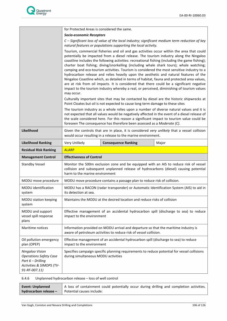
EA-00-RI-10060.03
Van Gogh, Coniston and Novara Drilling and Completions 106 of 126
for Protected Areas is considered the same. Socio-economic Receptors C – Significant loss of value of the local industry; significant medium term reduction of key natural features or populations supporting the local activity. Tourism, commercial fisheries and oil and gas activities occur within the area that could potentially be impacted from a diesel release. The tourism industry along the Ningaloo coastline includes the following activities: recreational fishing (including the game fishing); charter boat fishing; diving/snorkelling (including whale shark tours); whale watching; camping and eco-tourism activities. Tourism is considered the most sensitive industry to a hydrocarbon release and relies heavily upon the aesthetic and natural features of the Ningaloo Coastline which, as detailed in terms of habitat, fauna and protected area values, are at risk from oil impacts. It is considered that there could be a significant negative impact to the tourism industry whereby a real, or perceived, diminishing of tourism values may occur. Culturally important sites that may be contacted by diesel are the historic shipwrecks at Point Cloates but oil is not expected to cause long term damage to these sites The tourism industry as a whole relies upon a number of diverse natural values and it is not expected that all values would be negatively affected in the event of a diesel release of the scale considered here. For this reason a significant impact to tourism value could be foreseen The consequence has therefore been assessed as a Moderate (C).
Likelihood Given the controls that are in place, it is considered very unlikely that a vessel collision would occur resulting in a release to the marine environment.
Likelihood Ranking Very Unlikely Consequence Ranking Major
Residual Risk Ranking ALARP
Management Control Effectiveness of Control
Standby Vessel Monitor the 500m exclusion zone and be equipped with an AIS to reduce risk of vessel collision and subsequent unplanned release of hydrocarbons (diesel) causing potential harm to the marine environment
MODU move procedure MODU move procedure contains a passage plan to reduce risk of collision.
MODU identification system
MODU has a RACON (radar transponder) or Automatic Identification System (AIS) to aid in its detection at sea.
MODU station keeping system
Maintains the MODU at the desired location and reduce risks of collision
MODU and support vessel spill response plans
Effective management of an accidental hydrocarbon spill (discharge to sea) to reduce impact to the environment
Maritime notices Information provided on MODU arrival and departure so that the maritime industry is aware of petroleum activities to reduce risk of vessel collision.
Oil pollution emergency plan (OPEP)
Effective management of an accidental hydrocarbon spill (discharge to sea) to reduce impact to the environment
Ningaloo Vision Operations Safety Case Part 6 – Drilling Activities & SIMOPS (TV-91-RF-007.11)
Specifies campaign specific planning requirements to reduce potential for vessel collisions during simultaneous MODU activities
6.4.6 Unplanned hydrocarbon release – loss of well control
Event: Unplanned hydrocarbon release –
A loss of containment could potentially occur during drilling and completion activities. Potential causes include:

EA-00-RI-10060.03
Van Gogh, Coniston and Novara Drilling and Completions 107 of 126
loss of well control • Shallow gas; • Well kick; • Wellbore collision (existing production well); • Failure to keep the hole full;
• Working over live well; • Tripping/Swabbing; • Loss of primary and secondary well control; and • Failure to keep the correct mud density. In the event of a loss of containment, hydrocarbon may be released to the marine environment with the most likely release points at either the MODU floor (sea surface) or seabed. In the event of loss of containment at the MODU floor (sea surface) up to 352,185 m3 of crude oil may be released over a period of 11 weeks until the well is brought under control through the drilling of a relief well. For a release at the seabed, up to a predicted 270,777 m3 could be released over the same period. The crude oils within the Van Gogh, Coniston and Novara fields are well understood in terms of their properties and have been the subject of laboratory assays (Intertek 2007, 2009, 2010, 2012). In terms of their weathering behaviour and nature of impacts following a spill, these oils can be considered analogous; they are highly weathered heavy and persistent crude oils with a low proportion of volatile compounds and aromatic hydrocarbons. These characteristics are considered to apply to any oil encountered through drilling and completion activities carried out under this EP.
Potential receptors Fauna (including Threatened/ Migratory Fauna) – fish and sharks, marine reptiles, marine mammals, seabirds (refer Table 3-4) may be contacted by oil in offshore and shallow coastal waters/ shorelines. Areas important to marine fauna distributions which represent Key Ecological Features, and may be contacted within the EMBA, are listed in 4.2.2. Physical Environment/ Habitat – shoreline, intertidal and subtidal habitats (refer Section 4.2) may be contacted within the EMBA. Those habitats which represent Key Ecological Features and may be contacted within the EMBA are listed in Section 4.2. Protected Areas – refer Section 4.2 for Protected Areas that may be contacted within the EBMA. Socio-economic Receptors – commercial and recreational fishing, commercial shipping, oil and gas industry, tourism and natural cultural heritage areas may be contacted within the EMBA. Refer Section 4.2.
Potential Impacts Floating oil Impacts from floating oil include those from the physical smothering of marine flora, fauna and intertidal/shoreline habitats or chemical effects from contact or ingestion of oil by marine organisms at the sea surface or on shorelines. The degree to which impacts could occur will depend upon the level of coating (concentration of oil on the sea surface and/or loading of oil on shorelines). For oil floating on the sea surface a thickness equivalent to 10 g/m2 is considered the threshold for impact. Entrained oil Oil droplets entrained in the water column have the potential to coat benthic, intertidal and shoreline habitats and subtidal or intertidal organisms. The phenomena of smothering of submerged benthic habitats and those within tidal zones from water column oil has only been reported where very large oil spill quantities have affected these habitats or very sticky oil slicks have encountered exposed coral surfaces or polyps. For entrained oil, a concentration of >500 ppb is considered the threshold for impact. Dissolved Aromatic Hydrocarbons While there is some debate in the scientific literature (Barron et al., 1999), the main component of oil generally thought to be responsible for the majority of toxicity to wildlife is the Dissolved Aromatic Hydrocarbons (DAH) compounds that dissolve into the water

EA-00-RI-10060.03
Van Gogh, Coniston and Novara Drilling and Completions 108 of 126
column following a spill. Various studies indicate that the toxic effects of aromatic compounds result from the narcosis caused in biological receptors following exposure to low molecular weight aromatics including compounds from the BTEX group and 2−4 ring PAHs (French, 2000). A DAH concentration of >100 ppb has been considered the threshold for impacts. Given the highly weathered nature of the oils from the Van Gogh, Coniston and Novara fields, aromatic hydrocarbons comprise a very small proportion of fresh oil and DAHs have been modelled at only low concentrations following a spill and not above the impact threshold of 100 ppb. Impacts from floating or entrained oil are therefore considered of primary concern for the crude oil spills associated with activities under this EP. Socio-economic receptors Socio-economic receptors could be affected by hydrocarbon exposure in three key ways: 1. Restriction of access – for example, restriction of public access to areas of coastline
popular for tourism activities (e.g. camping and water activities); 2. Reduction in natural or cultural values – for example reduction in aesthetic values due
to oiling of specific features, habitats or landforms which have particular cultural or natural significance;
3. Loss of Income – for example reduction in catch for commercial fisheries due to loss of fishing habitat, access restrictions or fishing stock impacts. Reduction in tourism revenue from access restrictions to popular sites and/or damage/ loss of aesthetic value to habitats and features supporting tourism.
Protected areas It is considered that through the impact to fauna, flora and habitats or to socio-economic receptors (described above) the values of protected areas (e.g. Marine Parks, National Heritage Places and World Heritage Places) may also be diminished.
Consequence A summary of the consequence assessment for each receptor category is presented below. Fauna (including threatened/migratory fauna) D - Long term decrease in local population size and threat to local population viability. Major disruption to the breeding cycle of local population / occupancy of species / loss of habitat critical to survival of a species. Probable Fragmentation of existing population / Change of habitat to the extent that a long term decline in local population is likely / Introduction of disease. The highest potential consequence to fauna from a loss of well control was ranked as Major. This ranking was given to fauna from the Hot Spots of Ningaloo Coast (North and South), Muiron Islands, Carnarvon to Inner Shark Bay and Barrow Island. Collectively, these areas contain important populations of threatened/migratory fauna including nesting populations of marine turtles, seabirds/shorebird nesting/feeding areas and dugong/whale shark foraging areas. Oil concentration and shoreline loading in these areas was considered significant enough to result in a long term decline in a local population size, significantly disrupt an important life-cycle event or damage critical habitat for these species. Physical Environment/Habitat D - Major, large-scale loss of area and/or function of physical environment/ local habitat. Slow recovery over decades. The highest potential consequence to physical environment/ habitat from a loss of well control was ranked as Major. This ranking was given to the Hot Spots of Ningaloo Coast (North and South), Exmouth Gulf, Carnarvon to Inner Shark Bay and Barrow Island. Within these areas there is the potential for major losses and functions of local coral reefs, algae/seagrass areas, mangroves areas and intertidal mud/sand habitats, with recovery spanning over decades given toxicity (acute and potentially chronic) impacts associated with hydrocarbon exposure. Socio-economic receptors D - Major long-term loss of value of the local industry and threat to viability. Major

EA-00-RI-10060.03
Van Gogh, Coniston and Novara Drilling and Completions 109 of 126
reduction of key natural features or populations supporting the local activity. The highest potential consequence to socio-economic receptors from a loss of well control was ranked as Major. This ranking was given to the Ningaloo Coast North Hot Spot which supports a large tourism industry which relies on the natural attributes of the environment including the coral reef, the beaches, recreational fishing and whale shark aggregations. A loss of well control could significantly impact on these aspects of the environment and have a major loss of tourism revenue. Protected Areas D – Major long term effect on one or more of the protected area’s values. Long term decrease in species population contained within protected area and threat to that population’s viability, Major alteration, modification obscuring or diminishing of protected area values. The highest potential consequence to Protected Areas from a loss of well control was ranked as Major. This ranking was given to protected Hot Spots of Ningaloo Coast (North and South), Muiron Islands, Carnarvon to Inner Shark Bay and Barrow Island. Through Major impacts to Fauna, Physical Environment/ Habitat or Socio Economic values, a Major impact to the values of these protected areas was determined.
Likelihood Given the controls that are in place, it is considered rare that a loss of well control would occur.
Likelihood Ranking Rare Consequence Ranking Major
Residual Risk Ranking ALARP
Management Control Effectiveness of Control
Well operations management system
Well integrity control measures reduce the risk of unplanned discharges to the marine environment.
Well test procedures Includes control measures that reduce the risk of hydrocarbons from entering the marine environment
Oil pollution emergency plan (OPEP)
Effective management of an accidental hydrocarbon spill (discharge to sea) to reduce impact to the environment
6.4.7 Unplanned hydrocarbon release – damage to subsea infrastructure
Event: Unplanned hydrocarbon release – damage to subsea infrastructure
During activities covered under this EP, including MODU positioning, anchoring, kedging and lifting activities, there is the potential for dropped or dragged objects (e.g. anchors, chain, BOPs, drilling tools) to damage existing Quadrant Energy operated subsea infrastructure, including production wells and supporting subsea system (for example trees, manifolds, flowlines) within the WA-35-L permit potentially leading to a subsea release of hydrocarbons. A subsea release of hydrocarbons from damage to Quadrant Energy operated infrastructure within the WA-35-L permit has been previously detailed and assessed within the NOPSEMA-accepted Ningaloo Vision Operations Environment Plan (TV-00-RI-003) (specifically Section 7.7), being the EP relevant to the operation of the subsea infrastructure within that permit. Section 7.7.1 of that EP describes the failure scenarios and worst case credible releases from existing production wells and the subsea system due to external damage. The scenarios and worst case hydrocarbon release calculations are considered applicable to activities covered under this EP and should be referred to for further detail. From this information, the maximum credible hydrocarbon release from damage to the subsea system (e.g. trees, manifolds, flowlines and risers) is 327 m3 and the maximum credible release from an uncontrolled leak of an existing production well is 5,865 m3. Damage to subsea infrastructure could result in Van Gogh, Coniston or Novara crude oil being released or a mixture of these oils.
Potential receptors Fauna (including Threatened/ Migratory Fauna) – fish, marine reptiles, marine mammals, birds. A release would overlap with the following Key Ecological Feature (KEF): Continental

EA-00-RI-10060.03
Van Gogh, Coniston and Novara Drilling and Completions 110 of 126
Slope Demersal Fish Communities Physical Environment/ Habitat – subtidal bare sand habitat within the Defined Area. Also may overlap the following KEF: Canyons linking the Cuvier Abyssal Plain with the Cape Range Peninsula. Shoreline and intertidal habitats may be contacted along Ningaloo coast, Muiron Islands, Shark Bay, Southern Group Islands, Barrow Island, Montebello Islands and Lowendal Islands. Protected Areas – The following protected areas could be contacted: Gascoyne Commonwealth Marine Reserve, Ningaloo Commonwealth Marine Reserve, Shark Bay World Heritage Area, Shark Bay Marine Park, Ningaloo Coast World Heritage Area, Ningaloo Commonwealth Heritage Area, Ningaloo Marine Park, Muiron Islands Marine Management Area, Montebello and Barrow Islands Marine Conservation Reserves. Socio-economic Receptors – commercial fisheries, recreational fisheries, oil and gas industry, tourism, cultural heritage including Dirk Hartog Landing Site 1616 – Cape Inscription Area and historic shipwrecks at Point Cloates
Potential Impacts The impacts that could be expected from a release of crude oil from the subsea system are the same as those described for a loss of well control (Section 6.4.6). Impacts could occur from floating oil at the sea surface or entrained oil, impacts from dissolved aromatic hydrocarbons are unlikely given modelling did not predict the impact threshold of 100 ppb to be reached.
Consequence Fauna D - Long term decrease in local population size and threat to local population viability; major disruption to the breeding cycle of local population; major reduction in area of occupancy of species; fragmentation of existing population; major loss of habitat critical to survival of a species; modify, destroy, remove, isolate or decrease availability or quality of habitat to the extent that a long term decline in local population is likely; introduce disease likely to cause a long term population decline. Floating oil above 10 g/m2 may occur up to 80 km from the release site although no oil above this threshold is predicted to contact near shorelines or shallow waters. Threatened/migratory fish, birds, marine mammals and marine reptiles are susceptible to oiling at the sea surface but given that aggregation areas are not known within predicted oil distribution at this threshold, effects to a significant proportion of a population or during key life-cycle stages is not expected. While oil floating on the water’s surface is not considered to impact on key life-cycle processes the loading of oil could occur along beaches used by marine turtles during nesting season. For example a significant nesting site for loggerhead turtles exists at Muiron Islands where oil could accumulate to up to 112 m3. Turtle nesting sites are also present along the Ningaloo Coastline where oil could accumulate up to a worst case predicted volume of 230 m3. Bird nesting, roosting and feeding, primarily concentrated at the areas of Mangrove Bay, Mangrove Point, Mildura wreck site, Point Maud and Fraser Island, may also be impacted directly from the presence of oil stranded on shorelines or indirectly from oiled habitat (e.g. mangrove roosting areas and intertidal feeding areas). Entrained oil is less likely to affect threatened/migratory fauna and acute chemical effects are unlikely due to the weathered nature of the oil. Ingestion by fish/sharks and cetaceans could potentially occur and lead to physical impacts (e.g. clogging of gills). While not a threatened fauna, demersal fish that make up Continental Slope Demersal Fish Communities could be contacted by entrained oil. Given the relatively large size of this KEF compare to the area within which entrained oil would be above the impact threshold of 500 ppb, a significant proportion of the population would not expected to be affected. Neither entrained oil >500 ppb or DAHs >100 ppb were predicted by spill fate modelling to extend close the Ningaloo Reef, and therefore the fish and invertebrate communities associated with the coral reef are not expected to be impacted. Impacts from floating and stranded oil are such that important life-cycle events for local populations of threatened/migratory species (specifically nesting turtles) may be significantly disrupted and therefore a consequence ranking of Major (D) was assessed.

EA-00-RI-10060.03
Van Gogh, Coniston and Novara Drilling and Completions 111 of 126
Physical Environment/ Habitat D - Major, large-scale loss of area and/or function of physical environment / local habitat. Slow recovery over decades. Subtidal habitat comprising bare sand with a sparse epifaunal community would be expected to be contacted by oil above an impact threshold of 500 ppb in the vicinity of the release site. Intertidal and shoreline habitats, which could include sandy beaches, rocky shorelines, mangrove, coral, seagrass and macroalgae could be contacted on shorelines with oil accumulating up to a maximum volume of 230 m3 along the Ningaloo coastline. Mangrove habitats are expected to be most sensitive to accumulations of crude oil along shorelines; mangrove habitat exists along Ningaloo coastline and Barrow/Montebello and Lowendal Islands, which may receive accumulations of oil. Sandy Beaches important for turtles nesting may also receive loadings of oil. Slowest recovery would be expected from impacted mangroves given the natural rates of growth for these habitats. Dependent upon the level of infiltration of oil within beach and intertidal mudflat sediments, chronic effects may be felt within invertebrate communities (primarily infauna) associated with these habitats. Based on the above, slow recovery to habitats may occur, particularly for affected mangrove areas. Conservatively, a Major (D) consequence has been determined. Protected Areas D - Major long term effect on one of more of protected area’s values; long term decrease in species population contained within protected area and threat to that population’s viability; major alteration, modification, obscuring or diminishing of protected area values. A number of protected areas could be contacted, primarily from the loading of oil on shorelines, although the offshore protected areas of Gascoyne and Ningaloo Commonwealth Marine Reserves may be contacted by floating oil above a threshold of 10 g/m2. The Ningaloo Coast World Heritage Area (which includes the Ningaloo Commonwealth Marine Reserve and Ningaloo Marine Park) is considered to be the protected area of most concern given its globally recognised protected status and largest potential volume of accumulated oil. Protected Areas that may be contacted by diesel above threshold concentrations are the Gascoyne Commonwealth Marine Reserve and Ningaloo Coast World Heritage Area (which includes the Ningaloo Commonwealth Marine Reserve and Ningaloo Marine Park). The Ningaloo Coast World Heritage Area has important aesthetic values which would be diminished by diesel reaching near shorelines. The natural values of the area include those habitats previously discussed including the outer coral reef system, lagoon system including areas of coral, seagrass and macroalgae, shoreline habitats including pristine beaches (some important for turtles) and mangrove/mudflat areas. Important fauna of the protected area are the marine turtles, whale sharks, manta rays, cetaceans (humpback whales, dolphins and dugongs), bird life and the invertebrate/fish community supported by the coral reef habitat. Given that habitat and fauna values may be impacted to the extent where a Major environmental consequence could be predicted, the consequence for Protected Areas is considered the same. Socio-economic Receptors C – Significant loss of value of the local industry; significant medium term reduction of key natural features or populations supporting the local activity. Impacts to culturally important sites such as the Dirk Hartog Landing National Heritage site and historic shipwrecks at Point Cloates (Ningaloo coastline) may be contacted by floating oil but oil is not expected to cause long term damage to these sites. Impacts to fisheries are not expected to be large due to the small area of effect of entrained oil above an impact threshold of 500 ppb. Some disruption to fishing practices may occur in the area around the release site but not expected to threaten the viability of any fisheries. Tourism is the socio-economic receptor most likely to be impacted from a hydrocarbon release with shoreline accumulation of oil possible at high value tourist areas such as the Ningaloo coastline.

EA-00-RI-10060.03
Van Gogh, Coniston and Novara Drilling and Completions 112 of 126
Likelihood Ranking Very Unlikely Consequence Ranking Major
Residual Risk Ranking ALARP
Management Control Effectiveness of Control
MODU move procedure No accidental contact with the seabed and subsea infrastructure during the MODU move limiting seabed disturbance and preventing hydrocarbon release.
MODU station keeping system
Maintains the MODU at the desired location reduce risks to seabed habitat and petroleum infrastructure.
Dropped object prevention procedures
Minimises drop object risk during MODU lifting operations that may result in damage to subsea infrastructure
Oil pollution emergency plan (OPEP)
Effective management of an accidental hydrocarbon spill (discharge to sea) to reduce impact to the environment
Ningaloo Vision Operations Safety Case Part 6 – Drilling Activities & SIMOPS (TV-91-RF-007.11)
Specifies campaign specific planning requirements to reduce potential for damage to Ningaloo Vision infrastructure from simultaneous MODU activities

EA-00-RI-10060.03
Van Gogh, Coniston and Novara Drilling and Completions 113 of 126
7. HYDROCARBON SPILL RESPONSE ARRANGEMENTS
There are numerous oil spill response strategies available to be implemented in the event of a spill. These are generally based on strategies which have been implemented in the past or considered to be good industry practice. The evaluation of the suitable response strategies was conducted based on the credible spill scenarios identified.
The following response strategies may be applicable to the identified credible spill scenarios:
• Operational Monitoring, including: o Vessel surveillance; o Aerial surveillance; o Tracking buoys; o Satellite imagery; o Unmanned aerial vehicles; o Entrained oil surveillance; o Oil sampling and analysis; o Operational water quality monitoring; and o Spill fate modelling.
• Source Control activities, including the following strategies applicable for a loss of well control: o Subsea first response toolkit (SFRT) deployment including subsea dispersant application, o Capping Stack installation; and o Relief well drilling.
• Offshore containment and recovery of oil; • Application of chemical dispersants at surface (aerial and vessel application) and/or subsea (SFRT); • Deployment of booms for shoreline protection; • Shoreline clean-up operations; • Wildlife response operations including hazing and capture and rehabilitation; and • Scientific monitoring to assess oil impact and recovery.
Further detail on the environmental benefits on implementing these strategies is provided in Table 7-1 below.
7.1 Preparedness and Implementation of Response arrangements
Quadrant Energy will implement its OPEP in the event of a significant hydrocarbon spill (tier 2 or 3). In order to maintain a state of oil spill preparedness, personnel with OPEP responsibilities are trained and tested through drills and exercises, oil spill response equipment is inspected, tested and maintained, contracts with critical equipment and personnel suppliers are managed and maintained and agreements are in place with national regulatory agencies for support in oil spill response.
Section 7.3 provides an overview of agencies and organisations that Quadrant Energy maintains and ongoing relationship with and which would be utilised in an oil spill response.
Quadrant Energy implements an emergency response exercise and training schedule. This includes regular testing of spill response equipment, testing of critical emergency response communications channels prior to activity commencement and regular exercising of Quadrant Energy emergency response personnel and systems. Regular major exercises are undertaken, re-enacting major spill incidents, which involves the activation of Quadrant Energy’s incident response systems, facilities and personnel and which involves coordination with external agencies and support organisations. More frequent functional workshops, field based equipment deployments and facility-based drills are also undertaken which maintain the competency of Quadrant Energy personnel that make up the Perth-based Incident Management and Crisis Management Teams as well as field-based Incident Response Teams.

EA-00-RI-10060.03
Van Gogh, Coniston and Novara Drilling and Completions 114 of 126
Table 7-1: Assessment of spill response strategies
Strategy Description Environmental Benefits Adopted/Reject
Source control As part of a source control plan for loss of well control, the key controls include:
• deployment of subsea first response toolkit (SFRT); • installation of a capping stack (for subsea blowout
only);
• drilling a relief well
The drilling of a relief well, to stop the flow of hydrocarbons from the reservoir, is considered to be the primary control in event of a loss of well control and will be implemented regardless of any other controls in place. This control when implemented successfully will prevent further loss of hydrocarbon to the environment. Installation of a capping stack to limit the release of hydrocarbons is another source control method which is feasible for subsea wells drilled using a semi-submersible MODU. Quadrant Energy has access to two units (Aberdeen and Singapore). A SFRT includes equipment to clear the area around the wellhead, to enable intervention and prepare for relief well drilling. This includes a subsea dispersant injection kit, which can be utilised for subsea chemical dispersant application; see ‘Subsea Chemical Dispersant’ below for its details.
Adopt
Subsea chemical dispersant
Subsurface chemical dispersant involves dispersant applied directly into the wellhead location at the release point. Subsea chemical dispersant injection is used to disperse the oil either to enable safe implementation of the subsequent controls (e.g. capping stack installation) and/or to enhance dispersion in the water column and avoid/reduce floating oil reaching shorelines.
Subsea chemical dispersant injection can aid in application of source control activities or provide and environmental benefit by reducing the amount of oil expressing at the sea surface and potentially reaching shoreline areas. Conversely, this technique will increase the volume of oil retained within the water column; this may increase impacts to organisms within the water column and subsea habitats. Subsea chemical dispersant application is considered a suitable response strategy for a subsea blowout scenario. The decision for application of this response will be subject to a NEBA.
Adopt
Monitor and evaluate
Surveillance actions are used to monitor and evaluate the trajectory and fate of the released hydrocarbon, to determine the effectiveness of response strategies and to identify and report on any potential/actual contacts to flora, fauna, or any other sensitive receptor that occurs. Surveillance results are used to assist in escalating or de-escalating response strategies as required.
There are various specific control measures (vessel/aerial surveillance, tracking buoys, entrained oil monitoring, oil spill modelling, remote sensing/satellite imagery) within this response strategy which may be suitable. Their use, in combination or individually, will be determined based on the spill distribution as well as other considerations such as access to locations, environmental and metocean conditions. This strategy is vital to ensure that there is sufficient information to gain situational awareness and make informed decisions on response planning and execution.
Adopt

EA-00-RI-10060.03
Van Gogh, Coniston and Novara Drilling and Completions 115 of 126
Strategy Description Environmental Benefits Adopted/Reject
Scientific Monitoring
This is the main tool for determining the extent, severity and persistence of environmental impacts from an oil spill and allows operators to determine whether their environmental protection outcomes have been met (via scientific monitoring activities). This strategy also evaluates the recovery from the spill.
Scientific monitoring is especially beneficial for the purpose of monitoring entrained and dissolved oil impacts as response strategies are generally targeted to manage the floating oil impacts.
Adopt
Physical dispersion
Physical dispersion is undertaken by running vessels through the hydrocarbon plume and using the turbulence developed by the propellers or hydro-blasting from vessel hydrants to break up the slick. Once dispersed in the water column in the form of smaller droplet sizes, biodegradation processes are enhanced.
Oil: Physical dispersion is unlikely to be applied due the nature of the oil type – a highly weathered oil which does not entrain easily. Diesel: Physical dispersion is unlikely to be applied due to the nature of the product—preferentially relying on evaporation rather than dispersing toxic components of the fuel into the water column. In general, this strategy is considered to be an opportunistic strategy; used on targeted, small, breakaway areas thus achieving low beneficial outcomes. In view of the above, physical dispersion is not considered to be a suitable or effective response strategy.
Reject
Surface chemical dispersion
Chemical dispersant is applied to break down the hydrocarbons and allow/enhance dispersion into the water column, thereby preventing/reducing potential shoreline contact and increasing biodegradation.
The application of dispersants at the sea surface can reduce the volume of oil floating at the sea surface and potentially reaching shorelines. Surface chemical dispersant is considered a viable option for reduction in shoreline loading on the basis of spill fate modelling conducted with addition of dispersant scenarios The oil is a highly weathered persistent crude with the best window of opportunity for dispersant application being 0-12 hours following release. Beyond this, the ability of effective chemical dispersion is considered to be reduced. The decision for application of this response will be subject to a NEBA. Applicability given dispersant addition is predicted to increase the concentration of entrained oil near sensitive receptors in some environmental conditions
Adopt
Containment and recovery
Containment and recovery of hydrocarbons can offer a preventive form of protection to sensitive receptors. Skimmers (mechanical) and booms will be used at sea. This strategy is only effective in calm conditions.
For a spill resulting from this Activity, containment and recovery is a key strategy. The oil is highly weathered, of high viscosity and it is not easily entrained. Therefore, removal of floating oil is a key activity. The decision for application of this response will be subject to a NEBA.
Adopt

EA-00-RI-10060.03
Van Gogh, Coniston and Novara Drilling and Completions 116 of 126
Strategy Description Environmental Benefits Adopted/Reject
Protection and deflection
Protection and deflection activities involve the use of booms to: 1. Protect sensitive receptors; 2. Deflect spills away from sensitive receptors or
shorelines; or 3. Deflect spills to an area that provides increased
opportunity for recovery activities. This strategy is typically not effective in areas experiencing large tidal variations and associated currents.
Activities are focused on areas of high protection value in low energy environments based upon real time operational surveillance provided the environmental and metocean conditions are favourable for an effective implementation. Consequently, this strategy may not be applicable across all hotspots or receptors identified as priority for protection. The decision for application of this response will be subject to a NEBA.
Adopt
Shoreline clean-up
During a spill response, clean-up of the oiled shorelines will be implemented using suitable methods, provided it will be beneficial to the environment based on the NEBA performed on the affected areas based on actual site conditions.
Contacted shorelines will be assessed for their shoreline clean-up potential. This response has the potential to cause secondary disturbance associated with the clean-up, so applicability of the strategy is based on aerial surveillance reconnaissance, Oiled Shoreline Response Team (OSRT) observations and NEBA in the shoreline clean-up assessment. Natural recovery with a close monitoring program (i.e. scientific monitoring) is the preferred clean-up technique for reefs being submerged periodically. High volume, low pressure flushing may be considered if the oil enters high priority/ slow recovery habitats such as mangroves, permanently emerged reefs or wetlands.
Adopt
Oiled wildlife response (OWR)
Responding to an oiled wildlife incident will involve an attempt to prevent wildlife from becoming oiled and/or the treatment of animals that do become oiled.
As various hotspots with importance for marine wildlife have been identified to be threatened by the oil spill, mobilisation of a wildlife response will likely be necessary. Mobilisation of experts, trained work forces, facilities and equipment will then be needed. Wildlife response activities may take place at sea, on shorelines and in specialised facilities further inland. Options for wildlife management have to be considered and a strategy determined guided by the Western Australian Oiled Wildlife Response Plan (WAOWRP).
Adopt
In-situ burning In situ burning is a technique sometimes used in responding to an oil spill. In situ burning involves the controlled burning of oil that has spilled (from a vessel or a facility), at the location of the spill. When conditions are favourable and conducted
Operational constraints expected during a spill from the Activities suggest in-situ burning is not applicable. For in-situ burning to be undertaken oil has to be thicker than 1-2 mm and able to be ignited. Theo-3 crude oil has a high flash point (> 110 °C) and a low proportion of volatile components compared to other heavy crude oils and, consequently, it is likely difficult to
Reject

EA-00-RI-10060.03
Van Gogh, Coniston and Novara Drilling and Completions 117 of 126
Strategy Description Environmental Benefits Adopted/Reject
properly, in situ burning will reduce the amount of oil on the water.
initiate and sustain ignition without addition of accelerant.. Diesel tends to have high evaporation rates and spreads into very thin films rapidly. In addition, in-situ burning requires containment. Containment limitations are listed above (refer ‘Containment and Recovery’ strategy). Due to operational constraints and the expected hydrocarbon not being suitable for in-situ burning, this response strategy is deemed inapplicable for this Activity.
EA-00-RI-10060.03
Van Gogh, Coniston and Novara Drilling and Completions 118 of 126
7.2 Net Environmental Benefit Analysis
Net Environmental Benefit Analysis (NEBA) is a structured approach used by the response community and stakeholders to select spill response strategies that will effectively remove oil, are feasible to use safely in particular conditions, and will reduce the impact of an oil spill on the environment.
The NEBA process is used during pre-spill planning (Strategic NEBA) and during a response (Operational NEBA). A Strategic NEBA is an integral part of the contingency planning process and is used to ensure that response strategies for scenarios are well informed. An Operational NEBA is used to ensure that evolving conditions are understood, so that response strategy can be adjusted as necessary to manage individual response actions and end points.
Balancing trade-offs may involve differing and conflicting priorities, values and perceptions of the importance of sensitive receptors. There is no universally accepted way to assign perceived value or importance and is not a quantitative process. Overall, the NEBA process provides an estimate of potential environmental effects which are sufficient to allow the parties to compare and select preferred combinations of response strategies to reduce environmental impacts to ALARP.
7.3 Oil Spill Response Resources
Oil spill response equipment and resources are a combination of Quadrant, AMOSC (Australian Marine Oil Spill Centre Pty Ltd), AMSA, DoT, National Plan (NatPlan), OSRL (Oil Spill Response Limited), and other operator resources available through the AMOSPlan mutual aid arrangements. Under the Memorandum of Understanding (MOU) between AMSA and Quadrant, AMSA will provide all resources available through NatPlan to support a Quadrant spill response. The DoT coordinates the State Response Team (SRT) oil spill response personnel and equipment resources. The DoT will work with Quadrant in an oil spill response and will define termination criteria for the shoreline operations designed to reduce the environmental impacts and risk to as low as reasonably practicable (ALARP) in State waters. Where oil contacts shorelines in Commonwealth waters, Quadrant will work with the Department of the Environment to establish shoreline clean-up priorities, activities and termination criteria.
In the event of an oiled wildlife response, Quadrant will activate the West Australian Oiled Wildlife Response Plan (WAOWRP) and work with DPaW in determining resources and capability requirements. DPaW and Industry (AMOSC) Oiled Wildlife Advisors (OWAs) ensure minimum standards for oiled wildlife response, as outlined within the WAOWRP, are met and ensure timely mobilisation of appropriate resources (equipment and personnel) through communication with the wildlife logistics team. Quadrant are able to access:
• AMOSC core group responders; • DPaW staff and approved volunteers/subject matter experts; • Additional local resources under current contracts and suppliers; and • Access international support through Wildlife Response Services.
During and post-spill scientific response monitoring activities require resources external to Quadrant and include specialist technical capabilities. Astron Environmental Services Pty Ltd (Astron) is contracted as Quadrant’s primary control support agency for scientific response monitoring activities. If additional support is required, Quadrant has Master Service Agreements with other service providers to support scientific response monitoring activities

EA-00-RI-10060.03
Van Gogh, Coniston and Novara Drilling and Completions 119 of 126
8. IMPLEMENTATION STRATEGY AND MANAGEMENT APPROACH
Performance review and continuous improvement of Quadrant Energy offshore exploration and production activities is owned and maintained at a company level by the CEO.
Environmental performance outcomes and standards are set each within the EP and three specific methods are used to effectively monitor, measure and review the performance of the HSE-Management System:
• Audits and checks (Section 8.1.1); • Monitoring (Section 8.1.2); and • Reviews (Section 8.1.3).
Continuous improvement is achieved by addressing audit and management review outcomes. Focus shall be given on improving processes in which performance outcomes and standards are not achieved.
8.1.1 Audits and checks
An audit is a systematic examination and evaluation against defined criteria and performance indicators to determine whether activities/processes and related results conform to planned arrangements, whether these arrangements are implemented effectively, and if they are suitable to achieve Quadrant Energy’s Mission, Core Values and Policy. Audit plans and schedules are reviewed and updated at the beginning of each year.
Audits enable Quadrant Energy to:
• Assess the scope and effectiveness of its policies and activities; • Identify those aspects of the management system that are or are not working well; and • Plan improvements to these operations.
HSE checks are informal in nature and not conducted in accordance with a specific procedure. As with HSE audits, HSE checks generally assess compliance but they are specific, narrow and repetitive in focus. They can range from regular desk top inspections of specific documents or IT systems to regular onsite visual inspections of equipment, tools, and working environments. Non-conformance actions identified during HSE checks are corrected on the spot or individually tracked to closure.
HSE audits and checks are scoped and scheduled in accordance with HSE Audits and Checks Planning (EA-91-IG-003).
8.1.2 Monitoring
The effectiveness of performance review and continuous improvement system is monitored using the following:
• Audits, checks and reviews and executed on time and in line with scheduling requirements in specified procedures and processes;
• All corrective actions from HSE audits, checks and reviews are appropriately validated; • All corrective actions from HSE audits, checks and reviews are effectively closed in a timely manner
and appropriately documented; • The HSE Performance Dashboard is updated and reviewed quarterly with the HSE Oversight
Committee; and • Actions in Region HSE Plan are effectively implemented on time.
8.1.3 Review and improvement of environmental performance
Environmental performance during offshore exploration and production activities will be continually improved by focusing on:
• Feedback on HSE audit and check procedures from audit teams and the HSE Oversight Committee; • Actions identified in the review of HSE audit and check related performance indicators such as on time
execution and close out of corrective actions; and

EA-00-RI-10060.03
Van Gogh, Coniston and Novara Drilling and Completions 120 of 126
• Actions identified from HSE audit and incident investigation.
8.2 Management and review of the EP
MODU contractors are required to maintain current versions of HSE documents on their facilities. In particular, EPs and OPEPs will be controlled documents and be available to employees and contractors involved in the Activity.
Technical operational reports (e.g. daily mud reports, cementing reports etc.) that contain HSE information will also be made available during environmental performance reviews.
Prior to commencing each drilling campaign, Quadrant Energy’s Drilling Superintendent will ensure the EP is reviewed to make sure the proposed activities are not contrary to the EP, stakeholder consultation requirements have been fulfilled, compliance requirements can be met and measures are in place to address any previous lessons learned (e.g. documented in incident, audit and performance reports)
Changes that may have an impact on an EP or OPEP, which may include a change to the activity, change to the level of impact or risk, a new impact or risk, new stakeholder feedback, new legislation or guidance or change to control measures, will be made in accordance with Quadrant Energy’s Environmental Management of Change Procedure (EA-91-IQ-10001) (MoC). The MoC procedure will determine whether a revision of the EP or OPEP is required and whether that revision is to be submitted to NOPSEMA pursuant to Regulation 17 of the OPGGS (E) Regulations. The MoC process incorporates an impact and risk assessment of the proposed change to assess whether the change(s) constitutes a significant new, or significantly increased, impact or risk. The MoC process also requires an assessment of whether the change still results in impacts and risks being reduced to ALARP. MoC documents and associated EP will be tracked on an MOC register, which will be available on Quadrant Energy’s intranet.
8.3 Stakeholder consultation
All correspondence with external stakeholders is recorded in the stakeholder database and Quadrant Energy will remain available before, during and after completion of the activity. Concerns when raised will be listed against contact details for the relevant activity personnel and consultation material will be provided to relevant personnel as required.
Quadrant Energy has communications procedures for the life of the project as detailed in the Quadrant Energy Stakeholder Consultation Strategy (AE-91-RG-10002). In accordance with the strategy, Quadrant Energy will maintain two-way communications with stakeholders regarding the activity and all current or proposed activities undertaken on the NW Shelf.
For further information on stakeholder consultation refer to Section 5.
8.4 Performance Review and Continuous Improvement
Annual HSE reviews have an agreed Terms of Reference prior to starting and results are documented in a written close-out report. HSE reviews are generally focused on the effectiveness of, rather than compliance with, specific management systems or agreed plans, procedures and processes in achieving Quadrant Energy’s Health & Safety and Environment Policies.
Department Managers schedule HSE reviews covering part or all of their activities as annually or as required based on feedback from incidents, review of HSE performance indicators, general management of the department’s activities. Reviews will also evaluate the need for changes in light of:
• Changing legislation; • Changing businesses activities and environments; • Changing science and technology; and • Changing societal and stakeholder expectations.
Provided below is additional information on the mechanisms by which these requirements are achieved.

EA-00-RI-10060.03
Van Gogh, Coniston and Novara Drilling and Completions 121 of 126
8.4.1 Stakeholder consultation
Ongoing EP-specific and company-wide stakeholder consultation commitments detailed in Section 5 will be assessed to identify changing societal and stakeholder expectations.
8.4.2 Facility inspections
During a drilling program frequent HSE facility inspections, and equipment performance and preventative maintenance inspections, will be conducted to identify incidents and risks.
8.4.3 After action reviews (AARs)
AARs will be completed to identify opportunities for job performance improvement, including HSE risk reduction.
8.4.4 Changing science and technology
As new science and technology information becomes available, it will be reviewed and included into the EP and ALARP assessments.
8.4.5 Audits and management of non-conformance
Quadrant Energy will audit the MODU and support vessels in accordance with a scheduled environmental audit program. Based on current practices, the MODU will be audited every six months and support vessels every 12 months. The audits will be undertaken in a manner consistent with Quadrant Energy’s Environmental Auditing and Inspection Procedure (EA-91-IG-003) and Safety Health & Environmental Audit and Inspection Protocol (AE-91-IQ-015).
The audit criteria will include EP environmental performance outcomes and standards, and depending on the audit objectives, potentially commitments made within the implementation strategy.
Audit non-conformances and corrective actions taken will be tracked using Quadrant Energy’s incident management systems (i.e. Enablon). Audit findings will be shared between Quadrant Energy-contract MODUs and support vessels as a continual improvement initiative.
9. CONTACT DETAILS
Further information about the Van Gogh, Coniston and Novara drilling and completions Activity can be obtained from:
Ashlee Crabbe
Consultation Coordinator
100 St Georges Terrace, Perth, 6000
6218 4972

EA-00-RI-10060.03
Van Gogh, Coniston and Novara Drilling and Completions 122 of 126
10. REFERENCES
AHC (2006) Cape Range National Park and Surrounds, Exmouth, WA. A WWW publication accessed December 2006 at http://www.deh.gov.au. Australian Heritage Commission, Canberra.
Allen GR & Russell BC (1986) Fishes. Part VII. In "Faunal surveys of the Rowley Shoals, Scott Reef and Seringapatam Reef, north-western Australia" by P.F. Berry (ed.), Records of the Western Australian Museum Supplement No. 25. Western Australian Museum, Perth. pp 75-103
Amoser S & Ladich F (2005) Are Hearing Sensitivities of Freshwater Fish Adapted to the Ambient Noise in their Habitats? Journal of Experimental Biology, 208: 3533–3542
Barron MG, Carls MF, Heintz R & Rice SD (2004) Evaluation of Fish Early Life-Stage Toxicity Models of Chronic Embryonic Exposures to Complex Polycyclic Aromatic Hydrocarbon Mixtures. Toxicological Sciences 78: 60-67
Bartol MS & Musick JA (2003) Sensory biology of sea turtles. In: Lutz, P.L., Musick, J.A., Wyneken, J. (eds). Biology of sea turtles, Vol II. CRC Press, Boca Raton, FL, pp. 79-102
Berry PF & Morgan GJ (1986) Decapod Crustacea of Scott and Seringapatam Reefs. Part V. In "Faunal surveys of the Rowley Shoals, Scott Reef and Seringapatam Reef, north-western Australia" by P.F. Berry (ed.), Records of the Western Australian Museum Supplement No. 25. Western Australian Museum, Perth. pp 59-62
Brewer DT, Lyne V, Skewes TD, Rothlisberg, P (2007) Trophic systems of the North West Marine Region. Report to the Australian Government Department of the Environment and Water Resources, CSIRO, Cleveland
CALM (1996) Shark Bay Marine Reserves. Management Plan. 1996-2006. Marine Conservation Branch, Management Plan No. 34. Department of Conservation and Land Management.
CALM (2005) Management Plan for the Ningaloo Marine Park and Muiron Islands Marine Management Area 2005 – 2015 Management Plan No. 52. Department of Conservation and Land Management, Perth, Western Australia.
Cardno Ecology Lab (2011) Quadrant Energy Coral Monitoring Programme 2010. Report prepared for Quadrant Energy Energy Limited. July 2011
Commonwealth of Australia, 2002. Ashmore Reef National Nature Reserve and Cartier Island Marine Reserve Management Plans. Environment Australia.
Commonwealth of Australia (2003) Recovery Plan for Marine Turtles in Australia. Prepared by the Marine Species Section Approvals and Wildlife Division, Environment Australia in consultation with the Marine Turtle Recovery Team, July 2003
Commonwealth of Australia (2007) Commonwealth of Australia Gazette No. S127, 3 July 2007, Inclusion of a Place in the National Heritage List, Dampier Archipelago (including Burrup Peninsula). Published by the Commonwealth of Australia
Commonwealth of Australia (2015) Conservation Management Plan for the Blue Whale—A Recovery Plan under the Environment Protection and Biodiversity Conservation Act 1999, Commonwealth of Australia.
Costello MJ & Read P (1994) Toxicity of sewage sludge to marine organisms: A review. Mar Env Res 37: 23–46
CSIRO (2001) Analysis of monitoring data from the Stag Field (1997 – 1998). Report to Quadrant Energy Energy
DAFF (2011) Australian Ballast Water Management Requirements. Department of Agriculture, Fisheries and Forestry - Biosecurity. Canberra. Version 5, November 2011

EA-00-RI-10060.03
Van Gogh, Coniston and Novara Drilling and Completions 123 of 126
DEC (2005) Jurien bay Marine Park Management Plan 2005– 2015, Management plan number 49. Department of Environment and Conservation, Perth, Western Australia DEC (2007a) Management Plan for the Montebello/Barrow Islands Marine Conservation Reserves 2007–2017: Management Plan No. 55. Department of Environment and Conservation, Perth, Western Australia.
DEC (2007b) Management Plan for the Rowley Shoals Marine Park 2007–2017: Management Plan No. 56. Department of Environment and Conservation, Perth, Western Australia.
DEWHA (2008) The North-west Marine Bioregional Plan: Bioregional profile: A Description of the Ecosystems, Conservation Values and Uses of the North-West Marine Region. Department of the Environment Water, Heritage and the Arts, Canberra, ACT.
DEWHA (2010) Ningaloo Coast World Heritage Nomination. Department of the Environment, Water, Heritage and the Arts, Canberra, Australia. Available at < http://www.environment.gov.au/node/19787> [Accessed April 2014]
Director of National Parks (2014). Christmas Island National Park. Management Plan 2014 – 2024. Australian Government Director of National Parks. Canberra 2014
DoE (2014) Commonwealth marine reserves. Department of the Environment, Canberra, Act. Available at http://www.environment.gov.au/topics/marine/marine-reserves [Accessed on 02 April 2014]
DoE (2014d) Australian Heritage Database. Available at http://www.environment.gov.au/cgi-bin/ahdb/search.pl [Accessed April 2014]
DSEWPaC (2012) Marine bioregional plan for the North-west Marine Region. Department of Sustainability, Environment, Water, Population and Communities, Canberra, ACT. 269 pp.
DSEWPaC (2012b) (Department of Sustainability, Environment, Water, Population and Communities) (2012) Commonwealth marine environment report card. Commonwealth of Australia
DSEWPaC (2013) Shark Bay, Western Australia, Work Heritage Values. [Online, retrieved 17 July 2013] Available at: http://www.environment.gov.au/heritage/places/world/shark-bay/values.html
Enesar. (2007). Seabed characterisation. Van Gogh Development WA-155-P(1)(Defined Area). Report prepared by Enesar Consulting, Perth, for Apache Energy Ltd, Perth.
Falkner I, Whiteway T, Przeslawski R, Heap AD (2009) Review of ten key ecological features in the Northwest Marine Region. Record 2009/13, Geoscience Australia, Canberra
Fletcher WJ & Santoro K (Eds). (2013) Status Reports of the Fisheries and Aquatic Resources of Western Australia 2012/13: The State of the Fisheries. Department of Fisheries, Western Australia
French DP (2000) Estimation of oil toxicity using an additive toxicity model. Proceedings of the 23rd Arctic and Marine Oil Spill Program Technical Seminar, June 2000, Vancouver, British Columbia, Canada (561-600)
Frilingos N (1985) Nutrient conditions in the Euboikos Gulf (west Agean). Mar Poll Bull. 16(11): 435–439
Gordon J, Gillespie D, Potter J, Frantzis A, Simmonds MP, Swift R & Thomson D (2004) A Review of the Effects of Seismic Surveys on Marine Mammals. Marine Technology Society Journal, 37: 16–34
Hale, J., Butcher, R., 2013. Ashmore Reef Commonwealth Marine Reserve Ramsar Site ecological character description (A report to the Department of the Environment). Department of the Environment, Canberra.
Hatcher BG (1988) Australia, Western. In "Coral Reefs of the World. Volume 2: Indian Ocean, Red Sea and Gulf" by S.M. Wells (ed.) UNEP, Nairobi, Kenya and IUCN, Gland, Switzerland. pp 1-26
Houser, D. S., Helweg, D. A and Moore, P. W. B. (2001). A Bandpass filter-bank model of auditory sensitivity in the humpback whale. Aquatic Mammals 27.2: 82-91.
IRC (2007) Annual Marine Monitoring Program – 2006. Persistence and Impacts of Synthetic-based Muds. Unpublished report to Quadrant Energy Energy Ltd, 2007

EA-00-RI-10060.03
Van Gogh, Coniston and Novara Drilling and Completions 124 of 126
IRC (2007a) Annual Marine Monitoring Program – 2006 Coral Monitoring. Unpublished report to Apache Energy Ltd, 2007
IRC (2011) Review of Diesel Toxicity to the Marine Environment. Commissioned by Apache Energy, DOC NO: E-REP-00-101-400-REV-0
IRCE (2001) Stag Oilfield Environmental Monitoring 2000 Survey. Report to Apache Energy Limited, September 2001.
IRCE (2003) Environmental monitoring of drilling discharges in shallow water habitats. Report to Quadrant Energy Energy Ltd, June 2003
IRCE (2003) Environmental monitoring of drilling discharges in shallow water habitats. Report to Quadrant Energy Energy Ltd, June 2003
IRCE (2004) Biannual Coral Monitoring Survey 2004. Unpublished report prepared by IRC Environment for Quadrant Energy Energy Ltd., Perth, Western Australia
IRCE (2005) Seabed survey around the Victoria and Simpson Bravo Platforms. Report to Quadrant Energy Energy Ltd, February, 2005
IRCE (2006) Biannual Macroalgae Monitoring Survey 2005. Unpublished report to Quadrant Energy Energy Ltd, 2006
IRCE (2006a) Impacts of synthetic-based drilling muds on shallow-water marine environments. Unpublished report for Quadrant Energy Energy Pty Ltd
IRCE (2006b) Annual Marine Monitoring Program – 2005. Persistence and Impacts of Synthetic-based Muds. Unpublished report to Quadrant Energy Energy Ltd, 2006
Kinhill Pty Ltd (1997) East Spar First Post-commissioning Survey Report. A report to Quadrant Energy Energy. October 1997. Report EA-00-RI-9981/B
Kinhill Pty Ltd (1998) East Spar Benthic Survey, Biological Monitoring Program. A report to Quadrant Energy Energy. October 1998. Report EA-66-RI-006/B
Last, P, Lyne, V, Yearsley, G, Gledhill, D, Gomon, M, Rees, T & White, W (2005). Validation of national demersal fish datasets for the regionalisation of the Australian continental slope and outer shelf (>40 metres depth), Australian Government Department of the Environment and Heritage & CSIRO Marine and Atmospheric Research, Hobart.
Lindquist DC, Shaw RF & Hernandez Jr FJ (2005) Distribution patterns of larval and juvenile fishes at offshore petroleum platforms in the north central Gulf of Mexico. Estuarine, Coastal and Shelf Science, 62: 655-665
Marquenie J, Donners M, Poot H, Steckel W & de Wit B (2008) Adapting the spectral composition of artificial lighting to safeguard the environment. Petroleum and Chemical Industry Conference Europe -Electrical and Instrumentation Applications, pp 1-6
Marsh LM (1986) Echinoderms. Part VI. In "Faunal surveys of the Rowley Shoals, Scott Reef and Seringapatam Reef, north-western Australia" by P.F. Berry (ed.), Records of the Western Australian Museum Supplement No. 25. Western Australian Museum, Perth. pp 63-74
McAuley R (2004) Western Australian Grey Nurse Shark Pop Up Archival Tag Project. Final Report to Department of Environment and Heritage. Page(s) 55
McCauley RD (1998) Radiated underwater noise measured from the drilling rig Ocean General, rig tenders Pacific Ariki and Pacific Frontier, fishing vessel Reef Venture and natural sources in the Timor Sea, Northern Australia. Report to Shell Australia
McCauley RD & Salgado-Kent C (2008) Sea Noise Logger Deployment 2006–2008 Scott Reef – Whales, Fish and Seismic Surveys. Report for URS/Woodside Energy by Centre for Marine Science and Technology (CMST). Project CMST 639–2 and 688. Report No. R2008-36. Unpublished report for Woodside

EA-00-RI-10060.03
Van Gogh, Coniston and Novara Drilling and Completions 125 of 126
McCauley R. D., Fewtrell, J., Duncan, A., Jenner, C., Jenner M-N., Penrose, J. D., Prince, R. T., Adhitya, A., Murdoch, J. and McCabe, A. K. (2003). Marine seismic survey: analysis and propagation of source signals; and effects of exposure on humpback whales, sea turtles, fishes and squid. Curtin University Centre for Marine Science and Technology (CMST). Report R99-15 for the Australian Petroleum Production and Exploration Association (APPEA). Published in: Environmental Implications of Offshore Oil and Gas Developments in Australia: Further Research. APPEA, 2003: 520.
Meekan MG, Wilson SG, Halford A & Retzel A (2001) A comparison of catches of fishes and invertebrates by two light trap designs, in tropical NW Australia. Marine Biology, 139: 373–381
Neff JM, McKelvie S & Ayres Jr RC (2000b) Environmental Impacts of Synthetic Based Drilling Fluids. US Department of the Interior Minerals Management Service, Gulf of Mexico OCS Region
Neff JM (2005) Composition, Environmental Fates, and Biological Effects of Water Based Drilling Muds and Cuttings Discharged to the Marine Environment: A Synthesis and Annotated Bibliography. Prepared for Petroleum Environmental Research Forum and American Petroleum Institute
NRC (National Research Council) (2003) Ocean Noise and Marine Mammals. Summary Review for the National Academies National Research Council. The National Academies Press, Washington D.C, United States
OSPAR Commission, 2007: An Overview of Monitoring Results in the United Kingdom, the Netherlands and Norway
Parnell PE (2003) The effects of sewage discharge on water quality and phytoplankton of Hawai’ian coastal waters. Marine Environmental Research, Vol. 55 (4), pp.293-311
Parvin SJ, Nedwell JR & Harland E (2007) Lethal and physical injury of marine mammals, and requirements for passive acoustic monitoring. Subacoustech Report Reference: 565R0212, Feb. 2007, Submitted to the UK DTI, London. Published by the UK Department of Business, Enterprise and Regulatory Reform, 2007. http://www.subacoustech.com/information/publications.shtml
Paulay G., Kirkendale L., Lambert G. and C. Meyer (2002). Anthropogenic biotic interchange in a coral reef ecosystem: a case study from Guam. Pacific Science 56: 403-422.
Pradella, N., Fowler, A. M., Booth, D. J. and Macreadie, P. I. (2013) Fish assemblages associated with oil industry structures on the continental shelf of north-western Australia. Brief Communication. Journal of Fish Biology 2013.
Richardson WJ, Greene CR, Malme CI & Thomson DH (1995) Marine Mammals and Noise. Academic Press, San Diego, 576p
RPS Bowman Bishaw Gorham (2003) Twickenham Drill Solids Survey. Report for Quadrant Energy Energy Ltd, 16 December 2003
RPS Bowman Bishaw Gorham (2004) Survey of coral colonies adjacent to synthetic based mud drilling operations. Report to Quadrant Energy Energy Ltd, September 2004
RPS Bowman Bishaw Gorham (2005) Gudrun-2, Bambra-5, Bambra-6 Post-drilling seabed survey. Report to Quadrant Energy Energy Ltd, October 2005
Sea Serpent (2008). Apache Van Gogh 2008 Drilling Campaign Final Report. South East Asia Scientific and Environmental ROV Partnership using Existing Industrial Technology. 22 June 2010.
Shaw RF, Lindquist DC, Benfield MC, Farooqi T & Plunket JT (2002) Offshore petroleum platforms: functional significance for larval fish across longitudinal and latitudinal gradients. Prepared by the Coastal Fisheries Institute, Louisiana State University. U.S. Department of the Interior, Minerals Management Service, Gulf of Mexico OCS Region, New Orleans, LA. OCS Study MMS 2002-077, 107p
Simmonds MP, Dolman SJ & Weilgart L (eds) (2003) Oceans of Noise [Online]. http://www.wdcs.org/submissions_bin/OceansofNoise.pdf. AWDCS Science Report Published by the Whale and Dolphin Conservation Society

EA-00-RI-10060.03
Van Gogh, Coniston and Novara Drilling and Completions 126 of 126
Sinclair Knight Merz (1996) East Spar Gas Field Long Term Environmental Monitoring Program. Pre-production survey. A report for WMC Resources, October 1996
Sinclair Knight Merz (1997) East Spar biological monitoring program; first post-commissioning survey. A report to Quadrant Energy Energy. Report H175. October 1997
Southall BL, Bowles AE, Ellison WT, Finneran JJ, Gentry RL, Greene Jr. CR, Kastak D, Ketten DR, Miller JH, Nachtigall PE, Richardson WJ, Thomas JA & Tyack PL (2007) Marine Mammal Noise Exposure Criteria: Initial Scientific Recommendations. Aquatic Mammals. 33: 411-521
Surman C (2002) Survey of the marine avifauna at the Laverda-2 appraisal well (WA-271-P) Enfield Area Development and surrounding waters. Report prepared for Woodside Energy Ltd., Perth
Threatened Species Scientific Committee (2015a) Conservation Advice for Rhincodon typus (whale shark). http://www.environment.gov.au/biodiversity/threatened/species/pubs/66680-conservation-advice-01102015.pdf
UNESCO (2014) Shark Bay, Western Australia. United Nations Educational, Scientific, and Cultural Organization. Available at < http://whc.unesco.org/en/list/578> [Accessed April 2014]
URS (2008) Annual Marine Monitoring Programme – 2008. Persistence and Impacts of Synthetic-based Muds. Prepared for Quadrant Energy Energy Ltd
Veron JEN (1986) Reef-building corals. Part II. In "Faunal surveys of the Rowley Shoals, Scott Reef and Seringapatam Reef, north-western Australia" by P.F. Berry (ed.), Records of the Western Australian Museum Supplement No. 25. Western Australian Museum, Perth. pp 27-35
Walker DI & McComb AJ (1990) Salinity response of the seagrass Amphibolus antartica: an experimental validation of field results. Aquatic Botany 36: 359–366
WDCS (2006) Vessel collisions and cetaceans: What happens when they don’t miss the boat. Whale and Dolphin Conservation Society. United Kingdom.
Wells FE and Slack-Smith SM (1986) Molluscs. Part IV. In "Faunal surveys of the Rowley Shoals, Scott Reef and Seringapatam Reef, north-western Australia" by P.F. Berry (ed.), Records of the Western Australian Museum Supplement No. 25. Western Australian Museum, Perth. pp 41-57
Wells FE, McDonald JI & Huisman JM (2009) Introduced marine species in Western Australia. Published by the Department of Fisheries, Perth, WA
Wiese FK, Montevecci WA, Davoren GK, Huettmann F, Diamond AW & Linke J (2001) Seabirds at risk around off shore oil platforms in the northwest Atlantic. Marine Pollution Bulletin, 42: 1285-1290