variation of water flow in the ganges - the asia foundation · 2015-04-02 · variation of water...
TRANSCRIPT

Political Economy Case Study
Variation of Water Flowin the GangesAssessing Divergences, Power Asymmetriesand Information Asymmetriesamong the Stakeholders


Political Economy Case Study
Variation of Water Flowin the GangesAssessing Divergences, Power Asymmetriesand Information Asymmetriesamong the Stakeholders
September 2014


The Asia Foundation (TAF) and its civil society partners implemented a one-year program to promote and strengthen transparency and access to information on transboundary water governance in South Asia with funding from The Skoll Global Threats Fund (SGTF). Over a 9-month period, TAF and its partners assessed the availability of data and information relating to transboundary rivers in Bangladesh, India and Nepal, while building the capacity of civil society and the media to utilize transparency tools and mechanisms including Right to Information (RTI) to push for greater access to data and information on water and climate issues, and disseminate this information within the region. TAF partnered with Bangladesh Centre for Advanced Studies (BCAS) to implement the project in Bangladesh. It has been a rewarding experience.
“Political Economy Case Study: Variation of Water Flow in the Ganges” seeks to map the divergent perceptions of water availability and flow variation among local people of the Ganges basin, and to understand how asymmetries of power and information among the stakeholders influences the agriculture and fisheries of the basin, which are largely dependent on the river water.
We would like to express our thanks and gratitude to all the respondents, advisors and other stakeholders who contributed to this study in different ways. Our special thanks to the BCAS team consisting of Md Golam Rabbani, Mustainur Rahman, Mahmud Hasan Tuhin, M Hafijul Islam Khan, Zoheb Mahmud Khan and Samarendra Karmaker; and our donor (SGTF). A lot of technical and advisory inputs came from the colleagues in TAF India and Nepal. From the TAF Bangladesh country office, M Shameem Siddiqi reviewed the drafts and led process of finalizing this document. The Environment Team in TAF headquarters supported with the final editing costs. Last but not the least we would like to thank Meher Nigar Jerin from the TAF Bangladesh country office for coordinating the production process of this report with a lot of patience and efficiency.
We believe this will be an important resource document for the institutions that are interested in research and programming on the transboundary water sharing and water governance issues between India and Bangladesh, and in wider South Asia region.
Acknowledgement
Hasan M MazumdarCountry RepresentativeThe Asia Foundation, Bangladesh
Dr. Atiq RahmanExecutive Director
Bangladesh Centre for Advanced Studies (BCAS)
BWDB Bangladesh Water Development Board
CEGIS Center for Environmental and Geographic Information Services
CRG Conflict Research Group
DAE Department of Agriculture Extension
DoF Department of Fisheries
DPCR Department of Peace and Conflict Research
GoB Government of Bangladesh
JRC Joint River Commission
MoEF Ministry of Environment and Forest
MoUs Memoranda of Understanding
TAMS Tippetts Abbett McCarthy Stratton
UN United Nations
Abbreviations

Table of Contents
Inventory 1
1. Background of the Study 4
2. Methodology 5
3. Stakeholder Mapping 6
4. Key Findings 7
4.1 Key Divergences Among the Stakeholders 7
4.2 Asymmetries of Information and Power 9
Case Study of Divergence Between Stakeholders 8
Case Study of Information Asymmetry 9
5. Conclusion 10
Reference 11


Political Economy Case StudyVariation of Water Flow in the Ganges
(a) Pre-existing bilateral treatiesIndia and Bangladesh have signed four agreements on sharing the Ganges river water. The first treaty was signed in 1977, and the second in 1996. Two memoranda of understanding (MoUs) were signed in 1982 and 1985. The key provision of the 1977 treaty was the guarantee clause stipulatingthe minimum water for Bangladesh. This clause guaranteed Bangladesh a minimum 80 percent of its share during each period (dry or monsoon), however low the flow of the Ganges might be during that period. The key provision of the 1996 water sharing treaty was a joint committee, comprising an equal number of members from each country, to observe and record the daily flows below Farakka Barrage, in the feeder canal and the navigation lock, as well as at the Hardinge Bridge in Bangladesh (GoB, 1996; Khan, 1996; Rahman, 2006).
(b) Ongoing bilateral negotiations on Ganges RiverThe water sharing treaty of 1996 is a 30-year agreement that will remain valid until 2026. Therefore, technically it is the only ongoing bilateral negotiation between India and Bangladesh over the Ganges basin (GoB, 1996).
(c) Existing and proposed hydro-engineering structures on the stretch of the river being studied
The Hardinge Bridge was constructed over the Ganges during 1910-1916. It is the longest railway bridge connecting the northwest and southwest parts of Bangladesh. Another bridge, the Lalon Shah Bridge, was constructed during 2001-2004. This bridge is 1,800 meters long and is the fourth-longest road bridge in the country. It connects Khulna Division with Rajshahi Division. These two bridges are the important existing structures over the River Padma (Bangladesh part).
Bangladesh plans to build a barrage between Hardinge Bridge and Rajbari on the Padma River. Tippetts Abbett McCarthy Stratton (TAMS), a consultancy firm from New York, proposed this barrage in 1963, at a location three kilometers downstream of the Gorai River off-take. The barrage site was changed in 1981 to a location four kilometers downstream of the Hardinge Bridge, with the possibility of reducing its river-training cost. But later, in 1986, considering
Inventory
1

Political Economy Case StudyVariation of Water Flow in the Ganges
possible backwater effects upto Indian territory, the site was again shifted, to a point far downstream near Habashpur, Rajbari. In 2002, a study of the Ganges Dependent Area argued for a fourth location for the barrage site, near Thakurbari (Shelidah) of Kushtia. The Bangladesh Water Development Board (BWDB) plans to construct one of the largest multi-purpose barrages in the world over the Ganges River at Pangsha in Rajbari to irrigate about 4.69 million hectares of land in the southwestern region of Bangladesh. In 2011, the Center for Environmental and Geographic Information Services (CEGIS) conducted environmental and socioeconomic impact analyses and morphological studiesof the Ganges River and adjoining river systems, and analyzed the possible impacts of the barrage on floodplain characteristics, land use, ecosystems, and livelihoods in the region. Based on extensive field investigation, analytical environmental analysis, and resource analysis using space technology, the Environmental Management Plan and Resettlement Action Plan have been prepared to support the feasibility study (CEGIS, 2013).
When implemented, the barrage in Rajbari will retain the water of the transboundary river Ganges during the rainy season for use over the rest of the year. The flow of fresh water is supposed to reduce salinity by leaching salt from the soil, and it is expected to improve agriculture and livelihoods in the region (Haque, 2013).
(d) Major disasters recorded in the last 20 years on this stretch of the river
The increased salinity on this stretch of the river over the last 20 years due to reduced flow can be considered a major disaster. Drought is another common phenomenon for the Ganges basin. Two main types of drought have been observed in the region: hydrological drought causing very low stream flow and the drying up of bodies of water, and agricultural drought marked by insufficient soil moisture to support healthy crop growth. Floods in 1998, 2004, and 2007 can also be considered major natural disasters of the last 20 years. Although siltation of the river can be considered a contributing cause of flooding during the monsoon, other factors such as bad infrastructure and lack of embankments are equally to blame (Mirza, 2004; Rahman, 2006).
(e) Major environmental concerns regarding the riverAt present, the flow of the Ganges has been drastically reduced, especially during the dry season. It is widely held by the scientific community that reduced water flow in the Ganges is the major cause of increased salinity downstream (Khan, 1996; Mirza, 2004; Rahman, 2006). The downstream effects of the Ganges water diversion include reduced surface water and ground water, increased ground and surface salinity, agricultural loss, adverse effects on ecosystems, changes in river morphology, declining fisheries, etc. (Khan, 1996; Rahman, 2006).
2

Political Economy Case StudyVariation of Water Flow in the Ganges
(f) Prevailing disputes over water sharing, water usage, and flood control on this stretch of the river
Farakka Barrage, 17 km (11 miles) upstream from the Bangladesh border in India, has been the key source of disputes between India and Bangladesh over the Ganges River. It was intended to flush silt from the Ganges River in India and improve the navigability of Kolkata port by sustaining the flow of the Hooghly and the Bhagirathi Rivers. India proposed a test run of the feeder canal of Farakka Barrage between April 21 and May 31, 1975, but it never stopped withdrawing water (Rahman, 2006). Although Bangladesh tried to internationalize the issue by raising it with the UN, the issue remains unsettled. Since 1976, the countries have signed two treaties and two Memoranda of Understanding (MoUs), but to no remarkable effect. The 1977 treaty contained a guarantee clause that stipulated the minimum water that Bangladesh would receive. This clause guaranteed Bangladesh a minimum 80 percent of its share during each period (dry or monsoon), however low the flow of the Ganges might be. However, this guarantee clause was not included in any of the later treaties or MoUs after 1982. Currently, Bangladesh is trying to review the 1996 treaty by including the guarantee clause (Rahman, 2006; Khan, nd.).
3

Political Economy Case StudyVariation of Water Flow in the Ganges
Bangladesh is a lower riparian country with 57 transboundary rivers, of which 54 flow from India (JRC, 2013). The Ganges is the most important of these transboundary rivers, and plays a pivotal role in shaping the foreign policies of India and Bangladesh. Sharing the water of the Ganges River has been the apple of discord between the two countries since India commissioned the Farakka Barrage in 1975 (Rahman, 2006).
The inadequate supply of water in the Ganges system during the dry season has caused significant socioeconomic impacts, disrupting agriculture, fisheries, forestry, and navigation, and raising salinity levels ever further inland from the coast (MoEF, 1995). According to a study conducted by BWDB (1993, cited in Mirza and Hossain, 2004), much of this lost productivity is attributable to the upstream withdrawal of water at Farraka. The Ganges basin receives less rainfall than other areas of Bangladesh, and there is not enough water in the river system, lakes, and wells to compensate for the rain water shortage. The diversion of Ganges water also lowers the underground water table, which requires surface water to recharge it. These factors have contributed to falling crop production in the Ganges basin (Mirza and Hossain, 2004). The Ganges system in Bangladesh is home to a large variety of fresh water fish. Before the presence of the Farakka Barrage, the rivers of the southwestern region were a breeding ground for over 90 types of indigenous fish (CRG, 2006). Now, fish species like golda and magur can rarely be found. The presence of hilsa, the most popular fish in Bangladesh, has decreased by 99% (ibid.). Scientists are convinced that the Farakka Barrage reduces the water level and hampers the natural migration of the fish in the Ganges (ibid.). The Gorai River, a principal distributary of the Ganges that used to supply water to the southwestern part of Bangladesh, now virtually dries up in the dry season. The reduction of water causes the siltation of river beds, which obstructs flow and creates stagnant water in the dry season. As a result, water temperatures rise drastically, reducing populations of micro-organisms essential to the riverine fisheries (DPCR, 1996).
The governments of India and Bangladesh have signed two treaties, in 1977 and 1996, and two MoUs, in 1982 and 1985, to address the issue of water sharing (Rahman, 2006). This research project seeks to map the divergent perceptions of water availability and flow variation among local people of the Ganges basin, and to understand how asymmetries of power and information among the stakeholders influences the agriculture and fisheries of the basin, which are largely dependent on the river water.
1. Background of the Study
4

Political Economy Case StudyVariation of Water Flow in the Ganges
This study includes both primary and secondary research. The impact of reduced water flow in the Ganges on agriculture and fisheries has been selected from the inventory as a controversial issue, and this study examines how stakeholders vary in their views of reduced water flows in the Ganges basin during the lean period, and how asymmetries of power and information among the stakeholders shape their interests and opinions.
The research team assigned to this project selected Godagari sub-district of Rajshahi district and Ishwardi sub-district of Pabna district as sites. Godagari was chosen because it is situated at the point of entry of the Ganges into Bangladesh. Ishwardi was chosen because it lies at the point where two major bridges, Hardinge Bridge and Lalon Shah Bridge, are situated, and where the first ever nuclear power plant in Bangladesh—heavily dependent on Ganges water for cooling—is under construction. The study team intended to explore whether stakeholders with common interests hold different opinions under different conditions.
Data was collected by “snowball sampling.”1 First the study team, led by the project coordinator, contacted local government institutions and the local departments of agriculture and fisheries in Godagari and Ishwardi and interviewed them to get their opinions. Then the local government institutions guided the team to the best places to find communities of farmers and fishermen to interview. In total, 33 local community stakeholders were included in the research—20 farmers and 13 fishermen. Data was collected from the stakeholders mainly through Focus Group Discussions at each selected site. The most spontaneous respondent from each group was chosen for an in-depth interview.
1 Snowball sampling is used when people in an interest group inform the researcher about other individuals in the
population who may also fit the criteria for inclusion in the study. Researchers form their sample by first identifying
a few participants, then those participants provide them with clues to where they can find other potential
respondents. The sample grows like a snowball that gets bigger as it rolls down a slope (Aminuzzaman, 2011).
2. Methodology
5

Political Economy Case StudyVariation of Water Flow in the Ganges
In order to assess the divergences and asymmetries among stakeholders with similar interests, stakeholders were selected who had common interests in agriculture and fishing. Local departments of agriculture and fisheries were selected as one stakeholder, and local communities of farmers and fishermen were selected as another stakeholder for cross checking the divergences and asymmetries between them.
3. Stakeholder Mapping
6
ISSUE Stakeholder 1: Local Government
Institutions
Stakeholder 2: Local Community
Individuals/Groups/Communities and Private Entities that Stand
to Lose from the Decision
Variation of water flow in the Ganges basin during the lean period (Padma) in Bangladesh
Local agriculture departments of Godagari and Pakhsy sub-districts
Local fisheries departmentsof Godagari and Pakhsy sub-districts
Bangladesh Water Development Board (BWDB) regional office
Local farming communities of Godagari and Pakhsy subdistricts
Local fishing communities of Godagari and Pakhsy sub-districts.
Downstream fishing communities in Godagari and Pakhsy sub-districts would have their livelihoods affected by reduced river flow.
Downstream farming communities in Godagari and Pakhsy sub-districts would have their livelihoods affected by reduced river flow.

Political Economy Case StudyVariation of Water Flow in the Ganges
4.1 Key Divergences Among the StakeholdersAn acute divergence is visible among the stakeholders regarding the impact of reduced flow of the Ganges during the lean period. The local government institutions in Godagari claimed that fish and crop production are not being hampered by reduced water flow in the Ganges, and that Farakka does not have any noticeable impact in their region as far they are concerned. In Godagari, representatives of both Department of Agriculture Extension (DAE) and Department of Fisheries (DoF) claimed that the process of downstream sedimentation of the Ganges due to reduced flow actually forms a huge new landmass for farming, which eventually results in more crops, so it cannot be claimed that Farakka is harming crop production. To cross check their claims, the study team conducted interviews with local fishermen and farmers. In focus group discussions and in-depth interviews in both Ishwardi and Godagari, farmers and fishermen unanimously claimed that crop production and fish catches during the lean period (October-May) are being harmed by reduced flow. This divergence of views is less acute in Ishwardi, as both the community stakeholders and the government institutions admitted that the Ganges basin in Bangladesh (the Padma river) dries significantly in each lean period, causing a continuing decline in both crop production and fish catches. At both sites, fishermen and farmers claimed that the depth of the river has declined noticeably over the years. Farmers from the Matikata Union of Godagari claimed that, before Farakka, the river was around 100 feet deep (60–70 hands in their terms) during peak periods and approximately 60 feet deep (40 hands) during lean periods, but that now it is not more than 15 feet deep (10 hands) in peak periods and virtually water less in the dry season. A group of farmers from Pakhsy Union of Ishwardi claimed that, before Farakka, the river was 80–90 feet deep even in the lean period, but that now the water level never rises above 30 feet. The river, they say, is rapidly drying up: when they were young they were afraid of the flow, but now children can cross the river on foot. In order to crosscheck the claims of both local stakeholders, the study team contacted the local BWDB office in Pabna (hydro division) which is in charge of surface and ground water data in the 17 districts of northwestern Bangladesh. They argued that the farmers’ claims are not true, because Bangladesh always gets 35,000 cusecs of water during the lean period due to the water sharing treaty of 1996,2 and sometimes gets up to 40,000 cusecs. The river flow may decline, they say, but Bangladesh never gets less than 30,000 cusecs.
2 India and Bangladesh each shall receive a guaranteed 35,000 cusecs of water in alternating ten-day periods
during the period March 11 to May 10 (GoB,1996)
4. Key Findings
7
Political Economy Case StudyVariation of Water Flow in the Ganges
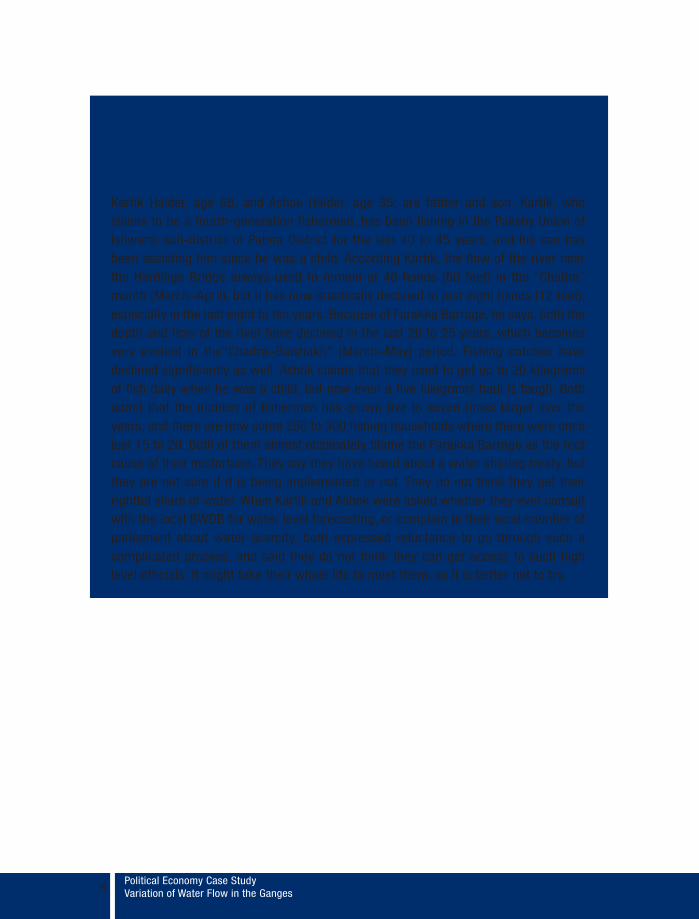
Case Study of DivergenceBetween StakeholdersKartik Halder, age 68, and Ashok Halder, age 35, are father and son. Kartik, who claims to be a fourth-generation fisherman, has been fishing in the Pakshy Union of Ishwardi sub-district of Pabna District for the last 40 to 45 years, and his son has been assisting him since he was a child. According Kartik, the flow of the river near the Hardinge Bridge always used to remain at 40 hands (60 feet) in the “Chaitra” month (March–April), but it has now drastically declined to just eight hands (12 feet), especially in the last eight to ten years. Because of Farakka Barrage, he says, both the depth and flow of the river have declined in the last 20 to 25 years, which becomes very evident in the“Chaitra–Baishakh” (March–May) period. Fishing catches have declined significantly as well. Ashok claims that they used to get up to 20 kilograms of fish daily when he was a child, but now even a five kilograms haul is tough. Both admit that the number of fishermen has grown five to seven times larger over the years, and there are now some 250 to 300 fishing households where there were once just 15 to 20. Both of them almost obstinately blame the Farakka Barrage as the root cause of their misfortune. They say they have heard about a water sharing treaty, but they are not sure if it is being implemented or not. They do not think they get their rightful share of water. When Kartik and Ashok were asked whether they ever consult with the local BWDB for water level forecasting, or complain to their local member of parliament about water scarcity, both expressed reluctance to go through such a complicated process, and said they do not think they can get access to such high level officials. It might take their whole life to meet them, so it is better not to try.
8
Political Economy Case StudyVariation of Water Flow in the Ganges
4.2 Asymmetries of Information and Power The study team asked the BWDB in Pabna why people in the local community, although they are aware of the BWDB office and its activities, still measure the river in hands, even though the BWDB has more accurate, scientific data. The BWDB answered that the local people are not familiar with the BWDB’s measuring standards, that they do not know the exact river situation, and that they make claims based on their own assumptions. It was found, however, that local communities are quite familiar with feet and inches. They claim that BWDB officials do not interact with local people. Why this should be, and why information is not being shared, raises the issue of power asymmetry. Local people and local governments claimed that the BWDB is a district level agency, where as the agriculture and fisheries departments operate at the sub-district level. Because BWDB is institutionally superior to them, they do not consult them on water related issues, despite the fact that they represent local farmers and fishermen. Local farmers and fishermen also claimed that it is inconvenient to travel to the district headquarter to visit the BWDB office, although sometimes they need water level predictions and other information. But BWDB argues that it is not that hard for a person to communicate if he really wants information, and they are not sure why they should consult with local agriculture and fisheries departments on water related issues.
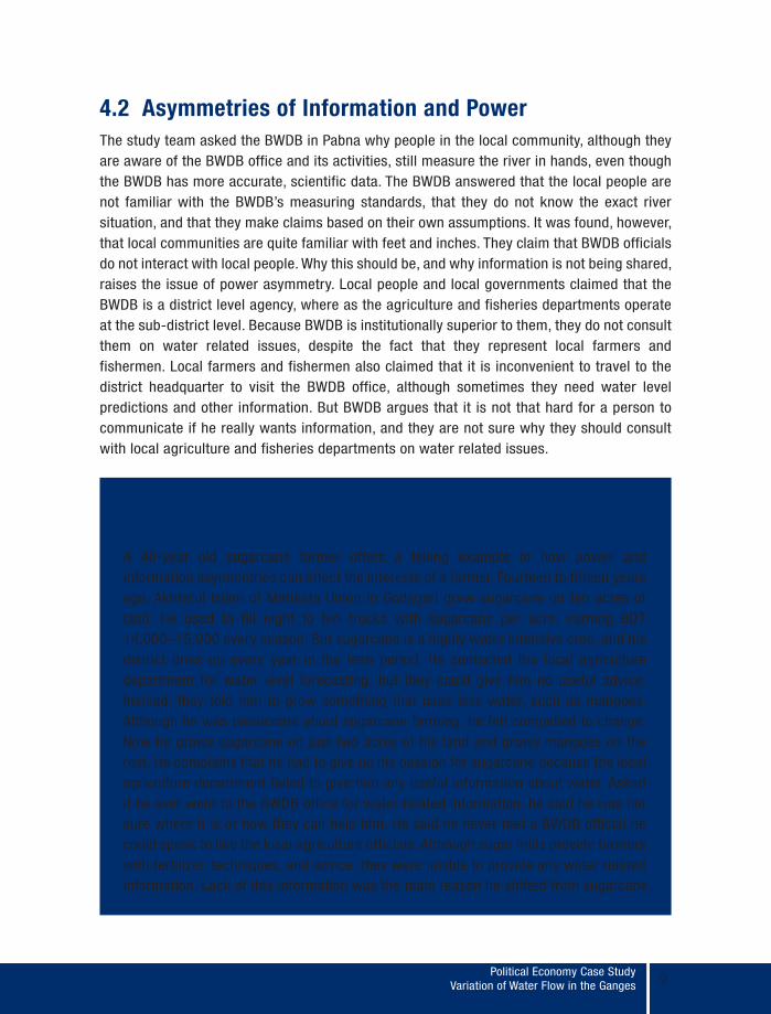
Case Study of Information AsymmetryA 40-year old sugarcane farmer offers a telling example of how power and information asymmetries can affect the interests of a farmer. Fourteen to fifteen years ago, Akhtarul Islam of Matikata Union in Godagari grew sugarcane on ten acres of land. He used to fill eight to ten trucks with sugarcane per acre, earning BDT 14,000–15,000 every season. But sugarcane is a highly water intensive crop, and his district dries up every year in the lean period. He contacted the local agriculture department for water level forecasting, but they could give him no useful advice. Instead, they told him to grow something that uses less water, such as mangoes. Although he was passionate about sugarcane farming, he felt compelled to change. Now he grows sugarcane on just two acres of his land and grows mangoes on the rest. He complains that he had to give up his passion for sugarcane because the local agriculture department failed to give him any useful information about water. Asked if he ever went to the BWDB office for water related information, he said he was not sure where it is or how they can help him. He said he never met a BWDB official he could speak to like the local agriculture officials. Although sugar mills provide farmers with fertilizer, techniques, and advice, they were unable to provide any water related information. Lack of this information was the main reason he shifted from sugarcane.
9
Political Economy Case StudyVariation of Water Flow in the Ganges10
The major finding of this study is that different stakeholders view the availability of the Ganges water through the lens of their own interests. The debate over water availability for agriculture and fisheries shows how asymmetries of information and power reinforce the divergence between the stakeholders. Local communities have an interest in growing crops and catching fish; they see water scarcity as a problem. The local government agency in charge of water resources, on the other hand, claims that water scarcity, if true, is exaggerated by the community. This happens because of the asymmetries of information and power between the stakeholders. Local agriculture and fisheries departments represent local farmers and fishermen; they have to face all the complaints about river water, but they cannot offer any solution. The practical solution to this information and power asymmetry has come from the local communities themselves: create a local water board at the sub-district level equivalent to the agriculture and fisheries departments. As long as there is unequal status among local governmental institutions, this debate will have no solution.
5. Conclusion
Political Economy Case StudyVariation of Water Flow in the Ganges 11
References
Adel, M.M. (2001).“Effects on water resources from upstream water diversion in the Ganges basin.” Journal of Environmental Quality 30, no.5: 356–368
Aminuzzaman, S.M. (2011). Essentials of Social Research, Osder Publications, Dhaka.
Asafuddowla, M. (1993).“Farakka Issue.”Paper presented at the International Farakka Seminar, Columbia University, New York, October 10, 1993.
BWDB (1993). Report on the Effect of Upstream Withdrawal of the Ganges River Flow on Bangladesh 1992-1993. Directorate of Ganges Studies, Bangladesh Water Development Board, Dhaka.
CEGIS (2013). Landmark Project of CEGIS. Center for Environment and Geographic Information Services. Accessed October 30, 2013. http://123.49.36.82/cegisweb/Legendary.aspx.
CRG (2006). O Mother, O Ganges! Water Reduction and Social Changes in Rural Southwest Bangladesh. Conflict Research Group, Ghent University.
DPCR (1996). The Environmental Trap: The Ganges River Diversion, Bangladesh Migration and Conflicts in India. Department of Peace and Conflict Research, Upsala University, Sweden.
GoB (1996).“Treaty Between the Government of the People’s Republic of Bangladesh and the Government of the People’s Republic of India on Sharing of the Ganga/Ganges Waters at Farakka.” Dhaka. Government of Bangladesh
Joint River Commission (JRC). 2014. Accessed on 23 August 2013 at http://www.jrcb.gov.bd/
Khan, T.A. (1996). “Management and Sharing of the Ganges.” Natural Resources Journal 36: 455–479.
Political Economy Case StudyVariation of Water Flow in the Ganges12
Mirza, M.M.Q. and Hossain, M.A. (2004). “Adverse Effects on Agriculture in the Ganges Basin in Bangladesh.”In The Ganges Water Diversion: Environmental Effects and Implications, edited by M.M.Q. Mirza, 177–194. Kluwaer Academic Publishers, The Netherlands.
MoEF (1995). “National Environmental Management Plan.” Ministry of Environment and Forest, Dhaka.
Rahman, M.M. (2006). “The Ganges Water Conflict: A Comparative Analysis of 1977 Agreement and 1996 Treaty.” Asterikos 1(2): 195–208.

The Asia Foundation is a nonprofit international development organization committed to improving lives across a dynamic and developing Asia. Informed by six decades of experience and deep local expertise, our programs address critical issues affecting Asia in the 21st century—governance and law, economic development, women's empowerment, environment, and regional cooperation. In addition, our Books for Asia and professional exchange programs are among the ways we encourage Asia's continued development as a peaceful, just, and thriving region of the world.
BANGLADESHHouse # 05,Road # 08,Baridhara, Dhaka 1212Tel: + 880(2)882-6941 to 44Fax: + 880 (2) 882-6134Email: [email protected]
www.asiafoundation.org
Bangladesh Centre for Advanced Studies (BCAS) is an independent, non-profit, non-government, policy, research and implementation institute working on Sustainable Development (SD) at local, national, regional and global levels through the interdisciplinary themes like environment- development integration, good governance and people’s participation, poverty alleviation and sustainable livelihoods, economic growth and public-private partnership. The aim of BCAS is to provide guidance and practical solutions to promote sustainable development, eradicate poverty, improve access of the poor to resources and ensure social justice.
BANGLADESH CENTRE FOR ADVANCED STUDIESHouse 10, Road 16A, Gulshan-1, Dhaka-1212, BangladeshTel: (88-02) 8818124 – 27, 9852904, 9851237;Fax: (88-02) 9851417E-mail: [email protected]
www.bcas.net