vaucluse and haute provence - wild swimming · 2012-05-19 · vaucluse and haute provence 57 lower...
TRANSCRIPT

104 Vaucluse and Haute Provence 105
Vaucluse and Haute ProvenceFrom the powerful spring at Fontaine-de-Vaucluse to the spectacular limestone gorges of Toulourenc and the mountain torrents of the Barles valley, sun-baked Provence may be popular but it also has its secret places
61 Gorges de la Méouge

SisteronSisteron
RiezRiez
AVIGNONAVIGNON
20km
b
c
a
a
b
b
bb a
a
a
d-556
a-9
n-85
d-956
d-94
2
n-85
d-900ad-900
a-51
d-942
a-51
a-7
d-973
d-7
d-1075
a-54
Digne-les-BainsDigne-les-Bains
ORANGEORANGE
Salon-de-ProvenceSalon-de-Provence
NyonsNyons
Vaison-la-RomaineVaison-la-Romaine SéderonSéderon
CARPENTRASCARPENTRAS
EntrechauxEntrechaux
CadenetCadenet
PertuisPertuis
CavaillonCavaillon
l’Isle-sur-la-Sourgel’Isle-sur-la-Sourge
AptApt
ForcalquierForcalquier
63
65
64
60
57
59
58
62
61
Montburn-les-BainsMontburn-les-Bains
20km north 6120km north
6565
MormoironMormoiron
DraixDraix
66 60km west
66
50km south
a
d-942
d-946
d-35
9d-40
d-942
d-97
7
d-31
d-546d-94
d-30
d-22
a-7
d-900
SaultSaultd-93
8
d-900
AIX-EN-PROVENCEAIX-EN-PROVENCE
SisteronSisteron
RiezRiez
AVIGNONAVIGNON
20km
b
c
a
a
b
b
bb a
a
a
d-556
a-9
n-85
d-956
d-94
2
n-85
d-900a
d-900
a-51
d-942
a-51
a-7
d-973
d-7
d-1075
a-54
Digne-les-BainsDigne-les-Bains
ORANGEORANGE
Salon-de-ProvenceSalon-de-Provence
NyonsNyons
Vaison-la-RomaineVaison-la-Romaine SéderonSéderon
CARPENTRASCARPENTRAS
EntrechauxEntrechaux
CadenetCadenet
PertuisPertuis
CavaillonCavaillon
l’Isle-sur-la-Sourgel’Isle-sur-la-Sourge
AptApt
ForcalquierForcalquier
63
65
64
60
57
59
58
62
61
Montburn-les-BainsMontburn-les-Bains
20km north 6120km north
6565
MormoironMormoiron
DraixDraix
66 60km west
66
50km south
a
d-942
d-946
d-35
9d-40
d-942
d-97
7
d-31
d-546d-94
d-30
d-22
a-7
d-900
SaultSaultd-93
8
d-900
AIX-EN-PROVENCEAIX-EN-PROVENCE
Vaucluse and Haute Provence
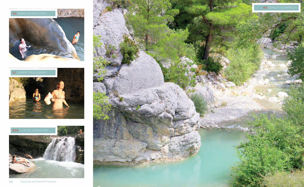
57 lower toulourencA beautiful little river with intermittent pools running through a wild gorge, perfect for aqua randonnée and children.
58 upper toulourencAn unexpected and amazing blue pool beneath a dried-up waterfall, in an otherwise arid stream bed.
61 gorges de la méougeThis waterfall and river pools by a Roman bridge in Haute Provence are wonderful but popular. Head upstream for many more pools, mainly shallow.
62 clues de barlesIn this lively mountain stream there are natural jacuzzi pools and rapids, with larger waterfalls upstream. Several ‘dinosaur’ discoveries were made here.
63 bouinenc and vabreAn intriguing double-pool with a waterfall and strange striated rock formations in the pools below.

108 Vaucluse and Haute Provence 109
This historic heartland – an area of fortified villages and fruit orchards irrigated by the Rhône and Durance rivers – is also an arid region. Many of the smaller rivers and gorges have dried up by summer, but there are many lakes, rivers and pools for refreshing dips off the beaten track.
One of the few rivers to keep a constant flow in the region is the Toulourenc, east of Vaison-la-Romaine, which has carved wonderful, white sinuous channels through the lower limestone slopes of Mont Ventoux 57. From Pont Vieux 57b there is a particularly wild and beautiful river walk, perfect for a light aqua randonnée spent wading in the stream, walking along the bank and swimming through the deep sections where they occur. Many families bring their children to the pools here and the stream is so popular with bathers that you will find hundreds of small stone dams across it by the end
57 lower toulourenclat long: 44.2150, 5.2140walk in: 20 mins, moderate
Below the north slopes of Mont Ventoux the Toulourenc stream runs through narrow white gorges with caves, pools and gravel beds.
,Turn off the D5 onto the D40 just before Mollans-sur-Ouvèze. After 1km turn R on D40A (dir Veaux) and park at bridge (3km). There are pools beneath but carry on walking/wading upstream to explore gorges and pools for up to 6km.
a Pont Romain is about 6km E / upstream (10km via D40), signed on R, with a pool beneath (44.2131, 5.2557). Or reach it by hiking from Veaux.
b Pont Vieux is downstream, off the D5 just W of the D40 turning (44.2217, 5.1740). Head upstream 500m and the gorges begin beyond the Chapelle des Anges.
58 upper toulourenclat long: 44.2172, 5.4249walk in: 3 mins, moderate
A deep plunge pool below a dried-up waterfall in an otherwise parched landscape.
,Continue 15km E and turn L from D72/D542 at Montbrun-les-Bains. 1km before Aulan, and 200m before the road bridge, find steps and large pool below. Scramble down dry waterfall ledge to reach it.
59 cornillon-sur-l’oulelat long: 44.4647, 5.3687walk in: 1 min, easy
Two managed lakes overlooked by the ruins of the château with views of the mountains and the pretty artisan village of La Motte-Chalancon nearby.
, 30km N of the Toulourenc. 7km N of the river Eygues on D61, via Rémuzat. 2€ entrance and music festival on the first Wednesday in August.
60 gorges d’ubrieuxlat long: 44.2931, 5.2803walk in: 2 mins, easy
Roadside pools and picnic tables beneath white cliffs with climbers scaling dizzy heights. From Aulan (upper Toulourenc) turn L (D546) and continue 20km following the river Ouvèze to find several pools near bridge 1km before Buis-les-Baronnies.
a Col de l’Homme Mort is 2.6km back upstream at the road tunnel (D546, 44.2985, 5.3081). Giant boulders poke out of the river bed and down below, the shallow blue river meanders away from the road for a while. ! Le Canard offers simple pitches by the river, 2km upstream.
b Pont St-Michel is a popular swimming location 12 km downstream (44.2288, 5.1363). It is shallow in late summer so bathers build dams and create pools. 4km upstream from Vaison-la-Romaine on D205 going E, 1km from Entrechaux. Upstream ! Les Trois Rivières has good riverside placements (E 04 90 46 01 72).
Haut Vaucluse
58 Upper Toulourenc above waterfall
58
57 Below the bridge
110 Vaucluse and Haute Provence
123 name of placePicture caption caption here here
60 gorges d’umbrieux
62a clue de verdaches
57 lower toulourenc
63 vabre double pool
112 Vaucluse and Haute Provence 113
of the summer. Some will also have been dismantled by those who care about the river’s fish population: if the water slows it also heats up, which reduces oxygen and kills fish.
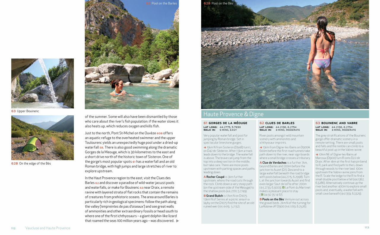
Just to the north, Pont St-Michel on the Ouvèze 60b offers an aquatic refuge to the overheated swimmer and the upper Toulourenc yields an unexpectedly huge pool under a dried-up waterfall 58. There is also good swimming along the dramatic Gorges de la Meouge, which is 30 kilometres to the east and a short drive north of the historic town of Sisteron. One of the gorge’s most popular spots 61 has a waterfall and an old Roman bridge, with high jumps and large stretches of river to explore upstream.
In the Haut Provence region to the east, visit the Clues des Barles 62 and discover a paradise of wild-water jacuzzi pools and waterfalls, or make for Bouinenc 63 near Draix, a remote ravine with layered strata of flat rocks that contain the remains of creatures from prehistoric oceans. The area around Barles is particularly rich in geological specimens: follow the path along the valley (‘empreintes de pas d’oiseaux’) and see great walls of ammonities and other extraordinary fossils or head south to where one of the first ichthyosaurs – a giant dolphin-like lizard that roamed the seas 100 million years ago – was discovered.
61 gorges de la méougelat long: 44.2775, 5.7930walk in: 5 mins, easy
Very popular waterfall and pool for jumping by Roman bridge. Set in spectacular limestone gorges.
, 15km N from Sisteron (D948) turn L on D42 dir Séderon. After 1.5km a track leads down to the bridge. The waterfall is above. The brave can jump from the top into a deep section in the middle, but take care. There are more pools upstream with parking spaces and paths leading down.
a Rocher Coupé is 3km further upstream, where the road cuts through the rock. Climb down a very steep path (on the upstream side of the Méouge) to the shallow pools (44.2701, 5.7749).
b Grand Buëch is 17km N on D1075. 1.5km N of Serres at a picnic area in a layby on the D1075 find the site of an old ruined weir (44.4419, 5.7132).
62 clues de barles lat long: 44.2136, 6.2754walk in: 3 mins, moderate
River pools amongst wild mountain scenery with ammonites and ichthyosaur imprints.
, 15km from Digne-les-Bains on D900A. 600m before the first road tunnels take path down to the river, near sign boards where a small bridge crosses a tributary.
a Clue de Verdaches is a further 7km, beyond Barles and 200m before the junction to Auzet (D7). Descend to a large waterfall beneath the road bridge with pools below (44.2715, 6.2998). Turn L at the junction towards Auzet and find even larger Saut de la Pie after 200m (44.2733, 6.3003). ! Le Pont du Martinet makes a pleasant place to stay ( E 04 92 35 14 67).
b Pools on the Bès Venture out across the gravel beds. 2km N of the turning for La Robine off D900 (44.1709, 6.2526).
63 bouinenc and vabrelat long: 44.2136, 6.2754walk in: 3 mins, moderate
The grey stratifications of the Bouinenc gorge offer dramatic scenery in a remote setting. There are small pools and falls and the nimble can climb to a beautiful pool up in the Vabre ravine.
, 10km NE of Digne-les-Bains at Marcoux (D900) turn R onto D22 dir Draix. After 4km at the first hairpin bend to R, park and find path to the L down through woods to the river bed. 100m upstream the Vabre ravine joins from the R. Scale the ledge to the R to find a small double pool below a fall (44.1362, 6.3286). Alternatively continue up the river bed another 400m to explore small pools and, eventually, a waterfall with small cave beneath (44.1359, 6.3329).
Haute Provence & Digne
62b Pool on the Bès62 Pool on the Barles
63 Upper Bouinenc
62b On the edge of the Bès

114 Vaucluse and Haute Provence 115
In the southern Vaucluse, the small rivers can run dry and you must make for artificial lakes and dedicated swimming areas (plans d’eau), such as the pretty hilltop Étang de la Bonde 65, and the reclaimed gravel pits along the Durance or the Rhône 65b. Much of the water that falls on the Ventoux, Lure and Luberon mountains actually seeps through the limestone rock into the great subterranean cave systems, with most of it reappearing at France’s greatest ‘resurgence’, or spring, at Fontaine-de-Vaucluse, the source of the river Sorgue 64a and a massively powerful natural fountain. The pool, at the foot of a great cliff, is 315 metres deep and very cold, but be brave – a swift dip will leave you wonderfully invigorated. Afterwards follow the Sorgue downstream to Le Partage des Eaux 64 and l’Isle-sur-la-Sorgue, to enjoy lunch at one of the delightful waterside restaurants in Provence’s ‘Little Venice’.
If you would like to explore the coast, this is a good area to do so. Head south to Arles and follow the Petite Rhône 66 as it winds through the wild Camargue. Or if you are looking for just one place to swim in the Mediterranean, make it the nature reserve of the Calanques at Cassis 67. With translucent water, spectacular cliffs, narrow inlets and sea caves, this is a place of real adventure.
64 partage des eauxlat long: 43.9170, 5.0722walk in: 1 min, easy
The river Sorgue forms a shallow lake above two weirs. Near L’Isle-sur-la Sorgue with its waterside cafés.
,Head out of town on Cours Fernande Peyre (D938 dir Pernes-les-Fontaines), but turn R after 150m (D25, Av Voltaire Garcin) and continue 1.7km. Here the Sorgue forms a large pool and splits into two at a pair of low weirs. Delightful, mainly shallow spot with paddling, canoes £ and a little beach on the far side. Eat at R La Guinguette.
a Fontaine-de-Vaucluse is 6km further upstream on the D25. The cave resurgence, one of the greatest in France, is set in a huge hollow beneath a cliff. Deep and cold, it’s worth a plunge if you don’t mind the hordes of onlookers (divers regularly explore the pool’s great depths).Resurgence is 15 mins along a well-signed path from the village centre (43.9182, 5.1324). Canoes £ can be hired, and further riverside areas explored, 1km downstream of the village on D24.
65 étang de la bondelat long: 43.7610, 5.5066walk in: 2 mins, easy
A very pleasant plan d’eau at the foot of the Luberon. 10km from A51 (J15) via D956 (Pertuis) then D9 dir Cabrières-d’Aigues.
a Plan d’Eau des Salettes is a small lake with beach and lifeguards in the heart of vineyards, under Mont Ventoux, 10km E of Carpentras. Turn E off the D184 at Mormoiron and continue 700m. Free entry ( E 04 90 61 80 17) (44.0694, 5.1964).
b Étang du Camping Val de Durance is a large gravel-pit lake with beach next to the Durance river bank and near Abbaye de Silvacane. 10km to the SW of Étang de la Bonde. Open July and August with life guards and entrance fee (3€). Off D973 at Cadenet then D943 (43.7177, 5.3557) !.
c Plan d’Eau Li Piboulo is an isolated lake on the edge of the Rhône just N of Orange. 4km W of Piolenc, off N7 dir Routes des Îles, just beyond the TGV line. (44.1583, 4.7289).
66 petite rhônelat long: 43.57251, 4.40267walk in: 2 mins, easy
Enjoy a swim in the Petite Rhône while exploring the wonderful Camargue wetlands. The best stretch is on the D202, between Mas de Capette and Les Pradaux, accessed from D570/D38C 25km SW of Arles.
67 calanque d’en vaulat long: 43.2023, 5.4982walk in: 60 mins, moderate
If you swim only once in the sea then choose Les Calanques de Marseille: spectacular cliffs, narrow inlets, sea caves and the only undeveloped part of the Côte d’Azur. Park at Port Miou/Port des Calanques, the marina just on from Cassis (A50). Follow the GR98 1.2km, 30 mins to Port Pin with its pretty cove and inlet and lovely rocks for snorkelling (43.2040, 5.5109) or continue another 1.2km up on the GR98 again then bear L down to dramatic Calanque d’en Vau.
Lower Vaucluse & the coast
67 Port Pin
67
64
67
64a