vegetation classification standard - fia.fs.fed.us
TRANSCRIPT

FGDC-STD-005
Vegetation Classification Standard
Vegetation SubcommitteeFederal Geographic Data Committee
June 1997
Federal Geographic Data CommitteeDepartment of Agriculture • Department of Commerce • Department of Defense • Department of Energy
Department of Housing and Urban Development • Department of the Interior • Department of StateDepartment of Transportation • Environmental Protection AgencyFederal Emergency Management Agency • Library of Congress
National Aeronautics and Space Administration • National Archives and Records AdministrationTennessee Valley Authority

ii
Federal Geographic Data Committee
Established by Office of Management and Budget Circular A-16, the Federal Geographic Data Committee (FGDC)promotes the coordinated development, use, sharing, and dissemination of geographic data.
The FGDC is composed of representatives from the Departments of Agriculture, Commerce, Defense, Energy,Housing and Urban Development, the Interior, State, and Transportation; the Environmental Protection Agency;the Federal Emergency Management Agency; the Library of Congress; the National Aeronautics and SpaceAdministration; the National Archives and Records Administration; and the Tennessee Valley Authority. Additional Federal agencies participate on FGDC subcommittees and working groups. The Department of theInterior chairs the committee.
FGDC subcommittees work on issues related to data categories coordinated under the circular. Subcommitteesestablish and implement standards for data content, quality, and transfer; encourage the exchange of informationand the transfer of data; and organize the collection of geographic data to reduce duplication of effort. Workinggroups are established for issues that transcend data categories.
For more information about the committee, or to be added to the committee's newsletter mailing list, pleasecontact:
Federal Geographic Data Committee Secretariatc/o U.S. Geological Survey
590 National CenterReston, Virginia 22092
Telephone: (703) 648-5514Facsimile: (703) 648-5755
Internet (electronic mail): [email protected] FTP: ftp://www.fgdc.gov/pub/FGDC/World Wide Web: http://www.fgdc.gov/fgdc.html

Federal Geographic Data Committee--Vegetation Subcommittee FGDC-STD-005National Vegetation Classification Standard , June 1997
iii
TABLE OF CONTENTS
Page
1. Introduction . . . . . . . . . . . . . . . . . . . . . . . . . . . . . . . . . . . . . . . . . . . . . . . . . . . . . . . . . . . . . . . . . . . . . . . . . . 12. Objective . . . . . . . . . . . . . . . . . . . . . . . . . . . . . . . . . . . . . . . . . . . . . . . . . . . . . . . . . . . . . . . . . . . . . . . . . . . . 13. Maintenance Authority . . . . . . . . . . . . . . . . . . . . . . . . . . . . . . . . . . . . . . . . . . . . . . . . . . . . . . . . . . . . . . . . . . 24. Standards Development Procedure . . . . . . . . . . . . . . . . . . . . . . . . . . . . . . . . . . . . . . . . . . . . . . . . . . . . . . . . . 25. Purpose and Scope . . . . . . . . . . . . . . . . . . . . . . . . . . . . . . . . . . . . . . . . . . . . . . . . . . . . . . . . . . . . . . . . . . . . . 4 5.1. Expectations . . . . . . . . . . . . . . . . . . . . . . . . . . . . . . . . . . . . . . . . . . . . . . . . . . . . . . . . . . . . . . . . . . . . . 4 5.2. Policy . . . . . . . . . . . . . . . . . . . . . . . . . . . . . . . . . . . . . . . . . . . . . . . . . . . . . . . . . . . . . . . . . . . . . . . . . . 4 5.3. Guiding Principles . . . . . . . . . . . . . . . . . . . . . . . . . . . . . . . . . . . . . . . . . . . . . . . . . . . . . . . . . . . . . . . . . 46. National Vegetation Classification Standard . . . . . . . . . . . . . . . . . . . . . . . . . . . . . . . . . . . . . . . . . . . . . . . . . . 5 6.1. Application . . . . . . . . . . . . . . . . . . . . . . . . . . . . . . . . . . . . . . . . . . . . . . . . . . . . . . . . . . . . . . . . . . . . . . . 8 6.2. Current Use of the National Vegetation Classification Standard . . . . . . . . . . . . . . . . . . . . . . . . . . . . . . 107. Requirements . . . . . . . . . . . . . . . . . . . . . . . . . . . . . . . . . . . . . . . . . . . . . . . . . . . . . . . . . . . . . . . . . . . . . . . . 12 7.1. Data Collection . . . . . . . . . . . . . . . . . . . . . . . . . . . . . . . . . . . . . . . . . . . . . . . . . . . . . . . . . . . . . . . . . . 12 7.2. Metadata . . . . . . . . . . . . . . . . . . . . . . . . . . . . . . . . . . . . . . . . . . . . . . . . . . . . . . . . . . . . . . . . . . . . . . . 13 7.3. Scale . . . . . . . . . . . . . . . . . . . . . . . . . . . . . . . . . . . . . . . . . . . . . . . . . . . . . . . . . . . . . . . . . . . . . . . . . . 14 7.4. Management and Reporting of Vegetation Information . . . . . . . . . . . . . . . . . . . . . . . . . . . . . . . . . . . . 148. Updating and Testing . . . . . . . . . . . . . . . . . . . . . . . . . . . . . . . . . . . . . . . . . . . . . . . . . . . . . . . . . . . . . . . . . 159. References . . . . . . . . . . . . . . . . . . . . . . . . . . . . . . . . . . . . . . . . . . . . . . . . . . . . . . . . . . . . . . . . . . . . . . . . . . 1610. Appendices . . . . . . . . . . . . . . . . . . . . . . . . . . . . . . . . . . . . . . . . . . . . . . . . . . . . . . . . . . . . . . . . . . . . . . . . . 18 10.1. National Vegetation Classification Standard (normative) . . . . . . . . . . . . . . . . . . . . . . . . . . . . . . . . . 19 10.2. Examples of Vegetation Types Organized Within The NVCS Hierarchy (informative) . . . . . . . . . . . 42 10.3. Definitions (normative) . . . . . . . . . . . . . . . . . . . . . . . . . . . . . . . . . . . . . . . . . . . . . . . . . . . . . . . . . . . 45

Federal Geographic Data Committee--Vegetation Subcommittee FGDC-STD-005National Vegetation Classification Standard , June 1997
1
NATIONAL VEGETATION CLASSIFICATION STANDARD
1. INTRODUCTION
The United States Federal Geographic Data Committee (hereafter called the FGDC) is tasked to develop geospatialdata standards that will enable sharing of spatial data among producers and users and support the growingNational Spatial Data Infrastructure (NSDI), acting under the Office of Management Budget (OMB) Circular A-16and Executive Order #12906. FGDC subcommittees and working groups, in consultation and cooperation withstate, local, tribal, private, academic, and international communities, are to develop standards for the content,quality, and transferability of geospatial data. FGDC standards are to be developed through a structured process,integrated with one another to the extent possible, supportable by the current vendor community (but areindependent of specific technologies), and are publicly available.
At present there is no Federal standard for vegetation classification and reporting of vegetation statistics. However,there is broad recognition of the need to establish national definitions and classification standards that willfacilitate a national synoptic view of the vegetation resources of the United States. This document proposes astandard for terminology, core (or minimum) data and vegetation classification.
There is no single agency responsible for classifying, describing, and/or mapping the vegetation cover of theUnited States. Many agencies have partial responsibilities for these activities, typically divided by broadvegetation/land use types (e.g., forest, rangelands, wetlands, agricultural lands) or by mission and jurisdiction (e.g.,National Forests, Public Lands, National Parks, National Refuges). This has resulted in the current condition ofmultiple agencies inventorying, mapping, analyzing, and reporting vegetation data in a variety of ways, sometimesin direct conflict with each other due to differing definitions and protocols. The present situation has preventeddevelopment of a national synoptic view of the vegetation resources of the United States. Federal agencies areencouraged by a variety of executive orders and Congressional actions to improve cooperation and to reduceduplication. The NVCS responds to this direction.
2. OBJECTIVE
The overall objective of the National Vegetation and Information Standard (NVCS) is to support the use of aconsistent national vegetation classification to produce uniform statistics in vegetation resources from vegetationcover data at the national level. It is important that, as agencies map or inventory vegetated Earth cover, theycollect enough data accurately and precisely to translate it for national reporting, aggregation, and comparisons. Adoption of the NVCS in subsequent development and application of vegetation mapping schemes will facilitatethe compilation of regional and national summaries. In turn, the consistent collection of such information willeventually support the detailed, quantitative, geo-referenced basis for vegetation cover modeling, mapping, andanalysis at the field level.
The standard presented represents more the minimum required than the ideal or maximum. The purpose of thenational standard is to require all federal vegetation classification efforts to have some core components that arethe same across all federal agencies to permit aggregating data from all federal agencies. The NVCS does notprevent local federal efforts from doing whatever they want to meet their specific purposes. NVCS does requirethat when those local efforts are conducted, they are conducted in ways that, among whatever else they do, they

Federal Geographic Data Committee--Vegetation Subcommittee FGDC-STD-005National Vegetation Classification Standard , June 1997
2
provide the required core data.
3. MAINTENANCE AUTHORITY
The United States Department of Agriculture - Forest Service was assigned responsibility to coordinate vegetationdata-related activities under the policy guidance and oversight of the FGDC. The enclosed draft NationalVegetation Classification Standard was developed under the authority of the Office of Management and BudgetCircular A-16, revised 1990. The standard is based on earlier work of United Nations Educational ScientificCultural Organization (UNESCO 1973) and Driscoll et al (1984) that was refined by The Nature Conservancy(TNC Ecology Working Group 1997 (in prep)) for conservation planning. The FGDC Vegetation Subcommittee iscoordinating with the United Nations Environment Programme/Food and Agriculture Organization (Young 1994,UNEP/FAO 1995, and Di Gregoiro and Jansen 1995) to have the NVCS as a model for a potential global standardto characterize earth (land) cover.
4. STANDARDS DEVELOPMENT PROCEDURE
Vegetation is comprised of a collection of plants or plant communities with distinguishable characteristics thatoccupy an area of interest and about which data can be arrayed in a standard format. These vegetation data canprovide information about a significant portion of the earth's surface. A Subcommittee on vegetation data (FGDCVegetation Subcommittee, hereafter called the Subcommittee) was established to promote the use of documentedstandards in data collection and reporting concerning vegetation that is financed in whole or in part by Federalfunds; to exchange information on technological improvements for collecting vegetation data; to encourage theFederal and non-Federal community to identify and adopt standards and specifications for vegetation data; and tocollect and process the requirements of Federal and non-Federal organizations for vegetation data.
The Subcommittee consists of representatives designated by the Federal agencies that collect, or finance thecollection of, vegetation data as part of their mission or have direct application of these data through legislatedmandate. The subcommittee provides interagency policy oversight. FGDC will need to maintain the subcommitteeto ensure ongoing interagency coordination, system evolution, and policy interpretation and development. Organizations having national vegetation classification and mapping responsibilities are also represented.
Current membership of the Subcommittee includes representatives from:
! U.S. Government Department of Agriculture (USDA)
Forest Service (FS) - ChairNational Agriculture Statistical Service (NASS)Natural Resources Conservation Service (NRCS)
Department of Commerce (DOC)National Oceanic and Atmospheric Administration (NOAA)
National Marine Fisheries Service.Department of Defense (DOD)
Tri-Service Technology CenterU.S. Army Corps of Engineers (USACERL)
Department of Interior (USDI)Bureau of Land Management (BLM)

Federal Geographic Data Committee--Vegetation Subcommittee FGDC-STD-005National Vegetation Classification Standard , June 1997
3
Bureau of Indian Affairs (BIA)Fish and Wildlife Service (FWS)National Park Service (NPS)
U.S. Geological Survey (USGS) Environmental Protection Agency (EPA) National Aeronautics and Space Administration (NASA)
! Non U.S. GovernmentThe Nature Conservancy (TNC)
Ecological Society of America (ESA)
The Subcommittee identified a need to establish a hierarchical classification standard and associated informationstandards that will contain an organized list of vegetation types (taxonomic units) with identified relationshipsamong them. Procedures used to identify these standards included users surveys, periodic Subcommittee meetings,a vegetation classification forum held in 1995, and an informal review of the draft standards by the agencies andorganizations represented on the Subcommittee. All decisions were made by consensus.
This document proposes a vegetation classification standard and set of information standards to be used by Federalagencies in their activities for inventory, mapping, and reporting on the vegetation resources of the United States. It includes a description of the National Vegetation Classification Standard, general policy regarding federalagencies' use, suggested applications, the principles (basic ideas, requirements) that guided the development of thisstandard, and a list of definitions used in the standard and its development. This document does not detail thefloristically defined units of the classification standard, the field methods, or the data management and analysisstandards that will be required to develop and maintain this National Vegetation Classification Standard. Thisinformation will be presented in subsequent documents by the Subcommittee.
The National Vegetation Classification Standard (NVCS) is an evolution of what TNC has already developed,which, in turn, is an evolution from other standards, including past federal government and UNESCO (1973)efforts. The NVCS is compatible with TNC because it has evolved from original TNC efforts and TNC now isusing NVCS. Once adopted by FGDC, NVCS will be the federal standard. It will guide federal efforts to classifyvegetation.
The goal of the NVCS is to provide a standard for meeting the FGDC requirements while at the same time not interfering with the local actions needed to meet local purposes or the bureau actions needed to meet bureaupurposes. The NVCS requires federally supported vegetation classification activities to collect data in ways thatpermit the data to be useful for creating a classification according to NVCS requirements without preventing theactivities from also collecting data to meet their local or bureau purposes and requirements.
This standard deals with vegetation cover. It consciously seeks to avoid land use terms. At the same time, it seeksto be useful to efforts to describe and map land use. The NVCS overlaps the Wetlands standard in wetland andemergent aquatic regions. The NVCS classifies primarily according to vegetation and floristic characteristics, notto habitat or related characteristics, whereas the Wetlands standard includes soils and other habitat characteristicsin its classification determinations. The two standards have different purposes and so the classifications of the twostandards should be viewed as complementary but different systematic approaches or layers in an overall analysisof a geographic area.

Federal Geographic Data Committee--Vegetation Subcommittee FGDC-STD-005National Vegetation Classification Standard , June 1997
4
5. PURPOSE and SCOPE :
! Fosters accuracy, consistency, and clarity in the structure, labeling, definition and application of asystematic vegetation taxonomy for the United States. Accuracy, consistency, and clarity are critical formaking effective and efficient decisions about complex assemblages of biotic organisms.
! Establishes a national set of standards for classifying existing vegetation cover and its associatedinformation for the United States and its Trust Territories that will be used by Federal agencies to developand report national statistics. This standard includes guiding principles, definitions of importantterminology, and the National Vegetation Classification Standards (NVCS).
! Develops federal minimum metadata requirements to ensure consistent reporting on the status of ourNation’s vegetation resources. Both the classification standard and the metadata requirements may beused nationally to link local level vegetation inventory and map efforts
.5.1. Expectations - The intention of this Federal Geographic Data Committee National Vegetation ClassificationStandard is to build a common data base of vegetation cover that the various federal agencies will cooperativelypopulate with consistent and credible data. As state, county, reservation, and private agencies inventory or maplands within the United States, they should collect core data required to meet this standard and populate a nationaldata base on existing vegetation. Agencies must be able to report their vegetation data according to this nationalstandard, although it is understood that agencies will also use other classification approaches according to theirrespective agency needs and missions. Crosswalks between agency-specific schemes, as well as conventions andprotocols for vegetation mapping will be developed through the use of the standards (for examples, see Section I).
5.2. Policy - These standards are intended to be used by federal agencies and as needed by other groups includingthose engaged in land use planning or management by county and state governments, teaching or research uses,and by the private sector. Widespread use of these standards will facilitate integration of Earth cover data collectedby diverse users into a common national data base, enhancing utility beyond single projects and establishing along-
The adopted standards must be followed by all Federal agencies for data collected directly or indirectly (throughgrants, partnerships, or contracts). Currently the policy for applying the standard is only through the formationlevel. Agencies are encouraged to aid in the development of the alliance and association levels throughparticipation in developing the national data base and support for the professional review panel. Non-federalorganizations of any and all types might find it useful to use the standard to increase the compatibility of theirefforts with those of nearby federal land managers and/or to make their efforts more compatible in any activitiesthat involve them with federal agencies.
5.3. Guiding Principles - The following principles were used to develop the National Vegetation ClassificationStandard:
! The classification is applicable over extensive areas.

Federal Geographic Data Committee--Vegetation Subcommittee FGDC-STD-005National Vegetation Classification Standard , June 1997
5
! The vegetation classification standard is compatible, wherever possible, with other Earth cover/land coverclassification standards.
! The classification will avoid developing conflicting concepts and methods through cooperativedevelopment with the widest possible range of individuals and institutions.
! Application of the classification must be repeatable and consistent.
! When possible, the classification standard will use common terminology (i.e., terms should beunderstandable and jargon should be avoided).
! For classification and mapping purposes, the classification categories were designed to be mutualexclusive and additive to 100% of an area when mapped within any of the classification’s hierarchicallevels (Division, Order, Class, Subclass, Subgroup, Formation, Alliance, or Association). Guidelineshave been developed for those instances where placement of a floristic unit into a single physiognomicclassification category is not clear. Additional guidelines will be developed as other such instances occur.
! The classification standard will be dynamic, allowing for refinement as additional information becomesavailable.
! The NVCS is of existing, not potential, vegetation and is based upon vegetation condition at the optimaltime during the growing season. The vegetation types are defined on the basis of inherent attributes andcharacteristics of the vegetation structure, growth form and cover.
! The NVCS is hierarchical (i.e., aggregatable) to contain a small number of generalized categories at thehigher level and an increasingly large number of more detailed categories at the lower levels. Thecategories are intended to be useful at a range of scales (UNEP/FAO 1995, Di Gregorio and Jansen 1995).
! The upper levels of the NVCS are based primarily on the physiognomy (life form, cover, structure, leaftype) of the vegetation (not individual species). The life forms (e.g., herb, shrub, or tree) in the dominantor uppermost stratum will predominate in the classification of the vegetation type. Climate and otherenvironmental variables are used to help organize the standard, but physiognomy is the driving factor.
! The lower levels of the NVCS are based on actual floristic (vegetation) composition. The data used todescribe Alliance and Association types must be collected in the field using standard and documentedsampling methods. The Alliance and Association units are derived from these field data. Thesefloristically-based classes will be nested under the physiognomic classes of the hierarchy.
6. NATIONAL VEGETATION CLASSIFICATION STANDARD
The NVCS provides a standard framework and classification approach for natural, semi-natural, planted andcultivated vegetation types. All areas having equal to or more than 1% of the surface area with live vegetationcover are classified within the NVCS. The vegetation classification standard is hierarchical and combinesfloristics at the lowest levels and physiognomy and broad ecological modifiers at the highest levels of thehierarchy. This approach allows the characterization of vegetation patterns at multiple spatial scales. Cultivatedand managed vegetation types are included in this classification standard due to their extensive geographical

Federal Geographic Data Committee--Vegetation Subcommittee FGDC-STD-005National Vegetation Classification Standard , June 1997
6
coverage and the importance of identifying, mapping, and monitoring these types. In addition to vegetation foundon strictly upland environments, this classification includes wetland vegetation (rooted emergent and floating).
The NVCS is largely the result of modifications to the vegetation classification standard compiled and refined forconservation planning and resource management at The Nature Conservancy (TNC Ecology Working Group 1994,1997 (in prep)). The upper five physiognomic levels of the TNC standard (Class, Subclass, Group, Subgroup andFormation) are based on modifications by TNC Ecology Working Group of the UNESCO (1973) and Driscoll et al.(1984) vegetation classification. The lower two floristic levels (Alliance and Association) have been developed andare periodically enhanced by the ongoing work of TNC and the network of State Heritage Programs (TNC EcologyWorking Group 1997 (in prep)).
The UNESCO system was modified and refined to provide greater consistency at all hierarchical levels andincludes additional physiognomic types. A few of the inconsistencies inherent to the UNESCO standard were leftintact where modification would have compromised the ecological integrity of the classification standards.
This classification scheme for the upper levels of the hierarchy was chosen because:
! It is already the product of an international group of experts. As a result, it is worldwide in coverage andis a more readily acceptable product than local and/or single-authored standards. Variations of thestandard are presently being used by different agencies in the United States and internationally.
! It is a hierarchical standard that was designed for classification and mapping at multiple scales.
! It was well suited to have floristic units nested under its lowest level.
! The structure of the standard makes it open-ended; units meeting the standard can be added as needed.
There are seven upper levels in the NVCS. Physiognomic class is a level that is defined by life form and percentcover of the vegetation strata. The level of physiognomic subclass is determined by the predominant leafphenology of woody plants and the leaf type and periodicity of herbaceous plants. The physiognomic group isdefined by a combination of factors relating to climate, leaf morphology and leaf phenology. The subgroupseparates the Natural/Semi-natural types from the Planted/Cultivated types. The formation level identifiesecological groupings of vegetation units with broadly defined environmental (e.g., hydrology) and additionalphysiognomic factors.
The hierarchy for the NVCS is presented below.

Federal Geographic Data Committee--Vegetation Subcommittee FGDC-STD-005National Vegetation Classification Standard , June 1997
7
NATIONAL VEGETATION CLASSIFICATION STANDARD
DIVISION
ORDER
PHYSIOGNOMIC CLASS
PHYSIOGNOMIC SUBCLASS
PHYSIOGNOMIC GROUP
SUBGROUP
physiognomic levels FORMATION
floristic levels ALLIANCE
ASSOCIATION
The physiognomic and environmental characteristics used to describe the physiognomic units differ among themajor groupings of vegetation. For example, some of the variables used to classify woody formations are differentthan the variables used to classify herbaceous formations. Adherence to a strictly parallel set of classificationvariables would cause inappropriate ecological distinctions to be made. Even within a given Physiognomic Group,some variables are better for describing certain vegetation types than others. For example, within the temperateneedle-leaved evergreen closed tree canopy group, crown shape is an important variable for distinguishing majorfloristic types within the upland types, but this distinction is not particularly useful for separating floristic typeswithin wetland types. Different variables are used as necessary to provide the most ecologically meaningfulgroupings possible and to limit arbitrary splitting of floristic units
There are two floristic levels in the NVCS. Alliances represent an aggregation of Associations and arecharacterized by one or a group of diagnostic species which, as a rule, occur in the dominant or uppermost stratumof the vegetation. The finest floristic unit of the classification standard is the Association which is characterized bydiagnostic species that occur in all strata (overstory and understory) of the vegetation. The diagnostic species usedto determine both the Alliance and Association are primarily the dominant species. When data indicate thatadditional diagnostic species (including differential, indicator, or character species) provide a bettercharacterization of ecological patterns, they are used in addition to the dominant species to classify these floristicunits. The current list of Alliances and Associations for the conterminous United States will be published by TheNature Conservancy in the spring of 1997 (TNC Ecology Working Group 1997 (in prep)).
Classification requires that fixed categories be imposed on naturally continuous systems. The cover values, heightcutoffs and other physiognomic and environmental distinctions in the classification (taken largely from UNESCO1973 and Driscoll et al. 1984) were chosen to best represent the ecology of vegetation and to provide a consistentframework for describing vegetation across the United States. While not arbitrary, these values may not perfectlydescribe the variable ecological patterns inherent to some types of vegetation. When the characteristics of a givenfloristic type span more than one physiognomic unit, the floristic type is placed intact in the physiognomic unit thatbest describes the majority of occurrences of the floristic type. Floristic units are only split and placed in more thanone physiognomic unit if there is evidence that the physiognomic differences also reflect true floristic differences.

Federal Geographic Data Committee--Vegetation Subcommittee FGDC-STD-005National Vegetation Classification Standard , June 1997
8
The physiognomic attributes in the classification are designed to describe the characteristics of the vegetation as awhole, not the characteristics of individual species. For example, willows and alders exhibit shrub characteristicsin many areas and tree characteristics in other areas. Where the overall physiognomy of the vegetation whichincludes willows and alders is multi-stemmed, the type is classified as shrub dominated. Where the overallphysiognomy of the vegetation which includes these species is single-stemmed, the type is classified as treedominated (provided this reflects additional floristic differences).
The combined physiognomic/floristic approach of this classification standard allows identification of units fromboth a “top-down” (divisive) and “bottom-up” (agglomerative) approach. The top-down approach allows the use ofphysiognomic distinctions to help map vegetation, to stratify sampling and, where floristic information is lacking,to delimit vegetation units. A bottom-up approach requires that field inventory and floristic analysis are theprimary means for defining associations. Where physiognomy is variable, the bottom-up approach can also beused to help to determine the important physiognomic distinctions.
Sparsely vegetated land cover units are classified within this standard because they cover significant areas acrossthe United States and comprise unique and recognizable vegetation types. The upper hierarchical levels of thesparsely vegetated types are based on physical characteristics of the landscape. Remote sensing approaches can beused to map such areas and provide a functional stratification for inventory of the vegetation types. The lowerlevels of the classification standard are based on the floristic associations similar to the rest of the classificationframework. This Subcommittee will work with the newly formed FGDC Earth Cover Working Group to determinea compatible approach to the upper levels of the sparsely vegetated classes.
Assigning a vegetation 'stand' to a classification type at each level of the classification hierarchy requires a definedset of information. The vegetation types in the NVCS may be developed through the analysis of imagery, thematicspatial data layers, and field survey data. More and more detailed data are required to derive units at consecutivelyfiner levels of the classification hierarchy. Standard inventory methods must be followed and documented toidentify the sample points, and uniform data collection protocols must be followed to ensure consistency andcomparability of the field data. The standards for vegetation inventory, data management and analysis will becompleted as a future stage of work by this Subcommittee.
The upper seven physiognomic levels of the classification standard appear in Appendix I. Appendix II givesexamples of vegetation types fully classified within the system. The terminology associated with each level of thehierarchy is included in the "Definitions" section in Appendix III.
6.1. Application - The National Vegetation Classification Standard will enable federal agencies to collect andreport vegetation information in a standard format and apply a standard classification standard in the attribution ofspatial vegetation data and to use standard vegetation units in reports and on maps. This classification is a criticalsupport tool for inventory, monitoring, research, management, and planning of biological resources and it iscurrently an aid in strengthening these activities at the national and state levels. The standards do not dictatevalues for several mapping-related parameters such as minimum mapping unit, polygon minimum widththresholds, etc.. Rather, the NVCS should be employed using the most appropriate level(s) in the hierarchy, inconcert with application-specific mapping protocols which provide for the retention of appropriate information. Inthis manner, as agencies map vegetation at the level(s) and resolution(s) required by their programs, they aregenerating data which may be shared and assembled into a larger data base of comparable vegetation information.
This standard was designed to be useable in a wide variety of situations and thus its application is not dependent on

Federal Geographic Data Committee--Vegetation Subcommittee FGDC-STD-005National Vegetation Classification Standard , June 1997
9
any specific data inputs, resolutions or mapping scales. This is one of the inherent values of a hierarchicalclassification standard. A user must have detailed information about a vegetation stand(s) in order to classify it atthe lowest floristic levels but lacking such detailed information, the user can still assign the required more generalclassification at one of the higher physiognomic classes in the hierarchy. The standard is applicable for manytypes of data inputs and resolutions and mapping scales. Thus any specific categorization breakout and detail inthe hierarchy would obviously depend on the type of data inputs. Data inputs could range from detailed groundobservations of very localized vegetation with GPS locations to high, medium, and coarse resolution remotesensing inputs such as 1 meter to 1 kilometer, some with little or no ground observations.
The application of this standard for national, regional and State analyses, reports, and maps will be particularlybeneficial by providing a cohesive, consistent, synoptic view of the vegetation resources of such broad geographicareas. Examples of major activities which will benefit directly or indirectly from such a unified classification andinformation standard include fire fuels mapping and management and general fire fighting, wildlife management,forestry and grazing planning and management, general land use planning and environmental impact assessments,biodiversity and ecosystem management and conservation, and many other natural resources management issues.
This uniform NVCS should also complement local classifications that are designed to meet more specificobjectives.
The specific application of this standard to any mapping activities is dependent on the goals and objectives of themapping activities. Issues of scale, minimum mapping area, appropriate level in the classification standard to use,etc. are all specific to each individual mapping effort. The classification standard merely sets a hierarchical list ofclasses that should be intelligently employed by the user based on the specifications and limitations of theirparticular mapping program. The program examples described in Section I, "Current Use of the NationalVegetation Classification Standard", all vary with regard to mapping program specifications and limitations andyet all employ the NVCS.
The upper physiognomic levels of the classification hierarchy (see Appendix I) are based on factors that aregenerally discernible from imagery or ground verification. The types of information needed to categorizevegetation stands from the Physiognomic Class through the Formation levels are referred to in the RequirementsSection of this report.
The floristic levels of the classification hierarchy are determined from field data concerning the structure,composition, and cover of the vegetation. Information that is required to categorize vegetation stands into nationalclassification types at the Alliance and Association levels is acquired using standardized inventory methods bycharacterizing the whole vegetation stand and by plots within the stand. The information needed to classifyvegetation into floristic units is listed in the Requirements Section of this report.
It is presently more complicated to assign a vegetation stand to a floristic level of the hierarchy than to aphysiognomic level of the hierarchy. While the standard must be considered dynamic and subject to change as newinformation becomes available, it is anticipated that the higher physiognomic levels of the classification areconsiderably more stable at this time. A comprehensive list of the nation's floristic level vegetation types iscurrently a goal to be pursued in the long term application of this standard. The first approximation of a nationallist of vegetation types across all levels of the classification hierarchy will be published by The Nature Conservancy(TNC Ecology Working Group) in 1997. This publication will serve as the initial basis for assigning vegetationstands to types within the NVCS. This initial national list of vegetation types is the result of several years of work

Federal Geographic Data Committee--Vegetation Subcommittee FGDC-STD-005National Vegetation Classification Standard , June 1997
10
accomplished at the local level in conjunction with private, State and Federal agencies and organizations. Withthe collection of standardized data, all users needing to classify a stand will eventually be able to input enter theirdata into a national data base on existing vegetation (as mentioned in Section D). This national data base will beaccessible over the Internet and will be searchable and browsable with photographs, descriptions, successionalstatus and relationships, and data for users to review the development and status of the NVCS. It will also providea useful tool to aid users in assigning the appropriate classification to their particular vegetation stand data.
A process to help users classify vegetation at the lowest floristic levels will be developed in the future involvingFederal, State, and private agencies and professional organizations . When a classification is questionable and aconfidence assignment is required, a copy of the vegetation data may need to be sent to the FGDC VegetationSubcommittee or a professional advisory panel authorized by the Subcommittee for review and assistance. The
Subcommittee or the authorized professional panel will ensure that the vegetation is classified within the NVCS atthe appropriate level and type within the classification hierarchy.
! Links with Remote SensingThe focus of the NVCS is on classifying vegetation, not on the currently available tools for producing theclassifications. The use of remote sensing platforms and ground-truthing practices are some of thetechniques by which one develops the data to permit the classification.
Size class and structure information to support many remote-sensing based classifications have to comefrom ground-truthing. The long term goal is to increase the accuracy of the vegetation classification, nomatter what scale of remote sensing is used.
Landsat TM can only be reliably used to interpret Alliances when field and aerial observations are alsoused. Significant advancements have been made in the last two years using multi-seasonal TM (thusgaining better pattern delineation by way of phenotypic distinction) in combination with aerialvideography. It is unlikely that many Alliance types could be distinguished by single-date TM and noother ancillary information.
! Links with ScaleThe NVCS is a vegetation classification standard. As such, it is scale independent. The scale a classifierchooses to use for presenting the mapped image of the classification will depend on the classifier's needsfor detail versus broad coverage and the choice of sensing and ground-truthing systems the classifiermakes for obtaining the raw data. The NVCS has no role to play in developing availability of remotelysensed data.
The level of field and other efforts will be determined by the scale of classification chosen. It is notrequired that all vegetation classification efforts must classify to Association or Alliance.
6.2. Current Use of the National Vegetation Classification Standard - In addition to the broad application of this classification standard for conservation planning and biodiversity management by the Nature Conservancy andnetwork of State Heritage Programs, the NVCS is currently being used and refined through TNC's work withnumerous national level Federal programs for resource inventory, management, monitoring and conservation. Examples of these applications are listed below.

Federal Geographic Data Committee--Vegetation Subcommittee FGDC-STD-005National Vegetation Classification Standard , June 1997
11
The USGS Gap Analysis Program (GAP) uses the NVCS for vegetation classification in mapping the natural andsemi-natural vegetation of the U.S. in order to assess the conservation status of species and their habitats. Theprogram's vegetation mapping methods use satellite imagery as a convenient meso-scale base map as well as asource of land cover information. Other sources of land cover information include field observations and aerialvideo and photography. The progenitors of the NVCS (UNESCO 1973, Driscoll et al 1984, TNC 1994) were theonly standards that met the necessary criteria for GAP when the program began working cooperatively with otherorganizations to develop a unified vegetation classification standard (Jennings 1996).
Since 1990, GAP has funded TNC regional ecologists to collect, evaluate, and classify described Alliances fromstate Natural Heritage Programs into regionalized classifications. The program first funded this work for the TNCWestern Region in 1990 (Bourgeron and Engelking 1993), and then continued to support work in the Northeast(Sneddon and Anderson 1994), Southeast (Weakley et al 1996) and Midwest (Faber-Langendoen and Drake 1996). The Gap Analysis Program currently has active or completed projects in 44 states.
As part of the National Park Service Inventory and Monitoring Program, the USGS/NPS Vegetation MappingProgram is currently involved in a long-term project to map the vegetation of all park units using the standardNVCS. This program requires the mapping of vegetation according to the NVCS using a minimum mapping unitof 0.5 hectare (about 1 acre ) mapped to a standard 1:24,000 scale USGS topographic quadrangle. Alliances orAssociations must be assigned to each vegetation polygon delineated. All vegetation maps, associated vegetationplot data, and accuracy assessment points are geographically referenced and made available in digital form that isGIS compatible. Inventory and mapping activities are currently taking place in Arizona, California, Maryland,Michigan, Minnesota, Nebraska, South Carolina, South Dakota, and Tennessee.
The U.S. Fish and Wildlife Service is interested in applying the same classification and mapping standards as theUSGS/NPS Vegetation Mapping Program for the wildlife refuge system. The Nature Conservancy is presentlymapping the vegetation of Chincoteague National Wildlife Refuge as a pilot project. The minimum mapping unitis 0.5 hectare, and the vegetation will be mapped to the Alliance and/or association level. The refuge envisionsnumerous applications for the vegetation information including improved management of their shorebirds,endangered species, invasive weeds, and ponies. Beyond the Chincoteague National Wildlife Refuge (NWR) pilot,the Service believes that identifying vegetation communities throughout the NWR system will improve themanagement of the standard fish and wildlife resources.
The Nature Conservancy is presently mapping the Connecticut River for the USGS Ecosystem Initiative to identifycritical migration forest bird habitat that should be included in the Conte Wildlife Refuge System. This mappingand analysis is being carried out at the Alliance and Association levels of the NVCS. TNC has performed both fullvegetation inventories and targeted analysis of rare communities on numerous Department of Defense installationsacross the United States. Many of these projects have been associated with the DOD Legacy Program. All of thiswork has been based on the NVCS.
Perhaps the oldest use and support of the NVCS has been from the U.S. Forest Service. This classification is usedto describe the existing and potential vegetation for the ecoregional subsections in the Eastern and SouthernRegions. This information is used for determining management and conservation goals. The classification wasthe basis for the ecological assessment that was carried out in the Pacific Northwest Region Columbia River Basin.
The Southern Region plans to replace the timber typing standard with the NVCS, and use this standard as thelowest level of the ecological classification standard of existing vegetation. In ecosystem management, the USFS

Federal Geographic Data Committee--Vegetation Subcommittee FGDC-STD-005National Vegetation Classification Standard , June 1997
12
plans to use the classification and ranking standard as a guide for management and conservation action. The California Region is carrying out a LANDSAT change detection program that is cross-walked to the NVCS. Inaddition, projects in the Ozark Highlands, the Northern Great Plains, the Southern Appalachians, and the GreatLakes States are using this classification as the basis for mapping and analysis.
There are many other agencies using the NVCS. For example, the Bureau of Land Management is cross-walkingto this classification standard for an interagency classification project in southwest Colorado. The NVCS providesthe framework for vegetation mapping and analysis of numerous riparian projects that The Nature Conservancy isimplementing for the Environmental Protection Agency. The Multi-Resolution Land Characterization Consortiumhas also identified this classification standard as a common basis for vegetation mapping.
7. REQUIREMENTS
The National Vegetation Classification Standard developed by this Subcommittee needs to be compatible with thestandards that are being developed, in particular, by the Wetlands Subcommittee, Soils Subcommittee, and theEarth Cover Working Group. The NVCS does not preclude application of the data to other classificationstandards, but does require that federal applications produce data that support being able to conduct a classificationaccording to the NVCS. Standards developed by this Subcommittee will need to be reflected in the FGDC ContentStandards for Digital Spatial Metadata.
NVCS identifies the minimum that must be done. NVCS sets a national minimum standard for federal actions toensure compatible and appropriate coordination across federal agencies. It does not prevent other actions, as well.
Most existing vegetation inventory/classification data bases may be cross-walked to populate the uniform NVCS. It is not the intent to throw out previous work and redo inventory. Each agency will need to consider the utility ofthe NVCS for meeting their unique needs and decide to retain existing inventory standards beyond what the NVCSdelivers or where the NVCS fits their needs, adopt the NVCS. Regardless of their decision, each agency is topopulate the NVCS data base to provide a uniform picture for the vegetation of the United States. Agencies shalluse all available tools for accurate classifications.
Applying the National Vegetation Classification Standard requires two separate but interrelated activities:! data collection and management for vegetation classification and reporting at different levels of
the hierarchy, and
! management and reporting of vegetation information associated with vegetation maps.
7.1 Data Collection - Data Collection to Describe Taxonomic Units of the Classification Standard: Agencies willadhere to common, professionally accepted field inventory and data collection methods that must be documentedin associated metadata (data about the data). One should incorporate existing information where possible.However, it is imperative to plan new data collection efforts within the context of the NVCS. This access willlikely be through the national data base of existing vegetation described elsewhere in this standard.
! Field samples with plot data used for describing or characterizing standard vegetation types mustbe collected within homogeneous stands of the vegetation types being described.

Federal Geographic Data Committee--Vegetation Subcommittee FGDC-STD-005National Vegetation Classification Standard , June 1997
13
! The sample size and mapping size must be determined by the purpose of the classification effortand the kind of sampling data that are available to the classifier. Sampling procedures andmethods must comply with recognized professional standards that will ensure the collection ofcore physiognomic, biological, locational and environmental information. The amount of datacollected may be determined by the level of classification required to meet the objectives of aparticular project.
All field work will be expected to obtain the core data listed below. By doing so, others will beable to use the results to develop, without duplication of field work, the higher levels ofclassification that will be useful to them. Core data that may be required to classify units downthrough the physiognomic levels of Class, Subclass, Group and Formation include:
. Dominant life form (i.e. tree, shrub, dwarf shrub, herb, non-vascular) and generalpercent cover class of the dominant vegetation stratum.
Physiognomic attributes of the dominant vegetation stratum (e.g., evergreen, deciduous,etc.)
Hydrologic regime of the vegetation site (Cowardin 1979)
The additional core data that will be required to classify units down to the floristic levels ofAlliance and Association include:
Height class of vegetation strata (in meters)
Dominant and indicator plant species by stratum and percent cover class estimate. Agencies will use the scientific names (nomenclature) found in the current NRCSPLANTS data base (see http://plants.usda.gov/plants) as a national standard or provideaccurate translators to those names as a cross-walk. (PLANTS is a component of theInteragency Taxonomic Information System (ITIS) (http://www.itis.usda.gov/itis).
7.2. Metadata - Agencies should record and make available the required FGDC metadata during the course ofvegetation inventory, whether data has been gathered via remote sensing or field work. This metadata includes butis not limited to:
! Metadata for Field (stand and plot) Samples:Data Collectors: name and affiliation of investigatorsDate of field work
Field Methods: plot design, date of observation/data collection, date of classification,[other field methods metadata?]
Geographic coordinates (UTM or latitude/longitude coordinates) of sample and thedatum (NAD27 or NAD83); method of determination; and estimated locational accuracyinformation, in the form of +/- X m.
Sampling design: how, why, and how many sample sites were chosen (subjective, random, stratified, etc.)

Federal Geographic Data Committee--Vegetation Subcommittee FGDC-STD-005National Vegetation Classification Standard , June 1997
14
Approximate extent of the stand sampled.
Where and how the data are stored.
! Metadata for Remotely Sensed Samples: Type of imagery (TM, SPOT, aircraft scanner, radar, CIR, B&W, video, etc.)
Source (mono, stereo, vertical, oblique)
Scale or resolution of imagery
Date of imagery
Methods used to classify type
Method of imagery classification (visual or computer assisted)
Geographic coordinates (UTM or latitude/longitude coordinates) of sample and the datum(NAD27 or NAD83); method of determination; and estimated locational accuracy information, inthe form of +/- X m.
7.3. Scale - The scale of data acquisition and presentation affects the resulting classification. When sponsored bya federal program, the classification, itself, must be done according to the NVCS scheme. The metadata thataccompany the classification will have to discuss the influence of the chosen scales on the ability of the resultingclassification to discriminate the smaller area vegetation types from the matrix of larger area vegetation typeswithin which the smaller types are mixed. Any presentation should include metadata about the influence of scaleon the nature or resolution of both the input data and the constructed or displayed product.
7.4. Management and Reporting of Vegetation Information Associated with Vegetation Maps
! The following metadata should be developed in conjunction with mapping efforts:a. Location and extent of mapped terrain.b. Map Scalec. Map legend and descriptors of the mapped unitsd. Criteria for minimum mapping units
! General Metadataa. Names and affiliations of people who collected the field datab. Level of vegetation classification that was used for the map c. Information about where the data are storedd. A description of the format in which the data are stored (GIS package, data base structure,etc.)e. A summary of accuracy assessment procedures (class and locational) that were used and theresults. It should be noted that some plot data collected with the protection of dataconfidentiality, by legislation and law, will not be revealed.

Federal Geographic Data Committee--Vegetation Subcommittee FGDC-STD-005National Vegetation Classification Standard , June 1997
15
8. UPDATING AND TESTING
The National Vegetation Classification Standard will be subject to periodic review and updates. It is necessary thatthe NVCS continue to improve with new information and knowledge about species assemblages across thelandscape in relation to succession, disturbance, extinction, climate change, etc.
Through the Vegetation Subcommittees the USDA Forest Service will oversee maintenance and updating of theNVCS in collaboration with agencies, professional societies, and other organizations. The subcommittee willmake arrangements for a data base manager who will effect changes to the master copy of the classificationstandard as well as conduct any routine maintenance on current versions. The frequency of updating andmaintenance that will be necessary is presently unknown, although it is expected that the number and extent ofchanges to the system will dampen over time.
The purpose of this classification standard is to provide a hierarchical set of categories describing assemblages ofplants. This particular standard should not be extended to uniformly include other discrete environmentalparameters (such as climate, soils, geology, or physiography). Rather, these other categories of information can becorrelated with classified vegetation types through use of common geographic coordinates, for example, byintersecting the desired sets of data using a GIS to yield a separate transformed spatial data showing the combinedthemes of interest.
An objective of these standards is to create a standard of repeatable classes of vegetation in which the units are bothexhaustive and mutually exclusive at each level of the hierarchy. To insure potential for improvements to thestandard there will be a period of operational testing and validation, providing an informed basis for any revisionsin the future. The goal of this operational testing period is to identify and address any problems in implementingthe classification standard. Since adherence to the NVCS will be mandatory for federal activities, the standardsneed to be applicable to all locations having natural, semi-natural, or cultivated vegetation.
The testing and validation of the physiognomic levels of the standard will consist of three parts: a) develop adichotomous key for the standard; b) test the standard for being exhaustive and mutually exclusive; and c) "crosswalk" the standard to other existing standards. Each of these parts is explained below.
! A simple dichotomous key to the standard will be developed. The key will use the criteria alreadyprovided in the system. The objective of this part is to arrange the standard into a "tree" structure thatcould be followed by a novice, and which will be used in part B, below.
! Using existing ground plot data samples, verify that the equivalence classes in each level of theclassification's hierarchy are both exhaustive and mutually exclusive. Then, classified samples from thefollowing image sources will be tested for these same qualities (exhaustive and mutually exclusive): a)aerial photographs at a nominal spatial scale of 1:24,000; b) Landsat Thematic Mapper satellite imageryat a nominal spatial scale of 1:100,000; and c) AVHRR satellite imagery at a nominal spatial scale of1:1,000,000. Results from testing the classification standard with data from these sources will becompared and these results will be used to recommend improvements to the standard. Although thetesting and validation activity need not generate large amounts of new data, since many usable data setsexist already, some original field work will be necessary. From this exercise, the subcommittee willdetermine how well the standard can characterize vegetation types across each level of the hierarchy from

Federal Geographic Data Committee--Vegetation Subcommittee FGDC-STD-005National Vegetation Classification Standard , June 1997
16
ground plot data, aerial photography, and satellite imagery. From this initial testing, improvements to thestandard may be made.
! Compare, or "crosswalk," the NVCS with other existing classification standards that have regional orstate, or national applications. This "crosswalking" may provide a means to identify possibleshortcomings in the NVCS. However, the importance of the "crosswalking" activity will be to facilitateapplications of the NVCS to previous work done using other standards. The "crosswalking" will beproduced in a database format that includes the map codes for each classification standard in order tofacilitate greater automated translation among computerized map products.
The operational testing period will test the classification at a number of sites across the United States to gage thesystem's functionality among different geographic and ecological regions and gradients. Testing will include, butnot be limited to the following range of regions and vegetation types: row crops, cereal crops, tree plantations,tundra, sub tropical scrub forests and marshes, shrub steppe, deserts, mixed graminoid and shrub vegetation, andconiferous forests grading into seasonally deciduous forests.
9. REFERENCES
Bourgeron, P.S., Engelking, L.D., eds. 1992. Preliminary compilation of a series level classification of thevegetation of the western United States using a physiognomic framework. The Nature Conservancy WesternRegional Office, Boulder, Colorado. Report submitted to Idaho Cooperative Fish and Wildlife Research Unit,University of Idaho, Moscow.
Cowardin, Lewis M. 1979. Classification of wetlands and deepwater habitats of the United States. FWS/OBS-79/31. Washington, DC: U.S. Department of Interior, Fish and Wildlife Service. 131 p.
Di Gregorio, Antonio; Jansen, Louisa J.M. 1996. FAO Land Cover Classification: A dichotomous, Modular-Hierarchical Approach. Rome, Italy: Food and Agriculture Organization of the United Nations. 11 p.
Driscoll, R.E. et al. 1984. An ecological land classification framework for the United States. USDA Forest Service,Misc. Pub. 1439. Washington, DC: U.S. Department of Agriculture, Forest Service.
Faber-Langendoen, D., and J. Drake. 1996. An initial description of Alliances of the Midwest. The NatureConservancy Midwest Regional Office,
Grossman, D.H., D. Faber-Langendoen, A.W. Weakley, M. Anderson, P. Bourgeron, R. Crawford, K. Goodin, S.Landaal, K. Metzler, K.D. Patterson, M. Pyne, M. Reid and L. Sneddon. (In press). International Classification ofEcological Communities: Terrestrial Vegetation of the United States. Volume I: The National VegetationClassification Standard. The Nature Conservancy.
Jennings, M.D. 1996. Mapping units: Their classification and nomenclature for Gap Analysis land cover data. pp 71-78 in: Gap Analysis: A landscape approach to biodiversity planning. American Society forPhotogrammetry and Remote Sensing, Scott et al., eds.

Federal Geographic Data Committee--Vegetation Subcommittee FGDC-STD-005National Vegetation Classification Standard , June 1997
17
PLANTS Data Base - PLANTS. 1995. USDA Natural Resources Conservation Service, National Plants DataCenter, Baton Rouge, LA.
Rutherford, M.C.; Westfall, R.H. 1994. Biomes of Southern Africa: an objective categorization. Memoirs of theBotanical Survey of South Africa NO. 63. Pretoria, SA: National Botanical Inst.
Sneddon, L., M. Anderson. 1994. A classification and description of terrestrial community alliances in TheNature Conservancy's eastern region: First approximation. The Nature Conservancy, Eastern Regional Office,Boston, Mass.
The Nature Conservancy Ecology Working Group. 1994. The National Vegetation Classification Standard. AReport for the NBS/NPS Vegetation Mapping Program. Arlington, VA: The Nature Conservancy.
The Nature Conservancy 1997. Under development.
UNEP/FAO. 1995. Background note on on-going activities relating to land use and land cover classification.Nairobi, Kenya: United Nations Environment Programme.
UNESCO. 1973. International Classification and Mapping of Vegetation, Series 6, Ecology and conservation.Paris, France: United Nations Educational, Scientific and Cultural Organization. 32 p.
Weakley, A.S.; Patterson, K.D; Landaal, S.; Gallyoun, M. et al. (compilers). 1996. Terrestrial vegetation of theSoutheastern United States: Working draft of April 1996. The Nature Conservancy, Southeast Regional Office,Chapel Hill, North Carolina.
Whittaker, R.H. 1977. Species diversity in land communities. Evolutionary Biology, 10:1-67.
Young, A. 1994. Towards International Classification Standards for Land Use and Land Cover. A preliminaryproposal for UNEP and FAO. Rome, Italy: FAO. 45 p

Federal Geographic Data Committee--Vegetation Subcommittee FGDC-STD-005National Vegetation Classification Standard , June 1997
18
10. APPENDICES
Federal Geographic Data Committee--Vegetation Subcommittee FGDC-STD-005National Vegetation Classification Standard , June 1997
19
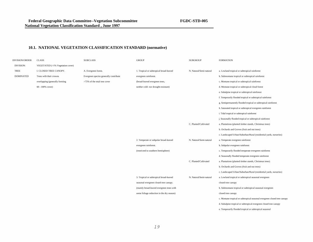
10.1. NATIONAL VEGETATION CLASSIFICATION STANDARD (normative)
DIVISION/ORDER CLASS SUBCLASS GROUP SUBGROUP FORMATION
DIVISION: VEGETATED (>1% Vegetation cover)
TREE I. CLOSED TREE CANOPY. A. Evergreen forest. 1. Tropical or subtropical broad-leaved N. Natural/Semi-natural a. Lowland tropical or subtropical rainforest
DOMINATED Trees with their crowns Evergreen species generally contribute evergreen rainforest. b. Submontane tropical or subtropical rainforest
overlapping (generally forming >75% of the total tree cover (broad-leaved evergreen trees, c. Montane tropical or subtropical rainforest
60 - 100% cover) neither cold- nor drought-resistant) d. Montane tropical or subtropical cloud forest
e. Subalpine tropical or subtropical rainforest
f. Temporarily flooded tropical or subtropical rainforest
g. Semipermanently flooded tropical or subtropical rainforest
h. Saturated tropical or subtropical evergreen rainforest
i. Tidal tropical or subtropical rainforest
j. Seasonally flooded tropical or subtropical rainforest
C. Planted/Cultivated a. Plantations (planted timber stands, Christmas trees)
b. Orchards and Groves (fruit and nut trees)
c. Landscaped Urban/Suburban/Rural (residential yards, nurseries)
2. Temperate or subpolar broad-leaved N. Natural/Semi-natural a. Temperate evergreen rainforest
evergreen rainforest. b. Subpolar evergreen rainforest
(restricted to southern hemisphere) c. Temporarily flooded temperate evergreen rainforest
d. Seasonally flooded temperate evergreen rainforest
C. Planted/Cultivated a. Plantations (planted timber stands, Christmas trees)
b. Orchards and Groves (fruit and nut trees)
c. Landscaped Urban/Suburban/Rural (residential yards, nurseries)
3. Tropical or subtropical broad-leaved N. Natural/Semi-natural a. Lowland tropical or subtropical seasonal evergreen
seasonal evergreen closed tree canopy. closed tree canopy
(mainly broad-leaved evergreen trees with b. Submontane tropical or subtropical seasonal evergreen
some foliage reduction in the dry season) closed tree canopy
c. Montane tropical or subtropical seasonal evergreen closed tree canopy
d. Subalpine tropical or subtropical evergreen closed tree canopy
e. Temporarily flooded tropical or subtropical seasonal

Federal Geographic Data Committee--Vegetation Subcommittee FGDC-STD-005National Vegetation Classification Standard , June 1997
20
evergreen closed tree canopy
f. Seasonally flooded tropical or subtropical seasonal evergreen
closed tree canopy
g. Semipermanently flooded tropical or subtropical seasonal
evergreen closed tree canopy
C. Planted/Cultivated a. Plantations (planted timber stands, Christmas trees)
b. Orchards and Groves (fruit and nut trees)
c. Landscaped Urban/Suburban/Rural (residential yards, nurseries)
4. Temperate broad-leaved seasonal N. Natural/Semi-natural a. Lowland temperate seasonal evergreen closed tree canopy
evergreen closed tree canopy. b. Submontane temperate seasonal evergreen closed tree canopy
(mainly broad-leaved evergreen with some c. Montane temperate seasonal evergreen closed tree canopy
foliage reduction in the dry season) d. Subalpine temperate evergreen closed tree canopy
e. Temporarily flooded temperate seasonal evergreen closed tree canopy
f. Seasonally flooded temperate seasonal evergreen closed tree canopy
g. Saturated temperate seasonal evergreen closed tree canopy
C. Planted/Cultivated a. Plantations (planted timber stands, Christmas trees)
b. Orchards and Groves (fruit and nut trees)
c. Landscaped Urban/Suburban/Rural (residential yards, nurseries)
5. Tropical or subtropical broad-leaved N. Natural/Semi-natural a. Lowland tropical or subtropical broad-leaved evergreen
evergreen sclerophyllous closed tree canopy. sclerophyllous closed tree canopy
b. Temporarily flooded tropical or subtropical broad-leaved
evergreen sclerophyllous closed tree canopy
c. Seasonally flooded tropical or subtropical broad-leaved
evergreen sclerophyllous closed tree canopy
d. Semipermanently flooded tropical or subtropical broad-
leaved evergreen sclerophyllous closed tree canopy
e. Saturated tropical or subtropical broad-leaved evergreen
sclerophyllous closed tree canopy
f.Tidal tropical or subtropical broad-leaved

Federal Geographic Data Committee--Vegetation Subcommittee FGDC-STD-005National Vegetation Classification Standard , June 1997
21
evergreen sclerophyllous closed tree canopy (e.g. mangroves)
C. Planted/Cultivated a. Plantations (planted timber stands, Christmas trees)
b. Orchards and Groves (fruit and nut trees)
c. Landscaped Urban/Suburban/Rural (residential yards, nurseries)
6. Winter-rain broad-leaved evergreen N. Natural/Semi-natural a. Giant lowland or submontane winter-rain evergreen sclerophyllousclosed tree canopy (over 50 m tall, e.g. Eucalyptus in Australia)
sclerophyllous closed tree canopy.
(stiff leathery-leaved trees)
b. Lowland or submontane winter-rain evergreen sclerophyllous
closed tree canopy (under 50 m tall, e.g. live oak in California)
C. Planted/Cultivated a. Plantations (planted timber stands, Christmas trees)
b. Orchards and Groves (fruit and nut trees)
c. Landscaped Urban/Suburban/Rural (residential yards, nurseries)
7. Tropical or subtropical needle-leaved N. Natural/Semi-natural a. Lowland or submontane tropical or subtropical needle-leaved
evergreen closed tree canopy. evergreen closed tree canopy
b. Montane or subalpine tropical or subtropical needle-leaved
evergreen closed tree canopy
c. Temporarily flooded tropical or subtropical needle-leaved
evergreen closed tree canopy
C. Planted/Cultivated a. Plantations (planted timber stands, Christmas trees)
b. Orchards and Groves (fruit and nut trees)
c. Landscaped Urban/Suburban/Rural (residential yards, nurseries)
8. Temperate or subpolar needle-leaved N. Natural/Semi-natural a. Giant temperate or subpolar needle-leaved evergreen
evergreen closed tree canopy. closed tree canopy (e.g. redwood and Douglas Fir)
(mostly needle-leaved or scale-leaved trees) b. Rounded-crowned temperate or subpolar needle-leaved
evergreen closed tree canopy (e.g. pines, western juniper)
c. Conical-crowned temperate or subpolar needle-leaved
evergreen closed tree canopy (e.g. spruce, eastern juniper, cedar)
d. Cylindrical-crowned temperate or subpolar needle-leaved
evergreen closed tree canopy (e.g. boreal spruce forests in Alaska)
e. Temporarily flooded temperate or subpolar needle-leaved

Federal Geographic Data Committee--Vegetation Subcommittee FGDC-STD-005National Vegetation Classification Standard , June 1997
22
evergreen closed tree canopy
f. Seasonally flooded temperate or subpolar needle-leaved
evergreen closed tree canopy
g. Saturated temperate or subpolar needle-leaved evergreen
closed tree canopy
h.Tidal temperate or subpolar needle-leaved
evergreen closed tree canopy
C. Planted/Cultivated a. Plantations (planted timber stands, Christmas trees)
b. Orchards and Groves (fruit and nut trees)
c. Landscaped Urban/Suburban/Rural (residential yards, nurseries)
9. Extremely xeromorphic evergreen N. Natural/Semi-natural a. Sclerophyllous extremely xeromorphic evergreen
closed tree canopy. closed tree canopy
b. Succulent extremely xeromorphic evergreen
closed tree canopy (assumed to be evergreen)
C. Planted/Cultivated a. Plantations (planted timber stands, Christmas trees)
b. Orchards and Groves (fruit and nut trees)
c. Landscaped Urban/Suburban/Rural (residential yards, nurseries)
B. Deciduous closed tree canopy. 1. Drought-deciduous closed tree canopy. N. Natural/Semi-natural a. Lowland or submontane drought-deciduous closed tree canopy
Deciduous tree species generally b. Montane or cloud drought-deciduous closed tree canopy
contribute >75% of the total tree cover C. Planted/Cultivated a. Plantations (planted timber stands, Christmas trees)
b. Orchards and Groves (fruit and nut trees)
c. Landscaped Urban/Suburban/Rural (residential yards, nurseries)
2. Cold-deciduous closed tree canopy. N. Natural/Semi-natural a. Lowland or submontane cold-deciduous closed tree canopy
(e.g. broadleaf forests of the Midwest)
b. Montane or boreal cold-deciduous closed tree canopy
(e.g. broad leaf forests of the mountains)
c. Subalpine or subpolar cold-deciduous closed tree canopy
d. Temporarily flooded cold-deciduous closed tree canopy
(e.g. alluvial bottomland hardwoods)
e. Seasonally flooded cold-deciduous closed tree canopy

Federal Geographic Data Committee--Vegetation Subcommittee FGDC-STD-005National Vegetation Classification Standard , June 1997
23
(e.g. deciduous larch forests in Alaska, peat forests)
f. Semipermanently flooded cold-deciduous closed tree canopy
(e.g. cypress swamp)
g. Saturated cold-deciduous closed tree canopy
h. Tidal cold-deciduous closed tree canopy
C. Planted/Cultivated a. Plantations (planted timber stands, Christmas trees)
b. Orchards and Groves (fruit and nut trees)
c. Landscaped Urban/Suburban/Rural (residential yards, nurseries)
3. Extremely xeromorphic deciduous N. Natural/Semi-natural a. Extremely xeromorphic deciduous thorn closed tree canopy
closed tree canopy. C. Planted/Cultivated a. Plantations (planted timber stands, Christmas trees)
b. Orchards and Groves (fruit and nut trees)
c. Landscaped Urban/Suburban/Rural (residential yards, nurseries)
C. Mixed evergreen-deciduous 1. Tropical or subtropical semi-deciduous N. Natural/Semi-natural a. Lowland tropical or subtropical semi-deciduous
closed tree canopy. closed tree canopy. closed tree canopy
Evergreen and deciduous species each b. Cloud or montane tropical or subtropical semi-deciduous
generally contribute 25-75% of total tree closed tree canopy
cover. (Includes semi-deciduous, c. Seasonally flooded tropical or subtropical semi-deciduous
semi-evergreen, mixed evergreen- closed tree canopy
deciduous xeromorphic, and mixed d. Saturated tropical or subtropical semi-deciduous
needle-leaved evergreen - cold- closed tree canopy
deciduous woody vegetation) C. Planted/Cultivated a. Plantations (planted timber stands, Christmas trees)
b. Orchards and Groves (fruit and nut trees)
c. Landscaped Urban/Suburban/Rural (residential yards, nurseries)
2. Mixed broad-leaved evergreen - N. Natural/Semi-natural a. Mixed broad-leaved evergreen - cold-deciduous
cold-deciduous closed tree canopy. closed tree canopy
b. Temporarily flooded mixed evergreen - cold-deciduous
closed tree canopy
c. Seasonally flooded mixed broad-leaved evergreen -
cold-deciduous closed tree canopy
d. Saturated mixed broad-leaved evergreen -
cold-deciduous closed tree canopy
C. Planted/Cultivated a. Plantations (planted timber stands, Christmas trees)

Federal Geographic Data Committee--Vegetation Subcommittee FGDC-STD-005National Vegetation Classification Standard , June 1997
24
b. Orchards and Groves (fruit and nut trees)
c. Landscaped Urban/Suburban/Rural (residential yards, nurseries)
3. Mixed needle-leaved evergreen - N. Natural/Semi-natural a. Mixed needle-leaved evergreen - cold-deciduous
cold-deciduous closed tree canopy. closed tree canopy
b. Temporarily flooded mixed needle-leaved evergreen -
cold-deciduous closed tree canopy
c. Seasonally flooded mixed needle-leaved evergreen -
cold-deciduous closed tree canopy
d. Saturated mixed needle-leaved evergreen - cold-deciduous
closed tree canopy
C. Planted/Cultivated a. Plantations (planted timber stands, Christmas trees)
b. Orchards and Groves (fruit and nut trees)
c. Landscaped Urban/Suburban/Rural (residential yards, nurseries)
4. Extremely xeromorphic mixed N. Natural/Semi-natural a. Extremely xeromorphic mixed evergreen - deciduous thorn
evergreen-deciduous closed tree canopy. closed tree canopy
C. Planted/Cultivated a. Plantations (planted timber stands, Christmas trees)
b. Orchards and Groves (fruit and nut trees)
c. Landscaped Urban/Suburban/Rural (residential yards, nurseries)
II. OPEN TREE CANOPY A. Evergreen open tree canopy. 1. Tropical or subtropical broad-leaved N. Natural/Semi-natural a. Tropical or subtropical broad-leaved evergreen
Open stands of trees with crowns Evergreen species generally contribute evergreen open tree canopy. open tree canopy
not usually touching (generally >75% of the total tree cover b. Temporarily flooded tropical or subtropical broad-leaved
forming 25 - 60% cover) evergreen open tree canopy
Canopy tree cover may c. Seasonally flooded tropical or subtropical broad-leaved
be less than 25% in cases evergreen open tree canopy
when the cover of each of the d. Semipermanently flooded tropical or subtropical broad-
the other life forms present leaved evergreen open tree canopy
(i.e. shrub, dwarf-shrub, herb, e. Tidal tropical or subtropical broad-leaved
nonvascular) is less than 25% evergreen open tree canopy
and tree cover exceeds the cover C. Planted/Cultivated a. Plantations (planted timber stands, Christmas trees)
of the other life forms b. Orchards and Groves (fruit and nut trees)
c. Landscaped Urban/Suburban/Rural (residential yards, nurseries)

Federal Geographic Data Committee--Vegetation Subcommittee FGDC-STD-005National Vegetation Classification Standard , June 1997
25
2. Temperate broad-leaved evergreen N. Natural/Semi-natural a. Temperate broad-leaved evergreen open tree canopy
open tree canopy. b. Seasonally flooded temperate broad-leaved evergreen
open tree canopy
c. Saturated temperate broad-leaved evergreen open tree canopy
C. Planted/Cultivated a. Plantations (planted timber stands, Christmas trees)
b. Orchards and Groves (fruit and nut trees)
c. Landscaped Urban/Suburban/Rural (residential yards, nurseries)
3. Tropical or subtropical needle-leaved N. Natural/Semi-natural a. Tropical or subtropical needle-leaved evergreen
evergreen open tree canopy. open tree canopy
b. Temporarily flooded tropical or subtropical needle-leaved
evergreen open tree canopy
c. Seasonally flooded tropical or subtropical needle-leaved
evergreen open tree canopy
d. Saturated tropical or subtropical needle-leaved evergreen
open tree canopy
C. Planted/Cultivated a. Plantations (planted timber stands, Christmas trees)
b. Orchards and Groves (fruit and nut trees)
c. Landscaped Urban/Suburban/Rural (residential yards, nurseries)
4. Temperate or subpolar needle-leaved N. Natural/Semi-natural a. Rounded-crowned temperate or subpolar needle-leaved
evergreen open tree canopy. evergreen open tree canopy (e.g. pine, Western juniper)
b. Conical-crowned temperate or subpolar needle-leaved
evergreen open tree canopy (e.g. spruce in the west)
c. Cylindrical-crowned temperate or subpolar needle-leaved
evergreen open tree canopy (e.g. some spruce in Alaska)
d. Temporarily flooded temperate or subpolar needle-leaved
evergreen open tree canopy
e. Seasonally flooded temperate or subpolar needle-leaved
evergreen open tree canopy
f. Saturated temperate or subpolar needle-leaved evergreen
open tree canopy (e.g. black spruce bogs)
C. Planted/Cultivated a. Plantations (planted timber stands, Christmas trees)

Federal Geographic Data Committee--Vegetation Subcommittee FGDC-STD-005National Vegetation Classification Standard , June 1997
26
b. Orchards and Groves (fruit and nut trees)
c. Landscaped Urban/Suburban/Rural (residential yards, nurseries)
5. Extremely xeromorphic evergreen N. Natural/Semi-natural a. Sclerophyllous extremely xeromorphic evergreen
open tree canopy. open tree canopy
b. Succulent extremely xeromorphic evergreen open tree canopy
C. Planted/Cultivated a. Plantations (planted timber stands, Christmas trees)
b. Orchards and Groves (fruit and nut trees)
c. Landscaped Urban/Suburban/Rural (residential yards, nurseries)
B. Deciduous open tree canopy. 1. Tropical or subtropical drought- N. Natural/Semi-natural a. Lowland or submontane broad-leaved drought-deciduous
Deciduous tree species generally deciduous open tree canopy. open tree canopy
contribute to >75% of the total tree cover
b. Montane (and cloud) drought-deciduous open tree canopy
c. Temporarily flooded tropical or subtropical drought-
deciduous open tree canopy
d. Seasonally flooded tropical or subtropical drought-deciduous
open tree canopy
C. Planted/Cultivated a. Plantations (planted timber stands, Christmas trees)
b. Orchards and Groves (fruit and nut trees)
c. Landscaped Urban/Suburban/Rural (residential yards, nurseries)
2. Cold-deciduous open tree canopy. N. Natural/Semi-natural a. Cold-deciduous open tree canopy
b. Temporarily flooded cold-deciduous open tree canopy
c. Seasonally flooded cold-deciduous open tree canopy
d. Semipermanently flooded cold-deciduous open tree canopy
e. Saturated cold-deciduous open tree canopy
f. Tidal cold-deciduous open tree canopy
C. Planted/Cultivated a. Plantations (planted timber stands, Christmas trees)
b. Orchards and Groves (fruit and nut trees)
c. Landscaped Urban/Suburban/Rural (residential yards, nurseries)
3. Extremely xeromorphic deciduous N. Natural/Semi-natural a. Thorn extremely xeromorphic deciduous open tree canopy
open tree canopy. (may not be represented in the U.S.)
C. Planted/Cultivated a. Plantations (planted timber stands, Christmas trees)
b. Orchards and Groves (fruit and nut trees)

Federal Geographic Data Committee--Vegetation Subcommittee FGDC-STD-005National Vegetation Classification Standard , June 1997
27
c. Landscaped Urban/Suburban/Rural (residential yards, nurseries)
C. Mixed evergreen-deciduous 1. Tropical or subtropical semi-deciduous N. Natural/Semi-natural a. Tropical or subtropical semi-deciduous open tree canopy
open tree canopy. Evergreen and deciduous species open tree canopy. C. Planted/Cultivated a. Plantations (planted timber stands, Christmas trees)
each contribute 25-75% of total tree cover b. Orchards and Groves (fruit and nut trees)
(Includes semi-deciduous, semi-evergreen, c. Landscaped Urban/Suburban/Rural (residential yards
mixed evergreen-deciduous xeromorphic, nurseries)
and mixed needle-leaved evergreen -
cold-deciduous woody vegetation) 2. Mixed broad-leaved evergreen - N. Natural/Semi-natural a. Mixed broad-leaved evergreen - cold-deciduous
cold-deciduous open tree canopy. open tree canopy
C. Planted/Cultivated a. Plantations (planted timber stands, Christmas trees)
b. Orchards and Groves (fruit and nut trees)
c. Landscaped Urban/Suburban/Rural (residential yards, nurseries)
3. Mixed needle-leaved evergreen - N. Natural/Semi-natural a. Mixed needle-leaved evergreen - cold-deciduous
cold-deciduous open tree canopy. open tree canopy
b. Seasonally flooded mixed needle-leaved evergreen -
cold-deciduous open tree canopy
c. Saturated mixed needle-leaved evergreen - cold-deciduous
open tree canopy
C. Planted/Cultivated a. Plantations (planted timber stands, Christmas trees)
b. Orchards and Groves (fruit and nut trees)
c. Landscaped Urban/Suburban/Rural (residential yards, nurseries)
4. Extremely xeromorphic mixed N. Natural/Semi-natural a. Mixed evergreen-deciduous thorn open tree canopy
evergreen-deciduous open tree canopy. C. Planted/Cultivated a. Plantations (planted timber stands, Christmas trees)
b. Orchards and Groves (fruit and nut trees)
c. Landscaped Urban/Suburban/Rural (residential yards, nurseries)
SHRUB III. SHRUBLAND. (SCRUB) A. Evergreen shrubland. (scrub) 1. Tropical or subtropical broad-leaved N. Natural/Semi-natural a. Tropical or subtropical broad-leaved evergreen shrubland
DOMINATED Shrubs generally greater than Evergreen species generally contribute evergreen shrubland. (includes bamboos and tuft-trees)
0.5 m tall with individuals or clumps >75% of the total shrub cover (with or without scattered tree canopy) b. Hemi-sclerophyllous tropical or subtropical broad-leaved
not touching to overlapping evergreen shrubland

Federal Geographic Data Committee--Vegetation Subcommittee FGDC-STD-005National Vegetation Classification Standard , June 1997
28
(generally forming > 25% canopy c. Sclerophyllous tropical or subtropical broad-leaved
cover - tree cover generally <25%) evergreen shrubland
Shrub cover may be d. Tropical or subtropical broad-leaved evergreen shrubland
less than 25% in cases when the with a sparse broad-leaved evergreen tree layer (includes tuft trees)cover of each of the other
life forms present (i.e. tree, e. Temporarily flooded tropical or subtropical broad-leaved evergreen
shrublandis less than 25% and shrub cover
f. Seasonally flooded tropical or subtropical broad-leaved
exceeds the cover of the other evergreen shrubland
life forms g. Semipermanently flooded tropical or subtropical broad-
leaved evergreen shrubland
h. Saturated tropical or subtropical broad-leaved evergreen shrubland
i. Tidal tropical or subtropical broad-leaved evergreen shrubland
C. Planted/Cultivated a. Fruit/Nut Shrubs and Vines (vineyards)
b. Landscaped Urban/Suburban/Rural (residential yards, nurseries)
2. Temperate broad-leaved evergreen N. Natural/Semi-natural a. Temperate broad-leaved evergreen shrubland (including
shrubland. (with or without scattered tree canopy) bamboos and tuft-trees)
b. Hemi-sclerophyllous temperate broad-leaved evergreen shrubland
c. Sclerophyllous temperate broad-leavedevergreen shrubland
d. Suffruticose temperate broad-leaved evergreen shrubland
e. Temperate broad-leaved evergreen shrubland with a sparse
broad-leaved evergreen tree layer (includes tuft trees)
f. Temperate broad-leaved evergreen shrubland with a sparse cold-
deciduous tree layer
g. Temporarily flooded temperate broad-leaved evergreen shrubland
h. Seasonally flooded temperate broad-leaved evergreen shrubland
i. Saturated temperate broad-leaved evergreen shrubland
j. Saturated temperate broad-leaved evergreen shrubland with a
sparse needle-leaved or mixed evergreen tree layer (e.g. pocosins)
k. Saturated temperate broad-leaved evergreen shrubland
with a sparse cold-deciduous tree layer

Federal Geographic Data Committee--Vegetation Subcommittee FGDC-STD-005National Vegetation Classification Standard , June 1997
29
l. Tidal broad-leaved evergreen temperate shrubland
C. Planted/Cultivated a. Fruit/Nut Shrubs and Vines (vineyards)
b. Landscaped Urban/Suburban/Rural (residential yards, nurseries)
III. 3. Needle-leaved evergreen shrubland. N. Natural/Semi-natural a. Needle-leaved evergreen shrubland (e.g. krummholz)
b. Saturated needle-leaved evergreen shrubland (e.g. shrub bog)
C. Planted/Cultivated a. Fruit/Nut Shrubs and Vines (vineyards)
b. Landscaped Urban/Suburban/Rural (residential yards, nurseries)
4. Microphyllous evergreen shrubland. N. Natural/Semi-natural a. Microphyllous evergreen shrubland
(e.g. sagebrush) b. Intermittently flooded microphyllous shrubland
c. Temporarily flooded microphyllous shrubland
d. Seasonally flooded microphyllous shrubland
C. Planted/Cultivated a. Fruit/Nut Shrubs and Vines (vineyards)
b. Landscaped Urban/Suburban/Rural (residential yards, nurseries)
5. Extremely xeromorphic evergreen N. Natural/Semi-natural a. Broad-leaved and microphyllous evergreen extremely
shrubland. xeromorphic subdesert shrubland (e.g. creosote bush)
b. Facultatively deciduous extremely xeromorphic subdesert
shrubland (e.g. saltbush)
c. Succulent extremely xeromorphic evergreen shrubland
d. Tidal extremely xeromorphic shrubland
e. Extremely xeromorphic evergreen shrubland with a sparse tree layer
C. Planted/Cultivated a. Fruit/Nut Shrubs and Vines (vineyards)
b. Landscaped Urban/Suburban/Rural (residential yards, nurseries)
B. Deciduous shrubland. (scrub) 1. Drought-deciduous shrubland. N. Natural/Semi-natural a. Lowland drought-deciduous shrubland
Deciduous species generally contribute C. Planted/Cultivated a. Fruit/Nut Shrubs and Vines (vineyards)
>75% of the total shrub cover b. Landscaped Urban/Suburban/Rural (residential yards, nurseries)
2. Cold-deciduous shrubland. N. Natural/Semi-natural a. Temperate cold-deciduous shrubland (e.g. serviceberry, some oaks)
b. Subalpine or subpolar cold-deciduous shrubland (e.g. willow, alder)
c. Intermittently flooded cold-deciduous shrubland
d. Temporarily flooded cold-deciduous shrubland

Federal Geographic Data Committee--Vegetation Subcommittee FGDC-STD-005National Vegetation Classification Standard , June 1997
30
e. Seasonally flooded cold-deciduous shrubland (e.g. blueberry -
azalea thickets)
f. Semipermanently flooded cold-deciduous shrubland
(e.g. buttonbush thickets)
g. Saturated cold-deciduous shrubland (e.g. on peat)
h.Tidal cold-deciduous shrubland (e.g. high tide bush)
C. Planted/Cultivated a. Fruit/Nut Shrubs and Vines (vineyards)
b. Landscaped Urban/Suburban/Rural (residential yards, nurseries)
3. Extremely xeromorphic deciduous N. Natural/Semi-natural a. Extremely xeromorphic deciduous subdesert shrubland
shrubland. without succulents
b. Intermittently flooded extremely xeromorphic deciduous
subdesert shrubland
C. Planted/Cultivated a. Fruit/Nut Shrubs and Vines (vineyards)
b. Landscaped Urban/Suburban/Rural (residential yards, nurseries)
C. Mixed evergreen-deciduous 1. Mixed evergreen - drought-deciduous N. Natural/Semi-natural a. Lowland mixed evergreen - drought-deciduous shrubland
shrubland. (scrub) shrubland. C. Planted/Cultivated a. Fruit/Nut Shrubs and Vines (vineyards)
Evergreen and deciduous species each b. Landscaped Urban/Suburban/Rural (residential yards,
generally contribute 25-75% of total nurseries)
shrub cover (includes facultatively
deciduous, extremely xeromorphic 2. Mixed evergreen - cold-deciduous N. Natural/Semi-natural a. Mixed evergreen - cold-deciduous shrubland
mixed evergreen-deciduous shrubland.(with or without scattered tree canopy) b. Mixed evergreen - cold-deciduous shrubland with a sparse needle-
woody plants) leaved evergreen tree layer (e.g. pitch pine-scrub oak)
c. Intermittently flooded mixed evergreen - cold-deciduous shrubland
d. Seasonally flooded mixed evergreen - cold-deciduous shrubland
e. Saturated mixed evergreen - cold-deciduous shrubland (e.g. on peat)
f. Saturated mixed evergreen - cold-deciduous shrubland
with a sparse needle-leaved evergreen tree layer (e.g. pocosins)
C. Planted/Cultivated a. Fruit/Nut Shrubs and Vines (vineyards)
b. Landscaped Urban/Suburban/Rural (residential yards, nurseries)
3. Extremely xeromorphic mixed N. Natural/Semi-natural a. Extremely xeromorphic deciduous subdesert shrubland
evergreen-deciduous shrubland. with succulents (e.g. palo verde)
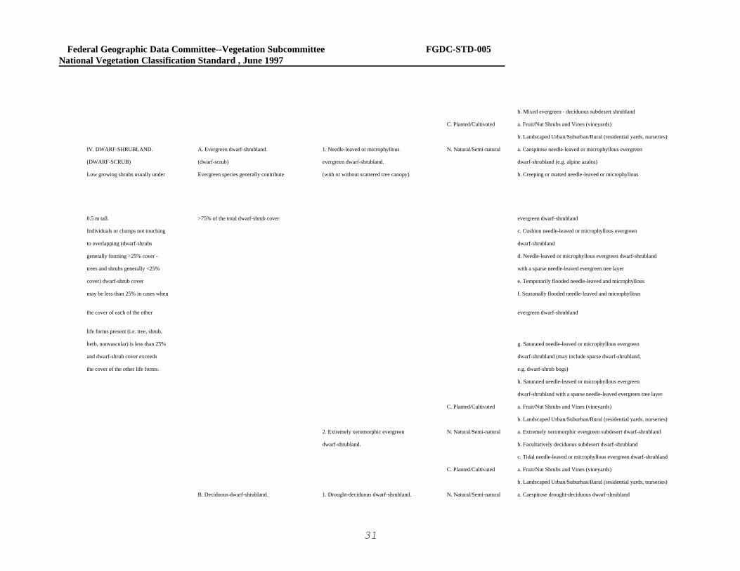
Federal Geographic Data Committee--Vegetation Subcommittee FGDC-STD-005National Vegetation Classification Standard , June 1997
31
b. Mixed evergreen - deciduous subdesert shrubland
C. Planted/Cultivated a. Fruit/Nut Shrubs and Vines (vineyards)
b. Landscaped Urban/Suburban/Rural (residential yards, nurseries)
IV. DWARF-SHRUBLAND. A. Evergreen dwarf-shrubland. 1. Needle-leaved or microphyllous N. Natural/Semi-natural a. Caespitose needle-leaved or microphyllous evergreen
(DWARF-SCRUB) (dwarf-scrub) evergreen dwarf-shrubland. dwarf-shrubland (e.g. alpine azalea)
Low growing shrubs usually under Evergreen species generally contribute (with or without scattered tree canopy) b. Creeping or matted needle-leaved or microphyllous
0.5 m tall. >75% of the total dwarf-shrub cover evergreen dwarf-shrubland
Individuals or clumps not touching c. Cushion needle-leaved or microphyllous evergreen
to overlapping (dwarf-shrubs dwarf-shrubland
generally forming >25% cover - d. Needle-leaved or microphyllous evergreen dwarf-shrubland
trees and shrubs generally <25% with a sparse needle-leaved evergreen tree layer
cover) dwarf-shrub cover e. Temporarily flooded needle-leaved and microphyllous
may be less than 25% in cases when f. Seasonally flooded needle-leaved and microphyllous
the cover of each of the other evergreen dwarf-shrubland
life forms present (i.e. tree, shrub,
herb, nonvascular) is less than 25% g. Saturated needle-leaved or microphyllous evergreen
and dwarf-shrub cover exceeds dwarf-shrubland (may include sparse dwarf-shrubland,
the cover of the other life forms. e.g. dwarf-shrub bogs)
h. Saturated needle-leaved or microphyllous evergreen
dwarf-shrubland with a sparse needle-leaved evergreen tree layer
C. Planted/Cultivated a. Fruit/Nut Shrubs and Vines (vineyards)
b. Landscaped Urban/Suburban/Rural (residential yards, nurseries)
2. Extremely xeromorphic evergreen N. Natural/Semi-natural a. Extremely xeromorphic evergreen subdesert dwarf-shrubland
dwarf-shrubland. b. Facultatively deciduous subdesert dwarf-shrubland
c. Tidal needle-leaved or microphyllous evergreen dwarf-shrubland
C. Planted/Cultivated a. Fruit/Nut Shrubs and Vines (vineyards)
b. Landscaped Urban/Suburban/Rural (residential yards, nurseries)
B. Deciduous dwarf-shrubland. 1. Drought-deciduous dwarf-shrubland. N. Natural/Semi-natural a. Caespitose drought-deciduous dwarf-shrubland

Federal Geographic Data Committee--Vegetation Subcommittee FGDC-STD-005National Vegetation Classification Standard , June 1997
32
Deciduous species generally contribute b. Creeping or matted drought-deciduous dwarf-shrubland
>75% of the total dwarf-shrub cover c. Cushion drought-deciduous dwarf-shrubland
C. Planted/Cultivated a. Fruit/Nut Shrubs and Vines (vineyards)
b. Landscaped Urban/Suburban/Rural (residential yards, nurseries)
2. Cold-deciduous dwarf-shrubland. N. Natural/Semi-natural a. Caespitose cold-deciduous dwarf-shrubland
b. Creeping or matted cold-deciduous dwarf-shrubland
c. Cushion cold-deciduous dwarf-shrubland
d. Saturated cold-deciduous dwarf-shrubland
C. Planted/Cultivated a. Fruit/Nut Shrubs and Vines (vineyards)
b. Landscaped Urban/Suburban/Rural (residential yards, nurseries)
3. Extremely xeromorphic deciduous N. Natural/Semi-natural a. Extremely xeromorphic deciduous subdesert dwarf-shrubland
dwarf-shrubland. without succulents
IV. B. C. Planted/Cultivated a. Fruit/Nut Shrubs and Vines (vineyards)
b. Landscaped Urban/Suburban/Rural (residential yards, nurseries)
C. Mixed evergreen-deciduous 1. Mixed evergreen - drought-deciduous N. Natural/Semi-natural a. Mixed evergreen - drought-deciduous dwarf-shrubland
dwarf-shrubland. (dwarf-scrub) dwarf-shrubland. C. Planted/Cultivated a. Fruit/Nut Shrubs and Vines (vineyards)
Evergreen and deciduous species each b. Landscaped Urban/Suburban/Rural (residential yards,
generally contribute 25-75% of total nurseries)
dwarf-shrub cover (Includes facultatively
deciduous shrubs and other mixed 2. Mixed evergreen- cold-deciduous N. Natural/Semi-natural a. Mixed evergreen - cold-deciduous dwarf-shrubland
xeromorphic evergreen-deciduous shrubs) dwarf-shrubland. C. Planted/Cultivated a. Fruit/Nut Shrubs and Vines (vineyards)
b. Landscaped Urban/Suburban/Rural (residential yards, nurseries)
3. Extremely xeromorphic mixed evergreen - N. Natural/Semi-natural a. Deciduous subdesert dwarf-shrubland with succulents
deciduous dwarf-shrubland. b. Mixed evergreen - deciduous subdesert dwarf-shrubland
C. Planted/Cultivated a. Fruit/Nut Shrubs and Vines (vineyards)
b. Landscaped Urban/Suburban/Rural (residential yards, nurseries)
HERB V. HERBACEOUS VEGETATION. A. Perennial graminoid vegetation 1. Tropical or subtropical grassland. N. Natural/Semi-natural a. Tall tropical or subtropical grassland
DOMINATED Herbs (graminoids, forbs and ferns) (grasslands). Perennial graminoids b. Medium-tall sod tropical or subtropical grassland
dominant (generally forming at generally contribute to > 50% of c. Medium-tall bunch tropical or subtropical grassland
least 25% canopy cover). Trees total herbaceous canopy cover d. Short sod tropical or subtropical grassland
shrubs and dwarf-shrubs generally e. Short bunch tropical alpine grassland (e.g. Super-paramo)

Federal Geographic Data Committee--Vegetation Subcommittee FGDC-STD-005National Vegetation Classification Standard , June 1997
33
with less than 25% cover. f. Temporarily flooded tropical or subtropical grassland
Herbaceous canopy cover g. Seasonally flooded tropical or subtropical grassland
may be less than 25% in cases h. Semipermanently flooded tropical or subtropical grassland
when the cover of each of the i. Tidal tropical or subtropical grassland
the other life forms present C. Planted/Cultivated a. Perennial Grass Crops (hayland, pastureland)
(i.e. tree, shrub, dwarf-shrub, b. Landscaped Urban/Suburban/Rural (residential yards, nurseries)
nonvascular) 'is less than 25%
and herbaceous cover exceeds
the cover of the other life forms. 2. Tropical or subtropical grassland N. Natural/Semi-natural a. Tall tropical or subtropical grassland with a sparse mainly
with a sparse tree layer . broad-leaved evergreen tree layer (includes tuft plants and
broad-leaved semi-evergreen trees)
b. Tall tropical or subtropical grassland with a sparse broad-
leaved drought-deciduous tree layer
c. Medium-tall tropical or subtropical grassland with a sparse
broad-leaved evergreen tree layer (includes tuft plants and
semi-evergreen trees)
d. Medium-tall tropical or subtropical grassland with a sparse
broad-leaved drought-deciduous tree layer
e. Medium-tall tropical or subtropical grassland with a sparse
needle-leaved evergreen or mixed tree layer
f. Medium-tall tropical or subtropical grassland with a sparse
xeromorphic or succulent tree layer
g. Temporarily flooded tropical grassland with a sparse broad-
leaved evergreen tree layer (includes tuft plants, e.g. Llanos de
Mojos, Bolivia)
h. Temporarily flooded tropical grassland with a sparse broad-
leaved deciduous tree layer (e.g. in Northeast Bolivia)
i. Seasonally flooded tropical or subtropical grassland with a
sparse needle-leaved evergreen tree layer
j. Seasonally flooded tropical or subtropical grassland with a
sparse needle-leaved deciduous tree layer
C. Planted/Cultivated a. Perennial Grass Crops (hayland, pastureland)

Federal Geographic Data Committee--Vegetation Subcommittee FGDC-STD-005National Vegetation Classification Standard , June 1997
34
b. Landscaped Urban/Suburban/Rural (residential yards, nurseries)
3. Tropical or subtropical grassland N. Natural/Semi-natural a. Tall tropical or subtropical grassland with a sparse broad-
with a sparse shrub layer. leaved evergreen or semi-evergreen shrub layer (includes tuft shrubs)
b. Tall tropical or subtropical grassland with a sparse broad-
leaved drought-deciduous shrub layer
c. Medium-tall tropical or subtropical grassland with a sparse
broad-leaved evergreen or semi-evergreen shrub layer
(includes tuft plants)
d. Medium-tall tropical or subtropical grassland with a sparse
drought-deciduous shrub layer
e. Medium-tall tropical or subtropical grassland with a sparse
xeromorphic (often thorny) shrub layer
f. Short tropical or subtropical grassland with a sparse broad-
leaved evergreen or semi-evergreen shrub layer (includes tuft
plants, e.g. Paramo)
g. Short tropical or subtropical grassland with a sparse drought-
deciduous shrub layer (includes thorny shrubs)
h. Short alpine bunch tropical or subtropical grassland with a
sparse evergreen shrub layer
i. Temporarily flooded tropical or subtropical grassland with a
sparse evergreen broad-leaved shrub layer
C. Planted/Cultivated a. Perennial Grass Crops (hayland, pastureland)
b. Landscaped Urban/Suburban/Rural (residential yards, nurseries)
4. Tropical or subtropical grassland N. Natural/Semi-natural a. Short bunch tropical or subtropical grassland with a sparse
with a sparse dwarf-shrub layer. needle-leaved or microphyllous evergreen dwarf-shrub layer (e.g. Puna)
C. Planted/Cultivated a. Perennial Grass Crops (hayland, pastureland)
b. Landscaped Urban/Suburban/Rural (residential yards, nurseries)
5. Temperate or subpolar grassland. N. Natural/Semi-natural a. Tall sod temperate grassland (includes sod or mixed sod-bunch
graminoids)
b. Tall bunch temperate grassland
c. Medium-tall sod temperate or subpolar grassland (includes
sod or mixed sod-bunch graminoids)
d. Medium-tall bunch temperate or subpolar grassland

Federal Geographic Data Committee--Vegetation Subcommittee FGDC-STD-005National Vegetation Classification Standard , June 1997
35
e. Short sod temperate or subpolar grassland (includes sod
or mixed sod-bunch graminoids, e.g. shortgrass prairie)
f. Short bunch temperate or subpolar grassland
g. Short alpine or subalpine sod grassland
h. Short alpine or subalpine dry bunch grassland
i. Intermittently flooded temperate or subpolar grassland
(e.g. playa lakes)
j. Temporarily flooded temperate or subpolar grassland
k. Seasonally flooded temperate or subpolar grassland
l. Semipermanently flooded temperate or subpolar grassland
m. Saturated temperate or subpolar grassland
n. Tidal temperate or subpolar grassland
C. Planted/Cultivated a. Perennial Grass Crops (hayland, pastureland)
b. Landscaped Urban/Suburban/Rural (residential yards, nurseries)
6. Temperate or subpolar grassland N. Natural/Semi-natural a. Tall temperate grassland with a sparse broad-leaved
with a sparse tree layer. evergreen tree layer
b. Tall temperate grassland with a sparse needle-leaved
evergreen tree layer
c. Tall temperate grassland with a sparse cold-deciduous tree layer
d. Tall temperate grassland with a sparse mixed needle-
leaved evergreen or cold-deciduous tree layer
e. Medium-tall temperate grassland with a sparse broad-leaved
evergreen or semi-evergreen tree layer (includes tuft plants)
f. Medium-tall temperate or subpolar grassland with a sparse
needle-leaved evergreen or mixed tree layer
g. Medium-tall temperate or subpolar grassland with a sparse
cold-deciduous tree layer
h. Short temperate or subpolar grassland with a sparse broad-
leaved evergreen or semi-evergreen tree layer
i. Short temperate or subpolar grassland with a sparse cold-
deciduous tree layer
j. Intermittently flooded temperate or subpolar grassland with a
sparse needle-leaved evergreen tree layer

Federal Geographic Data Committee--Vegetation Subcommittee FGDC-STD-005National Vegetation Classification Standard , June 1997
36
k. Temporarily flooded temperate or subpolar grassland with a
sparse broad-leaved evergreen tree layer
l. Temporarily flooded temperate or subpolar grassland with a
sparse cold-deciduous tree layer
m. Seasonally flooded temperate or subpolar grassland with a
sparse cold-deciduous tree layer
n. Semipermanently flooded temperate or subpolar grassland
with a sparse cold-deciduous tree layer
o. Saturated temperate or subpolar grassland with a
sparse needle-leaved evergreen tree layer
p. Tidal temperate grassland with a sparse
cold-deciduous tree layer
C. Planted/Cultivated a. Perennial Grass Crops (hayland, pastureland)
b. Landscaped Urban/Suburban/Rural (residential yards, nurseries)
7. Temperate or subpolar grassland N. Natural/Semi-natural a. Tall temperate grassland with a sparse broad-leaved
with a sparse shrub layer. evergreen shrub layer (includes tuft shrubs)
b. Tall temperate grassland with a sparse microphyllous
evergreen shrub layer
c. Tall temperate grassland with a sparse cold-deciduous shrub layer
d. Medium-tall temperate or subpolar grassland with a sparse
broad-leaved evergreen shrub layer
e. Medium-tall temperate or subpolar grassland with a sparse
needle-leaved or microphyllous evergreen shrub layer
f. Medium-tall temperate or subpolar grassland with a sparse
drought-deciduous shrub layer
g. Medium-tall temperate or subpolar grassland with a sparse
cold-deciduous shrub layer
h. Medium-tall temperate grassland with a sparse xeromorphic
(often thorny) shrub layer
i. Short temperate or subpolar grassland with a sparse broad-
leaved evergreen or semi-evergreen shrub layer
j. Short temperate or subpolar grassland with a sparse
microphyllous evergreen shrub layer

Federal Geographic Data Committee--Vegetation Subcommittee FGDC-STD-005National Vegetation Classification Standard , June 1997
37
k. Short temperate or subpolar grassland with a sparse drought-
deciduous shrub layer (includes thorny shrubs)
l. Short temperate or subpolar grassland with a sparse cold-
deciduous shrub layer
m. Short temperate or subpolar grassland with a sparse
xeromorphic (evergreen and/or deciduous) shrub layer
n. Intermittently flooded temperate or subpolar grassland
with a sparse xeromorphic (evergreen and/or deciduous) shrub layer
o. Saturated temperate or subpolar grassland with a sparse
broad-leaved evergreen shrub layer
p. Saturated temperate or subpolar grassland with a sparse
cold-deciduous shrub layer
q. Saturated temperate or subpolar grassland with a sparse
microphyllous evergreen shrub layer
C. Planted/Cultivated a. Perennial Grass Crops (hayland, pastureland)
b. Landscaped Urban/Suburban/Rural (residential yards, nurseries)
8. Temperate or subpolar grassland N. Natural/Semi-natural a. Short temperate or subpolar lowland grassland with a sparse
with a sparse dwarf-shrub layer. needle-leaved or microphyllous dwarf shrub layer
b. Short temperate or subpolar lowland grassland with a sparse
cold-deciduous dwarf shrub layer
c. Short temperate or subpolar alpine grassland with a sparse
needle-leaved or microphyllous evergreen dwarf-shrub layer
(e.g. dwarf-shrub meadows)
d. Seasonally flooded temperate or subpolar grassland with a
sparse needle-leaved or microphyllous dwarf-shrub layer
C. Planted/Cultivated a. Perennial Grass Crops (hayland, pastureland)
b. Landscaped Urban/Suburban/Rural (residential yards, nurseries)
9. Polar grassland. N. Natural/Semi-natural a. Short sod polar grassland (including sod or mixed sod-bunch
grassland, e.g. sod grass tundra)
b. Short bunch polar grassland (e.g. Eriophorum)
c. Seasonally flooded polar grassland
d. Saturated polar grassland with nonvascular plants admixed
C. Planted/Cultivated a. Perennial Grass Crops (hayland, pastureland)

Federal Geographic Data Committee--Vegetation Subcommittee FGDC-STD-005National Vegetation Classification Standard , June 1997
38
b. Landscaped Urban/Suburban/Rural (residential yards, nurseries)
10. Polar grassland with a sparse shrub layer. N. Natural/Semi-natural [Formations have not yet been defined]
C. Planted/Cultivated a. Perennial Grass Crops (hayland, pastureland)
b. Landscaped Urban/Suburban/Rural (residential yards, nurseries)
11. Polar grassland with a sparse dwarf-shrub N. Natural/Semi-natural [Formations have not yet been defined]
layer. C. Planted/Cultivated a. Perennial Grass Crops (hayland, pastureland)
b. Landscaped Urban/Suburban/Rural (residential yards, nurseries)
B. Perennial forb vegetation. 1.Tropical or subtropical perennial forb N. Natural/Semi-natural a. Tall tropical or subtropical perennial forb vegetation
Perennial forbs (including ferns and vegetation. b. Low tropical or subtropical perennial forb vegetation
biennials) generally contributing to >50% c. Semipermanently flooded tropical or subtropical perennial
of total herbaceous canopy cover forb vegetation
d. Saturated tropical or subtropical perennial forb vegetation
e. Tidal tropical or subtropical perennial forb vegetation
C. Planted/Cultivated a. Perennial Forb Row Crops
b. Perennial Forb Close-Grown Crops
c. Landscaped Urban/Suburban/Rural (residential yards, nurseries)
2. Temperate or subpolar perennial forb N. Natural/Semi-natural a. Tall temperate or subpolar perennial forb vegetation
vegetation. (e.g. tall forb meadows)
b. Low temperate or subpolar perennial forb vegetation
(e.g. Aleutian forb meadows)
c. Intermittently flooded temperate perennial forb vegetation
d. Temporarily flooded temperate perennial forb vegetation
e. Semipermanently flooded temperate perennial forb vegetation
f. Saturated temperate perennial forb vegetation
g. Tidal temperate perennial forb vegetation
h. Seasonally flooded temperate perennial forb vegetation
C. Planted/Cultivated a. Perennial Forb Row Crops
b. Perennial Forb Close-Grown Crops
c. Landscaped Urban/Suburban/Rural (residential yards, nurseries)
C. Hydromorphic rooted vegetation. 1. Tropical or subtropical hydromorphic N. Natural/Semi-natural a. Permanently flooded tropical or subtropical hydromorphic
Non-emergent graminoids or forbs rooted vegetation. rooted vegetation
structurally supported by water and (without seasonal contrasts) b. Permanently flooded-tidal tropical or subtropical
rooted in substrate (e.g. pond weeds hydromorphic rooted vegetation (e.g. tropical seagrass beds)

Federal Geographic Data Committee--Vegetation Subcommittee FGDC-STD-005National Vegetation Classification Standard , June 1997
39
and water lilies). C. Planted/Cultivated [Formations have not yet been defined]
2. Temperate or subpolar N. Natural/Semi-natural a. Permanently flooded temperate or subpolar hydromorphic rootedvegetation
hydromorphic rooted vegetation.
b. Permanently flooded-tidal temperate or subpolar
hydromorphic rooted vegetation (e.g. temperate seagrass beds)
C. Planted/Cultivated [Formations have not yet been defined]
D. Annual graminoid or forb vegetation. 1. Tropical or subtropical annual N. Natural/Semi-natural a. Tropical or subtropical annual grasslands
grasslands or forb vegetation. b. Tall tropical or subtropical annual forb vegetation.
c. Low tropical or subtropical ephemeral annual forb vegetation
d. Tidal tropical or subtropical annual forb vegetation
C. Planted/Cultivated a. Annual Close-Grown Forbs and Grasses
b. Annual Row-Crop Forbs and Grasses
2. Temperate or subpolar annual N. Natural/Semi-natural a. Tall temperate or subpolar annual grassland (dominated by
grasslands or forb vegetation. annual graminoids)
b. Tall temperate or subpolar annual forb vegetation (dominated
by annual forbs)
c. Low desert or subdesert ephemeral or episodic annual forb
vegetation
d. Short temperate annual grassland
e. Low temperate intermittently exposed annual forb vegetation
f. Temporarily flooded temperate annual forb vegetation
g. Seasonally flooded temperate annual grassland
h. Seasonally flooded temperate annual forb vegetation
i. Saturated temperate annual forb vegetation
. C. Planted/Cultivated a. Annual Close-Grown Forbs and Grasses
b. Annual Row-Crop Forbs and Grasses
NONVASCULAR VI. NONVASCULAR VEGETATION. A. Bryophyte vegetation. 1. Temperate or subpolar bryophyte N. Natural/Semi-natural a. Lowland bryophyte vegetation
DOMINATED Nonvascular cover (bryophytes, Bryophytes generally dominate vegetation. b. Seasonally flooded bryophyte vegetation
lichens and algae) dominant the nonvascular cover. c. Saturated bryophyte vegetation
(generally forming at least 25% d. Saturated bryophyte vegetation with a sparse tree layer
cover). Trees, shrubs, dwarf-shrubs (e.g. treed bogs)
and herbs generally with less than e. Saturated bryophyte vegetation with a sparse dwarf-shrub

Federal Geographic Data Committee--Vegetation Subcommittee FGDC-STD-005National Vegetation Classification Standard , June 1997
40
25% cover. layer (e.g. dwarf-shrub/moss tundra)
Nonvascular cover may be C. Planted/Cultivated [Formations have not yet been defined]
less than 25% in cases when the
cover of each of the other life forms B. Lichen vegetation. 1. Temperate or subpolar lichen vegetation. N. Natural/Semi-natural a. Lowland lichen vegetation
present (tree, shrub, dwarf-shrub, Lichens (foliose or fruticose) generally b. Montane/submontane tropical or subtropical ichen vegetation
DIVISION/ORDER CLASS SUBCLASS GROUP SUBGROUP FORMATION
and herb) is less than 25% and non- dominate the nonvascular cover c. Lichen vegetation with a sparse tree layer
vascular cover exceeds the cover of d. Lichen vegetation with a sparse dwarf-shrub layer
the other life forms. Crustose lichen- C. Planted/Cultivated [Formations have not yet been defined]
dominated areas should be placed
in the Sparsely Vegetated class. 2. Tropical or subtropical lichen vegetation N. Natural/Semi-natural a. Montane/submontane tropical or subtropical lichen vegetation
C. Alga vegetation 1. Tropical or subtropical alga vegetation N. Natural/Semi-natural a. Seasonally flooded alga vegetation
Algae generally dominate the nonvascular
cover
VEGETATION VII. SPARSE VEGETATION. A. Consolidated rock sparse vegetation. 1. Sparsely vegetated cliffs. N. Natural/Semi-natural a. Cliffs with sparse vascular vegetation (e.g. bromeliads in neotropics)
NOT DOMINANT Vegetation is scattered or (cliffs, pavement, incl. pahoehoe lava flows) (May have sparse to dense cructose lichens, sparse bryoids or foliose orfructicose lichens)
nearly absent; total vegetation [Vegetation characterized by herbs,
cover, excluding crustose shrubs, trees, and/or nonvascular
lichens (which can sometimes plants growing in fissures of rocks or walls, C. Planted/Cultivated [Formations have not yet been defined]
have greater then 10% cover) or growing adnate on these surfaces]
is generally 1%- 10% 2. Sparsely vegetated pavement. N. Natural/Semi-natural a. Pavement with sparse vascular vegetation
(level/gently sloping bedrock) (May have sparse to dense crustose lichens, sparse
bryoids, or foliose or fruticose lichens)
C. Planted/Cultivated [Formations have not yet been defined]
B. Boulder, gravel, cobble, or talus 1. Sparsely vegetated talus/scree slopes. N. Natural/Semi-natural a. Lowland or submontane talus/scree
sparse vegetation. (incl. a'a lava flows) b. Montane talus/scree
[Vegetation generally characterized by c. High mountain talus/scree
herbs, and occasionally shrubs and trees C. Planted/Cultivated [Formations have not yet been defined]
on gravel or cobble substrates. Lichens are
also common.] 2. Sparsely vegetated rock flats. N. Natural/Semi-natural a. Boulder fields
(boulders, cobble or gravel) b. Cobble/gravel beaches and shores

Federal Geographic Data Committee--Vegetation Subcommittee FGDC-STD-005National Vegetation Classification Standard , June 1997
41
c. Cobble/gravel flats and ridges
C. Planted/Cultivated [Formations have not yet been defined]
C. Unconsolidated material sparse 1. Sparsely vegetated sand dunes. N. Natural/Semi-natural a. Dunes with sparse herbaceous vegetation
vegetation. (soil, sand and ash) b. Dunes with sparse woody vegetation
[Vegetation generally characterized by C. Planted/Cultivated [Formations have not yet been defined]
isolated herbs or occasionally shrubs]
2. Sparsely vegetated sand flats. N. Natural/Semi-natural a. Sand flats (including storm-washed beaches)
b. Intermittently flooded sand beaches and shores
c. Temporarily flooded sand flats
d. Tidal sand flats (e.g. salt pannes)
C. Planted/Cultivated [Formations have not yet been defined]
3. Sparsely vegetated soil slopes. N. Natural/Semi-natural a. Moist slopes
b. Dry slopes
C. Planted/Cultivated a. Agriculture field-bare soil, crop residue.
b. Non-agriculture disturbed areas
4. Sparsely vegetated soil flats. N. Natural/Semi-natural a. Soil slumps or landslides
b. Intermittently flooded mud flats (e.g. playa lakes)
c. Seasonally / temporarily flooded mud flats
d. Tidal mud flats
C. Planted/Cultivated a. Agricultural field - bare soil, crop residue
b. Non-agriculture disturbed areas
5. Sparsely vegetated ash deposits. N. Natural/Semi-natural [Formations have not yet been defined]
C. Planted/Cultivated [Formations have not yet been defined]
DIVISION: NON-VEGETATED (<1% Vegetation cover)

Federal Geographic Data Committee--Vegetation Subcommittee FGDC-STD-005National Vegetation Classification Standard , June 1997
42
10.2. Examples of Vegetation Types Organized Within The NVCS Hierarchy (informative) 1. DIVISION VegetatedORDER Tree DominatedPHYSIOGNOMIC CLASS Closed Tree CanopyPHYSIOGNOMIC SUBCLASS EvergreenPHYSIOGNOMIC GROUP Temperate or Subpolar Needle-leavedSUBGROUP Natural/Semi-naturalFORMATION Rounded CrownsALLIANCE Pinus taeda Closed Tree Canopy AllianceASSOCIATION Pinus taeda/Symplocos tinctoria-Myrica cerifera-Vaccinium elliotii
2.DIVISION VegetatedORDER Tree DominatedPHYSIOGNOMIC CLASS Closed Tree CanopyPHYSIOGNOMIC SUBCLASS EvergreenPHYSIOGNOMIC GROUP Temperate or Subpolar Needle-leavedSUBGROUP Planted/CultivatedFORMATION Tree PlantationALLIANCE Loblolly Pine (Pinus taeda) Plantation
3.DIVISION VegetatedORDER Tree DominatedPHYSIOGNOMIC CLASS Open Tree CanopyPHYSIOGNOMIC SUBCLASS DeciduousPHYSIOGNOMIC GROUP Cold-deciduousSUBGROUP Natural/Semi-naturalFORMATION UplandALLIANCE Quercus garryana AllianceASSOCIATION Quercus garryana-Quercus kellogii/Rhus diversiloba
4. DIVISION VegetatedORDER Shrub DominatedPHYSIOGNOMIC CLASS ShrublandPHYSIOGNOMIC SUBCLASS DeciduousPHYSIOGNOMIC GROUP Cold-deciduousSUBGROUP Natural/Semi-naturalFORMATION Seasonally flooded/saturatedALLIANCE Alnus incana AllianceASSOCIATION Alnus incana/Calamagrostis canadensis

Federal Geographic Data Committee--Vegetation Subcommittee FGDC-STD-005National Vegetation Classification Standard , June 1997
43
5. DIVISION VegetatedORDER Shrub DominatedPHYSIOGNOMIC CLASS ShrublandPHYSIOGNOMIC SUBCLASS EvergreenPHYSIOGNOMIC GROUP Macrophyllous evergreen shrubSUBGROUP Planted/CultivatedFORMATION Fruit/leaf/nut shrub cropALLIANCE Cultivated Cranberry (Vaccinium macrocarpon) Bog
6.DIVISION VegetatedORDER Shrub DominatedPHYSIOGNOMIC CLASS Dwarf ShrublandPHYSIOGNOMIC SUBCLASS EvergreenPHYSIOGNOMIC GROUP Needle-leaved or MicrophyllousSUBGROUP Natural/Semi-naturalFORMATION CushionALLIANCE Cassiope mertensiana AllianceASSOCIATION Cassiope mertensiana-Phyllodoce empetriformis7.DIVISION VegetatedORDER Herbaceous/Non-vascular DominatedPHYSIOGNOMIC CLASS HerbaceousPHYSIOGNOMIC SUBCLASS Perennial Graminoid PHYSIOGNOMIC GROUP Temperate or subpolarSUBGROUP Natural/Semi-naturalFORMATION Temperate tall dense sod grasslandALLIANCE Andropogon gerardii-Panicum virgatum AllianceASSOCIATION Andropogon gerardii-Panicum virgatum- (Spartina patens)
8.DIVISION VegetatedORDER Herbaceous/Non-vascular DominatedPHYSIOGNOMIC CLASS HerbaceousPHYSIOGNOMIC SUBCLASS Annual GraminoidPHYSIOGNOMIC GROUP TemperateSUBGROUP Planted/CultivatedFORMATION Row CropALLIANCE Corn (Zea mays) Crop 9.DIVISION VegetatedORDER Herbaceous/Non-vascular DominatedPHYSIOGNOMIC CLASS Non-vascularPHYSIOGNOMIC SUBCLASS Bryophyte vegetation

Federal Geographic Data Committee--Vegetation Subcommittee FGDC-STD-005National Vegetation Classification Standard , June 1997
44
PHYSIOGNOMIC GROUP TemperateSUBGROUP Natural/Semi-naturalFORMATION SaturatedALLIANCE Sphagnum cuspidatum AllianceASSOCIATION Sphagnum cuspidatum
10.DIVISION VegetatedORDER No dominant life formPHYSIOGNOMIC CLASS Sparsely vegetatedPHYSIOGNOMIC SUBCLASS Gravel, cobble rocksPHYSIOGNOMIC GROUP Rock flatsSUBGROUP Natural/Semi-naturalFORMATION PavementALLIANCE Sedum nuttallianum AllianceASSOCIATION Sedum nuttallianum-Selaginella peruviana

Federal Geographic Data Committee--Vegetation Subcommittee FGDC-STD-005National Vegetation Classification Standard , June 1997
45
10.3. Definitions (normative)
The following terms and definitions are used in the National Vegetation Classification Standard:
Agricultural Field - Bare Soil, Crop Residue - Cropland, either tilled or untilled, which has little or no live cropvegetation present. Such areas may or may not have crop residue from previous crops on the surface. Thiscategory also includes cropland in a fallow state -- that is, cropland which has been left idle during the whole orgreater portion of the growing season.
Alliance - A physiognomically uniform group of Associations sharing one or more diagnostic (dominant,differential, indicator, or character) species which, as a rule, are found in the uppermost stratum of thevegetation.
Alluvial - Characterized by the deposition of sediment by a stream or other running water at any point along itscourse.
Alpine - The zone on mountain tops between permanent snow and the cold limits of trees.
Annual - Plant species that complete their life-cycle within a single growing season.
Annual Close-Grown Forbs and Grasses - Annual (non-perennial) forbs and grasses which are drill-seeded orbroadcast. Examples include wheat, barley, and oats.
Annual Row-Crop Forbs and Grasses - Annual (non-perennial) forbs and grasses planted in rows on a regular andgenerally consistent row and plant spacing. Examples include corn, soybeans, tomatoes, potatoes, sorghum, andcotton.
Annual Vegetation - Associations that persist for less than one year or are dominated by annual species.
Assemblages - Vegetative communities composed of several to many different species of plants that assemblethemselves based on specific site conditions and the presence of seed.
Association - The finest level of the classification standard. The Association is a physiognomically uniform groupof vegetation stands that share one or more diagnostic (dominant, differential, indicator, or character) overstoryand understory species. These elements occur as repeatable patterns of assemblages across the landscape, and aregenerally found under similar habitat conditions. (The Association refers to existing vegetation, not a potentialvegetation type).
Biennial - Plant species that complete their life-cycles within two growing seasons.
Boreal - Northern biogeographical region typically referring to subpolar and cold temperate areas.
Brackish - Tidal water with a salinity of 0.5-30 parts per thousand.
Broad-leaved - A plant with leaves that have well-defined leaf blades and are relatively wide in outline (shape) as

Federal Geographic Data Committee--Vegetation Subcommittee FGDC-STD-005National Vegetation Classification Standard , June 1997
46
opposed to needle-like or linear; leaf area is typically greater than 500 square millimeters or 1 square inch.
Bryophyte - Nonvascular, terrestrial green plant, including mosses, hornworts, and liverworts.
Bunch Grass - Multi-stemmed (caespitose) life form of grasses characterized by clumps of erect shoots that slowlyspread horizontally by tillers, generally creating distinct individual plants spaced across the ground; often appliedto sedges and other graminoids with similar life forms.
Caespitose (cespitose) - Describes a low branching pattern from near the base that forms a multi-stemmed or abunched appearance.
Canopy Cover - The proportion of ground, usually expressed as a percentage, that is occupied by theperpendicular projection down on to it of the aerial parts of the vegetation or the species under consideration. Theadditive cover of multiple strata or species may exceed 100%.
Canopy Stratum - Canopy layer. Classification - The grouping of similar types (in this case - vegetation) according to criteria (in this case -physiognomic and floristic) which are considered significant for this purpose. The rules for classification must beclarified prior to identification of the types within the classification standard. The classification methods shouldbe clear, precise, where possible quantitative, and based upon objective criteria, so that the outcome would be thesame whoever performs the definition (or description). Classification necessarily involves definition of classboundaries (UNEP/FAO 1995).
Cliff - Any high, very steep to perpendicular, or overhanging face of a rock outcrop.
Closed Tree Canopy - A class of vegetation that is dominated by trees with interlocking crowns (generally forming60-100% crown cover).
Cloud Forest - Tropical and subtropical montane forest characterized by a high incidence of low-level cloud cover,usually at the canopy level, promoting development of an abundance of vascular epiphytes.
Cold Deciduous - A class of vegetation where the leaves drop in the unfavorable season of winter frost and freeze.The foliage is dropped every year. Applied to vegetation adapted to cold season influences (temperate).
Conical-crowned - Describes a needle-leaved evergreen tree with a pyramidal or cone-shaped canopy or life form;for example, Douglas fir and silver fir (Pseudotsuga menziesii and Abies amabilis).
Cover - The area of ground covered by the vertical projection of the aerial parts of plants of one or more species.
Cover Type - A designation based upon the plant species forming a plurality of composition within a given area(e.g., Oak-Hickory).
Creeping - The pattern of stems growing at or just beneath the surface of the ground and usually producing rootsat nodes.

Federal Geographic Data Committee--Vegetation Subcommittee FGDC-STD-005National Vegetation Classification Standard , June 1997
47
Crosswalk - Organizational and definitional property of a classification standard which provides that all itscategories either share a common definition with an FGDC vegetation standard category at some level of thehierarchy, or represent a subset of one and only one category at a given level of the FGDC VegetationClassification Standard. When a standard crosswalks with the FGDC Vegetation Classification, it means that allcategories of the standard have one and only one place with the FGDC Standard where they logically exist. Itdoes not mean that all categories of the standard must crosswalk to the same level of the FGDC Standard.
Crustose Lichen - Lichen life form that grows in intimate contact with its substrate, lacks a lower cortex andrhizoids (root-like structures), and is impossible to separate from the substrate without destroying the thallus;lichen with an unlobed, flattened thallus, growing adnate to the substrate.
Cushion Plant - A low, woody, plant life form so densely branched that it forms a compact canopy that is pad- orbolster-like in appearance; usually with microphyllous foliage; characteristic of alpine and tundra plants.
Cylindrical-crowned - A needle-leaved evergreen tree with a narrow, essentially cylinder-shaped canopy or lifeform; for example, subalpine fir and black spruce (Abies lasiocarpa and Picea mariana).
Deciduous - A woody plant that seasonally loses all of its leaves and becomes temporarily bare-stemmed.
Deciduous Cover - Vegetation classes where 75% or more of the diagnostic vegetation is made up of tree or shrubspecies that shed foliage simultaneously in response to an unfavorable season. There is usually one "leaf-off" season every year.
Deciduous Vegetation - Associations in which deciduous woody plants generally contribute 75% or more to totaldominant plant cover.
Diagnostic Species - a.k.a. indicator species or phytometers. Used to evaluate [i.e., diagnose] an area, or site, forsome characteristic. For example, the presence and relative density of a Vaccinium stamineum var. stamineum(gooseberry) understory existing beneath a canopy of chestnut oak, black oak, and Virginia pine indicates that thesite is xeric (or dry). The oaks and pines can inhabit a wide range of sites, wet to dry. But the gooseberryunderstory is the indicator of a drier habitat (which is probably due to a combination of factors including: soiltype, slope, aspect, elevation, and site history).
Division - This is the first level in the classification standard separating Earth cover into either vegetated ornon-vegetated categories (See also Order)
Dominance - The extent to which a given species or life form predominates in a community because of its size,abundance or cover, and affects the fitness of associated species. Dominance is interpreted in two different waysfor vegetation classification purposes:
100% 25% 0% |----------------------------------------------------------------|- - - - - - - - - - - -|
Where one or more vegetation strata (life form) covers greater than 25% (represented by the ---- line), the life form greater than 25% which constitutes the uppermost canopy is referred to as the dominant lifeform.

Federal Geographic Data Committee--Vegetation Subcommittee FGDC-STD-005National Vegetation Classification Standard , June 1997
48
100% 25% 0% |- - - - - - - - - - - - - - - - - - - - - - - - - - - - - - - - - - - - |---------------------| Where no vegetation life form covers greater than 25% (represented by the - - - line), the life form withthe highest percent canopy cover is referred to as the dominant life form. In the case of a 'tie', the uppercanopy will be referred to as the dominant life form.
Dominant - An organism, group of organisms, or taxon that by its size, abundance, or coverage exertsconsiderable influence upon an association's biotic (such as structure and function) and abiotic (such as shade andrelative humidity) conditions.
Dominant Vegetation Stratum - see Canopy Stratum (above).
Drought Deciduous - Vegetation where the leaves drop in response to an annual unfavorable season characterized by drought. The foliage is dropped every year. Applied to vegetation adapted to climates withseasonal drought and little cold-season influence (tropical-subtropical).
Dwarf Shrubland - A class of vegetation dominated by a life form of shrubs and/or trees under 0.5 m tall. Thesetypes generally have greater than 25% cover of dwarf shrubs and less than 25% cover of trees and shrubs. Herbsand non-vascular plants may be present at any cover value. In rare cases (e.g., alpine and polar regions), dwarfshrub cover may exceed the cover of trees, shrubs, herbs and, non-vascular plants and be less than 25% of thetotal cover.
Dwarf Shrubs - Multi-stemmed woody plants with a life form at a height of less than 0.5 m due either to geneticor environmental constraints.
Earth Cover - The observed physical cover as seen on the ground or through remote sensing. Examples of earthcover classes might be vegetated, unvegetated, water and artificial cover (human construction). A given piece of land can only fit in one earth cover class that makes earth cover mutually exclusive at the same scale of mapping.
Ephemeral Forb Vegetation - Annual associations or synusiae that, during favorable periods, dominate areas thatare usually sparsely vegetated or unvegetated for most of the year.
Epiphyte - Vascular plant that grows by germinating and rooting on other plants or other perched structures;sometimes called "air plants."
Episodic Forb Vegetation - Herbaceous-dominated associations that occupy areas periodically denuded ofvegetation.
Ericoid - Plants of the Heath Family or Family Eriaceae; for example, heaths, rhododendrons, and blueberries(Erica, Rhododendron, and Vaccinium).
Established - Species that invade, occupy, and reproduce on a non-native site.
Evergreen - A plant that has green leaves all year round; or a plant that in xeric habitats has green stems or trunks

Federal Geographic Data Committee--Vegetation Subcommittee FGDC-STD-005National Vegetation Classification Standard , June 1997
49
and never produces leaves.
Evergreen Cover - Vegetation classes where 75% or more of the diagnostic vegetation consists of trees or shrubshaving leaves all year. Canopy is never without green foliage. Examples are pine, spruce, juniper, laurel, Cefrela,Ceiba, Guaiacum, Live Oak, Magnolia, Mescal Bean, Texas Ebony, Palms, etc.
Evergreen Vegetation - Associations in which evergreen woody plants generally contribute 75% or more to totaldominant plant cover; vegetation canopy is never without photosynthetic tissue.
Extremely Xeromorphic - Associations that are adapted primarily to growing in drought-persistent environmentsand are only secondarily adapted to other environmental stresses; plants typically have several well-developedxeromorphic characteristics.
Facultatively Deciduous - Evergreen species that shed leaves only under extreme conditions; this strategy is oftenassociated with plants found in semiarid saline/alkaline environments; for example, Atriplex-Kochia saltbush inAustralia and North America.
Foliose Lichen - Lichen life form that is leafy in appearance and loosely attached to its substrate; lichen with alobed, flattened thallus growing loosely attached to the substrate, the lobes flattened or inflated with distinctlydifferentiated upper and lower surfaces; umbilicate lichens are included.
Forb - A broad-leaved herbaceous plant.
Formation - A level in the classification based on ecological groupings of vegetation units with broadly definedenvironmental and additional physiognomic factors in common. This level is subject to revision as the vegetation Alliances and Associations are organized under the upper levels of the hierarchy. Different variables are appliedto this hierarchical level in the sparsely vegetated class.
Fresh Water - Water with a salinity of less than 0.5 parts per thousand.
Fruit/Nut Shrubs and Vines (vineyards) - Areas dominated by fruit or nut shrubs and vines planted on a regularand generally consistent row and plant spacing. Vegetation is planted for the purpose of producing a fruit or nutcrop. Examples include blueberries, cranberries, blackberries, and grapes.
Fruticose Lichen - Lichen life form that is bunched, shrubby or "hairy" in appearance and loosely attached to itssubstrate; lichen with the thallus branched, the branches solid, or hollow and round, or flattened without distinctlydifferentiated upper and lower surfaces; squamulose lichens are included.
Giant - Mature forests in which the height of a typical canopy exceeds 50 meters or 165 feet.
Graminoid - Grasses and grass-like plants, including sedges and rushes.
Grassland - Vegetation dominated by perennial graminoid plants.
Growth Form - The shape or appearance of a plant; it primarily reflects the influence of growing conditions.

Federal Geographic Data Committee--Vegetation Subcommittee FGDC-STD-005National Vegetation Classification Standard , June 1997
50
Hemi-sclerophyllous - A plant with stiff, firm, leathery leaves that partially retain their rigidity during wilting; forexample, rhododendron and salal (Rhododendron and Gaultheria).
Herb - A vascular plant without significant woody tissue above or at the ground; an annual, biennial, or perennialplant lacking significant thickening by secondary woody growth, with perennating buds borne at or below theground surface (hemicryophytes, geophytes, helophytes, and therophytes of Raunkier).
Herbaceous - A class of vegetation dominated by non-woody plants known as herbs (graminoids, forbs and ferns).Herbs generally form at least 25% cover. Trees, shrub and dwarf shrub generally have less than 25% cover. Inrare cases, herbaceous cover exceeds the combined cover of trees, shrubs, dwarf shrubs, and non-vascular plantsand is less than 25% cover. Height classes for the graminoids are short (<0.5 m), medium-tall (0.5-1 m) and tall(>1 m). Height classes for the forbs are low (<1 m) and tall (>1 m). For both graminoids and forbs, the heightclasses are measured when the inflorescences are fully developed.
Herbaceous Vegetation - Vegetation in which herbs (mostly graminoids, forbs, and ferns) form at least 25% cover,and woody vegetation has generally less than 25% cover; herbaceous cover may be less than 25% in cases wherethe cover of each of the other life forms present is less than 25% and herbaceous cover exceeds the cover of theother life forms.
Herbs - Non-woody vascular plants such as grasses, grass-like plants, and forbs.
Hydrophyte - A plant which has evolved with adaptations to live in aquatic or very wet habitats, e.g., cattail, waterlily, water tupelo.
Hydromorphous Herbs - Herbaceous plants structurally adapted for life in water-dominated or aquatic habitats.
Intermittently Flooded - Substrate is usually exposed, but surface water can be present for variable periods withoutdetectable seasonal periodicity. Inundation is not predictable to a given season and is dependent upon highlylocalized rain storms. This modifier was developed for use in the arid West for water regimes of Playa lakes,intermittent streams, and dry washes but can be used in other parts of the U.S. where appropriate. This modifiercan be applied to both wetland and non-wetland situations. Equivalent to Cowardin's Intermittently Floodedmodifier.
Krummholz - Growth form assumed by tree species at the upper treeline or in the alpine zone; characterized by acreeping and multi-stemmed growth pattern due to desiccation and physical damage caused by wind and blowingice crystals near the upper treeline; the same species grows as an erect, single-stemmed tree at lower elevation.
Landscaped Urban/Suburban/Rural - Areas consisting of partially or entirely planted vegetation which isintensively managed for aesthetics, erosion control, horticultural, and/or recreation. Examples include vegetatedareas around residential dwellings, industry, golf courses, transportation right-of-ways, and nurseries.
Legend - The list of classification types that are portrayed on a map. The legend will contain a subset of the totalclasses in the overall classification standard.
Lichen - An organism generally recognized as a single plant that consists of a fungus and an alga or

Federal Geographic Data Committee--Vegetation Subcommittee FGDC-STD-005National Vegetation Classification Standard , June 1997
51
cyanobacterium living in symbiotic association.
Life Form (growth form) - A classification of plants based upon their size, morphology, habit, life span, andwoodiness.
Lignified - A plant with woody tissue developed by secondary cell wall thickening by lignin and cellulose.
Low Forb - A broad-leaved herbaceous plant usually less than 1 meter or 3 feet tall when inflorescences are fullydeveloped.
Lowland - A large land area with vegetation reflecting limits set by regional climate and soil/site conditions; anarea where elevation is not the primary gradient affecting vegetation zonation.
Matted - A creeping plant that by reiterative growth has overlapping stems and forms a low, dense ground cover.
Medium-tall Grassland - Graminoid-dominated vegetation usually between 0.5 to 1 meter or 1.5 to 3 feet tallwhen inflorescences are fully developed in temperate zones and to 2 meters or 6 feet in tropical zones.
Metadata - Data about data. This describes the content, quality, condition, and other characteristics of data. Itspurpose is to:
help organize and maintain a organization’s internal investment in spatial data,provide information about an organization’s data holdings to data catalogues, clearinghouses , andbrokerages, andprovide information to process and interpret data received through a transfer from an external source.
Microphyllous - A plant with small leaves; individual leaf surface areas are less than 500 square millimeters orone square inch.
Mixed Evergreen-deciduous - Vegetation in which evergreen and deciduous species each generally contribute25-75% to the total canopy cover.
Mixed Evergreen Deciduous Cover - A class of vegetation types where trees (or shrubs) are the dominant life formand neither deciduous nor evergreen species represent more than 75% of cover present.
Montane - The zone in mountainous regions where the influence of altitude (vertical relief) results in localclimatic regimes that are sufficiently different from those in the adjacent lowlands as to cause a complex verticalclimate-vegetation-soil zonation; includes vegetation at the base of a mountain when it is different from lowlandvegetation.
Natural/Semi-natural - Areas dominated by native or established vegetation that has not been cultivated or treatedwith any annual management or manipulation regime. In cases where it cannot be assessed whether thevegetation was planted or cultivated by humans, the vegetation is considered "Natural/Semi-Natural."
Needle-leaved - A plant with slender, elongated leaves; for example, pine and fir trees (Pinus and Abies).

Federal Geographic Data Committee--Vegetation Subcommittee FGDC-STD-005National Vegetation Classification Standard , June 1997
52
Non-agricultural Disturbed Areas - Areas with little or no vegetation which have been disturbed by human activityother than for the production of agricultural crops. Examples include areas such as construction sites for urbanand residential, mining operations, and landfills.
Non-vascular - Bryoids and lichens dominate with generally at least 25 % canopy cover, while trees, shrubs, dwarfshrubs, and herbs generally make up less than 25% cover. In some regions, non-vascular cover may exceed trees,shrubs, dwarf shrubs, and herbs and be less than 25% of the total cover.
Non-vascular Plant - A plant without specialized water or fluid conductive tissue (xylem and phloem); includesbryophytes, lichens, and algae.
Non-vascular Vegetation - Vegetation that is dominated by bryophytes and lichens, generally forming at least 25%cover, with other vegetation forming less than 25% cover; nonvascular cover may be less than 25% in cases wherethe cover of each of the other life forms present is less than 25% and nonvascular cover exceeds the cover of otherlife forms.
Non-vegetated - A class with less than 1 % of the surface area with vegetation cover naturally or from whichvegetation is removed and replaced by man (human)-made surfaces or structures. Open Tree Canopy - A class of vegetation types dominated by trees with crowns not touching, generally forming25-60% cover. In rare cases, tree cover may exceed the combined cover of shrubs, dwarf shrubs, herbs andnon-vascular plants and be less than 25% of the total cover.
Orchards and Groves - Areas dominated by fruit or nut trees planted on a regular and generally consistent rowand plant spacing. Stands are planted for the purpose of producing a fruit or nut crop. Examples include areasused for the production of apples, peaches, oranges, pecans, walnuts, cherries, and bananas.
Order - This is a the next level in the hierarchy under Division. The Orders within the Vegetated Division aregenerally defined by dominant life form (tree, shrub, dwarf shrub, herbaceous, or non-vascular).
Pavement - A relatively flat surface of consolidated material, generally exposed bedrock.
Perennial - Plant species with a life-cycle that characteristically lasts more than two growing seasons and persistsfor several years.
Perennial Forb Close-Grown Crops - Perennial forbs which are drill-seeded or broadcast. Examples includealfalfa, clover, and lespedeza.
Perennial Forb Row Crops - Perennial forb vegetation planted in rows on a regular and generally consistent rowand plant spacing. Examples include strawberries.
Perennial Grass Crops (hayland, pastureland) - Areas of dominantly perennial grasses, either native or non-nativespecies, planted and/or intensively managed as pure or mixed-species stands. Stands often managed for theproduction of feed or seed, or are grazed. Examples include hayland, pastureland, and native pasture.
Perennial Herbaceous Vegetation - Associations that persist for several years and are dominated by herbaceous

Federal Geographic Data Committee--Vegetation Subcommittee FGDC-STD-005National Vegetation Classification Standard , June 1997
53
species.
Permanently Flooded - Water that covers the land surface at all times of the year in all years. Equivalent toCowardin's (1979) "permanently flooded".
Permanently Flooded-tidal - Salt water that covers the land surface at all times of the year in all years. Thismodifier applies only to permanently flooded areas irregularly flooded by fresh tidal water. Equivalent toCowardin's (1979) "permanently flooded/tidal".
Physiognomic Class - A level in the classification hierarchy defined by the relative percent canopy cover of thetree, shrub, dwarf shrub, herb, and nonvascular life form in the uppermost strata during the peak of the growingseason.
Physiognomic Group - A level in the classification defined by a combination of climate, leaf morphology, and leafphenology. Different variables are applied to this hierarchical level in the sparsely vegetated class.
Physiognomic Subclass - A level in the classification determined by the predominant leaf phenology of classesdefined by tree, shrub, or dwarf shrub stratum (evergreen, deciduous, mixed evergreen-deciduous), and theaverage vegetation height for the herbaceous stratum (tall, medium, short). Different variables are applied to thishierarchical level in the sparsely vegetated class.
Physiognomy - The structure and life form of a plant community.
Plantations - Areas dominated by trees planted on a regular and generally consistent row and plant spacing. Stands are planted for the purpose of producing a crop of timber, Christmas trees, or other products. Examplesinclude planted hardwood and softwood timber stands.
Planted/Cultivated - Areas dominated with vegetation which has been planted in its current location by humansand/or is treated with annual tillage, a modified conservation tillage, or other intensive management ormanipulation. The majority of vegetation in these areas is planted and/or maintained for the production of food,feed, fiber, or seed. This includes:
vegetation planted in built-up settings, for recreation, erosion control, or aesthetic purposes, all areas used for the production of crops, such as corn, soybeans, vegetables, tobacco, cotton, wheat, andrice, grasses, legumes, or grass-legume mixtures planted for livestock grazing or the production of seed or haycrops, orchards, vineyards, and tree plantations planted for the production of fruit, nuts, fiber (wood), orornamental. In cases where one can not assess whether it was planted by humans (e.g., some matureforests), the vegetation is consider "natural/semi-natural."
Plurality - The plant species that has the most numerous numbers on a site.
Polar - Geographically, the areas within the Arctic and Antarctic circles in which the sun is entirely not visible forsix months and is constantly above the horizon for the next six months; climatically, polar regions arecharacterized by the lack of a period of warmth and by enduring cold; in polar climates the average temperature of

Federal Geographic Data Committee--Vegetation Subcommittee FGDC-STD-005National Vegetation Classification Standard , June 1997
54
each month is below 10* C (50* F).
Pulvinate Mosses - Mosses growing in cushion-like mats or clumps.
Rainforest - Vegetation in frost-free areas dominated by trees that are always wet from rain.
Repeatable Patterns of Assemblages - see Cover Type
Revolute - Rolled toward the lower surface of a leaf.
Rosulate - A plant with leaves arranged in rosettes (circular clusters).
Rounded-crowned - A needle-leaved evergreen tree with a basically semi-circular canopy or life form; forexample, whitebark pine and alligator juniper (Pinus albicaulis and Juniperus deppeana).
Saltwater - Water with a salinity of greater than 30 parts per thousand.
Saturated - Surface water is seldom present, but substrate is saturated to surface for extended periods during the growing season. Equivalent to Cowardin's (1979) Saturated modifier.
Scale-leaved - A plant with small, overlapping leaves that usually lie flat on the stem; for example, easternredcedar and western redcedar (Juniperus virginiana and Thuja plicata).
Sclerophyllous - A plant with usually evergreen leaves that are stiff and firm and retain their stiffness even whenwilted; they are common in, but not restricted to, regions with a long summer drought and predictable yet limitedwinter rain.
Scree - A sheet of coarse rock debris covering a mountain slope without an adjacent cliff.
Scrub - Vegetation dominated by shrubs, including thickets.
Seasonal - Showing periodicity related to the seasons; applied to vegetation exhibiting pronounced seasonalperiodicity marked by conspicuous physiognomic changes.
Seasonal Evergreen Vegetation - Associations in which most of the upper canopy plants retain leaves year-roundand drop some leaves during unfavorable seasons.
Seasonally Flooded - Surface water is present for extended periods during the growing season, but is absent by theend of the growing season in most years. The water table after flooding ceases is very variable, extending fromsaturated to a water table well below the ground surface. Includes Cowardin's (1979) Seasonal,Seasonal-Saturated, and Seasonal Well Drained modifiers.
Semi-arid - A climatic region having an annual precipitation, usually between 25.4 and 50.8 centimeters or 10and 20 inches, that is higher than a truly arid climate; typically, vegetation is composed of grasses with or withoutwoody plant layers.

Federal Geographic Data Committee--Vegetation Subcommittee FGDC-STD-005National Vegetation Classification Standard , June 1997
55
Semi-deciduous Vegetation - Associations (usually tropical and subtropical) in which most of the upper canopytrees are drought-deciduous and many of the understory trees and shrubs are evergreen. The evergreen anddeciduous woody plants are not always separated by layers.
Semi-evergreen Vegetation - Associations in which evergreen and deciduous species each generally contribute25-75% of total tree cover; specifically, this term refers to tropical and subtropical vegetation in which most of theupper canopy trees are evergreen mixed with drought-deciduous trees.
Semi-permanently Flooded - Surface waters persists throughout growing season in most years except duringperiods of drought. Land surface is normally saturated when water level drops below soil surface. IncludesCowardin’s (1979) Intermittently Exposed and Semi-permanently Flooded modifiers.
Short Grassland - Graminoid-dominated vegetation usually less than 0.5 meters or 1.5 feet tall wheninflorescences are fully developed.
Shrubland - A class of vegetation defined by areas dominated by shrubs generally greater than 0.5 m tall withindividuals or clumps not touching to interlocking. Shrub canopy cover is generally greater than 25% while treecover is generally less than 25%. In rare cases, shrub cover exceeds the tree, dwarf shrub, herb, non-vascularplant cover and is less than 25% cover.
Shrubs - Woody plants greater than 0.5 m in height that generally exhibit several erect, spreading, or prostratestems; and have a bushy appearance. In instances where life form cannot be determined, woody plants greaterthan 0.5 m in height, but less than 5 m in height will be considered shrubs.
Sod Grass - A life form of graminoids that tends to develop a solid mat of grass, sedge, etc. over the ground byvegetative increase of rhizomes or stolons; resulting vegetation generally has few spaces between plants.
Sparsely Vegetated - A class of vegetation types that are defined as having a surface area with 1-10% vegetationcover over the landscape at the peak of the growing season.
Stomata - Pores or openings for gas exchange that are generally concentrated on leaf surfaces.
Subalpine - Upper mountain vegetation immediately below the cold limits of tree and tall shrub growth.
Subdesert - An area of xerophytic shrubby vegetation with a poorly-developed herbaceous layer.
Subgroup - A level of the hierarchy that splits Natural/Semi-Natural vegetation types from the Planted/Cultivatedvegetation types.
Submontane - An area where the influence of altitude (vertical relief) does not result in local climate regimes thatare sufficiently different from the adjacent lowlands as to cause a complex vegetation-climate-soil zonation; generally includes the foothills of a mountain range; the lowland vegetation atthe base of a mountain that displays vegetation zonation.
Subpolar - Geographically, the region immediately equator-ward of the Arctic and Antarctic circles; climatically,

Federal Geographic Data Committee--Vegetation Subcommittee FGDC-STD-005National Vegetation Classification Standard , June 1997
56
winters are long and extremely cold, and summers are very short; only one month per year has a monthly averagewarmer than 10* C (50* F); as a rule, the ground is completely covered by snow for at least half a year; the regionbetween the tundra and cold temperate forests or steppes.
Subtropical - Pertains to areas within tropical regions with variable (seasonal) temperature and moisture regimes;climatically, it has seasonal variation marked by dry/wet seasons rather than cold/hot seasons; parts of this regionare subject to sub-0* C (32* F) temperatures but rarely have freezing periods of 24 hours or longer; in the UnitedStates this term includes southern Florida and the southern tip of Texas.
Succulent - A plant with fleshy stems or leaves with specialized tissue for the conservation of water; axeromorphic strategy for tolerating long periods of drought.
Suffruticose - A somewhat shrubby plant in which the upper vegetative and flowering shoots die back to leaveonly the lower parts to survive unfavorable seasons.
Synusia - An association of plant species with a similar life form and similar ecological requirements occurringtogether in the same habitat; sometimes called a "union"; most habitats are occupied by several synusiae, whichmay grow above each other in layers, beside each other, or in mixture; for example, an open tree synusia or layerover a grass-dominated synusia or layer.
Tall Forb - Broad-leaved herbaceous plants usually greater than 1 meter or 3 feet tall when inflorescences are fullydeveloped.
Tall Grassland - Graminoid-dominated vegetation usually over 1 meter or 3 feet tall when inflorescences are fullydeveloped in temperate zones and greater than 2 meters or 6 feet in tropical zones.
Talus - A sloping accumulation of coarse rock fragments at the base of a cliff.
Temperate - A geographically, the region between the polar and tropical regions; climatically, the region ismoderate with distinct seasons of alternating long, warm summers and short, cold winters.
Temporarily Flooded - Surface water present for brief periods during growing season, but water table usually lieswell below soil surface. Often characterizes flood-plain wetlands. Equivalent to Cowardin's (1979) Temporarymodifier.
Tidally Flooded - Areas flooded by the alternate rise and fall of the surface of oceans, seas, and the bays, rivers,etc. connected to them, caused by the attraction of the moon and sun [or by the back-up of water caused byunfavorable winds].
Trees - Woody plants that generally have a single main stem and have more or less definite crowns. In instanceswhere life form cannot be determined, woody plants equal to or greater than 5 m in height will be consideredtrees.
Treeline - A zone where the normal growth of trees is limited; cold temperatures often combined with droughtform the upper or arctic treeline, and drought combined with hot temperatures form lower or arid treeline.

Federal Geographic Data Committee--Vegetation Subcommittee FGDC-STD-005National Vegetation Classification Standard , June 1997
57
Tropical - Geographically, the area between the Tropic of Cancer (23 27' N) and the Tropic of Capricorn (23 27'S), which includes tropical montane and alpine zones; climatically, the tropics are described as either theequatorial limits of freeze or, in temperate marine locations without freezing, the 65* F isotherm for the coldestmonth of the year; generally, tropical regions are characterized by high mean temperatures, small annual variationin temperature, and abundant rainfall throughout the year, although mountainous areas within the tropics aremore variable.
Tuft-tree - Woody plant with large leaf-fronds or rosulate branches at the tips of major trunk(s); for example,palms and tree ferns.
Tundra - The treeless region north of the Arctic Circle (arctic tundra) or above the treeline of high mountains(alpine tundra) and on some sub-Antarctic islands; characterized by very low winter temperatures, short coolsummers, permafrost below a surface layer subject to summer melt, short growing season, and low precipitation.
Tussock - Graminoid life form consisting of bunch-like tufts, sometimes more than 1 meter or 3 feet tall, in whichthe hard, old, withered leaves are intermingled with the fresh, young, green leaves.
Vascular Plant - Plant with water and fluid conductive tissue (xylem and phloem); includes seed plants, ferns, andfern allies. Vegetated - Areas having equal to or greater than 1% or more of the land or water surface with live vegetationcover at the peak of the growing season.
Vegetation - The collective plant cover over an area.
Vegetation Cover - Vegetation that covers or is visible at or above the land or water surface. It is a sub-categoryof Earth cover. The percentage of the ground covered by a vertical projection of the outermost perimeter of thenatural spread of the foliage of plants.
Vegetation Data - The attributes of the vegetation that are used to classify and characterize the vegetation type andto map a vegetation stand. These data come from the interpretation of remotely sensed imagery, field work, andother thematic data sources.
Vegetation Stands - Contiguous areas that are homogenous with respect to the current condition of vegetation;that is, these are plant communities possessing sufficient uniformity in regard to composition and structure to beclearly different from adjacent areas.
Winter-rain - A climatic regime characterized by precipitation that occurs mostly as rain during cool winters thatalternate with dry, hot summers; often associated with sclerophyllous vegetation.
Woody Plant - Plant species life form with woody tissue and buds on that woody tissue near or at the groundsurface or above; plants with limited to extensive thickening by secondary woody growth and with perennatingbuds; includes phanerophytes and chamaephytes of Raunkier.
Woody - Containing lignified plant tissue.

Federal Geographic Data Committee--Vegetation Subcommittee FGDC-STD-005National Vegetation Classification Standard , June 1997
58
Xeromorphic (Scleromorphic) - Having structural characteristics common among plants adapted to drought, i.e.,small thick leaves with sunken stomata or revolute margins, surfaces that are heavily pubescent, waxy or highly reflective and small vein islets.