vegetation of the 'altipiani di colfiorito' wetlands
TRANSCRIPT
Vegetation of the "Altipiani di Colfiorito" wetlands (central Apennines, Italy)Federico Maria Tardella1, Vincenzo Maria Di Agostino2
1 Herbarium Universitatis Camerinensis, Unit of Plant Diversity and Ecosystems Management, School of Biosciences and Veterinary Medicine, University of Camerino, Via Pontoni 5, I-62032 Camerino, Macerata, Italy
2 School of Biosciences and Veterinary Medicine, University of Camerino, Via Pontoni 5, I-62032 Camerino, Macerata, Italy
Corresponding author: Federico Maria Tardella ([email protected])
Subject editor: Daniele Viciani ♦ Received 22 September 2020 ♦ Accepted 16 December 2020 ♦ Published 28 December 2020
Abstract
The "Altipiani di Colfiorito" catchment basin in central Italy features a wetland system of great interest for conservation, composed of seven plains. Considering that most of the relevés conducted in the past refer to one plain and date back to the 1960s, the research aim was to widen and update the vegetation knowledge in the whole wetland system. Two hundred and thirty-nine phytosociological relevés were carried out using the Braun-Blanquet method. On the basis of cluster analysis of the species data set and phytosocio-logical interpretation, 39 vegetation types were classified, most of which of high conservation interest in central Italy, referred to the Potamogetonetea (6 communities), Bidentetea (2), Phragmito-Magnocaricetea (21), Molinio-Arrhenatheretea (9), and Epilobietea an-gustifolii (1) classes. The new subassociation Phalaridetum arundinaceae alopecuretosum bulbosi is also described. Twenty-two com-munities found in the past decades by other authors were confirmed, while 17 were new records for the study area. Ten communities were attributed to four habitats of community interest according to the 92/43/EEC Directive, coded as 3150, 3260, 3270, and 6510. Twenty-four communities were not confirmed (eight of Charetea, Lemnetea minoris, and Potamogetonetea, one of Bidentetea; seven of Phragmito-Magnocaricetea; three of Scheuchzerio-Caricetea fuscae, four of Molinio-Arrhenatheretea and one of Isoëto-Nanojuncetea). Three habitats of community interest (3140, 3170*, and 7230) were not confirmed.
Keywords
central Italy, habitats of community interest, humid meadows, lacustrine habitat, marshland, nature conservation
Introduction
Wetlands represent important ecosystems at the European level (Landucci et al. 2015). The central Apennine (Italy) wetland systems of tectonic-karstic basins are important hotspots of plant and animal biodiversity (Ciaschetti et al. 2020), but management abandonment and such anthropic pressures as drainage, water extraction, tillage, and exca-vations have greatly reduced their extent and worsened their conservation status (Pedrotti 1965, 1996, 2019; Bal-lelli et al. 2010; Catorci et al. 2010).
The "Altipiani di Colfiorito" catchment basin hosts one of the most important wetlands of central Italy and is highly worthy of conservation because of its landscape,
plant and animal biodiversity, and ecology (Orsomando and Catorci 1998; Renzini 1998; Tardella 2007). This area includes a wetland protected by the Ramsar Convention, an Important Bird Area, three Special Areas of Conser-vation, and a Special Protection Area of the Natura 2000 network, according to the 92/43/EEC Directive. Since 1995, part of this wetland system has been included in the Parco di Colfiorito, a Regional Park of Umbria.
Several authors (e.g. Pedrotti 1965, 1996, 2019; Ballelli et al. 2001; Brusaferro et al. 2008; Catorci et al. 2010; La-strucci et al. 2017a, b, 2019a) pointed out the modifica-tions of this wetland in the past decades, which have led to the reduction in extension, worsening of conservation status or local extinction of rare and endangered plant
Plant Sociology 57(2) 2020, 113–132 | DOI 10.3897/pls2020572/04
Copyright Federico Maria Tardella & Vincenzo Maria Di Agostino This is an open access article distributed under the terms of the Creative Commons Attribu-tion License (CC BY 4.0), which permits unrestricted use, distribution, and reproduction in any medium, provided the original author and source are credited.
Società Italiana di Scienza della Vegetazione (SISV)
Federico M. Tardella & Vincenzo M. Di Agostino: Wetland vegetation of the Altipiani di Colfiorito114
communities, some of which deemed habitats of commu-nity interest (Biondi et al. 2010). Moreover, this wetland system includes the Habitat “C1.6a Temperate temporary waterbody” that, although is qualified for Least Concern in the European Red List of habitats and, thus, is not deemed threatened at the European level, in Italy has a declining trend in extent and quality (Janssen et al. 2016).
Most of the studies about the vegetation of this dis-trict have been conducted at the Palude di Colfiorito, in the central part of the catchment basin, since the 1960s by Pedrotti, who published the vegetation map (Pedrotti 1975) and the related phytosociological relevés (Pedrot-ti 2019), which date back to the years 1963-1968, along with some new relevés (Pedrotti 2019; Pedrotti and Mur-rja 2020). Some other relevés at the Palude di Colfiorito have been published by Pedrotti (1979), Buchwald (1992, 1994), and Lastrucci et al. (2017a). A few relevés are available for the other wetlands (Aleffi and Cortini Pe-drotti 1995; Pedrotti 2019).
Considering that the plant sociology of plant commu-nities in the whole system of the "Altipiani di Colfiorito" had never been exhaustively analysed and that most of the relevés conducted in the past refer to the only Palude di Colfiorito and date back to the 1960s, the research goal was to classify the plant communities that compose the vegetation of the wet environments, widening and updat-ing the vegetation knowledge of the wetland system.
MethodsStudy area
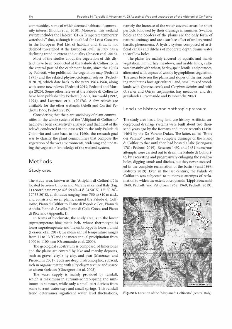
The study area, known as the “Altipiani di Colfiorito”, is located between Umbria and Marche in central Italy (Fig. 1) (coordinate range 42° 59.40'–43° 04.50' N, 12° 50.30'–12° 55.80' E), at altitudes ranging from 750 to 810 m a.s.l., and consists of seven plains, named the Palude di Colf-iorito, Piano di Colfiorito, Piano di Popola e Cesi, Piano di Annifo, Piano di Arvello, Piano di Colle Croce, and Piano di Ricciano (Appendix I).
In terms of bioclimate, the study area is in the lower supratemperate bioclimatic belt, whose thermotype is lower supratemperate and the ombrotype is lower humid (Pesaresi et al. 2017); the mean annual temperature ranges from 11 to 13 °C and the mean annual precipitation from 1000 to 1100 mm (Orsomando et al. 2000).
The geological substratum is composed of limestones and the plains are covered by lake and marshy deposits, such as gravel, clay, silty clay, and peat (Materazzi and Pieruccini 2001). Soils are deep, hydromorphic, subacid, rich in organic matter, with silty clayey texture and scarce or absent skeleton (Giovagnotti et al. 2003).
The water supply is mainly provided by rainfall, which is maximum in autumn-winter-spring and min-imum in summer, while only a small part derives from some torrent waterways and small springs. This rainfall trend determines significant water level fluctuations,
namely the increase of the water-covered areas for short periods, followed by their drainage in summer. Swallow holes at the borders of the plains are the only form of natural drainage and are a surface effect of underground karstic phenomena. A hydric system composed of arti-ficial canals and ditches of moderate depth drains water to swallow holes.
The plains are mainly covered by aquatic and marsh vegetation, humid hay meadows, and arable lands, culti-vated mainly with wheat, barley, spelt, lentils, and potatoes, alternated with copses of woody hygrophilous vegetation. The areas between the plains and slopes of the surround-ing mountains host agricultural land, small mixed wood-lands with Quercus cerris and Carpinus betulus and with Q. cerris and Ostrya carpinifolia, hay meadows, and dry grasslands (Orsomando and Pambianchi 2002).
Land use history and anthropic pressure
The study area has a long land use history. Artificial un-derground drainage systems were built about two thou-sand years ago by the Romans and, more recently (1458-1464) by the Da Varano Dukes. The latter, called “Botte dei Varano”, caused the complete drainage of the Piano di Colfiorito that until then had hosted a lake (Mengozzi 1781; Pedrotti 2019). Between 1492 and 1631 numerous attempts were carried out to drain the Palude di Colfiori-to, by excavating and progressively enlarging the swallow holes, digging canals and ditches, but they never succeed-ed in the complete reclamation of the basin (Sensi 1998; Pedrotti 2019). Even in the last century, the Palude di Colfiorito was subjected to numerous attempts of recla-mation to widen the extent of croplands (Lippi-Boncambi 1940; Pedrotti and Pettorossi 1968, 1969; Pedrotti 2019).
Figure 1. Location of the “Altipiani di Colfiorito” (central Italy).

Plant Sociology 57(2) 2020, 113–132 115
Photographic documentation of the Palude di Colfiorito shows that in the 1940s-early 1950s, this wetland was al-most completely flooded during the rainy part of the year, appearing as a lacustrine area surrounded by a belt of Phragmites australis and Schoenoplectus lacustris, and was indeed called Lake of Colfiorito (Brusaferro et al. 2008; Catorci et al. 2010; Pedrotti 2019). The reed was contained by flame weeding to foster the presence of anatids for hunting purposes (Brusaferro et al. 2008). The extent of the coenoses of the Phragmition communis was change-able depending on the water amount and anthropic pres-sure, whereas, in the outer part of the basin, there was herbaceous vegetation (Pedrotti 2019). The free waters in the central part of the basin in the mid of the reed bed hosted hydrophytic communities characterized by Pota-mogeton lucens, Nymphaea alba, Persicaria amphibia, and Characeae (Pedrotti 2019).
Between 1964 and 1972, the vegetation of a peat bog, composed of Eriophorum latifolium, Carex panicea, and Juncus subnodulosus communities, along with Magnocar-icion elatae communities and part of Ranunculion velutini hay-meadows, were destroyed to plant a poplar (Populus canadensis) cultivation, and then drained, tilled, and sub-jected to peat mining (Pedrotti 1965, 1977, 2019).
From the early 1970s, when hunting was prohibited and the periodical flame weeding ceased, to the end of the 20th century, the reed doubled its surface to the detriment of hydrophytic communities and Schoenoplectetum lacus-tris (Pedrotti 1975; Orsomando 2002; Catorci et al. 2010), while the vegetation of Trifolio-Hordeetalia reduced its extent (Pedrotti 2019).
In the early 1990s, the thresholds of the bulkheads in front of the three main swallow holes were raised, and gaps in the helophytic vegetation were opened near the borders of the basin (Pedrotti 1996). This intervention had the positive effect of limiting the frequency of des-iccation events during summer. However, in the last 20 years, the Palude di Colfiorito underwent several times desiccation, probably because of the reduction of pre-cipitation and the increase in evapotranspiration due to the spread of the reed bed (Brusaferro et al. 2008; Ca-torci et al. 2010).
Since the institution of the Colfiorito Regional Park, the anthropic pressure ceased; however, the reed bed spread, closing some canals and ditches, and accumulat-ed a great amount of litter, causing negative impacts on the wetland ecosystem (Brusaferro et al. 2008; Catorci et al. 2010). The Nymphaeetum albae spread as well, and a shrub formation now covers the area formerly covered by the peat bog vegetation (Pedrotti 2019).
Recently, Lastrucci et al. (2019a) recorded at the Pa-lude di Colfiorito a net 18.8% increase in the surface of the reed bed between 1988 and 2012 due to the expansion of the reeds in terrestrial habitats formerly covered by dif-ferent types of natural vegetation. However, they reported a retreat of the reed bed from the waterfront and an in-creasing fragmentation associated with the reed dieback process (Lastrucci et al. 2017b, 2019a).
The privately-owned lands occupied by humid hay meadows around the marsh, as well as in the other plains, are traditionally mown twice during the year (late June/early July and late August). The use of fertilizers in the surrounding arable lands has been deemed as the main cause of water eutrophication in the Palude di Colfiorito, where the quality of water between 2004 and 2011 was frequently considered as poor or bad, with low oxygen concentrations during summer (Regione Umbria 2015).
Data collection
We conducted 239 phytosociological relevés (years 2005-2009) using the Braun-Blanquet phytosociological method (Braun-Blanquet 1964). The species nomencla-ture followed Bartolucci et al. (2018). For each relevé, we recorded the following data: collection date, locality, altitude (m a.s.l.), slope aspect (azimuth degrees), slope angle (vertical degrees), total vegetation cover (%), and cover-abundance values of the species, the latter assigned using the Braun-Blanquet scale (Braun-Blanquet 1964). Localities are indicated in the tables (Supplementary ma-terial 1: Tables S1-S19) using the following abbreviations: An, Piano di Annifo; Ar, Piano di Arvello; Cc, Piano di Colle Croce; Co, Piano di Colfiorito; PC, Palude di Colf-iorito; P, Piano di Popola e di Cesi; R, Piano di Ricciano. The dates of relevés are listed in Appendix II.
Data elaboration
We transformed Braun-Blanquet cover-abundance class-es into percent values using the average cover values of Braun-Blanquet classes:
+ (< 1%), 0.5 %; 1 (1–5%), 3 %; 2 (5–25%), 15%; 3 (25–50%), 37.5%; 4 (50–75%), 62.5%; 5 (75–100%), 87.5%. r (rare species) were attributed 0.1%.We performed cluster analysis on the Hellinger-trans-
formed “relevé-by-species cover” matrix, using the group average algorithm, based on euclidean distance. The Hellinger transformation is recommended for the classi-fication and ordination of species abundance data (Rao 1995; Legendre and Gallagher 2001). To perform cluster analysis, we used R software (version 3.4.1, R Foundation for Statistical Computing, Vienna, Austria, 2017, http://www.R-project.org) and the hclust function of the stats R-package, version 3.4.1, as well as the vegdist function of the vegan R-package, version 2.4-3 (Oksanen et al. 2017). To perform the Hellinger transformation, we used the decostand function of vegan.
For the syntaxonomic placement of the vegetation types, we referred to Chytrý (2011), Landucci et al. (2013, 2015, 2020), Biondi and Blasi (2016), Mucina et al. (2016),
Federico M. Tardella & Vincenzo M. Di Agostino: Wetland vegetation of the Altipiani di Colfiorito116
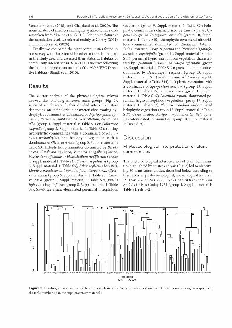
Figure 2. Dendrogram obtained from the cluster analysis of the “relevés-by-species” matrix. The cluster numbering corresponds to the table numbering in the supplementary material 1.
Venanzoni et al. (2018), and Ciaschetti et al. (2020). The nomenclature of alliances and higher syntaxonomic ranks was taken from Mucina et al. (2016). For nomenclature at the association level, we referred mainly to Chytrý (2011) and Landucci et al. (2020).
Finally, we compared the plant communities found in our survey with those found by other authors in the past in the study area and assessed their status as habitats of community interest sensu 92/43/EEC Directive following the Italian interpretation manual of the 92/43/EEC Direc-tive habitats (Biondi et al. 2010).
ResultsThe cluster analysis of the phytosociological relevés showed the following nineteen main groups (Fig. 2), some of which were further divided into sub-clusters depending on their floristic characteristics: rooting hy-drophytic communities dominated by Myriophyllum spi-catum, Persicaria amphibia, M. verticillatum, Nymphaea alba (group 1, Suppl. material 1: Table S1) or Callitriche stagnalis (group 2, Suppl. material 1: Table S2); rooting hydrophytic communities with a dominance of Ranun-culus trichophyllus, and helophytic vegetation with a dominance of Glyceria notata (group 3, Suppl. material 1: Table S3); helophytic communities dominated by Berula erecta, Catabrosa aquatica, Veronica anagallis-aquatica, Nasturtium officinale or Helosciadium nodiflorum (group 4, Suppl. material 1: Table S4), Eleocharis palustris (group 5, Suppl. material 1: Table S5), Schoenoplectus lacustris, Limniris pseudacorus, Typha latifolia, Carex hirta, Glyce-ria maxima (group 6, Suppl. material 1: Table S6), Carex vesicaria (group 7, Suppl. material 1: Table S7), Juncus inflexus subsp. inflexus (group 8, Suppl. material 1: Table S8); Sambucus ebulus-dominated perennial nitrophilous
vegetation (group 9, Suppl. material 1: Table S9); helo-phytic communities characterized by Carex riparia, Cy-perus longus or Phragmites australis (group 10, Suppl. material 1: Table S10); therophytic ephemeral nitrophi-lous communities dominated by Xanthium italicum, Bidens tripartita subsp. tripartita and Persicaria lapathifo-lia subsp. lapathifolia (group 11, Suppl. material 1: Table S11); perennial hygro-nitrophilous vegetation character-ized by Epilobium hirsutum or Galega officinalis (group 12, Suppl. material 1: Table S12); grassland communities dominated by Deschampsia cespitosa (group 13, Suppl. material 1: Table S13) or Ranunculus velutinus (group 14, Suppl. material 1: Table S14); helophytic vegetation with a dominance of Sparganium erectum (group 15, Suppl. material 1: Table S15) or Carex acuta (group 16, Suppl. material 1: Table S16); Potentilla reptans-dominated pe-rennial hygro-nitrophilous vegetation (group 17, Suppl. material 1: Table S17); Phalaris arundinacea-dominated helophytic vegetation (group 18, Suppl. material 1: Table S18); Carex otrubae, Rorippa amphibia or Gratiola offici-nalis-dominated communities (group 19, Suppl. material 1: Table S19).
DiscussionPhytosociological interpretation of plant communities
The phytosociological interpretation of plant communi-ties highlighted by cluster analysis (Fig. 2) led to identify-ing 39 plant communities, described below according to their floristic, phytocoenological, and ecological features.POTAMOGETONO PECTINATI-MYRIOPHYLLETUM SPICATI Rivas Goday 1964 (group 1, Suppl. material 1: Table S1, rels 1–2)
Plant Sociology 57(2) 2020, 113–132 117
Hydrophytic vegetation characterized by the sub-merged species Myriophyllum spicatum, attributed to the Potamogetono pectinati-Myriophylletum spicati associa-tion (Potamogetonion pectinati alliance). This community, generally common in water bodies characterized by a high concentration of organic sediments (Barko and Smart 1986; Ceschin and Salerno 2008), is uncommon in the Pa-lude di Colfiorito, where water depth exceeds 50 cm.
In 1967, Pedrotti found at the Palude di Colfiorito a Myriophyllum spicatum-dominated community, attribut-ed to the Myriophylletum spicati association, which had a localized distribution (Pedrotti 2019).
The association was reported in lacustrine and fluvial environments in Italy, e.g. along the River Tiber (Lastruc-ci et al. 2012), at the Lakes of Massaciuccoli (Lastrucci et al. 2017c) and Martignano (Azzella et al. 2013). Al-though some authors (Minissale and Spampinato 1985; Pirone et al. 1997; Tomei et al. 2001; Brullo et al. 2001, 2002; Ceschin and Salerno 2008) reported Myriophyllum spicatum communities in central-southern Italy as Myrio-phylletum spicati and attributed them to the Nymphaeion albae alliance, we attributed this community to the Pot-amogetonion pectinati alliance following many European and Italian authors (e.g. Felzines 1983; Golub et al. 1991; Pedrotti 1991, 1995; Loidi et al. 1997; Brzeg and Wojter-ska 2001; Sburlino et al. 2008; Lastrucci et al. 2010a; Šum-berová 2011a; Pedrotti 2019).
PERSICARIA AMPHIBIA community (group 1, Suppl. material 1: Table S1, rels 3–5)
Hydrophytic species-poor community dominated by Persicaria amphibia, with Myriophyllum verticillatum and ingressive species from the Phragmito-Magnocaricetea class (Phragmites australis, Mentha aquatica subsp. aquat-ica, and Carex acuta).
We found this community of the Nymphaeion albae al-liance, in the stagnant waters of the Palude di Colfiorito, with water depth ranging from a few centimeters to 50 cm during the year.
Persicaria amphibia communities have been reported from north-eastern Italy (Sburlino et al. 2008), in Lake Bol-sena (Latium) (Iberite et al. 1995), Valdichiana and along the River Arno (Tuscany) (Lastrucci et al. 2007, 2010a,b), in Umbria and Abruzzo (Buchwald 1994; Orsomando 2002; Landucci et al. 2011), and in Sicily (Brullo et al. 1994).
MYRIOPHYLLETUM VERTICILLATI Gaudet ex Šum-berová in Chytrý 2011 (group 1, Suppl. material 1: Table S1, rels 6–7)
Hydrophytic vegetation characterized by Myriophyl-lum verticillatum, a submerged species occurring in me-so-eutrophic waters.
This community, attributed to the Myriophylletum ver-ticillati association (Potamogetonion pectinati alliance), occurs in habitats in an advanced stage of terrestrializa-tion (Šumberová 2011b) and is quite common in stagnant waters of the Palude di Colfiorito (water depth ranging from a few centimeters to more than half a meter). This
community was sporadic at the end of the 1960s (Pedrotti 2019). In Italy, this association is uncommon, occurring in Latium (Ceschin and Salerno 2008), Tuscany (Lastruc-ci et al. 2016), and Sicily (Brullo et al. 1994, 2002; Rai-mondo et al. 2000).
NYMPHAEETUM ALBAE Vollmar 1947 (group 1, Suppl. material 1: Table S1, rels 8–10)
Species-poor hydrophytic vegetation, dominated by Nymphaea alba, sometimes with Myriophyllum verticil-latum and Persicaria amphibia. Following Šumberová (2011a) and Tomaselli et al. (2006), we attributed this community to the Nymphaeetum albae Vollmar 1947 association (Nymphaeion albae alliance). We found this community in the stagnant waters of the Palude di Colf-iorito, 0.5-1 m-deep, where it forms very extensive stands. This is consistent with Šumberová (2011a), who stated that this association significantly contributes to water body filling by its high biomass production.
According to Pedrotti (1975, 2019), Nymphaea alba oc-curred in the 1960s inside the subassociation Myriophyl-lo-Potamogetonetum lucentis nymphaeetosum.
The association was reported at the Lake of Massaci-uccoli (Tuscany) by Lastrucci et al. (2017c), in Piedmont (Guglielmetto Mugion and Montacchini 1993-1994), Lombardy (Andreis and Zavagno 1996), Veneto (Anoè and Caniglia 1987), Trentino (Canullo et al. 1990), and Friuli-Venezia Giulia (Poldini 1989).
CALLITRICHE STAGNALIS community (group 2, Suppl. material 1: Table S2)
Hydrophytic vegetation dominated by Callitriche stag-nalis, with Ranunculus trichophyllus, of the Ranunculion aquatilis alliance, with ingressive species from Nastur-tio-Glycerietalia (Nasturtium officinale, Helosciadium no-diflorum, Veronica anagallis-aquatica, and Berula erecta).
We found this community in stagnant or slowly flowing waters of ditches; toward the banks, it was in contact with the helophytic vegetation of the Helosciadietum nodiflori, Nasturtietum officinalis, and Veronica anagallis-aquatica community.
Pedrotti (2019) found in the outer part of the Palude di Colfiorito, along spring-fed ditches, the Veronico beccab-ungae-Callitrichetum stagnalis Müller 1962, which differs from our relevés for the presence of Veronica beccabunga and Glyceria fluitans.
In accordance with some Italian authors (e.g. Corbet-ta and Pirone 1989; Baldoni and Biondi 1993; Venanzoni and Gigante 2000), we did not attribute C. stagnalis-dom-inated communities to the association Callitrichetum stagnalis Segal 1967, given their low floristic richness.
In Italy C. stagnalis-dominated communities have been found in the Venetian Plain (Marchiori and Sburli-no 1997), Tuscany, Marche, Umbria, Latium, and Abruz-zo (Corbetta and Pirone 1989; Baldoni and Biondi 1993; Buchwald 1994; Venanzoni and Gigante 2000; Ceschin and Salerno 2008; Lastrucci and Becattini 2008; Mereu et al. 2010), and in Sardinia (Biondi and Bagella 2005).
Federico M. Tardella & Vincenzo M. Di Agostino: Wetland vegetation of the Altipiani di Colfiorito118
POTAMOGETONO CRISPI-RANUNCULETUM TRICHOPHYLLI Imchenetzky 1926 (group 3, Suppl. ma-terial 1: Table S3, rels 1–5)
Ranunculus trichophyllus-dominated hydrophytic community, with Callitriche stagnalis, referred to the Ra-nunculion aquatilis alliance. The species composition in-cluded elements of the Glycerio-Sparganion alliance and higher-rank syntaxa (e.g. Nasturtium officinale, Veronica anagallis-aquatica, and Glyceria notata).
The association is uncommon in the stagnant or slowly flowing waters along ditches.
In Italy, Ranunculus trichophyllus-dominated com-munities were found in northeastern and central Italy, and in Sicily (e.g. Ferro 1980; Corbetta and Pirone 1989; Buchwald 1994; Gerdol and Tomaselli 1997; Tomei et al. 2001; Pirone et al. 2004; Tomasi and Caniglia 2004; La-strucci et al. 2010a; Landucci et al. 2011).
GLYCERIETUM NOTATAE Kulczyński 1928 (group 3, Suppl. material 1: Table S3, rels 6–9)
Species-poor plant community, physiognomically characterized by Glyceria notata and other species of the Glycerio-Sparganion alliance and higher syntaxa (e.g. Ve-ronica anagallis-aquatica, Nasturtium officinale, Mentha aquatica subsp. aquatica, and Myosotis scorpioides) and ingressive species from the Potamogetonetea class (Ra-nunculus trichophyllus).
The association is widespread in the ditches, in con-tact with the Nasturtietum officinalis association and the Veronica anagallis-aquatica community. In the sections with slow flowing water, it was found at the border of the watercourse, toward the inside, in contact with the Pota-mogetono crispi-Ranunculetum trichophylli. Where water is stagnant for most of the year, the community occupies the ditch bed, together with the Caricetum vesicariae and Phalaridetum arundinaceae associations.
In Italy this vegetation type is frequent, being recorded by many authors from sea level to the mountain belt (e.g. Cortini Pedrotti et al. 1973; Canullo et al. 1988; Corbetta and Pirone 1989; Pedrotti et al. 1992; Baldoni and Biondi 1993; Buchwald 1994; Pedrotti 1995; Marchiori and Sbur-lino 1997; Scoppola 1998; Biondi et al. 1999; Lastrucci et al. 2004; Pedrotti 2008).
BERULETUM ERECTAE Roll 1938 (group 4, Suppl. ma-terial 1: Table S4, rels 1–3)
Helophytic vegetation characterized by Berula erecta, with species of the Glycerio-Sparganion alliance and high-er syntaxa (Glyceria notata, Veronica anagallis-aquatica, and Nasturtium officinale).
In the study area, it occurs along the ditches of the Palude di Colfiorito, near the banks of the deepest ones, where it is in contact with Helosciadietum nodiflori, to-wards the central part of the ditch section.
This community (syn. Veronico-Sietum erecti Passarge 1982, Veronico beccabungae-Beruletum erectae Passarge
1999) was found by Prosser and Sarzo (2003) and Pedrotti (1995) in Trentino, Pedrotti (2008) in the "Marcite di Nor-cia" (Umbria), by Ceschin and Salerno (2008) along the Rivers Tevere, Aniene and Treia (Latium), and in Molise (Canullo et al. 1988).
RORIPPO ANCIPITIS-CATABROSETUM AQUATICAE (Oberdorfer 1957) Müller et Görs 1961 (group 4, Suppl. material 1: Table S4, rel. 4)
Plant community with a dominance of Catabrosa aquatica, with Veronica anagallis-aquatica, Glyceria nota-ta, and Helosciadium nodiflorum, growing on slow-flow-ing or temporarily stagnant waters. It hosts some species of the Molinio-Arrhenatheretea class, such as Holcus la-natus, Poa pratensis and Dactylis glomerata, because it is in contact with the temporarily flooded meadows of the Ranunculion velutini alliance. Following Landucci et al. (2020), the composition of this community fits with that of the Rorippo ancipitis-Catabrosetum aquaticae associa-tion (Glycerio-Sparganion alliance).
We found this community along the main ditch that crosses the Piano di Colle Croce.
The Catabrosa aquatica community found along the River Nera (Marche, central Italy) by Buchwald (1994), which was attributed to the Catabrosetum aquaticae Rübel 1911, should be referred to this association.
VERONICA ANAGALLIS-AQUATICA subsp. AQUATI-CA community (group 4, Suppl. material 1: Table S4, rels 5–9)
Veronica anagallis-aquatica-dominated community, with Nasturtium officinale and some ingressive species from the Molinio-Arrhenatheretea and Bidentetea class-es. The occurrence of Veronica anagallis-aquatica and Nasturtium officinale justifies its placement in the Glyce-rio-Sparganion alliance.
The community was found in stagnant or slightly flow-ing waters, 20-50 cm deep, in contact with Nasturtietum officinalis and the Callitriche stagnalis community.
NASTURTIETUM OFFICINALIS Gilli 1971 (group 4, Suppl. material 1: Table S4, rels 10–12)
Single-species or species-poor pioneer helophytic community, which establishes after human disturbance, with a dominance of Nasturtium officinale, with Veron-ica anagallis-aquatica and ingressive species from Moli-nio-Arrhenatheretea.
This community, typical of sunny, quickly to slowly flowing, oligo- to eutrophic waters (Buchwald 1994), is distributed in small stands along the ditches that cross cultivated lands, in contact with Helosciadietum nodiflori, Glycerietum notatae, Callitriche stagnalis community, and Veronica anagallis-aquatica community.
In Italy, this community is widely spread (e.g. Barberis and Mariotti 1981; Canullo et al. 1988; Géhu and Biondi 1988; Corbetta and Pirone 1989; Baldoni and Biondi 1993; Pedrotti 1995; Biondi et al. 1997; Pirone et al. 1997; Scop-pola 1998; Bracco et al. 2000; Brullo et al. 2002; Prosser

Plant Sociology 57(2) 2020, 113–132 119
and Sarzo 2003; Tomasi and Caniglia 2004; Ceschin and Salerno 2008; Pedrotti 2008; Lastrucci et al. 2010b, 2012, 2016, 2017c).
HELOSCIADIETUM NODIFLORI Maire 1924 (group 4, Suppl. material 1: Table S4, rels 13–16)
Vegetation of ditches characterized by Helosciadium nodiflorum with elements of the Glycerio-Sparganion al-liance and the Nasturtio-Glycerietalia order (Nasturtium officinale, Veronica anagallis-aquatica, Berula erecta, and Glyceria notata).
We found this community along a short stretch of a ditch at the Palude di Colfiorito, in contact with Berule-tum erectae and Nasturtietum officinalis, where water was 50-60 cm deep.
The association is rather frequent in Italy (e.g. Pedrotti, 1967, 1995, 2008; Canullo et al. 1988; Baldoni and Bion-di 1993; Buchwald 1994; Pirone et al. 1997; Brullo et al. 2001, 2002; Prosser and Sarzo 2003; Biondi and Bagella 2005; Sburlino et al. 2008; Mereu et al. 2010; Lastrucci et al. 2016).
ELEOCHARITETUM PALUSTRIS Savič 1926 (group 5, Suppl. material 1: Table S5)
Single-species or species-poor pioneer plant commu-nity, physiognomically characterized by Eleocharis pal-ustris subsp. palustris, sometimes associated with species of the Molinio-Arrhenatheretea class, coming from the surrounding meadows. The community develops where the soil is subject to periodic cycles of submergence and emergence until the end of spring and can tolerate long periods of flooding, but it can also withstand periods with dry soil (Šumberová 2011a).
We found this association in small patches at the edge of Palude di Colfiorito, in contact with communities re-ferred to Phragmition communis and Bidention tripartitae alliances.
This vegetation type is distributed in northern and cen-tral Italy (e.g. Pedrotti et al. 1992; Buchwald 1994; Mariot-ti 1995; Biondi et al. 1997; Venanzoni and Gigante 2000; Tomei et al. 2001; Landi et al. 2002; Angiolini et al. 2003; Lastrucci et al. 2007, 2010a,b, 2012, 2019b).
SCHOENOPLECTETUM LACUSTRIS Chouard 1924 (group 6, Suppl. material 1: Table S6, rels 1–11)
Community characterized by Schoenoplectus lacustris, mostly occurring in the outer vegetation belt of the Palude di Colfiorito, where it forms dense and extensive mono-specific stands between Phragmitetum/Phalaridetum and open waters. Where the stands are less dense, other species of the Phragmition communis alliance and high-er-rank syntaxa, including Phragmites australis, Phalaris arundinacea, and Typha latifolia, enter into the composi-tion of this community.
The Schoenoplectetum lacustris is in close contact with other associations of the Phragmition communis alliance, especially in the Palude di Colfiorito, and sometimes oc-cupies the whole section of unmanaged ditches.
The association is rather frequent across Italy in marsh-es, around lakes and along watercourses (Fascetti et al. 1989; Poldini 1989; Brullo et al. 1994; Iberite et al. 1995; Venanzoni and Gigante 2000; Merloni and Piccoli 2001; Landi et al. 2002; Venanzoni et al. 2003; Lastrucci et al. 2007; Ceschin and Salerno 2008; Lastrucci et al. 2019b).
IRIDETUM PSEUDACORI Eggler 1933 ex Brzeg et M. Wojterska 2001 (group 6, Suppl. material 1: Table S6, rels 12–15)
Plant community with a dominance of Limniris pseu-dacorus, with species of the Phragmition communis alli-ance (e.g. Typha latifolia and Schoenoplectus lacustris) and ingressive species from the Molinio-Arrhenatheretea class, coming from the surrounding meadows.
We found this association inside depressions in the humid meadows and along some ditches of the Piano di Colfiorito.
Limniris pseudacorus-dominated communities had been found in various Italian wetlands from the Trenti-no-Alto Adige to Sicily (e.g. Brullo et al. 1994; Pedrotti 1995; Pirone et al. 1997; Raimondo et al. 2000; Arrigoni and Papini 2003; Prosser and Sarzo 2003; Maiorca et al. 2005; Presti et al. 2005; Ceschin and Salerno 2008; La-strucci et al. 2010a,b, 2016).
TYPHETUM LATIFOLIAE Nowiński 1930 (group 6, Suppl. material 1: Table S6, rels 16–20)
Species-poor plant community, characterized by Typha latifolia, associated with other species of the Phragmition communis alliance (Schoenoplectus lacustris and Glyceria maxima).
Typhetum latifoliae occurs in stagnant or slowly flow-ing waters of marshes and ditches, less than 50 cm deep, in contact with other associations of Phragmito-Magno-caricetea and, to the inside of the basins and ditches, with the hydrophytic coenoses of Potamogetonetea.
It is very common in Italian wetlands (e.g. Martini and Poldini 1980; Corbetta and Pirone 1989; Baldoni and Biondi 1993; Biondi and Baldoni 1994; Buchwald 1994; Biondi et al. 1997; Bracco et al. 2000; Venanzoni and Gi-gante 2000; Viciani and Raffaelli 2003; Prosser and Sarzo 2004; Ceschin and Salerno 2008; Lastrucci et al. 2010a,b, 2012).
CAREX HIRTA community (group 6, Suppl. material 1: Table S6, rels 21–23)
Species-poor plant community, with a dominance of Carex hirta. Due to the occurrence of elements of Poten-tillion anserinae and higher-rank syntaxa, we placed this community in the Potentillion anserinae alliance, even though the presence of some elements of the Phragmi-to-Magnocaricetea class marks its transition towards the coenoses of flooded habitats. Because of the lack of floris-tic characterization, we could not classify it at the associ-ation level.
Toward the inside of the basins, this community is in contact with helophytic communities of Phragmition
Federico M. Tardella & Vincenzo M. Di Agostino: Wetland vegetation of the Altipiani di Colfiorito120
communis and Magnocaricion gracilis, and toward the ex-ternal areas, with Ranunculion velutini meadows.
In Tuscany, Lastrucci et al. (2019b) found a communi-ty characterized by Carex hirta and C. otrubae, in fresh, partially shaded and not submerged soils. Biondi and Bal-lelli (1995) described in Umbria a Carex hirta-dominated association, the Ranunculo acri-Caricetum hirtae, which was found by Ciaschetti et al. (2020) in the highlands of Abruzzo. However, in our opinion there are not enough elements to attribute this community to this association, because all the diagnostic species except Carex hirta are absent (Carex leporina, Ranunculus acris, R. repens, and Alopecurus rendlei).
GLYCERIETUM MAXIMAE Nowiński 1930 corr. Šum-berová, Chytrý et Danihelka in Chytrý 2011 (group 6, Suppl. material 1: Table S6, rels 24–30)
Species-poor plant community of marshes and ditches, with a dominance of Glyceria maxima, which is associat-ed with other species of the Phragmition communis alli-ance and higher syntaxa, including Phragmites australis, Phalaris arundinacea, Alisma plantago-aquatica, Sparga-nium erectum, and Lycopus europaeus.
The community forms more or less extensive stands in the outer part of the Palude di Colfiorito basin, where, according to Pedrotti and Murrja (2020) is reducing its extent, and in small parts of some ditches in other plains, in contact with the associations of the Phragmition com-munis and Glycerio-Sparganion alliances.
In Italy this vegetation type is reported from lowland to submontane areas of northern and central Italy (e.g. Pe-drotti 1965; Gerdol et al. 1979; Arrigoni and Ricceri 1982; Piccoli and Gerdol 1982; Marchiori and Sburlino 1986; Pedrotti 1995; Sartori and Bracco 1997; Catorci and Or-somando 2001; Lastrucci et al. 2010b, 2014).
CARICETUM VESICARIAE Chouard 1924 (group 7, Suppl. material 1: Table S7)
Species-poor, sometimes monospecific helophytic community, dominated by Carex vesicaria, belonging to the Magnocaricion gracilis alliance, with a few other spe-cies of Phragmito-Magnocaricetea class (e.g. Typha lati-folia, Glyceria notata, and Rorippa amphibia), typical of stagnant waters and marshy meadows, which grows on meso-eutrophic, mineral or semi-peaty soils (Mierwald 1988).
The association is uncommon in the study area and oc-curs along a short stretch of the main ditch of the Piano di Arvello.
The association had been found in wetlands of north-ern and central Italy (Cortini Pedrotti et al. 1973; Marti-ni and Poldini 1980; Montanari and Guido 1980; Pirone 1987; Marchiori et al. 1993; Buchwald 1994; Gerdol and Tomaselli 1997; Marchiori and Sburlino 1997; Rossi and Alessandrini 1998; Prosser and Sarzo 2003; Lastrucci et. al. 2008).CARICI OTRUBAE-JUNCETUM INFLEXI Minissale et Spampinato 1985 (group 8, Suppl. material 1: Table S8)
Species-poor sub-nitrophilous and sub-hygrophilous community dominated by Juncus inflexus subsp. inflexus, associated with species of the Potentillo-Polygonetalia or-der and Molinio-Arrhenateretea class, e.g. Carex otrubae, Ranunculus repens, Carex hirta, Galium album subsp. al-bum, and Rumex acetosa. The species composition of the community allows us to place it in the Potentillo-Polyg-onetalia order of the Molinio-Arrhenateretea class. This is consistent with Landucci et al. (2020), who excluded Juncus inflexus communities from the Phragmito-Magno-caricetea vegetation in Europe.
The species composition of this community differs from that of Galio palustris-Juncetum inflexi, described by Venanzoni and Gigante (2000), because of the absence of Galium palustre and Scutellaria galericulata and the prev-alence of species of the Molinio-Arrhenatheretea class. It also differs from the Mentho longifoliae-Juncetum inflexi Lohmeyer ex Oberdorfer 1957 asssociation because Men-tha longifolia, characteristic of the association, is absent. Because of the dominance of the helophyte Juncus inflexus subsp. inflexus and the presence of Carex otrubae, we at-tributed this community to the Carici otrubae-Juncetum inflexi, described at Lake Gurrida in northeastern Sicily by Minissale and Spampinato (1985) and found in Calabria (Maiorca et al. 2005) and Tuscany (Lastrucci et al. 2019b).
The association is in contact with some communities of Phragmition communis, i.e. Phalaridetum arundinaceae, Schoenoplectetum lacustris, Glycerietum maximae, and with the humid meadows of the Ranunculion velutini al-liance. The other contact vegetation is the Carex otrubae community, toward the banks of some ditches subjected to periodic desiccation.
URTICO DIOICAE-SAMBUCETUM EBULI (Br.-Bl. in Br.-Bl., Gajewski, Wraber et Wa1as 1936) Br.-Bl. in Br.-Bl., Roussine et Nègre 1952 (group 9, Suppl. material 1: Table S9)
Thermo-heliophilous and nitrophilous association, characterized by Sambucus ebulus, with Urtica dioica and species of the Balloto-Conion maculati alliance and high-er syntaxa, such as Conium maculatum, Rubus caesius, Cruciata laevipes, Galium aparine, and ingressive species from Molinio-Arrhenatheretea.
The association occurs sporadically on nitrogen-rich soils, at the edge of roads, paths, and hedges around the wetlands.
This association has been found in northern (Poldini 1980; Tomaselli et al. 2006), central (Biondi and Ballelli 1982; Lastrucci et al. 2010a,b, 2014), and southern Italy (Brullo et al. 1998; Maiorca and Spampinato 1999).
CARICETUM RIPARIAE Máthé et Kovács 1959 (group 10, Suppl. material 1: Table S10, rels 1–3)
Species-poor Carex riparia-dominated community, with a low number of Phragmito-Magnocaricetea species and ingressive elements from the Molinio-Arrhenatheretea class. The occurrence of C. acuta and C. vesicaria, besides the dominant species, allows its attribution to the com-munity of the Caricetum ripariae association, included in
Plant Sociology 57(2) 2020, 113–132 121
the Magnocaricion gracilis alliance, following Landucci et al. (2020).
This community is very fragmented and forms dense stands in marshy meadows and ditches, in contact with the communities of the Phragmition communis and Ma-gnocaricion gracilis alliances.
This association is rather frequent, but endangered, across the Italian Peninsula (e.g. Anoè and Caniglia 1987; Orsomando 1993; Pirone et al. 1997; Sartori and Bracco 1997; Prosser and Sarzo 2004; Landucci et al. 2013; Lastruc-ci et al. 2014, 2016) and Sicily (Brullo et al. 1998, 2002).
CYPERETUM LONGI (Micevski 1957) Micevski 1963 (group 10, Suppl. material 1: Table S10, rels 4–5)
Community characterized by Cyperus longus, poor in elements of the Phragmito-Magnocaricetea class, with sev-eral ingressive species from Molinio-Arrhenatheretea.
Because of the dominance of Cyperus longus and the presence of species of the Phragmito-Magnocaricetea and Molinio-Arrhenatheretea classes, following Landucci et al. (2020), this plant community fits with the Cyperetum lon-gi association (Phragmition communis alliance).
This community is uncommon in the study area, where it forms small and dense stands, in periodically flooded soils, in contact with Phragmitetum australis and the com-munities of the Ranunculion velutini alliance.
In Italy, the association was found in Tuscany (Lastruc-ci et al. 2010a,b, 2016), Umbria (Venanzoni and Gigante 2000; Pedrotti 2008; Lastrucci et al. 2012), Abruzzo (Cor-betta and Pirone 1989; Pirone et al. 2003), Molise (Paura et al. 2004), Basilicata (Venanzoni et al. 2003), and Sicily (Brullo et al. 1994).
PHRAGMITETUM AUSTRALIS Savič 1926 (group 10, Suppl. material 1: Table S10, rels 6–21)
Helophytic single-species or species-poor communi-ty, dominated by Phragmites australis, attributed to the Phragmitetum australis association, including species of the Phragmition communis alliance and higher syntaxa, as well as ingressive elements from the Molinio-Arrhenathe-retea and Artemisietea vulgaris classes.
It is the dominant type of vegetation in the Palude di Colfiorito, where it develops in stagnant eutrophic waters with ground flooded from autumn to early summer and not drying in summer. In the other plains, this association occurs in the bed of the ditches.
If it is not subjected to periodic disturbance (mowing or tillage), this community tends to colonize the marshy and humid meadows in the outer vegetation band of the Palude di Colfiorito and the uncultivated lands in contact with the wetland vegetation (Catorci et al. 2010). Lastruc-ci et al. (2019a) documented the increasing fragmentation related to the dieback process of the reed bed along the waterfront and the expansion of the reeds in terrestrial habitats formerly occupied by different types of natural vegetation. Phragmites australis is in fact a highly compet-itive species, which can invade other plant communities in the absence of disturbance. This colonization process
was observed for the Carex panicea peaty meadow com-munity, which once had spread over a large area in the south-western part of the Palude di Colfiorito (Pedrotti 1975) and has disappeared as a consequence of competi-tion with Phragmites australis. In fact, relevés carried out in the area formerly occupied by the C. panicea commu-nity (Pedrotti 2019), with very rare and interesting species from a biogeographical and conservation viewpoint, such as Dactylorhiza incarnata and Epipactis palustris, were grouped by the cluster analysis among those of Phrag-mitetum australis, indicating a dynamic stage of vegeta-tion. Nowadays, this area is almost completely invaded by shrubs (Pedrotti 2019).
To the inside of the basin, the community is in contact with the hydrophytic communities of the Nymphaeion al-liance, while to the outside of the basin, it is in contact with other Phragmito-Magnocaricetea and Molinio-Ar-rhenatheretea communities, with which it sometimes forms compenetrations.
The association is very common in all the countries of the temperate zone, including Italy (e.g. Corbetta and Pirone 1989; Baldoni and Biondi 1993; Buchwald 1994; Iberite et al. 1995; Pirone et al. 1997; Venanzoni and Gi-gante 2000; Arrigoni and Papini 2003; Ceschin and Saler-no 2008; Lastrucci et al. 2010a,b, 2012, 2017c, 2019b). In particular, in the Palude di Fucecchio, Lake Chiusi (Tus-cany), Lake Vico (Latium), Lake Trasimeno, and Palude di Colfiorito (Umbria), Lastrucci et al. (2017a) described seven variants, four of which (with Myriophyllum spica-tum, Schoenoplectus lacustris, Calystegia sepium, and Urti-ca dioica) were found at the Palude di Colfiorito.
POLYGONO LAPATHIFOLII-XANTHIETUM ITALICI Pirola et Rossetti 1974 (group 11, Suppl. material 1: Table S11, rel. 1)
Therophytic ephemeral plant community, which appears in late-summer in temporarily flooded nutri-ent-rich and silty-sandy soils, characterised by species of the Bidentetea tripartitae class and ingressive elements from Stellarietea mediae and Artemisietea vulgaris class-es. Because of the dominance of Xanthium italicum and the occurrence of Persicaria lapathifolia, we attributed it to the Polygono lapathifolii-Xanthietum italici association (Chenopodion rubri alliance).
The very fragmented stands of this association (some-times extended a few square meters) occur on the external edge of humid meadows, in contact with croplands.
The association is known for the border of water basins on silty-sandy nitrophilous soils (Lastrucci and Becattini 2008; Sciandrello 2009), but it is more common along wa-tercourses in northern Italy (Liguria, Lombardia, Emilia Romagna), central Italy, Molise, Sicily (e.g. Mariotti 1995; Assini 1997; Sartori and Bracco 1997; Biondi et al. 1997, 1999, 2004; Brullo et al. 2002; Paura et al. 2004; Ceschin and Salerno 2008; Lastrucci et al. 2010b; Crisanti and Taf-fetani 2015).BIDENTETUM TRIPARTITAE Miljan 1933 (group 11, Suppl. material 1: Table S11, rels 2–5)
Federico M. Tardella & Vincenzo M. Di Agostino: Wetland vegetation of the Altipiani di Colfiorito122
Therophytic ephemeral plant community of temporar-ily flooded, nutrient-rich areas, which appears in the late summer, characterized by the annual species Bidens tri-partita subsp. tripartita and Persicaria lapathifolia, char-acteristic of the association Bidentetum tripartitae and higher syntaxa, and transgressive species from Potentil-lion anserinae alliance.
The very fragmented stands of this association, some-times extended a few square meters, occur at the edge of marshy and humid meadows, which are flooded until late spring-early summer and emerge in mid-late summer.
Two variants of this association, characterized by Per-sicaria lapathifolia and Chenopodiastrum murale were found by Pedrotti and Murrja (2020) in the eastern part of the Palude di Colfiorito.
In Italy, it was found in northern and central Italy and Sicily (Martini and Poldini 1980; Marchiori et al. 1993; Bi-ondi et al. 1999, 2003; Sarzo et al. 1999; Brullo et al. 2002; Pirone et al. 2003; Prosser and Sarzo 2004).
EPILOBIUM HIRSUTUM community (group 12, Suppl. material 1: Table S12, rel. 1)
Epilobium hirsutum-dominated nitrophilous commu-nity found at the edge of the humid meadows of Ranun-culion velutini. Given that most of the species of this com-munity are characteristic of Potentillion anserinae and higher syntaxa, e.g. Ranunculus repens, Galega officinalis, and Lotus corniculatus, we placed it in the Potentillion an-serinae alliance.
GALEGA OFFICINALIS community (group 12, Suppl. material 1: Table S12, rels 2–7)
Nitrophilous pioneer community, physiognomically characterized by Galega officinalis, including species of the Potentillion anserinae alliance and higher syntaxa, e.g. Ra-nunculus repens, Galium album subsp. album, and Poa triv-ialis. The occurrence of ingressive species from the Phrag-mito-Magnocaricetea, Stellarietea mediae, and Artemisietea vulgaris classes indicates the placement of this community between the helophytic vegetation of Phragmition commu-nis / Magnocaricion gracilis and anthropogenic vegetation.
This community occurs along the banks of ditches at the borders of the plains, periodically flooded during the year, with alternation of a flooding phase in winter and spring and a summer emergence phase.
Venanzoni and Gigante (2000) described in the Lakes Trasimeno and Alviano (Umbria) the Cirsio triumfet-ti-Galegetum officinalis association, placed in the Potentil-lion anserinae alliance. Compared to that association, our relevés lack Cirsium creticum subsp. triumfettii, Convolvu-lus sepium, and Lotus tenuis, characteristic species of this association. However, we did not find enough elements to describe a new association.
Pedrotti and Murrja (2020) found a similar community in the eastern part of the Palude di Colfiorito and referred it to the Cirsio triumfetti-Galegetum officinalis association; however, in our opinion, this attribution is doubtful be-
cause it lacks the characteristic species except C. creticum subsp. triumfettii.
DESCHAMPSIO-CARICETUM DISTANTIS Pedrotti 1976 (group 13, Suppl. material 1: Table S13)
Thick-sward wet meadows, dominated by Deschampsia cespitosa. The occurrence of Ranunculus velutinus, Lolium arundinaceum subsp. arundinaceum, Orchis laxiflora, Bel-levalia romana, Trifolium resupinatum, and Alopecurus rendlei justifies placing the community in the Ranuncu-lion velutini alliance and the Trifolio-Hordeetalia order. The occurrence of Carex distans, besides Deschampsia cespitosa, allows its attribution to the Deschampsio-Car-icetum distantis association, described by Pedrotti (1976) in the nearby Piani di Montelago (Marche).
This community, found in depressions flooded until early summer and moist until the end of summer, is in contact with Hordeo-Ranunculetum velutini meadows, inside which it sometimes forms more or less extended patches, and with communities of the Phragmitetalia and Nasturtio-Glycerietalia orders.
The association is endemic of the humid meadows of central and southern Italy (Pedrotti 1975; 1976; Canullo et al. 1988; Pedrotti el al. 1992; Pirone 1997; Catorci and Orsomando 2001; Tardella et al. 2002).
HORDEO-RANUNCULETUM VELUTINI Pedrotti 1976 (group 14, Suppl. material 1: Table S14)
Community of humid hay meadows with a dense sward, common in areas that remain flooded until early spring, while the ground dries up in the early summer. It is physiognomically characterized by Ranunculus ve-lutinus, Cynosurus cristatus, Poa pratensis subsp. praten-sis, Centaurea jacea subsp. jacea, and Trifolium pratense. The occurrence of Lolium arundinaceum subsp. arundi-naceum, Orchis laxiflora, and Gaudinia fragilis, besides Ranunculus velutinus, justify placing the community in the Ranunculion velutini alliance and the Trifolio-Hordee-talia order, while the presence of Hordeum secalinum, Bromus racemosus subsp. racemosus, Trifolium dubium, T. resupinatum, Alopecurus rendlei, and Bellevalia roma-na indicates that the community fits with the association Hordeo-Ranunculetum velutini.
This association is in contact with the helophytic as-sociations of Phragmito-Magnocaricetea toward the inside of the basins, and with the therophytic nitrophilous com-munities, and croplands, toward the outside.
This association, described by Pedrotti (1976) in the nearby Piani di Montelago (Marche), is endemic to the central and southern Apennines (Pedrotti 1967, 1975; Canullo et al. 1988; Pedrotti et al. 1992; Venanzoni 1992; Catorci and Orsomando 2001; Tardella et al. 2002).
SPARGANIETUM ERECTI Roll 1938 (group 15, Suppl. material 1: Table S15)
Plant community dominated by Sparganium erectum, which forms more or less thick stands. The dominant spe-cies and the presence of elements of the Glycerio-Spargan-
Plant Sociology 57(2) 2020, 113–132 123
ion alliance led us to attribute this community, following Venanzoni and Gigante (2000), Lastrucci et al. (2010b), and Pedrotti (2019), to the Sparganietum erecti association.
We found the plant community in stagnant waters, 10-50 cm deep, in contact with Phragmitetum australis and Glycerietum maximae.
It has been reported in northern, central, and south-ern Italy (e.g. Marchiori and Sburlino 1986, 1997; Corbet-ta and Pirone 1990; Baldoni and Biondi 1993; Buchwald 1994, Pedrotti 1995; Brullo et al. 1998; Venanzoni and Gigante 2000; Prosser and Sarzo 2003; Venanzoni et al. 2003; Ceschin and Salerno 2008; Lastrucci et al. 2010b, 2012, 2016, 2017c).
CARICETUM GRACILIS Savič 1926 (group 16, Suppl. material 1: Table S16)
Species-poor helophytic association, characterized by Carex acuta, which forms thick stands, with species of the Magnocaricion gracilis alliance and higher syntaxa (Car-ex vesicaria, Galium palustre subsp. elongatum, Phalaris arundinacea, etc.) and sporadic occurrences of ingressive species of the Potentillo-Polygonetalia and Trifolio-Hordee-talia orders (Molinio-Arrhenatheretea class).
The association occurs where the soil is frequent-ly flooded from autumn to spring and remains muddy during summer, often in contact with other communities of the Phragmito-Magnocaricetea class.
This community is more frequent in northern Italy, but is recorded from several localities across the Italian peninsula (e.g. Cortini Pedrotti et al. 1973; Martini and Poldini 1980; Marchiori and Sburlino 1986; Marchiori et al. 1993; Venanzoni 1988; Buffa et al. 1995; Pirone and Tammaro 1995; Marchiori and Sburlino 1997; Sartori and Bracco 1997; Bracco et al. 2000; Prosser and Sarzo 2003).
POTENTILLA REPTANS community (group 17, Suppl. material 1: Table S17)
Species-poor hygro-nitrophilous plant community, dominated by Potentilla reptans.
The prevalence of floristic elements of Potentillion anserinae and higher syntaxa (Potentilla reptans, Rumex crispus, Oenanthe fistulosa, and Thalictrum lucidum) led us to place this community in the Potentillion anserinae alliance.
This community differs in species composition from Rorippo amphibiae-Potentilletum reptantis described in Valdichiana (Tuscany, Italy) by Lastrucci et al. (2010a), because of the absence of Rorippa amphibia, R. prostrata, Bolboschoenus maritimus, and Oenanthe silaifolia; howev-er, there are no elements to describe a new association.
The Potentilla reptans community is generally present on the bottom of the sinkholes, in contact with Phalaris arundinacea and Carex acuta-dominated stands.
PHALARIDETUM ARUNDINACEAE Libbert 1931 TYPICUM (group 18, Suppl. material 1: Table S18, rels 1–15; holotypus Table 1, rel. 2 in Libbert 1931)
ALOPECURETOSUM BULBOSI subass. nova (group 18, Suppl. material 1: Table S18, rels 16–31, holotypus relevé 30)CAREX ACUTA VARIANT (group 18, Suppl. material 1: Table S18, rels 16–24)
Helophytic association dominated by Phalaris arun-dinacea, with other species of Phragmito-Magnocaricetea (e.g. Phragmites australis, Scutellaria galericulata, Eleo-charis palustris, Lythrum salicaria, and Carex acuta) and ingressive species from Molinio-Arrhenatheretea (e.g. Loli-um arundinaceum subsp. arundinaceum, Centaurea jacea subsp. jacea, and Trifolium pratense). The species compo-sition allows us to place this community in the Phragmi-tion communis alliance (Phragmitetalia order, Phragmi-to-Magnocaricetea class), following Landucci et al. (2020).
The association is rather frequent across the Italian pen-insula (e.g. Bracco 1981; Marchiori et al. 1993; Buchwald 1994; Venanzoni and Gigante 2000; Arrigoni and Papini 2003; Prosser and Sarzo 2003; Tomasi and Caniglia 2004; Lastrucci et al. 2007, 2010a,b, 2014; Ceschin and Salerno 2008).
The typical form of this community was found in sites with stagnant eutrophic waters, at the edge of ditches and swallow holes, characterized by seasonal fluctuations, in contact with other helophyitic coenoses of Phragmi-to-Magnocaricetea to the inside of the basin and the main ditches, and with wet meadows of Trifolio-Hordeetalia, hygro-nitrophilous communities and croplands to the outside.
In the areas where water is drained more rapidly by larger canals to foster the mowing of the surrounding hay meadows, and the soil remains waterlogged and humid for a shorter period, the species composition of the commu-nity changes, increasing species from the Molinio-Arrhe-natheretea class. The occurrence of this group of species indicates the transition from Phalaridetum arundinaceae to humid meadows of Ranunculion velutini and allows us to describe the new subassociation Phalaridetum arundi-naceae alopecuretosum bulbosi, whose differential species are Alopecurus bulbosus subsp. bulbosus, A. rendlei, Oe-nanthe fistulosa, Trifolium resupinatum, Centaurea jacea subsp. jacea, Galium debile, and Plantago lanceolata.
In small depressions of few centimeters or in contact with marsh vegetation of the Magnocaricion gracilis, where water stands for more time during the year, Carex acuta tends to become codominant with Phalaris arundi-nacea. We attributed this aspect to a Carex acuta variant of the subassociation Phalaridetum arundinaceae alopecu-retosum bulbosi.
CAREX OTRUBAE community (group 19, Suppl. materi-al 1: Table S19, rels 1–5)
Species-poor plant community of the stagnant waters dominated by Carex otrubae, present exclusively along the banks of ditches of modest depth, which during the year undergo periods of submergence (winter-early spring) and emergence (summer), depending on the variability of the water supply resulting from rainfall.
Federico M. Tardella & Vincenzo M. Di Agostino: Wetland vegetation of the Altipiani di Colfiorito124
Carex otrubae communities found by Venanzoni and Gigante (2000) at Lakes Trasimeno and Alviano (Um-bria), Minissale and Spampinato (1995) and Brullo et al. (2002) in Sicily, by Cortini Pedrotti et al. (1973) and Pedrotti (1982a) at the Pian Grande of Castelluccio di Norcia (Umbria), attributed to Cypero longi-Caricetum otrubae or Caricetum otrubae, were placed in the Magno-caricion elatae alliance, while Buchwald (1994) placed the Carex otrubae coenoses found at Pian Grande and Pian Piccolo (Sibillini Mountains, Umbria) in the Potentillion anserinae alliance; instead, Lastrucci et al. (2014) attribut-ed the C. otrubae community found at Lake Montepul-ciano to the Cypero longi-Caricetum otrubae association, in the Mentho-Juncion inflexi. Because of the absence of species of Magnocaricion elatae, and the prevalence of flo-ristic entities of Potentillion anserinae and higher syntaxa (Ranunculus repens, Gratiola officinalis, Carex hirta, and Galium album subsp. album), we considered it more ap-propriate to place this plant community in the Potentillion anserinae alliance.
The Carex otrubae community is in contact, toward the center of the ditch section, with the Oenantho aquat-icae-Rorippetum amphibiae, Carici otrubae-Juncetum in-flexi, Glycerietum notatae, and Caricetum vesicariae asso-ciations, while toward the external areas, it is in contact with the humid meadows of the Ranunculion velutini.
GRATIOLA OFFICINALIS community (group 19, Suppl. material 1: Table S19, rels 6-11)
Community characterized by Gratiola officinalis, which colonizes soils undergoing alternation of spring floods and summer desiccation, with species from peaty and marshy meadows, such as Carex panicea, Dactylorhiza incarnata, Ranunculus flammula, and Oenanthe fistulosa, and elements of Potentillo-Polygonetalia, such as Mentha pulegium subsp. pulegium, Carex hirta, C. otrubae, Ranun-culus repens, and Galium album subsp. album.
We found this community inside depressions 20-30 cm deep, surrounded by the humid meadows of Ranunculion velutini alliance.
Two associations physiognomically characterized by Gratiola officinalis have been identified in Hungary (Ra-nunculo flammulae-Gratioletum Borhidi and Juhász 1985 of the Eleocharition acicularis alliance, see Borhidi and Juhász 1985), the Czech Republic and Slovakia (Lathyro palustris-Gratioletum Balátová-Tuláčková 1966 of the De-schampsion cespitosae alliance, Botta-Dukát et al. 2005). In Italy, Pedrotti (1982b) referred the occurrence of a com-munity characterized by Gratiola officinalis, Juncus inflex-us, and Mentha pulegium in 20-40 cm deep depressions in the basin of Lake Trasimeno, however without phyto-sociological relevés. Biondi and Bagella (2005) described the Alismo lanceolatae-Gratioletum officinalis association (Glycerio-Sparganion) in Sardinia, and the same associa-tion was found by Gigante et al. (2013) on the western side of Lake Trasimeno (Umbria). Lastrucci and Becattini (2008) found in temporarily flooded meadows near “Bo-
sco ai Frati” (Tuscany) a Gratiola officinalis community, attributed to the Molinio-Arrhenatheretea class.
Because of the different floristic composition and biogeo-graphic contexts, the abovementioned syntaxa do not seem suitable for interpreting the analyzed community; however, there are no elements to describe a new association. Giv-en the high frequencies of species of Potentillion anserinae and the higher syntaxonomic units, we propose placing this community in the Potentillion anserinae alliance.
OENANTHO AQUATICAE-RORIPPETUM AMPHI-BIAE Lohmeyer 1950 (group 19, Suppl. material 1: Table S19, rel. 12-15)
Plant community physiognomically characterized by Rorippa amphibia, with Mentha aquatica subsp. aquati-ca, Myosotis scorpioides and other species of the Phrag-mito-Magnocaricetea class, such as Phalaris arundinacea, Glyceria maxima, Alisma plantago-aquatica, Glyceria no-tata, and Typha latifolia. Sometimes there are submerged hydrophytic rooting species, such as Myriophyllum verti-cillatum, Ranunculus trichophyllus, and Callitriche stagna-lis. The occurrence of species such as Gratiola officinalis, Ranunculus repens and Rumex conglomeratus indicates an early dynamic stage of this community, which will prob-ably lead to progressive terrestrialization, testified by the Rorippa amphibia community, extremely species-poor and mainly composed of nitrophilous and ruderal spe-cies, found at the border of the Palude di Colfiorito by Pedrotti and Murrja (2020).
We refer this community to the Oenantho-Rorippetum association and the Eleocharito palustris-Sagittarion sagit-tifoliae alliance, often published under the synonym name Oenanthion aquaticae Hejny 1948 (Baldoni and Biondi 1993; Biondi et al. 2003).
The plant community develops in stagnant or slow-ly flowing waters, less than 50 cm deep, in contact with communities of the Phragmition communis alliance. It is indicated in northern and central Italy (e.g. Pedrotti 1977; Baldoni and Biondi 1993; Marchiori et al. 1993; Biondi and Baldoni 1994; Marchiori and Sburlino 1997; Lastruc-ci et al. 2007; Pedrotti and Murrja 2020).
Changes in the occurrence of plant communities
In the relevés carried out in the period 1963-1977, Pedrotti reported 40 plant communities (Suppl. mate-rial 2: Table S20), 10 hydrophytic (Charetea, Potamoge-tonetea, and Lemnetea classes), 17 helophytic (Phragmi-to-Magnocaricetea), six humid meadow communities (Molinio-Arrhenatheretea), three communities of peat bogs (Scheuchzerio-Caricetea nigrae), two of temporarily flooded lands (Bidentetea), one of Isoëto-Nanojuncetea, and one of Epilobietea angustifolii (Pedrotti 1975, 2019) (Suppl. material 2: Table S20).
In our survey (years 2005-2009), we found 39 plant communities referred to the Potamogetonetea (six com-
Plant Sociology 57(2) 2020, 113–132 125
munities), Bidentetea (2), Phragmito-Magnocaricetea (21), Molinio-Arrhenatheretea (9), and Epilobietea angustifo-lii (1) classes. Twenty-two of them confirm the findings of Pedrotti (1975, 1976, 2019), Buchwald (1994), Orso-mando (2000, 2002), and Tardella et al. (2002), while 17 were new records for the study area. Twenty-four com-munities, found by Pedrotti (1975, 2019), instead, were not confirmed (eight of Charetea, Lemnetea minoris, and Potamogetonetea, one of Bidentetea; seven of Phrag-mito-Magnocaricetea; three of Scheuchzerio-Caricetea fuscae, four of Molinio-Arrhenatheretea and one of Isoë-to-Nanojuncetea).
Changes in the occurrence of the habitats of conservation interest
As far as habitats of community interest are con-cerned, 19 plant communities found by Pedrotti in the 1960s/1970s can be ascribed to seven habitats of com-munity interest (Suppl. material 2: Table S20). Three of these habitats (3140 – Hard oligo-mesotrophic waters with benthic vegetation of Chara spp.; 3170* – Mediter-ranean temporary ponds; and 7230 – Alkaline fens) have not been confirmed in our research. In particular, habitat 7230, related to the peat bog, has completely disappeared. In the early 2000s, there was still a residual area character-ized by Carex panicea, Epipactis palustris, and Dactylorhi-za incarnata (Tardella, pers. obs.), which was invaded by Phragmites australis in the subsequent years (see Suppl. material 1: Table S10, relevés 6–7) and, then, by shrubs (Pedrotti 2019). The habitats that can be confirmed, also in the light of the most recent available relevés are: 3150 – Natural eutrophic lakes with Magnopotamion or Hy-drocharition-type vegetation (two communities of the Potamogetonion and two of the Nymphaeion alliances); 3260 – Water courses of plain to montane levels with the Ranunculion fluitantis and Callitricho-Batrachion vege-tation (two communities of the Ranunculion aquatilis); 3270 – Rivers with muddy banks with Chenopodion rubri p.p. and Bidention p.p. vegetation (one community of the Bidention tripartitae and one of the Chenopodion rubri); and 6510 – Lowland hay meadows (Alopecurus pratensis, Sanguisorba officinalis) (two communities of the Ranun-culion velutini).
ConclusionsWe found a considerable richness in plant commu-
nities (39 vegetation units, belonging to five vegetation classes). Most of them are of high conservation interest in central Italy because they are endemic to the central and southern Apennines (meadows of the Ranunculion velu-tini alliance), rare or endangered in peninsular Italy (hy-drophytic and helophytic vegetation of Potamogetonetea and Phragmito-Magnocaricetea classes), and deemed hab-itats of community interest according to the 92/43/EEC
Directive. However, we did not confirm 24 plant commu-nities found in the past, most of which can be attributed to habitats of community interest.
The studied wetland system underwent several alter-ations over time and is still threatened by the reduction of precipitation due to climate change, anthropic activities outside or bordering on the basins, such as tillage of crop-lands, circulation of agricultural vehicles, cropland fertil-ization that causes eutrophication of the water bodies, and unauthorized water collection for irrigation purposes. The lack or the discontinuity of management and maintenance interventions in part of the study area, especially the lack of management of the reed beds, canals, and ditches, could further negatively impact the biodiversity of the wetland system. The reed expansion to the outside of the basins, the increase in the extent of the Nymphaeetum albae, and the filling of small artificial watercourses is threatening rare species (e.g. Ranunculus ophioglossifolius, R. flammu-la, Equisetum fluviatile, and Ophioglossum vulgatum, see Ballelli et al. 2010) and fragmenting or substituting plant communities of small extent, such as some hydrophytic and therophytic communities. Moreover, these pressures are exacerbated by the absence of buffer zones covered by meadows between arable lands and wetlands.
To preserve plant species and vegetation diversity of these wetlands, besides the implementation of the usual maintenance activities (cleaning of ditches and mowing of the hay meadows), some conservation actions are ad-visable, such as the periodical mowing of the reed bed to contain its expansion outwards, and the removal of dead material from the bottom of water pools and canals. Fi-nally, the monitoring of the species composition of plant communities, and of changes in the vegetation mosaic, periodically updating the vegetation maps, is of great im-portance for the management of the wetland system.
Syntaxonomic scheme POTAMOGETONETEA Klika in Klika et Novák 1941POTAMOGETONETALIA Koch 1926Potamogetonion Libbert 1931 Potamogetono pectinati-Myriophylletum spicati Rivas Go-day 1964 Myriophylletum verticillati Gaudet ex Šumberová in Ch-ytrý 2011Nymphaeion albae Oberd. 1957Nymphaeetum albae Vollmar 1947Persicaria amphibia communityRanunculion aquatilis Passarge ex Theurillat in Theuril-lat et al. 2015Potamogetono crispi-Ranunculetum trichophylli Im-chenetzky 1926Callitriche stagnalis community
BIDENTETEA Tüxen et al. ex von Rochow 1951BIDENTETALIA Br.-Bl. et Tüxen ex Klika et Hadač 1944Bidention tripartitae Nordhagen ex Klika et Hadač 1944
Federico M. Tardella & Vincenzo M. Di Agostino: Wetland vegetation of the Altipiani di Colfiorito126
Bidentetum tripartitae Miljan 1933 Chenopodion rubri (Tüxen in Poli et J. Tüxen 1960) Hil-big et Jage 1972Polygono lapathifolii-Xanthietum italici Pirola et Rossetti 1974
PHRAGMITO-MAGNOCARICETEA Klika in Klika et Novák 1941PHRAGMITETALIA Koch 1926Phragmition communis Koch 1926Glycerietum maximae Nowiński 1930 corr. Šumberová, Chytrý et Danihelka in Chytrý 2011Iridetum pseudacori Eggler 1933 ex Brzeg et M. Wojterska 2001Phalaridetum arundinaceae Libbert 1931
typicumalopecuretosum bulbosi subass. novaalopecuretosum bulbosi subass. nova Carex acuta variant
Phragmitetum australis Savič 1926 Cyperetum longi (Micevski 1957) Micevski 1963 Schoenoplectetum lacustris Chouard 1924Typhetum latifoliae Nowiński 1930 MAGNOCARICETALIA Pignatti 1953Magnocaricion gracilis Géhu 1961Caricetum gracilis Savič 1926 Caricetum ripariae Máthé et Kovács 1959Caricetum vesicariae Chouard 1924OENANTHETALIA AQUATICAE Hejný ex Bála-tová-Tuláčková, Mucina, Ellmauer et Wallnöfer in Grab-herr et Mucina 1993 Eleocharito palustris-Sagittarion sagittifoliae Passarge 1964Eleocharitetum palustris Savič 1926Oenantho aquaticae-Rorippetum amphibiae Lohmeyer 1950NASTURTIO-GLYCERIETALIA Pignatti 1953Glycerio-Sparganion Br.-Bl. et Sissingh in Boer 1942Beruletum erectae Roll 1938 Glycerietum notatae Kulczyński 1928Rorippo ancipitis-Catabrosetum aquaticae (Oberdorfer 1957) Müller et Görs 1961Helosciadietum nodiflori Maire 1924Nasturtietum officinalis Gilli 1971Sparganietum erecti Roll 1938Veronica anagallis-aquatica subsp. anagallis-aquatica community
MOLINIO-ARRHENATHERETEA Tüxen 1937TRIFOLIO-HORDEETALIA Horvatić 1963Ranunculion velutini Pedrotti 1978Deschampsio-Caricetum distantis Pedrotti 1976Hordeo-Ranunculetum velutini Pedrotti 1976POTENTILLO-POLYGONETALIA AVICULARIS Tüxen 1947Potentillion anserinae Tüxen 1947Carex hirta communityCarex otrubae communityGalega officinalis community Gratiola officinalis community
Epilobium hirsutum communityPotentilla reptans communityMentho longifoliae-Juncion inflexi T. Müller et Görs ex de Foucault 2009Carici otrubae-Juncetum inflexi Minissale et Spampinato 1985
EPILOBIETEA ANGUSTIFOLII Tüxen et Preising ex von Rochow 1951ARCTIO LAPPAE-ARTEMISIETALIA VULGARIS Den-gler 2002Balloto-Conion maculati S. Brullo et Marcenò 1985Urtico dioicae-Sambucetum ebuli (Br.-Bl. in Br.-Bl., Ga-jewski, Wraber et Wa1as 1936) Br.-Bl. in Br.-Bl., Roussine et Nègre 1952
AcknowledgementsThe authors wish to thank the “Servizio Parco di Colfiori-to – Comune di Foligno” for the logistical support, Sheila Beatty for editing the English usage of the manuscript, and Dr Marco Tavoloni for the preparation of Fig. 1.
FundingThe authors have no funding to report.
Competing interestsThe authors have declared that no competing interests exist.
BibliographyAleffi M, Cortini Pedrotti C (1995) Variazioni temporali dell’associazi-
one Ricciocarpetum natantis nel Piano di Colfiorito (Marche, Italia centrale). Colloques Phytosociologiques 24: 601–608.
Andreis C, Zavagno F (1996) La vegetazione del Lago di Ganna, con particolare riferimento ai rapporti spaziali tra le cenosi dei Molini-etalia e degli Scheuchzerietalia palustris. Il Naturalista Valtellinese. Atti Museo Civico Storia Naturale Morbegno 7: 33–56.
Angiolini C, Landi M, De Dominicis V (2003) La vegetazione idrofitica ed elofitica del fiume Merse (Toscana meridionale). Atti Convegno Nazionale Botanica delle zone umide, Vercelli 10-11/11/2000. Mu-seo Regionale di Scienze Naturali di Torino: 99–112.
Anoè N, Caniglia G (1987) La vegetazione acquatica e palustre di alcune cave di argilla dell'entroterra veneziano. Lavori Società Veneta Scien-ze Naturali Venezia 12: 159–175.
Arrigoni PV, Papini P (2003) La vegetazione del sistema fluviale Lima – Serchio (Toscana Settentrionale). Parlatorea 6: 95–129.
Arrigoni PV, Ricceri C (1982) La vegetazione dei laghi di Chiusi e di Montepulciano (Siena). Atti Società Toscana di Scienze Naturali Se-rie B 88: 285–299.
Assini S (1997) La vegetazione di greto del Po in relazione al substrato. Archivio Geobotanico 3 (1): 41–50.
Plant Sociology 57(2) 2020, 113–132 127
Azzella MM, Rosati L, Blasi C (2013) Phytosociological survey as a baseline for environmental status assessment: the case of hydrophyt-ic vegetation of a deep volcanic lake. Plant Sociology 50 (1): 33–46. https://doi.org/10.7338/pls2013501/04
Baldoni M, Biondi E (1993) La vegetazione del medio e basso corso del Fiume Esino (Marche-Italia centrale) (in Italian). Studia Botanica 11: 209–257. https://revistas.usal.es/index.php/0211-9714/article/viewFile/5448/5486
Ballelli S, Orsomando E, Tardella FM (2001) Specie floristiche estinte, non più rinvenute e rare della Palude di Colfiorito. Plesta Colfiorito XXIV Mostra mercato e Sagra della patata rossa della montagna um-bro-marchigiana 11-19 agosto 2001: 31–40.
Ballelli S, Tardella FM, Orsomando E, Catorci A (2010) The vascular flora of the “Altipiani di Colfiorito” (Umbria-Marches Apennines, Central Italy). Webbia 65 (2): 241–290. https://doi.org/10.1080/00837792.2010.10670875
Barberis G, Mariotti M (1981). Ricerche geobotaniche sulle zone umide del Gruppo di Voltri (Appennino ligure-piemontese). Archivio Bo-tanico e Biogeografico Italiano. 57 (1-2): 50–91.
Barko JW, Smart RM (1986) Sediment‐related mechanisms of growth limitation in submersed macrophytes. Ecology 67 (5): 1328–1340. https://www.jstor.org/stable/1938689?seq=1andcid=pdf-refer-ence#references_tab_contents
Bartolucci F, Peruzzi L, Galasso G, Albano A, Alessandrini A, Ardenghi NMG, et al. (2018) An updated checklist of the vascular flora native to Italy. Plant Biosystems 152 (2): 179–303. https://doi.org/10.1080/11263504.2017.1419996
Biondi E, Bagella S (2005) Vegetazione e paesaggio vegetale dell’arcipe-lago di La Maddalena (Sardegna nord-orientale) (in Italian). Fitoso-ciologia 42 (2) Suppl. 1: 3–99. http://www.scienzadellavegetazione.it/sisv/documenti/Articolo/pdf/123.pdf
Biondi E, Baldoni M (1994) La vegetazione del Fiume Marecchia (Ita-lia centrale). Biogeographia 17: 51–87. https://doi.org/10.21426/B617110369
Biondi E, Ballelli S (1982) La végétation du Massif du Catria (Apennin central) avec carte phytosociologique 1:15.000. Guide-Itinéraire. Excursion Internationale de Phytosociologie en Italie centrale (2-11 juillet 1982). Università di Camerino: 215–236.
Biondi E., Ballelli S (1995) Le praterie del Monte Coscerno e Monte di Civitella (Appennino umbro-marchigiano–Italia centrale). Fitoso-ciologia 30: 91–121.
Biondi E, Blasi C (2016) Prodromo della Vegetazione Italiana. Check-list sintassonomica aggiornata di classi, ordini e alleanze presenti in Ita-lia. Società Botanica Italiana (in Italian). [available online at http://www.prodromo-vegetazione-italia.org, accessed on 15 Nov 2018]
Biondi E, Vagge I, Baldoni M, Taffetani F (1997) La vegetazione del Par-co Fluviale Regionale del Taro (Emilia Romagna). Fitosociologia 34: 69–110.
Biondi E, Vagge I, Baldoni M, Taffetani F (1999) La vegetazione del Par-co Fluviale Regionale dello Stirone (Emilia Romagna). Fitosociolo-gia 36: 67–93.
Biondi E, Vagge I, Baldoni M, Taffetani F (2003) Biodiversità fitocenot-ica e paesaggistica dei fiumi dell’Italia centro-settentrionale: aspetti fitosociologici e sinfitosociologici (in Italian). Studi Trentini di Sci-enze Naturali Acta Biologica 80: 13–21. http://www2.muse.it/pubbli-cazioni/5/actaB80/01_actaBIO_biondi.pdf
Biondi E, Vagge I, Baldoni M, Taffetani F (2004) Biodiversità fitocenot-ica e paesaggistica dei fiumi dell’Italia centro-settentrionale: aspetti
fitosociologicie sinfitosociologici. Studi Trentini di Scienze Naturali Acta Biologica 80: 13–21
Biondi E, Blasi C, Burrascano S, Casavecchia S, Copiz R, Del Vico E, Galdenzi D, Gigante D., Lasen C, Spampinato G, Venanzoni R, Zivkovic L (2010) Manuale Italiano di interpretazione degli habitat della Direttiva 92/43/CEE. Direzione per la Protezione della Natura e del Mare – Ministero dell’Ambiente e della Tutela del Territorio e del Mare. http://vnr.unipg.it/habitat/index.jsp
Borhidi A, Juhász M (1985) Egy új növénytársulás a Barcsi Tájvédelmi Körzetben: Ranunculo flammulae-Gratioletum officinalis Borhi-di et Juhász ass. nova (in Hungarian). Dunántúli Dolgozatok Ter-mészettudományi Sorozat 5: 59–66.
Botta-Dukát Z, Chytrý M, Hájková P, Havlová M (2005) Vegetation of lowland wet meadows along a climatic continentality gradient in Central Europe. Preslia 77(1): 89–111.
Bracco F (1981) Note sulla vegetazione acquatica e palustre della bassa valle del Ticino. Notiziario Fitosociologico 17: 55–68.
Bracco F, Buffa G, Ghirelli L, Sburlino G, Zuccarello V (2000) The phy-tosociological information and the management of the upspring vegetation of the River Sile regional Park (Venetian plain – Northern Italy). Archivio Geobotanico 4: 51–57.
Braun-Blanquet J (1964) Pflanzensoziologie (in German). 3rd ed. Springer, Wien - New York, 865 pp.
Brullo S, Giusso del Galdo G, Minissale P, Spampinato G (2002) Con-siderazioni sintassonomiche e fitogeografiche sulla vegetazione della Sicilia (in Italian). Bollettino dell’Accademia Gioenia di Scienze Nat-urali 35 (361): 325–359.
Brullo S, Minissale P, Siracusa G (1998) Quadro sintassonomico della vegetazione iblea. Bollettino Accademia Gioenia Scienze Naturali 29 (352): 113–150.
Brullo S, Minissale P, Spampinato G (1994) Studio fitosociologico della vegetazione lacustre dei Monti Nebrodi (Sicilia settentrionale). Fito-sociologia 27: 5–50.
Brullo S, Scelsi F, Spampinato G (2001) La vegetazione dell'Aspromonte. Studio fitosociologico. Laruffa Editore, Reggio Calabria, 368 pp.
Brusaferro A, Catorci A, Cesaretti S (2008) La conservazione della bio-diversità della Palude di Colfiorito. Studio preliminare per la redazi-one del piano di gestione del canneto. La Nuova Stampa. Camerino (MC), Italia. 31 pp.
Brzeg A, Wojterska M (2001) Plant communities in Wielkopolska: the state of knowledge and threats (in Polish). In: Wojterska M (Ed.) Plant cover of Wielkopolska and South Pomerania Lake-land, Guide of terrain sessions of 52 PTB Congress, Poznań (Poland), 2001. Bo-gucki Wyd. Nauk., 39–110.
Buchwald R (1992) Il Veronico-Apietum submersi, una nuova associazi-one dell'Italia centrale. Document Phytosociologiques 14: 513–529.
Buchwald R (1994) Vegetazione e odonatofauna negli ambienti acquati-ci dell’Italia centrale (in Italian). Braun-Blanquetia 11: 3–77. http://www.scienzadellavegetazione.it/sisv/libreria/braun-blanquetia/BRBL11.pdf
Buffa G, Ghirelli L, Sburlino G (1995) La vegetazione delle sorgenti del fi ume Sile (Veneto – Italia nord-orientale). Giornale Botanico Italiano 129 (2): 265. https://doi.org/10.1080/11263509509431078
Canullo R, Pedrotti F, Venanzoni R (1988) I prati umidi ed inondati dell’alto Trigno (Molise, Italia). Documents Phytosociologiques 11: 583–606.
Canullo R, Pedrotti F, Venanzoni R (1990) Carte phytosociologique et carte des proces et des stades dynamiques de la tourbière de Fiavé
Federico M. Tardella & Vincenzo M. Di Agostino: Wetland vegetation of the Altipiani di Colfiorito128
(Italie du Nord). Vegetation processes as subject of geobotanical map (Warsaw, April 8-12, 1990). Abstracts: 119-120.
Catorci A, Brusaferro A, Tardella FM (2010) Analisi preliminari finaliz-zate alla redazione di un piano di gestione per il canneto (Phragmite-tum vulgaris) nella Palude di Colfiorito (Umbria - Italia) (in Italian). Atti del Convegno Nazionale della Società Italiana di Ecologia del Paesaggio. “Ecologia del paesaggio per la gestione delle zone umide. Nuovi approcci per migliorare la qualità dei servizi ecosistemici deg-li ambienti palustri”. Ravenna (Italy), December 2009. Aras Edizioni, Fano, 134–142.
Catorci A, Orsomando E (2001) Note illustrative della Carta della Vege-tazione del Foglio Nocera Umbra (N. 312 - Carta d’Italia I.G.M. - 1: 50.000). Braun-Blanquetia 23: 3–97. http://www.scienzadellavege-tazione.it/sisv/libreria/braun-blanquetia/BRBL23n.pdf
Ceschin S, Salerno G (2008) La vegetazione del basso corso del Fiume Tevere e dei suoi affluenti (Lazio, Italia) (in Italian). Fitosociologia 45(1): 39–74. http://www.scienzadellavegetazione.it/sisv/rivista/arti-coloCerca.do?idArticolo=44
Chytrý M (Ed.) (2011) Vegetace České republiky 3. Vodní a mokřadní vegetace (in Czech) [Vegetation of the Czech Republic 3. Aquatic and wetland vegetation]. Academia, Praha, 828 pp.
Ciaschetti G, Pirone G, Venanzoni R (2020) Sedge Vegetation of the “Major Highlands of Abruzzo” (Central Italy): Updated Knowledge After New Discoveries. Plant Biosystems - An International Journal Dealing with all Aspects of Plant Biology, https://doi.org/10.1080/11263504.2020.1801876
Corbetta F, Pirone G (1989) La vegetazione del Fiume Tirino. Archivio Botanico Italiano 65 (3/4): 121–153.
Cortini Pedrotti C, Orsomando E, Pedrotti F, Sanesi G (1973) La vege-tazione e i suoli del Pian Grande di Castelluccio di Norcia (Appenni-no centrale) (in Italian). Atti dell’Istituto Botanico e del Laboratorio Crittogamico dell’Università di Pavia 9: 155–249.
Crisanti MA, Taffetani F (2015) Diachronic analysis of variations in-duced on the flora and vegetation of river ecosystems by actions tak-en to reduce the risk of flooding. Case study of the River Chienti (central Adriatic, Italy) Plant Sociology 52 (1): 41–64. https://doi.org/0.7338/pls2015521/04
Fascetti S, Colacino C, De Marco G (1989) Analisi fitosociologica dei popolamenti a alofite e idrofite radicate del Lago Pantano di Pi-gnola (Potenza). Giornale Botanico Italiano 123, suppl. 1: 95.
Felzines JC (1983) Les groupements du Potamion des étangs du centre de la France: aspects phytosociologiques et écologiques (in French). Colloques Phytosociologiques 10: 149–170.
Ferro G (1980) La vegetazione di Butera (Sicilia meridionale). Atti Isti-tuto di Botanica Laboratorio Crittogamico Università di Pavia (6)13: 51–118.
Géhu JM, Biondi E (1988) Donnes sur la vegetation des ceintures d’atter-rissement des lacs Alimini [Data on the vegetation belts of Alimini Lakes]. Documents Phytosociologiques 11: 353–378.
Gerdol R, Piccoli F, Bassi M (1979) Contributo alla conoscenza floristica e vegetazionale degli ambienti umidi del Ferrarese: i maceri. Annali Università di Ferrara 2: 1–34.
Gerdol R, Tomaselli M (1997) Vegetation of wetlands in the Dolomites. Dissertationes Botanicae 281: 1–195.
Gigante D, Maneli F, Venanzoni R (2013) Mediterranean temporary wet systems in inland Central Italy: ecological and phytosociologi-cal features. Plant Sociology 50 (2): 93–112. https://doi.org/10.7338/pls2013502/06
Giovagnotti C, Calandra R, Leccese A, Giovagnotti E (2003) I Paesaggi Pedologici e la Carta dei Suoli dell’Umbria (in Italian). Camera di Commercio, Industria, Artigianato e Agricoltura di Perugia, Litograf srl, Perugia, 191 pp.
Golub VB, Losev TGA, Mirkin BM (1991) Aquatic and hygrophytic vegetation of the Lower Volga valley. Phytocoenologia 20 (1): 1–63.
Guglielmetto Mugion L, Montacchini F (1993–1994) La vegetazione del lago di Viverone. Allionia 32: 7–25.
Iberite M, Paolozzi AM, Resini AM (1995) La vegetazione del lago di Bolsena (Viterbo, Italia centrale). Fitosociologia 29: 151–164.
Janssen JAM, Rodwell JS, García Criado M, Gubbay S, Haynes T, et al. (2016) European Red List of Habitats. Part 2. Terrestrial and freshwa-ter habitats. Luxembourg: Publications Office of the European Union. 38 pp. ISBN 978-92-79-61588-7. https://doi.org/10.2779/091372
Landi M, Angiolini C, De Dominicis V (2002) Analisi fitosociologi-ca dei fiumi della Toscana meridionale: il tratto medio-basso del Merse (Italia centrale). Studia Botanica 21: 37–88. http://hdl.handle.net/10366/56355
Landucci F, Gigante D, Venanzoni R (2011) An application of the Cock-tail method for the classification of the hydrophytic vegetation at Lake Trasimeno (Central Italy). Fitosociologia 48 (2): 3-22.
Landucci F, Gigante D, Venanzoni R, Chytrý M (2013) Wetland veg-etation of the class Phragmito-Magno-Caricetea in central Ita-ly. Phytocoenologia 43: 67–100. https://doi.org/10.1127/0340-269X/2013/0043-0545
Landucci F, Řezníčková M, Šumberová K, Chytrý M, Aunina L, Biţă-Nicolae C, et al. (2015) WetVegEurope: A database of aquatic and wetland vegetation of Europe. Phytocoenologia 45: 187–194. https://doi.org/10.1127/phyto/2015/0050
Landucci F, Šumberová K, Tichý L, Hennekens S, Aunina L, Biță‐Nico-lae C, et al. (2020) Classification of the European marsh vegetation (Phragmito‐Magnocaricetea) to the association level. Applied Vegeta-tion Science https://doi.org/10.1111/avsc.12484
Lastrucci L, Becattini R (2008) La vegetazione delle aree umide presso Bosco ai Frati (Firenze, Toscana). Atti Società Toscana Scienze Natu-rali, Memorie, Serie B 115: 57–67.
Lastrucci L, Bonari G, Angiolini C, Casini F, Giallonardo T, Gigante D, et al. (2014) Vegetation of Lakes Chiusi and Montepulciano (Siena, central Italy): updated knowledge and new discoveries. Plant Sociol-ogy 51 (2): 29–55. https://doi.org/10.7338/pls2014512/03
Lastrucci L, Cerri M, Coppi A, Ferranti F, Ferri V, Foggi B, et al. (2017a) Understanding common reed die-back: a phytocoenotic approach to explore the decline of palustrine ecosystems. Plant Sociology 54 (2) Suppl. 1: 15–28. https://doi.org/10.7338/pls2017542S1/02
Lastrucci L, Cerri M, Coppi A, Dell’Olmo L, Ferranti F, Ferri V, et al. (2019a) Spatial landscape patterns and trends of declining reed-beds in peninsular Italy. Plant Biosystems-An International Journal Deal-ing with all Aspects of Plant Biology 153 (3): 427–435. https://doi.org/10.1080/11263504.2018.1498401
Lastrucci L, Dell’Olmo L, Foggi B, Massi L, Nuccio C, Vicenti C, Viciani D (2017c) Contribution to the knowledge of the vegetation of the Lake Massaciuccoli (northern Tuscany, Italy). Plant Sociology 54 (1): 67–87. https://doi.org/10.7338/pls2017541/03
Lastrucci L, Ferretti G, Mantarano N, Foggi B (2019b) Vegetation and habitat of conservation interest of the lake Acquato (Grosseto - Cen-tral Italy). Plant Sociology 56 (1): 19–30. https://doi.org/10.7338/pls2019561/03
Plant Sociology 57(2) 2020, 113–132 129
Lastrucci L, Foggi B, Selvi F, Becattini R (2007) Contributo alla conos-cenza della vegetazione e della flora delle aree umide nel compren-sorio di Capalbio (Provincia di Grosseto, Italia centrale). Archivio Geobotanico 10: 1–30.
Lastrucci L, Gonnelli V, Foggi B (2004) Flora e vegetazione di alcune aree umide dell’altopiano della “Pianca” nell’alta Val Marecchia (Provincia di Arezzo, Toscana). Informatore Botanico Italiano 36: 429–442.
Lastrucci L, Landi M, Angiolini C (2010a) Vegetation analysis on wet-lands in Tuscan agricultural landscape (central Italy). Biologia 65 (1): 54–68. https://doi.org/10.2478/s11756-009-0213-5
Lastrucci L, Landucci F, Gonnelli V, Barocco R, Foggi B, Venanzoni R (2012) The vegetation of the upper and middle River Tiber (Cen-tral Italy). Plant Sociology 49 (2): 29–48. https://doi.org/ 10.7338/pls2012492/02
Lastrucci L, Lazzaro L, Coppi A, Foggi B, Ferranti F, Venanzoni R, et al. (2017b) Demographic and macro-morphological evidence for com-mon reed dieback in central Italy. Plant Ecology & Diversity 10 (2-3): 241–251. https://doi.org/10.1080/17550874.2017.1351499
Lastrucci L, Paci F, Raffaelli M (2010b) The wetland vegetation of the Natural Reserves and neighbouring stretches of the Arno river in the Arezzo province (Tuscany, Central Italy). Fitosociologia 47 (1): 31–61. http://www.scienzadellavegetazione.it/sisv/rivista/articoloCerca.do?idArticolo=184
Lastrucci L, Valentini E, Dell’Olmo L, Vietina B, Foggi B (2016) Hy-grophilous vegetation and habitats of conservation interest in the area of the Lake Porta (Tuscany, Central Italy). Atti Soc. Tosc. Sci. Nat., Mem., Serie B 122: 131–146. https://doi.org/10.2424/ASTSN.M.2015.12
Lastrucci L, Viciani D, Nuccio C, Melillo C (2008) Indagine vegetazio-nale su alcuni laghi di origine artificiale limitrofi al Padule di Fucec-chio (Toscana, Italia centrale). Annali del Museo Civico di Rovereto 23: 169–203.
Legendre P, Gallagher ED (2001) Ecologically meaningful transforma-tions for ordination of species data. Oecologia 129: 271–280. https://doi.org/10.1007/s004420100716
Lippi-Boncambi C (1940) Osservazioni morfologiche sul bacino di Col-fiorito e presupposti idrogeologici della sua bonifica. L’Universo 21 (7): 459–485.
Loidi JA, Biurrun IG, Herrera MG (1997) La vegetación del cen-tro-septentrional de España (in Spanish). Itinera Geobotanica 9: 161–618.
Maiorca G, Spampinato G (1999) La vegetazione della Riserva Naturale Orientata Valle del Fiume Argentino (Calabria Nord-Occidentale). Fitosociologia 36 (2): 15–60.
Maiorca G, Spampinato G, Cameriere P, Crisafulli A, Caridi D, Paleolo-go P, Grasso S (2005) Carta della Vegetazione Reale della Foce del Fi-ume Crati (CS-Calabria), scala 1: 4000 (in Italian). Progetto Phytosis (Arssa–Università Mediterranea di Reggio Calabria). Ed. De Rose, Cosenza (Italia), 64 pp.
Marchiori S, Sburlino G (1986) La vegetazione della Palude Brusà (Cerea - Verona). Bollettino Museo Civico di Storia Naturale Verona 13: 265–272.
Marchiori S, Sburlino G (1997) Present vegetation of the Venetian Plain. Allionia 34: 165–180.
Marchiori S, Sburlino G, Tornadore N (1993) Check-list of the hy-dro-hygrophious vegetation of the Venetian plain. Giornale Botani-co Italiano 127: 720.
Mariotti MG (1995) Osservazioni sulla vegetazione della Liguria. Atti Convegno Lincei 115: 189–227.
Martini F, Poldini L (1980) Il paesaggio vegetale del fiume Noncello nell’area urbana di Pordenone. Gortania 2: 123–156.
Materazzi M, Pieruccini P (2001) Geolitologia. In: Catorci A, Orsoman-do E (Eds) Note illustrative della Carta della vegetazione del Foglio Nocera Umbra (N. 312 - Carta d’Italia I.G.M. - 1: 50.000) (in Italian). Braun-Blanquetia 23: 10–13. http://www.scienzadellavegetazione.it/sisv/libreria/braun-blanquetia/BRBL23n.pdf
Mengozzi G (1781) De’ Plestini Umbri. Del loro lago e della battaglia ap-presso di questo seguita tra i Romani e i Cartaginesi. Dissertazione. Feliciano Campitelli Stampatore Accademico.
Mereu L, Lastrucci L, Viciani D (2010) Contributo alla conoscenza della vegetazione del Fiume Pesa (Toscana, Italia centrale). Studia Botan-ica 29: 105–143.
Merloni N, Piccoli F (2001) La vegetazione del complesso Punte alber-ate e Valle Mandriole (Parco Regionale del Delta del Po – Italia). Braun-Blanquetia 29: 1–17. http://www.scienzadellavegetazione.it/sisv/libreria/braun-blanquetia/BRBL29.pdf
Mierwald U (1988) Die Vegetation der Kleingewässer landwirtschaft-lich genutzter Flächen. Eine pflanzensoziologische Studie aus Schleswig-Holstein (in German). Arbeitsgemeinschaft Geobotanik in Schleswig-Holstein und Hamburg, Kiel, 286 pp.
Minissale P, Spampinato G (1985) Osservazioni fitosociologiche sul Lago Gurrida (Sicilia Nord-Orientale) (in Italian). Giornale Botanico Italia-no 119 (3-4): 197–225. https://doi.org/10.1080/11263508509428015
Minissale P, Spampinato G (1995) L’impatto antropico sulla vegetazione della Riserva naturale orientata Fiume Fiumefreddo (Sicilia orien-tale) (in Italian). Colloques Phytosociologiques 21: 343–356.
Montanari C, Guido MA (1980) La vegetazione idro-igrofila di alcune conche lacustri del versante nord di Monte Ragola (alta Val Nure – Appennino ligure-piacentino). Archivio Botanico e Biogeografico Italiano 56: 13–42.
Mucina L, Bültmann H, Dierßen K, Theurillat J-P, Raus T, Čarni A, et al. (2016) Vegetation of Europe: hierarchical floristic classification system of vascular plant, bryophyte, lichen, and algal communi-ties. Applied Vegetation Science 19 (Suppl. 1): 1–264. https://doi.org/10.1111/avsc.12257
Oksanen FJ, Blanchet FG, Friendly M, Kindt R, Legendre P, McGlinn D, et al. (2017) vegan: Community Ecology Package. R package Version 2.4-3. https://CRAN.R-project.org/package=vegan
Orsomando E (1993) Carte della vegetazione dei Fogli Passignano sul Trasimeno (N. 310 - Carta d'Italia I.G.M.I. - 1: 50.000) e Foligno (N. 324 - Carta d'Italia I.G.M.I. - 1: 50.000). Braun-Blanquetia 10: 3–26. http://www.scienzadellavegetazione.it/sisv/libreria/braun-blanque-tia/BRBL10.pdf
Orsomando E (2000) Il paesaggio vegetale della Palude di Colfiorito e zone limitrofe. Appennino umbro-marchigiano. Plestia Colfiorito. XXIII Mostra mercato e sagra della patata rossa della montagna um-bro-marchigiana 11 agosto 2000: 23–30.
Orsomando E (2002) Carta della vegetazione della Palude di Colfiorito. Scala 1: 2000. S. EL. CA., Firenze, Italy.
Orsomando E, Catorci A (1998) Aspetti fitogeografici dei piani. In: Or-somando E (Ed.) Gli di Colfiorito, Appennino umbro-marchigiano (in Italian). Storia e Ambiente. Tipografia S. Giuseppe, Pollenza (Ita-lia), 70 pp.
Orsomando E, Catorci A, Pitzalis M, Raponi M (2000) The phytoclimate of Umbria. Parlatorea 4: 5–24.

Federico M. Tardella & Vincenzo M. Di Agostino: Wetland vegetation of the Altipiani di Colfiorito130
Orsomando E, Pambianchi G (2002) Carta del paesaggio vegetale del Bacino Imbrifero dell’Altopiano di Colfiorito (in Italian). Università di Camerino. S.EL.CA., Firenze.
Paura B, Presti G, D'Alessandro E, Blasi C (2004) La vegetazione ripari-ale del F. Biferno (Molise, Italia meridionale). Abstract 40° Congres-so Società Italiana di Fitosociologia, Roma 19-21/02/2004: 89.
Pedrotti F (1965) Censimento degli ambienti umidi meritevoli di pro-tezione: i piani carsici dell’Appennino Umbro-Marchigiano (in Ital-ian). Atti dell’Istituto Botanico Laboratorio Crittogamico Università di Pavia, serie 6 (1): 141–158.
Pedrotti F (1967) Carta fitosociologica della vegetazione dei piani di Mon-telago (in Italian). Notiziario Società Italiana di Fitosociologia 4: 1–8.
Pedrotti F (1975) Carta fitosociologica della vegetazione della Palude di Colfiorito (Foligno) (in Italian). Litografia Artistica Cartografica, Firenze (Italy).
Pedrotti F (1976) Les prairies permanentes humides de l'Apennin cen-tral: phytosociologie et cartographie (in French). Colloques Phyto-sociologiques 5: 181–187.
Pedrotti F (1977) Gli altopiani plestini. Informatore Botanico Italiano 9 (3): 223–224.
Pedrotti F (1979) L’association Ricciocarpetum natantis (Segal 1963) Tüxen 1972 dans le marais de Colfiorito (Italie centrale). Documents Phytosociologiques 4: 795–802.
Pedrotti F (1982a) La végétation du Pian Grande (in French). In: Pedrot-ti F (Ed.) Guide-Itineraire. Excursion Internationale de Phytosociol-ogie en Italie centrale (2-11 juillet 1982). Centro stampa Università di Camerino, Camerino (Italia), 347–360.
Pedrotti F (1982b) La végétation des collines entre le Trasimene et le Val de Chiana (in French). In: Pedrotti F (Ed.) Guide-Itineraire. Excursion Internationale de Phytosociologie en Italie centrale (2-11 juillet 1982). Centro stampa Università di Camerino, Camerino (Italia), 482–492.
Pedrotti F (1991) Nota sulla flora e vegetazione del Lago di Madrano (Trentino) (in Italian). Informatore Botanico Italiano 22 (3): 182–193.
Pedrotti F (1995) Nota sulla vegetazione degli ambienti umidi della Bassa Valsugana (Trentino). Documents Phytosociologiques 15: 417–449.
Pedrotti F (1996) Gestione su base scientifica dei sistemi ecologici per la loro conservazione e recupero (in Italian). In: Virzo De Santo A, Alfani A, Carrada GC, Rutigliano FA (Eds) Atti del VII Congres-so Nazionale della Società Italiana Ecologia. Napoli (Italy), 11-14 Settembre 1996. S.It.E. 17, 549–554.
Pedrotti F (2008) La vegetazione delle marcite di Norcia (Italia centrale). Braun-Blanquetia 44: 3–31. http://www.scienzadellavegetazione.it/sisv/libreria/braun-blanquetia/BRBL44.pdf
Pedrotti F (2019) Flora e vegetazione della palude di Colfiorito (Appen-nino centrale, Italia) (in Italian). Les Cahiers de Braun-Blanquetia 2. Tip. Editrice Temi, Trento.
Pedrotti F, Gafta D, Manzi A, Canullo R (1992) Le associazioni vegetali della piana di Pescasseroli (Parco Nazionale d’Abruzzo). Documents Phytosociologiques 14: 123–147.
Pedrotti F, Murrja E (2020) Dinamismo stagionale della vegetazione del fagiolaro (palude di Colfiorito, Appennino centrale). Les Cahiers de Braun-Blanquetia 6: 1–21. Tip. Editrice Temi, Trento.
Pedrotti F, Pettorossi L (1968) La Palude di Colfiorito: problemi fito-geografici e di conservazione dell’ambiente. Natura e Montagna 8 (1): 19–27.
Pedrotti F, Pettorossi L (1969) Rilevamento cartografico della vegetazi-one della palude di Colfiorito. Mitt. ostalp.- din. pflauzensoz. Arbe-itsgem. 9: 153–159.
Pesaresi S, Biondi E, Casavecchia S (2017) Bioclimates of Italy. Journal of Maps 13 (2): 955–960. https://doi.org/10.1080/17445647.2017.1413017
Piccoli F, Gerdol R (1982) Rice field weed communities in Ferrara Province (Northern Italy). Aquatic Botany 10: 317–328. https://doi.org/10.1016/0304-3770(81)90030-9
Pirone G (1987) I magnocariceti degli Maggiori d’Abruzzo. Informatore Botanico Italiano 19: 131–135.
Pirone G (1997) Il paesaggio vegetale di Rivisondoli aspetti della flora e della vegetazione. Azienda Autonoma di Soggiorno e Turismo.
Pirone G, Ciaschetti G, Frattaroli AR (2004) La vegetazione del bosco di S.Antonio (Pescocostanzo, Abruzzo). Micologia e Vegetazione Med-iterranea 19 (2): 163–176.
Pirone G, Ciaschetti G, Frattaroli AR, Corbetta F (2003) La vegetazione della Riserva Naturale Regionale “Lago della Serranella” (Abruz-zo-Italia). Fitosociologia 40 (2): 55–71.
Pirone G, Frattaroli AR, Corbetta F (1997) Vegetazione, cartografia veg-etazionale e lineamenti floristici della riserva naturale “Sorgenti della Pescara” (Abruzzo – Italia). Università degli Studi dell’Aquila, Dipar-timento di Scienze Ambientali, Popoli (Italia): 1–74.
Pirone G, Tammaro F (1995) La vegetazione del bacino del Lago di Campotosto (Abruzzo). Giornale Botanico Italiano 129 (2): 276. https://doi.org/10.1080/11263509509431078
Poldini L (1980) Carta della vegetazione del Carso Triestino (zona dell'accordo di Osimo). C.N.R. Coll. Progr. Final. Promozione della qualità dell'ambiente. AQ/1/82: 3–27.
Poldini L (1989) La vegetazione del Carso Isontino e Triestino. Ed. Lint, Trieste.
Presti G, Di Filippo C, Blasi C (2005) La vegetazione igrofila del Mon-umento Naturale Pantane e Lagusiello (Lazio centrale). Informatore Botanico Italiano 36 (2): 401–408.
Prosser F, Sarzo A (2003) Flora e vegetazione dei fossi nel settore Tren-tino del fondovalle dell’Adige (Trentino, Italia settentrionale). Anna-li Museo Civico di Rovereto, Sezione Archeologia, Storia e Scienze Naturali 18: 89–144.
Prosser F, Sarzo A (2004) L’area umida relitta di Roncafort: un biotopo di eccezionale interesse botanico (Trentino, Italia settentrionale). An-nali Museo Civico di Rovereto Sezione Archeologia, Storia e Scienze Naturali 19: 233–280.
Raimondo FM, Bazan G, Gianguzzi L, Ilardi V, Schicchi R, Surano N (2000) Carta del paesaggio e della biodiversita`vegetale della Provin-cia di Palermo. Quaderni di Botanica Ambientale e Applicata 9 (2): Allegati cartografici (Tav.1–10).
Rao CR (1995) A review of canonical coordinates and an alternative to correspondence analysis using Hellinger distance. Qüestiió 19: 23–63. http://hdl.handle.net/2099/4059
Regione Umbria (2015) Parco Regionale di Colfiorito. Sistema idrau-lico e risorse idriche. PSR Umbria 2007-2013. Misura 3.2.3, azione a. Allegato: dati e criticità: 1–6. https://www.regione.umbria.it/docu-ments/18/2512711/colfiorito_risorse+idriche+allegato_ott_15.pdf/c2c16c82-df9d-4ba9-8d5e-96ec72707c93
Renzini F (1998) Fauna. In: Orsomando E (Ed.) Gli di Colfiorito, Ap-pennino umbro-marchigiano. Storia e Ambiente (in Italian). Tip. S. Giuseppe, Pollenza (MC, Italy), 34–36.
Rossi G, Alessandrini A (1998) Una banca dati sulla vegetazione delle aree protette in Emilia-Romagna. Archivio Geobotanico 4: 149–155.
Sartori F, Bracco F (1997) Present vegetation of the Po plain in Lombar-dy. Allionia 34: 113–135.
Plant Sociology 57(2) 2020, 113–132 131
Sarzo A, Prosser F, Frisinghelli M (1999) Flora e vegetazione della zona umida di Bolzonella (Provincia di Padova – Italia settentrionale). Ar-chivio Geobotanico 3: 179–200.
Sburlino G, Tommaselli M, Oriolo G, Poldini L, Bracco F (2008) La veg-etazione acquatica e palustre dell’Italia nord-orientale 2 – La classe Potametea Klika in Klika et V. Novák 1941 (in Italian). Fitosociologia 45 (2): 3–40. http://www.scienzadellavegetazione.it/sisv/rivista/arti-coloCerca.do?idArticolo=50
Sciandrello S (2009) La vegetazione igrofila dei bacini artificiali della Provincia di Caltanissetta (Sicilia centro-meridionale). Informatore Botanico Italiano 41 (1): 53–62.
Scoppola A (1998) La vegetazione della Riserva Naturale Regionale Monte Rufeno (VT). Reg. Lazio-Riserva Naturale Monte Rufeno. Acquapendente: 104 pp.
Sensi M (1998) Aspetti storici della Palude. In: Orsomando E (Ed.) Gli di Colfiorito. Appennino Umbro-Marchigiano. Storia e Ambiente. Tipografia S. Giuseppe, Pollenza (MC), Italy: 43–44.
Šumberová K (2011a) Vegetace vodních rostlin zakořeněných ve dně (Potametea) (in Czech). Vegetation of aquatic plants rooted in the bottom. In Chytrý M (Ed.), Vegetace České republiky 3. Vodní a mokřadní vegetace. [Vegetation of the Czech Republic 3. Aquatic and wetland vegetation]. Academia, Praha, 100–247.
Šumberová K (2011b) VBB08 Myriophylletum verticillati Gaudet ex Šumberová in Chytrý 2011 (in Czech). In: Chytrý, M. (Ed.) Vege-tace České republiky. 3. Vodní a mokřadní vegetace [Vegetation of the Czech Republic 3. Aquatic and wetland vegetation]. Academia, Praha, 162–165.
Tardella FM (2007) Studi geobotanici sull’Altopiano di Colfiorito final-izzati alla gestione dei Siti Natura 2000 in Umbria (in Italian). PhD Thesis. Camerino, Italy: University of Camerino.
Tardella FM, Ballelli S, Raponi M, Piccioni S, Orsomando E (2002) As-petti floristici e vegetazionali del Piano di Ricciano (Umbria). Plestia Colfiorito. 25° Mostra Mercato e Sagra della Patata Rossa della Mon-tagna Umbro-Marchigiana 14-25 agosto 2002: 69–85.
Tomaselli M, Bolpagni R, Gualmini M, Petraglia A, Longhi D (2006) Studio fitosociologico, cartografia della vegetazione ed analisi dello statotrofico delle acque delle “Paludi del Busatello” (Italia settentri-onale) (in Italian). Bollettino del Museo Civico di Storia Naturale di Verona, Botanica Zoologia 30: 3–37.
Tomasi D, Caniglia G (2004) La vegetazione de le Poscole: importante sito di biodiversità in Provincia di Vicenza (N-E Italia). Lavori Soci-età Veneta di Scienze Naturali 29: 71–78.
Tomei PE, Guazzi E, Kugler PC (2001) Le zone umide della Toscana: ind-agine sulle componenti floristiche e vegetazionali. Ed. Regione Toscana.
Venanzoni R (1988) Contributo alla conoscenza dei prati umidi della Sila (Calabria - Italia). Documents Phytosociologiques 11: 613–633.
Venanzoni R (1992) I prati umidi e inondati dell’Alta Valle del Velino (Rieti-Italia Centrale). Documents Phytosociologiques 14: 149–164.
Venanzoni R, Apruzzese A, Gigante D, Suanno G, Vale F (2003) Con-tributo alla conoscenza della vegetazione acquatica e igrofitica del Laghi di Monticchio. Informatore Botanico Italiano 35 (1): 69–80.
Venanzoni R, Gigante D (2000) Contributo alla conoscenza della vege-tazione degli ambienti umidi dell’Umbria (Italia) (in Italian). Fitoso-ciologia 37 (2): 13–63.
Venanzoni R, Properzi A, Bricchi E, Landucci F, Gigante D (2018) The Magnocaricetalia Pignatti 1953 (Phragmito-Magnocaricetea Klika in Klika et Novák 1941) Plant Communities of Italy. Geobotany Stud-ies, Springer, Berlin-New York, pp 135-173.
Viciani D, Raffaelli M (2003) Contributo alla conoscenza di flora e vege-tazione spontanea delle Riserve Naturali di Valle dell’Inferno - Bandel-la e Ponte a Buriano - Penna (Arezzo, Toscana). Parlatorea 6: 131–162.
Appendixes
Appendix I – Coordinates of localities.
Palude di Colfiorito: 43° 01.35' N; 12° 52.50' EPiano di Annifo: 43° 02.50' N; 12° 52.20' EPiano di Arvello: 43° 02.15' N; 12° 51.20' EPiano di Colfiorito: 43° 02.30' N; 12° 54.60' EPiano di Colle Croce: 43° 03.70' N; 12° 51.95' EPiano di Popola e Cesi: 43° 00.00' N; 12° 53.85' EPiano di Ricciano: 43° 00.45' N; 12° 50.90' E
Appendix II – Dates of relevés.
Suppl. material 1: Table S1 – Rels 1–10: 12/08/2006. Suppl. material 1: Table S2 – Rels 1–4: 20/05/2006;
rels 5–6: 27/05/2006; rels 7–8: 18/05/2009. Suppl. material 1: Table S3 – Rels 1, 3, 6–9: 27/05/2006;
rels 2: 18/05/2009; rels 4–5: 17/05/2008. Suppl. material 1: Table S4 – Rels 1–3: 18/05/2009; rel.
4: 24/05/2008; rels 5–6: 26/08/2006; rels 7–8: 20/05/2006; rels 9: 30/05/2009; rel. 10: 03/09/2005; rels 11: 20/05/2006; rel. 12: 30/05/2009; rels 13–16: 20/05/2006.
Suppl. material 1: Table S5 – Rel. 1: 20/05/2006; rels 2: 27/05/2006; rels 3–4: 02/06/2005.
Suppl. material 1: Table S6 – Rels 1–2, 3, 9, 16, 19–20: 27/05/2006; rels 4, 5: 20/05/2006; rels 6–7, 27: 11/07/2005; rels 8, 18, 28: 03/09/2005; rels 10–15, 17, 29–30: 18/05/2009; rels 21: 27/05/2006; rels 22–23 02/06/2005; rels 24: 12/08/2006; rels 25–26: 21/06/2005.
Suppl. material 1: Table S7 – Rels 1–3: 27/05/2006. Suppl. material 1: Table S8 – Rel. 1: 24/05/2008;
rels 2, 8: 20/05/2006; rels 3–6, 9–11: 27/05/2006; rel. 7: 02/06/2005.
Suppl. material 1: Table S9 – Rels 1–2: 27/05/2006; rel. 3: 12/08/2006; rel. 4: 06/05/2006.
Suppl. material 1: Table S10 – Rels 1, 12–14: 27/05/2006; rels 2–3: 20/05/2006; Rel. 4–5: 26/08/2006; rels 6–7, 10–11, 15, 17–21: 03/09/2005; rels 8: 27/05/2006; rels 9, 11, 16: 18/05/2009.
Suppl. material 1: Table S11 – Rels 1–3, 5: 26/08/2006; rel. 4: 12/08/2006.
Suppl. material 1: Table S12 – Rels 1, 5: 26/08/2006; rels 2–3: 27/05/2006; rels 4, 7: 12/08/2006; rel. 6: 11/07/2005.
Suppl. material 1: Table S13 – Rel. 1: 24/05/2008;Rel. 2–3, 5: 10/06/2006; Rel. 4: 13/05/2006; Rel. 6–7, 7: 27/05/2006.
Suppl. material 1: Table S14 – Rels 1, 29–30, 34–37: 27/05/2006; rels 2–5: 24/06/2006; rels 6, 14–15: 24/05/2008; rels 7–8: 27/05/2006; rels 9–10: 20/05/2006;
Federico M. Tardella & Vincenzo M. Di Agostino: Wetland vegetation of the Altipiani di Colfiorito132
rels 11, 16–17, 31, 33: 10/06/2006; rels 12–13, 20, 26: 18/05/2009; rels 21, 32: 02/06/2005; rels 22–23: 13/05/2006; rels 24–25: 20/05/2006; rels 27–28: 17/05/2008; rels 18–19: 31/05/2009.
Suppl. material 1: Table S15 – Rels 1–4: 11/07/2005. Suppl. material 1: Table S16 – Rels 1, 6–7: 10/06/2006;
rels 2: 10/06/2006; rels 3, 5, 11: 27/05/2006; rels 4, 12: 20/05/2006; rels 8–10: 02/06/2005; rels 13: 02/07/2005; rels14–15: 13/05/2006.
Suppl. materiale 1: Table S17 – Rel. 1: 27/05/2006; rel. 2: 10/06/2006.
Suppl. material 1: Table S18 – Rels 1–2: 20/05/2006; rels 3, 7–9, 19, 26–28: 27/05/2006; rels 4–5: 10/06/2006; rel. 6: 03/09/2005; rels 10, 18: 27/05/2006; rels 11–15: 11/07/2005; rels 16, 20–24, 31: 10/06/2006; rel. 25: 10/06/2006; rels 17, 29: 21/05/2005; rel. 30: 06/05/2006.
Suppl. material 1: Table S19 – Rels 1–5, 8–14: 27/05/2006; rel. 6: 13/05/2006; rel. 7: 13/05/2007; rel. 15: 24/05/2008.
Supplementary material 1
Tables S1–S19Authors: Federico Maria Tardella, Vincenzo Maria Di AgostinoData type: phytosociological tablesExplanation note: Phytosociological tables (Tables S1–S19) of
the surveyed plant communities.Copyright notice: This dataset is made available under the Open
Database License (http://opendatacommons.org/licenses/odbl/1.0). The Open Database License (ODbL) is a license agreement intended to allow users to freely share, modify, and use this Dataset while maintaining this same freedom for others, provided that the original source and author(s) are credited.
Link: https://doi.org/10.3897/PlantSociology.57.58883.suppl1
Supplementary material 2
Table S20Authors: Federico Maria Tardella, Vincenzo Maria Di AgostinoData type: data tableExplanation note: List of the plant communities found in the
current research and of those found by other authors in the past.
Copyright notice: This dataset is made available under the Open Database License (http://opendatacommons.org/licenses/odbl/1.0). The Open Database License (ODbL) is a license agreement intended to allow users to freely share, modify, and use this Dataset while maintaining this same freedom for others, provided that the original source and author(s) are credited.
Link: https://doi.org/10.3897/PlantSociology.57.58883.suppl2