verification report for the project reduction of
TRANSCRIPT

VERIFICATION REPORT
1
VERIFICATION REPORT FOR THE PROJECT
REDUCTION OF DEFORESTATION AND
DEGRADATION IN TAMBOPATA NATIONAL
RESERVE AND BAHUAJA-SOPNENE NATIONAL
PARK WITHIN THE AREA OF MADRE DE DIOS
REGION –PERU 1
Contact Information:
AENOR 6 Génova. 28004 Madrid – Spain
www.aenor.es
Project Title Reduction of Deforestation and Degradation in Tambopata National Reserve and
Bahuaja-Sonene National Park within the area of Madre de Dios region –Peru
Version 01
Report ID AENOR VER CCBA 20160727
Report Title Verification Report for the Project: "Reduction of Deforestation and Degradation in
Tambopata National Reserve and Bahuaja-Sonene National Park within the area of
Madre de Dios region –Peru”. Period 2014-2015
Implementation
Period
01/07/2014 - 30/06/2015
Client AIDER
Pages 58
Date of Issue 2016-07-27
Prepared By AENOR
Contact Génova 6. 28004 Madrid- Spain. Telephone +34 914326000, www.aenor.es
1 Project name in spanish: “Reducción de la Deforestación y Degradación en la Reserva Nacional Tambopata y en el
Parque Nacional Bahuaja-Sonene del Ámbito de la Región Madre de Dios – Perú”.

VERIFICATION REPORT
2
Work Carried
Out By
Lead auditor: Manuel García-Rosell.
Auditor: Jose Luis Fuentes Pérez.
Summary:
AENOR started the verification process on March 29, 2016 when AENOR submitted the PIR for public comments. The field visit took place on April 19-22, 2016, in which the auditors visited the project zone, interviewed key stakeholders, staff and other related experts, and also reviewed the PIR, validated PDD, the monitoring plan and other supporting documents. The purpose of the visit was to determine the conformance of the project implementation with respect to the CCB Standard Second Edition. The implementation period covered by this verification reports is from 01July 2014 to 30 June 2015.
The auditor submitted to the PPs a draft verification report in which the 1 Non Conformities and 3 Clarifications were reported. However, all these issues raised during the verification process where appropriately closed by means of corrections, more clear explanations and other supported documents.
Thus, once all issued detected were appropriate solved, AENOR have carried out this final verification report and deems with reasonable level of assurance that the project implementation complies with all verification requirements of the CCB Standard.

VERIFICATION REPORT
3
Table of contents
Table of contents ....................................................................................................................................... 3 1 Introduction ............................................................................................................................................ 4
1.1 Objective ....................................................................................................................................... 4 1.2 Scope and Criteria ........................................................................................................................ 4 1.3 Project Description ........................................................................................................................ 4 1.4 Summary of Verification Results ................................................................................................... 5
2 METHODOLOGY ................................................................................................................................... 6 2.1 CCBA Standards ........................................................................................................................... 6 2.2 Verification Team .......................................................................................................................... 7 2.3 Audit process................................................................................................................................. 7
2.4 Interviews ...................................................................................................................................... 8 3 STAKEHOLDER COMMENTS .............................................................................................................. 9 4 VERIFICATION FINDINGS ................................................................................................................... 9
4.1 General Section ............................................................................................................................ 9
4.1.1 G1. Original Conditions in the project area ............................................................................. 10 4.1.2 G2. Baseline projections ......................................................................................................... 14
4.1.3 G3. Project Design and Goal .................................................................................................. 17
4.1.4 G4. Management Capacity and Best Practices. .................................................................... 23
4.1.5 G5. Legal Status and Property Rights.................................................................................... 27 4.2 Climate Section ........................................................................................................................... 31
4.2.1 CL1 Net Positive Climate Section ........................................................................................... 31 4.2.2 CL2 Offsite Climate Impacts (Leakage) .................................................................................. 33 4.2.3 CL3 Climate Impact Monitoring ............................................................................................... 35
4.3 Community Section ..................................................................................................................... 37 4.3.1 CM1 Net Positive Community Impacts.................................................................................... 37
4.3.2 CM2 Offsite Stakeholder Impacts ........................................................................................... 38 4.3.3 CM3 Community Impact Monitoring ........................................................................................ 40
4.4 Biodiversity Section ..................................................................................................................... 42
4.4.1 B.1 Net Positive Biodiversity Impacts...................................................................................... 42 4.4.2 B2. Offsite Biodiversity Impacts .............................................................................................. 45 4.4.3 B3. Biodiversity Impact Monitoring .......................................................................................... 47
4.5 GOLD LEVEL SECTION ............................................................................................................. 49 4.5.1 GL 1. Climate Change Adaptation Benefits ............................................................................ 49
4.5.2 GL2. Exceptional Community Benefits.................................................................................... 52 4.5.3 GL3. Exceptional Biodiversity Benefits ................................................................................... 54
5 VERIFICATION CONCLUSION ........................................................................................................... 56 6 APPENDIX 1: LIST OF EVIDENCE PROVIDED ................................................................................. 57

VERIFICATION REPORT
4
1 INTRODUCTION
1.1 Objective
The objective of the verification audit was to conduct an independent assessment of the project
against all defined criteria as defined by the Climate Biodiversity and Community Alliance.
Verification will result in a conclusion by AENOR whether the project activity is in compliance with
the CCB Standard second edition.
1.2 Scope and Criteria
The project was assessed against the CCB Standards Second Edition to determine which of the
fourteen required and three optional CCB Standards criteria the project satisfies. Any potential or
actual material discrepancies identified during the assessment process were resolved through the
issuance of findings.
The types of findings issued by AENOR were characterized as follows:
A Clarification Request (CL) is raised if information is insufficient or not clear enough to determine
whether the applicable CCB requirements have been met.
Where a non-conformance arises the verification team shall raise a Non Conformity (NC). A NC is
issued, where:
Non-Conformity (NC): An NC signified a material discrepancy with respect to a specific
requirement. This type of finding could only be closed upon receipt by AENOR of evidence
indicating that the identified discrepancy had been corrected. Resolution of all open NCs was a
prerequisite for issuance the final verification report and the verification statement.
The project participants were requested to address all verification findings and finally provided the
verification team with sufficient evidence to determine that the applicable CCB requirements have
been met. The project participant modified the initial PIR to resolve the verification team concerns
and resubmitted a final version of the PIR. AENOR has prepared this report based on the final PIR.
All the verification findings are detailed in section 3 below.
1.3 Project Description
The project purpose is to conserve forest against deforestation imminent advance in Tambopata
National Reserve and the sector of Bahuaja-Sonene National Park located in Madre de Dios
region. Both Natural Protected Areas (ANP) belong politically to Tampopata province, Inambari and
Tambopata districts, and have a combined area of 573,299.97 hectares. The conservation of these
forests protects the habitat of several species of fauna and flora.

VERIFICATION REPORT
5
The project strategy has 9 components: management, control and surveillance, organizational
strengthening, environmental education and communication, agroforestry, sustainable mining,
community tourism promotion, biological monitoring and research. The project strategy supports
the development of sustainable economic activities, thus improving the life condition of the
surrounding communities and its resilience.
The project proposes to reduce pressure to change land-use at the ANPs Buffer Zone by
promoting sustainable economic activities and establishing conservation agreements at previously
identified critical areas. Both actions are looking forward to consolidate a “barrier” against
expansion of economic frontier (agricultural and mining activities), with alliance and permanent
coordination with institutions that are currently doing conservation activities in the area.
Additionally, RNTAMB and PNBS control and surveillance system will be strengthened, even more
on conformation and operation of community committees of surveillance with official recognition, as
a strategy for local communities to participate in ANPs management. The project will provide
technical support to regional forest authority and National Service of Natural Protected Areas –
SERNANP for forest and environmental governance of Madre de Dios region, enhancing State
participation on ANPs and optimizing coordination and collaboration between authorities and local
population on ANPs management.
From 01 July 2014 to 30 June 2015, the project has contributed to the climate change mitigation by
avoiding the emission of 469,771 tCO2-e. The project comprises benefits for local population and
for biodiversity conservation, beyond benefits of GHG emissions reduction.
The project was validated in June 2012, under the CCB Standards second edition, and under the
Gold Level for Climate Adaptation and Biodiversity exceptional benefits. Its first implementation
report was approved in May 2015 and its second in November 2015.
1.4 Summary of Verification Results
This report of our verification findings addresses each of the CCB criteria and indicators. For each
criterion, the CCB indicators are listed along with a description of the evidence that was
considered, and reference the findings from the audit when applicable. These findings can include
Non-Conformity, Clarifications and Forward Actions Requests. To carry out this final verification
report all issues have to be closed. A summary of results is provided below.
Criterion Required/
Optional
Conformanc
e Y/N N/A
G1 Original Conditions in the Project area Required Y
G2 Baseline projections Required Y

VERIFICATION REPORT
6
G3 Project design and goals Required Y
G4 Management capacity and best practices Required Y
G5 Legal Status and property rights Required Y
CL1 Net positive climate impacts Required Y
CL2 Offsite climate impacts Required Y
CL3 Climate impact monitoring Required Y
CM1 Net positive community impacts Required Y
CM2 Offsite community impacts Required Y
CM3 Community impact monitoring Required Y
B1 Net positive biodiversity impacts Required Y
B2 Offsite biodiversity impacts Required Y
B3 Biodiversity impact monitoring Required Y
GL1 Climate change adaptation Benefits Optional Y
GL2 Exceptional community benefits Optional N/A
GL3 Exceptional biodiversity benefits Optional Y
2 METHODOLOGY
2.1 CCBA Standards
AENOR conducted its evaluation to validate claims that the Project conforms to the CCBA Climate,
Community and Biodiversity Project Design Standards (Second Edition). The CCB Standards
require conformance to 14 criteria in each of 4 categories: 1) General (5 criteria), 2) Climate (3
criteria), 3) Community (3 criteria), and 4) Biodiversity (3 criteria). In addition, applicants can
achieve a higher level of verification through the application of two criteria in the Gold Level

VERIFICATION REPORT
7
section. Gold level verification can be achieved by projects that meet the core requirements and at
least one optional Gold Level criterion.
2.2 Verification Team
Lead Auditor: Manuel García-Rosell
Mr. García-Rosell is Forestry Engineer and Diploma of Specialization in Management of Agriculture
business from Nacional Agraria La Molina University (Perú) and Diploma in Natural Resources
Management from Universidad Científica del Sur.
Mr García-Rosell is qualified by AENOR in Validation and Verification of Sustainable Development
Projects under Clean Development Mechanism Requirements (CDM projects) and other voluntary
schemes as Carbon Standard (VCS), Gold Standard, REDD+ and CCB. Mr García-Rosell has
experience in Social Development Projects with NGOs and forestry consultancy tasks.
Auditor: Jose Luis Fuentes Pérez
Mr. Fuentes is Master Science in Forestry Engineering from the Polytechnic University of Madrid
(Spain), Master in Business Administration from Industrial Organization School of Madrid and
Environment Management Postgraduate from the Polytechnic University of Madrid.
Mr. Fuentes have been working for 9 years as Lead auditor, qualified by AENOR in Validation and
Verification of Sustainable Development Projects under Clean Development Mechanism
Requirements (CDM projects) and other voluntary schemes as Carbon Standard (VCS), Gold
Standard, REDD+ and CCB. Mr. Fuentes has experienced in Forestry Management Certification
(PEFC), Quality System (ISO 9000 and 14000) and forestry consultancy tasks.
2.3 Audit process
The audit process included the following steps:
Initial Review of PDD for public comment.
Site visit April 19-22, 2016 that included meetings with project team, with project field
technicians and local communities.
Review of stakeholder comments
Issuance of NCs, CLs and FARs, if applicable.
Project proponent response to NCs, CLs, and FARs
Further document review and draft report preparation
VERIFICATION REPORT
8
Technical review and approval of the draft report.
Issuance of the final report.
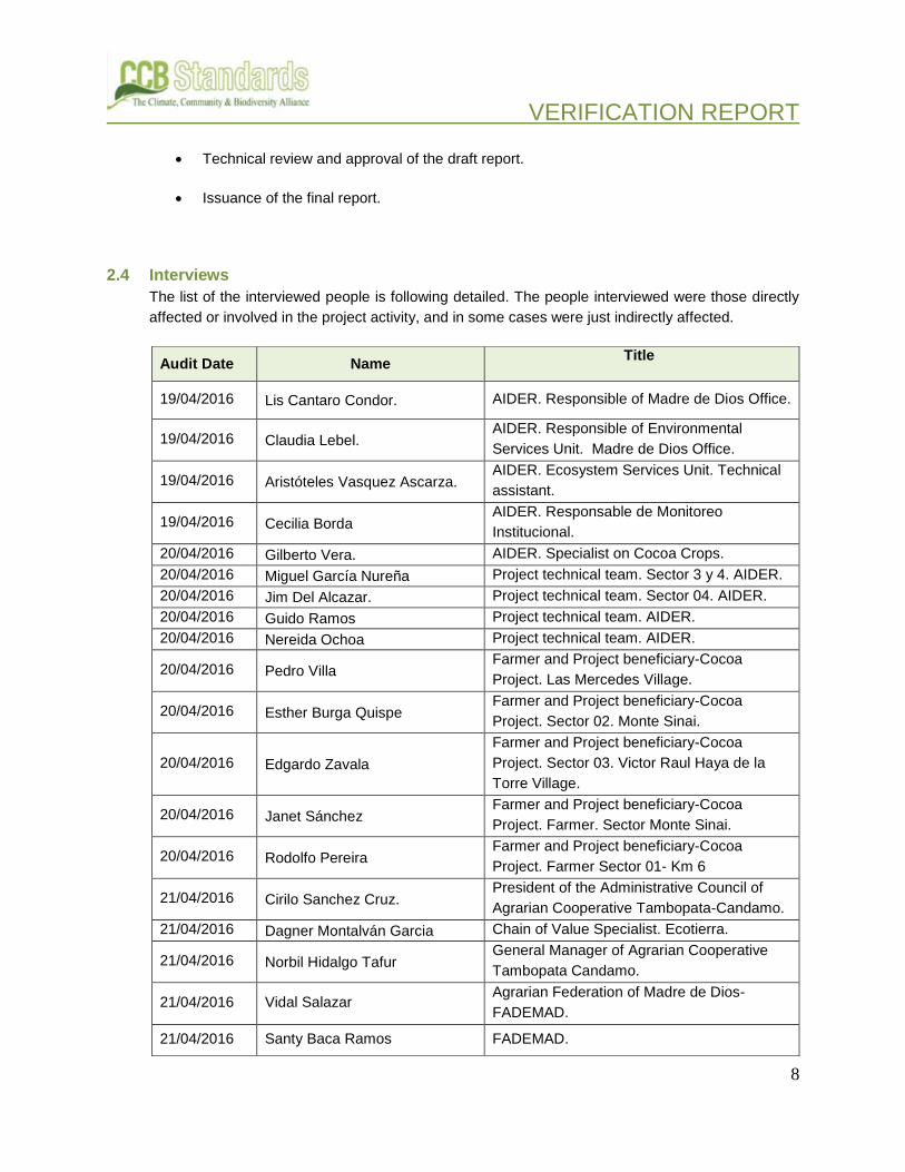
2.4 Interviews
The list of the interviewed people is following detailed. The people interviewed were those directly
affected or involved in the project activity, and in some cases were just indirectly affected.
Audit Date Name Title
19/04/2016 Lis Cantaro Condor. AIDER. Responsible of Madre de Dios Office.
19/04/2016 Claudia Lebel. AIDER. Responsible of Environmental
Services Unit. Madre de Dios Office.
19/04/2016 Aristóteles Vasquez Ascarza. AIDER. Ecosystem Services Unit. Technical
assistant.
19/04/2016 Cecilia Borda AIDER. Responsable de Monitoreo
Institucional.
20/04/2016 Gilberto Vera. AIDER. Specialist on Cocoa Crops.
20/04/2016 Miguel García Nureña Project technical team. Sector 3 y 4. AIDER.
20/04/2016 Jim Del Alcazar. Project technical team. Sector 04. AIDER.
20/04/2016 Guido Ramos Project technical team. AIDER.
20/04/2016 Nereida Ochoa Project technical team. AIDER.
20/04/2016 Pedro Villa Farmer and Project beneficiary-Cocoa
Project. Las Mercedes Village.
20/04/2016 Esther Burga Quispe Farmer and Project beneficiary-Cocoa
Project. Sector 02. Monte Sinai.
20/04/2016 Edgardo Zavala
Farmer and Project beneficiary-Cocoa
Project. Sector 03. Victor Raul Haya de la
Torre Village.
20/04/2016 Janet Sánchez Farmer and Project beneficiary-Cocoa
Project. Farmer. Sector Monte Sinai.
20/04/2016 Rodolfo Pereira Farmer and Project beneficiary-Cocoa
Project. Farmer Sector 01- Km 6
21/04/2016 Cirilo Sanchez Cruz. President of the Administrative Council of
Agrarian Cooperative Tambopata-Candamo.
21/04/2016 Dagner Montalván Garcia Chain of Value Specialist. Ecotierra.
21/04/2016 Norbil Hidalgo Tafur General Manager of Agrarian Cooperative
Tambopata Candamo.
21/04/2016 Vidal Salazar Agrarian Federation of Madre de Dios-
FADEMAD.
21/04/2016 Santy Baca Ramos FADEMAD.

VERIFICATION REPORT
9
3 STAKEHOLDER COMMENTS
The Project Implementation Report (PIR) was posted on the CCBA website on 29 March 2016 and,
the public comment period extended through 29 April 2016. No comments were received via the
CCBA online comment process. The project proponents also conducted their own processes to
engage stakeholders. As indicator CM.1.1 states the communication process was participatory,
starting in 2010. Evidence provided (attendance lists, pictures of meetings, meeting programs and
meeting reports) confirms the participatory process conducted during the period of project
implementation. These documents detail the way in which project documentation was distributed
throughout the project zone and stakeholders were invited to comment. This process is further
discussed in the findings related to the indicator G3.8.
4 VERIFICATION FINDINGS
4.1 General Section
The General Section of the CCB Standards addresses original conditions in the project are
baseline projections, project design and goals, management capacity and best practices, and legal
status and property rights.
21/04/2016 Erick Huamani Villalobos AIDER. Biological Monitoring Responsible.
21/04/2016 Roberto Gutierrez: Biological monitoring coordinator of Pampas
del Heath. National University of San Agustin
21/04/2016 Joel Mendoza Coordinator of the Project “Lobo de Rio”-.
Frankfurt Zoological Society
21/04/2016 Victor Zambrano President of the Forest Management
Committee of National Reserve Tambopata.
21/04/2016 Gilberto Yojaje President of the Tourism Committee of
Palma Real / FENAMAD member.
21/04/2016 Wilber Carahuiri Vice-president of the Management
Committee of Bahuaja Sonene National Park.
21/04/2016 Edwin Tucha President of Sonene Community
22/04/2016 Percy Rojas de la Cruz Tourism Specialist SERNANP
22/04/2016 Ernesto Fernández Control and Surveillance. Tambopata
National Reserve. SERNANP.
22/04/2016 Asmín Flores Regional Environmental Coordinator.
SERNANP
22/04/2016 David Aranibar. Chief of Bahuaja-Sonene National Park.
SERNANP.
VERIFICATION REPORT
10
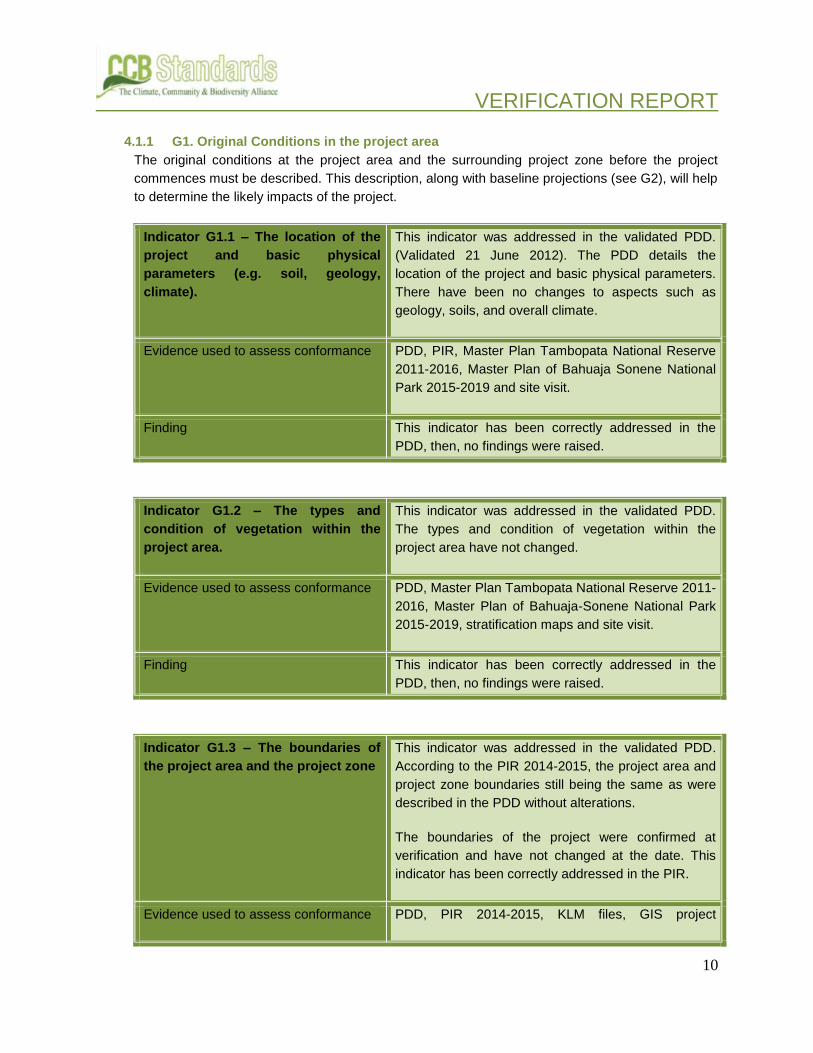
4.1.1 G1. Original Conditions in the project area
The original conditions at the project area and the surrounding project zone before the project
commences must be described. This description, along with baseline projections (see G2), will help
to determine the likely impacts of the project.
Indicator G1.1 – The location of the
project and basic physical
parameters (e.g. soil, geology,
climate).
This indicator was addressed in the validated PDD.
(Validated 21 June 2012). The PDD details the
location of the project and basic physical parameters.
There have been no changes to aspects such as
geology, soils, and overall climate.
Evidence used to assess conformance PDD, PIR, Master Plan Tambopata National Reserve
2011-2016, Master Plan of Bahuaja Sonene National
Park 2015-2019 and site visit.
Finding This indicator has been correctly addressed in the
PDD, then, no findings were raised.
Indicator G1.2 – The types and
condition of vegetation within the
project area.
This indicator was addressed in the validated PDD.
The types and condition of vegetation within the
project area have not changed.
Evidence used to assess conformance PDD, Master Plan Tambopata National Reserve 2011-
2016, Master Plan of Bahuaja-Sonene National Park
2015-2019, stratification maps and site visit.
Finding This indicator has been correctly addressed in the
PDD, then, no findings were raised.
Indicator G1.3 – The boundaries of
the project area and the project zone
This indicator was addressed in the validated PDD.
According to the PIR 2014-2015, the project area and
project zone boundaries still being the same as were
described in the PDD without alterations.
The boundaries of the project were confirmed at
verification and have not changed at the date. This
indicator has been correctly addressed in the PIR.
Evidence used to assess conformance PDD, PIR 2014-2015, KLM files, GIS project

VERIFICATION REPORT
11
shapefiles and interviews during the site visit.
Finding This indicator has been correctly addressed in the
PDD, then, no findings were raised.
Indicator G1.4 - Current carbon
stocks within the project area(s),
using stratification by land-use or
vegetation type and methods of
carbon calculation (such as biomass
plots, formulae, default values) from
the Intergovernmental Panel on
Climate Change’s 2006 Guidelines
for National GHG Inventories for
Agriculture, Forestry and Other Land
Use (IPCC 2006 GL for AFOLU) or a
more robust and detailed
methodology.
This indicator was addressed in the validated PDD.
Evidence used to assess conformance
PDD, VCS Methodology VM0007 - REDD
Methodology Modules (REDD-MF) and spreadsheet
of baseline carbon stocks calculation.
Finding This indicator has been correctly addressed in the
PDD, then, no findings were raised.
Indicator G1.5 – A description of
communities located in the project
zone, including basic socio-
economic and cultural information
that describes the social, economic
and cultural diversity within
communities (wealth, gender, age,
ethnicity etc.), identifies specific
groups such as Indigenous Peoples
and describes any community
characteristics.
The PDD describes the local communities in the
project area and project zone and the basic
socioeconomic and cultural information.
Evidence used to assess conformance PDD, PIR 2014-2015 and interviews during the on-site visit.

VERIFICATION REPORT
12
Finding This indicator has been correctly addressed in the
PDD, then, no findings were raised.
Indicator G1.6 – A description of
current land use and customary and
legal property rights including
community property in the project
zone, identifying any ongoing or
unresolved conflicts or disputes and
identifying and describing any
disputes over land tenure that were
resolved during the last ten years
(see also G5).
The reader is referred to the validated PDD, which
describes this indicator.
Evidence used to assess conformance Validated PDD, PIR, interviews during the site visit.
Finding This indicator has been correctly addressed in the
PDD, then, no findings were raised.
Indicator G1.7 – A description of
current biodiversity within the
project zone (diversity of species
and ecosystems) and threats to that
biodiversity, using appropriate
methodologies, substantiated where
possible with appropriate reference
material.
The reader is referred to the validated PDD, which
fully describes the biodiversity as of validation (21
June 2012).
Evidence used to assess conformance PDD, PIR, Master Plan Tambopata National Reserve
2011-2016, Master Plan of Bahuaja-Sonene National
Park 2015-2019 and site visit.
Finding This indicator has been correctly addressed in the
PDD, then, no findings were raised.
Indicator G1.8 – An evaluation of
whether the project zone includes
any of the following High
The reader is referred to the validated PDD, which
fully describes this indicator.

VERIFICATION REPORT
13
Conservation Values (HCVs) and a
description of the qualifying
attributes:
8.1. Globally, regionally or nationally
significant concentrations of
biodiversity values;
8.1.1 Protected areas
8.1.2 Threatened species
8.1.3 Endemic species
8.1.4 Areas that support significant
concentrations of a species during
any time in their lifecycle (e.g.
migrations, feeding grounds,
breeding areas)
8.2. Globally, regionally or nationally
significant large landscape-level
areas where viable populations of
most if not all naturally occurring
species exist in natural patterns of
distribution and abundance;
8.3. Threatened or rare ecosystems
8.4. Areas that provide critical
ecosystem services (e.g.,
hydrological services, erosion
control, fire control);
8.5. Areas that are fundamental for
meeting the basic needs of local
communities (e.g., for essential food,
fuel, fodder, medicines or building
materials without readily available
alternatives); and
8.6. Areas that are critical for the
traditional cultural identity of
communities (e.g., areas of cultural,
ecological, economic or religious

VERIFICATION REPORT
14
significance identified in
collaboration with the communities).
Evidence used to assess conformance PDD, PIR, Master Plan Tambopata National Reserve
2011-2016, Master Plan of Bahuaja-Sonene National
Park 2015-2019 and site visit.
Finding This indicator has been correctly addressed in the
PDD, then, no findings were raised.
4.1.2 G2. Baseline projections
A baseline projection is a description of expected conditions in the project zone in the absence of
project activities. The project impacts will be measured against this ‘without-project’ reference
scenario.
Indicator G.2.1 - Describe the most
likely land-use scenario in the
absence of the project following
IPCC 2006 GL for AFOLU or a more
robust and detailed methodology,
describing the range of potential land
use scenarios and the associated
drivers of GHG emissions and
justifying why the land-use scenario
selected is most likely.
This indicator was addressed in the validated PDD,
which describes the most-likely land-use scenario in
the absence of project activities.
Evidence used to assess conformance PDD, VC PD and VCS Methodology,
Finding This indicator has been correctly addressed in the
PDD, then, no findings were raised.
Indicator G.2.2 - Document that
project benefits would not have
occurred in the absence of the
project, explaining how existing laws
or regulations would likely affect
land use and justifying that the
benefits being claimed by the project
are truly ‘additional’ and would be
The reader is referred to the validated PDD, which
describes the likelihood of occurrence of project
activities in the absence of the project. Is reasonable
to assume that no changes have occurred to the
validated scenario. Site visit observations also confirm
this.

VERIFICATION REPORT
15
unlikely to occur without the project.
Evidence used to assess conformance PDD, PD-VCS and VCS Methodology,
Finding This indicator has been correctly addressed in the
PDD, then, no findings were raised.
Indicator G.2.3.- Calculate the
estimated carbon stock changes
associated with the ‘without project’
reference scenario described above.
This requires estimation of carbon
stocks for each of the land-use
classes of concern and a definition
of the carbon pools included, among
the classes defined in the IPCC 2006
GL for AFOLU. The timeframe for this
analysis can be either the project
lifetime (see G3) or the project GHG
accounting period, whichever is
more appropriate. Estimate the net
change in the emissions of non-CO2
GHG emissions such as CH4 and
N2O in the ‘without project’ scenario.
Non-CO2 gases must be included if
they are likely to account for more
than 5% (in terms of CO2-equivalent)
of the project’s overall GHG impact
over each monitoring period.
Projects whose activities are
designed to avoid GHG emissions
(such as those reducing emissions
from deforestation and forest
degradation (REDD), avoiding
conversion of non-forest land, or
certain improved forest management
projects) must include an analysis of
the relevant drivers and rates of
deforestation and/or degradation and
a description and justification of the
approaches, assumptions and data
This indicator was addressed in the validated PDD.
The estimated carbon stock changes associated with
the ‘without project’ reference scenario was confirmed
at validation.

VERIFICATION REPORT
16
used to perform this analysis.
Regional-level estimates can be used
at the project’s planning stage as
long as there is a commitment to
evaluate locally-specific carbon
stocks and to develop a project-
specific spatial analysis of
deforestation and/or degradation
using an appropriately robust and
detailed carbon accounting
methodology before the start of the
project.
Evidence used to assess conformance PDD and ex-ante GHG baseline emission calculation
spreadsheet.
Finding This indicator has been correctly addressed in the
PDD, then, no findings were raised.
Indicator G.2.4.- Describe how the
‘without project’ reference scenario
would affect communities in the
project zone, including the impact of
likely changes in water, soil and
other locally important ecosystem
services.
The reader is referred to the validated PDD. The
validated PDD describes how ‘without project’
reference scenario would affect communities in the
project zone. Is reasonable to assume that no
changes have occurred to this ‘without project’
scenario. Site visit observations also confirmed this.
Evidence used to assess conformance PDD and Participative Socioeconomic Diagnostics:
Nueva America, Las Mercedes, San Francisco, San
Bernardo, Filadelfia, Sol Naciente, Sonene, Union
Progreso and Virgen de La Candelaria
Finding This indicator has been correctly addressed in the
PDD, then, no findings were raised.
Indicator G.2.5.- Describe how the
‘without project’ reference scenario
would affect biodiversity in the
The reader is referred to the validated PDD. The
validated PDD describes how ‘without project’
reference scenario would affect biodiversity in the

VERIFICATION REPORT
17
project zone (e.g., habitat availability,
landscape connectivity and
threatened species).
project zone. The ‘without project’ reference scenario
remains unchanged from validation.
Evidence used to assess conformance PDD and site visit.
Finding This indicator has been correctly addressed in the
PDD, then, no findings were raised.
4.1.3 G3. Project Design and Goal
The project must be described in sufficient detail so that a third-party can adequately evaluate it. Projects
must be designed to minimize risks to the expected climate, community and biodiversity benefits and to
maintain those benefits beyond the life of the project. Effective local participation in project design and
implementation is key to optimizing multiple benefits, equitably and sustainably. Projects that operate in a
transparent manner build confidence with stakeholders and outside parties and enable them to contribute
more effectively to the project.
Indicator G.3.1.- Provide a summary
of the project’s major climate,
community and biodiversity
objectives.
This section was addressed in Section G3.1 of the
PDD. The audit team has confirmed that the climate,
community and biodiversity objectives still being the
same.
Evidence used to assess conformance PDD and PIR 2014-2015
Finding This indicator has been correctly addressed in the
PDD, then, no findings were raised.
Indicator G.3.2.- Describe each
project activity with expected
climate, community and biodiversity
impacts and its relevance to
achieving the projects objectives.
This indicator has been correctly addressed,
considering the project activities planned described in
the PDD still valid and the additional information given
in the section G.3.2 of PIR.
Evidence used to assess conformance PD, REDD Project Strategy 2012, REDD Project
Strategy 2015 and interviews during the on-site visit.
Finding This indicator has been correctly addressed in the
PDD, then, no findings were raised.

VERIFICATION REPORT
18
Indicator G.3.3.- Provide a map
identifying the project location and
boundaries of the project area(s),
where the project activities will
occur, of the project zone and of
additional surrounding locations that
are predicted to be impacted by
project activities (e.g. through
leakage).
Project location and boundaries are the same as
identified in the PDD. However, in accordance with
information provided by the project proponent the
REDD Project Strategy has been updated during the
year 2014 and then, the project strategy considers a
new zoning for implementation of the project activities.
In that sense, the changes in zoning and location of
the project activities shall be described in the PIR and
a map shall be provided.
Evidence used to assess conformance PDD, PIR, REDD Project Strategy 2012, REDD
Project Strategy 2015, maps of project activities
location and interview during the site visit.
Finding NC 01: PIR shall provide information regarding the
changes given in the location of project activities.
An updated map shall be included.
PIR final version gives information regarding the
updated Project Strategy and the location of its
activities. The strategy 2014 includes the components
of previous strategy, such as Control and
Surveillance, Sustainable Economic Activities,
Governance, Conservation Agreements and
Communication, but also has been add specific
components for biological monitoring, biological
research, environmental education and tourism
promotion. Changes have been considered in order to
improve the effectiveness of the designed strategies
to reach the project goals. Furthermore, the zoning of
activities has also been updated considering the social
dynamic of the population in the project zone during
the last years. A zoning map for project activities has
been included in the PIR.
This indicator is addressed.
NC 01 is closed.
Indicator G.3.4.- Define the project
lifetime and GHG accounting period
and explain and justify any
Project lifetime and GHG accounting period are
explain and justified. The start date is 1 January 2009

VERIFICATION REPORT
19
differences between them. Define an
implementation schedule, indicating
key dates and milestones in the
project’s development.
and the lifetime of the project is 20 years.
On the other hand, the project GHG accounting period
began with the VCS crediting period, that is 1 July
2010, in order to use a validated baseline. Audit team
considers this is correct and conservative.
The implementation schedule, indicating key dates
and milestones in the project’s development, was
described in the PDD.
Evidence used to assess conformance CCB PDD and PIR, and VCS PD.
Finding This indicator has been correctly addressed.
Indicator G.3.5.- Identify likely natural
and human-induced risks to the
expected climate, community and
biodiversity benefits during the
project lifetime and outline measures
adopted to mitigate these risks.
Likely natural and human-induced risks to the
expected climate, community and biodiversity benefits
during the project lifetime and outline measures
adopted to mitigate these risks was identified in the
PDD.
PIR list some measures taken during the
implementation period 2014-2015 in order to reduce
the natural and human-induced risks identified, such
as fire prevention measures, diversified production
practices, improvement of governance and advocacy.
Furthermore, in order to obtain data about occurrence
of events, the platform SINPAD (National System of
Information for Disaster Prevention and data from the
National Agrarian Health Service- SENASA, has been
used.
Evidence used to assess conformance PDD, PIR, Report of Plagues Occurrence (“Informe-
0011-2016-MINAGRI-SENASA-DEMDD-ASV-
NGuerrero, INDECI Statistic Bulletin N°4/January
2016, Handbook of Prevention of Forest Fires. AIDER
2015, Agreement between FADEMAD and AIDER.
2015
Finding This indicator has been correctly addressed.

VERIFICATION REPORT
20
Indicator G.3.6.- Demonstrate that the
project design includes specific
measures to ensure the maintenance or
enhancement of the high conservation
value attributes identified in G1
consistent with the precautionary
principle.
The reader is referred to the validated PDD.
Evidence used to assess conformance PDD, REDD Project Strategy 2012, REDD Project
Strategy 2014, Master Plan of Tambopata National
Reserve 2011-2016 and Master Plan of Bahuaja
Sonene National Park 2015-2019
Finding This indicator has been correctly addressed in the
PDD, then, no findings were raised.
Indicator G.3.7.- Describe the
measures that will be taken to
maintain and enhance the climate,
community and biodiversity benefits
beyond the project lifetime.
The reader is referred to the validated PDD.
Evidence used to assess conformance PDD, REDD Project Strategy 2012, REDD Project
Strategy 2014, and interviews during the site visit.
Finding This indicator has been correctly addressed in the
PDD, then, no findings were raised.
Indicator G.3.8.- Document and
defend how communities and other
stakeholders potentially affected by
the project activities have been
identified and have been involved in
project design through effective
Relevant communities and other stakeholders was
identified and involved in the project design. This
community involvement was discussed in the PDD.
The PIR includes the plan for communication and
consultation. The communication plan aims to

VERIFICATION REPORT
21
consultation, particularly with a view
to optimizing community and
stakeholder benefits, respecting
local customs and values and
maintaining high conservation
values. Project developers must
document stakeholder dialogues and
indicate if and how the project
proposal was revised based on such
input. A plan must be developed to
continue communication and
consultation between project
managers and all community groups
about the project and its impacts to
facilitate adaptive management
throughout the life of the project.
increase project visibility, transparency and
participation, promote the sustainable agroforestry
among the local population and to strength
partnership with partners.
The project proponent maintains permanent
communication and coordination with the
management committees of National Reserve
Tambopata and Bahuaja-Sonene National Park, which
are made up of representatives of local population.
The Committees are permanently informed of the
planned and carry out activities through periodic
meetings of coordination. In addition, participation in
radio programs has constituted another media to
communicate news about the project.
During the site visit through interviews to relevant
stakeholder, such as representatives of local
management committees and representatives of local
communities, the audit team was able to verify the
information provided in the PIR.
Evidence used to assess conformance
PDD, PIR, reports of meetings with the Management
Committees, reports and attendance list of workshops
with the local population.
Finding This indicator has been correctly addressed in the
PDD, then, no findings were raised.
Indicator G.3.9.- Describe what
specific steps have been taken, and
communications methods used, to
publicize the CCBA public comment
period to communities and other
stakeholders and to facilitate their
submission of comments to CCBA.
Project proponents must play an
active role in distributing key project
documents to affected communities
and stakeholders and hold widely
publicized information meetings in
As PIR mentions there is a permanent coordination
with the Management Committees of the Tambopata
National Reserve and the Bahuaja-Sonene National
Park, which represents the local surrounding
population. In that sense, local representatives are
permanent informed about the project steps.
The PIR has been made in Spanish, which is the
relevant language for both the national and local
stakeholders.
In accordance with the PIR, in order to publicize the
CCBA public comment period, letters were sent to

VERIFICATION REPORT
22
relevant local or regional languages. relevant stakeholders.
Evidence used to assess conformance PIR, letter 003-2016 AIDER, and interviews during the
site visit.
Finding CL 01: PP shall provide copy of the letters sent to
stakeholders to publicize the CCBA public
comment periods.
Project proponent has provided the copy of the letter
(letter 003-2016 AIDER/MDD) sent to different
stakeholders such as the management committees of
Tambopata National Reserve, NGOs, private
enterprises, local authorities, etc. Furthermore, during
the site visit the audit team was able to confirm the
information provided in the PIR.
CL 01 is closed
This indicator has been correctly addressed.
Indicator G.3.10.- Formalize a clear
process for handling unresolved
conflicts and grievances that arise
during project planning and
implementation. The project design
must include a process for hearing,
responding to and resolving
community and other stakeholder
grievances within a reasonable time
period. This grievance process must
be publicized to communities and
other stakeholders and must be
managed by a third party or mediator
to prevent any conflict of interest.
Project management must attempt to
resolve all reasonable grievances
raised, and provide a written
response to grievances within 30
In the validated PDD, section G3.10 the project
proponent provides a description of the
process/methodology to be used to handle the
conflicts and claims that arise throughout the project
planning and implementation phase.
The project proponent has formalized an updated
procedure for handling conflicts and grievances during
the project implementation. The annex 29 of the PIR,
procedure for handling conflicts and grievances,
describes the basic principles considered to manage a
conflict, the mechanism and the strategies to resolve
conflicts, and also the grievance process.
The PP has described in the PIR how the procedures
are being applied successfully. In that sense, during
the implementation period the project has supported
to marking boundaries of the Community of Palma
Real, in order to support the resolution of land

VERIFICATION REPORT
23
days. Grievances and project
responses must be documented.
conflicts with the villages of Lago Valencia and Puerto
Arturo. Map of land conflicts identified has been
provided.
Evidence used to assess conformance PDD, PIR, Map of Land Conflicts, Project Procedure
for Handling Conflicts and Grievances, Master Plan of
Tambopata National Reserve, interviews during the
site visit.
Finding This indicator has been correctly addressed in the
PIR.
Indicator G.3.11.- Demonstrate that
financial mechanisms adopted,
including projected revenues from
emissions reductions and other
sources, are likely to provide an
adequate flow of funds for project
implementation and to achieve the
anticipated climate, community and
biodiversity benefits.
The financial mechanisms adopted are providing an
adequate flow of funds for project implementation. The
project proponent has signed an agreement with
Althelia Carbon Fund (ACF) in order to obtain funds
for project implementation. Carbon credits have been
an essential financial income for the project. The
breakeven point was reached in the third year and an
80% of the project investment has been secured.
Evidence used to assess conformance PDD, PIR, agreement AIDER-Althelia Carbon Fund.
Finding This indicator has been correctly addressed in the
PDD, then, no findings were raised.
4.1.4 G4. Management Capacity and Best Practices.
The success of a project depends upon the competence of the implementing management team. Projects
that include a significant capacity-building (training, skill building, etc.) component are more likely to
sustain the positive outcomes generated by the project and have them replicated elsewhere.
Best practices for project management include: local stakeholder employment, worker rights, worker
safety and a clear process for handling grievances.
Indicator G.4.1.- Identify a single
project proponent, which is
PIR in section G.4.1 described the governance
structure, roles and responsibilities of each

VERIFICATION REPORT
24
responsible for the project’s design
and implementation. If multiple
organizations or individuals are
involved in the project’s
development and implementation the
governance structure, roles and
responsibilities of each of the
organizations or individuals involved
must also be described.
organization involved in the project.
PP has included in the PIR the updated information
regarding the organization involved in the project.
AIDER is the project proponent and executor of the
contract for management of monitoring and research
operations, and AIDER is responsible for project
implementation.
It also defines the supervisory and political roles of
SERNANP through the Tambopata National Reserve
and Bahuaja-Sonene National Park Directorships.
The information in the PIR has been verified in
interviews of the stakeholders involved in the contract
signed for execution of these activities.
This indicator has been correctly addressed in the
PIR.
Evidence used to assess conformance PIR, PDD, resolution 045-2013-SERNANP and on-site
visit interviews.
Finding This indicator has been correctly addressed in the
PDD, then, no findings were raised.
Indicator G.4.2.- Document key
technical skills that will be required
to implement the project
successfully, including community
engagement, biodiversity
assessment and carbon
measurement and monitoring skills.
Document the management team’s
expertise and prior experience
implementing land management
projects at the scale of this project. If
relevant experience is lacking, the
proponents must either demonstrate
how other organizations will be
partnered with to support the project
In accordance with the PIR, the positions and
management skills requirements mentioned in the
PDD still in place. In the PIR, section G4.2, the project
proponent presents its team‘s technical abilities for
project implementation regarding the carbon,
community and biodiversity.
Chart 04 describes the specialist team and their skills
to work on biodiversity monitoring, the geographic
management system (SIG), management of
deforestation, carbon stock models and work with the
community.
This indicator has been correctly addressed in the

VERIFICATION REPORT
25
or have a recruitment strategy to fill
the gaps.
final version of the PIR.
Evidence used to assess conformance PDD, PIR and interviews.
Finding This indicator has been correctly addressed in the
PDD, then, no findings were raised.
Indicator G.4.3.- Include a plan to
provide orientation and training for
the project’s employees and relevant
people from the communities with an
objective of building locally useful
skills and knowledge to increase
local participation in project
implementation. These capacity
building efforts should target a wide
range of people in the communities,
including minority and
underrepresented groups. Identify
how training will be passed on to
new workers when there is staff
turnover, so that local capacity will
not be lost.
The training plan was provide to the audit team. The
training plan has been designed to provided
orientation and training for project staff, local
communities and project partners. Among the training
topics are: agroforestry, organizational strength,
cooperative, monitoring, research, and ecosystem
services. Several activities were developed in this
period and evidence was provided to the audit team,
such as list of attendance and photographs records
Evidence used to assess conformance PDD, PIR, interviews during the site visit, reports and
list of attendance of workshops.
Finding This indicator has been correctly addressed in the
PDD, then, no findings were raised.
Indicator G.4.4.- Show that people
from the communities will be given
an equal opportunity to fill all
employment positions (including
management) if the job requirements
are met. Project proponents must
explain how employees will be
selected for positions and where
relevant, must indicate how local
PIR described how is given opportunities to fill job
position by the local people and practices of gender
equity adopted. PP has included in the PIR
information regarding opportunities to fill job position
by local people. Evidence has been provided and
considered appropriate. This was also verified through
interviews to some workers during the on-site visit.

VERIFICATION REPORT
26
community members, including
women and other potentially
underrepresented groups, will be
given a fair chance to fill positions
for which they can be trained.
Evidence used to assess conformance PDD, PIR, interviews during the on-site visit.
Finding This indicator has been correctly addressed in the
PDD, then, no findings were raised.
Indicator G.4.5.- Submit a list of all
relevant laws and regulations
covering worker’s rights in the host
country. Describe how the project
will inform workers about their
rights. Provide assurance that the
project meets or exceeds all
applicable laws and/or regulations
covering worker rights and, where
relevant, demonstrate how
compliance is achieved.
PIR final version includes an updated list of all
relevant laws and regulations covering workers’ rights
in the host country issued up to 2015. The audit team
considers the list complete.
Evidence used to assess conformance PDD, PIR 2013-2014, PIR 2014-2015, Ministry of
Labor and Employment Promotion website.
Finding This indicator has been correctly addressed
Indicator G.4.6.- Comprehensively
assess situations and occupations
that pose a substantial risk to worker
safety. A plan must be in place to
inform workers of risks and to
explain how to minimize such risks.
Where worker safety cannot be
guaranteed, project proponents must
show how the risks will be minimized
using best work practices.
The safety plan has been developed and provided to
the audit team. Through interviews to project staff
conducted during the site visit the audit team was able
to confirm workers are informed about how to
minimize risk. In addition, list of attendance of safety
training workshops and proof of delivery of safety
equipment was provided to the audit team.

VERIFICATION REPORT
27
Evidence used to assess conformance PDD, PIR, safety plan, proof of delivery and list of
attendance.
Finding This indicator has been correctly addressed.
Indicator G.4.7.- Document the
financial health of the implementing
organization(s) to demonstrate that
financial resources budgeted will be
adequate to implement the project.
PP has included updated information regarding the
financial health for the project implementation.
Evidence, such as project cash flow and a loan
agreement, has been provided to the audit team
Evidence used to assess conformance PDD, PIR and Fondo Climático Althelia (ACF)
agreement.
Finding This indicator has been correctly addressed.
4.1.5 G5. Legal Status and Property Rights.
The project must be based on a solid legal framework (e.g., appropriate contracts are in place) and the
project must satisfy applicable planning and regulatory requirements.
During the project design phase, the project proponents should communicate early on with relevant local,
regional and national authorities in order to allow adequate time to earn necessary approvals. The project
design should be sufficiently flexible to accommodate potential modifications that may arise as a result of
this process.
In the event of unresolved disputes over tenure or use rights to land or resources in the project zone, the
project should demonstrate how it will help to bring them to resolution so that there are no unresolved
disputes by the start of the project.
Indicator G.5.1.- Submit a list of all
relevant national and local laws and
regulations in the host country and
all applicable international treaties
and agreements. Provide assurance
that the project will comply with
these and, where relevant,
demonstrate how compliance is
In the PIR has been listed all the relevant national and
local laws and regulations. The list of relevant laws
and regulation detailed in the PIR and evidence of its
fulfilment is considered complete.

VERIFICATION REPORT
28
achieved.
Evidence used to assess conformance PDD and PIR
Finding This indicator has been correctly addressed in the
final version of the PIR.
Indicator G.5.2.- Document that the
project has approval from the
appropriate authorities, including the
established formal and/or traditional
authorities customarily required by
the communities.
The approval from national authorities was presented
in the PDD. The project proponent presents approval
from the Peruvian government, represented by
SERNANP, by means of a contract titled ―Agreement
between the Institute of National Resources –
INRENA and AIDER.
Evidence used to assess conformance PDD and Agreement between the Institute of Natural
Resources – INRENA and AIDER.
Finding This indicator has been correctly addressed. Then no
finding was raised.
Indicator G.5.3.- Demonstrate with
documented consultations and
agreements that the project will not
encroach uninvited on private
property, community property, or
government property and has
obtained the free, prior, and informed
consent of those whose rights will be
affected by the project.
This indicator was discussed in the PDD. In addition,
the PIR reiterates the fulfilment of this indicator.
In addition, the PIR version 01 states some measures
have been taken to include villager as beneficiaries of
the agroforestry activities in order in order to ensure
that the project will not encroach uninvited on private
property and to avoid any potential land conflict.
However, the procedures and requirements are not
clearly described in the PIR.
Evidence used to assess conformance PDD, PIR, Agroforestry Project Admissibility Criteria
and Application Form and on-site visit interviews.
Finding CL 02: PP shall clarify the procedures and
requirements to include villagers into the
agroforestry project activities.

VERIFICATION REPORT
29
PIR final version gives a summary description of the
requirements and procedures to included beneficiaries
into the agroforestry project component.
Among other requirements, the beneficiaries shall be
local villagers in the project zone and shall
demonstrate the right of use over the land.
Furthermore, the plot must provide appropriate
conditions for establishing of agriculture and shall not
be deforested land at least since 2012. The
Admissibility Criteria and Application Form to be
admitted in the agroforestry activities was provided to
the audit team
CL 02 is closed.
This indicator is correctly addressed.
Indicator G.5.4.- Demonstrate that the project does not require the involuntary relocation of people or of the activities important for the livelihoods and culture of the communities. If any relocation of habitation or activities is undertaken within the terms of an agreement, the project proponents must demonstrate that the agreement was made with the free, prior, and informed consent of those concerned and includes provisions for just and fair compensation.
In accordance with the PDD and PIR, relocation of
people has not been required. The National Reserve
Tambopata and Bahuaja-Sonene National Park
management plans contemplate the natural resources
right of use in the area by native communities and
local Brazilian nuts collectors. In addition the PIR
indicates that the project strategy includes develop
sustainable economic activities in partnership with the
local communities.
Evidence used to assess conformance PDD, PIR, Monitoring Plan, list of attendance of
workshops, Master Plan of Tambopata National
Reserve, interviews during the on-site visit.
Finding This indicator has been correctly addressed. Then no
finding was raised.
Indicator G.5.5.- Identify any illegal activities that could affect the project’s climate, community or
Reader is referred to the PDD. The PDD identified
illegal activities that affect project objectives and

VERIFICATION REPORT
30
biodiversity impacts (e.g., logging) taking place in the project zone and describe how the project will help to reduce these activities so that project benefits are not derived from illegal activities.
activities that the project will carry out to promote
productive alternatives for these activities and to
increase control and surveillance.
Project benefits are not derived from illegal activities.
Illegal activities were identified in the PDD. Site visit
observations and interview with participants further
confirms these elements have not changed since the
validation of the PDD, and thus, no new information is
needed to be presented here. Issue is addressed.
Evidence used to assess conformance
PDD, PIR, Monitoring Plan, list of attendance of
workshops, Master Plan of Tambopata National
Reserve, interviews during the on-site visit.
Finding This indicator has been correctly addressed. Then no
finding was raised.
Indicator G.5.6.- Demonstrate that the project proponents have clear, uncontested title to the carbon rights, or provide legal documentation demonstrating that the project is undertaken on behalf of the carbon owners with their full consent. Where local or national conditions preclude clear title to the carbon rights at the time of validation against the Standards, the project proponents must provide evidence that their ownership of carbon rights is likely to be established before they enter into any transactions concerning the project’s carbon assets.
Project proponent holds an administrative contract
with SERNANP (Servicio Nacional de Areas Naturales
Protegidas de Peru) being the state of Peru owner of
Reserva Nacional Tambopata and Parque Nacional
Bahuaja Sonene. Title to carbon rights has not
changed and all elements of this indicator remain
constant since the previous validation effort.
Evidence used to assess conformance PDD, PIR and agreement (administrative contract)
between AIDER and SERNANP.
Finding This indicator was adequately addressed.

VERIFICATION REPORT
31
4.2 Climate Section
4.2.1 CL1 Net Positive Climate Section
The project must generate net positive impacts on atmospheric concentrations of greenhouse gases
(GHGs) over the project lifetime from land use changes within the project boundaries.
Indicator CL.1.1- Estimate the net change in carbon stocks due to the project activities using the methods of calculation, formulae and default values of the IPCC 2006 GL for AFOLU or using a more robust and detailed methodology. The net change is equal to carbon stock changes with the project minus carbon stock changes without the project (the latter having been estimated in G2). This estimate must be based on clearly defined and defendable assumptions about how project activities will alter GHG emissions or carbon stocks over the duration of the project or the project GHG accounting period.
PP has detailed in the PIR the net changes in carbon
stocks in accordance with the VCS methodology
VM0007- REDD Methodology Modules (REDD-MF).
GHG emissions calculation spreadsheet has been
provided.
Evidence used to assess conformance PDD, PIR, GHG emission calculation spreadsheet
2014-2015, baseline project emissions calculations.
Finding This indicator has been correctly addressed.
Indicator CL.1.2- Estimate the net change in the emissions of non-CO2 GHG emissions such as CH4 and N2O in the with and without project scenarios if those gases are likely to account for more than a 5% increase or decrease (in terms of CO2-equivalent) of the project’s overall GHG emissions reductions or removals over each monitoring period.
The section CL. 1.2 has reported 408.2 t CO2-e as the
amount emission of non-CO2 GHG emissions. The
GHG calculation spreadsheet has been provided to
the audit team. The spreadsheet has been checked
and calculation has been made in accordance with the
methodology.
Evidence used to assess conformance PDD, PIR, GHG emission calculation spreadsheet
2014-2015, baseline project emissions calculations.
Finding This indicator has been correctly addressed.

VERIFICATION REPORT
32
Indicator CL1.3.- Estimate any other
GHG emissions resulting from
project activities. Emissions sources
include, but are not limited to,
emissions from biomass burning
during site preparation, emissions
from fossil fuel combustion, direct
emissions from the use of synthetic
fertilizers, and emissions from the
decomposition of N-fixing species.
No biomass burning is considered in the project. No
synthetic fertilizers are applied and no increase in the
use of N fixing species is expected.
Evidence used to assess conformance PDD, PIR, list of project activities developed 2011-
2014 and site visit
Finding These sources of GHG emissions are not applicable
to this project, which was also confirmed at validation.
This indicator has been correctly addressed. Then no
finding was raised.
Indicator CL1.4.- Demonstrate that
the net climate impact of the project
is positive. The net climate impact of
the project is the net change in
carbon stocks plus net change in
non-CO2 GHGs where appropriate
minus any other GHG emissions
resulting from project activities
minus any likely project-related
unmitigated negative offsite climate
impacts (see CL2.3).
PP has provided the net climate impact assessment of
the project for the complete implementation period.
The GHG emissions calculation was provided to the
audit team, which is completely treatable and in
accordance with the applied methodology.
Evidence used to assess conformance
PDD, PIR and GHG Emission calculation
spreadsheet.
Finding Project proponent has demonstrated that the net
climate impact of the project is positive. The project
has reduced a total of 469,771.0 t CO eq.

VERIFICATION REPORT
33
This indicator has been correctly addressed.
Indicator CL1.5.- Specify how double counting of GHG emissions reductions or removals will be avoided, particularly for offsets sold on the voluntary market and generated in a country with an emissions cap.
This indicator was described in the PDD. The
proponent has included in the last version of PIR
updated information about how is avoided the double
counting. PIR reiterates that double counting will be
avoided because the project is not included in an
emissions trade program and because Peru has not
made any commitments in terms of a cap on GHG
emissions as the country does not belong to Annex 1
of the Kyoto Protocol.
On the other hand, the country is developing a Forest
and Climate Change National Strategy, however the
national REDD program is under construction yet.
Finally, the Peruvian government is developing a
national registry of REDD initiatives
Evidence used to assess conformance PDD, PIR, on site interviews.
Finding This indicator has been correctly addressed.
4.2.2 CL2 Offsite Climate Impacts (Leakage)
The project proponents must quantify and mitigate increased GHG emissions that occur beyond the
project area and are caused by project activities (commonly referred to as ‘leakage’).
Indicator CL2.1.- Determine the types of leakage that are expected and estimate potential offsite increases in GHGs (increases in emissions or decreases in sequestration) due to project activities. Where relevant, define and justify where leakage is most likely to take place.
This indicator was addressed in the PDD.
Evidence used to assess conformance PDD
Finding This indicator has been correctly addressed in the
PDD. Then no finding was raised.

VERIFICATION REPORT
34
Indicator CL2.2.- Document how any leakage will be mitigated and estimate the extent to which such impacts will be reduced by these mitigation activities.
Activities carried out are summarized in the PIR. The
leakage mitigation activities have been described as
the promotion of economic alternatives, control and
surveillance and resource governance among the
stakeholders. The PDD presented a description of
mitigation activities to reduce impact in the leakage
belt conducted during the period 2014-2015 which
was verified during the site visit by the audit team.
Evidence used to assess conformance PDD, PIR, list of project activities developed (period
2014-2015).
Finding This indicator has been correctly addressed.
Indicator CL2.3.- Subtract any likely project-related unmitigated negative offsite climate impacts from the climate benefits being claimed by the project and demonstrate that this has been included in the evaluation of net climate impact of the project (as calculated in CL1.4).
In accordance with the methodological process
established, any likely project-related unmitigated
negative offsite impact shall be subtract as a “leakage
emission” However, during this implementation period
there are not leakage emission reported. That was
checked by the audit team through the maps, GIS
shape files and GHG calculation spreadsheet, and is
considered correct.
Evidence used to assess conformance PDD, GHG Calculation Spreadsheet, maps and GIS
shape files.
Finding This indicator has been correctly addressed. Then no
finding was raised.
Indicator CL2.4.- Non-CO2 gases must be included if they are likely to account for more than a 5% increase or decrease (in terms of CO2-equivalent) of the net change calculations (above) of the project’s overall off-site GHG emissions reductions or removals over each monitoring period.
Not applicable as leakage is reported to be zero.

VERIFICATION REPORT
35
Evidence used to assess conformance PDD, GHG Calculation Spreadsheet.
Finding Not applicable as leakage is reported to be zero. This
indicator has been correctly addressed. Then no
finding was raised.
4.2.3 CL3 Climate Impact Monitoring
Before a project begins, the project proponents must have an initial monitoring plan in place to quantify
and document changes (within and outside the project boundaries) in project-related carbon pools,
project emissions, and non-CO2 GHG emissions if appropriate. The monitoring plan must identify the
types of measurements, the sampling method, and the frequency of measurement.
Since developing a full monitoring plan can be costly, it is accepted that some of the plan details may not
be fully defined at the design stage, when projects are being validated against the Standards. This is
acceptable as long as there is an explicit commitment to develop and implement a monitoring plan.
Indicator CL.3.1.- Develop an initial
plan for selecting carbon pools and
non-CO2 GHGs to be monitored, and
determine the frequency of
monitoring. Potential pools include
aboveground biomass, litter, dead
wood, belowground biomass, wood
products, soil carbon and peat.
Pools to monitor must include any
pools expected to decrease as a
result of project activities, including
those in the region outside the
project boundaries resulting from all
types of leakage identified in CL2. A
plan must be in place to continue
leakage monitoring for at least five
years after all activity displacement
or other leakage causing activity has
taken place. Individual GHG sources
may be considered ‘insignificant’
and do not have to be accounted for
if together such omitted decreases in
carbon pools and increases in GHG
emissions amount to less than 5% of
the total CO2-equivalent benefits
An initial plan was develop at validation stage.

VERIFICATION REPORT
36
generated by the project. Non-CO2
gases must be included if they are
likely to account for more than 5% (in
terms of CO2-equivalent) of the
project’s overall GHG impact over
each monitoring period. Direct field
measurements using scientifically
robust sampling must be used to
measure more significant elements
of the project’s carbon stocks. Other
data must be suitable to the project
site and specific forest type.
Evidence used to assess conformance PDD
Finding The initial monitoring plan was provided in the PDD. A
full monitoring plan has since been developed and is
being implemented. This indicator has been correctly
addressed. Then no finding was raised.
Indicator CL.3.2.- Commit to
developing a full monitoring plan
within six months of the project start
date or within twelve months of
validation against the Standards and
to disseminate this plan and the
results of monitoring, ensuring that
they are made publicly available on
the internet and are communicated
to the communities and other
stakeholders.
The PIR states that the full monitoring plan was
developed and posted on the CCB website. The
results of the climate impact monitoring plan have
been communicated to the SERNANP through the
trimestral and yearly reports. On the other hand, the
management committees of Tambopata National
reserve and Bahuaja-Sonene National Park have
been informed through the different meetings develop
during the period.
In addition, the result of the net changes in carbon
storage will be communicated through the website of
the administration contract of Tambopata National
reserve and Bahuaja-Sonene National Park. Finally,
since the project is also register under the VCS
Standard, the periodic report will be public in its web
page.
This indicator has been correctly addressed.

VERIFICATION REPORT
37
Evidence used to assess conformance PIR, Monitoring Plan, Agreement (administrative
contract) between AIDER and SERNANP and web
page of contract administration of Tambopata National
Reserve and Bahuaja-Sonene National Park
Finding This indicator has been correctly addressed. Then no
finding was raised.
4.3 Community Section
4.3.1 CM1 Net Positive Community Impacts
The project must generate net positive impacts on the social and economic well-being of communities
and ensure that costs and benefits are equitably shared among community members and constituent
groups during the project lifetime.
Projects must maintain or enhance the High Conservation Values (identified in G1) in the project zone
that are of particular importance to the communities’ well-being.
Indicator CM1.1.- Use appropriate
methodologies to estimate the
impacts on communities, including
all constituent socio-economic or
cultural groups such as indigenous
peoples (defined in G1), resulting
from planned project activities. A
credible estimate of impacts must
include changes in community
wellbeing due to project activities
and an evaluation of the impacts by
the affected groups. This estimate
must be based on clearly defined
and defendable assumptions about
how project activities will alter social
and economic wellbeing, including
potential impacts of changes in
natural resources and ecosystem
services identified as important by
the communities (including water
and soil resources), over the
duration of the project. The ‘with
project’ scenario must then be
A baseline determination was included in the PDD.
The project proponent describes the methodologies
and tools that will be used to measure the impacts of
project activities on the communities involved in the
project.
In addition, in the PIR indicates that during this period
the Community Monitoring Plan has been
implemented. In order to monitor the produced
benefits to the community a methodology based in the
Social and Biodiversity Impact Assessment Manual for
REDD Projects was developed. The monitoring
targets are detailed in the PIR. That report give
information about the developed activities related to
the monitoring targets and its effects

VERIFICATION REPORT
38
compared with the ‘without project’
scenario of social and economic
wellbeing in the absence of the
project (completed in G2). The
difference (i.e., the community
benefit) must be positive for all
community groups.
Evidence used to assess conformance PDD, PIR and Monitoring Plan.
Finding This indicator has been correctly addressed. Then no
finding was raised.
Indicator CM1.2.- Demonstrate that
no High Conservation Values
identified in G1.8.4-6 will be
negatively affected by the project.
In order to demonstrate that no High Conservation
Values identified in G1.8.4-6 has been negatively
affected by the project, project proponent has listed in
PIR 2010-2013, PIR 2013-2014 and PIR 2014-2015,
the different measures adopted during the
implementation period, which includes technical
support to local communities for land zoning, develop
of resources management plans (e.g. Mauritia
flexuosa Palms, Brazilian nut etc.), ecotourism
planning, among others activities. In AENOR opinion
and in accordance with the evidence provided, since
the project began, the project activities have
prevented negative effects on the HCVs.
Evidence used to assess conformance PDD, PIR, list of project activities developed 2014-
2015, list of attendance of workshops, land zoning
maps of Sonene and Palma Real, Integral Monitoring
System of TNR and Master Plan of Tambopata
National Reserve,
Finding
4.3.2 CM2 Offsite Stakeholder Impacts
The project proponents must evaluate and mitigate any possible social and economic impacts that could
result in the decreased social and economic well-being of the main stakeholders living outside the project

VERIFICATION REPORT
39
zone resulting from project activities. Project activities should at least ‘do no harm’ to the well-being of
offsite stakeholders.
Indicator CM2.1.- Identify any
potential negative offsite stakeholder
impacts that the project activities are
likely to cause.
The PDD and PIR identify potential negative impacts
resulting from the activities of people located outside
of the project zone, relating to illegal mining and
lumber extraction activities. Restricting the evaluation
to well-being based on activities that comply with
statutory or conform with customary rights there are
not negative impacts identified that the project
activities are likely to cause.
In fact, the only negative impact has been related to
the displacement of illegal mining and lumber
extraction activities.
The assessment by the audit team concluded that the
identified possible negative impacts were accurate.
Evidence used to assess conformance PDD, PIR, Monitoring Plan, list of attendance of
workshops, Master Plan of Tambopata National
Reserve, Integrated Monitoring System of Tambopata
National Reserve and Bahuaja Sonene National Park.
Finding This indicator has been correctly addressed. Then no
finding was raised.
Indicator CM2.2.- Describe how the project plans to mitigate these negative offsite social and economic impacts.
As noted in section CM 2.1, restricting the evaluation
to well-being based on activities that comply with
statutory or conform with customary rights, there are
not negative impacts identified that the project
activities are likely to cause. However, in order to
prevent possible land conflicts due to the presence of
illegal activities, the project strategy promotes the
governance and organizational strength and the
implementation of sustainable economic activities as
mitigation activities.
Evidence used to assess conformance PDD, PIR, Monitoring Plan, list of attendance of
workshops, Master Plan of Tambopata National
Reserve, Integrated Monitoring System of Tambopata

VERIFICATION REPORT
40
National Reserve and Bahuaja Sonene National Park.
Finding This indicator has been correctly addressed. Then no
finding was raised.
Indicator CM2.3.- Demonstrate that
the project is not likely to result in
net negative impacts on the
wellbeing of other stakeholder
groups.
In accordance with the reported information, the
project doesn’t result in net negative impacts on the
wellbeing of other stakeholder groups. The project
strategies of promotion of sustainable economic
activities; control and surveillance and governance
provide benefits to the communities located in the
RNTAMB buffer zone and for other groups of local
stakeholders.
Assessment by the audit team concluded that the
likelihood of net negative impacts on the well-being of
other stakeholder groups is adequately addressed in
the PIR.
Evidence used to assess conformance
PDD, PIR, Monitoring Plan, list of attendance of
workshops, Master Plan of Tambopata National
Reserve, Integrated Monitoring System of Tambopata
National Reserve and Bahuaja Sonene National Park,
interviews during the on-site visit.
Finding This indicator has been correctly addressed. Then no
finding was raised.
4.3.3 CM3 Community Impact Monitoring
The project proponents must have an initial monitoring plan to quantify and document changes in social
and economic well-being resulting from the project activities (for communities and other stakeholders).
The monitoring plan must indicate which communities and other stakeholders will be monitored, and
identify the types of measurements, the sampling method, and the frequency of measurement.
Since developing a full community monitoring plan can be costly, it is accepted that some of the plan
details may not be fully defined at the design stage, when projects are being validated against the
Standards. This is acceptable as long as there is an explicit commitment to develop and implement a
monitoring plan.

VERIFICATION REPORT
41
Indicator CM3.1.- Develop an initial
plan for selecting community
variables to be monitored and the
frequency of monitoring and
reporting to ensure that monitoring
variables are directly linked to the
project’s community development
objectives and to anticipated impacts
(positive and negative).
This indicator was described in the PDD. The
validated PDD includes an initial monitoring plan.
Evidence used to assess conformance PDD
Finding This indicator has been correctly addressed. Then no
finding was raised
Indicator CM3.2.- Develop an initial
plan for how they will assess the
effectiveness of measures used to
maintain or enhance High
Conservation Values related to
community wellbeing (G1.8.4-6)
present in the project zone.
This indicator was described in the PDD. The
validated PDD includes an initial monitoring plan.
Evidence used to assess conformance PDD
Finding This indicator has been correctly addressed. Then no
finding was raised.
Indicator CM3.3.- Commit to
developing a full monitoring plan
within six months of the project start
date or within twelve months of
validation against the Standards and
to disseminate this plan and the
results of monitoring, ensuring that
they are made publicly available on
the internet and are communicated
to the communities and other
Different stakeholder such management committees
of the Tambopata National Reserve and Bahuaja-
Sonene National Park are informed trough the
periodic meetings.
Results of the monitoring were included in section
CM3.3 of the PIR version 01 in accordance with the
monitor in plan published in the CCB web site.
However, some differences were found between the
monitoring indicators reported and those which were

VERIFICATION REPORT
42
stakeholders considered in the monitoring plan. No information
about the identified differences was given in PIR
version 01.
Evidence used to assess conformance PDD, PIR, Monitoring Plan, interviews during the on-
site visit.
Finding CL 03. PP shall clarify the differences given in the
indicators reported in this period against those
which was considered in the monitoring plan.
During the site visit, the project proponent explains to
the audit team the CCB monitoring plan was revised
and updated during the year 2014, in order to
measure more efficiently the impacts of the executed
activities over the community and biodiversity. For that
reason, some indicators were removed from the
monitoring plan and, in other cases monitoring
frequency has change. The updated monitoring plan
has been checked by the audit team and it is verified
that the main and specific objectives still being the
same and that monitoring indicator are directly linked
to the project’s community development objectives
and to anticipated impacts.
In AENORs opinion changes are minor and justified.
The revised Monitoring Plan has been included as an
annex of the PIR. The updated version of the project
monitoring plan has been applied for this
implementation period and will replace the previously
published in CCB web site.
CL 03 is closed.
This indicator was correctly addressed.
4.4 Biodiversity Section
4.4.1 B.1 Net Positive Biodiversity Impacts
The project must generate net positive impacts on biodiversity within the project zone and within the
project lifetime, measured against the baseline conditions.

VERIFICATION REPORT
43
The project should maintain or enhance any High Conservation Values (identified in G1) present in the
project zone that are of importance in conserving globally, regionally or nationally significant biodiversity.
Invasive species populations must not increase as a result of the project, either through direct use or
indirectly as a result of project activities.
Projects may not use genetically modified organisms (GMOs) to generate GHG emissions reductions or
removals. GMOs raise unresolved ethical, scientific and socio-economic issues. For example, some GMO
attributes may result in invasive genes or species.
Indicator B1.1. Use appropriate
methodologies to estimate changes
in biodiversity as a result of the
project in the project zone and in the
project lifetime. This estimate must
be based on clearly defined and
defendable assumptions. The ‘with
project’ scenario should then be
compared with the baseline ‘without
project’ biodiversity scenario
completed in G2. The difference (i.e.,
the net biodiversity benefit) must be
positive.
This indicator was discussed in the PDD. PDD shows
the biological landscape integrated into human
landscape approach as a monitoring proposal. That
motoring plans has included 8 conservation targets: 1)
types of forest: alluvial, hilly and terraced; 2) Brazil nut
plantations; 3) the Heath Plains; 4) wetlands, rivers,
lakes and ponds; 5) colpas; 6) Jaguar (Panthera
onca); 7) large endangered mammals: maquisapa,
river otter; 8) endangered birds: harpy eagle, hyacinth
macaw. In the with-out project scenario, due to the
loss of forest cover, all this conservation targets would
be seriously affected. In accordance with the PIR, the
monitoring plan has been implemented during the
project life.
Evidence used to assess conformance PDD, Monitoring Plan, Master Plan of Tambopata
National Reserve, Integrated Monitoring System of
Tambopata National Reserve and Bahuaja-Sonene
National Park, interviews during the on-site visit.
Finding This indicator has been correctly addressed in the
PDD, then, no findings were raised.
Indicator B.1.2. Demonstrate that no
High Conservation Values identified
in G1.8.1-3 will be negatively affected
by the project.
In accordance with the PDD, only 3 cases of project
activities will handling of high conservation values be
considered: 1) tourism, in which landscape and
species conservation is the main purpose; 2)
harvesting of Brazil nuts, for which there is a
management plan and there are monitoring and
research activities; 3) the Heath Plains, for which

VERIFICATION REPORT
44
monitoring is conducted with the support as partner of
the Institute Michael Owen Dillon (IMOD) and the
MUSA (Natural History Museum of San Agustin
University).This monitoring has shown the
maintenance of biodiversity of this ecosystem.
Furthermore, AIDER implements the Integral
Monitoring System of Tambopata National Reserve
and Bahuaja –Sonene National Park, which includes
the monitoring of HCVs and human activities
developed.
In accordance with the evidence provided, since the
project began, the project activities consider have
prevented negative effects on the HCVs.
Evidence used to assess conformance
PDD, PIR, Master Plan of Tambopata National
Reserve, Integrated Monitoring System of Tambopata
National Reserve and Bahuaja-Sonene National Park,
reports of fauna monitoring, Interviews with different
stakeholder (AIDER staff, FZS, SERNANP, etc.)
during the on-site visit.
Finding This indicator has been correctly addressed in the
PDD, then, no findings were raised.
Indicator B.1.3. Identify all species to
be used by the project and show that
no known invasive species will be
introduced into any area affected by
the project and that the population of
any invasive species will not
increase as a result of the project.
The chart 12 of the PIR are listed all the species used
by the project. Species are used in the agroforestry
plots. Invasive species are not considered by the
project and the population of any invasive species will
not increase as a result of the project
Evidence used to assess conformance PDD, PIR and on-site visit.
Finding This indicator has been correctly addressed in the
PDD, then, no findings were raised.
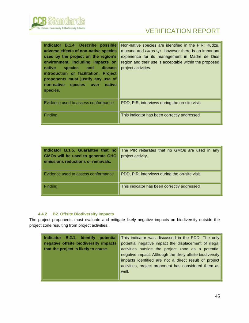
VERIFICATION REPORT
45
Indicator B.1.4. Describe possible
adverse effects of non-native species
used by the project on the region’s
environment, including impacts on
native species and disease
introduction or facilitation. Project
proponents must justify any use of
non-native species over native
species.
Non-native species are identified in the PIR: Kudzu,
mucuna and citrus sp., however there is an important
experience for its management in Madre de Dios
region and their use is acceptable within the proposed
project activities.
Evidence used to assess conformance PDD, PIR, interviews during the on-site visit.
Finding This indicator has been correctly addressed
Indicator B.1.5. Guarantee that no
GMOs will be used to generate GHG
emissions reductions or removals.
The PIR reiterates that no GMOs are used in any
project activity.
Evidence used to assess conformance PDD, PIR, interviews during the on-site visit.
Finding This indicator has been correctly addressed
4.4.2 B2. Offsite Biodiversity Impacts
The project proponents must evaluate and mitigate likely negative impacts on biodiversity outside the
project zone resulting from project activities.
Indicator B.2.1. Identify potential
negative offsite biodiversity impacts
that the project is likely to cause.
This indicator was discussed in the PDD. The only
potential negative impact the displacement of illegal
activities outside the project zone as a potential
negative impact. Although the likely offsite biodiversity
impacts identified are not a direct result of project
activities, project proponent has considered them as
well.

VERIFICATION REPORT
46
Evidence used to assess conformance PDD
Finding This indicator has been correctly addressed in the
PDD, then, no findings were raised.
Indicator B.2.2. Document how the
project plans to mitigate these
negative offsite biodiversity impacts.
PDD describes how plans to mitigate negative offsite
impacts. In that sense, the project strategies avoid
displacement of illegal activities outside the project
zone trough the promotion of sustainable economic
activities. For this implementation period the PIR has
listed some specific activities developed, such as the
implementation of agroforestry plots and the support
of tourism activities and governance.
During this period 164,8 ha. Of Cocoa agroforestry
plots have been installed over deforested and
degraded lands located between Km1 and 83 of the
Interoceanic Highway.
AIDER has been supporting the design of guidelines
for sustainable tourism management. In 2014, it was
realised the Strategy of Tourism of the Native
Community of Palma Real.
In AENORs opinion, the project activities in the buffer
zone contribute to mitigate the displacement of illegal
activities outside the project zone.
Evidence used to assess conformance PDD, PIR, Tourism Strategy of Palma Real native
community, visit to agroforestry plots and interviews
with farmers. Report of agroforestry plots installation.
Finding This indicator has been correctly addressed in the
PDD, then, no findings were raised.
Indicator B.2.3. Evaluate likely
unmitigated negative offsite
biodiversity impacts against the
biodiversity benefits of the project
within the project boundaries. Justify
Project proponent has included an assessment
regarding likely unmitigated negative offsite
biodiversity impacts against the biodiversity benefits of
the project within the project boundaries.

VERIFICATION REPORT
47
and demonstrate that the net effect
of the project on biodiversity is
positive.
The project strategy aims to preserve the ecological
conditions into the project area.
The project activities performed in the project zone,
such as promotion of sustainable activities and
governance, contributes to reduce the presence of
illegal activities in both project zone and off-site.
The audit team has checked the list of activities
implemented during this monitoring period and since
the project start.
Furthermore, during the site visit several interviews
were conducted with relevant stakeholder that
confirms information provided in the PDD.
In AENORs opinion the net effect of the project on
biodiversity is clearly positive.
Evidence used to assess conformance PDD, PIR, VCS monitoring reports (2010-2011 and
2011-2013) and GHG Emissions calculation
spreadsheet.
Finding This indicator has been correctly addressed in the
PDD, then, no findings were raised.
4.4.3 B3. Biodiversity Impact Monitoring
The project proponents must have an initial monitoring plan to quantify and document the changes in
biodiversity resulting from the project activities (within and outside the project boundaries). The monitoring
plan must identify the types of measurements, the sampling method, and the frequency of measurement.
Since developing a full biodiversity-monitoring plan can be costly, it is accepted that some of the plan
details may not be fully defined at the design stage, when projects are being validated against the
Standards. This is acceptable as long as there is an explicit commitment to develop and implement a
monitoring plan.
Indicator B.3.1. Develop an initial
plan for selecting biodiversity
variables to be monitored and the
frequency of monitoring and
reporting to ensure that monitoring
Reader is referred to the PDD. The PDD provides an
initial monitoring plan.

VERIFICATION REPORT
48
variables are directly linked to the
project’s biodiversity objectives and
to anticipated impacts (positive and
negative).
Evidence used to assess conformance PDD
Finding The initial monitoring plan was provided in the PDD. A
full monitoring plan has since been developed and is
being implemented. This indicator was adequately
addressed in the PDD and no longer has relevance,
given the full monitoring plan is now in place.
Indicator B.3.2. Develop an initial
plan for assessing the effectiveness
of measures used to maintain or
enhance High Conservation Values
related to globally, regionally or
nationally significant biodiversity
(G1.8.1-3) present in the project
zone.
Reader is referred to the PDD. The PDD states that
HCVs are accounted for in the initial plan described in
section B3.2 of the PDD. Chart 48 of the PDD shows
the matrix of biodiversity monitoring for conservation
targets. This was defined during participative
processes between groups of specialized institutions,
the SERNANP, WCS, and AIDER. This initial plan
was found to be adequate for assessing the
effectiveness of measures used to maintain or
enhance HCVs.
Evidence used to assess conformance PDD
Finding This indicator has been correctly addressed, then, no
findings were raised.
Indicator B.3.3. Commit to
developing a full monitoring plan
within six months of the project start
date or within twelve months of
validation against the Standards and
to disseminate this plan and the
results of monitoring, ensuring that
they are made publicly available on
the internet and are communicated
to the communities and other
In the frame of the administration contract the project
has an integral system of biological monitoring on
which is based the Project Biodiversity Monitoring
Plan. The current biological monitoring system of the
administration contract was approved by SERNANP in
2013. The biodiversity plan was disseminated on
internet through the web page of the administration
contract of Tambopata National Reserve and
Bahuaja-Sonene National Park. In addition, that
monitoring plan is published in the CCB web page.

VERIFICATION REPORT
49
stakeholders. Finally, the results of the biological monitoring are
included in the PIR.
This indicator correctly addressed.
Evidence used to assess conformance PIR, Monitoring plan, CCB website, web page of the
Contract of Administration of Tambopata National
Reserve and Bahuaja –Sonene National Park
(http://www.tambopata-bahuaja.info/) and interviews.
Finding This indicator has been correctly addressed, then, no
findings were raised.
4.5 GOLD LEVEL SECTION
4.5.1 GL 1. Climate Change Adaptation Benefits
This Gold Level Climate Change Adaptation Benefits criterion identifies projects that will provide
significant support to assist communities and/or biodiversity in adapting to the impacts of climate change.
Anticipated local climate change and climate variability within the project zone could potentially affect
communities and biodiversity during the life of the project and beyond. Communities and biodiversity in
some areas of the world will be more vulnerable to the negative impacts of these changes due to:
vulnerability of key crops or production systems to climatic changes; lack of diversity of livelihood
resources and inadequate resources, institutions and capacity to develop new livelihood strategies; and
high levels of threat to species survival from habitat fragmentation. Land-based carbon projects have the
potential to help local communities and biodiversity adapt to climate change by: diversifying revenues and
livelihood strategies; maintaining valuable ecosystem services such as hydrological regulation,
pollination, pest control and soil fertility; and increasing habitat connectivity across a range of habitat and
climate types.
Indicator GL.1.1 Identify likely
regional climate change and climate
variability scenarios and impacts,
using available studies, and identify
potential changes in the local land-
use scenario due to these climate
change scenarios in the absence of
the project.
This indicator was described in the PDD, which
identify likely regional climate change and climate
variability scenarios and impact, using available
studies. Potential changes in local land-use scenario
are also identified in PDD.

VERIFICATION REPORT
50
Evidence used to assess conformance PDD, Peru’s Second National Communication to the
UNFCCC. MINAM-2010; “El Cambio climático en la
Amazonia”, Fundación Bustamante de la Fuente 2010
and ppt: “El cambio climático y sus efectos en la zona
del MAP”, Foster Brown, Woods Hole Research
Center. May 2009.
Finding This indicator has been correctly addressed in the
PDD, then, no findings were raised.
Indicator GL.1.2 Identify any risks to
the project’s climate, community and
biodiversity benefits resulting from
likely climate change and climate
variability impacts and explain how
these risks will be mitigated.
This indicator was described in the PDD, which
identify risks to the project climate, community and
biodiversity benefits from likely climate change and
also, the planned activities (such as the
implementation of an early warning system, fire
prevention activities, degradation lands restoration,
among others) to mitigate them. Since the starting
date of the project several activities has been
developed, such as degraded lands restoration,
wildlife monitoring, fire prevention and implementation
of agroforestry system. Those activities have
continued being implemented during this
implementation period. In order to prevent fires, during
the monitoring period the project proponent has been
developing different tasks in order to prevent fires,
such as support the develop and dissemination of
community plans against fires (communities of
Sonene, Palma Real, Infierno, Tres Islas, Boca
Pariamanu y Puerto Arturo and production of
informative brouchures.
The audit has verified the implementation of these
measure trough evidence provided and the on-site
visit to the project
Evidence used to assess conformance PDD, PIR, 40- Handbook of Prevention of Forest
Fires. AIDER 2015, Reports and attendance list of
Workshops, interviews, on-site visit.
Finding This indicator has been correctly addressed in the

VERIFICATION REPORT
51
PDD, then, no findings were raised.
Indicator GL.1.3 Demonstrate that
current or anticipated climate
changes are having or are likely to
have an impact on the well-being of
communities and/or the conservation
status of biodiversity in the project
zone and surrounding regions.
This indicator was correctly described in the PDD,
which presents information regarding climate change
expected impacts in Peru and the region.
Evidence used to assess conformance PDD, Peru’s Second National Communication to the
UNFCCC. MINAM-2010; “El Cambio climático en la
Amazonia”, Fundación Bustamante de la Fuente 2010
and ppt: “El cambio climático y sus efectos en la zona
del MAP”, Foster Brown, Woods Hole Research
Center. May 2009.
Finding This indicator has been correctly addressed in the
PDD, then, no findings were raised.
Indicator GL.1.4 Demonstrate that
the project activities will assist
communities and/or biodiversity to
adapt to the probable impacts of
climate change.
The PDD identified risks to the project climate,
community and biodiversity benefits from likely climate
change and also, the planned activities (such as the
implementation of an early warning system, fire
prevention activities, degradation lands restoration,
among others) to mitigate them.
The maintenance of the surface of natural forest
contained in the project area (protecting ecosystem
services and biological communities), is an important
strategy that will favourably assist the communities
and biodiversity to adapt to probable impacts of
climate change.
In addition, some actions developed during this period
contribute to mitigate the climate risks to the project’s
benefits, such as the implementation of agroforestry
systems, diversification of cultivated species and

VERIFICATION REPORT
52
prevention of fires.
An internal control system called MINKA has been
implemented in order to monitor the state of each
agroforestry plot. The location and other
characteristics of each plots is register into MINKA
system. The data obtained is expected to be used to
monitor the vulnerability of some areas.
The audit has verified the implementation of these
measure trough evidence provided and the on-site
visit to the project.
Evidence used to assess conformance PDD, PIR, MINKA system, Reports and attendance
list of Workshops, interviews, on-site visit.
Finding This indicator has been correctly addressed in the
PDD, then, no findings were raised.
4.5.2 GL2. Exceptional Community Benefits
This Gold Level Exceptional Community Benefits criterion recognizes project approaches that are
explicitly pro-poor in terms of targeting benefits to globally poorer communities and the poorer, more
vulnerable households and individuals within them. In so doing, land-based carbon projects can make a
significant contribution to reducing the poverty and enhancing the sustainable livelihoods of these groups.
Given that poorer people typically have less access to land and other natural assets, this optional criterion
requires innovative approaches that enable poorer households to participate effectively in land-based
carbon activities. Furthermore, this criterion requires that the project will ‘do no harm’ to poorer and more
vulnerable members of the communities, by establishing that no member of a poorer or more vulnerable
social group will experience a net negative impact on their well-being or rights.
Indicator GL.2.1 Demonstrate that the project zone is in a low human development country OR in an administrative area of a medium or high human development country in which at least 50% of the population of that area is below the national poverty line.
N/A. The project was not assessed against GL
Exceptional Community Benefits.
Evidence used to assess conformance N/A

VERIFICATION REPORT
53
Finding N/A
Indicator GL.2.2 Demonstrate that at least 50% of households within the lowest category of well-being (e.g., poorest quartile) of the community are likely to benefit substantially from the project.
N/A. The project was not assessed against GL
Exceptional Community Benefits.
Evidence used to assess conformance N/A
Finding N/A
Indicator GL.2.3 Demonstrate that any barriers or risks that might prevent benefits going to poorer households have been identified and addressed in order to increase the probable flow of benefits to poorer households.
N/A. The project was not assessed against GL
Exceptional Community Benefits.
Evidence used to assess conformance N/A
Finding N/A
Indicator GL.2.4 Demonstrate that measures have been taken to identify any poorer and more vulnerable households and individuals whose well-being or poverty may be negatively affected by the project, and that the project design includes measures to avoid any such impacts. Where negative impacts are unavoidable, demonstrate that they will be effectively mitigated.
N/A. The project was not assessed against GL
Exceptional Community Benefits.
Evidence used to assess conformance N/A
Finding N/A

VERIFICATION REPORT
54
Indicator GL.2.5 Demonstrate that community impact monitoring will be able to identify positive and negative impacts on poorer and more vulnerable groups. The social impact monitoring must take a differentiated approach that can identify positive and negative impacts on poorer households and individuals and other disadvantaged groups, including women.
N/A. The project was not assessed against GL
Exceptional Community Benefits.
Evidence used to assess conformance N/A
Finding N/A
4.5.3 GL3. Exceptional Biodiversity Benefits
All projects conforming to the Standards must demonstrate net positive impacts on biodiversity within their
project zone. This Gold Level Exceptional Biodiversity Benefits criterion identifies projects that conserve
biodiversity at sites of global significance for biodiversity conservation. Sites meeting this optional criterion
must be based on the Key Biodiversity Area (KBA) framework of vulnerability and irreplaceability. These
criteria are defined in terms of species and population threat levels, since these are the most clearly
defined elements of biodiversity. These scientifically based criteria are drawn from existing best practices
that have been used, to date, to identify important sites for biodiversity in over 173 countries.
Project proponents must demonstrate that the project zone includes a site of high biodiversity
conservation priority by meeting either the vulnerability or irreplaceability criteria defined below:
4.5.3.1 GL.3.1. Vulnerability
Regular occurrence of a globally threatened species (according to the IUCN Red List) at the site:
Indicator GL.3.1.1 Critically
Endangered (CR) and Endangered
(EN) species – presence of at least a
single individual; or Vulnerable
species (VU) – presence of at least
30 individuals or 10 pairs.
In accordance with the validated PDD, the project
area has registered endangered-EN species of fauna
(Ateles chamek and Pteronura brasiliensis) and flora
(Cedrela fissilis and Caryocar amygdaliforme). The
presence of these species in the project area has
been reported and documented during the project

VERIFICATION REPORT
55
implementation period.
Furthermore, in accordance with the PDD and PIR, 12
species of fauna are listed as vulnerable. The audit
team has confirmed that these species are currently
present in the IUCN Red List, version 2015.3.
PIR described in section GL3.1.1 the methods,
indicators and results obtained through the biological
monitoring conducted. In addition, during the site visit
interviews were conducted with the biological
monitoring coordinator of the “Pampas del Heath” and
the coordinator of the project “Lobo de Rio”-.
Frankfurt Zoological Society.
Evidence used to assess conformance
PDD, PIR 2014-2015, Reports of Monitoring of
Frankfurt Zoological Society, TNR fauna monitoring
reports, book “Parque Nacional Bahuaja-Sonene.
Rapid Biological Inventories”- WCS 2015, interviews
with stakeholders and IUCN Red List, version 2016.1.
Finding This indicator has been correctly addressed in the
final version of the PIR.
4.5.3.2 G.3.2. Irreplaceability
Not applicable. The project was not assessed against GL3.2.

VERIFICATION REPORT
56
5 VERIFICATION CONCLUSION
The review and cross-check of explanations and justifications in the PIR dated on 07 July 2016 with
sources detailed in the report have provided AENOR with sufficient evidence to determine the
accomplishment of all stated criteria of the Climate, Community and Biodiversity Standard v.2. The
summary of Climate, Community and Biodiversity benefits that will be generated by the project included
on the cover page of the PIR is accurate..
In opinion of AENOR, the project implementation meets all relevant requirements for the CCB Standards
second edition, including climate adaptation and biodiversity exceptional benefits. Hence, AENOR
considers the project implementation in accordance with the CCB Standards and the Gold Level
requirements applied, verified.
Madrid, 2016-07-27
Luis Robles Olmos Manuel García-Rosell
Authorized Person Verification Team Leader

VERIFICATION REPORT
57
6 APPENDIX 1: LIST OF EVIDENCE PROVIDED
1- CCB Project Design Document (June 2012)
2- CCB Project Implementation Report 2014-2015 (final version, 07 July 2016)
3- CCB Project Implementation Reports (2010-2014)
4- VCS Monitoring Report 2014-2015
5- VCS Monitoring Reports (2010-2015)
6- VCS Project Description Tambopata (May 2012)
7- GHG Emission Calculation Spreadsheet: Hoja de Cálculo emisiones del proyecto 2014-2015
8- REDD Project Strategy 2015.
9- REDD Project Strategy 2012.
10- REDD Project CCB Monitoring Plan 2014
11- REDD Project CCB Monitoring Plan 2012
12- Agreement between the Natural Resource Institute-INRENA and AIDER.
Contract of Partial Administration for the component of biological monitoring and research over
the RNTAMB and PNBS. 2008.
13- Amendment to the Contract of Partial Administration for the component of biological monitoring
and research over the RNTAMB and PNBS. SERNANP-AIDER. 2010
14- Agreement between Regional Government Madre de Dios and AIDER. 2014.
15- Agreement between FADEMAD and AIDER. 2015
16- Letter 003-2016 AIDER/MDD: Dissemination of the REDD Project Implementation Report. March
2016.
17- Project Cash Flow
18- Estimation of the Carbon Stocks and Emission of GHG from Unplanned Deforestation under the
Baseline Scenario.
19- Safety Plan related to the activities of the REDD Project Tambopata. June 2011. AIDER.
20- Report of Implementation of Agroforestry Plots (April, May and June 2014).
21- Peruvian Governments Decrees: DL N°1100; DL N° 1101 and DS 006-2012-EM
22- Reports of activities of the Management Committee of Tambopata National Reserve.
23- Project Training Plan 2014-2015
24- Report and list of attendance of the workshop on deforestation map validation procedure for
project team.
25- Report of workshop on agroforestry and cocoa cultivation for project staff.
26- Report of workshop on biological monitoring for park rangers (30/01/2015).
27- Report of workshop on biological monitoring for voluntary park rangers (20/01/2015).
28- Report of workshop on project activities for park rangers (20/03/2015)
29- Report of workshop for determination potential area under illegal logging threat (20/03/2015)
30- Records of workshops in local communities.
31- Internal Communication Strategy of Sonene. 2014
32- Internal Communication Strategy of Palma Real. 2014
33- Community Fire Prevention Plan. AIDER. 2014.

VERIFICATION REPORT
58
34- Handbook of Prevention of Forest Fires. AIDER 2015
35- Directoral Resolution Nº 439-2013-GOREMAD-GRDE/DRA-DSFLPR- Madre de Dios Regional
Government, 2013.
36- Resolution Nº 045-2013-SERNANP
37- Law N°29763. Forestry and Wildlife Law.
38- Law Nº 26834: Law of Natural Protected Areas.
39- Supreme Decree Nº 038-2001-AG: Law Nº 26834 regulation.
40- Law N° 30222. Safety and health at work and regulation.
41- Report of Project activities conducted. Period 2014-2015
42- Project Photographic archive
43- Master Plan of Tambopata National Reserve 2011-2016.
44- Master Plan of Bahuaja-Sonene National Park 2015-2019
45- KML files
46- Integrated Monitoring System: Tambopata National Reserve and Bahuaja Sonene National Park.
47- Project GIS Package
48- Participative Socioeconomic Diagnostic: Nueva America, Las Mercedes, San Francisco, San
Bernardo, Filadelfia, Sol Naciente, Sonene, Unión Progreso, Virgen de La Candelaria
49- Wildlife Conservation Society. “Parque Nacional Bahuaja-Sonene. Rapid Biological Inventories”.
WCS 2015
50- Tourism Strategy of Palma Real native community. October 2014.
51- Handbook Procedures for Handling Conflicts and Grievances. AIDER 2016.
52- Report of Plagues Occurrence (“Informe-0011-2016-MINAGRI-SENASA-DEMDD-ASV-
NGuerrero
53- INDECI Statistic Bulletin N°4/January 2016.
54- List of project employees.
55- Delivery record of delivery of personal protective equipment to project staff.