vicmap property update robert morrison vicmap property custodial officer
TRANSCRIPT
Vicmap Property Update
Robert Morrison
Vicmap Property Custodial Officer

• Land Administration Themes
• Data Improvement Projects
• Future Diredtions
Presentation Overview

Land Administration Themes (LAT)
Par
cel
Approved
Proposed
Pro
pert
y
Approved
Proposed
Add
ress
Adm
in B
dys
No Status
3.3 Mil 3.1 Mil

LAT Maintenance Process
Customers
Customer Data
Delivery
Property Custodian
Maintenance Docs
Parcel Custodian
Maintenance Docs
Custodian Data Delivery
SII Responsibility
External Maintainer
VSDL
Mai
ntai
ned
Vic
map
LA
T
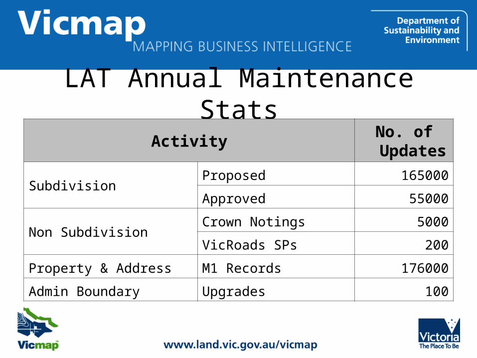
LAT Annual Maintenance Stats
ActivityNo. of Updates
SubdivisionProposed 165000
Approved 55000
Non SubdivisionCrown Notings 5000
VicRoads SPs 200
Property & Address M1 Records 176000
Admin Boundary Upgrades 100

Data Improvement Projects• Aspatial Record Compliance
– Property Completion Initiative– Parcel Completion Program
• Road Polygons

1. Improve Aspatial Record Compliance to Authoritative Sources
98% Parcel & Property
Match Rates
Land Registry Records Comparison
• VOTS Freehold
• VOTS Crown
Parcel
LGA Property Records Comparison
• Property & Rates
Property
Vicmap Property
Parcel and Property Quality Audits

Target Match Rate
Real Parcel match rate 75.82%
980K parcels to be added
The 3 R’s to resolve
• Roads
• Railways
• Reserves

2. Road Polygon Creation
• Traditionally road casements voids • Drivers for Road Polygon Creation
– Road Management Act 2004– Facilities Management of “Road Furniture”
• Polygonisation commenced in late 2009 – Programmatic Scripts & Manual Editing– Due for release in the coming months

Future Directions
RE Plans
Complete
• Improved Spatial Accuracy
• Custodian Empowerment
Direct Editing
Quicker Turn
Around
Reduce Duplication
of Effort
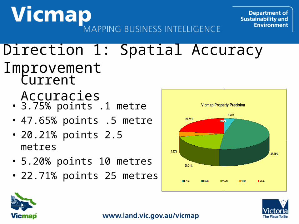
Direction 1: Spatial Accuracy Improvement
• 3.75% points .1 metre• 47.65% points .5 metre • 20.21% points 2.5 metres• 5.20% points 10 metres• 22.71% points 25 metres
Current Accuracies

Incremental Spatial Upgrading• Utilising Digital Subdivisions to Improve
Accuracy• Extracting Coordinates for Fieldnotes• Re-established 4 growth corridor areas• Adjust a Region using Survey control &
Photography• Adopted higher accuracy data from other
authorities
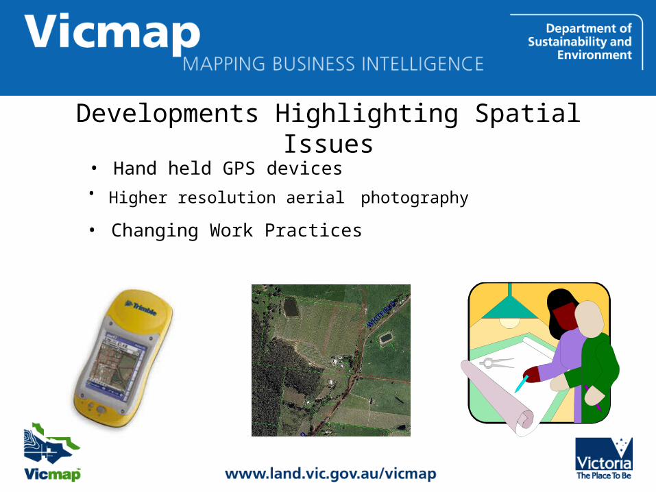
Developments Highlighting Spatial Issues
• Higher resolution aerial photography
• Hand held GPS devices
• Changing Work Practices

Spatial Upgrade Business Case• Identifies the impacts of spatial
changes
• Details the benefits of improving the spatial accuracy
• Assesses change options available
• Outlining funding options

Business Case Preferred Option
• 10 year process to spatially upgrade state– All Urban & Peri-Urban Areas 0.05 m
• Existing observations and field control infill
– Rural Areas – 0.1 m to 10 m• Mathematical Adjustment to high resolution Aerial
Photography• Control either derived from aerial photography
and/or field control

Direction 2: Custodian Process Control / Real Time Access
• Current practices are restricting– Source Data Custodians cannot make any changes to the
data– Turn around time frames can be up to 5 weeks from
creation of work order
• Introduction of Notification and Editing Service – Improved process transparency – Given custodians power of veto – Didn’t improve turn-around or provide edit ability
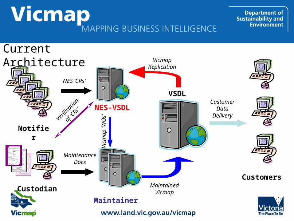
NES-VSDL
Custodian
Maintenance Docs
Notifier
NES ‘CRs’
VSDLV
icm
ap
‘WO
s’
Vicmap Replicatio
n
Customers
Customer Data
Delivery
Maintained Vicmap
Verifi
cati
on o
f
‘CRs’
Maintainer
Current Architecture
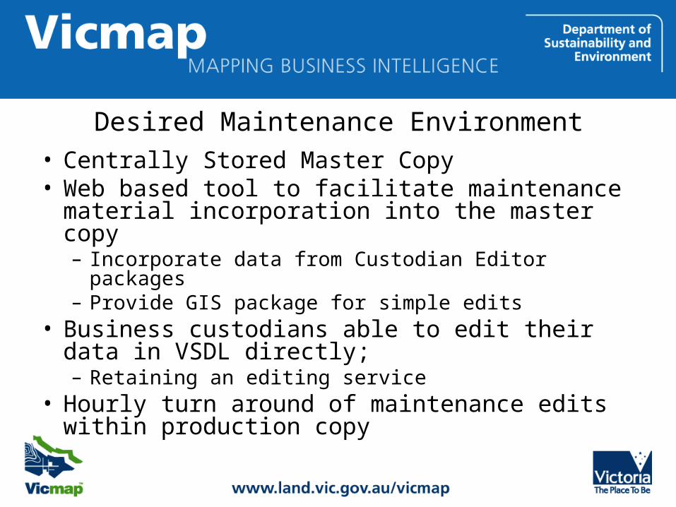
Desired Maintenance Environment
• Centrally Stored Master Copy• Web based tool to facilitate maintenance
material incorporation into the master copy– Incorporate data from Custodian Editor packages– Provide GIS package for simple edits
• Business custodians able to edit their data in VSDL directly;– Retaining an editing service
• Hourly turn around of maintenance edits within production copy
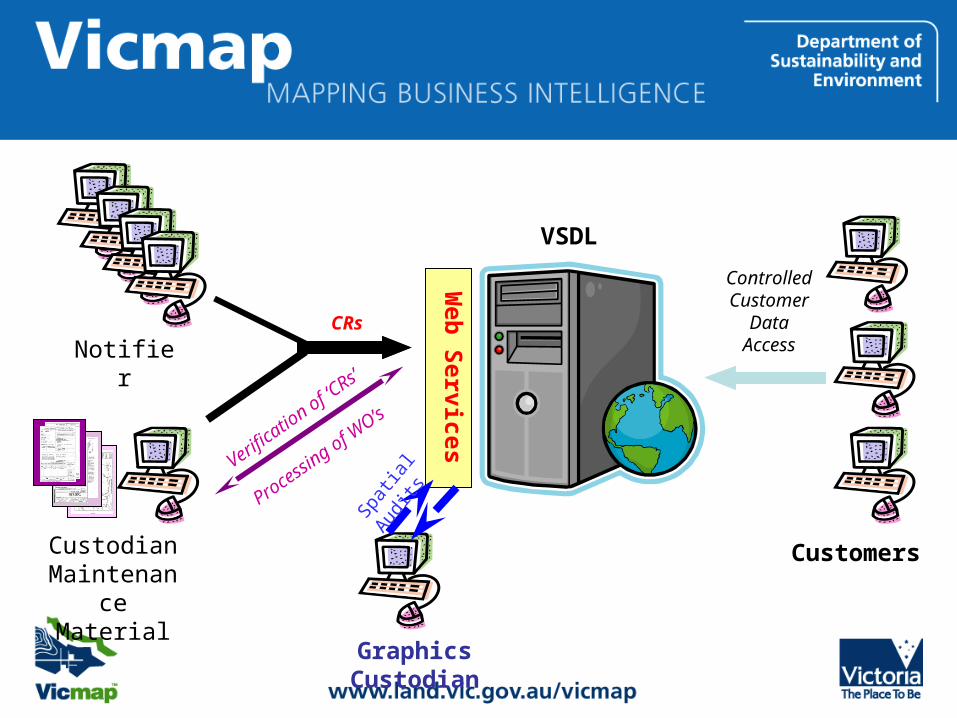
Web
Serv
ices
VSDL
Graphics Custodian
Spa
tial A
udits
Customers
Controlled
Customer Data
AccessNotifier
Custodian Maintenance Material
CRs
Verifica
tion of ‘C
Rs’
Proce
ssing of W
O’s
QUESTIONS?