victoria river district - dpir.nt.gov.au
TRANSCRIPT

Victoria River District
Understanding the productivity of grazing lands
Land Condition
GuideGuide
This guide was produced by the Northern Territory Government in association with the Northern Territory Cattlemen’s Association as part of the Caring for Our Country project “Grazing Land Management – Demonstration, Continuation and Evaluation”.
AuthorCaroline Pettit
AcknowledgementsThe author would like to thank the following for their contribution to the development of this publication:Whitney Dollemore, Jodie Ward, Robyn Cowley, Trudi Oxley, Dionne Walsh, Chris Materne, Charmayne Craven, Lee Crothers, Steve Eldridge and Jason De Araujo.
PhotographsThe author would like to thank the following for contributing photographs to this publicationCamilla Osborn, Arthur Cameron, NRETAS Weed Management Branch, Graeme Owen, Paul Thomson, Adam Northey, Jodie Ward and Whitney Dollemore.
Further information on land condition can be found through the Grazing Land Management (GLM) workshops. For information about the GLM courses available in the Northern Territory please contact the Department of Resources on 8973 9739.

1
Land Condition Guide
ContentsIntroduction ............................................................................................................2
Using this guide .....................................................................................................7
Arid short grasses on red soil .............................................................................8Antrim land system
Northern tall grass country ................................................................................10Dinnabung land system
Arid short grass on limestone hilly country ...................................................12Humbert land system
Southern mitchell grass plains on alluvial clay ..............................................14Inverway land system
Bluegrass on alluvial clay plains ......................................................................16Ivanhoe land system
Spinifex on rugged hilly country .......................................................................18Pinkerton land system
Spinifex plains ......................................................................................................20Geebee, Coolindie, Redsan, Barry land system
Perennial grasses on basalt cracking clays ...................................................22Wavehill land system
Species list ............................................................................................................24
Map Victoria River District land systems.........................................................25

2
This booklet is a pastoral land condition assessment tool that has been produced to assist land managers.
Land condition can be described as the ability of land to respond to rainfall and produce useful forage. Country in good condition is robust and can recover quickly from stresses such as grazing, fi re or a few dry years.
Land in poor condition is lacking in productive perennial pastures and is often affected by soil erosion due to a decline in ground cover and the stabilising effects of perennial grass tussocks and roots.
Often land is somewhere between good and poor condition where pastures are in some state of decline or soil condition is starting to deteriorate. It is important to understand what processes are causing the decline so that changes in management can be implemented before land condition declines further.
To assess a given area for land condition we look at FOUR major features of the landscape: pasture structure and composition, soil condition, presence of weeds and woodland structure. Table 1 outlines how these features change with varying land condition states and what criteria must be met to assign an area to a land condition group.
Land condition is divided into 4 categories A, B, C and D condition with A condition being the best andD condition the worst.
Table 1
Land Condition Soil Pasture Weed Woodland
A(All of these features)
No erosion and good surface condition
Good coverage of 3P grasses,* little bare ground (<30%) in most years
Few weeds and no signifi cant infestations
No signs of woodland thickening
B(At least one or more of these features)
Some signs of previous erosion and some current signs of erosion risk
Some decline in the presence of 3P grasses and/or bare ground (more than 30%, but less than 50% in most years)
Small infestations of weeds
Some thickening in the density of woody plants
C(One or more of these features)
Obvious signs of past erosion and/or current susceptibility to erosion
General decline in the presence of 3P species and/or bare ground (>50% in most years)
Obvious presence of weeds
General thickening in the density of woody plants
D(One or more of these features)
Severe erosion, scalding or compaction resulting in a hostile environment for plant growth
General lack of any perennial grasses or forbs
Large weed infestations covering signifi cant areas
Thickets of woody plants that cover signifi cant areas
*3P grasses= Palatable, Productive Perennial grasses
Land Condition Guide
Introduction
Good condition Poor condition

3
SoilGood soil condition is important for healthy plant growth. The uppermost layer of the soil is known as top soil or the A horizon. This layer is anywhere from a few cm to 20+ cm deep and is where seed germination occurs and plants concentrate their roots for stability and nutrient uptake. When top soil is eroded, plants struggle to establish which leads to less ground cover and subsequently higher rates of runoff, reduced infi ltration of rain water and further erosion.
The key to maintaining soil condition is good plant cover. Plant tussocks and leaf litter provide barriers which slow the velocity of water and wind and reduce resource loss from the system.
Types of soil erosionThese are some of the erosional processes that may occur in land with declining land condition.
Rills and GulliesChannels cut upslope by fl owing water, often initiated by water fl owing down a cattle pad, fence line or road.
TerracettesSmall abrupt walls 1-10cm high cut into the slope and aligned with the contour.
Sheeting or sheet erosionProgressive removal of thin layers of soil across extensive areas.
ScaldingThe loss of A horizon material to expose a hard-setting subsurface horizon.
HummockingConfi ned to soils with coarse textured surface layers such as sand and is the result of accumulation of wind borne material around obstructions.
PedestallingRemoval of soil from around obstructions (commonly plants) to leave them perched on a mound above the surrounding soil surface.
Rill erosion Sheet erosion Pedestalling erosion

4
PastureThe presence of palatable productive perennial grasses (3P’s) in most cases indicates good land condition. These species are the fi rst to disappear under heavy grazing and are often replaced by less productive grasses and forbs. Carrying capacity is therefore reduced because there is less palatable forage for stock.
Some land types such as those dominated by spinifex don’t typically meet the 3P grass criteria for good land condition. While spinifex is not as productive or palatable as other 3P grasses, it is perennial and can facilitate good land condition when other land condition components are maintained.
Areas of land in good condition have healthy soils that provide water and nutrients for plants to grow. In return, the plants help protect the soil and return nutrients through decomposing leaf litter. Carbon is also captured and stored effectively where good land condition occurs. When land condition declines, the cycle is broken and resources such as nutrients and water are lost from the system.
A modifi cation in grazing strategies can assist in improving pasture condition. Wet season spelling and stocking rate adjustments can encourage the re-establishment of preferentially grazed pasture species and increase ground cover.
Strategic burning can also be used to manage pastures by removing rank growth and modifying grazing distribution. In the VRD, a low-moderate intensity fi re after rain at the beginning of the wet season is recommended for black soil pastures to improve pasture quality and encourage more even grazing as cattle will be less selective when grazing new growth. At least 1500kg/ha is required to successfully burn under these conditions.
Annual-dominated pastures do not respond well to fi re. As annual species only live for one year, a fi re can completely remove ground cover until the next rains occur and seeds are germinated. If fi re occurs before the annual species have set seed then the seed bank is depleted and even good rain may not produce much forage.
Land in poor condition often has wide spaces between grass tussocks which allow resources to leave the local ecosystem. More bare ground also leads to greater rates of erosion by wind and water which accelerates the decline in land condition.
The solid lines represent the movement of resources such as nutrients, water or vegetative cover such as leaves. The dashed lines show how the grass tussocks encourage the retention of these resources so they remain available to the surrounding plants.

5
Weeds and woody thickeningA decline in land condition is not always a decline in vegetative growth. A weed infestation or woody thickening will also decrease land condition while maintaining some of the “good” condition characteristics such as ground cover. However weeds and woody thickening can have a large impact on land condition because they require more intensive and expensive management techniques to rectify.
Weeds, trees and shrubs in large numbers affect land condition by competing with pastures for nutrients, water and sunlight. Minor weed infestations or woody thickening can quickly spread to dominate the landscape, inhibiting pasture growth and making them less viable for cattle production.
Studies conducted in the VRD and Katherine region show that trees can reduce pasture growth by up to 50%. However, total clearing of trees is not recommended in extensive grazing systems due to the costs of controlling tree regrowth. The most effective way to maintain good tree basal area is with appropriate fi re and grazing management.
Burning conditions required for various weed and woody management objectives.
Management Objective Fire Intensity Fuel Load
(kg (dry weight)/ha) Season of Burn
Maintaining woody vegetation structure Moderate-High 2000-3000 April-October
Change woody vegetation structure, control exotic weeds
High-very high 2500-4500 August-October
Hazard reduction – reducing risk of wildfi re Low-moderate >1500-2000 March-June
Parkinsonia on Wavehill land system Prickly acacia on Wavehill land system
6
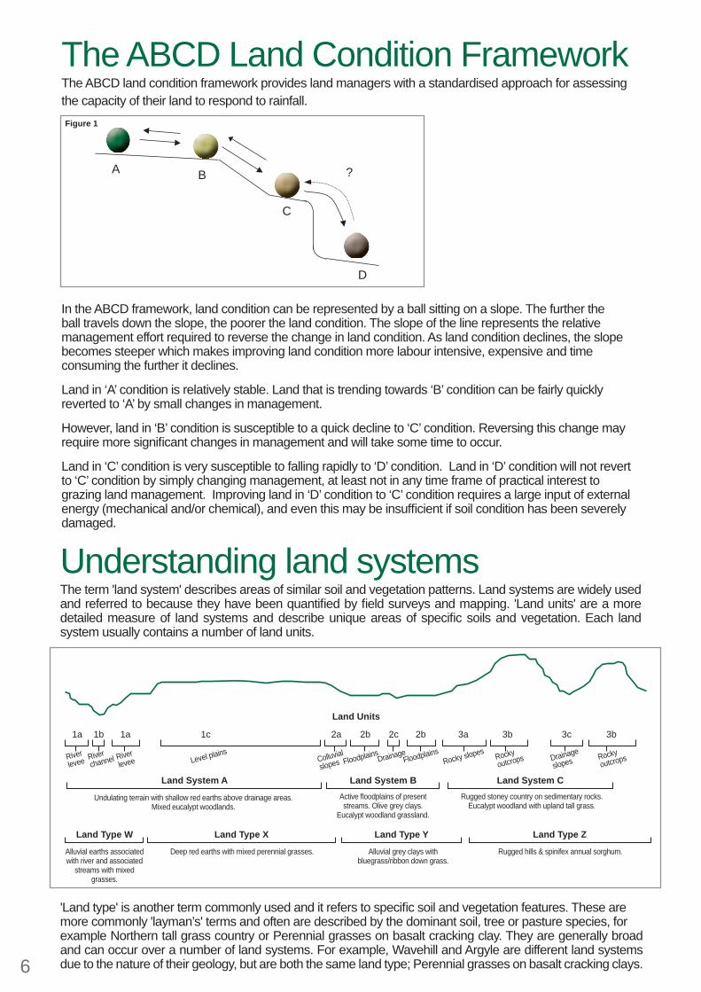
The ABCD Land Condition FrameworkThe ABCD land condition framework provides land managers with a standardised approach for assessing the capacity of their land to respond to rainfall.
In the ABCD framework, land condition can be represented by a ball sitting on a slope. The further the ball travels down the slope, the poorer the land condition. The slope of the line represents the relative management effort required to reverse the change in land condition. As land condition declines, the slope becomes steeper which makes improving land condition more labour intensive, expensive and time consuming the further it declines.
Land in ‘A’ condition is relatively stable. Land that is trending towards ‘B’ condition can be fairly quickly reverted to ‘A’ by small changes in management.
However, land in ‘B’ condition is susceptible to a quick decline to ‘C’ condition. Reversing this change may require more signifi cant changes in management and will take some time to occur.
Land in ‘C’ condition is very susceptible to falling rapidly to ‘D’ condition. Land in ‘D’ condition will not revert to ‘C’ condition by simply changing management, at least not in any time frame of practical interest to grazing land management. Improving land in ‘D’ condition to ‘C’ condition requires a large input of external energy (mechanical and/or chemical), and even this may be insuffi cient if soil condition has been severely damaged.
Understanding land systemsThe term 'land system' describes areas of similar soil and vegetation patterns. Land systems are widely used and referred to because they have been quantifi ed by fi eld surveys and mapping. 'Land units' are a more detailed measure of land systems and describe unique areas of specifi c soils and vegetation. Each land system usually contains a number of land units.
'Land type' is another term commonly used and it refers to specifi c soil and vegetation features. These aremore commonly 'layman’s' terms and often are described by the dominant soil, tree or pasture species, forexample Northern tall grass country or Perennial grasses on basalt cracking clay. They are generally broad and can occur over a number of land systems. For example, Wavehill and Argyle are different land systems due to the nature of their geology, but are both the same land type; Perennial grasses on basalt cracking clays.
1a
Riverlevee River
leveeRiver channel Level plains
Undulating terrain with shallow red earths above drainage areas. Mixed eucalypt woodlands.
Deep red earths with mixed perennial grasses.Alluvial earths associated with river and associated
streams with mixed grasses.
Alluvial grey clays with bluegrass/ribbon down grass.
Rugged hills & spinifex annual sorghum.
Active fl oodplains of present streams. Olive grey clays.
Eucalypt woodland grassland.
Rugged stoney country on sedimentary rocks. Eucalypt woodland with upland tall grass.
Colluvial
slopes FloodplainsFloodplains
Rocky slopes Rocky outcrops Drainage
slopes Rocky outcropsDrainage
Land System A
Land Type XLand Type W Land Type Y Land Type Z
Land System B Land System C
1b 1a 1c
Land Units
2a 2b 2c 2b 3a 3b 3c 3b
?
D
C
BA
Figure 1

7
Using this guideThis guide includes information on pasture growth and carrying capacity for a selection of land systems in the region. Above the land system name is a general land type description. This will help you identify which pages are most suitable to land systems not mentioned in the booklet.Use the land system photos in conjunction with the land condition assessment table on page 2 to help you identify your pastures and what condition they are in.
Carrying capacity assumptions and notesLong term carrying capacity is the average number of animals that a paddock can be expected to support over a planning horizon (5-10 years) without affecting land condition.
Pasture growth estimates have been calculated using models created from data collected from monitoring sites across the NT.
Carrying capacity fi gures assume all land is within 3-5km of water (depending on terrain).
Discounts for pasture growth for land condition changes have been calculated using GLM principles
Pasture growth may vary outside of the given ranges depending on the type of land condition decline you have. Where high yielding weeds and undesirable plants invade, pasture growth values may actually be higher but the overall productivity of useful forage or carrying capacity would be reduced.
Utilisation rates are based on research work conducted across northern Australia. As a general rule, recommended utilisation rates are 20% for robust black soils, 15% for productive red soils with perennial grasses, 10% for poorer red soils with a mix of less palatable perennial and annual grasses and 5% for spinifex dominated land types.
Utilisation rate recommendations and carrying capacity fi gures have been excluded for land in D condition. While pastures in this condition can grow limited grass, it is not recommended that these areas be grazed until land condition can be improved.
Table 2Land Condition
Discount applied to pasture growth Land Condition
Discount applied to pasture growth
A 100% of A condition pasture growth C 45% of A condition pasture growthB 75% of A condition pasture growth D 20% of A condition pasture growth
A ConditionRecommended utilisation rate
20%Pasture growth expected in 50% of years
850 - 2200 kg/haDesirable species %
>80%Carrying Capacity (AE’s/km2)
4.5 - 12
Utilisation rate is the proportion of pasture growth that can be consumed while maintaining good land condition.
Pasture growth values are based on median annual rainfall (the expected annual rainfall in 50% of years). Annual rainfall can vary within a region, and this will affect how much pasture grows. Where this is the case a range of expected pasture growth values have been given that represent the lowest to the highest across the region that the land system occurs in.
Carrying capacity is the average long term stocking rate that can be carried safely. Because of differences in average rainfall across geographical areas a range of expected pasture growths have been used in the calculations.
Pasture growth * Utilisation rate * 100
Forage demand
(times by 100 is conversion from ha to km2)
Carrying capacity =
Forage demand = annual animal intake per AE (3650kg/year)AE = Adult equivalent (One AE = One 450kg dry cow)Carrying capacity is expressed as AE’s /km2

Arid short grasses on red soilAntrim land system
8
DescriptionHilly country with useful lowlands - mostly rocky outcrops with basalt boulders and pockets of red clay soils. Located in southern parts of the VRD region.
Pastoral ValueLow to moderate pastoral value. Small areas of the lower slopes and drainage lines most productive. Steeper, annual grass dominated areas are generally good quality pastures but lack bulk.
Management ImplicationsPossibility for overgrazing during wet season, particularly when associated with large areas of black soil (notably Wavehill land system). Frequent burning is not recommended for annual dominated pastures.
Dominant Pastures Limestone grass (Enneapogon species)
Spinifex (Triodia species) Annual sorghum (Sorghum timorense)
Other Pastures Wiregrass (Aristida species)
Fairy grass (Sporobolus australasicus)Ribbon grass (Chrysopogon fallax)
White grass (Sehima nervosum)Native couch (Brachyachne convergens)
Dominant ShrubsConkerberry (Carissa lanceolata)
Dominant TreesInland bloodwood (Corymbia terminalis)
Southern box (Eucalyptus argillacea)
Other TreesCabbage gum (Eucalyptus confertifl ora)
Whitewood (Atalaya hemiglauca)

9
A ConditionRecommended utilisation rate
10%Pasture growth expected in 50% of years
1950 – 2550 kg/haDesirable species %
>80%Carrying Capacity (AE’s/km2)
5.5 – 7
B ConditionRecommended utilisation rate
10%Pasture growth expected in 50% of years
1450 – 1900 kg/haDesirable species %
50 – 80%Carrying Capacity (AE’s/km2)
4 – 5
C ConditionRecommended utilisation rate
10%Pasture growth expected in 50% of years
900 – 1150 kg/haDesirable species %
25 – 50%Carrying Capacity (AE’s/km2)
2.5 – 3
D ConditionRecommended utilisation rate
0%Pasture growth expected in 50% of years
400 – 500 kg/haDesirable species %
0 – 25%Carrying Capacity (AE’s/km2)
0
No image available

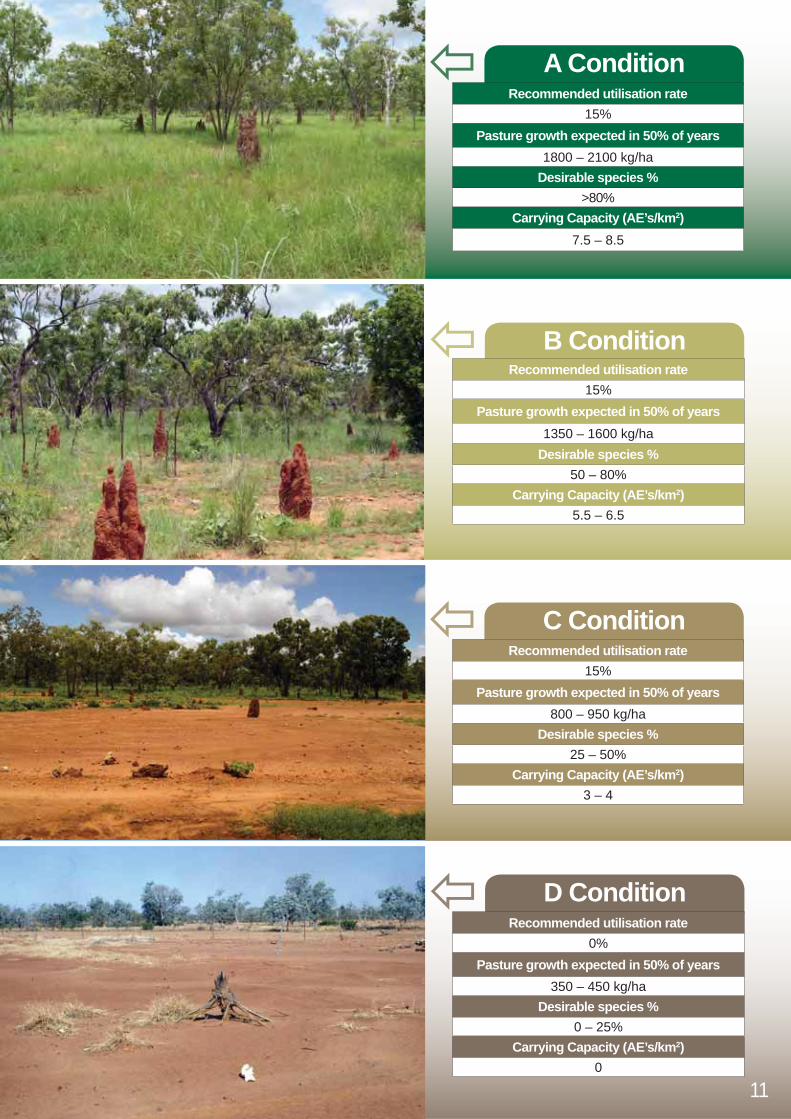
Northern tall grass countryDinnabung land system
10
DescriptionTimbered gently undulating limestone country in the northern parts of the VRD. Brown-grey sandy loam over red and yellow clays. Scattered limestone outcrops.
Pastoral ValueModerate pastoral value. High proportion of 3P grasses but quality is limited particularly in higher rainfall areas where nutrients are diluted by plants or leached through the soil profi le.
Management ImplicationsBenefi ts from strategic burning to manage woody thickening.
Dominant Pastures Ribbon grass (Chrysopogon fallax)
Black speargrass (Heteropogon contortus)Kangaroo grass (Themeda triandra)
Plume sorghum (Sorghum plumosum)White grass (Sehima nervosum)
Other Pastures Bluegrass (Dichanthium species)
Native couch (Brachyachne convergens)
Dominant TreesWoollybutt (Eucalyptus tectifi ca)
Cabbage gum (Eucalyptus confertifl ora)Broad-leaf bloodwood (Corymbia foelscheana)
Southern box (Eucalyptus argillacea)
Other TreesSilver box (Eucalyptus pruinosa)
11
A ConditionRecommended utilisation rate
15%Pasture growth expected in 50% of years
1800 – 2100 kg/haDesirable species %
>80%Carrying Capacity (AE’s/km2)
7.5 – 8.5
B ConditionRecommended utilisation rate
15%Pasture growth expected in 50% of years
1350 – 1600 kg/haDesirable species %
50 – 80%Carrying Capacity (AE’s/km2)
5.5 – 6.5
C ConditionRecommended utilisation rate
15%Pasture growth expected in 50% of years
800 – 950 kg/haDesirable species %
25 – 50%Carrying Capacity (AE’s/km2)
3 – 4
D ConditionRecommended utilisation rate
0%Pasture growth expected in 50% of years
350 – 450 kg/haDesirable species %
0 – 25%Carrying Capacity (AE’s/km2)
0

Arid short grass on limestone hilly countryHumbert land system
12
DescriptionHilly limestone country in the southern parts of the VRD.
Pastoral ValueLow to moderate pastoral value. Small areas of the lower slopes and drainage lines most productive. Higher, rocky limestone hills with annual grass dominated areas are generally good quality pastures but lack bulk. Most valuable during and immediately after the wet season.
Management ImplicationsPotential for overgrazing during the wet season, particularly when adjacent to large areas of black soil. Frequent burning not recommended for annual dominated pastures.
Dominant PasturesLimestone grass (Enneapogon species)
Spinifex (Triodia species)Annual sorghum (Sorghum timorense)
Black speargrass (Heteropogon contortus)
Other PasturesBarley mitchell (Astrebla pectinata)
Wiregrasses (Aristida species)Fairy grass (Sporobolus australasicus)
Dominant TreesInland bloodwood (Corymbia terminalis)

13
A ConditionRecommended utilisation rate
15%Pasture growth expected in 50% of years
2150 – 2450 kg/haDesirable species %
>80%Carrying Capacity (AE’s/km2)
6 – 7
B ConditionRecommended utilisation rate
15%Pasture growth expected in 50% of years
1650 – 1850 kg/haDesirable species %
50 – 80%Carrying Capacity (AE’s/km2)
4.5 – 5
C ConditionRecommended utilisation rate
15%Pasture growth expected in 50% of years
1000 – 1100 kg/haDesirable species %
25 – 50%Carrying Capacity (AE’s/km2)
3
D ConditionRecommended utilisation rate
0%Pasture growth expected in 50% of years
400 – 500 kg/haDesirable species %
0 – 25%Carrying Capacity (AE’s/km2)
0

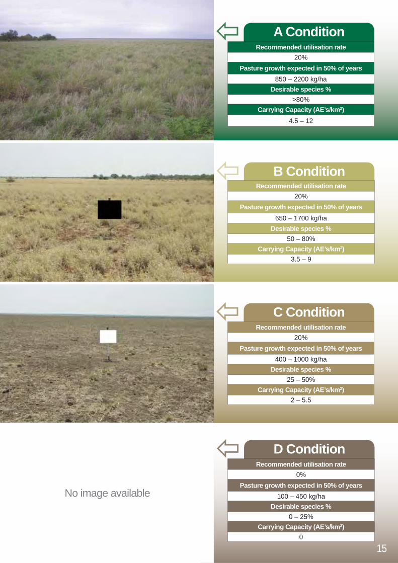
Southern Mitchell grass plains on alluvial clayInverway land system
14
DescriptionNearly treeless, elevated alluvial “black soil” plains in the southern parts of the VRD.
Pastoral ValueHigh pastoral value. Fertile soils with a high proportion of palatable perennial grasses.
Management ImplicationsBenefi ts from wet season spelling to allow seed germination and plant establishment. Moderate to hot fi res required to control woody weeds.
Dominant Pastures Barley mitchell (Astrebla pectinata)
Other Pastures Weeping mitchell (Astrebla elymoides)
Bull mitchell (Astrebla squarrosa)Curly bluegrass (Dichanthium fecundum)
Feathertop wiregrass (Aristida latifolia)Silky browntop (Eulalia aurea)
Flinders grass (Iseilema species)Sensitive plant (Neptunia species)
Native couch (Brachyachne convergens)
15
A ConditionRecommended utilisation rate
20%Pasture growth expected in 50% of years
850 – 2200 kg/haDesirable species %
>80%Carrying Capacity (AE’s/km2)
4.5 – 12
B ConditionRecommended utilisation rate
20%Pasture growth expected in 50% of years
650 – 1700 kg/haDesirable species %
50 – 80%Carrying Capacity (AE’s/km2)
3.5 – 9
C ConditionRecommended utilisation rate
20%Pasture growth expected in 50% of years
400 – 1000 kg/haDesirable species %
25 – 50%Carrying Capacity (AE’s/km2)
2 – 5.5
D ConditionRecommended utilisation rate
0%Pasture growth expected in 50% of years
100 – 450 kg/haDesirable species %
0 – 25%Carrying Capacity (AE’s/km2)
0
No image available

Bluegrass on alluvial clay plainsIvanhoe land system
16
DescriptionGently sloping alluvial “black soil” plains (grey/brown cracking clays) with some timbered “red” soil in central and northern regions of the VRD.
Pastoral ValueModerate to high pastoral value. Fertile clay soils produce large quantities of 3P grasses.
Management ImplicationsBenefi ts from wet season spelling to allow seed germination and plant establishment. Moderate to hot fi res required to control woody regrowth.
Dominant PasturesBluegrasses (Dichanthium species)
Other PasturesBull mitchell (Astrebla squarrosa)
Annual sorghum (Sorghum timorense)Cane grass (Ophiuros exaltatus)
Feathertop wiregrass (Aristida latifolia)
Dominant ShrubsRosewood (Terminalia volucris)
Dominant TreesBauhinia (Bauhinia cunninghamii)Coolibah (Eucalyptus microtheca)
Other TreesSilver box (Eucalyptus pruinosa)

17
A ConditionRecommended utilisation rate
20%Pasture growth expected in 50% of years
1550 – 3850 kg/haDesirable species %
>80%Carrying Capacity (AE’s/km2)
8.5 – 21
B ConditionRecommended utilisation rate
20%Pasture growth expected in 50% of years
1200 – 2900 kg/haDesirable species %
50 – 80%Carrying Capacity (AE’s/km2)
6.5 – 16
C ConditionRecommended utilisation rate
20%Pasture growth expected in 50% of years
700 – 1750 kg/haDesirable species %
25 – 50%Carrying Capacity (AE’s/km2)
4 – 9.5
D ConditionRecommended utilisation rate
0%Pasture growth expected in 50% of years
300 – 750 kg/haDesirable species %
0 – 25%Carrying Capacity (AE’s/km2)
0

Spinifex on rugged hilly countryPinkerton land system
18
DescriptionRugged stony country formed on sedimentary rocks, shallow sandy skeletal soils in southern parts of the VRD. Comparable to Wickham land system.
Pastoral ValueLow pastoral value. Mostly unpalatable species and low forage production. Steep rugged country reduces accessibility for stock.
Management ImplicationsPoor accessibility for mustering. Rugged areas can protect feral animals such as horses, scrub cattle and wild dogs.
Dominant PasturesSoft spinifex (Triodia pungens)
Feathertop spinifex (Triodia bitextura)Annual sorghum (Sorghum intrans)
Other ShrubsWattles (Acacia species)
Turkey bush (Calytrix exstipulata)
Dominant TreesStringybark (Eucalyptus tetrodonta)
Variable-bark bloodwood (Corymbia dichromophloia) Smooth-stemmed bloodwood (Corymbia bleeseri)
Woollybutt (Eucalyptus miniata)
Other TreesRusty bloodwood (Corymbia ferruginea)
Grey box (Eucalyptus tectifi ca)Large-leaf cabbage gum (Eucalyptus grandifolia)

19
A ConditionRecommended utilisation rate
5%Pasture growth expected in 50% of years
900 – 1700 kg/haDesirable species %
>80%Carrying Capacity (AE’s/km2)
1 – 2.5
B ConditionRecommended utilisation rate
5%Pasture growth expected in 50% of years
700 – 1300 kg/haDesirable species %
50 – 80%Carrying Capacity (AE’s/km2)
1 – 2
C ConditionRecommended utilisation rate
5%Pasture growth expected in 50% of years
400 – 800 kg/haDesirable species %
25 – 50%Carrying Capacity (AE’s/km2)
0.5 – 1
D ConditionRecommended utilisation rate
0%Pasture growth expected in 50% of years
200 – 350 kg/haDesirable species %
0 – 25%Carrying Capacity (AE’s/km2)
0

Spinifex plainsGeebee, Coolindie, Redsan, Barry land systems
20
DescriptionGently undulating red sandy and gravelly “desert” soils in the southern and south-eastern parts of the VRD. Includes Redsan, Geebee, Barry and Coolindie land systems.
Pastoral ValueLow pastoral value. Dominated by unpalatable and unproductive species with low forage production.
Management ImplicationsBurning may encourage new growth of spinifex in higher rainfall areas which can increase the palatability of the plant. In lower rainfall areas spinifex can be killed by fi re late in dry season. Unstructured, sandy soil is prone to erosion when ground cover is low.
Dominant PasturesSoft spinifex (Triodia pungens)
Other PasturesGulf wiregrass (Aristida pruinosa)
Other ShrubsSilver Cassia (Senna glutinosa ssp. pruinosa)
Wattles (Acacia species)
Dominant TreesSnappy gum (Eucalyptus brevifolia)
Silver box (Eucalyptus pruinosa)Long-fruited bloodwood (Corymbia polycarpa)

21
A ConditionRecommended utilisation rate
5%Pasture growth expected in 50% of years
900 – 1100 kg/haDesirable species %
>80%Carrying Capacity (AE’s/km2)
1 – 1.5
B ConditionRecommended utilisation rate
5%Pasture growth expected in 50% of years
650 – 850 kg/haDesirable species %
50 – 80%Carrying Capacity (AE’s/km2)
1
C ConditionRecommended utilisation rate
5%Pasture growth expected in 50% of years
400 – 500 kg/haDesirable species %
25 – 50%Carrying Capacity (AE’s/km2)
0.5
D ConditionRecommended utilisation rate
0%Pasture growth expected in 50% of years
200 kg/haDesirable species %
0 – 25%Carrying Capacity (AE’s/km2)
0
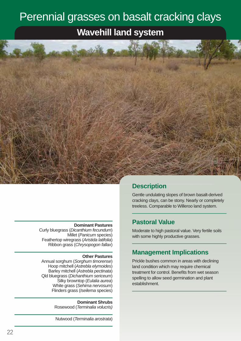
Perennial grasses on basalt cracking claysWavehill land system
22
DescriptionGentle undulating slopes of brown basalt-derived cracking clays, can be stony. Nearly or completely treeless. Comparable to Willeroo land system.
Pastoral ValueModerate to high pastoral value. Very fertile soils with some highly productive grasses.
Management ImplicationsPrickle bushes common in areas with declining land condition which may require chemical treatment for control. Benefi ts from wet season spelling to allow seed germination and plant establishment.
Dominant PasturesCurly bluegrass (Dicanthium fecundum)
Millet (Panicum species)Feathertop wiregrass (Aristida latifolia)
Ribbon grass (Chrysopogon fallax)
Other PasturesAnnual sorghum (Sorghum timorense)
Hoop mitchell (Astrebla elymoides)Barley mitchell (Astrebla pectinata)
Qld bluegrass (Dichanthium sericeum)Silky browntop (Eulalia aurea)
White grass (Sehima nervosum)Flinders grass (Iseilema species)
Dominant ShrubsRosewood (Terminalia volucris)
Nutwood (Terminalia arostrata)

23
A ConditionRecommended utilisation rate
20%Pasture growth expected in 50% of years
2250 – 4200 kg/haDesirable species %
>80%Carrying Capacity (AE’s/km2)
12.5 – 23
B ConditionRecommended utilisation rate
20%Pasture growth expected in 50% of years
1700 – 3150 kg/haDesirable species %
50 – 80%Carrying Capacity (AE’s/km2)
9.5 – 17
C ConditionRecommended utilisation rate
20%Pasture growth expected in 50% of years
1000 – 1900 kg/haDesirable species %
25 – 50%Carrying Capacity (AE’s/km2)
5.5 – 10.5
D ConditionRecommended utilisation rate
0%Pasture growth expected in 50% of years
450 – 850 kg/haDesirable species %
0 – 25%Carrying Capacity (AE’s/km2)
0
24
Land Condition Guide
Species listVRDDesirable Perennial Grasses (3P’s)Ribbon grass Chrysopogon fallaxKangaroo grass Themeda triandraPlume sorghum Sorghum plumosumBarley mitchell grass Astrebla pectinataWeeping/Hoop mitchell grass Astrebla elymoidesBull mitchell grass Astrebla squarrosaCurly bluegrass Dicanthium fecundumSilky browntop Eulalia aureaMillet Panicum species
Desirable Annual GrassesLimestone grass Enneapogon polyphyllusNative couch Brachyachne convergensFlinders grass Iseilema speciesQLD bluegrass Dicanthium sericeum
Intermediate value grasses (perennials and annuals)Soft spinifex Triodia pungensFeathertop spinifex Triodia bitexturaAnnual sorghum Sorghum intrans (on red soil)
Sorghum timorense (on black soil)Northern kerosene grass Aristida hygrometricaWhitegrass Sehima nervosumBlack speargrass Heteropogon contortus Desirable legumes and forbsSensitive plant Neptunia species
Less desirable grasses (perennials and annuals)Fairy grass Sporobolus australasicusFeathertop wiregrass Aristida latifoliaCane grass Ophiuros exaltatusGulf wiregrass Aristida pruinosa

25

Victoria River District
Land Condition
GuideGuide