village of lumby development permit and development
TRANSCRIPT

VILLAGE OF LUMBY DEVELOPMENT PERMIT AND
DEVELOPMENT VARIANCE PERMIT APPLICATIONS
DATE: February 20, 2014
FILE NO.: 14-0005-LUM-DP / 14-0006-LUM-DVP
APPLICANT: Lumby Developments Ltd. c/o Derek Crawford Architect Inc.
LEGAL DESCRIPTION: Lot 1, District Lot 164, ODYD, Plan EPP15070
PID #: 028-754-981
CIVIC ADDRESS: 2165 Norris Avenue
PROPERTY SIZE: 0.601 ha
ZONING: Comprehensive Development – Senior Citizens Assisted Living (CD.1)
O.C.P. DESIGNATION: Administration and Development Permit Area (Multiple Residential Unit and Natural Hazard - Floodplain)
PROPOSED USE: 22 Multiple Family Dwelling Units (Assisted Living Apartments)
PROPOSED VARIANCE(S): Side yard setback and number of parking spaces
PLANNING DEPARTMENT RECOMMENDATION: THAT Council authorize the issuance of a Development Variance Permit for the property legally described as Lot 1, DL 164, ODYD, Plan EPP15070 and located at 2165 Norris Avenue to permit variances to the following sections of the Village of Lumby Zoning Bylaw No. 750, 2012: 1. Section 1403.7.e by decreasing the east side yard setback of a multi-family use building
from 8 m to 7.269 m as shown on the attached site plan; and 2. Section 601.3 by decreasing the number of parking spaces required for the existing 46
nursing/care beds and the proposed 22 assisted living residential units from 19 to 18 as shown on the attached site plan.
AND THAT Council authorize the issuance of a Development Permit for the property legally described as Lot 1, DL 164, ODYD, Plan EPP15070 and located at 2165 Norris Avenue subject to the following: 1. The dimensions and siting of the building addition to be constructed on the land is to be in
general accordance with the attached site plan and floor plans; 2. The exterior design and finish of the building addition to be constructed on the land is to be
in general accordance with the attached building elevations; 3. Landscaping to be provided on the land is to be in general accordance with the attached
landscaping plan and a 2 m high screen must be provided between the parking area and the adjacent Residential zoned property to the east. The screen must consist of a solid fence or wall or a compact evergreen hedge;

Development Permit and Development Variance Permit Application 14-0005-LUM-DP and 14-0006-LUM-DVP (LUMBY DEVELOPMENTS LTD. c/o DEREK CRAWFORD ARCHITECT) Page 2 4. All construction must meet the Flood Construction Level of 493.5 m as defined in Section
501 of the Village of Lumby Zoning Bylaw No. 750, 2012 except as provided for by Covenant No. CA2441701;
AND THAT issuance of the Development Permit be withheld until the Village of Lumby is provided with an irrevocable letter of credit in the amount equal to 125% of the estimated cost of landscaping, screening and paving of parking and sidewalk areas. The estimates must be prepared by qualified landscaping and paving contractors and must include costs associated with installing underground irrigation to ensure an adequate supply of water to landscaped areas. BACKGROUND: This report relates to an application for a Development Permit and Development Variance Permit for the property located at 2165 Norris Avenue. The applicant is proposing to construct 22 Assisted Living apartments as an addition to the existing 46 bed Residential Care Facility known as “Monashee Mews”. A Development Permit is required in accordance with the Official Community Plan which states that all properties that are currently, or become zoned for Comprehensive Development containing Multiple Residential uses will require a Multiple Residential Unit Development Permit. The proposed development, referred to as “Monashee Mews Phase 2” also includes a request for variances to Zoning Bylaw No. 750, 2012 as it would not comply with the side yard setback and parking requirements of the Bylaw. In this regard, a Development Variance Permit must also be approved and issued prior to issuance of a Building Permit for Phase 2. Development History In 2007 the parent parcels of the subject property were rezoned from the Residential Resource (R.6) zone to the Comprehensive Development – Senior Citizens Assisted Living (CD.1) zone. In 2010, a 0.17 ha portion of the CD.1 zoned area was rezoned from CD.1 to Residential Apartment and Multi-Family (R.3) and the area was subdivided from the parent parcel and developed with eight units of senior’s rental housing. In August 2011 a Development Permit with Variances was issued by the Village for Phase 1 of Monashee Mews. Phase 1 is a two storey, 46 bed Residential Care Facility licensed under the Community Care and Assisted Living Act. The approved variances allowed for reduced setbacks on all sides of the Phase 1 building. On March 5, 2012, the Village granted the proposed development an exemption from the Zoning Bylaw Flood Construction Level (FCL) requirements on the condition that a restrictive covenant between the Village and the proponent be registered on the title of the subject properties. The covenant was subsequently registered and includes the following statements: 1) no buildings or structures shall be constructed, reconstructed, moved, extended or located
on the lands except in accordance with the zoning, building, and development requirements of the municipality;
2) the underside of any floor system, and top of any pad supporting any space used for a dwelling, business, or storage of goods susceptible to damage by floodwater shall be situated above the Flood Construction Level of 493.5 m1, and
1 Geodetic Survey of Canada Datum

Development Permit and Development Variance Permit Application 14-0005-LUM-DP and 14-0006-LUM-DVP (LUMBY DEVELOPMENTS LTD. c/o DEREK CRAWFORD ARCHITECT) Page 3 3) the basement level shall be set at 490.7 m and the basement shall:
a. be waterproofed up to the Flood Construction Level, b. be provided with a sump pumping system to remove excess water from flooding, c. not be used for habitation and shall only be used as one or more service rooms.
The covenant also contains ‘release and indemnity’ clauses in which the land owner agrees not to claim damages from the municipality for any water damage and agrees to save harmless the municipality against all losses, damages, actions, etc. in connection with flooding. The covenant (No. CA2441701) applies to all structures on the subject property. Site Context and the Proposal
The subject property is a 0.601 ha parcel flanked by Glencaird Street on the north and east sides and by Norris Avenue on the west side. The subject property is generally flat and is situated within the Bessette Creek / Duteau Creek floodplain. An established paved public walkway runs in an east/west direction within an easement along the south boundary of the subject property and links the east end of Glencaird Street to Norris Avenue. The walkway overlays a sanitary sewer main which follows the same alignment. The following orthophoto of the subject and surrounding properties was taken in 2013.

Development Permit and Development Variance Permit Application 14-0005-LUM-DP and 14-0006-LUM-DVP (LUMBY DEVELOPMENTS LTD. c/o DEREK CRAWFORD ARCHITECT) Page 4 Land use, zoning and Official Community Plan designations surrounding the subject property, are as follows:
North: The Village of Lumby municipal office is located on the north side of Glencaird Street on property zoned Recreation Park (R.P), and designated Park / Administration.
South: The Interior Health “Health Centre” is located on property zoned Recreation Park (R.P) and designated Health Care.
East: Surrounding the cul-de-sac, and on the south and east side of Glencaird Street are housing developments which provide level entry, independent-living, low income housing for seniors on lands zoned Residential Multiple Family (R.3) and designated Residential High Density.
West: Single family homes are located along the west side of Norris Avenue on lands zoned Residential Multiple Family (R.3) and designated Residential High Density.
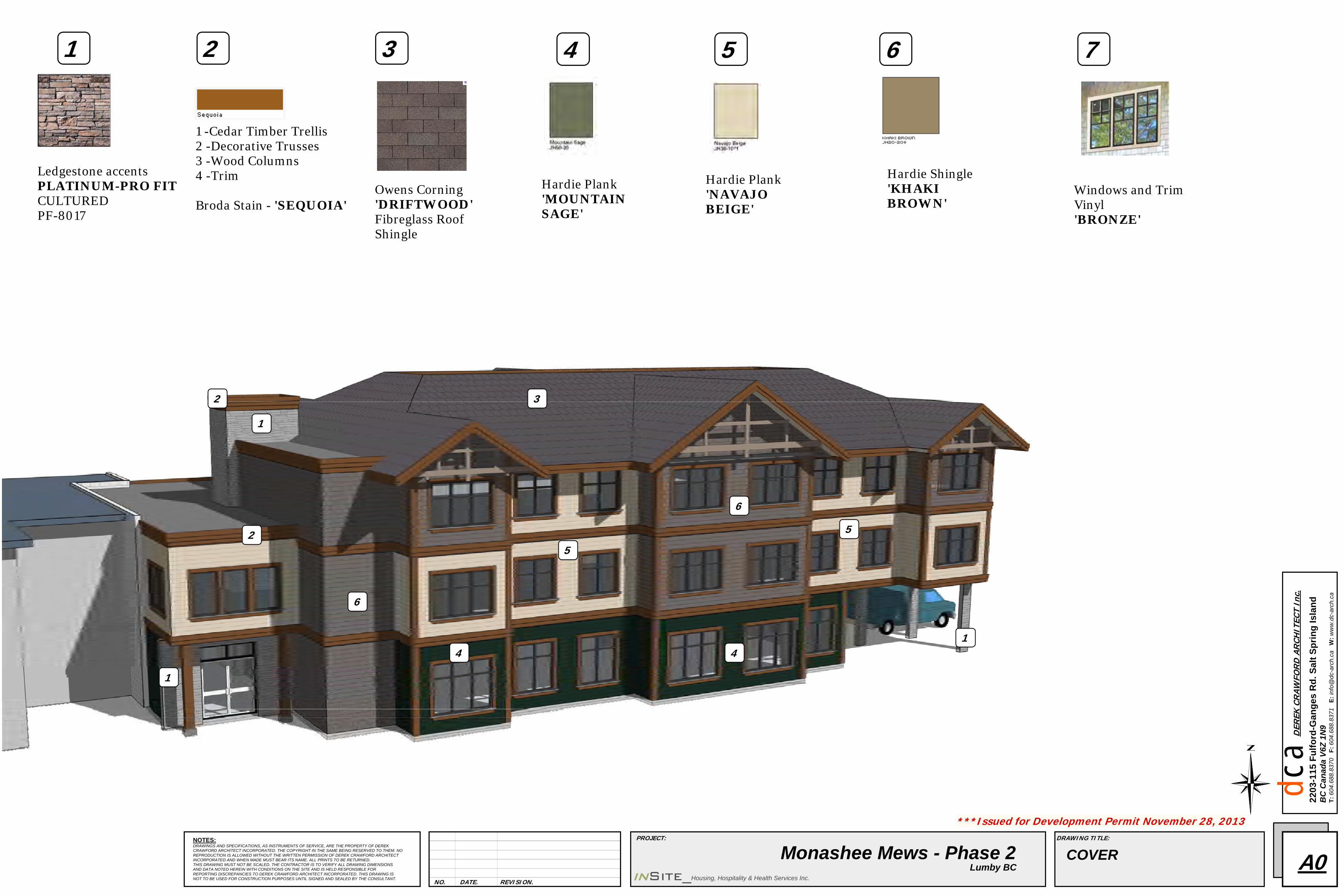
Phase 1 of the Monashee Mews Residential Care facility is a two storey building located on the northerly part of the subject property. Phase 1 is oriented towards residents requiring ongoing assistance with personal care, meals, and other daily needs and it consists of 46 beds in individual rooms which each have a two-piece bathroom. Meals are prepared by staff and served in a common dining area. Monashee Mews - Phase 2 is proposed to be a three storey building adjoining the south side of Phase 1. Phase 2 would be oriented towards assisted living units as each of the 22 units would be completely self-contained including a kitchen, living / dining area, one bedroom, and a complete bathroom. An internal corridor would provide residents with access between Phase 1 and Phase 2. Phase 2 is proposed to include amenities such as a laundry room, dining, and lounge areas. Other amenities, developed as part of Phase 1, would be accessible to the residents of Phase 2 including a multi-purpose room, general store for residents, occupational therapy, and support services including staff rooms and offices. A commercial kitchen within Phase 1 would serve the residents of both phases. The range of care that would be available in the two phases of Monashee Mews is intended to facilitate “aging in place”, that is, the ability for residents to meet their changing needs for care without having to move to a completely new facility. Architecturally, Phase 2 would be compatible with but not stylistically identical to Phase 1. The three storey Phase 2 building would have a hip and gable roof with gable ends accented by interlocking timbers. Roofing would be fibreglass shingles in a brown tone (“driftwood”) and the exterior finish would consist of beige, sage, and khaki brown Hardie Plank and Shingle siding accented with wooden trim and cultured stone. The main entry to Phase 2 would be at the northwest corner of the building and a secondary access door would be available at the south end from the proposed parking area. The main floor dwelling units are not proposed to have individual access to the outside. Landscaping is proposed to have a reduced reliance on irrigation and would utilize a high efficiency irrigation system with low emitter heads. Plantings would include massed shrubs, trees, ornamental grasses, perennials, and lawn. A rainwater–biofiltration garden is proposed to collect and filter parking lot run-off. Canopy trees would be situated where possible to shade the parking area, and a lighting system would illuminate pedestrian areas, outdoor service areas and building entrances.

Development Permit and Development Variance Permit Application 14-0005-LUM-DP and 14-0006-LUM-DVP (LUMBY DEVELOPMENTS LTD. c/o DEREK CRAWFORD ARCHITECT) Page 5 Eight (8) parking spaces and two (2) loading spaces are currently provided from a driveway off Glencaird Street on the easterly side of Monashee Mews - Phase 1. An established u-shaped driveway off Norris Avenue provides convenient, covered, vehicle access close to the main entry of Monashee Mews for pick-up and drop-off of residents. Two handicap parking spaces are provided off this westerly driveway. Currently there are six (6) temporary parking spaces on the site of proposed Phase 2. With the construction of Phase 2, the six temporary parking spaces would be removed and replaced with eight (8) new parking spaces that would be provided within a paved parking lot accessed from Norris Avenue at the south boundary of the subject property. In total, Phases 1 and 2 would be served by 18 parking spaces and two (2) loading spaces. ZONING BYLAW: The subject property is zoned Comprehensive Development – Senior Citizens Assisted Living (CD.1). The uses permitted in the CD.1 zone include multiple family dwellings; common facilities including dining room, kitchen, lounge, games room and other amenities for residents; and convalescent, nursing, and personal care use in accordance with the regulations of the Community Care and Assisted Living Act. The proposal for the existing (Phase 1) and proposed (Phase 2) development as compared to the CD.1 zone requirements is as follows:
CRITERIA PROPOSAL ZONE REQUIREMENTS Lot Area (min.) 0.601 ha 0.21 ha (0.52 acre) Lot Frontage (min.) 253.3 m 35 m Lot Depth 101.8 m N/A Lot Coverage (max.) 38.4% 40% Building Height (max.) 11.9 m 12 m Setbacks (min.) - Front (north, Glencaird St.) (approved by DVP 2011-1) 4.5 m 10 m - Rear (south) 10.469 m 10 m - Side (east) 7.269 m 8 m - Exterior Side (west) 10.086 m 8 m - from Duteau Creek >30 m 30 m Parking Spaces (min.) 18 (10 existing + 8 proposed) 19 (Phases 1 & 2 combined) Parking and Loading Section 601 of the Zoning Bylaw requires one (1) parking space per eight (8) dwelling units of multi-family senior citizen housing and one (1) parking space per three (3) beds in a convalescent, nursing and personal care home. In this regard, the 22 multi-family dwelling units in Phase 2 would require three (3) parking spaces and the 46 beds in Phase 1 would require 16 parking spaces. All parking spaces must be not less than 6 m in length and 2.8 m in width. Two way driveway aisles must be 7 m wide for all ninety degree parking. With regard to loading spaces, Phase 1 and proposed Phase 2 would have a combined gross floor area of approximately 4,917 m2. A building of this size used as a hospital, institution, hotel, club, lodge or other similar use requires two (2) loading spaces which must be not less than 9 m in length and 2.4 m in width. Two loading spaces of adequate size have been provided in conjunction with the development of Phase 1.

Development Permit and Development Variance Permit Application 14-0005-LUM-DP and 14-0006-LUM-DVP (LUMBY DEVELOPMENTS LTD. c/o DEREK CRAWFORD ARCHITECT) Page 6 Screening and Landscaping Section 700 of the Zoning Bylaw requires screening of 2 m in height where a parking area abuts a lot in a Residential zone. The proposed parking lot at the south side of Phase 2 would abut the Residential Multiple Family (R.3) zoned property to the east therefore screening of 2 m in height would be required at the interface. Screening may consist of a solid fence or wall or a compact evergreen hedge. The Zoning Bylaw does not include regulations for landscaping of residential development. Density The maximum permitted gross density for senior citizen assisted living housing in the CD.1 zone shall not exceed 96 units per ha. As the two phases of Monashee Mews consist of two distinct forms of senior citizen housing, the sleeping units of Phase 1 cannot be counted towards the overall density. In this regard the density is determined by the 22 units proposed for Phase 2 within the 0.601 ha subject property which equates to approximately 57 units per ha, well below the maximum permitted density. Useable Private Open Space The CD.1 zone requires 25 m2 of useable private open space for each one-bedroom unit. In this regard, the 22 one bedroom units proposed in Phase 2 would require a total of 550 m2 of useable private open space. Based on the site plan and landscape plan, to the east and west of the Phase 2 building, there would be approximately 275 m2 and 210 m2 respectively of useable private open space. These areas combined with the public pathway along the south lot line and other outdoor landscaped areas accessible to residents of both Phases 1 and 2, are more than sufficient to meet the Zoning Bylaw requirements for useable private open space. Floodplain Regulations The purpose of the floodplain management provisions in Section 501 of the Zoning Bylaw is to reduce the risk of injury, loss of life and damage to buildings and structures due to flooding. All new construction, except where exempted under Section 501.3.b.iii of the Zoning Bylaw, must conform to the Flood Construction Levels and Floodplain Setbacks outlined in the Zoning Bylaw. The Flood Construction Level for a specific property is determined by interpolation from the Flood Construction Levels shown on Schedule “A” which is the floodplain and zoning map of Zoning Bylaw No. 750, 2012. Based on Schedule “A” the subject property is largely between the 493 m and 494 m 200-year Flood Level (which includes an allowance for freeboard) and is therefore interpolated to have a Flood Construction Level of 493.5 m. This elevation is consistent with the Flood Construction Level determined for Phase 1 of Monashee Mews as cited in Covenant No. CA2441701. Approximately 90 m east of the subject property, Duteau Creek flows northward to its confluence with Bessette Creek. Section 501 of the Zoning Bylaw requires a Floodplain Setback of 30 m from the Natural Boundary of Duteau Creek. Monashee Mews is well in excess of 30 m from the Natural Boundary of Duteau Creek and therefore the proposed development satisfies the Floodplain Setback requirements of the Zoning Bylaw.

Development Permit and Development Variance Permit Application 14-0005-LUM-DP and 14-0006-LUM-DVP (LUMBY DEVELOPMENTS LTD. c/o DEREK CRAWFORD ARCHITECT) Page 7 Zoning Bylaw Section 501.4.f provides for the Village of Lumby to grant exemptions from the Floodplain Setbacks and Flood Construction Level requirements provided that the property owner submits a written request to the Village of Lumby for an exemption, and the exemption is consistent with the Provincial Guidelines or a qualified professional certifies that the property can be safely used for the intended use. OFFICIAL COMMUNITY PLAN: Natural Hazard Development Permit Area The OCP identifies the subject property as being within a floodplain area. Section 4.6 of the OCP states that all properties within Natural Hazard Areas will require a Natural Hazard Development Permit unless specified criteria for exemption are satisfied. In this regard the OCP states that a Natural Hazard Development Permit may not be required if:
A Section 219 Restrictive Covenant has been registered as a priority charge under the Land Title Act against the title of the subject property at the time of subdivision or building permit which states that all construction must meet the Flood Construction Levels and Floodplain Setbacks as outlined in the Zoning Bylaw and indemnifies the Village of Lumby from any losses or damages caused by flooding.
Development Permit for Form and Character of Multiple Residential Unit Development The OCP states that all properties that are currently, or become zoned for Comprehensive Development containing Multiple Residential uses will require the issuance of a Multiple Residential Unit Development Permit prior to the issuance of a Building Permit for a new building or a building addition. Upon reviewing a Development Permit application, consideration is to be given to how a proposed development complies with established guidelines. The DP guidelines in the Official Community Plan are too numerous to cite in full in this report therefore those most relevant to Phase 2 of Monashee Mews are summarized as follows:
Grass, trees, shrubs and other plant materials should be used to define building edges, screen parking areas, provide shade, soften views of the new structure from adjacent properties, complement the building’s architectural features, provide colour and create design interest, incorporate native plants ecologically suited to the site, incorporate xeriscape vegetation and principles, contribute to a sense of personal safety and security, and provide equal access for mobility-challenged individuals.
First storey units should ideally provide ground-level access and outdoor amenity space. The principal front entrance should be clearly identified and in scale with the development. Porches are encouraged where they are part of the neighbourhood character. The architectural and landscape theme should reflect the context of Lumby and reduce overall impact of building height through the exterior design, roofline, colours, and materials. Lighting and signs should be unobtrusive and in scale with Village character.
Sub-roofs, dormers, balconies, bay windows and variations in the facade are encouraged. View corridors should, wherever possible, be preserved to maintain the dominance of the local hillsides from public spaces.
Consideration should be given to reducing impervious surfaces through reduction of building footprint, paved areas and use of on-site infiltration.

Development Permit and Development Variance Permit Application 14-0005-LUM-DP and 14-0006-LUM-DVP (LUMBY DEVELOPMENTS LTD. c/o DEREK CRAWFORD ARCHITECT) Page 8
Basic CPTED principles should apply such as keeping entry areas lit and well defined, and keeping shrubbery trimmed to avoid concealed places for criminal activity. Pedestrian linkages from residences, parking and loading areas to building entries should be lit and well defined.
Appropriate high quality public spaces, which provide links to surrounding areas and open space relief within the development should be encouraged. Dwelling units are encouraged to have level access to the entrance from driveways and pathways. Vehicle access should minimize interference with pedestrian movement.
REFERRAL COMMENTS: The application was referred for comments to the Village of Lumby Municipal Office, Public Works Manager, Approving Officer, and Building Inspector; the Ministry of Transportation and Infrastructure, Interior Health Authority, Parks and Recreation Department, Regional Fire Protection Officer, Fire Chief and the Fire Inspector. The Village of Lumby Public Works Department submitted the following comments:
Existing Services: a. 150 mm water line running on shoulder of west side of Norris Avenue b. 200 mm diameter sanitary sewer running north to south on Norris Avenue, and
200 mm diameter sanitary sewer located through easement on south side of plan KAP90969
c. 250 mm diameter storm sewer line running south to north on west side of Norris Avenue. Required Works: a. An engineered report and design required to meet proven fire flows. Consultation with the
Public Works Department will be required to locate existing water services. Backflow Prevention Devices are to be installed along with water meters at all properties.
b. A detailed engineered design required for the sanitary sewer system. Consultation with the Public Works Department required locating existing services on Norris Avenue. Public Works to be notified of all filtration equipment, grease or oil separators that may be used.
c. Drainage plan required to address disposal of on-site storm water and also to ensure fulfillment of proper containment of potential release of deleterious liquids.
d. All properties located within the flood plain to address sufficient elevation requirements. e. Sufficient access and egress required onto Norris Avenue. f. All works and services shall be installed in accordance with the municipality’s existing
Subdivision Control Bylaw. g. All works and services shall be installed at the Owner/Applicant’s expense. h. Follow the Crime Prevention Through Environmental Design (CPTED) guidelines for Best
Practices. i. Ensure clear site lines at all intersections, driveways and letdowns onto public roads. j. Tree canopies on Glencaird cul-de-sac road appear to overhang onto sidewalk which may
incur extra maintenance costs for the Village of Lumby. k. Southwest section of property to have a fence installed to delineate a 3.0 m walkway as
per Drawing No. 703 of the Corporation of the Village of Lumby Subdivision Servicing Bylaw No. 443. Fence to intersect with proposed fence to be located behind existing building on Glencaird cul-de-sac.

Development Permit and Development Variance Permit Application 14-0005-LUM-DP and 14-0006-LUM-DVP (LUMBY DEVELOPMENTS LTD. c/o DEREK CRAWFORD ARCHITECT) Page 9
l. All driveway letdowns from property onto Norris Street and Glencaird cul-de-sac to be identified with colored stamped concrete for a smooth identification for pedestrians.
The Building Inspection Department requires confirmation of adequate water supply for fire fighting in accordance with BC Building Code regulations, from either the Coordinating Registered Professional or a responsible Registered Professional prior to Building Permit issuance. The Ministry of Transportation and Infrastructure (MoTI) reported that the second phase of construction of Monashee Mews would bring the total floor area above the 4500 m2 threshold which triggers the requirement for MoTI’s endorsement for this Development Permit per Section 924(2) of the Local Government Act. After reviewing the existing Phase 1 and proposed Phase 2, it was determined that this development would not likely have a negative impact to the Province’s highway infrastructure. Therefore, MoTI expressed no objections to this proposal and requested that a copy of the Development Permit be forwarded to MoTI for endorsement. The Environmental Health Officer for Interior Health responded that, provided the proposed development would be serviced by community sanitary sewer and community water systems, Interior Health had no concern regarding wastewater and water supply and no objection to approval of the DP/DVP application. The Village of Lumby Fire Chief noted that his primary concern was in regards to water supply for fire protection and he recommended the applicant retain a Fire Engineer to confirm fire flows can be met before proceeding. The Fire Inspector responded that the following must be in place before he could support this development:
o Water supplies (including fire hydrants if required) for firefighting with regards to this building must be shown to be adequate and in place prior to construction of this structure for fire fighting with multiple hand lines, master lines, multiple pumper truck operations and full building sprinkler system activation.
o Fire Protection Engineer involvement, oversight, sign-off and approval(s), and site inspection records on file throughout the project.
o The building is to be sprinkled to NFPA 13 as the existing structure already in place is. o Continuation of the fire alarm system from the existing building into the new phase and
an annunciator panel at entrance to the new phase as well. o Fire Safety Plan adjusted or redone totally to reflect the new phase of construction and
posted in new phase building as well. o Access for firefighting is to be as per the BC Building Code with setbacks that will allow
enough room for ground firefighting with ladders and hose lines and patient/resident evacuation.
No other comments were received in response to the referral. PLANNING ANALYSIS: Subject to consideration of input from adjacent landowners regarding the proposed variances, the Planning Department recommends that the proposed Development Permit and Development Variance Permit be given favourable consideration.

Development Permit and Development Variance Permit Application 14-0005-LUM-DP and 14-0006-LUM-DVP (LUMBY DEVELOPMENTS LTD. c/o DEREK CRAWFORD ARCHITECT) Page 10 With regard to the proposed Development Variance Permit, it does not appear that a 0.7 m reduction of the east side yard setback width and a shortfall of one parking space would affect the use and enjoyment of the subject and surrounding properties. Through the use of trees, shrubs and lawn, the applicant has made an effort to create a visually pleasing outdoor amenity area within the easterly side yard of Phase 2. Given the recesses and projections of the east facade of Phase 2, the majority of the building addition would comply with the side yard setback requirement and overall, it appears that sufficient spatial separation would be provided between the proposed building addition and the adjacent property to the east. With respect to parking, it is anticipated that Monashee Mews residents, staff, and visitors would be provided with sufficient parking on-site with the potential for some on-street parking during occasions of peak demand. At only one (1) parking space, the proposed reduction from 19 to 18 spaces is considered minor. With regard to the Development Permit, the proposed development incorporates design elements that are encouraged by the OCP guidelines for form and character of Multiple Residential Unit Development particularly with respect to:
Landscaping which uses trees and shrubs to define building edges and provide shade, and incorporates native plants suited to the site and climate;
Landscaping which softens views of the new structure from adjacent properties, complements architectural features, provides colour and design interest, and facilitates enjoyment and social activities within outdoor amenity areas;
Architectural design which retains the prominence of the principal front entrance, and incorporates a hip and gable pitched roof which follows the natural rhythms of the topography within and surrounding Lumby;
Exterior colour and finish which complements the character of houses and other buildings in the neighbourhood through the use of earth tones, horizontal plank and shingle siding, and cultured stone and natural wood accents;
Lighting of pedestrian and amenity areas which is proposed to be subtle yet adequate to enhance the safety of users;
Accessibility for all abilities through level entries and on-site pathways which provide access to building entries, outdoor amenity areas, and parking;
Use of infiltration areas within the landscaping to collect stormwater run-off and filter out suspended solids and phosphates;
Minimizing the impacts of climatic conditions such as heat and cold through the use of trees and generous roof overhangs; and
Parking areas are distributed around the site. Whereas the first storey units are not proposed to have individual access to the outdoors which would be contrary to a Development Permit guideline which promotes individual private access from ground floor dwelling units, the applicant has explained that for security reasons, residents and visitors would be required to access the facility via the main entry door which will be security controlled and monitored by staff. With respect to the subject property’s designation as a Natural Hazard Development Permit Area due to its location within the Duteau – Bessette Creek floodplain, Phase 2 of Monashee Mews is exempt from the requirement for a Permit as a floodplain covenant, including indemnification of the Village, was registered on the title of the subject property prior to issuance of the Building Permit for Phase 1. Such a covenant satisfies the Natural Hazard Areas DP exemption criteria specified in Section 4.6 of the Official Community Plan.

Development Permit and Development Variance Permit Application 14-0005-LUM-DP and 14-0006-LUM-DVP (LUMBY DEVELOPMENTS LTD. c/o DEREK CRAWFORD ARCHITECT) Page 11 With regard to compliance with the Zoning Bylaw Floodplain Regulations, the subject property is well outside the 30 m Floodplain Setback from Duteau Creek and it is proposed that construction of Phase 2 would meet the Flood Construction Level of 493.5 m elevation.
With regard to the Fire Inspector’s suggestion to provide adequate setbacks for ground firefighting and patient/resident evacuation, the Building Inspection Department has advised that, as Monashee Mews is required to be sprinklered, the BC Building Code would not require external access to above-grade storeys. Water supply for fire protection was raised as a concern in some of the agency referral responses. Municipal water infrastructure upgrades were not undertaken in conjunction with the development of Monashee Mews - Phase 1 and in this regard it is to be noted that compliance with water supply requirements must be demonstrated prior to issuance of a Building Permit. SUMMARY: The subject Development Permit and Development Variance Permit application proposes to facilitate the construction of an addition to the Monashee Mews seniors care facility located at 2165 Norris Avenue. The addition would be a three storey structure including 22 one-bedroom apartments for seniors. The applicant has requested to vary Zoning Bylaw No. 750, 2012 by reducing the required number of parking spaces from 19 to 18 and by reducing the east side yard setback provisions from 8 m to 7.269 m. The Planning Department recommends that upon consideration of input from adjacent land owners, the application receive favourable consideration as the proposal meets the applicable Development Permit guidelines and the requested variances would not negatively impact the use and enjoyment of the subject and neighbouring properties. Prepared by: Reviewed by:
Marnie Skobalski, MCIP, RPP Planner
Greg Routley Deputy Planning Manager

VILLAGE OF LUMBY DEVELOPMENT PERMIT / DEVELOPMENT VARIANCE PERMIT
APPLICATION SUBJECT PROPERTY MAP
File: 14-0005-LUM-DP / 14-0006-LUM-DVP Applicant: LUMBY DEVELOPMENTS LTD. C/O DEREK CRAWFORD ARCHITECT Location: 2165 NORRIS AVE – MONASHEE MEWS PHASE 2
***Issued for Development Permit November 28, 2013
2203
-115
Ful
ford
-Gan
ges
Rd.
Sal
t Spr
ing
Isla
ndB
C C
anad
a V6
Z 1N
9T:
604
.688
.837
0 F
: 604
.688
.837
1 E
: inf
o@dc
-arc
h.ca
W
: ww
w.d
c-ar
ch.c
a
cd
aD
EREK
CR
AWFO
RD
AR
CHIT
ECT
Inc.
NO. DATE. REVISION.
DRAWING TITLE:NOTES:DRAWINGS AND SPECIFICATIONS, AS INSTRUMENTS OF SERVICE, ARE THE PROPERTY OF DEREK CRAWFORD ARCHITECT INCORPORATED. THE COPYRIGHT IN THE SAME BEING RESERVED TO THEM. NO REPRODUCTION IS ALLOWED WITHOUT THE WRITTEN PERMISSION OF DEREK CRAWFORD ARCHITECT INCORPORATED AND WHEN MADE MUST BEAR ITS NAME. ALL PRINTS TO BE RETURNED.THIS DRAWING MUST NOT BE SCALED. THE CONTRACTOR IS TO VERIFY ALL DRAWING DIMENSIONS AND DATA NOTED HEREIN WITH CONDITIONS ON THE SITE AND IS HELD RESPONSIBLE FOR REPORTING DISCREPANCIES TO DEREK CRAWFORD ARCHITECT INCORPORATED. THIS DRAWING IS NOT TO BE USED FOR CONSTRUCTION PURPOSES UNTIL SIGNED AND SEALED BY THE CONSULTANT.
PROJECT:
Monashee Mews - Phase 2Lumby BC
COVER A0inSite_Housing, Hospitality & Health Services Inc.
Ledgestone accentsPLATINUM-PRO FITCULTUREDPF-8017
1 -Cedar Timber Trellis2 -Decorative Trusses3 -Wood Columns4 -Trim
Broda Stain - 'SEQUOIA'
1 2
Owens Corning'DRIFTWOOD'Fibreglass Roof Shingle
3
Hardie Plank'MOUNTAIN SAGE'
4
1
Hardie Plank'NAVAJO BEIGE'
5
Hardie Shingle'KHAKI BROWN'
6 7
Windows and TrimVinyl'BRONZE'
2
2
1
1
3
44
5
5
6
6

G L E N C A I R D S T R E E T
N O
R R
I S
A
V E
N U
E
Sad d
le M
o unt
ain
Pla c
e
4500
4500
4500
4500
EAST R.C.SECURECOURT
WEST A.B.I.SECURECOURT
NORTH A.B.I.SECURECOURT
NORTH R.C.SECURECOURT
EXIST.BUILDING A
EXIST.BUILDING B
EXIST.BUILDING C
2 HR FIR
EWALL
2 HR FIREWALL
PORTECOCHERE
SETBACK(VARIANCE)
SET
BAC
K(V
ARIA
NC
E)
2500
SETBACKTO PORTECOCHERE
(VARIANCE)
MAIN FIREFIGHTING ENTRANCE
SIAMESECONNECTION- SEE MECHANICAL
TOP OF MAIN FLOOR
= 100' - 0" ARCH.= 493.54 M GEODETIC
GENERATOR
493.6
M
493.6
0M E
X.
492.3
1M
492.3
1 M E
X.
492.0
M
492.0
M E
X.
492.0
1 M
492.0
1 M E
X.
492.2
1 M
492.2
1 M E
X.
492.3
8 M
492.3
8 M E
X.
492.1
M
492.1
M E
X.
492.3
9 M
492.3
9 M E
X.
493.8
9 M
493.8
9 M E
X.
EX. UTIL.POLE
EXISTING FIREHYDRANT
EX.POLE
EX.POLE
EXISTING FIREHYDRANT
EXISTING EDGE OF PAVEMENT / GUTTER
EXISTING SIDEWALK
ED
GE
OF
EXI
STI
NG
PA
VE
ME
NT
EXI
STI
NG
GU
TTE
R @
RO
LL O
VE
R C
UR
B
EXI
STI
NG
ED
GE
OF
PAV
EM
EN
T / G
UTT
ER
EXI
STI
NG
SID
EWAL
K
SL. DOWN CONCRETE
SLOPE DOWN ASPHALTMAX. 4.99% - SEE CIVIL
1000
1000
1000
4500
SETBACK(VARIANCE)
1000
MAXIMUMPROJECTION MAXIMUM
PROJECTION
1000
MAXIMUMPROJECTION
6000
8000
6000
MA
XIM
UM
PR
OJE
CT I
ON
MA
XIM
UM
PR
OJE
CT I
ON
A.B.I. DEDICATEDACCESS DOOR FOR CONTINUALINDEPENDENT USE
AREA BETWEEN FIREWALLS= 922.7 M2 9932 SQ. FT.
AREA BETWEEN FIREWALL= 377.8 M2 4067 SQ. FT.
OUTLINE OFMAIN FLOOR
3 @ 2800 = 8400STAFF ENTRANCE
DELIVERIESENTRANCE
LOADING
1500
AREA BETWEEN FIREWALL= 377.8 M2 4067 SQ. FT.
10000
FRONT YD.SETBACK
8000
SIDE YD.SETBACK
8000
SIDE YD. SETBACK
1000
0
REA
R Y
D.
SET
BAC
K
8000
SIDE YD.SETBACK
10000REAR YD.SETBACK
5000
BUILDINGSET OUTDIMENSIONS
4550
NOTE:BUILDING SET PARALLELTO THIS BOUNDARY
15005 @ 2800 = 14000
492.7
9 EX.
492.6
3 EX.
492.9
5 EX.
493.2
EX.
493.3
8 EX.
493.5
7 EX.
493.5
9 EX.
493.6
7 EX.
1000
MA
X.P
RO
J.
493.3
M
492.4
1 M E
X.
493.3
5M
492.1
3 M E
X.
493.3
5M
492.2
5 M E
X.
493.4
M
492.2
2 M E
X.
493.3
5M
492.1
9 M E
X.
492.2
2 EX.
492.1
0 EX.
492.3
3 EX.
TOP OF BASEMENT
= 90' - 8" ARCH.= 490.7 M GEODETIC
EXIT
EXIT
EXIT EXIT
GARB.ENCL.
RECYC.ENCL.
GATE- SEELANDSC.
FENCE - SEELANDSCAPE
1500MIN.
1500 3700 3700
6000
EASTCOVEREDTERRACE
WESTCOVEREDTERRACE
NWCOVEREDTERRACE
FENCE - SEELANDSCAPE
ROOF OVERDOTTED- TYPICAL
NECOVEREDTERRACE
FIRE ALARM ANNUNCIATOR PANEL- SEE ELECTRICAL
30
DD
EXISTINGBUILDING
BOLLARDTYP OF 3
PROJECTSIGNAGE
2500 x 1500 GATEDCHAIN LINK ENCLOSURE FOR GAS METERS
PAD MOUNTTRANSFORMER- SEE ELECTRICAL
WALL + ROOF OVER 2ND FLOOR
1500
FIREHYDRANTSEE CIVIL
ROOF OVER DOTTED
ROOF OVER DOTTED
ROOF OVER DOTTED
ROOF OVER DOTTED
SID
EW
ALK
- S
EE
CIV
ILS
IDE
WA
LK -
SE
E C
IVIL
FENCE - SEELANDSCAPE
1
1
13001500
A
SRW PLAN KAP90970
NEW SIDEWALKSEELANDSCAPE
1 2 3 1 11 11
SIDE YARD 10086SIDE YARD 7269.7
REAR YARD PROVIDED 10469.7
DOTTED INDICATESUNITS ABOVE
6000
2800
7000
***VARIANCE REQUIRED
SIDEWALK
AmenitySpace
AmenitySpace
SITE PLANScale: 1" = 20 ft1
2203
-115
Ful
ford
-Gan
ges
Rd.
Sal
t Spr
ing
Isla
ndB
C C
anad
a V6
Z 1N
9T:
604
.688
.837
0 F
: 604
.688
.837
1 E
: inf
o@dc
-arc
h.ca
W
: ww
w.d
c-ar
ch.c
a
cd
aD
EREK
CR
AWFO
RD
AR
CHIT
ECT
Inc.
NO. DATE. REVISION.
DRAWING TITLE:NOTES:DRAWINGS AND SPECIFICATIONS, AS INSTRUMENTS OF SERVICE, ARE THE PROPERTY OF DEREK CRAWFORD ARCHITECT INCORPORATED. THE COPYRIGHT IN THE SAME BEING RESERVED TO THEM. NO REPRODUCTION IS ALLOWED WITHOUT THE WRITTEN PERMISSION OF DEREK CRAWFORD ARCHITECT INCORPORATED AND WHEN MADE MUST BEAR ITS NAME. ALL PRINTS TO BE RETURNED.THIS DRAWING MUST NOT BE SCALED. THE CONTRACTOR IS TO VERIFY ALL DRAWING DIMENSIONS AND DATA NOTED HEREIN WITH CONDITIONS ON THE SITE AND IS HELD RESPONSIBLE FOR REPORTING DISCREPANCIES TO DEREK CRAWFORD ARCHITECT INCORPORATED. THIS DRAWING IS NOT TO BE USED FOR CONSTRUCTION PURPOSES UNTIL SIGNED AND SEALED BY THE CONSULTANT.
PROJECT:
Monashee Mews - Phase 2Lumby BC
Site Plan A1inSite_Housing, Hospitality & Health Services Inc.
NEW CONSTRUCTION
MAIN FLOORELEVATION493.54 GEO.
PROPOSED:
Setbacks
Zoning: CD-1
Site Data:
Site Area: 64,727 SF [6,013 SQ.M]
Allowed Coverage: 40%
Nursing / Care --- 1/ 3 Beds
Parking
FRONT
Assisted Living --- 1/ 8 Beds
15 - Existing/Req'd
3 - New/Req'd
Total Site Provided
REQUIRED:
10.O M
8.0M SIDE
10.O MREAR
4500mm PHASE 1VARIANCE
10.4M
7.27M**VARIANCE REQUIRED
Height Allowed 12 M
Height Provided 39'3" [11.95 M]
Existing Building Footprint-----------18,129 SF
New Building Area Footprint-----------6,712 SF
Provided Coverage: 38.4%
18
Main
Floor Area Summary:
Second
5489 SF [509 Sq.M]
Third
6712 SF [623 Sq.M]
5651 SF [524 Sq.M]
25 M2 / per Bed Unit
Useable Open Space:
=550 M2 [5,920 SF]____PROVIDED
LEGAL DESCRIPTION :
1760 / 1780 GLENCAIRD STREET
STREET ADDRESS
LOT A, PLAN 30783, exc PLAN KAP990969, and LOT B, PLAN 30783; BOTH OF DL 164, ODYD
NEWASST. LIV.ENTRY
NEW STREET ACCESS PARKING - 8 STALLS
New Fence
***Issued for Development Permit November 28, 2013

4500
493.6
M
493.6
0M E
X.
EX. UTIL.POLE
1
MAXIMUMPROJECT
8000
SIDE YSETBA
X.
X.
X.
493.6
7 EX.
EXIT
30
1500
SID
EW
ALK
- S
EE
CIV
I LA 112
O T/ PT
T HE R A PY /
A 113T EA M O F FI CE
S TA IR
A 114N O . 1
EXIT
EXI
T
Entry
UP 20 R at 6.71
Shower
Res.
Carpet
Shower
Res.
Carpet
Shower
Res.
Carpet
Shower
Res.
Carpet
Shower
Res.
Carpet
Shower
Res.
Carpet
EXISTING
NEW
Mach.
Corr.
Laundry
Storage.
Storage.
Mail.
New Corridor.
1 2 3 4 85 76Storage
UP
1
2
4
5
6
7
8
15'-0
"8'
-7"
21'-1
0"21
'-10"
22'-1
"21
'-10"
9'-1
0"
121'
-0"
C L
FEB CA D
71'-6"GF
4'-0" 23'-6" 6'-6" 10'-0" 13'-6" 4'-0"
E
6'-0" 4'-0"
IH
MAIN FLOOR - L1Scale: 1/8" = 1'-0"1
OUTLINE OF UNITS ABOVE
2203
-115
Ful
ford
-Gan
ges
Rd.
Sal
t Spr
ing
Isla
ndB
C C
anad
a V6
Z 1N
9T:
604
.688
.837
0 F
: 604
.688
.837
1 E
: inf
o@dc
-arc
h.ca
W
: ww
w.d
c-ar
ch.c
a
cd
aD
EREK
CR
AWFO
RD
AR
CHIT
ECT
Inc.
NO. DATE. REVISION.
DRAWING TITLE:NOTES:DRAWINGS AND SPECIFICATIONS, AS INSTRUMENTS OF SERVICE, ARE THE PROPERTY OF DEREK CRAWFORD ARCHITECT INCORPORATED. THE COPYRIGHT IN THE SAME BEING RESERVED TO THEM. NO REPRODUCTION IS ALLOWED WITHOUT THE WRITTEN PERMISSION OF DEREK CRAWFORD ARCHITECT INCORPORATED AND WHEN MADE MUST BEAR ITS NAME. ALL PRINTS TO BE RETURNED.THIS DRAWING MUST NOT BE SCALED. THE CONTRACTOR IS TO VERIFY ALL DRAWING DIMENSIONS AND DATA NOTED HEREIN WITH CONDITIONS ON THE SITE AND IS HELD RESPONSIBLE FOR REPORTING DISCREPANCIES TO DEREK CRAWFORD ARCHITECT INCORPORATED. THIS DRAWING IS NOT TO BE USED FOR CONSTRUCTION PURPOSES UNTIL SIGNED AND SEALED BY THE CONSULTANT.
PROJECT:
Monashee Mews - Phase 2Lumby BC
Main & SecondFloors A2
inSite_Housing, Hospitality & Health Services Inc.
S TA IR
A 212N O . 1
A 211
O T / P T
A 209S TO R A GE
A 208
M A LE
A 207
F EM A LE
EXIT
Elev.Lobby
Lounge
Dining
Servery
Corr.
UP 20 R at 6.71
Shower
Res.
Carpet
Shower
Res.
Carpet
Shower
Res.
Carpet
Shower
Res.
Carpet
Shower
Res.
Carpet
Shower
Res.
Carpet
Shower
Res.
Carpet
Shower
Res.
Carpet
Laundry
Corr
CoveredPatio
DN
UP
FEB CA D
71'-6"GF
4'-0" 23'-6" 6'-6" 10'-0" 13'-6" 4'-0"
E
6'-0" 4'-0"
IH
SECOND FLOOR - L2Scale: 1/8" = 1'-0"1
***Issued for Development Permit November 28, 2013

Shower
Res.
Carpet
Shower
Res.
Carpet
Shower
Res.
Carpet
Shower
Res.
Carpet
Shower
Res.
Carpet
Shower
Res.
Carpet
Shower
Res.
Carpet
Shower
Res.
Carpet
Laundry
Corr.
Lobby.
Roof{986.0 SF}
DN
1
2
4
5
6
7
8
15'-0
"8'
-7"
21'-1
0"21
'-10"
22'-1
"21
'-10"
9'-1
0"
121'
-0"
C L
FEB CA D
71'-6"GF
4'-0" 23'-6" 6'-6" 10'-0" 13'-6" 4'-0"
E
6'-0" 4'-0"
IH
THIRD FLOOR - L3Scale: 1/8" = 1'-0"1
1
1
2
2
FEB CA D
71'-6"GF
4'-0" 23'-6" 6'-6" 10'-0" 13'-6" 4'-0"
E
6'-0" 4'-0"
IH
ROOF PLANScale: 1/8" = 1'-0"1 22
03-1
15 F
ulfo
rd-G
ange
s R
d. S
alt S
prin
g Is
land
BC
Can
ada
V6Z
1N9
T: 6
04.6
88.8
370
F: 6
04.6
88.8
371
E: i
nfo@
dc-a
rch.
ca
W: w
ww
.dc-
arch
.ca
cd
aD
EREK
CR
AWFO
RD
AR
CHIT
ECT
Inc.
NO. DATE. REVISION.
DRAWING TITLE:NOTES:DRAWINGS AND SPECIFICATIONS, AS INSTRUMENTS OF SERVICE, ARE THE PROPERTY OF DEREK CRAWFORD ARCHITECT INCORPORATED. THE COPYRIGHT IN THE SAME BEING RESERVED TO THEM. NO REPRODUCTION IS ALLOWED WITHOUT THE WRITTEN PERMISSION OF DEREK CRAWFORD ARCHITECT INCORPORATED AND WHEN MADE MUST BEAR ITS NAME. ALL PRINTS TO BE RETURNED.THIS DRAWING MUST NOT BE SCALED. THE CONTRACTOR IS TO VERIFY ALL DRAWING DIMENSIONS AND DATA NOTED HEREIN WITH CONDITIONS ON THE SITE AND IS HELD RESPONSIBLE FOR REPORTING DISCREPANCIES TO DEREK CRAWFORD ARCHITECT INCORPORATED. THIS DRAWING IS NOT TO BE USED FOR CONSTRUCTION PURPOSES UNTIL SIGNED AND SEALED BY THE CONSULTANT.
PROJECT:
Monashee Mews - Phase 2Lumby BC Third Floor & Roof Plan A3
inSite_Housing, Hospitality & Health Services Inc.
***Issued for Development Permit November 28, 2013

Level 10' - 0"
Level 211' - 2 1/8"
T.O Stud b20' - 2 7/8"
Level 321' - 4 1/4"
U.S. Truss29' - 5"
T.O. Stud a10' - 0 3/4"
t.o. roof39' - 3"
HATCH INDICATESEXISTING BUILDING
----
39' -
3"
Level 10' - 0"
Level 211' - 2 1/8"
T.O Stud b20' - 2 7/8"
Level 321' - 4 1/4"
U.S. Truss29' - 5"
T.O. Stud a10' - 0 3/4"
t.o. roof39' - 3"
----
1/8" = 1'-0"1 East
1/8" = 1'-0"2 West
Elevations - 1 A4
Main Entrance at PorteCochere
New Entrance to Assisted Living
EXISTING
NEW
Hardi Board Siding
Hardi Shingle Siding
Fibre glass shingle roofCultured Stone - Drystack Accents
Hardi Board Siding
Decorative Wood Gable Truss

Level 10' - 0"
Level 211' - 2 1/8"
T.O Stud b20' - 2 7/8"
Level 321' - 4 1/4"
U.S. Truss29' - 5"
T.O. Stud a10' - 0 3/4"
t.o. roof39' - 3"
HATCH INDICATESEXISTING BUILDINGBEHIND
Level 10' - 0"
Level 211' - 2 1/8"
T.O Stud b20' - 2 7/8"
Level 321' - 4 1/4"
U.S. Truss29' - 5"
T.O. Stud a10' - 0 3/4"
t.o. roof39' - 3"
1/8" = 1'-0"1 North
1/8" = 1'-0"2 South
Elevations - 2 A5

2203
-115
Ful
ford
-Gan
ges
Rd.
Sal
t Spr
ing
Isla
ndB
C C
anad
a V6
Z 1N
9T:
604
.688
.837
0 F
: 604
.688
.837
1 E
: inf
o@dc
-arc
h.ca
W
: ww
w.d
c-ar
ch.c
a
cd
aD
EREK
CR
AWFO
RD
AR
CHIT
ECT
Inc.
NO. DATE. REVISION.
DRAWING TITLE:NOTES:DRAWINGS AND SPECIFICATIONS, AS INSTRUMENTS OF SERVICE, ARE THE PROPERTY OF DEREK CRAWFORD ARCHITECT INCORPORATED. THE COPYRIGHT IN THE SAME BEING RESERVED TO THEM. NO REPRODUCTION IS ALLOWED WITHOUT THE WRITTEN PERMISSION OF DEREK CRAWFORD ARCHITECT INCORPORATED AND WHEN MADE MUST BEAR ITS NAME. ALL PRINTS TO BE RETURNED.THIS DRAWING MUST NOT BE SCALED. THE CONTRACTOR IS TO VERIFY ALL DRAWING DIMENSIONS AND DATA NOTED HEREIN WITH CONDITIONS ON THE SITE AND IS HELD RESPONSIBLE FOR REPORTING DISCREPANCIES TO DEREK CRAWFORD ARCHITECT INCORPORATED. THIS DRAWING IS NOT TO BE USED FOR CONSTRUCTION PURPOSES UNTIL SIGNED AND SEALED BY THE CONSULTANT.
PROJECT:
Monashee Mews - Phase 2Lumby BC SECTION & UNIT BLOW-UP A6
inSite_Housing, Hospitality & Health Services Inc.
Level 10' - 0"
Level 211' - 2 1/8"
T.O Stud b20' - 2 7/8"
Level 321' - 4 1/4"
U.S. Truss29' - 5"
T.O. Stud a10' - 0 3/4"
t.o. roof39' - 3"
SECTIONScale: 3/16" = 1'-0"1
HIDDENROOF TOPEQUIPMENT
AL-UNIT
AL-UNIT
AL-UNIT
AL-UNIT
AL-UNIT
AL-UNIT
CORR
CORR
CORR
Shower
Res.Carpet
TYPICAL UNITScale: 1/4" = 1'-0"1
27'-6
"
21'-10"
LIVINGRM.
DINING
BEDROOM
BATHROOM
KITCHEN
CLOSETCLOSET
CLOSET
ENTRY
AREA: 555 SF [51.5 Sq.M.]
***Issued for Development Permit November 28, 2013

• ~ 1i ~
l :1
Legen .... :
e -
'
Autumn Blaze Maple
Daybreak Magnolia
[F Massed Shrubs, Grosses
__.., and Perennials
~ ~ _ : Sodded Lawn
1 J . . ~ J ... . • • :.:'> ~- . " , .~ Exist1ng
, J . ~ • : -:>, ... '!. Phase I Londscope ~··.\ / ~l~J,;it
1.8m ht Cedar Fence to match Phose 1
Housing, Hospitalily & Hea!U1 SeNices Inc.
8$h~~ lj $ ~fr=ucoJ~® liw© "ft
o~1cep~ a1 LandscoJpe ~an
[No·ies AU.I'\Ril$,r».TtJtAlSAJ;:U~:;mrnc£STOCOt.'FC:WTOM!CtltA'DC
~&:1lfJIIlD·1TH~ 2. ~ turrDIDEA~.AN'NJI9tCDt$1o~ONAI!.i'tMt'SA.'fDL'I.iEJII.U
l"tA.'lBOII*~TW.TfAI.UI'Oft!c:tl~'l'tAII7W.'TT'tltCOSHAU.l'!e\X!D !YTttECOIC'TlUCTt:R. COI'ti'IVClCRiO\oStf'fntelQCt,~OHJU.EXJSTN;~O.'I W. AU.SKII.eMU.S101:ECtM li'tl".MI CFTC'SOI.. H.L~~~m::Dit~'~'OfTef"'-OI'PROI.TOOCMI'n'10:1T!.A~WttA,..!:~'JIU!:.utiJTmJIDAT301flt'l'::o:t. SHa..lDE<:~A'1AtRlETOili;CCWStll.VHJFOit~ Sf'OOCPUO n:noL 1'AT8E US!l)PROo'CI.'C It uem EQ.IIA.ST»CAADS. NOI'tA. .. 'TSPF.:IES~'I'CI.!.!II!.IItttl'fD'I'ImtCIIT\'.'R!Trefc:::::e!MTCFlWE ~AA:C:t41t'ECT.
' · V."S\R:r.n:rl'<t:~FR¢!.1!1'JI.-"t:(;.MnltTOCI\':I.~"'INC$FtiRt.er..A'nC.'CSCf' AU~C»!DIU.I.!SICA.tot~'Oft'l''t.~l!.$..
10. .o\U.S~AWS10~~fAD!ttAA1l7".W(iN;KU'.I.CIIIIJITDI~ II. AU. Tfi£E!SIN ...... MISAST0Hil\IEA#.IC')CW.1tlai;~.I.CMO~ t2. OOIC)t"'-"CEJA.lOfWIOI't:!'OFIPS:'OfAtlf'I.Nf'r.>. '1:1 f'Nl'II)[JP»asof'tW'~~~IIM!!ft~CQt~Cflfl!'IWJ':\'I'm
wttm!:M61/ei.OCAT!'O~r.!"(;#C'C»lCC'm!3'.Jai.<!·P'AAti.JL'IItlo..'"O ·AV~t.f~8Rfm.Mt) ·l2tl~Tl'IST'Rl::ET~.~nl.litO.Ul~IG
SHADEJFEATIJRE TREES Trembling Aspen J!panese r~:tap!e Magnolia Mountain Ash
SHRUBS Mock Orange FOtSyth;a Ulac Spirea Welgelia Potentill3
0 5 10 15 M M G w Ia L&2litiiW
Cl0~-1.:-'C:I:ttUII!'IC' I'LA!'I:"'"IJII(I \.'k U r.D U ICl )( t
r;g
'