visibility over land from contrast analysis of multi-spectral satellite
TRANSCRIPT

MONTEREY, CALIFORNIA
THESIS
Approved for public release; distribution is unlimited.
VISIBILITY OVER LAND FROM CONTRAST ANALYSIS OF MULTI-SPECTRAL SATELLITE OBSERVATIONS
by
Dominick A. Vincent
September 2003
Thesis Advisor: Philip A. Durkee Second Reader: Carlyle H. Wash

THIS PAGE INTENTIONALLY LEFT BLANK
i
REPORT DOCUMENTATION PAGE Form Approved OMB No. 0704-0188 Public reporting burden for this collection of information is estimated to average 1 hour per response, including the time for reviewing instruction, searching existing data sources, gathering and maintaining the data needed, and completing and reviewing the collection of information. Send comments regarding this burden estimate or any other aspect of this collection of information, including suggestions for reducing this burden, to Washington headquarters Services, Directorate for Information Operations and Reports, 1215 Jefferson Davis Highway, Suite 1204, Arlington, VA 22202-4302, and to the Office of Management and Budget, Paperwork Reduction Project (0704-0188) Washington DC 20503.
1. AGENCY USE ONLY (Leave blank)
2. REPORT DATE September 2003
3. REPORT TYPE AND DATES COVERED Master’s Thesis
4. TITLE AND SUBTITLE: Visibility Over Land from Contrast Analysis of Multi-Spectral Satellite
6. AUTHOR(S) Dominick A. Vincent
5. FUNDING NUMBERS
7. PERFORMING ORGANIZATION NAME(S) AND ADDRESS(ES) Naval Postgraduate School Monterey, CA 93943-5000
8. PERFORMING ORGANIZATION REPORT NUMBER
9. SPONSORING /MONITORING AGENCY NAME(S) AND ADDRESS(ES) N/A
10. SPONSORING/MONITORING AGENCY REPORT NUMBER
11. SUPPLEMENTARY NOTES The views expressed in this thesis are those of the author and do not reflect the official policy or position of the Department of Defense or the U.S. Government. 12a. DISTRIBUTION / AVAILABILITY STATEMENT Approved for public release; distribution is unlimited.
12b. DISTRIBUTION CODE
13. ABSTRACT (maximum 200 words) The objective of this thesis is to investigate the viability of using contrast reduction in multi-spectral satellite observations to characterize surface visibility reduction due to heavy aerosol loading. Two methods are explored. First, the spectral distribution of standard deviation of surface reflectance over a homogeneous background (urban, agriculture, or forested) is plotted for three aerosol conditions (dust, smoke, and low aerosol loading). Second, the same cases are analyzed using a pixel-to-pixel differencing of surface reflectance. The spectral distributions of the means for the resulting difference fields are constructed. Each aerosol type was found to exhibit a relatively unique spectral distribution for both methods. Each background was found to exhibit a characteristic amount of contrast in the absence of heavy aerosol loading. The unique spectral characteristics for each aerosol-background combination may be correlated to aerosol optical depths or surface visibilities with corrections for sensor view angle variations, Rayleigh scattering, and masking of clouds and surface water. The spectral distribution-aerosol optical depth correlation can be used to build an empirical model for aerosol optical depth and surface visibility retrievals from satellite observations. This method may be applied to multi-spectral or panchromatic imagery, unlike current aerosol optical depth retrievals over land.
15. NUMBER OF PAGES
69
14. SUBJECT TERMS Aerosol, Satellite Observations, Aerosol Optical Depth Retrieval, Over Land, Contrast
16. PRICE CODE 17. SECURITY CLASSIFICATION OF REPORT
Unclassified
18. SECURITY CLASSIFICATION OF THIS PAGE
Unclassified
19. SECURITY CLASSIFICATION OF ABSTRACT
Unclassified
20. LIMITATION OF ABSTRACT
UL
NSN 7540-01-280-5500 Standard Form 298 (Rev. 2-89) Prescribed by ANSI Std. 239-18

ii
THIS PAGE INTENTIONALLY LEFT BLANK

iii
Approved for public release; distribution is unlimited.
VISIBILITY OVER LAND FROM CONTRAST ANALYSIS OF MULTI-SPECTRAL SATELLITE OBSERVATIONS
Dominick A. Vincent
Lieutenant Commander, United States Navy B.S., Texas A&M University, 1994
Submitted in partial fulfillment of the requirements for the degree of
MASTER OF SCIENCE IN METEOROLOGY AND PHYSICAL OCEANOGRAPHY
from the
NAVAL POSTGRADUATE SCHOOL SEPTEMBER 2003
Author: Dominick A. Vincent
Approved by: Philip A. Durkee
Thesis Advisor
Carlyle H. Wash Second Reader and Chairman, Department of Meteorology

iv
THIS PAGE INTENTIONALLY LEFT BLANK

v
ABSTRACT
The objective of this thesis is to investigate the viability of using contrast
reduction in multi-spectral satellite observations to characterize surface visibility
reduction due to heavy aerosol loading. Two methods are explored. First, the
spectral distribution of standard deviation of surface reflectance over a homogeneous
background (urban, agriculture, or forested) is plotted for three aerosol conditions
(dust, smoke, and low aerosol loading). Second, the same cases are analyzed using a
pixel-to-pixel differencing of surface reflectance. The spectral distributions of the
means for the resulting difference fields are constructed. Each aerosol type was
found to exhibit a relatively unique spectral distribution for both methods. Each
background was found to exhibit a characteristic amount of contrast in the absence of
heavy aerosol loading. The unique spectral characteristics for each aerosol-
background combination may be correlated to aerosol optical depths or surface
visibilities with corrections for sensor view angle variations, Rayleigh scattering, and
masking of clouds and surface water. The spectral distribution-aerosol optical depth
correlation can be used to build an empirical model for aerosol optical depth and
surface visibility retrievals from satellite observations. This method may be applied
to multi-spectral or panchromatic imagery, unlike current aerosol optical depth
retrievals over land.

vi
THIS PAGE INTENTIONALLY LEFT BLANK

vii
TABLE OF CONTENTS
I. INTRODUCTION........................................................................................................1
II. BACKGROUND ..........................................................................................................5 A. AEROSOL OPTICAL DEPTH RETRIEVALS...........................................5 B. OVER-WATER AEROSOL OPTICAL DEPTH RETRIEVALS..............5 C. OVER-LAND AEROSOL OPTICAL DEPTH RETRIEVALS..................7 D. AN ALTERNATIVE APPROACH TO OVER LAND AEROSOL
OPTICAL DEPTH RETRIEVALS ...............................................................8
III. DATA ..........................................................................................................................11 A. ACE-ASIA DATA SETS ...............................................................................11 B. INSTRUMENTS ............................................................................................11
1. Moderate Resolution Imaging Spectroradiometer (MODIS) ........11 2. MODIS Data.......................................................................................14 3. Microtops II hand-held Sun Photometer.........................................16 4. Microtops Data...................................................................................16
IV. METHODS AND PROCEDURES...........................................................................19 A. SATELLITE IMAGE RETRIEVAL AND DISPLAY...............................19 B. CONTRAST REDUCTION FROM VARIATION OF
REFLECTANCE (STANDARD DEVIATION METHOD) ......................19 C. CONTRAST REDUCTION FROM VARIATION OF
REFLECTANCE (DIFFERENCING METHOD) .....................................22
V. RESULTS ...................................................................................................................25 A. AEROSOL REGIME ANALYSIS – 27 APRIL 2001.................................25
1. Standard Deviation Method..............................................................25 a. Forested Background..............................................................26 b. Urban Background .................................................................27 c. Agricultural Background........................................................27
2. Differencing Method..........................................................................28 a. Forested Background..............................................................29 b. Urban Background .................................................................30 c. Agricultural Background........................................................30
B. AEROSOL REGIME ANALYSIS – 10 APRIL 2001.................................31 1. Standard Deviation Method..............................................................31
a. Forested Background..............................................................32 b. Urban Background .................................................................33 c. Agricultural Background........................................................34
2. Differencing Method..........................................................................34 a. Forested Background..............................................................35 b. Urban Background .................................................................36 c. Agricultural Background........................................................36

viii
C. AEROSOL REGIME ANALYSIS – 21 MAY 2003....................................37 1. Standard Deviation Method..............................................................37
a. Forested Background..............................................................38 b. Urban Background .................................................................39 c. Agricultural Background........................................................40
2. Differencing Method..........................................................................40 a. Forested Background..............................................................41 b. Urban Background .................................................................42 c. Agricultural Background........................................................42
D. SPATIAL RESOLUTION ANALYSIS – URBAN CASE – 27 APRIL 2001..................................................................................................................42
VI. CONCLUSIONS AND RECOMMENDATIONS...................................................47 A. CONCLUSIONS ............................................................................................47 B. RECOMMENDATIONS...............................................................................48
LIST OF REFERENCES......................................................................................................49
INITIAL DISTRIBUTION LIST .........................................................................................53

ix
LIST OF FIGURES
Figure 1. Comparison of Aerosol Optical Depth (AOD) Spectral Distributions of Different Aerosols..............................................................................................9
Figure 2. MODIS Level 1B 1-kilometer true color image (Channels 1, 4 and 3) of Japan under (a) low aerosol conditions at 0200 GMT 27 April 2001, (b) dust at 0135 GMT 10 April 2001, and (c) smoke at 0155 GMT 21 May 2003..................................................................................................................15
Figure 3. Example of U. S. Geological Survey Land Use/Land Cover System over central Japan (courtesy of Land Processes Distributed Active Archive Center)..............................................................................................................20
Figure 4. Regions of Interest (ROI) for (a) the forested background type, (b) the urban background type, and (c) the agricultural background type based on the MODIS image for the smoke case on 21 May 2003..................................21
Figure 5. Spectral Distribution of Averaged Standard Deviation of Surface Reflectance as measured by MODIS for 27 April 2001 (Low Aerosol Loading Case). .................................................................................................26
Figure 6. Spectral Distribution of Averaged Mean Differenced Surface Reflectance as measured by MODIS for 27 April 2001 (Low Aerosol Loading Case). .....29
Figure 7. Spectral Distribution of Averaged Standard Deviation of Surface Reflectance as measured by MODIS for 10 April 2001 (Dust Case). .............32
Figure 8. Spectral Distribution of Averaged Mean Differenced Surface Reflectance as measured by MODIS for 10 April 2001 (Dust Case). .................................35
Figure 9. Spectral Distribution of Averaged Standard Deviation of Surface Reflectance as measured by MODIS for 21 May 2003 (Smoke Case)............38
Figure 10. Spectral Distribution of Averaged Mean Differenced Surface Reflectance as measured by MODIS for 21 May 2003 (Smoke Case). ..............................41
Figure 11. Spectral Distribution of Average Standard Deviation of Surface Reflectance as measured by MODIS at 1 kilometer, 500 meter, and 250 meter resolutions for the Urban Background for 27 April 2001 (Low Aerosol Loading Case). ...................................................................................43
Figure 12. Spectral Distribution of Averaged Mean Differenced Surface Reflectance as measured by MODIS at 1 kilometer, 500 meter, and 250 meter resolutions for the Urban Background for 27 April 2001 (Low Aerosol Loading Case). .................................................................................................44
Figure 13. Examples of the Standard Deviation and Differencing Methods as used on high-resolution imagery. ..................................................................................45

x
THIS PAGE INTENTIONALLY LEFT BLANK

xi
LIST OF TABLES
Table 1 MODIS Channel Primary Use and Specifications (Adapted from GSFC 2003). ...............................................................................................................13

xii
THIS PAGE INTENTIONALLY LEFT BLANK

xiii
ACKNOWLEDGMENTS
First, I would like to thank my advisor, Dr. Philip A. Durkee of the Department of
Meteorology, Naval Postgraduate School, for his unwavering guidance, support, and
patience during the thesis development process. I would also like to thank Dr. Carlyle H.
Wash for his input as second reader. Together, they have pushed me to develop concepts
that contribute to academia and the effectiveness of the warfighter.
I would like to thank Mr. Kurt Nielsen for his technical expertise and personal
support through the many course changes during the thesis process. Without Kurt, I
would still be staring at a blank computer screen. I would like to thank the members of
my class, CDR Juan Aguilar (Mexican Navy), LCDR Victor Ross, Lt Cmdr. Andy Moys
(Royal Navy), LCDR Claude Gahard, and LT Jeff Dixon, for their camaraderie during
our time at NPS. I would also like to thank LCDR Dan Eleuterio for his support during
both the education process and the PhD selection process.
Finally, I would like to thank my family, my wife, Gwen, my daughter, Marissa,
and my son, Connor. Without their love, support, and understanding, none of this would
have been possible. With all my love, I dedicate my work to them.

xiv
THIS PAGE INTENTIONALLY LEFT BLANK

1
I. INTRODUCTION
Atmospheric aerosols impact the Earth’s energy budget through reflection and
absorption of solar radiation (the aerosol direct effect) and modification of cloud
properties (the aerosol indirect effect). The direct effect of aerosols works to scatter
incoming solar radiation resulting in a net decrease in heating at the Earth’s surface. The
indirect effect works to increase cloud albedo at solar wavelengths by providing
additional cloud condensation nuclei that produces more and smaller drops that result in
brighter clouds. Again, this reduces heating at the Earth’s surface. When compared to
the global heating caused by anthropogenic greenhouse gases, cooling due to aerosols
offsets greenhouse gas warming by approximately 25 to 50% (IPCC 2001, Twomey et al.
1984, Charlson et al. 1992, Kiehl and Briegleb 1993). Aerosols, however, are much
harder to characterize and quantify than greenhouse gases. Greenhouse gases have a
relatively homogeneous distribution globally and a lifetime of up to 100 years (ICCP
2001, Andreae et al. 1986). Aerosols have heterogeneous spatial and temporal
distributions with life spans of approximately a week (ICCP 2001, Andreae et al. 1986).
Recent research efforts, especially in the fields of remote sensing and modeling, have
focused on characterizing the sources and distributions of natural and anthropogenic
aerosols and distinguishing between the climatic effects of each.
Ideally, characterization of aerosol optical properties should be approached with a
triad of observational techniques that include remote and in situ ground measurements,
remote and in situ airborne measurements, and satellite observations. Ground
measurements are provided by sun photometers, spectrometers, radiometers, and lidars.
Their use, however, is limited spatially and temporally. Airborne measurements require
instruments similar to those used in ground measurements with the addition of
nephelometers and impactors capable of directly measuring aerosol size and
concentration. Airborne measurements also provide the ability to determine the vertical
distribution of aerosols. Again, however, airborne measurements are limited spatially
and temporally, although less so than ground measurements. Satellite observations of
aerosols are limited to radiometers and lidars but provide information on spatial
distribution and source regions not available from point measurements. Improvements in

2
spatial and spectral resolution of radiometers found on current research satellites, such as
Earth Observing System’s Terra and Aqua satellites, can provide information unavailable
from older satellite systems. An observational dataset that balances all three legs of the
triad is difficult to find. Typically, such a dataset is only available from a large-scale
field experiment requiring intricate planning and coordination and significant manpower.
For this reason, satellite observations are widely used with ground and airborne
measurements providing the validation data when available.
Characterization of aerosols is also important to the Department of Defense. The
increasing reliance on the use of electro-optical weapons for precision strike has
demanded an increased ability to quantify aerosol distributions both spatially and
temporally. The areas of interest to the Department of Defense are often hostile,
therefore in situ measurements, while preferred, are often unavailable. Much effort has
been focused on aerosol characterization using satellite observations. Over water aerosol
characterization efforts have met with much success. Over land efforts have proven
much more difficult due to the complexity added by the variability of the land surface
characteristics. Current satellite techniques for characterizing aerosols over land require
large bodies of water or large areas of vegetation and are therefore highly background
dependent. The Department of Defense, however, is often interested in areas where such
limitations cannot be accommodated, such as desert regions. For this reason, alternative
methods for characterizing aerosols over land using satellite observations must be
explored.
One possible approach to characterizing and quantifying aerosols over land
involves measuring the pixel-to-pixel contrast in regions of a satellite observation outside
of clouds or in the absence of clouds. The amount of aerosol between the ground
(background) and the sensor is inversely proportional to the contrast seen between pixels
in the image. The reduced contrast seen in the presence of aerosol as compared to some
low aerosol loading case, for the same area, can potentially be used to gauge the aerosol
loading for that area.
The main objectives of this thesis are twofold:
1) Evaluate the potential of using a standard deviation method to determine
pixel-to-pixel contrast reduction as a measure of aerosol presence and

3
properties against three different backgrounds; urban, agricultural, and
forested areas, and
2) Evaluate the potential of using a differencing method to determine pixel-to-
pixel contrast reduction as a measure of aerosol presence and properties
against three different backgrounds; urban, agricultural, and forested areas.
Chapter II describes the background and previous approaches to over land aerosol
characterization efforts. Chapter III describes the data sets and instrumentation used to
collect the data. Chapter IV describe the two methods used evaluate contrast reduction in
the satellite imagery. Chapter V presents the results and Chapter VI discusses final
conclusions and recommendations.

4
THIS PAGE INTENTIONALLY LEFT BLANK

5
II. BACKGROUND
A. AEROSOL OPTICAL DEPTH RETRIEVALS
Atmospheric aerosols are a major source of uncertainty in the global heat budget
due to the large spatial and temporal variability in sources, chemical composition, and
microphysical properties. Aerosols may be either liquid or solid and may derive from
natural or anthropogenic sources. One proposed strategy for global characterization of
aerosol distribution and properties relies on a synergy between satellite analysis of
aerosol spatial distribution over both land and ocean and continuous ground-based remote
sensing and in situ measurements of aerosols from a global network of observation sites
(Kaufman et al. 1997a, Prospero and Nees 1986). Aerosol retrievals over the ocean are
routinely done over the low reflectance oceans that provide a dark background at the red-
visible and near-infrared solar wavelengths. Aerosol retrievals over land are complicated
by the heterogeneous reflective properties of the brighter land surface. Such retrievals
are only successful when the “dark object” approach suggested by Kaufman and Sendra
(1988) is used in areas where dense vegetation or large bodies of water are present. The
method proposed here for aerosol optical depth retrieval over land uses reduction in
apparent variability of the surface reflective properties to gauge the contrast reduction
due to the intervening atmospheric aerosol.
B. OVER-WATER AEROSOL OPTICAL DEPTH RETRIEVALS
Current operational satellite optical depth retrievals are limited to reflectance
measurements in the ocean environment. Retrievals are possible using reflectance
measurements in one channel from a geostationary satellite (e.g., GOES) (Fraser et al.
1984, Knapp et al. 2002) or two channels from a polar orbiter (e.g., NOAA-AVHRR)
(Kaufman et al. 1990, Durkee et al. 1991, Nakajima and Higurashi 1998, Mishchenko et
al. 1999). According to Durkee et al. (1986), the satellite observed radiance in the visible
and near-infrared wavelengths can be written as:
aerosolRayleighOO LLLL ++= τ , (2.1)

6
where LO is the radiance leaving the surface, τO is the transmittance from the surface to
the satellite, LRayleigh is the radiance due to Rayleigh scattering by air molecules, and
Laerosol is the radiance due to scattering by aerosols. The surface-leaving radiance, LO, is
greatly simplified over the ocean. However, surface glint due to specular ocean surface
reflectance and reflectance by water constituents can enhance the surface-leaving
radiance and mask that portion of the total signal attributed to aerosols. Such
contributions can be avoided through the proper choice of sun-sensor geometry and
avoiding areas of high concentrations of reflective ocean constituents. Radiance due to
Rayleigh scattering is accounted for using model calculations (e.g. Kaufman 1979). The
reflectance of the ocean in the red portion of the spectrum is less than 0.5% and near zero
for wavelengths longer than 0.7 micrometers (Ramsey 1968). The remaining signal, in
the absence of the contaminants mentioned above, is due to aerosol.
According to Kidder and Vonder Haar (1999), the radiative transfer equation can
be written for the aerosol radiance, assuming only a single scatter, as:
( )
−−+−=
sun
aerosolsunsun
Oaerosol
aerosol pELd
dLµ
δδψπ
ωδ
µ λ
λ
exp4
~, (2.2)
where δλ is the vertical optical depth, δaerosol is the vertical aerosol optical depth of the
entire atmosphere, and µ is the cosine of the satellite viewing angle. The solution to the
first order, linear, ordinary differential equation is
( )
+−−
+
=sun
sunaerosol
sun
sunsunsun
Oaerosol pEL
µµµµδ
µµµψ
πω
exp14
~. (2.3)
The aerosol optical depth is often much less than one. As such, the signal
received at the satellite can be approximated as
( )µ
δψπ
ω aerosolsunsun
Oaerosol pEL
4
~= . (2.4)
Equation 2.4 can be used to retrieve aerosol optical depth if the other terms of the
right-hand side (RHS) are known. Irradiance from the sun, the solar zenith angle, and the
satellite-viewing angle are all easily calculated. Irradiance from the sun, Esun, is a
function of the time of year, the solar spectrum, and the spectral response function of the
satellite radiometer and can be easily calculated. The solar zenith angle is a function of

7
time and the location of the scan spot. The satellite-viewing angle is a function of the
location of the satellite and that of the scan spot. The single-scatter albedo and the
scattering phase function are a function of the index of refraction and the size distribution
of the aerosols. As such, they require a priori knowledge of the aerosol’s properties
before the equation can be solved.
The over-water approach has several limitations. The algorithms based on this
method must assume a model aerosol type and size distribution to determine the single-
scatter albedo and the scattering phase function necessary to solve Eq. 2.4. The aerosol
models used are typically those from literature that best represent the local conditions
(Whitby 1978, Shettle and Fenn 1979, and D’Almeida et al. 1991). These model
distributions can be assumed or be objectively chosen using a method developed by
Durkee et al. (1991) in which the ratio between AVHRR channels 1 and 2 is used to
select a model size distribution. Either method may be used with single channel
geostationary satellite observations (Kuciauskus 2002). The two-channel method,
however, lessens the uncertainty caused by assuming a single-scatter albedo and
scattering phase function.
C. OVER-LAND AEROSOL OPTICAL DEPTH RETRIEVALS
Over land, the surface leaving radiance term in Eq. 2.1, LO, cannot be simplified
as in the case over the ocean. Surface reflectance over land can be quite variable
depending on the background. The high surface reflectance can easily overwhelm that
part of the signal due to aerosol, which is typically very optically thin. For this reason,
aerosol retrievals are closely tied to surface characterization (Wen et al. 1999).
Initial efforts to retrieve aerosol optical depth over land in the presence of
anthropogenic haze used a clear atmosphere case of the same area as a reference (Fraser
et al. 1984, Kaufman et al. 1990, Ferrare et al. 1990). This assumes that surface
reflectance will be consistent between cases. Kaufman and Sendra (1988) developed a
“dark object” approach to over land aerosol optical depth retrievals that reduces surface
effects in densely vegetated or forested regions. The dark object approach assumes that
the low surface reflectance minimizes the error in the retrieved optical depth as compared

8
to errors over bright surfaces. The dark object approach also allows the use of the
correlations between the middle-IR band at 2.2 micrometers and the blue and red bands
in the visible. Thus, the middle-IR band may be used to estimate surface reflectance in
these bands and infer optical depths in both bands (Kaufman et al. 1997b). The
relationship between the middle-IR band and the visible bands varies as a function of
time, vegetation type, and can vary within certain vegetation types by the internal
structure of chlorophyll and water amount changes (Wen et al. 1999). Any deviation
from the “mean relation” of the correlation then leads to a bias in the aerosol optical
depth retrievals.
The over-land aerosol optical depth retrieval schemes are limited by high surface
reflectance values, surface reflectance variability, and background type. High surface
reflectance values will mask any radiance due to aerosols. Surface reflectance variability
leads to biased aerosol optical depth retrievals due to departures from the “mean relation”
between the middle-IR band and the visible bands. This also limits retrievals to
multispectral satellite observations. The dark object approach is inherently limited to
land areas that can support abundant vegetation. Many of the anthropogenic aerosols are
generated in these regions, but mineral dust aerosols are largely produced in arid regions.
Therefore, source regions for natural aerosols are largely neglected by the dark object
approach.
D. AN ALTERNATIVE APPROACH TO OVER LAND AEROSOL OPTICAL
DEPTH RETRIEVALS
Kaufman (1979) developed an analytical approximation for intensity of reflected
radiation based on the radiative transfer equation and on the two-stream approximation
from Coakley and Chylek (1975). The calculated intensity was used for the calculation
of the atmospheric influence on the contrast between different adjacent surface
reflectance values, or albedo, for two particular cases. Preliminary results indicated that
this same method may be used to solve the radiative transfer equation for a non-uniform
surface albedo and used to calculate the adjacency effects between areas of differing
albedo.

9
The over-land aerosol optical depth retrieval approach proposed in this study uses
the non-uniformity of different background types and evaluates contrast reduction due to
various aerosols when viewed from near-zenith. Contrast reduction may be characterized
by the standard deviation of the surface reflectance values or by the mean of adjacent
pixel differences. The spectral distribution of the standard deviation and the mean across
the visible spectrum in the absence of heavy aerosol loading can be used to characterize
background types due to the wavelength dependence of surface albedo. Figure 1 shows
that aerosols have unique spectral distributions of aerosol optical depth based on the size
distribution of the particles. Likewise, the spectral distribution of contrast reduction can
also be used to characterize the aerosol type due to its dependence on aerosol optical
depth. Contrast reduction will be greater at wavelengths equivalent to or less than the
aerosol particle size. Empirical relationships between contrast reduction and aerosol
optical depth can be determined by comparison of calculated contrast reductions and
ground or in situ aerosol optical depth measurements.
Figure 1. Comparison of Aerosol Optical Depth (AOD) Spectral Distributions of Different
Aerosols.

10
THIS PAGE INTENTIONALLY LEFT BLANK

11
III. DATA
In order to validate the contrast reduction methods of aerosol optical depth and
visibility proposed in this study, reference data sets were chosen based on the
documented presence or absence of heavy aerosol loading. To the greatest extent
possible, satellite observations of Japan were chosen within the same two-month window
over a three-year period to reduce seasonal variability. This chapter will briefly describe
the data sets and instrumentation used to collect the data in this study.
A. ACE-ASIA DATA SETS
The Aerosol Characterization Experiment-Asia (ACE-Asia) field experiment was
the fourth in a series of Aerosol Characterization Experiments conducted by the
International Global Atmospheric Chemistry Program (IGAC). As part of the
experiment, an intensive field study was conducted between late March and May, 2001,
in an effort to quantify the spatial and vertical distribution of aerosol concentrations and
properties, the processes controlling their formation, evolution and fate, and the column
integrated radiative effect of the aerosol (Huebert et al. 2003). During the intensive study
period, a variety of aerosol conditions ranging from relatively clean to unusually heavy
dust loading were observed and measured throughout East Asia using mobile and static
platforms as well as satellite observations. The Earth Observing System (EOS) satellite,
Terra, collected Moderate Resolution Imaging Spectroradiometer (MODIS) data during
the period of intensive study as well.
B. INSTRUMENTS
1. Moderate Resolution Imaging Spectroradiometer (MODIS)
The MODIS instrument is a rotating scan mirror-type imager currently deployed
aboard the Earth Observing System (EOS) satellites, Terra and Aqua, launched in 1999
and 2002, respectively. Both Terra and Aqua are polar-orbiting satellites with near-
circular, sun-synchronous orbits with approximately 98.2 degrees of inclination at an

12
altitude of approximately 705 km (Goddard Space Flight Center, 2003). Terra, the
“morning” satellite, was designed for a descending node equatorial crossing time of
10:30 a.m. local. Drag and inclination adjustments within the last year have caused
delays in equatorial crossing time by as much as one hour, however (Brentzel 2003).
Aqua, the “afternoon” satellite, has an ascending node equatorial crossing time of 1:30
p.m. local. MODIS measures radiant and solar-reflected energy from sampled areas of
the Earth in 36 spectral bands between 0.415 and 14.385 µm. MODIS has nominal
spatial resolutions of 250 m (2 bands), 500 m (5 bands), and 1000 m (29 bands) across a
swath of 2330 km. Table 1 lists the primary use of each band and its maximum spatial
resolution.
The MODIS data used in this study were acquired as part of the NASA's Earth
Science Enterprise. The raw MODIS data were processed by the MODIS Adaptive
Processing System (MODAPS) and Goddard Distributed Active Archive Center
(DAAC), and are archived and distributed by the Goddard DAAC.

13
Primary Use Band Bandwidth1 Spatial Resolution2
Spectral Radiance3
Required SNR4
1 620 - 670 250 21.8 128 Land/Cloud/Aerosols Boundaries 2 841 - 876 250 24.7 201
3 459 - 479 500 35.3 243
4 545 - 565 500 29.0 228
5 1230 - 1250 500 5.4 74
6 1628 - 1652 500 7.3 275
Land/Cloud/Aerosols Properties
7 2105 - 2155 500 1.0 110
8 405 - 420 1000 44.9 880
9 438 - 448 1000 41.9 838
10 483 - 493 1000 32.1 802
11 526 - 536 1000 27.9 754
12 546 - 556 1000 21.0 750
13 662 - 672 1000 9.5 910
14 673 - 683 1000 8.7 1087
15 743 - 753 1000 10.2 586
Ocean Color/ Phytoplankton/ Biogeochemistry
16 862 - 877 1000 6.2 516
17 890 - 920 1000 10.0 167
18 931 - 941 1000 3.6 57
Atmospheric Water Vapor
19 915 - 965 1000 15.0 250
Primary Use Band Bandwidth1 Spatial Resolution2
Spectral Radiance2
Required NE[delta]T(K)45
20 3.660 - 3.840 1000 0.45(300K) 0.05
21 3.929 - 3.989 1000 2.38(335K) 2.00
22 3.929 - 3.989 1000 0.67(300K) 0.07
Surface/Cloud Temperature
23 4.020 - 4.080 1000 0.79(300K) 0.07
24 4.433 - 4.498 1000 0.17(250K) 0.25 Atmospheric Temperature 25 4.482 - 4.549 1000 0.59(275K) 0.25
26 1.360 - 1.390 1000 6.00 150(SNR)
27 6.535 - 6.895 1000 1.16(240K) 0.25
Cirrus Clouds Water Vapor
28 7.175 - 7.475 1000 2.18(250K) 0.25
Cloud Properties 29 8.400 - 8.700 1000 9.58(300K) 0.05
Ozone 30 9.580 - 9.880 1000 3.69(250K) 0.25
31 10.780 - 11.280 1000 9.55(300K) 0.05 Surface/Cloud Temperature 32 11.770 - 12.270 1000 8.94(300K) 0.05
33 13.185 - 13.485 1000 4.52(260K) 0.25
34 13.485 - 13.785 1000 3.76(250K) 0.25
35 13.785 - 14.085 1000 3.11(240K) 0.25
Cloud Top Altitude
36 14.085 - 14.385 1000 2.08(220K) 0.35
1 Bands 1 to 19 are in nm; Bands 20 to 36 are in µm 2 Resolution at nadir in meters 3 Spectral Radiance values are (W/m2 -µm-sr) 4 SNR = Signal-to-noise ratio 5 NE(delta)T = Noise-equivalent temperature difference
Table 1 MODIS Channel Primary Use and Specifications (Adapted from GSFC 2003).
14
2. MODIS Data
The quality control and processing of the MODIS data are described by a series of
levels ranging from 0 to 4 with successively higher processing corresponding to higher
numbers (NASA 2003). Level 0 processing eliminates transmission errors, artifacts, and
duplicate packets. The processed Level 0 data are then sent to the Distributed Active
Archive Center (DAAC) for further processing. At the DAAC, the Level 0 data are
processed to Level 1 data by combining ephemeris data with calibration information to
produce geo-located radiance values and then partitioned into 5-minute granules
representing approximately 2000 kilometers along the flight path. At this point, the
bands for 250 meter, 500 meter, and 1000 meter data are separated into three files. For
1000 m and 500 m data, those bands with higher resolution (i.e. bands 1 through 7) are
aggregated to the lower resolution.
ACE-Asia thoroughly documented the occurrence of heavy mineral dust loading
during the spring 2001 intensive observation period. An independent field collection
effort sponsored by the Naval Postgraduate School documented the presence of smoke
from Siberian biomass burning over Japan during the period of 19 through 24 May 2003.
MODIS data over Japan for 10 and 27 April 2001, and 21 May 2003 clearly delineating
heavy mineral dust loading, absence of heavy aerosol loading, and heavy smoke loading
respectively. Level 1B data were ordered from the GSFC DAAC for these dates at 1-
kilometer resolution (Channels 1-36), 500-meter resolution (Channels 1-7), and 250-
meter resolution (Channels 1 and 2). One-kilometer data included reflectance and
reflected radiance data (Channels 1-19 and 26) and emissive radiance (Channels 20-36
excluding channel 26). Higher resolution data included only reflectance and reflected
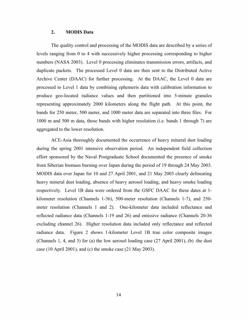
radiance data. Figure 2 shows 1-kilometer Level 1B true color composite images
(Channels 1, 4, and 3) for (a) the low aerosol loading case (27 April 2001), (b) .the dust
case (10 April 2001), and (c) the smoke case (21 May 2003).

15
(a)
(b)
(c)
Figure 2. MODIS Level 1B 1-kilometer true color image (Channels 1, 4 and 3) of Japan under (a) low aerosol conditions at 0200 GMT 27 April 2001, (b) dust at 0135 GMT 10
April 2001, and (c) smoke at 0155 GMT 21 May 2003.

16
3. Microtops II hand-held Sun Photometer
The Microtops II hand-held sun photometer (hence forth the Microtops sun
photometer) is a narrow field of view radiometer (Volz type) manufactured by Solar
Light Incorporated (Morys et al. 1996). The Microtops sun photometer is widely used
due to its ease of use, portability, and relatively low cost. The instrument uses
photodiode detectors coupled with amplifiers and analog-to-digital converters and the
collimators are mounted in a cast aluminum block with a full field of view of 2.5°. Data
can be collected a five wavelengths that may be chosen by the interference filter installed.
Two filter configurations were used in the NPS field collection effort. The first was the
“ozone” configuration with wavelengths of 340, 380, 440, 500, and 675 nanometers. The
second was the “water vapor” configuration with wavelengths of 500, 675, 870, 936, and
1020 nanometers. The instrument can collect aerosol optical depths, column ozone
concentrations, and column water vapor concentrations based on the filter combination
installed. These parameters are calculated in real-time by a built-in microprocessor and
may be viewed on the LCD screen. The Microtops sun photometer may be ordered with
built-in pressure and temperature sensors or such data may be entered manually. A
Global Positioning System (GPS) connection allows for the collection of precise position
and time. Data is collected by pointing the instrument at the sun and aligning the sun in a
cross-hair screen. The user may adjust the sampling time and number of values used for
averaging to achieve the reported result. Results are stored internally and may be
recalled to the LCD screen or downloaded to a personal computer.
4. Microtops Data
An independent field collection effort sponsored by the Naval Postgraduate
School documented the presence of smoke from Siberian biomass burning over Japan
during the period of 19 through 24 May 2003. Microtops data were collected
approximately every two to five minutes for a five-hour period on 21 May 2003 at Naval
Station, Yokosuka, Japan. Porter et al. (2001) noted that if the Microtops sun photometer
is not turned off between readings, the data may experience a bias when changes in the
ambient temperature on the order of 30°C to 40°C are present during the collection

17
period. The instruments were not turned off between readings during this collection
effort due to the time required for the initial diagnostics to run. The ambient temperature
change during the collection effort was less than 2°C so any bias due to temperature
change is assumed to be negligible. The data collected were used to construct the
spectral signature of the smoke aerosol shown in Figure 1.

18
THIS PAGE INTENTIONALLY LEFT BLANK
19
IV. METHODS AND PROCEDURES
This chapter outlines the methods and procedures used to evaluate the contrast
reduction due to heavy aerosol loading in visual satellite imagery. Small spectral and
spatial subsets of MODIS data were sorted by aerosol type (low aerosol loading, heavy
smoke, and heavy dust) and background type (urban, forested, and agricultural). Nine
combinations of aerosol type and background type were evaluated (low aerosol loading -
urban, low aerosol loading -forested, low aerosol loading -agricultural, smoke-urban,
smoke-forested, smoke-agricultural, dust-urban, dust-forested, dust-agricultural).
A. SATELLITE IMAGE RETRIEVAL AND DISPLAY
Satellite image retrieval and display was performed using the Environment for
Visualizing Images (ENVI) version 3.6 software and Interactive Data Language (IDL)
version 5.6 by Research Systems, Incorporated. The ENVI software allows the display
and enhancement of the Earth Observing System’s MODIS data along with various other
types of satellite data. Tools within ENVI include the ability to subset data spatially and
spectrally, build and apply masks, and calculate statistics on the entire data set or subsets.
IDL was used to script functions not inherent in ENVI.
B. CONTRAST REDUCTION FROM VARIATION OF REFLECTANCE
(STANDARD DEVIATION METHOD)
For this investigation, contrast reduction was divided into three aerosol regimes
and three background regimes. A true color image constructed in ENVI was used to
ensure the presence or absence of aerosol prior to selecting a site for analysis. The cases
selected were chosen for the presence of mineral dust from Asian continental source
regions, smoke from the biomass burning in Siberia, and an absence of heavy aerosol
loading. The United States Geological Survey (USGS) Land Use/Land Cover System
from the Eurasia land cover characteristics database was used for the background surface
determination (Anderson et al. 1976). The USGS Land Use/Land Cover System divides

20
land use into 24 categories. Several categories have been combined for the purpose of
this investigation to define generic forested regions, agricultural sectors and grasslands,
and urban areas. Figure 3 shows an example of land use over central Japan.
Figure 3. Example of U. S. Geological Survey Land Use/Land Cover System over central
Japan (courtesy of Land Processes Distributed Active Archive Center).
Four to six areas were selected for each aerosol-background combination. Areas
were defined by visual inspection using the Region of Interest (ROI) function in ENVI.
The ROI function allows areas to be defined by a user created polygon. Uniform
background types were identified using a visual inspection of the true color image in
conjunction with the USGS Land Use/Land Cover System image of Japan. Figure 4
shows the regions of interest for (a) the forested background, (b) the urban background,
and (c) the agricultural background for the smoke case on 21 May 2003. Channel 20
(3.660 to 3.840 micrometers), a thermal band, was used to delineate background-type
boundaries where the true color image showed little distinction between background
types. The variation in emissivity, or the ratio of flux emitted by an object to that emitted
by a blackbody at the same temperature, for each background type provided strong
thermal contrasts between background regions where little contrast in the visible
wavelengths existed (Boyd 1988).

21
(a) (b) (c)
Figure 4. Regions of Interest (ROI) for (a) the forested background type, (b) the urban background type, and (c) the agricultural background type based on the MODIS image
for the smoke case on 21 May 2003. The standard deviation of the reflectance values was calculated for all visual
channels in each region. The standard deviation for channels 12 through 16 failed to
register for many cases due to saturation of the bands. These bands were originally
optimized for ocean color applications. As such, the maximum spectral radiance allowed
by the sensor was exceeded over land. The resulting standard deviations were then
plotted as a function of wavelength by aerosol and background type. Several cases
showed exceptionally high standard deviations in channels 10 and 11. Upon inspection,
cloud contamination was found to be the main culprit. The reflectance due to cloud was
identified by plotting a histogram of the reflectance values in the contaminated region.
Cloud contamination was then filtered using a band pass mask excluding the cloud
reflectance. The standard deviations were again calculated for those channels using the
band pass mask and found to be more in line with expected values. The average standard
deviation was determined for each channel in the background/aerosol groupings and the
standard deviation of the values in each channel was used to define the relative
variability.
The effects of resolution were also investigated. In the MODIS sensor, the first
two channels have an optimum resolution of 250 meters and channels three through
seven have an optimum resolution of 500 meters. Because these channels are aggregated
to form lower resolution images at the 1-kilometer resolution, they provide an excellent
data set to gauge variability due to changes in resolution. The low aerosol loading-urban
case was chosen for this test due to its high variability at smaller spatial scales. The
process described in the previous paragraphs was applied to channels one through seven

22
for the 500-meter resolution data and to channels one and two for the 250-meter data for
the same low aerosol loading-urban cases used earlier.
C. CONTRAST REDUCTION FROM VARIATION OF REFLECTANCE
(DIFFERENCING METHOD)
An alternative method of evaluating contrast reduction using differences between
adjacent pixels was also explored. Differences between adjacent pixels to the right and
below were calculated separately and then summed to enhance contrast boundaries. The
mean of this summed difference field was then determined for each channel.
For this part of the investigation, the same cases were used for each of the nine
combinations of aerosol and background type as used previously. The region subsets
were exported to an IDL variable using the ENVI export function prior to any statistical
calculation. The export function, however, includes all pixels in a rectangle based on the
most extreme points of the ROI’s polygon and therefore included more data than the
regions used in the first part of the investigation. An IDL program was then used to:
• Read in the variable,
• Divide the region subset into 22 separate channel variables,
• Difference each channel to the right and down,
• Sum the difference fields, and
• Determine the mean of each summed difference field.
Many of the problems experienced in the standard deviation analysis were
encountered again for the difference analysis. Channels 12 through 16 showed signs of
total saturation in fewer cases than seen using the standard deviation method described
previously. Visual inspection of cases where channels 12 through 16 did not experience
total saturation showed at least partial saturation over land, making the results suspect at
best.
Again, several cases showed exceptionally high standard deviations in channels
10 and 11. These outliers were attributed to contamination due to clouds or water that
was unintentionally included in the export process. This contamination proved difficult
to remove by a filtering process. Unsuccessful attempts were made to apply a cloud and

23
water masks prior to exporting the data. Also unsuccessful were attempts to apply the
previously generated mask to the summed difference fields. These failures were
attributed to the fact that IDL assigns a value of zero to masked pixels instead of a
missing data or “Not a Number (NaN)” value. The masked pixels continued to be used in
the statistical calculations and created large differences along the mask boundaries
comparable to that created by the cloud or water boundaries. The values within the mask
were shifted in the same manner as the data channels and summed with the original mask
to create a more conservative mask. This conservative mask was applied to the final
summed difference field prior to the mean calculation, thus removing the exceptionally
high differences. The final result more closely matched those cases not contaminated by
clouds or water.

24
THIS PAGE INTENTIONALLY LEFT BLANK

25
V. RESULTS
A. AEROSOL REGIME ANALYSIS – 27 APRIL 2001
The Terra MODIS observations over Japan for the date of 27 April 2001 represent
atmospheric conditions with minimal influence from continental natural or anthropogenic
aerosols. Maritime aerosols dominate the aerosol size and concentration distributions
over Japan at this time. Anthropogenic aerosols are likely present in the vicinity of urban
areas, but the maritime aerosol regime appears to dominate from visual inspection of the
imagery. Four to six cases for each background type (forested, urban, and agricultural)
have been chosen for analysis. All cases were chosen as close to the sensor zenith as
possible to prevent reductions in observed contrast due to low view angles.
1. Standard Deviation Method
Four to six cases throughout central and southern Japan were chosen for each
background type. Polygons were constructed to define the selected areas limited to a
common background type and excluded any cloud contamination. Each area covered
approximately 200 square kilometers. Standard deviations for the surface reflectance
values were calculated for the visible MODIS channels (channels 1 through 19 and 26) in
each of the polygons. The average standard deviations of surface reflectance for the
cases in each background type were calculated for each channel. The standard deviation
of the standard deviation values in the cases in each channel was used as a measure of
variability of a low aerosol regime over a given background type.
Standard deviation calculations failed for over 50% of the cases for channels 13
through 16, centered at 667, 678, 748 and 870 nanometers respectively. Channels 13 and
14 include both high and low gain measurements.
Saturation of channels 13 through 16 results from the designed radiometric
response set before launch. High gain measurements consistently saturate over land.
Low gain measurements saturated over 50% of the time over land. MODIS channels 8
through 16 are optimized for ocean color applications and the maximum measurable

26
spectral radiance is relatively low in channels 13 through 16. Over land, these channels
tend to saturate frequently. Channels 13 through 16 have been excluded from the
calculations for the standard deviation method leaving a gap between 700 and 800
nanometers in the spectral distribution of standard deviations. Figure 5 shows a
comparison of the spectral plots of average standard deviation of surface reflectance for
each background type on 27 April 2001.
Figure 5. Spectral Distribution of Averaged Standard Deviation of Surface Reflectance as measured by MODIS for 27 April 2001 (Low Aerosol Loading Case).
a. Forested Background
Six cases were selected covering the forested mountain regions of central
and southern Japan. In Figure 5, the absolute average standard deviation for the forested
background in the visible end of the spectrum, 400 through 700 nanometers, was found to
be less than 0.005, the lowest of all background types studied. The absolute average
standard deviation in the near-infrared region of the spectrum, 800 through 1000
nanometers, was found to be approximately 0.01, also the lowest of all background types
studied. Variability within each channel as measured by the standard deviation of the six

27
cases was the lowest for all background types studied. This exceptionally low variability
reduces the effectiveness of the variability techniques as the addition of aerosol lowers
the already low variability. The “dark object” approach, however, is proven and effective
of large forested areas and is likely more appropriate for the forested background type.
The shape of the average spectral distribution of standard deviation in
Figure 5 for the forested region shows a linear increase in the visible region. The average
spectral distribution of standard deviation in the near-infrared region shows a decreasing
trend between 860 and 936 nanometers with a negative slope ten times greater than in the
visible region followed by a sharp increase to 940 nanometers. The sharp contrast
between 936 and 940 nanometers, Channels 18 and 19 respectively, are seen consistently
with all background and aerosol types and is attributed to their proximity to the wings of
water vapor absorption band.
b. Urban Background
Five cases were selected covering major urban centers in southern and
central Japan. In Figure 5, the absolute average standard deviation for the urban
background type in the visible end of the spectrum ranged from 0.005 to 0.01. The urban
background showed a distinctive spectral shape in the visible region. The average
standard deviation showed peaks of approximately 0.0075 and 0.01 at 488 and 645
nanometers respectively. The absolute average standard deviation in the near-infrared
region of the spectrum ranged from over 0.01 to 0.025 and exhibited the same spectral
shape seen in the forested case due to the proximity to the water vapor absorption band.
The variability of the standard deviations was two to three times that seen in the forested
case in both the visible and near-infrared regions.
c. Agricultural Background
Five cases were selected covering agricultural areas in southern and
central Japan. In Figure 5, the absolute average standard deviation of the agricultural
background in the visible end of the spectrum ranged from approximately 0.01 to just
over 0.015. The agricultural background showed a spectral shape in the visible region

28
similar to that of the urban background in Figure 5. The average standard deviation and
the variability of the agricultural background were the highest for all background types in
Figure 5. The average standard deviation showed peaks of over 0.013 and just over 0.015
at 488 and 645 nanometers respectively. The absolute average standard deviation in the
near-infrared region of the spectrum for the agricultural background ranged from below
0.015 to just below 0.03 and exhibited the same spectral shape seen in the forested case in
Figure 5 due to the proximity to the water vapor absorption band. The variability of the
standard deviations in the visible region was similar to that seen in the urban background
in Figure 5. The variability in the near-infrared region was approximately double that
seen in the urban background. The similar spectral shape is attributed to the similar
scales of variability between the urban and agricultural backgrounds. The agricultural
practices of Japan result in a crop size scales similar to that of buildings in an urban area.
Such agricultural size scales are likely unique to Japan and similar cultures and may not
be applicable to large areas of open agriculture such as seen in the central United States.
Figure 5 shows that in the absence of heavy aerosol loading different
background types have unique spectral signatures. The standard deviation of the standard
deviations is used as a measure of variability. Here, the background types exhibit little
overlap in spectral signatures in the visible region. This result may be used to
discriminate background types based on spectral signature.
2. Differencing Method
The differencing method of variability assessment was applied to the same cases
for each background type used in the standard deviation method. The areas used for the
differencing were rectangles containing the polygons defined for the standard deviation
method. Each area covered approximately 300 square kilometers and was not necessarily
free of cloud or surface water contamination. The differences in surface reflectance
values between each pixel and the adjacent pixel to the right and below were taken
separately. The resulting difference fields were summed for each of the visible MODIS
channels (channels 1 through 19 and 26) in each of the cases. The mean was calculated
for each of the summed difference fields. The average mean of differenced surface
reflectance for the cases in each background type were calculated for each channel. The

29
standard deviation of the mean values in the cases in each channel was used as a measure
of variability of a low aerosol regime over a given background type. Mean calculations
failed for over 50% of the cases for Channels 13 through 16. These channels have been
excluded from the calculations for the differencing method leaving a gap between 700
and 800 nanometers in the spectral distribution of mean differences in surface
reflectance. Figure 5 shows a comparison of the spectral plots of averaged mean
differenced surface reflectance for each background type on 27 April 2001.
Figure 6. Spectral Distribution of Averaged Mean Differenced Surface Reflectance as measured by MODIS for 27 April 2001 (Low Aerosol Loading Case).
a. Forested Background
The same six cases covering the forested mountain regions of central and
southern Japan were used for the differencing method. In Figure 6, the absolute average
mean differenced surface reflectance in the visible end of the spectrum increased linearly
and was the lowest of all background types studied. The absolute average mean
differenced surface reflectance in the near-infrared region of the spectrum for the forested

30
background was also the lowest of all background types studied. Variability within each
channel as measured by the standard deviation of the six cases was the lowest for all
background types studied. The near-infrared region for the forested background type
shown in Figure 6 exhibited the same spectral shape seen in the standard deviation
method attributed to the proximity of the channels to the water vapor absorption band.
b. Urban Background
The same five cases covering major urban centers in central and southern
Japan were used in the differencing method. The urban background in Figure 6 again
showed a distinctive spectral shape in the visible region as it did in Figure 5. The average
mean differenced surface reflectance for the urban background in the visible region
peaked at approximately 0.0015 and 0.002 at 488 and 645 nanometers respectively. The
average mean differenced surface reflectance in the near-infrared region of the spectrum
ranged from approximately 0.015 to 0.04. The urban background type for low aerosol
loading is the only case where the near-infrared signature did not exhibit the same
spectral shape seen in the forested case due to the proximity to the water vapor absorption
band. The only deviation is a significant dip at 905 nanometers of the same order as that
seen at 936 nanometers as seen in Figure 6. The variability of the standard deviations
was twice that seen in the forested case in both the visible and near-infrared regions.
c. Agricultural Background
The same five cases were covering agricultural areas in central and
southern Japan were used in the differencing method. In Figure 6, the average mean
differenced surface reflectance for the agricultural background in the visible end of the
spectrum peaked at approximately 0.002 at 531 and 645 nanometers respectively. The
agricultural background showed a spectral shape in the visible region similar to that of
the urban background in Figure 6 with the exception of the significant peak at 531
nanometers. The average mean differenced surface reflectance was higher than or
comparable to that of the urban background type in Figure 6 with variability similar to

31
that of the urban background. The average mean differenced surface reflectance in the
near-infrared region of the spectrum for the agricultural background type ranged from
0.002 to just over 0.003 and exhibited the same spectral shape seen in the forested case
due to the proximity to the water vapor absorption band. The variability of the mean
differences in the visible region of the agricultural background as measured by the
standard deviations was similar to that seen in the urban background in Figure 6. The
variability in the near-infrared region was of the same order of that seen in the urban
background in Figure 6. A discussion of the similarities between the agricultural and
urban backgrounds can be found in the standard deviation method section.
B. AEROSOL REGIME ANALYSIS – 10 APRIL 2001
The Terra MODIS observations over Japan for the date of 10 April 2001 represent
atmospheric conditions dominated by mineral dust from the Asian continent.
Anthropogenic aerosols are likely present in the vicinity of urban areas, but the dust
regime dominates in the urban area chosen from visual inspection of the imagery. Four
to five cases for the agricultural and forested background types have been chosen for
analysis. Only one urban case could be clearly identified from imagery due to the nature
of the dust plume from the Asian continent. All cases were chosen as close to the sensor
zenith as possible to prevent reductions in observed contrast due to low view angles.
1. Standard Deviation Method
Four to five cases for the agricultural and forested background type and one case
for the urban background type were chosen throughout northern Japan. Polygons were
constructed to define the selected areas limited to a common background type and
excluded any cloud contamination. Each area covered approximately 200 square
kilometers. Standard deviations for the surface reflectance values were calculated for the
visible MODIS channels (channels 1 through 19 and 26) in each of the polygons. The
average standard deviations of surface reflectance for the cases in each background type
were calculated for each channel. The standard deviation of the standard deviation values

32
in the cases in each channel was used as a measure of variability of a dust regime over a
given background type. Standard deviation calculations failed for over 50% of the cases
for Channels 11 through 16, centered at 531, 555, 667, 678, 748 and 870 nanometers
respectively. Both Channels 13 and 14 high and low gain measurements consistently
saturated over land. See the previous section for a discussion of limitations of Channels 8
through 16. Channels 11 through 16 have been excluded from the calculations for the
standard deviation method. Figure 7 shows a comparison of the spectral plots of average
standard deviation of surface reflectance for each background type on 10 April 2001.
Figure 7. Spectral Distribution of Averaged Standard Deviation of Surface Reflectance as
measured by MODIS for 10 April 2001 (Dust Case).
a. Forested Background
Five cases were selected covering the forested mountain regions of
northern Japan. In Figure 7, the absolute average standard deviation in the visible end of
the spectrum was found to be less than 0.012. The absolute average standard deviation in
the near-infrared region of the spectrum for the forested background ranged was less than

33
0.014. Variability within each channel as measured by the standard deviation of the five
cases was the two to five times of that seen in the low aerosol regime in Figure 5.
The shape of the average spectral distribution of standard deviation for the
forested region in Figure 7 shows a linear increase in visible spectrum similar to that seen
in the low aerosol regime in Figure 5 but with a slope four times larger. The average
spectral distribution of standard deviation in the near-infrared region shows a decreasing
trend between 860 and 936 nanometers followed by a less pronounced increase to 940
nanometers. The slope of the line between 859 and 905 nanometers in Figure 7 is twice
the value of that seen in the low aerosol case in Figure 5.
The dust-forested background case in Figure 7 was the only case to exhibit
an increase in contrast in the presence of heavy aerosol loading. Visual inspection of the
MODIS image revealed striations in the plume of dust in the study area. It is thought that
the nature of the dust plume added contrast and variability to what is normally a low
contrast background with low variability. The limitations of the contrast method with
respect to the forested case are discussed above.
b. Urban Background
Only one case of a dust regime dominating a major urban center in
northern Japan was identified. In Figure 7, the absolute average standard deviation in the
visible end of the spectrum was less than 0.007. The dust regime as characterized in
Figure 7 showed the expected decrease in standard deviation. The urban background in
the presence of dust also showed the same distinctive spectral shape in the visible region
as seen in Figure 5. Figure 7 shows average standard deviation increased linearly with
peaks of just over 0.005 at 488 and 555 nanometers and a peak of 0.007 at 645
nanometers. The absolute average standard deviation in the near-infrared region of the
spectrum for the urban background was less than 0.01, half of that seen in the low aerosol
loading case, and exhibited the water vapor absorption band spectral. The variability of
the standard deviations could not be determined due to the limited number of urban cases.

34
c. Agricultural Background
Four cases were selected covering agricultural areas in northern Japan. In
Figure 7, the absolute average standard deviation in the visible end of the spectrum was
below 0.009. The agricultural background under the influence of the dust regime shown
in Figure 6 showed the same spectral shape across the entire spectrum as seen in the low
aerosol case in Figure 5 but with lower average standard deviations and variability in all
channels. The average standard deviation of the agricultural background showed two
peaks of approximately 0.005 and 0.009 at 469 and 645 nanometers respectively. The
absolute average standard deviation in the near-infrared region of the spectrum for the
agricultural background ranged from approximately 0.005 to 0.008, roughly one-third of
that seen for the agricultural case in the low aerosol loading case in Figure 5, and
exhibited the typical water vapor absorption band spectra. The contrast reduction was
greatest in the near-infrared region.
2. Differencing Method
The differencing method of variability assessment was applied to the same cases
for each background type used in the standard deviation method. The areas used for the
differencing were rectangles containing the polygons used for the standard deviation
method. Each area covered approximately 300 square kilometers and was not necessarily
free of cloud or water contamination. The differences in surface reflectance values
between each pixel and the adjacent pixel to the right and below were taken separately.
The resulting difference fields were summed for each of the visible MODIS channels
(channels 1 through 19 and 26) in each of the cases. The mean was calculated for each of
the summed difference fields. The average mean of differenced surface reflectance for
the cases in each background type were calculated for each channel. The standard
deviation of the mean values in the cases in each channel was used as a measure of
variability of a dust regime over a given background type. Mean calculations failed for
over 50% of the cases for Channel 11 and for all cases for Channels 12 through 16.
Channels 11 through 16 have been excluded from the calculations for the differencing

35
method. Figure 8 shows a comparison of the spectral plots of average mean differenced
surface reflectance for each background type on 10 April 2001.
Figure 8. Spectral Distribution of Averaged Mean Differenced Surface Reflectance as
measured by MODIS for 10 April 2001 (Dust Case).
a. Forested Background
The same five cases covering the forested mountain regions of northern
Japan were used for the differencing method. In Figure 8, the absolute average mean
differenced surface reflectance in the visible end of the spectrum for the forested
background increased linearly to 0.0025, with the exception of a value of just over 0.01 at
488 nanometers (channel 10). Channel 10 was contaminated with high surface
reflectance values due to a body of water in the image subset. Two areas were excluded
due to exceptionally high values of mean differenced surface reflectance. This removal
of outliers likely caused an over-correction resulting in a low bias in the channel 10
average for the forested background in Figure 8. It is thought that a conservative water
mask would reduce both the absolute average mean differenced surface reflectance and
the variability of the differenced surface reflectance values. The absolute average mean

36
differenced surface reflectance in the near-infrared region of the spectrum for the forested
background ranged from approximately 0.0015 to 0.0035. Variability within each
channel as measured by the standard deviation of the five cases used to determine the
mean for the forested background in Figure 8 was two to five times that of the low
aerosol loading case over the forested background in Figure 6. The near-infrared region
for the forested background in Figure 8 exhibited the same spectral shape seen in the
standard deviation method in Figure 7, but with more pronounced differences between
the maximum and minimum values. Variations in magnitude of the spectral shape in the
near-infrared region are likely due to variations in vegetation type. Radiometric response
in the near-infrared region is highly dependent on the vegetation type and moisture
content of the soil. Cases showing high variations are likely those with a wide range of
vegetation types and varying soil moisture content.
b. Urban Background
The same case covering a major urban center in northern Japan were used
in the differencing method. In Figure 8, the spectral shape of the urban background
showed a linear trend in the visible region peaking at 0.0005. The results were
inconclusive due to restriction to one case. The absolute mean differenced surface
reflectance in the near-infrared region for the urban background exhibited a spectral
shape that resembled a muted signature of the forested case in Figure 8. See discussion
in previous section. The variability of the standard deviations was unavailable due to the
limited number of cases.
c. Agricultural Background
The same four cases were covering agricultural areas in northern Japan
were used in the differencing method. In Figure 8, the absolute average mean differenced
surface reflectance in the visible end of the spectrum for the agricultural background
showed the same linear spectral shape see in the forested region but at half of the
magnitude of that seen in the forested region in Figure 8. The variability was of the same
magnitude seen in the forested case in Figure 8. As in the forested case, two cases

37
showed exceptionally high values of mean differenced surface reflectance and were
excluded as outliers. Again, conservative water and cloud masks should remedy this
problem and bring values in line with expectations. The absolute average standard
deviation in the near-infrared region of the spectrum showed the typical spectral shape
due to the water vapor absorption band at half the magnitude seen in the forested case in
Figure 8.
C. AEROSOL REGIME ANALYSIS – 21 MAY 2003
The Terra MODIS observations over Japan for the date of 21 May 2003 represent
atmospheric conditions dominated by anthropogenic smoke from biomass burning in
Siberia. Four to five cases for all background types have been chosen for analysis based
on the presence of smoke from visual inspection of imagery. All cases were chosen as
close to the sensor zenith as possible to prevent reductions in observed contrast due to
low view angles.
1. Standard Deviation Method
Four to five cases for each background type were chosen throughout central and
southern Japan. Polygons were constructed to define the selected areas and were limited
to a common background type and excluded any cloud contamination. Each area covered
approximately 200 square kilometers. Standard deviations for the surface reflectance
values were calculated for the visible MODIS channels (channels 1 through 19 and 26) in
each of the polygons. The average standard deviations of surface reflectance for the
cases in each background type were calculated for each channel. The standard deviation
of the standard deviation values in the cases in each channel was used as a measure of
variability of a smoke regime over a given background type. Standard deviation
calculations failed for over 50% of the cases for channels 10 and 11, centered at 488 and
531 nanometers respectively. Channels 12 through 16 failed for all cases due to
saturation of the channel over land. See the previous section for a discussion of
limitations of Channels 8 through 16. Channels 10 through 16 for the forested
background and channels 11 through 16 for urban and agricultural backgrounds have

38
been excluded from the calculations for the standard deviation method. Figure 9 shows a
comparison of the spectral plots of average standard deviation of surface reflectance for
each background type on 21 May 2003.
Figure 9. Spectral Distribution of Averaged Standard Deviation of Surface Reflectance as
measured by MODIS for 21 May 2003 (Smoke Case).
a. Forested Background
Five cases were selected covering the forested mountain regions of central
and southern Japan. In Figure 9, the absolute average standard deviation in the visible
end of the spectrum peaked at approximately 0.0035. The absolute average standard
deviation in the near-infrared region of the spectrum for the forested background ranged
from 0.006 to 0.01. Variability within each channel as measured by the standard
deviation of the five cases for the forested background was on the same order of that seen
in the low aerosol regime in Figure 5.
The shape of the average spectral distribution of standard deviation for the
forested region in Figure 9 shows a linear increase in visible spectrum between 412 and
469 nanometers. The standard deviation remains constant through 600 nanometers and

39
slightly increases at 645 nanometers. This is a significant deviation from linearly
increasing spectral shape seen in the other two aerosol regimes for the forested
background type seen in Figures 4 and 6. Takemura et al. (2002) generalized the single
scatter albedo as a function of wavelength for carbonaceous aerosols for an aerosol
modeling effort. The carbonaceous aerosol shows a peak in single scatter albedo at
approximately 500 nanometers. This relatively high single scatter albedo at 500
nanometers is one explanation for the contrast reduction seen between 500 and 600
nanometers that is seen in the smoke aerosol regime in Figure 9 but not in the others.
The average spectral distribution of standard deviation in the near-infrared region for the
forested background shows the same shape and magnitude of standard deviation as seen
in the low aerosol case in Figure 5.
b. Urban Background
Four cases covering major urban centers in central and southern Japan
were selected. In Figure 9, the absolute average standard deviation in the visible end of
the spectrum peaked at approximately 0.008. The absolute average standard deviation in
the near-infrared region of the spectrum for the urban background showed the same
spectral shape as seen in the low aerosol loading case in Figure 5, but with a lesser
magnitude. The smoke regime depicted in Figure 9 showed the expected decrease in
standard deviation due to contrast reduction. In Figure 9, variability in the visible region
of the spectrum is of the same order of that seen in the low aerosol regime over an urban
background in Figure 5. The variability in the near-infrared region was one-third of that
seen with the low aerosol regime over the urban background in Figure 5.
In Figure 9, the shape of the average spectral distribution of standard
deviation for the urban background shows a linear increase in the visible spectrum
between 412 and 469 nanometers. The standard deviation dips to its lowest average
value at 488 nanometers. A similar decrease in standard deviation, but smaller in
magnitude, is seen at 488 nanometers for all background types in Figure 9. The
combination of urban pollution and the carbonaceous smoke may account for the
exceptionally high reduction in contrast at 488 nanometers over urban backgrounds. See
the discussion of the wavelength dependence of single scatter albedo of carbonaceous

40
aerosols in the previous section. The average spectral distribution of standard deviation in
the near-infrared region shows the same shape but a lesser magnitude of both standard
deviation and variability as seen in the low aerosol case.
c. Agricultural Background
Five cases were selected covering agricultural areas in central and
southern Japan. In Figure 9, the absolute average standard deviation in the visible end of
the spectrum for the agricultural background peaked at 0.008. The agricultural
background under the influence of the smoke regime showed the same spectral shape
across the entire spectrum as seen in the low aerosol case as seen in Figure 5 but with
lower average standard deviations and variability in all channels. The average standard
deviation increased linearly between 412 to 469 nanometers decreased slightly at 488
nanometers and then increased at 555 and 645 nanometers. In Figure 9, the absolute
average standard deviation in the near-infrared region of the spectrum exhibited the
typical water vapor absorption band spectral shape with values of the same order as seen
in the low aerosol loading case in Figure 5.
2. Differencing Method
The differencing method of variability assessment was applied to the same cases
for each background type used in the standard deviation method. The areas used for the
differencing were rectangles containing the polygons used for the standard deviation
method. Each area covered approximately 300 square kilometers and was not necessarily
free of cloud or water contamination. The differences in surface reflectance values
between each pixel and the adjacent pixel to the right and below were taken separately.
The resulting difference fields were summed for each of the visible MODIS channels
(channels 1 through 19 and 26) in each of the cases. Means were calculated for each of
the summed difference fields. The average means of differenced surface reflectance for
the cases in each background type were calculated for each channel. The standard
deviation of the mean values in the cases in each channel was used as a measure of
variability of a smoke regime over a given background type. Mean calculations failed

41
for over 50% of the cases for channels 10 and 11 for the forested background type and for
all cases for channels 12 through 16. Channels 11 through 16 have been excluded from
the calculations for the differencing method. Figure 10 shows a comparison of the
spectral plots of average standard deviation for differenced surface reflectance for each
background type on 10 April 2001.
Figure 10. Spectral Distribution of Averaged Mean Differenced Surface Reflectance as
measured by MODIS for 21 May 2003 (Smoke Case).
a. Forested Background
The same five cases covering the forested mountain regions of central and
southern Japan were used for the differencing method. In Figure 10, the absolute average
mean differenced surface reflectance in the visible end of the spectrum for the forested
background shows a linear increase between 412 and 469 nanometers followed by a two-
fold increase at 488 and 531 nanometers. The original linear trend is resumed at 555
nanometers and continues to 645 nanometers. In Figure 10, the absolute average mean
differenced surface reflectance in the near-infrared region of the spectrum was the lowest
of all background types in the smoke regime and showed the typical water vapor

42
absorption band signature. Variability within each channel as measured by the standard
deviation of the five cases was two to five times of that of the low aerosol loading case
over the forested background in the visible region as seen in Figure 6 and of the same
order as that seen in the near-infrared region in the low aerosol regime in Figure 6.
b. Urban Background
The same four cases covering major urban centers in central and southern
Japan were used in the differencing method. In Figure 10, the absolute average mean
differenced surface reflectance in the visible end of the spectrum showed peaks of 0.0008
and 0.0009 and 469 and 645 respectively. The absolute average mean differenced
surface reflectance in the near-infrared region of the spectrum for the urban background
showed the characteristic spectral shape of the water vapor absorption band, but with a
lesser overall magnitude as compared to the low aerosol loading case in Figure 6. The
variability of the standard deviations was of approximately the same order as that of the
low aerosol loading cases in Figure 6.
c. Agricultural Background
The same five cases were covering agricultural areas in central and
southern Japan were used in the differencing method. In Figure 10, the absolute average
mean differenced surface reflectance in the visible end of the spectrum showed peaks of
approximately 0.0015 and 0.0016 at 488 and 645 nanometers respectively. The
variability was of the same order as that seen in the low aerosol regime in Figure 6. The
absolute average standard deviation in the near-infrared region of the spectrum showed
the expected decrease in magnitude as compared to the low aerosol loading case in Figure
6 and exhibited the spectral shape typical of the water absorption band.
D. SPATIAL RESOLUTION ANALYSIS – URBAN CASE – 27 APRIL 2001
The availability of MODIS data at 500-meter resolution for channels 1 through 7
and at 250-meter resolution for channels 1 and 2 allowed an investigation of the effects of

43
resolution on both the standard deviation and differencing methods. The urban
background, low aerosol loading case was used for this analysis in hopes of maximizing
the signal due to the high spatial variability of the urban environment. Satellite
measurements at resolutions of one kilometer, 500 meters, and 250 meters were used
covering the same five urban areas.
Figure 11 shows the spatial resolution analysis for the standard deviation method.
Little separation is seen between the average standard deviation of surface reflectance for
the three resolutions. This agreement likely results from the fact that range of surface
reflectance values is the same at all three scales as are the relative proportions of the
surface reflectance values to each other. Another possible explanation is that fact that the
500-meter and 250-meter data may not be sufficient to resolve urban variability any
better than the one-kilometer data and no real difference is noted.
Figure 11. Spectral Distribution of Average Standard Deviation of Surface Reflectance as
measured by MODIS at 1 kilometer, 500 meter, and 250 meter resolutions for the Urban Background for 27 April 2001 (Low Aerosol Loading Case).
Figure 12 shows the spatial resolution analysis for the differencing method.
Figure 12 shows clear separation between the average mean differenced surface

44
reflectance for the three resolutions. The average mean differenced surface reflectance
decreased with increased resolution. It is thought that the higher resolution data is still
insufficient to resolve urban structures and therefore fails to add significant differences to
the mean calculation. The higher resolution imagery displays more low contrast areas
resulting in little or no pixel-to-pixel contrast and lowering the average mean differenced
surface reflectance.
Figure 12. Spectral Distribution of Averaged Mean Differenced Surface Reflectance as
measured by MODIS at 1 kilometer, 500 meter, and 250 meter resolutions for the Urban Background for 27 April 2001 (Low Aerosol Loading Case).
A separate investigation of IKONOS imagery with four channels covering the
blue, green, red, and near-infrared wavelengths and a nominal resolution of one-meter,
showed that extremely high resolution imagery may be better suited to detailed contrast
analysis. Figure 13 shows the results of a modified standard deviation analysis and a
differencing analysis over Gila Bend, Arizona. These results suggest that as resolution
increases, no change or degradation in the signal may be experienced until some critical
resolution threshold is reached. In Figure 13, the features of an agricultural area are
easily resolved by both methods. Likewise, the features in urban settings should be

45
increasingly masked with increased resolution until the features can be sufficiently
resolved.
Figure 13. Examples of the Standard Deviation and Differencing Methods as used on high-resolution imagery.

46
THIS PAGE INTENTIONALLY LEFT BLANK

47
VI. CONCLUSIONS AND RECOMMENDATIONS
A. CONCLUSIONS
Two contrast reduction methods of aerosol characterization were investigated for
use in surface visibility retrievals from MODIS observations. The first method used the
standard deviation of surface reflectance as a measure of surface contrast. The second
method used the mean of the difference in surface reflectance between adjacent pixels as
a measure of surface contrast. Three different aerosol regimes over three different
backgrounds in Japan were used in this investigation. The spectral distribution of
standard deviation for both methods showed a unique spectral shape for each background
type. The comparison of the aerosol effects within each background type showed
wavelength dependence for contrast reduction based on aerosol type. Initial results of the
investigation show that a surface visibility model based on contrast reduction in surface
reflectance measurements from MODIS is viable.
This investigation found other environmental sensitivities beyond those to
background and aerosol type mentioned above. Conservative cloud and surface water
masks would be required to remove any unusually high contrast values that would lead to
a high bias in retrieved visibility. A correction for sensor view angle would be required
to remove a low bias for those areas near the edges of the scene. A correction for
Rayleigh scattering may also be useful in retrieving more accurate surface visibilities.
The variability in each MODIS channel as measured by the standard deviation of
the values from each case prevented a clear characterization of the amount of aerosol
present. The temporal and spatial variability of the aerosol would require validation data
of very high temporal and spatial resolution. In situ surface visibility and aerosol optical
depth data were unavailable for the cases used in this investigation. Such data could be
used to assign visibility or aerosol optical depth values to contrast measurements. The
limited number of cases and the variability seen in each case would limit the statistical
validity of any conclusions even if such validation data were available.

48
B. RECOMMENDATIONS
As a result of this study, the following recommendations are suggested:
- Repeat similar investigations over similar background types worldwide to
determine uniqueness of results.
- Extend investigation to mixed aerosol regimes (e.g. dust mixed with
anthropogenic pollution).
- Analyze a sufficient number of cases for each background type and aerosol
regime to determine statistically significant values of average standard deviation of
surface reflectance and mean differenced surface reflectance and their associated
variability.
- Collect sufficient surface visibility observation data and aerosol optical depth
measurements for use correlation studies of observed contrast reduction.
- Construct a surface visibility model based on the correlation between observed
surface visibilities or aerosol obstacle depths and the contrast reduction as measured by
the standard deviation of surface reflectance or mean differenced surface reflectance
taking sensor view angle, Rayleigh scattering, the presence of clouds and surface water,
background type, and aerosol type into account.

49
LIST OF REFERENCES
Anderson, J. R., E. E. Hardy, J. T. Roach, and R. E. Witmer, 1976: A land use and land cover classification system for use with remote sensor data. U. S. Geological Survey Professional Paper 964. 28 pp.
Andreae, M. O., R. J. Charlson, F. Bruynseels, H. Storms, R. Van Grieken, and W.
Maenhaut, 1986: External mixture of sea salt, silicates, and excess sulfate in marine aerosols. Science, 232, 1620-1623.
Brentzel, K., 2003: Personal Communication. Boyd, R. W., 1988: Radiometry and the Detection of Optical Radiation. Wiley and
Sons, 254 pp. Charlson, R. J., S. E. Swartz, J. M. Hales, R. D. Cess, J. A. Coakley, Jr., J. E. Hansen and
D. J. Hoffman, 1992: Climate forcing by anthropogenic aerosols. Science, 255, 423-430.
Coakley, J. A., and P. Chylek, 1975: The two-stream approximation radiative transfer
including the angle of the incident radiation. Atmos. Sci., 32, 409. D’Almeida, G. A., P. Koepke, and E. P. Shettle, 1991: Atmospheric Aerosol, Global
Climatology and Radiative Characteristics. A. Deepak, 561 pp. Durkee, P. A., D. R. Jensen, E. E. Hindman, and T. H. Vonder Haar, 1986: The
relationship between marine aerosol particles and satellite-derived radiance. J. Geophys. Res., 91, 4063-4072.
Durkee, P. A., F. Pfeil, E. Frost, R. Shema, 1991: Global analysis of aerosol particle
characteristics. Atmos. Environ., 25(A), 2457-2471. Ferrare, R. A., R. S. Fraser, and Y. J. Kaufman, 1990: Satellite remote sensing of large-
scale air pollution: Measurements of forest fire smoke. J. Geophys. Res., 95, 9911-9925.
Fraser, R. S., Y. J. Kaufman, and R. L. Mahoney, 1984: Satellite measurements of
aerosol mass and transport. Atmos. Environ., 18, 2577-2584. Goddard Space Flight Center, cited 2003: MODIS technical specifications. [Available
online at http://modis.gsfc.nasa.gov/about/specs.html.] Huebert, B.J., T. Bates, P.B. Russell, G. Shi, Y.J. Kim, K. Kawamura, G. Carmichael and
T. Nakajima, 2003: An overview of ACE-Asia: strategies for quantifying the

50
relationships between Asian aerosols and their climatic impacts. J. Geophys. Res., (In Press).
Intergovernmental Panel on Climate Change. Climate Change 2001 – The Scientific
Basis (contribution of working group I to the Third Assessment Report of the Intergovernmental Panel on Climate Change). Cambridge University Press, Cambridge, 2001.
Kaufman, Y. J., 1979: Effect of the Earth’s atmosphere on contrast for zenith
observations. J. Geophys. Res., 84, 3165-3172. Kaufman, Y. J., R. S. Fraser, and R. A. Ferrare, 1990: Satellite measurements of large-
scale air pollution methods. J. Geophys. Res., 95, 9895-9909. Kaufman, Y. J. and C. Sendra, 1988: Algorithm for automatic atmospheric corrections to
visible and near-IR satellite imagery. Int. J. Remote Sens., 9, 1357-1381. Kaufman, Y. J., D. Tanre, L. A. Remer, E. F. Vermote, A. Chu, and B. N. Holben, 1997a:
Operational remote sensing of tropospheric aerosol over land from EOS moderate resolution imaging spectroradiometer. J. Geophys. Res., 102, 17051-17067.
Kaufman, Y. J., A. E. Wald, L. A. Remer, B.-C. Gao, R.-R. Li, and L. Flynn, 1997b: The
MODIS 2.1-micrometer channel correlation with visible reflectance for use in remote sensing of aerosol. IEEE Trans. Geosci. Remote Sens., 35, 1286-1298.
Kidder, S. Q. and T. H. Vonder Haar, 1999: Satellite Meteorology: An Introduction.
Academic Press, pp. 466. Kiehl, J. T. and B. P. Briegleb, 1993: The relative roles of sulfate aerosols and
greenhouse gases in climate forcing. Science, 260, 311-314. King, M. D., W. P. Menzel, Y. J. Kaufman, D. Tanre, B. C. Gao, S. Platnick, S. A.
Ackerman, L. A. Remer, R. Pincus, and P. A. Hubanks, 2002: Cloud and aerosol properties, precipitable water, and profiles of temperature and humidity from MODIS. IEEE Trans. Geosci. Remote Sens., (In Press).
Knapp, K. R. and L. L. Stowe, 2002: Evaluating the potential for retrieving aerosol
optical depth over land from AVHRR Pathfinder Atmosphere data. J. of Atmos. Sci., 59 (3), 279-293.
Kuciauskas, A. P., 2002: Aerosol optical depth analysis with NOAA GOES and POES in
the Western Atlantic. M. S. thesis, Dept. of Meteorology, Naval Postgraduate School, Monterey, CA, 101 pp.
51
Mishchenko, M. K., I. V. Geogdzhayev, B. Cairns, W. B. Rossow, and A. A. Lacis, 1999: Aerosol retrievals over the ocean using channel 1 and 2 AVHRR data: A sensitivity analysis and preliminary results. Appl. Opt., 38, 7325-7341.
Morys, M. F., F. M. Mims III, and S. E. Anderson, 1996: Design, calibration and
performance of MICROTOPS II hand-held ozonometer. 12th Int. Symp.on Photobiology, Vienna, Austria, International Congress on Photobiology. [Available on line at http://www.solar.com/ftp/papers/mtops.pdf.]
Nakajima, T. and A. Higurashi, 1988: A use of two-channel radiances for an aerosol
characterization from space. Geophys. Res. Lett., 25, 3815-3818. National Aeronautical and Space Administration, cited 2003: Terra: Earth Observing
System (EOS) AM-1. [Available online at http://terra.nasa.gov/Brochure/Sect_5-1.html]
Porter, J. N., M. Miller, C. Pietras, and C. Motell, 2001: Ship-based sun photometer
measurements using Microtops sun photometers. J. Atmos. Oceanic Technol., 18, 765-774.
Prospero, J. M., and R. T. Nees, 1986: Impact of the North African drought and El Nino
on mineral dust in the Barbados trade wind. Nature, 320, 735-738. Ramsey, R. C., 1968: Study of the Remote Measurement of Ocean Color. Final Report:
NASW-1658. TRW, Redondo Beach, California. Shettle, E. P., and R. W. Fenn, 1979: Models for the aerosol of the lower atmosphere and
the effect of humidity variations on their optical properties. AFGL-TR790214, Opt. Phys. Div., Air Force Geophys. Lab., Hanscom Air Force Base, MA.
Takemura, T., T. Nakajima, O. Dubovik, B. N. Holben, and S. Kinne, 2002: Single-
scattering albedo and radiative forcing of various aerosol species with a global three-dimensional model. J. Climate, 15, 333-352.
Twomey, S. A., M. Piepgrass, and T. L. Wolfe, 1984: An assessment of the impact of
pollution on the global albedo. Tellus 36B, 356-366. Wen, G., S. Tsay, R. F. Cahalan, and L. Oreopoulos, 1999: Path radiance technique for
retrieving aerosol optical thickness over land. J. Geophys. Res., 104, 31321-31332.
Whitby, K. Y., 1978: The physical characteristics of sulfur aerosols. Atmos. Environ., 12, 135-159.

52
THIS PAGE INTENTIONALLY LEFT BLANK

53
INITIAL DISTRIBUTION LIST
1. Defense Technical Information Center Ft. Belvoir, Virginia
2. Dudley Knox Library Naval Postgraduate School Monterey, California
3. Chairman, Code MR Department of Meteorology Naval Postgraduate School Monterey, California
4. Professor Philip A. Durkee (Code MR/DE) Department of Meteorology Naval Postgraduate School Monterey, California
5. LCDR Dominick A. Vincent Department of Meteorology Naval Postgraduate School Monterey, California