visitor guide great sand dunes and preserve · weather the weather can change rapidly at great sand...
TRANSCRIPT

Weather The weather can change rapidly at Great Sand Dunes! Storms and cold temperatures can occur any time of year. If you see a thunderstorm approaching, get off the dunes immediately. Lightning strikes can be fatal. Storms can produce flash floods in the mountains, especially in wildfire-burned areas in Medano Canyon. Dangerous debris flows can trap people or vehicles. Burned, standing trees may fall at any time, especially in wind.
Hot Sand In summer, the sand surface can reach 150°F (66° C) in mid-day. Bring closed-toe shoes, and protect your pets’ feet. Hike the dunes early morning or evening. Although the sand surface can become hot, summer daytime highs are typically in the low 80s F (upper 20s C).
Wildlife Never feed wild animals. Adhere to speed limit signs on park and area roads to prevent accidents with crossing animals. Pay attention to wildlife alerts and information. Bears and mountain lions may be encountered; pick up the “Wild Ways” handout at the Visitor Center to learn more about these animals. In the campground, always store food, toiletries and trash in the bear–proof boxes provided at each site. Great Sand Dunes is home to a variety of wildlife. Visit the Visitor Center or attend a ranger program to learn more.
Altitude Park elevations range from 7,515 feet to 13,604 feet (2,291m to 4,146m) above sea level. The Visitor Center and campground are at approximately 8,200 feet (2,499m). Altitude sickness is a possibility. Symptoms include shortness of breath, headaches, and nausea. Drink plenty of water (about one gallon or 2 liters per day), take it slow, and avoid alcoholic drinks. Seek medical attention if your symptoms are severe.
Emergency Call 911. Telephones are located at the Visitor Center, Dunes parking lot, and at the campground kiosk. You can contact a ranger at the Visitor Center during business hours.
Visitor Guide Great Sand DunesNational Park and Preserve
2-3 Getting StartedInformation you’ll need to prepare for your visit. Weather info, camping, pro-grams, accessibility, and local services.
7 Places Nearby Nearby attractions including state and federal lands fea-turing wetlands, 14,000’ peaks, and historic sites.
4-6 Exploring Your Park Suggested trails, destinations, and activities. Color map, photos, distances, and average travel times are included.
For Your Safety
Welcome to one of the world’s most diverse national parks!
Welcome! Great Sand Dunes offers diverse experiences throughout the year. Whether you backcoun-try ski in winter, splash in Medano Creek during spring, explore mountain trails in summer, or photograph gold aspens in fall, you’ll find Great Sand Dunes is a park for all seasons. New research (page 8) confirms that Great Sand Dunes contains many of the tallest dunes in North America. While I encour-age you to enjoy these massive dunes, I challenge you to also discover and learn about some of the less obvious features of this park. The park protects insect species found nowhere else in the world. The dunes have drawn people to the area for thousands of years and today the park preserves the archeological sites, historic homesteads, and trails made by earlier inhabitants. On a clear night, the skies are so dark that you can see the Milky Way.
Whatever your interests, I think you’ll discover that Great Sand Dunes National Park and Preserve has much to offer in every season.
Lisa Carrico Superintendent
Water is the unexpected ribbon that ties the ecosystems of Great Sand Dunes together. Hike to Sand Creek Lakes (left) or splash in Medano Creek during its seasonal flow.
There is something special about every season at Great Sand Dunes!
Keep wildlife wild. Use campsite bear-proof boxes.

An adult and child sand wheelchair are available upon reservation at the Visitor Center. The Dunes parking lot has an acces-sible mat to the creek as well a viewing plat-form. Accessible restrooms are available at the Visitor Center, Amphitheater, and Dunes parking lot. Three accessible campsites are located in the Campground (Site # 10, 14 in Loop 1, site # 63 In Loop 2).
Leashed pets are permitted in day use areas and in the national preserve, but not in national park backcountry; ask for a map of permitted pet areas at the Visitor Center. Please clean up after your pet. Dur-ing summer months, avoid hiking on the dunes with your pet during the mid-day. Sand temperatures during this time of day can harm your pet. Take proper amounts of water for your pet in addition to yourself. Medano Creek only flows seasonally.
Piñon Flats Campground contains 88 individual sites, of which 44 sites (Loop 2) can be reserved through www.reservation.gov or by calling 1-877-444-6777. The other 44 sites (Loop 1) are based on a first-come/first-serve basis. All 88 campsites are equipped for tent and RV sites, however RV sites can accommodate RVs no larger than 35 feet in length. There are no RV hook-ups but flush toilets and sinks are available in Loop 1 and Loop 2. All sites cost $20.00 per night for a maximum of 6 people, 2 tents and 2 vehicles.
Three sites for groups of 15 or more are also available for reserva-tion through www.reservation.gov or by calling 1-877-444-6777. Group sites cost $65-$80 depending on size. Trailers and RVs are not allowed in the group site campground.
Check-out is 1:00 p.m. for all campers. Quiet hours are from 10 p.m. to 6 a.m. Generators may run between 7 a.m. and 8 p.m. Loop1 , Loop 2 and group sites have picnic tables and fire pits. Purchase firewood at the Visitor Center, Campground Store, or the Oasis Store; wood gathering is not permitted.
2 Visitor Guide
Para Su Própia Seguridad
Getting Started
!
Please also visit our website
www.nps.gov/grsa
Temperatures are relatively cool all year, thanks to our high elevation (Visitor Center is at 8,200 feet/2,499m). Conditions are often calm, but winds can arise, especially in spring and during storm fronts. In summer, mid-day sand surface temperatures can soar to 150 F, but average daytime highs are only in the 80s F. Daytime temperatures feel warmer here year round due to intense high-altitude sunlight. Use sun protection. Nights are cool in summer, and frigid in winter.
Season Highs (F) Lows (F)Winter 20s - 30s -10 - 10
Spring 40s - 70s 20s - 40s
Summer 70s - 80s 40s
Fall 40s - 70s 20s - 40s
Weather Information
Entrance fees directly provide for improvements to park facilities and trails, and for the production of park brochures and visitor guides. Check www.nps.gov/grsa/feesandreservations.htm for a list of fee-free days during the year.
Per person (16 years and older) - valid for 7 days $3Great Sand Dunes Annual Family Pass $15Interagency Annual Pass (for all federal fee areas) $80Senior Lifetime Pass (62 and older) $10Interagency Lifetime Access Pass (permanent disability) FreeActive Duty Military Annual Pass Free
The Visitor Center is open daily year round, except for federal winter holidays. You’ll find ranger assistance, a 20-minute movie, exhibits, restrooms, vending machines, and park store. Phone: 719-378-6395.
Memorial Day weekend through July: 8:30-6:00 August through September: 9:00-5:00October until Memorial Day weekend: 9:00-4:30
Most ranger-led programs are fun and interactive for all ages. In different programs you might touch real artifacts and fossils, safely hold a live amphibian, sing a funny song, view the stars through a telescope, or taste an edible plant. Programs are offered late May-September. Weekly schedules are posted at the Visitor Center, campground, and park website. Free programs for groups may be reserved in advance by calling 719–378–6395.
Backpack into the Dunes Wilderness, one of 7 designated sites along the Sand Ramp Trail, or into the National Preserve. A free backcountry permit from the Visitor Center is required. Fires and pets are not permitted in the national park backcountry, but are permitted in some ares of the preserve. Please “Leave No Trace”.
Drive-in camping is permitted in 18 forested sites along the Medano Pass Primitive Road in Great Sand Dunes National Preserve. No permit is required. Access to these sites requires a high-clearance 4WD vehicle for soft sand, rocky terrain, and creek crossings. Camp along the road in designated first-come/first-served sites equipped with bear boxes and fire grates.
Piñon Flats Campground
Entrance Fees
Visitor Center
Free Ranger Programs
Backcountry Campsites in the Park and Preserve
Drive-In Camping Along Medano Primitive Road
Pets
Accessibility

Visitor Guide 3
Getting Started
Park Partners
In partnership with the National Park Service since 1938, Western National Parks Association advances education, interpretation, research, and com-munity engagement to ensure national parks are increasingly valued by all. Your purchases at the WNPA park store in the Visitor Center help make the national park experience possible for everyone. Become a WNPA member today! www.wnpa.org
Friends of the Dunes is a non-profit citizen’s support group for Great Sand Dunes National Park and Preserve. In cooperation with the National Park Service, the Friends provide a forum for citizen involvement in planning decisions, focus public interest on issues and need, and provide volunteer and financial aid for projects beyond the scope of the park’s budget. Learn more and support the Friends by becoming a member. For more information visit www.friendsofgreatsanddunes.org
In recent years, Great Sand Dunes has made management decisions that are more efficient and environmentally friendly. We have replaced windows in park facilities including park housing to improve energy efficiencies. The Visitor Center is now double in-sulated to be more energy-efficient as well. The park has increased its capacity to recycle a variety of materials keeping approximately 20,000 pounds of waste out of landfills this year. Take advantage of the recycling program at the following locations. Check the bottom of plastic containers for the recycling material number.
#1, #2 plastic Campground, Dunes Lot, Visitor Center
Aluminum cans Campground, Dunes Lot, Visitor Center
Dark glass Campground, Dunes Lot, Visitor Center
Light colored glass Campground, Dunes Lot, Visitor Center
#3 - #7 plastics Campground
Steel Cans, Propane Cans Campground
Please also visit our website
www.nps.gov/grsa
Recycling and Green Initiatives
Nearby Camping, Lodging, Dining, and Services
Great Sand Dunes Oasis (near park entrance)• RV/Tent Campground, store, gas station, and duplex motel open
April - October. Restaurant open May - September. 719-378-2222 www.greatdunes.com
Great Sand Dunes Lodge (near park entrance)• Modern motel, open mid-March through October
719-378-2900 www.gsdlodge.com
Zapata Falls Campground (11 miles south of park entrance)• Primitive BLM RV/tent campground; no water, compost toilets.
$11 per night. 719-852-5941 (BLM office in Monte Vista; no phone at campground)
San Luis State Park (15 miles west of park entrance)• RV or tents. Water availability unreliable. Lakebed may be dry.
1-800-678-2267 www.coloradostateparks.reserveamerica.com
Junior Ranger Program
Get a free booklet at the Visitor Center for fun learning! Kids 3-12 complete required sections to become Junior Rangers; visitors 13 and older complete required sections to become Park Explorers. All ages earn a badge or patch! Completion of required sections and activities usually takes one to three hours, depending on your age group. Visit the park store in the Visitor Center to purchase Junior Ranger vests, hats, and passport stamp books.
US Forest Service Campgrounds (in various mountain locations surrounding the San Luis Valley; closest campgrounds one hour from park entrance)• Generally open May-September, depending on elevation
1-877-444-6777 www.fs.fed.us/r2/recreation/camping
The closest gas stations and convenience stores available year-round are in Mosca and Fort Garland. Lodging and groceries are available year-round in Alamosa and Monte Vista.
Great Sand Dunes is located in Alamosa County and Saguache County. For more camping, lodging, and local services, visit: www.alamosa.org www.saguache.org
Medical FacilitiesSan Luis Valley Regional Medical Center 719-589-2511(24-hour Emergency Room, Family Physicians, and Specialists) Convienient Care Clinic (until 8pm, 7 days/wk) 719-589-2562
Friends of the Dunes board member Loree’ Harvey helps at Junior Ranger Day.

Exploring
4 Visitor Guide
The park map is also available separately, distributed at the Entrance Station or Visitor Center. Download it at www.nps.gov/grsa/planyourvisit/maps.htm Area topographic maps are available for purchase at the Visitor Center.
• Dunes Parking Lot: 1 mile (1.6 km) from Pinyon Flats Campground or Visitor Center
• Montville/Mosca Pass Trailhead: 1/8 mile (100 m) north of Visitor Center, on east side of park road
• Medano Lake Trailhead: 1/2 mile (0.8 km) west of Medano Pass (high-clearance 4WD access only)
• Music Pass Trailhead: 4.5 miles (7.2 km) south of Westcliffe, turn off Highway 69 at Music Pass sign. At the “T” junction, turn left. 2WD drivers park at Grape Creek Campground (USFS). 4WD drivers may drive another 2.5 miles (4 km) to Music Pass Trailhead. From there, hike 1 mile (1.6 km) to Music Pass, or 4 miles (6.4 km) to Upper or Lower Sand Creek Lake. Allow 2 1/2 to 3 hours drive from Visitor Center to upper Music Pass trailhead, via Pass Creek Pass; ask a ranger or visit www.nps.gov/grsa/planyourvisit/directions.htm for directions from Visitor Center.
5 Visitor Guide
Exploring the Park (continued) See pages 4-5 for map locations, and page 7 for nearby attractions
Destination Trailhead SuggestionsRound
Trip Distance
Average Time
Beach
Medano Creek (seasonal)
Dunes Parking Lot (2WD)
Sand Pit Picnic Area (4WD)
Castle Creek Picnic Area (4WD)
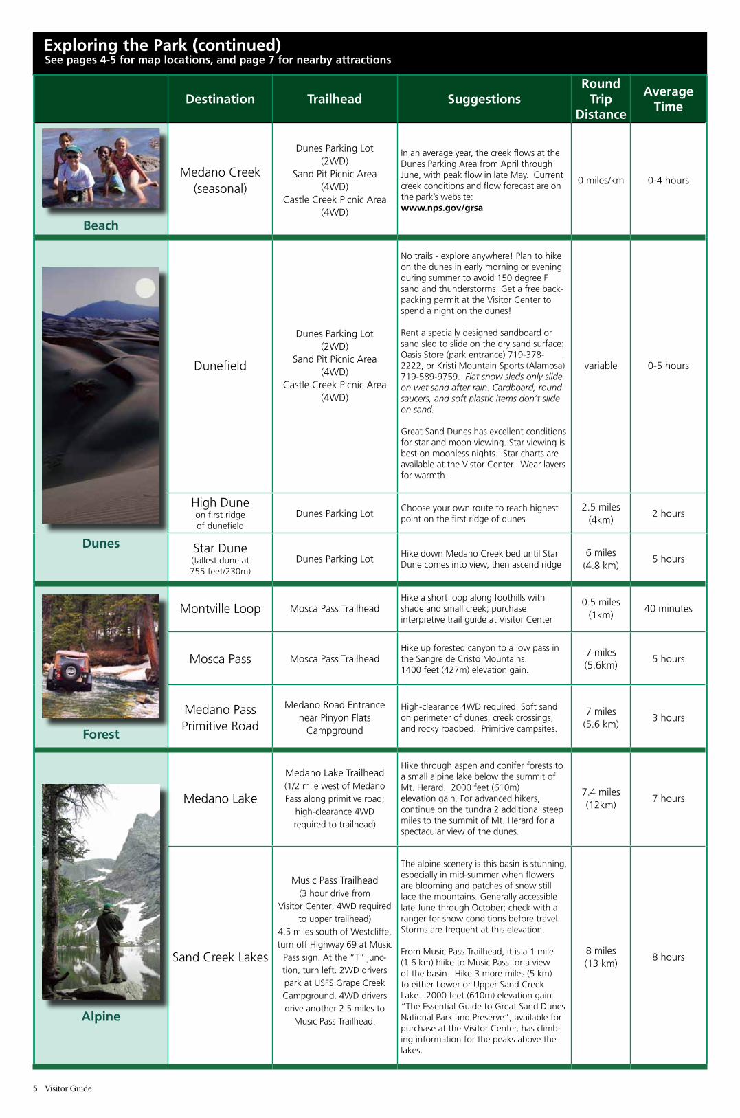
In an average year, the creek flows at the Dunes Parking Area from April through June, with peak flow in late May. Current creek conditions and flow forecast are on the park’s website: www.nps.gov/grsa
0 miles/km 0-4 hours
Dunes
Dunefield
Dunes Parking Lot (2WD)
Sand Pit Picnic Area (4WD)
Castle Creek Picnic Area (4WD)
No trails - explore anywhere! Plan to hike on the dunes in early morning or evening during summer to avoid 150 degree F sand and thunderstorms. Get a free back-packing permit at the Visitor Center to spend a night on the dunes!
Rent a specially designed sandboard or sand sled to slide on the dry sand surface: Oasis Store (park entrance) 719-378-2222, or Kristi Mountain Sports (Alamosa) 719-589-9759. Flat snow sleds only slide on wet sand after rain. Cardboard, round saucers, and soft plastic items don’t slide on sand.
Great Sand Dunes has excellent conditions for star and moon viewing. Star viewing is best on moonless nights. Star charts are available at the Vistor Center. Wear layers for warmth.
variable 0-5 hours
High Dune on first ridge of dunefield
Dunes Parking Lot Choose your own route to reach highest point on the first ridge of dunes
2.5 miles(4km)
2 hours
Star Dune (tallest dune at 755 feet/230m)
Dunes Parking Lot Hike down Medano Creek bed until Star Dune comes into view, then ascend ridge
6 miles(4.8 km)
5 hours
Forest
Montville Loop Mosca Pass TrailheadHike a short loop along foothills with shade and small creek; purchase interpretive trail guide at Visitor Center
0.5 miles(1km)
40 minutes
Mosca Pass Mosca Pass TrailheadHike up forested canyon to a low pass in the Sangre de Cristo Mountains. 1400 feet (427m) elevation gain.
7 miles(5.6km)
5 hours
Medano Pass Primitive Road
Medano Road Entrance near Pinyon Flats
Campground
High-clearance 4WD required. Soft sand on perimeter of dunes, creek crossings, and rocky roadbed. Primitive campsites.
7 miles(5.6 km)
3 hours
Alpine
Medano Lake
Medano Lake Trailhead(1/2 mile west of Medano Pass along primitive road;
high-clearance 4WD required to trailhead)
Hike through aspen and conifer forests to a small alpine lake below the summit of Mt. Herard. 2000 feet (610m) elevation gain. For advanced hikers, continue on the tundra 2 additional steep miles to the summit of Mt. Herard for a spectacular view of the dunes.
7.4 miles(12km)
7 hours
Sand Creek Lakes
Music Pass Trailhead(3 hour drive from
Visitor Center; 4WD required to upper trailhead)
4.5 miles south of Westcliffe, turn off Highway 69 at Music
Pass sign. At the “T” junc-tion, turn left. 2WD drivers park at USFS Grape Creek Campground. 4WD drivers drive another 2.5 miles to
Music Pass Trailhead.
The alpine scenery is this basin is stunning, especially in mid-summer when flowers are blooming and patches of snow still lace the mountains. Generally accessible late June through October; check with a ranger for snow conditions before travel. Storms are frequent at this elevation.
From Music Pass Trailhead, it is a 1 mile (1.6 km) hiike to Music Pass for a view of the basin. Hike 3 more miles (5 km) to either Lower or Upper Sand Creek Lake. 2000 feet (610m) elevation gain. “The Essential Guide to Great Sand Dunes National Park and Preserve”, available for purchase at the Visitor Center, has climb-ing information for the peaks above the lakes.
8 miles(13 km)
8 hours
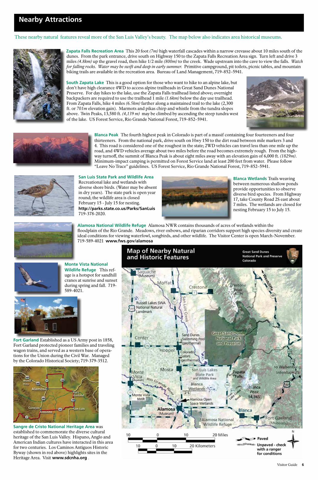
These nearby natural features reveal more of the San Luis Valley’s beauty. The map below also indicates area historical museums.
Zapata Falls Recreation Area This 20 foot (7m) high waterfall cascades within a narrow crevasse about 10 miles south of the dunes. From the park entrance, drive south on Highway 150 to the Zapata Falls Recreation Area sign. Turn left and drive 3 miles (4.8km) up the gravel road, then hike 1/2 mile (800m) to the creek. Wade upstream into the cave to view the falls. Watch for falling rocks. Water may be swift and deep in early summer. Primitive campground, pit toilets, picnic tables, and mountain biking trails are available in the recreation area. Bureau of Land Management, 719–852–5941.
Nearby Attractions
Visitor Guide 6
San Luis State Park and Wildlife Area Recreational lake and wetlands with diverse shore birds. (Water may be absent in dry years). The state park is open year round; the wildlife area is closed February 15 - July 15 for nesting. http://parks.state.co.us/Parks/SanLuis 719-378-2020.
Monte Vista National Wildlife Refuge This ref-uge is a hotspot for sandhill cranes at sunrise and sunset during spring and fall. 719-589-4021.
Alamosa National Wildlife Refuge Alamosa NWR contains thousands of acres of wetlands within the floodplain of the Rio Grande. Meadows, river oxbows, and riparian corridors support high species diversity and create ideal conditions for viewing waterfowl, songbirds, and other wildlife. The Visitor Center is open March-November. 719-589-4021 www.fws.gov/alamosa
Zapata Falls
South Zapata Lake This is a good option for those who want to hike to an alpine lake, but don’t have high clearance 4WD to access alpine trailheads in Great Sand Dunes National Preserve. For day hikes to the lake, use the Zapata Falls trailhead listed above; overnight backpackers are required to use the trailhead 1 mile (1.6km) below the day use trailhead. From Zapata Falls, hike 4 miles (6.5km) farther along a maintained trail to the lake (2,300 ft. or 701m elevation gain). Marmots and pikas chirp and whistle from the tundra slopes above. Twin Peaks, 13,580 ft. (4,139 m) may be climbed by ascending the steep tundra west of the lake. US Forest Service, Rio Grande National Forest, 719–852–5941.
Blanca Peak The fourth highest peak in Colorado is part of a massif containing four fourteeners and four thirteeners. From the national park, drive south on Hwy 150 to the dirt road between mile markers 3 and 4. This road is considered one of the roughest in the state; 2WD vehicles can travel less than one mile up the road, and 4WD vehicles average about two miles before the road becomes extremely rough. From the high-way turnoff, the summit of Blanca Peak is about eight miles away with an elevation gain of 6,000 ft. (1829m). Minimum-impact camping is permitted on Forest Service land at least 200 feet from water. Please follow “Leave No Trace” guidelines. US Forest Service, Rio Grande National Forest, 719–852–5941.
Blanca Wetlands Trails weaving between numerous shallow ponds provide opportunities to observe diverse bird species. From Highway 17, take County Road 2S east about 7 miles. The wetlands are closed for nesting February 15 to July 15.
Fort Garland Established as a US Army post in 1858, Fort Garland protected pioneer families and traveling wagon trains, and served as a western base of opera-tions for the Union during the Civil War. Managed by the Colorado Historical Society; 719-379-3512.
Sangre de Cristo National Heritage Area was established to commemorate the diverse cultural heritage of the San Luis Valley. Hispano, Anglo and American Indian cultures have interacted in this area for two centuries. Los Caminos Antiguos Historic Byway (shown in red above) highlights sites in the Heritage Area. Visit www.sdcnha.org .

7 Visitor Guide
A hiker shares the view in Sand Creek Basin, part of Great Sand Dunes National Preserve. See pages 4-7 for ways to explore this diverse park.
Great Sand Dunes National Park and Preserve11999 Highway 150Mosca, Colorado 81146General information (recorded, 24 hours) 719-378-6300Visitor Center and bookstore 719-378-6399www.nps.gov/grsaemail: [email protected]
E X P E R I E N C E Y O U R A M E R I C A
Science News
Innovative Mapping Tool Gives New Insight into Great Sand Dunesby Andrew Valdez, Park Geologist
Great Sand Dunes is one of this country’s most unique and complicated landscapes. Thanks to a new mapping technique known as LiDAR (Light Detection and Ranging) the National Park Service now has an accurate map of the Park and Preserve’s complex topography. The LiDAR mapping occurred in September 2011 as part of a U. S. Geological Survey project that mapped the San Luis Valley, (an area the size of Connecticut!). The mapping was done by an airplane flying over the park with a laser that scanned the ground below. The result of this mapping technique, provides NPS staff with a more accurate snapshot of the topography. Since the dunes shift each year, the dunefield portion of the LiDAR map is not as current as other areas.
So how is having such an accurate map useful? First, it helps the NPS staff answer visitor’s questions accurately. How much sand is in the sand dunes? Lots of answers to that question were just estimations. Examples include there’s enough sand to fill a train that would circle the Earth 20 times or to cover one tenth of Colorado ankle deep. Other calculations based on topographic maps yield an answer of 4.3 billion cubic meters. Thanks to LiDAR mapping we can say with much more confidence that the answer is: 1.5 cubic miles or 6.5 billion cubic meters!
Another question staff can more accurately answer is “How tall are the sand dunes?” We’ve known for a while that the biggest dune, Star Dune, is around 750 feet (230 meters) tall which is measured by yearly surveys. Thanks to LiDAR we know the heights of all the dunes. Did you know there are five dunes that are over 700 feet tall? And thirty-seven dunes over 600 feet tall.
Accurate elevations also help when planning construction or maintenance projects within the park and preserve boundaries. Information such as how high will a pump have to pump water to reach a storage tank, or how much fill material will be needed to build a parking lot can easily be answered with the LiDAR data often saving the expense of doing traditional surveys. It can also be used to locate fault lines and those areas can be avoided or planned for if construction crosses them.
Lastly, its scientific application is great. The dunes are believed to have their sand supplied by a lake that only exists during wet periods. The lake is currently dry, but with LiDAR data, the depression that the lake would fill can be determined to show the relationship between the lake location and the sand dunes. Glimpses to past climatic conditions can be understood by mapping the extent of glaciers, heights of trees in a forest, and what kinds of slopes favor certain plants can all be aided with this data.
It can also help discover new features. At the north end of the Park is the Crestone Crater. A bowl shaped depression that’s about 300 feet (100 meters) across and of unknown origin. Thanks to LiDAR, other craters have been found in that area hidden by trees. So, LiDAR has greatly aided in the Park’s ability to understand and protect its resources.
New aerial Lidar scanning of the dunefield shows there are five dunes taller than “High Dune”.