vitae - nmsu department of geographygeography.nmsu.edu/people/faculty/docs/cv_demers.pdfph.d.,...
TRANSCRIPT
VITAE
Michael N. DeMers Department of Geography, New Mexico State University
MSC MAP, P.O. Box 30001 Las Cruces, NM 88003
(575) 496-5231 DATE:11/6/2015 E-Mail: [email protected] EDUCATION GCERT, Online Teaching and Learning, NMSU, 2007
Ph.D., Geography, University of Kansas, 1985
M.Phil., Geography, University of Kansas, 1983
M.S., Geography, University of North Dakota, 1980
B.S.Ed., Earth Science, University of North Dakota, 1974
CERTIFICATES
2016 Quality Matters Certified Course Evaluator
2015 Geographic Information System Professional (GISP)
2013 National Certificate of Course Recognition - Fundamentals of Geographic Information
Systems (Quality Matters).
Teachers Teaching Teachers GIS (T3G) Institute Certificate (Esri)
2012 Introduction to Scripting in Unity (Digital Tutors)
Introduction to Unity (Digital Tutors)
2011 Blended Learning: Using the HyFlex Course and Design Process (Sloan-C)
2010 Learning ArcGIS Desktop (ESRI)
Creating and Editing Geodatabase Topology with ArcGIS Desktop (ESRI)
2009 Planning for a GIS (ESRI)
POSITIONS HELD 2011-present, Professor, Geography, New Mexico State University
2009-2012, Courtesy Professor, Survey Engineering, Texas A&M, Corpus Christi. 1996-2011, Associate Professor, Geography, New Mexico State University 2000-2004, Department Head, Geography, New Mexico State University
1993-1996, Assistant Professor, Geography, New Mexico State University Assistant Professor, Survey Engineering, New Mexico State University
1991-1993, Courtesy Assistant Professor, Graduate Program in Environmental
Science, The Ohio State University 1986-1993, Assistant Professor, Geography, The Ohio State University 1985-1986, Assistant Professor, Geography, North Texas State University 1983-1984, Assistant Professor, Dept. of Geography, Mankato State University SCHOLARSHIPS AND AWARDS Quality Matters (QM) Certification, Geography 481 (Fundamentals of GIS), 2013 Distinguished Alumni Award, University of North Dakota, 2013 Teaching Innovation Award, New Mexico State University Teaching Academy, 2011 James R. Anderson Medal of Honor in Applied Geography, 2010 Who’s Who in America, Summer, 2006
Who’s Who in Social Science Education, Fall, 2004 Highest Award for Achievement, Dale Carnegie Training, Fall, 2003. Certificate of Completion, Dale Carnegie Course, Fall, 2003. Teacher of the Year Nomination, Arts and Sciences, Ohio State, Spring, 1990. PUBLICATIONS: BOOKS / MONOGRAPHS / AND BOOK CHAPTERS
DeMers, Michael N., 2017, Fundamentals of Geographic Information Systems 5th Edition, New
York, John Wiley and Sons, Inc., 2017 (in preparation) DeMers, Michael N., 2016, GIS in Action, New York, John Wiley & Sons, Inc. (in production) DeMers, Michael N., 2015. Developing a Quest-Based GIS Course, Chapter in Ahlquist, O. and
C. Schlieder, Geogames and Geoplay: Game-based Approaches to Geo-Information, Springer, (invited chapter under review).
DeMers, Michael N., 2015. Zoogeography, Chapter in The Wiley-AAG International
Encyclopedia of Geography: People, the Earth, Environment, and Technology (in Press). DeMers, Michael N., 2015. Geography education, Trends and opportunities in digital and online
teaching and learning, Chapter in The Wiley-AAG International Encyclopedia of Geography: People, the Earth, Environment, and Technology (in Press).
DeMers, Michael N., 2015. Cartesian Coordinate Systems, Chapter in The Wiley-AAG
International Encyclopedia of Geography: People, the Earth, Environment, and Technology (in Press).
DeMers, Michael N. 2011. Subject Matter Content Creation for Second Life Delivery: Teaching
GIS in Second Life, Chapter 22 (pages 414-432) in James Braman and Giovonni Vincenti (eds), Teaching Through Multi-User Virtual Environments: Applying Dynamic Elements to the Modern Classroom.
DeMers, Michael N. 2010. Linking MUVE Education and Best Educational Practices, Chapter in
James Braman and Giovonni Vincenti (eds). Multi-User Virtual Environments for the Classroom: Practical Approaches to Teaching in Virtual Worlds (chapter 1).
DeMers, Michael N., 2010. GIS Modeling in Raster, Arabic Translation, New York, John Wiley
& Sons, Inc. DeMers, Michael N., 2010, “A Hitchhicker’s Guide to Geographic Information Systems: A
Multidisciplinary Introduction to the Subject,” Chapter 4, pp. 25-40, The Manual of GIS, American Society for Photogrammetry and Remote Sensing
DeMers, Michael N., GIS For Dummies, 2008, New York, John Wiley and Sons, Inc. DiBiase, David, Michael DeMers, Ann Johnson, Karen Kemp, Ann Taylor Luck, Brandon Plew
and Elizabeth Wentz, 2008, “Supporting Curriculum Development in Geographic Information Science and Technology: The GIS&T Body of Knowledge,” Chapter 62, pp. 1261-1271, The Manual of GIS, American Society for Photogrammetry and Remote Sensing.

DeMers, Michael N., 2008, . Fundamentals of Geographic Information Systems, 4th Edition,
New York, John Wiley and Sons, Inc., 2008. DiBiase, D., Michael DeMers, et al., (Editors), 2006. The Geographic Information Science and
Technology Body of Knowledge, Association of American Geographers, Monograph. DeMers, Michael N., 2005. Fundamentals of Geographic Information Systems, 2nd Edition,
Chinese Translation., New York, John Wiley & Sons, Inc. DeMers, Michael N., 2004. Fundamentals of Geographic Information Systems, 3rd Edition, New
York, John Wiley and Sons, Inc. DeMers, Michael N., 2003. Fundamentals of Geographic Information Systems, 2nd Edition
(Revised with integrated laboratory exercises), New York, John Wiley and Sons, Inc., 636 pp.
DeMers, Michael N., 2002. GIS Modeling in Raster, New York, John Wiley & Sons, Inc. DeMers, Michael N., 2000. Fundamentals of Geographic Information Systems, 2nd Edition,
New York, John Wiley and Sons, Inc., 512 pp. DeMers, Michael N., 2000, Exercises in Geographic Information Systems, New York, John
Wiley & Sons, Inc., 141 pp. DeMers, Michael N., 1999, Fundamentals of Geographic Information Systems, Moscow,
(Russian Translation), John Wiley & Sons, Inc. DeMers, Michael N., 1997. Fundamentals of Geographic Information Systems, New York, John
Wiley and Sons, Inc., 504 pp. DeMers, Michael N., 1995. "A GIS Design for Preserving Phytodiversity," in Tod F. Stuessy
(ed.) Sampling the Green World: Innovative Concepts and Methods for Collection, Preservation and Storage of Phytodiversity, Columbia University Press, New York.
DeMers, Michael N., 1994. "Requirements Analysis for GIS LESA Implementation," in
Frederick Steiner, James Pease and Robert Coughlin (eds.) A Decade With LESA, Selected Papers from the 1st National LESA Conference, March 26-28, 1993, Kansas City, MO.
PUBLICATIONS: ARTICLES AND PROCEEDINGS DeMers, Michael N. 2016. Spatio-Temporal Analysis of K-12 Education in New Mexico,
Professional Geographer (in preparation).

DeMers, Michael N. and Joseph Kerski, 2016, Effectiveness of T3G Professional Development:
The First Ten Years, Journal of Geography (in preparation). Parra, Julia, DeMers, Michael N., Raymond Carr, 2015, Designing for Engaged Learning in GIS
Courses Through Online, Hybrid/Blended and Collaborative Models, Research in Geography Education Online, (in preparation).
DeMers, Michael N. 2015. Recoupling Theory and Application: Legitimizing U.S. Academic
Applied Geography, Applied Geography, (under review). Bearman, N., N. Jones, Andre, I, Cachinho, H, and DeMers, M., 2015. The Future of GIS
Education in Creating Critical Spatial Thinkers, Journal of Geography in Education (in press).
DeMers, Michael N., 2015. Categorical Boundary Analysis: Sorting Out Terminology and
Methodologies, Proceedings GEOTHINK Conference, Athens, (in press). DeMers, Michael N. 2015. Teaching the Complexities of Map Boundaries. Lecture Notes in
Computer Science, Proceedings of the COSIT conference, (in press). DeMers, Michael N., 2015. Revisiting Classical Land Classification, Assessment, and
Management Literature to Inform GIS Research, Proceedings of the Retro Colloquium, Redlands, CA. http://wellar.ca/wellarconsulting/COLLOQUIUM_PROCEEDINGS.pdf.
DeMers, Michael N., 2014. Land Classification Research: Retrospective and Prospects,
International Journal of Applied Geospatial Research, 5(3): 82-92. DeMers, Michael N. 2014, The ConnectED Initiative and Geography Education 11(4):174-175. DeMers, Michael N. 2014. ELA Connections. The Geography Teacher 11(3):116-117. DeMers, Michael N. 2014. Collaboration Possibilities, The Geography Teacher 11(2):80-81. DeMers, Michael N. 2014. There’s Geography in My Science, The Geography Teacher 11(1):
41-42. Ahearn, S., I. Ilknur, R. Datta, M. DeMers, B. Plewe, and A. Skupin, 2013. Re-Engineering the
GIS&T Body of Knowledge, International Journal of Geographical Information Science, 27(11):2227-2245. [http://www.tandfonline.com/doi/full/10.1080/13658816.2013.802324#.UkYzsBaq7l1].
DeMers, M.N., 2013. A Geodesign Exercise: First Experiences. Proceedings, ESRI Education
User Conference, paper 1267. (http://proceedings.esri.com/library/userconf/educ13/papers/1267_27.pdf)
Al-Ajlouni, M., VanLeeuwen, M, DeMers, and St. Hilaire, R., 2013. A Method to
Quantitatively Classify Residential Urban Landscapes in A Desert Environment, Horticultural Technology, 23(4): 474-481.
DeMers, M.N., et al. 2013. Toward an Immersive 3D Virtual BoK Exploratorium: A Proof of
Concept, Transactions in GIS 17(3):335-352. DeMers, Michael N., 2012. Preliminary Analysis of GIS Workforce Education: Linking
Practitioners with Educators, Papers of the Applied Geography Conferences, 35, 41-49. Mohamed, A.H., J. L. Holechek, D. W. Bailey, C. L. Campbell, and M. N. DeMers, 2011.
"Mesquite encroachment impact on southern New Mexico rangelands: remote sensing and geographic information systems approach," J. Appl. Remote Sens. 5, 053514.
Dugas, D., Michael N. DeMers, Janet C. Greenlee, Walter G. Whitford, and Anna
Klimaszewski-Patterson), 2011. Rapid Evaluation of Arid Lands (REAL): A Methodology, International Journal of Applied Geospatial Research 2(3):32-49.
DeMers, Michael N., Martha Roditti, Madeline, Gillette, and Zach Edwards, 2010. Spatio-
Temporal Dimensions of Rural Family Violence: Initial Observations from Doña Ana County, New Mexico, Papers of the Applied Geography Conferences 33, 213-220.
DeMers, Michael N., Daniel P. Dugas, Walter G. Whitford, and Janet Greenlee, 2010,
Landform-based Eco-Regional Mapping in Arid Environments: Lessons from the Chihuahuan Desert, Papers of the Applied Geography Conferences 33, 1-8.
DeMers, Michael N., 2010. Second Life as a Surrogate for Experiential Learning, International
Journal of Virtual and Personal Learning Environments 1(2):17-31. DeMers, Michael N. 2010. Coyote Teaching in Geographic Education, Journal of Geography
109(2):1- 8. DeMers, Michael N., Daniel P. Dugas, Walter G. Whitford, and Janet Greenlee, 2010.
Landform-based Eco-regional Mapping in Arid Environments: Lessons from the Chihuahuan Desert, Papers of the Applied Geography Conferences 33:1-8.
DeMers, Michael N. 2009. Using Intended Learning Objectives to Assess Curriculum Materials:
the UCGIS Body of Knowledge. Journal of Geography in Higher Education, 33(Suppl):1-8.
DiBiase, David; DeMers, Michael; Johnson, Ann; Kemp, Karen; Luck, Ann Taylor; Plewe,
Brandon; Wentz, Elizabeth, 2007. Introducing the First Edition of the GIS&T Body of Knowledge, Cartography and Geographic Information Systems, 34(2):113-120.
Northcott, Jason, Mark C. Andersen, Gary W. Roemer, Ed L. Fredrickson, Michael DeMers, Joe
Truett, and Paulette L. Ford, 2007. Spatial Analysis of Effects of Mowing and Burning on Colony Expansion in Reintroduced Black-Tailed Prairie Dog (Cynomys ludovicianus), Restoration Ecology 16(3): 495-502.
DeMers, Michael N., and Jeffrey S. Vincent, 2007, “ArcAtlas in the Glassroom: Pattern
Identification, Description, and Explanation,” Journal of Geography, 106: 277-284. Johnson, A., K. Kemp, B. Plewe, and M. DeMers, 2006. Developing GIS Curricula UCGIS
Body of Knowledge, 2006., Proceedings, Fifth European GIS Education Seminar, Sept. 7-10, 2006, Cracow-Pieniny, Poland,
DeMers, M.N., 2005, “Coyote Medicine: Tricking Your GIS students into Learning,”
Proceedings ESRI Education User Conference, San Diego, CA. http://proceedings.esri.com/library/userconf/educ05/papers/pap1934.pdf
DeMers, M.N., 2004, “Bloom’s Taxonomy and the UCGIS Model Curriculum Learning
Objectives,” Proceedings ESRI Education User Conference, San Diego, CA. http://proceedings.esri.com/library/userconf/educ04/papers/pap5112.pdf
DeMers, Michael N., 1999, “Integrating GIS Into the K-12 Curriculum,” Education West
3(2):24-25. DeMers, Michael N., John W. Simpson, Ralph E.J. Boerner, Alejandra Silva, Leslie A. Berns
and Francisco J. Artigas, 1996. "Fencerows, Edges, and Implications of Changing Connectivity: A Prototype on Two Contiguous Ohio Landscapes," Conservation Biology 9(5):1159-1168.
Boerner, Ralph E.J., Michael N. DeMers, John W. Simpson, Francisco J. Artigas, Alejandra
Silva and Leslie A. Berns, 1996. "A Markov Chain Model of Land Use Inertia and Dynamism on Two Contiguous Ohio Landscapes," Geographical Analysis 28(1):56-66..
Simpson, John W., Ralph E.J. Boerner, Michael N. DeMers, Leslie A. Berns, Francisco J.
Artigas and Alejandra Silva, 1994. "48 Years of Landscape Change on Two Contiguous Ohio Landscapes" Landscape Ecology 9(4):261-270.
Boryslawski, Z.R., P.S. Curtis and M.N. DeMers, 1993. "The Olawa Watershed Project:
Incorporating Wetlands and Water Quality into Geographic Information Systems," In, A. Szyjikowski (ed) Campaign for Biological Restoration of the Olawa River, pp. 79-87, Polish Hydrological Society, Wroclow.

DeMers, Michael N., 1993. "Roadside Ditches as Corridors for Range Expansion of the Western
Harvester Ant," Landscape Ecology 8(2):93-102. DeMers, Michael N., 1992. "Data Dictionary for ARC/INFO Database: Vegetation of
Southeastern Mount Desert Island, Maine," The Ohio State University, Geographic Information Systems Laboratory, Technical Report.
DeMers, Michael N., 1992 "Resolution Tolerance in an Automated SCS Forest Land Evaluation
Model," Computers, Environment and Urban Systems, 16(5):389-401. DeMers, Michael N., 1991 "Classification and Purpose in Automated Vegetation Maps,"
Geographical Review, Vol. 81, No. 3, pp. 267-280. DeMers, Michael N., Peter F. Fisher, 1991 "Comparative Evolution of Statewide Geographic
Information Systems in Ohio," International Journal of Geographical Information Systems, Vol. 5, pp. 69-76.
DeMers, Michael N., 1990 "SEDRULE: A Rule Based System for Interpreting the Major Sites of
Sediment Deposition," Computers and Geosciences, Vol. 16, No. 6, pp. 833-846. DeMers, Michael N. 1990. "Adding Robustness to Linear Planning Models Through
Simulation," Technological Forecasting and Social Change, Vol. 37, No. 4, pp. 139-158. Barnes, G., M. DeMers, E. Epstein, S. Gordon, P.C. Lai, J. Loon, D. Marble, C. Merry, H.
Moellering, J. Simpson and D. Tomlin, 1990. "GIS/LIS Activities at The Ohio State University," Proceedings GIS/LIS 90.
DeMers, Michael N., 1989 "The Importance of Site Assessment in Land Use Planning: A Re-
examination of the SCS LESA Model," Applied Geography, Vol. 9, pp. 287-303. DeMers, Michael N., 1989 "Knowledge Acquisition for GIS Automation of the SCS LESA
Model: An Empirical Study," AI Applications in Natural Resource Management, (Special GIS Issue) Vol. 3, No. 4, pp. 12-22.
Fisher, Peter F. and Michael N. DeMers, 1989. "The Institutional Context of GIS: A Model for
Development," Proceedings, AUTO-CARTO 9. DeMers, Michael N. 1988. "Policy Implications of LESA Factor and Weight Determination in
Douglas County, Kansas," Land Use Policy, Vol. 5, No. 4, pp. 408-418. DeMers, Michael N. and Peter F. Fisher, 1988. "Evolution of Statewide GIS in Ohio: The
Institutional Context," The Ohio State University, Geographic Information Systems Laboratory, Technical Report, TR-88-02.
DeMers, Michael N. 1987. "Sliced Vegetation Maps," Proceedings, International Geographic
Information Systems (IGIS) Symposium: The Research Agenda, Association of American Geographers, Nov. 15-18, Arlington, VA., Vol. III, pp. 487-498.
Luckey, Donna and Michael N. DeMers 1986-1987. "A Comparative Analysis of Land
Evaluation Systems for Douglas County," Journal of Environmental Systems, Vol. 16, No. 4, pp. 259-277.
DeMers, Michael N. 1985. "The Formulation of A Rule-Based GIS Framework for County Land
Use Planning," Modeling and Simulation, Vol. 16, pp. 93-97. DeMers, Michael N. 1985. "A Knowledge Base Acquisition Strategy for Expert Geographic
Information System Development," Proceedings, Geographic Information Systems in Government Workshop, Springfield, VA, Dec. 10-13, Vol.2, pp. 837-850.
U.S. Dept. of Education 1980. Education for Cultural Understanding, University of North
Dakota, Department of Geography. DeMers, Michael N. 1980. "Moisture Balance as a Locational Factor for the Western Harvester
Ant in North Dakota," Association of North Dakota Geographers Bulletin, Vol. 30, pp. 49-67.
Bein, F., DeMers, M., et al., 1978, Impact Assessment: Columbia Road Overpass, University of
North Dakota, Dept. of Geography. DeMers, M. N. and S. E. Lee 1978. "A Brief History of the Devils Lake Area," in W. A. Dando,
et al., Climate and Man: Cyclic Water Levels and Land Use Problems in the Devils Lake Basin, University of North Dakota, Dept. of Geography Technical Report.
DeMers, M. N. and S. E. Lee 1978. "Bibliography of Devils Lake: Climate and Man," in W. A.
Dando et al., Climate and Man: Cyclic Water Levels and Land Use Problems in the Devils Lake Basin, University of North Dakota, Dept. of Geography Technical Report.
ENCYCLOPEDIA ARTICLES DeMers, M.N., 2000, “Geographic Information Systems,” Encyclopaedia Britannica DeMers, M.N., 2000, “Global Positioning Systems,” Encyclopaedia Britannica SOFTWARE REVIEWS FASTCAD, Professional Geographer, Vol. 41, No. 1, pp. 89-91 DRAFIX CAD ULTRA, Cartography and Geographic Information Systems, Vol. 17, No. 1, pp. 114-116.
BOOK REVIEWS Geographic Information Systems: Principles and Applications, Geographical Review, Vol. 93, No. 3, pp. 330-332. CONSULTING AND CONTRACT WORK 2011 – 2012
Consultant, Los Alamos National Laboratories, The Visual Simulation Baseline Experience (curricular design for educating the International Atomic Energy Commission nuclear power plant inspectors within a virtual world created using Unity 3d and Unity 4)
2011 – 2012 Chair, Geospatial Advisory Committee, 1105 Media Inc. 2009 – 2012 Mentor, Sloan-C Online Teaching Certification Program
Facilitator for the Sloan-C Online Teaching Certification. I taught Intermediate Second Life for two to four times per year. This prepares online teachers to use Multi-User Virtual Environments in their classrooms. County College Instructor. I taught GIS for Non-GIS Professionals for the Agricultural Extension Service
2008
Expert Witness: John Baca VS The State of New Mexico. I was retained by Lee E. Peters of Hubert & Hernandez, (575-526-2101). I interpreted aerial photographs using a-posteriori methods (no predisposed outcome) to determine the nature of land and water use. The State of New Mexico was attempting to remove water rights for land based on lack of use of the water for irrigation. My observations, although not conclusive in themselves, suggested that the use of periodic aerial photo interpretation was not sufficient to determine that the land had not been irrigated or used for agriculture.
2006
Evidence preparation: I was retained by the Bureau of Land Management, Las Cruces Field Office to interpret aerial photographs to determine the nature of change on the landscape, and its potential causes. The complainants (off-road driving clubs represented
by Hubert & Hernandez) argued that their use of the land was having no discernable or adverse effect on the Roblados Mountains land under control of the BLM and that the features visible on the aerial photos were natural. My observations and measurements disputed this conclusion. I determined an increased length of linear features through time and noted the development of loops that did not correspond to bedding planes nor to natural erosion cycles.
PRESENT RESEARCH INTERESTS Current research efforts involve GIScience, particularly the roots of GIS literature as it applies to supporting and teaching critical spatial thinking. I study the definition of land category boundaries and aerial differentiation theory as scientific geography. My applied research focuses on the design, teaching, and development of geographic information systems models for arid and semiarid ecosystems and habitat assessment and modeling; and floral and faunal mapping. Many of my most recent publications are based on the development and refinement of the UCGIS Body of Knowledge and revolve around new methods of delivering GIS education in an age of neo-millennial students. Finally, I am deeply concerned about the future of the discipline and am working to try to link the theoretical roots of geography to the practical applications with a view toward reinvigorating the discipline. GRANT AWARDS (total ~ 5 M) Autumn, 2015: PI: GP-IMPACT: Developing a Pathway to The Geospatial Workforce, National
Science Foundation, Under Review ($323,644). Autumn, 2015
PI: New Mexico Geographic Alliance, National Geographic Education Foundation, $27,500
Spring, 2015
PI: New Mexico Esri ConnectED Instruction, Environmental Systems Research Institute, $5,000
Autumn, 2014
PI: New Mexico Geographic Alliance, National Geographic Education Foundation, $27,500
Coordinator: New Mexico Geographic Alliance Strategic Planning Grant, National Geographic Education Foundation, $20,000.

Autumn, 2013
Coordinator: New Mexico Geographic Alliance, National Geographic Education Foundation, $27,000
Autumn, 2012
Coordinator: New Mexico Geographic Alliance, National Geographic Education Foundation, $34,000.
Spring, 2012
Coordinator: New Mexico Geographic Alliance, National Geographic Education Foundation, $32,000.
Fall, 2010 Co-PI: Foundational Research for the Geographic Information Science and Technology BoK2. National Science Foundation: ($409,000). PI: Online communities of practice for mentoring GIS&T professionals, Association of American Geographers (EDGE) and National Science Foundation: $2,000. Summer 2010 PI: Geographic Information and Technology Association $500 Spring, 2009
PI: Geographic Information and Technology Association: $750 Fall, 2008
PI: Intergraph Registered Research Laboratory (2 year renewal): $116,165. Spring, 2008
PI: Geographic Information and Technology Association: $1,000 Spring, 2007 - 2012
PI: Geographic Information and Technology Association: $1,000
Co-PI: GIS Analysis of Domestic Violence in Dona Ana County, New Mexico. Department of Justice. $850,000.
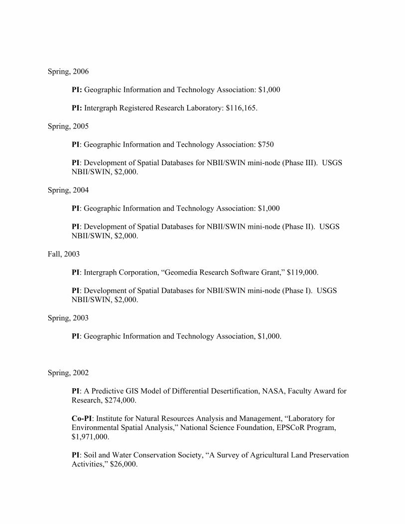
Spring, 2006 PI: Geographic Information and Technology Association: $1,000 PI: Intergraph Registered Research Laboratory: $116,165. Spring, 2005 PI: Geographic Information and Technology Association: $750
PI: Development of Spatial Databases for NBII/SWIN mini-node (Phase III). USGS NBII/SWIN, $2,000.
Spring, 2004 PI: Geographic Information and Technology Association: $1,000
PI: Development of Spatial Databases for NBII/SWIN mini-node (Phase II). USGS NBII/SWIN, $2,000.
Fall, 2003
PI: Intergraph Corporation, “Geomedia Research Software Grant,” $119,000. PI: Development of Spatial Databases for NBII/SWIN mini-node (Phase I). USGS NBII/SWIN, $2,000.
Spring, 2003
PI: Geographic Information and Technology Association, $1,000. Spring, 2002
PI: A Predictive GIS Model of Differential Desertification, NASA, Faculty Award for Research, $274,000. Co-PI: Institute for Natural Resources Analysis and Management, “Laboratory for Environmental Spatial Analysis,” National Science Foundation, EPSCoR Program, $1,971,000. PI: Soil and Water Conservation Society, “A Survey of Agricultural Land Preservation Activities,” $26,000.

PI: Geographic Information and Technology Association, $1,000. Fall, 2001
PI: Intergraph Corporation, “Educational Teaching Resources Software Grant,” $101,900.
Spring, 2001
PI: Geographic Information and Technology Association, $1,000. Spring, 1999 – Spring, 2003
Co-PI: Bureau of Land Management, Department of Defense, Cooperative Fish and Wildlife Service, “GIS and Remote Sensing Activities in support of the Aplomado Falcon relocation Program,” approximately $28,000.
Spring, 1998 - 1999
PI: Environmental Systems Research Institute, “Zoogeographical and Educational Uses of ArcAtlas,” $4,000.
Fall, 1996 – 1998
PI: Hornocker Wildlife Institute and the New Mexico Department of Game and Fish, "A Predictive GIS Model of Cougar Habitat Use in the San Andres Mountains, New Mexico," $5,962.
Fall, 1993 - Spring 1994
Cooperator: United States Department of Defense, White Sands Missile Range, and Coop. US Fish and Wildlife Service, "Feral Horse Relationships to Vegetational Communities and Wildlife Habitat in the Tularosa Basin, New Mexico," $5,000.
Fall, 1992 - Spring 1995
Co-PI and GIS Specialist, US Agency for International Development, Program in Science and Technology Cooperation, "Reclaiming Poland's Riverine Resources," $149,998.
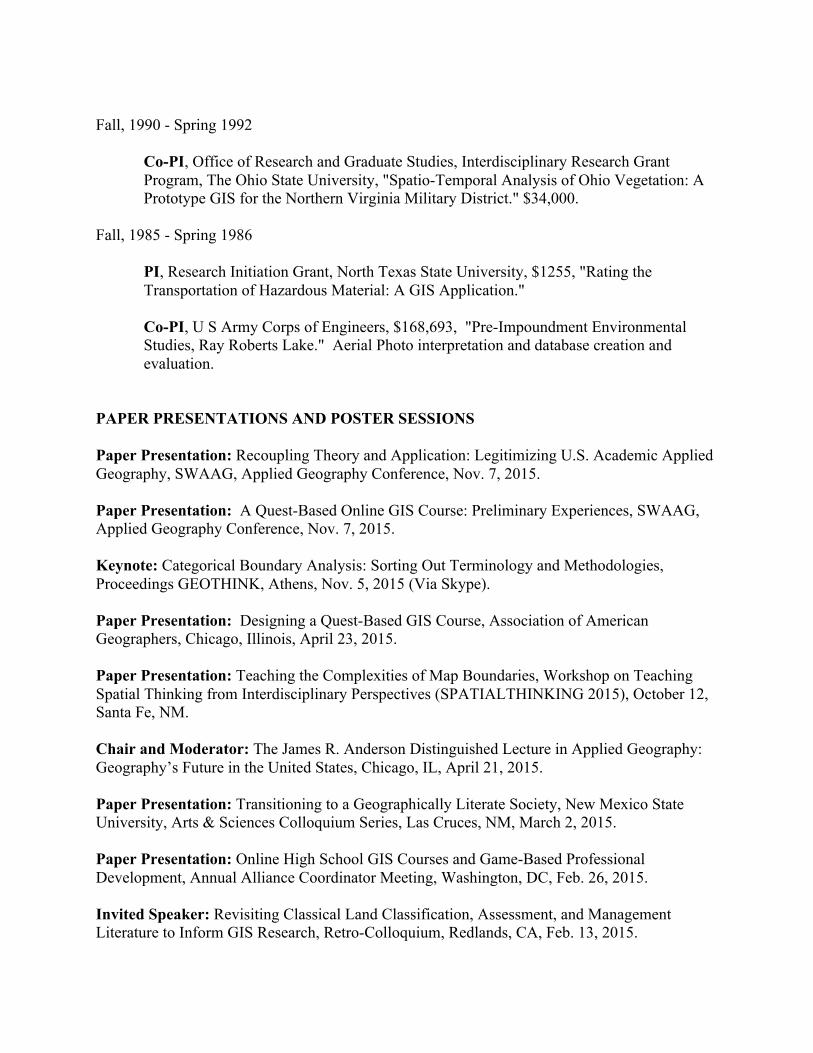
Fall, 1990 - Spring 1992
Co-PI, Office of Research and Graduate Studies, Interdisciplinary Research Grant Program, The Ohio State University, "Spatio-Temporal Analysis of Ohio Vegetation: A Prototype GIS for the Northern Virginia Military District." $34,000.
Fall, 1985 - Spring 1986
PI, Research Initiation Grant, North Texas State University, $1255, "Rating the Transportation of Hazardous Material: A GIS Application." Co-PI, U S Army Corps of Engineers, $168,693, "Pre-Impoundment Environmental Studies, Ray Roberts Lake." Aerial Photo interpretation and database creation and evaluation.
PAPER PRESENTATIONS AND POSTER SESSIONS Paper Presentation: Recoupling Theory and Application: Legitimizing U.S. Academic Applied Geography, SWAAG, Applied Geography Conference, Nov. 7, 2015. Paper Presentation: A Quest-Based Online GIS Course: Preliminary Experiences, SWAAG, Applied Geography Conference, Nov. 7, 2015. Keynote: Categorical Boundary Analysis: Sorting Out Terminology and Methodologies, Proceedings GEOTHINK, Athens, Nov. 5, 2015 (Via Skype). Paper Presentation: Designing a Quest-Based GIS Course, Association of American Geographers, Chicago, Illinois, April 23, 2015. Paper Presentation: Teaching the Complexities of Map Boundaries, Workshop on Teaching Spatial Thinking from Interdisciplinary Perspectives (SPATIALTHINKING 2015), October 12, Santa Fe, NM. Chair and Moderator: The James R. Anderson Distinguished Lecture in Applied Geography: Geography’s Future in the United States, Chicago, IL, April 21, 2015. Paper Presentation: Transitioning to a Geographically Literate Society, New Mexico State University, Arts & Sciences Colloquium Series, Las Cruces, NM, March 2, 2015. Paper Presentation: Online High School GIS Courses and Game-Based Professional Development, Annual Alliance Coordinator Meeting, Washington, DC, Feb. 26, 2015. Invited Speaker: Revisiting Classical Land Classification, Assessment, and Management Literature to Inform GIS Research, Retro-Colloquium, Redlands, CA, Feb. 13, 2015.
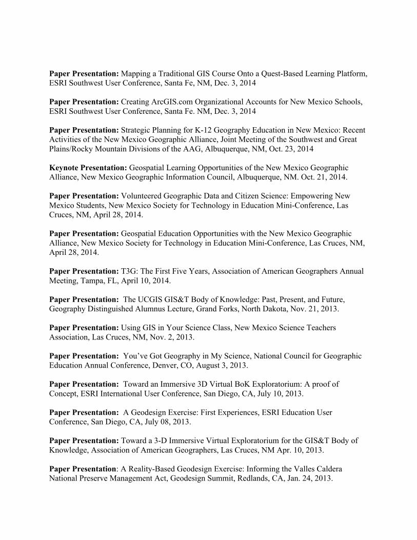
Paper Presentation: Mapping a Traditional GIS Course Onto a Quest-Based Learning Platform, ESRI Southwest User Conference, Santa Fe, NM, Dec. 3, 2014 Paper Presentation: Creating ArcGIS.com Organizational Accounts for New Mexico Schools, ESRI Southwest User Conference, Santa Fe. NM, Dec. 3, 2014 Paper Presentation: Strategic Planning for K-12 Geography Education in New Mexico: Recent Activities of the New Mexico Geographic Alliance, Joint Meeting of the Southwest and Great Plains/Rocky Mountain Divisions of the AAG, Albuquerque, NM, Oct. 23, 2014 Keynote Presentation: Geospatial Learning Opportunities of the New Mexico Geographic Alliance, New Mexico Geographic Information Council, Albuquerque, NM. Oct. 21, 2014. Paper Presentation: Volunteered Geographic Data and Citizen Science: Empowering New Mexico Students, New Mexico Society for Technology in Education Mini-Conference, Las Cruces, NM, April 28, 2014. Paper Presentation: Geospatial Education Opportunities with the New Mexico Geographic Alliance, New Mexico Society for Technology in Education Mini-Conference, Las Cruces, NM, April 28, 2014. Paper Presentation: T3G: The First Five Years, Association of American Geographers Annual Meeting, Tampa, FL, April 10, 2014. Paper Presentation: The UCGIS GIS&T Body of Knowledge: Past, Present, and Future, Geography Distinguished Alumnus Lecture, Grand Forks, North Dakota, Nov. 21, 2013. Paper Presentation: Using GIS in Your Science Class, New Mexico Science Teachers Association, Las Cruces, NM, Nov. 2, 2013. Paper Presentation: You’ve Got Geography in My Science, National Council for Geographic Education Annual Conference, Denver, CO, August 3, 2013. Paper Presentation: Toward an Immersive 3D Virtual BoK Exploratorium: A proof of Concept, ESRI International User Conference, San Diego, CA, July 10, 2013. Paper Presentation: A Geodesign Exercise: First Experiences, ESRI Education User Conference, San Diego, CA, July 08, 2013. Paper Presentation: Toward a 3-D Immersive Virtual Exploratorium for the GIS&T Body of Knowledge, Association of American Geographers, Las Cruces, NM Apr. 10, 2013. Paper Presentation: A Reality-Based Geodesign Exercise: Informing the Valles Caldera National Preserve Management Act, Geodesign Summit, Redlands, CA, Jan. 24, 2013.

Paper Presentation: A geodesign project to augment a traditional GIS course, Southwest Division, Association of American Geographers, Las Cruces, NM Oct. 25, 2012. Paper Presentation: Preliminary comparative analysis of GIS workforce education: Comparing practitioners with educators,” Applied Geography Conference, Minneapolis, MN, Oct.12, 2012. Panel: Rethinking Applied Geography – An Open Forum, Applied Geography Conference, Minneapolis, MN, Oct. 10, 2012. Paper Presentation: Designing for Engaged Learning in GIS Courses Through Online, Hybrid, and Collaborative Models, National Council for Geographic Education, San Marcos, TX, Oct. 6, 2012. Anderson Distinguished Lecture in Applied Geography: Land Classification Research: Retrospective and Prospects, Association of American Geographers Annual Meeting, Seattle, WA, June, 2012. Panelist: Developing a Conceptual Framework and Best Practices for Community Geography Research and Pedagory 4: A Focus on Educational Practices, New York, New York, June, 2012. Paper Presentation: Geographic Information Science and Technology BoK2: Foundational Research (Cyber-GIS Panel), Association of American Geographers Annual Meeting, Seattle, Washington, 2011. Paper Presentation: Geographic Information Science and Technology BoK2: Foundational Research, Milwalkee, Wisconsin, American Society for Photogrammetry and Remote Sensing, 2011. Paper Presentation: Mapping the GIS&T Body of Knowledge onto Applied Geography Curricula, Redlands, California, Applied Geography Conference, 2011. Paper Presentation: Geospatial 101: GIS as a Decision Support Tool, Washington, D.C., FOSE Conference and Exposition, 2011. Paper Presentation: Geographic Information Science and Technology BoK2: Foundational Research, Milwaukee, Wisconsin, American Society for Photogrammetry and Remote Sensing, 2011. Paper Presentation: Making Geography Exercises With Short Movie Clips, Portland, Oregon, National Council for Geographic Education annual meeting, August 4, 2011. Invited Presentation: Geospatial 101: GIS as a Decision Support Tool, Washington, D.C., FOSE Conference and Exposition, July 20, 2011.

Paper Presentation: Creating Communities of Practice for GIS Education, Seattle, WA, Association of American Geographers Annual Meeting, April 12, 2011. Paper Presentation (Workshop): Popular Media in the Geography Classroom, Microcomputers in Education Conference, Tempe, Az, March 14, 2011. Paper Presentation: Reinforcing the Base of the GIS Education Pyramid. Savannah, GA, National Council for Geographic Education annual meeting, October 2, 2010. Paper Presentation: Project-based GIS Design Education in the University. Washington, D.C., Association of American Geographers Annual Meeting, April 17, 2010. Poster Session: Using high spatial resolution satellite imagery to detect vegetation change in response to precipitation and grazing intensity in Chihuahuan Desert Rangelands. 63rd Annual Meeting of the Society for Range Management, Denver, CO, Feb. 7-11, 2010, Paper No. P-41. Paper Presentation: “Landform-based Eco-Regional Mapping in Arid Environments: Lessons from the Chihuahuan Desert,” Baton Rouge, Applied Geography Conference, October 28-30, 2009. Paper Presentation: “A Spatio-temporal Examination of Domestic Violence Indicators,” New Orleans, 10th Crime Mapping Conference, August 19-22, 2009. Paper Presentation: Using Simple Second Life Building Tools to Create Learning Objects, June 18, 2009, San Francisco, California, Sloan-C (Emerging Technologies in Education) Conference. Paper Presentation: Using Second Life to Augment an Online GIS Course, March 25, 2009, Las Vegas, Nevada, Association of American Geographers, annual meeting. Paper Presentation: “Shared Intellectual Landscapes: Teaching Science in Second Life,” June, 15, 2008, Carefree Arizona, Sloan-C (Emerging Technologies in Education) Conference. Paper Presentation: “Second Life Fireside Chats: Social Presence in Online GIS Education,” ESRI Education User Conference, August, 2008. Paper Presentation: “Spatial Correspondence Analysis of Family Violence Indicators in Dona Ana County: Preliminary Results,” National Institute of Justice Annual Meeting, Washington, DC, July, 2008. Paper Presentation: “Shared Intellectual Landscapes: Teaching Science in Second Life,” Sloan-C: Emerging Technologies in Education, Carefree, AZ, May, 2008. Paper Presentation: “Coyote Teaching: A Second Life for Online Geography Instruction,” Association of American Geographers Annual Meeting, Boston, March, 2008.
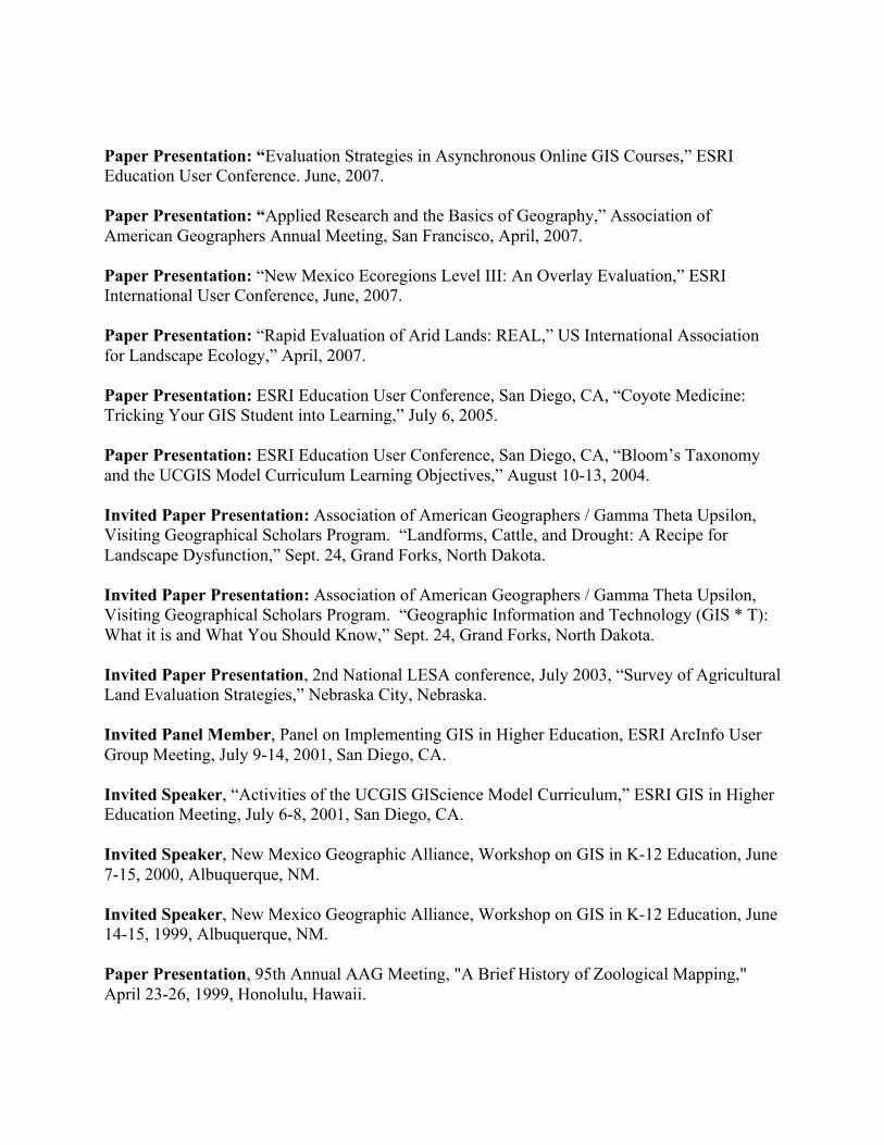
Paper Presentation: “Evaluation Strategies in Asynchronous Online GIS Courses,” ESRI Education User Conference. June, 2007. Paper Presentation: “Applied Research and the Basics of Geography,” Association of American Geographers Annual Meeting, San Francisco, April, 2007. Paper Presentation: “New Mexico Ecoregions Level III: An Overlay Evaluation,” ESRI International User Conference, June, 2007. Paper Presentation: “Rapid Evaluation of Arid Lands: REAL,” US International Association for Landscape Ecology,” April, 2007. Paper Presentation: ESRI Education User Conference, San Diego, CA, “Coyote Medicine: Tricking Your GIS Student into Learning,” July 6, 2005. Paper Presentation: ESRI Education User Conference, San Diego, CA, “Bloom’s Taxonomy and the UCGIS Model Curriculum Learning Objectives,” August 10-13, 2004. Invited Paper Presentation: Association of American Geographers / Gamma Theta Upsilon, Visiting Geographical Scholars Program. “Landforms, Cattle, and Drought: A Recipe for Landscape Dysfunction,” Sept. 24, Grand Forks, North Dakota. Invited Paper Presentation: Association of American Geographers / Gamma Theta Upsilon, Visiting Geographical Scholars Program. “Geographic Information and Technology (GIS * T): What it is and What You Should Know,” Sept. 24, Grand Forks, North Dakota. Invited Paper Presentation, 2nd National LESA conference, July 2003, “Survey of Agricultural Land Evaluation Strategies,” Nebraska City, Nebraska. Invited Panel Member, Panel on Implementing GIS in Higher Education, ESRI ArcInfo User Group Meeting, July 9-14, 2001, San Diego, CA. Invited Speaker, “Activities of the UCGIS GIScience Model Curriculum,” ESRI GIS in Higher Education Meeting, July 6-8, 2001, San Diego, CA. Invited Speaker, New Mexico Geographic Alliance, Workshop on GIS in K-12 Education, June 7-15, 2000, Albuquerque, NM. Invited Speaker, New Mexico Geographic Alliance, Workshop on GIS in K-12 Education, June 14-15, 1999, Albuquerque, NM. Paper Presentation, 95th Annual AAG Meeting, "A Brief History of Zoological Mapping," April 23-26, 1999, Honolulu, Hawaii.
Invited Speaker, ESRI Latin America, Workshop on GIS in Higher Education, Teaching GIS in Latin American Universities, April 9-11, 1999, Caracas, Venezuela. Invited Speaker, 93rd Annual AAG Meeting, "Field Work, Regional Description and the Transition to Automated Geography: Lessions Learned from the Montfort Study," April 1-5, 1997, Fort Worth, TX. Paper Presentation (co-author), 93rd Annual AAG Meeting, "A Predictive GIS Model of Cougar Habitat in the San Andres Mountains, New Mexico," April 1-5, 1997, Fort Worth, TX. Paper Presentation, 92nd Annual AAG Meeting, "Characterizing the Myrmecofauna Along an Engineered Riparian Corridor," April 13-17, 1996, Charlotte, NC. Invited Workshop Paper, 11th Annual US IALE Landscape Ecology Conference, "Zoological Mapping: First Principles and Landscape Ecological Applications," March 26-29, 1996, Galveston, TX. Paper Presentation, 91st Annual AAG Meeting, "Sympatric Speciation in Pogonomyrmex Harvester Ants," March 14-18, 1995, Chicago, IL. Poster Session, 10th Annual US IALE Landscape Ecology Conference, "A Structural Analysis of Landuse and Landcover Change along a Riparian Landscape," April 22-26, 1995, Minneapolis, MN. Paper Presentation, 90th Annual AAG Meeting, "Range Expansion of the Western Harvester Ant," March 29-April 2, 1994, San Francisco, CA. Poster Session, 9th Annual US IALE Landscape Ecology Conference, "Modeling Edge Habitat Allocation Under Differing Conditions of Connectivity," March 23-26, 1994, Tuscon, AZ. Invited Speaker, Conference on Sampling the Green World: Innovative Concepts and Methods for Collecting, Preservation and Storage of Phytodiversity, "Remote Sensing and Geographic Information Systems: Spatial Technologies for Preserving Phytodiversity," Fort Worth, TX (Nov. 19-20, 1993). Paper Presentation, 89th Annual AAG Meeting, "Hypothesis Testing of a Vector-Based Percolation Model," April 8-11, 1993, Atlanta, GA. Paper Presentation, 88th Annual AAG Meeting, "A Model of Species Response to Changing Edgescape," April 18-21, 1992, San Diego, CA. Invited Speaker, 1st National Land Evaluation and Site Assessment Conference, "Requirements Analysis for GIS LESA Implementation," March 26-28, 1992, Kansas City, MO.

Paper Presentation, 2nd Ohio ARC/INFO User's Group Meeting, "A GIS Analysis of Landcover Change in the Northern Virginia Military District," Oct. 4, 1991, Columbus, OH. Paper Presentation, Centennial Meeting, Ohio Academy of Science, "Vegetation Change in the Northern Virginia Military District, Ohio," April 26-28, 1991, Columbus, OH. Paper Presentation, 87th Annual AAG Meeting, "Pedological and Microtopographic Influences on Western Harvester Ant Range and Eastward Expansion," April 13-17, 1991, Miami, FL. Paper Presentation, 13th Annual Applied Geography Conference, "GIS Database Design for Archived Vegetation Map Information," Charlotte, North Carolina, Oct. 24-27, 1990. Paper Presentation, 5th Annual US-IALE, Landscape Ecology Symposium, "A GIS Model of Jaguar Habitat Partitioning Under Conditions of Uncertainty," Oxford, Ohio, March 20-24, 1990. Paper Presentation, 86th Annual AAG Meeting, "GIS Automation of Archived Vegetation Map Information," Toronto, Ontario, Canada, April 14-19, 1990. Invited Speaker, GTU/AAG Visiting Scientist Program, Indiana State University Department of Geography guest lecture series, "Breathing New Life Into Old Data: GIS as Archive," July 26, 1989, Terre Haute, IN. Invited Speaker, GTU/AAG Visiting Scientist Program," Research Directions in GIS," Feb. 17-18, 1989, University of North Dakota, Grand Forks, and Bemidji State University, Bemidji, MN. Paper Presentation, ASPRS/ACSM, AUTO-CARTO 9, "The Institutional Context of GIS: A Model for Development," (Peter Fisher: Senior Author), April 3-7, 1989, Baltimore, MD. Paper Presentation, West Lakes Division, AAG Meeting, "GIS: A Tool for Identifying Potential Food Shortages via Desert Locust Activity," Oct. 26-29, 1989, St. Paul, MN. Paper Presentation, 11th Annual Applied Geography Conference, "SEDRULE: A Rule-Based System for Interpreting the Major Sites of Sediment Deposition," Oct. 26-29, 1988, St. Paul, MN. Paper Presentation, Ohio Academy of Science Annual Meeting, "Statewide Geographical Information Systems in Transition: The Case of the Ohio Capability Analysis Program," April 29, 1988, Newark, OH. Paper Presentation, 84th Annual AAG Meeting, "Automating the SCS Land Evaluation Procedures for Forest Land," April 6-10, 1988, Phoenix, AZ. Paper Presentation, 3rd Annual Landscape Ecology Symposium, "Fuzzy Overlay: Foundations and Potential," March 16-19, 1988, Albuquerque, NM.
Paper Presentation, International Geographic Information Systems Symposium, Association of American Geographers, "Sliced Vegetation Maps," Nov. 15-18, 1987, Arlington, VA. Paper Presentation, 83rd Annual AAG Meeting, Portland, OR, "Fuzzy Sets, Natural Language Computation and Neighborhood Functions," April 21-26, 1987. Paper Presentation, 82nd Annual AAG Meeting, Minneapolis, MN, "Rating the Transportation of Hazardous Material: A GIS Application," May 3-7, 1986. Paper Presentation, Geographic Information Systems in Government Workshop, "A Knowledge Base Acquisition Strategy for Expert GIS Development," Dec. 10-13, 1985, Springfield, VA. Paper Presentation, Southwest Division, AAG Meeting, Denton, TX, "Implications of LESA Weight Determination in Douglas County, Kansas," Oct. 17-19, 1985. Paper Presentation, Sixteenth Annual Pittsburgh Conference on Simulation And Modeling, "The Formulation of A Rule-Based GIS Framework for County Land Use Planning," April 24-25, 1985 Poster Session, 48th North American Wildlife and Natural Resources Conference, Kansas City, MO, "The Agricultural Land Evaluation and Site Assessment (LESA) System: An Automated Approach," March 18-23, 1983. Paper Presentation, Great Plains Rocky Mountain Division, AAG Meeting, Laramie, WY, "LANDSAT Data Classification for Detection of Pine Beetle Infestation," 1982. Paper Presentation, Great Plains Rocky Mountain Division, AAG Meeting, Grand Forks, ND, "Mapping Pogonomyrmex," 1979. HONOR SOCIETIES Member: Gamma Theta Upsilon, Honorary Geographic Society Member: Sigma Xi, National Science Honor Society PROFESSIONAL SOCIETIES Fellow: Royal Geographical Society Member: Association of American Geographers Member: National Council for Geographic Education Member: National Council for the Social Studies Member: New Mexico Geographic Information Council Member: New Mexico Science Teachers Association Member: International Society for Technology in Education Member: New Mexico Society for Technology in Education

PROFESSIONAL ACTIVITIES: PROPOSAL REVIEWS
Proposal Review, NSF Geography Division, 2010, 2013, 2015 Proposal Review Team, NSF Geography Division, 2006 - 2008 Proposal Reviewer, NSF Geography Division, 2001, 2002. 2003, 2004, 2008 Proposal Reviewer, NSF Economics Division, 2000. Proposal Reviewer, New Mexico State University, Arts & Sciences, 1998-99.
Proposal Reviewer, NOAA, Coastal Change Analysis Program, 1992-1998. Proposal Reviewer, National Fish and Wildlife Foundation, 1992. Proposal Reviewer, NSF, Geography and Regional Science Division, 1989. Proposal Reviewer, NOAA, C-CAP, 1989, 1990 Proposal Reviewer, Center for Teaching Excellence, The Ohio State
University, 1986-88. PROFESSIONAL ACTIVITIES: EDITORIAL BOARDS
Editorial Board, Review of International Geography Education Online, (2012 – present) Associate Editor: Section Editor (Remote Sensing and GIS) Geography Compass (2012 – present) Associate Editor: International Journal of Virtual and Personal Learning Environments (2010 – present) Editorial Board: International Journal of Applied Geospatial Research (2011 – present) Member, Editorial Board: Geography Compass – GIScience Division (2008 – present) Task Force Member: Editorial Board, Geography Education National Implementation Project (2012 – 2013) Member, Advisory Panel, National Science Foundation, Geography and Regional Science Division, 2006 - 2008 Secretary and Editor, US-IALE Newsletter, Newsletter of the US Regional Division, International Association for Landscape Ecology, (6/1994 - 5/1996) Board of Directors, Editor, The Biogeographer, Newsletter of the AAG Biogeography Specialty Group, 3 year elected position (9/1991 - 5/1997). Editorial Review Board: Computers, Environment and Urban Systems, 1989 to December 1997.
PROFESSIONAL ACTIVITIES: EDITORIAL REVIEWS Articles reviewed for:
Review of Geography Education Online (2012) International Journal of Virtual and Personal Learning Environments (2012, 2014,2015) Papers of the Applied Geography Conferences (2012, 2013) Cartography and GIS (2011) Transactions in GIS (2011, 2012) Journal of Geography (2005, 2009, 2010, 2011, 2012, 2013, 2014) Applied Geography Conferences (2010, 2013 [3]) International Journal of Applied Geospatial Research (2010, 2013, 2014) Journal of Virtual Worlds Research (2009) Journal of Geography in Higher Education (2009 [2])
Geography Compass (2007, 2013) Annals, Association of American Geographers, (2005, 2011) Geographical Analysis (2001, 2000) Geographical Sciences (2003) Landscape Ecology (2000) Environmental Monitoring (1999) Journal of Arid Environments (1999, 2001, 2003) Landscape Ecology (1997, 1996, 1994) Int’l Journal of Geographical Information Science (2001, 1999, 1998, 1997, 1993, 1992, 1989, 2009) Photogrammetric Engineering and Remote Sensing (2005, 2003, 2002, 1996, 1995, 1994,
1993, 1991, 1990, 1989) AI Applications in Natural Resource Management (1996, 1993, 1991) Computers, Environment and Urban Systems (1992, 1990) Journal of the Soil and Water Conservation Society (1992) Computers and Geosciences (1991, 1989, 2012) Journal of Agricultural, Biological and Environmental Statistics (1997) Wetlands Journal (1997) PROFESSIONAL ACTIVITIES: REVIEW BOARDS GIS External Review Panel, Southwest Indian Polytechnic Institute (continuing) GIS External Review Panel, Technical Vocational Institute, (continuing). GIS External Review Panel, San Juan College, Farmington, (continuing) PROFESSIONAL ACTIVITIES: PROGRAM REVIEWS 2007: Northern Arizona University, Geography Department

PROFESSIONAL ACTIVITIES: OUTSIDE P&T REVIEWS 2014: C.P. Lai (University of Hong Kong) for promotion to Professor 2011: Aniruddha Banerjee (Indiana University, Purdue University at Indianapolis) -‐ for promotion to Associate and Tenure 2010: Goeffrey Duh (Portland State) – for promotion to Associate and Tenure Jun Luo (Missouri State) – for promotion to Associate and Tenure 2009: Sharolyn Anderson (University of Denver) – for promotion to Associate and Tenure PROFESSIONAL ACTIVITIES: ORGANIZATIONAL 2015 – Present – Immediate Past President, National Council for Geographic Education. 2014 – Dec. 31, 2014 – President, National Council for Geographic Education 2011 – present – Chair, Anderson Medal of Honor Committee, Association of American
Geographers 2011 – present – Delegate, Task Force, National Geography Education Implementation Project 2011 – 2014 Board, Applied Geography Conferences 2011 – Present - Alliance Coordinator, NGS New Mexico Geographic Alliance 2011 – March - July 30, 2011 – Steering Committee: National Geographic Society New Mexico Geographic Alliance 2011 – 2013 – Vice Chair (External Relations) National Council for Geographic Education 2008 – 2013 – Vice Chair: Geography Education Specialty Group, AAG 2007 – 2009 – Board member, Geography Education Specialty Group, AAG 2006 – present – Board member, Applied Geography Specialty Group, AAG 2001 – 2003 – Chair UCGIS Sponsored Programs Committee 2002 – Present: Director: Laboratory for Environmental Spatial Analysis 2002 – Present: Board of Directors, Institute for Natural Resources Assessment and
Management, EPSCoR, National Science Foundation. 2002 – Present: University Information Science Strategic Planning Committee 2001 – Present: Geography Department Capitol Campaign Development Coordinator 1999 – Organizer, Zoogeography Session, Association of American Geographers’
Annual Meeting, Honolulu, Hawaii. 1998 – 2006: Member, GIS Model Curriculum Working Group, Sponsored by University Consortium for Geographic Information Science. 1997 – 2002 – Faculty Senate, New Mexico State University 1997 – 1999: Member, Arts and Sciences Curriculum Review Committee, NMSU. 1996 – Organizer, Zoogeography Session, Association of American Geographers' Annual Meeting, Fort Worth, TX. 1994-1996 – Secretary, US Regional Division, International Association for Landscape Ecology. 1991-1997 –Member, Board of Directors, Biogeography Specialty Group, Association of American Geographers 1995 – Member Arts & Sciences Ad Hoc Committee on Social Science Education, NMSU. SW Division, Association of American Geographers Arrangements Committee Organizer: Landscape Ecology Sessions, Association of American Geographer's Annual Meeting, Charlotte, North Carolina. 1993 –1995 – Treasurer: US Division International Association for Landscape Ecology 1993 –1996 – Board Member, Biogeography Specialty Group, Association of Am. Geographers 1993 – present – Advisor, Kappi Xi Chapter, G.T.U., New Mexico State University 1995 – 1996 – Chair, Science Review Panel, NOAA Coastal Change Analysis Program. 1991 – 1997 – Member, Science Review Panel, NOAA's Coastal Change Analysis Program. 1991 – 1993 – Board of Directors, NASA Center for Mapping, The Ohio State University. 1991 – Workshop Participant, NOAA's Coastal Ocean Program - Great Lakes workshop, Coastwatch: Change Analysis Program (invited participant). Local Arrangements Chair, Geography Branch, Ohio Academy of Science. 1988 – AAG, GIS/LIS Program Committee. 1987 – 1993 – Member, Ohio Remote Sensing Steering Committee, Fall 1987-present. 1986 – 1988 – Member, Educational Enhancement Grants Review Panel, Center for Teaching Excellence, The Ohio State University. 1985 – 1986 – Associate Director, GIS Laboratory, North Texas State University. 1984 – Advisor/Organizer, Zeta Phi Chapter, G. T. U., Mankato State University. 1981 – 1983 – President, Iota Upsilon Chapter, G. T. U., University of Kansas. 1976 – 1978 – Public Relations Officer, Psi Chapter, GTU, University of North Dakota. TEACHING EXPERIENCE 1993-present: Assistant / Associate Professor / Professor, New Mexico State University GIS for Water Management GIS Design GIS Capstone Geodatabase Design Introduction to Remote Sensing
Introduction to Cartography (Cartography and GIS) World Regional Geography Map Reading and Aerial Photo Interpretation Fundamentals of Geographic Information Systems Advanced Geographic Information Systems GIS Modeling and System Design Advanced Spatial Analysis Landscape Ecology Geodatabase Design 1986-1993: Assistant Professor, The Ohio State University
Geographic Information Systems Geographical and Land Information Systems Advanced GIS Applications in Botanical Mapping and Modeling Advanced GIS Applications in Biogeographical Modeling Seminar in Geographic Information Systems Principles of Cartography Numerical Cartography Map Reading
1985-1986: Assistant Professor, North Texas State University
Physical Geology Physical Geography Geomorphology Geographic Information Systems
1984-1985 Graduate Teaching Associate (Full Responsibility) Conservation of Natural Resources 1983-1984 Assistant Professor, Mankato State University
Air Photo Interpretation Digital Remote Sensing Map Reading Geomorphology Glacial Geomorphology Seminar in Geographic Information Systems
TEACHING INTERESTS
GIScience, Land Classification, GIS applications, Spatial Statistics, GIS Education, Landscape Ecology

THESES SUPERVISED (* indicates subsequent PhD) 29. Lee, Christopher, MAG 2015, GIS in Vitaculture: An Analysis of Marginality and Wineries
in New Mexico. 28. Habrock, Christopher D., MAG 2013, An Analysis of Migration from The Caucasus to
Russia 27. *Klimaszewski-Patterson, Anna, MAG 2011. Assessing synthetic predictive vegetation
boundaries in the Chihuahuan Desert 26. Molinar, Marcos, MAG 2009, Documenting Business Requirements: A Bureau of Land
Management Field Office Approach. 25. Chacon, Jose, MAG, 2008. A GIS Design Analysis for the Las Cruces Office of the Bureau
of Land Management. 24. Gronemeyer, Peg, MAG, 2007. The Role of Vegetation Cover on the Spatial Distribution of
African Wild Dogs, Lycaon pitus. 23. Koehler, Nori L., MAG, 2007. Impacts of Cattle Grazing on Opuntia macrocentra Mounds,
in the Norther Chihuan Desert. 22. Fiori, Francis, MAG, Spring 2004. A Conceptual GIS Design for the Liquid Waste Program,
District 3, New Mexico Environment Department. 21. La Cava, Jennifer, MAG, Spring 2004. “The Impact of Roads on Adjacent Vegetation in the
Chihuahuan Desert. 20. Lanser, Julie, MAG, Summer 2003. “Spectrally Driven Predictive GIS Habitat Models for
Aplomado Falcons (Falco femoralis) in Northern Chihuahua, Mexico.” 19. *Campbell, Carol, MAG, Spring 2002. “A Descriptive Model of the Avian Community in a
Semi-arid Riparian Landscape.” 18. *Kulas, Christina, MAG, Spring 2001. “The Effects of Lehmann Lovegrass (Eragrostis
Lehmanniana) on Semiarid Desert Ecosystems: Biopedorturbation as an Ecosystem Indicator.”
17. Surface, Laura, MAG, Autumn, 1999, “Effects of Riparian Corridors on Wintering Birds
Along the Rio Grande.” 16. Hangen, James, MAG, Autumn, 1999, “A Biogeographic Survey of the Ants of the Tularosa
Valley, New Mexico.”

15. *Davis, James, MAG, Summer 1999, “Ant Biodiversity along the Rio Grande Riparian
Corridor.” 14. *Vincent, Jeffrey, MAG, Summer 1999, “A Descriptive Geographic Information System
Model of the Cotton Boll Weevil (Anthonomus Grandis Grandis) in Doña Ana County.” 13. Dappen, Patricia R., MAG., Spring 1999, "Remote Sensing Techniques to Map and Monitor
C3 and C4 Chihuahuan Desert Plant Communities Using NOAA AVHRR Satellite Data." 12. Campbell, Ralph J., MAG, Summer 1998, "A Predictive GIS Model of Cougar Habitat, San
Andres Mountains, New Mexico." 11. *Dogan, Hakan M., MAG., Spring, 1998. "Visualizing Spatio-Temporal Mesquite Variation
on Desert Grasslands Under Different Grazing Management Applications." 10. Huck, Terence W. Jr., MAG, Spring, 1998, “Evaluation of Interannual Precipitation and
NDVI Using AVHRR Satellite Data.” 9. Beavers, Michael, MAG, Autumn, 1996 "Visualizing Spatio-Temporal Forage Conditions on
a Continuously Grazed Desert Pasture." 8. Groothousen, Rhonda, MAG, Summer 1996, "A Landscape Ecological Assessment of the Rio
Grande River Corridor." 7. Gerth, Jeffrey D., MA 1993, "Towards Improved Spatial Analysis with Areal Units: The Use
of GIS to Facilitate the Creation of Dasymetric Maps." 6. Klein, Ronald J., MA 1993, "A GIS Exploration of Inertia and Dynamism in Two Ohio
Landscapes" 5. Tabler, Mary, MA 1993, "Design and Implementation of a GIS Application for Site Selection
of Sanitary Solid Waste Landfills" 4. Bremer, Richard C., MA 1992, "A Technique for the Quantification of Positional Error
Distributions for Geographic Database Feature Classes" 3. Coffeen, Stephen L., MA 1992, "GIS in Geographic Education: An Empirical Study" 2. *Thompson, James A., MA 1992, "Predicting Soil Mapping Unit Inclusion Locations Using
Detailed Topographic Data Within a Geographic Information System" 1. *Mesev, Victor T., MA 1992, "Suitability of Ancillary Data for Improving Post-Image
Classification of Mixed Hardwoods"

PROFESSIONAL ACTIVITIES: Member, Outside Review Panel, Southwest Indian Polytechnic Institute, Geospatial Information Systems Program Member, Outside Review Panel, TVI, GIS program Member, Outside Review Panel, San Juan College, GIS program Teacher Training, New Mexico Geographical Alliance, Summer, 1999, 2000 Visiting Professor, Indiana State University, NSF Summer GIS Program, 1997 Teacher Training, Ohio Geographical Alliance, Summer, 1992 Visiting Geographical Scientist, AAG/GTU, 1988-1989, 2003 PROFESSIONAL ACTIVITIES: CONSULTING
Virtual World Consultant, Los Alamos National Laboratories GIS Workshop Consultant, 1105 Media Corporation, Inc. GIS Education Consultant, GIS in Higher Education, Environmental Systems Research Institute, Spring 1998-present.
GIS Consultant, El Paso Electric Corporation, Introduction to Geographic Information Systems and AM/FM for managing their operations, (Spring 1997)
GIS Consultant, Botanical Research Institute of Texas, Review of Needs for GIS Implementation and Hiring, (Spring, 1994).
GIS Consultant, Lake Erie Geographic Information System, Product-Level Design Study, Funded by the Ohio Department of Natural Resources. (Summer, 1993)
SKILLS
Experienced in field mapping techniques, air photo interpretation, digital image processing, radar image interpretation, image segmentation, and geographic information system applications using ArcView 3.x (with extensions), ArcGIS 10, Geomedia Professional, Softchalk, Articulate, Blender, Unity3D, Unity4, Maya, Mudbox.