vive guatemala - live guatemala
DESCRIPTION
Conozca los destinos turísticos Discover the touristic destinationsTRANSCRIPT
Viv
e G
uate
mal
a
Liv
e G
uate
mal
a
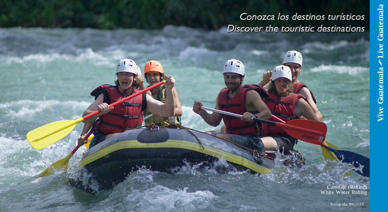
Canotaje (Rafting)White Water Rafting
Fotografía: INGUAT
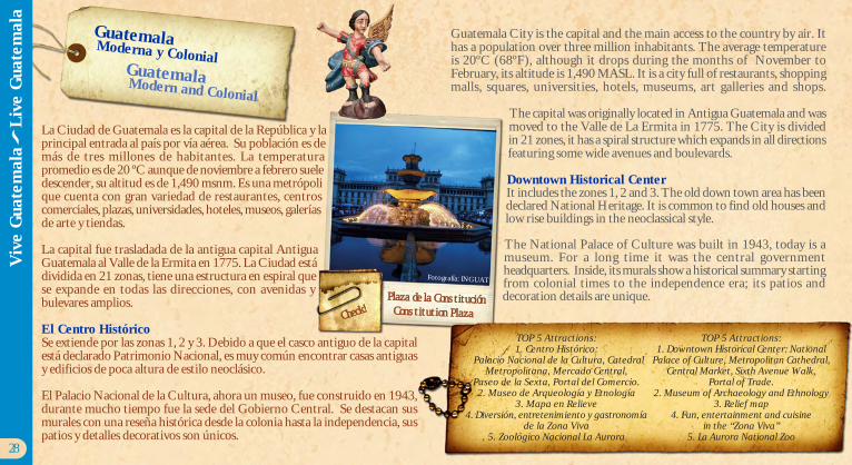
Guatemala City is the capital and the main access to the country by air. Ithas a population over three million inhabitants. The average temperatureis 20ºC (68ºF), although it drops during the months of November toFebruary, its altitude is 1,490 MASL. It is a city full of restaurants, shoppingmalls, squares, universities, hotels, museums, art galleries and shops.
The capital was originally located in Antigua Guatemala and wasmoved to the Valle de La Ermita in 1775. The City is dividedin 21 zones, it has a spiral structure which expands in all directionsfeaturing some wide avenues and boulevards.
Downtown Historical CenterIt includes the zones 1, 2 and 3. The old down town area has beendeclared National Heritage. It is common to find old houses andlow rise buildings in the neoclassical style.
The National Palace of Culture was built in 1943, today is amuseum. For a long time it was the central governmentheadquarters. Inside, its murals show a historical summary startingfrom colonial times to the independence era; its patios anddecoration details are unique.
La Ciudad de Guatemala es la capital de la República y laprincipal entrada al país por vía aérea. Su población es demás de tres millones de habitantes. La temperaturapromedio es de 20 ºC aunque de noviembre a febrero sueledescender, su altitud es de 1,490 msnm. Es una metrópolique cuenta con gran variedad de restaurantes, centroscomerciales, plazas, universidades, hoteles, museos, galeríasde arte y tiendas.
La capital fue trasladada de la antigua capital AntiguaGuatemala al Valle de la Ermita en 1775. La Ciudad estádividida en 21 zonas, tiene una estructura en espiral quese expande en todas las direcciones, con avenidas ybulevares amplios.
El Centro HistóricoSe extiende por las zonas 1, 2 y 3. Debido a que el casco antiguo de la capitalestá declarado Patrimonio Nacional, es muy común encontrar casas antiguasy edificios de poca altura de estilo neoclásico.
El Palacio Nacional de la Cultura, ahora un museo, fue construido en 1943,durante mucho tiempo fue la sede del Gobierno Central. Se destacan susmurales con una reseña histórica desde la colonia hasta la independencia, suspatios y detalles decorativos son únicos.
28
Guatemala Moderna y ColonialGuatemala Modern and Colonial
TOP 5 Attractions:1. Centro Histórico:
Palacio Nacional de la Cultura, CatedralMetropolitana, Mercado Central,
Paseo de la Sexta, Portal del Comercio.2. Museo de Arqueología y Etnología
3. Mapa en Relieve4. Diversión, entretenimiento y gastronomía
de la Zona Viva5. Zoológico Nacional La Aurora
Plaza de la ConstituciónConstitution Plaza
TOP 5 Attractions:1. Downtown Historical Center: National
Palace of Culture, Metropolitan Cathedral,Central Market, Sixth Avenue Walk,
Portal of Trade.2. Museum of Archaeology and Ethnology
3. Relief map4. Fun, entertainment and cuisine
in the “Zona Viva”5. La Aurora National Zoo
Check!
Viv
e G
uate
mal
a
Liv
e G
uate
mal
a
Fotografía: INGUAT
El Mercado Central es famoso por encontrarse losproductos representativos y artesanías guatemaltecas,ubicado detrás de la catedral Metropolitana, acudenlocales y visitantes para encontrar una amplia variedadde productos y es uno de los lugares que amerita servisitado.
Desde la Plaza Central inicia la Sexta Avenida, queha sido recientemente revitalizada y llamada el “Paseode la Sexta”, que presenta una avenida con áreapeatonal y comercios, donde se realizan actividadesculturales.
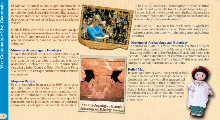
Museo de Arqueología y EtnologíaCreado desde 1948, cuenta con secciones de granriqueza arqueológica de las culturas Maya y Olmeca,con salas de los períodos preclásico, clásico ypostclásico, incluyendo escultura monumental,cerámica y jades. Ocupa el Salón No. 5 de la Finca“La Aurora”, un área que cuenta con varios museosy atracciones.
Mapa en RelieveEs una obra única, inaugurada en 1905, en un áreade 1,809 m2, representa todo el territorioguatemalteco con todos sus accidentes geográficos.Se encuentra situada en el Hipódromo del Norte,posee un alto valor estético y científico ya que fueconstruido sin las facilidades del mundo modernocomo son la fotografía aérea y la fotometría.
The Central Market is a famous place in which culturalproducts and handcrafts from Guatemala can be bought.Located behind the Metropolitan Cathedral, Guatemalansand visitors come to find a wide variety of national products;it is definitely a place worth visiting.
From Central Plaza starts the Sixth Avenue, which hasrecently been revitalized and named "Paseo de la Sexta", whichfeatures a pedestrian street with shopping areas and culturalactivities.
Museum of Archaeology and EthnologyFounded in 1948, this museum features sections of greatarchaeological wealth of the Mayan and Olmeca cultures,featuring exhibitions of the Preclassic, Classic and Postclassic
periods. It exhibits monumental sculptures, ceramics and jades.Located in building No. 5 at “La Aurora”, this is an area thatintegrates various museums and attractions.
Relief MapIt is a unique piece of work. Inaugurated in 1905,it covers an area of 1.809 m2 and depicts theGuatemalan territory with all its geographicalfeatures. It is located in the Hipodromo delNorte at the end of Avenida Simeón Cañas,Zone 2. It has a high aesthetic and scientificvalue because it was built without the modernday resources such as aerial photography andphotometry.
30
Viv
e G
uate
mal
a
Liv
e G
uate
mal
a
Fotografía: INGUAT
Museo de Arqueología y EtnologíaArchaeology and Ethnology Museum
SP
32
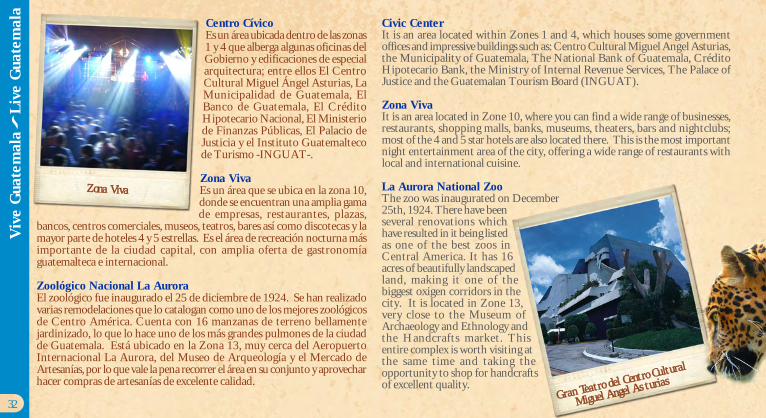
Centro CívicoEs un área ubicada dentro de las zonas1 y 4 que alberga algunas oficinas delGobierno y edificaciones de especialarquitectura; entre ellos El CentroCultural Miguel Ángel Asturias, LaMunicipalidad de Guatemala, ElBanco de Guatemala, El CréditoHipotecario Nacional, El Ministeriode Finanzas Públicas, El Palacio deJusticia y el Instituto Guatemaltecode Turismo -INGUAT-.
Zona VivaEs un área que se ubica en la zona 10,donde se encuentran una amplia gamade empresas, restaurantes, plazas,
bancos, centros comerciales, museos, teatros, bares así como discotecas y lamayor parte de hoteles 4 y 5 estrellas. Es el área de recreación nocturna másimportante de la ciudad capital, con amplia oferta de gastronomíaguatemalteca e internacional.
Zoológico Nacional La AuroraEl zoológico fue inaugurado el 25 de diciembre de 1924. Se han realizadovarias remodelaciones que lo catalogan como uno de los mejores zoológicosde Centro América. Cuenta con 16 manzanas de terreno bellamentejardinizado, lo que lo hace uno de los más grandes pulmones de la ciudadde Guatemala. Está ubicado en la Zona 13, muy cerca del AeropuertoInternacional La Aurora, del Museo de Arqueología y el Mercado deArtesanías, por lo que vale la pena recorrer el área en su conjunto y aprovecharhacer compras de artesanías de excelente calidad.
Civic CenterIt is an area located within Zones 1 and 4, which houses some governmentoffices and impressive buildings such as: Centro Cultural Miguel Angel Asturias,the Municipality of Guatemala, The National Bank of Guatemala, CréditoHipotecario Bank, the Ministry of Internal Revenue Services, The Palace ofJustice and the Guatemalan Tourism Board (INGUAT).
Zona VivaIt is an area located in Zone 10, where you can find a wide range of businesses,restaurants, shopping malls, banks, museums, theaters, bars and nightclubs;most of the 4 and 5 star hotels are also located there. This is the most importantnight entertainment area of the city, offering a wide range of restaurants withlocal and international cuisine.
La Aurora National ZooThe zoo was inaugurated on December25th, 1924. There have beenseveral renovations whichhave resulted in it being listedas one of the best zoos inCentral America. It has 16acres of beautifully landscapedland, making it one of thebiggest oxigen corridors in thecity. It is located in Zone 13,very close to the Museum ofArchaeology and Ethnology andthe Handcrafts market. Thisentire complex is worth visiting atthe same time and taking theopportunity to shop for handcraftsof excellent quality.
Zona Viva
Viv
e G
uate
mal
a
Liv
e G
uate
mal
a
Gran Teatro del Centro Cultural
Miguel Angel Asturias
Fotografía: INGUAT
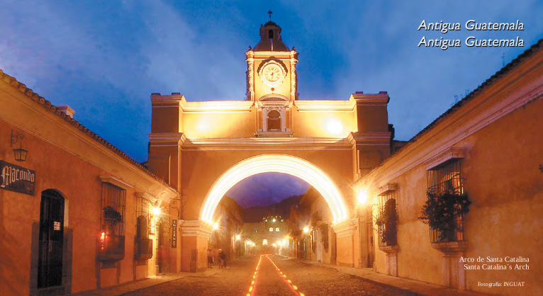
Arco de Santa CatalinaSanta Catalina´s Arch
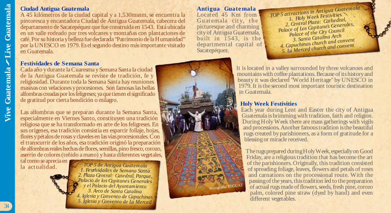
Ciudad Antigua GuatemalaA 45 kilómetros de la ciudad capital y a 1,530msnm, se encuentra lapintoresca y encantadora Ciudad de Antigua Guatemala, cabecera deldepartamento de Sacatepéquez que fue construida en 1543. Está ubicadaen un valle rodeado por tres volcanes y montañas con plantaciones decafé. Por su historia y belleza fue declarada “Patrimonio de la Humanidad”por la UNESCO en 1979. Es el segundo destino más importante visitadoen Guatemala.
Festividades de Semana SantaCada año y durante la Cuaresma y Semana Santa la ciudadde la Antigua Guatemala se reviste de tradición, fe yreligiosidad. Durante toda la Semana Santa hay reunionesmasivas con velaciones y procesiones. Son famosas las bellasalfombras creadas por los feligreses; ya que tienen el significadode gratitud por cierta bendición o milagro.
Las alfombras que se preparan durante la Semana Santa,especialmente en Viernes Santo, constituyen una tradiciónreligiosa que se ha transformado en arte de los feligreses. Ensus orígenes, esa tradición consistía en esparcir follaje, hojas,flores y pétalos de rosas y claveles en las vías procesionales. Conel transcurrir de los años, esa tradición originó la preparaciónde alfombras reales hechas de flores, semillas, pino fresco, corozo,aserrín de colores (teñido a mano) y hasta diferentes vegetales,tal como se aprecia enla actualidad.
Antigua GuatemalaLocated 45 Km fromG u a t e m a l a c i t y , t h epicturesque and charmingcity of Antigua Guatemala,built in 1543, is thedepartmental capital ofSacatepéquez.
It is located in a valley surrounded by three volcanoes andmountains with coffee plantations. Because of its history andbeauty it was declared "World Heritage" by UNESCO in1979. It is the second most important touristic destinationin Guatemala.
Holy Week FestivitiesEach year during Lent and Easter the city of AntiguaGuatemala is brimming with tradition, faith and religion.During Holy Week there are mass gatherings with vigilsand processions. Another famous tradition is the beautifulrugs created by parishioners, as a form of gratitude for ablessing or miracle received.
The rugs prepared during Holy Week, especially on GoodFriday, are a religious tradition that has become the artof the parishioners. Originally, this tradition consistedof spreading foliage, leaves, flowers and petals of rosesand carnations on the processional route. With thepassing of the years, this tradition led to the preparationof actual rugs made of flowers, seeds, fresh pine, corozopalm, colored pine straw (dyed by hand) and evendifferent vegetables.
34
TOP 5 de Antigua Guatemala1. Festividades de Semana Santa
2. Plaza Central: Catedral, Parque,Palacio de los Capitanes Generales
y el Palacio del Ayuntamiento3. Arco de Santa Catalina
4. Iglesia y Convento de Capuchinas5. Iglesia y Convento de La Merced
TOP 5 attractions in Antigua Guatemala
1. Holy Week Festivities
2. Central Plaza: Cathedral,
Palace of Los Capitanes Generales,
Palace of the City Council
3. Santa Catalina Arch
4. Capuchinas church and convent
5. La Merced church and convent
Viv
e G
uate
mal
a
Liv
e G
uate
mal
a
Fotografía: INGUAT

36
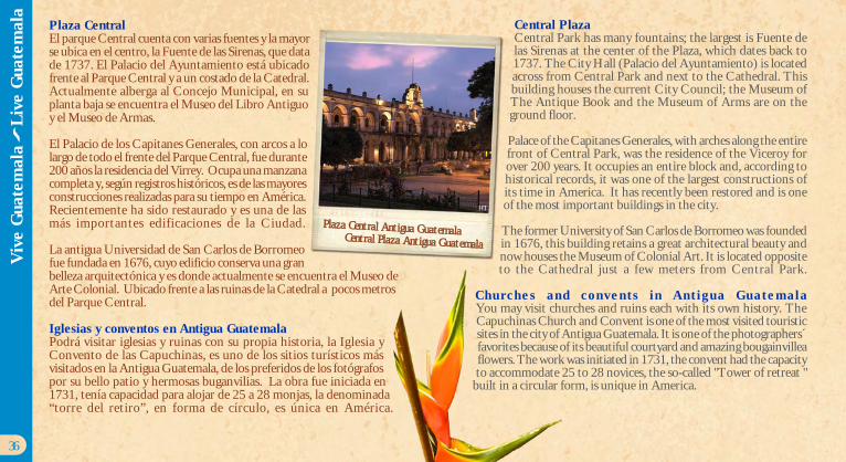
Plaza CentralEl parque Central cuenta con varias fuentes y la mayorse ubica en el centro, la Fuente de las Sirenas, que datade 1737. El Palacio del Ayuntamiento está ubicadofrente al Parque Central y a un costado de la Catedral.Actualmente alberga al Concejo Municipal, en suplanta baja se encuentra el Museo del Libro Antiguoy el Museo de Armas.
El Palacio de los Capitanes Generales, con arcos a lolargo de todo el frente del Parque Central, fue durante200 años la residencia del Virrey. Ocupa una manzanacompleta y, según registros históricos, es de las mayoresconstrucciones realizadas para su tiempo en América.Recientemente ha sido restaurado y es una de lasmás importantes edificaciones de la Ciudad.
La antigua Universidad de San Carlos de Borromeofue fundada en 1676, cuyo edificio conserva una granbelleza arquitectónica y es donde actualmente se encuentra el Museo deArte Colonial. Ubicado frente a las ruinas de la Catedral a pocos metrosdel Parque Central.
Iglesias y conventos en Antigua GuatemalaPodrá visitar iglesias y ruinas con su propia historia, la Iglesia yConvento de las Capuchinas, es uno de los sitios turísticos másvisitados en la Antigua Guatemala, de los preferidos de los fotógrafospor su bello patio y hermosas buganvilias. La obra fue iniciada en1731, tenía capacidad para alojar de 25 a 28 monjas, la denominada“torre del retiro”, en forma de círculo, es única en América.
Central PlazaCentral Park has many fountains; the largest is Fuente delas Sirenas at the center of the Plaza, which dates back to1737. The City Hall (Palacio del Ayuntamiento) is locatedacross from Central Park and next to the Cathedral. Thisbuilding houses the current City Council; the Museum ofThe Antique Book and the Museum of Arms are on theground floor.
Palace of the Capitanes Generales, with arches along the entirefront of Central Park, was the residence of the Viceroy forover 200 years. It occupies an entire block and, according tohistorical records, it was one of the largest constructions ofits time in America. It has recently been restored and is oneof the most important buildings in the city.
The former University of San Carlos de Borromeo was foundedin 1676, this building retains a great architectural beauty andnow houses the Museum of Colonial Art. It is located oppositeto the Cathedral just a few meters from Central Park.
Churches and convents in Antigua GuatemalaYou may visit churches and ruins each with its own history. TheCapuchinas Church and Convent is one of the most visited touristicsites in the city of Antigua Guatemala. It is one of the photographers´favorites because of its beautiful courtyard and amazing bougainvilleaflowers. The work was initiated in 1731, the convent had the capacityto accommodate 25 to 28 novices, the so-called "Tower of retreat "
built in a circular form, is unique in America.
HT
Plaza Central Antigua GuatemalaCentral Plaza Antigua Guatemala
Viv
e G
uate
mal
a
Liv
e G
uate
mal
a
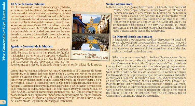
El Arco de Santa CatalinaEn el Convento de Santa Catalina Virgen y Mártir,sus internas evitaban tener contacto con las personasde la ciudad; con el crecimiento de adeptas, se hizonecesario ocupar un edificio de la cuadra ubicada alfrente. El Arco de Santa Catalina nace como soluciónpara cruzar hacia el resto del convento, y es así comose inicia su construcción en 1693. La calle es conocidapopularmente como la “Calle del Arco”, íconoinconfundible de la ciudad que crea una imagenllevada a cuadros y fotografiada incontables veces;puede contemplarse con el Volcán de Agua en sufondo.
Iglesia y Convento de la MercedEs una iglesia cuya fachada muestra un extraordinarioestilo barroco. En su atrio han pasado fotógrafosnacionales y extranjeros para capturar el detalle yminuciosos adornos sobre su entrada. En el interiordel convento puede apreciarse una de lasfuentes más grandes de la ciudad, siempre con el estilo clásico de la época.
Otros lugares recomendados en Antigua Guatemala es el Convento de SantoDomingo, en la actualidad es un hotel de lujo y cuenta con varios museos (versección de Museos de esta Guía). El Cerro de la Cruz, un paseo desde donde seobtiene una vista panorámica de la ciudad y del valle, puede ascenderse a pie oen vehículo. El Santo Hermano Pedro de San José de Betancourt, es símbolo enAntigua Guatemala donde ayudó a muchas personas, y sus obras han permanecidoen la memoria de todos. Juan Pablo II lo beatificó en 1980 y lo canonizó el 30 dejulio de 2002, siendo el primer santo guatemalteco. “La Ruta del Peregrino” seha identificado en los lugares más importantes de la vida y obra del Santo HermanoPedro de Betancourt (mapa y explicación gratuitos en la Casa del Turista, al ladodel Convento de Capuchinas en Antigua Guatemala).
Santa Catalina ArchIn the Convent of Virgin and Martir Santa Catalina, the novices avoided
contact with people; with the steady growth of followers, itbecame necessary to occupy another building on the block infront. Santa Catalina Arch was built to cross over to the rest ofthe convent, and this is how its construction started in 1693.The street is popularly known as the "Calle del Arco”, anunmistakable landmark of the city that creates an imagerepresented in paintings and photographed countless times; theAgua Volcano can be seen in the background.
La Merced church and conventIt has a facade showing an extraordinary Baroque style. Local andforeign photographers have passed thru its atrium to try to capturethe detail and meticulous decorations at the entrance. Inside themonastery you can see one of the largest fountains of the city,made in the classic style of the time.
Other places recommended in Antigua Guatemala are: SantoDomingo Convent, today a luxurious hotel with many museums(see Museums section in the “Enjoy Guatemala” section of this
Guide); Cerro de la Cruz is a walk from where you get a panoramicview of the city and valley; it can be reached on foot or by vehicle. TheSaint Brother Pedro de San José de Betancourt, is a symbol in AntiguaGuatemala where he helped many people, his work has remained in thememory of all. John Paul II beatified him in 1980 and cannonized himon July 30th, 2002, becoming the first Guatemalan saint. Today, "ThePilgrim's Route" is identified in several places of Antigua Guatemala,for those who wish to know the most important facts about the life andwork of Santo Hermano Pedro de Betancourt (ask for a free map ofthe Pilgrim´s Route at the Visitors Office Casa del Turista, next toCapuchinas Convent in Antigua Guatemala).
38
Santa Catalina´s ArchArco de Santa Catalina
CM
Viv
e G
uate
mal
a
Liv
e G
uate
mal
a
Fotografía: INGUAT
Paisajes PintorescosPintoresque Landscapes
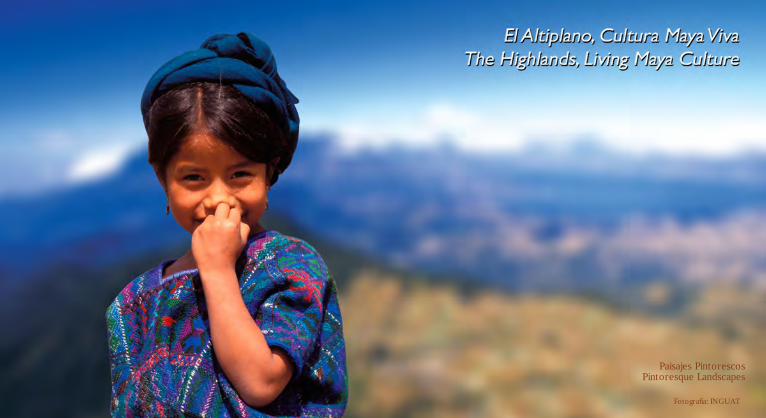
Altiplano, Cultura Maya VivaEl Altiplano de Guatemala es una de las regiones máspintorescas y diversas del país, que presenta una geografíadensa de montañas, volcanes y lagos, pequeños pobladosy ciudades importantes habitadas mayormente pordiferentes grupos mayas, que en su conjunto hacen queel visitante descubra la Cultura Maya Viva en su únicay cautivante expresión.
En cada rincón se puede vivir las tradiciones y aspectosculturales de esta región que incluye los departamentosde: Chimaltenango, Totonicapán, Sololá, Quiché,Quetzaltenango, Huehuetenango y San Marcos.
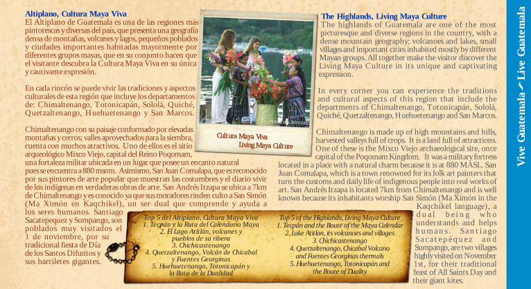
Chimaltenango con su paisaje conformado por elevadasmontañas y cerros; valles aprovechados para la siembra,cuenta con muchos atractivos. Uno de ellos es el sitioarqueológico Mixco Viejo, capital del Reino Poqomam,una fortaleza militar ubicada en un lugar que posee un encanto naturalpues se encuentra a 880 msnm. Asimismo, San Juan Comalapa, que es reconocidopor sus pintores de arte popular que muestran las costumbres y el diario vivirde los indígenas en verdaderas obras de arte. San Andrés Itzapa se ubica a 7kmde Chimaltenango y es conocido ya que sus moradores rinden culto a San Simón(Ma Ximón en Kaqchikel), un ser dual que comprende y ayuda alos seres humanos. SantiagoSacatepequez y Sumpango, sonpoblados muy visitados el1 de noviembre, por sutradicional fiesta de Díade los Santos Difuntos ysus barriletes gigantes.
The Highlands, Living Maya CultureThe highlands of Guatemala are one of the mostpicturesque and diverse regions in the country, with adense mountain geography; volcanoes and lakes, smallvillages and important cities inhabited mostly by differentMayan groups. All together make the visitor discover theLiving Maya Culture in its unique and captivatingexpression.
In every corner you can experience the traditionsand cultural aspects of this region that include thedepartments of Chimaltenango, Totonicapán, Sololá,Quiché, Quetzaltenango, Huehuetenango and San Marcos.
Chimaltenango is made up of high mountains and hills,harvested valleys full of crops. It is a land full of attractions.One of these is the Mixco Viejo archaeological site, oncecapital of the Poqomam Kingdom. It was a military fortress
located in a place with a natural charm because it is at 880 MASL. SanJuan Comalapa, which is a town renowned for its folk art painters thatturn the customs and daily life of indigenous people into real works ofart. San Andrés Itzapa is located 7km from Chimaltenango and is wellknown because its inhabitants worship San Simón (Ma Ximón in the
Kaqchikel language), ad u a l b e i n g w h ounderstands and helpsh u m a n s . S a n t i a g oS a c a t e p é q u e z a n dSumpango, are two villageshighly visited on November1st, for their traditionalfeast of All Saints Day andtheir giant kites.
Cultura Maya VivaLiving Maya Culture
Viv
e G
uate
mal
a
Liv
e G
uate
mal
a
Top 5 del Altiplano, Cultura Maya Viva1. Tecpán y la Ruta del Calendario Maya
2. El Lago Atitlán, volcanes ypueblos de su ribera3. Chichicastenango
4. Quetzaltenango, Volcán de Chicabaly Fuentes Georginas
5. Huehuetenango, Totonicapán yla Ruta de la Dualidad
Top 5 of the Highlands, Living Maya Culture1. Tecpán and the Route of the Maya Calendar
2. Lake Atitlan, its volcanoes and villages3. Chichicastenango
4. Quetzaltenango, Chicabal Volcanoand Fuentes Georginas thermals
5. Huehuetenango, Totonicapán andthe Route of Duality
Fotografía: INGUAT
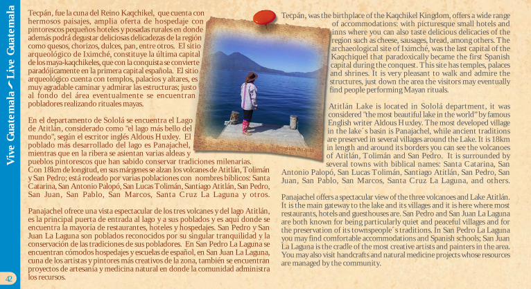
Tecpán, fue la cuna del Reino Kaqchikel, que cuenta conhermosos paisajes, amplia oferta de hospedaje conpintorescos pequeños hoteles y posadas rurales en dondeademás podrá degustar deliciosas delicadezas de la regióncomo quesos, chorizos, dulces, pan, entre otros. El sitioarqueológico de Iximché, constituye la última capitalde los maya-kaqchikeles, que con la conquista se convierteparadójicamente en la primera capital española. El sitioarqueológico cuenta con templos, palacios y altares, esmuy agradable caminar y admirar las estructuras; justoal fondo del área eventualmente se encuentranpobladores realizando rituales mayas.
En el departamento de Sololá se encuentra el Lagode Atitlán, considerado como "el lago más bello delmundo", según el escritor inglés Aldous Huxley. Elpoblado más desarrollado del lago es Panajachel,mientras que en la ribera se asientan varias aldeas ypueblos pintorescos que han sabido conservar tradiciones milenarias.Con 18km de longitud, en sus márgenes se alzan los volcanes de Atitlán, Tolimány San Pedro; está rodeado por varias poblaciones con nombres bíblicos: SantaCatarina, San Antonio Palopó, San Lucas Tolimán, Santiago Atitlán, San Pedro,San Juan, San Pablo, San Marcos, Santa Cruz La Laguna y otros.
Panajachel ofrece una vista espectacular de los tres volcanes y del lago Atitlán,es la principal puerta de entrada al lago y a sus poblados y es aquí donde seencuentra la mayoría de restaurantes, hoteles y hospedajes. San Pedro y SanJuan La Laguna son poblados reconocidos por su singular tranquilidad y laconservación de las tradiciones de sus pobladores. En San Pedro La Laguna seencuentran cómodos hospedajes y escuelas de español, en San Juan La Laguna,cuna de los artistas y pintores más creativos de la zona, también se encuentranproyectos de artesanía y medicina natural en donde la comunidad administralos recursos.
Tecpán, was the birthplace of the Kaqchikel Kingdom, offers a wide rangeof accommodations: with picturesque small hotels andinns where you can also taste delicious delicacies of theregion such as cheese, sausages, bread, among others. Thearchaeological site of Iximché, was the last capital of theKaqchiquel that paradoxically became the first Spanishcapital during the conquest. This site has temples, palacesand shrines. It is very pleasant to walk and admire thestructures, just down the area the visitors may eventuallyfind people performing Mayan rituals.
Atitlán Lake is located in Sololá department, it wasconsidered "the most beautiful lake in the world” by famousEnglish writer Aldous Huxley. The most developed villagein the lake´s basin is Panajachel, while ancient traditionsare preserved in several villages around the Lake. It is 18kmin length and around its borders you can see the volcanoesof Atitlán, Tolimán and San Pedro. It is surrounded byseveral towns with biblical names: Santa Catarina, San
Antonio Palopó, San Lucas Tolimán, Santiago Atitlán, San Pedro, SanJuan, San Pablo, San Marcos, Santa Cruz La Laguna, and others.
Panajachel offers a spectacular view of the three volcanoes and Lake Atitlán.It is the main gateway to the lake and its villages and it is here where mostrestaurants, hotels and guesthouses are. San Pedro and San Juan La Lagunaare both known for being particularly quiet and peaceful villages and forthe preservation of its townspeople´s traditions. In San Pedro La Lagunayou may find comfortable accommodations and Spanish schools; San JuanLa Laguna is the cradle of the most creative artists and painters in the area.You may also visit handcrafts and natural medicine projects whose resourcesare managed by the community.
42
Viv
e G
uate
mal
a
Liv
e G
uate
mal
a
Fotografía: INGUAT
Santiago Atitlán, del otro lado del lago, es una comunidad que conserva supersonalidad y cultura tradicional, el Ma Ximón de la cofradía de La SantaCruz, es uno de los más visitados.
Totonicapán es un departamento que cuenta con atractivos naturales como losbaños de aguas termales y los Riscos de Momostenango, declarado parquenacional. Otro de los atractivos para los visitantes, es la iglesia ubicada en SanAndrés Xecul, de estilo arquitectónico barroco popular. Son muy conocidosen San Miguel Totonicapán sus centros de producción artesanal, conciertos demúsica tradicional, morerías, entre otros. En Totonicapán se fabrican artículosde lana como frazadas, alfombras y ponchos, muy populares para proteger delfrío.
Quiché es un departamento con clima frío y templado, posee riqueza artesanaly tradiciones de cuatro grupos étnicos: El K´iche´, el Ixil (ubicado en laregión llamada Región Ixil conformado por Nebaj, Cotzal y Chajul); elPoqomchi y el Q'eqchi'. Entre sus tradiciones se encuentra la de “El PaloVolador” y “El Torito”, especialmente durante las fiestas patronalesde Joyabaj en agosto. Sus coloridos trajes regionales sonimpresionante, entre ellos el de Chajul, donde sobresaleel rojo y blanco que fusiona historia y tradición.
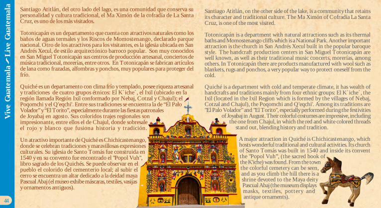
Un atractivo importante de Quiché es Chichicastenango,donde se celebran tradiciones y maravillosas expresionesculturales. Su iglesia de Santo Tomás fue construida en1540 y en su convento fue encontrado el "Popol Vuh",libro sagrado de los Quichés. Se puede observar en elpueblo el colorido del cementerio local; al subir elcerro se encuentra un altar dedicado a la deidad mayaPascual Abaj (el museo exhibe máscaras, textiles, vasijasy ornamentos antiguos).
Santiago Atitlán, on the other side of the lake, is a community that retainsits character and traditional culture. The Ma Ximón of Cofradía La SantaCruz, is one of the most visited.
Totonicapán is a department with natural attractions such as its thermalbaths and Momostenango cliffs which is a National Park. Another importantattraction is the church in San Andrés Xecul built in the popular baroquestyle. The handcraft production centers in San Miguel Totonicapán arewell known, as well as their traditional music concerts, morerías, amongothers. In Totonicapán there are products manufactured with wool such asblankets, rugs and ponchos, a very popular way to protect oneself from thecold.
Quiché is a department with cold and temperate climate, it has wealth ofhandcrafts and traditions mainly from four ethnic groups: El K´iche´, theIxil (located in the Ixil Region which is formed by the villages of Nebaj,Cotzal and Chajul), the Poqomchi and Q'eqchi'. Among its traditions are"El Palo Volador" and "El Torito", especially performed during the festivities
of Joyabaj in August. Their colorful costumes are impressive, includingthe one from Chajul, in which the red and white colored threads
stand out, blending history and tradition.
A major attraction in Quiché is Chichicastenango, whichhosts wonderful traditional and cultural activities. Its churchof Santo Tomás was built in 1540 and inside its conventthe "Popol Vuh”, (the sacred book ofthe K'iche) was found. From the townthe colorful cemetery can be seen,and as you climb the hill there is ashrine devoted to the Maya deityPascual Abaj (the museum displaysmasks, textiles, pottery andantique ornaments).
44
Viv
e G
uate
mal
a
Liv
e G
uate
mal
a
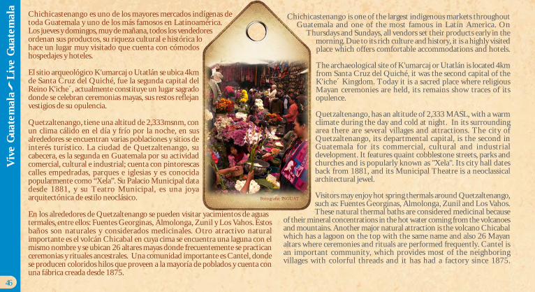
Chichicastenango es uno de los mayores mercados indígenas detoda Guatemala y uno de los más famosos en Latinoamérica.Los jueves y domingos, muy de mañana, todos los vendedoresordenan sus productos, su riqueza cultural e histórica lohace un lugar muy visitado que cuenta con cómodoshospedajes y hoteles.
El sitio arqueológico K'umarcaj o Utatlán se ubica 4kmde Santa Cruz del Quiché, fue la segunda capital delReino K'iche´, actualmente constituye un lugar sagradodonde se celebran ceremonias mayas, sus restos reflejanvestigios de su opulencia.
Quetzaltenango, tiene una altitud de 2,333msnm, conun clima cálido en el día y frío por la noche, en susalrededores se encuentran varias poblaciones y sitios deinterés turístico. La ciudad de Quetzaltenango, sucabecera, es la segunda en Guatemala por su actividadcomercial, cultural e industrial; cuenta con pintorescascalles empedradas, parques e iglesias y es conocidapopularmente como “Xela”. Su Palacio Municipal datadesde 1881, y su Teatro Municipal, es una joyaarquitectónica de estilo neoclásico.
En los alrededores de Quetzaltenango se pueden visitar yacimientos de aguastermales, entre ellos: Fuentes Georginas, Almolonga, Zunil y Los Vahos. Estosbaños son naturales y considerados medicinales. Otro atractivo naturalimportante es el volcán Chicabal en cuya cima se encuentra una laguna con elmismo nombre y se ubican 26 altares mayas donde frecuentemente se practicanceremonias y rituales ancestrales. Una comunidad importante es Cantel, dondese producen coloridos hilos que proveen a la mayoría de poblados y cuenta conuna fábrica creada desde 1875.
Chichicastenango is one of the largest indigenous markets throughoutGuatemala and one of the most famous in Latin America. On
Thursdays and Sundays, all vendors set their products early in themorning. Due to its rich culture and history, it is a highly visitedplace which offers comfortable accommodations and hotels.
The archaeological site of K'umarcaj or Utatlán is located 4kmfrom Santa Cruz del Quiché, it was the second capital of theK'iche´ Kingdom. Today it is a sacred place where religiousMayan ceremonies are held, its remains show traces of itsopulence.
Quetzaltenango, has an altitude of 2,333 MASL, with a warmclimate during the day and cold at night. In its surroundingarea there are several villages and attractions. The city ofQuetzaltenango, its departmental capital, is the second inGuatemala for its commercial, cultural and industrialdevelopment. It features quaint cobblestone streets, parks andchurches and is popularly known as "Xela". Its city hall datesback from 1881, and its Municipal Theatre is a neoclassicalarchitectural jewel.
Visitors may enjoy hot spring thermals around Quetzaltenango,such as: Fuentes Georginas, Almolonga, Zunil and Los Vahos.These natural thermal baths are considered medicinal because
of their mineral concentrations in the hot water coming from the volcanoesand mountains. Another major natural attraction is the volcano Chicabalwhich has a lagoon on the top with the same name and also 26 Mayanaltars where ceremonies and rituals are performed frequently. Cantel isan important community, which provides most of the neighboringvillages with colorful threads and it has had a factory since 1875.
46
Viv
e G
uate
mal
a
Liv
e G
uate
mal
a
Fotografía: INGUAT
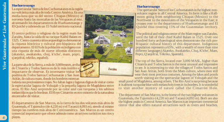
HuehuetenangoLa espectacular Sierra de los Cuchumatanes es la regiónno-volcánica más alta de toda Centro América. Es unamedia-luna que va del vecino Chiapas (México) alnoroeste hasta las montañas de las Verapaces al este,atravesando los departamentos de Huehuetenango yEl Quiché y cubriendo un 15 % del territorio nacional.
El centro político y religioso de la región mam fueZaculeu, hasta la caída de su cacique Kaibil Balam en1525. Ciento cuarenta sitios arqueológicos demuestranla riqueza histórica y cultural pre-hispánica deldepartamento. El 65% de la población es indígena conuna riqueza de más de nueve idiomas distintos(akateko, awakateko, chuj, k'iche', mam, pópti,q'anjob'al, tektiko, español).
La parte alta de la Sierra, a más de 3,000msnm, arribade Chiantla y Todos Santos es de lo más insólito eimpactante de observar. Es interesante visitar lospueblos de Todos Santos Cuchumatán y San JuanAtitán, de cultura mam, donde los hombres ostentantodavía sus preciosísimos trajes. No faltan lagos y lagunas dignas de visitar comola espectacular laguna de Yolnajab y la pequeña laguna de Magdalena entreotras. El Río Azul sorprende por su color azul casi turquesa y los sabinosmelancólicos que lo bordean. El Hoyo Cimarrón es otro misterio de la naturalezaencantador de visitar.
El departamento de San Marcos, es la tierra de los dos volcanes más altos deGuatemala, el Tajumulco (de 4,220 m) y el Tacaná (4,093 m), siendo al mismotiempo las cumbres más altas de Centroamérica. San Marcos es un centrocomercial importante que ofrece además como atractivos turísticos sus ríos yplayas.
HuehuetenangoThe spectacular Sierra of los Cuchumatanes is the highest non-volcanic region in all Central America. Its form is like a Half-moon going from neighboring Chiapas (Mexico) to theNorthwest to the mountains of the Verapaces in the East; itcrosses over to the departments of Huehuetenango and ElQuiché thus covering 15% of the Guatemalan territory.
The political and religious center of the Mam region was Zaculeu,until the fall of their chief Kaibil Balam in 1525. Over onehundred forty archaeological sites demonstrate the rich pre-Hispanic cultural history of this department. Indigenouspopulation represents a 65% , with a wealth of more than ninedifferent languages (Akateko, Awakateko, Chuj, K'iche', Mam,Popti, Q'anjob'al, Tektiko, Spanish).
The top of the Sierra, located over 3,000 MASL, higher thanChiantla and Todos Santos is the most unusual and impressiveto see. It is interesting to visit the villages of Todos Santos andSan Juan Atitán, both from the Mam culture, where men stillwear their most precious costumes. Among the lakes and pondsworth visiting are the spectacular lagoon of Yolnajab and the
small pond of Magdalena, among others. The Río Azul is surprising becauseit is almost turquoise blue with melancholy trees in its borders. It is wonderfulto visit another mystery of nature called the Cimarrón Hole.
The department of San Marcos, is the home of the two highest volcanoes inGuatemala, the Tajumulco (4,220 m) and Tacaná (4,093 m). Both are alsothe highest peaks in Central America. San Marcos is an important commercialcenter that also offers natural attractions such as rivers and beaches.
48
Zaculeu
RL
Viv
e G
uate
mal
a
Liv
e G
uate
mal
a
Check!

Parque Nacional TikalTikal National Park
Fotografía: INGUAT
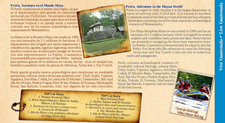
Petén, Aventura en el Mundo MayaEl Petén constituye en sí mismo una región, ya quees el departamento más grande en extensiónterritorial con 35,854 km2. Se encuentra situadoal norte de Guatemala, la mayor parte de su territorioes bosque tropical y su paisaje verde y exóticocontiene uno de los tesoros arqueológicos másimportantes de Mesoamérica.
La Reserva de la Biosfera Maya, fue creada en 1990,con una extensión de 2.1 millones de hectáreas. Eldepartamento está irrigado por varios majestuosos ycristalinos ríos, aguadas, lagunas y lagunetas, entre ellosmuchos turistas son atraídos para navegar en los tresríos más impresionantes: La Pasión, Usumacinta(recomendable para expertos) y el San Pedro. Además,para quienes gustan de la aventura en cuevas, las hay ricas en estalactitas,bóvedas y pasadizos como las grutas de Jobtzinaj, Actún-kan y Naj Tunich.
Petén guarda grandes tesoros arqueológicos que constituyen un invaluablepatrimonio cultural, dentro de los que podemos citar: Tikal, Yaxhá, Topoxté,Aguateca, Dos Pilas, Ceibal, la Cuenca de El Mirador, Tamarindito, Río AzulSak-Ha Wizatz, Piedras Negras, Perú Waká, Nakum, El Naranjo, Machaquilá,Kinal, San Bartolo, Uaxactún, Ixlú; son algunos de los más conocidos.
Petén, Adventure in the Mayan WorldPetén is a region in itself, because it is the largest department interms of territory with 35,854 km2. It is located in northernGuatemala, most of the land is a tropical forest and has wild greenlandscapes containing one of the most important archaeologicaltreasures of Mesoamerica.
The Maya Biosphere Reserve was created in 1990 and has anextension of 2.1 million hectares. Petén is irrigated by severalmajestic and crystalline rivers, ponds and lakes. Many touristsare attracted to navigating the three most impressive rivers:La Pasión, Usumacinta (recommended for experts) and SanPedro. For those who like adventure in caves the Jobtzinaj,Actún-kan and Naj Tunich Caves are rich in stalactites,
vaults and passageways.
Petén contains archaeological treasures ofinvaluable cultural heritage, among them:Tikal, Yaxhá, Topoxté, Aguateca, Dos Pilas,Ceibal, El Mirador Basin, Tamarindito, RíoAzul, Sak-Ha Wizatz, Piedras Negras, PerúWaká, Nakum, El Naranjo, Machaquilá,Kinal, San Bartolo, Uaxactún, Ixlú are someof the best known.
Viv
e G
uate
mal
a
Liv
e G
uate
mal
a
Ceibal
TOP 5 de Petén1. Parque Nacional Tikal2. Sitios Arqueológicos y Reserva Yaxhá,Nakum y El Naranjo3. Aventura en cuevas y canopy tours4. Cuenca de El Mirador5. Isla de Flores y los poblados alrededordel Lago Petén Itzá
TOP 5 of Petén1. Tikal National Park2. Yaxhá, Nakum and El NaranjoArchaeological Sites and natural reserve3. Adventure in caves and canopy tours4. The Mirador Basin
5. Isla de Flores and the villagesaround Peten Itzá Lake
Fotografía: INGUAT
Canotaje (Rafting)White Water Rafting
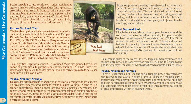
Petén respalda su economía con varias actividadesagrícolas, manejo de bosques de maderas finas y preciosas,artesanías y el turismo. Su fauna es variada, cuenta coninnumerables especies como el faisán, el pavo real, elpavo ocelado, que es una especie endémica de Petén.También habitan el venado cola blanca, el tepezcuintle,el tapir, el jaguar, los monos aulladores, entre otros.
Parque Nacional TikalTikal es el complejo-ciudad maya más famoso alrededordel mundo y sede de la pirámide más alta: el TemploIV de la Serpiente Bicéfala con 70 metros de altura.En 1979, la UNESCO declara al Parque, como elprimer Sitio de Patrimonio Mundial Cultural y Naturalde la Humanidad. La combinación de lo cultural ynatural de Tikal, hace que se convierta en el primerode los 23 sitios en el mundo que han sido declaradoscomo Sitios de Patrimonio Mundial Mixto dela Humanidad, es decir tanto Cultural como Natural.
Tikal significa "lugar de las voces". Es la ciudad Maya más grande hasta ahoraconocida y estudiada. El parque tiene una extensión de 576 kms2. Puede servisitado por el público, todos los días del año, una carretera asfaltada de 65 kmcomunica a Tikal con Flores.
Yaxhá, Nakum y NaranjoEstas ciudades formaban un triángulo político y social y comprende actualmenteun área protegida y reserva llamada Yaxhá-Nakum-Naranjo. Yaxhá es unaciudad majestuosa, mezcla entre arqueología y paisajes hermosos. Lasconstrucciones monumentales que se aprecian como templos, pirámides gemelas,acrópolis, palacios, juego de pelota y varias calzadas dan fe de lo que un díarepresentó un centro lacustre y puerto marítimo de comercio de gran importanciadentro del Mundo Maya.
Petén supports its economy through several activities suchas farming crops of agricultural products, precious woods,handcrafts and tourism. The fauna is varied, and it is formedby many species such as pheasant, peacock, turkey, ocellatedturkey, which is an endemic species of Petén. It is alsoinhabited by the white-tail deer, paca, tapir, jaguar, howlermonkeys, among others.
Tikal National ParkTikal is the ancient Mayan city complex, famous around theworld and home to the tallest pyramid, Temple IV of theDouble-Headed Serpent, 70 meters high. In 1979, UNESCOdeclared the park, the first site of World Cultural and NaturalHeritage of Humanity. The combination of culture and naturemakes Tikal the first of the 23 sites in the world that havebeen declared World Mix Heritage of Humanity, both culturaland natural.
Tikal means "place of the voices". It is the largest Mayan city known andstudied until now. The Park covers an area of 576 km2. It is open to thepublic every day of the year. A 65 km asphalt road connects Tikal to Flores.
Yaxhá, Nakum and NaranjoThese cities formed a political and social triangle, now a protected areaand reserve called Yaxhá -Nakum-Naranjo. Yaxhá is a majestic city, amixture of archaeology and beautiful scenery. The monumental buildingsthat can be seen such as temples, twin pyramids, acropolis, palaces, Mayaball game and several roads attest to what once was a commercial seaportof great importance within the Mayan world.
52
Fauna localLocal FaunaCheck
!
Viv
e G
uate
mal
a
Liv
e G
uate
mal
a
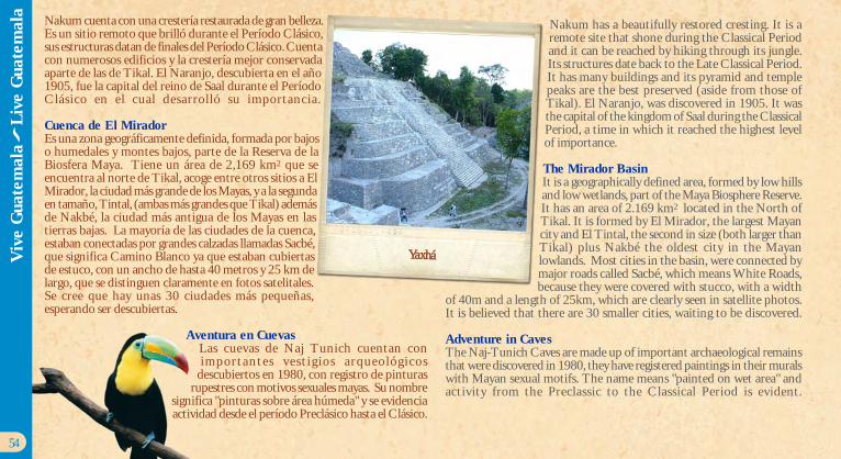
Nakum cuenta con una crestería restaurada de gran belleza.Es un sitio remoto que brilló durante el Período Clásico,sus estructuras datan de finales del Período Clásico. Cuentacon numerosos edificios y la crestería mejor conservadaaparte de las de Tikal. El Naranjo, descubierta en el año1905, fue la capital del reino de Saal durante el PeríodoClásico en el cual desarrolló su importancia.
Cuenca de El MiradorEs una zona geográficamente definida, formada por bajoso humedales y montes bajos, parte de la Reserva de laBiosfera Maya. Tiene un área de 2,169 km2 que seencuentra al norte de Tikal, acoge entre otros sitios a ElMirador, la ciudad más grande de los Mayas, y a la segundaen tamaño, Tintal, (ambas más grandes que Tikal) ademásde Nakbé, la ciudad más antigua de los Mayas en lastierras bajas. La mayoría de las ciudades de la cuenca,estaban conectadas por grandes calzadas llamadas Sacbé,que significa Camino Blanco ya que estaban cubiertasde estuco, con un ancho de hasta 40 metros y 25 km delargo, que se distinguen claramente en fotos satelitales.Se cree que hay unas 30 ciudades más pequeñas,esperando ser descubiertas.
Aventura en CuevasLas cuevas de Naj Tunich cuentan conimportantes vest ig ios arqueológicos
descubiertos en 1980, con registro de pinturasrupestres con motivos sexuales mayas. Su nombre
significa "pinturas sobre área húmeda" y se evidenciaactividad desde el período Preclásico hasta el Clásico.
Nakum has a beautifully restored cresting. It is aremote site that shone during the Classical Periodand it can be reached by hiking through its jungle.Its structures date back to the Late Classical Period.It has many buildings and its pyramid and templepeaks are the best preserved (aside from those ofTikal). El Naranjo, was discovered in 1905. It wasthe capital of the kingdom of Saal during the ClassicalPeriod, a time in which it reached the highest levelof importance.
The Mirador BasinIt is a geographically defined area, formed by low hillsand low wetlands, part of the Maya Biosphere Reserve.It has an area of 2.169 km2 located in the North ofTikal. It is formed by El Mirador, the largest Mayancity and El Tintal, the second in size (both larger thanTikal) plus Nakbé the oldest city in the Mayanlowlands. Most cities in the basin, were connected bymajor roads called Sacbé, which means White Roads,because they were covered with stucco, with a width
of 40m and a length of 25km, which are clearly seen in satellite photos.It is believed that there are 30 smaller cities, waiting to be discovered.
Adventure in CavesThe Naj-Tunich Caves are made up of important archaeological remainsthat were discovered in 1980, they have registered paintings in their muralswith Mayan sexual motifs. The name means "painted on wet area" andactivity from the Preclassic to the Classical Period is evident.
54
Viv
e G
uate
mal
a
Liv
e G
uate
mal
a
Yaxhá
SP
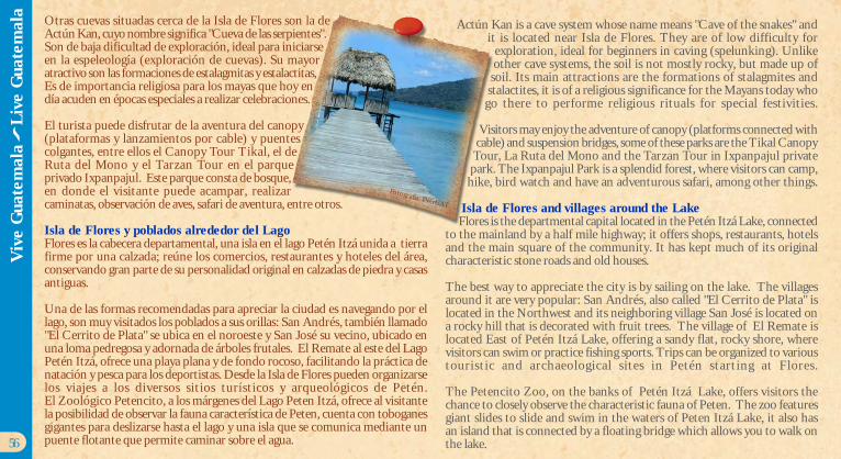
Otras cuevas situadas cerca de la Isla de Flores son la deActún Kan, cuyo nombre significa "Cueva de las serpientes".Son de baja dificultad de exploración, ideal para iniciarseen la espeleología (exploración de cuevas). Su mayoratractivo son las formaciones de estalagmitas y estalactitas,Es de importancia religiosa para los mayas que hoy endía acuden en épocas especiales a realizar celebraciones.
El turista puede disfrutar de la aventura del canopy(plataformas y lanzamientos por cable) y puentescolgantes, entre ellos el Canopy Tour Tikal, el deRuta del Mono y el Tarzan Tour en el parqueprivado Ixpanpajul. Este parque consta de bosque,en donde el visitante puede acampar, realizarcaminatas, observación de aves, safari de aventura, entre otros.
Isla de Flores y poblados alrededor del LagoFlores es la cabecera departamental, una isla en el lago Petén Itzá unida a tierrafirme por una calzada; reúne los comercios, restaurantes y hoteles del área,conservando gran parte de su personalidad original en calzadas de piedra y casasantiguas.
Una de las formas recomendadas para apreciar la ciudad es navegando por ellago, son muy visitados los poblados a sus orillas: San Andrés, también llamado"El Cerrito de Plata" se ubica en el noroeste y San José su vecino, ubicado enuna loma pedregosa y adornada de árboles frutales. El Remate al este del LagoPetén Itzá, ofrece una playa plana y de fondo rocoso, facilitando la práctica denatación y pesca para los deportistas. Desde la Isla de Flores pueden organizarselos viajes a los diversos sitios turísticos y arqueológicos de Petén.El Zoológico Petencito, a los márgenes del Lago Peten Itzá, ofrece al visitantela posibilidad de observar la fauna característica de Peten, cuenta con toboganesgigantes para deslizarse hasta el lago y una isla que se comunica mediante unpuente flotante que permite caminar sobre el agua.
Actún Kan is a cave system whose name means "Cave of the snakes" andit is located near Isla de Flores. They are of low difficulty for
exploration, ideal for beginners in caving (spelunking). Unlikeother cave systems, the soil is not mostly rocky, but made up of
soil. Its main attractions are the formations of stalagmites andstalactites, it is of a religious significance for the Mayans today who
go there to performe religious rituals for special festivities.
Visitors may enjoy the adventure of canopy (platforms connected withcable) and suspension bridges, some of these parks are the Tikal Canopy
Tour, La Ruta del Mono and the Tarzan Tour in Ixpanpajul privatepark. The Ixpanpajul Park is a splendid forest, where visitors can camp,
hike, bird watch and have an adventurous safari, among other things.
Isla de Flores and villages around the LakeFlores is the departmental capital located in the Petén Itzá Lake, connected
to the mainland by a half mile highway; it offers shops, restaurants, hotelsand the main square of the community. It has kept much of its originalcharacteristic stone roads and old houses.
The best way to appreciate the city is by sailing on the lake. The villagesaround it are very popular: San Andrés, also called "El Cerrito de Plata" islocated in the Northwest and its neighboring village San José is located ona rocky hill that is decorated with fruit trees. The village of El Remate islocated East of Petén Itzá Lake, offering a sandy flat, rocky shore, wherevisitors can swim or practice fishing sports. Trips can be organized to varioustouristic and archaeological sites in Petén starting at Flores.
The Petencito Zoo, on the banks of Petén Itzá Lake, offers visitors thechance to closely observe the characteristic fauna of Peten. The zoo featuresgiant slides to slide and swim in the waters of Peten Itzá Lake, it also hasan island that is connected by a floating bridge which allows you to walk onthe lake.56
Viv
e G
uate
mal
a
Liv
e G
uate
mal
a
Fotografía: INGUAT
Fotografía: INGUAT
Playa de arena blancaWhite sand beach
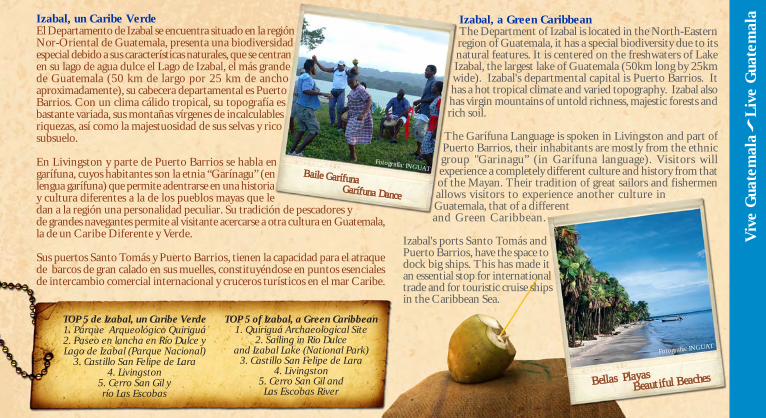
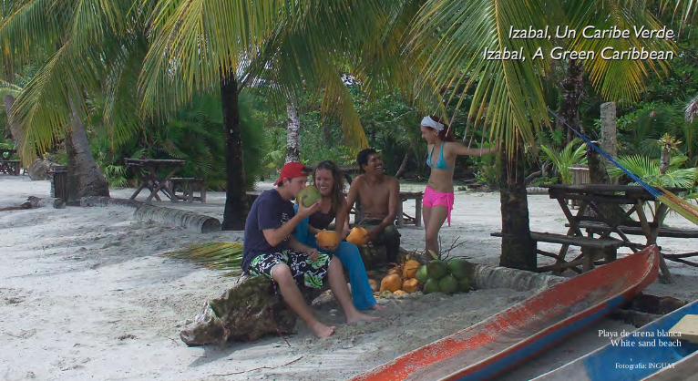
Izabal, un Caribe VerdeEl Departamento de Izabal se encuentra situado en la regiónNor-Oriental de Guatemala, presenta una biodiversidadespecial debido a sus características naturales, que se centranen su lago de agua dulce el Lago de Izabal, el más grandede Guatemala (50 km de largo por 25 km de anchoaproximadamente), su cabecera departamental es PuertoBarrios. Con un clima cálido tropical, su topografía esbastante variada, sus montañas vírgenes de incalculablesriquezas, así como la majestuosidad de sus selvas y ricosubsuelo.
En Livingston y parte de Puerto Barrios se habla engarífuna, cuyos habitantes son la etnia “Garínagu” (enlengua garífuna) que permite adentrarse en una historiay cultura diferentes a la de los pueblos mayas que ledan a la región una personalidad peculiar. Su tradición de pescadores yde grandes navegantes permite al visitante acercarse a otra cultura en Guatemala,la de un Caribe Diferente y Verde.
Sus puertos Santo Tomás y Puerto Barrios, tienen la capacidad para el atraquede barcos de gran calado en sus muelles, constituyéndose en puntos esencialesde intercambio comercial internacional y cruceros turísticos en el mar Caribe.
Izabal, a Green CaribbeanThe Department of Izabal is located in the North-Easternregion of Guatemala, it has a special biodiversity due to itsnatural features. It is centered on the freshwaters of LakeIzabal, the largest lake of Guatemala (50km long by 25kmwide). Izabal's departmental capital is Puerto Barrios. Ithas a hot tropical climate and varied topography. Izabal alsohas virgin mountains of untold richness, majestic forests andrich soil.
The Garífuna Language is spoken in Livingston and part ofPuerto Barrios, their inhabitants are mostly from the ethnicgroup "Garinagu” (in Garífuna language). Visitors willexperience a completely different culture and history from thatof the Mayan. Their tradition of great sailors and fishermenallows visitors to experience another culture inGuatemala, that of a differentand Green Caribbean.
Izabal's ports Santo Tomás andPuerto Barrios, have the space todock big ships. This has made itan essential stop for internationaltrade and for touristic cruise shipsin the Caribbean Sea.
TOP 5 de Izabal, un Caribe Verde1. Parque Arqueológico Quiriguá2. Paseo en lancha en Río Dulce yLago de Izabal (Parque Nacional)
3. Castillo San Felipe de Lara4. Livingston
5. Cerro San Gil yrío Las Escobas
Viv
e G
uate
mal
a
Liv
e G
uate
mal
a
TOP 5 of Izabal, a Green Caribbean1. Quiriguá Archaeological Site
2. Sailing in Rio Dulceand Izabal Lake (National Park)
3. Castillo San Felipe de Lara4. Livingston
5. Cerro San Gil andLas Escobas River
Baile GarífunaGarífuna Dance
Fotografía: INGUAT
Bellas PlayasBeautiful Beaches
Fotografía: INGUAT
60
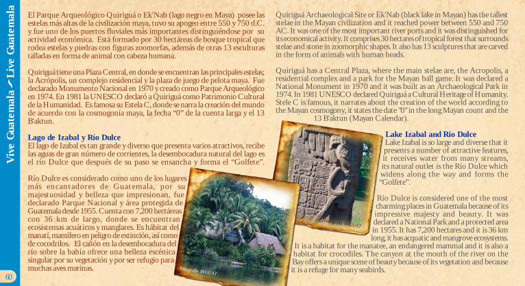
El Parque Arqueológico Quiriguá o Ek'Nab (lago negro en Maya) posee lasestelas más altas de la civilización maya, tuvo su apogeo entre 550 y 750 d.C.y fue uno de los puertos fluviales más importantes distinguiéndose por suactividad económica. Está formado por 30 hectáreas de bosque tropical querodea estelas y piedras con figuras zoomorfas, además de otras 13 esculturastalladas en forma de animal con cabeza humana.
Quiriguá tiene una Plaza Central, en donde se encuentran las principales estelas;la Acrópolis, un complejo residencial y la plaza de juego de pelota maya. Fuedeclarado Monumento Nacional en 1970 y creado como Parque Arqueológicoen 1974. En 1981 la UNESCO declaró a Quiriguá como Patrimonio Culturalde la Humanidad. Es famosa su Estela C, donde se narra la creación del mundode acuerdo con la cosmogonía maya, la fecha “0” de la cuenta larga y el 13B'aktun.
Lago de Izabal y Río DulceEl lago de Izabal es tan grande y diverso que presenta varios atractivos, recibelas aguas de gran número de corrientes, la desembocadura natural del lago esel río Dulce que después de su paso se ensancha y forma el “Golfete”.
Río Dulce es considerado como uno de los lugaresmás encantadores de Guatemala, por sumajestuosidad y belleza que impresionan, fuedeclarado Parque Nacional y área protegida deGuatemala desde 1955. Cuenta con 7,200 hectáreascon 36 km de largo, donde se encuentranecosistemas acuáticos y manglares. Es hábitat delmanatí, mamífero en peligro de extinción, así comode cocodrilos. El cañón en la desembocadura delrío sobre la bahía ofrece una belleza escénicasingular por su vegetación y por ser refugio paramuchas aves marinas.
Quiriguá Archaeological Site or Ek'Nab (black lake in Mayan) has the talleststelae in the Mayan civilization and it reached power between 550 and 750AC. It was one of the most important river ports and it was distinguished forits economical activity. It comprises 30 hectares of tropical forest that surroundsstelae and stone in zoomorphic shapes. It also has 13 sculptures that are carvedin the form of animals with human heads.
Quiriguá has a Central Plaza, where the main stelae are, the Acropolis, aresidential complex and a park for the Mayan ball game. It was declared aNational Monument in 1970 and it was built as an Archaeological Park in1974. In 1981 UNESCO declared Quiriguá a Cultural Heritage of Humanity.Stele C is famous, it narrates about the creation of the world according tothe Mayan cosmogony, it states the date "0" in the long Mayan count and the
13 B'aktun (Mayan Calendar).
Lake Izabal and Rio DulceLake Izabal is so large and diverse that itpresents a number of attractive features,it receives water from many streams,its natural outlet is the Río Dulce whichwidens along the way and forms the“Golfete”.
Río Dulce is considered one of the mostcharming places in Guatemala because of itsimpressive majesty and beauty. It wasdeclared a National Park and a protected areain 1955. It has 7,200 hectares and it is 36 kmlong, it has acquatic and mangrove ecosystems.
It is a habitat for the manatee, an endangered mammal and it is also ahabitat for crocodiles. The canyon at the mouth of the river on theBay offers a unique scene of beauty because of its vegetation and becauseit is a refuge for many seabirds.
Viv
e G
uate
mal
a
Liv
e G
uate
mal
a
Fotografía: INGUAT
Fotografía: INGUAT
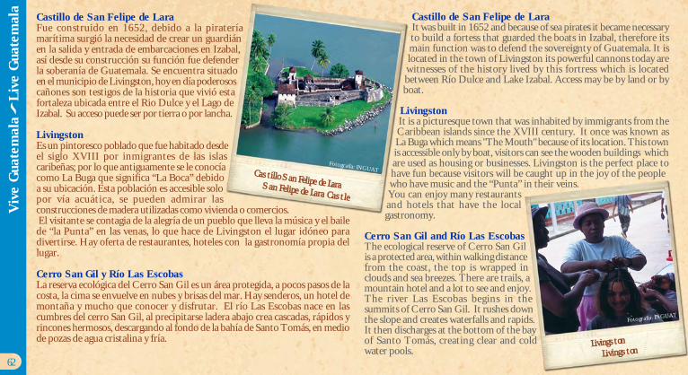
Castillo de San Felipe de LaraFue construido en 1652, debido a la pirateríamarítima surgió la necesidad de crear un guardiánen la salida y entrada de embarcaciones en Izabal,así desde su construcción su función fue defenderla soberanía de Guatemala. Se encuentra situadoen el municipio de Livingston, hoy en día poderososcañones son testigos de la historia que vivió estafortaleza ubicada entre el Rio Dulce y el Lago deIzabal. Su acceso puede ser por tierra o por lancha.
LivingstonEs un pintoresco poblado que fue habitado desdeel siglo XVIII por inmigrantes de las islascaribeñas; por lo que antiguamente se le conocíacomo La Buga que significa “La Boca” debidoa su ubicación. Esta población es accesible solopor vía acuática, se pueden admirar lasconstrucciones de madera utilizadas como vivienda o comercios. El visitante se contagia de la alegría de un pueblo que lleva la música y el bailede “la Punta” en las venas, lo que hace de Livingston el lugar idóneo paradivertirse. Hay oferta de restaurantes, hoteles con la gastronomía propia dellugar.
Cerro San Gil y Río Las EscobasLa reserva ecológica del Cerro San Gil es un área protegida, a pocos pasos de lacosta, la cima se envuelve en nubes y brisas del mar. Hay senderos, un hotel demontaña y mucho que conocer y disfrutar. El río Las Escobas nace en lascumbres del cerro San Gil, al precipitarse ladera abajo crea cascadas, rápidos yrincones hermosos, descargando al fondo de la bahía de Santo Tomás, en mediode pozas de agua cristalina y fría.
Castillo de San Felipe de LaraIt was built in 1652 and because of sea pirates it became necessaryto build a fortess that guarded the boats in Izabal, therefore itsmain function was to defend the sovereignty of Guatemala. It islocated in the town of Livingston its powerful cannons today arewitnesses of the history lived by this fortress which is locatedbetween Río Dulce and Lake Izabal. Access may be by land or byboat.
LivingstonIt is a picturesque town that was inhabited by immigrants from theCaribbean islands since the XVIII century. It once was known asLa Buga which means "The Mouth" because of its location. This townis accessible only by boat, visitors can see the wooden buildings whichare used as housing or businesses. Livingston is the perfect place tohave fun because visitors will be caught up in the joy of the peoplewho have music and the “Punta” in their veins.You can enjoy many restaurantsand hotels that have the localgastronomy.
Cerro San Gil and Río Las EscobasThe ecological reserve of Cerro San Gilis a protected area, within walking distancefrom the coast, the top is wrapped inclouds and sea breezes. There are trails, amountain hotel and a lot to see and enjoy.The river Las Escobas begins in thesummits of Cerro San Gil. It rushes downthe slope and creates waterfalls and rapids.It then discharges at the bottom of the bayof Santo Tomás, creating clear and coldwater pools.
62
Castillo San Felipe de LaraSan Felipe de Lara Castle
Fotografía: INGUAT
LivingstonLivingston
Fotografía: INGUAT
Viv
e G
uate
mal
a
Liv
e G
uate
mal
a

Otros lugares importantes en IzabalEl municipio de El Estor, es una región rica en tierras vírgenes y oasisecológicos esperando a ser descubiertos. La Finca El Paraíso es un centro derecreación de burbujeantes aguas en una parte del río, donde es posiblereposar tranquilamente recibiendo el masaje de aguas cálidas.
La Estación Científica Selempín se ubica a orillas delLago de Izabal, se puede disfrutar del ecosistema deun humedal y convivir con la comunidad q´eqchícercana. El área es atractiva por la diversidad de aves,más de 214 especies. Sus paisajes y sus ríos de aguacaliente y fría son inigualables, es posible hospedarseen la estación.
El Biotopo Chocón Machacas es una reserva naturalprotegida, consta de extensas selvas mediopantanosas, riachuelos que forman lagunas dondese observan peces, tortugas, aves acuáticas y anfibios.Fue declarado zona protegida en los años 90, conla meta de preservar al manatí en su ambientenatural, resguardando la cuenca del río Chocón.
Siete Altares es también un área protegida, su nombreproviene de las siete pozas principales que se distinguen por su tamañoy belleza, se crean por un río selvático a la orilla del mar. La visita al RíoSarstún, que marca una frontera natural entre Belice e Izabal, constituye unaruta histórica y vía turística con paisajes escénicos de exuberante naturaleza. En la Bahía de Amatique converge el agua dulce y la salada del mar, idealpara practicar deportes acuáticos como remo, navegación o vela con botesde motor. Las hermosas playas de Mariscos, una oferta turística de potencialenorme, con playas públicas como la famosa Playa Dorada, hasta lujososhoteles resorts como Denny´s Beach. Punta de Palma es otra playa cercanay accesible desde Puerto Barrios, famosa por sus parajes.
Other important places in IzabalEl Estor, is a region that is rich in virgin lands and it has an ecological oasiswaiting to be discovered. The Finca El Paraíso is a recreation center thatfeatures sparkling waters in the river, where you can sit quietly and have arelaxing massage in the warm water.
Selempín Research Station is located on the shores of Lake Izabal,you can enjoy a wetland ecosystem and have a unique experiencewith the Q'eqchi community nearby. The area is attractive becauseof its diversity of birds, it has over 214 species. The landscapes andrivers of hot and cold water are incomparable; it is possible to stayin the station.
Chocón Machacas Biotope is a protected nature reserve; it consistsof extensive forests and wetlands. It has streams that form lakeswhere you can fine fish, turtles, birds and amphibians. It was declareda protected area in the 90's, because they wished to preserve themanatee in its natural environment and at the same time protect theChocón river basin.
Siete Altares is also a protected area, its name comes from the sevenmain pools that are distinguished for their size and beauty, it is formedby a jungle river next to the sea. The Sarstún River, which is a naturalborder between Belize and Izabal, is a historic and touristic route that
has exuberant nature.
Fresh and salty water from the sea converge in the Amatique Bay, it is idealfor water sports such as rowing, sailing or motor boats sail. The beautifulbeaches of Mariscos, have great potential for tourism. There are also publicbeaches such as the famous Playa Dorada and luxurious resorts like Denny'sBeach that are worth visiting. Punta de Palma is another beach that is closeand accessible from Puerto Barrios, which is famous for its scenery.
64
Viv
e G
uate
mal
a
Liv
e G
uate
mal
a
Fotografía: INGUAT
Las Escobas
Fotografía: INGUAT
Semuc Champey
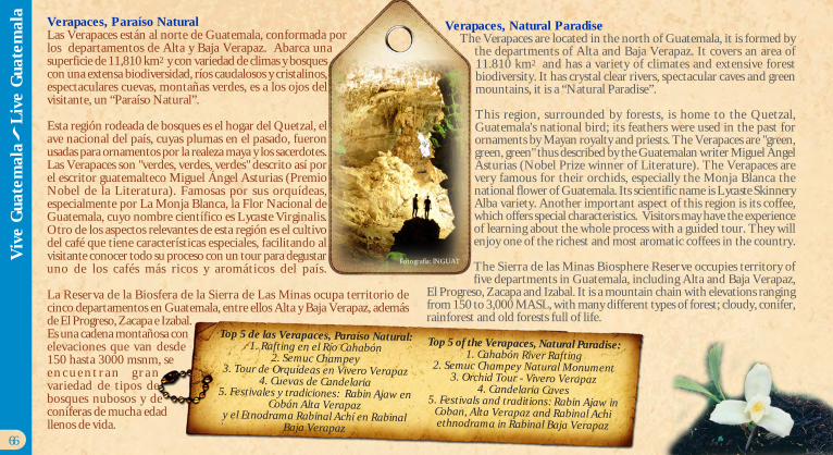
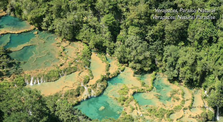
Verapaces, Paraíso NaturalLas Verapaces están al norte de Guatemala, conformada porlos departamentos de Alta y Baja Verapaz. Abarca unasuperficie de 11,810 km2 y con variedad de climas y bosquescon una extensa biodiversidad, ríos caudalosos y cristalinos,espectaculares cuevas, montañas verdes, es a los ojos delvisitante, un “Paraíso Natural”.
Esta región rodeada de bosques es el hogar del Quetzal, elave nacional del país, cuyas plumas en el pasado, fueronusadas para ornamentos por la realeza maya y los sacerdotes.Las Verapaces son "verdes, verdes, verdes" descrito así porel escritor guatemalteco Miguel Ángel Asturias (PremioNobel de la Literatura). Famosas por sus orquídeas,especialmente por La Monja Blanca, la Flor Nacional deGuatemala, cuyo nombre científico es Lycaste Virginalis.Otro de los aspectos relevantes de esta región es el cultivodel café que tiene características especiales, facilitando alvisitante conocer todo su proceso con un tour para degustaruno de los cafés más ricos y aromáticos del país.
La Reserva de la Biosfera de la Sierra de Las Minas ocupa territorio decinco departamentos en Guatemala, entre ellos Alta y Baja Verapaz, ademásde El Progreso, Zacapa e Izabal.Es una cadena montañosa conelevaciones que van desde150 hasta 3000 msnm, see n c u e n t r a n g r a nvariedad de tipos debosques nubosos y deconíferas de mucha edadllenos de vida.
Verapaces, Natural ParadiseThe Verapaces are located in the north of Guatemala, it is formed by
the departments of Alta and Baja Verapaz. It covers an area of11.810 km2 and has a variety of climates and extensive forestbiodiversity. It has crystal clear rivers, spectacular caves and greenmountains, it is a “Natural Paradise”.
This region, surrounded by forests, is home to the Quetzal,Guatemala's national bird; its feathers were used in the past forornaments by Mayan royalty and priests. The Verapaces are "green,green, green" thus described by the Guatemalan writer Miguel AngelAsturias (Nobel Prize winner of Literature). The Verapaces arevery famous for their orchids, especially the Monja Blanca thenational flower of Guatemala. Its scientific name is Lycaste SkinneryAlba variety. Another important aspect of this region is its coffee,which offers special characteristics. Visitors may have the experienceof learning about the whole process with a guided tour. They willenjoy one of the richest and most aromatic coffees in the country.
The Sierra de las Minas Biosphere Reserve occupies territory offive departments in Guatemala, including Alta and Baja Verapaz,
El Progreso, Zacapa and Izabal. It is a mountain chain with elevations rangingfrom 150 to 3,000 MASL, with many different types of forest; cloudy, conifer,rainforest and old forests full of life.
Top 5 de las Verapaces, Paraíso Natural:1. Rafting en el Río Cahabón
2. Semuc Champey3. Tour de Orquídeas en Vivero Verapaz
4. Cuevas de Candelaria5. Festivales y tradiciones: Rabin Ajaw en
Cobán Alta Verapazy el Etnodrama Rabinal Achí en Rabinal
Baja Verapaz
Top 5 of the Verapaces, Natural Paradise:1. Cahabón River Rafting
2. Semuc Champey Natural Monument3. Orchid Tour - Vivero Verapaz
4. Candelaria Caves5. Festivals and traditions: Rabin Ajaw in
Coban, Alta Verapaz and Rabinal Achiethnodrama in Rabinal Baja Verapaz
66
Viv
e G
uate
mal
a
Liv
e G
uate
mal
a
Fotografía: INGUAT
Viv
e G
uate
mal
a
Liv
e G
uate
mal
a
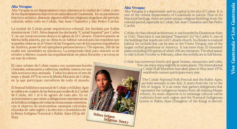
Alta VerapazAlta Verapaz es un departamento cuya cabecera es la ciudad de Cobán y unode los departamentos más ricos en naturaleza de Guatemala. En su patrimoniohistórico-artístico, destacan algunos edificios religiosos singulares del períodocolonial, sobre todo en Cobán, San Juan Chamelco y San Pedro Carchá.
La ciudad de Cobán posee arquitectura colonial, fue fundada por frailesdominicos en 1543. Años después fue declarada “Ciudad Imperial” por CarlosV, en sus construcciones destaca la iglesia de El Calvario. Históricamente sefabrica bella platería, por su clima es un hábitat natural para las orquídeas quese pueden observar en el Vivero de las Verapaces, uno de los mayores orquideariosde América, posee 60 mil ejemplares pertenecientes a 750 especies, 200 de lascuales son variedades en miniatura. La temporada ideal para visitarlo es deoctubre a febrero, cuando las orquídeas están en plena floración y se torna enun mar de colores.
El casco urbano de Cobán cuenta con numerosos hotelesy hostales, restaurantes y cafeterías, también cuenta con unavida nocturna muy animada. Todos los años en el mes demayo y desde 1974 se corre la Media Maratón de Cobán,en la que participan corredores de todo el mundo.
El festival folklórico nacional de Cobán y el Rabin Ajawse celebra en ocasión de las fiestas patronales de la Ciudadde Cobán, del 1 al 6 de agosto de cada año. Es unacontecimiento que reúne a delegaciones representativasde la belleza indígena de todas las etnias mayas existentes,con el objetivo de intercambiar estampas culturalesoriundas de cada región y la elección e investidura dela Reina Indígena Nacional o Rabín Ajaw (Hija delRey).
Alta VerapazAlta Verapaz is a department and its capital is the city of Coban. It isone of the richest departments of Guatemala in nature. Due to itshistorical heritage, there are some unique religious buildings from thecolonial period, especially in Cobán, San Juan Chamelco and San PedroCarchá.
Cobán city has colonial architecture, it was founded by Dominican friarsin 1543. Years later it was declared "Imperial City" by Carlos V, one ofthe buildings that stands out is El Calvario church. Its climate is a naturalhabitat for orchids that can be seen in the Vivero Verapaz, one of thelargest orchid greenhouse in America. It has more than 35 thousandplants including 650 species of which 200 are miniature. The ideal seasonto visit is from October to February, when the orchids are in full bloom.
Cobán has numerous hotels and guest houses, restaurants and cafes.You can enjoy enjoy nightlife in many places. The International
Cobán Half Marathon has taken place in May since 1974,worldwide runners participate every year.
The Cobán National Folk Festival and the Rabin Ajaw,are held annually in late July. It starts from the 1st to the6th of August. It is an event that gathers delegations thatrepresents the indigenous beauty from all existing Mayanethnics. Its main objective is to exchange cultural nativetraditions from each region and the National IndigenousQueen or Rabin Ajaw (Daughter of the King) is elected.
JCLBelleza IndígenaIndigenous Beauty

El Paa´bank, es una tradicióncultural, que se observa conmás f recuencia en LasVerapaces, en tradicionesreligiosas, en la transmisión,recepción o entrega de los cargosen la mayordomía superior deuna cofradía. Como actocultural, el Paa´bank se realizaposterior al evento "Rabin Ajaw",donde se realizan ceremoniasreligiosas, presentación de danzasfolklóricas y música tradicional conarpa, chir imía, marimba ytamborón.
Tactic es un municipio de grandes manifestaciones espirtuales, cuyapoblación estaba rodeada de centros ceremoniales mayas. Su ermita Chi-Ixim, ubicada en un cerro, fue construida en 1620 y se venera la imagen deJesús en la Cruz. Son reconocidos sus tejidos hechos en telares de cinturay por su arte en plata. Tamahú a orillas del Río Polochic, destaca por sustextiles elaborados por las mujeres en telares de cintura, especialmente suhuipil ceremonial de color rojo.
La región de Alta Verapaz cuenta con numerosos atractivos para el turismo,pero fundamentalmente para el ecoturismo:
Grutas del Rey Marcos, Se distinguen por la belleza de sus formaciones,enormes estalagmitas y por la aventura que se vive al adentrarse en pasajessubterráneos que el agua ha perforado. La cueva se encuentra por encimade un famoso lugar de picnic y balneario, donde un manantial brota desdela ladera de la montaña y crea una serie de piscinas y cascadas.
The Paa'bank is a cultural tradition, held in the Verapaces. Its purpose is tobequeath authority among the Cofradía (Maya religious hierarchy). As acultural event, the Paa'bank is performed after the "Rabin Ajaw" in the Chapelof Santo Domingo, where religious ceremonies, presentation of folk dancesand traditional music with harp, chirimia, marimba and drum are held.
Tactic is a town of great spiritual expressions. This settlement was surroundedby Mayan ceremonial centers. Its church is located on a hill, which was builtin 1620. In this church pilgrims worship the image of Jesus on the Cross.Tactic is known for its textiles made on it is also known for its silvermanufactured art. Tamahú is a town located along the Polochic River, itstands out for its textiles made by women on backstrap looms and its ceremonialred huipil.
There are many tourist andecotourist attractions in AltaVerapaz:
Grutas del Rey Marcos are highlyknown for their beauty andstalagmites. You can enjoy gettinginto underground water passages.
The cave is located above apopular picnic spot andswimming area, where aspring emerges from themountainside, creating a seriesof pools and waterfalls.
68
Viv
e G
uate
mal
a
Liv
e G
uate
mal
a
Fotografía: INGUAT
JCL
Rituales en RutasRituals in Caves
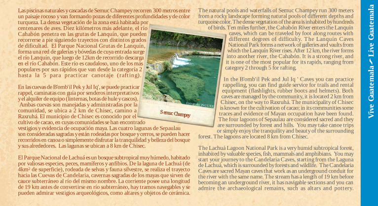
Las piscinas naturales y cascadas de Semuc Champey recorren 300 metros entreun paisaje rocoso y van formando pozas de diferentes profundidades y de colorturqueza. La densa vegetación de la zona está habitada porcentenares de aves. Diez kilómetros más adelante, el ríoCahabón penetra en las grutas de Lanquín, que puedenrecorrerse a pie siguiendo trayectos con distintos gradosde dificultad. El Parque Nacional Grutas de Lanquín,forma una red de galerías y bóvedas de cuya entrada surgeel río Lanquín, que luego de 12km de recorrido descargaen el río Cahabón. Este río es caudaloso, uno de los máspopulares por sus rápidos que van desde la categoría 2hasta la 5 para practicar canotaje (rafting).
En las cuevas de B'omb'il Pek y Jul Iq', se puede practicarrappel, caminatas con guía por senderos interpretativosy el alquiler de equipo (linternas, botas de hule y cascos). Ambas cuevas son manejadas y administradas por lacomunidad, se ubica a 2 km de Chisec, camino aRaxruhá. El municipio de Chisec es conocido por elcultivo de cacao, en cuyas comunidades se han encontradovestigios y evidencia de ocupación maya. Las cuatro lagunas de Sepaulauson consideradas sagradas y están rodeadas por bosque y cerros, se pueden hacerrecorridos en canoa o simplemente disfrutar la tranquilidad y belleza del bosquey sus alrededores. Las lagunas se ubican a 8 km de Chisec.
El Parque Nacional de Lachuá es un bosque subtropical muy húmedo, habitadopor valiosas especies, peces, mamíferos y anfibios. De la laguna de Lachuá (de4km2 de superficie), rodeada de selvas y fauna silvestre, se realiza el trayectohacia las Cuevas de Candelaria, cavernas sagradas de los mayas que sirven decauce subterráneo al río del mismo nombre. La corriente posee una longitudde 19 km antes de convertirse en río subterráneo, hay tramos navegables y sepueden admirar vestigios arqueológicos, como altares y objetos de cerámica.
The natural pools and waterfalls of Semuc Champey run 300 metersfrom a rocky landscape forming natural pools of different depths andturquoise color. The dense vegetation of the area is inhabited by hundreds
of birds. Ten miles further, the Cahabón River enters the Lanquíncaves, which can be traveled by foot along routes withdifferent degrees of difficulty. The Lanquín CavesNational Park forms a network of galleries and vaults fromwhich the Lanquín River rises. After 12 km, the river formsinto another river, the Cahabón. It is a strong river, andit is one of the most popular for its rapids, ranging fromcategory 2 through 5 for rafting.
In the B'omb'il Pek and Jul Iq ' Caves you can practicerappelling, you can find guide service for trails and rentalequipment (flashlights, rubber boots and helmets). Bothcaves are managed by the community, it is located 2 km fromChisec, on the way to Raxruhá. The municipality of Chisecis known for the cultivation of cacao; in its communities sometraces and evidence of Mayan occupation have been found.The four lagoons of Sepaulau are considered sacred and theyare surrounded by forest and hills. You may take canoe tripsor simply enjoy the tranquility and beauty of the surrounding
forest. The lagoons are located 8 km from Chisec.
The Lachuá Lagoon National Park is a very humid subtropical forest,inhabited by valuable species, fish, mammals and amphibians. You maystart your journey to the Candelaria Caves, starting from the Lagunade Lachuá, which is surrounded by forests and wildlife. The CandelariaCaves are sacred Mayan caves that work as an underground conduit forthe river with the same name. The stream has a length of 19 km beforebecoming an underground river, it has navigable sections and you canadmire the archaeological remains, such as altars and pottery.
Semuc Champey Viv
e G
uate
mal
a
Liv
e G
uate
mal
a
Fotografía: INGUAT
En la aldea de Se'pemech, en Chahal, se encuentra el balneario Las Conchas,con cataratas, exuberante vegetación y un lugar perfecto para observar lanaturaleza.
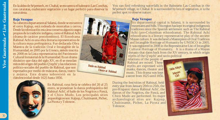
Baja VerapazSu cabecera departamental Salamá, donde se encuentrael cerro Kajiup, está rodeada de montañas y cerros.Desde la colonización esta área conserva algunos rasgospropios de la tradición indígena, como el Rabinal Achí(drama de carácter precolombino). El EtnodramaRabinal Achí es una obra literaria representativa dela cultura maya prehispánica. Fue declarada ObraMaestra de la tradición Oral e Intangible de laHumanidad, en 2005 por la Unesco, siendo inscritaen 2008 en la Lista representativa del PatrimonioCultural Inmaterial de la Humanidad. Es un dramadinástico que data del siglo XV, en él se mezclanmitos del origen del pueblo Q'eqchi' y las relacionespolítico-sociales del pueblo de Rabinal, que sonexpresados por medio de máscaras, danza, teatroy música. Este drama sobrevivió en laclandestinidad desde 1625 hasta 1856.
En Rabinal, cuya feria se celebra del 20 al 25enero, se presentan la danza prehispánica delRabinal Achi', el baile de los Negritos y Paxcá,y el Chico Mudo. Los principales sitiosarqueológicos son: Kajyup, Chuitinamit, Pichec,La Picota y Toloxcoc.
You can find refreshing waterfalls in the Balneario Las Conchas in theSe'pemech village, in Chahal. It is surrounded by lots of vegetation, it is theperfect spot to observe nature.
Baja VerapazIts departmental capital is Salamá, it is surrounded bymountains and hills. This region has kept its original indigenoustraditions since the Spanish settlement such as The RabinalAchí (pre-Columbian ethnodrama). The Rabinal Achíethnodrama is a literary representative play of the ancientMayan culture. It was declared a Masterpiece of Oral Traditionand Intangible Heritage of Humanity by UNESCO in 2005.It was registered in 2008 in the Representative List of IntangibleCultural Heritage of Humanity. It is a drama of a Mayandynasty that dates back from the XV century, in which originmyths of the Q'eqchi' and socio-politicalrelations of the people ofRabinal are mixed. Thesemyths are expressed withmasks, dances, theater andmusic. This drama was kepta secret from 1625 until 1856.
During the festivities of Rabinal, heldevery year from January 20th to 25th, thepre-Hispanic dance Rabinal Achi', thedances of the Negritos, the Paxcá, andChico Mudo are performed. Its majorarchaeological s ites are: Kajyup,Chuitinamit, Pichec, La Picota andToloxcoc.
70
Viv
e G
uate
mal
a
Liv
e G
uate
mal
a
Baile en RabinalDance at Rabinal
JCL
Niña Maya
MayanGirl
Fotografía: INGUAT
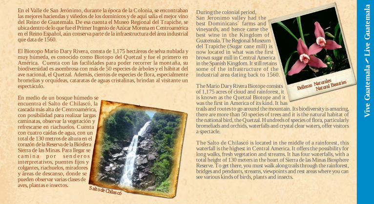
En el Valle de San Jerónimo, durante la época de la Colonia, se encontrabanlas mejores haciendas y viñedos de los dominicos y de aquí salía el mejor vinodel Reino de Guatemala. De esa cuenta el Museo Regional del Trapiche, seubica dentro de lo que fue el Primer Ingenio de Azúcar Morena en Centroaméricaen el Reino Español, aún conserva parte de la infraestructura del área industrialque data de 1560.
El Biotopo Mario Dary Rivera, consta de 1,175 hectáreas de selva nublada ymuy húmeda, es conocido como Biotopo del Quetzal y fue el primero enAmérica. Cuenta con las facilidades para poder recorrer la montaña, subiodiversidad es asombrosa con más de 50 especies de árboles y el hábitat delave nacional, el Quetzal. Además, cientos de especies de flora, especialmentebromelias y orquídeas, cataratas de aguas cristalinas, brindan al visitante unespectáculo.
En medio de un bosque húmedo seencuentra el Salto de Chilascó, lacascada más alta de Centroamérica,con posibilidad para realizar largascaminatas, observar la vegetación yrefrescarse en riachuelos. Cuentacon cuatro caídas de agua, con untotal de 130 metros de altura en elcorazón de la Reserva de la BiósferaSierra de las Minas. Para llegar sec a m i n a p o r s e n d e r o sinterpretativos, puentes fijos ycolgantes, riachuelos, miradoresy áreas de descanso, donde sepueden observar varias clases deaves, plantas e insectos.
During the colonial period,San Jeronimo valley had thebest Dominicans´ farms andvineyards, and hence came thebest wine in the Kingdom ofGuatemala. The Regional Museumdel Trapiche (Sugar cane mill) isnow located in what was the firstbrown sugar mill in Central Americain the Spanish Kingdom. It still retainssome of the infrastructure of theindustrial area dating back to 1560.
The Mario Dary Rivera Biotope consistsof 1,175 acres of cloud and rainforest, itis known as the Quetzal Biotope and itwas the first in America of its kind. It hastrails and routes to go around the mountain. Its biodiversity is amazing,there are more than 50 species of trees and it is the natural habitat ofthe national bird, the Quetzal. Hundreds of species of flora, particularlybromeliads and orchids, waterfalls and crystal clear waters, offer visitorsa spectacle.
The Salto de Chilascó is located in the middle of a rainforest, thiswaterfall is the highest in Central America. It offers the possibility forlong walks, fresh vegetation and streams. It has four waterfalls, with atotal height of 130 meters in the heart of Sierra de las Minas BiosphereReserve. To get there, you must walk along trails through the rainforest,bridges and pendants, streams, viewpoints and rest areas where you cansee various kinds of birds, plants and insects.
Viv
e G
uate
mal
a
Liv
e G
uate
mal
a
Fotografía: INGUAT
Bellezas NaturalesNatural Beauties
Salto de Chilascó
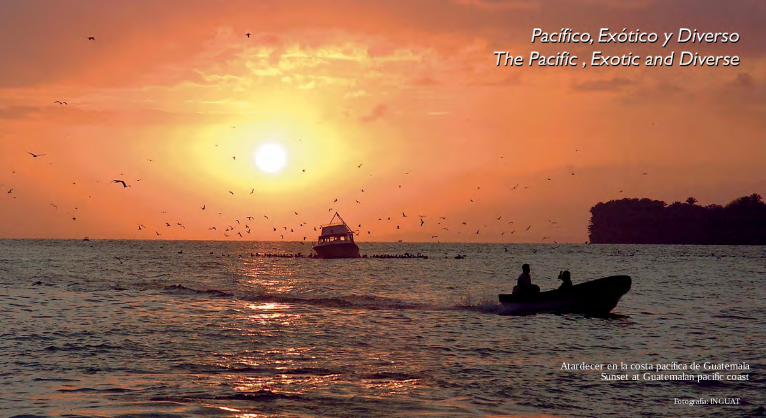
Fotografía: INGUAT
Atardecer en la costa pacífica de GuatemalaSunset at Guatemalan pacific coast
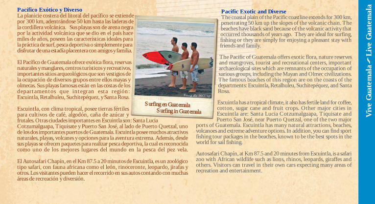
Pacífico Exótico y DiversoLa planicie costera del litoral del pacífico se extiendepor 300 km, adentrándose 50 km hasta las laderas dela cordillera volcánica. Sus playas son de arena negrapor la actividad volcánica que se dio en el país hacemiles de años, poseen las características ideales parala práctica de surf, pesca deportiva o simplemente paradisfrutar de una estadía placentera con amigos y familia.
El Pacífico de Guatemala ofrece exótica flora, reservasnaturales y manglares, centros turísticos y recreativos,importantes sitios arqueológicos que son vestigios dela ocupación de diversos grupos entre ellos mayas yolmecas. Sus playas famosas están en las costas de losdepartamentos que integran esta región:Escuintla, Retalhuleu, Suchitepéquez, y Santa Rosa.
Escuintla, con clima tropical, posee tierras fértilespara cultivos de café, algodón, caña de azúcar yfrutales. Otras ciudades importantes en Escuintla son: Santa LuciaCotzumalguapa, Tiquisate y Puerto San José, al lado de Puerto Quetzal, unode los dos importantes puertos de Guatemala. Escuintla posee muchos atractivosnaturales, playas, volcanes y opciones para la aventura extrema. Además, desdesus playas se ofrecen paquetes para realizar pesca deportiva, la cual es reconocidacomo uno de los mejores lugares del mundo en la pesca del pez vela.
El Autosafari Chapín, en el Km 87.5 a 20 minutos de Escuintla, es un zoológicotipo safari, con fauna africana como el león, rinoceronte, leopardo, jirafas yotros. Los visitantes pueden hacer el recorrido en sus autos contando con muchasáreas de recreación y diversión.
Pacific Exotic and DiverseThe coastal plain of the Pacific coastline extends for 300 km,penetrating 50 km up the slopes of the volcanic chain. Thebeaches have black sand because of the volcanic activity thatoccurred thousands of years ago. They are ideal for surfing,fishing or they are simply for enjoying a pleasant stay withfriends and family.
The Pacific of Guatemala offers exotic flora, nature reservesand mangroves, tourist and recreational centers, importantarchaeological sites which are remnants of the occupation ofvarious groups, including the Mayan and Olmec civilizations.The famous beaches of this region are on the coasts of thedepartments: Escuintla, Retalhuleu, Suchitepéquez, and SantaRosa.
Escuintla has a tropical climate, it also has fertile land for coffee,cotton, sugar cane and fruit crops. Other major cities inEscuintla are: Santa Lucia Cotzumalguapa, Tiquisate andPuerto San José, near Puerto Quetzal, one of the two major
ports of Guatemala. Escuintla has many natural attractions, beaches,volcanoes and extreme adventure options. In addition, you can find sportfishing tour packages in the beaches, known to be the best spots in theworld for sail fishing.
Autosafari Chapín, at Km 87.5 and 20 minutes from Escuintla, is a safarizoo with African wildlife such as lions, rhinos, leopards, giraffes andothers. Visitors can travel in their own cars expecting many areas ofrecreation and entertainment.
Surfing en GuatemalaSurfing in Guatemala V
ive
Gua
tem
ala
L
ive
Gua
tem
ala
Fotografía: INGUAT
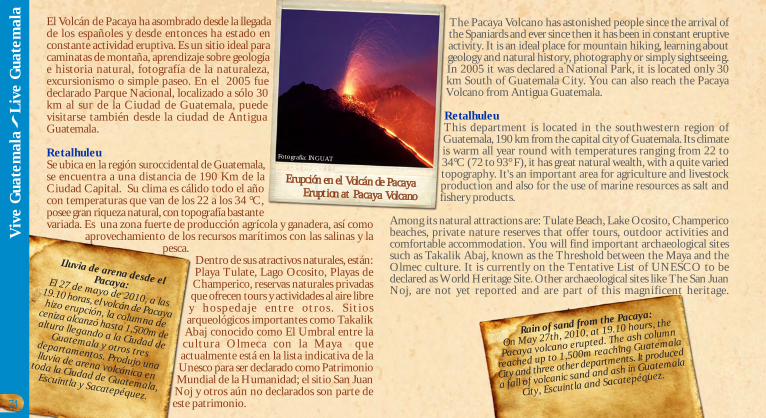
El Volcán de Pacaya ha asombrado desde la llegadade los españoles y desde entonces ha estado enconstante actividad eruptiva. Es un sitio ideal paracaminatas de montaña, aprendizaje sobre geologíae historia natural, fotografía de la naturaleza,excursionismo o simple paseo. En el 2005 fuedeclarado Parque Nacional, localizado a sólo 30km al sur de la Ciudad de Guatemala, puedevisitarse también desde la ciudad de AntiguaGuatemala.
RetalhuleuSe ubica en la región suroccidental de Guatemala,se encuentra a una distancia de 190 Km de laCiudad Capital. Su clima es cálido todo el añocon temperaturas que van de los 22 a los 34 °C,posee gran riqueza natural, con topografía bastantevariada. Es una zona fuerte de producción agrícola y ganadera, así como
aprovechamiento de los recursos marítimos con las salinas y lapesca.
Dentro de sus atractivos naturales, están:Playa Tulate, Lago Ocosito, Playas deChamperico, reservas naturales privadasque ofrecen tours y actividades al aire librey hospedaje entre otros . S it iosarqueológicos importantes como TakalikAbaj conocido como El Umbral entre lacultura Olmeca con la Maya queactualmente está en la lista indicativa de laUnesco para ser declarado como PatrimonioMundial de la Humanidad; el sitio San JuanNoj y otros aún no declarados son parte deeste patrimonio.
The Pacaya Volcano has astonished people since the arrival ofthe Spaniards and ever since then it has been in constant eruptiveactivity. It is an ideal place for mountain hiking, learning aboutgeology and natural history, photography or simply sightseeing.In 2005 it was declared a National Park, it is located only 30km South of Guatemala City. You can also reach the PacayaVolcano from Antigua Guatemala.
RetalhuleuThis department is located in the southwestern region ofGuatemala, 190 km from the capital city of Guatemala. Its climateis warm all year round with temperatures ranging from 22 to34°C (72 to 93° F), it has great natural wealth, with a quite variedtopography. It's an important area for agriculture and livestockproduction and also for the use of marine resources as salt andfishery products.
Among its natural attractions are: Tulate Beach, Lake Ocosito, Champericobeaches, private nature reserves that offer tours, outdoor activities andcomfortable accommodation. You will find important archaeological sitessuch as Takalik Abaj, known as the Threshold between the Maya and theOlmec culture. It is currently on the Tentative List of UNESCO to bedeclared as World Heritage Site. Other archaeological sites like The San JuanNoj, are not yet reported and are part of this magnificent heritage.
Erupción en el Volcán de PacayaEruption at Pacaya Volcano
Lluvia de arena desde elPacaya:El 27 de mayo de 2010, a las19.10 horas, el volcán de Pacayahizo erupción, la columna de
ceniza alcanzó hasta 1,500m dealtura llegando a la Ciudad de
Guatemala y otros tresdepartamentos. Produjo unalluvia de arena volcánica en
toda la Ciudad de Guatemala,Escuintla y Sacatepéquez.
Rain of sand from the Pacaya:
On May 27th, 2010, at 19.10 hours, the
Pacaya volcano erupted. The ash column
reached up to 1,500m reaching Guatemala
City and three other departments. It produced
a fall of volcanic sand and ash in Guatemala
City, Escuintla and Sacatepéquez.
74
Viv
e G
uate
mal
a
Liv
e G
uate
mal
a
Fotografía: INGUAT
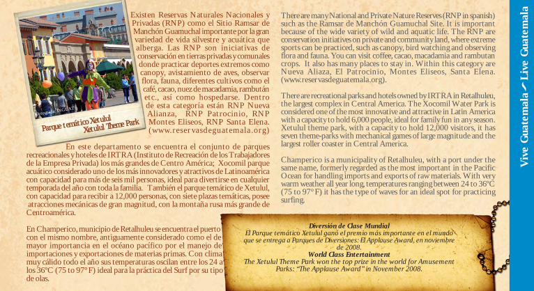
Existen Reservas Naturales Nacionales yPrivadas (RNP) como el Sitio Ramsar deManchón Guamuchal importante por la granvariedad de vida silvestre y acuática quealberga. Las RNP son iniciativas deconservación en tierras privadas y comunalesdonde practicar deportes extremos comocanopy, avistamiento de aves, observarflora, fauna, diferentes cultivos como elcafé, cacao, nuez de macadamia, rambutánetc., así como hospedarse. Dentrode esta categoría están RNP NuevaAlianza, RNP Patrocinio, RNPMontes Eliseos, RNP Santa Elena.(www.reser vasdeguatemala .org)
En este departamento se encuentra el conjunto de parquesrecreacionales y hoteles de IRTRA (Instituto de Recreación de los Trabajadoresde la Empresa Privada) los más grandes de Centro América; Xocomil parqueacuático considerado uno de los más innovadores y atractivos de Latinoaméricacon capacidad para más de seis mil personas, ideal para divertirse en cualquiertemporada del año con toda la familia. También el parque temático de Xetulul,con capacidad para recibir a 12,000 personas, con siete plazas temáticas, posee atracciones mecánicas de gran magnitud, con la montaña rusa más grande deCentroamérica.
En Champerico, municipio de Retalhuleu se encuentra el puertocon el mismo nombre, antiguamente considerado como el demayor importancia en el océano pacífico por el manejo deimportaciones y exportaciones de materias primas. Con climamuy cálido todo el año sus temperaturas oscilan entre los 24 alos 36ºC (75 to 97° F) ideal para la práctica del Surf por su tipode olas.
There are many National and Private Nature Reserves (RNP in spanish)such as the Ramsar de Manchón Guamuchal Site. It is importantbecause of the wide variety of wild and aquatic life. The RNP areconservation initiatives on private and community land, where extremesports can be practiced, such as canopy, bird watching and observingflora and fauna. You can visit coffee, cacao, macadamia and rambutancrops. It also has many places to stay in. Within this category areNueva Aliaza, El Patrocinio, Montes Eliseos, Santa Elena.(www.reservasdeguatemala.org).
There are recreational parks and hotels owned by IRTRA in Retalhuleu,the largest complex in Central America. The Xocomil Water Park isconsidered one of the most innovative and attractive in Latin Americawith a capacity to hold 6,000 people, ideal for family fun in any season.Xetulul theme park, with a capacity to hold 12,000 visitors, it hasseven theme-parks with mechanical games of large magnitude and thelargest roller coaster in Central America.
Champerico is a municipality of Retalhuleu, with a port under thesame name, formerly regarded as the most important in the PacificOcean for handling imports and exports of raw materials. With verywarm weather all year long, temperatures ranging between 24 to 36ºC(75 to 97° F) it has the type of waves for an ideal spot for practicingsurfing.
Diversión de Clase MundialEl Parque temático Xetulul ganó el premio más importante en el mundoque se entrega a Parques de Diversiones: El Applause Award, en noviembre
de 2008.World Class Entertainment
The Xetulul Theme Park won the top prize in the world for AmusementParks: “The Applause Award” in November 2008.
Parque temático XetululXetulul Theme Park
Viv
e G
uate
mal
a
Liv
e G
uate
mal
a
Fotografía: INGUAT
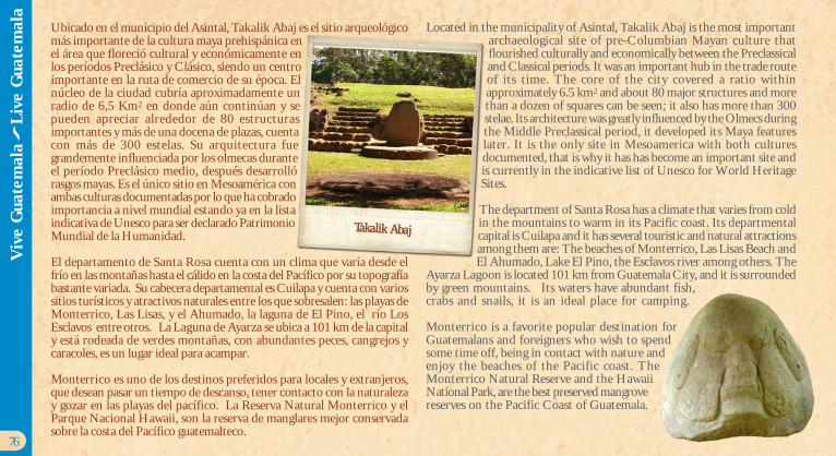
Ubicado en el municipio del Asintal, Takalik Abaj es el sitio arqueológicomás importante de la cultura maya prehispánica enel área que floreció cultural y económicamente enlos períodos Preclásico y Clásico, siendo un centroimportante en la ruta de comercio de su época. Elnúcleo de la ciudad cubría aproximadamente unradio de 6,5 Km2 en donde aún continúan y sepueden apreciar alrededor de 80 estructurasimportantes y más de una docena de plazas, cuentacon más de 300 estelas. Su arquitectura fuegrandemente influenciada por los olmecas duranteel período Preclásico medio, después desarrollórasgos mayas. Es el único sitio en Mesoamérica conambas culturas documentadas por lo que ha cobradoimportancia a nivel mundial estando ya en la listaindicativa de Unesco para ser declarado PatrimonioMundial de la Humanidad.
El departamento de Santa Rosa cuenta con un clima que varía desde elfrío en las montañas hasta el cálido en la costa del Pacífico por su topografíabastante variada. Su cabecera departamental es Cuilapa y cuenta con variossitios turísticos y atractivos naturales entre los que sobresalen: las playas deMonterrico, Las Lisas, y el Ahumado, la laguna de El Pino, el río LosEsclavos entre otros. La Laguna de Ayarza se ubica a 101 km de la capitaly está rodeada de verdes montañas, con abundantes peces, cangrejos ycaracoles, es un lugar ideal para acampar.
Monterrico es uno de los destinos preferidos para locales y extranjeros,que desean pasar un tiempo de descanso, tener contacto con la naturalezay gozar en las playas del pacífico. La Reserva Natural Monterrico y elParque Nacional Hawaii, son la reserva de manglares mejor conservadasobre la costa del Pacífico guatemalteco.
Located in the municipality of Asintal, Takalik Abaj is the most importantarchaeological site of pre-Columbian Mayan culture thatflourished culturally and economically between the Preclassicaland Classical periods. It was an important hub in the trade routeof its time. The core of the city covered a ratio withinapproximately 6.5 km2 and about 80 major structures and morethan a dozen of squares can be seen; it also has more than 300stelae. Its architecture was greatly influenced by the Olmecs duringthe Middle Preclassical period, it developed its Maya featureslater. It is the only site in Mesoamerica with both culturesdocumented, that is why it has has become an important site andis currently in the indicative list of Unesco for World HeritageSites.
The department of Santa Rosa has a climate that varies from coldin the mountains to warm in its Pacific coast. Its departmentalcapital is Cuilapa and it has several touristic and natural attractionsamong them are: The beaches of Monterrico, Las Lisas Beach andEl Ahumado, Lake El Pino, the Esclavos river among others. The
Ayarza Lagoon is located 101 km from Guatemala City, and it is surroundedby green mountains. Its waters have abundant fish,crabs and snails, it is an ideal place for camping.
Monterrico is a favorite popular destination forGuatemalans and foreigners who wish to spendsome time off, being in contact with nature andenjoy the beaches of the Pacific coast. TheMonterrico Natural Reserve and the HawaiiNational Park, are the best preserved mangrovereserves on the Pacific Coast of Guatemala.
Takalik Abaj
76
Viv
e G
uate
mal
a
Liv
e G
uate
mal
a
GK
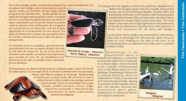
Entre los mangles anidan muchas aves migratorias como los pelícanos. Losmanglares son refugio, entre otras especies, para laiguana verde y el cocodrilo, de los cuales existenprogramas de reproducción. Suelen anidar en susplayas las tortugas marinas parlama y baule, cuya épocade cría se extiende principalmente entre los meses demayo a septiembre, por lo que los visitantes puedenobservar muchas veces la liberación de tortuguitasque constituye un acto divertido y a la vez de gransignificado en la preservación de esta especie. Lasplayas de Monterrico cuentan con una amplia ofertade hoteles y restaurantes para todos los gustos ypresupuestos.
Los Esclavos es un río caudaloso, aprovechado poruna hidroeléctrica con un puente antiguo con másde 500 años de existencia. En los muros de rocaubicados a sus costados, se realizan rutas deportivaspara escalada en roca. En sus alrededores hayplantaciones de café y es posible hacer caminataspor sus senderos.
Suchitepequez, su cabecera departamental es Mazatenango y está a 165 km dela ciudad capital. Es una región fértil, en donde los árboles como los conacastes,
ceibas o palo blancos resaltan en el paisaje. Mazatenangoes famoso por su feria titular del carnaval, la cual se
celebra durante 8 días y cuenta con prestigio nacionale internacional. Entre sus actividades hay juegos
florales, desfiles escolares, cívicos, juegosdeportivos nacionales e internacionales,
presentación de bailes tradicionales,ceremonias religiosas.
The mangroves nest migratory birds such as pelicans. Mangroves areshelters for the green iguana and the crocodile, among otherspecies, and it has breeding programs. Usually ridley andleatherback turtles nest on the beaches, their breeding seasonextends mainly between May and September, therefore visitorscan observe the release of baby turtles many times. The turtlerelease is a fun event and of high significance in the preservationof this species. Monterrico's beaches have a wide selection ofhotels and restaurants for all tastes and budgets.
Los Esclavos river is a mighty one, harnessed by a hydroelectricplant with an old bridge over 500 years old. Sport routes aremade for rock climbing on the sides of the river. In itssurroundings there are plantations of coffee and it is possibleto hike its trails.
M a z a t e n a n g o i s t h edepartmental capital ofSuchitepequez, located165
km from the capital city of Guatemala.It is a fertile region, where trees suchas the Conacaste, Ceibas (nationaltree) or Palo Blanco stand out in thelandscape. Mazatenango is famous forits carnival festivities, which arecelebrated for 8 days; it has nationaland international prestige. Amongits activities are floral games, schooland civic parades, national andinternat ional sports games ,presentation of traditional dancesand religious ceremonies.
Liberación de tortugas - MonterricoTurtles Release - Monterrico
ManglaresMangroves
Viv
e G
uate
mal
a
Liv
e G
uate
mal
a
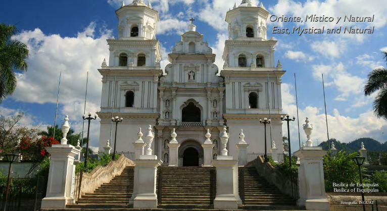
Fotografía: INGUAT
Basílica de EsquipulasBasílica of Esquipulas
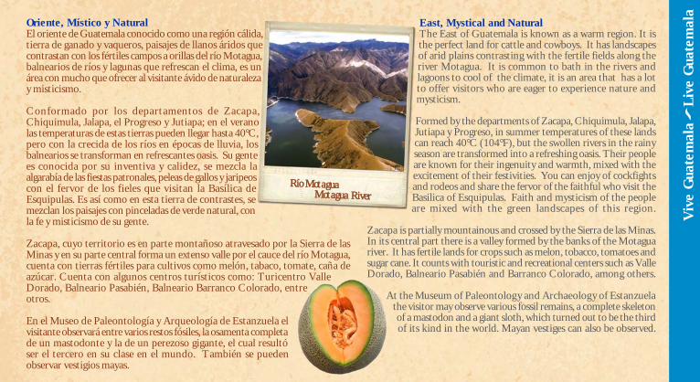
Oriente, Místico y NaturalEl oriente de Guatemala conocido como una región cálida,tierra de ganado y vaqueros, paisajes de llanos áridos quecontrastan con los fértiles campos a orillas del río Motagua,balnearios de ríos y lagunas que refrescan el clima, es unárea con mucho que ofrecer al visitante ávido de naturalezay misticismo.
Conformado por los departamentos de Zacapa,Chiquimula, Jalapa, el Progreso y Jutiapa; en el veranolas temperaturas de estas tierras pueden llegar hasta 40°C,pero con la crecida de los ríos en épocas de lluvia, losbalnearios se transforman en refrescantes oasis. Su gentees conocida por su inventiva y calidez, se mezcla laalgarabía de las fiestas patronales, peleas de gallos y jaripeoscon el fervor de los fieles que visitan la Basílica deEsquipulas. Es así como en esta tierra de contrastes, semezclan los paisajes con pinceladas de verde natural, conla fe y misticismo de su gente.
Zacapa, cuyo territorio es en parte montañoso atravesado por la Sierra de lasMinas y en su parte central forma un extenso valle por el cauce del río Motagua,cuenta con tierras fértiles para cultivos como melón, tabaco, tomate, caña deazúcar. Cuenta con algunos centros turísticos como: Turicentro ValleDorado, Balneario Pasabién, Balneario Barranco Colorado, entreotros.
En el Museo de Paleontología y Arqueología de Estanzuela elvisitante observará entre varios restos fósiles, la osamenta completade un mastodonte y la de un perezoso gigante, el cual resultóser el tercero en su clase en el mundo. También se puedenobservar vestigios mayas.
East, Mystical and NaturalThe East of Guatemala is known as a warm region. It isthe perfect land for cattle and cowboys. It has landscapesof arid plains contrasting with the fertile fields along theriver Motagua. It is common to bath in the rivers andlagoons to cool of the climate, it is an area that has a lotto offer visitors who are eager to experience nature andmysticism.
Formed by the departments of Zacapa, Chiquimula, Jalapa,Jutiapa y Progreso, in summer temperatures of these landscan reach 40°C (104°F), but the swollen rivers in the rainyseason are transformed into a refreshing oasis. Their peopleare known for their ingenuity and warmth, mixed with theexcitement of their festivities. You can enjoy of cockfightsand rodeos and share the fervor of the faithful who visit theBasilica of Esquipulas. Faith and mysticism of the peopleare mixed with the green landscapes of this region.
Zacapa is partially mountainous and crossed by the Sierra de las Minas.In its central part there is a valley formed by the banks of the Motaguariver. It has fertile lands for crops such as melon, tobacco, tomatoes andsugar cane. It counts with touristic and recreational centers such as ValleDorado, Balneario Pasabién and Barranco Colorado, among others.
At the Museum of Paleontology and Archaeology of Estanzuelathe visitor may observe various fossil remains, a complete skeletonof a mastodon and a giant sloth, which turned out to be the thirdof its kind in the world. Mayan vestiges can also be observed.
Viv
e G
uate
mal
a
Liv
e G
uate
mal
a
Río MotaguaMotagua River
RL
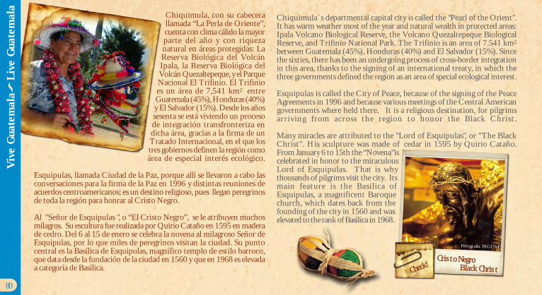
Chiquimula, con su cabecerallamada “La Perla de Oriente”,cuenta con clima cálido la mayorparte del año y con riquezanatural en áreas protegidas: LaReserva Biológica del VolcánIpala, la Reserva Biológica delVolcán Quezaltepeque, y el ParqueNacional El Trifinio. El Trifinioes un área de 7,541 km2 entreGuatemala (45%), Honduras (40%)y El Salvador (15%). Desde los añossesenta se está viviendo un procesode integración transfronteriza endicha área, gracias a la firma de unTratado Internacional, en el que lostres gobiernos definen la región comoárea de especial interés ecológico.
Esquipulas, llamada Ciudad de la Paz, porque allí se llevaron a cabo lasconversaciones para la firma de la Paz en 1996 y distintas reuniones deacuerdos centroamericanos; es un destino religioso, pues llegan peregrinosde toda la región para honrar al Cristo Negro.
Al "Señor de Esquipulas ", o “El Cristo Negro”, se le atribuyen muchosmilagros. Su escultura fue realizada por Quirio Cataño en 1595 en maderade cedro. Del 6 al 15 de enero se celebra la novena al milagroso Señor deEsquipulas, por lo que miles de peregrinos visitan la ciudad. Su puntocentral es la Basílica de Esquipulas, magnífico templo de estilo barroco,que data desde la fundación de la ciudad en 1560 y que en 1968 es elevadaa categoría de Basílica.
Chiquimula´s departmental capital city is called the "Pearl of the Orient".It has warm weather most of the year and natural wealth in protected areas:Ipala Volcano Biological Reserve, the Volcano Quezaltepeque BiologicalReserve, and Trifinio National Park. The Trifinio is an area of 7.541 km2
between Guatemala (45%), Honduras (40%) and El Salvador (15%). Sincethe sixties, there has been an undergoing process of cross-border integrationin this area, thanks to the signing of an international treaty, in which thethree governments defined the region as an area of special ecological interest.
Esquipulas is called the City of Peace, because of the signing of the PeaceAgreements in 1996 and because various meetings of the Central Americangovernments where held there. It is a religious destination, for pilgrimsarriving from across the region to honor the Black Christ.
Many miracles are attributed to the "Lord of Esquipulas", or "The BlackChrist". His sculpture was made of cedar in 1595 by Quirio Cataño.From January 6 to 15th the “Novena”iscelebrated in honor to the miraculousLord of Esquipulas. That is whythousands of pilgrims visit the city. Itsmain feature is the Basilica ofEsquipulas, a magnificent Baroquechurch, which dates back from thefounding of the city in 1560 and waselevated to the rank of Basilica in 1968.
Cristo NegroBlack Christ
80
Viv
e G
uate
mal
a
Liv
e G
uate
mal
a
Fotografía: INGUAT
Check!
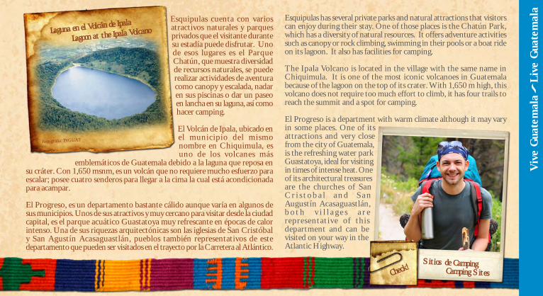
Esquipulas cuenta con variosatractivos naturales y parquesprivados que el visitante durantesu estadía puede disfrutar. Unode esos lugares es el ParqueChatún, que muestra diversidadde recursos naturales, se puederealizar actividades de aventuracomo canopy y escalada, nadaren sus piscinas o dar un paseoen lancha en su laguna, así comohacer camping.
El Volcán de Ipala, ubicado enel municipio del mismonombre en Chiquimula, esuno de los volcanes más
emblemáticos de Guatemala debido a la laguna que reposa ensu cráter. Con 1,650 msnm, es un volcán que no requiere mucho esfuerzo paraescalar; posee cuatro senderos para llegar a la cima la cual está acondicionadapara acampar.
El Progreso, es un departamento bastante cálido aunque varía en algunos desus municipios. Unos de sus atractivos y muy cercano para visitar desde la ciudadcapital, es el parque acuático Guastatoya muy refrescante en épocas de calorintenso. Una de sus riquezas arquitectónicas son las iglesias de San Cristóbaly San Agustín Acasaguastlán, pueblos también representativos de estedepartamento que pueden ser visitados en el trayecto por la Carretera al Atlántico.
Esquipulas has several private parks and natural attractions that visitorscan enjoy during their stay. One of those places is the Chatún Park,which has a diversity of natural resources. It offers adventure activitiessuch as canopy or rock climbing, swimming in their pools or a boat rideon its lagoon. It also has facilities for camping.
The Ipala Volcano is located in the village with the same name inChiquimula. It is one of the most iconic volcanoes in Guatemalabecause of the lagoon on the top of its crater. With 1,650 m high, thisvolcano does not require too much effort to climb, it has four trails toreach the summit and a spot for camping.
El Progreso is a department with warm climate although it may varyin some places. One of itsattractions and very closefrom the city of Guatemala,is the refreshing water parkGuastatoya, ideal for visitingin times of intense heat. Oneof its architectural treasuresare the churches of SanC r i s t o b a l a n d S a nAugustín Acasaguastlán,b o t h v i l l a g e s a r erepresentative of thisdepartment and can bevisited on your way in theAtlantic Highway.
Viv
e G
uate
mal
a
Liv
e G
uate
mal
a
Fotografía: INGUAT
Sitios de CampingCamping SitesCheck!
Laguna en el Volcán de Ipala
Lagoon at the Ipala Volcano
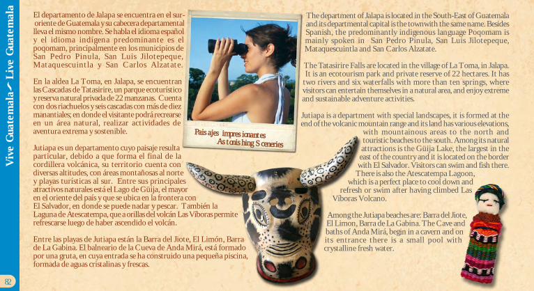
El departamento de Jalapa se encuentra en el sur- oriente de Guatemala y su cabecera departamentallleva el mismo nombre. Se habla el idioma españoly el idioma indígena predominante es elpoqomam, principalmente en los municipios deSan Pedro Pinula, San Luis Jilotepeque,Mataquescuintla y San Carlos Alzatate.
En la aldea La Toma, en Jalapa, se encuentranlas Cascadas de Tatasirire, un parque ecoturísticoy reserva natural privada de 22 manzanas. Cuentacon dos riachuelos y seis cascadas con más de diezmanantiales; en donde el visitante podrá recrearseen un área natural, realizar actividades deaventura extrema y sostenible.
Jutiapa es un departamento cuyo paisaje resultaparticular, debido a que forma el final de lacordillera volcánica, su territorio cuenta condiversas altitudes, con áreas montañosas al nortey playas turísticas al sur. Entre sus principalesatractivos naturales está el Lago de Güija, el mayoren el oriente del país y que se ubica en la frontera conEl Salvador, en donde se puede nadar y pescar. También laLaguna de Atescatempa, que a orillas del volcán Las Víboras permiterefrescarse luego de haber ascendido el volcán.
Entre las playas de Jutiapa están la Barra del Jiote, El Limón, Barrade La Gabina. El balneario de la Cueva de Anda Mirá, está formadopor una gruta, en cuya entrada se ha construido una pequeña piscina,formada de aguas cristalinas y frescas.
The department of Jalapa is located in the South-East of Guatemalaand its departmental capital is the townwith the same name. BesidesSpanish, the predominantly indigenous language Poqomam ismainly spoken in San Pedro Pinula, San Luis Jilotepeque,Mataquescuintla and San Carlos Alzatate.
The Tatasirire Falls are located in the village of La Toma, in Jalapa. It is an ecotourism park and private reserve of 22 hectares. It hastwo rivers and six waterfalls with more than ten springs, wherevisitors can entertain themselves in a natural area, and enjoy extremeand sustainable adventure activities.
Jutiapa is a department with special landscapes, it is formed at theend of the volcanic mountain range and its land has various elevations,
with mountainous areas to the north andtouristic beaches to the south. Among its naturalattractions is the Güija Lake, the largest in the
east of the country and it is located on the borderwith El Salvador. Visitors can swim and fish there.
There is also the Atescatempa Lagoon,which is a perfect place to cool down and
refresh or swim after having climbed LasVíboras Volcano.
Among the Jutiapa beaches are: Barra del Jiote,El Limon, Barra de La Gabina. The Cave andbaths of Anda Mirá, begin in a cavern and onits entrance there is a small pool withcrystalline fresh water.
82
Viv
e G
uate
mal
a
Liv
e G
uate
mal
a
Paisajes impresionantesAstonishing Sceneries