vocals-regional experiment vocals-rex experimental … · (vocals-rex) experimental design overview...
TRANSCRIPT

VOCALS-Regional Experiment
(VOCALS-REx)
EXPERIMENTAL DESIGN OVERVIEW
Robert Wood (University of Washington) and the VOCALS Scientific Working Group
Contributions from Christopher Bretherton (University of Washington), Chris Fairall (NOAA ETL), Laura Gallardo Klenner (Universidad de Chile), Steve Esbensen (Oregon State University), Graham Feingold (NOAA ETL), Rene Garreaud (Universidad de Chile), Barry Huebert (University of Hawaii), Dave Leon (University of Wyoming), C.
Roberto Mechoso (UCLA), Jim McWilliams (UCLA), Art Miller (Scripps Institution of Oceanography), Oscar Pizarro (Universidad de Concepcion, Chile), Jose Rutllant (Universidad de Chile), Jefferson Snider (University of
Wyoming), Ken Takahashi (IGP, Lima and University of Washington), Robert Weller (WHOI), Hemantha Wijesekera (Oregon State University), Sandra Yuter (North Carolina State University), Sarah Doherty (University of
Washington, IGAC)
January 2006

2
Table of Contents
EXECUTIVE SUMMARY .......................................................................................................... 3
PROGRAM RATIONALE, HYPOTHESES, AND OBJECTIVES........................................ 5
EXPERIMENTAL DESIGN AND OBSERVATIONAL REQUIREMENTS........................ 7
VOCALS-REX STUDY REGION AND DATES ...............................................................................................................7 PLATFORMS AND INSTRUMENTATION.........................................................................................................................8
C-130 Instruments.................................................................................................................................................8 NOAA R/V Ronald H Brown instruments............................................................................................................10 NOAA P3 Instruments.........................................................................................................................................13 Chilean coastal component platforms and instrumentation................................................................................14 Peruvian coastal component platforms and instrumentation..............................................................................14
PLATFORM DEPLOYMENT AND SAMPLING STRATEGY ...............................................................................................15 C-130 sampling strategy .....................................................................................................................................15 RHB deployment strategy ...................................................................................................................................21 NOAA P3 sampling strategy ...............................................................................................................................22 VOCALS-REx Coastal component sampling ......................................................................................................22
PROJECT MANAGEMENT INCLUDING MANAGEMENT IN THE FIELD................. 25
DATA MANAGEMENT PLAN ................................................................................................ 26
SECTION I OF THE SPO ......................................................................................................... 27
SECTION J OF THE SPO......................................................................................................... 33

3
Executive Summary
The VAMOS Ocean-Cloud-Atmosphere-Land Study - Regional Experiment (VOCALS-REx) is an international field experiment designed to better understand physical and chemical processes central to the climate system of the Southeast Pacific (SEP) region. The climate of the SEP region is a tightly coupled system involving poorly understood interactions between the ocean, the atmosphere, and the land (Fig. 1) VOCALS-REx will focus on interactions between clouds, aerosols, marine boundary layer (MBL) processes, upper ocean dynamics and thermodynamics, coastal currents and upwelling, large-scale subsidence, and regional diurnal circulations, to the west of the Andes mountain range. The field experiment is ultimately driven by a need for improved model simulations of the coupled climate system in both the SEP and over the wider tropics and subtropics.
Figure 1: Key features and processes in the Southeast Pacific climate system.
VOCALS-REx will provide detailed and targeted observations of those processes that impact the SEP climate system and are amenable to study with a month long program. The intensive field observations are a vital component of the broader VOCALS program and have been carefully designed to complement a suite of enhanced long-term observations. The long-term observations provide important context for the intensive observations. In addition, a major thrust of the VOCALS program is to provide coordination for modeling activities, which will benefit from the intensive observations in a poorly observed region where coupled ocean-atmosphere models exhibit strong biases in sea surface temperature. The coordination through VOCALS of observational and modeling efforts will lead to an improved pull-through for climate and regional forecasting agencies.
Multi-disciplinary intensive observational datasets will be obtained during VOCALS-REx from several platforms including aircraft, research vessels, and a surface land site. These datasets will be used

4
to test a coordinated set of hypotheses that are organized into two broad themes: (1) improved understanding of aerosol-cloud-drizzle interactions in the marine boundary layer (MBL) and the physicochemical and spatiotemporal properties of aerosols; (2) improved understanding of the chemical and physical couplings between the upper ocean, the land, and the atmosphere. The intensive observational period will be a month long and will take place during October 2007, chosen because it is the month during which the coverage of stratocumulus over the SEP is at its greatest, the southeast trade winds are at their strongest, and the coupling between the upper ocean and the lower atmosphere is at its tightest.
Intellectual merits:
The proposed work involves making state of the art field measurements of the atmosphere and ocean in a climate regime that is poorly explored but that has important consequences for the regional and global climate system. Few previous observational programs have been designed with such a strong multidisciplinary focus, and the simultaneous and collocated ocean and atmosphere dataset will allow an unprecedented examination of how mesoscale ocean variability impacts the chemical and aerosol properties of the lower atmosphere. These measurements will have a broad impact upon current knowledge in the fields of atmospheric science and oceanography which will ultimately lead to improved predictions of future climate.
Broader impacts:
The field and subsequent analysis phases will involve and foster considerable international collaboration and provide important training for a number of scientists and graduate students. The datasets generated in the field will stimulate the development of a broad range of numerical process models, and provide invaluable constraints that will accelerate the improvement of regional and global climate models.

5
Program Rationale, Hypotheses, and Objectives
A justification of the key scientific issues and a complete description of the objectives of VOCALS-REx are presented in the Scientific Program Overview (SPO) document. Here, we present a concise description of the scientific issues and hypotheses that will be tested with datasets obtained during the field program.
The climate of the SEP is dependent upon important interactions and feedbacks between the upper ocean, the Andes mountains, and the lower troposphere. Marine boundary layer (MBL) clouds, which swathe a large fraction of the SEP, are essential for driving strong trade winds and producing the observed SST distribution. The Andes mountains increase the lower tropospheric static stability over the SEP, enhancing the cloud cover and encourage the formation of a near-coastal jet in the MBL that enhances the oceanic upwelling of cold, nutrient-rich water. The mountains also drive a stronger subtropical gyre which increases the evaporative cooling of the surface and further reduces SST. The coastal upwelling associated with the Humboldt Current system is not only important in the coastal zone, but also impacts the SST much further offshore through ocean transport processes that include mesoscale eddy transport. The climate of the SEP region is therefore a tightly coupled system involving interactions between
the ocean, the atmosphere, and the land. The SEP climate system is unique in that its ocean current system is the only eastern boundary current directly connected with the tropical ocean and so is subject to strong ENSO variability. The SEP climate system is poorly explored observationally, yet our ability to make accurate predictions of the broader tropical climate is strongly sensitive to its representation in numerical models. These models, especially those which couple the ocean and atmosphere, exhibit strong biases in the SEP that stem directly from poorly represented processes occurring on scales smaller than the model resolution.
Cloud optical properties over the SEP are influenced by large scale dynamics, boundary layer turbulence, and by atmospheric aerosols. Turbulence, primarily driven by the clouds themselves, is responsible for maintaining the cloud moisture supply, allowing the MBL to remain well mixed and capped with cloud. Precipitation can influence the cloud structure and dynamics and may be responsible for rapid transitions in cloudiness that are observed from satellite over the SEP. Aerosols influence the cloud microphysical properties and may suppress drizzle if their concentration is high enough. Both natural and anthropogenic sources are expected to influence the aerosol properties over the SEP. Satellite observations, model results, and limited in-situ data show that the background conditions are remarkably pristine, but that strong sulfur emissions from Chilean and Peruvian copper smelters lead to strongly polluted conditions near the coasts. The strong microphysical contrasts provide an excellent test bed for hypotheses concerning indirect effects of aerosols.
The maintenance of the SST distribution over the SEP is an important unresolved problem. Satellite altimetry, SST maps, and regional ocean model studies all reveal that mesoscale eddies 50-200 km across can affect the SST well offshore by fluxing cold water out from the coastal upwelling regions. Through their nutrient content, these eddies could also impact the ocean-atmosphere flux of dimethylsulfide (DMS), and important aerosol precursor gas. A preliminary study of the three-year mean heat budget at the WHOI stratus buoy suggests that heat flux divergence by mesoscale eddies is the most plausible process to balance the roughly 40 W m-2 net heat flux into the ocean measured at the buoy during this period.
VOCALS-REx will provide intensive observations of key processes contributing to the climate of the SEP. The observations will be used to test a coordinated set of hypotheses, to help validate satellite retrievals, and to evaluate our ability to model the important physical and chemical processes in the SEP. The VOCALS-REx hypotheses are organized into two broad categories: (1) testing hypotheses related to the impacts of aerosols upon the microphysical and structural properties of stratocumulus clouds and drizzle production; (2) testing hypotheses related to the coupled ocean-atmosphere-land system. The hypotheses are as follows:

6
1) TESTING AEROSOL-CLOUD-DRIZZLE HYPOTHESES
a) Variability in the physicochemical properties of aerosols has a measurable impact upon the
formation of drizzle in stratocumulus clouds over the SEP.
b) Precipitation is a necessary condition for the formation of pockets of open cells (POCs) within
stratocumulus clouds.
c) The small effective radii measured from space over the SEP are primarily controlled by
anthropogenic, rather than natural, aerosol production, and that entrainment of polluted air from
the lower free-troposphere is an important source of cloud condensation nuclei (CCN).
d) Depletion of aerosols by coalescence scavenging is necessary for the maintenance of POCs.
2) TESTING COUPLED OCEAN-ATMOSPHERE-LAND HYPOTHESES
a) Oceanic mesoscale eddies play a major role in the transport of heat and fresh water from
coastally upwelled water to regions further offshore.
b) Upwelling, by changing the physical and chemical properties of the upper ocean, has a
systematic and noticeable effect on aerosol precursor gases and the aerosol size distribution in
the MBL over the SEP.
c) The depth, phase speed, and vertical structure of the diurnal subsidence wave (“upsidence
wave”) originating on the Andes slopes in northern Chile/southern Peru is well predicted using
regional model simulations.
An additional key VOCALS-REx goal is to use the observational datasets to critically evaluate the accuracy of current and future satellite cloud microphysical retrieval algorithms. These measurements are central to our understanding and quantification of the indirect effects of aerosols upon clouds and the climate system.
The accompanying Scientific Program Overview (SPO) details the scientific rationale behind the hypotheses and describes how they will be tested using the intensive field observations. In the following sections of this document, we describe in detail the experimental design for VOCALS-REx which includes information on the location and dates of the proposed experiment, the platforms and instruments to be used, the sampling and data collection strategy, the program and data management.

7
Experimental Design and Observational Requirements
The multidisciplinary nature of the VOCALS-REx field program necessitates a multi-platform approach to observational data collection. In this section we describe the experimental design, including the different research platforms, the instruments they will carry, and their deployment strategy, while maintaining a focus upon how the datasets obtained from them will be used to meet the scientific program objectives.
Two major platforms form the central core of our experimental design and are essential to the overall success of the program: (a) the NSF C-130 aircraft; (b) the NOAA R/V Ronald H Brown (RHB). In addition, a number of other platforms will provide additional important datasets especially at the land-ocean boundary, and these are described in detail below. The C-130 will provide detailed in-situ measurements of cloud microphysics, gas and aerosol physicochemical properties, lower tropospheric structure, and MBL turbulence, in addition to passive and active cloud and precipitation remote sensing measurements. The RHB will provide atmospheric, oceanographic and air-sea exchange datasets. Atmospheric measurements will include in-situ surface meteorology, rawinsonde profiles, and gas/aerosol physicochemical properties. Remote sensing measurements of cloud and precipitation will be made from the RHB using active millimeter and centimeter radars, a ceilometer, and a passive microwave radiometer. Oceanographic measurements from the RHB include the towed SeaSoar platform that will provide upper ocean vertical profile sampling, XBTs, surface drifters and thermistor chains, an ADCP, and high time resolution sea water DMS concentration.
VOCALS-REx study region and dates
Figure 2 shows a map of the Southeast Pacific (SEP) region which encompasses the smaller VOCALS-REx study region extending from 10-30°S and between 90°W and the Andes Cordillera (approximately 70°W). All C-130 and RHB operations during the field program will take place within the VOCALS-REx study region.
Figure 2: The Southeast Pacific (SEP),
and South American orography. The
VOCALS-REx study region comprises
the region between latitudes 10°S and
30°S, and between 90°W and the Andes
Cordillera. The proposed track of the
RHB is shown, along with the locations
of the IMET Buoy, San Felix Island, and
the flight tracks for the cross-section
flights with the NCAR C-130.

8
The field program will take place during the entire month of October 2007. The October time frame is chosen because it is the month at which the coverage of stratocumulus over the SEP is at its greatest (approximately 70%) and the southeast trade winds are at their strongest, which means that the coupling between the upper ocean and the lower atmosphere is at its tightest. This period will also provide continuity with the recent annual buoy maintenance cruises which have taken observational data during September-November (2001, 2003-2005, with further cruises planned for 2006 and 2008).
Platforms and instrumentation
C-130 Instruments
The NSF C-130 aircraft instrument payload for VOCALS-REx is given in Table 1. A total of 90 hours research time is requested for the C-130 to make approximately 10 flights of 9 hours duration. Preliminary costs estimates have been provided by NCAR Earth Observing Laboratory (EOL). The C-130 will be based either in Arica (18°S, 70°W) or Iquique (20°S, 70°W).
The C-130 will be equipped with the full range of in-situ meteorological, turbulence, and microphysical probes, and a dropsonde system will be used to give the large-scale meteorological context. A scanning backscatter lidar (SABL) will be used in vertically-pointing mode (both up and down) to detect cloud boundaries. The 95 GHz (W-band) Doppler polarization Wyoming Cloud Radar (WCR) will be used above cloud as depicted in Fig. 3 to detect the structural and kinematic structure of drizzle within and below stratocumulus clouds using dual antennas to carry out dual doppler analysis and obtain horizontal wind components along the flight direction. This configuration was employed successfully in the Dynamics and Chemistry of Marine Stratocumulus (DYCOMS-II) campaign in 2001.
Figure 3: Proposed WCR configuration on the C-130 during VOCALS-REx. Three derived fields are shown
(reflectivity, vertical Doppler velocity, and horizontal winds).
A comprehensive chemistry and aerosol sampling suite will be carried on the C-130. This includes
atmospheric pressure ionization mass spectrometry (APIMS) measurements of sulfur dioxide and dimethylsulfide (DMS), condensation nuclei (CN) and cloud condensation nuclei (CCN) counters, tandem differential mobility analyzer (DMA) aerosol size distributions and humidity growth factors for particles from 5-500 nm in diameter, scattering nephelometer measurements, and cascade impactor size-resolved aerosol chemical speciation. The suite is a slightly reduced version of that employed during ACE-ASIA. See Table 2 in Section I of the SPO (included at the end of this document) for a complete list of the proposed instrumentation in the C-130 chemistry and aerosol suite.

9
Passive remote sensing measurements will be made with high spatial resolution using NCAR’s Multichannel Radiometer (MCR) and Advanced Imaging Microwave Radiometer (AIMR). These instruments will provide the measurements of cloud liquid water path, optical depth, and the effective radius of cloud droplets necessary to quantify how cloud microphysical properties affect the optical and structural properties of low clouds over the SEP.
Table 1: NSF C-130 aircraft instrument requirements
Instrument Observations Funding source
Contact
Wyoming Cloud Radar (WCR) Cloud and precipitation structure, dynamics of precipitating systems
NSF Deployment
pool
Leon (University of Wyoming)
FSSP, 2D-C, 260X, PCASP
Gust probe, temperature and humidity sensors
Cloud microphysics, thermodynamics, turbulence, dynamics
NSF Deployment
pool
NCAR RAL
(standard instrument suite)
Dropsondes
(15 per flight)
Lower tropospheric and boundary layer structure
NSF Deployment
pool NCAR RAL
Scanning Aerosol Backscatter Lidar (SABL)
Cloud top and base height NSF-Clim NCAR RAL
APIMS (Atmospheric Pressure Ionization Mass Spectrometry)
SO2 and DMS high frequency gas phase measurements
NSF-Chem
(SOLAS)
Bandy, Thornton (Drexel University)
CCN Spectrometer Cloud condensation nuclei NSF-Clim Snider (University of
Wyoming)
Aerosol physicochemical measurement suite
Aerosol number concentration, size distribution, chemical composition,
optical properties
NSF-Chem
(SOLAS)
Howell and Huebert (University of
Hawaii)
Multi Channel Radiometer (MCR)
Passive remote sensing of cloud effective radius and optical depth
NSF Deployment
pool
Tschudi (NCAR EOL)
Airborne Imaging Microwave Radiometer (AIMR)
[37 and 90 GHz]
Passive remote sensing of cloud liquid water path
NSF Deployment
pool
Haggerty (NCAR EOL)

10
NOAA R/V Ronald H Brown instruments
The R/V Ronald H Brown (RHB) instrument payload is given in Table 2. The RHB has already been requested as part of NOAA CPPA proposal by Chris Fairall at NOAA ETL. A total of 45 days have been requested, of which approximately 35 during the entire month of October will constitute the intensive observational phase of VOCALS-REx. The C-130 and RHB deployments will be fully overlapped in time to maximize the synergy between the two platforms.
The RHB will be equipped with a set of cloud remote sensing instrumentation which will sample almost continuously throughout the cruise. A vertically-pointing stabilized 35 GHz sensitive millimeter radar will provide high vertical resolution (≈20 m) reflectivity profiles along with doppler spectral information for the determination of the size distribution of falling drizzle drops and from this the precipitation rate. A three-channel (20.6, 31.6 and 90 GHz) microwave radiometer will be used to determine the cloud liquid water path, and a Vaisala CT-25K ceilometer will provide measurements of cloud base and the surface area of drizzle drops.
A scanning C-band (5 cm wavelength) precipitation radar with a sensitivity of -12 dBZ will be used to determine horizontal and vertical structure, kinematics and evolution of the precipitation field within a 30 km radius of the ship (Fig 4). The C-band beamwidth is better than 500 m within 30 km of the ship, and the antenna is electronically stabilized to remove ship motion. There is negligible attenuation within drizzling stratocumulus. These measurements have also been invaluable in providing the first accurate determination of the statistical properties of precipitation in marine stratocumulus. A scanning strategy similar to that carried out in EPIC 2001 will be used in VOCALS-REx.
Figure 4: Example of C-
band capability for
observation of drizzle cells
in stratocumulus cloud. (a)
horizontal reflectivity map
showing cellularity; (b,c)
RHI scans showing vertical
cross sections (along solid
line in marked in (a))
detailing the structure and
kinematics of the inflow and
outflow regions of the
mesoscale cell pictured in
the photograph composite
between P and P’.
The RHB will also carry an extensive suite of in situ aerosol instruments, with which to record a time-series of aerosol physical and chemical properties. These will include integrated measurements of bulk and size-distributed aerosol chemistry as well as physical size distributions and light scattering and absorption. We hope to also have a single-particle aerosol mass spectrometer aboard, with which to look at issues such as the presence of organic carbon and halogens in small sulfate aerosols. These will all be focused on aerosol indirect forcing of climate: what controls the nucleation of new particles and their growth into the CCN size range? Since most of the aerosol growth is expected to be via sulfate condensation, we will also measure ozone and the gas-phase precursors DMS and SO2. The latter two will
11
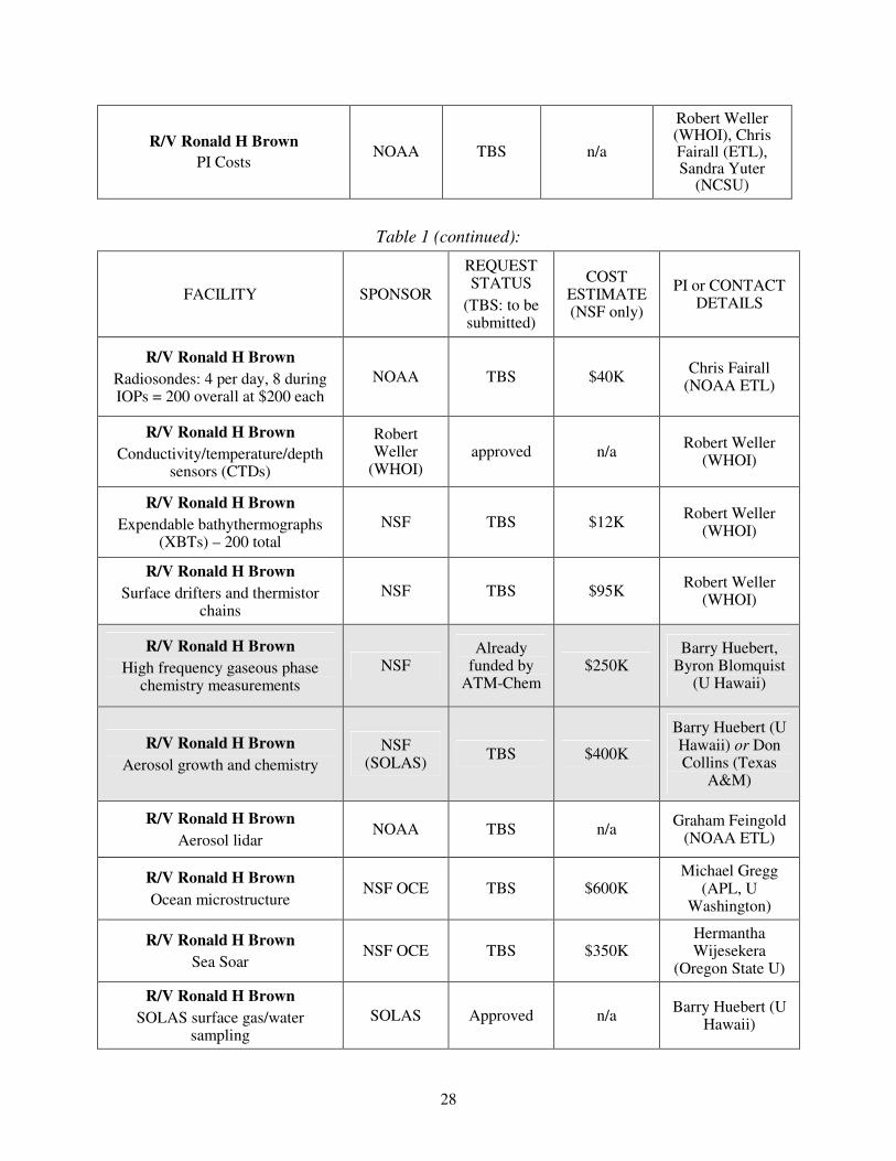
be measured by APIMS-ILS, so that we can constrain the MBL sulfur budget by measuring their surface fluxes throughout the cruise via eddy correlation. Rapid measurements of sea water DMS will allow us to derive gas exchange velocities from the DMS fluxes. It is also planned to make remotely sensed aerosol measurements from the RHB using an aerosol lidar operated by NOAA ETL. See Table 3 in Section I of the SPO (included at the end of this document) for a complete list of the proposed instrumentation in the RHB chemistry and aerosol suite.
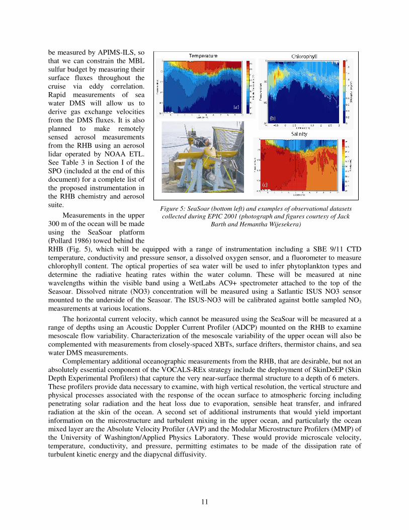
Measurements in the upper 300 m of the ocean will be made using the SeaSoar platform (Pollard 1986) towed behind the RHB (Fig. 5), which will be equipped with a range of instrumentation including a SBE 9/11 CTD temperature, conductivity and pressure sensor, a dissolved oxygen sensor, and a fluorometer to measure chlorophyll content. The optical properties of sea water will be used to infer phytoplankton types and determine the radiative heating rates within the water column. These will be measured at nine wavelengths within the visible band using a WetLabs AC9+ spectrometer attached to the top of the Seasoar. Dissolved nitrate (NO3) concentration will be measured using a Satlantic ISUS NO3 sensor mounted to the underside of the Seasoar. The ISUS-NO3 will be calibrated against bottle sampled NO3
measurements at various locations.
The horizontal current velocity, which cannot be measured using the SeaSoar will be measured at a range of depths using an Acoustic Doppler Current Profiler (ADCP) mounted on the RHB to examine mesoscale flow variability. Characterization of the mesoscale variability of the upper ocean will also be complemented with measurements from closely-spaced XBTs, surface drifters, thermistor chains, and sea water DMS measurements.
Complementary additional oceanographic measurements from the RHB, that are desirable, but not an absolutely essential component of the VOCALS-REx strategy include the deployment of SkinDeEP (Skin Depth Experimental Profilers) that capture the very near-surface thermal structure to a depth of 6 meters. These profilers provide data necessary to examine, with high vertical resolution, the vertical structure and physical processes associated with the response of the ocean surface to atmospheric forcing including penetrating solar radiation and the heat loss due to evaporation, sensible heat transfer, and infrared radiation at the skin of the ocean. A second set of additional instruments that would yield important information on the microstructure and turbulent mixing in the upper ocean, and particularly the ocean mixed layer are the Absolute Velocity Profiler (AVP) and the Modular Microstructure Profilers (MMP) of the University of Washington/Applied Physics Laboratory. These would provide microscale velocity, temperature, conductivity, and pressure, permitting estimates to be made of the dissipation rate of turbulent kinetic energy and the diapycnal diffusivity.
Figure 5: SeaSoar (bottom left) and examples of observational datasets
collected during EPIC 2001 (photograph and figures courtesy of Jack
Barth and Hemantha Wijesekera)

12
Table 2: NOAA R/V Ronald H Brown instrument requirements
Instrument Observations Funding source
Contact
Scanning C-band radar Horizontal and vertical precipitation
structure and dynamics within 30 km of the ship
NOAA CPPA
and NSF-Clim
Yuter (North Carolina State University)
/Fairall (NOAA ETL)
Vertically pointing 35 GHz cloud radar
Cloud and precipitation vertical structure
NOAA CPPA
Fairall (NOAA ETL)
Vaisala Ceilometer Cloud base height, drizzle drop
surface area NOAA CPPA
Fairall (NOAA ETL)
Rawinsondes
(4 per day, 8 during special periods)
Tropospheric thermodynamic and wind profiles
NOAA CPPA
Fairall (NOAA ETL)
Microwave radiometer (MWR)
Cloud liquid water path, water vapor path
NOAA CPPA
Fairall (NOAA ETL)
Surface meteorological tower, turbulent flux
suite, sea-snake
Ocean surface physics, surface meteorology and turbulent fluxes
NOAA CPPA
Fairall (NOAA ETL)
Aerosol lidar Backscatter profiles for aerosol
characterization, depolarization ratio
NOAA
CPPA Fairall (NOAA ETL)
APIMS (Atmospheric Pressure Ionization Mass
Spectrometry)
Atmospheric DMS, surface DMS fluxes through eddy correlation
NSF-Chem,
SOLAS
(already funded)
Huebert and Blomquist (University of Hawaii)
Aerosol physicochemical measurement suite
Aerosol number concentration, size distribution, chemical composition,
optical properties
NSF-Chem
(SOLAS)
Howell and Huebert (University of Hawaii) or Don Collins (Texas
A&M)
Sea Soar
Upper ocean horizontal and vertical structure, oxygen, nitrate, radiative properties, mesoscale ocean eddy
structure
NSF-OCE Wijesekera (Oregon
State University)
XBT
(200 requested)
Ocean temperature and salinity profiles
NOAA-CPPA
Weller (Woods Hole OI)
Ocean near-surface profiler
High spatial resolution upper ocean profiles
NSF-OCE Ward (????)

13
NOAA P3 Instruments
The participation of the NOAA P3 aircraft in VOCALS-REx would add important additional information and characterization of the cloud microphysics, aerosols, and cloud radiative properties. It should be made clear that at this time, although the P3 platform is desirable, it is unclear whether resources and scheduling will permit its participation in VOCALS-REx. We therefore consider that the instrument suite outlined in Table 3 for the P3 during the field program is at an early stage of planning, and may be subject to considerable change.
The P3 will most likely be based at the same location as the C-130, either in Arica (18°S, 70°W) or Iquique (20°S, 70°W). Ideally, the P3 will carry a complete set of cloud microphysical probes, thermodynamic and turbulence measurements, and a set of instrumentation to measure aerosol physicochemical properties. A microwave radiometer, broadband radiative fluxes, and the Miniaturized Differential Absorption Spectrometer (MIDAS) would play important roles in examining the indirect effects of aerosols upon cloud radiative properties by characterizing the cloud liquid water path and droplet effective radius remotely.
Table 3: NOAA P3 instrument requirements
Instrument Observations Funding source
Contact
Cloud microphysical suite,
dynamics and thermodynamics
FSSP, 2D-C, 260X, PCASP
Gust probe, temperature and humidity sensors
NOAA aero-cloud
Feingold (NOAA ETL)
Microwave radiometer (MWR) Liquid water path NOAA
aero-cloud Feingold
Miniaturized differential absorption spectrometer
(MIDAS)
Liquid water path, cloud droplet effective radius
NOAA aero-cloud
Solomon (NOAA ETL)
Aerosol physicochemical suite Aerosol size distributions NOAA
aero-cloud Possibly Brock and
Middlebrook (NOAA)
Broadband radiative fluxes Cloud optical depth NOAA
aero-cloud Feingold
SeaScan Instruments
It is proposed to deploy small SeaScan Unmanned Aeronautical Vehicles (UAVs) during VOCALS-REx to provide additional information on the vertical and horizontal structure of the marine boundary layer. The SeaScan UAVs are manufactured by the Insitu Group (www.insitugroup.com), have an endurance of 15 hours, a speed of 25 m s-1, a lowest altitude of 30 m, and a ceiling of ~5 km. A 1200 km round-trip mission will be possible, which allows the SeaScan to reach and sample POCs several hundred km from the Chilean coast. The SeaScan will be based, and be launched, from a site close to the C-130. The SeaScan carries a digital video camera integrated into an inertially-stabilized pan/tilt nose turret, and a set of meteorological measurements including winds, pressure, temperature, and humidity. Possible additions to the SeaScan payload could include a turbulence measurements and a liquid water probe.

14
Chilean coastal component platforms and instrumentation
A comprehensive near-coastal sampling strategy is planned for October 2007, which includes atmospheric thermodynamic and dynamic measurements with a light aircraft (Chilean AirForce Twin Otter), a Chilean Servicio Hidrográfico y Oceanográfico de la Armada de Chile (SHOA) research vessel, an elevated land site at a site, El Tofo, on the Chilean coastal range to measure cloud and aerosol microphysical properties, and enhanced meteorological observations at sites along the Chilean seaboard. Funding for most of these activities will be requested from FONDECYT, the Chilean science funding agency, with support from the Chilean Airforce (Twin Otter). Table 4 provides details of the instrumentation for this component of VOCALS-REx.
Table 4: Chilean VOCALS-REx coastal component platforms and instrumentation
Platform Instruments Observations Contact
Chilean Airforce Twin Otter aircraft
AIMMS20 AQ instrument suite
Temperature, humidity, winds, turbulence
Gallardo (Universidad de Chile)
SHOA R/V
Atmosphere
Radiosondes, surface meteorological package,
NOAA wind profiler
MBL structure and dynamics
Rutllant/Garreaud (Universidad de Chile)
SHOA R/V Ocean
CTD-O, ADCP and thermo-salinograph, water sampling
Upper ocean physical and chemical structure
Pizarro (Universidad de Concepcion)
El Tofo
(land site)
Counterflow virtual impactor (CVI), bulk filter
measurements, Differential mobility analyzer (DMA)
Cloud and aerosol size distribution and chemical properties, cloud droplet
residual properties
Gallardo (Universidad de Chile) and Krejci
(MISU, Sweden)
Modeling PSU/NCAR MM5 regional
atmospheric model
MBL/coastal jet structure and variability, diurnal
subsidence wave generation
Garreaud (Universidad de Chile)
Peruvian coastal component platforms and instrumentation
As part of the international contribution to VOCALS-REx, a group of Peruvian researchers are proposing a set of enhanced atmospheric measurements and an oceanographic/atmospheric coastal cruise with the Peruvian research vessel. The suite of measurements is given in Table 5. The primary contribution to VOCALS-REx will consist of a 30 day cruise organized by the Instituto del Mar del Perú (IMARPE) to sample oceanography and meteorology along the Peruvian coastal zone from 4-18°S. It is also planned to request the NSF Deployment Pool 915 MHz wind profiler and Radio Acoustic Sounding System (RASS) on the cruise which to provide high time resolution profiling observations of the horizontal wind and virtual temperature in the marine boundary layer and lower free troposphere. The wind profiler is also sensitive to precipitation-sized hydrometeors in low clouds, and will be used to characterize the occurrence of drizzle falling from the near-coastal stratocumulus clouds.

15
Table 5: Peruvian VOCALS-REx coastal component platforms and instrumentation
Platform Instruments Observations Contact
Surface meteorological suite, wind profiler, 6 hourly
radiosondes,
CTD ocean profiling, Acoustic Doppler Current Profiler (ADCP)
Surface meteorology, SST, bulk fluxes, MBL wind and
turbulence profiles, tropospheric structure
Upper ocean currents, temperature and salinity
profiles
Silva
Instituto del Mar del Perú (IMARPE) IMARPE
R/V
NSF Deployment Pool 915 MHz wind profiler, radio acoustic
sounding system (RASS)
Horizontal and vertical winds, turbulence, virtual temperature
profiles
Takahashi/Wood (University of Washington)
Enhanced met sites
Tethered balloon, automatic weather stations
MBL structure and dynamics along the Peruvian costal zone
Takahashi (University of Washington)
Platform deployment and sampling strategy
The VOCALS-REx hypotheses presented above will be tested using carefully designed platform deployment strategies. Table 6 provides a quick-look summary of how the different platforms and components discussed above will contribute to the testing of these hypotheses, with further discussion of the scientific issues and a description of the testing strategy provided in the Scientific Program Overview document. Here we describe the specific sampling patterns, including cruise tracks, flights plans, and coordinated inter-platform activities.
C-130 sampling strategy
Two distinct primary C-130 flight plans will provide the range of sampling necessary to address the VOCALS-REx hypotheses. In addition, subsections of the flights will be used to carry out coordinated sampling with the RHB and/or the NOAA P3 aircraft, and the C-130 will make some survey flight legs along the Chilean coast to sample the pollutant outflow at the start and/or end of the primary missions. The two primary flight plans are (a) Cross-section missions along the 20°S latitude from the coast to either the RHB or the IMET buoy at 85°W; (b) POCs-drift missions which target either existing pockets of open cells (POCs) within overcast stratocumulus, or areas prone to POC development, and track these as they advect with the flow. Additional flight plans are described at the end of this section.
(a) Cross-section missions (Fig. 6): These flights are designed to sample contrasts in MBL thermodynamics, chemistry, aerosols and clouds between the South American coast and that in the remote SEP. Specific focus will be placed on good sampling of aerosol characteristics, MBL structure/depth, cloud morphology, microphysics, and drizzle production (using the University of Wyoming 94 GHz cloud radar, WCR, on the C-130). These flight are also extremely useful for airborne cloud remote sensing, and there will be efforts made to

16
coordinate some of these missions with satellite overpasses, particularly those of Terra and Aqua/Cloudsat/Calipso at roughly 10:30 am/pm and 1:30 am/pm local time. The general idea is to fly from the coast to either the IMET buoy (85W, 20S) or the RHB (which will carry out its pattern moving progressively further away from the coast over 35 days as described below). On the outbound section, the mission will comprise a set of straight and level runs below (30 m AMSL daytime, 150 m AMSL nighttime) and above (1800 m AMSL) cloud, and to sample the cloud layer itself using slant profiles ascending at approximately 150 m minute-1. An exact specification of the levels used and the leg-duration will be dependent upon the needs of the key participants. The above cloud runs will be used to sample the drizzle, cloud, and MBL structure using the WCR and SABL lidar, to characterize the free-tropospheric chemistry, aerosol and thermodynamic structure, and to use the MCR and AIMR radiometers to remotely sense the cloud bulk and microphysical properties. Below cloud runs will aim to determine physicochemical properties of aerosols, and to determine lower boundary conditions (SST, surface thermodynamic and DMS fluxes, winds). The return leg back from the IMET buoy will be carried out at approximately 6km with dropsondes being launched at regular intervals. Because drizzle is expected to be more prevalent during the night, this type of flight pattern may be flown in the day or at night. This type of flight plan was implemented very successfully during EPIC 2001 for studying southerly cross-equatorial boundary layer inflow into the East Pacific ITCZ.
An important component of the cross-section missions is to devote a portion of the flight (typically at least one hour) to coincident sampling with the RHB. These coordinated sections will serve as a means of comparing the accuracies of the instruments (particularly aircraft aerosol sampling and SST estimates) and will provide important in-situ context to remotely sampled cloud and drizzle properties from the RHB. In addition, these sections will be invaluable in helping to determine, using a combination of C-130 and C-band radar measurements, the dynamical structures and mesoscale organization associated with POCs and mesoscale drizzle cells in general. Planned coordinated flight sections are described in plan (d) below.
Figure 6: Flight-plan for C-130 Cross-section missions.

17
(b) POC drift missions (Fig. 7): These flights are designed specifically to examine microphysical and dynamical processes that occur in pockets of open cells (POCs) and in the surrounding cloud. POCs that are completely surrounded by overcast stratocumulus clouds are of the most interest, but broader boundaries between open and closed cellular convection may also be a focus of these missions. Of particular importance will be a characterization of the aerosol and cloud microphysical properties in the two regions. If possible, these flights will be coordinated with the RHB, whose scanning C-band radar will provide the mesoscale context for the C-130 data, as well as aerosol and cloud characterization within the POC region. The idea is to use geostationary satellite imagery to locate POCs or regions prone to POC formation (using cloud microphysical retrievals to location regions of unbroken but clean clouds), and then to target missions accordingly. Once a POC boundary has been reached, the aim is to carry out across-wind stacks of five straight and level runs approximately 100 km in length below, in, and above cloud (with additional porpoising runs to characterize the cloud top and inversion layers). The aircraft will be allowed to drift with the MBL mean wind (i.e. with the advecting POC) to provide Lagrangian-type measurements of the temporal evolution of the POC. Efforts will be made to sample the same POC on two C-130 flights, or to fly in a POC region that will ultimately advect over the ship.
The SeaScan UAV will also be used both in conjunction with C-130 flights and on standalone missions to determine POC thermodynamic structure. When used in conjunction with the C-130, it is hoped that the SeaScan will permit Lagrangian continuity during the daytime between two C-130 night flights in and around the same POC. The excellent video capability on the SeaScan will be used to determine the boundary between the POC and the surrounding overcast stratocumulus: profiles and horizontal sampling legs with the SeaScan will be devised accordingly.
Figure 7: Lagrangian-type C-130 flight plan for POCs-drift missions.
(c) Coordinated flights with other platforms: There will be opportunities during VOCALS-REx for periods where the capabilities of the C-130 can be enhanced by coordinated flights in conjunction with the RHB and/or the P3 aircraft. For periods during the cross-section and/or POCS-drift missions we envisage periods of approximately 2 hours where the platform sampling strategies can be synchronized.

18
For the C-130/RHB combination, the goals will be (i) to intercompare ship and aircraft aerosol measurements in the subcloud region; (ii) to study the structure and dynamics of the drizzle cells using collocated C-130 data and C-band radar data. The C-130 will collect in-situ data from drizzling cells in a direction perpendicular to and parallel to the alongwind RHI scan line (see below for details of the C-band radar scan strategy). These data would be used to improve our conceptual model of the physical processes taking place in the transition from closed to open cells by providing quantitative measurement of the mesoscale cell structure.
For the C-130/P3 combination, the goal will be to first obtain simultaneous measurements of the cloud microphysical properties and the subcloud aerosol properties, and then to simultaneously sample cloud and drizzle microphysics with the P3 while remotely sensing the cloud from above with the MCR, AIMR and WCR. These measurements constitute important tests of the aerosol first and second indirect effects.
(d) Coastal aerosol survey legs: When time permits at the start or end of flights, we hope to
carry out 2-3 legs and vertical profiles in a roughly north-south direction along the Chilean coast at different altitudes to sample the chemical and aerosol characteristics of the airmass advecting from Northern Chile over the SEP. A vertical profile up to 6000 m will be carried out to identify elevated pollution layers (these have been observed using spaceborne lidars and reflect the elevations of copper smelters on the west Andean slopes). These will then be sampled using horizontal legs. If interesting horizontal structure is observed, these legs can be extended southwards to sample plume variability. The SABL lidar will also be used to characterize the elevated layers remotely.

19
Table 6a: Contribution of different observational platforms to testing of Aerosol-Cloud-Drizzle
hypotheses
Hypothesis NSF C-130 NOAA RHB NOAA P3 El. Tofo
1a: Variability in the physicochemical properties of aerosols has a measurable impact upon the formation of drizzle in stratocumulus clouds over the SEP.
In-situ aerosol, cloud and drizzle
microphysical measurements from cross-section and POCs-drift flight
patterns
WCR drizzle rate estimates
Near-continuous aerosol sampling
over 35 day period at a range of
distances from the coast
Cloud and drizzle remote sensing
Aerosol and cloud microphysical measurements
Chemistry of aerosols and cloud droplet residuals at continental outflow site
Detailed Lagrangian observations of the evolving cloud and
precipitation structure within POCs
Simultaneous observations of
precipitation and cloud structure as POCs advect over
the ship.
Sampling of the aerosol and cloud
properties in POCs and
surrounding cloud
1b:Precipitation is a necessary condition for the formation of pockets of open cells (POCs) within stratocumulus clouds.
C-130 and/or P3 flights coordinated with RHB C-band radar to observe mesoscale dynamics of drizzle cells
N/A
1c: The small effective radii measured from space over the SEP are primarily controlled by anthropogenic, rather than natural, aerosol production, and that entrainment of polluted air from the lower free-troposphere is an important source of cloud condensation nuclei (CCN).
DMS and SO2 chemistry, aerosol
chemical composition, cloud microphysical
measurements, MCR/AIMR remote
sensing
Entrainment fluxes of aerosols and precursors using DMS/turbulence
measurements
DMS and SO2 chemistry, aerosol
chemical composition,
remotely sensed cloud microphysics
during daytime
Aerosol chemical composition,
horizontal gradients in cloud
microphysics
Cloud microphysical measurements
and aerosol source
attribution
1d: Depletion of aerosols by coalescence scavenging is a major sink term for cloud condensation nuclei over the SEP.
WCR precipitation and Lagrangian-type
sampling of evolving aerosol population. Eddy correlation aerosol and cloud
droplet flux measurements to close
CCN budget
Simultaneous in-situ aerosol and C-band precipitation
estimates
N/A N/A

20
Table 6b: Contribution of different platforms to testing of Coupled Ocean-Atmosphere-Land
hypotheses
Hypothesis C-130 RHB Chilean
coastal
Peruvian
coastal
2a: Oceanic mesoscale eddies play a major role in the transport of heat and fresh water from coastally upwelled water to regions further offshore.
N/A
Upper ocean butterfly pattern sampling with
SeaSoar, ADCP, XBTs
Upper ocean spatial sampling
in eddy-generation zone
Upper ocean spatial sampling
in eddy-generation zone
Atmospheric DMS/SO2 measurements,
mesoscale variability in SST, surface DMS fluxes, and aerosol physicochemical
properties
Surface DMS fluxes. Simultaneous
measurement of mesoscale ocean eddies, nutrients,
DMS, and aerosols
Contextual information on the variability and strength of
coastal upwelling
Contextual information on the variability and strength of
coastal upwelling
2b: Upwelling, by changing the physical and chemical properties of the upper ocean, has a systematic and noticeable effect on aerosol precursor gases and the aerosol size distribution in the MBL over the SEP. VOCALS modeling will be used to test aspects of this hypothesis by incorporating the
relevant physical and chemical processes into the modeling framework.
2c: The depth, phase speed, and vertical structure of the diurnal subsidence wave (“upsidence wave”) originating on the Andes slopes in northern Chile/southern Peru is well predicted using regional model simulations.
Atmospheric structure in the vertical plane
along wave propagation direction
from cross-section flights at different
phases of the diurnal cycle
Continuous sampling of lower troposphere
(rawinsondes, clouds, surface
meteorology) over several days along
20°S latitude at 77.5°W and 85°W
Diurnal sampling of
winds and free-tropospheric
structure using R/V in near-
coastal region
Diurnal sampling of
winds and free-tropospheric
structure using R/V in near-
coastal region
Table 6c: Contribution of different platforms to evaluation of satellite cloud remote sensing issues
NSF C-130 NOAA RHB NOAA P3
Airborne remote sensing at similar wavelengths to satellite instruments but at
much higher spatial resolution. Near
coincident in-situ cloud microphysical and drizzle
measurements for validation
Continuous remotely sensed cloud and
precipitation measurements for
direct satellite evaluation
Airborne microwave and broadband fluxes with near coincident
in-situ cloud microphysical and measurements for
validation
Can satellite estimates of
stratocumulus cloud microphysical
properties (e.g. effective radius or
cloud droplet number concentration
from MODIS) and precipitation
(from CloudSat or MODIS) be
refined to perform in a satisfactory
manner even under conditions of
broken cloudiness on the pixel
scale?
Coordinated stacked C-130 and P3 flights over the ship for simultaneous in-situ cloud microphysics and remote sensing from above (C-130) and below
(P3 and RHB) cloud
Flights coordinated with satellite overpasses where possible

21
RHB deployment strategy
The RHB will provide critical oceanographic and atmospheric measurements in VOCALS-REx. The RHB cruise track is shown in Fig. 8 and consists of a 35 day period on task (with approximately 10 days of transit for a total of 45 days requested). The deployment strategy consists of two stationary extended measurement periods of 6 days each at 20°S, 85°W and at 20°S, 75°W (where maintenance work will be carried out on the instrumented IMET and SHOA buoys). Continuous sampling of DMS and SO2, aerosols, meteorology, vertical atmospheric structure, and remotely sensed cloud and drizzle properties will take place during the stationary periods. In addition to the stationary periods, the RHB will carry out two ocean mesoscale survey butterfly patterns 500 km on a side at a speed of 8 kts. The butterfly patterns, centered on the IMET buoy at 20°S, 85°W and on 20°S, 77.5°W respectively, will be used to sample the mesoscale structure of the upper ocean including obtaining high vertical and horizontal resolution sampling of the upper 100 m of ocean using the SeaSoar vertical profiler towed behind the RHB. The total duration for each butterfly pattern is approximately 7 days. The butterfly patterns are a larger version of those used to effectively and efficiently sample mesoscale variability and eddy structure in the upper ocean during the Intertropical Convergence Zone component of the East Pacific Investigation of Climate field program in 2001.
Atmospheric measurements will be made continuously during the butterfly patterns, but caution will be taken to screen the data for times when the ship exhaust could be sampled by the chemical and aerosols instrumentation. The orientation of the butterfly patterns is chosen to provide legs in the across and downwind directions (these are also parallel and perpendicular to the direction of the mean surface currents). Because the cloud and drizzle structures advect with the mean wind (typically 6-10 m s-1 from the ESE), their evolution can only be tracked for roughly 1.5-2 hours with the C-band radar on a stationary ship. The downwind legs therefore allow us to track drizzling cells for almost twice as long (3-4 hours) which will provide important information on the their evolution and longevity. Another advantage of the chosen butterfly orientation is that the combination of the mesoscale butterfly surveys centered on 77.5°W and 85°W will result in an almost complete longitudinal upper ocean cross section from 87.5°W to the Chilean coast.
Figure 8: Track of the RHB overlaid
on SST and surface current field from
a regional eddy-resolving ocean
model (ROMS, figure from Penven et
al. J. Geophys. Res., 110,
10.1029/2005JC002945, 2005).

22
C-Band radar scan strategy: Because a key focus of VOCALS-REx is to quantify, and determine the structural properties of precipitation in and below stratocumulus, it is important to design an efficient scan strategy for the C-band radar on the RHB. As in the 2001 East Pacific Investigation of Climate (EPIC) cruise, the C-band radar will conduct (a) volumetric scans at intervals of 5 minutes using PPIs at different elevation angles to build up a 3-dimensional volume over a 60 km diameter region centered on the ship; (b) vertical cross sections at a fixed azimuth angle using (range-height indicators, RHIs) for improved sampling of the vertical structure of the precipitating cells. Sector scans using a number of RHIs taken over a narrow range of azimuth angles may also be used during periods where the C-130 is making measurements around the RHB. These will provide high vertical resolution sampling of a few drizzle cells where the C-130 is making simultaneous, collocated in-situ measurements. The combination of the two platforms sampling the same drizzle cells will provide an unprecedented dataset on the structure and kinematics of drizzling stratocumulus.
Ocean mesoscale survey sampling strategy: The mesoscale survey will use a combination of the SeaSoar to provide multivariable sawtooth-pattern (series of slanted profiles) sampling which will capture sharp horizontal gradients associated with the mesoscale eddies. XBTs will measure temperature only, but these will provide truly vertical profiles with a vertical resolution higher than that of the SeaSoar approximately every 50 km along the butterfly pattern. The ADCP will be used to provide vertical profiles of the current velocity continuously which are corrected for ship motion using a sophisticated Ashtech GPS system. The ADCP data will be used in conjunction with both the SeaSoar and the XBT data to examine the advective term in the upper ocean heat budget, and also to look for vertical shears associated with propagating waves and mixing.
NOAA P3 sampling strategy
The P3 will primarily be used to sample aerosols and cloud microphysical properties during VOCALS-REx. Satellite data and forecast fields from numerical models will be used to plan flights, and these plans chiefly aim to sample strong gradients in cloud microphysical properties in regions where there are only weak or no corresponding gradients in the large scale meteorology, to ascertain the potential strengths of the aerosol indirect effects upon the cloud radiative properties. As with the C-130 the P3 is expected to have capability for making remote sensing measurements, and so flight legs will be carried out below, in, and above cloud. Coordinated flights with both the C-130 and the RHB are also envisaged (See C-130 flight plan (c) above).
VOCALS-REx Coastal component sampling
The near coastal oceanographic and atmospheric sampling during VOCALS-REx, including measurements from land sites, will largely be carried out by research groups from Chile and Peru, augmented with NSF C-130 and possibly NOAA P3 flight legs specifically devoted to chemistry and aerosol sampling along the Chilean coast. An overview of the Chilean observational capabilities is presented in Fig. 9, while the track of the Peruvian coastal ocean/atmosphere research cruise is shown in Fig. 10.

23
The oceanographic aims of the VOCALS-REx coastal component are to improve our understanding of the structure and spatial variability of the Humboldt current system along the west coasts of Peru and Chile. The Peruvian and Chilean cruises will be used to determine the vertical thermodynamic and dynamic structure of the coastal upwelling at a number of different locations along the coast, where satellite ocean color imagery shows strong local variability most likely related to topographic coastal features. Regional ocean modeling at high resolution will be used in conjunction with the oceanography measurements to better understand both the spatial and the temporal variability in the upwelling and eddy generation.
Particular sections of this coastline, most notably southern Peru (at 15°S) and central Chile (30-40°S) exhibit particularly strong ocean eddy activity and the cruise data will be used to examine how these features affect the MBL and cloud structure using wind profiler, radiosondes, and thermodynamic data from the cruises. In addition, the Chilean Airforce Twin Otter will be used to sample the near-coastal marine boundary layer, in particular to examine the structure and variability of the coastal low level jet that forms at the location of the peak in ocean eddy kinetic energy along the Chilean coast. The air-sea interactions between the oceanic eddy structure and the strength of the coastal jet will be explored using the cruise and the airborne data. The MM5 regional atmospheric model will be run for the VOCALS-REx period and will be used to examine aspects of the interactions of the coastal jet with the cloud and MBL structure, and to examine the factors controlling the diurnal subsidence wave generated along the west Andean slopes of Northern Chile and Southern Peru.
Along the Southern Peruvian coast are regions (especially 13-17°S) where there is near-permanent stratus cloud clearing. The structure of the MBL in these regions (area inside red circle in Fig. 10) will be studied using data from a tethered balloon and from enhanced automatic meteorological observations along the coastline. The Peruvian 30 day coastal cruise organized by the Instituto del Mar del Perú (IMARPE) will provide upper-ocean and lower atmosphere measurements, with focus upon the southern Peruvian coast. The NSF wind profiler and RASS data will be used to characterize the MBL structure associated with the coastal jet, and to provide important data from the lower free troposphere on the diurnally generated subsidence wave close to the South American coast. These data, together with wind profiler data from the Chilean coastal cruise will provide information on the geographical structure of the diurnal subsidence wave.
Atmospheric aerosol, chemistry, and cloud measurements will be carried out at an elevated site (850 m amsl) in the Chilean coastal range at El Tofo (29.5°S, 71°W). El Tofo is well positioned to sample the airmass leaving Chile and advecting over the SEP, and is directly downwind of the major copper smelters in central Chile (Fig. 2 in the SPO) and the Santiago urban region. It is also sufficiently far from local urban centers that it can be considered to be a site that is representative of the ‘Chilean plume’ that
Figure 9: Observational capabilities of the Chilean component of the VOCALS-REx field campaign.
Iquique
Lengua de Vaca
El Tofo
San Felix
Antofagasta
SantoDomingo
Valparaiso
AricaSan Juan
Sc Deck
Coastal Jet
Radiosonde Station
Enhanced Meteorological obs.
Aerosol Measurements
Port
Airborne MBL obs.
Radiosonde obs.

24
is hypothesized to be responsible for the small cloud droplet effective radii over the broader SEP ocean. The elevation of the site means that it is frequently in cloud (the site is used for community water provision through fog-collection). The site will be used for both cloud and aerosol sampling. Counterflow virtual impactor (CVI) measurements of the physicochemical properties of the cloud droplet residuals will be made by MISU (Department of Meteorology, Stockholm University, Sweden) to determine the sources and levels of anthropogenic pollutants in the cloud droplets.
In addition to the El Tofo site, the NSF C-130 will sample low level and elevated pollution layers in the coastal region of northern Chile at 18-20°S (see flight plan (d) above). Together with spaceborne lidar sampling from CALIPSO, these flight sections will be useful in determining the composition and structural properties of smelter plumes.
Figure 10: Observational capabilities of the Peruvian component of the VOCALS-REx field campaign. The proposed cruise track is shown in blue, with green circles
representing XBT deployments. The red circle shows the region of atmospheric focus.

25
Project Management including Management in the Field
The Project Scientist (Dr. Robert Wood) and deputies (Dr. Christopher Bretherton and Dr. Barry Huebert) are responsible for the overall planning and coordination of the field experiment. They will work to coordinate activities with the broader VOCALS science team, the NSF C-130 aircraft manager (NCAR Earth Observing Laboratory EOL), and the NOAA R/V Ronald H Brown (RHB) and P3 platform managers, the NSF project office, and the Joint Office of Scientific Support (JOSS). The EOL at NCAR will be responsible for C-130 payload management and logistical support. Data management will be provided by JOSS, and is described in the following section.
Mission planning for the C-130 flights will be coordinated by the Project Scientist, who will consult with the science team and the other VOCALS-REx participants. Daily briefings will be held at the aircraft operations center to discuss the previous day’s mission and to plan future missions. The weather forecasting plan is to work with local Chilean weather service or airforce forecasters and to use real-time trajectory forecasts using the NOAA Air Resources Laboratory HYSPLIT website. Additional satellite datasets will be collated in real time by JOSS to assist in forecasting cloud conditions.
Before and after the daily briefings, a discussion (via satellite telephone or internet) between the Project Scientist and the RHB manager/lead scientist will be held to discuss the following day’s ship activities and to plan for possible coordinated aircraft/ship flight operations. This is necessary because the C-band radar may require some reprogramming based upon wind direction forecasts.
During C-130 flights it is planned that the ground team will communicate with the aircraft using an internet connection, which has proven successful in previous campaigns. For the POC-drift C-130 missions, where the aim is to locate regions either with existing POCs or prone to POC formation, updates from the most recent geostationary satellite data could prove invaluable.

26
Data management plan
Data archiving for observational data and associated satellite, reanalysis, and model output for VOCALS-REx will be constructed and maintained by the NCAR Joint Office of Scientific Support (JOSS). The plan is to make the VOCALS-REx archive available to all participants in the field phase and in the broader VOCALS community as soon as possible after the field program, allowing for a period of a few months or so for quality control procedures to be applied by the individual PIs. At some later date, to be determined during the later planning stages of VOCALS-REx, the archive will be made freely available to the scientific community. JOSS will also implement a real-time internet Field Catalog as they have done for a number of previous field campaigns which assists in the planning and operational phase, and offers a useful overview of the missions carried out in the field phase. Additional datasets will be gathered and made available in the data archive both during and after the field phase. These include satellite data (e.g. GOES, AVHRR, MODIS, MISR, Cloudsat, CALIPSO, SSM/I, TRMM), reanalysis fields (ECMWF and NCEP), and model output from participants running case studies based upon the VOCALS-REx observational data. Standard NSF procedures will be adopted for data sharing including prompt and complete data sharing and a fair attribution of data sources.

27
Section I of the SPO
Facilities, Equipment and Other Resources
Table 1: Field facilities requested, sponsors, status, costs estimates, personnel
Note: Additional detail about the range of instrumentation for the atmospheric chemistry measurements (shaded items) is presented in Table 2 (C-130) and Table 3 (Ronald H Brown)
FACILITY/INSTRUMENT SPONSOR
REQUEST STATUS
(TBS: to be submitted)
COST ESTIMATE (NSF only)
PI or CONTACT DETAILS
NCAR C-130
Base facility (cloud microphysics, dynamics, turbulence)
Flight hours (90 hours research time)
NSF TBS $805K Robert Wood
(U Washington)
NCAR C-130
Dropsondes (150 sondes total) NSF TBS $215K
Robert Wood
(U Washington)
NCAR C-130
SABL Lidar NSF TBS $90K
Robert Wood
(U Washington)
NCAR C-130
Multichannel radiometer (MCR) NSF TBS
To be determined
Mark Tschudi (NCAR EOL)
NCAR C-130
Airborne Imaging Microwave Radiometer (AIMR)
NSF TBS To be
determined Julie Haggerty (NCAR EOL)
NCAR C-130
PI Costs NSF TBS $450K
Robert Wood, Chris Bretherton (U Washington)
NCAR C-130
High frequency gaseous phase chemistry measurements
NSF (SOLAS)
TBS $500K Alan Bandy,
Donald Thornton (Drexel)
NCAR C-130
Aerosol growth and chemistry
NSF (SOLAS)
TBS $400K Steve Howell,
Barry Huebert (U Hawaii)
NCAR C-130
WCR Radar analysis and CCN NSF TBS $300K
Dave Leon, Jeff Snider (U Wyoming)
Aerosondes NSF TBS $400K Steve Esbensen
(Oregon State U)
R/V Ronald H Brown
45 cruise days: NOAA/ETL surface flux, cloud and drizzle remote
sensing instrumentation
NOAA (CPPA)
Proposal submitted
n/a Chris Fairall
(NOAA ETL)
28
R/V Ronald H Brown
PI Costs NOAA TBS n/a
Robert Weller (WHOI), Chris Fairall (ETL), Sandra Yuter
(NCSU)
Table 1 (continued):
FACILITY SPONSOR
REQUEST STATUS
(TBS: to be submitted)
COST ESTIMATE (NSF only)
PI or CONTACT DETAILS
R/V Ronald H Brown
Radiosondes: 4 per day, 8 during IOPs = 200 overall at $200 each
NOAA TBS $40K Chris Fairall
(NOAA ETL)
R/V Ronald H Brown
Conductivity/temperature/depth sensors (CTDs)
Robert Weller
(WHOI) approved n/a
Robert Weller (WHOI)
R/V Ronald H Brown
Expendable bathythermographs (XBTs) – 200 total
NSF TBS $12K Robert Weller
(WHOI)
R/V Ronald H Brown
Surface drifters and thermistor chains
NSF TBS $95K Robert Weller
(WHOI)
R/V Ronald H Brown
High frequency gaseous phase chemistry measurements
NSF Already
funded by ATM-Chem
$250K Barry Huebert,
Byron Blomquist (U Hawaii)
R/V Ronald H Brown
Aerosol growth and chemistry
NSF (SOLAS)
TBS $400K
Barry Huebert (U Hawaii) or Don Collins (Texas
A&M)
R/V Ronald H Brown
Aerosol lidar NOAA TBS n/a
Graham Feingold (NOAA ETL)
R/V Ronald H Brown
Ocean microstructure NSF OCE TBS $600K
Michael Gregg (APL, U
Washington)
R/V Ronald H Brown
Sea Soar NSF OCE TBS $350K
Hermantha Wijesekera
(Oregon State U)
R/V Ronald H Brown
SOLAS surface gas/water sampling
SOLAS Approved n/a Barry Huebert (U
Hawaii)

29
R/V Ronald H Brown
Ocean near-surface profiler NSF TBS $400K
Brian Ward (U Miami)

30
Table 1 (continued):
FACILITY SPONSOR
REQUEST STATUS
(TBS: to be submitted)
COST ESTIMATE (NSF only)
PI or CONTACT DETAILS
NOAA P3 aircraft
NOAA
Aerosol-cloud
Requires allocation
n/a
Tim Bates (NOAA PMEL), Graham Feingold (NOAA
ETL)
San Felix Island/Chilean R/V
Wind profiler/ceilometer shipping/install
FONDECYT,
NOAA TBS n/a
Chris Fairall (NOAA ETL)
Peruvian coastal cruise
Peruvian agencies +
Possible wind profiler
from NSF deployment
pool
TBS $250K
(profiler)
Ken Takahashi and Robert Wood
(University of Washington)
Logistical support (NCAR JOSS)
Field operations NSF TBS
To be negociated
José Meitín
Logistical support (NCAR JOSS)
Data archiving and integration, satellite datasets
NSF TBS To be
negociated José Meitín

31
Table 2: Atmospheric chemistry suite on the NSF C-130
INSTRUMENT
*indicates lower priority MEASUREMENTS
FUNDING SOURCE
CONTACT
5 stage MOI impactor & APS on LTI
Size distributions of NSS, MSA, NH4, Na, K, Ca, Mg, NO3, Cl, etc.
NSF- ATM Barry Huebert (U.
Hawaii)
Total Aerosol Sampler Bulk NSS, MSA, NH4, Na, K, Ca,
Mg, NO3, Cl, etc. NSF- ATM
Barry Huebert (U. Hawaii)
Streaker on LTI, SEM, TEM Sized dust, sea salt, sulfate, &
pollution aerosol images NSF-ATM Jim Anderson (ASU)
*PC-BOSS, EGA analysis Total elemental and organic
carbon aerosols NSF- ATM
Barry Huebert (U. Hawaii)
TSI 3010, 3025 Total aerosol number, incl.
nanoparticles NSF- ATM
Howell & Clarke (U. Hawaii)
DMPS and APS Number size distribution from 5 to
10,000 nm diameter NSF- ATM
Howell & Clarke (U. Hawaii)
NCAR RCAD Number size distribution, 8 – 120
nm (nucleation) Deployment
pool NCAR RAF
PSAP Light absorption NSF- ATM Howell & Clarke (U.
Hawaii)
3 wavelength TSI nephelometer Total and sub-micron (alternating) light scattering and backscattering
by aerosols NSF- ATM
Howell & Clarke (U. Hawaii)
*LWC collector Cloud water chemistry NSF- ATM Jeff Collett (CSU)
CVI CCN chemistry NSF-ATM Cindy Twohy (U.
Oregon)
Giant Aerosol Impactor Giant aerosol size distribution (1-
1000 µm) NSF-ATM
Jorgen Jensen (NCAR)
APIMS DMS concentration and flux NSF- ATM Alan Bandy (Drexel
U.)
APIMS SO2 concentration and flux NSF- ATM Alan Bandy (Drexel
U.)
UV Resonance fluorescence CO Deployment
pool Teresa Campos
(NCAR)
*Licor IR CO2 Deployment
pool Teresa Campos
(NCAR)
Dasibi or TECO O3 Deployment
pool Teresa Campos
(NCAR)
*NO chemiluminescence Fast O3 concentration and flux Deployment
pool Teresa Campos
(NCAR)

32
Table 3: Atmospheric chemistry suite on the R/V Ronald H Brown
INSTRUMENT MEASUREMENTS FUNDING SOURCE
CONTACT
Two 9 stage MOUDI impactors Size distributions of NSS, MSA, NH4, Na, K, Ca, Mg, NO3, Cl,
mass, EC, OC, etc. NSF- ATM
Barry Huebert (U. Hawaii)
Open filter Sampler Bulk NSS, MSA, NH4, Na, K,
Ca, Mg, NO3, Cl, mass, EC, OC, etc.
NSF- ATM Barry Huebert (U.
Hawaii)
Semicontinuous OC/EC analyzer Elemental and organic carbon
aerosols NSF- ATM
Barry Huebert (U. Hawaii)
TSI 3010, 3025 Total aerosol number, incl.
nanoparticles NSF- ATM
Howell & Clarke (U. Hawaii)
DMPS and APS Number size distribution from 5
to 10,000 nm diameter NSF- ATM
Howell & Clarke (U. Hawaii)
Aethalometer 7 λ light absorption NSF- ATM Barry Huebert (U.
Hawaii)
3 wavelength TSI nephelometer – Ambient RH
Total and sub-micron (alternating) light scattering and
backscattering by aerosols NSF- ATM
Howell & Clarke (U. Hawaii)
3 wavelength TSI nephelometer - DRY
f(RH) for light scattering NSF- ATM Howell & Clarke (U.
Hawaii)
APIMS DMS concentration and flux NSF- ATM Alan Bandy (Drexel
U.)
APIMS SO2 concentration and flux NSF- ATM Alan Bandy (Drexel
U.)
Monitor Labs UV O3 NSF- ATM Barry Huebert (U.
Hawaii)

33
Section J of the SPO
Special Information and Supplementary Documentation
Participants, roles, anticipated sponsors
Cloud and marine boundary layer structural properties and their dependence upon large
scale and microphysical processes
PI Robert Wood and Christopher Bretherton, University of Washington
Anticipated sponsor – NSF
PI Wood will have overall responsibility for the field management of the NCAR C-130 deployment during VOCALS-REx, and Bretherton will assist in a deputy role. Both Wood and Bretherton have valuable field experience working with C-130 research aircraft. Wood will act as chief liaison for coordinated activities with the broader VOCALS science team, the NSF C-
130 aircraft manager (NCAR Earth Observing Laboratory EOL), and the NOAA R/V Ronald H Brown (RHB) and P3 platform managers, the NSF project office, and the Joint Office of
Scientific Support (JOSS). Wood and Bretherton will coordinate mission planning for the C-130 flights through consultation with the science team and the other VOCALS-REx participants.
Following the field phase, Wood will work with Bretherton and one or two graduate students on data synthesis and analysis. Particular emphasis of the analysis phase will be on testing the
aerosol-cloud-drizzle hypotheses using C-130 and RHB datasets focusing on marine boundary layer (MBL), cloud, aerosol, and precipitation data. The C-130 data taken from flights in pockets of open cells (POCs) will be used to develop a conceptual model of the structure and kinematics
of the evolving mesoscale drizzle cells, and to assess the roles of precipitation, cloud microphysics, and aerosol depletion in the formation of these mesoscale systems.
Energy and moisture budgets in the MBL will be constructed from the RHB data in a manner similar to that employed using data from the East Pacific Investigation of Climate stratocumulus cruise, and these will be used as a basis for initializing small scale semi-analytical and numerical models (mixed layer, single column, and large eddy simulation) that will play an essential role in
hypothesis testing. The ability of climate models to accurately simulate low clouds and their variability will be tested using the VOCALS-REx budgets.

34
Measurement of aerosols in the near-coastal and remote marine boundary layer over the
SE Pacific Ocean
Steve Howell, Barry Huebert, Byron Blomquist, Antony Clarke, University of Hawaii
Anticipated sponsor – NSF
Howell and Huebert will coordinate a team that will make a suite of gaseous phase atmospheric chemistry and physicochemical aerosol measurements from both the NSF C-130 and the NOAA Ronald H Brown (RHB) during VOCALS-REx. These measurements are central to addressing several of the key hypotheses related to aerosol-cloud-drizzle interactions in the SEP marine
boundary layer (MBL) that will be tested with the field data. The measurement suite proposed for the NSF C-130 aircraft (described more completely in Table 2 of Section I of this SPO) is
similar to that used in ACE-ASIA and includes bulk and size resolved aerosol soluble and insoluble composition measurements using impactors and filters, total aerosol concentration,
aerosol size distribution (5-10000 nm diameter) using a differential mobility particle spectrometer, light absorption and scattering measurements. The measurement suite proposed for
the RHB (see Table 3 of Section I of this SPO) is similar to that on the C-130 but includes a more comprehensive set of light scattering and absorption measurements including both ambient
and dry scattering nephelometer (Howell and Clarke) and seven-wavelength absorption aethalometer measurements for measuring carbonaceous aerosol species. Dimethylsulfide measurements will also be made by Huebert and Blomquist in both the seawater and the
atmosphere from the RHB.
The key scientific goal that Howell and Huebert will attempt to address relates to the origin and evolution of the aerosol in the marine boundary layer. Based upon satellite measurements of
cloud particle size, and upon the few in-situ aerosol measurements that have been made by Don Collins and collaborators at Texas A&M University, we expect to encounter both extremely
clean and quite heavily polluted MBLs in the VOCALS-REx study region. The aerosol measurements, combined with DMS flux measurements from the RHB and SO2 measurements from the Drexel group (see below), will aid in assessing the relative importance of natural and anthropogenic aerosols in the MBL. Evidence for new nucleation of aerosols has been seen,
during extremely clean periods, in the limited prior measurements, but limited chemical composition information was available at that time. These measurements also suggested that
sharp reductions in accumulation mode aerosol concentration accompany distinct changes in the macrophysical structure of the clouds (the formation of pockets of open cells (POCs) within otherwise overcast stratocumulus cloud), but no measurements have been made to date that document the recovery of the aerosol concentration in the MBL following aerosol depletion
events. The Lagrangian flights during VOCALS-REx will be used to assess aerosol recovery in the clean MBL and the source of the aerosols that are responsible for this recovery. The aerosol
chemistry data will also be invaluable at attempting to address whether ocean mesoscale variability due to transient eddy activity has a distinct chemical signature in addition to a
physical one.

35
Measurement of aerosol precursor gases in the near-coastal and remote marine boundary
layer over the SE Pacific Ocean
Alan Bandy and Donald Thornton, Drexel University
Anticipated sponsor – NSF
Bandy and Thornton have pioneered high frequency measurements of aerosol precursor gases from aircraft using atmospheric pressure ionization mass spectrometry (APIMS). The
tremendous advantage of high frequency measurements is that they permit the determination of vertical fluxes of these gases which can then be used to infer their sources, both at the sea surface and at the top of the marine boundary layer (MBL). During VOCALS-REx Bandy and Thornton
will use this technique on the NSF C-130 to measure two key aerosol precursor species: dimethylsulfide (DMS) and sulfur dioxide (SO2). These measurements will be made at a
frequency of 25 Hz and will be used to assess the sources of aerosols and their precursor gases in the MBL over the Southeast Pacific (SEP). High concentrations of SO2, especially when
observed in the lower free troposphere, are likely to be a clear sign of anthropogenic activity. The DMS flux measurements will be used to assess the importance of ocean-atmosphere transfer
of sulfur species in the coastal and more remote SEP, and to provide accurate estimates of the entrainment rate of free tropospheric air into the MBL. The entrainment estimates proved to be
extremely valuable during the recent Dynamics and Chemistry of Marine Stratocumulus (DYCOMS-2) field campaign in the NE Pacific stratocumulus topped MBL.

36
Characterization of giant aerosol particles in the marine boundary layer and their impact
on warm rain formation
Jorgen Jensen, NCAR
Anticipated sponsor – NSF
Jensen has developed a specialized impactor (Giant Aerosol Impactor, GAI) designed for the
collection of giant aerosols in the size range of approximately 1-1000 µm for use on the NSF C-130 aircraft. In addition, hardware and software has been built to automatically count and
determine the dry size of the many particles that are collected per slide. Most of the giant aerosol particles in the remote marine boundary layer will be sea salt particles formed natural as a
function of wind speed, and it remains an open question whether these particles are of major importance for the formation of embryonic drizzle drops in stratocumulus clouds, or whether
precipitation formation in these clouds is controlled primarily by the accumulation mode aerosol concentration which limits the growth of cloud drops and thereby impedes coalescence. It is also
possible that evaporating drizzle drops are themselves an important source of large soluble aerosols that can subsequently be recycled into cloud and initiate precipitation.
Jensen will operate and analyse data from the GAI on the NSF C-130 during VOCALS-REx to assess the factors controlling precipitation formation in marine stratocumulus over the SEP. The opposing effects of aerosol-rich injections of continental air and cleaning through coalescence
scavenging will provide a wide range of submicron aerosol concentrations in the VOCALS-REx experiment. Synoptic scale variations in wind speed from 4-10 m s-1 have been observed in the
SEP that will be used to assess the impact of changing wind speed upon giant sea-salt formation. Together with the detailed radar-based estimates of precipitation rate, and the in-situ cloud/drizzle microphysical data, and the comprehensive suite of submicron aerosol
measurements, the GAI measurements will be used to assess the relative roles of super and submicron aerosol in precipitation formation in the SEP.

37
Wyoming Cloud Radar (WCR) observations of the structure and kinematics of
precipitating cells within marine stratocumulus clouds
David Leon, University of Wyoming
Anticipated sponsor - NSF
Leon’s participation in VOCALS will focus upon using the Wyoming Cloud Radar to characterize the structure and kinematics of stratocumulus clouds. These measurements will
build upon observations collected during DYCOMS-II, ASTEX and which have demonstrated that drizzle is a nearly ubiquitous feature of marine Sc. Because of their high sample volumes (relative to in situ cloud and precipitation probes), disproportionate sensitivity to precipitation sized particles, high spatial resolution, and ability to collect two-dimensional cross-sections,
cloud radars have been able to reveal the fine-scale structure of precipitation within marine Sc. The presence of well-defined fallstreaks extending through the depth of the BL within marine Sc is of particular interest as it suggests that a key process in drizzle formation is highly localized yet long-lived. We hope to exploit the fine-scale reflectivity structure in order to shed light on
key processes underlying drizzle formation.
The WCR has also proven instrumental in documenting mesoscale organization within the STBL. The dual-beam configuration of the WCR used during DYCOMS-II allowed a horizontal component of the velocity field to be retrieved in a vertical plane below the aircraft. Unlike the
vertical Doppler velocity, which is difficult to interpret due to the contribution from particle fallspeeds, variations in the horizontal velocity component are dominated by mesoscale circulations with a horizontal scale 5-10 times the BL depth consistent with closed-cell
mesoscale cellular convection. High-reflectivity cores are the most readily apparent evidence of mesoscale organization, consequently we refer to these structures as ‘drizzle-cells’. However, the underlying circulations appear to be present regardless of drizzle. A key objective of WCR
participation in VOCALS is examine the mesoscale organization in the deeper SE-pacific stratocumulus region both within the unbroken, closed-cell regime and in the strongly-drizzling, wall regions of the POC (open-cell) regime. We also plan to use aircraft flights coordinated with
satellite overpasses to confirm that the mesoscale circulations observed using the WCR correspond to features in the cloud reflectance and LWP that have previously been attributed to
closed-cell MCC.
The downward-looking dual-beam configuration of the WCR on the C-130 may be extended for VOCALS through the addition of an upward-looking beam. The upward looking beam will presumably use a 16” aperture in the top of the C-130 slightly forward of the current WCR
installation. The addition of an upward-looking beam would allow the radar to view the entire BL with the exception of a 200-250m blind spot centered on the aircraft and would offer two
specific advantages in addition to greatly increasing the amount of useful radar data collected: (i) radar reflectivity at the flight level could be estimated accurately by interpolating across the
WCR blind spot. We plan to use the interpolated flight-level reflectivity and in situ vertical air motion to stratify the in situ droplet spectra in order to form a Z-R relationship that does not require long averaging times and taking into account correlations between reflectivity and
vertical air motion. (ii) The WCR will be able to estimate cloud-top height within an accuracy the radar pulse length (~30m). Combined with lidar or other measurements of cloud-base height
this will allow us to estimate adiabatic LWP for sub-cloud flight legs.

38
Aircraft measurements of aerosol size spectra, cloud condensation nuclei and cloud
droplets from the C-130 aircraft
Jeff Snider and Binod Pokharel, University of Wyoming
Anticipated sponsor - NSF
Jeff Snider’s and Binod Pokharel’s planned involvement in VOCALS-REx will focus on airborne measurements of aerosol size spectra and cloud condensation nuclei activity spectra.
Snider’s relevant experience includes studies during SWYVIS, ACE-2, DYCOMS-II, and in the Wyoming aerosol test laboratory. Binod Pokharel is a first-year Wyoming MS student from
Nepal.
Instrumentation planned for VOCALS-REx will be the standard set of aerosols sensors operated on the NSF-NCAR C-130 (CPC, RDMA, PCASP and FSSP300) plus fine-particulate sensors
from Wyoming. The latter will consist of the Wyoming thermal gradient CCN and ultrafine CN instruments. Four activities are proposed for VOCALS-REx: (1) construction of composite
aerosol size spectra (0.005<D<3 µm) consistent with constraining measurements of total aerosol concentration, (2) utilization of the composite spectra, and aerosol chemistry data provide by co-
investigators, in an aerosol-to-CCN closure study, (3) utilization of measurements from the
FSSP300 for conducting sub-cloud aerosol (0.3 µm wet size<D<1 µm wet size) turbulent flux measurements in support of the coalescence scavenging work described in the SOD, and (4) laboratory-based calibrations of the PCASP and FSSP300 probes. The latter are described
below.
Laboratory characterizations of the PCASP indicate that bin diameters provided by the probe manufacturer underestimate the size of latex test particles by as much as 30% at particle
diameters smaller than 0.2 µm. Our calibration work, using a PCASP of the same design as the NCAR PCASP (i.e. the SPP200, Droplet Measurement Technologies, Boulder, CO), shows
results consistent with Liu et al. Because of this we assert that the sizing correction proposed by Liu et al. should be applied to data derived from the NCAR PCASP. To our knowledge this has
never been done. An additional correction is needed since ambient particles will have a refractive index different from the latex test particles and since there may be situations where the common
assumption of complete particle drying in the sampling system of the PCASP may be not be valid. Because of these uncertainties we will propose to check the sizing and concentration
measurement accuracies of NCAR PCASP both prior to and after VOCALS-REx.
The volume sample rate of the FSSP300 is five times that of the PCASP, and for this reason the former is preferred for the aerosol number flux work described in the SOD. Prior studies
demonstrate that the wet aerosol size spectra measurements made by the FSSP300 are consistent with concurrent dry aerosol and humidity measurements. In spite of this consistency, questions
have been raised about the reliability of aircraft FSSP300. Given these uncertainties we intend to establish a laboratory-based sizing and concentration validation for the NCAR FSSP300. The proposed system will utilize a monodisperse aerosol generator and a flow system capable of simulating test particle transit through the NCAR FSSP300 detection volume at velocities
approaching the airspeed of the C-130. This work will be conducted in parallel with the proposed validations of the NCAR PCASP.

39
Observations central to the indirect effects of aerosols upon stratocumulus clouds
Graham Feingold, NOAA ETL
Anticipated sponsor - NOAA
Feingold plans to use datasets from the NOAA P3 aircraft, which will provide in-situ aerosol and cloud microphysical measurements and aircraft cloud remote sensing measurements, to study
aerosol indirect effects in polluted and clean marine stratocumulus during VOCALS-REx. Feingold will build on his previous experience making measurements of the Twomey effect from ground based sensors, by characterizing the aerosol and cloud liquid water path below cloud, the cloud microphysical properties (cloud droplet concentration, effective droplet radius) in cloud,
and using aircraft remote sensing measurements from a microwave radiometer (above and below clouds) and the Miniaturized differential absorption spectrometer (MIDAS) developed by Susan Solomon at NOAA to characterize remotely the microphysical and bulk properties of the cloud
layer. The aim is to use the P3 as a platform to seek and sample horizontal gradients in cloud and aerosol microphysics over a region where the large-scale meteorological properties are relatively constant, to attempt to separate the effects of aerosols upon cloud radiative properties from those changes due to physical forcings. It is also hoped to perform coordinated flights with both the P3 and the NSF C-130 to provide simultaneous characterization of the sub-cloud aerosol and cloud
microphysical properties.

40
Evaluation of visible/near infrared remote sensing algorithms of marine stratocumulus
using satellite and aircraft measurements
Mark Tschudi, Julie Haggerty, NCAR EOL,
James Coakley, Oregon State University, Steve Platnick NASA GSFC
Anticipated sponsors – to be decided
Tschudi, Haggerty, Coakley and Platnick are interested in the general problem of design and evaluation of passive remote sensing retrieval algorithms that use visible, near infrared, and microwave satellite data from state of the art instruments such as, for example, the Moderate Resolution Imaging Spectroradiometer (MODIS) on the NASA Terra and Aqua satellites, the Advanced Microwave Scanning Radiometer (AMSR) on Aqua, and from NOAA AVHRR,
SSM/I and GOES data. During VOCALS-REx we plan to fly two key passive radiometers on the NSF C-130 that will help to evaluate the reliability of spaceborne estimates of cloud optical
depth and dropet size (visible/near IR) and liquid water path (passive microwave and visible/near IR): (a) the NCAR multichannel radiometer (MCR); (b) the Airborne Imaging Microwave
Radiometer (AIMR). These instruments operate with similar channels as their satellite counterparts, but because the aircraft is close to the cloud, their footprints are far smaller,
allowing assessments of the possible biases in spaceborne passive estimates of cloud properties caused by subpixel variability. This goal is one of the central goals of VOCALS-REx. The wide range of different structures within the stratocumulus clouds over the SEP (overcast, closed cells,
pockets of open cells), coupled with the coincident in-situ microphysical and other cloud structural data should lead to an extremely valuable dataset for evaluation of spaceborne passive
cloud retrievals.
Tschudi will be responsible for the operation and data analysis of data from the MCR, which will be used by Coakley and Platnick in algorithm testing and development. The C-130 in-situ
microphysics and bulk liquid water content data will also be used to assess the physical retrievals both from the aircraft passive sensors and from coincident satellite overpasses. Haggerty will
have responsibility for the operation and analysis of passive microwave AIMR data.
Measurements of the evolution of pockets of open cells using SEASCAN aerosondes
Steve Esbensen, Oregon State University
Anticipated Sponsor - NSF
Esbensen will assume responsibility for the acquisition and deployment of SEASCAN aerosondes during VOCALS-REx. It is planned to base these aircraft at the same location as the
NSF C-130 aircraft. Mission planning will be coordinated with that for the C-130 activities. These missions will provide additional continuity to the C-130 POCs missions by extending the Lagrangian observations on either side of the time that the C-130 is sampling the target airmass,
and to provide horizontal wind information to help determine the flight pattern for the C-130. The SEASCAN measurements in particular will consist of basic thermodynamic parameters (pressure, temperature, relative humidity) which will be used to give important vertical and
horizontal structure information both in and out of the POC structures.

41
In-situ and remote sensing observations of cloud and marine boundary layer structure
from the NOAA R/V Ronald H Brown
Chris Fairall, NOAA ETL, and Sandra Yuter/Matt Parker, North Carolina State University
Anticipated sponsor - NOAA
Chris Fairall will assume overall responsibility for the atmospheric and surface ocean measurements from the NOAA R/V Ronald H Brown (RHB) during VOCALS-REx. Sandra
Yuter will provide expertise in processing and analysis of radar data and provide graduate student support for activities on ship. The measurement suite on the RHB will be similar to that
employed in the recent 2001 and 2004/05 buoy maintenance cruises to the region and will include cloud remote sensing measurements using a ceilometer, vertically pointing millimeter
cloud radar, microwave radiometer and a scanning C-band radar, frequent rawinsonde launches, surface turbulent and bulk flux and meteorological measurements, surface radiative flux
measurements, and surface ocean temperature measurements.
Fairall and Yuter will use the RHB atmospheric data to examine the structural and radiative properties of precipitating stratocumulus clouds, with special focus upon the differences between
closed cellular convection and pockets of open cells (POCs). The scanning C-band radar data will provide three-dimensional structure of the precipitation cells as demonstrated in the EPIC
Stratocumulus cruise during October 2001. Some major improvements (higher vertical resolution, stabilized platform) in the millimeter cloud radar data will be capitalized upon during VOCALS-REx: the combination of ceilometer lidar backscatter with the Doppler data from the millimeter radar will be used to determine the microphysical properties of the drizzle drop size distribution with greater accuracy than has been possible from a ship before. Together with the comprehensive atmospheric chemistry and aerosol data that will be collected by the University
of Hawaii group, and the combined C-130/RHB synergistic activities, Fairall and Yuter, together with the University of Washington group, will attempt to test the key aerosol-cloud-drizzle
hypotheses laid out in the VOCALS-REx SPO.
Yuter, together with modeler Matt Parker, will attempt to simulate the cloud and marine boundary layer structure from key case studies obtained during VOCALS-REx using large eddy
simulation. The emphasis of the modeling work will be to attempt to capture the essential features of the drizzle cells, including their multi-level mesoscale kinematic features and their longevity, using idealized model simulations with simple representation of the microphysical
processes.

42
The mesoscale structural properties of the upper ocean and their influence upon heat and
salinity budgets over the coastal and remote SE Pacific Ocean
Robert Weller, Woods Hole Oceanographic Institution
Anticipated Sponsor – NOAA
Weller is the lead investigator on the long-term surface mooring at 20°S, 85°W (the IMET buoy) and will be responsible for recovery and redeployment of that mooring and the ship-buoy
intercomparison studies conducted together with Chris Fairall that are essential to obtaining the desired accuracy in surface fluxes at the buoy. Weller will also coordinate oceanographic
activities to be carried out on the NOAA R/V Ronald H Brown (RHB) during VOCALS-REx. These measurements will focus upon (a) determining the local budgets of heat and salinity, and
the key physical factors controlling them, at teh IMET buoy and at a contrasting near coastal (20°S, 77.5°W) site and (b) carrying out ocean mesoscale surveys using butterfly patterns centered on the two sites above to assess non-one-dimensional processes influencing those
budgets at the two sites. The mesoscale surveys will use a combination of CTDs, XBTs and the SeaSoar (this effort will be led by Hemantha Wijesekera, see below) equipped with a range of instrumentation to measure temperature, salinity, oxygen, nitrate, and upper ocean radiative
properties, as detailed in the EDO that accompanies this document. Horizontal current variability will be examine using an ADCP mounted on the RHB.
The data analysis will involve the construction of heat and salinity budgets for the VOCALS-REx period. These will be compared with the longer term budgets that have been obtained at the
IMET Buoy (20°S, 85°W) from 2000-present, with the advantage that the VOCALS-REx measurements will provide invaluable unprecedented information on how the mesoscale ocean
eddies are influencing these budgets.
Measurements of the mesoscale structure of the upper ocean using SeaSoar
Hemantha Wijesekera, Oregon State University
Anticipated Sponsor - NSF
Wijesekera will lead the efforts to deploy the SeaSoar oceanic profiling instrument platform that will be towed behind the NOAA Ronald H Brown during VOCALS-REx. Two large (500 km per side) butterfly sampling patterns will be used to conduct mesoscale ocean surveys at two
locations (see EDO for additional details). The SeaSoar platform will be equipped with a range of instrumentation to measure vertical profiles of temperature, oxygen, chlorophyll, and seawater
radiometric properties, and these will be used by Wijesekera to build up a three-dimensional picture of the structure of mesoscale oceanic eddies. Together with Robert Weller (see above),
Wijesekera will use these data to assess the importance of mesoscale eddies in transporting cold, upwelled waters offshore, thereby influencing the heat and salinity budgets over the more remote
regions of the SE Pacific Ocean.

43
Very near-surface ocean thermal structure using experimental profilers
Brian Ward, University of Miami
Anticipated sponsor, NSF
A recommended additional component of the oceanic mesoscale component of VOCALS-REx is the planned deployment by Brian Ward of SkinDeEP (Skin Depth Experimental Profilers) that capture the very near surface thermal structure to a depth of 6 meters. These profilers will be
used to examine the vertical structure and physical processes associated with the response of the ocean surface to atmospheric forcing including the penetrating solar radiation and the heat loss due to evaporation, sensible heat transfer, and infrared radiation at the skin of the ocean. The
profiler data and subsequent analyses would be used to examine the ability of ocean and coupled models to replicate the vertical and temporal variability of near-surface thermal stratification and
sea surface temperature.

44
Structural properties of the coastal upper ocean and their connection with the coastal
atmospheric jet
Oscar Pizarro, Universidad de Concepcion, Chile
Rodrigo Nuñez, Servicio Hidrográfico y Oceanográfico de la Armada de Chile (SHOA)
Anticipated Sponsors – FONDECYT and SHOA, Chile
Pizarro and Nuñez will be responsible for oceanographic and atmospheric measurements taken on the 30 day-oceanographic cruise, using the Chilean SHOA research vessel, that will be carried
out during October 2007 to coincide with the other VOCALS-REx activities. The cruise will contribute to study the ocean atmosphere coupling along the Chilean upwelling region and will be focus on the ocean coastal jet and mesoscale structures in two upwelling sites. In both sites, data will be analysed to examine the mesoscale spatial variability of the coastal upwelling and embryonic eddy generation, and will be combined with analyses of subsurface current meter
moorings (including upward-pointing ADCPs) that are maintained over the continental slope (at 900 m total depth) and in the deep ocean at about 150 km and 200 km offshore near 30°S and
21°S respectively. Current meter data from those sites, combined with the cruise data will also be used by Pizarro in collaboration with Rene Garreaud and José Rutllant (Universidad de Chile) to
study temporal variability of the oceanic coastal jet and its interaction with the ocean eddy kinetic energy in the Chilean coastal zone.
Pizarro and Nuñez also aim to complement the ADCP current meter moorings with two meteorological buoys located over the shelf near 30°S and 21° S and to better instrument the present moorings by including near surface temperature sensors and extra current meters. The
coastal data will be used as powerful constraints for the VOCALS-REx regional ocean modeling and mesoscale atmospheric modeling work that aims to better understand the connections
between upwelling and atmospheric/cloud structure in the marine boundary layer of the SE Pacific Ocean.

45
Structure and variability of the near-coastal marine boundary layer
Rene Garreaud and Jose Rutllant, Universidad de Chile
Anticipated Sponsor – FONDECYT, Chile
Garreaud and Rutllant will use data from the Chilean atmospheric/oceanographic coastal cruise during October 2007, together with enhanced coastal measurements, data from an instrumented
Chilean Airforce Twin Otter aircraft, mesoscale numerical modeling, and the VOCALS-REx and enhanced monitoring datasets, to study aspects of the atmospheric circulation in the coastal zone of subtropical northern and central Chile. Three key aspects will form the focus for study: (a) the
structure and variability of the low level jet that is commonly observed in the coastal marine boundary layer (MBL) from 25-40°S; (b) the diurnal cycle of MBL and cloud properties in the
coastal zone; (c) relationships between the sea surface temperature (SST), air temperature, surface winds, and cloudiness over the coastal and more remote SE Pacific region.
To aid these activities, Garreaud plans to run the NCAR/Penn State MM5 mesoscale model over the VOCALS-REx study region for October 2007. The observational data from the Chilean
cruise will be used to assess the reliability of this model in the coastal zone. Particular emphasis will be placed upon the model’s ability to accurately simulate the structure of the coastal jet
which will be observed using data collected on the Twin Otter aircraft and the Chilean cruise. The diurnal cycle of MBL cloudiness and thermodynamics, and the temperature above the MBL
in the model will be examined and compared with the VOCALS-REx data from the Chilean coastal component and from the Ronald H Brown. Earlier modeling simulations by Garreaud and
colleagues, and surface wind data from Quikscat, have determined that along the northern Chilean and southern Peruvian coastline, a unique diurnal wave of subsidence is generated which
can propagate and have a detectable influence upon the remote ocean as far as 1000-1500 km from the coast.
Physicochemical characterization of aerosols and cloud residuals at an elevated site in the
Chilean coastal range
Laura Gallardo, Universidad de Chile, and Radek Krejci, MISU, Sweden
Anticipated Sponsor – FONDECYT, Chile and Swedish government
Gallardo and Krejci will make measurements of aerosols and cloud droplet residuals on El Tofo, an elevated site (29.5°S, 71°W, 780 meters elevation) in the Chilean coastal mountain range. The
location of El Tofo is ideal for the characterization of the outflow from major Chilean copper smelter pollution sources as it flows northward and out over the SE Pacific Ocean. El Tofo is
also frequently shrouded by marine boundary layer clouds, and so a counterflow virtual impactor (operated by Krejci) will be used to collect cloud droplets for analysis to determine the major
chemical species controlling the population of cloud condensation nuclei. Aerosol instrumentation will include a differential mobility analyzer (DMA) and impactor/filter
measurements of submicron aerosol chemical composition and gaseous aerosol precursor gases (SO2). Gallardo will employ a chemical transport model to help determine aerosol sources and to
evaluate the major meteorological flow regimes that impact the degree of pollution at El Tofo.

46
The structure and winds in the marine boundary layer and lower free-troposphere in the
Peruvian coastal zone
Yamina Silva, Kobi Mosquera (Instituto Geofisico del Peru - IGP, Lima, Peru), Ken Takahashi (IGP, University of Washington), Percy Condor (JRO, IGP), David Garcia (Consejo Nacional
del Ambiente – CONAM, Lima, Peru), Jose M. Galvez (University of Oklahoma)
Anticipated Sponsor – Peruvian agencies
Wind profiler – NSF Deployment Pool
The structure of the coastal wind field off Peru is not well known. Although there have been indications that land/sea contrasts might have a significantly effect by driving a coastal jet, this
has not been confirmed by observations. Near-coastal winds in this region have a large importance for climate through their association with coastal upwelling, which both cools the
surface of the ocean and makes nutrients available to the very productive ecosystem found in the region. The effect of coastal upwelling might also have a effect on large-scale tropical climate
and its representation is likely to be a key element in adequate simulations of climate by general circulation climate models.
Coastal upwelling is particularly strong near 15ºS where the highest oceanic eddy kinetic energy is found. A recent high resolution ocean modeling of this region with scatterometer wind forcing
found that their results did not show enhanced eddy kinetic energy, which suggests that near-coastal processes, in particular wind forcing, need to be better defined. Another interesting
feature in this region is the presence of a persistent cloud clearing extending from around 15ºS, 300 km to the northwest, with an offshore scale of 100 km. Similar clearings have been observed
off the coast of California, although of somewhat smaller scale, and have been interpreted as signatures of expansion fans produced as the strong coastal jet flows around a cape.
A team from three Peruvian institutes will study structural properties of the lower atmosphere in the coastal zone, using data collected from a 30 day cruise conducted by the Instituto del Mar del Perú (IMARPE). The atmospheric measurements will hopefully include a surface meteorological suite, the 915 MHz NSF wind profiler and radio acoustic sounding system (RASS), and 6 hourly
rawinsondes. In addition, enhanced observations will be made using a tethered balloon at a coastal site in Southern Peru. The 915 MHz wind profiler, rawinsondes, and RASS data will
provide key information on the thermodynamic and dynamic structure of the lower free-troposphere which will be composited to study the phase, strength, and vertical structure of the
diurnal subsidence wave originating on the Andean slopes of Southern Peru and Northern Chile.