vol. 1 (2007) - seaa-web
TRANSCRIPT

SHŌDA: Yayoi Period Dating Controversy 9
Editor: Barbara Seyock
www.seaa-web.org
Vol. 1 (2007)
ISSN 1864-6026 © 2007
KARAKAMI - A YAYOI SITE IN IKI ISLAND
Jane OKSBJERG School of Oriental and African Studies (SOAS), London
(Photos: MATSUO Toshiko and Jane OKSBJERG)
Publ.: March 2007 Updated.: April 2007
INTRODUCTION
The following is an account of the Yayoi period site of Karakami カラカミ in the western part of the Island of Iki 壱岐, located 20 km off the north-western coast of Kyūshū (Map 1, 2). It takes its point of departure in the description of the island in an early Chinese docu-ment, but is mainly based on discoveries made during
the most recent excavation at the site in September 2006 as well as on interviews with Professor MIYAMOTO Kazuo 宮本一夫 and Assistant Professor TSUJITA Jun'ichirō 辻 田 淳 一 郎 (both Kyūshū University, Fukuoka, Dept. of Archaeology). These were carried out alongside the excavation procedure. Professor MIYAMOTO also communicated all information relating to the excavation history of the site. 21
students, including the author, joined the excavation led by Professor MIYAMOTO and Dr. TSUJITA.
TOPOGRAPHY AND HISTORICAL ACCOUNTS
The modestly sized Iki Island (238 km2) in the Strait of Korea is mentioned in the Chinese chronicle of the Wei 魏 Dynasty (CE 221-265), whose time frame co-
Map 1: Provinces of the Korean Peninsula at the time of the "Records of Wei", as well as the distantly located Wa (Japan), an unidentified extent of which was known to the Chinese in the Yayoi Period. Iki and Tsushima Islands are located between Pyŏnhan (Byeonhan) and Wa (after SEYOCK 2004:249, Map 1).
Map 2: The five currently identified kingdoms of Wa, mentioned in the "Records of Wei". Iki Island is located between Tsushima Is-land and the north-west coast of Kyūshū that houses the former kingdoms of Matsuro, Ito and Na (after SEYOCK 2004:249, Map 2).

BSEAA 1 (2007) 10
vers the last decades of Late Yayoi (CE 1-250), and touches upon the following Early Kofun (CE 250-400). Its entry is a description of the island as one of several "countries" along the route leading from the Chinese commandery of Lelang 樂浪 in the northern part of the Korean Peninsula to the legendary Queendom of Yama-tai 邪馬台 within the realms of the region that the Chi-nese knew as Wo (Jap. Wa) 倭, located on the islands east of China.
The identification at present of the locations of the more distantly located "countries" of this route, notably the final destination of Yamatai itself is lost in the obscurity of the directions presented in the 'Records of Wei' (Chin. Weizhi 魏志); Iki, however, is located at the nearer end of the route, and can be conveniently identi-fied as the island next to Tsushima 対馬, mentioned immediately preceding that of Iki and located 40 km to its north-west. The "country of Iki" is described along lines similar to those of other "countries" encountered by travellers, according to population size and natural environment.
Allegedly, Iki held at the time of the Wei chronicle 3,000 households and was administered by a chief offi-cial and his assistant, a system parallel to that of the neighbouring island Tsushima. Iki is described as "full of bushy thickets of bamboo and trees" (TSUNODA and GOODRICH 1951:8).
Tsushima held with its much larger size (696 km2) only about 1,000 households and had "no good rice fields, but (the people) live(d) upon marine products", whereas Iki housed "some" rice fields, but still not enough to provide for its inhabitants. People at both islands therefore sailed out to purchase rice (TSUNODA and GOODRICH 1951:8). Interestingly, archaeological excavations at Iki in recent time support this statement in the Wei chronicle that not much rice was grown in the island even in places that would have been well suited for this.
The southern part of Iki with its lowlands makes up the island's fertile area, where crops could be grown, whereas the topography of the northern part resembles that of mountainous Tsushima, a setting that invites hunters and fishermen, but not agriculturalists. Farming groups were attracted by the natural environment of southern Iki, but the main crop seems to have been wheat rather than rice.
HARUNOTSUJI SITE
Iki's largest Yayoi settlement, Harunotsuji 原ノ辻 (Map 3), was founded in the earliest phases of Early Yayoi (500-300 BCE)1 when people emigrated from the
1 The exact dating of Initial and Early Yayoi is presently a matter of much debate caused by varying results of AMS tests according to sample-type and the difficulty of matching some of the results with
Korean Peninsula to the Japanese archipelago. There are various explanations as to what caused the relatively sudden increase in human migration, resulting eventu-ally in the change within the archipelago of the main mode of subsistence from hunting, fishing and gathering to farming. According to Professor MIYAMOTO, the large scale movement of people from the Peninsula to North Kyūshū originates in a climatic deterioration at the end of the Jōmon period that would have obstructed the growing and ripening of rice in the Peninsula. Northern Kyūshū is located south of southern Korea, and this area offered the climate needed for rice agricul-ture. It was during these early waves of migration that a group of people settled in the eastern part of Iki and established the Harunotsuji settlement.
Harunotsuji is known today as one within a large number of Yayoi sites that were surrounded by moats. Its three moats laid out in a concentric circle design, however, also incorporate it into a narrower group of Yayoi sites with multiple moats; and they signal its character as a nucleus site, whose size was considerably continental imports of well-known date, furthermore being compli-cated by the diffuse state of the calibration curve in the years between 800-400 BCE. The dates used in this article are those suggested by MIYAMOTO Kazuo, who sets the beginning of the Yayoi Period to 800 BCE [see also the article by SHŌDA Shinya, BSEAA 2007 (editors note)].
Map 3: Iki Island with its main archaeological sites (after MIYAMOTO Kazuo 2005, pl. 13). 1. Amagahara-Sejōgami site; 2. Katsumoto Castle ruins; 3. Matsuzaki site; 4. Sasazuka kofun; 5. Onino'iwaya kofun; 6. Kokubunji ruins; 7. Sōroku kofun; 8. Tsushimazuka kofun; 9. Karakami site; 10. Oniyakubo kofun; 11. Otsukayama kofun; 12. Kurumade site; 13. Harunotsuji site; 14. Kamasaki Coast site; 15. Nakiri site; 16. Mount Takenotsuji

OKSBJERG: KARAKAMI - A YAYOI SITE IN IKI ISLAND 11
larger than the average, and who housed many more industries than most farming settlements. Multiply moated settlements show evidence of a high degree of far distance exchange as well as a wide range of produc-tions of highly rated goods. The typical location for such a settlement is that of a large plain that makes room for adjacent fields. This setting is true also for Harunotsuji whose circular moats cover an area of ap-proximately 100 ha, a size that exceeds that of any other Yayoi settlement in either Iki or Tsushima, but which fits comfortably with the scales of other important moated settlements. The sequence of moat construction at the site likewise falls into a temporal pattern known from several other multiply moated settlements.2 Ha-runotsuji's first moat was constructed already in Early Yayoi, since the construction of moats was part of the cultural package brought in from the Peninsula, but more moats were added to the outside of the first moat during the Yayoi Period.
KARAKAMI SITE
Karakami (Map 4) was a somewhat smaller settle-ment, situated on the slope of a hill. Furthermore, it has given no finds from the beginning of the Yayoi period. The establishment of Karakami stems from some point of time during Middle Yayoi; hence it is later than that of Harunotsuji. This settlement was also equipped with a moat, but in contrast to the situation at Harunotsuji, the moat at Karakami was laid out in a triangular fashion (Map 4). Within the smaller moated settlements, a great variety of moat outlay exists (ARBOUSSE-BASTIDE 2005:31), but the moat at Karakami is highly unusual, because of its location on a mountain slope. The moat-legs east and west of the settlement stretched uphill obliquely until they met at the top of the moun-tain behind a small hill that marks the peak of the slope. No regular moat-part was constructed at the southern edge of the place, which was the foot of the hill, since segregation from the outside world was provided by the Karida'in 刈田院 River. In modern times, the topogra-phy of the site has been modified from a smooth slope into three terraced fields (Figures 01, 02, 03, 04).
RESEARCH HISTORY
The existence of both the Karakami and the Haru-notsuji sites was known prior to actual excavation based on finds of pottery and other artefacts on their surface.
Treasure hunting took place at Karakami as early as 1926, when a bronze mirror was found, but the first professional excavation was carried out in 1952, when
2 This sequence has been investigated among other regions in the Nara Basin, where Karako Kagi, Byodobo Iwamuro and Tsuboi Daifuku have proved outstanding examples of alternating but mutu-ally concurrent maintaining and negligence of moats.
an excavation team from Kyōto University (Tō-A Board of Archaeology), cut the first L-shaped trench (Map 4, trench 1). The excavation was led by MIZUNO Sei'ichi 水野清一 assisted by OKAZAKI Takashi 岡崎敬. A substantial amount of pottery and other artefacts were disclosed and brought to Kyōto, but the results of this early investigation in the island came to suffer a sad fate, since the artefacts remained in the storage room of Kyōto University for more than 30 years without further analysis or interpretation, followed by 20 more years in another storage room, namely that of Kyūshū University. With this in mind, Professor MIYAMOTO had decided to attempt a resurrection of some of the lost data stemming from the earlier excavation during the one to be carried out between 14th and 27th September 2006.
The logbook and drawings from the 1952 excavation had been stored together with the artefacts, but a genu-ine report was never published nor written, presumably because of MIZUNO’s becoming tied up with research overseas, and OKAZAKI’s change of post to Nagoya University and because of Iki being outside the geogra-phical area normally covered by researchers in Kyōto.
Map 4: Karakami (after MIYAMOTO Kazuo 2006, pl. 15). 1. 1951 -1952 Trench 1: Tō-A Board of Archaeology, Kyōto Uni-versity; 2. 1951 -1952 Trench 2: Tō-A Board of Archaeology, Kyōto University (discovery of shellmound and scattered finds reported from this location in 1926 and 1939); 3. 1977 Trench 3: Kyūshū University; 4. 1977 Trench 4: Kyūshū University; 5. 1977 Trench 5. Kyūshū University; 6. 1977 Trench 6: Kyūshū University; 7. 1977 Trench 7: Kyūshū University; 8. 1983 -1984 Nagasaki Prefectural Department of Culture; 9. 1983 - I984 Nagasaki Prefectural Department of Culture; 10. 1984 Nagasaki Prefectural Department of Culture; 11. 1984 Nagasaki Prefectural Department of Culture; 12. 1984 Nagasaki Prefectural Department of Culture; 13. 2004 Kyūshū University; 14. 2005 Kyūshū University; 15. 2005 Kyūshū University

BSEAA 1 (2007) 12
OKAZAKI was originally from Fukuoka, and he took a life-long interest in the accounts of the Wei chronicle. His aim was to compare the information within these entries with the archaeological remains3 and apart from excavating in Iki, he also led investiga-tions in Karatsu 唐津, located at the coast north-west of Fukuoka, a place that has been identified as the former Matsuro 末盧 kingdom. Other kingdoms mentioned in the Wei chronicle are that of Ito 伊都, identified to be Maebaru 前原 east of Karatsu and that of Na 奴, which is the Fukuoka area itself. After working at Nagoya University for 2 1/2 years, OKAZAKI was subsequently made associate professor at Kyūshū University in 1960. In the 1960s he excavated in Karatsu, upon which he initiated a large volume of his finds and the Matsuro kingdom.
In 1977, OKAZAKI was back at Iki and Karakami, but this time with a team from Kyūshū University. That
3 Barbara SEYOCK (2004) published a book-length study on the Wei chronicle and the connected archaeological data from southern Korea and North Kyūshū.
year, five trenches were laid out; two north of the small peak on top of the slope (trenches 3, 4) and three approximately halfway down the slope (trenches 5, 6, 7). What was not recognised by that time was, that features uncovered in trenches 6 and 7 were moat parts. This however, became clear to OKAZAKI when in 1983-84 he opened two trenches north-west of the hill peak (trenches 11, 12), and each presented moat features.
OKAZAKI then decided to put an end to the life in oblivion that the material from the 1952 excavation was suffering in the storage room at Kyōto University, and since the staff there willingly agreed to let it go, he had all of it moved from Kyōto to his new place of employ-ment.
OKAZAKI had plans of a new comprehensive publication relating archaeological material to the accounts of the Wei chronicle, this time about the Iki kingdom. But then, sadly, he passed away before he had even started his important task.
Fig. 3: The Karida'in River (from east) with the mountain holding the Karakami site to the right
Fig. 2: A view from the lowest terrace before the steep fall to the foot of the mountain. The bed of the presently shallow current of the Karida'in River can be distinguished below.
Fig. 1: The 2006 excavation took place at the higher of the three ter-races, whereas trench 15 (two parts) were laid out at the one in the centre of the picture in 2005 (from east).
Fig. 4: South-western corner of the excavation overlooking the valley beneath.

OKSBJERG: KARAKAMI - A YAYOI SITE IN IKI ISLAND 13
Consequently, the material and other data were now
again to be left in a storage room, and they stayed there, until MIYAMOTO Kazuo recently decided to make renewed efforts to revive the results gained and partly lost again from the old excavation. This decision was made after a trench was opened in September 2005 intersecting with the one made more than 50 years ear-lier. The new trench (trench 14) had been laid out in order to cut not only the old trench (trench 1) but also the eastern moat-leg, which indeed it proved to do. The eastern moat-leg had been identified in 2004 by two parts of it further uphill (trench 13) and was now again encountered in two places (trenches 14, 15). Trench 14 is situated approximately halfway up the eastern moat leg.
Prior to the excavation in September 2006, the arte-facts from 1952 were identified and looked through, and a search for the remaining data was initiated. Two days before the excavation started, the drawings of the pro-files of the L-shaped trench were identified. As for the logbook however, only the cover was found. Two draw-ings exist (not reproduced in this article), one of the profile of the east-west oriented trench-leg, the other of the north-south oriented trench-leg.
EXCAVATION DIARY
On 14th September 2006, the main part of trench 14 (trench B on working map: map 5) from the excavation of the previous year was reopened, which meant the whole field except from the westernmost 11 m of the 25 m long and 2 m wide stretch making up the southern part of the field. The field in 2005 had included a 4×4 m. large square protruding towards the north (grids B6-7), and the western half of the north-south oriented leg of the old trench from 1952 (1.8 m wide) could be ob-served at the eastern edge of this square. At that time, layer 3 containing Middle and Late Yayoi artefacts had been removed in grids B3, B6 and B7, whereas grids B4 and B5 had been excavated to a greater depth, i.e. layer 4 had been removed in these grids. Upon the renewed disclosing of the trench from 1952 and due to the newly obtained access to the original drawings from which it appeared that the lowest layers of this trench had not been examined, Professor MIYAMOTO decided to let the excavation team enlarge the northern protrusion towards east (2 m) and north (7 m). This way it would be possible to examine the relationship between layers appearing on the drawing and those exposed in situ. Also, choosing this location for the present excavation meant the possibility to investigate a larger part of the eastern moat leg.
Map 5: Trench B (14) and the trench from 1952. Investigations in 2005 had included grids B1 - 7. In 2006, B3 - 7 were reopened and extended with B8 -17. Outline of 1952 - trench shown underneath, consisting of grids A - L. Grids J - L were not reopened (courtesy of MIYAMOTO Kazuo).

BSEAA 1 (2007) 14
On 16th September, work started (Figure 05) digging into the grids appearing on the original drawings as H and I in the east-west oriented trench-leg and as A, B, C and D in the north-south oriented trench-leg. In grids H and I, shells and other organic material appeared in the refill soil from 1952. Since the shell assemblage was so local, it is likely that only small portions of the old trench had been opened at a time, hence these grids were excavated meticulously by spoons although this was refilled material. That the early excavation had been that of a crude orientation using large tools like spades was suggested by the fact that in the north-south oriented trench-leg large amounts of minor pottery sherds appeared from the refilled soil. However, eventu-ally in grids A and B respectively, two assemblages were found consisting of excessively large sherds (Fig-ure 06), finds that proved to precede the identification of the original walls on both sides of the trench (Figure 07); these assemblages were consequently recognised as
having been left in situ in the eastern and western wall respectively by the team in 1952.
Already at this early stage of excavation (Figure 08), several circular grinding stones had appeared (Figure 09), a type of tool that has been recovered during excavations all over Iki. Previously recovered items of this type have proved to have been used for grinding wheat, since protein from this cereal has been identified on the tools by PhD student KAMIJŌ Nobuhiko 上條
信彦, who specialises in this field, and also took part in last year's excavation. It appears that Iki was a wheat region much more than it was a rice region, since an abundance of finds of these items goes together with finds of actual wheat grains, whereas rice grains have been recovered only to a minor degree on Iki. Also, many finds of stone sickles have been made, used for cutting the stalks of cereal plants in bunches; whereas finds of stone reapers, used for harvesting the ears of rice individually as they ripened, have been peculiarly
Fig. 7: 16th September: Finding the wall of the old trench (from south).
Fig. 6: 16th September: First large pottery assemblage being recovered in grid B by MISAKA Kazunori.
Fig. 5: 16th September: First digging into the old trench; grids H and I in the foreground; grids A-D to the left (from north).
Fig. 8: 16th September: First finds are being discussed (OKAMOTO Yuya, WATANABE Yoshihiza, IWAHASHI Yuki and NAKAMURA Kazuhiro).

OKSBJERG: KARAKAMI - A YAYOI SITE IN IKI ISLAND 15
few as well as have finds of mortars and pestles that were used for husking rice seeds.4
Work was set to a halt on 17th September by a typhoon that prevented the team from excavating that day; however, enough pottery had been recovered in order to keep the whole team busy washing it throughout the day (Figures 10, 11, 12, 13).
The excavation was resumed the following day, set-ting out with some obstacles (Figures 14, 15, 16, 17, 18, 19), but progressing well allowing for the first levelling (Figure 20), the disclosing of the top of layer 3 in grids B8 and B9 (Figures 21, 22), and a first round with the metal detector (Figure 23). The recovery of a bronze arrowhead in the eastern wall of the north-south ori-ented trench marked the end of the day (Figures 24, 25, 26).
On 19th September, the fill of the L-shaped trench from 1952 had been completely removed (Figures 27,
4 One pestle is present in the museum at Harunotsuji.
28, 29), disclosing the north-south oriented leg to have been approximately 1.5 m deep, cutting first through layer 3 incorporating Late and late Middle Yayoi pottery, then through the moat and finally into cultural layer 4 whose bottom had however not been reached. The east-west oriented leg, however, had not reached below the bottom of layer 3 in its northern half and only a depth of approximately 20 cm into layer 3 in its southern half.
The following two days were spent drawing, excavating and removing layer 3 in grids B8 - B11 and
Fig. 11: TANIZAWA Ari (back turned, TAKITA Kenzō, MATSUMOTO Keita, KAMIJŌ Nobuhiko, AMANO Shōtarō, FUJIMOTO Shōta, ITŌ Miki and SAIKI Yuka (back turned).
Fig. 10: 17th September, day of the typhoon: At Ikijimasō, our hotel. Dr. TSUJITA folding containers for cleansed pottery (with IWAHASHI Yuki, SAIKI Yuka, NAKAMURA Kazuhiro, HAYAKAWA Wakako).
Fig. 9: 26th September: A few of the many circular grinding stones used for processing wheat, apparently a predominant Iki crop in the Yayoi period.
Fig. 12: HAKOSHIMA Namiko, SAEKI Mayako, Jane OKSBJERG, MAEKAWA Ryūsuke, OKAMOTO Yuya and TAKIO Mariko (back turned).

BSEAA 1 (2007) 16
Fig. 15: 18th September: Water shovelling.
Fig. 14: 18th September: After the typhoon Fig. 13: The typhoon.
Fig. 16: 18th September: Professor MIYAMOTO inspects the damages of the previous day.
Fig. 17: 18th September: The digging goes on. Fig. 18: 18th September: MATSUO Toshiko digs into the north-east corner of the old trench, while soil is being removed to the piles by TAKITA Kenzō, MATSUMOTO Keita, SAIKI Yuka and AMANO Shōtarō.

OKSBJERG: KARAKAMI - A YAYOI SITE IN IKI ISLAND 17
Fig. 21: 18th September: Reaching the top of layer 3 in grid B8 (MIYAMOTO Kazuo, TAKIO Mariko, NAKAMURA Kazuhiro, OKAMOTO Yuya and FUJIMOTO Shōta)…
Fig. 20: 18th September: KAMIJŌ Nobuhiko starts levelling the field.Fig. 19: 18th September: HAYAKAWA Wakako (back turned), ITŌ Miki, YAMASHITA Natsuki, TAKITA Kenzo, MATSUO Toshiko, SAIKI Yuka, MATSUMOTO Keita and AMANO Shōtarō.
Fig. 22: 18th September: … and in grid B9 (SAEKI Mayako, YAMASHITA Natsuki, SAIKI Yuka and MISAKA Kazunori.
Fig. 23: 18th September: TSUJITA Jun'ichirō takes a first round with the metal detector.
Fig. 24: 18th September: Profile of the eastern wall of the old trench, including bronze arrowhead in grid B13, layer 4.

BSEAA 1 (2007) 18
Fig. 27: 19th September: The muddy field has been tidied up for photos (from north-west). The shallow depth of the east-west oriented trench-leg can be observed at the northern end of the field.
Fig. 26: 26th September: The bronze arrowhead recovered in the eastern profile of the north-east oriented trench together with a piece of obsidian and half a spindle whorl.
Fig. 25: 18th September: Bronze arrowhead.
Fig. 28: 19th September: The emptied north-south oriented leg of the old trench (from south).
Fig. 29: 19th September: Pottery assemblage in the eastern wall of layer 4, grid B, left in situ by the 1952 excavation team.
Fig. 30: 19th September: Levelling (TANIZAWA Ari, MISAKA Kazunori, IWAHASHI Yuki, ITŌ Miki).

OKSBJERG: KARAKAMI - A YAYOI SITE IN IKI ISLAND 19
in the remains of grids B12 - B17 (Figures 30, 31, 32, 33, 34, 35, 36, 37). When this work finished more than 20 kg of pottery had been collected (Figure 38); and exposed on top of layer 4 were now large amounts of Middle and Late Yayoi pottery, among which were several assemblages consisting of large sherds from vessels of probably complete stature at the time of deposition (Figures 39, 40). MIZUNO's drawings from 1952 showed that rich concentrations of pottery and other artefacts, among these two iron axes, had at that time been exposed in layer 3 of the eastern wall of the north-south oriented trench, finds that had been re-moved before the refilling of the trench.
On the surface of layer 4 in the northern part of the excavation field (Figures 41, 42), the concentration of pottery and other artefacts was demarcated clearly to the north-east, following smoothly the outer outline of the moat, whereas the demarcation towards south-west was much more diffuse, suggesting that pottery was left at the inner slope of the moat, says TSUJITA Jun'ichirō. MIYAMOTO Kazuo adds that the outer wall of many
settlement moats is very steep, almost vertical, whereas the side facing inwards is much more gradually sloping. This design, known from many moated settlements, fits into the general idea of moats having functioned both as protection against entering enemies, and as a place for deposition of waste as well as of ritual objects; deposi-tions that took place from the inside of the settlement.
The team carried out drawings of the new surface (Figures 43, 44).
Fig. 33: 19th September: ITŌ Miki and MATSUO Toshiko...
Fig. 32: 19th September: ...and start of plan drawing takes place.
Fig. 31: 19th September: Grid sectioning (MAEKAWA Ryūsuke, NAKAMURA Kazuhiro, KAMIJŌ Nobuhiko and OKAMOTO Yuya)…
Fig. 34: 19th September: ...while digging into layer 3 starts in grid B8 (from west).

OKSBJERG: KARAKAMI - A YAYOI SITE IN IKI ISLAND 21
At this stage of the examinations, the profile of the moat could be observed in the walls of the old trench, and expectations were that the moat had been constructed in Late Yayoi, at which time we are told in the Chinese chronicles that unrest prevailed in the Wa countries.5 For the same reason it is not irrelevant that the location
5 The Wei chronicle states that queen Himiko of Yamatai was enthroned in the earlier half of the 3rd century after 70 or 80 years of “disturbances and warfare” (TSUNODA and GOODRICH 1951:13). Also she herself entered into a dispute with a neighbouring king (ibid:15), and after her death shortly before the middle of the century “assassination and murder followed” (ibid:16).
of the Karakami settlement provides good protection against sudden attacks. This became quite clear when it was proved impossible to spot the rest of the excavation team from any point along the Karida'in River located at the foot of the mountain, and the exact location of the site was only identified with some difficulties. It should be borne in mind that in Late Yayoi the forest was even denser than now, and whereas ships approaching the hill would have been spotted instantly from the hillside, the settlement itself would have been hidden from the view of newcomers. Whether the enemies that could be expected consisted of groups from other settlements at
Fig. 44: 22nd September: WATANABE Yoshihiza at the interior edge of the moat (from west).
Fig. 43: 22nd September: Drawing of the surface of the moat.
Fig. 42: 21st September: The outline of the settlement moat is clear towards north-east, its outer demarcation; but diffuse towards south-west, facing the interior of the settlement (from south).
Fig. 45: 22nd September: Professor MIYAMOTO has now demarcated the crosswise running wall of the moat.

BSEAA 1 (2007) 22
Iki - like Harunotsuji or the nearer lying Kurumade 車出 - or of people from further away we do not know, but Karakami made up a good and safe place to reside, says Professor MIYAMOTO. Travellers from the settlement had easy access to the river and, if necessary, they could walk to the seaside just as they could to other settle-ments within the island. MIYAMOTO continues with an estimate that within the settlements in Iki, we should probably assess Karakami to be second to Harunotsuji in size.
Leaving the cultural layer 4 in situ, and with a demarcation of a crosswise running wall of the moat (Figure 45), on 23rd September, the process of emptying the moat was initiated (Figures 46, 47). Within the higher lying, approximately 20 cm of layer 4, a canine tooth of a boar (western part of B11) (Figure 48), a deer rib (central part of B10) (Figure 49), and a net sinker (western part of B10) (Figure 50) were recovered.
A whole vessel appeared at the centre of B8 (Figures 51, 52, 53) and several fragments of red-painted pottery (characteristic for the region), turned up inside the moat
(Figures 54, 55, 56, 57). A few finds of animal bones were also made, among these the lower jaw of a deer in the south-western corner of B9. The concentration of shells in grid I (B10) continued into the in situ layer that was now removed. This grid was divided into smaller grids sized 25×25 cm, the soil of each of which was re-moved for flotation. A most conspicuous find was that of a human skull in the top layer of B10 (Figures 58, 59, 60).
As the team worked its way through the moat's layer 4, (Figures 61, 62), and the finds were documented and registered (Figures 63, 64), still new assemblages of pottery appeared (Figures 65, 66, 67).
By the end of the day of 24th September the moat sections in B9, B10, B14 and B15 had been emptied (Figure 68), and the design of the moat was confirmed to have been that of a flat bottom with a steep fall at the outside edge (although now disrupted by the cut of the trench) and a slope at the inside edge (Figures 69, 70, 71).
After digging through the moat's layer 4, being a 35 cm deep cultural layer from Middle and Late Yayoi, an
Fig. 47: 22nd September: MATSUMOTO Keita was to prove the ultimate driver of wheel barrels, much appreciated and applauded by his co-excavators for helping and entertaining everybody all through the dig.
Fig. 46: 22nd September: We start digging into layer 4 of the moat.
Fig. 48: 23rd September: A canine tooth from a boar was recovered in the top layer of grid B11…
Fig. 49: 23rd September: ...and a rib from a deer in that of B10. About 1 m west of this the net sinker was found.

OKSBJERG: KARAKAMI - A YAYOI SITE IN IKI ISLAND 23
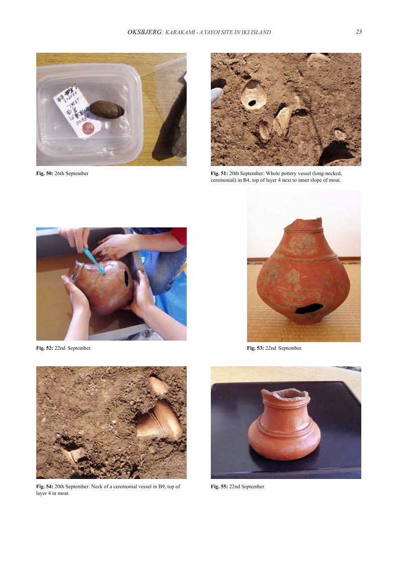
Fig. 52: 22nd September.
Fig. 51: 20th September: Whole pottery vessel (long-necked, ceremonial) in B4, top of layer 4 next to inner slope of moat.
Fig. 50: 26th September
Fig. 53: 22nd September.
Fig. 54: 20th September: Neck of a ceremonial vessel in B9, top of layer 4 in moat.
Fig. 55: 22nd September
BSEAA 1 (2007) 24
Fig. 59: 22nd September: ...while MISAKA Kazunori measures and draws.
Fig. 57: 22nd September. Fig. 56: 22nd September
Fig. 58: 22nd September: KAMIJŌ Nobuhiko excavates a human skull from the western part of B10…
Fig. 60: 22nd September: The skull cleansed and ready for photo. To the right an almost complete pottery vessel.
Fig. 61: 23rd September: The crosswise running wall takes shape.

OKSBJERG: KARAKAMI - A YAYOI SITE IN IKI ISLAND 25
Fig. 64: 23rd September: WATANABE Yoshihiza sorting out pottery and stone tools trying to keep up with the appearance of new artefacts.
Fig. 63: 23rd September: AMANO Shōtarō and MATSUMOTO Keita, who, together with YAMASHITA Natsuki, were in charge of the large variety of cameras, prepare for photos of animal bones.
Fig. 62: 23rd September: MAEKAWA Ryūsuke digging in grid B9.
Fig. 65: 23rd September: New assemblages appear below the ones just removed (from north).
Fig. 66: 23rd September. Fig. 67: 23rd September.

BSEAA 1 (2007) 26
approximately 20 cm deep black layer was removed - layer 5, with almost no artefacts (but containing the bones of a few small-sized animals (s-w part of B10) (Figure 72) -, and the natural reddish underground was disclosed. Layer 5 was a silting layer, but since also the layer on top of it was sloping, which could still be ob-served in the eastern profile of the old trench, Professor MIYAMOTO concluded that soil had sloped down into the moat continuously from an elevated position. This proved to be in accordance with a plateau of approxi-mately 2 m in width that had appeared at the inside edge of the moat. An earthen wall could have been con-structed there, containing the dug up soil from the moat, thus also Middle and Late Yayoi pottery. At this stage, the moat was still assumed to have been constructed in Late Yayoi.
On 25th September the team cleaned the surface of
the entire area for photos. When demarcating the layers in the profiles, Profes-
sor MIYAMOTO found the stratigraphy in the eventu-ally very wide western profile that now appeared in conjunction with the plateau and the emptied moat to suggest that the earthen wall, and thus also the moat, had been constructed twice (Figure 73). In the profile, a later phase of a wall could now be observed on top of the phase indicated by the plateau. The early phase, which probably belongs to layer 4 that is thus still in situ, will be left for this year's investigations. The later phase of the wall belongs to layer 3 that stems from late Middle and Late Yayoi, and has been removed during the 2006 excavation.
The moat's content of layer 4 was a mixture of the cultural layers 3 and 4, since the moat was constructed twice. This explains the mixture of Middle and Late Yayoi pottery in the fill of the moat, and the presence in some places south-west of the wall-plateau of Middle Yayoi pottery on top of pieces from Late Yayoi.
The moat and the wall could initially have been con-structed in Middle Yayoi to be left without maintenance
Fig. 70: 25th September: The north-east (outer) edge of the moat would have risen steeply from the bottom of which about 20 cm is left.
Fig. 69: 25th September: Profile of the moat (from south-east). The step-like shape of the right (north-east) edge of the moat is caused by the 1952-trench that was emptied during the current excavation.
Fig.68: 24th September: Reaching the bottom of the moat at the end of the day.
Fig. 71: 25th September: Prof. MIYAMOTO in front of the sloping south-west inner edge of the moat. The plateau from the earthen wall is seen next to the slope.

OKSBJERG: KARAKAMI - A YAYOI SITE IN IKI ISLAND 27
at the end of the phase, which would have resulted in the wall slowly sloping down at both sides; they could then have been reconstructed in Late Yayoi and again left at the end of that phase (Figure 74). If this sequence can be proved to be what actually took place, it fits with not only the one observed at Harunotsuji but also that of sites in other parts of Japan, e.g. sites in the Nara Basin.
The flotation of the shell layer soil from B10 was carried out by Dr. TSUJITA together with students SAEKI Mayako 佐伯眞矢子, HAYAKAWA Wakako 早川和賀子, TANIZAWA Ari 谷澤亜里 and OKAMOTO Yuya 岡本侑也 . Among other finds it resulted in approximately 50 grains. 6 Also fish bones were re-covered from the same soil during the flotation process that took place at Harunotsuji.
6 According to anticipation the major part of these proved to be wheat, whereas some were identified as japonica rice grains, the DNA of which is now going to be analyzed. (MIYAMOTO Kazuo, personal communication, 27th March, 2007).
Apart from the grains and the fish bones, the nature of which remains to be identified, other dietary remains were recovered during last year's excavation. These showed up in the shape of remains of a deer and a wild boar, making up evidence, together with the fish-bones, that the farmers living at Karakami were also hunting and fishing.
The domesticated dog, however, was so popular in Iki that skeletal remains from it surmount the bones of hunted animals, says Professor MIYAMOTO. At Ha-runotsuji, dog skeletons account for 47 % of the animal skeletons7 in one of the moats, followed by boar and then deer. 8 As mentioned earlier, during last year's investigations at Karakami, a skeleton from an animal the size of a small dog or a raccoon dog was recovered towards the bottom of the moat.
The find of the human skull adds to the ritual significance that settlement moats also seem to have had, although at this stage it is difficult to attach any further interpretation to the skull's presence in the Karakami moat. Since it was recovered at the very edge of the excavation field (western edge of grid B10), it is possi-ble that material that could throw light on its interpreta-tion is still left in situ. It is still too early to assess ex-actly what was the significance of moats. Most likely it was manifold. Still, a ritual function was without doubt held by many of the Yayoi period moats (MIZOGUCHI 2002:136-7; HIROSE 2004:206). During excavations at some Yayoi period settlements whole pottery vessels and extraordinary objects have been observed in large
7 In contrast to this, there were no cats at Harunotsuji. 8 However, this percentage is not based on flotation, and fish is
not included in the table. We have reason to suspect that fish would range high if more soil from Harunotsuji’s moat was to be surveyed. The flotation of the soil from one pit at the site proved fish bones to account for 80 % of the skeletons (total number: 55), (MIYAMOTO Kazuo, personal communication, 24th September 2006).
Fig. 74: 25th September: The plateau is clearly distinguishable to the south-west of the moat (from north-east).
Fig. 73: 25th September: The earthen wall and the sloping of all layers on top of it signify slow erosion away from it in times of negligence. The phases are shown in the profile (from east).
Fig.72: 24th September: KAMIJŌ Nobuhiko excavates a skeleton of a small-sized animal from the black silting layer (layer 5).

BSEAA 1 (2007) 28
numbers inside the moats.9 Pits at Yayoi sites were also of various functions, some were for ritual purposes, while others were entirely for utilitarian use. It is very common to find pits located at the bottom, the wall or immediately adjacent to the moats. Also at Karakami, one pit was located at the outside edge of the moat in grid B10, but it proved to be empty.
On 26th September, final levelling were carried out (Figure 75), the drawings of all surfaces and profiles were finished (Figures 76, 77, 78, 79, 80), and visiting expert Dr. SUGIYAMA Shinji 杉山真二 from the Pa-leoenvironment Research Institute in Miyazaki Prefec-ture took samples of soil at the site (Figure 81), that were to be taken back to the laboratory in Miyazaki to be analysed for remains of plant phytoliths.10
9 Examples of the former are Byodobo Iwamuro and Tsuboi Dai-fuku and of the latter Karako Kagi, all in the Nara Basin (Nara Ken-ritsu Kashihara Kōkogaku Kenkyūjo Fuzoku Hakubutsukan 2005:12-13, 16-17; Tawaramoto Chō Kyōiku Iinkai (ed.) 1979-1997). I already addressed this topic with a paper I gave last year in London (Jane OKSBJERG: The Religious Significance of Settlement Enclosures in the Yayoi Period (research seminar held 9th March 2006 at SOAS, University of London)).
10 Also the result of the phytolith-analysis showed the expected pattern of the presence of some rice, but a domination of wheat at the
Apart from the finds of organic material described above, all in all the results of the 2006 excavation at Karakami were more than 100 kg of Middle and Late Yayoi pottery almost all of which belonged to the Sugu II style that again belongs in the end of Middle Yayoi, but still exists at the beginning of Late Yayoi, plus a few sherds of peninsular pottery. Also more than 20 grinding stones, expected to add further support, once analysed, to the image we already have of Iki as a wheat region, were recovered. These were supplemented by mortar stones and grinding stones usually discovered in Jōmon context. Other stone artefacts were the above mentioned net sinker, half a spindle whorl and a chisel (Figures 26, 82). On 25th in the hotel, artefacts had been selected and prepared for exhibiting (Figures 83, 84), and at 2 pm on 26th local visitors were welcomed by a small on-site exhibition (Figures 85, 86), and Professor MIYAMOTO gave an account of the excavation, the finds that had been made and the significance they carry (Figures 87, 88). The excavated field with the emptied moat and the profiles were explained. After the visit, the team laid out sandbags to protect the walls and the pottery still in situ in layer 4, and the whole field was covered and will remain as the team left it at the end of the next day until the excavation in 2007 (Figures 89, 90).
All finds were packed and sent to Kyūshū University. site. (MIYAMOTO Kazuo, personal communication, 27th March 2007).
Fig. 77: 26th September: ...of profiles.
Fig. 76: 26th September: MATSUMOTO Keita and HAYAKAWA Wakako at the final drawings…
Fig.75: 26th September: TAKIO Mariko checking the levelling.

OKSBJERG: KARAKAMI - A YAYOI SITE IN IKI ISLAND 29
Fig. 81: 26th September: Dr. SUGIYAMA and Professor MIYAMOTO discuss the quality of the soil in the field’s eastern profile.
Fig. 79: 26th September: …and KAMIJŌ Nobuhiko includes them in the overall plan drawing. In the background Dr. SUGIYAMA taking soil samples while making conversation with a local visitor.
Fig. 78: 26th September: SAIKI Yuka takes precise measures in every spot of the excavated field…
Fig. 83: 25th September: Preparing for the following day's on site-exhibition (MISAKA Kazunori and MATSUO Toshiko).
Fig. 82: 26th September.
Fig. 80: 26th September: The soil of all layers is checked according to the standardised soil colour table (MATSUO Toshiko and TAKITA Kenzō).

BSEAA 1 (2007) 30
Fig. 87: 26th September: MIYAMOTO Kazuo introducing the results of the excavation to the local audience.
Fig. 85: 26th September: Arranging the pottery for the audience.
Fig. 84: 25th September: Professor MIYAMOTO selecting good pieces among the abundance of pottery sherds and vessel parts
Fig. 89: 26th September: Laying out sandbags and sand... Fig. 88: 26th September.
Fig. 86: 26th September.

OKSBJERG: KARAKAMI - A YAYOI SITE IN IKI ISLAND 31
CONCLUSIONS
During the excavations that will take place at Kara-kami in September 2007, layer 4 will be excavated, and hopefully more light will be thrown on the site as it was in Middle Yayoi. In this phase, during which activity started at Karakami, the groups residing in Iki (and all over the archipelago) seem to have had little formal contact with peninsular groups. Whereas we can detect waves of immigration in Initial (800 - 500 BCE) and Early Yayoi (500 - 300 BCE). In Middle Yayoi (300 BCE - CE 1) interrelation seems to have taken place sporadically in the shape of arrivals in Iki of small-scaled groups from the Korean Peninsula. From early Middle Yayoi Mumun pottery at Harunotsuji makes up proof of such exchange.
It is in Late Yayoi that we see the organized mutual trading between groups on either side of the Korean Strait and the Yellow Sea, also referred to in the Chinese chronicles that describe diplomatic missions by which the regents of the Wa-kingdoms exchanged gifts with the Chinese emperor. The finds of peninsular pottery in Late Yayoi layers at Karakami and particularly at Ha-runotsuji compose parts of the material culture that lies behind the records written down in the Wei chronicle. Other, more conspicuous objects are the bronze mirrors found in graves in north-western Kyūshū and fragments of these in the Kinki11 近畿 region, not to mention the golden seal given to the Na king in CE 57 and recov-ered at the small island of Shikanoshima 志賀島 in Fukuoka Bay in 1784.12
11 Whereas Late Yayoi graves in Kyūshū sometimes hold whole bronze mirrors, sites in the Kinki region from this phase have given fragments of these only. Thus, in Kinki, fragments equipped with two holes for suspension were abandoned at settlements or inherited as heirlooms until the Kofun Period, whereas fragments without holes were buried in graves in northern Kyūshū (TSUJITA Jun’ichirō, personal communication, 21st September 2006).
12 The Chinese emperor’s bestowal in CE 57 of a golden seal upon the king of the country Na, recognised as the region of and
The location of the Karida'in River at the foot of the Karakami hill-side would have provided good harbour-ing facilities, and foreign people visiting the place in times when peace prevailed would access it from there. Both the Karida'in and also the Hatahoko 幡鉾 River that runs past Harunotsuji would have contained more water in the Yayoi period than they do at present, and they would have been navigable. Also, the sea cut deeper into the coastlines than is the case today, provid-ing hospitable bays near both sites. However, the impor-tance of the harbour at Karakami would have been particularly great in times when the outstandingly fast current of the Hatahoko River at Harunotsuji would hamper landing at the larger settlement. It is therefore likely that diplomats arriving from the Korean Penin-sula in Late Yayoi, such as we know it from the Wei chronicle, would disembark at Karakami, and access Harunotsuji over land. Karakami can be seen as the gateway to Iki in the Yayoi period just like Kōrokan 鴻臚館 in present days' Fukuoka City can be seen as the gateway to Dazaifu 太宰府, outside Fukuoka City, in the Nara (710-784) and Heian (-1192) periods, says MIYAMOTO Kazuo, and whereas evidence of trade can be observed at Late Yayoi Harunotsuji, Karakami may have been a location of ritual activities. Although most of the foreign pottery discovered at Iki has been found at Harunotsuji, 3-4 complete vessels have been recov-ered at Karakami in trench 2 that was cut, as was trench 1, in 1952 in close proximity to the small peak where the Karakami shrine is now to be found. The vessels were modestly sized Lelang vessels, thus it seems pro-bable that they were brought to the place by foreign diplomats. The location of these vessels at this high lying spot makes MIYAMOTO consider the likelihood of rituals having taken place on top of the hill peak in the Yayoi Period, and of these having been carried out here by the foreigners before the group resumed the travel and continued to Harunotsuji and later to Matsuro (Karatsu). Entrance rituals for travellers may thus have been part of the role of the settlement, and their location on or near the hill top would be likely. Professor MIYA-MOTO draws attention to the meaning of the name Karakami, used today as the name of the shrine on top of the hill peak, being that of “Chinese gods” or simply “foreign gods”. This could very well refer to a past employment of the place as an altar used by travellers.
Given the peculiar topography for a moated settle-ment, Karakami may turn out eventually to have been a ritual location in general. In 1977, four deer scapulae for divination use were recovered from trench 7. Such around present day’s Fukuoka City in northern Kyūshū, is recorded in a chronicle of the Later Han Dynasty (CE 25-220) (TSUNODA and GOODRICH 1951:2).
Fig. 90: 27th September: ...and covering up the field until next year’s investigations.

BSEAA 1 (2007) 32
oracle bones are peculiar to the Yayoi period, and were part of the cultural package that arrived from the Ko-rean Peninsula at the beginning of the Yayoi period.13As in the Peninsula, where the same type of scapulae have been found from the corresponding temporal horizon, the deer grew to hold essential religious importance in Yayoi period Japan.
The bronze mirror recovered in 1926 was a small imitated mirror14 and was picked up at the lower lying ranges of the site below any of the trenches. A fragment of a mirror provided with two holes was excavated in 1952 from trench 1. Such fragments of bronze mirrors have been found in Late Yayoi context at other sites as well, particularly are they predominant in the Kinki area in Late Yayoi context (see note 11). Breaking and depositing of bronze mirrors and bells were part of the
13 One of these oracle bones plus additional finds from Karakami, Harunotsuji and other sites at Iki can be observed at Kyūshū National Historical Museum in Dazaifu, outside Fukuoka City, which opened in October 2005. Many finds from Harunotsuji, however, can be observed at the on-site museum.
14 The category of imitated mirrors are so called because they were produced in Japan as imitations of the imported Chinese mirrors.
ritual life in Late Yayoi, says TSUJITA Jun'ichirō, and continues that the mirror fragments were often provided with two holes just wide enough to let a string pass through. They are therefore assumed to have been used as pendants.
The domestic material culture on Iki was part of a larger cultural sphere that also included the Itoshima 糸島 Peninsula north-west of present day's Fukuoka City. As mentioned earlier, this place has been identified as the one of Ito-koku (country of Ito), such as it is de-scribed in the Wei chronicle, thus in Late Yayoi it held more than 1,000 households, and was ruled by a heredi-tary king (TSUNODA and GOODRICH 1951:9). In Middle Yayoi, contact between Iki and groups located further away even within the archipelago seems to have been scarce, although we do see a small degree of im-port on Iki from eastern Kyūshū. However, pottery produced locally at Iki is identical to that produced in Itoshima, says Dr. TSUJITA. Thus, the two countries of Iki and Ito apparently shared their material culture (and perhaps their ruler) already in Middle Yayoi. (Figures 91, 92, 93, 94).
Fig. 93: 20th September: The field from north-west during lunch break. Still more pottery appears as we work our way through layer 3.
Fig. 92: 19th September: ITŌ Miki, SAIKI Yuka, HAYAKAWA Wakako, SAEKI Mayako, HAKOSHIMA Namiko and TAKIO Mariko.
Fig.91: 19th September: Obtaining valuable information (MIYAMOTO Kazuo, Jane OKSBJERG).
Fig. 94: 20th September: Lunch break. Still conscious: MISAKA Kazunori, WATANABE Yoshihiza, MATSUMOTO Keita.

OKSBJERG: KARAKAMI - A YAYOI SITE IN IKI ISLAND 33
ACKNOWLEDGEMENTS
First of all I would like to thank Professor MIYA-MOTO Kazuo for allowing my participation at the excavation at Karakami, even if not being a student of Kyūshū University, for giving me a first-hand orienta-tion of the surroundings of the Karakami site as well as of the previous excavation spots, and for telling the substantial accounts on the research history of the site. I would also like to thank both Professor MIYAMOTO and Dr. TSUJITA for their endless patience with my many questions, providing me with explanations and comments for this article during working hours as well as after they had ended. I also wish to express my warm thanks to my room-mate and friend MATSUO Toshiko, who was there for me whenever my limited Japanese abilities threatened to cause misunderstandings during conversation with other members of the team, and who generously provided this article with half of its pictures.
Finally, I want to thank every single member of the excavation team for bearing with me when taking countless photos of them during their work, and to express my respect for the seriousness and the professionalism with which they all approached their work in the field as well as outside it.
The field-trip providing the background for this article was funded by the Scandinivia-Japan Sasakawa Foundation, Copenhagen, and the Central Research Fund, University of London, London.
REFERENCES:
ARBOUSSE-BASTIDE, Tristan 2005, Les Structures d'habi-tat Enclose de la Protohistoire du Japon (période de Yayoi 350BC - 300AD), BAR International Series 1345. Oxford: Archaeopress.
HIROSE Kazuo 2004, Zur Frage des städtischen Charakters yayoi-zeitlicher Großsiedlungen. In: WIECZOREK, Alfred, Werner STEINHAUS and Sahara MAKOTO (eds.), Zeit der Morgenröte: Japans Archäologie und Geschichte bis zu den ersten Kaisern, Handbuch (Publikationen der Reiss-Engelhorn-Museen, Vol. 11). Mannheim: Reiss-Engelhorn-Museen, pp. 203-206.
Tawaramoto Chō Kyōiku Iinkai (ed.) 1979-1997, Karako Kagi Iseki: Hakkutsu Chōsa Hōkoku, No. 6 - No. 62 (Ka-rako Kagi Site: Excavation reports). Tawaramoto Chō (Nara): Tawaramoto Chō Kyōiku Iinkai [田原本町教
育委員会 [編]: 「唐古・鍵遺跡 : 発掘調査概報, 第6 次 ∼第 62 次」. 田原本町(奈良県): 田原本町教育
委員会]. MIYAMOTO Kazuo (ed.) 2005, Yayoi Jidai Seiritsu-ki ni
okeru Torai-jin Mondai no Kōkogaku-teki Kenkyū (Archaeological study on the imigrated people at the beginning of the Yayoi Culture). Fukuoka: Kyūshū Daigaku Daigakuin Monbu Kagaku Kenkyūin Kōkogaku Kenkyūshitsu, pl. 13 [宮本一夫 編 「弥生
時代成立期における渡来人問題の考古学的研
究」. 福岡: 九州大学大学院人文科学研究院考古
学研究室]. MIYAMOTO Kazuo (ed.) 2006, Karakami Iseki Hakkutsu
Chōsa Gaihō, (unpublished manuscript), pl. 15. [宮本
一夫 編「カラカミ遺跡発掘調査概報」]. MIZOGUCHI Koji 2002, An Archaeological History of
Japan: 30,000 BC to AD 700. Philadelphia: University of Pennsylvania Press.
Nara Kenritsu Kashihara Kōkogaku kenkyūjo Fuzoku Haku-butsukan (ed.) 2005, Mura no Henbō: Yayoi Kōki no Yamato to sono Shūhen (Transformation of Settlements: Late Yayoi in Yamato and its surroundings) (Exhibition catalogue, No. 63). Kashihara: Nara Kenritsu Kashihara Kōkogaku Kenkyūjo Fuzoku Hakubutsukan. 奈良県立橿原考古
学研究所附属博物館 [編]: 「ムラの変貌 : 弥生後
期の大和とその周辺」, 特別展図録 第 63 冊, 橿原: 奈良県立橿原考古学研究所附属博物館.
SEYOCK, Barbara 2004, Auf den Spuren der Ostbarbaren: Zur Archäologie protohistorischer Kulturen in Südkorea und Westjapan (Tracing the Eastern Barbarians: On the archaeology of protohistoric cultures in South Korea and western Japan), BUNKA - Tübinger interkulturelle und linguistische Japanstudien, BUNKA - Tuebingen intercultural and linguistic studies on Japan, Band/Volume 8. Münster: LIT-Verlag.
TSUNODA, Ryusaku and L. Carrington GOODRICH 1951, Japan in the Chinese Dynastic Histories: Later Han through Ming Dynasties. South Pasadena: P.D. and Ione Perkins, pp. 1-7, 8-21.