vol. 25, no. 2 - pennsylvania · state geologist's editorial the fourth pennsylvania...
TRANSCRIPT

VOL. 25, NO. 2

COMMONWEALTH OF PENNSYLVANIA
Robert P. Casey, Governor
DEPARTMENT OF ENVIRONMENTAL RESOURCES
Arthur A. Davis, Secretary
OFFICE OF PARKS AND FORESTRY
Patrick J. Solano, Deputy Secretary
BUREAU OF
TOP OGRAPHIC AND GEOLOGIC SURVEY
Donald M. Hoskins, Director
CONTENTS
The Fourth Pennsylvania Geological Survey at 75: 1919 to 1994 ........... . Hooked on the rocks: exploring the geology of the Youghiogheny River
Lake-a boating field trip............................................................................ 2 Sedimentary evaporites in the Galesburg Formation of central Pennsyl-
vania ..................................... . . . . . . . . . . . . . . . . . . . . . . . . . . ....................... . . . . . . . . . . . . . . . . 10 Earth Science Teachers' Corner . .. ..... ........... .. ..... . . . .. . . .. . . . . . .. . .. . ... ... .. ... .... .. 16
ON THE COVER
The "stair-step" exposure of the Lower Conemaugh Pine Creek marine zone along the shoreline of the Youghiogheny River Lake, Confluence, Pa., locality 11 (see article on page 2). The outcrop was exposed due to the lowering of the lake level. Photograph by W. E. Kochanov.
PENNSYLVANIA GEOLOGY
PENNSYLVANIA GEOLOGY is published quarterly by the Bureau of Topographic and Geologic Survey, Pennsylvania Department of Environmental Resources, P. 0. Box 8453, Harrisburg, PA 17105-8453. Editors: Christine M. Dodge, Anne B. Lutz, and Donald M. Hoskins. Contributed articles are welcome; for further information and guidelines for manuscript preparation, contact D. M. Hoskins at the address listed above. Articles may be reprinted from this magazine if credit is given to the Bureau of Topographic and Geologic Survey.
VOL. 25, NO. 2 SUMMER 1994

STATE GEOLOGIST'S EDITORIAL
The Fourth Pennsylvania Geological
Survey at 75: 1919 to 1994
The present (Fourth) Topographic and Geologic Survey of Pennsylvania was created on June 7, 1919, when then Governor Sproul signed Act 205 into law. Although Governor Sproul's appointment letter to the first employee of the new Bureau was dated September 4,
1919, the work of the survey actually began on September 1, reflecting the urgent need of the day. On that date, Dr. George H. Ashley, widely respected for a lengthy career in both state and federal geological surveys, became State Geologist. He immediately began to deal with an accumulation of problems in Pennsylvania that required both an understanding of geology and the support of accurate topographic maps. His successors as State Geologists have been Ralph Stone, Stanley Cathcart, Carlyle Gray, Arthur Socolow, and myself.
During the succeeding 75 years, the staff of the Topographic and Geologic Survey of Pennsylvania has served the Commonwealth by providing answers to problems that require an understanding of the geology and topography of our state. The Bureau has served Pennsylvania citizens by responding to uncounted thousands of requests for specific geological and topographic information and for explanations of the many geological features and phenomena present in our Commonwealth. In order to provide reliable scientific information supporting these responses, the Bureau has independently conducted or assisted in extensive field investigations in all areas of the Commonwealth. These investigations include the collection of geologic data concerning the location and nature of Pennsylvania's rocks and surficial materials and their energy, mineral, and water resources. The data have been analyzed, synthesized, and provided to the public through detailed, as well as popularly written, reports and maps. The number of reports and maps issued since 1919 now totals nearly 900.
These accomplishments are the result of 75 years of work by dedicated and competent geologists and support staff of the Bureau, for whom public service has a high personal value, following the principles established by Dr. Ashley. Their work and the products of the Bureau have been complemented by the efforts of the larger community of geologists who investigate and analyze the complex geology of
(continued on page 15)

HOOKED ON THE ROCKS: Exploring
the Geology of the Youghiogheny River
Lake-A Boating Field Trip
by James R. Shaulis Pennsylvania Geological Survey
You are out fishing one morning on the Youghiogheny River Lake. As the sun begins to rise, you make your first cast of the day. Trying to drop your lure near the steep rocky shore, you accidentally overthrow. Your lure becomes wedged in a rock crevasse so tightly that you are forced to go ashore to free it. When you bend down to retrieve it, you notice that some of the rock layers contain many different types of marine fossils. Other rock slabs that have slid down from above have rippled surfaces, and a few are also marked with sinuous wormlike trails. When you look up to see where these rocks came from, you notice that higher up on the shoreline, the rocks change in color from pale olive to grayish red. You have many questions about what you see here. If the answers could be found on a boating excursion that included beautiful scenery, fishing, fossil hunting, and a basic introduction to the various types of sedimentary rocks and the geologic history of western Pennsylvania, would that be a catch worth keeping? If so, cast your eyes on this article and reel it in.
THE CREATION, CARE, AND MAINTENANCE OF AN OUTCROP. The Youghiogheny River Lake (YRL) (Figure 1) was completed by the U.S. Army Corps of Engineers in 1943 in conjunction with the Flood Control Act of 1938. The Y RL provides flood protection and also is a water supply for downstream communities and commerce. Its water level is adjusted continuously by the Corps of Engineers according to a schedule that takes into account seasonal precipitation amounts in the Y RL watershed. On the average, the level is adjusted by 0.5 foot per day up or down over a 50-foot range between 1,390 feet and 1 ,440 feet above mean sea level. However, during very wet or very dry periods, the range can increase by 20 feet in either direction. The right-hand column of Table 1 contains a listing of water levels by month for an average precipitation profile based on records for the past 30 years.
Before the Y RL existed, the Youghiogheny River cut a deep gorge-like valley hundreds of feet deep across the landscape of this area. Field notes of geologists who mapped in the region indicated
2
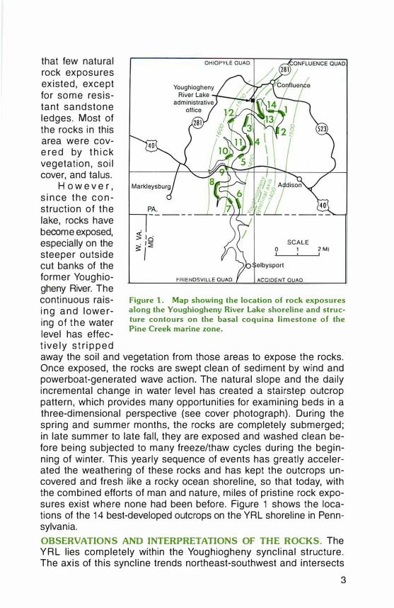
that few natural rock exposures existed, except for some resistant sandstone ledges. Most of the rocks in this area were covered by thick vegetation, soil cover, and talus.
H o w e v e r , since the construction of the lake, rocks have become exposed, especially on the steeper outside cut banks of the former Youghiogheny River. The continuous raising and lowering of the water level has effectively stripped
OHIOPYLE OUAD.
SCALE 0 2MI
FRIENDSVILLE QUAD. ACCIDENT QUAD.
Figure 1. Map showing the location of rock exposures along the Youghiogheny River Lake shoreline and structure contours on the basal coquina limestone of the Pine Creek marine zone.
away the soil and vegetation from those areas to expose the rocks. Once exposed, the rocks are swept clean of sediment by wind and powerboat-generated wave action. The natural slope and the daily incremental change in water level has created a stairstep outcrop pattern, which provides many opportunities for examining beds in a three-dimensional perspective (see cover photograph). During the spring and summer months, the rocks are completely submerged; in late summer to late fall, they are exposed and washed clean before being subjected to many freeze/thaw cycles during the beginning of winter. This yearly sequence of events has greatly accelerated the weathering of these rocks and has kept the outcrops uncovered and fresh like a rocky ocean shoreline, so that today, with the combined efforts of man and nature, miles of pristine rock exposures exist where none had been before. Figure 1 shows the locations of the 14 best-developed outcrops on the Y RL shoreline in Pennsylvania.
OBSERVATIONS AND INTERPRETATIONS OF THE ROCKS. The Y RL lies completely within the Youghiogheny synclinal structure. The axis of this syncline trends northeast-southwest and intersects
3

Table 1. Months When the Base of a Stratigraphic lnterual Is Exposed Aboue the
YRL Shoreline in a Year Hauing Auerage Rainfall
Locality number Lake
Mo. 1 2 3 4 5 6 7 8 9 10 11 12 13 14 elev.'
J n n n n pc n b m b b n b wr wr 1.400 pc pc pc pc pc pc
F n n n n pc n b m b b n b wr wr 1.410 pc pc (pc) pc pc pc
M n n n n pc' n b m b b n b wr wr 1,420 (pc) pc (pc) pc
A n> n• pc' n' b' m' b n' 1.437 M n • n• pc' n• b' m• b n• 1,440 J n• n• pc' n> b' m • b n• 1,440 J n n n pc n• b' m• b nZ 1,438 A n n n pc n b m b (b) n 1,433 s (pc) n (pc) (pc) pc (pc) b m b b n b wr wr 1.421
n n n n pc 0 n n n n pc n b m b b n b wr wr 1,407
pc pc pc pc pc pc N n n n n pc n b m b b n b wr wr 1,394
pc pc pc pc pc pc D n n n n pc n b m b b n b wr wr 1,395
pc pc pc pc pc pc
'Elevations are for the first day of each month. 2Base of Interval is jusl above water level. ( ), Only exposed for half of the month. m, Mahoning coal and sandstone; b, Brush Creek coal and marine zone; pc, Pine Creek marine zone; n, Nadine marine zone; wr, Woods Run marine zone.
the shoreline of the Y RL at locality 13 (Figure 1 ). Its southeastern limb can be seen dipping gently 1 degree to the northwest toward the axis at locality 1. The dip on the northwestern limb varies from 1 to 2.5 degrees to the southeast but is hard to see because most of the outcrops on this side of the syncline are oriented parallel to strike.
The exposed stratigraphic sequence totals about 230 feet along the Y RL shoreline and contains four discrete intervals: (1) the Mahoning coal and sandstone interval; (2) the Brush Creek coal and marine zone interval; (3) the Pine Creek and Nadine marine zone interval; and (4) the Lower Bakerstown coal and Woods Run marine zone interval (Figure 2). Composite columnar sections and interpretations of depositional environments for each interval are shown in Figure 3. The depositional history for each interval is briefly discussed below, in ascending stratigraphic order.
A. Mahoning Coal and Sandstone Interval (Locality 8). The Mahoning coal and sandstone interval is the only nonmarine sequence occurring along the lake. It makes up the longest continuous outcrop, nearly 1 mile in length.
After a river that was flowing across a deltaic plain deposited the Lower Mahoning sandstone, it migrated out of the area. A slow
4

scm M fl
Upper Mahoning sandstone
Mahon.ng coal
15150 10
25 5
0 0
Lowet Mahon•no sandstone
Figure 2. Composite columnar section of Upper Pennsylvanian rocks (Glenshaw Formation, Lower Conemaugh Group) exposed along the YRL shoreline. The sketch shows rock units exposed at locality 1 in mid-September in an average rainfall year. The fish under the boat are rock bass and freshwater sandstone sharks. See Figure 3 for explanation of symbols and patterns.
subsidence of the land then occurred, and large, shallow, poorly drained depressions developed. This provided an ideal setting for plant growth and the development of a peat swamp that eventual ly became the Mahoning coal. The swamp was then covered with clay, organic debris, and silt from overbank deposits of a nearby f luvial system. Finally, another river meandered back into the area and deposited the Upper Mahoning sand-stone at the top
of the section. A generalized diagram illustrating depositional environments common to a Pennsylvanian delta is shown in Figure 4. Of special interest is the upper portion of the Mahoning coal seam, which contains well-preserved sideritized Stigmaria fossils up to 0.8 inch wide and 3.0 feet long.
B. Brush Creek Coal and Marine Zone (Localities 7, 9, 10, and 12). The Brush Creek coal and marine zone is exposed at four separate localities on the western shoreline of the Y RL.
The freshwater limestone at the base of the section is interpreted to have been deposited in a freshwater pond or lake. As this lake filled with lime mud and fine noncarbonate sediments, the water shallowed, allowing plant growth, and the area evolved into a swamp that accumulated peat, which eventually formed the Brush Creek coal. A rise in sea level led to a marine transgression over the swamp, transforming the area into a restricted interdistributary bay. In this environment, dark fossiliferous shales and thin coquina limestones containing a nearshore marine fauna were deposited. Land was close by, as indicated by the presence of crinoid columnals and
5

MAHON lNG COAL AND SANDSTONE INTERVAL BRUSH CREEK COAL AND MARINE ZONE INTERVAL
COilPOSiiE SECTION FROilLOCAUTY I
"n 40 10
UPPER 30 MAHON lNG
SAN_2�0�E-
M AHO NINO COAt.
LOWER MAHON! NO
SANDSTONE
D Sandstone
.f I I I
E IUJl ([I] �:�: ����
DEPOSITIONAL EHVIRONIAENT
Ltvee and overeoan.,
Swamp
Fluvial channel
COIAPOSiiE SECTION FROII LOCAUTIES 7, 9. 10, .v;o 12
BUFFALO SAUDSTONC
BRUSH CAUK MARit-E ZONE
------BRUSH CREEK
- -- �".!:-
EXPLANATION
� Ball·and·p•llow s11ucture llibJ Block $
OEPOSiiiONAL EIIVIROhllENT
Orstnbu• tary·mouth btr or
n" 40 1-'-'"-'"-"-•'--r-IO
JO
ResttJC:IMI lnltrO.I· 1t1butary bly
. ..
20
i-S 10
s .. teauh
FrtShW1111f L-0 �e or -FOSSILS
Brachiopod r1 Horn coral
0 Slllstona or [[!] ��:���:�: od � Caliche � �,'
aoy
onlsh sill shale
$ Pelecypod • Bryozoan IJ Gasuopod
= lchnoloss•l E9 limestone � �::�:�ad � �����eous IQ§} Olrvo g11y • Crinoid
• C opholopod .. Plant
0 Clay shate or claystone � !�:���.d
� Sidente nodule [[) Rod T Trilobite O S11gm4r,.
• Coal E3 ��;,: • D Phosphate nodule
LOWER BAKERSTOWN COAL AND PINE CREEK AND NADINE MARINE ZONE INTERVAL WOODS RUN MARINE ZONE INTERVAL
SUBFACIES GROUP A (LOCALITIES I AND 2) SUBFACIES GROUP B (LOCALITIES 3. 4, 5,oV;D II) DEPOSITIONAL COMPOSITE SECTION FROM DEPOSITIONAL
SUBFACIES GROUP C (LOCALITY 61 ENVIROIIMENT LOCAUTIES 13 AIIO U ENVIAONUEIIT
un nu so so
15 SA.I..TSBURG lnttrcM· -IS SANDSTONE
tubutary channel
�0� 40 NADINE GG
MARINE ZOtiE 10 Ollshort marine f-'-10 JO
...r.au wooos""" Ret.IJ.Ct� ....... Cakfte a.nd \lld&l·n&l caltiOn• IWUNE .. W\ltfdol·
l!l<b•G¢ ate ,ii.ii,Mutt surt.ea ZOhE BL tnbutary £!] �r'al carbonate .. , I!Jc::. (!) {!] Tidal-Oat short tact
20 ©� (f) Bawer bar BL 1-5
$(!) .. lnttHtdaJ (delta slope) (I) 10
loWER"" IWl[RS· S w
0 ProtK1ea OtS1tdMI1Aty•tnOUU'I T��c� Sui ' Dar and lt\ttrdlsU1bu1ary crtvuse splay tilth Lo I I I I I I I I
E ljljljl s t � • q
E IJJ Figure 3. Composite columnar sections of rock exposures found along the Youghiogheny River Lake and their interpreted depositional environments.
6

intact fern fronds together in one of the coquina limestone beds. As the interdistributary bay continued to fill with sediment and prograde seaward, a coarsening-upward sequence of rocks was deposited that culminated with the Buffalo sandstone.
C. The Pine Creek and
Nadine Marine Zones (Lo
calities 1, 2, 3, 4, 5, 6, and 11). The Pine CreekNadine marine zone interval is exposed at seven different localities covering more than 2 miles of the Y RL shoreline.
The sediments underlying the Pine Creek were formed either in an interdistributary bay environment by a distributary-mouth bar (locality 1
= Marine =offshore_,
Figure 4. Generalized diagram showing depositional environments common to a Pennsylvanian delta (modified from Flores and Arndt, 1979). See Figure 3 for explanation of patterns.
only) or as crevasse-splay deposits. A subsequent rise in sea level resulted in a marine transgression. The coquina limestone and fossiliferous shales (Figures SA, 5C, and 50) at the base of the Pine Creek represent the initial transgressive phase. Following this phase, a shallowing of the water occurred as the land prograded seaward. This is reflected in a gradual coarsening-upward pattern in the Pine Creek. However, in the upper portion, this trend is also accompanied by complex lateral facies changes in what is interpreted as a nearshore intertidal environment. Within this intertidal setting, the following subfacies groups have been identified: intertidal carbonate shoal (group A), tidal-flat shore face (group B), and barrier bar (group C)( Figure 3).
Following the deposition of the Pine Creek in a nearshore intertidal environment, a drying out occurred, as indicated by the appearance of caliche beds. After subaerial exposure of the land, marine conditions returned and resulted in the deposition of a red clay shale interbedded with thin limestones, called the Nadine marine zone. The presence of crinoids (Figure 58). corals, bryozoans, and phosphate nodules in the limestones and brachiopods in the red shales, and
7

A B
c D
Figure 5. Photographs of fossils found in the rocks along the YRL shoreline. A, Trilobite pygidium in basal coquina limestone of the Pine Creek marine zone from locality 5. B, Crinoid calyx found in the Nadine limestone at locality 3. C, Large "adult" Juresania sp., a brachiopod from the basal Pine Creek at locality 1 1 . D, Dunbarella sp., a brachiopod from the lower Pine Creek shale at locality 1 1 . The length of the large valve is 25 mm.
the lack of any coarse-grained siliciclastics in the Nadine interval indicate that it was deposited in an offshore marine setting. The red color of the clay shale may have resulted from the erosion of a reddish, iron-rich soil into the marine depositional environment.
D. The Lower Bakerstown Coal and Woods Run Marine Zone (localities 13 and 14). This interval is lithologically nearly identical to the Brush Creek coal and marine zone and is interpreted to have a similar depositional history (Figure 3).
8

PLANNING YOUR VISIT TO SEE THE SITES. Before planning to visit any of the outcrop localities along the lake, first check the exposure chart shown in Table 1 to see which sites are exposed at that time of year. Better yet, contact the Army Corps of Engineers at Y R L to find out if the current lake level corresponds to the level shown on the chart. Otherwise, determine what sites are accessible by finding the month on the chart in which the lake level is approximately the same as the current lake level. The best time to examine all of the outcrops is in late summer to late fall when water levels are lowest.
To get to the outcrops, pontoon boats are available for daily rental at the Youghiogheny Lake Marina from June 1 through the middle of September. However, all outcrops are accessible by car and foot for the truly determined. Before attempting to do this, consult the 7.5-minute-quadrangle map of the area. Many roads that encircle the lake are narrow semiprivate routes having limited off-road parking. If you are near a private residence, it is advisable to ask permission before leaving your car parked for an extended period. WARNING: The lake is surrounded by steep slopes and cliffs that are made up of highly weathered, incompetent rocks. Vertical drops of more than 20 feet occur along the shoreline in many areas. The author can assure you that access via this route can be very quick, but very painful, so use extreme caution if you go down to the shoreline on foot in these areas.
THE END OF THE LINE. The sun has now almost set, but it seems as though only an hour has passed. You have visited ancient oceans, coastlines, bays, rivers, and swamps without leaving the shoreline of the Youghiogheny River Lake. You have marveled at how the natural geologic processes and man's presence have changed and continue to change the landscape over time.
When you finally arrive back home, a family member comments on how the fishing must have been good today because you are home so late. Not having any fish to show off, you reply, "Well you see, what happened is that, while I was fishing, I got hooked on some rocks and I just couldn't get loose."
REFERENCE
Flores, A. M., and Arndt, H. H. (1979), Depositional environments of Middle Pennsylvanian Series in proposed Pennsylvanian System stratotype, in Englund, K. H., and others, eds., Proposed Pennsylvanian System stratotype, Virginia and West Virginia, Ninth International Congress of Carboniferous Stratigraphy and Geology, American Geological Institute Selected Guidebook Series 1, p. 115-121.
9

Sedimentary Evaporites in the
Gatesburg Formation of Central
Pennsylvania
by Christopher D. Laughrey Pennsylvania Geological Survey
"It's these changes in latitude ... nothing remains quite the same."
-Jimmy Buffet, 1976 INTRODUCTION. The winter of 1 993-94, with no fewer than 1 6 snowstorms, caused many a Pennsylvanian to dream about balmy southern climes and tropical shores. While shovelling through the drifts left in my driveway by a hydrologic cycle gone berserk, I tried to find consolation in the fact that the Keystone State once lay near the equator. A little more than 500 million years ago, Pennsylvania resembled the Bahamas, although it was probably much drier. Drifts of sand rather than snow lined the shore, and often, much of the water available there evaporated, leaving behind only a mineral legacy.
THE GATESBURG FORMATION AND "GREAT AMERCAN BANK." Rocks of Late Cambrian age in the Gatesburg Formation of central Pennsylvania are part of a thick regional succession of platform carbonates that accumulated on the southwest-facing coast of the ancient continent called Laurentia, which was positioned athwart the equator (see back cover). The Cambrian and Ordovician Periods were times of widespread carbonate deposition in what would later become North America. Broad carbonate shelves extended along the lengths of what would become the Appalachians in the east and the Rockies in the west (Hardie, 1986, p. 40).1n the area of the future Appalachians, this Cambrian and Ordovician platform produced a wedge of carbonate rocks more than 1 ,860 miles long, more than 1 86 miles wide, and as much as 2.2 miles thick (Colton, 1 970)! It is one of the largest accumulations of carbonate sediments in the geologic record (Hardie, 1 986), an accumulation that the eminent carbonate geologist R. N. Ginsburg (1982) christened the "Great American Bank" (similar to the modern Great Bahama Bank).
In central Pennsylvania, the Gatesburg Formation consists of repeated (cyclic) sequences of peritidal carbonates, noncyclic subti-
10

dal carbonates, and two rather prominent quartz-sandstone zones. The cyclic peritidal carbonates exhibit well-defined shallowing-upward tidal-flat sequences, as schematically illustrated in Figure 1 .
ANCIENT CLIMATES. Paleogeographic and paleo-oceanographic placement of the Laurentian landmass indicates that the climate was probably semiarid during deposition of the Upper Cambrian rocks of central Pennsylvania. Because the southwest-facing coast of Laurentia lay between 0 and 30 degrees south latitude (see back cover), the dominant wind pattern likely was a southeasterly trade wind that carried warm maritime air from the moist western side of a high-pressure center in the Iapetus Ocean (Riley and others, 1 993, p. 1 1 -1 2). This air movement would have provided abundant rainfall along the east coast of Laurentia, but the southwest coastal climate would have been relatively dry and similar to those of modern-day Morocco, Baja California, and western Australia (Wilde, 1 991 ; Riley and others, 1 993).
The geological evidence for a semiarid setting is mostly indirect. Shallowing-upward tidal-flat sequences in the Gatesburg Formation contain several indicators of subaerial exposure and desiccation, such as mudcracks and intraclast chips in association with isolated, displacive nodules of sparry calcite. Hardie (1 986) and Read (1 989) interpreted the calcite nodules as former anhydrite nodules formed in the supratidal zone.
EVAPORITES. The Pennsylvania Geological Survey recently participated in a two-year multidisciplinary research program designed to measure and predict petroleum reservoir heterogeneity in Upper Cambrian rocks in Pennsylvania and Ohio (Riley and others, 1 993). During this work, Survey geologist John Harper and I were surprised and delighted to find sedimentary evaporites in core samples of the Gatesburg Formation.
The Shell Oil Company drilled the Shade Mountain #1 well in Fayette Township, Juniata County, in 1 964. One of the cores recovered from this well consists of almost 26 feet of dolostone and a 4-foot-thick sequence of sedimentary anhydrite near the top (Figures 1 B and 2). The anhydrite occurs between depths of 1 0,01 3 and 10,01 7 feet. The lowest part of the anhydrite zone in the core is transitional with subjacent oolitic, fossiliferous, mottled, and burrowed dolostone.
The bulk of the evaporite in the core consists of moderateyellowish-brown, slightly dolomitic anhydrite. The anhydrite displays wavy, anastomosing, and laminated bedding. It also contains very thin, discontinuous and wispy, nonparallel laminations of finely crystalline dolomite intercalated with micron-sized, subhedral crystals of
1 1

10.010
10,015 <J) w (.J z w :::> 0 w <J) 10,020 0 II: < :;:: Cl. :::> "' z � 10,025 0 � < :I: <J)
10.030
10.035
12
MUDCRACKED FLAT LAMINITE
SUPRATIDAL • PLAIN
PRISM-CRACKED UPPER
Figure 1. Shallowing-upward carbonate sequences are stratigraphic successions in which each unit was deposited in progressively shallower water. These successions are repeated many times within a stratigraphic section of shallow-water carbonate rocks. A, Lithologies and interpreted depositional environments of several sedimentary subfacies in shallowingupward sequences found in Cambrian and Ordovician rocks in the central Appalachians (from Hardie, 1986). B, Graphical core description of the Gatesburg Formation in the Shade Mountain well, Juniata County (modified from Riley and others, 1993). The core contains repeated shallowingupward sequences. Note the presence of anhydrite near the top of the core.
WAVY =INTERTIDAL
LAMINITE ALGAL FLATS
RIBBON
ROCK
CROSSS TRATIFIED GRAINSTONE$
THROMBOLITIC
BIOHERMS
LOWER • INTER TIDAL •
MIXED SANDMUD FLATS
SU BTl DAL = O O ID-PELOID
SAND SHOALS
ALGAL =PATCH
R EEFS
FLAT PEBBLE • STORM SHEET CONGLOMERATE
• DEPOSITION
A
Cl. :::>
"""""""''
�ii:B, "�';). if..""
0 0 0 0 000 0 0 0 . .. . ..
.
.... . .
····� •IO•" : . . . �-. .. . .. .
00 .
(9 Dolostone
DEPOSITIONAL SETTING
SUBTIDAL SHELF·LAGOON
SUPRATIDAL TO SUBTIDAL
banks having sabkha deposits and subaqueous evapori1es; inter· bank lagoon or "pond" deposi1s
SUBTIDAL TO INTERTIDAL (?)
shoal or levee bank and shoal or channel flank
SUBTIDAL SHELF·LAGOON
SUBTIDAL SHOAL OR CHANNEL FLANK
SUBTIDAL SHELF·LAGOON
EXPLANATION
X Dolomilic
LITHOLOGIES
DOLOSTONE. mauled and burrowed
NODULAR ANHYDRITE conlaining dolomite
LAMINATED EVAPORITES contain· Ina dolomile and s1roma1o1i1es
DOLOSTONE. oolilic. fossililerous, motlled, and burrowed
0010 DOLOGRAINSTONE. grades down to MIXED OOID·PELOID DOLOGRAINSTONE and DOLO· PACKSTONE. and PELOID·MIXED FOSSIL DOLOPACKSTONE
MIXED FOSSIL DOLOPACK· STONES AND DOLOWACKE· STONES
OOID·PELOID DOLOGRAINSTONE • quanzose, fossiliferous; con1ains rip·up clas1 conglomera1es
DOLOSTONE, monied and bloturba1ed
• Peloids
t:Z:5} Calcareous dolostone
� Anhydrote
:::::::::::. Nodular bedding
= laminated bedding
� Stromatolites
[SJ Quartz sand o Ooids
8

anhydrite (Figure 3). Coarser anhydrite in this part of the sequence consists of subhedral crystals ranging in size from 0.03 to 0.75 mm in diameter (Figure 3).
The upper part of the anhydrite sequence in the Shade Mountain well core consists of light-olive-gray to yellowish-gray nodular anhydrite. The change from laminated to nodular bedding is transitional, and a zone of decreasing lamination and crystal size occurs between the laminated and nodular intervals. The laminae in the transitional zone are indistinct, and some nodules appear within the laminae. Distinct nodules in the upper part of the sequence consist of aggregates of subhedral anhydrite crystals in a groundmass of micron-sized dolomite. The latter contains the microfossils Epiphyton (a calcareous red alga) and Renalcis (a cyanophyte, or "blue-green alga"). These remnants of mound-building organisms are common in Cambrian and Ordovician rocks of the central Appalachians.
The anhydrite in the Shade Mountain well core exhibits two principal habits, laminated and nodular. Nodular anhydrite is a common habit in both modern and ancient evaporite deposits, and its presence is a key factor in the recognition of paleosabkhas in the rock record (Tucker, 1981; Kendall, 1984). Laminated anhydrite has been variously interpreted as basinal varves, algal mats, or coalescing nodules. Nodular and laminated anhydrite commonly occur together, and both form subaqueously in shallow or deep standing water (Dean and others, 1975). The sequence in the Shade Mountain well core occurs within well-defined cyclic peritidal deposits and
CORE DEPTH (feet)
10,014
10,016
10.017
10,019
B Oolom1to l11t11\l Anhydrite
CD Anhydrllo nodulos
Dolostone containing anhydrite nodules
Nodular anhydrite
Laminated anhydrite
Anhydritic and pyritic dolostone containing abundant peloids mixed with fossil fragments
Oolitic, fossiliferous. mottled. and burrowed dolostone
EXPLANATION o Ooids • Peloids
191 Bacterial microfossils
9 Algae ?r Burrows #Pyrite
Figure 2. Detailed description of the anhydrite interval from near the top of the core shown in Figure 1 .
13

can be confidently interpreted as having been produced on a tidal flat (Figure 1 ) . The evaporites in the Shade Mountain core probably formed along the high portion of a carbonate bank or in interbank ponds and lagoons as subaqueous evaporites.
A
Although the spe- s cific mechanism of
Figure 3. Thin-section photomicrographs of the laminated anhydrite in the Shade Mountain well core. A, Low magnification reveals the laminated habit of the anhydrite. 8, Higher magnification shows the crystal texture in the coarser laminae.
original evaporite precipitation and subsequent diagenetic alteration of these beautiful anhydrites in the Shade Mountain core remain to be proven, the fact that unambiguous sedimentary evaporite minerals do occur in Upper Cambrian rocks of central Pennsylvania helps to support published paleoclimatic interpretations of ancient continents. This occurrence of anhydrite in the Gatesburg Formation provides direct evidence of at least semiarid, and perhaps actual arid, conditions during Late Cambrian time on the southwest-facing coast of Laurentia.
REFERENCES
Bambach, R. K., Scotese, C. R., and Ziegler, A.M. (1980), Before Pangea: the geog
raphies of the Paleozoic world, American Scientist, v. 68, p. 26-38.
14

Colton, G. W. (1970), The Appalachian basin-its depositional sequences and their geologic relationships, in Fisher, G. W., and others, eds., Studies of Appalachian geology: central and southern, New York, lnterscience Publishers, p. 5-47.
Dean, W. E., Davies, G. R., and Anderson, R. Y. (1975), Sedimentological significance of nodular and laminated anhydrite, Geology, v. 3, p. 367-372.
Ginsburg, R. N. (1982), Actualistic depositional models for the Great American Bank (Cambro-Ordovician) [abs.], International Congress on Sedimentology, 11th, Hamilton, Ontario, Canada, Abstracts, International Association of Sedimentologists, p. 114.
Hardie, L. A. (1986), Ancient carbonate tidal-flat deposits, in Hardie, L. A., and Shinn, E. A., Carbonate depositional environments, modern and ancient-Part 3:
tidal flats, Colorado School of Mines Quarterly, v. 81, no. 1, p. 37-57. Kendall, A. C. (1984), Evaporites, in Walker, R. G, ed., Facies models, 2nd ed., Geo
science Canada, Reprint Series 1, p. 259-296. Read, J. F. (1989), Controls on evolution of Cambrian-Ordovician passive margin,
U.S. Appalachians, in Crevello, P. D., and others, eds., Controls on carbonate platform and basin development, Society of Economic Paleontologists and Mineralogists Special Publication 44, p. 147-165.
Riley, R. A., and others (1993), Measuring and predicting reservoir heterogeneity in complex deposystems: the Late Cambrian Rose Run Sandstone of eastern Ohio and western Pennsylvania, Appalachian Oil and Natural Gas Research Consortium, National Research Center for Coal and Energy, West Virginia University, Morgantown, 257 p.
Tucker, M. E. (1981), Sedimentary petrology, an introduction, New York, John Wiley and Sons, 252 p.
Warren, J. K., and Kendall, C. G. (1985), Comparison of sequences formed in marine sabkha (subaerial) and salina (subaqueous) settings-modern and ancient, American Association of Petroleum Geologists Bulletin, v. 69, p. 1013-1023.
Wilde, Pat (1991), Oceanography in the Ordovician, in Barnes, C. R., and Williams, S. H., eds., Advances in Ordovician geology, Geological Survey of Canada Paper 90-9, p. 283-298.
The Fourth Pennsylvania Geological Survey at 7 5: 1919 to 1994
(continued from page 1)
Pennsylvania. Although the tasks ahead will be even more demanding as increased use is made of Pennsylvania's land surface and earth resources, on this occasion of the Survey's 75th anniversary, I commend the past and present geologists, hydrogeologists, and technical and administrative assistants of the Pennsylvania Bureau of Topographic and Geologic Survey for jobs very well done I
Donald M. Hoskins State Geologist
15

EARTH SCIENCE TEACHERS' CORNER
The Carpenter's Level as a
Geomorphological Teaching Tool
by William Kreiger Physical Sciences Department, York College York, PA 17 405-7199
As part of an introductory labo- find that the level indicates that ratory mapping exercise that utilizes the tops of the mountains are all road maps, topographic maps, at about the same elevation. The and raised-relief maps of Penn- bubble indicates that these tops sylvania, the students observe form a level surface. Even though the mountains in the Ridge and the students can see from the Valley physiographic province on topographic maps that the elevaall maps. After they look at the tions are quite close, the simple ridges on the ''flat" maps, they act of placing a carpenter's level place a carpenter's level on the on the raised-relief map does wonmountaintops in both the north- ders for their comprehension. This south and northwest-southeast new awareness opens the door directions at several locations on for discussion of peneplains verthe Hubbard NK18-1 0 Harrisburg sus rock resistance and other raised-relief map, which has a aspects of erosion that produced scale of 1 :250,000. The students this topography.
16

PENNSYLVANIA GEOLOGICAL SURVEY STAFF
Donald M. Hoskins, Bureau Director
DIRECTOR'S OFFICE 717-787-2169
Access no. for the hearing impaired: 1-800-{)54-5984 (TOO) Pa. AT&T relay service
Administrative Services
Shirley J. Barner, Clerical Supervisor Sharon E. Garner, Clerk Typist Jody A. Smith, Clerk Typist
Administrative Services (cont.) Janet L. Wotring, Administrative
Assistant
GEOLOGIC AND GEOGRAPHIC INFORMATION SERVICES DMSION 717-787-8162
Christine M. Dodge, Division Chief
Geologic Ubrary
Richard C. Keen, Librarian
Geologic Information Section Anne B. Lutz, Geologist Caron E. O'Neil, Geologist Thomas G. Whitfield, Geologist
Geographic Information Section
James H. Kaiser, Engineering Technician William H. Stoner, Engineering Technician
Geologic Drafting Section
John G. Kuchinski, Section Chief Lajos J. Balogh, Cartographic Drafter
(Pittsburgh Office) James H. Dolimpio, Cartographic
Drafter John G. Petro, Cartographic Drafter
(Pittsburgh Office)
GEOLOGIC MAPPING DIVISION 717-787-{)029
Jon D. lnners, Division Chief
Ea.stem Regional Section Rodger T. Faill, Section Chief David B. Maclachlan, Geologist William D. Seven, Geologist
Geotechnical Section
Helen L. Delano, Geologist William E. Kochanov, Geologist
Western Regional Section
Albert D. Glover, Section Chief Clifford H. Dodge, Geologist Leonard J. Lentz, Geologist John C. Neubaum, Geologist James A. Shaulis, Geologist Viktoras W. Skema, Geologist
GEOLOGIC RESOURCES DMSION 717-787-5828
Samuel W. Berkheiser, Division Chief
Groundwater Geology Section
Michael E. Moore, Section Chief Thomas A. McElroy, Hydrogeologist Dawna S. Yannacci, Hydrogeologist
Mineral Resources Section Robert C. Smith, II, Section Chief John H. Barnes, Geologist Leslie T. Chubb, Laboratory Technician
Water Well Drillers licensing and Records Section Donna M. Snyder, Section Chief Mari G. Barnhart, Clerk
Subsurface Geology Section 500 Waterfront Drive Pittsburgh, PA 15222-4745 412-442-4235 John A. Harper, Section Chief Cheryl L. Cozart, Descriptive Statistician Kathy J. Flaherty, Geologist Joseph E. Kunz, Clerk Typist Christopher D. Laughrey, Geologist Lynn J. Levine, Clerk Typist Antonette K. Markowski, Geologist
(Ha"lsburg Office) Joseph A. Tedeski, Geologist
IN COOPERATION WITH THE U.S. GEOLOGICAL SURVEY
TOPOGRAPHIC MAPPING GROUNDWATER-RESOURCE MAPPING

GLOBAL GEOGRAPHY IN THE LATE CAMBRIAN
{modified from Bambach and others, 1980)
(see article on page 1 0)
Approximate position of Pennsylvania on the southwest coast of Laurentia in the Late Cambrian
* Position of Pennsylvania today
Bureau of Topographic and Geologic Survey Department of Environmental Resources P. 0. Box 8453 Harrisburg, PA 1 71 05-8453
Address Corrections Requested
An Equal Opportunity/ Affirmative Action Employer
�
Recycled Paper �
Bulk Rate U.S. Postage
PAID Harrisburg, PA Permit No. 747
87QO.BK·OEROIOO