vol. 4, n° 1 (2020), 589 602 impat of groundwater drought
TRANSCRIPT
J. Wat. Env. Sci. Vol. 4, N° 1 (2020), 589-602
______________________________
ISSN : 2509-0445
http://revues.imist.ma/?journal=jwes
Copyright © 2016 - 2020
IMPACT OF GROUNDWATER DROUGHT ON DOMESTIC WATER USE IN BARIND TRACT,
BANGLADESH
MD. KAMRUZZAMAN
(1), F.F. HUQ
(2)
1Department of Civil Engineering, Rajshahi University of Engineering & Technology (RUET), Rajshahi, Bangladesh
2Department of Urban & Regional Planning, Rajshahi University of Engineering & Technology (RUET), Rajshahi,
Bangladesh *Corresponding Author E-mail: [email protected]
Received: January 6, 2019, Accepted: November 16, 2020, Online: December 27, 2020
SUMMARY________________________________
The prevailing extreme climatic condition in the
northwest part of Bangladesh, also known as the
Barind tract has severely intensified the drought
condition of the region which has developed a
greater shortage of domestic water in the region.
This paper intends to explore the nature of the
domestic water crisis of the Barind tract, the
adaptation strategy of people to manage the
domestic water crisis, and the relationship
between climate-induced droughts with the
domestic water crisis. For conducting the study,
three villages from Porsha Upazila of Noagoan
district of Barind tract have been selected. In the
study area, Questionnaire survey, Focus Group
Discussion (FGD), and Participatory Rural Appraisal
(PRA) surveys were performed to gather the
primary data. Secondary information was collected
from the Barind Multipurpose Development
Authority (BMDA). All the collected data were
analyzed using SPSS, Excel, and GIS software. The
results of the research present a portfolio of the
domestic water crisis of Porsha Upazila that
demonstrates the history of domestic water
sources, availability scenario of domestic water,
consumption pattern, and collection techniques.
The adaptation strategy to the domestic water
crisis followed by the people is also revealed in this
research. Most importantly the relationship
between the domestic water crisis and the climate-
induced drought of Porsha Upazila has been
explored in this research.
Key Words: Climate Change, Domestic Water Crisis,
Drought, Ground Water Depletion, Focus Group
Discussion, Participatory Rural Appraisal.
1. INTRODUCTION
The occurrence of natural disasters every year in
different parts of Bangladesh has become a
recurrent phenomenon. Cyclone in the south, the
landslide in the south-east, flood in the north-east,
and drought in the north-west takes place every
RESEARCH ARTICLE
J. Wat. Env. Sci. Vol. 4, N° 1 (2020) MD. Kamruzzaman & F.F. Huq _____________________________________________________________________________________________________
590
year at different intensities. Among all these
disasters, drought has received the least attention
in the disaster literature of Bangladesh (Habiba et
al., 2011; Ahmed et al., 2014; Rahman et al., 2016).
Drought is slowly evolving and complex disasters
that is often poorly understood in the context of
their regional climatic, hydrological, and human
environment. Drought prevails in the north-
western part of the country mainly due to high
variability in rainfall (Shahid and Behrawan, 2008 in
Adhikary et al., 2013). The north-western part of
Bangladesh lies within Barind tract which is
comprised of 7,770 sq km land covering greater
Dinajpur, Rangpur, Pabna, Rajshahi, Bogra,
Joypurhat, and Naogaon districts of Rajshahi
division (Banglapedia, 2014). The annual rainfall of
this region is less than the country’s average
rainfall record (Mohsenipour et al., 2018). The
economy of the region mostly depends on
agriculture, livestock rearing, and fishing. Nearly
82% of local inhabitants of the study area are
involved with these occupations where agriculture
takes up the highest percentage (Selvaraju et al.,
2006). Throughout the past, peoples of the Barind
tract use rainwater and other surface water
sources for irrigation as well as for drinking and
domestic uses. Rainfall intensity and frequency
were sufficient enough to meet the demand for
irrigation water. In the last 2-3 decades, the
situation has been altered entirely as the rainfall
frequency becomes irregular and insufficient too.
During summer, due to the high rate of
evapotranspiration; ponds, rivers, and other
surface water sources of this region become dry
and it causes a crisis of drinking and domestic
water (Habiba et al., 2011). Thus people have
bound to use groundwater for irrigation and other
uses. Over extraction of groundwater has led to
depleting groundwater levels sharply. The situation
is deteriorating in every passing day as Adhikary
(2013) stated that increasing day time temperature
and low rainfall has obliged the groundwater level
to deplete by 7m in a decade.
For domestic uses, people are accustomed to
using pond water which diminishes in summer and
the suffering goes beyond the endurable limit.
People need to travel furthest places on foot to
collect potable water from STWs and ponds.
Although the situation is extremely difficult to
survive, the local people do not migrate from their
origin. Within this backdrop; this research aims to
highlight how the indigenous people tackle,
survive, and adapt to these drought events by
portraying the field examples from three
communities of the Barind tract of Bangladesh.
The specific objectives of this research are:
To investigate the nature, scale, and
characteristic outlook of Domestic Water
Impact of groundwater drought on domestic water use in barind tract, Bangladesh
_____________________________________________________________________________________________________
591
(DoW) crisis within the study area;
To find out the coping strategy of people
to combat with DoW crisis.
2. MATERIALS AND METHODS
At the beginning of the research, a desk study
covering the existing pieces of literature, statistical
records, newspaper articles were reviewed. Based
on the input from the literature review; research
gaps and themes were identified. A reconnaissance
survey was carried out in some other sub-districts
of Noagoan district to search drought-prone area
suitable for conducting a case study. According to
the feedback from reconnaissance, survey water
scarcity in the Porsha sub-district is found to be the
most severe. Thus Porsha sub-district of Noagaon
district was selected as the case study area. The
case study comprised of the household
questionnaire survey, Participatory Rural Appraisal
(PRA) survey, and Focus Group Discussion (FGD). A
structured questionnaire was prepared to explore
the history of domestic water sources, availability
of DoW, storage of DoW, collection time, collection
distance and adaptation technique during DoW
crisis, and opinion to solve the problem. Question-
naire surveys were carried on 50 households. In
addition to the questionnaire survey, PRA tools
such as social and resource mapping, seasonal
diagrams, and daily activity schedules were used to
collect data on the nature and impact of domestic
water scarcity in the region. For conducting the
PRA survey, three FGD within three different
communities were chosen. Each focus group con-
sisted of 8 to 10 members. Gender equivalence
was tried to maintain in each focus group. Data
collected by questionnaire survey were analyzed
by using SPSS and Excel software. Maps were pro-
duced during the PRA survey and digitalized later
using AutoCad. Based on the analyzed data, the
interpretations were made which contributed to
generate the findings of the research.
2.1. Study area
This study was conducted in a marginalized
community which is located in the Porsha
sub-district of Naogaon District in Bangladesh.
Naogaon district is located at 240 km North-West
from Dhaka, the capital city of Bangladesh (BBS,
2011). Porsha Upazila is located at the North-West
corner of Naogaon District covering an area of
252.8 km2 with a population of 121 809 (Selvaraju
et al., 2006) (Fig. 1). The study area is located be-
tween 88° 24'E and 88°39'E longitude and 24°54'N
and 25°05'N Latitude (BBS 2011). Porsha Upazila of
Noagoan district is the most drought-prone area of
Noagoan district based on combined drought
vulnerability ranking and drought severity ranking
(Dutil et al., 2015). Three villages of Porsha Upazila
namely Khatirpur, Bondhu para, and Natun para

J. Wat. Env. Sci. Vol. 4, N° 1 (2020) MD. Kamruzzaman & F.F. Huq _____________________________________________________________________________________________________
592
have been chosen to conduct the study. According
to BBS (2011), in the study area, about 175 house-
holds are having 676 inhabitants out of which 48%
are male and 52% are female. Overall household
size is about 5 which has increased over the past 3-
4 decades. The education rate in the study area is
about 56.6% and the rests of the people are
illiterate (BBS, 2011). Most of the people in this
area belong to tribal owing to the Santal communi-
ty. The majority of these tribal people are landless
poor. The main occupations of the respondents are
agricultural day labor, wage labor, livestock rear-
ing, and driving pushcarts. More than 80 percent
of the ethnic population serves as an agricultural
daily labor. Female are engaged mostly in
household works; the majority of them help in
agricultural works (BBS, 2011).
Fig. 1. Naogaon District of Bangladesh.
(Source: Wikimedia, 2010).
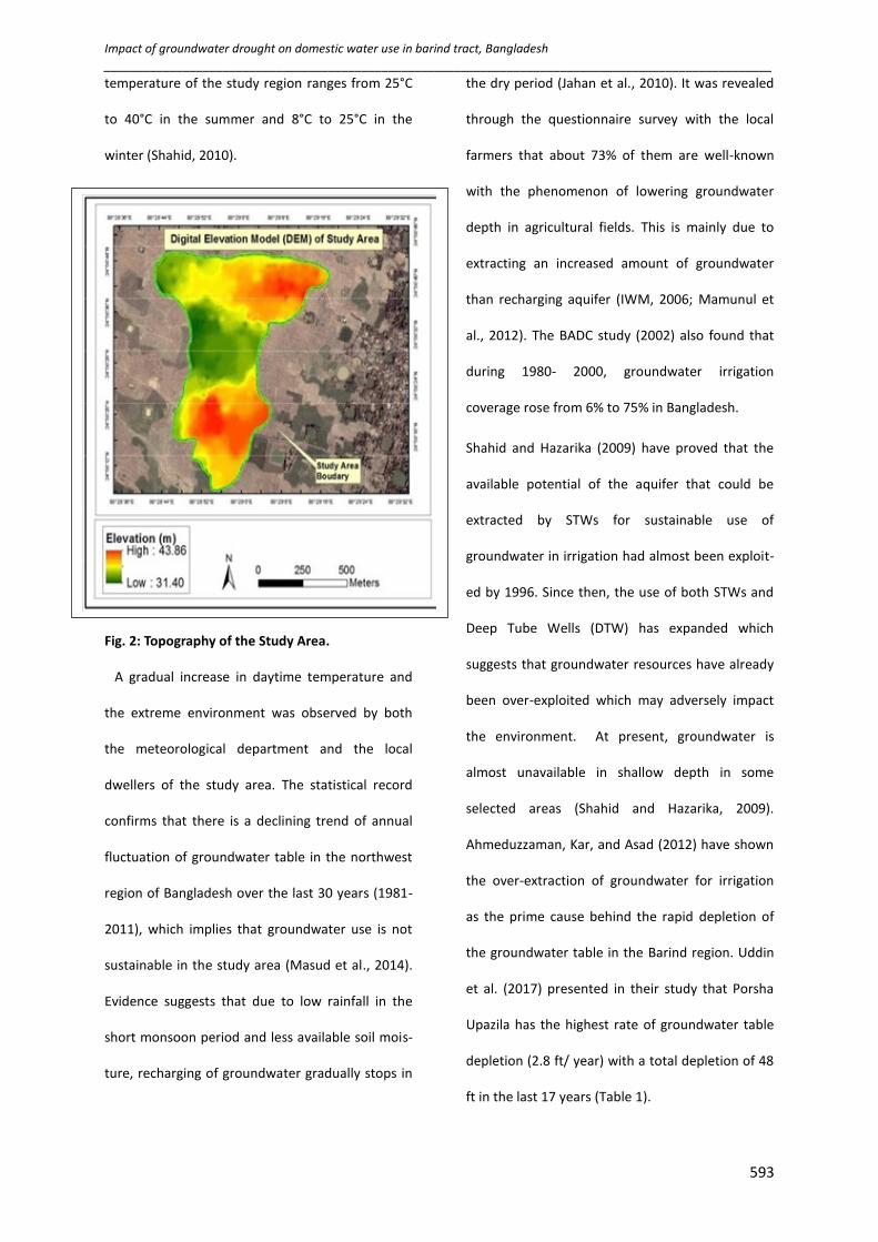
The topography of the area is mainly undulated
ranging from 40 m in the northeast to a minimum
of 22 m in the west above the mean sea level (Reza
and Mazumdar, 2005). Due to high land elevation,
the groundwater level remains at a very low
altitude causing it more difficult for groundwater
extraction in this area (Fig. 2). It is known that the
shape of an aquifer is bowl-shaped and at the edge
of the aquifer water availability is least. This region
lies at the edge of the bowl-shaped aquifer which
implies the water crisis and drought condition of
the region. This is also one of the reasons for acute
groundwater drought in this area (Uddin et al.,
2017).
Climatically, the study area belongs to a dry
humid zone with annual average rainfall vary
between 500 mm to 2100 mm (Uddin et al., 2017).
The seasonal distribution of rainfall shows that
almost 92.7% of rainfall occurs from May to Octo-
ber. Less than 6% rainfall occurs during the
irrigation period of Boro rice (January to April). The
rainfall also varies widely from year to year
(Shahid, 2008). Hydrograph analysis of the study
area indicates a significant direct relationship
between rainfall and groundwater level fluctuation
(Reza and Mazumder, 2005). Such low rainfall
intensity, undulated ground, and hard topsoil con-
ditions allow the water level to vary from place to
place which results in groundwater drought. The
Impact of groundwater drought on domestic water use in barind tract, Bangladesh
_____________________________________________________________________________________________________
593
temperature of the study region ranges from 25°C
to 40°C in the summer and 8°C to 25°C in the
winter (Shahid, 2010).
Fig. 2: Topography of the Study Area.
A gradual increase in daytime temperature and
the extreme environment was observed by both
the meteorological department and the local
dwellers of the study area. The statistical record
confirms that there is a declining trend of annual
fluctuation of groundwater table in the northwest
region of Bangladesh over the last 30 years (1981-
2011), which implies that groundwater use is not
sustainable in the study area (Masud et al., 2014).
Evidence suggests that due to low rainfall in the
short monsoon period and less available soil mois-
ture, recharging of groundwater gradually stops in
the dry period (Jahan et al., 2010). It was revealed
through the questionnaire survey with the local
farmers that about 73% of them are well-known
with the phenomenon of lowering groundwater
depth in agricultural fields. This is mainly due to
extracting an increased amount of groundwater
than recharging aquifer (IWM, 2006; Mamunul et
al., 2012). The BADC study (2002) also found that
during 1980- 2000, groundwater irrigation
coverage rose from 6% to 75% in Bangladesh.
Shahid and Hazarika (2009) have proved that the
available potential of the aquifer that could be
extracted by STWs for sustainable use of
groundwater in irrigation had almost been exploit-
ed by 1996. Since then, the use of both STWs and
Deep Tube Wells (DTW) has expanded which
suggests that groundwater resources have already
been over-exploited which may adversely impact
the environment. At present, groundwater is
almost unavailable in shallow depth in some
selected areas (Shahid and Hazarika, 2009).
Ahmeduzzaman, Kar, and Asad (2012) have shown
the over-extraction of groundwater for irrigation
as the prime cause behind the rapid depletion of
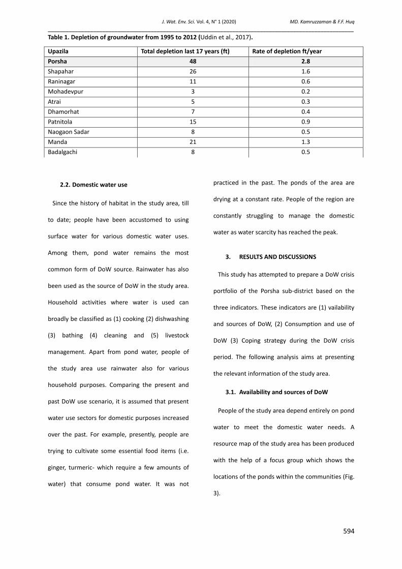
the groundwater table in the Barind region. Uddin
et al. (2017) presented in their study that Porsha
Upazila has the highest rate of groundwater table
depletion (2.8 ft/ year) with a total depletion of 48
ft in the last 17 years (Table 1).
J. Wat. Env. Sci. Vol. 4, N° 1 (2020) MD. Kamruzzaman & F.F. Huq _____________________________________________________________________________________________________
594
Table 1. Depletion of groundwater from 1995 to 2012 (Uddin et al., 2017).
2.2. Domestic water use
Since the history of habitat in the study area, till
to date; people have been accustomed to using
surface water for various domestic water uses.
Among them, pond water remains the most
common form of DoW source. Rainwater has also
been used as the source of DoW in the study area.
Household activities where water is used can
broadly be classified as (1) cooking (2) dishwashing
(3) bathing (4) cleaning and (5) livestock
management. Apart from pond water, people of
the study area use rainwater also for various
household purposes. Comparing the present and
past DoW use scenario, it is assumed that present
water use sectors for domestic purposes increased
over the past. For example, presently, people are
trying to cultivate some essential food items (i.e.
ginger, turmeric- which require a few amounts of
water) that consume pond water. It was not
practiced in the past. The ponds of the area are
drying at a constant rate. People of the region are
constantly struggling to manage the domestic
water as water scarcity has reached the peak.
3. RESULTS AND DISCUSSIONS
This study has attempted to prepare a DoW crisis
portfolio of the Porsha sub-district based on the
three indicators. These indicators are (1) vailability
and sources of DoW, (2) Consumption and use of
DoW (3) Coping strategy during the DoW crisis
period. The following analysis aims at presenting
the relevant information of the study area.
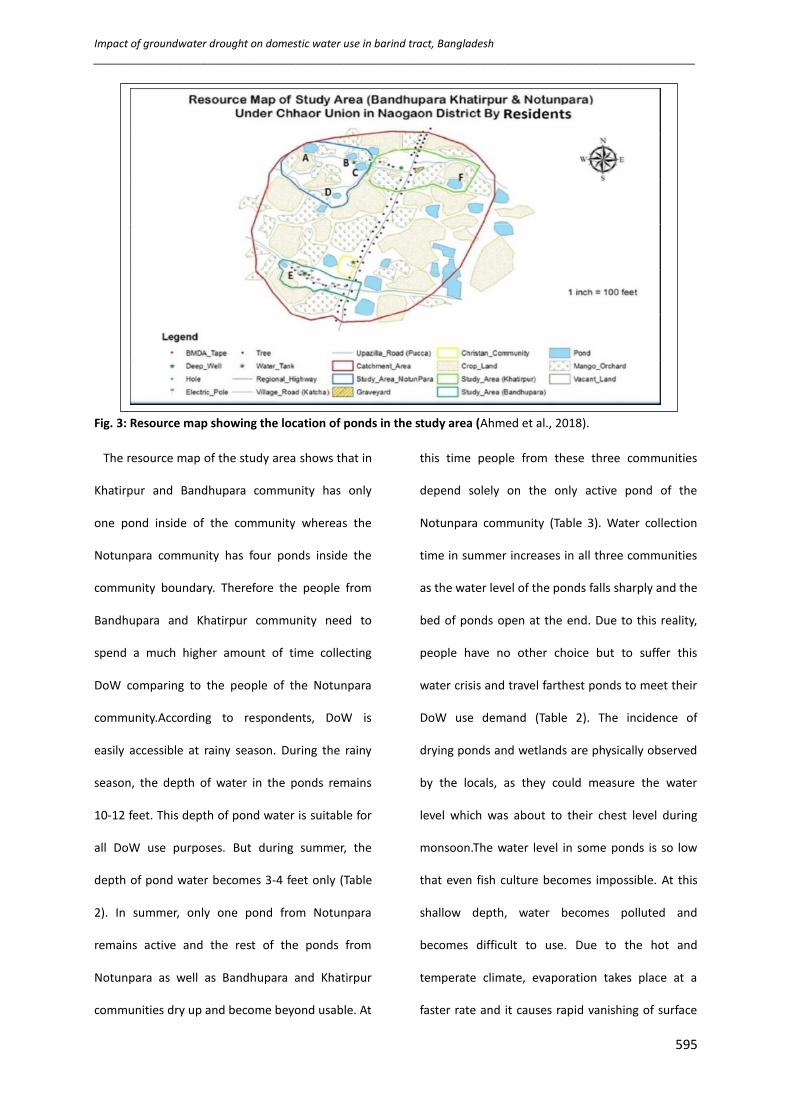
3.1. Availability and sources of DoW
People of the study area depend entirely on pond
water to meet the domestic water needs. A
resource map of the study area has been produced
with the help of a focus group which shows the
locations of the ponds within the communities (Fig.
3).
Upazila Total depletion last 17 years (ft) Rate of depletion ft/year
Porsha 48 2.8
Shapahar 26 1.6
Raninagar 11 0.6
Mohadevpur 3 0.2
Atrai 5 0.3
Dhamorhat 7 0.4
Patnitola 15 0.9
Naogaon Sadar 8 0.5
Manda 21 1.3
Badalgachi 8 0.5
Impact of groundwater drought on domestic water use in barind tract, Bangladesh
_____________________________________________________________________________________________________
595
Fig. 3: Resource map showing the location of ponds in the study area (Ahmed et al., 2018).
The resource map of the study area shows that in
Khatirpur and Bandhupara community has only
one pond inside of the community whereas the
Notunpara community has four ponds inside the
community boundary. Therefore the people from
Bandhupara and Khatirpur community need to
spend a much higher amount of time collecting
DoW comparing to the people of the Notunpara
community.According to respondents, DoW is
easily accessible at rainy season. During the rainy
season, the depth of water in the ponds remains
10-12 feet. This depth of pond water is suitable for
all DoW use purposes. But during summer, the
depth of pond water becomes 3-4 feet only (Table
2). In summer, only one pond from Notunpara
remains active and the rest of the ponds from
Notunpara as well as Bandhupara and Khatirpur
communities dry up and become beyond usable. At
this time people from these three communities
depend solely on the only active pond of the
Notunpara community (Table 3). Water collection
time in summer increases in all three communities
as the water level of the ponds falls sharply and the
bed of ponds open at the end. Due to this reality,
people have no other choice but to suffer this
water crisis and travel farthest ponds to meet their
DoW use demand (Table 2). The incidence of
drying ponds and wetlands are physically observed
by the locals, as they could measure the water
level which was about to their chest level during
monsoon.The water level in some ponds is so low
that even fish culture becomes impossible. At this
shallow depth, water becomes polluted and
becomes difficult to use. Due to the hot and
temperate climate, evaporation takes place at a
faster rate and it causes rapid vanishing of surface

J. Wat. Env. Sci. Vol. 4, N° 1 (2020) MD. Kamruzzaman & F.F. Huq _____________________________________________________________________________________________________
596
water. During the last 10 to 15 years, people of the
locality observed the incidence of drying of ponds
and opening the beds of ponds and wetlands. This
physical observation of drying up ponds and
wetlands indicates a foreseeable drought situation
and the initiation of the desertification process.
Table 2. Impact of Drought on Availability of DoW. (Source: Field Survey, 2017)
Table 3. Domestic water demand during summer & monsoon. (Source: Field Survey, 2017)
3.2. Consumption and use of domestic water
The consumption of DoW varies from season to
season. In general, In general, the demand for DoW
for cooking, cleaning, and washing does not have a
significant difference between summer and other
seasons. For other purposes i.e for livestock
management, the difference in DoW demand is
noticeable. For example, other than the summer,
cattle bathing is a regular household activity that is
practiced twice a week. But during summer people
limit this activity to once a week to minimize the
traveling during the hot climatic condition of
summer season. DoW consumption varies from a
minimum of 2 pitchers per day to 9 pitchers per
day. Among the 58 respondents of the household
survey, it is found that the mean amount of DoW
Parameter Monsoon Summer Remarks
Water depth of
ponds
10-12 feet 3-4 feet In summer, water depth decreases and water becomes unsuitable
for domestic water use activities.
Fish culture Yes No The depth of pond water in summer is unsuitable for fish culture.
DoW Collection
Time
5-10
minutes
15-30
minutes
In summer, DoW collection time increases.
DoW Collection
Distance
100 -200
meter
400-500
meter
In summer, DoW collection distance increases. It imposes mental
and physical stress on women and children as they need to carry as
many as pots possible to reduce the travel frequencies.
Mode walking walking Women and children have to walk a long distance in the hot climatic
condition during summer which imposes a huge physical and
mental stress
Total number of ponds
(Fig. 3)
Notunpara Bandhupara Khatirpur
Pond A, B, C, D (Fig. 3) Pond E (Fig. 3) Pond F (Fig. 3)
(04) (01) (01)
Functional Period Summer and monsoon Monsoon
Number active ponds Only ‘A’ pond is active in Summer No ponds are active in summer
User in Summer Pond A Pond B Pond C Pond D Pond E Pond F
(No of HH) 100 0 0 0 0 0
User in Monsoon (No of
HH) 30 20 15 15 10 10
Remarks
During summer, huge pressure of DoW demand is created on the single active pond ‘A’
of Notunpara, and a domestic water crisis is created. This indicates a drought trend in
the study areas.

Impact of groundwater drought on domestic water use in barind tract, Bangladesh
_____________________________________________________________________________________________________
597
use is 4 pitchers per day (Table 4).
Table 4. DoW Consumption Scenario (Pitcher per day; 1 pitcher =10 liters). (Source: Field Survey,
2017)
People collect water from nearby ponds and
carry water to their homes using pitchers. People
also go to the pond for bathing; dishwashing, and
washing clothes (Fig. 4 and 5). Usually, they do
these activities at late noon. Reviewing the history
of the locality, it is evident that there is a sharp
increase of DoW use or consumption rate due to:
(1) demographical change (2) diversity of water
uses pattern (3) increase in individual consumption
pattern. These contribute to increasing the water
demand without increasing the water source.
Eventually, this acute water shortage tends to a
drought scenario in the locality. DoW collection
time has increased manifolds as the ponds near
the communities have dried up.
Fig. 4. Washing and Collecting DoW.
(Source: Field Survey, 2017)
Fig. 5. Bathing in Pond Water.
(Source: Field Survey, 2017)
During the monsoon, 53% of the people of the
community spend 5 to 10 minutes collecting water.
About 8% of people were found who spend more
than 20 minutes collecting DoW (Fig. 6). This
variation in collection time depends on the
distance of the ponds. The resource map of the
study area (Fig. 3) shows the location of ponds in
the communities. The DoW collection distance
varies with the location of ponds.
It has been already discussed above that during
summer only one pond remains active and it
contributes to the increase of DoW collection
distance. Furthermore, 55.2% of people perceive
that the ponds of the study areas have been drying
Mean 4
Median 4
Mode 3
Maximum 2
Minimum 9
Fig. 6. DoW collection time. (Nonwater availability period). (Source: Field survey, 2017)
J. Wat. Env. Sci. Vol. 4, N° 1 (2020) MD. Kamruzzaman & F.F. Huq _____________________________________________________________________________________________________
598
up since 2002-2007. Rest thinks that the drying of
ponds has started since a decade ago (Fig. 7). Their
perception regarding the period of the initiation of
drying of ponds resembles the drought scenario of
the region.
3.3. Coping strategy during the DoW crisis
period
People of the study area use pitchers, plastic
mugs, balti for storing water. Previously, before
1980, they used pitcher made of mud for storing
water. Now they are using the same kind of pitcher,
but along with this, they use available plastic balti,
mug for storing water (Fig. 8). During the acute
shortage of DoW, people collect water from distant
water sources as the water is not available in
nearby places and they try to keep their water
consumption rate minimum to cope with the
situation. To tackle the crisis, people store water in
pitcher and pots which serves their daily demands.
People collect water twice a day. Two common
forms of crisis management were observed: (1)
reducing the consumption rate (2) increasing the
endurance level. People said that they cannot even
offer a single glass of water to their guests during
the water crisis period. Table 5 presents the overall
storage option and drought indicator of the study
area.
Table 5. Domestic water storage options and drought indicators. (Source: Field Survey, 2017)
Indicator Monsoon Summer Remarks
Travel Frequencies 2 3 Increase in travel frequencies
Storage facilities Decreases Increases Slightly increases in summer to
reduce travel frequencies.
Water Increases Decrease Slightly decreases to reduce the
consumption travel frequencies
DoW use Increases Decreases Decreases due to lack of DoW sources
Travel distance Decreases Increases Only one pond remain active
Figure 7. People's perception of the drying up the ponds (in years). (Source: Field survey, 2017)
Fig. 8. Conventional DoW Storage System. (Source: Field Survey, 2017)
Source: Field Survey,
2017
Impact of groundwater drought on domestic water use in barind tract, Bangladesh
_____________________________________________________________________________________________________
599
3.4. Relationship between the climate
changes with DoW crisis
From the analysis of the DoW availability;
consumption; collection pattern; and storage
system it has been realized that DoW use depends
on pond water. The crisis starts in summer as the
water level of ponds lowered due to low recharge,
high evaporation rate, and depletion of
groundwater level. All these factors are natural
phenomena and it can be said that the DoW crisis
is mainly driven by natural or climatic change
induced factors. Along with the natural causes, the
increasing demand for DoW is also responsible for
causing the DoW crisis in the region as the
numbers of sources are limited. The overall
analysis proves that the DoW crisis in the study
area is a strong indicator of climatic change-
induced drought in the region.
4. Conclusion
The study was conducted on three communities
from the Northwest part of Bangladesh named
Khatirpur, Notunpara, and Bandhupara to
understand the impact of groundwater drought on
the domestic water use sector. This research aimed
at investigating the nature, scale, and
characteristics of the domestic water crisis of the
study area as well as exploring the indigenous
coping strategies that the local people are
following to combat the DoW crisis. The findings of
the study suggest that the livelihood of the people
of this region depends solely on agriculture. The
irrigation system of the region depends on surface
water and rainwater since the past. But since 1980,
the rainfall intensity of the region started to
decrease and temperature increased significantly
which eventually compelled people to depend on
groundwater instead of rainwater for irrigation.
Later people started using STW and DTW for
groundwater extraction. Geographically, Porsha
Upazila is located at the edge of the bowl-shaped
aquifer of the region. The topsoil of the area is
hard in characteristics that impede the natural
infiltration process. These natural disadvantages
along with low rainfall intensity and increased
temperature have created a cumulative impact on
the depletion of the groundwater table. Therefore
both natural and manmade reasons are
responsible for the occurrence of drought in the
Porsha Upazila. At present, the agriculture, as well
as food production of the region, are under threat.
In addition to the problem of irrigation water,
people are suffering from terrible drinking and
domestic water crisis. For domestic activities i.e.
cooking, dishwashing, cleaning, bathing, cattle
bathing, and feeding, people depend on pond
water. With the diminishing trend of rainfall, rise of
temperature, and faster Evapotranspiration; ponds
J. Wat. Env. Sci. Vol. 4, N° 1 (2020) MD. Kamruzzaman & F.F. Huq _____________________________________________________________________________________________________
600
are gradually drying. During monsoon, the water
depth of the pond remains suitable for domestic
uses but during summer the water level of the
pond decreases, and the river beds open up. The
water collection time and frequency increases in
summer. With the increase in the number of
households in these communities and other
sectors that require water, the total demand for
domestic water has increased than in the past.
Research findings suggest that, with the pace of
the increase of domestic water uses, the sources
for domestic water have not increased. It is evident
from the research findings that the natural
phenomenon contributed to the present DoW
crisis. Besides, demographic changes and over-
extraction of groundwater simultaneously
contributed to the crisis as a man-made cause. The
respondent's feedback, field observation, and
expert opinion claim the incidence as a climate-
induced drought. If such a situation continues,
there will be no pond available for serving
domestic uses soon. An investigation should be
made on exploring the potentials of artificial
recharge of the groundwater in the study area.
Besides, indigenous concepts of water preservation
such as digging ponds and canals should also be
explored to develop an effective solution to the
domestic water crisis in the region.
ACKNOWLEDGEMENTS
The authors express profound gratitude to Dr.
Bayes Ahmed, Dr. Ilan Kelmen, Md. Mostafizur
Rahman, Md. Abdul Wakil, Nazia Hossain, Md.
Hossain Mohiuddin and Anutosh Das for their
valuable guidance, encouragement, and support at
different stages of the research work. This work
was funded by the International Center for
Collaborative Research on Disaster Risk Reduction
(ICCR-DRR).
REFERENCES
- ADHIKERY K.S., DAS K.S., CHAKI T. (2013).
Groundwater drought assessment for Barind
irrigation project In Northwestern Bangladesh,
20th International Congress on Modelling and
Simulation, Adelaide, Australia.
- AHMEDUZZAMAN M., KAR S., ASAD A. (2012). A
Study on Ground Water Fluctuation at Barind
Area, Rajshahi. International Journal of
Engineering Research and Applications (IJERA),
2(6):1465-1470
- AHMED B., RAHMAN M.S., RAHMAN S., HUQ F.F.,
ARA S. (2014). Landslide Inventory Report of
Chittagong Metropolitan Area, Bangladesh.
BUET-Japan Institute of Disaster Prevention and
Urban Safety: Dhaka, Bangladesh.
- AHMED B., KELMAN I., KAMRUZZAMAN D.M.,
MOHIUDDIN H., RAHMAN M.M., DAS A.,
FORDHAM M., SHAMSUDDUHA M. (2018).
Indigenous people’s responses to drought in
Impact of groundwater drought on domestic water use in barind tract, Bangladesh
_____________________________________________________________________________________________________
601
northwest Bangladesh. Environmental
Development,
https://doi.org/10.1016/j.envdev.2018.11.004
- BANGLAPEDIA (2014). “Noagoan District”
http://en.banglapedia.org/index.php?title=Naog
aon_District
- BADC (Bangladesh Agricultural Development
Corporation) (2002). Survey report on irrigation
equipment and irrigated area in Boro/2001
season. Bangladesh Agricultural Development
Corporation, Dhaka.
- DUTIL M.B., KHAN A.F.M., TAMANNA T.,
MUKHERJEE N., RASHID A.M. (2015).
Vulnerability Assessment and Adaptation
Technique for Climate Change Induced Drought
in Bangladesh, 5th International Conference on
Water & Flood Management (ICWFM-2015).
- HABIBA U., SHAW R., TAKEUCHI Y. (2011).
Drought risk reduction through a Socioeconomic,
Institutional and Physical approach in the
northwestern region of Bangladesh,
Environmental Hazards, 10:2, 121-138, DOI:
10.1080/17477891.2011.582311
- HASSAN S.M., ISLAM M.S. (2015). Drought
Vulnerability Assessment in the High Barind Tract
of Bangladesh Using MODIS NDVI and Land
Surface Temperature (LST) Imageries,
International Journal of Science and Research
(IJSR), 4:2, 55-60.
- IWM (2006). Project brief on groundwater model
study for deep tubewell installation project on
Barind area, Draft Final Report, Institute of Water
Modeling, Dhaka.
- JAHAN C.S., MAZUMDER Q.H., AKTER N., ADHAM
M.I., ZAMAN M.A. (2010). Hydrogeological
environment and groundwater occurrences in
the polio-Pleistocene aquifer in barind area,
northwest Bangladesh, Bangladesh Geoscience
Journal. 16, 23-37.
- MOHENIPOUR.M., SHAHID.S., CHUNG.E. &
WANG.X. (2018). Changing Pattern of Droughts
during Cropping Seasons of Bangladesh, Water
Resource Manage 32, 1555–1568
https://doi.org/10.1007/s11269-017-1890-4
- MASUD A.A., LIZA K.A., AZAD K.A. (2014). The
vulnerability of crop production to climatic
variability in a water stress area of the north-
west region of Bangladesh: a case study in the
Sapahar Upazila under Naogaon District. IOSR
Journal of Environmental Science, Toxicology and
Food Technology (IOSR-JESTFT) e-ISSN: 2319-
2402 - ISSN: 2319-2399, 8(5): 41-52.
- REZA S.A.H.M., MAZUMDAR H.Q. (2005).
Evaluation Of Hydrogeological Conditions Of
Sapahar and Porsha Upazillas, Barind Tract,
Bangladesh, Journal of Life Earth Science, 1(1):15-
20.http://dept.ru.ac.bd/flife/04.%20Hydrogeolog
ical.pdf
J. Wat. Env. Sci. Vol. 4, N° 1 (2020) MD. Kamruzzaman & F.F. Huq _____________________________________________________________________________________________________
602
- RAHMAN M.S., AHMED B., HUQ F.F., RAHMAN S.,
AL-HUSSAINI T. (2016). Landslide Inventory in an
Urban Setting in the Context of Chittagong
Metropolitan Area, Bangladesh. In: Proceedings
of 3rd International Conference on Advances in
Civil Engineering (ICACE-2016). (pp. pp. 170-178).
Chittagong University of Engineering &
Technology (CUET): Cox's Bazar, Bangladesh
- SELVARAJ R., SUBBIAH A.R., BAAS S., JUERGENS I.
(2006). Livelihood adaptation to climate
variability and change in drought-prone areas of
Bangladesh, Asian Disaster Preparedness Center,
Food And Agriculture Organization Of The United
Nations, Rome.
- SHAHID S. (2010). Impact of climate change on
irrigation water demand of dry season Boro rice
in northwest Bangladesh. Climatic Change,
http://repository.um.edu.my/84700/1/ClimateC
hangePaper.pdf
- SHAHID S., HAZARIKA K.M. (2009). Groundwater
Drought in the Northwestern Districts of
Bangladesh, Water Resource Manage. 24:1989–
2006.
- UDDIN N.M., PERVIN R., ALAUDDIN M. (2017).
Analysis of Drought and Ground Water Depletion
of Naogaon District in Bangladesh. International
Journal of Civil & Environmental Engineering
IJCEE-IJENS, 17(1): 27-39.