vol. 60, no. 1 (march 2007) infonorth - university...
TRANSCRIPT
InfoNorthARCTIC
VOL. 60, NO. 1 (MARCH 2007)
101
Fifty Years of McCall Glacier Research: From the International Geophysical
Year 1957–58 to the International Polar Year 2007–08
by Gunter Weller, Matt Nolan, Gerd Wendler, Carl Benson, Keith Echelmeyer and Norbert Untersteiner
INTRODUCTION
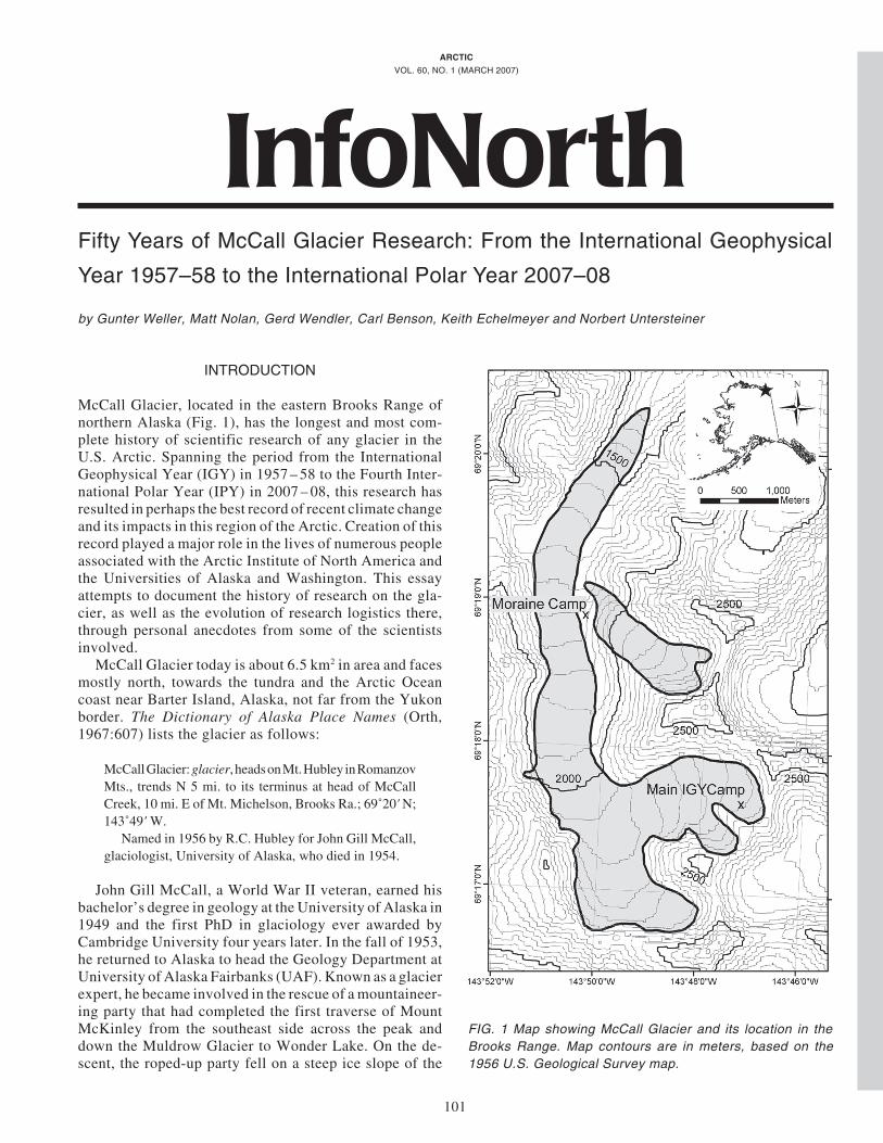
McCall Glacier, located in the eastern Brooks Range ofnorthern Alaska (Fig. 1), has the longest and most com-plete history of scientific research of any glacier in theU.S. Arctic. Spanning the period from the InternationalGeophysical Year (IGY) in 1957 – 58 to the Fourth Inter-national Polar Year (IPY) in 2007 – 08, this research hasresulted in perhaps the best record of recent climate changeand its impacts in this region of the Arctic. Creation of thisrecord played a major role in the lives of numerous peopleassociated with the Arctic Institute of North America andthe Universities of Alaska and Washington. This essayattempts to document the history of research on the gla-cier, as well as the evolution of research logistics there,through personal anecdotes from some of the scientistsinvolved.
McCall Glacier today is about 6.5 km2 in area and facesmostly north, towards the tundra and the Arctic Oceancoast near Barter Island, Alaska, not far from the Yukonborder. The Dictionary of Alaska Place Names (Orth,1967:607) lists the glacier as follows:
McCall Glacier: glacier, heads on Mt. Hubley in RomanzovMts., trends N 5 mi. to its terminus at head of McCallCreek, 10 mi. E of Mt. Michelson, Brooks Ra.; 69˚20' N;143˚49' W.
Named in 1956 by R.C. Hubley for John Gill McCall,glaciologist, University of Alaska, who died in 1954.
John Gill McCall, a World War II veteran, earned hisbachelor’s degree in geology at the University of Alaska in1949 and the first PhD in glaciology ever awarded byCambridge University four years later. In the fall of 1953,he returned to Alaska to head the Geology Department atUniversity of Alaska Fairbanks (UAF). Known as a glacierexpert, he became involved in the rescue of a mountaineer-ing party that had completed the first traverse of MountMcKinley from the southeast side across the peak anddown the Muldrow Glacier to Wonder Lake. On the de-scent, the roped-up party fell on a steep ice slope of the
FIG. 1 Map showing McCall Glacier and its location in theBrooks Range. Map contours are in meters, based on the1956 U.S. Geological Survey map.

102 • INFONORTH
Muldrow Glacier, where one climber was killed and an-other badly injured. McCall helped in the evacuation of thewounded person, who was left in a tent on the glacier. JohnMcCall died of polio in 1954, shortly after this event.
RESEARCH STARTS DURINGTHE INTERNATIONAL GEOPHYSICAL YEAR
As a contribution to the IGY, the Arctic Institute ofNorth America, with support from the U.S. Air Force,planned an 18-month study of McCall Glacier. The ideafor this came from Richard Hubley and Walter Wood ofthe U.S. IGY Glaciological Panel. Hubley was a graduateof the University of Washington, having received his PhDin 1956 in the Atmospheric Sciences Department, only thesecond PhD awarded by the department. Before going toMcCall Glacier, Hubley had served as planner and coordi-nator for the U.S.-IGY Glaciology program in the North-ern Hemisphere, working at the National ScienceFoundation (NSF) in Washington, D.C. The initial team onthe glacier included Richard C. Hubley as chief scientist(until his death in October 1957), John Sater as juniorscientist and chief surveyor, Charles Keeler as assistantscientist, and Robert Mason as logistics officer and scien-tific assistant.
None of the original IGY team members were availableto contribute to this story, but Norbert Untersteiner helpedwith the construction of the glacier camps. In April 1957,reconnaissance flights of the U.S. Air Force Alaska Com-mand had located an ice floe 1000 km north of Point Barrowthat was deemed suitable for the establishment of IGYDrifting Station Alpha. The teams of scientists from Co-lumbia University, the University of Washington, and theU.S. Weather Bureau, including Untersteiner, waited atthe former Ladd Air Force Base (now Fort Wainwright)near Fairbanks while a crew of four civilian constructionworkers and Air Force personnel was preparing the campfor occupancy. At the same time, Walter Wood and his sonPeter were also at Ladd AFB, on behalf of the ArcticInstitute of North America (AINA), to coordinate thedeployment of two small camps for Richard Hubley’s IGYproject on McCall Glacier.
As a person with experience working in the mountains,Untersteiner was given the chance to help in this glacierdeployment. The planes used for this mission were thelegendary twin-engined C-119 “flying boxcars,” with amplecargo space and a cockpit mounted between two slenderfuselages. In brilliant weather, they made two flights fromLadd AFB over the snow-covered Brooks Range to theglacier, where they pushed boxes with camp and scientificgear out the huge cargo door. In total, more than 30 tons offuel and 18 tons of supplies dropped onto the glacierduring the IGY deployment. On the last return flight on 10May, the party landed at Barter Island, where the scientistsremained while the C-119 returned to Fairbanks. On thesame afternoon, John Sater and Charles Keeler (AINA),
Art Rich (Martin-Marietta), and Untersteiner were flownto McCall Glacier in a small Cessna by Al Wright, arenowned bush pilot who looked like Spencer Tracy. Aftera smooth landing on the lower, gently sloping part of theglacier, they pitched a tent for the night before making thehike up the glacier to visit Hubley and Mason, who werealready established at the upper station. Hubley seemedfull of energy and enthusiasm and ready to brave theprospect of many months of work in this remote region.
The next day was spent collecting all the scatteredcrates dropped from the air. On the third day, Sater andUntersteiner built a rock platform for a truncated Jameswayhut on the lateral moraine near the lower camp. (Little didthey realize that this base would be re-used in the late1960s to erect a plywood hut, which survives there to thisday.) The main camp, comprising five half-units ofJamesway huts, was established on the uppermost of thethree cirques of the glacier, with the lower moraine campas a secondary location in the ablation area. An emergencyretreat camp, another Jamesway hut, was erected on theshores of Jago Lake in the foothills, about 15 km from theterminus. All of these camps played a role in subsequentexpeditions. On 13 May, Untersteiner returned to BarterIsland with Al Wright because he had received word thatthe ice camp in the Beaufort Sea was ready for occupancy.His brief excursion to McCall Glacier was a fortunate andmemorable event of initiation for a novice to the Arctic.
In the summer of 1957, Walter Sullivan, the leadingscience writer of The New York Times, visited McCallGlacier to collect material for his book on the IGY, inwhich he describes his experiences there (Sullivan,1961:275 – 279). He and Dick Hubley discussed the goalsand history of the project. Sullivan found Hubley to bequiet and, in retrospect, perhaps somewhat preoccupied,but there was no evidence of the deep-seated trouble thatlater led to tragedy. Sullivan even helped with droppingsupplies on the glacier from a Cessna-180.
The weather and climate of the glacier were majortopics of the research. Both are influenced by the BrooksRange, which provides a topographic barrier between theextreme continental climate of interior Alaska and thepolar climate of the Arctic Basin, with both regimesinfluencing the local glacier climate. The glacier liesabove the prevailing summer stratus cloud decks thatcover the Arctic Ocean and extend into the foothills of theBrooks Range. It was found that the glacier’s weather wasinfluenced mainly by storms moving over the ocean northof the glacier. Storm winds were westerlies but were consid-erably modified by local topography in the lower sections ofthe glacier. Glacier and katabatic winds characterized themeso-scale circulation between storm periods.
Even during the last glacial maximum, glaciation in theBrooks Range was never very extensive, since precipita-tion is relatively low (ca. 500 mm of water, falling largelyas snow in spring and fall) and summer temperatures arehigh. Keeler (1959) documented five distinctive advancesof McCall Glacier. The farthest of these advances gave the

INFONORTH • 103
glacier a length of approximately 20 km where it joined aglacier that used to fill the Jago River valley, comparedwith its 1957 length of about 8 km. Mason studied icetemperatures and heat flux in the upper cirque of McCallGlacier, in a borehole drilled down to 90 m. While theupper 15 m showed strong seasonal variations, below thatlevel the temperature was fairly constant, with a valueclose to -1˚C, because of surface meltwater that percolatedinto the cold firn and refroze, releasing its latent heat.Keeler also reported on the ablation on the lower McCallfor the summer of 1957. He provided an ablation map forthe glacier and discussed the snow cover and superim-posed ice. He found that the ablation rates were 2 – 3 cm/day: surprisingly, not much less than on the Blue Glacierin Washington State. These began the first comprehensivemeasurements of ablation on a glacier in the U.S. Arctic,although there was work on a small glacier on nearby Mt.Michelson at the same time, and Leffingwell had studiedOkpilak Glacier briefly in 1906.
The work on the glacier proceeded well, but in Octobera tragic event occurred: Hubley committed suicide, fol-lowing severe depression. Arctic (1957:187) published thefollowing announcement:
Richard Carleton Hubley, 1926 –1957On October 29, 1957, word was received by the Institute
of the death of Richard Hubley while leading theInternational Geophysical Year glaciological program onMcCall Glacier, Brooks Range, Alaska.
Dr. Hubley’s death has come at a time when he hasassumed national—and even international—leadershipin his chosen field. North American science has been slowin building a coterie of scientists in the field of glaciology.Of those we have, Richard Hubley was one of the most
distinguished. Science can as ill afford his loss as can wewho knew him as a companion in the office and among thehigh snows.
It was a sad ending after such a promising start. The fieldstation was closed in October but reactivated in late Feb-ruary 1958 by Keeler, Mason, and Sater, with Svenn Orvigof McGill University as the new scientific leader of theproject. Austin Post, who considered Dick Hubley his bestfriend at the time, also returned with the scientific partyout of respect for Hubley. Post helped to finish the projectby leading the surveying and other measurements, includ-ing photo documentation. His photos are perhaps the mostlasting and often used legacy of the IGY project (see Figs.2 and 6). The stations were occupied from June to October1957 and from February to August 1958, when they wereabandoned in place. In the following years, a peak over-looking McCall Glacier and an adjacent glacier werenamed after Hubley to honor his contributions to science.Three reports on the McCall Glacier project (Keeler, 1959;Mason, 1959; Sater, 1959) were published in the June1959 issue of Arctic. The meteorological observationsmade on the glacier, typically every one to six hours, werelater edited and published by Orvig (1961), but withoutDick Hubley around to analyze them, they remainedunanalyzed glaciologically for another 45 years.
UNIVERSITY OF ALASKA RESEARCHERSRETURN TO THE GLACIER, 1969–72
In 1969, the National Science Foundation awarded agrant to researchers at the University of Alaska Fairbanksto resume the study of McCall Glacier. These researchers
FIG 2. A) A supercub unloads people and supplies in the upper cirque of McCall Glacier, with the IGY camp in the background.B) Main IGY camp on McCall Glacier after a blizzard. Photos by A. Post, AINA.

104 • INFONORTH
argued that the glacier was of special importance since itlies at the intersection of two glacier “chains” recom-mended for intensive study in the International Hydrologi-cal Decade (IHD): the Arctic Circle and the Americanchains. They stated that since it had been studied duringthe IGY, McCall Glacier had a useful past data base andthat the United States should study at least one Arcticglacier on its own territory. McCall Glacier was indeed theonly Arctic glacier studied by the United States for sometime. The goal of the research was to conduct a compre-hensive investigation of the heat, ice, and water balance ofthe glacier under the auspices of the IHD.
The principal investigator of the research project wasProf. Gerd Wendler, a PhD graduate of the University ofInnsbruck who had done research on glaciers in the Aus-trian Alps. Prof. Carl Benson, with a PhD from the Califor-nia Institute of Technology (Caltech), was a seniorglaciologist at the Geophysical Institute. He had con-ducted pioneering snow research on traverses across Green-land, under the auspices of SIPRE (Snow Ice PermafrostResearch Establishment), now CRREL (Cold RegionsResearch and Engineering Laboratory), of the U.S. Army.Benson and Prof. Gunter Weller were the two main scien-tists participating in the studies with Wendler. Weller,with a PhD from the University of Melbourne, Australia,had worked on heat and mass balance studies in Antarcticabefore joining the UAF faculty.
On 1 April 1969, Wendler and Weller, in a Cessna 180flown by Fairbanks pilot Tom Classen, made a reconnais-sance flight from Fairbanks up to the Brooks Range to locatethe glacier and any remains of the IGY camps. Circling overthe glacier after a long flight, they could detect no sign of pasthuman occupation on the ice. It later turned out that the uppercirque camp had been completely buried by snow, and no signremained of it. The glacier surface appeared to be very rough,and although the scientists were prepared to land, the pilot
was reluctant to do so. They returned home, refueling theplane at Arctic Village on the southern slopes of the BrooksRange, after landing on the ice of the frozen east fork of theChandalar River. The entire flight in excellent weather tooksix and a half hours.
At the end of April, the party organized an overland tripby snowmobile from the village of Kaktovik on BarterIsland, located about 100 km from the glacier. Wendler,Weller, and graduate student Charlie Fahl set out withthree snowmobiles. They were led by two Inuit guidesfrom Kaktovik, one accompanied by his wife, who cookedfor them. They drove up the Jago River valley, over ripesnow and partly broken-up river ice, and got fairly wet inthe process. Wendler shot a few ptarmigan and they had agood meal in the evening, each fishing out a whole bird—by hand—from the broth in a big cooking pot. Theyreached the glacier in two days and managed to get theirown Ski-Doo up the steep frozen waterfalls and aufeisfields that form each winter below the glacier’s terminus.They found the moraine camp completely ruined, butretrieved from the rubble the original camp sign—with thestill legible words: “Moraine Camp, McCall Glacier Project,AINA”—which remains at the camp to this day (Fig. 3). Ameteorological instrument shelter was set up on the mo-raine, as well as a big corrugated standpipe for the waterlevel recorder in McCall Creek. Several accumulation/ablation stakes were drilled into the glacier ice, and anairstrip 3000 feet long was laid out and marked with stakesand surveyor tape. Leaving their Ski-Doo and other equip-ment on the glacier, the party returned with the threeKaktovik villagers on their snowmobiles.
Logistical support for the glacier research turned out tobe difficult. In June, a first attempt was made to land aCessna 180 on the glacier. Al Wright, the same pilot whohad flown Untersteiner to the glacier during the IGY,landed to bring some gear and Eldon Thomson, an engi-neer at UAF’s Geophysical Institute, who was to do aquick survey of the site for the building to be constructed.When they did not return after six hours, and since therewas no radio communication, the Naval Arctic ResearchLab (NARL) at Barrow was alerted and sent a rescue plane,which reported that the two on the glacier were safe butcould not take off because of the rough glacier surface andstrong down-glacier katabatic winds. After 10 hours ofcompacting the snow surface with the Ski-Doo, Wrightand Thomson flew out to Barter Island, where the rest ofthe glacier team was waiting. Al Wright reported that itwas too dangerous at that time for small aircraft to land onthe glacier.
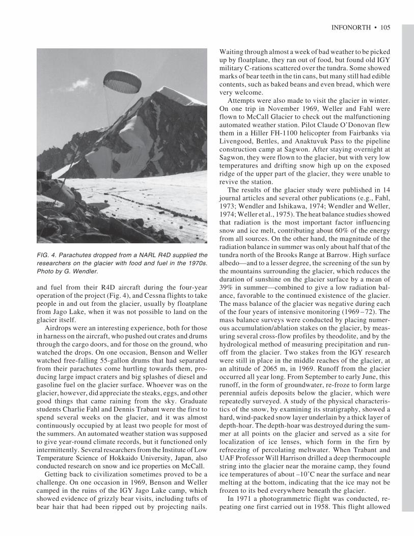
With help from the Office of Naval Research andNARL, then directed by Dr. Max Brewer, the project wasable to continue. NARL chartered a large Huey helicopterthat brought in building materials for a new moraine campin five separate flights from Barter Island. The floorboardsof the old Jamesway hut on the moraine were still usefulfor constructing the building, but everything else had to beflown in. Later NARL provided parachute airdrops of food
FIG. 3. The IGY sign for the moraine camp, found in 1969 andheld in the photo by Gunter Weller (left) and Charlie Fahl(right). Photo by G. Wendler.
INFONORTH • 105
and fuel from their R4D aircraft during the four-yearoperation of the project (Fig. 4), and Cessna flights to takepeople in and out from the glacier, usually by floatplanefrom Jago Lake, when it was not possible to land on theglacier itself.
Airdrops were an interesting experience, both for thosein harness on the aircraft, who pushed out crates and drumsthrough the cargo doors, and for those on the ground, whowatched the drops. On one occasion, Benson and Wellerwatched free-falling 55-gallon drums that had separatedfrom their parachutes come hurtling towards them, pro-ducing large impact craters and big splashes of diesel andgasoline fuel on the glacier surface. Whoever was on theglacier, however, did appreciate the steaks, eggs, and othergood things that came raining from the sky. Graduatestudents Charlie Fahl and Dennis Trabant were the first tospend several weeks on the glacier, and it was almostcontinuously occupied by at least two people for most ofthe summers. An automated weather station was supposedto give year-round climate records, but it functioned onlyintermittently. Several researchers from the Institute of LowTemperature Science of Hokkaido University, Japan, alsoconducted research on snow and ice properties on McCall.
Getting back to civilization sometimes proved to be achallenge. On one occasion in 1969, Benson and Wellercamped in the ruins of the IGY Jago Lake camp, whichshowed evidence of grizzly bear visits, including tufts ofbear hair that had been ripped out by projecting nails.
Waiting through almost a week of bad weather to be pickedup by floatplane, they ran out of food, but found old IGYmilitary C-rations scattered over the tundra. Some showedmarks of bear teeth in the tin cans, but many still had ediblecontents, such as baked beans and even bread, which werevery welcome.
Attempts were also made to visit the glacier in winter.On one trip in November 1969, Weller and Fahl wereflown to McCall Glacier to check out the malfunctioningautomated weather station. Pilot Claude O’Donovan flewthem in a Hiller FH-1100 helicopter from Fairbanks viaLivengood, Bettles, and Anaktuvuk Pass to the pipelineconstruction camp at Sagwon. After staying overnight atSagwon, they were flown to the glacier, but with very lowtemperatures and drifting snow high up on the exposedridge of the upper part of the glacier, they were unable torevive the station.
The results of the glacier study were published in 14journal articles and several other publications (e.g., Fahl,1973; Wendler and Ishikawa, 1974; Wendler and Weller,1974; Weller et al., 1975). The heat balance studies showedthat radiation is the most important factor influencingsnow and ice melt, contributing about 60% of the energyfrom all sources. On the other hand, the magnitude of theradiation balance in summer was only about half that of thetundra north of the Brooks Range at Barrow. High surfacealbedo—and to a lesser degree, the screening of the sun bythe mountains surrounding the glacier, which reduces theduration of sunshine on the glacier surface by a mean of39% in summer—combined to give a low radiation bal-ance, favorable to the continued existence of the glacier.The mass balance of the glacier was negative during eachof the four years of intensive monitoring (1969 – 72). Themass balance surveys were conducted by placing numer-ous accumulation/ablation stakes on the glacier, by meas-uring several cross-flow profiles by theodolite, and by thehydrological method of measuring precipitation and run-off from the glacier. Two stakes from the IGY researchwere still in place in the middle reaches of the glacier, atan altitude of 2065 m, in 1969. Runoff from the glacieroccurred all year long. From September to early June, thisrunoff, in the form of groundwater, re-froze to form largeperennial aufeis deposits below the glacier, which wererepeatedly surveyed. A study of the physical characteris-tics of the snow, by examining its stratigraphy, showed ahard, wind-packed snow layer underlain by a thick layer ofdepth-hoar. The depth-hoar was destroyed during the sum-mer at all points on the glacier and served as a site forlocalization of ice lenses, which form in the firn byrefreezing of percolating meltwater. When Trabant andUAF Professor Will Harrison drilled a deep thermocouplestring into the glacier near the moraine camp, they foundice temperatures of about –10˚C near the surface and nearmelting at the bottom, indicating that the ice may not befrozen to its bed everywhere beneath the glacier.
In 1971 a photogrammetric flight was conducted, re-peating one first carried out in 1958. This flight allowed
FIG. 4. Parachutes dropped from a NARL R4D supplied theresearchers on the glacier with food and fuel in the 1970s.Photo by G. Wendler.

106 • INFONORTH
another method of calculating the total mass loss of theglacier for the period 1958 – 71. In addition to thephotogrammetric method, changes in the mean height ofthe equilibrium line and a hydrological method were usedto calculate the mass balance of the glacier. All threemethods gave mean values on the order of -100 to -200 mmwater equivalent annually (Dorrer and Wendler, 1976).
NEW RESEARCH TEAMS AND METHODS,1993 TO THE PRESENT
Research on the glacier did not begin again in earnestuntil 1993, when Keith Echelmeyer (UAF) was awardedan NSF grant. Echelmeyer, who had earned his own PhDfrom Caltech, was supervising that of Bernhard Rabus atUAF, and together they led the scientific efforts from 1993to 1997. A major part of this PhD involved the rescue ofsurveying and mapping data from the 1950s and 1970s.The original field books were scoured and the calculationswere double-checked to ensure accuracy. Many of thelocations for the new mass balance and ice velocity stakeswere based on former locations.
The biggest campaign occurred in 1993, when severalUAF researchers spent the summer on the glacier to makeintensive measurements of ice velocity, mass balance, andice temperatures. Dennis Trabant joined the field party fora few days in June 1993 to help relocate the surveybenchmarks from the 1970s, some of which were old IGYbenchmark locations. He also helped with ice radar meas-urements to construct the first bedrock map of McCall Gla-cier. Ice thicknesses typically ranged from 120 to 200 m.
An innovative way of measuring the surface elevationof glaciers, developed by Keith Echelmeyer and Will
Harrison, involved an airborne laser altimeter coupledwith a high-accuracy Global Positioning System that couldmeasure the elevation every 1.5 m along glaciers with anaccuracy of 30 cm. This new system, installed in a smallaircraft that Echelmeyer flew along one or more tracksdown a glacier, allowed a detailed and accurate profilingof the glacier’s surface. Profiles were flown on about 110glaciers in Alaska and northwest Canada during 1993 –2002, and these profiles were then compared to U.S.Geological Survey and Canadian topographic maps made30 – 45 years earlier. Eleven glaciers in the northeasternBrooks Range, including McCall, were profiled, both bythis system and by researchers on foot or on skis (Fig. 5).These comparisons yielded elevation, volume, and areachanges between 1956 and 1993 – 94. Profiles were alsocompared with the 1972 IHD McCall Glacier maps. Thesecomparisons showed that all of the measured BrooksRange glaciers have been thinning at rapid rates. Thisrapid thinning has been observed on most of the Alaskanglaciers thus studied. Such changes in glaciers must berelated to changes in climate.
Echelmeyer’s aircraft had frequently had problems get-ting stuck in rotten snow in July 1993, so the next McCallGlacier field season was started earlier, during an unusualcold spell in the spring of 1994. Nevertheless, with internalmelt setting in just after the field party left in early July,1994 still became a record negative melt year, and severalmass balance poles were unexpectedly lost on the lowerglacier. The neighboring Hubley, Bravo, and Gooseneckglaciers were also surveyed with kinematic GPS duringthis campaign. As on previous expeditions, leaving theglacier sometimes proved to be a challenge. In 1994,Echelmeyer and Rabus, waiting for better weather at theJago Lake camp, also ran out of food, but found thatnothing was left at this camp except some loose debris.They later accused Benson and Weller of having con-sumed everything edible in 1969. In 1995, two field cam-paigns were carried out, one in late winter. The 1996campaign was already outside the official three-year lifeof the project; nonetheless, Echelmeyer and Rabus carriedout two brief (1 – 2 day) campaigns to measure the massbalance poles and read the data loggers.
Four significant papers resulted from this research(Rabus et al., 1995; Rabus and Echelmeyer, 1997, 1998,2002). The mass balance of the glacier was found to benegative, or nearly so, in every year of measurement, andvolume change measurements made by laser altimeterconfirmed and quantified this further, indicating that therates of ice loss had nearly doubled in 20 years. Icetemperatures were re-analyzed at the same locations as inthe 1970s and found to be significantly warmer, indicat-ing, after all other factors had been accounted for, that anair temperature increase of at least 1.2˚C had occurred inthe previous two decades. One region of the glacier, nearthe hut established on top of the old IGY Jamesway base,was found to be sliding significantly. Through modeling,this sliding area was found to be at least a kilometer long,
FIG. 5. GPS surveying on the glacier can be carried out innearly any weather, which is both good news and bad news.Photo by M. Nolan (May 2006) of Thomas Nylen of UNAVCOand Jason Geck of UAF heading out to survey as the cloudsdescend.

INFONORTH • 107
and the modeling suggested that basal motion accountedfor over 50% of the annual surface motion there.
After the NSF grant expired, the mass balance programwas maintained primarily through the efforts ofEchelmeyer, who used his own plane and resources to keepa reduced stake network functional. At this point, it hadbecome clear to the scientists that long-term measure-ments of the glacier were not only fruitful, but vital. In1999, Echelmeyer and his students installed a number of newpoles in traditional locations that had been surveyed in thepast. In 2000 and 2001, these locations were resurveyed byEchelmeyer and his graduate students, who came in by footfrom airstrips several days’ hike away. They typically spentonly one or two nights on the glacier before hiking back to theairstrip for their ride back to Fairbanks.
The next major phase of McCall Glacier research beganin 2003, after a one-year gap in field efforts. The NSFfunded a large grant to UAF Professors Larry Hinzman andMatt Nolan for a multi-component study of changes in thefreshwater flux to the Arctic Ocean in Alaska and thewestern Arctic. Nolan led the glacier aspect of the study,and selected McCall Glacier as the best location to studythe role of Arctic polythermal glaciers in the hydrologicalcycle and climate change in this region. The choice ofMcCall Glacier was largely due to its history of priorresearch and the wealth of expertise to draw on amonglocal UAF faculty. One fact Nolan learned at the onset of theproject was that because McCall Glacier is now in what isknown as the Designated Wilderness Area of the ArcticNational Wildlife Refuge, new long-term glacier researchprojects would be impossible to start there or elsewhere in therefuge. The only reason the U.S. Fish and Wildlife Servicecontinues to grant permits to continue work on McCallGlacier is that research efforts there pre-dated the formationof this refuge and the wilderness area within it—a fortuitous,unexpected benefit derived from the original IGY project.
Over the five-year project, Nolan and his teams ofstudents, technicians, family members, and visitingfaculty installed and maintained a network of mass bal-ance and velocity stakes, all largely at locations used in the1970s and 1990s, to facilitate long-term comparisons.They also installed over a dozen automated weather sta-tions, some on former sites, and four of which telemetereddata hourly to the Internet. An interesting challenge theyhad to face was the conversion to using GPS for all of theirsurveying, as the geographic projections and datums changebetween theodolite and satellite triangulations. On the firstexpedition of this five-year effort, the others on the triplistened patiently while Nolan, Bernhard Rabus (who hadfinished his PhD in 1997) and Bjorn Johns of UNAVCOspent seemingly endless hours in the cook tent trying toconvince themselves that they had not made some blunderin these conversions. In the end, judging by the re-occupa-tion of bedrock benchmarks still in place since the IGY,they think they got it right. Modern Real-Time Kinematic(RTK) GPS methods also permitted them to re-occupy theairborne laser transects of Keith Echelemeyer. Several of
the stakes installed in the 1990s were found still upright in theglacier, and many of the stakes and thermocouple wires fromthe 1970s were found fallen over, often making a trail leadingback to where their modern counterparts are now located.
Nolan and colleagues were able to verify and expand onmany of the prior studies through a time-series analysismade possible after 50 years of measurements. The rate ofice loss continues to increase over time (Nolan et al., 2006)and the annual mass balance trend continues to grow morenegative, indicating that local climate is continuing tochange and become less conducive to glacier growth.Since no long-term weather stations exist in the entireBrooks Range, loss of glacier ice is one of our few indica-tions of long-term climate trends here. One particularlyominous example of this change was the discovery that theterminus had retreated past the lowest survey transectestablished in 1969—the ice is completely gone there!Finite-difference thermomechanical modeling, led by Dr.Frank Pattyn and graduate student Charlotte Delcourt inBelgium, has indicated that if current climate trends con-tinue, McCall Glacier will continue to retreat up into thehighest cirque and possibly disappear within the next 100–200 years. Such modeling is made possible only by long-term records of ice velocities, ice temperatures, and massbalance, as well as a bedrock map that continues to beimproved through new radar studies.
Nolan, like others before him, has collaborated on thisproject with numerous national and international col-leagues, both in the field and in the office, but his collabo-ration with Austin Post is especially appropriate to relatehere. It was only by chance that Nolan learned of Post’spresence on the glacier in 1958, as it was not documentedin the scientific literature. After several e-mail exchangesbetween them, a shoebox arrived in the mail the day beforeNolan’s second expedition to the glacier in August 2003.Inside this shoebox were hundreds of medium-formatnegatives of McCall Glacier from 1958 that Post had neverprinted, and which had miraculously survived a house fire.At 2:00 a.m. the night before the trip, Nolan held eachnegative up to his window, in the dim glow of the late-summer night, to see if there were any shots that might begood to repeat. Several candidates were found, scanned,and printed out to take into the field. The best among themwas a photo of the terminus. As things went in the field, itwas a busy trip and there was not much time for hikes downpast the terminus. On a reasonably nice evening at about6:00 p.m., however, Nolan and his wife Kristin had fin-ished maintenance on a weather station on the ice near theold moraine camp and decided to try to repeat the terminusphoto. After several hours of hiking and hunting for Post’sphoto location, they finally found it and took the picture.Part of the delay was Nolan’s mistake in scrambling up thewrong gullies, forgetting that the terminus had retreatedsubstantially so that Austin’s viewpoint was much fartherdown-glacier than the terminus he was looking at thatnight. But back at camp by about 3:00 a.m., they hadaccomplished what is likely to be the most lasting and

108 • INFONORTH
often used public legacy of their project—the secondphoto of the pair shown in Figure 6, which has beenreproduced widely and is becoming an icon of Arcticclimate change.
CLEANUP
During the IGY and IHD efforts, most supplies werebrought in with air drops, and over the next 30 yearsvarious efforts were made to clean up the glacier, nowlocated in an environmentally and politically sensitivewildlife refuge. Carl Benson tried to find a way to enticemilitary helicopters to come for a “training” mission on theglacier and backhaul this debris out, but without success.To start the process, however, in July 1987 Benson andWeller were flown from Kaktovik to the glacier in a Fishand Wildlife helicopter. Accompanied by Larry Sweet andgraduate student Eric Breitenberger, they collected para-chutes and other debris scattered over the glacier, made aninventory of all the major pieces, including fuel drums, abroken-down snowmobile, and generators, and waited forgood weather to have everything flown out. Bad weatherdefeated them, and after waiting for two weeks they had toreturn without having achieved much cleanup. In 1993,Bernhard Rabus, Keith Echelmeyer, and colleagues spentmuch of the summer consolidating the debris locatedaround the hut, but also lacked the resources to remove it.
Matt Nolan, talking with the prior researchers at thestart of his project, became aware of the importance andchallenges associated with cleaning up the tons of debrison the glacier. With the help and funding of the NSF andthe U.S. Fish and Wildlife Service, he was able to developa successful removal plan. A major unforeseen issue hereturned out to be that although on the glacier the debris was
just junk, once it was removed it became a hazardousmaterial (“haz-mat”) and needed to be handled in a legallyrigorous (and potentially expensive) way. Fortunately, theNSF agreed to fund some extra helicopter time as part ofthe research in May 2004, and the U.S. Fish and WildlifeService agreed to handle the haz-mat analysis and paper-work once the debris got to Kaktovik village. On twobeautiful sunny, calm days in August 2004, Dave Jones ina Bell 407 took out six sling-loads of debris, weighing overtwo tons in total. Most of this came from the hut, whichwas gutted, and from its environs. Nolan’s biggest regretfrom this operation was that a case of dated water samplesfrom throughout 1971 was accidentally thrown away. Whoknows what scientific value that water might have had?They also took a load of fuel barrels and debris from theupper cirque, where the IGY camp was beginning to meltout of the ice over an icefall. They found a carton of C-rations there, which must have melted out just that day, asthe cardboard box was in perfect condition. Nolan kept afew of the cans, but his wife would not let him eat them onthe glacier for fear of his sudden demise; a can of “FruitCocktail” still sits on the shelf above his desk at theuniversity.
CONCLUSION
What were the conclusions and lessons learned fromthese studies conducted over half a century? First, theydemonstrated the usefulness of long-term, systematic quan-titative observations on the ground, particularly observa-tions of complex processes, like those observed andmeasured on McCall Glacier. Such long-term observa-tions are not that frequent in the Arctic, and in these daysof satellite remote sensing are becoming even less so. The
FIG. 6. Comparison of the McCall Glacier terminus in 1958 (photo by A. Post) and in 2003 (photo by M. Nolan).

INFONORTH • 109
information obtained from the studies provided a clearpicture of the dramatic changes that have occurred in thisregion of the Arctic, caused largely by changes in theclimate. The studies begun during the IGY have contin-ued, albeit with interruptions, to the present day, and willcontinue to shed additional light on processes in thisfascinating region of the Arctic and the world. Changes inlogistics, technology, and permitting have also changedthe nature of the fieldwork, though it could be argued notalways for the better. For example, these advances intechnology and logistics have allowed expeditions to com-plete in days what it previously took months to do, but it isunsettling to think about all the phenomena and new ideaswe miss in those “saved” months of time.
The studies also demonstrated the foresight of theirearly initiators, the dedication and contributions of thescientists who were involved, and the importance of properdata archival. Richard Hubley should be given great creditfor starting the studies. Svenn Orvig, who took over theproject after Hubley’s death, has also died, but others ofthe IGY scientists on the glacier are still with us. Thescientists from the University of Alaska who restarted theproject in 1969 and kept it going through the 1990s and2000s owe them all a great debt. Those of us who partici-pated in the McCall Glacier enterprise gained much fromtheir earlier work and would not have missed the experi-ence for the world.
There is also another lesson to be learned from thisexperience. While the McCall Glacier project has at thispoint turned into a long-term (50-year) study, the recorditself was created through the contributions of severalshort-term projects. These were funded sporadically andresulted in gaps in the record. One of the causes for this isthe paucity of federal funding opportunity for long-termglacier research projects. This is a problem not only forglacier research, but for all Arctic research, as long-termstudies are the only way to ensure sufficient understandingof important processes such as the climate changes we areexperiencing now. The future prospects of obtaining long-term glacier records remains bleak, and the record willlikely continue to have gaps. Although modern data log-gers for remotely measuring weather, ice melt, and icemotion may help bridge these gaps, it has been and likelywill continue to be the initiative, energy, and at somepoints the personal resources of individual scientists in-volved that provide a semblance of research continuity.
As glaciers around the world continue to recede, willthere still be a McCall Glacier or a McCall Glacier Projectat the next IPY in 2057? If the present trends continue, thefinal chapter in the McCall Glacier story may not be far off(Fig. 7). When it comes, we hope that there will besomeone to record it for posterity. In the meantime, fromall of us and on behalf of those already departed, we wishthese unknown future researchers and colleagues well, andurge them to take good care of McCall Glacier and its long-term record.
REFERENCES
DORRER, E., and WENDLER, G. 1976. Climatological andphotogrammetric speculations on mass-balance changes ofMcCall Glacier, Brooks Range, Alaska. Journal of Glaciology17(77):479 –490.
FAHL, C. 1973. Some relationships between glaciers and climatein Alaska. Fairbanks: University of Alaska Fairbanks.
KEELER, C.M. 1959. Notes on the geology of the McCall Valleyarea. Arctic 12(2):87 –97.
MASON, R.W. 1959. The McCall Glacier Project and its logistics.Arctic 12(2):77 –81.
NOLAN, M., ARENDT, A., and RABUS, B. 2006. Volume changeof McCall Glacier, Arctic Alaska, from 1956 to 2003. Annals ofGlaciology 42:409 –416.
ORTH, D.J. Dictionary of Alaska place names. Geological SurveyProfessional Paper 567. Washington, D.C.: U.S. GovernmentPrinting Office.
ORVIG, S., ed. 1961. McCall Glacier Alaska: Meteorologicalobservations 1957 –1958. Research Paper 8. Montreal: ArcticInstitute of North America.
RABUS, B.T., and ECHELMEYER, K.A. 1997. The flow of apolythermal glacier: McCall Glacier, Alaska, USA. Journal ofGlaciology 43(145):522 –536.
———. 1998. The mass balance of McCall Glacier, Brooks Range,Alaska, USA: Its regional relevance and implications for climatechange in the Arctic. Journal of Glaciology 44(147):333 –351.
———. 2002. Increase of 10 m ice temperature: Climate warmingor glacier thinning? Journal of Glaciology 48(161):279 –286.
RABUS, B.T., ECHELMEYER, K.A., TRABANT, D.C., andBENSON, C.S. 1995. Recent changes of McCall Glacier, Alaska.Annals of Glaciology 21:231 –239.
SATER, J.E. 1959. Glacier studies of the McCall Glacier, Alaska.Arctic 12(2):82 –86.
FIG. 7. The future of glacier research depends on the nextgeneration of scientists, but will there still be a glacier left herewhen young Turner Nolan grows up and brings his kids intothe field?

110 • INFONORTH
SULLIVAN, W. 1961. Assault on the unknown: The InternationalGeophysical Year. New York: McGraw-Hill Book Company,Inc. 460 p.
WELLER, G., TRABANT, D.C., and BENSON, C.S. 1975. Physicalcharacteristics of the McCall Glacier, Brooks Range, Alaska.Proceedings of the Snow and Ice Symposium, Moscow, August1971. International Association of Hydrological Sciences (IAHS/AISH) 104:88 – 91.
WENDLER, G., and ISHIKAWA, N. 1974. The combined heat, iceand water balance of McCall Glacier, Alaska: A contribution tothe International Hydrological Decade. Journal of Glaciology13(68):227 – 241.
WENDLER, G., and WELLER, G. 1974. A heat-balance study ofMcCall Glacier, Brooks Range, Alaska: A contribution to theInternational Hydrological Decade. Journal of Glaciology13(67):13 –26.
Gunter Weller, Gerd Wendler, Carl Benson, and Keith Echelmeyerare all Professors of Geophysics Emeritus at the University ofAlaska Fairbanks; Matt Nolan is Associate Professor at theUniversity of Alaska Fairbanks; Norbert Untersteiner is a Profes-sor Emeritus at the University of Washington.