volcanic ash advisory center buenos aires - · volcanic ash advisory center buenos aires by miriam...
TRANSCRIPT
Volcanic Ash Advisory Center
Buenos Aires
by Miriam Andrioliby Miriam Andrioli
WMO VAAC Best Practice Workshop 2015
Westminster, London, UK. 5-8 May 2015
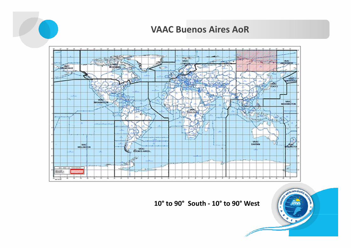
VAAC Buenos Aires AoR
10° to 90° South - 10° to 90° West
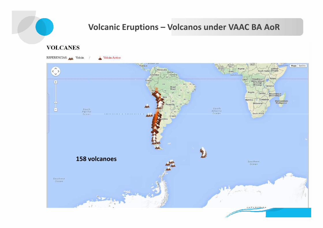
Volcanic Eruptions – Volcanos under VAAC BA AoR
Mapa cuadro CamilaMapa cuadro Camila
158 volcanoes

VOLCANO 2006 2007 2008 2009 2010 2011 2012 2013 2014 2015TOTAL /
Volcano
Lascar 17 14 4 1 36
Ubinas 534 392 136 40 2 400 1504
Planchón Peteroa 18 60 79 157
Quizapú 6 6
Llaima 19 33 7 2 61
Villarrica 2 7 5 1 24 39
Chaitén 437 198 36 5 676
Callaquí 1 5 2 8
VAA issued during the period 2006 - 2014
Updated April 1st, 2015 - 14:45 UTC (VAA + VAG as of 2011)
Callaquí 1 5 2 8
Nev. del Chillán 3 3
San José 1 1
Cordón Caullé 856 263 14 12 2 1147
Hudson 19 19
Osorno 2 2
Olca Paruna 1 1
Tolhuaca 3 3
Copahue 24 48 39 111
Antuco 1 1
Palena Group 1 1
Sabancaya 5 39 10 54
MIchinmahuida 1 1
TOTAL / Year 575 427 606 250 106 970 296 72 490 39 3831
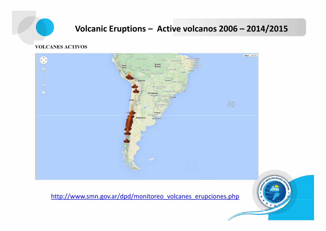
Volcanic Eruptions – Active volcanos 2006 – 2014/2015
5
http://www.smn.gov.ar/dpd/monitoreo_volcanes_erupciones.php
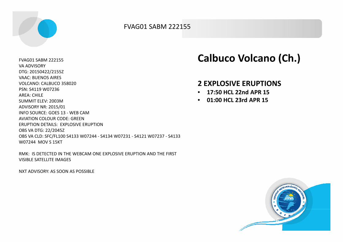
FVAG01 SABM 222155
VA ADVISORY
DTG: 20150422/2155Z
VAAC: BUENOS AIRES
VOLCANO: CALBUCO 358020
PSN: S4119 W07236
AREA: CHILE
SUMMIT ELEV: 2003M
ADVISORY NR: 2015/01
INFO SOURCE: GOES 13 - WEB CAM
AVIATION COLOUR CODE: GREEN
FVAG01 SABM 222155
Calbuco Volcano (Ch.)
2 EXPLOSIVE ERUPTIONS• 17:50 HCL 22nd APR 15
• 01:00 HCL 23rd APR 15
6
AVIATION COLOUR CODE: GREEN
ERUPTION DETAILS: EXPLOSIVE ERUPTION
OBS VA DTG: 22/2045Z
OBS VA CLD: SFC/FL100 S4133 W07244 - S4134 W07231 - S4121 W07237 - S4133
W07244 MOV S 15KT
RMK: IS DETECTED IN THE WEBCAM ONE EXPLOSIVE ERUPTION AND THE FIRST
VISIBLE SATELLITE IMAGES
NXT ADVISORY: AS SOON AS POSSIBLE
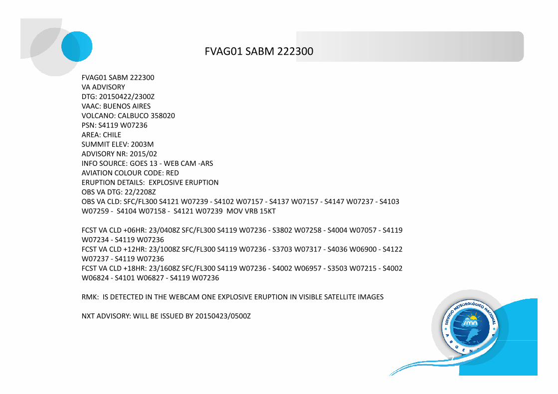
FVAG01 SABM 222300
VA ADVISORY
DTG: 20150422/2300Z
VAAC: BUENOS AIRES
VOLCANO: CALBUCO 358020
PSN: S4119 W07236
AREA: CHILE
SUMMIT ELEV: 2003M
ADVISORY NR: 2015/02
INFO SOURCE: GOES 13 - WEB CAM -ARS
AVIATION COLOUR CODE: RED
ERUPTION DETAILS: EXPLOSIVE ERUPTION
OBS VA DTG: 22/2208Z
OBS VA CLD: SFC/FL300 S4121 W07239 - S4102 W07157 - S4137 W07157 - S4147 W07237 - S4103
FVAG01 SABM 222300
7
OBS VA CLD: SFC/FL300 S4121 W07239 - S4102 W07157 - S4137 W07157 - S4147 W07237 - S4103
W07259 - S4104 W07158 - S4121 W07239 MOV VRB 15KT
FCST VA CLD +06HR: 23/0408Z SFC/FL300 S4119 W07236 - S3802 W07258 - S4004 W07057 - S4119
W07234 - S4119 W07236
FCST VA CLD +12HR: 23/1008Z SFC/FL300 S4119 W07236 - S3703 W07317 - S4036 W06900 - S4122
W07237 - S4119 W07236
FCST VA CLD +18HR: 23/1608Z SFC/FL300 S4119 W07236 - S4002 W06957 - S3503 W07215 - S4002
W06824 - S4101 W06827 - S4119 W07236
RMK: IS DETECTED IN THE WEBCAM ONE EXPLOSIVE ERUPTION IN VISIBLE SATELLITE IMAGES
NXT ADVISORY: WILL BE ISSUED BY 20150423/0500Z
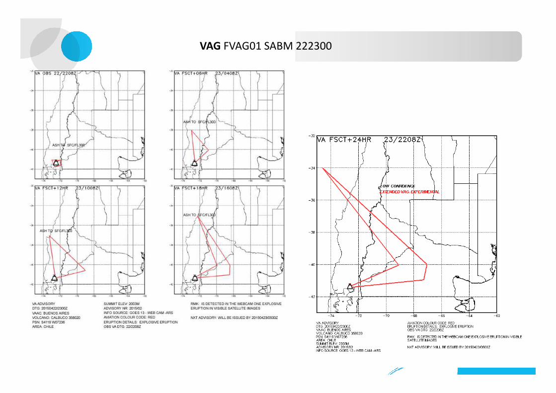
VAG FVAG01 SABM 222300
8
Monitoring and Observations
• VA SIGMET
• AIREPs; Special AIREPs (ARS)
• AMDAR (Aerolíneas Argentinas – Lan Argentina)
• Volcanic Observatory reports (VO) from Argentina, Chile and Perú
• METARs• METARs
• Webcam volcano images OVDAS
• Global service for lightning activity
• Met. RADAR (where available)
• Satellite imagery ( GOES E –G 13, 1-2-4-6 bands)
• LIDAR
• TOPAS
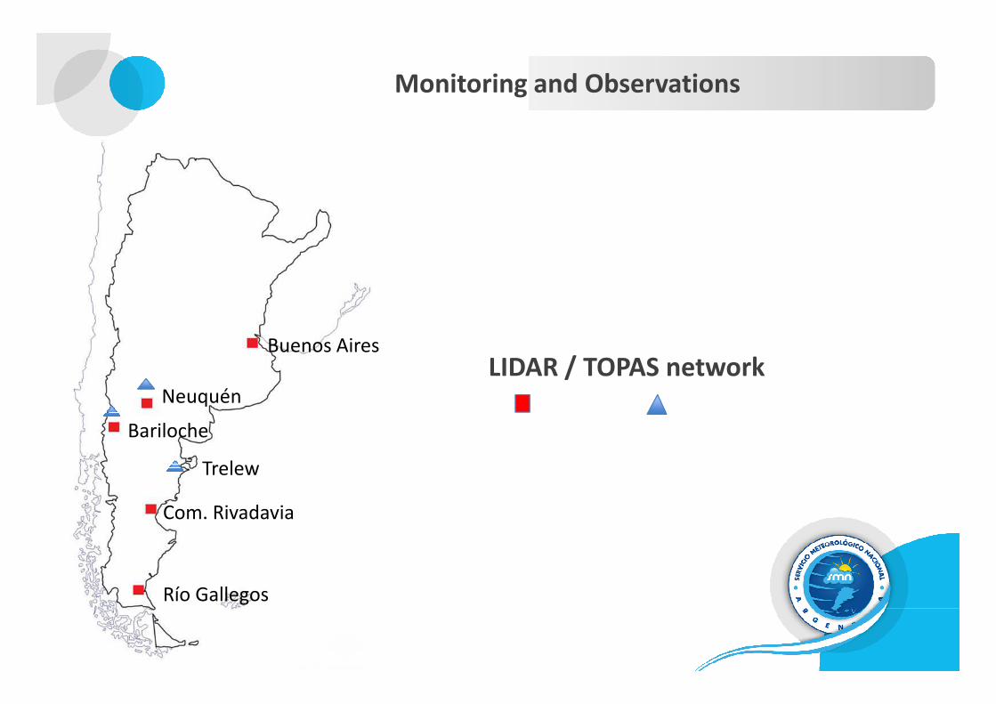
Monitoring and Observations
Buenos Aires
LIDAR / TOPAS networkBuenos Aires
Neuquén
Bariloche
Com. Rivadavia
Río Gallegos
Trelew
LIDAR / TOPAS network

Modelling
� HYSPLIT (HYbrid Single Particle Lagrangian Integrated Trajectory VA dispersion model
• Run at the NMS of Argentina on to the GFS numerical model (Global Forecast System,
NCEP).
� FALL 3D (Eulerian dispersion and concentration model for VA) NMS of Argentina - BSC� FALL 3D (Eulerian dispersion and concentration model for VA) NMS of Argentina - BSC
• Coupled to the
-GFS numerical model;
-local numerical model WRF-ARW (experimental); and
-local operational version of ETA NMS numerical model (adapted to the
VAAC BA AoR, better grid resolution).
• Ash concentration, ground load and deposition thickness.
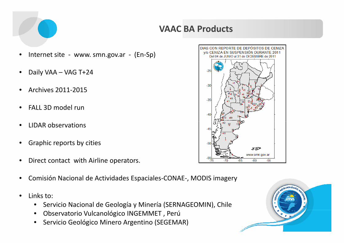
VAAC BA Products
• Internet site - www. smn.gov.ar - (En-Sp)
• Daily VAA – VAG T+24
• Archives 2011-2015
• FALL 3D model run
• LIDAR observations• LIDAR observations
• Graphic reports by cities
• Direct contact with Airline operators.
• Comisión Nacional de Actividades Espaciales-CONAE-, MODIS imagery
• Links to:
• Servicio Nacional de Geología y Minería (SERNAGEOMIN), Chile
• Observatorio Vulcanológico INGEMMET , Perú
• Servicio Geológico Minero Argentino (SEGEMAR)

VAAC Buenos Aires improvements
• New International Volcano Database ID numbers for VAACs (as of October 1st, 2013;
related to IAVWOPSG Conclusion 7/30).
• VAG T+24 (as of July 1st, 2014);
– Where is this information published by other VAACs??
• Confidence levels (under consideration)
– “IAVWOPSG Conclusion 7/9, Expressing confidence at the time of observation of an ash cloud
(T+0) in the VAA/VAG.
– Submitted to this BP Workshop for further discussion.
13

VAAC Buenos Aires improvements
� Interagency Volcanic Ash Information management protocol
for Argentina.
• Project Source: Ministerio de Ciencia, Tecnología e Innovación Productiva , Comisión Gestión de Riesgo
• National Agencies involved: SEGEMAR, NMS; SHN; CONAE; CONICET; IGN; CIN; APN, among others.
• User: Subsecretaría de Protección Civil y Abordaje Integral de Emergencias y Catástrofes, Min. de Seguridad.
• Main objective: to better articulate the scientific, technological and administrative capacities of all agencies
involved for a better management of the hazardous situations posed by the presence of VA in the
Argentinian territory in order to improve national decision making processes. Argentinian territory in order to improve national decision making processes.
• Specific objectives:
• Provide thorough information on the volcanos and the level of threat of an eruption;
• Catalog of active volcanos
• Monitor the threat of an eruption and provide VA forecasts (from dispersion and transport models), to determine
potentially affected areas
• Isopach maps and VA deposit forecast
• Water & Air quality assessment in the affected areas
• Efficient warnings
14
VAAC Buenos Aires improvements
� Design and develop a database of volcanoes VORHISE (Volcanes de la Región y su
Historia Eruptiva), to collect and validate its data.
• Eruptive history, behavior and characterization of the volcanos under the VAAC BA AoR.
• Global /National data bases
-Smithsonian Institution’s Global Volcanism Program
-LaMEVE (Large Magnitude Explosive Volcanic Eruptions) (Crosweller et al., 2012), Univ. of Bristol, U.K.-LaMEVE (Large Magnitude Explosive Volcanic Eruptions) (Crosweller et al., 2012), Univ. of Bristol, U.K.
-Instituto Geográfico Nacional (IGN)
• VORHISE will include volcano location, ID number, type/height; and for each recorded eruption, the
dates and/or the duration of the activity, height/s column/s eruptive/s, granulometric characteristics
and parameters of shape of the ash emitted by volcanoes, explosivity index (VEI), volume,
petrographic and geochemical characteristics of the material erupted, among other data.
• Information will be used to adjust the initialization of dispersion forecast models and to
create scenarios for future eruptions.
15
VAAC Buenos Aires improvements
� VA hazard maps
• Create eruption/re-suspension VA hazard maps for the VAAC BA AoR.
• State of the art tools, including VA dispersion forecast model and deposit model ensemble
and use of advanced satellite data processing techniques for validation.and use of advanced satellite data processing techniques for validation.
• The maps will depict the probability of the presence of VA, its concentration in the
atmosphere and the thickness of its ground deposits exceeding certain given thresholds.
• This cartography will combine the most probable vulcanological scenarios for the more
explosive volcanos with the typical regional synoptic situations.
16
VAAC Buenos Aires improvements
� Remote sensing
• Evaluation and implementation of algorithms for qualitative detection and retrieval of
volcanic ash following the work of Prata (Prata & Grant, 2001; Prata, 2011) and the
developments of Pavolonis (2010) for the GOES R ABI.
• Development of a multi-sensor, multi-band detection algorithm using Chaitén and Cordón
Caulle volcanos data.
• Characterization of the re-suspended VA event of October 2011 using MODIS, and work
on the identification of the plume event of December 14th, 2013 informed to VAAC BA by
M. Pavolonis.
17
Other VAAC BA activities
VAAC exercises
• Annual SIGMET WV tests, last on Dec. 2014• Southern Hemisphere Ash Propagation Exercise (SHAPE), VAACs Tolouse-Buenos Aires(Guide for “Collaborative Decision Analysis and Forecasting (CDAF)”- ICAO 9766 Manual).
VAAC best practice documentation
• Operations Manual, in progress• Competency assessment of VAAC BA personnel , in progress• QMS ISO 9001-2008, in progress• QMS ISO 9001-2008, in progress
Lectures/Training
• ”Volcano Monitoring using Infrasound” Latest developments on the use of infrasound data (CTBTO type data) and their usefulness in detecting volcanic eruptions, by Dr. Maurizio Ripepe, Dipartimento di Scienze della Terra - Geofisica della terra solida-Firenze, Italia.
• Lidar operation/ interpretation training for Met. Obervers and Forecasters, 2015.
Visits
Brazilian Air Force; VP WMO CAeM

19