volcano trails - city of albuquerque · rio rancho city limit t volcano heights volcano trails...
TRANSCRIPT
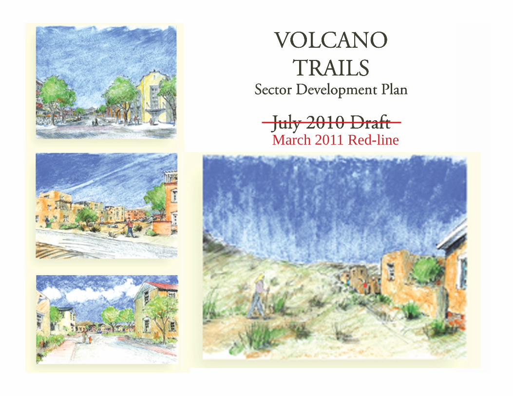
VOLCANOTRAILS
Sector Development Plan
July 2010 DraftMarch 2011 Red-line
Volcano Trails Sector Development Plan - 2011 - March RED-LINE
DRAFT
ii
DRAFT
City of Albuquerque Richard J. Berry, MayorDavid Campbell, Chief Administrative Officer
City CouncilKen Sanchez, District 1, PresidentDebbie O’Malley, District 2Isaac Benton, District 3Brad Winter, District 4Dan Lewis, District 5Rey Garduño, District 6, Vice-PresidentMichael D. Cook, District 7Trudy E. Jones, District 8, Vice-PresidentDon Harris, District 9, President
Environmental Planning CommissionRon O. Garcia, Council District 1Jonathan Siegel, Council District 2Rob Dickson, Council District 3Joe Yardumian, Council District 4Hugh Floyd Richard Shine, Council District 5Len Malry, Council District 6Laurie Moye, Vice Chair, District 7Doug Peterson, Chair, Council District 8Michael Dickson, Council District 9
City Staff & Technical Review TeamDeborah Stover, Director, Planning DepartmentLaura Mason, Director, Council ServicesKara Shair-Rosenfield, Planning Policy Analyst, City Council Sara Westbrook, Policy Analyst, City CouncilRussell Brito, Manager, Urban Design & Development, Planning Department Petra Morris, Long Range Planning, Planning DepartmentMikaela Renz-Whitmore, Long Range Planning, Planning DepartmentDavid Zamora, AGIS, Planning DepartmentBrad Bingham, City Hydrologist, Planning Department Matt Schmader, Superintendent, Parks and Open SpaceJames Lewis, Parks and Open SpaceChristina Sandoval, Parks and RecreationJohn Hartmann, Department of Municipal DevelopmentAllan Porter, Albuquerque Bernalillo County Water Utility Authority
Note for EPC Hearing March 3, 2011:
In this redline document, changes in red are based on recom-mended conditions of approval from the November 4, 2010 EPC hearing. Numbers in brackets refer to the spreadsheet of comments and responses and are generally listed in the order they appear.
Changes in blue reflect more recent clarifications and adjust-ments based on further staff review and additional public and agency input.
Volcano Trails Sector Development Plan
DRAFT
Volcano Trails Sector Development Plan - 2011 - March RED-LINE
DRAFT
DRAFT
iii
Chapter 1 Introduction Page 1Introduction Page 1Purpose of the Plan Page 2Plan Area Page 2Area Overview Page 4Transportation Page 4Open Space and Parks Page 7Pre-existing Current Zoning Page 8Planning Process Page 9Regulatory Tool Page 10
Chapter 2 Plan Goals Page 13
Chapter 3 Zoning and General Standards Page 17Development Review Process Page 19Permitted Deviations Modifications Page 20Zoning Intention and Character Page 21Zoning Established by the Volcano Trails Sector Development Plan and Land Use Plan Page 24 Pre-existing Standards for Development Previously Omitted Standards Page 25The Zones Page 25SU-2/Volcano Trails Village Center Zone Page 26SU-2/Volcano Trails Urban Residential Zone Page 29SU-2/Volcano Trails Residential Developing Area Zone Page 32SU-2/Volcano Trails Small Lot Zone Page 34SU-2/Volcano Trails Medium Lot Zone Page 36General Standards Page 39General Design Requirements Page 40Building Design Standards Page 43Landscape Design Standards Page 48Usable Open Space Standards Page 51Parking Standards Page 51
Chapter 4 General RegulationsA – Approved Colors Page 54B – Native Plant List A and Xeric Plant List B Page 55C – Construction Mitigation Page 60D – Rainwater Stormwater Design Standards Page 62
Appendix E Northwest Mesa Escarpment Plan Page 40
ExhibitsExhibit 1 Trails Plan Area Page 1Exhibit 2 Exempted Areas Page 2Exhibit 2 The Trails Phase I, Unit 2 Tracts Page 2Exhibit 3 Volcano Mesa Plan Area Page 3Exhibit 4 Volcano Trails Plan Location Page 4Exhibit 5 4 Proposed Volcano Mesa Road Network Page 5Exhibit 6 5 Volcano Trails Road Network Page 6Exhibit 7 6 Volcano Trails On-Street Bikeways Network Page 7Exhibit 8 6 Existing Zoning Page 8Exhibit 9 Northwest Mesa Escarpment PlanBoundary Page 11Exhibit 10 7 Zoning and Land Use Plan Page 24Exhibit 11 PNM Electric Facilities Page 42Exhibit 12 11 Approved Colors Page 54
Tables
Table 1 Relevant Existing Ranked City Plans Page 10Table 2 Modifications Page 15Table 2 1 Development Approval Process Page 19Table 3 Garage Types Page 45
Table of Contents
Volcano Trails Sector Development Plan - 2011 - March RED-LINE
DRAFT
iv
DRAFTThis Page Left Intentionally Blank
Volcano Trails Sector Development Plan

DRAFT
Volcano Trails Sector Development Plan - 2011 - March RED-LINE
DRAFT
DRAFT
1
Introduction. In 2004, the City Council called for a planning study of the larger Volcano Mesa area. Finding that “The Volcanic Escarpment of the Northwest Mesa has long been considered a unique landscape that requires special protec-tion,” the Council expressed concerns over devel-opment trends with subdivisions being approved piecemeal without the guidance of an overall plan for the area. The Council recognized the need for a plan that would bring development in line with the Westside Strategic Plan (WSSP), the North-west Mesa Escarpment Plan (NWMEP), the Al-buquerque / Bernalillo County Comprehensive Plan, and other previously established policies. Issues to be addressed included transportation, drainage, water and wastewater, a mix of land uses, view corridors, building height, massing and orientation, walls, parks, trails and open space, and phasing and timing of growth.
The Planning study forecasted over 100,000 additional residents at final build out in the Volcano Mesa area and adjoining areas on the Northwest Mesa and identified how build-out of exclusively single family residen-tial subdivisions would increase the imbalance of jobs and housing, adding to traffic demands and increasing the burden on Westside and east-west transportation systems. The study identified an overall need for transit-supportive densities and design; additional mixed-use centers; a large-scale, regional mixed-use employment center; consolidation and connection of open space and trails along drainage channels; and retaining access to exceptional views.
Introduction
Chapter 1
NORTHERNGEOLOGICWINDOW
WOODM
ONT AV
VOLCANO TRAILS SECTOR DEVELOPMENT PLAN
ALBUQUERQUE CITY LIMIT ´0 500 1,000
Feet
Q:\AGISFILE\PROJECTS\PetraMorris\DMZ-Jun10-VolcanoCliffsSDP\VT_Context.mxd
RAIN
BOW
BLV
D
TREE LINE AV
HEARTHSTONE RD
PASEO DEL NORTE
UN
IVER
SE B
LVD
Exhibit 1, Volcano Trails Plan Area
DRAFT
2
Chapter 1Introduction
Volcano Trails Sector Development Plan - 2011 - March RED-LINE
DRAFTExhibit 2, Exempted Areas
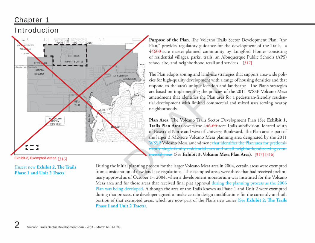
Purpose of the Plan. The Volcano Trails Sector Development Plan, “the Plan,” provides regulatory guidance for the development of the Trails, a 44600-acre master-planned community by Longford Homes consisting of residential villages, parks, trails, an Albuquerque Public Schools (APS) school site, and neighborhood retail and services. [317]
The Plan adopts zoning and land-use strategies that support area-wide poli-cies for high-quality development with a range of housing densities and that respond to the area’s unique location and landscape. The Plan’s strategies are based on implementing the policies of the 2011 WSSP Volcano Mesa amendment that identifies the Plan area for a pedestrian-friendly residen-tial development with limited commercial and mixed uses serving nearby neighborhoods.
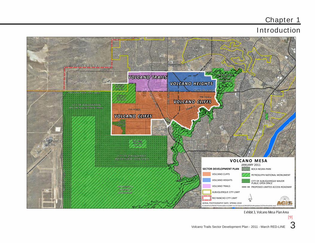
Plan Area. The Volcano Trails Sector Development Plan (See Exhibit 1, Trails Plan Area) covers the 446-00 acre Trails subdivision, located south of Paseo del Norte and west of Universe Boulevard. The Plan area is part of the larger 3,532-acre Volcano Mesa planning area designated by the 2011 WSSP Volcano Mesa amendment that identifies the Plan area for predomi-nantly single-family residential uses and small neighborhood-serving com-mercial areas (See Exhibit 3, Volcano Mesa Plan Area). [317] [316]
During the initial planning process for the larger Volcano Mesa area in 2004, certain areas were exempted from consideration of new land-use regulations. The exempted areas were those that had received prelim-inary approval as of October 1-, 2004, when a development moratorium was instituted for the Volcano Mesa area and for those areas that received final plat approval during the planning process as the 2006 Plan was being developed. Although the area of the Trails known as Phase 1 and Unit 2 were exempted during that process, the developer agreed to make certain design modifications for the currently un-built portion of that exempted areas, which are now part of the Plan’s new zones (See Exhibit 2, The Trails Phase I and Unit 2 Tracts).
[316]
[Insert new Exhibit 2, The Trails Phase 1 and Unit 2 Tracts]
DRAFT
DRAFT
DRAFT
3
Chapter 1Introduction
Volcano Trails Sector Development Plan - 2011 - March RED-LINE
Exhibit 3, Volcano Mesa Plan Area
´AERIAL PHOTOGRAPHY DATE: SPRING 2010
V O L C A N O M E S AJANUARY 2011
Q:\AGISFILE\PROJECTS\PetraMorris\DMZ-Jun10-VolcanoCliffsSDP\DraftUpdates\VCPlanAreaFeb.mxd
COO
RS B
LVD
UNSER B
LVD
PASE
O D
EL
VO
LCA
N
MONTAN O RD
CO
OR
S B
LVD
DOUBLE EAGLEAIRPORT
PASEO DEL NORTE
RA
INB
OW
BLV
D
UN
IVE
RSE
BLV
D
PETROGLYPHNATIONAL
MO NUMENT
PETROGLYPHNATIONAL
MO NUMENT
GO
LF C
OU
RSE
RD
PAR A DIS E B LVD
LYON
BLV
D
PARADISEHILLS
RIO RANCHO CITY L IMIT
ALBUQUERQUE C ITY L IMIT
VOLCANO HEIGHTS
VOLCANO TRAILS
VOLCANO CLIFFS
VOLCANO CLIFFS
UNSER BLV
D
UN
SE
R BL
V D
NO RTH ERN GEOLOGICWINDOW
MIDDLEGEOLOGICWINDOW
SO UT HERNGEOLOGICWINDOW
PETROGLY PHNATIONA L
MO NUM ENT
CITY OF ALBU QUERQ UEMA JO R PUBLIC O PEN SPACE
CITY OF ALBU QUERQ UEMA JO R PUBLIC O PEN SPACE
SECTOR DEVELOPMENT PLAN
VOLCANO CLIFFS
VOLCANO HEIGHTS
VOLCANO TRAILS
ALBUQUERQUE CITY LIMIT
RIO RANCHO CITY LIMIT
BOCA NEGRA PARK
PETROGLYPH NATIONAL MONUMENT
CITY OF ALBUQUERQUE MAJOR
PROPOSED LIMITED ACCESS ROADWAY
ROSA PARKS RD
ROSA PARKS RD
KIMMICK DR
PUBLIC OPEN SPACE
§̈¦4 0[9]
DRAFT
4
Chapter 1Introduction
Volcano Trails Sector Development Plan - 2011 - March RED-LINE
DRAFT
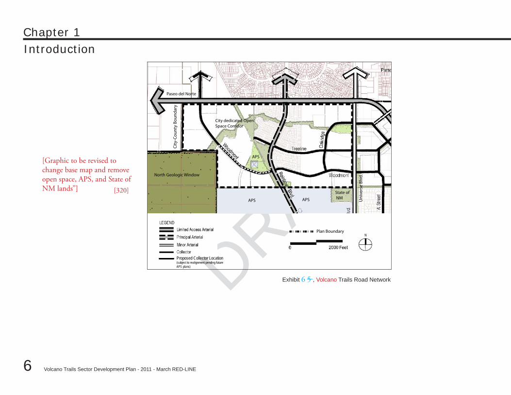
Area Overview. The Plan area is located north of Volcano Vista High School, Tony Hillerman Middle School, and Tierra An-tigua Elementary School and undeveloped lands held by the State of New Mexico. Paseo del Norte borders the area to the north and Universe to the east. To the west of the Plan Area is the Petroglyph National Monument’s North Geologic Window and undeveloped land in unincorporated Bernalillo County. (See Exhibit 4, Volcano Trails Plan Location.)
Approximately XX percent of the Trails is complete. Vacant parcels remaining include the lots bordering the North Geo-logic window and APS and State of New Mexico lands, the ar-eas designated for future commercial uses and a XX acre parcel designated for future APS use. [New APS language pending solidification of APS plans for the site.] [321]
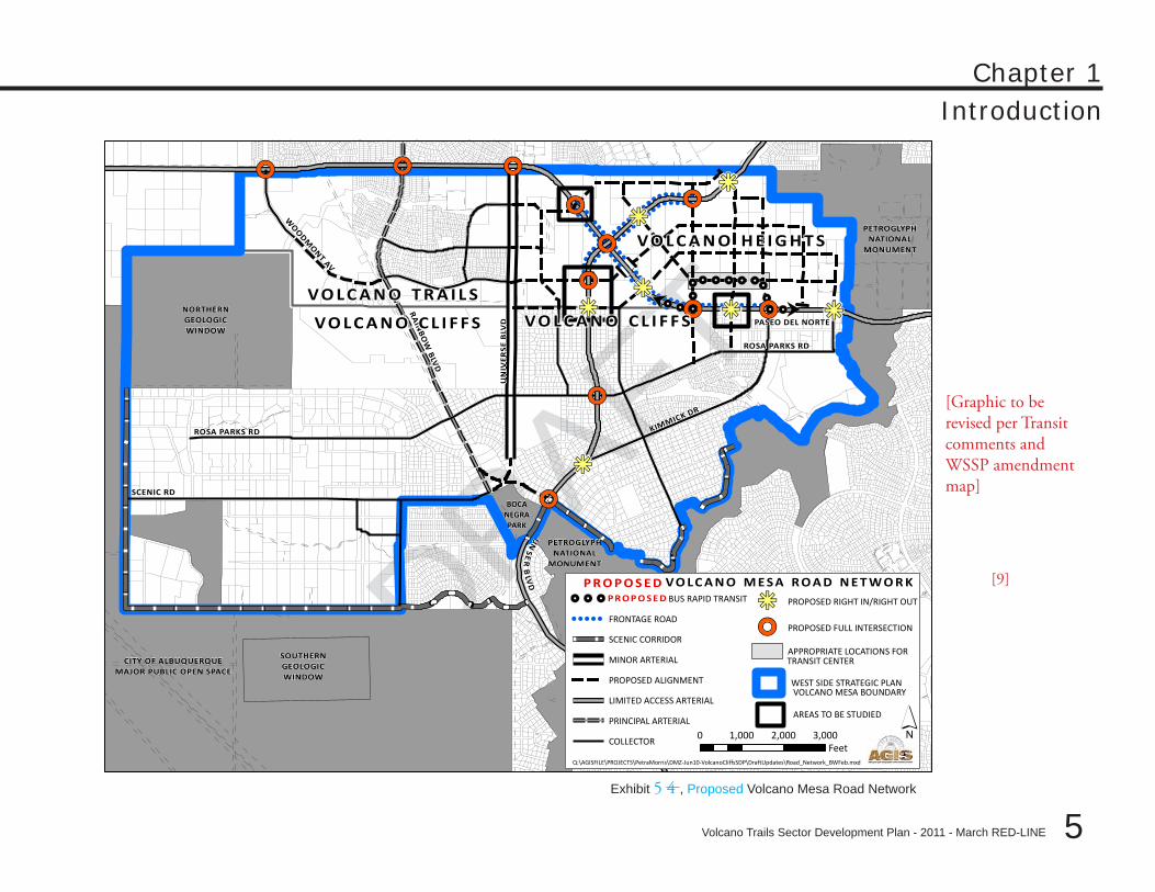
Transportation. The Plan’s major road network, in various states of completion, includes the following:
Rainbow Boulevard, a principal arterial, which bisects the •plan area and provides access from Paseo del Norte, a lim-ited access major arterial, to the APS campuses of Volcano Vista High School, Tony Hillerman Middle School, and Tierra Antingua Elementary School; Universe Boulevard, a designated minor arterial, which •borders the Plan to the east; andWoodmont Avenue, a designated collector, which upon •completion will generally run east-west through the plan area from Paseo del Norte to Rainbow and Universe Bou-levards, eventually connecting outside of the Plan area with Unser Boulevard.
Other collector streets include Treeline and Oakridge.
Exhibit 4, Volcano Trails Plan Location
[Graphic to come showing boundaries men-tioned in “Area overview.”]
DRAFT
DRAFT
DRAFT
5
Chapter 1Introduction
Volcano Trails Sector Development Plan - 2011 - March RED-LINE
Exhibit 5 4 , Proposed Volcano Mesa Road Network
!!!!
!!!!!!!!!!!!!!!!!!
!!!!!!!!!!!!!!!!!!!
!!!!!!!!!!!!!!!!!!
!!!!!!!!!!!!!!!!!!!
!!
!!!
!!!!
!!!!!!!!!!!!!! ! ! ! !
!. !. !.!.
! .!. !. !. !. !.!.!.
!. !.
,,/ ,,/,,/
,,/
,,/
,,/,,/ ,,/
,,/
kj
kjkjkj
kj
kj
kj
,,/
,,/
ROSA PARKS RD
SCENIC RD
KIMMICK DR
RA
INB
OW
BLV
D
UN
IVER
SE B
LVD
UN
SER
BLV
D
PASEO DEL NORTE
WO
ODMONT AV
ROSA PARKS RD
PETROGLYPHNATIONAL
MONUMENT
NORTHERNGEOLOGICWINDOW
BOCANEGRAPARK
SOUTHERNGEOLOGICWINDOW
´0 1,000 2,000 3,000Feet
VO LC A N O M E S A R O A D N E T W O R K
Q:\AGISFILE\PROJECTS\PetraMorris\DMZ-Jun10-VolcanoCliffsSDP\DraftUpdates\Road_Network_BWFeb.mxd
VO L C A N O H E I G H T S
VO L C A N O C L I F F S VO L C A N O C L I F F S
VO L C A N O T R A I L S
!. !. !. BUS RAPID TRANSIT
! ! ! ! ! FRONTAGE ROAD
SCENIC CORRIDOR
MINOR ARTERIAL
PROPOSED ALIGNMENT
LIMITED ACCESS ARTERIAL
PRINCIPAL ARTERIAL
COLLECTOR
kj PROPOSED RIGHT IN/RIGHT OUT
,,/ PROPOSED FULL INTERSECTION
APPROPRIATE LOCATIONS FOR
AREAS TO BE STUDIED
TRANSIT CENTERCITY OF ALBUQUERQUEMAJOR PUBLIC OPEN SPACE
PETROGLYPHNATIONAL
MONUMENT
P R O P O S E DP R O P O S E D
WEST SIDE STRATEGIC PLANVOLCANO MESA BOUNDARY
[Graphic to be revised per Transit comments and WSSP amendment map]
[9]
DRAFT
6
Chapter 1Introduction
Volcano Trails Sector Development Plan - 2011 - March RED-LINE
DRAFT
Exhibit 6 5 , Volcano Trails Road Network
Uni
vers
e Bl
vd.
City
-Cou
nty
Boun
dary
APS
State of NM
Paseo del Norte
North Geologic Window
Plan Boundary
City dedicated Open Space Corridor
APS
APS
Proposed Collector Location (subject to realignment pending future APS plans)
[Graphic to be revised to change base map and remove open space, APS, and State of NM lands”] [320]
DRAFT
DRAFT
DRAFT
7
Chapter 1Introduction
Volcano Trails Sector Development Plan - 2011 - March RED-LINE
Open Space and Parks. The Plan’s western boundary includes the Petroglyph National Monument’s North Geologic Window, which contains culturally significant resources that should be protected by access restric-tions limiting use. Internal to the Trails development, XX acres of open space including two parks, one of which has been built, the other of which is still in the planning phases. This open space/park area forms a corridor that runs through the development, providing trails and park sites for area recreation. The corridor connects to the designated open space corridor located along Universe Boulevard, which runs the length of the Plan area. [321]
Exhibit 7 6 , Volcano Trails On-Street Bikeways Network [323]
[Graphic to come showing On-Street Bike-ways Network]
DRAFT
8
Chapter 1Introduction
Volcano Trails Sector Development Plan - 2011 - March RED-LINE
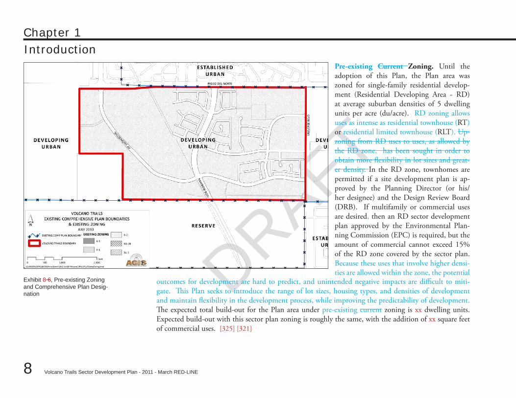
DRAFTPre-existing Current Zoning. Until the adoption of this Plan, the Plan area was zoned for single-family residential develop-ment (Residential Developing Area - RD) at average suburban densities of 5 dwelling units per acre (du/acre). RD zoning allows uses as intense as residential townhouse (RT) or residential limited townhouse (RLT). Up-zoning from RD uses to uses, as allowed by the RD zone, has been sought in order to obtain more flexibility in lot sizes and great-er density. In the RD zone, townhomes are permitted if a site development plan is ap-proved by the Planning Director (or his/her designee) and the Design Review Board (DRB). If multifamily or commercial uses are desired, then an RD sector development plan approved by the Environmental Plan-ning Commission (EPC) is required, but the amount of commercial cannot exceed 15% of the RD zone covered by the sector plan. Because these uses that involve higher densi-ties are allowed within the zone, the potential
Exhibit 8 6, Pre-existing Zoning and Comprehensive Plan Desig-nation
outcomes for development are hard to predict, and unintended negative impacts are difficult to miti-gate. This Plan seeks to introduce the range of lot sizes, housing types, and densities of development and maintain flexibility in the development process, while improving the predictability of development. The expected total build-out for the Plan area under pre-existing current zoning is xx dwelling units. Expected build-out with this sector plan zoning is roughly the same, with the addition of xx square feet of commercial uses. [325] [321]
DRAFT
DRAFT
DRAFT
9
Chapter 1Introduction
Volcano Trails Sector Development Plan - 2011 - March RED-LINE
The current single-use residential zoning prohibits integrating a mix of other uses that could make neighbor-hoods more walkable and convenient (e.g. neighborhood services). This Plan adopts new zoning for neighbor-hood-serving commercial areas with pedestrian-oriented design standards that serve neighborhoods. It is the intention that t This new commercial zoning will allow development that supports a wide range of transporta-tion, housing, and amenity choices.
Planning Process. In 2010, at the direction of City Councilor Dan Lewis and Planning Director Deborah Stover, in consultation with area property owners, a new approach to developing long-range plans for this special area of Albuquerque was initiated. The original Volcano Heights Sector Plan was adopted in 2006 but appealed to district court by the Volcano Cliff Property Owners Association. Upon remand from the court, the Plan was divided into three separate, but related, Rank III Sector Development Plans in order to address the diverse needs and issues within each planning area. Language related to the overall development of the plan area, including analysis of existing conditions and consideration and general goals and policies for land use, transportation, and open space were moved separated into the companion “Volcano Mesa” amendment to the West Side Strategic Plan, the Rank II Area Plan that governs Albuquerque’s West Side.
The City sought input from stakeholders and property owners in a renewed planning process and used that input to guide the development of the three plans that were based on the original planning effort but more specifically tailored to the goals and vision of affected stakeholders and property owners of each area. The three plans can generally be described as follows: the Volcano Cliffs Sector Development Plan (VCSDP), which includes the areas where small lots are individually owned and lower-density residential development will predominate; the Volcano Heights Sector Development Plan (VHSDP), which includes larger tracts of land designated a Major Activity Center, with opportunities for where a mix of employment, commercial, and high- and medium-density residential development opportunities exist, and the Volcano Trails Sector Development Plan (VTSDP), which is primarily designated for medium-density, single-family residential development held in consolidated ownership, with larger tracts being developed by master developer Longford Homes.
DRAFT
10
Chapter 1Introduction
Volcano Trails Sector Development Plan - 2011 - March RED-LINE
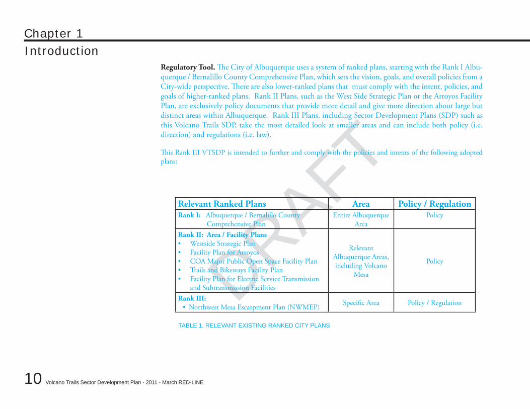
DRAFTRegulatory Tool. The City of Albuquerque uses a system of ranked plans, starting with the Rank I Albu-querque / Bernalillo County Comprehensive Plan, which sets the vision, goals, and overall policies from a City-wide perspective. There are also lower-ranked plans that must comply with the intent, policies, and goals of higher-ranked plans. Rank II Plans, such as the West Side Strategic Plan or the Arroyos Facility Plan, are exclusively policy documents that provide more detail and give more direction about large but distinct areas within Albuquerque. Rank III Plans, including Sector Development Plans (SDP) such as this Volcano Trails SDP, take the most detailed look at smaller areas and can include both policy (i.e. direction) and regulations (i.e. law).
This Rank III VTSDP is intended to further and comply with the policies and intents of the following adopted plans:
Relevant Ranked Plans Area Policy / RegulationRank I: Albuquerque / Bernalillo County
Comprehensive PlanEntire Albuquerque
AreaPolicy
Rank II: Area / Facility PlansWestside Strategic Plan•Facility Plan for Arroyos•COA Major Public Open Space Facility Plan•Trails and Bikeways Facility Plan•Facility Plan for Electric Service Transmission •and Subtransmission Facilities
Relevant Albuquerque Areas, including Volcano
Mesa
Policy
Rank III: Northwest Mesa Escarpment Plan (NWMEP)• Specific Area Policy / Regulation
TABLE 1, RELEVANT EXISTING RANKED CITY PLANS
DRAFT
DRAFT
DRAFT
11
Chapter 1Introduction
Volcano Trails Sector Development Plan - 2011 - March RED-LINE
Volcano Heights Area Plan 1
Appendix F Northwest Mesa Escarpment Plan and Volcano Heights Area Plan Boundaries January 2010 DRAFT
Appendix F
Exhibit 29,Northwest Mesa Escarpment Plan and Volcano Heights Area Plan Boundaries
Albuquerque City Limits
PETROGLYPHNATIONAL
MONUMENT
PETROGLYPHNATIONAL
MONUMENT
NATIONALMONUMENT
PETROGLYPH
DELLYNE AV
ATRISCO DR
MO
NTANO
DR
CO
OR
S BL
VD
UNSER BLVD
PARADISE BLVD
MONTANO RD
PASEO DEL
NORTE
UNSER
BLVD
GILA RD
ATRIS
CO
DR
81S
T S
T
UNSER
BLVD
RAIN
BOW
BLV
D
LYO
N B
LVD
BO
ULE
VAR
D D
E LA
OE
STA
UNSER
BLVD
UN
IVE
RS
E B
LVD
PROPOSED VOLCANO HEIGHTS SDP BOUNDARY
PETROGLYPH NATIONAL MONUMENT
NORTHWEST MESA ESCARPMENT SDP
CONSERVATION
IMPACT
VIEW
±0 2,500 5,000 Feet
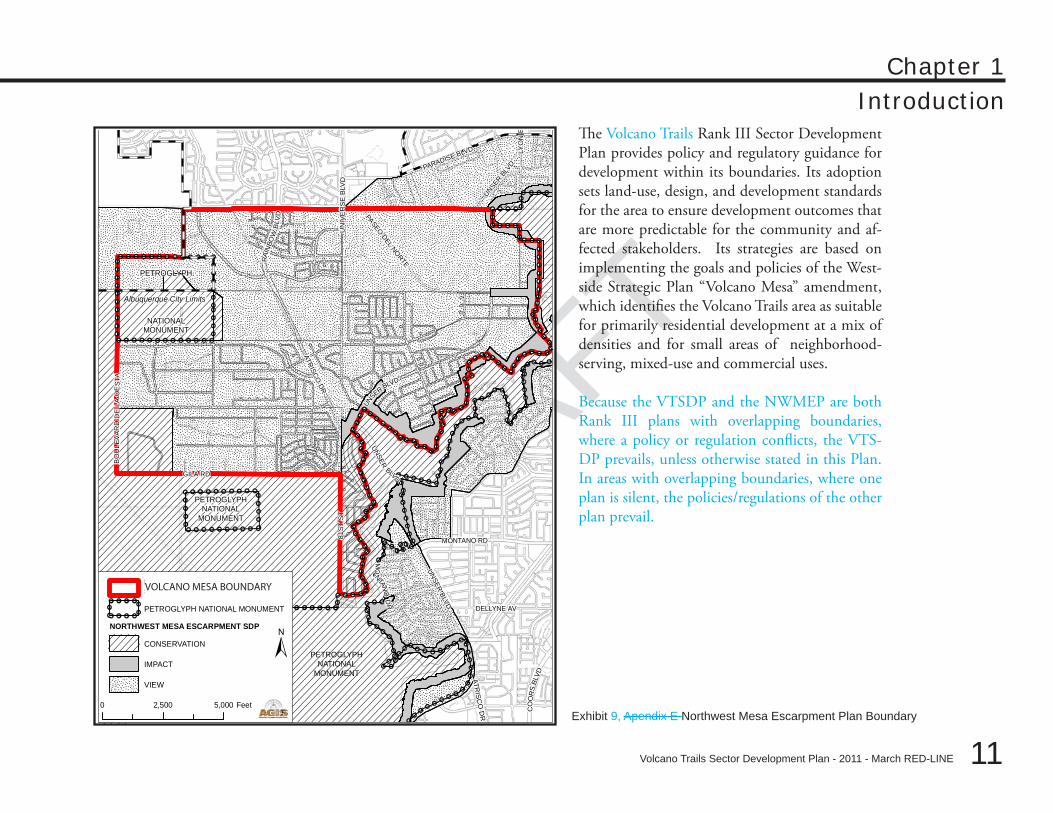
Exhibit 9, Apendix E Northwest Mesa Escarpment Plan Boundary
VOLCANO MESA BOUNDARY
The Volcano Trails Rank III Sector Development Plan provides policy and regulatory guidance for development within its boundaries. Its adoption sets land-use, design, and development standards for the area to ensure development outcomes that are more predictable for the community and af-fected stakeholders. Its strategies are based on implementing the goals and policies of the West-side Strategic Plan “Volcano Mesa” amendment, which identifies the Volcano Trails area as suitable for primarily residential development at a mix of densities and for small areas of neighborhood-serving, mixed-use and commercial uses.
Because the VTSDP and the NWMEP are both Rank III plans with overlapping boundaries, where a policy or regulation conflicts, the VTS-DP prevails, unless otherwise stated in this Plan. In areas with overlapping boundaries, where one plan is silent, the policies/regulations of the other plan prevail.
DRAFT
12
Chapter 1Introduction
Volcano Trails Sector Development Plan - 2011 - March RED-LINE
DRAFTThis Page Left Intentionally Blank
DRAFT
Volcano Trails Sector Development Plan - 2011 - March RED-LINE
DRAFT
DRAFT
13
plan goalsChapter 2
Volcano Trails Sector Development Plan - 2011 - March RED-LINE
DRAFT
14
DRAFT
Chapter 2
Plan Goals
Goals for Volcano TrailsThe Plan’s zoning and development standards are intended to create a context-sensitive development that realizes the policies established by the WSSP Volcano Mesa amendment. 1. Promote Residential Diversity. In order to encourage a range of housing opportunities for various ages and incomes, the Trails development will include apartments, townhouses, small-lot, and medium-lot single-family residential development to attract a diverse population.
2. Create Healthy Residential Neighborhoods. Street and courtyard facing residences—with entrances and windows facing pedestrian paths—support neighborhoods and improve safety. Street-facing buildings keep “eyes on the street” and deter unwanted behavior. Furthermore, when paired with calm streets, street-facing architecture can encourage neighbors to come together and socialize. Blank walls, garage doors, and parking lots have deleterious effects on streets (and parks) and shall be avoided or mitigated. [327]
3. Create Neighborhood Retail Centers. Encourage retail, commercial, and community services homes to be lo-cated within walking distance of homes. Convenience stores and other neighborhood retail, like a grocery store, drugstore and hardware store, are encouraged within Neighborhood Centers to bring retail, commercial, and community services within walking distance of homes.
4. Ensure Quality Design and Sensitivity to Climate. The quality of individual buildings contributes to the sense of place and permanence. These architectural and landscape standards apply to individual buildings, lighting, utilities, walls, and landscape design, with the intent of creating a high-quality built environment with lasting character that draws on southwestern regional styles and traditions. Individual design expression and the diverse character of the land-use districts can all flourish within an overall framework of quality. Architectural elements respond to unique southwestern climatic conditions. This means conserving water and providing shade as relief from harsh sunlight and heat. Building design, architectural elements, drainage, and site design should work together to conserve and harvest water, provide shade as relief from harsh sunlight and heat, and offer protection from seasonal winds and rain.
DRAFT
DRAFT
DRAFT
15
Chapter 2Plan Goals
Volcano Trails Sector Development Plan - 2011 - March RED-LINE
5. Create Neighborhood Edge/Transitions from Open Space areas and the Petroglyph National Monument. Land-scaping and roads are transitions from open space and the Petroglyph National Monument to the built envi-ronment. Roads or other buffer areas should be planned as a transition from Major Public Open Space and the Petroglyph National Monument to residential or commercial development. Landscaping, buildings, and roads are transitions from open space and the Petroglyph National Monument to the built environment. Roads or low density one story residential buildings shall abut the open space. Building colors should be in harmony with the desert palette. Preferred fencing is stucco walls or “coyote fencing.” Native vegetation should be used wherever landscaping is visible to the public. [326]
6. Protect important views, vistas, and view corridors. Important views from locations within Volcano Trails to the Rio Grande basin, across the city of Albuquerque, and to the Sandia Mountains should be protected. Building height limits, site layout, and street orientation are all important tools to protect views into, out of, and through this unique area in perpetuity for nearby residents as well as all Albuquerque citizens and visitors. As development within the Trails will be visible from most of the City of Albuquerque, care should be taken to achieve non-visually intrusive development, especially in the lower-density residential areas adjacent to the Petroglyph National Monument. To minimize the visual impact of development, predominant colors used on structures should blend with the natural colors of the mesa.
DRAFT
16
Chapter 2Plan Goals
Volcano Trails Sector Development Plan - 2011 - March RED-LINE
DRAFTThis Page Left Intentionally Blank
DRAFT
Volcano Trails Sector Development Plan - 2011 - March RED-LINE
DRAFT
DRAFT
17
zoning and general standardsChapter 3
Volcano Trails Sector Development Plan - 2011 - March RED-LINE
DRAFT
18
DRAFT
Chapter 3
Zoning and General Standards
This chapter establishes the framework necessary to implement the Plan. It establishes SU-2 zoning for most properties within the Plan boundary and the development review process associated with the SU-2 zones. Not all properties are rezoned with this Plan. The areas with development pre-existing or approved prior to the adoption of this Plan or that were exempted from the development moratorium during the planning process retain their existing RD zoning.
Section • A-Zoning in this Chapter establishes a framework for future growth that encourages walk-able, transit-supportive districts, while also maintaining many of the area’s scenic qualities and con-serving unique ecological and archeological assets.
Section • B-General Standards in this Chapter contains additional standards that apply across dif-ferent zones. Properties zoned SU-2/VTVC, SU-2/VTUR, SU-2/VTSL, SU-2/VTML, and SU-2/VTRD must comply with the provisions of the General Standards section as applicable. [407]
DRAFT
DRAFT
DRAFT
19
Chapter 3Zoning and General Standards
Volcano Trails Sector Development Plan - 2011 - March RED-LINE
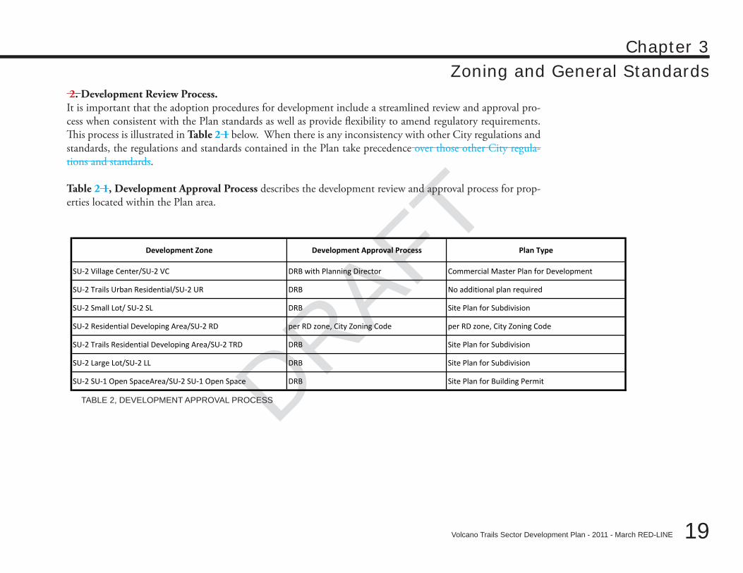
2. Development Review Process.It is important that the adoption procedures for development include a streamlined review and approval pro-cess when consistent with the Plan standards as well as provide flexibility to amend regulatory requirements. This process is illustrated in Table 2 1 below. When there is any inconsistency with other City regulations and standards, the regulations and standards contained in the Plan take precedence over those other City regula-tions and standards.
Table 2 1, Development Approval Process describes the development review and approval process for prop-erties located within the Plan area.
Development Zone Development Approval Process Plan Type
SU‐2 Village Center/SU‐2 VC DRB with Planning Director Commercial Master Plan for Development
SU‐2 Trails Urban Residential/SU‐2 UR DRB No additional plan required
SU‐2 Small Lot/ SU‐2 SL DRB Site Plan for Subdivision
SU‐2 Residential Developing Area/SU‐2 RD per RD zone, City Zoning Code per RD zone, City Zoning Code
SU‐2 Trails Residential Developing Area/SU‐2 TRD DRB Site Plan for Subdivision
SU‐2 Large Lot/SU‐2 LL DRB Site Plan for Subdivision
SU‐2 SU‐1 Open SpaceArea/SU‐2 SU‐1 Open Space DRB Site Plan for Building Permit
TABLE 2, DEVELOPMENT APPROVAL PROCESS
DRAFT
20
Chapter 3Zoning and General Standards
Volcano Trails Sector Development Plan - 2011 - March RED-LINE
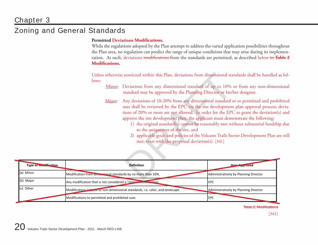
DRAFTPermitted Deviations Modifications.While the regulations adopted by the Plan attempt to address the varied application possibilities throughout the Plan area, no regulation can predict the range of unique conditions that may arise during its implemen-tation. As such, deviations modifications from the standards are permitted, as described below in Table 2 Modifications.
Unless otherwise restricted within this Plan, deviations from dimensional standards shall be handled as fol-lows:
Minor: Deviations from any dimensional standard of up to 10% or from any non-dimensional standard may be approved by the Planning Director or his/her designee.
Major: Any deviations of 10-20% from any dimensional standard or to permitted and prohibited uses shall be reviewed by the EPC via the site development plan approval process; devia-tions of 20% or more are not allowed. In order for the EPC to grant the deviation(s) and approve the site development plan, the applicant must demonstrate the following:
1) the original standard(s) cannot be reasonably met without substantial hardship due to the uniqueness of the site, and
2) applicable goals and policies of the Volcano Trails Sector Development Plan are still met, even with the proposed deviation(s). [341]
Type of Modification Definition How Approved
(a) Minor Modification from dimensional standards by no more than 10%. Administratively by Planning Director
(b) Major Any modification that is not considered a “minor” modification. EPC
Modifications related to non-dimensional standards, i.e. color, and landscape. Administratively by Planning Director
Modifications to permitted and prohibited uses EPC
(c) Other
Table 2, Modifications
[341]
DRAFT
DRAFT
DRAFT
21
Chapter 3Zoning and General Standards
Volcano Trails Sector Development Plan - 2011 - March RED-LINE
Zoning Intention and CharacterThe development standards for each of the zones are located in the following section A-Zoning in this Chapter of this docu-ment.
SU-2 Volcano Trails/Village Center (VTVC)• . Village Centers will put local retail, conveniences, schools, and a “sense of place” within walking distance of most homes. Besides shops, each Village Center will include housing, a small park (parks smaller than 2 acres shall be privately owned and maintained), and civic uses such as daycare and community facilities. [329]
SU-2 Volcano Trails/Urban Residential (VTUR)• . Urban Residential development allows a variety of urban housing types within a network of livable, pedestrian-friendly streets, including courtyard housing, loft apartments, patio homes, townhous-es, duplexes, and detached single-family homes on small lots.
SU-2 Volcano Trails/Suburban Residential–Small Lot (VTSL)• . Suburban Residential–Small Lot development allows typical modern suburban lot sizes but with rear access alleys, houses moved up to the sidewalk, front porches and other features to create a more pedestrian-friendly environment.
SU-2 Volcano Trails/Suburban Residential–Medium Lot (VTML)• . Suburban Residential–Medium Lot development allows homes on larger lots (+11,000 square feet), respecting the existing platting, built in a way that protects the natural environ-ment, preserves significant view corridors, and contains visible private open space.
SU-2 Volcano Trails Residential Developing Area (VTRD)• . Residential Developing Area allows for RD zoning and approval process per City Zoning Code §14-16-2-14. Lots without alleys shall be limited to a minimum lot size of 5000 square feet. On alley lots minimum lot size shall be 3000 square feet. All development in the Volcano Trails/RD zone shall meet applicable requirements in the General Standards section.
Residential Developing Area (RD)• . This area was exempted from the planning process and retains its existing zoning and is subject to the regulations of the RD zone per the City Zoning Code §14-16-2-14.
SU-2 • Volcano Trails Open Space. Open Space areas are dedicated City property. This area includes proposed and existing private-ly owned and maintained (i.e. Homeowners Association-owned and maintained) parks, open space, and trails, which meet the developer’s Off-site Open Space dedication requirements. [326] [399]
DRAFT
22
Chapter 3Zoning and General Standards
Volcano Trails Sector Development Plan - 2011 - March RED-LINE
DRAFTThis Page Left Intentionally Blank
DRAFT
DRAFT
DRAFT
23
Chapter 3Zoning and General Standards
Volcano Trails Sector Development Plan - 2011 - March RED-LINE
A – ZONING
DRAFT
24
Chapter 3
Volcano Trails Sector Development Plan - 2011 - March RED-LINE
DRAFT
A –Zoning
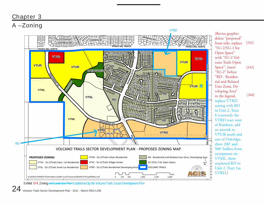
Exhibit 10 7, Zoning and Land Use Plan Established by the Volcano Trails Sector Development Plan
VTVC
VTSL
VTLL
VTLL
VTUR VTUR
RDRD
RDRD RDRD
RD
VTRD
RD
VTSLVTSL
VTSL
VTUR
VTSL
VTSL
RD
RD
RDRD
RD
RD
RD
RD
RD
VTRD
VTURVTVC
RD
EDISON RD
LAD
RO
N D
RTEYPANA RD
TREE LINE AV
SABI
NAL
DR
WILLIAMSBURG RD
HA
LLST
ON
TRL KAYSER MILL RD
GLYNDON TRL
WO
ODMONT AV
WOODMONT AVWOODMONT AV
PASEO DEL NORTEPASEO DEL NORTE PASEO DEL NORTE
TIJERAS CREEK RD
KAYSER MILL RD
LAS NUTRIAS RD
MES
A PL
TOME
CT
OLD
MIL
L ST
OASIS CANYON RD
RAIN
BOW
BLV
DRAINBO
W BLVD
CUCHILLO RD
SENDERO RD
TALA
RA PL
TREELINE AV
CERROS PL
UN
IVER
SE B
LVD
UN
IVE R
SE B
L VD
LATIR MESA RD
CROSSWINDS TRL
OA
KRID
GE
ST
VALLE
PRADO
LA
RIO
GA
LIST
EO PL
SU-2
/SU-
1OPEN SPACE
PROPOSED ZONING
VTLL - SU-2/Trails Large Lot Residential
VTSL - SU-2/Trails Small Lot Residential
VTUR - SU-2/Trails Urban Residential
VTVC - SU-2/Trails Village Center
VTRD - SU-2/Trails Residential Developing Area
RD - Residential and Related Uses Zone, Developing Area
SU-2/SU-1 for Open Space
VOLCANO TRAILS
VOLCANO TRAILS SECTOR DEVELOPMENT PLAN - PROPOSED ZONING MAP
´Q:\AGISFILE\PROJECTS\PetraMorris\DMZ-Jun10-VolcanoCliffsSDP\VTPropZONING.mxd 0 500 1,000 1,500 2,000250
Feet
VTML
VTML
VTML Med.
[Revise graphic: delete “proposed” from title, replace “SU-2/SU-1 for Open Space” with “SU-2 Vol-cano Trails Open Space”, insert “SU-2” before “RD - Residen-tial and Related Uses Zone, De-veloping Area” in the legend, replace VTRD zoning with RD in Unit 2, Tract 8 (currently the VTRD tract west of Rainbow, add an asterisk to VTUR south and east of Oakridge, show 200’ and 500’ buffers from escarpment on VTML, show unplatted RD in Unit 2, Tract 1as VTRD.]
[332]
[333]
[368]
VTRD
RD
DRAFT
DRAFT
DRAFT
25
Chapter 3
Volcano Trails Sector Development Plan - 2011 - March RED-LINE
A –ZoningPre-existing Standards for Development. Previously Omitted Standards. The following regulations were established for Unit 2 and Phase 1 development prior to the adoption of this Plan. Where there is a conflict between these requirements in this section and the requirements in the other sections of this regula-tion Plan, these requirements this section shall prevail. [342]
Subdivisions and site development plans approved prior to the adoption of this Plan are subject 1. only to the requirements approved at the time of their approval. This includes the Cantata @ the Trails (shown with an asterisk on Exhibit 10) approved by the DRB in October 2007.
The privately owned and maintained open space2. /parks zoned SU-2 Volcano Trails Open Space OS-4 park in the open space area may be amended so as to accommodate a 3-acre park area with-out decreasing the amount of dedicated open space shall count toward the developer’s open space dedication requirements. [332]
Street C, now on the south boundary of Unit 2-Tract 11, shall be moved to the proposed City 3. Open Space area and connect from Rainbow to the middle school site. Street C shall be removed to the west of this point. A new street connection shall be shown provided from Woodmont to the North Geologic Window adjacent to the open space shown in the land-use plan to allow mainte-nance access for City vehicles. The ultimate location is to be determined via coordination between the City and the developer. [342]
The ultimate location of 4. the street to serve the APS schools south of the Plan area Street D may be changed based on the size and location of park / school site in Unit 2-Tract 12 and Unit 3-Tract 6. [342]
A new street connection shall be shown 5. as a dotted line from Woodmont west to private property in Bernalillo County that is currently landlocked per agreement with the developer. [342]
3. The Zones. The following section contains the development standards for new SU-2 zones established by the Plan. The section is divided into two parts, the zones and the general standards. The SU-2 RD and SU-2 SU-1 Open Space zones are regulated by the City Zoning Code with the following exceptions: [340]
Volcano Trails Sector Development Plan - 2011 - March RED-LINE
DRAFT
26
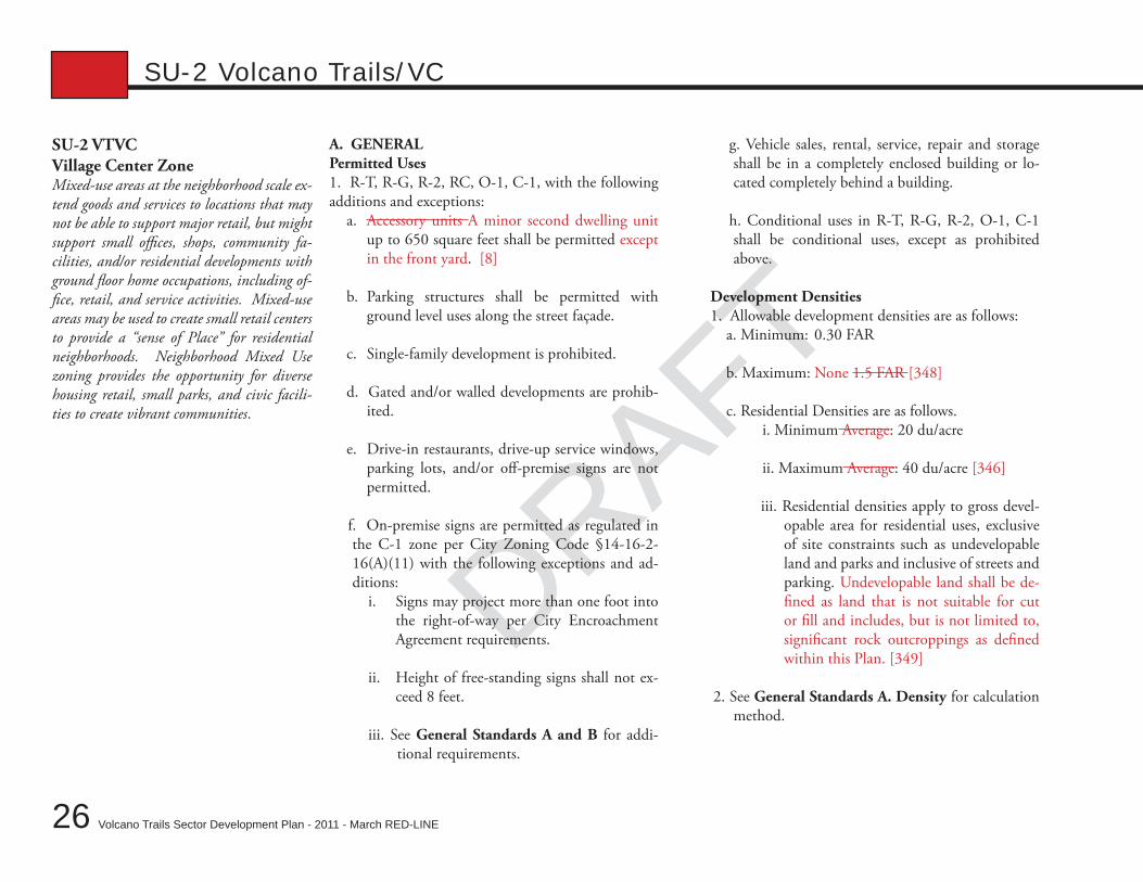
DRAFTSU-2 VTVCVillage Center ZoneMixed-use areas at the neighborhood scale ex-tend goods and services to locations that may not be able to support major retail, but might support small offices, shops, community fa-cilities, and/or residential developments with ground floor home occupations, including of-fice, retail, and service activities. Mixed-use areas may be used to create small retail centers to provide a “sense of Place” for residential neighborhoods. Neighborhood Mixed Use zoning provides the opportunity for diverse housing retail, small parks, and civic facili-ties to create vibrant communities.
g. Vehicle sales, rental, service, repair and storage shall be in a completely enclosed building or lo-cated completely behind a building.
h. Conditional uses in R-T, R-G, R-2, O-1, C-1 shall be conditional uses, except as prohibited above.
Development Densities1. Allowable development densities are as follows:
a. Minimum: 0.30 FAR
b. Maximum: None 1.5 FAR [348]
c. Residential Densities are as follows. i. Minimum Average: 20 du/acre ii. Maximum Average: 40 du/acre [346]
iii. Residential densities apply to gross devel-opable area for residential uses, exclusive of site constraints such as undevelopable land and parks and inclusive of streets and parking. Undevelopable land shall be de-fined as land that is not suitable for cut or fill and includes, but is not limited to, significant rock outcroppings as defined within this Plan. [349]
2. See General Standards A. Density for calculation method.
A. GENERALPermitted Uses1. R-T, R-G, R-2, RC, O-1, C-1, with the following additions and exceptions:
a. Accessory units A minor second dwelling unit up to 650 square feet shall be permitted except in the front yard. [8]
b. Parking structures shall be permitted with ground level uses along the street façade.
c. Single-family development is prohibited.
d. Gated and/or walled developments are prohib-ited.
e. Drive-in restaurants, drive-up service windows, parking lots, and/or off-premise signs are not permitted.
f. On-premise signs are permitted as regulated in the C-1 zone per City Zoning Code §14-16-2-16(A)(11) with the following exceptions and ad-ditions:
i. Signs may project more than one foot into the right-of-way per City Encroachment Agreement requirements.
ii. Height of free-standing signs shall not ex-ceed 8 feet.
iii. See General Standards A and B for addi-tional requirements.
SU-2 Volcano Trails/VC
DRAFT
DRAFT
DRAFT
27
Chapter 3: A – Zoning
Volcano Trails Sector Development Plan - 2011 - March RED-LINE
SU-2 Volcano Trails/VCLot sizes1. Lot sizes shall be limited as follows:
a. Minimum: None
b. Maximum: 300 feet wide and 300 feet deep[411]
c. Lots may exceed 90,000 square feet if a pedes-trian street a minimum of 12 feet wide connects a minimum of two public streets through the lot at least every 300 feet measured along the street fa-çade.
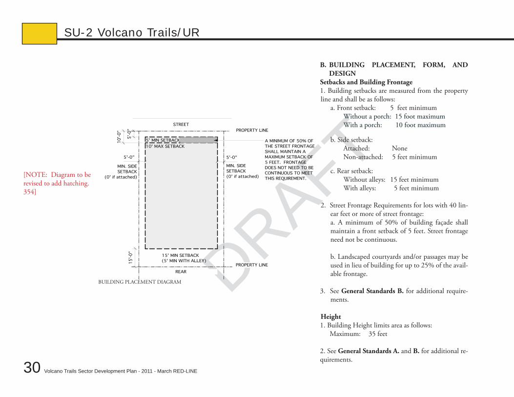
B. BUILDING PLACEMENT, FORM, AND DESIGN
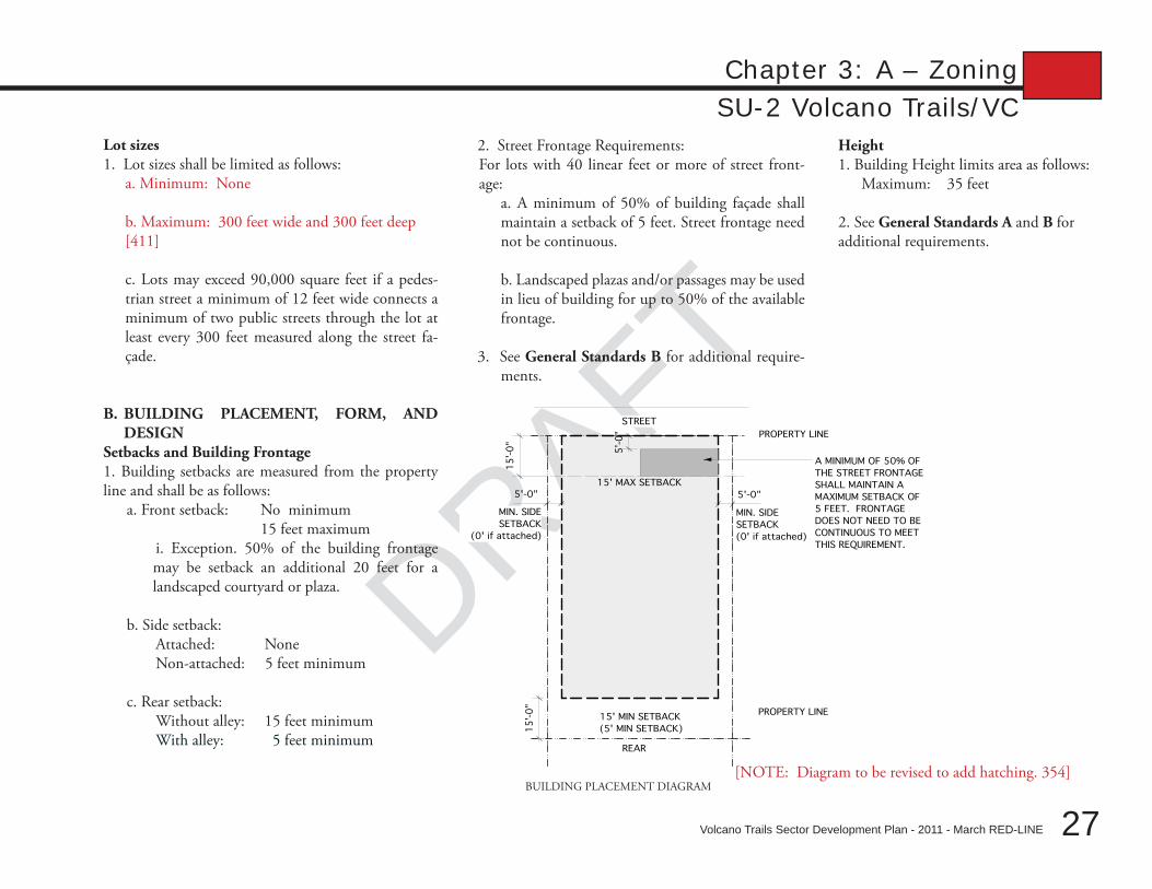
Setbacks and Building Frontage1. Building setbacks are measured from the property line and shall be as follows:
a. Front setback: No minimum 15 feet maximum
i. Exception. 50% of the building frontage may be setback an additional 20 feet for a landscaped courtyard or plaza.
b. Side setback: Attached: None Non-attached: 5 feet minimum
c. Rear setback: Without alley: 15 feet minimum With alley: 5 feet minimum
2. Street Frontage Requirements: For lots with 40 linear feet or more of street front-age:
a. A minimum of 50% of building façade shall maintain a setback of 5 feet. Street frontage need not be continuous.
b. Landscaped plazas and/or passages may be used in lieu of building for up to 50% of the available frontage.
3. See General Standards B for additional require-ments.
STREET
REAR
5'-0"5'-0"
15
'-0
"
15
'-0
"
PROPERTY LINE
15' MAX SETBACK
PROPERTY LINE15' MIN SETBACK
(5' MIN SETBACK)
MIN. SIDE
SETBACK
(0' if attached)
MIN. SIDE
SETBACK
(0' if attached)
A MINIMUM OF 50% OF
THE STREET FRONTAGE
SHALL MAINTAIN A
MAXIMUM SETBACK OF
5 FEET. FRONTAGE
DOES NOT NEED TO BE
CONTINUOUS TO MEET
THIS REQUIREMENT.
5'-
0"
BUILDING PLACEMENT DIAGRAM[NOTE: Diagram to be revised to add hatching. 354]
Height1. Building Height limits area as follows:
Maximum: 35 feet
2. See General Standards A and B for additional requirements.
DRAFT
28 Volcano Trails Sector Development Plan - 2011 - March RED-LINE
DRAFT
SU-2 Volcano Trails/VC
Building Articulation1. The following standards shall apply: a. Transparency: At least 25% of the ground floor fa-
çade of street-facing elevations shall be comprised of windows and/or entrances.
i. Exception: Ground-level, street-facing façades that are not the primary entrances and are located on streets classified as Arterial or higher may utilize Win-dow Cases located a minimum of 20 feet on center per Planning Director (or his/her designee) approval. See General Standards B.5. for additional requirements. [353]
b. Residential garages shall be setback from the front façade. See General Standards B.8. c. A minimum of 50% of the street frontage shall be accompanied by portals, verandas and/or arcades. See General Standards B.7.
2. See General Standards B for additional require-ments.
C. LANDSCAPE REqUIREMENTS1. The following requirements shall apply:
a. Shall meet city standard landscape requirements for non-residential development per City Zoning Code §14-16-3-10.
b. Plants shall be from the General Regulation B Plant List A and/or Plant List B (see Chapter 4 Gen-eral Regulation B for plant lists).
c. Walls shall be limited to 6 feet in height and within 3 feet of the front yard setback. Walls may be up to 4
foot high within the front yard setback of residential buildings. See General Standards A. for additional requirements. [352]
2. See General Standards A. and C. for additional re-quirements.
D. USABLE OPEN SPACE REqUIREMENTS 1. Multifamily dwellings: Private: 60 square feet/du minimum Shared: 80 square feet/du minimum
2. Off-site Open Space dedication requirements are met by existing or proposed parks and trails.
3. Plaza or Courtyard Public Space. All commercial development over 2 acres shall include a 1,000 square feet minimum privately owned and maintained pub-lic space adjacent to retail/office areas. Public space shall be hardscaped, with seating and shading covering a minimum of 50% of the area. Shade coverage may be trees or other shading devices. Public space shall be linked to the main entrance of adjacent structures by a public sidewalk and have pedestrian-scale lighting and trash receptacles.
4. See General Standards D. for additional require-ments.
E. PARkING REqUIREMENTS1. Parking Calculations are as follows:
a. Residential: 1/unit minimum
b. Non-Residential: 1/1000 square feet minimum
2. See General Standards E. for additional require-ments.
DRAFT
DRAFT
DRAFT
29
Chapter 3: A – Zoning
Volcano Trails Sector Development Plan - 2011 - March RED-LINE
SU-2 Volcano Trails/URSU-2 VTURUrban Residential ZoneThe Urban Residential zone provides a di-verse range of mixed density housing in order to suit a range of lifestyles in a pedestrian ori-ented residential environment.
Lot sizes 1. The following requirements shall apply:
a. On lots without alleys, minimum lot size shall be 5000 square feet.
b. On alley lots minimum lot size shall be 3000 square feet.
A. GENERALPermitted Uses 1. R-T and R-2, with the following additions and
exceptions:a. R-T development requires a minimum lot size of 20 by 90 feet. [358]
b. a. Accessory units A minor second dwelling unit up to 650 square feet shall be permitted except in the front yard. [8]
c. b. Parking structures shall be permitted under-ground.
d. c. Gated and/or walled developments are pro-hibited. [356]
Development Densities1. Allowable development densities are as follows:
a. Minimum: 10 du/acre
b. Maximum: 20 du/acre
c. Residential densities apply to gross develop-able area for residential uses, exclusive of site con-straints such as undevelopable land and parks and inclusive of streets and parking. Undevelopable land shall be defined as land that is not suitable for cut or fill and includes, but is not limited to, significant rock outcroppings as defined within this Plan. [349]
2. See General Standards A. Density for additional requirements.
DRAFT
30 Volcano Trails Sector Development Plan - 2011 - March RED-LINE
DRAFT
SU-2 Volcano Trails/UR
B. BUILDING PLACEMENT, FORM, AND DESIGN
Setbacks and Building Frontage1. Building setbacks are measured from the property line and shall be as follows:
a. Front setback: 5 feet minimum Without a porch: 15 foot maximum With a porch: 10 foot maximum
b. Side setback: Attached: None Non-attached: 5 feet minimum
c. Rear setback: Without alleys: 15 feet minimum With alleys: 5 feet minimum
2. Street Frontage Requirements for lots with 40 lin-ear feet or more of street frontage:a. A minimum of 50% of building façade shall maintain a front setback of 5 feet. Street frontage need not be continuous.
b. Landscaped courtyards and/or passages may be used in lieu of building for up to 25% of the avail-able frontage.
3. See General Standards B. for additional require-ments.
Height1. Building Height limits area as follows:
Maximum: 35 feet
2. See General Standards A. and B. for additional re-quirements.
MIN. SIDE
SETBACK
(0' if attached)
STREET
REAR
MIN. SIDE
SETBACK
(0' if attached)
5'-0"5'-0"
5'-
0"
15
'-0
"PROPERTY LINE
PROPERTY LINE
15' MIN SETBACK
(5' MIN WITH ALLEY)
A MINIMUM OF 50% OF
THE STREET FRONTAGE
SHALL MAINTAIN A
MAXIMUM SETBACK OF
5 FEET. FRONTAGE
DOES NOT NEED TO BE
CONTINUOUS TO MEET
THIS REQUIREMENT.
5' MIN SETBACK10
'-0
"
10' MAX SETBACK
BUILDING PLACEMENT DIAGRAM
[NOTE: Diagram to be revised to add hatching. 354]
DRAFT
DRAFT
DRAFT
31
Chapter 3: A – Zoning
Volcano Trails Sector Development Plan - 2011 - March RED-LINE
SU-2 Volcano Trails/URBuilding Articulation1. The following articulation standards shall apply to
buildings in the SU-2 Trails/UR zone: a. Transparency: At least 25% of the area of the
street-facing elevations shall be comprised of win-dows and/or entrances. Ground-level, street-facing façades that are not the primary entrances and are located on streets classified as Arterial or higher may utilize Window Cases located a minimum of 20 feet on center per Planning Director (or his/her designee) approval. See General Standards B.5. for additional requirements. [353]
b. Residential garages shall be setback from the front façade. See General Standards B.8. for ad-ditional requirements.
c. Each detached, single-family dwelling unit shall address the street with one of the following three options. In the case of a developer constructing 3 or more detached, single-family dwelling units, at least 2 of every 3 shall incorporate a porch.
Options:a porch or stoop at least 5 feet in depth•
a walled courtyard with entrance easily vis-•ible from the public right-of-way
a window on the front façade that directly •faces the street
2. See General Standards B. for additional require-ments.
C. LANDSCAPE REqUIREMENTS1. The following landscape requirements shall apply to all development in the UR zone:
a. One tree and 50% vegetative cover in front of all single family lots.
b. All non-single-family development shall follow City Standard Landscaping requirements per City Zoning Code §14-16-3-10.
c. Plants shall be from the General Regulation B – Plant List A and/or Plant List B (see Chapter 4 General Regulation B for plant lists).
d. Walls shall be per City Zoning Code §14-16-3-19. See General Requirements A. for additional requirements. Walls shall be limited to: i. 4 feet maximum in front yard setback. ii. Rear Walls are per City Standards [357]
2. See General Standards A. and C. for additional requirements.
D. USABLE OPEN SPACE REqUIREMENTS1. Multifamily dwellings: Private: 60 square feet/du minimum Shared: 80 square feet/du minimum
2. Off-site Open Space dedication requirements are met by existing or proposed parks and trails.
3. See General Standards D. for additional require-ments.
E. PARkING REqUIREMENTS1. Parking Calculations are as follows:
a. Residential: 1/du minimum
2. See General Standards E. for additional requirements.
DRAFT
32 Volcano Trails Sector Development Plan - 2011 - March RED-LINE
DRAFT
SU-2 Volcano Trails/RD
SU-2 VTRDResidential Developing Area ZoneThe Volcano Trails Residential Developing Area Zone provides a predominantly resi-dential area, including a mixture of dwelling unit types, with incidental, related commer-cial activities.
A. GENERALPermitted Uses 1. RD per City Zoning Code §14-16-2-14 except for the following:
a. A minor second dwelling unit up to 650 square feet shall be permitted except in the front yard.
b. Gated and/or walled developments are prohib-ited.
Lot sizes 1. The following requirements shall apply:
a. On lots without alleys, minimum lot size shall be 5000 square feet.
b. On alley lots minimum lot size shall be 3000 square feet.
B. BUILDING PLACEMENT, FORM, AND DESIGN
Building Articulation1. The following articulation standards shall apply
to buildings in the SU-2 Trails/UR zone: a. Transparency: At least 25% of the area of the
street-facing elevations shall be comprised of windows and/or entrances.
b. Residential garages shall be setback from the front façade. See General Standards B. 8. for additional requirements.
c. Each dwelling unit shall have a porch or stoop address the street with one of the following three options. In the case of a developer con-structing 3 or more dwelling units, at least 2 of every 3 shall incorporate a porch.
Options:a porch or stoop at least 5 feet in depth•
a walled courtyard with entrance easily •visible from the public right-of-way
a window on the front façade that di-•rectly faces the street
2. See General Standards B. for additional require-ments.
DRAFT
DRAFT
DRAFT
33
Chapter 3: A – Zoning
Volcano Trails Sector Development Plan - 2011 - March RED-LINE
SU-2 Volcano Trails/RDC. LANDSCAPE REqUIREMENTS1. The following landscape requirements shall apply to all development in the VTRD zone:
a. One tree and 50% vegetative cover in front of all single family lots.
b. All development that is not single-family resi-dential shall follow City Standard Landscaping re-quirements per City Zoning Code §14-16-3-10.
c. Plants shall be from the General Regulation B – Plant List A and/or Plant List B (see Chapter 4 General Regulation B for plant lists).
d. Walls shall be per City Zoning Code §14-16-3-19. See General Requirements A. for more re-quirements.
e. Off-street pedestrian connections via a land-scaped parkway with a trail on one side shall be permitted in lieu of street sidewalks.
2. See General Standards C. for additional require-ments.
D. USABLE OPEN SPACE REqUIREMENTS1. No additional requirements to RD.
E. PARkING REqUIREMENTS1. No additional requirements to RD.
Volcano Trails Sector Development Plan - 2011 - March RED-LINE
DRAFT
34
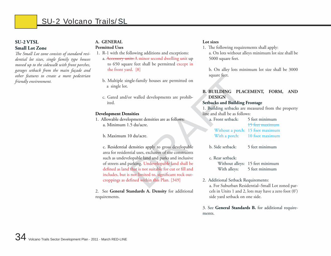
DRAFTSU-2 VTSLSmall Lot ZoneThe Small Lot zone consists of standard resi-dential lot sizes, single family type houses moved up to the sidewalk with front porches, garages setback from the main façade and other features to create a more pedestrian friendly environment.
A. GENERALPermitted Uses 1. R-1 with the following additions and exceptions:
a. Accessory units A minor second dwelling unit up to 650 square feet shall be permitted except in the front yard. [8]
b. Multiple single-family houses are permitted on a single lot.
c. Gated and/or walled developments are prohib-ited.
Development Densities1. Allowable development densities are as follows:
a. Minimum 1.5 du/acre.
b. Maximum 10 du/acre.
c. Residential densities apply to gross developable area for residential uses, exclusive of site constraints such as undevelopable land and parks and inclusive of streets and parking. Undevelopable land shall be defined as land that is not suitable for cut or fill and includes, but is not limited to, significant rock out-croppings as defined within this Plan. [349]
2. See General Standards A. Density for additional requirements.
Lot sizes 1. The following requirements shall apply:
a. On lots without alleys minimum lot size shall be 5000 square feet.
b. On alley lots minimum lot size shall be 3000 square feet.
B. BUILDING PLACEMENT, FORM, AND DESIGN
Setbacks and Building Frontage1. Building setbacks are measured from the property line and shall be as follows:
a. Front setback: 5 feet minimum 15 feet maximum Without a porch: 15 foot maximum With a porch: 10 foot maximum
b. Side setback: 5 feet minimum c. Rear setback: Without alleys: 15 feet minimum With alleys: 5 feet minimum
2. Additional Setback Requirements: a. For Suburban Residential–Small Lot zoned par-
cels in Units 1 and 2, lots may have a zero foot (0’) side yard setback on one side.
3. See General Standards B. for additional require-ments.
SU-2 Volcano Trails/SL
DRAFT
DRAFT
DRAFT
35
Chapter 3: A – Zoning
Volcano Trails Sector Development Plan - 2011 - March RED-LINE
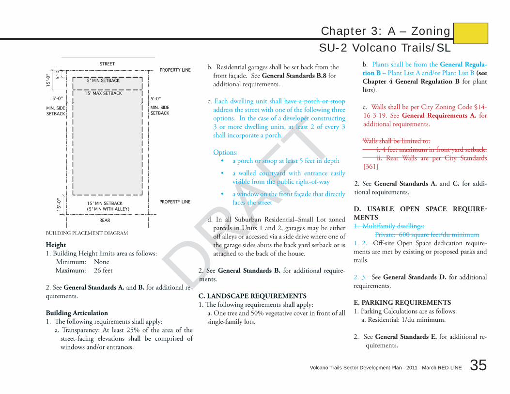
SU-2 Volcano Trails/SL
b. Residential garages shall be set back from the front façade. See General Standards B.8 for additional requirements.
c. Each dwelling unit shall have a porch or stoop address the street with one of the following three options. In the case of a developer constructing 3 or more dwelling units, at least 2 of every 3 shall incorporate a porch.
Options:
a porch or stoop at least 5 feet in depth•
a walled courtyard with entrance easily •visible from the public right-of-way
a window on the front façade that directly •faces the street
d. In all Suburban Residential–Small Lot zoned parcels in Units 1 and 2, garages may be either off alleys or accessed via a side drive where one of the garage sides abuts the back yard setback or is attached to the back of the house.
2. See General Standards B. for additional require-ments.
C. LANDSCAPE REqUIREMENTS1. The following requirements shall apply:
a. One tree and 50% vegetative cover in front of all single-family lots.
Height1. Building Height limits area as follows:
Minimum: NoneMaximum: 26 feet
2. See General Standards A. and B. for additional re-quirements.
Building Articulation1. The following requirements shall apply:
a. Transparency: At least 25% of the area of the street-facing elevations shall be comprised of windows and/or entrances.
MIN. SIDE
SETBACK
STREET
REAR
MIN. SIDE
SETBACK
5'-0"5'-0"
5'-
0"
15'-
0"
PROPERTY LINE
PROPERTY LINE15' MIN SETBACK
(5' MIN WITH ALLEY)
15'-
0"
5' MIN SETBACK
15' MAX SETBACK
BUILDING PLACEMENT DIAGRAM
b. Plants shall be from the General Regula-tion B – Plant List A and/or Plant List B (see Chapter 4 General Regulation B for plant lists).
c. Walls shall be per City Zoning Code §14-16-3-19. See General Requirements A. for additional requirements.
Walls shall be limited to: i. 4 feet maximum in front yard setback. ii. Rear Walls are per City Standards [361]
2. See General Standards A. and C. for addi-tional requirements.
D. USABLE OPEN SPACE REqUIRE-MENTS1. Multifamily dwellings:
Private: 600 square feet/du minimum1. 2. Off-site Open Space dedication require-ments are met by existing or proposed parks and trails.
2. 3. See General Standards D. for additional requirements.
E. PARkING REqUIREMENTS1. Parking Calculations are as follows:
a. Residential: 1/du minimum.
2. See General Standards E. for additional re-quirements.
Volcano Trails Sector Development Plan - 2011 - March RED-LINE
DRAFT
36
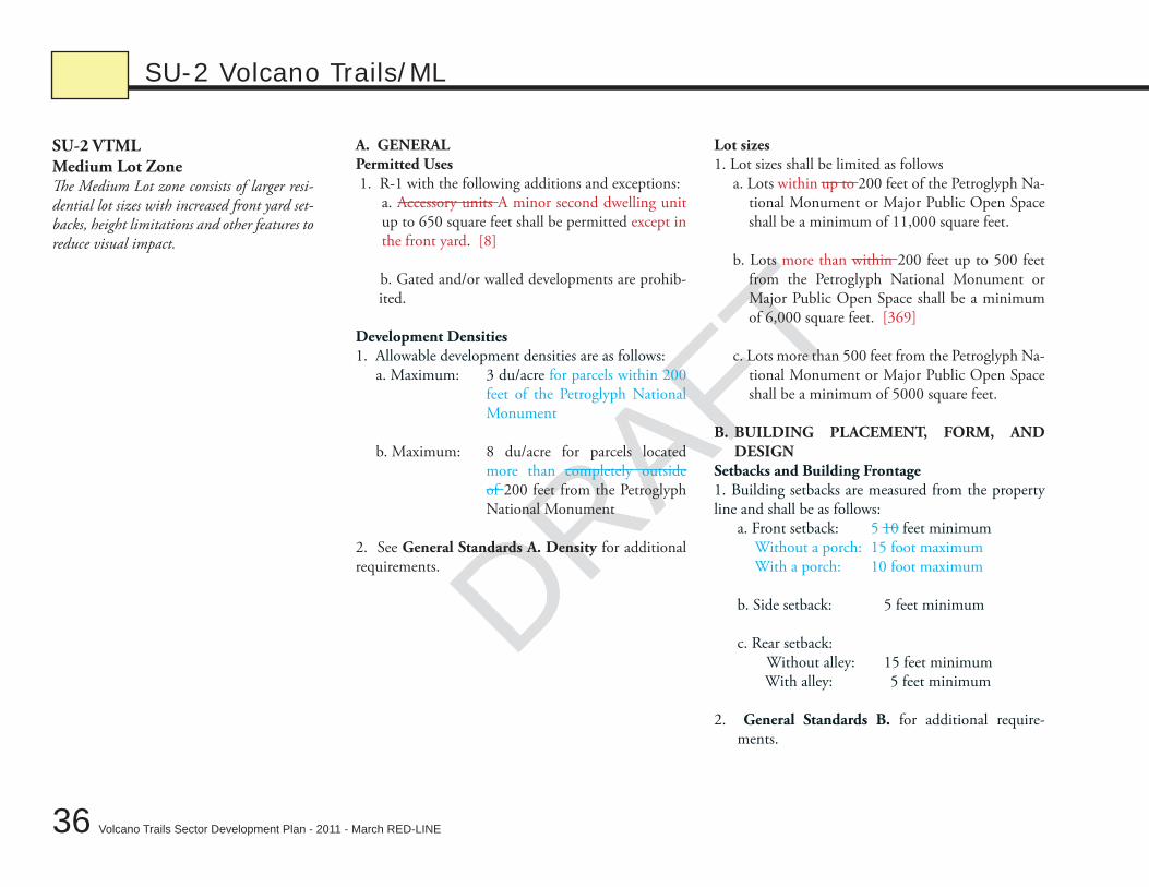
DRAFTSU-2 VTMLMedium Lot ZoneThe Medium Lot zone consists of larger resi-dential lot sizes with increased front yard set-backs, height limitations and other features to reduce visual impact.
A. GENERALPermitted Uses 1. R-1 with the following additions and exceptions:
a. Accessory units A minor second dwelling unit up to 650 square feet shall be permitted except in the front yard. [8]
b. Gated and/or walled developments are prohib-ited.
Development Densities1. Allowable development densities are as follows:
a. Maximum: 3 du/acre for parcels within 200 feet of the Petroglyph National Monument
b. Maximum: 8 du/acre for parcels located more than completely outside of 200 feet from the Petroglyph National Monument
2. See General Standards A. Density for additional requirements.
Lot sizes1. Lot sizes shall be limited as follows
a. Lots within up to 200 feet of the Petroglyph Na-tional Monument or Major Public Open Space shall be a minimum of 11,000 square feet.
b. Lots more than within 200 feet up to 500 feet from the Petroglyph National Monument or Major Public Open Space shall be a minimum of 6,000 square feet. [369]
c. Lots more than 500 feet from the Petroglyph Na-tional Monument or Major Public Open Space shall be a minimum of 5000 square feet.
B. BUILDING PLACEMENT, FORM, AND DESIGN
Setbacks and Building Frontage1. Building setbacks are measured from the property line and shall be as follows:
a. Front setback: 5 10 feet minimum Without a porch: 15 foot maximum With a porch: 10 foot maximum b. Side setback: 5 feet minimum c. Rear setback: Without alley: 15 feet minimum With alley: 5 feet minimum
2. General Standards B. for additional require-ments.
SU-2 Volcano Trails/ML
DRAFT
DRAFT
DRAFT
37
Chapter 3: A – Zoning
Volcano Trails Sector Development Plan - 2011 - March RED-LINE
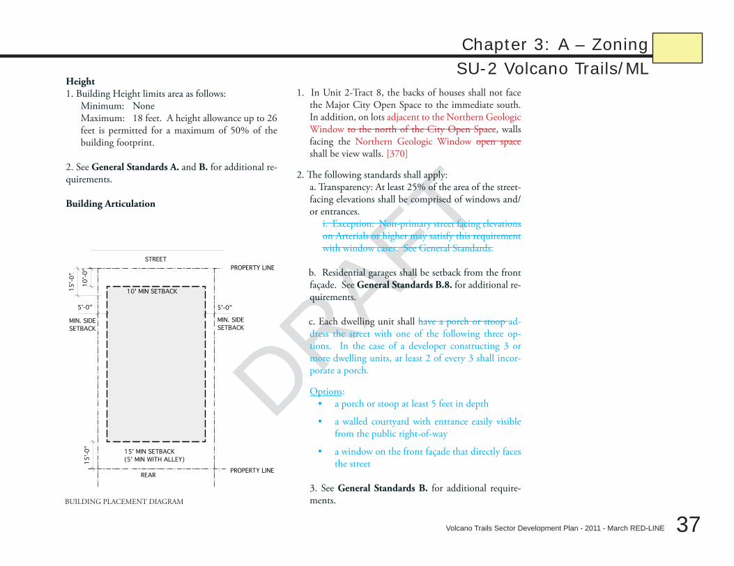
SU-2 Volcano Trails/MLHeight1. Building Height limits area as follows:
Minimum: NoneMaximum: 18 feet. A height allowance up to 26 feet is permitted for a maximum of 50% of the building footprint.
2. See General Standards A. and B. for additional re-quirements.
Building Articulation
1. In Unit 2-Tract 8, the backs of houses shall not face the Major City Open Space to the immediate south. In addition, on lots adjacent to the Northern Geologic Window to the north of the City Open Space, walls facing the Northern Geologic Window open space shall be view walls. [370]
2. The following standards shall apply: a. Transparency: At least 25% of the area of the street-
facing elevations shall be comprised of windows and/or entrances.
i. Exception: Non-primary street facing elevations on Arterials or higher may satisfy this requirement with window cases. See General Standards.
b. Residential garages shall be setback from the front façade. See General Standards B.8. for additional re-quirements. c. Each dwelling unit shall have a porch or stoop ad-dress the street with one of the following three op-tions. In the case of a developer constructing 3 or more dwelling units, at least 2 of every 3 shall incor-porate a porch.
Options:a porch or stoop at least 5 feet in depth•
a walled courtyard with entrance easily visible •from the public right-of-way
a window on the front façade that directly faces •the street
3. See General Standards B. for additional require-ments.
MIN. SIDE
SETBACK
STREET
REAR
MIN. SIDE
SETBACK
5'-0"5'-0"
10
'-0
"1
5'-
0"
PROPERTY LINE
PROPERTY LINE
15' MIN SETBACK
(5' MIN WITH ALLEY)
15
'-0
"
10' MIN SETBACK
BUILDING PLACEMENT DIAGRAM
DRAFT
38 Volcano Trails Sector Development Plan - 2011 - March RED-LINE
DRAFT
C. LANDSCAPE REqUIREMENTS1. The following requirements shall apply:
a. One tree and 50% vegetative cover in front of all single family lots.
b. Plant Lists.i. Lots within 200 feet of the Petroglyph Na-
tional Monument shall use plants from General Regulation B - Plant List A only.
ii. Lots more than 200 feet from the Petro-glyph National Monument shall use plants from General Regulation B Plant List A and/or B.
iii. See General Regulation B for plant lists.
c. Walls shall be per City Zoning Code §14-16-3-19. See General Requirements, Walls and Fences for exceptions. Walls shall be limited to: i. 3 feet maximum in front yard setback. ii. Rear Walls are per City Standards [367]
2. See General Standards C. for additional require-ments.
D. USABLE OPEN SPACE REqUIREMENTS1. Off-site Open Space dedication requirements are met by existing or proposed parks and trails.
2. See General Standards D. for additional require-ments.
E. PARkING REqUIREMENTS1. Parking Calculations are as follows:
a. Residential: 1/du minimum
2. See General Standards E. for additional require-ments.
SU-2 Volcano Trails/ML
DRAFT
DRAFT
DRAFT
39
Chapter 3Zoning and General Standards
Volcano Trails Sector Development Plan - 2011 - March RED-LINE
B – GENERAL STANDARDS
DRAFT
40
Chapter 3
Volcano Trails Sector Development Plan - 2011 - March RED-LINE
B – General Standards
DRAFT
The General Standards are applicable to the following SU-2 zones: Village Center (VTVC), Urban Residential, (VTUR), Small Lot (VTSL), Medium Lot (VTML), and Residential Developing Area (VTRD). The General Standards do not apply to property zoned SU-2 Residential Developing Area (RD). The General Standards include General Requirements, Building Standards, Landscape Standards, Us-able Open Space Standards, and Parking Standards. [373]
quality. The quality of individual buildings contributes to the sense of place and permanence. These architectural and landscape stan-dards apply to individual buildings, lighting, utilities, walls, and landscape design, with the intent of creating a high-quality built envi-ronment with lasting character that draws on southwestern regional styles and traditions. Individual design expression and the diverse character of the land-use districts can all flourish within an overall framework of quality.
Climate. Architectural elements should respond to the unique climatic conditions of the southwest. In particular, this means conserving water and providing shade as relief from harsh sunlight and heat.
Views. Important views from locations within Volcano Heights to the Rio Grande basin, across the city of Albuquerque and to the Sandia Mountains should be protected. As development within the Trails will be visible from most of the City of Albuquerque, care should be taken to achieve nonvisually intrusive development, especially in the lower-density residential areas adjacent to the Petroglyph National Monument. To minimize the visual impact of development, predominant colors used on structures will blend with the natural colors of the mesa.
A. GENERAL DESIGN STANDARDS1. Where there is a conflict between the regulations in this document and those of the Northwest Mesa Escarpment Plan, this Plan the Northwest Mesa Escarpment Plan shall prevail unless otherwise detailed in this Plan. Where one plan is silent, policies and regulations in the other plan prevail.
2. The General Regulations section of the City Zoning Code §14-16-3 shall apply with the following additions and exceptions:
Density1. Floor Area Ratio shall be defined as the gross floor area of all buildings at all levels divided by the total of site area of a project minus undevelopable areas (i.e. gross floor area/(total site area – undevelopable areas). Parking structures shall not be counted toward the gross floor area calculations. Undevelopable land shall be defined as land that is not suitable for cut or fill and includes, but is not limited to, significant rock outcroppings as defined within this Plan. [349]
DRAFT
DRAFT
DRAFT
41
Chapter 3
Volcano Trails Sector Development Plan - 2011 - March RED-LINE
B – General StandardsHeights and Setbacks1. Heights shall be measured from approved grade.
2. Exceptions to Zone Height and Setback Requirements:a. Chimneys and cupolas flagpoles and screened equipment may extend 10 feet beyond height limits. Screened equipment and flag-poles may extend 6 feet beyond height limits. Screened equipment shall be set back 15 feet from the façade. [377]
b. Walls and fences adjacent to streets and roads and/or within public right-of-way shall be limited in height to 8 feet measured from the low side of wall.
c. All rock outcroppings containing petroglyphs shall be protected per City Zoning Code §14-16-3-20. Generally a major rock outcr-pping shall be a portion of bedrock or other stratum protruding through the soil level at a minimum of 6 feet high or greater, contain more than 50% exposed basalt or rock, and include native trees and/or native shrubs. Rock outcrops —volcanic knolls or hillocks— occur randomly throughout the Plan area. No petroglyph shall be defaced, altered, or moved without approval of a National Park Service representative from the Petroglyph National Monument. Major rock outcroppings that exceed 3 feet in height and 6 feet in volume shall be conserved per §14-16-3-20. All other archeological sites shall be protected or mitigated per City Zoning Code §14-16-3-20. Site treatment shall include preservation, avoidance, testing, or documentation of surface and/or subsurface remains and/or artifacts. Development, trails, and recreation areas should be set back at least 50 feet from prehistoric petroglyphs or other sites with high archeological value, unless approved by Planning Director (or his/her designee). [376]
Utilities1. Utility Easements shall be located in public rights-of-way or alleys. In order to facilitate pedestrian movement and maintain accessibil-ity, utility infrastructure, such as light poles, transformers, boxes, and access panels shall not be located in the sidewalk or pedestrian realm. Transformer boxes and access panels are not permitted in the front setback in residential zones.
2. All screeing and vegetation surrounding ground-mounted transformers and utility pads shall allow 10 feet of clearance for access and to ensure the safety of the work crew and public during maintenance and repair. [374]

DRAFT
42
Chapter 3
Volcano Trails Sector Development Plan - 2011 - March RED-LINE
B – General Standards
DRAFT
Exhibit 11, PNM Electric Facilities [1]
DRAFT
DRAFT
DRAFT
43
Chapter 3
Volcano Trails Sector Development Plan - 2011 - March RED-LINE
B – General StandardsB. BUILDING DESIGN STANDARDSThe following Building Design Standards shall apply as specified below:
1. a. Exterior Finishes. Building walls shall be stucco, masonry, adobe, and/or native stacked stone (or synthetic equivalent). Plain block is not allowed for exterior walls. Wood and reflective panels shall not be used as an exterior finish. Stucco and concrete shall have integral color. Veneer materials shall extend around exterior corners at least one foot. Brick coping and trims are encouraged. Steel and synthetic wood substitutes are permitted for trim and detailing.
2. b. Massing and articulation. Building massing and articulation are required so that no more than 60 feet of wall may occur without an offset vertically or horizontally of at least 24 inches, or a change in material may be used for articulation at the same interval.
3. d. Roofs. Reflective roofs are prohibited. Parapets shall hide flat roofs from adjacent public rights-of-way and Major Public Open Space. Dimensional asphalt shall be used if asphalt roofing is specified. Solar panels are permitted on roofs and need not be screened. Flashing shall match roof or building color.
4. e. Building Transparency. Transparency is measured by taking the total area of all of the windows and entrances and dividing it by the total area of the street-facing building elevations. Glass block, mirrored glass, frosted glass, and other obscured openings may not be used to meet the building transparency requirement.
5. f. Window Cases. Window Cases allow some flexibility in meeting the transparency requirement for commercial uses. Window Cases have transparent fronts and are surface mounted or recessed shallow boxes that are a minimum of 3 feet wide by 5 feet tall. Window Cases shall contain display material at all times and shall not be backlit. Window cases shall be a minimum of 3 feet wide by 5 feet tall, shall be located a minimum of 30 feet on center, and shall be occupied by print media at all times. Window cases shall have transparent fronts and shall not be backlit. [387]
6. g. Windows. Windows shall be recessed in the façade so that the glass plane is a minimum of 2.5 inches 1 1/2” from the external plane of the adjacent wall. Glass on any surface shall not be reflective or mirror glass, that is, glass having greater than 15% average daylight ex-terior reflectance. Highly reflective or mirrored glass is prohibited. Glass for non-residential and mixed-use areas shall have light transmis-sion between exterior and interior rated at a minimum of 90% for the ground story and at least 75% for the upper stories. Modifications are permitted as necessary to meet any applicable building and/or energy code requirements. [381-reordering]
DRAFT
44
Chapter 3
Volcano Trails Sector Development Plan - 2011 - March RED-LINE
B – General Standards
DRAFT
7. h. Entrances, Porches, Stoops & Vestibules. Entries for buildings shall connect to a street via a sidewalk, connecting directly and vis-ibly from the street where possible, otherwise connecting via landscaped courtyard(s) or plaza(s). In addition, residential building entries shall have the following features with the floor area stipulated below:
• Apartmentbuildings–acoveredporchorinteriorvestibulewith60squarefeetfloorareaandatleast6feetclearinanydirection;interior vestibule entry doors shall be accompanied by an overhang and clear glazing within the door or immediately to the side of the door.
• Single-familydetachedhouses–acoveredporchwith60squarefeetfloorareaandatleast6feetclearinanydirection.
• Townhouses–acoveredporch,verandaorstoopwith40squarefeetfloorareaandatleast6feetclearinanydirection.
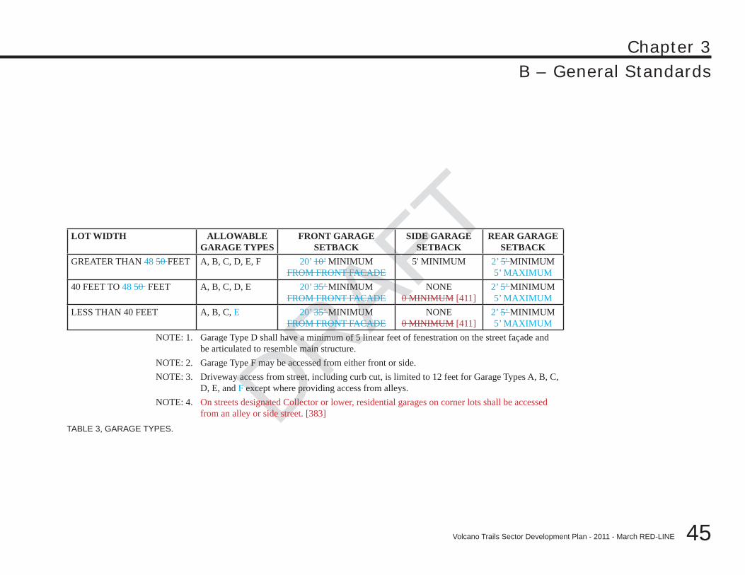
8. c. Residential Garages. Garages shall not dominate the front façade. Street-fronting garages shall be per the requirements of Table 3. Garages shall not exceed 50% of the total front façade. Garages should not dominate the front façade. Street fronting garages shall be set back at least 10 feet from the front façade. Garages should not exceed 50% of the total front façade. Lots greater than 40 feet wide up to 50 feet in width, garages shall not exceed 65% of total façade and each garage façade shall be set back a minimum of 3 feet from other garage façades. Three-car garages are not permitted on lots less than 50 feet wide. Three-car garages on lots greater than 50 feet wide shall have the third garage bay set back a minimum of 3 feet from the primary garage façade. (See Table 3 for additional garage requirements.)
a. Garage doors shall be set back a minimum of 2 feet from the garage facade to create a ‘shadow box’ that minimizes the promi-nence of the garage door.
b. Three-car garages are not permitted on lots less than 50 feet wide. Three-car garages on lots greater than 50 feet wide shall have a third garage setback of 3 feet minimum from the primary garage façade.
c. On lots less than 50 feet, property owners intending to build garages on the property lot line shall submit a platted and filed maintenance easement agreement signed by the adjacent property owner prior to being issued a building permit.
d. The color of garage doors shall blend with or complement the exterior wall color in order to minimize the prominence of the garage door. See B. Building Design Standards 9. Color for additional requirements.
e. See Table 3 for additional garage requirements. [381]
DRAFT
DRAFT
DRAFT
45
Chapter 3
Volcano Trails Sector Development Plan - 2011 - March RED-LINE
B – General Standards
TABLE 3, GARAGE TYPES.
LOT WIDTH ALLOWABLE GARAGE TYPES
FRONT GARAGE SETBACK
SIDE GARAGE SETBACK
REAR GARAGE SETBACK
GREATER THAN 48 50 FEET A, B, C, D, E, F 20’ 10’ MINIMUM FROM FRONT FACADE
5' MINIMUM 2’ 5' MINIMUM5’ MAXIMUM
40 FEET TO 48 50 FEET A, B, C, D, E 20’ 35’ MINIMUM FROM FRONT FACADE
NONE0 MINIMUM [411]
2’ 5’ MINIMUM5’ MAXIMUM
LESS THAN 40 FEET A, B, C, E 20’ 35’ MINIMUM FROM FRONT FACADE
NONE0 MINIMUM [411]
2’ 5’ MINIMUM5’ MAXIMUM
NOTE: 1. Garage Type D shall have a minimum of 5 linear feet of fenestration on the street façade and be articulated to resemble main structure.
NOTE: 2. Garage Type F may be accessed from either front or side.NOTE: 3. Driveway access from street, including curb cut, is limited to 12 feet for Garage Types A, B, C,
D, E, and F except where providing access from alleys.NOTE: 4. On streets designated Collector or lower, residential garages on corner lots shall be accessed
from an alley or side street. [383]
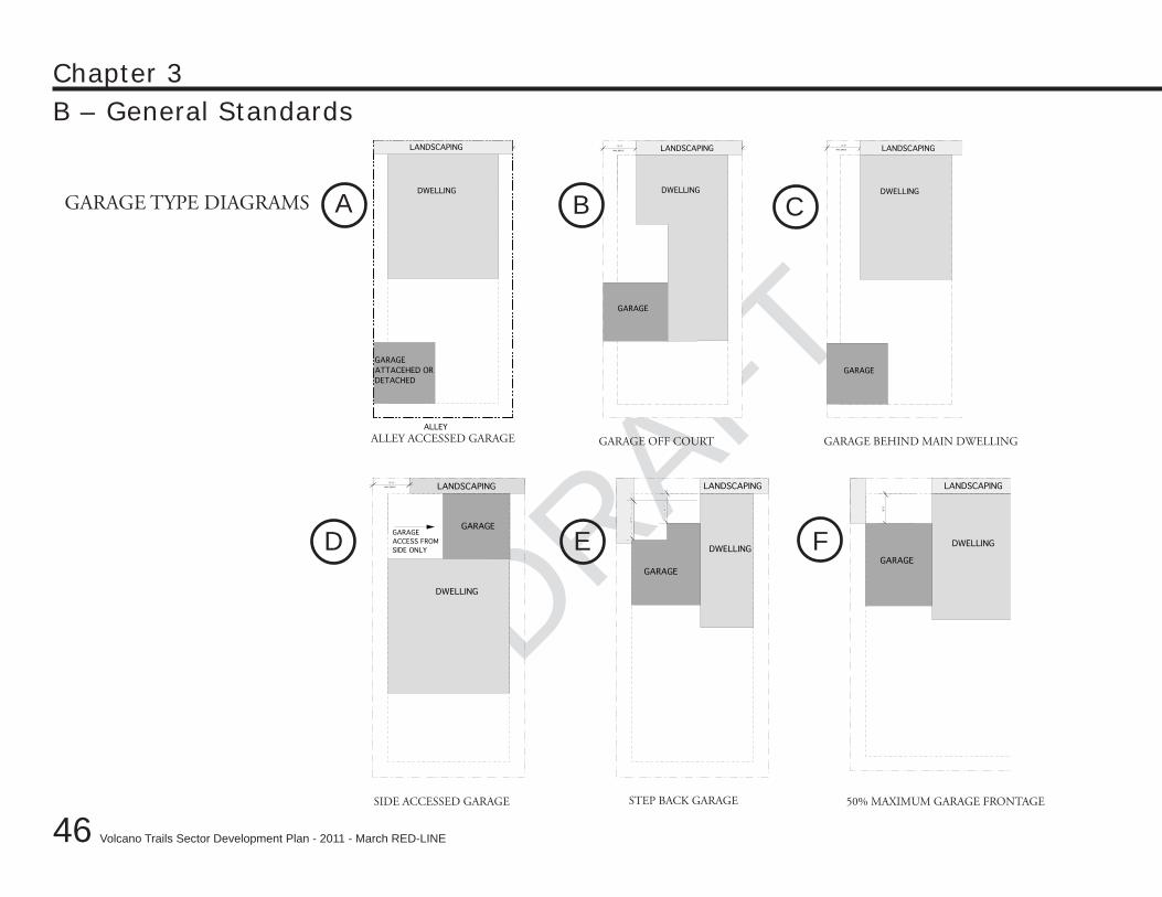
DRAFT
46
Chapter 3
Volcano Trails Sector Development Plan - 2011 - March RED-LINE
B – General Standards
DRAFTALLEY ACCESSED GARAGE GARAGE OFF COURT GARAGE BEHIND MAIN DWELLING
DWELLING
GARAGE
DWELLING
10'-0"
13'-0"
12'-0"
MAX DRIVE
DWELLING
10'-0"
GARAGE
GARAGE
GARAGE
GARAGE
ACCESS FROM
SIDE ONLY
LANDSCAPING LANDSCAPING LANDSCAPING
12'-0"5'-0"
12'-0"5'-0"
DWELLING DWELLING
GARAGE
GARAGE
MAX DRIVE LANDSCAPING MAX DRIVE
5'-0"
DWELLING
GARAGE
ATTACEHED OR
DETACHED
ALLEY
LANDSCAPINGLANDSCAPING
D E F
SIDE ACCESSED GARAGE STEP BACK GARAGE 50% MAXIMUM GARAGE FRONTAGE
GARAGE TYPE DIAGRAMS A B C
DRAFT
DRAFT
DRAFT
47
Chapter 3
Volcano Trails Sector Development Plan - 2011 - March RED-LINE
B – General Standards9. i. Color. Colors used on building walls, roofs, and garage doors in Suburban Residential–Small Lot, Suburban Residential–Medium Lot shall be earth tones and meet reflectivity standards as specified in General Regulation B - Approved Colors. Other colors may only be uses as accents. Buildings throughout the Plan area shall not have highly reflective surfaces. Mechanical devices, roof vents, and screen-ing materials are also subject to this regulation, as are fences and walls. Trim materials constituting less than 10% of the façade’s opaque surface may be any color.
10. j. Service Areas. Service areas (e.g. loading docks, freestanding mechanical equipment, refuse containers, compactors, recycling re-ceptacles, etc.) shall not be visible from streets or public open spaces. They shall be located away from streets, or recessed within the build-ing envelope, and/or screened from view of streets and Major Public Open Space. Service areas recessed within the building envelope, and facing streets, and/or Major Public Open Space shall not comprise more than 20% of a building’s linear frontage; and shall be accompa-nied by roll-up doors. Free standing equipment and refuse containers shall be screened from view of streets and public open space.
11. k. Commercial Signage. Signs shall complement the architectural style of the site building(s). Letters shall not exceed 18 inches in height or width and 3 inches in relief.
12. l. Awnings. Awnings shall be cloth or equivalent, metal, or glass. “Quarter-cylinder” awning configurations are not permitted. Letter-ing on awnings is limited to 9 inches in height.
13. m. Energy-Efficient Buildings. Two or more of the following features shall be included in building design to ensure that buildings are energy efficient:
•interiordaylighting;•fluorescent lighting low-energy consumptive lighting for at least 80% of fixtures; •heat-exchangeunits;•super-insulatedlow-emissivewindows;•passiveor active solar heating; •passiveor active solar hot water; •natural cross-ventilation; •highlyefficientappliancesandheatingandcoolingsystems;and •generationofelectricitythroughwindgenerationandphotovoltaics.; and
geothermal heating and cooling• .
DRAFT
48
Chapter 3
Volcano Trails Sector Development Plan - 2011 - March RED-LINE
B – General Standards
DRAFT
C. LANDSCAPE DESIGN STANDARDS 1. The following Landscape Standards shall apply to all zones as specified below:
1. a. Walls & Fences Material Finishes & Design. a. Height & Placement. Walls and fences shall not exceed a height of 36 inches where allowed within street-facing setbacks (except for
columns that support arcades or trellises). Retaining walls in all locations shall not exceed 48 inches, unless approved by the City Hydrologist. Fences and walls shall not exceed a height of 72 inches inside required street-facing setbacks along rear and interior side property lines. Height shall be measured from the lower side within the required side or rear yard.
b. Adjacency to Monument and City Open Space. Properties that are located adjacent to the Petroglyph National Monument and/or Major Public Open Space shall use coyote fencing, post and wire (not barbed), or view fencing. View fencing allows for a general sense of openness, visual transparency, and passive surveillance, while still maintaining perimeter security.
c. Materials & Design. Site walls may be clad or plastered with stucco, brick, tile masonry, concrete, and/or native stone (or synthetic equivalent). Exposed plain block, including all colors, is not allowed for site walls. Stucco and concrete shall have an integral color. The end of walls shall have a pier or pilaster at least 12 inches wideto give a substantial appearance. Post and wire or coyote fencing is allowed. Wood board, cyclone, chain link, and razor wire fencing are prohibited.
Walls. Walls may be clad or plastered with stucco, brick and tile masonry, or native stone (or synthetic equivalent). Split face block is allowed throughout. Smooth exposed block, of any color, is allowed for a maximum of 50% of exterior walls outside of the front setback. Stucco and concrete shall have an integral color. The end of walls shall have a pier or pilaster that is at least 12 inches in width, to give a substantial appearance. For Parcels adjacent to the High School site, the backs of the parcels facing the High School site shall use a perimeter wall design approved by the City. [394]
2. b. Pedestrian Walkways. Arcades, trellises, awnings, and/or trees are encouraged along pedestrian paths for shade and spatial defini-tion. In parking lots, pedestrian walkways shall not extend more than 75 feet without one of these features.
3. Sidewalk Locations. The location of sidewalks shall reflect the desired character and density of the surrounding land uses. In high- and medium-density neighborhoods (i.e., SU-2/VC and SU-2/UR, and SU-2 SL zone), sidewalks are essential to creating a vibrant, pedestri-an lifestyle. In lower-density settings (i.e., SU-2/ML), the use of sidewalks may be excessive, and connections may be more appropriately provided via trails and gravel shoulders.
a. Where average densities exceed 4 units per gross acre, sidewalks shall accompany both sides of all streets.
b. Where average densities are less than 4 units per acre, trails and gravel shoulders may be used in lieu of street sidewalks.
DRAFT
DRAFT
DRAFT
49
Chapter 3
Volcano Trails Sector Development Plan - 2011 - March RED-LINE
B – General Standards4. c. On-Lot Trees. Where buildings are placed more than 10 feet from a street-side property line, at least one tree shall be planted per property within the street-side setback. Properties with a street frontage over 100 feet shall have a minimum of one tree for every 40 50 feet. [395] Street trees on local streets shall be maintained by the property owner. Street trees on collector or higher capacity streets shall be maintained by the City Parks and Recreation Department.
5. d. Site Lighting. Lighting shall have a cut-off angle that directs light downward and only toward the property on which the light source is located. Light fixtures shall be of a type that throws light downward and have baffles, hoods or diffusers so that no light point source shall be visible from a distance greater than 1000 feet. On-site light poles shall not exceed a height of 16 feet. High-intensity discharge lamps and sodium lamps shall not be used.
6. e. Gateway Monuments. Pillars or walls are permitted at entry points to neighborhoods and projects. Walls shall not be more than 12 feet long and conform with General Standard C.1. Walls & Fences Material Finishes & Design. Pillars shall not be more than 3 feet in width and 10 feet in height. Pillars and walls shall be stucco, masonry, rammed earth, adobe, native stacked stone (or synthetic equivalent) or straw bale. Exposed plain block, of any color, is not allowed. Stucco and concrete shall have an integral color. See General Standard B.9. Color for additional requirements.
7. g. Grading. Cut and fill slopes shall be no steeper than 3:1 on average and retaining walls shall not exceed 4 feet in height unless in-corporated within a building’s foundation or approved by the City Hydrologist. Graded areas shall maintain the character of the natural terrain by varying gradients, undulating contours, and rounding the toe and crest of any slope greater than 10 feet in height. Fill shall be limited to the minimum required for site development and drainage. Fill shall not exceed the existing highest natural grade point on site, unless approved by the City Hydrologist for required drainage. Height shall be measured from the natural grade. Bikeways and other amenities within the right-of-way shall be provided in such a way as to minimize the extent of disturbance to slopes and vegetation and the need for cut and fill.
8. h. Rainwater Storm water quality and Management. Where appropriate, development projects shall incorporate unobtrusive rain-water storm water features that facilitate the detention and infiltration of rainwater storm water and the filtration of pollutants from urban run-off. At all densities and intensities, appropriate techniques include:
•permeablepavers&concrete,• infiltrationbedsplacedbelowpavedareas,• stone-filledreservoirsanddry-wells,• small“raingardens”(low-lyingwithmoisture-tolerantgrasses,wildflowers,shrubs,andtrees),and• vegetatedswales(incourtyards,streetmedians,andplantingstrips).
DRAFT
50
Chapter 3
Volcano Trails Sector Development Plan - 2011 - March RED-LINE
B – General Standards
DRAFT
a. Materials and treatments used for rainwater storm water management shall be natural in appearance. Channels lined by concrete or rip-rap are prohibited, unless necessary for public safety.
b. Fencing shall be avoided; the bottom slopes of detention basins shall be designed for safety. In addition, a hydrological study and design may be required of new development by the City of Albuquerque to identify appropriate rainwater storm water detention and energy dissipation features. [422] [398]
9. i. Construction Mitigation. Construction within the Plan area or parts of the area shall be mitigated as provided by General Regula-tion C – Construction Mitigation. These regulations are fully part of this regulating plan and shall be enforced as such.
10. j. Appropriate Planting Lists. The purpose of directing landscaping regulating plants are is to reduce water usage, maintain the char-acter of native plants now existing in the Petroglyph National Monument, and provide a harmonious landscape image. Two plant lists shall guide landscaping within the Plan Area. Shrubs and trees shall be nursery grown. Theis Plan expressly supports enforcement activities to prevent illegal removal of naturally occurring vegetation from its existing location. All properties in Volcano Trails more than 200 feet from public lands such as the Petroglyph National Monument, arroyos, and other Major Public Open Space shall use plants from Plant List A and/or B. Land disturbed in development shall be re-vegetated using the appropriate Plant List.
a. List A – Petroglyph National Monument Plant List. These are the plant species inventoried by the National Park Service in 1994-1995, including almost 200 plants (amended). This plant list is reproduced in full in General Regulation B. Lots within 200 feet of adjacent to public lands such as the Petroglyph National Monument, arroyos, and other Major Public Open Space areas should primarily shall follow Plant List A to limit impact of invasive and/or non-native plants on native vegetation. [5]
b. List B – Xeric Plant List. These plant species are the official xeric or low-water use plant list of the City of Albuquerque Water
Conservation Office Albuquerque Bernalillo County Water Utility Authority (ABCWUA). The majority of the list is low and medium water-use plants. Some high-water use plants are also listed in order to classify them as such in implementation of the water conservation program. This xeric plant list is extensive and is maintained updated periodically by the City ABCWUA. Contact the City of Albuquerque Water Conservation Office ABCWUA to obtain the most current information (see contact information provided in General Regulation B). [7]
DRAFT
DRAFT
DRAFT
51
Chapter 3
Volcano Trails Sector Development Plan - 2011 - March RED-LINE
B – General StandardsD. USABLE OPEN SPACE STANDARDS1. Private Usable Open Space may be a yard, deck, balcony, porch, portal, or patio and shall have an unobstructed dimension of at least 6 feet. [400]
2. Shared Usable Open Space shall be accessible to all project residents and have unobstructed dimensions of at least 40 feet. Shared Us-able Open Space may be a park, courtyard, plaza, play area, community facility, roof garden, or some combination thereof.
3. Usable Open Space shall be privately maintained.
4. Off-site Open Space dedication requirements are met by proposed and existing public and private (i.e. Homeowners Association-owned and maintained) parks, open space tracts, and trails parks and trails. [399]
E. PARkING STANDARDS 1. Parking Dimensions – On-Site. On-site parking shall be per the City Zoning Code §14-16-1-5 definition for “Parking Space, Auto-mobile and Light Truck.” Parking spaces may be have a length of 18 feet; this may be reduced to 16 feet where cars can overhang wheel stops. Standard parking spaces may have a width of 9 feet, and compact parking spaces shall have a width of 8.5 feet. Within every parking lot or garage, up to 25% of all spaces shall be compact and shall be dispersed throughout any lot. [403] 2. Parking Dimensions – On-Street. On-street parking spaces may have a length of 20 feet and a width of 7 feet.
3. Landscaping. Surface parking shall have one tree planted adjacent to every six parking spaces. Diamond-shaped tree wells (approxi-mately 5 feet by 5 feet) are an efficient means to meet this requirement, as they take advantage of car overhangs. Surface parking lots may not exceed a dimension of 200 260 feet in any direction without providing a landscaped pedestrian walkway. [401]
4. Neighborhood Permit Parking. Neighborhoods adjoining a Village Center, high school site, and access points to the Petroglyph Na-tional Monument, parks, and open space may initiate a petition and establish a Neighborhood Permit Parking system without regard to the percentage of on-street parking spaces used by persons who are not residents of the neighborhood. [402]
DRAFT
52
Chapter 3
Volcano Trails Sector Development Plan - 2011 - March RED-LINE
B – General Standards
DRAFTThis Page Left Intentionally Blank
DRAFT
Volcano Trails Sector Development Plan - 2011 - March RED-LINE
DRAFT
DRAFT
53
general regulat ionsChapter 4
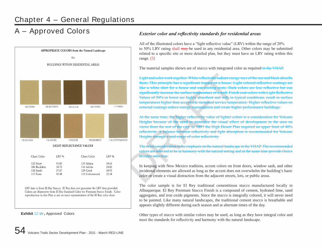
DRAFT
54
Chapter 4 – General Regulations
Volcano Trails Sector Development Plan - 2011 - March RED-LINE
DRAFT
A – Approved Colors Exterior color and reflectivity standards for residential areas
All of the illustrated colors have a “light reflective value” (LRV) within the range of 20%to 50% LRV rating shall may be used in any residential area. Other colors may be submitted related to a specific site or more detailed plan, but they must have an LRV rating within this range. [5]
The material samples shown are of stucco with integrated color as required in the VHAP.
Light and color work together. White reflects the radiant energy rays of the sun and black absorbs them. This principle has a significant impact on a house. Light colored reflective coatings are like a white shirt for a house and cut cooling costs. Dark colors are less reflective but can significantly increase the surface temperature of a wall. Finish coat colors with Light Reflective Values of 20% or lower are highly absorbent and will, in typical conditions, result in surface temperatures higher than acceptable sustained service temperature. Higher reflective values on external coatings reduce energy consumption and create higher performance buildings.
At the same time, the higher reflectivity value of lighter colors is a consideration for Volcano Heights because of the need to minimize the visual effect of development in the area on views from the rest of the city. In 1993 the High Desert Plan required an upper limit of 40% reflectivity. A balance between reflectivity and light absorption is recommended for Volcano Heights through a mid-range of color reflectivity.
The third consideration is the emphasis on the natural landscape in the VHAP. The recommended colors are selected to be in harmony with the natural setting and at the same time provide choice in color selection.
In keeping with New Mexico tradition, accent colors on front doors, window sash, and other incidental elements are allowed as long as the accent does not overwhelm the building’s basic color or create a visual distraction from the adjacent streets, lots, or public areas.
The color sample is for El Rey traditional cementitious stucco manufactured locally in Albuquerque. El Rey Premium Stucco Finish is a compound of cement, hydrated lime, sand aggregates, and iron oxide pigments. Since the stucco is integrally colored, it will never need to be painted. Like many natural landscapes, the traditional cement stucco is breathable and appears slightly different during each season and at alternate times of the day.
Other types of stucco with similar colors may be used, as long as they have integral color and meet the standards for reflectivity and harmony with the natural landscape.
Exhibit 12 11 , Approved Colors
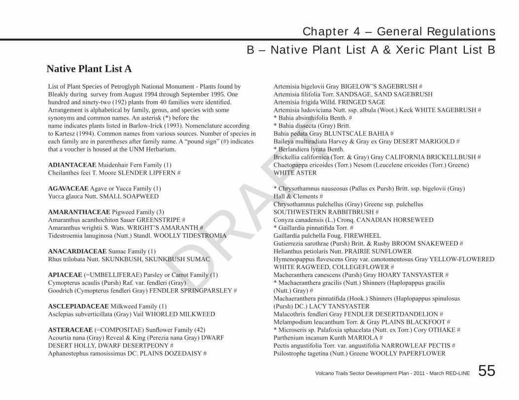
DRAFT
DRAFT
DRAFT
55
Chapter 4 – General Regulations
Volcano Trails Sector Development Plan - 2011 - March RED-LINE
B – Native Plant List A & Xeric Plant List B
List of Plant Species of Petroglyph National Monument - Plants found by Bleakly during survey from August 1994 through September 1995. One hundred and ninety-two (192) plants from 40 families were identified. Arrangement is alphabetical by family, genus, and species with some synonyms and common names. An asterisk (*) before thename indicates plants listed in Barlow-Irick (1993). Nomenclature according to Kartesz (1994). Common names from various sources. Number of species in each family are in parentheses after family name. A “pound sign” (#) indicates that a voucher is housed at the UNM Herbarium.
ADIANTACEAE Maidenhair Fern Family (1)Cheilanthes feei T. Moore SLENDER LIPFERN #
AGAVACEAE Agave or Yucca Family (1)Yucca glauca Nutt. SMALL SOAPWEED
AMARANTHACEAE Pigweed Family (3)Amaranthus acanthochiton Sauer GREENSTRIPE #Amaranthus wrightii S. Wats. WRIGHT’S AMARANTH #Tidestroemia lanuginosa (Nutt.) Standl. WOOLLY TIDESTROMIA
ANACARDIACEAE Sumac Family (1)Rhus trilobata Nutt. SKUNKBUSH, SKUNKBUSH SUMAC
APIACEAE (=UMBELLIFERAE) Parsley or Carrot Family (1)Cymopterus acaulis (Pursh) Raf. var. fendleri (Gray)Goodrich (Cymopterus fendleri Gray) FENDLER SPRINGPARSLEY #
ASCLEPIADACEAE Milkweed Family (1)Asclepias subverticillata (Gray) Vail WHORLED MILKWEED
ASTERACEAE (=COMPOSITAE) Sunflower Family (42)Acourtia nana (Gray) Reveal & King (Perezia nana Gray) DWARFDESERT HOLLY, DWARF DESERTPEONY #Aphanostephus ramosissimus DC. PLAINS DOZEDAISY #
Artemisia bigelovii Gray BIGELOW’S SAGEBRUSH #Artemisia filifolia Torr. SANDSAGE, SAND SAGEBRUSHArtemisia frigida Willd. FRINGED SAGEArtemisia ludoviciana Nutt. ssp. albula (Woot.) Keck WHITE SAGEBRUSH #* Bahia absinthifolia Benth. #* Bahia dissecta (Gray) Britt.Bahia pedata Gray BLUNTSCALE BAHIA #Baileya multiradiata Harvey & Gray ex Gray DESERT MARIGOLD #* Berlandiera lyrata Benth.Brickellia californica (Torr. & Gray) Gray CALIFORNIA BRICKELLBUSH #Chaetopappa ericoides (Torr.) Nesom (Leucelene ericoides (Torr.) Greene)WHITE ASTER
* Chrysothamnus nauseosus (Pallas ex Pursh) Britt. ssp. bigelovii (Gray)Hall & Clements #Chrysothamnus pulchellus (Gray) Greene ssp. pulchellusSOUTHWESTERN RABBITBRUSH #Conyza canadensis (L.) Cronq. CANADIAN HORSEWEED* Gaillardia pinnatifida Torr. #Gaillardia pulchella Foug. FIREWHEELGutierrezia sarothrae (Pursh) Britt. & Rusby BROOM SNAKEWEED #Helianthus petiolaris Nutt. PRAIRIE SUNFLOWERHymenopappus flavescens Gray var. canotomentosus Gray YELLOW-FLOWEREDWHITE RAGWEED, COLLEGEFLOWER #Macheranthera canescens (Pursh) Gray HOARY TANSYASTER #* Machaeranthera gracilis (Nutt.) Shinners (Haplopappus gracilis(Nutt.) Gray) #Machaeranthera pinnatifida (Hook.) Shinners (Haplopappus spinulosus(Pursh) DC.) LACY TANSYASTERMalacothrix fendleri Gray FENDLER DESERTDANDELION #Melampodium leucanthum Torr. & Gray PLAINS BLACKFOOT #* Microseris sp. Palafoxia sphacelata (Nutt. ex Torr.) Cory OTHAKE #Parthenium incanum Kunth MARIOLA #Pectis angustifolia Torr. var. angustifolia NARROWLEAF PECTIS #Psilostrophe tagetina (Nutt.) Greene WOOLLY PAPERFLOWER
Native Plant List A
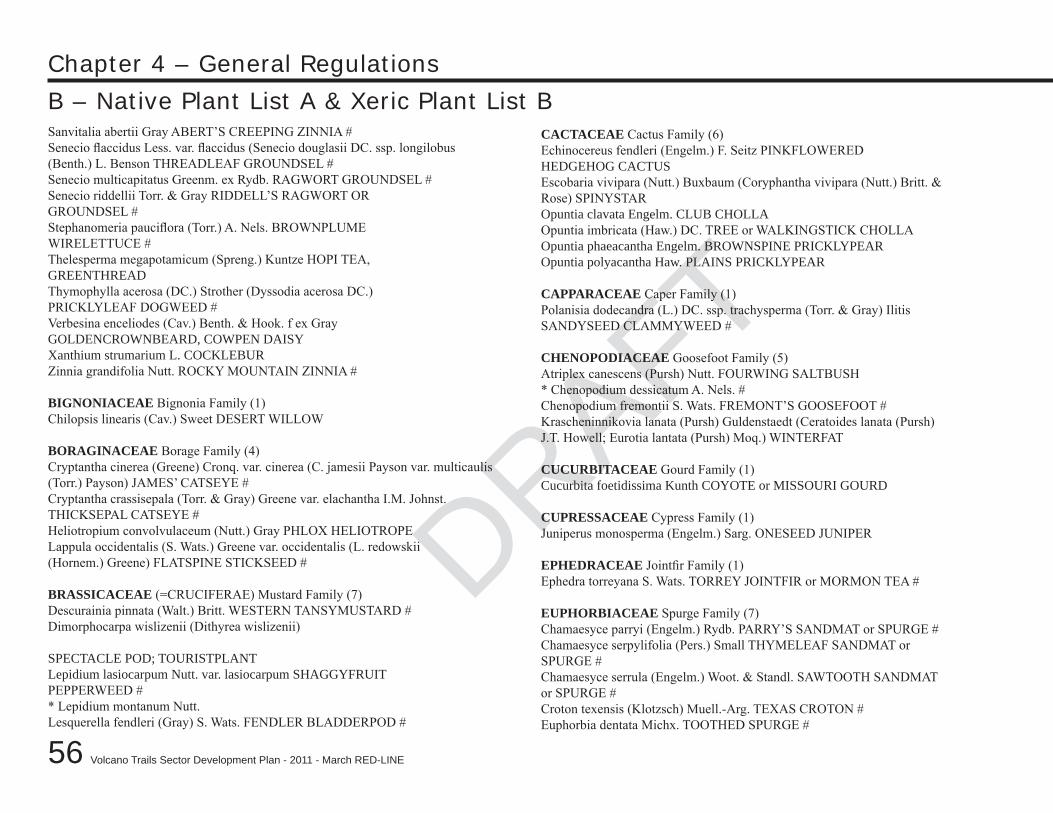
DRAFT
56
Chapter 4 – General Regulations
Volcano Trails Sector Development Plan - 2011 - March RED-LINE
DRAFT
B – Native Plant List A & Xeric Plant List BSanvitalia abertii Gray ABERT’S CREEPING ZINNIA #Senecio flaccidus Less. var. flaccidus (Senecio douglasii DC. ssp. longilobus(Benth.) L. Benson THREADLEAF GROUNDSEL #Senecio multicapitatus Greenm. ex Rydb. RAGWORT GROUNDSEL #Senecio riddellii Torr. & Gray RIDDELL’S RAGWORT ORGROUNDSEL #Stephanomeria pauciflora (Torr.) A. Nels. BROWNPLUMEWIRELETTUCE #Thelesperma megapotamicum (Spreng.) Kuntze HOPI TEA,GREENTHREADThymophylla acerosa (DC.) Strother (Dyssodia acerosa DC.)PRICKLYLEAF DOGWEED #Verbesina enceliodes (Cav.) Benth. & Hook. f ex GrayGOLDENCROWNBEARD, COWPEN DAISYXanthium strumarium L. COCKLEBURZinnia grandifolia Nutt. ROCKY MOUNTAIN ZINNIA #
BIGNONIACEAE Bignonia Family (1)Chilopsis linearis (Cav.) Sweet DESERT WILLOW
BORAGINACEAE Borage Family (4)Cryptantha cinerea (Greene) Cronq. var. cinerea (C. jamesii Payson var. multicaulis(Torr.) Payson) JAMES’ CATSEYE #Cryptantha crassisepala (Torr. & Gray) Greene var. elachantha I.M. Johnst.THICKSEPAL CATSEYE #Heliotropium convolvulaceum (Nutt.) Gray PHLOX HELIOTROPELappula occidentalis (S. Wats.) Greene var. occidentalis (L. redowskii(Hornem.) Greene) FLATSPINE STICKSEED #
BRASSICACEAE (=CRUCIFERAE) Mustard Family (7)Descurainia pinnata (Walt.) Britt. WESTERN TANSYMUSTARD #Dimorphocarpa wislizenii (Dithyrea wislizenii)
SPECTACLE POD; TOURISTPLANTLepidium lasiocarpum Nutt. var. lasiocarpum SHAGGYFRUITPEPPERWEED #* Lepidium montanum Nutt.Lesquerella fendleri (Gray) S. Wats. FENDLER BLADDERPOD #
CACTACEAE Cactus Family (6)Echinocereus fendleri (Engelm.) F. Seitz PINKFLOWEREDHEDGEHOG CACTUSEscobaria vivipara (Nutt.) Buxbaum (Coryphantha vivipara (Nutt.) Britt. &Rose) SPINYSTAROpuntia clavata Engelm. CLUB CHOLLAOpuntia imbricata (Haw.) DC. TREE or WALKINGSTICK CHOLLAOpuntia phaeacantha Engelm. BROWNSPINE PRICKLYPEAROpuntia polyacantha Haw. PLAINS PRICKLYPEAR
CAPPARACEAE Caper Family (1)Polanisia dodecandra (L.) DC. ssp. trachysperma (Torr. & Gray) IlitisSANDYSEED CLAMMYWEED #
CHENOPODIACEAE Goosefoot Family (5)Atriplex canescens (Pursh) Nutt. FOURWING SALTBUSH* Chenopodium dessicatum A. Nels. #Chenopodium fremontii S. Wats. FREMONT’S GOOSEFOOT #Krascheninnikovia lanata (Pursh) Guldenstaedt (Ceratoides lanata (Pursh)J.T. Howell; Eurotia lantata (Pursh) Moq.) WINTERFAT
CUCURBITACEAE Gourd Family (1)Cucurbita foetidissima Kunth COYOTE or MISSOURI GOURD
CUPRESSACEAE Cypress Family (1)Juniperus monosperma (Engelm.) Sarg. ONESEED JUNIPER
EPHEDRACEAE Jointfir Family (1)Ephedra torreyana S. Wats. TORREY JOINTFIR or MORMON TEA #
EUPHORBIACEAE Spurge Family (7)Chamaesyce parryi (Engelm.) Rydb. PARRY’S SANDMAT or SPURGE #Chamaesyce serpylifolia (Pers.) Small THYMELEAF SANDMAT orSPURGE #Chamaesyce serrula (Engelm.) Woot. & Standl. SAWTOOTH SANDMATor SPURGE #Croton texensis (Klotzsch) Muell.-Arg. TEXAS CROTON #Euphorbia dentata Michx. TOOTHED SPURGE #
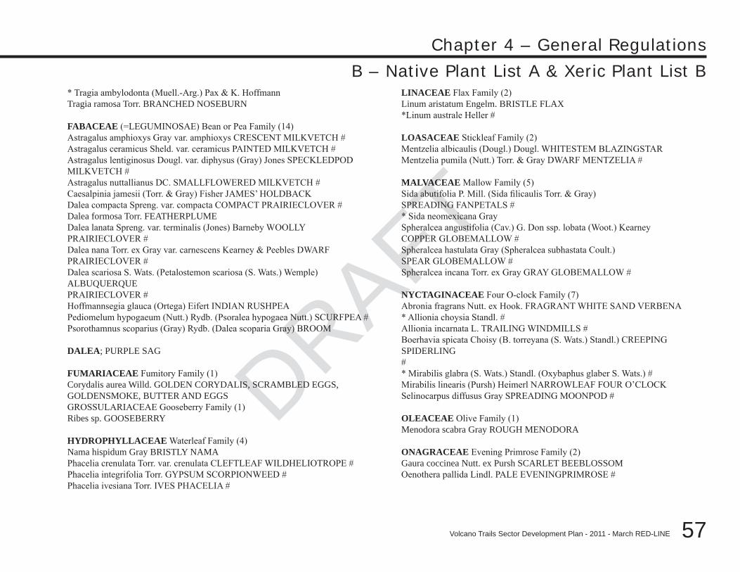
DRAFT
DRAFT
DRAFT
57
Chapter 4 – General Regulations
Volcano Trails Sector Development Plan - 2011 - March RED-LINE
* Tragia ambylodonta (Muell.-Arg.) Pax & K. HoffmannTragia ramosa Torr. BRANCHED NOSEBURN
FABACEAE (=LEGUMINOSAE) Bean or Pea Family (14)Astragalus amphioxys Gray var. amphioxys CRESCENT MILKVETCH #Astragalus ceramicus Sheld. var. ceramicus PAINTED MILKVETCH #Astragalus lentiginosus Dougl. var. diphysus (Gray) Jones SPECKLEDPODMILKVETCH #Astragalus nuttallianus DC. SMALLFLOWERED MILKVETCH #Caesalpinia jamesii (Torr. & Gray) Fisher JAMES’ HOLDBACKDalea compacta Spreng. var. compacta COMPACT PRAIRIECLOVER #Dalea formosa Torr. FEATHERPLUMEDalea lanata Spreng. var. terminalis (Jones) Barneby WOOLLYPRAIRIECLOVER #Dalea nana Torr. ex Gray var. carnescens Kearney & Peebles DWARFPRAIRIECLOVER #Dalea scariosa S. Wats. (Petalostemon scariosa (S. Wats.) Wemple) ALBUQUERQUEPRAIRIECLOVER #Hoffmannsegia glauca (Ortega) Eifert INDIAN RUSHPEAPediomelum hypogaeum (Nutt.) Rydb. (Psoralea hypogaea Nutt.) SCURFPEA #Psorothamnus scoparius (Gray) Rydb. (Dalea scoparia Gray) BROOM
DALEA; PURPLE SAG
FUMARIACEAE Fumitory Family (1)Corydalis aurea Willd. GOLDEN CORYDALIS, SCRAMBLED EGGS,GOLDENSMOKE, BUTTER AND EGGSGROSSULARIACEAE Gooseberry Family (1)Ribes sp. GOOSEBERRY
HYDROPHYLLACEAE Waterleaf Family (4)Nama hispidum Gray BRISTLY NAMAPhacelia crenulata Torr. var. crenulata CLEFTLEAF WILDHELIOTROPE #Phacelia integrifolia Torr. GYPSUM SCORPIONWEED #Phacelia ivesiana Torr. IVES PHACELIA #
LINACEAE Flax Family (2)Linum aristatum Engelm. BRISTLE FLAX*Linum australe Heller #
LOASACEAE Stickleaf Family (2)Mentzelia albicaulis (Dougl.) Dougl. WHITESTEM BLAZINGSTARMentzelia pumila (Nutt.) Torr. & Gray DWARF MENTZELIA #
MALVACEAE Mallow Family (5)Sida abutifolia P. Mill. (Sida filicaulis Torr. & Gray)SPREADING FANPETALS #* Sida neomexicana GraySpheralcea angustifolia (Cav.) G. Don ssp. lobata (Woot.) KearneyCOPPER GLOBEMALLOW #Spheralcea hastulata Gray (Spheralcea subhastata Coult.)SPEAR GLOBEMALLOW #Spheralcea incana Torr. ex Gray GRAY GLOBEMALLOW #
NYCTAGINACEAE Four O-clock Family (7)Abronia fragrans Nutt. ex Hook. FRAGRANT WHITE SAND VERBENA* Allionia choysia Standl. #Allionia incarnata L. TRAILING WINDMILLS #Boerhavia spicata Choisy (B. torreyana (S. Wats.) Standl.) CREEPING SPIDERLING#* Mirabilis glabra (S. Wats.) Standl. (Oxybaphus glaber S. Wats.) #Mirabilis linearis (Pursh) Heimerl NARROWLEAF FOUR O’CLOCKSelinocarpus diffusus Gray SPREADING MOONPOD #
OLEACEAE Olive Family (1)Menodora scabra Gray ROUGH MENODORA
ONAGRACEAE Evening Primrose Family (2)Gaura coccinea Nutt. ex Pursh SCARLET BEEBLOSSOMOenothera pallida Lindl. PALE EVENINGPRIMROSE #
B – Native Plant List A & Xeric Plant List B
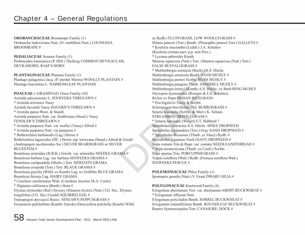
DRAFT
58
Chapter 4 – General Regulations
Volcano Trails Sector Development Plan - 2011 - March RED-LINE
DRAFT
OROBANCHACEAE Broomrape Family (1)Orobanche ludoviciana Nutt. (O. multiflora Nutt.) LOUISIANABROOMRAPE #
PEDALIACEAE Sesame Family (1)Proboscidea louisianica (P. Mill.) Thelleng COMMON DEVILSCLAW,DEVILSHORN, RAM’S HORN
PLANTAGINACEAE Plantain Family (1)Plantago patagonica Jacq. (P. purshii Morris) WOOLLY PLANTAIN #Plantago lanceolota L. NARROWLEAF PLANTAIN
POACEAE (=GRAMINAE) Grass Family (42)Aristida adscensionis L. SIXWEEKS THREEAWN #* Aristida arizonica VaseyAristida havardii Vasey HAVARD’S THREEAWN #* Aristida pansa Woot. & Standl.Aristida purpurea Nutt. var. fendleriana (Steud.) VaseyFENDLER’S THREEAWN #* Aristida purpurea Nutt. var. neallyi (Vasey) Allred #* Aristida purpurea Nutt. var purpurea #* Bothriochloa barbinodis (Lag.) Herter #Bothriochloa laguroides (DC.) Herter ssp. torreyana (Steud.) Allred & Gould(Andropogon saccharoides Sw.) SILVER BEARDGRASS or SILVERBLUESTEM #Bouteloua aristoides (H.B.K.) Griseb. var. aristoides NEEDLE GRAMA #Bouteloua barbata Lag. var. barbata SIXWEEKS GRAMA #Bouteloua curtipendula (Michx.) Torr. SIDEOATS GRAMABouteloua eriopoda (Torr.) Torr. BLACK GRAMA #Bouteloua gracilis (Willd. ex Kunth) Lag. ex Griffiths BLUE GRAMABouteloua hirsuta Lag. HAIRY GRAMA* Cenchrus carolinianus Walt. (Cenchrus incertus M.A. Curtis)* Digitaria californica (Benth.) Henr.#Elymus elymoides (Raf.) Swezey (Sitanion hystrix (Nutt.) J.G. Sm.; Elymuslongifolius (J.G. Sm.) Gould) SQUIRRELTAIL #Enneapogon desvauxii Beauv. NINEAWN PAPPUSGRASS #Erioneuron pulchellum (Kunth) Tateoka (Dasyochloa pulchella (Kunth) Willd.
ex Rydb.) FLUFFGRASS, LOW WOOLLYGRASS #Hilaria jamesii (Torr.) Benth. (Pleuraphis jamesii Torr.) GALLETA #* Koeleria macrantha (Ledeb.) J.A. Schultes(Koeleria cristata auct. p.p. non Pers.)* Lycurus phleoides KunthMonroa squarrosa (Nutt.) Torr. (Munroa squarrosa (Nutt.) Torr.)FALSE BUFFALOGRASS #* Muhlenbergia arenacea (Buckl.) A.S. Hitchc.Muhlenbergia arenicola Buckl. SAND MUHLY #Muhlenbergia porteri Scribn. BUSH MUHLY #Muhlenbergia pungens Thurb. SANDHILL MUHLY #Muhlenbergia torreyi (Kunth) A.S. Hitchc. ex Bush RING MUHLYOryzopsis hymenoides (Roemer & J.A. Schultes)Ricker ex Piper INDIAN RICEGRASS* Poa bigelovii Vasey & Scribn.Scleropogon brevifolius Phil. BURROGRASS #Setaria leucopila (Scribn. & Merr.) K. Schum.STREAMBED BRISTLEGRASS #* Setaria lutescens (Weigel) F.T. Hubbard ?Sporobolus contractus A.S. Hitchc. SPIKE DROPSEEDSporobolus cryptandrus (Torr.) Gray SAND DROPSEED #* Sporobolus flexuosus (Thurb. ex Vasey) Rydb. #Sporobolus giganteus Nash GIANT DROPSEED #Stipa comata Trin & Rupr. var. comata NEEDLEANDTHREAD #* Stipa neomexicana (Thurb. ex Coult.) Scribn.Stipa spartea Trin. PORCUPINEGRASS #Vulpia octoflora (Walt.) Rydb. (Festuca octoflora Walt.)SIXWEEKS FESCUE #
POLEMONIACEAE Phlox Family (1)Ipomopsis pumila (Nutt.) V. Grant DWARF GILIA #
POLYGONACEAE Knotweed Family (4)Eriogonum abertianum Torr. var. abertianum ABERT BUCKWHEAT #* Eriogonum effusum Nutt.Eriogonum polycladon Benth. SORREL BUCKWHEAT #Eriogonum rotundifolium Benth. ROUNDLEAF BUCKWHEAT #Rumex hymenosepalus Torr. CANAIGRE; DOCK #
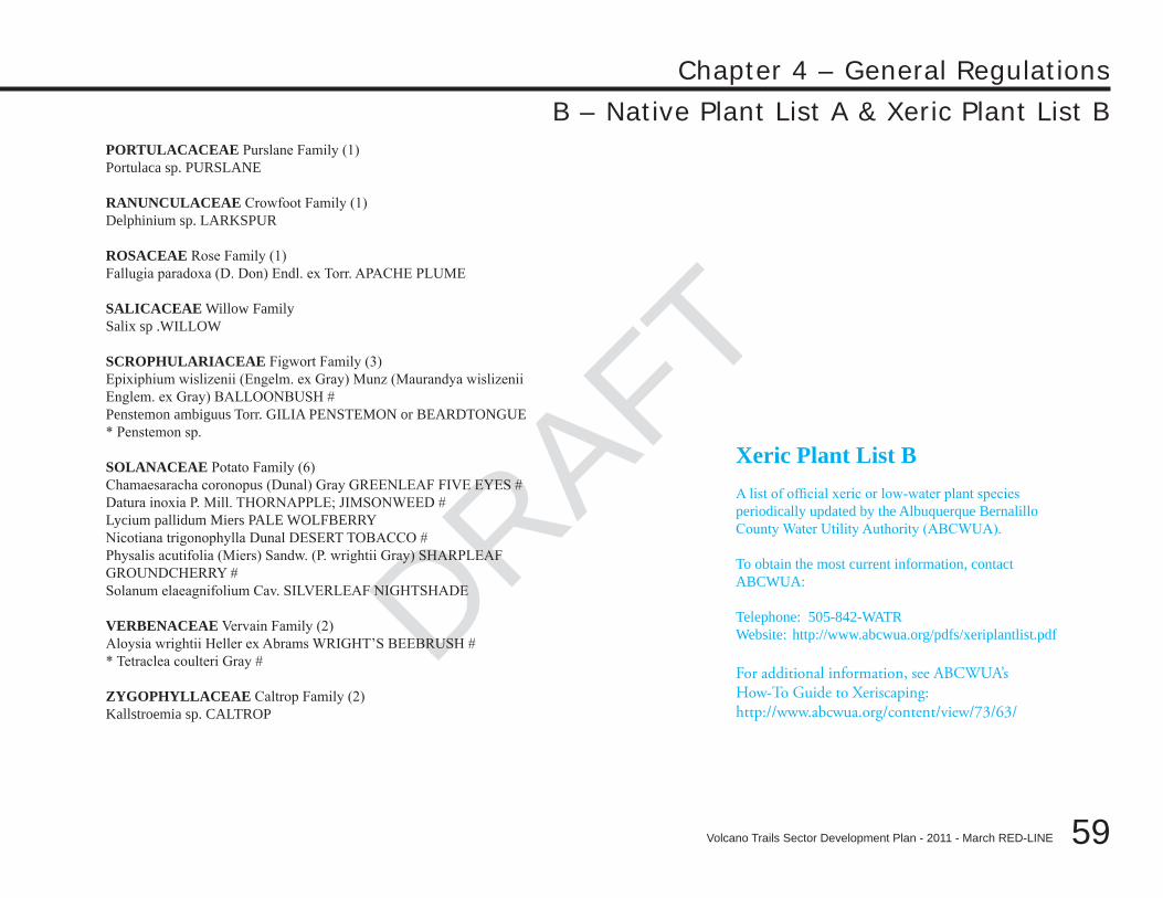
DRAFT
DRAFT
DRAFT
59
Chapter 4 – General Regulations
Volcano Trails Sector Development Plan - 2011 - March RED-LINE
PORTULACACEAE Purslane Family (1)Portulaca sp. PURSLANE
RANUNCULACEAE Crowfoot Family (1)Delphinium sp. LARKSPUR
ROSACEAE Rose Family (1)Fallugia paradoxa (D. Don) Endl. ex Torr. APACHE PLUME
SALICACEAE Willow FamilySalix sp .WILLOW
SCROPHULARIACEAE Figwort Family (3)Epixiphium wislizenii (Engelm. ex Gray) Munz (Maurandya wislizeniiEnglem. ex Gray) BALLOONBUSH #Penstemon ambiguus Torr. GILIA PENSTEMON or BEARDTONGUE* Penstemon sp.
SOLANACEAE Potato Family (6)Chamaesaracha coronopus (Dunal) Gray GREENLEAF FIVE EYES #Datura inoxia P. Mill. THORNAPPLE; JIMSONWEED #Lycium pallidum Miers PALE WOLFBERRYNicotiana trigonophylla Dunal DESERT TOBACCO #Physalis acutifolia (Miers) Sandw. (P. wrightii Gray) SHARPLEAFGROUNDCHERRY #Solanum elaeagnifolium Cav. SILVERLEAF NIGHTSHADE
VERBENACEAE Vervain Family (2)Aloysia wrightii Heller ex Abrams WRIGHT’S BEEBRUSH #* Tetraclea coulteri Gray #
ZYGOPHYLLACEAE Caltrop Family (2)Kallstroemia sp. CALTROP
B – Native Plant List A & Xeric Plant List B
Xeric Plant List BA list of official xeric or low-water plant species periodically updated by the Albuquerque Bernalillo County Water Utility Authority (ABCWUA).
To obtain the most current information, contact ABCWUA:
Telephone: 505-842-WATRWebsite: http://www.abcwua.org/pdfs/xeriplantlist.pdf
For additional information, see ABCWUA’s How-To Guide to Xeriscaping: http://www.abcwua.org/content/view/73/63/
DRAFT
60
Chapter 4 – General Regulations
Volcano Trails Sector Development Plan - 2011 - March RED-LINE
DRAFT
C – Construction MitigationPolicy CM: Any damage to the vegetation, slope, or placement of boulders due to or related to construction shall be mitigated as provided herein.
Standard Policy CM-1: Prior to beginning construction, the property owner shall construct a temporary silt fence at the site boundary adjacent to sensitive lands (i.e. the Escarpment Buffer, Major Open Space Area, archeological site, or public or private conservation area to be maintained in natural desertscape) to effectively barricade it protect them from heavy equipment and vehicles. Photographs of the site in its original condition shall be submitted with the application for building permit and subdivision and/or site development plan.
Policy CM-2: Prior to beginning construction, the property owner shall construct a temporary fence at the Development Envelope boundary and at the parcel boundary (except for the interior lot lines of parcels developed at the same time) within the Conservation Residential, and Suburban Residential–Large Lot land use designations to protect natural desertscape in the Conservation Easement area to effectively barricade it from heavy equipment and vehicles.
Standard Policy CM-2 3: Public- and private-sector projects within the Conservation Area and the Impact Area facing the Escarpment and adjacent to archeological sites must include geotechnical data and analysis that demonstrate to the satisfaction of the City Engineer that proposed trenching or blasting will not affect the face of the Escarpment, potentially causing erosion or caving of the slopes and boulders and thereby threatening public safety or welfare or otherwise damage archeological resources.
Standard Policy CM-3 4: The following standard applies in the selection of alignment and in site design: a. Grading plans shall demonstrate that cut and fill has been kept to a minimum consistent with the standards in this Plan. Generally, the overall topography of the site is not to be substantially altered.b. Minimum width of disturbance to slopes and vegetation and minimum cut and fill, balanced against the need to provide for bikeways or other amenities within the right-of-way.
Standard Policy CM-4 5: Replacement of boulders shall be to the approximate the original location, angle, and surface exposure. Revegetation to approximate original cover with appropriate native or naturalized plants as identified in General Regulation B - Plant List A is required within 90 days of project completion. A variance deviation may be granted by the Planning Director or his/her designee if the type of vegetation or time of year make revegetation within 90 days impossible. For infrastructure projects on public lands, the construction company shall post a warranty bond effective for three years after completion of the infrastructure work to insure successful revegetation. [5]
DRAFT
DRAFT
DRAFT
61
Chapter 4 – General Regulations
Volcano Trails Sector Development Plan - 2011 - March RED-LINE
C – Construction Mitigation
Standard Policy CM-5 6: The City shall be responsible for restoring existing damaged areas that lie within Major Public Open Space. The property owner shall be responsible for restoring damaged areas on lands accepted by the City to meet open space requirements if that damage occurred after the adoption of the Volcano Trails Sector Development Plan; this shall occur prior to title transfer if the land is to be deeded to the City and shall be an ongoing responsibility of the property owner if the land remains private open space.
Standard Policy CM-6 7: Existing cuts that are used as trail locations shall be stabilized and revegetated at the time of trail construction.
Standard Policy CM-7 8: As Major Public Open Space is acquired by the City, damaged areas shall be protected from further abuse and reseeded.
DRAFT
62
Chapter 4 – General Regulations
Volcano Trails Sector Development Plan - 2011 - March RED-LINE
DRAFT
D – Stormwater Rainwater Design & Management StandardsThe drainage right-of-way of the North and Middle Forks of the Boca Negra Arroyo should remain as undisturbed desert with natural vegetation, rock formations, and drainageway intact. If the option of Improved naturalistic channel is used, the design will shall retain as much undisturbed desert vegetation and rock formations insofar as practicable.
Standard Policy RDM-1: Channel treatments shall meet the following requirements:
Limited stabilization of natural channels, according to the policies contained in the “Facility Plan for Arroyos,” 1. unless such treatment is determined to be infeasible by the City Hydrologist or the Albuquerque Metropolitan Flood Control Authority as appropriate.
Use of many small, unobtrusive structures, such as check dams or small drop structures, rather than larger, more 2. obtrusive structures, when structural solutions are required.
Use of materials in treated channels that3. blend visually with the Escarpment and adjacent open space. Naturalistic treatments, such as rip-rap, gabions, or tinted concrete, are the preferred treatment types.
Protection of canyons from erosion through control of developed flows and through stabilization techniques 4. which that are consistent with the visual character of the open space.
Standard Policy RDM-2: Developed flows shall be managed to minimize their impact on Major Public Open Space, North Geologic Window, archeological sites, and the Escarpment. The potential impacts of water retention should shall be thoroughly studied prior to use of detention areas to control flows. Rainwater detention ponds shall be fully lined.
Standard Policy RDM-3: Within large areas of open space, developed flows shall be modified through check dams or other means to approximate undeveloped flows to minimize impacts on the Escarpment and to minimize the intensity of channel treatment required. The impact of check dams as a method of controlling flows should shall be thoroughly studied prior to their use. [11]
[422]
DRAFT
DRAFT
DRAFT
63
Chapter 4 – General Regulations
Volcano Trails Sector Development Plan - 2011 - March RED-LINE
This Page Left Intentionally Blank
DRAFT
64
Chapter 4 – General Regulations
Volcano Trails Sector Development Plan - 2011 - March RED-LINE
This Page Left Intentionally Blank