volume 1: environmental assessment - scheme homepage › ... › volume-1 ›...
TRANSCRIPT
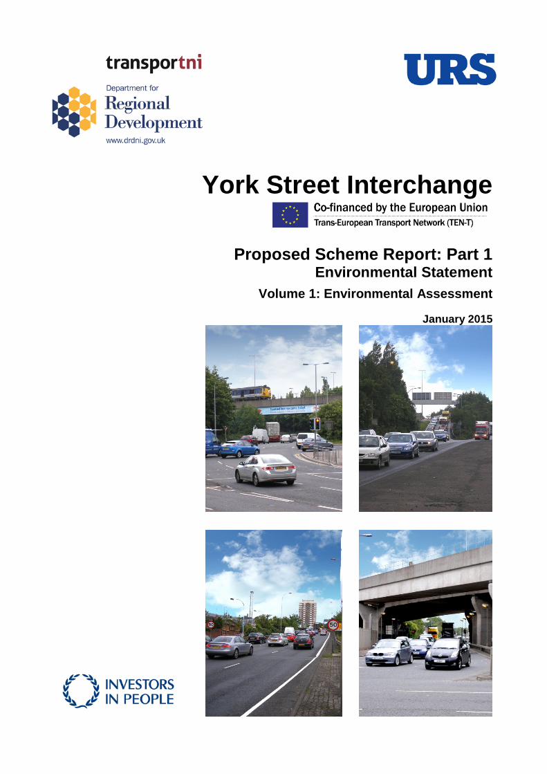
York Street Interchange
Proposed Scheme Report: Part 1 Environmental Statement
Volume 1: Environmental Assessment
January 2015
Transport NI – York Street Interchange
Rev Date Details Prepared by Checked by Approved by
0 27 Jan. 2015 Final Issue Glenn McKay Senior Assistant Environmental Engineer
Ruth Beattie Assistant Environmental Scientist
Mathew Hill Graduate Air Quality Specialist
Andrew Copp Senior Archaeological Consultant
Dr Paul Lynas Senior Ecologist
Christina Todd Landscape Architect
Robert Colder Acoustic Consultant
Peter Gray Chartered Civil Engineer (Drainage)
Alex Staton Principal Consultant (Geotechnical)
Michael Gillespie Environmental Scientist
Shauna Woods Town Planner
Gareth Coughlin Associate (Environment Team Leader)
Glenn McKay Senior Assistant Environmental Engineer
John McBride Senior Engineer (Roads)
Garry Gray Associate (Air Quality)
Neil Macnab Associate (Heritage)
Paul Tully Technical Director (Landscape)
Alf Maneylaws (Associate) Noise and Vibration
Gabriel Gallagher Associate (Geotechnical)
Philip Heyburn Associate (Drainage)
Una Somerville Associate (Town Planner)
Gareth Coughlin Associate (Environment Team Leader)
Michael Megarry Associate (Project Manager)
URS Beechill House 40 Beechill Road Belfast BT8 7RP Telephone: +44(0)28 9070 5111 Fax: +44(0)28 9079 5651 www.ursglobal.com
Prepared for: Transport NI Eastern Division Hydebank 4 Hospital Road Belfast BT8 8JL
ENVIRONMENTAL STATEMENT (VOLUME 1) January 2015
i
Transport NI – York Street Interchange
Limitations
URS Infrastructure & Environment UK Limited (“URS”) has prepared this Report for the sole use of Transport NI (“Client”) in accordance with the Agreement under which our services were performed [Major Works Planning, Assessment and Delivery Contract, April 2009]. No other warranty, expressed or implied, is made as to the professional advice included in this Report or any other services provided by URS. This Report may not be relied upon by any person other than Transport NI without the prior and express written agreement of URS.
The conclusions and recommendations contained in this Report are based upon information provided by others and upon the assumption that all relevant information has been provided by those parties from whom it has been requested and that such information is accurate. Information obtained by URS has not been independently verified by URS, unless otherwise stated in the Report.
The methodology adopted and the sources of information used by URS in providing its services are outlined in this Report. The work described in this Report was undertaken between December 2012 and January 2015 and is based on the conditions encountered and the information available during the said period of time. The scope of this Report and the services are accordingly factually limited by these circumstances.
Where assessments of works or costs identified in this Report are made, such assessments are based upon the information available at the time and where appropriate are subject to further investigations or information which may become available.
URS disclaim any undertaking or obligation to advise any person of any change in any matter affecting the Report, which may come or be brought to URS’ attention after the date of the Report.
Certain statements made in the Report that are not historical facts may constitute estimates, projections or other forward-looking statements and even though they are based on reasonable assumptions as of the date of the Report, such forward-looking statements by their nature involve risks and uncertainties that could cause actual results to differ materially from the results predicted. URS specifically does not guarantee or warrant any estimate or projections contained in this Report.
Unless otherwise stated in this Report, the assessments made assume that the sites and facilities will continue to be used for their current purpose without significant changes.
Where field investigations are carried out, these have been restricted to a level of detail required to meet the stated objectives of the services. The results of any measurements taken may vary spatially or with time and further confirmatory measurements should be made after any significant delay in issuing this Report.
Costs may vary outside the ranges quoted. Whilst cost estimates are provided for individual issues in this Report these are based upon information at the time which can be incomplete. Cost estimates for such issues may therefore vary from those provided. Where costs are supplied, these estimates should be considered in aggregate only. No reliance should be made in relation to any division of aggregate costs, including in relation to any issue, site or other subdivision.
No allowance has been made for changes in prices or exchange rates or changes in any other conditions which may result in price fluctuations in the future. Where assessments of works or costs necessary to achieve compliance have been made, these are based upon measures which, in URS’ experience, could normally be negotiated with the relevant authorities under present legislation and enforcement practice, assuming a pro-active and reasonable approach by site management.
Forecast cost estimates do not include such costs associated with any negotiations, appeals or other non-technical actions associated with the agreement on measures to meet the requirements of the authorities, nor are potential business loss and interruption costs considered that may be incurred as part of any technical measures.
EU Disclaimer
The sole responsibility of this publication lies with the author. The European Union is not responsible for any use that may be made of the information contained therein.
ENVIRONMENTAL STATEMENT (VOLUME 1) January 2015
ii
Transport NI – York Street Interchange
Copyright
© This Report is the copyright of Transport NI. Any unauthorised reproduction or usage by any person other than the addressee is strictly prohibited.
URS Project Number
URS project number (up to 31 May 2011): S105296
URS project number (from 31 May 2011): 47037827
About Transport NI
Transport NI, formerly branded as Roads Service, is a business unit within the Department for Regional Development (DRD), playing a significant role in facilitating the safe and convenient movement of people and goods throughout the province and the safety of road users, through the delivery of road maintenance services and the management and development of the transport network. It also informs the Department's policy development process to ensure that measures to encourage safe and sustainable travel are practical and can be delivered.
Transport NI is responsible for the maintenance of over 25,000km of public roads together with about 9,700km of footways, 5,800 bridges, 271,000 street lights and 367 public car parks. It also has responsibility for the development of the transport network and a range of transport projects designed to improve network safety, sustainability and efficiency.
The key objectives of Transport NI are to:
• Manage, maintain and improve the transport network to keep it safe, efficient, reliable and sustainable;
• Promote increased customer satisfaction with the services delivered by Transport NI;
• Work constructively with Transport NI's key stakeholders to support the delivery of high quality services;
• Develop Transport NI's capacity and capability to meet objectives;
• Ensure effective management of Transport NI's budget, assets and corporate governance arrangements; and
• Improve Transport NI's resilience in responding to emergencies.
For the purposes of this report, references to Transport NI shall be read as references to its former Roads Service brand.
Further information about Transport NI is available on the Department for Regional Development website, please visit www.drdni.gov.uk.
ENVIRONMENTAL STATEMENT (VOLUME 1) January 2015
iii

Transport NI – York Street Interchange
TABLE OF CON TENTS
TABLE OF CONTENTS
1. INTRODUCTION.............................................................................................. 1
1.1 Background ...................................................................................................... 1 1.2 Proposed Scheme Report Structure ................................................................ 2 1.3 The Environmental Statement ......................................................................... 2 1.3.1 Legal basis for the Environmental Statement .................................................. 2 1.3.2 The purpose of the Environmental Statement ................................................. 4 1.3.3 Matters for Inclusion in the Environmental Statement ..................................... 4 1.3.4 Structure of the Environmental Statement ....................................................... 5 1.3.5 The Assessment Team .................................................................................... 8 1.3.6 Review and Comment ...................................................................................... 8 1.4 Assessment of Implications on European Sites ............................................... 9
2. STRATEGIC NEED FOR THE PROPOSED SCHEME................................. 11
2.1 Strategic Road Improvements ....................................................................... 11 2.2 How does Transport NI decide if an SRI scheme should be built? ............... 11 2.3 Strategic need for York Street Interchange ................................................... 12 2.3.1 Scheme-Specific Objectives .......................................................................... 13 2.4 Strategic Context............................................................................................ 13 2.4.1 European Union Policy .................................................................................. 13 2.4.2 United Kingdom Policy ................................................................................... 15 2.4.3 Northern Ireland Policy .................................................................................. 15 2.4.4 Regional Strategies ........................................................................................ 16 2.4.5 Transport Plans .............................................................................................. 24 2.4.6 Development Plan .......................................................................................... 25 2.5 Proposed Scheme Context ............................................................................ 29 2.5.1 Expanding the Strategic Road Improvement Programme 2015 –
Consultation Document .................................................................................. 29 2.5.2 Expanding the Strategic Road Improvement Programme 2015 – Draft
Environmental Report .................................................................................... 30 2.5.3 Investment Delivery Plan for Roads............................................................... 33
3. ALTERNATIVES CONSIDERED ................................................................... 35
3.1 Introduction .................................................................................................... 35 3.2 Stage 1 Scheme Assessment ........................................................................ 36 3.3 Stage 2 Scheme Assessment ........................................................................ 36 3.3.1 Option A ......................................................................................................... 37 3.3.2 Option B ......................................................................................................... 38 3.3.3 Option C ......................................................................................................... 39 3.3.4 Option D ......................................................................................................... 40 3.3.5 Stage 2 Scheme Assessment findings .......................................................... 40 3.4 Stage 3 Scheme Assessment ........................................................................ 42
4. SCHEME DESCRIPTION .............................................................................. 43
4.1 General Scheme Description ......................................................................... 43 4.1.1 Overview ........................................................................................................ 43 4.2 Detailed Scheme Description ......................................................................... 50 4.2.1 Link Referencing System ............................................................................... 50 4.2.2 Road Geometry .............................................................................................. 50 4.2.3 Structures ....................................................................................................... 60
ENVIRONMENTAL STATEMENT (VOLUME 1) January 2015
iv

Transport NI – York Street Interchange
4.2.4 Geotechnics ................................................................................................... 73 4.3 Road Drainage ............................................................................................... 75 4.3.1 Introduction .................................................................................................... 75 4.3.2 Road Drainage Strategy ................................................................................ 76 4.3.3 Description of Proposed Drainage Infrastructure ........................................... 76 4.3.4 Interconnecting Pipework linking the Underpasses to the Pumping Station . 78 4.3.5 Road Edge Detail ........................................................................................... 78 4.3.6 Proposed Road Drainage .............................................................................. 78 4.3.7 Further Drainage Measures ........................................................................... 81 4.4 Public Utilities ................................................................................................. 81 4.5 Motorway Communications ............................................................................ 81 4.5.1 Overview ........................................................................................................ 81 4.5.2 Operational Management .............................................................................. 82 4.5.3 ITS Components ............................................................................................ 82 4.5.4 Westlink to the M2 and M3 Motorways .......................................................... 83 4.5.5 M3 / Westlink and York Street to the M2 North ............................................. 83 4.5.6 M2 Southbound to the Westlink and M3 Motorway ....................................... 84 4.5.7 Standalone CCTV .......................................................................................... 84 4.5.8 Communication Interrupters ........................................................................... 85 4.6 Health and Safety .......................................................................................... 85 4.7 Construction ................................................................................................... 86 4.7.1 Construction Sequence .................................................................................. 86 4.7.2 Construction Programme ............................................................................... 94 4.7.3 Environmental Management Plan .................................................................. 94
5. EXISTING CONDITIONS ............................................................................... 97
5.1 Environmental Conditions .............................................................................. 97 5.1.1 Historical ........................................................................................................ 97 5.1.2 Belfast Lough ................................................................................................. 98 5.1.3 Belfast Harbour .............................................................................................. 98 5.1.4 George Best Belfast City Airport .................................................................... 99 5.1.5 Local Context ................................................................................................. 99 5.1.6 Industry ........................................................................................................ 100 5.1.7 Climate ......................................................................................................... 101
6. CONSULTATIONS....................................................................................... 103
6.1 Introduction .................................................................................................. 103 6.2 Stakeholder Engagement ............................................................................ 103 6.3 Previous Stakeholder Consultations ............................................................ 104 6.3.1 Stage 1 Scheme Assessment ...................................................................... 104 6.3.2 Stage 2 Scheme Assessment ...................................................................... 104 6.3.3 Stage 3 Scheme Assessment ...................................................................... 104 6.4 Public Consultation ...................................................................................... 107 6.4.1 Public Consultation Event – June 2011 ....................................................... 107 6.4.2 Ministerial Announcement - December 2012 ............................................... 110
7. ENVIRONMENTAL IMPACT ASSESSMENT METHODS .......................... 112
7.1 Introduction .................................................................................................. 112 7.2 Design Manual for Roads and Bridges (DMRB) .......................................... 112 7.2.1 Stage 3 Environmental Assessment ............................................................ 112 7.2.2 Revision to ES Section Structure ................................................................. 112
ENVIRONMENTAL STATEMENT (VOLUME 1) January 2015
v
Transport NI – York Street Interchange
7.3 Approach & Methods ................................................................................... 113 7.3.1 Assessment of Predicted Impacts and Residual Effects (Significance of
Effects) ......................................................................................................... 114
8. AIR QUALITY ............................................................................................... 118
8.1 Introduction .................................................................................................. 118 8.1.1 Previous Studies .......................................................................................... 118 8.2 Methodology ................................................................................................. 118 8.2.1 Scope of the Assessment ............................................................................ 118 8.2.2 Overview ...................................................................................................... 120 8.2.3 Road Traffic Emissions ................................................................................ 120 8.2.4 Construction Phase Emissions .................................................................... 121 8.2.5 Air Quality Sensitive Receptors ................................................................... 123 8.2.6 Prediction of Operational Air Quality Impacts .............................................. 124 8.2.7 Prediction of Construction Phase Impacts ................................................... 130 8.2.8 Method for Assessment of Significance ....................................................... 131 8.2.9 Limitations & Assumptions ........................................................................... 134 8.3 Consultations ............................................................................................... 134 8.4 Regulatory & Policy Framework ................................................................... 135 8.4.1 Legislation .................................................................................................... 135 8.4.2 Regional and Local Policy ............................................................................ 135 8.4.3 Local Air Quality Management ..................................................................... 136 8.5 Baseline Conditions ..................................................................................... 137 8.5.1 Data from Belfast City Council ..................................................................... 137 8.5.2 Project Specific Data .................................................................................... 139 8.5.3 Predicted Baseline Conditions ..................................................................... 141 8.6 Predicted Impacts ........................................................................................ 145 8.6.1 Operation ..................................................................................................... 145 8.6.2 Construction ................................................................................................. 151 8.7 Mitigation & Enhancement Measures .......................................................... 156 8.7.1 Operation ..................................................................................................... 156 8.7.2 Construction ................................................................................................. 156 8.8 Residual Effects ........................................................................................... 158 8.8.1 Significance of Potential Effects................................................................... 158 8.9 Summary & Conclusions .............................................................................. 158
9. CULTURAL HERITAGE ............................................................................... 160
9.1 Introduction .................................................................................................. 160 9.2 Methodology ................................................................................................. 160 9.2.1 Defining the Study Area ............................................................................... 161 9.2.2 Previous Studies and Sources of Information .............................................. 161 9.2.3 Fieldwork ...................................................................................................... 162 9.2.4 Assessment Process ................................................................................... 162 9.2.5 Identification of Assets ................................................................................. 162 9.2.6 Identification of Impacts ............................................................................... 162 9.2.7 Setting Impacts ............................................................................................ 163 9.2.8 Assessment of the Cultural Heritage Resource ........................................... 163 9.2.9 Magnitude of Impacts ................................................................................... 165 9.2.10 Significance of Effects .................................................................................. 167 9.2.11 Limitations and Assumptions ....................................................................... 168 9.3 Consultations ............................................................................................... 168 9.4 Regulatory & Policy Framework ................................................................... 169
ENVIRONMENTAL STATEMENT (VOLUME 1) January 2015
vi

Transport NI – York Street Interchange
9.4.1 The Historic Monuments and Archaeological Objects (Northern Ireland) Order 1995 ................................................................................................... 169
9.4.2 The Planning (Northern Ireland) Order 1991 ............................................... 169 9.4.3 PPS 6: Planning, Archaeology and The Built Heritage ................................ 169 9.4.4 Regional Development Strategy (RDS 2035) Building a Better Future ....... 171 9.4.5 Belfast Metropolitan Area Plan 2015 ........................................................... 171 9.5 Baseline Conditions ..................................................................................... 172 9.5.1 Physical Background ................................................................................... 172 9.5.2 Field Observations ....................................................................................... 173 9.5.3 Cultural Heritage Assets .............................................................................. 173 9.5.4 Archaeological and Historical Background .................................................. 175 9.5.5 Development and Historic Mapping ............................................................. 179 9.5.6 Motorway and Trunk Road Development .................................................... 181 9.5.7 Cultural Heritage Overview .......................................................................... 182 9.5.8 Summary of the Cultural Heritage Baseline ................................................. 193 9.6 Predicted Impacts ........................................................................................ 230 9.6.1 Archaeological Remains .............................................................................. 230 9.6.2 Historic Buildings.......................................................................................... 233 9.6.3 Historic Landscape ...................................................................................... 238 9.7 Mitigation & Enhancement Measures .......................................................... 244 9.7.1 Archaeological Mitigation Strategy............................................................... 244 9.7.2 Mitigation Measures to be adopted during Scheme Construction ............... 247 9.7.3 Archaeological Mitigation Programme ......................................................... 248 9.7.4 Dissemination of Results ............................................................................. 248 9.8 Residual Effects ........................................................................................... 249 9.8.1 Introduction .................................................................................................. 249 9.8.2 Archaeological Remains .............................................................................. 249 9.8.3 Historic Buildings.......................................................................................... 250 9.8.4 Historic Landscape ...................................................................................... 250 9.9 Summary & Conclusions .............................................................................. 251
10. ECOLOGY AND NATURE CONSERVATION ............................................. 253
10.1 Introduction .................................................................................................. 253 10.2 Methodology ................................................................................................. 253 10.2.1 Definition of Study Area ............................................................................... 253 10.2.2 Desk Study ................................................................................................... 253 10.2.3 Field Survey ................................................................................................. 253 10.2.4 Impact Assessment Methodology ................................................................ 255 10.2.5 Value of Ecological Receptors ..................................................................... 256 10.2.6 Determining the magnitude of impacts ........................................................ 259 10.2.7 Assessing Significant Effects ....................................................................... 261 10.2.8 Limitations and Assumptions ....................................................................... 264 10.3 Consultations ............................................................................................... 264 10.4 Regulatory & Policy Framework ................................................................... 267 10.4.1 Ramsar Convention (1971) .......................................................................... 267 10.4.2 Bonn Convention (1979) .............................................................................. 268 10.4.3 Bern Convention (1982) ............................................................................... 268 10.4.4 EC Habitats Directive 1992 (Annex I, II, IV) ................................................. 268 10.4.5 EC Birds Directive 2009 (Annex I) ............................................................... 268 10.4.6 The Conservation (Natural Habitats, etc.) Regulations (Northern Ireland)
1995 SR 380 ................................................................................................ 269 10.4.7 The Environment (Northern Ireland) Order 2002 SI 3153 (NI 7) (including
amendments up to 2004) ............................................................................. 269
ENVIRONMENTAL STATEMENT (VOLUME 1) January 2015
vii

Transport NI – York Street Interchange
10.4.8 The Environmental Liability (Prevention and Remediation) Regulations (Northern Ireland) 2009 SR 252 ................................................................... 269
10.4.9 The Environmental Liability (Prevention and Remediation) (Amendment) Regulations (Northern Ireland) 2009 SR 361 .............................................. 269
10.4.10 The Nature Conservation and Amenity Lands (Northern Ireland) Order 1985 ............................................................................................................. 269
10.4.11 The Wildlife (Northern Ireland) Order 1985, (as amended) ......................... 269 10.4.12 Northern Ireland Biodiversity Strategy 2009 ................................................ 269 10.4.13 The Regional Development Strategy 2035 ‘Building a Better Future’ ......... 269 10.4.14 PPS2 – Natural Heritage (July 2013) ........................................................... 270 10.4.15 Belfast Metropolitan Area Plan 2015 – District Proposals Belfast ............... 271 10.5 Baseline Conditions ..................................................................................... 271 10.5.1 Desk Study ................................................................................................... 271 10.5.2 Field Survey ................................................................................................. 274 10.5.3 Value of Ecological Receptors ..................................................................... 279 10.5.4 Predicted trends in the absence of Scheme Development .......................... 280 10.6 Predicted Impacts ........................................................................................ 280 10.6.1 Operational Phase Impacts (without mitigation) .......................................... 280 10.6.2 Construction Phase Impacts (Without mitigation) ........................................ 281 10.6.3 Specific Impacts ........................................................................................... 283 10.7 Mitigation & Enhancement Measures .......................................................... 292 10.7.1 Principles of Mitigation ................................................................................. 292 10.7.2 General Mitigation Measures ....................................................................... 293 10.7.3 Designated Ecological Sites ........................................................................ 293 10.7.4 Natural Habitats ........................................................................................... 294 10.7.5 Invasive Species .......................................................................................... 295 10.7.6 Bats .............................................................................................................. 295 10.7.7 Protected species......................................................................................... 296 10.7.8 Breeding Birds.............................................................................................. 296 10.7.9 Biodiversity enhancement ............................................................................ 296 10.8 Residual Effects ........................................................................................... 298 10.9 Summary & Conclusions .............................................................................. 302 10.9.1 Designated Ecological sites ......................................................................... 302 10.9.2 Habitats and Flora ........................................................................................ 302 10.9.3 Bats .............................................................................................................. 303 10.9.4 Breeding Birds.............................................................................................. 303 10.9.5 Further work ................................................................................................. 303 10.9.6 Statement of Significance ............................................................................ 304
11. LANDSCAPE & VISUAL EFFECTS............................................................. 306
11.1 Introduction .................................................................................................. 306 11.2 Methodology ................................................................................................. 306 11.2.1 Landscape Effects Assessment Methodology ............................................. 307 11.2.2 Visual Effects Assessment Methodology ..................................................... 312 11.2.3 Limitations & Assumptions ........................................................................... 314 11.3 Consultations ............................................................................................... 317 11.4 Regulatory & Policy Framework ................................................................... 318 11.4.1 European Landscape Convention (2000) .................................................... 318 11.4.2 The Nature Conservation and Amenity Lands (Northern Ireland) Order
1985 ............................................................................................................. 318 11.4.3 The Planning (Northern Ireland) Order 1991 ............................................... 318 11.4.4 The Regional Development Strategy (RDS) 2035 – Building a Better
Future ........................................................................................................... 319
ENVIRONMENTAL STATEMENT (VOLUME 1) January 2015
viii

Transport NI – York Street Interchange
11.4.5 A Sustainable Development Strategy for Northern Ireland 2006 ................. 320 11.4.6 PPS 2 – Natural Heritage (July 2013) .......................................................... 321 11.4.7 PPS 6 - Planning, Archaeology and The Built Heritage (March 1999) ........ 321 11.4.8 Northern Ireland Landscape Character Assessment 2000 .......................... 322 11.4.9 The Belfast Metropolitan Area Plan 2015 .................................................... 322 11.5 Baseline Conditions ..................................................................................... 323 11.5.1 Landscape Effects ....................................................................................... 323 11.5.2 Visual Effects ............................................................................................... 333 11.6 Predicted Impacts ........................................................................................ 335 11.6.1 Operation (Landscape Effects) .................................................................... 335 11.6.2 Operation (Visual Effects) ............................................................................ 338 11.6.3 Construction (Landscape & Visual).............................................................. 343 11.7 Mitigation & Enhancement Measures .......................................................... 344 11.7.1 Operation ..................................................................................................... 344 11.7.2 Construction ................................................................................................. 346 11.8 Residual Effects ........................................................................................... 346 11.8.1 Significance of Landscape Effects ............................................................... 346 11.8.2 Significance of Visual Effects ....................................................................... 349 11.9 Summary & Conclusions .............................................................................. 350
12. LAND USE ................................................................................................... 352
12.1 Introduction .................................................................................................. 352 12.2 Methodology ................................................................................................. 352 12.2.1 Demolition of Private Property and Private Land Loss ................................ 352 12.2.2 Development Land and Planning Applications ............................................ 352 12.2.3 Community Land .......................................................................................... 353 12.2.4 Agricultural Land .......................................................................................... 353 12.2.5 Waterways ................................................................................................... 353 12.2.6 Assessing the Significance of Effects .......................................................... 353 12.2.7 Limitations and assumptions ........................................................................ 355 12.3 Consultations ............................................................................................... 355 12.4 Regulatory & Policy Framework ................................................................... 357 12.4.1 The Regional Development Strategy 2035 ‘Building a Better Future’ ......... 358 12.4.2 Planning Policy Statements ......................................................................... 359 12.4.3 Belfast Metropolitan Area Plan 2015 ........................................................... 362 12.5 Baseline Conditions ..................................................................................... 367 12.5.1 Existing Development .................................................................................. 367 12.5.2 Planning Applications ................................................................................... 369 12.5.3 Development Land ....................................................................................... 370 12.5.4 Community Land .......................................................................................... 373 12.5.5 Waterway Restoration Schemes.................................................................. 374 12.6 Predicted Impacts ........................................................................................ 374 12.6.1 Operation ..................................................................................................... 374 12.6.2 Construction ................................................................................................. 388 12.7 Mitigation & Enhancement Measures .......................................................... 391 12.7.1 Operation ..................................................................................................... 391 12.7.2 Construction ................................................................................................. 392 12.8 Residual Effects ........................................................................................... 393 12.8.1 Significance of Potential Effects................................................................... 393 12.9 Summary & Conclusions .............................................................................. 397
13. NOISE & VIBRATION .................................................................................. 398
ENVIRONMENTAL STATEMENT (VOLUME 1) January 2015
ix

Transport NI – York Street Interchange
13.1 Introduction .................................................................................................. 398 13.2 Methodology ................................................................................................. 398 13.2.1 Study Area ................................................................................................... 399 13.2.2 Ambient Noise Monitoring ............................................................................ 400 13.2.3 Operational Noise ........................................................................................ 401 13.2.4 Operational Vibration ................................................................................... 405 13.2.5 Construction Noise and Vibration ................................................................ 406 13.2.6 Limitations & Assumptions ........................................................................... 408 13.3 Consultations ............................................................................................... 409 13.4 Regulatory & Policy Framework ................................................................... 409 13.4.1 The Land Acquisition and Compensation (Northern Ireland) Order 1973 ... 410 13.4.2 The Noise Insulation Regulations (Northern Ireland) 1995 ......................... 410 13.4.3 The Regional Development Strategy 2035 ‘Building a Better Future’ ......... 411 13.4.4 Belfast Metropolitan Transport Plan 2015 (BMTP) ...................................... 411 13.5 Baseline Conditions ..................................................................................... 412 13.5.1 Value (Sensitivity) of Resource .................................................................... 412 13.5.2 Existing Conditions ...................................................................................... 412 13.5.3 Future Conditions ......................................................................................... 413 13.6 Predicted Impacts ........................................................................................ 414 13.6.1 Operation ..................................................................................................... 414 13.6.2 Construction Noise and Vibration ................................................................ 419 13.7 Mitigation & Enhancement Measures .......................................................... 423 13.7.1 Operation ..................................................................................................... 423 13.7.2 Construction ................................................................................................. 424 13.8 Residual Effects ........................................................................................... 424 13.8.1 Operational Noise and Vibration .................................................................. 424 13.8.2 Construction Noise and Vibration ................................................................ 424 13.9 Summary & Conclusions .............................................................................. 425
14. PEDESTRIANS, CYCLISTS, EQUESTRIANS AND COMMUNITY EFFECTS ..................................................................................................... 426
14.1 Introduction .................................................................................................. 426 14.2 Methodology ................................................................................................. 426 14.2.1 Assessing the Significance of Effects .......................................................... 426 14.2.2 Limitations & Assumptions ........................................................................... 428 14.3 Consultations ............................................................................................... 428 14.4 Regulatory & Policy Framework ................................................................... 431 14.4.1 The Access to the Countryside (Northern Ireland) Order 1983 ................... 431 14.4.2 The Regional Development Strategy 2035 ‘Building a Better Future’ ......... 431 14.4.3 Planning Policy Statements ......................................................................... 432 14.4.4 Development Plan ........................................................................................ 433 14.4.5 Belfast Metropolitan Transport Plan 2015 ................................................... 434 14.5 Baseline Conditions ..................................................................................... 437 14.5.1 Existing Road Network ................................................................................. 437 14.5.2 Vehicle Movements ...................................................................................... 442 14.5.3 Community Facilities .................................................................................... 442 14.5.4 Public Transport ........................................................................................... 446 14.5.5 Parking Facilities .......................................................................................... 450 14.5.6 Pedestrians .................................................................................................. 451 14.5.7 Cyclists ......................................................................................................... 456 14.5.8 Equestrian Facilities ..................................................................................... 457 14.5.9 Non-Motorised User Survey ......................................................................... 457 14.6 Predicted Impacts ........................................................................................ 459
ENVIRONMENTAL STATEMENT (VOLUME 1) January 2015
x
Transport NI – York Street Interchange
14.6.1 Operation ..................................................................................................... 459 14.6.2 Construction ................................................................................................. 479 14.7 Mitigation & Enhancement Measures .......................................................... 481 14.7.1 Operation ..................................................................................................... 481 14.7.2 Construction ................................................................................................. 483 14.8 Residual Effects ........................................................................................... 484 14.8.1 Local Vehicle Movements ............................................................................ 484 14.8.2 Community Facilities .................................................................................... 485 14.8.3 Public Rail Network ...................................................................................... 485 14.8.4 Public Bus Network ...................................................................................... 486 14.8.5 Pedestrians .................................................................................................. 486 14.8.6 Cyclists ......................................................................................................... 487 14.8.7 Equestrian Facilities ..................................................................................... 487 14.9 Summary & Conclusions .............................................................................. 487
15. VEHICLE TRAVELLERS ............................................................................. 489
15.1 Introduction .................................................................................................. 489 15.1.1 Views from the Road .................................................................................... 489 15.1.2 Driver Stress ................................................................................................ 489 15.2 Methodology ................................................................................................. 490 15.2.1 Views from the Road .................................................................................... 490 15.2.2 Driver Stress ................................................................................................ 490 15.2.3 Limitations and assumptions ........................................................................ 491 15.3 Consultations ............................................................................................... 492 15.4 Regulatory & Policy Framework ................................................................... 492 15.5 Baseline Conditions ..................................................................................... 492 15.5.1 Views from the Road .................................................................................... 492 15.5.2 Driver Stress (Existing Road Network) ........................................................ 495 15.6 Predicted Impacts ........................................................................................ 499 15.6.1 Operation ..................................................................................................... 499 15.6.2 Construction ................................................................................................. 512 15.7 Mitigation & Enhancement Measures .......................................................... 513 15.7.1 Views from the Road .................................................................................... 513 15.7.2 Driver Stress ................................................................................................ 513 15.8 Residual Effects ........................................................................................... 513 15.8.1 Views from the Road .................................................................................... 513 15.8.2 Driver Stress ................................................................................................ 514 15.9 Summary & Conclusions .............................................................................. 514 15.9.1 Views from the Road .................................................................................... 514 15.9.2 Driver Stress ................................................................................................ 514
16. ROAD DRAINAGE & THE WATER ENVIRONMENT ................................. 515
16.1 Introduction .................................................................................................. 515 16.2 Methodology ................................................................................................. 516 16.2.1 Assessing the significance of effects ........................................................... 517 16.2.2 Limitations & Assumptions ........................................................................... 522 16.3 Consultations ............................................................................................... 522 16.4 Regulatory & Policy Framework ................................................................... 525 16.5 Baseline Conditions ..................................................................................... 528 16.5.1 Existing Road Drainage ............................................................................... 528 16.5.2 Existing Water Environment ......................................................................... 530 16.5.3 Groundwater ................................................................................................ 539
ENVIRONMENTAL STATEMENT (VOLUME 1) January 2015
xi

Transport NI – York Street Interchange
16.5.4 Flood Risk from Rivers and Sea .................................................................. 543 16.5.5 Surface Flooding .......................................................................................... 544 16.6 Predicted Impacts ........................................................................................ 545 16.6.1 Operation ..................................................................................................... 545 16.6.2 Construction ................................................................................................. 556 16.7 Mitigation & Enhancement Measures .......................................................... 559 16.7.1 Operation ..................................................................................................... 559 16.7.2 Construction ................................................................................................. 562 16.8 Residual Effects ........................................................................................... 565 16.8.1 Significance of Potential Effects (Operation) ............................................... 565 16.8.2 Significance of Potential Effects (Construction) ........................................... 567 16.9 Summary & Conclusions .............................................................................. 568
17. GEOLOGY & SOILS .................................................................................... 569
17.1 Introduction .................................................................................................. 569 17.2 Methodology ................................................................................................. 569 17.2.1 Contaminated Land Assessment Methodology ........................................... 570 17.2.2 Assessing the Significance of Effects .......................................................... 571 17.2.3 Limitations & Assumptions ........................................................................... 574 17.3 Consultations ............................................................................................... 574 17.4 Regulatory & Policy Framework ................................................................... 577 17.5 Baseline Conditions ..................................................................................... 578 17.5.1 Soils, Made Ground and Engineered Fill ..................................................... 578 17.5.2 Superficial (Drift) Geology ............................................................................ 579 17.5.3 Solid Geology ............................................................................................... 580 17.5.4 Earthquake Seismicity ................................................................................. 580 17.5.5 Minerals ........................................................................................................ 581 17.5.6 Topographical maps .................................................................................... 581 17.5.7 Contaminated Land ...................................................................................... 581 17.5.8 Designated and Non-Designated sites ........................................................ 587 17.6 Predicted Impacts ........................................................................................ 587 17.6.1 Operation ..................................................................................................... 587 17.6.2 Construction ................................................................................................. 590 17.7 Mitigation & Enhancement Measures .......................................................... 591 17.7.1 Operation ..................................................................................................... 591 17.7.2 Construction ................................................................................................. 591 17.8 Residual Effects ........................................................................................... 593 17.9 Summary & Conclusions .............................................................................. 593
18. CONCLUSIONS ........................................................................................... 596
18.1 Introduction .................................................................................................. 596 18.2 Methodology ................................................................................................. 596 18.2.1 Cumulative impacts from a single project (i.e. Interaction of Impacts) ........ 596 18.2.2 Cumulative impacts from different projects .................................................. 597 18.2.3 Significance of Effects .................................................................................. 599 18.3 Assessment of Cumulative Environmental Effects ...................................... 600 18.3.1 Air Quality ..................................................................................................... 600 18.3.2 Cultural Heritage .......................................................................................... 601 18.3.3 Ecology and Nature Conservation ............................................................... 601 18.3.4 Landscape & Visual Effects ......................................................................... 601 18.3.5 Land Use ...................................................................................................... 602 18.3.6 Noise and Vibration ...................................................................................... 603
ENVIRONMENTAL STATEMENT (VOLUME 1) January 2015
xii

Transport NI – York Street Interchange
18.3.7 Pedestrians, Cyclists, Equestrians and Community Effects ........................ 603 18.3.8 Vehicle Travellers......................................................................................... 604 18.3.9 Road Drainage and the Water Environment ................................................ 604 18.3.10 Geology & Soils............................................................................................ 605 18.4 Summary of Environmental Effects.............................................................. 606 18.5 Schedule of Environmental Commitments ................................................... 625
19. REFERENCES............................................................................................. 646
19.1 Introduction .................................................................................................. 646 19.2 Strategic Need for the Proposed Scheme ................................................... 646 19.3 Alternatives Considered ............................................................................... 646 19.4 Scheme Description ..................................................................................... 646 19.5 Existing Conditions ...................................................................................... 647 19.6 Consultations ............................................................................................... 647 19.7 Environmental Impact Assessment Methods ............................................... 647 19.8 Air Quality ..................................................................................................... 647 19.9 Cultural Heritage .......................................................................................... 649 19.10 Ecology & Nature Conservation ................................................................... 651 19.11 Landscape and Visual Impact ...................................................................... 652 19.12 Land Use ...................................................................................................... 653 19.13 Noise and Vibration ...................................................................................... 653 19.14 Pedestrian, Cyclist, Equestrian and Community Effects ............................. 654 19.15 Vehicle Travellers......................................................................................... 654 19.16 Road Drainage and the Water Environment ................................................ 654 19.17 Geology & Soils............................................................................................ 657
20. GLOSSARY OF TERMS .............................................................................. 658
20.1 Glossary of Terms ........................................................................................ 658
ENVIRONMENTAL STATEMENT (VOLUME 1) January 2015
xiii

Transport NI – York Street Interchange
VOLUME 2 – APPENDICES
APPENDIX 4: SCHEME DESCRIPTION
Environmental Management Plan
APPENDIX 6: CONSULTATIONS
Annex A: Communications Plan
Annex B: Consultee Responses
Annex C: Public Consultation Event
APPENDIX 8: AIR QUALITY
Annex A: Central Growth Traffic Data
Annex B: High Demand Growth Scenario
APPENDIX 9: CULTURAL HERITAGE
Cultural Heritage Bibliography
APPENDIX 10: ECOLOGY & NATURE CONSERVATION
Annex A: Phase 1 Habitat Survey
Annex B: Bat Survey
Annex C: Breeding Bird Survey
Annex D: Native Species Planting Guidance
Annex E: CEDaR Records
APPENDIX 11: LANDSCAPE & VISUAL EFFECTS
Annex A: Glossary of Terms
Annex B: Potentially Sensitive Existing Views
Annex C: Visual Effects Schedule
Annex D: Visual Effects Schedule (Committed Development)
ENVIRONMENTAL STATEMENT (VOLUME 1) January 2015
xiv

Transport NI – York Street Interchange
APPENDIX 13: NOISE & VIBRATION
Annex A: Façade Noise Levels
Annex B: High Demand Growth Scenario
APPENDIX 14: PEDESTRIAN, CYCLIST, EQUESTRIAN & COMMUNITY EFFECTS
NMU Context Report
APPENDIX 15: VEHICLE TRAVELLERS
Annex A: Driver Stress Analysis (Central Growth)
Annex B: Driver Stress Analysis (High Demand Growth)
APPENDIX 16: ROAD DRAINAGE & THE WATER ENVIRONMENT
Annex A: Hydrogeological Technical Note
Annex B: Serious Spillage Risk Calculations
Annex C: Flood Risk Assessment
ENVIRONMENTAL STATEMENT (VOLUME 1) January 2015
xv

Transport NI – York Street Interchange
LIST OF FIGURES Introduction Figure 1.1 – Location Plan Figure 1.2 – Study Area Strategic Need for the Proposed Scheme Figure 2.1 – North Sea-Mediterranean Corridor Trans-European Transport Network Figure 2.2 – Regional Strategic Transport Network Scheme Description Figure 4.1 – Link Reference Plan Figure 4.2 – Structures Location Plan Figure 4.3 – General Arrangement (sheet 1 of2) Figure 4.3 – General Arrangement (sheet 2 of2) Figure 4.4 – Plan and Profiles (Westlink to M2 (Link No. 1) (Sheet 1 of 11) Figure 4.4 – Plan and Profiles (M2 to Westlink (Link No. 2) (Sheet 2 of 11) Figure 4.4 – Plan and Profiles (M2 to Westlink (Link No. 2) (Sheet 3 of 11) Figure 4.4 – Plan and Profiles (Westlink to M3 (Link No. 3) (Sheet 4 of 11) Figure 4.4 – Plan and Profiles (M3 to Westlink (Link No. 4) (Sheet 5 of 11) Figure 4.4 – Plan and Profiles (York Street (Link No. 11) (Sheet 6 of 11) Figure 4.4 – Plan and Profiles (York Street (South) to M2 (Link No. 15) (Sheet 7 of 11) Figure 4.4 – Plan and Profiles (M3 to York Street (Link No. 7) (Sheet 8 of 11) Figure 4.4 – Plan and Profiles (Duncrue to Westlink (Link No. 31) (Sheet 9 of 11) Figure 4.4 – Plan and Profiles (Dock Street to M3 (Link No. 6) (Sheet 10 of 11) Figure 4.4 – Plan and Profiles (Westlink to York Street (Link No. 5) (Sheet 11 of 11) Figure 4.5 – Construction Sequence Phase 1 (Sheet 1 of 13) Figure 4.5 – Construction Sequence Phase 2 (Sheet 2 of 13) Figure 4.5 – Construction Sequence Phase 3 (Sheet 3 of 13) Figure 4.5 – Construction Sequence Phase 4 (Sheet 4 of 13) Figure 4.5 – Construction Sequence Phase 5 (Sheet 5 of 13) Figure 4.5 – Construction Sequence Phase 6 (Sheet 6 of 13) Figure 4.5 – Construction Sequence Phase 7 (Sheet 7 of 13) Figure 4.5 – Construction Sequence Phase 8 (Sheet 8 of 13) Figure 4.5 – Construction Sequence Phase 9 (Sheet 9 of 13) Figure 4.5 – Construction Sequence Phase 10 (Sheet 10 of 13) Figure 4.5 – Construction Sequence Phase 11 (Sheet 11 of 13) Figure 4.5 – Construction Sequence Phase 12 (Sheet 12 of 13) Figure 4.5 – Construction Sequence Phase 13 (Sheet 13 of 13) Air Quality Figure 8.1 – Air Quality Study Area Cultural Heritage Figure 9.1 – Location of Cultural Heritage Assets Ecology & Natural Conservation Figure 10.1 – Designated Sites Figure 10.2 – Phase 1 Habitat Survey Figure 10.3 – Bat Survey Figure 10.4 – Bird Survey
ENVIRONMENTAL STATEMENT (VOLUME 1) January 2015
xvi

Transport NI – York Street Interchange
Landscape and Visual Effects Figure 11.1 – Zone of Visual Influence Figure 11.2 – Visual Receptor Locations (Zones A&F) (Sheet 1 of 11) Figure 11.2 – Visual Receptor Locations (Zone B) (Sheet 2 of 11) Figure 11.2 – Visual Receptor Locations (Zones C&D) (Sheet 3 of 11) Figure 11.2 – Visual Receptor Locations (Zone E) (Sheet 4 of 11) Figure 11.2 – Visual Receptor Locations (Zone G) (Sheet 5 of 11) Figure 11.2 – Visual Receptor Locations (Zone H) (Sheet 6 of 11) Figure 11.2 – Visual Receptor Locations (Zone J) (Sheet 7 of 11) Figure 11.2 – Visual Receptor Locations (Zone K) (Sheet 8 of 11) Figure 11.2 – Visual Receptor Locations (Zone L) (Sheet 9 of 11) Figure 11.2 – Visual Receptor Locations (Zone M) (Sheet 10 of 11) Figure 11.2 – Visual Receptor Locations (Zone N) (Sheet 11 of 11) Figure 11.3 – Cityscape Character Areas Figure 11.4 – Landscape Designations Figure 11.5 – Landscape Impacts (Vegetation & Buildings) Figure 11.6 – Landscape Photomontages (Receptor B019) (Sheet 1of 7) Figure 11.6 – Landscape Photomontages (Receptor G023) (Sheet 2 of 7) Figure 11.6 – Landscape Photomontages (Receptor G004) (Sheet 3 of 7) Figure 11.6 – Landscape Photomontages (Receptor N051) (Sheet 4of 7) Figure 11.6 – Landscape Photomontages (Receptor N033) (Sheet 5 of 7) Figure 11.6 – Landscape Photomontages (Receptor J009) (Sheet 6 of 7) Figure 11.6 – Landscape Photomontages (Receptor F063) (Sheet 7 of 7) Figure 11.7 – Landscape Mitigation (General Layout) (Sheet 1 of 7) Figure 11.7 – Landscape Mitigation (Layout A) (Sheet 2 of 7) Figure 11.7 – Landscape Mitigation (Layout B) (Sheet 3 of 7) Figure 11.7 – Landscape Mitigation (Layout C) (Sheet 4 of 7) Figure 11.7 – Landscape Mitigation (Layout D) (Sheet 5 of 7) Figure 11.7 – Landscape Mitigation (Layout E) (Sheet 6 of 7) Figure 11.7 – Landscape Mitigation (Layout F) (Sheet 7 of 7) Figure 11.8 – Visual Effect Year 1, Winter (Zones A&F) (Sheet 1 of 11) Figure 11.8 – Visual Effect Year 1, Winter (Zone B) (Sheet 2 of 11) Figure 11.8 – Visual Effect Year 1, Winter (Zones C&D) (Sheet 3 of 11) Figure 11.8 – Visual Effect Year 1, Winter (Zone E) (Sheet 4 of 11) Figure 11.8 – Visual Effect Year 1, Winter (Zone G) (Sheet 5 of 11) Figure 11.8 – Visual Effect Year 1, Winter (Zone H) (Sheet 6 of 11) Figure 11.8 – Visual Effect Year 1, Winter (Zone J) (Sheet 7 of 11) Figure 11.8 – Visual Effect Year 1, Winter (Zone K) (Sheet 8 of 11) Figure 11.8 – Visual Effect Year 1, Winter (Zone L) (Sheet 9 of 11) Figure 11.8 – Visual Effect Year 1, Winter (Zone M) (Sheet 10 of 11) Figure 11.8 – Visual Effect Year 1, Winter (Zone N) (Sheet 11 of 11) Figure 11.9 – Visual Effect Year 15, Summer (Zones A&F) (Sheet 1 of 11) Figure 11.9 – Visual Effect Year 15, Summer (Zone B) (Sheet 2 of 11) Figure 11.9 – Visual Effect Year 15, Summer (Zones C&D) (Sheet 3 of 11) Figure 11.9 – Visual Effect Year 15, Summer (Zone E) (Sheet 4 of 11) Figure 11.9 – Visual Effect Year 15, Summer (Zone G) (Sheet 5 of 11)
ENVIRONMENTAL STATEMENT (VOLUME 1) January 2015
xvii

Transport NI – York Street Interchange
Figure 11.9 – Visual Effect Year 15, Summer (Zone H) (Sheet 6 of 11) Figure 11.9 – Visual Effect Year 15, Summer (Zone J) (Sheet 7 of 11) Figure 11.9 – Visual Effect Year 15, Summer (Zone K) (Sheet 8 of 11) Figure 11.9 – Visual Effect Year 15, Summer (Zone L) (Sheet 9 of 11) Figure 11.9 – Visual Effect Year 15, Summer (Zone M) (Sheet 10 of 11) Figure 11.9 – Visual Effect Year 15, Summer (Zone N) (Sheet 11 of 11) Land Use Figure 12.1 – Land Loss and Potential Demolition (Sheet 1 of 2) Figure 12.1 – Land Loss and Potential Demolition (Sheet 2 of 2) Figure 12.2 – Area Plan Designations Figure 12.3 – Planning Applications Figure 12.4 – Indicative Works Area Figure 12.5 – Potential Future Development Noise & Vibration Figure 13.1 – Scheme Study Showing Sensitive Receptors Figure 13.2 – Long-Term Traffic Noise Change 2012 DM to 2035 DM Figure 13.3 – Short-Term Traffic Noise Change 2012 DM to 2021 DS Figure 13.4 – Long-Term Traffic Noise Change 2012 DM to 2035 DS Pedestrian, Cyclist, Equestrian & Community Effects Figure 14.1 – Community Facilities Figure 14.2 – Existing and Proposed Bus Routes at York Street Interchange Area Figure 14.3 – Belfast City Centre Areas of Parking Restraint Figure 14.4 – Existing Footways Figure 14.5 – Quality Walking Route Network Figure 14.6 – City Centre Cycle Routes Vehicle Travellers Figure 15.1 – Driver Stress – Baseline Conditions Figure 15.2 – Driver Stress –Do-Minimum (2035) Figure 15.3 – Driver Stress - Do-Something (2035) Road Drainage & the Water Environment Figure 16.1 – Watercourses Figure 16.2 – Ecological Status of Waterbodies Figure 16.3 – Groundwater Bodies Figure 16.4 – Groundwater Vulnerability Figure 16.5 – Flood Risk Assessment – Existing Q50 Floodplain (Sheet 1 of 3) Figure 16.5 – Flood Risk Assessment – Existing Q100 Floodplain (Sheet 2 of 3) Figure 16.5 – Flood Risk Assessment – Existing Q200 Floodplain (Sheet 3 of 3) Figure 16.6 – Proposed Drainage Design Measures Figure 16.7 – Proposed Q200 Floodplain Figure 16.8 – Outline Flood Mitigation Measures Geology & Soils Figure 17.1 – Ground Investigation Location Plan Figure 17.2 – Solid and Drift Geology Figure 17.3 – Geological Cross-Section Figure 17.4 – Potentially Contaminated Land
ENVIRONMENTAL STATEMENT (VOLUME 1) January 2015
xviii

Transport NI – York Street Interchange
LIST OF ABBREVIATIONS
Abbreviations
3D Three dimensional
AADT Annual Average Daily Traffic
AAWT Annual Average Weekday Traffic
AD Anno Domini
ADEPT Association of Directors of Environment, Economy, Planning and Transport
AEP Annual Exceedance Probability
AFBI Agri-Food Biosciences Institute
AIES Assessment of Implications on European Sites
AMIs Advanced Motorway Indicators
AOD Above Ordnance Datum
AONB Area of Outstanding Natural Beauty
AQAP Air Quality Action Plan
AQMA Air Quality Management Area
AQS Air Quality Standards
AR Arterial Route
ASSI Area of Special Scientific Interest
ATC Area of Townscape Character
BAP Biodiversity Action Plan
BC Before Christ
BCC Belfast City Council
BELB Belfast Education and Library Board
BEP Bad Ecological Potential
BES Bad Ecological Status
BGS British Geological Survey
BHA Belfast Harbour Area
BIP Biodiversity Implementation Plan
BMA Belfast Metropolitan Area
ENVIRONMENTAL STATEMENT (VOLUME 1) January 2015
xix
Transport NI – York Street Interchange
Abbreviations
BMAP Belfast Metropolitan Area Plan
BMTP Belfast Metropolitan Transport Plan
BMUA Belfast Metropolitan Urban Area
BNCR Belfast & Northern Counties Railway
BoCCI Birds of Conservation Concern Ireland
BRP Bat Roost Potential
BRT Belfast Rapid Transit
BS British Standard
BTO British Trust for Ornithology
CaCO3 Calcium Carbonate
CAFE Clean Air for Europe
CBC Common Bird Census
CC City Centre
CDM Construction Design Management
CEDaR Centre for Environmental Data and Recording
CEF Connecting Europe Facility
CEMP Construction Environmental Management Plan
CIfA Chartered Institute for Archaeologists
CIRIA Construction Industry Research and Information Association
CKD Combined Kerb and Drainage
CLR Contaminated Land Report
CNCC Council for Nature Conservation and the Countryside
CO2 Carbon dioxide
CO2e Carbon dioxide equivalent
COBA Cost Benefit Analysis
CoCP Code of Construction Practice
COSHH Control of Substances Hazardous to Health
CPT Cone Penetration Test
ENVIRONMENTAL STATEMENT (VOLUME 1) January 2015
xx

Transport NI – York Street Interchange
Abbreviations
CRTN Calculation of Road Traffic Noise
CS Characteristic Situation
CSM Conceptual Site Model
CSO Combined Sewer Overflow
DARD Department of Agriculture & Rural Development
DBFO Design, Build, Finance & Operate
DCAL Department of Culture, Arts & Leisure
DETI Department of Enterprise, Trade and Investment
DFP Department of Finance and Personnel
DfT Department for Transport
DIN Dissolved Inorganic Nitrogen
DMRB Design Manual for Road and Bridges
DOE The Department of the Environment
DRD Department for Regional Development
DSD Department for Social Development
DTM Digital Terrain Model
DVA Driver & Vehicle Agency
DWD Drinking Water Directive
DWG Drinking Water Guideline
DWS Drinking Water Standards
EC European Commission / European Community
ECI Early Contractor Involvement
EcIA Ecological Impact Assessment
ECoW Ecological Clerk of Works
EEC European Economic Community
EFT Emissions Factor Toolkit
EIA Environmental Impact Assessment
EPS European Protected Species
ENVIRONMENTAL STATEMENT (VOLUME 1) January 2015
xxi
Transport NI – York Street Interchange
Abbreviations
EQS Environmental Quality Standards
ES Environment Statement
ESCR Earth Science Conservation Review
EU European Union
FAB Forum for Alternative Belfast
FSA Food Standards Agency
GAC Generic Assessment Criteria
GEP Good Ecological Potential
GES Good Ecological Status
GIR Ground Investigation Report
GIS Geographical Information Systems
GLVIA Guidelines for Landscape and Visual Impact Assessment
GOMMMS Guidance on the Methodology for Multi-Modal Studies
GPS Global Positioning System
GQRA Generic Quantitative Risk Assessment
GSNI Geological Survey of Northern Ireland
GSV Gas Screening Value
GWB General Watching Brief
ha hectare
HA Highways Agency
HAWRAT Highways Agency Water Risk Assessment Tool
HDV Heavy Duty Vehicle
HES High Ecological Status
HFS High Friction Surfacing
HGV Heavy Goods Vehicle
HPGD Historic Park, Garden and Demesne
HRA Habitats Regulations Assessment
HRA Hot Rolled Asphalt
ENVIRONMENTAL STATEMENT (VOLUME 1) January 2015
xxii
Transport NI – York Street Interchange
Abbreviations
HSENI Health and Safety Executive for Northern Ireland
IAN Interim Advice Note
IAQM Institute of Air Quality Management
IDP Investment Delivery Plan
IEEM Institute of Ecology and Environmental Management
IEMA Institute of Environmental Management & Assessment
IfA Institute for Archaeologists
INSTAR Irish National Strategic Archaeological Research Programme
IROPI Imperative Reasons of Overriding Public Interest
ISNI Investment Strategy for Northern Ireland
ITS Intelligent Transport Systems
IV Intermittent View
JNCC Joint Nature Conservation Committee
JR Judicial Review
KTC Key Transport Corridor
LAQM Local Air Quality Management
LBAP Local Biodiversity Action Plan
LCA Landscape Character Area
LCT Lagan Canal Trust
LDV Light Duty Vehicle
LI Landscape Institute
LiDAR Light Detection and Ranging
LLPA Local Landscape Policy Area
LMA Local Management Area
LNR Local Nature Reserve
LoLo Lift-on / Lift-off
LPS Land & Property Services
LTN Local Transport Note
ENVIRONMENTAL STATEMENT (VOLUME 1) January 2015
xxiii
Transport NI – York Street Interchange
Abbreviations
LVIA Landscape & Visual Impact Assessment
LVRP Lagan Valley Regional Park
MAC Metropolitan Arts Centre
MBR Monuments & Buildings Record
MEP Moderate Ecological Potential
MES Moderate Ecological Status
MPA Mineral Products Association
MSFD Marine Strategy Framework Directive
MUGA Multi-use Games Area
NATA New Approach To Appraisal
NB North Belfast
NCN National Cycle Network
NIAF Northern Ireland Archaeology Forum
NIBG Northern Ireland Bat Group
NIBS Northern Ireland Biodiversity Strategy
NIEA Northern Ireland Environment Agency
NIHE Northern Ireland Housing Executive
NILCA Northern Ireland Landscape Character Area
NNR National Nature Reserve
NO2 Nitrogen dioxide
NOx Oxides of Nitrogen
NRTF National Road Traffic Forecast
NV No View
OS Ordnance Survey
OSNI Ordnance Survey of Northern Ireland
OV Open View
PAH Polycyclic Aromatic Hydrocarbons
PAW Programme of Archaeological Works
ENVIRONMENTAL STATEMENT (VOLUME 1) January 2015
xxiv
Transport NI – York Street Interchange
Abbreviations
PEP Poor Ecological Potential
PES Poor Ecological Status
PfG Programme for Government
PI Petrol Interceptor
PM Particulate Matter
PPE Personal Protective Equipment
PPS Planning Policy Statement
PPV Peak Particle Velocity
PRONI Public Record Office of Northern Ireland
PRoW Public Right of Way
PSNI Police Service of Northern Ireland
PSSR Preliminary Sources Study Report
PTZ Pan Tilt and Zoom
RBMP River Basin Management Plan
RDS Regional Development Strategy
REAC Register of Environmental Actions and Commitments
RG Regional Guidance
RMSE Root Mean Square Error
RoRo Roll-on / Roll-off
RSPB Royal Society for the Protection of Birds
RSPPG Roads Service Policy and Procedure Guide
RSTN Regional Strategic Transport Network
RSTN-TP Regional Strategic Transport Network – Transport Plan
RTM Remedial Targets Methodology
RTS Regional Transportation Strategy
RV Restricted View
SAC Special Area of Conservation
SAM Scheduled Archaeological Monument
ENVIRONMENTAL STATEMENT (VOLUME 1) January 2015
xxv

Transport NI – York Street Interchange
Abbreviations
SEA Strategic Environmental Assessment
SEPA Scottish Environmental Protection Agency
SFG Spatial Framework Guidance
SHW Specification for Highway Works
SLNCI Site of Local Nature Conservation Importance
SO2 Sulphur dioxide
SPA Special Protection Area
SPPS Strategic Planning Policy Statement
SPR Source – Pathway – Receptor
SRI Strategic Road Improvements
SS Suspended Solids
SuDS Sustainable Drainage Systems
SVOC Semi-Volatile Organic Compounds
SWMP Site Waste Management Plan
TAG Transport Analysis Guidance
TENs Trans-European Network
TEN-T Trans-European Network in Transport
TG Technical Guidance
THC Total Hydrocarbons
TICC Traffic Information and Control Centre
TP Trial Pit
TPH Total Petroleum Hydrocarbons
TPO Tree Preservation Order
TSCS Thin Surface Course Systems
TTM Temporary Traffic Management
TWB Targeted Watching Brief
UCL Upper Confidence Level
UK United Kingdom
ENVIRONMENTAL STATEMENT (VOLUME 1) January 2015
xxvi

Transport NI – York Street Interchange
Abbreviations
UKBAP United Kingdom Biodiversity Action Plan
UKTAG United Kingdom Technical Advisory Group
UTC Urban Traffic Control
UV Ultra violet
UWWT Urban Waste Water Treatment
v/v volume/volume
VCB Vertical Concrete Barrier
VCSB Variable Concrete Step Barrier
VES Visual Effects Schedule
VOC Volatile Organic Compounds
WAC Waste Acceptance Criteria
WANE Wildlife and Natural Environment Act
WEL Workplace Exposure Limits
WFD Water Framework Directive
WHO World Health Organisation
WMU Water Management Unit
WTV Water Target Values
ZVI Zone of Visual Influence
ENVIRONMENTAL STATEMENT (VOLUME 1) January 2015
xxvii

Transport NI — York Street Interchange
York Street Interchange
Volume 1
Part III
Conclusions
ENVIRONMENTAL STATEMENT (VOLUME 1) January 2015
595
Transport NI — York Street Interchange
18. CONCLUSIONS
18.1 Introduction
This chapter outlines the conclusions of the Proposed Scheme and the main likely significant cumulative effects.
Cumulative effects are the total effect caused by the sum of past, present and reasonably foreseeable future actions. They can result from incremental changes caused by interactions between effects arising from a scheme and/or interaction with the effects from other developments. With regard to road improvement schemes, cumulative effects are considered in the following ways:
• Multiple effects from the scheme, and from different schemes (of similar or different types), upon the same resource; such as the effect on a single community of noise from several transport sources or landtake and damage due to hydrological change, affecting several sites of the same habitat; and
• Incremental effects arising from a number of small actions, including ongoing maintenance operations, having developed or developing over time.
The chapter is structured as follows:
• Methodology – how the cumulative impacts have been assessed;
• Assessment of Cumulative Environmental Effects – an assessment of main likely significant cumulative effects;
• Summary of Environmental Effects – a summary section of the findings of each technical assessment; and
• Schedule of Environmental Commitments – a summary of proposed mitigation measures.
18.2 Methodology
The assessment of cumulative impacts has been undertaken in line with DMRB Volume 11, Section 2, Part 5 (Assessment and Management of Environmental Effects; HA205/08) and Volume 11, Section 2, Part 6 (Reporting of Environmental Impact Assessments; HD 48/08).
The DMRB outlines two types of cumulative impact that are to be considered in the EIA of a Proposed Scheme. These are:
• Cumulative impacts from a single project (i.e. Interaction of Impacts); and
• Cumulative impacts from different projects (in combination with the Proposed Scheme being assessed).
18.2.1 Cumulative impacts from a single project (i.e. Interaction of Impacts)
The interaction of impacts arises from the combined action of a number of different environmental topic-specific impacts upon a single receptor/resource (e.g. the removal of vegetation would have a landscape, visual and ecological effect and an individual residential receptor can be affected by air, noise and visual impacts, etc.).
The technical assessments in this ES (Chapters 8 – 17) have assessed the likely significant interacting impacts within each chapter. During the assessment process, co-ordination took place between assessment specialists to ensure that interacting impacts were identified, assessed and, where appropriate, mitigated. Table 18.1 outlines the likely significant interacting impacts and chapters where they have been assessed.
ENVIRONMENTAL STATEMENT (VOLUME 1) January 2015
596

Transport NI — York Street Interchange
Table 18.1: Interaction of Impacts on the Proposed Scheme
Air
Qua
lity
Cul
tura
l Her
itage
Eco
logy
& N
atur
e C
onse
rvat
ion
Land
scap
e &
Vis
ual E
ffect
s
Land
Use
Noi
se a
nd V
ibra
tion
Ped
estri
ans,
Cyc
lists
, E
ques
trian
s &
Com
mun
ity
Veh
icle
Tra
velle
rs
Roa
d D
rain
age
& th
e W
ater
E
nviro
nmen
t
Geo
logy
& S
oils
Air Quality
Cultural Heritage
Ecology & Nature Conservation
Landscape & Visual Effects
Land Use
Noise and Vibration
Pedestrians, Cyclists, Equestrians & Community
Vehicle Travellers
Road Drainage & the Water Environment
Geology & Soils
18.2.2 Cumulative impacts from different projects
Cumulative impacts may arise from the combined effects of a number of different projects, in combination with the project being assessed, on a single receptor/resource. This can include multiple impacts of the same or similar type from a number of projects upon the same receptor/resource.
The DMRB states projects that should be included in the cumulative impact assessment include:
• Development projects with valid planning permissions as granted by DOE Planning, and for which a formal EIA was a requirement or for which non-statutory EIA has been undertaken;
• Trunk road and motorway projects which have been confirmed (i.e., gone through the statutory processes).
18.2.2.1 Planning Applications
Information on planning applications within the study area was obtained from DOE Planning and has been assessed as appropriate within the Land Use assessment (Chapter 12) and
ENVIRONMENTAL STATEMENT (VOLUME 1) January 2015
597
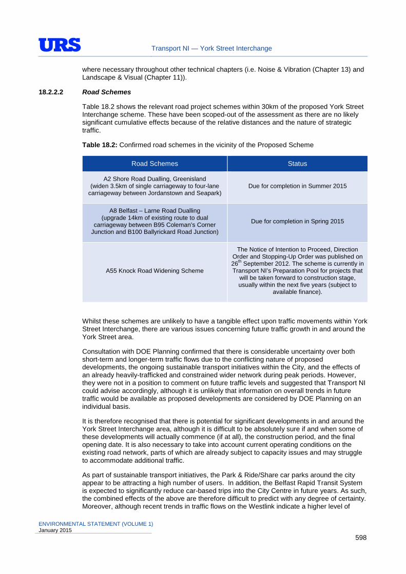
Transport NI — York Street Interchange
where necessary throughout other technical chapters (i.e. Noise & Vibration (Chapter 13) and Landscape & Visual (Chapter 11)).
18.2.2.2 Road Schemes
Table 18.2 shows the relevant road project schemes within 30km of the proposed York Street Interchange scheme. These have been scoped-out of the assessment as there are no likely significant cumulative effects because of the relative distances and the nature of strategic traffic.
Table 18.2: Confirmed road schemes in the vicinity of the Proposed Scheme
Road Schemes Status
A2 Shore Road Dualling, Greenisland (widen 3.5km of single carriageway to four-lane
carriageway between Jordanstown and Seapark) Due for completion in Summer 2015
A8 Belfast – Larne Road Dualling (upgrade 14km of existing route to dual
carriageway between B95 Coleman’s Corner Junction and B100 Ballyrickard Road Junction)
Due for completion in Spring 2015
A55 Knock Road Widening Scheme
The Notice of Intention to Proceed, Direction Order and Stopping-Up Order was published on 26th September 2012. The scheme is currently in Transport NI’s Preparation Pool for projects that
will be taken forward to construction stage, usually within the next five years (subject to
available finance).
Whilst these schemes are unlikely to have a tangible effect upon traffic movements within York Street Interchange, there are various issues concerning future traffic growth in and around the York Street area.
Consultation with DOE Planning confirmed that there is considerable uncertainty over both short-term and longer-term traffic flows due to the conflicting nature of proposed developments, the ongoing sustainable transport initiatives within the City, and the effects of an already heavily-trafficked and constrained wider network during peak periods. However, they were not in a position to comment on future traffic levels and suggested that Transport NI could advise accordingly, although it is unlikely that information on overall trends in future traffic would be available as proposed developments are considered by DOE Planning on an individual basis.
It is therefore recognised that there is potential for significant developments in and around the York Street Interchange area, although it is difficult to be absolutely sure if and when some of these developments will actually commence (if at all), the construction period, and the final opening date. It is also necessary to take into account current operating conditions on the existing road network, parts of which are already subject to capacity issues and may struggle to accommodate additional traffic.
As part of sustainable transport initiatives, the Park & Ride/Share car parks around the city appear to be attracting a high number of users. In addition, the Belfast Rapid Transit System is expected to significantly reduce car-based trips into the City Centre in future years. As such, the combined effects of the above are therefore difficult to predict with any degree of certainty. Moreover, although recent trends in traffic flows on the Westlink indicate a higher level of
ENVIRONMENTAL STATEMENT (VOLUME 1) January 2015
598
Transport NI — York Street Interchange
annual growth, which may in part be due to the effects of traffic re-assignment from the City Centre rather than traffic growth, traffic flows on the M2 have increased at a much lower rate. The combined growth over these two sites which reflects the M1-M2 movements has been generally below central growth.
It is also important to take into account the transport objectives of the Proposed Scheme and the effects that different traffic growth scenarios would have on the development of the scheme. The Expanded SRI Programme identified the necessity to deal with bottlenecks on very highly trafficked routes and identified the provision of a flyover junction carrying the Westlink over York Street, (i.e. ‘to provide a grade-separated junction at the last remaining part of Westlink which has a traffic signalled junction’). The Proposed Scheme addresses that requirement and incorporates additional features such as the York Street bus lane, although there is little or no scope for further increasing the capacity of the Proposed Scheme within the constrained site. The traffic forecast scenarios will therefore not change the proposed design but will quantify the extent to which the scheme satisfies the Government’s transport planning objectives.
This degree of uncertainty has been reflected by testing the Proposed Scheme against a range of traffic forecasts, with four scenarios developed, namely:
• National Road Traffic Forecasts (NRTF) Low traffic growth – which would reflect the effects of sustainable transport initiatives and the lower growth observed on the M2 corridor;
• NRTF Central traffic growth – which provides a balanced forecast of overall trends in traffic flows over the longer term;
• NRTF High traffic growth – which could better reflect the potential increase in demand if the proposed developments are realised; and
• High demand growth – which included an allowance for additional traffic using the strategic M1-M2 and M1-M3 links following the provision of the Proposed Scheme.
The traffic data used within this assessment is derived from the Traffic & Economic Assessment study for the Proposed Scheme, which is detailed within Section 5 (Traffic and Economic Assessment) of the Engineering, Traffic and Economic Assessment Report which forms Part 2 of the overall Proposed Scheme Report (akin to a Stage 3 Scheme Assessment Report).
If sustainable transport initiatives currently or soon to be implemented reduce private car trips into the city centre and mitigate the effects of additional trips generated by potential/proposed developments in and around the area, then the NRTF Central traffic growth forecast would be a reasonable basis for the assessment of the Proposed Scheme, and has been used for the technical assessments contained within this ES.
For the assessment of cumulative effects, it has been agreed with Transport NI to test the Proposed Scheme against the ‘High Demand’ traffic growth scenario, which would better reflect the potential increase in demand if the proposed developments are realised (i.e. as a worst case scenario).
18.2.3 Significance of Effects
The cumulative impacts of different projects are assessed against the significance criteria outlined in Table 18.3. These impacts will be determined arising from the potential impacts identified in the individual assessments. Mitigation measures will be identified if needed, and where relevant residual impacts will be assessed.
ENVIRONMENTAL STATEMENT (VOLUME 1) January 2015
599

Transport NI — York Street Interchange
Table 18.3: Determining Significance of Cumulative Effects
Significance Effects
Severe Effects that the decision-maker must take into account as the receptor/resource is irretrievably compromised.
Major Effects that may become a key decision-making issue.
Moderate Effects that are unlikely to become issues on whether the project design should be selected, but where future work may be needed to improve on current performance.
Minor Effects that are locally significant.
Not Significant Effects that are beyond the current forecasting ability or are within the ability of the resource to absorb such change.
Source: DMRB Volume 11, Section 2, Part 5, Chapter 2, Table 2.6
18.3 Assessment of Cumulative Environmental Effects
18.3.1 Air Quality
For the assessment of cumulative effects, the results from a Local Air Quality assessment based on a high demand traffic growth scenario has been calculated and presented in Appendix 8, Annex B in Volume 2 of this ES. This assessment considered the following:
• High Demand Traffic Growth Do-Minimum Scenario Annual Mean Pollutant concentrations (2021);
• High Demand Traffic Growth Do-Something Scenario Annual Mean Pollutant concentrations (2021);
• Change in Annual Mean Pollutant concentrations for High Demand Traffic Growth Scenario (2021);
• High Demand Traffic Growth Do-Minimum Scenario Annual Mean Pollutant concentrations (2035);
• High Demand Traffic Growth Do-Something Scenario Annual Mean Pollutant concentrations (2035); and
• Change in Annual Mean Pollutant concentrations for High Demand Traffic Growth Scenario (2035).
In the year of Opening (2021) and the Design year (2035), predicted annual mean concentrations of NO2 and particulate matter (PM10 and PM2.5) would be below national air quality objective values at all assessed sensitive receptors for both the Do-Minimum and Do-Something scenarios. Whilst the combined effects would also result in localised changes in emissions as a result of modification to the existing road layout and associated traffic redistributional effects, the changes in concentrations of nitrogen dioxide or particulate matter (PM10, PM2.5) would generally be of an imperceptible or small magnitude, in terms of both increases and decreases in exposure. On this basis, the effects are not significant as it is within the ability of the predicted environment to absorb such change.
The assessment of combined and interrelated impacts also includes a High Demand Growth Regional Assessment and also concluded that the effects would not be significant.
ENVIRONMENTAL STATEMENT (VOLUME 1) January 2015
600

Transport NI — York Street Interchange
18.3.2 Cultural Heritage
Cumulative impacts can arise from the multiple effects of the same scheme on a single asset, different multiple effects of the scheme and other sources on the same asset, or incremental effects arising from a number of small actions over time. Interactions may arise from activities related to other topics, such as drainage schemes, endangered species relocation, sound attenuation measures or access arrangements, taken together with any cultural heritage impacts. The combined and interrelated impacts have been assessed within Chapter 9 (Cultural Heritage) and are summarised below.
18.3.2.1 Potential Cumulative Effects on Archaeological Remains
Potential cumulative impacts on archaeology would affect AR11 (Area of Archaeological Potential, defined by the local authority) and AR13 (buried palaeo-environmental remains) (Figure 9.1) as a result of the proposed development at City Quays (currently under construction). On this basis, the effect is not significant.
18.3.2.2 Potential Cumulative Effects on Historic Buildings
The development at City Quays Belfast (currently under construction) that is within the vicinity of the Proposed Scheme is likely to result in cumulative impacts upon the setting of a number of historic buildings that are designated – HB3 (Clarendon Dock Buildings, Harbour Estate Belfast), HB4 (Sinclair Seamen's Presbyterian Church, Corporation Square) and HB5 (Harbour Office, Corporation Square). The scale of the proposed City Quays development would impact upon the setting of the listed buildings and its visual association with the area which reinforces the significance of the functional relationship. Combined with the Proposed Scheme, it would further diminish the setting and historic integrity of the historic dock area. In terms of significance, the effects are minor adverse as they are only locally significant.
18.3.2.3 Potential Cumulative Effects on Historic Landscape
No such effects have been identified.
18.3.3 Ecology and Nature Conservation
In terms of committed development in the vicinity of the Proposed Scheme, the majority of sites to be developed are either hardstanding or vacant brownfield land and are typically of low ecological interest. However, in terms of development proposals, the City Quays Masterplan for example proposes to enhance the ecological value of the site and minimise the potential impact of the proposed development through a number of recommended mitigation measures.
Essentially as PPS2 Natural Heritage (July 2013) sets out the DOE’s planning policies for the conservation, protection and enhancement of the natural heritage, it is expected that any development in the area would be required to meet the objectives of this PPS. On this basis, in terms of cumulative impacts from different projects, the significance of effect would be minor beneficial, from an ecology and nature conservation perspective.
18.3.4 Landscape & Visual Effects
Future development trends in the vicinity of the Proposed Scheme indicate that committed developments would include more large scale buildings, thus the built form of the area would change, in-combination with the Proposed Scheme. For example, a new building at City Quays and the University of Ulster Greater Belfast Development are currently under construction and a range of other key planning applications within the area have recently received planning approval.
As detailed within Chapter 11 (Landscape and Visual Effects), a committed development assessment has been undertaken to consider in-combination effects. Committed
ENVIRONMENTAL STATEMENT (VOLUME 1) January 2015
601

Transport NI — York Street Interchange
developments are potential future visual receptors, which may be constructed before completion of the Proposed Scheme, and as a result would alter the baseline conditions. Committed developments have been divided into two groups; those in the “Primary Zone” are within the ground level Zone of Visual Influence, and those in the “Secondary Zone” are immediately outwith this. Committed development visual receptors are detailed in Appendix 11, Annex D of this ES.
Overall, committed developments would alter some existing available views, as they would partially or fully obstruct potential views (from existing receptors and committed development receptors) towards the Proposed Scheme. The extent to which the Primary Zone Committed Developments would give rise to additional visual impact over and above that identified in the baseline visual assessment is summarised in Table 18.4.
Table 18.4: Summary of Visual Impacts on Committed Development in Year 1 (‘assumed’ year of scheme Opening) and Year 15 (‘Design Year’)
Magnitude of Visual Impact
No. of Primary Zone Committed Development Visual Receptors
Year 1 (Winter)
No. of Primary Zone Committed Development Visual Receptors
Year 15 (Summer)
Major 11 4
Moderate 19 9
Minor 8 17
Negligible 6 14
No Change 3 3
Total 47 47
In terms of significance, the in-combination effects would at worst be minor as even though some receptors would be subject to a major adverse visual impact, the effect would only be locally significant and would not be a key decision making issue.
18.3.5 Land Use
As detailed within Chapter 12, the Land Use assessment has taken account of, as far as practicable, future changes in land use due to new development which would likely occur in the absence of the Proposed Scheme. As noted previously, DRD Transport NI currently owns the majority of private land that would be affected by the Proposed Scheme. Therefore, in terms of intended future usage, the land affected is largely required by the Department for the performance of its present and future responsibilities (i.e. to construct the road). Only four planning applications would be lost in their entirety to accommodate the Proposed Scheme, however as advertisement applications, these are of low value and do not contribute positively to the development of the area. Furthermore, no areas of community land or designations, policies, proposals or zonings for development land within Belfast City Centre, Belfast Harbour Area, or Outer Belfast City (North Belfast) would be adversely affected by the Proposed Scheme.
After the entire scheme opens to traffic, the DRD Transport NI would carry out a review of land vested for construction of the new road; if this exceeds the minimum required by the Department for the performance of its present and future responsibilities, any surplus land may be sold back to the original owner or others at the then market value. There are four areas which may be made available to future development as part of surplus land disposal.
ENVIRONMENTAL STATEMENT (VOLUME 1) January 2015
602
Transport NI — York Street Interchange
The potential development of this land would be a significant benefit to the area, as this land would remain to be underutilised until post scheme completion.
On this basis, the cumulative effect upon future land uses as a result of in-combination effects is not significant.
18.3.6 Noise and Vibration
For the assessment of cumulative effects, the results from an assessment based on a high demand traffic growth scenario have also been calculated and are presented in Appendix 13, Annex B of this ES.
The high demand growth scenario includes other significant developments that are not included in the central growth scenario, with an allowance for additional traffic using the strategic Westlink-M2 and Westlink-M3 links following the provision of the Proposed Scheme. Figures are also included for this high demand traffic scenario within A13.1 to A13.3 of Appendix 13, Annex B. The DMRB tables for high traffic demand are included within Appendix 13, Annex B.
As with central traffic growth, all residential properties are predicted to experience a negligible increase in traffic noise levels from 2021 to 2035, under the Do-Minimum scenario. Approximately 85% of residential properties are predicted to experience a negligible increase, approximately 5% are predicted to experience a minor increase, approximately 10% are predicted to experience no change, and approximately 3% experience a negligible or minor decrease in short-term noise levels. For non-residential sensitive receptors, approximately 79% would experience a negligible increase, approximately 14% would experience a minor increase, and approximately 7% would experience no change in short-term noise levels.
In terms of the long-term change between the Do-Minimum 2021 and Do-Something 2035 scenarios, approximately 98% of residential properties are predicted to experience a negligible increase and approximately 2% are predicted to experience no change or a negligible decrease in long-term traffic noise levels. For non-residential sensitive receptors, all are predicted to experience a negligible increase in long-term traffic noise levels. Long-term changes in night-time noise levels show a similar pattern to the daytime changes, albeit with significantly fewer properties included in the assessment.
In terms of changes in nuisance, for the Do-Minimum scenario, all residential properties would experience an increase in nuisance. For the Do-Something scenario, the situation is similar, with 99% of residential properties experiencing an increase in nuisance or no change, and a small number with a <10% decrease.
On this basis, the effects are not significant as they are within the ability of the predicted noise environment to absorb such change.
18.3.7 Pedestrians, Cyclists, Equestrians and Community Effects
A number of committed developments within the study area (i.e. City Quays, University of Ulster and a number of substantial residential developments with a particular focus on student accommodation) are likely to bring a significant influx of Non-Motorised Users (NMUs) into the study area.
The new University of Ulster Belfast Campus for example, will accommodate approximately 11,292 Full Time Equivalent (FTE) students and approximately 1,280 FTE staff with the majority of those staff and students relocating from the existing Jordanstown campus. Parking provision will be limited to 350 spaces within the DSD ‘Mixed Use Regeneration Scheme’ on Frederick Street. On this basis, there would be a significant influx of NMUs into the study area, which would put significantly increased demand on the footway, cycleway and bus lanes which have been incorporated into the Proposed Scheme design.
ENVIRONMENTAL STATEMENT (VOLUME 1) January 2015
603

Transport NI — York Street Interchange
Accordingly, a NMU Audit report has been prepared and considered the effects of these in-combination impacts for a range of committed developments within the study area. Generally, York Street would be the most heavily utilised NMU route, particularly to the proposed University and the provision of a 3m wide footway along its length between Great Patrick Street and Dock Street (as much as is feasibly possible), is considered adequate to accommodate this demand. Further to this, the provision of a dedicated cycle lane northbound, and a bus/cycle lane southbound is also considered sufficient to accommodate this increased demand. Overall, the cumulative effects have been assessed to be not significant.
18.3.8 Vehicle Travellers
For the assessment of cumulative effects, the results from an assessment based on a high demand traffic growth scenario have also been calculated and are presented in Appendix 15, Annex B of this ES.
In terms of a comparison of Central Growth and High Demand Growth scenarios for the Do-Minimum scenario in the Design Year (2035), the analysis showed that four links on the existing road network would change in terms of driver stress. As shown in Figure 15.2, levels of stress would be ‘High’ on the strategic road network and North Queen Street, and generally ‘Moderate’ on the remainder of the local city road network with the Central Growth scenario. The High Demand Growth scenario displays similar trends, with four links (Link 106 (Clifton Street), Link 224 (Nelson Street), Link 272 (Duncrue Street) and Link 362 (Dunbar Link)) increasing in stress, from ‘Moderate’ to ‘High’, compared with the Central Growth scenario (Appendix 15, Annex B, Figure 15.B1). Each of these links increase in stress due to increased flows per lane, however there are no significant rises in speed, keeping each of these links in the <50kph threshold. As key strategic links are already at a ‘High’ stress level, the increase in traffic flows in the area would not exacerbate stress levels further.
In terms of a comparison of the Central Growth and High Demand Growth scenarios for the Do-Something scenario in the Design Year (2035), the analysis showed that eight links on the proposed road network would change in terms of driver stress. As shown in Figure 15.3, levels of stress would again be ‘High’ on the strategic road network and North Queen Street, and generally ‘Moderate’ on the remainder of the local city road network with the Central Growth scenario. The High Demand Growth scenario displays similar trends, but with eight links increasing in stress, from ‘Moderate’ to ‘High’. Each of these links increase in stress due to increased flows per lane, however there are no significant rises in speed, keeping each of these links in the lowest speed threshold. These are; Links 104 & 106 on Clifton Street, Link 332 on North Queen Street, Links 131 & 362 on Dunbar Link, Link 412 on York Street (northbound), Link 463 Nelson Street, and Link 426 from the M2 to Westlink.
There are no links predicted to have ‘Low’ stress with either the ‘Do-Minimum’ or ‘Do-Something’ scenario, with either Central or High Demand Growth.
Future development trends in the vicinity of the Proposed Scheme indicate that committed developments would include more large scale buildings, thus views from the road would change, in-combination with the Proposed Scheme. For example, the City Quays and University of Ulster Greater Belfast developmens would be viewable contituents from many locations on the proposed road network.
18.3.9 Road Drainage and the Water Environment
The road drainage for the Proposed Scheme has been developed in such a manner as to:
• address road safety issues pertaining to the accumulation of surface water as defined in DMRB;
ENVIRONMENTAL STATEMENT (VOLUME 1) January 2015
604
Transport NI — York Street Interchange
• provide an effective system, using normally available and readily maintained components,
for conveying surface water arising from the Proposed Scheme to the receiving watercourses, water bodies or drainage systems;
• incorporate facilities to inhibit discharge of sediments and significant volumes of hydrocarbons, prior to discharge to receiving water bodies or drainage systems; and
• provide facilities to isolate the drainage system from the receiving watercourses, water bodies or drainage systems in the event of significant spillages of contaminants.
In terms of in-combination effects with committed developments, cumulative impacts upon the water environment would be negligible as the surface water management measures associated with these developments have been designed in-line with current best practice. For example, the City Quays development would include petrol interceptors within its cark parks and the University of Ulster Greater Belfast Development has incorporated a Sustainable Drainage Strategy (SuDS). Measures such as SuDS and petrol interceptors will reduce the level of pollutants which are discharged to Belfast Harbour. On this basis, the cumulative effect would not be significant.
18.3.10 Geology & Soils
From a geology and soils perspective, there would be relatively few cumulative effects. There would be no significant impacts on solid or drift geology, or on soils of the region expected from any of the committed developments within the study area; thus the cumulative effect is likely to be not significant.
As all committed developments would affect brownfield land or existing development, potential areas of contaminated land may be encountered. Whether or not the Proposed Scheme or any other developments encounters contaminated land, further investigation will be necessary, including a contaminated land risk assessment to assess the appropriate remediation / mitigation measures. As such, the cumulative effect would be neutral, if not slightly beneficial as a consequence of remediation resulting in improved land quality and reduction in risk to human health and the wider environment. It has been assessed that the potential cumulative effects upon geology and soils are not significant.
ENVIRONMENTAL STATEMENT (VOLUME 1) January 2015
605
Transport NI — York Street Interchange
18.4 Summary of Environmental Effects
Table 18.5 provides a collective summary of the environmental effects described throughout each of the previous technical Chapters (8-17), taking into account the effectiveness of measures (where appropriate) to mitigate adverse impacts, thus allowing for the overall significance of effect to be rated. It also provides comments on what would be the equivalent environmental effect if the Proposed Scheme was not to be constructed. Specifically, the following have been tabulated:
• Description of Predicted Impact (with the proposed scheme);
• Mitigation Objective and Commitment;
• Sensitivity / Value of Receptor;
• Duration of Impact (Short / Long-Term);
• Magnitude of Impact with Mitigation;
• Significance of Impact with Mitigation; and
• Description of Likely Effects (without the proposed scheme).
As Table 18.5 only provides a brief summary of the overall environmental effects, reference should be made to individual chapters of this ES for further explanation and understanding.
ENVIRONMENTAL STATEMENT (VOLUME 1) January 2015
606
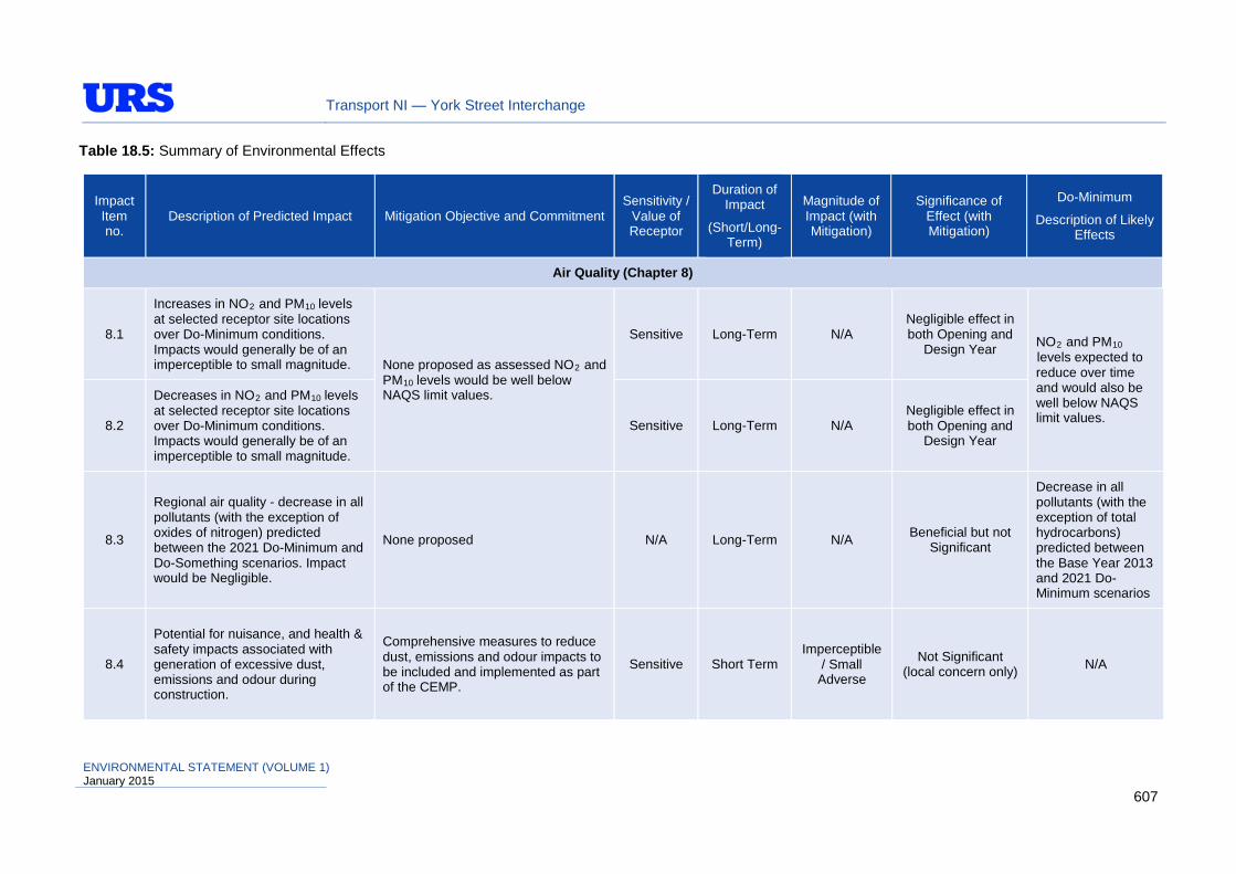
Transport NI — York Street Interchange
Table 18.5: Summary of Environmental Effects
Impact Item no.
Description of Predicted Impact Mitigation Objective and Commitment Sensitivity /
Value of Receptor
Duration of Impact
(Short/Long-Term)
Magnitude of Impact (with Mitigation)
Significance of Effect (with Mitigation)
Do-Minimum
Description of Likely Effects
Air Quality (Chapter 8)
8.1
Increases in NO2 and PM10 levels at selected receptor site locations over Do-Minimum conditions. Impacts would generally be of an imperceptible to small magnitude. None proposed as assessed NO2 and
PM10 levels would be well below NAQS limit values.
Sensitive Long-Term N/A Negligible effect in both Opening and
Design Year NO2 and PM10 levels expected to reduce over time and would also be well below NAQS limit values. 8.2
Decreases in NO2 and PM10 levels at selected receptor site locations over Do-Minimum conditions. Impacts would generally be of an imperceptible to small magnitude.
Sensitive Long-Term N/A Negligible effect in both Opening and
Design Year
8.3
Regional air quality - decrease in all pollutants (with the exception of oxides of nitrogen) predicted between the 2021 Do-Minimum and Do-Something scenarios. Impact would be Negligible.
None proposed N/A Long-Term N/A Beneficial but not Significant
Decrease in all pollutants (with the exception of total hydrocarbons) predicted between the Base Year 2013 and 2021 Do-Minimum scenarios
8.4
Potential for nuisance, and health & safety impacts associated with generation of excessive dust, emissions and odour during construction.
Comprehensive measures to reduce dust, emissions and odour impacts to be included and implemented as part of the CEMP.
Sensitive Short Term Imperceptible
/ Small Adverse
Not Significant (local concern only) N/A
ENVIRONMENTAL STATEMENT (VOLUME 1) January 2015
607

Transport NI — York Street Interchange
Impact Item no.
Description of Predicted Impact Mitigation Objective and Commitment Sensitivity /
Value of Receptor
Duration of Impact
(Short/Long-Term)
Magnitude of Impact (with Mitigation)
Significance of Effect (with Mitigation)
Do-Minimum
Description of Likely Effects
Cultural Heritage (Chapter 9)
9.1
The Proposed Scheme would have a Minor impact on two assets of Medium value (Area of Archaeological Potential & buried palaeo-environmental remains), a Major impact on a Low value asset and Minor impact on a Low value asset.
Appropriate archaeological mitigation (preservation by record / preservation by design), and sensitive engineering of earthworks would minimise the adverse effects of Scheme construction.
Low to Medium Long-Term Minor to Major
Adverse
Slight Adverse effect on the two assets of Medium value and Slight
Adverse effect on two assets of Low
value.
Some of these sites may be directly or indirectly affected in the long-term as a result of other non-infrastructural development in this urban location which would take place in the absence of the scheme.
9.2
The Proposed Scheme would impact on the setting of ten historic building assets (four high value and six medium value). In all cases, these would be either Negligible or Minor Adverse.
No specific mitigation for setting has been proposed, as appropriate mitigation such as landscaping and landscape planting is already outlined in Chapter 11 (Landscape and Visual Effects).
Medium to High Long-Term
Negligible to Minor
Adverse
Slight Adverse effect on the assets of high and medium
value
9.3
The Proposed Scheme would impact 15 historic landscape elements (setting impacts and impacts to buried and upstanding remains), which includes two high value, nine low value and four negligible value assets. Impacts would range from Negligible to Major Adverse.
No specific mitigation for the setting of ten of the historic landscape assets has been proposed. However, for four of the assets archaeological trial trench evaluation, followed by detailed excavation would be undertaken, if appropriate. It is acknowledged that careful consultation with the local community would be required in connection with the treatment of the memorial façade to McGurk’s Bar bombing currently in place.
Low to High
Short-Term & Long-Term
Negligible to Major
Adverse
Slight Adverse effect on the assets of high value. Slight Adverse to Neutral effect on all Low
value assets, except McGurk’s Bar
memorial. Slight Adverse effect on
the assets of Negligible value.
ENVIRONMENTAL STATEMENT (VOLUME 1) January 2015
608

Transport NI — York Street Interchange
Impact Item no.
Description of Predicted Impact Mitigation Objective and Commitment Sensitivity /
Value of Receptor
Duration of Impact
(Short/Long-Term)
Magnitude of Impact (with Mitigation)
Significance of Effect (with Mitigation)
Do-Minimum
Description of Likely Effects
Ecology & Nature Conservation (Chapter 10)
10.1
Disturbance to receiving water at Belfast Harbour, resulting in stirring-up of existing contaminated sediments;
Pollution incident;
Disturbance to existing contaminants in Scheme footprint;
Cumulative effects of disturbance or contaminants from this Proposed Scheme acting in combination with others;
Pollution from construction traffic and accidental spillage; Run-off from borrow and fill sites.
Predicted impact would be Slight to Large Adverse.
Control of flow velocity entering Belfast Harbour;
Construction method using full cut-off diaphragm walls;
Pollution emergency control valves.
Inter-national Short-term Negligible
Adverse Negligible No change from existing conditions.
10.2
Loss of woodland / trees and damage to woodland / trees during construction. Predicted impact would Slight to Large Adverse.
Over 3ha of extensive planting and landscaping with native species, including large trees;
Care during construction to retain trees and woodland where possible;
Habitat Management Plan to be prepared and implemented.
Local / Parish
Short-Term & Long-Term
Negligible to Slight
Adverse Negligible No change from
existing conditions.
10.3 Loss of habitat and damage to remaining habitat. Predicted impact would be Moderate to Large
Brownfield habitat would be retained on completion of construction works;
Local / Parish
Short-Term & Long-Term
Negligible Adverse Negligible No change from
existing conditions.
ENVIRONMENTAL STATEMENT (VOLUME 1) January 2015
609

Transport NI — York Street Interchange
Impact Item no.
Description of Predicted Impact Mitigation Objective and Commitment Sensitivity /
Value of Receptor
Duration of Impact
(Short/Long-Term)
Magnitude of Impact (with Mitigation)
Significance of Effect (with Mitigation)
Do-Minimum
Description of Likely Effects
Adverse. Care taken to retain brownfield habitats, where possible;
Habitat Management Plan to be prepared and implemented.
10.4 Risk of spread of invasive species. Predicted impact would be Moderate Adverse.
Invasive Species Management Plan followed and ECoW to advise on any work within the contaminated zones.
Zone of Influence
Short-Term & Long-Term
Negligible Adverse Negligible Risk of spread of
invasive species.
10.5
Loss of foraging habitats, commuting routes for bats and disturbance during construction. Predicted impact would be Slight to Moderate Adverse.
Two bat roosting boxes provided at North Queen Street Bridge & proposed new Dock Street Bridge; Large-scale landscaping; Tree-lined road links; Introduction of new habitats; Planting of bat ‘hop-over’ vegetation adjacent to the new road links; Bats considered in lighting plan; Vegetation clearance would be temporary and last for a relatively short duration.
Regional / County
Short-Term & Long-Term
Negligible to Slight
Adverse Minor Adverse No change from
existing conditions.
10.6
Loss of nesting habitats, foraging habitats for breeding bird assemblage. Disturbance to birds during construction. Predicted impact would be Slight to Moderate Adverse.
Extensive planting and landscaping with native species, including plantation woodland;
Bird boxes would be erected throughout the scheme footprint;
Vegetation clearance to be carried out during the winter months or supervised by the ECoW.
Local / Parish
Short-Term & Long-Term
Slight Adverse Negligible No change from
existing conditions.
ENVIRONMENTAL STATEMENT (VOLUME 1) January 2015
610

Transport NI — York Street Interchange
Impact Item no.
Description of Predicted Impact Mitigation Objective and Commitment Sensitivity /
Value of Receptor
Duration of Impact
(Short/Long-Term)
Magnitude of Impact (with Mitigation)
Significance of Effect (with Mitigation)
Do-Minimum
Description of Likely Effects
Landscape and Visual Effects (Chapter 11)
11.1
Cityscape Character Area 1 Transport Infrastructure Node
The additional elevated roads and the underpasses would increase the mass of transport infrastructure. An existing path and existing vegetation would be removed.
Proposed mitigation could improve the appearance of site boundaries and replace some areas of removed vegetation.
Low Long-Term Moderate Adverse Slight Adverse
No change from existing conditions.
11.2
Cityscape Character Area 1 McGurk’s memorial
In local landscape character terms, the removal of McGurk’s memorial would cause the loss of this locally characteristic feature, which is directly associated with this location.
No noticeable permanent change if memorial would be replaced, if progressed separately to this scheme.
High Long-Term Major
Adverse
Very Large Adverse
No change from existing conditions.
11.3
Cityscape Character Area 1 Bridges Urban Sports Park
The character of the context is dominated by the Dargan and Lagan bridges overhead and this would not be noticeably altered by the development.
None specifically proposed other than what is illustrated on the Landscape Mitigation drawings (Figure 11.7, Sheets 1 to 7) and also shown in the photomontages (Figure 11.6, Sheets 1 to 7).
Low Long-Term Negligible Adverse Neutral
No change from existing conditions.
11.4
Cityscape Character Area 2 Northern Residential
The removal of vegetation on the edge of this character type would alter the character at localised
Proposed mitigation could improve the appearance of site boundaries and replace some areas of removed vegetation.
Moderate Long-Term Minor Adverse Slight Adverse
No change from existing conditions.
ENVIRONMENTAL STATEMENT (VOLUME 1) January 2015
611
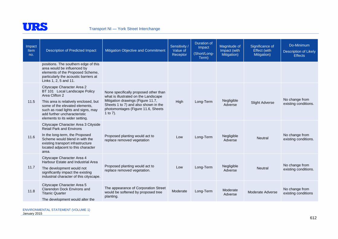
Transport NI — York Street Interchange
Impact Item no.
Description of Predicted Impact Mitigation Objective and Commitment Sensitivity /
Value of Receptor
Duration of Impact
(Short/Long-Term)
Magnitude of Impact (with Mitigation)
Significance of Effect (with Mitigation)
Do-Minimum
Description of Likely Effects
positions. The southern edge of this area would be influenced by elements of the Proposed Scheme, particularly the acoustic barriers at Links 1, 2, 5 and 11.
11.5
Cityscape Character Area 2 BT 101 Local Landscape Policy Area Clifton 2
This area is relatively enclosed, but some of the elevated elements, such as road lights and signs, may add further uncharacteristic elements to its wider setting.
None specifically proposed other than what is illustrated on the Landscape Mitigation drawings (Figure 11.7, Sheets 1 to 7) and also shown in the photomontages (Figure 11.6, Sheets 1 to 7).
High Long-Term Negligible Adverse Slight Adverse
No change from existing conditions.
11.6
Cityscape Character Area 3 Cityside Retail Park and Environs
In the long-term, the Proposed Scheme would blend in with the existing transport infrastructure located adjacent to this character area.
Proposed planting would act to replace removed vegetation
Low Long-Term Negligible Adverse Neutral
No change from existing conditions.
11.7
Cityscape Character Area 4 Harbour Estate and Industrial Area
The development would not significantly impact the existing industrial character of this cityscape.
Proposed planting would act to replace removed vegetation.
Low Long-Term Negligible Adverse Neutral
No change from existing conditions.
11.8
Cityscape Character Area 5 Clarendon Dock Environs and Titanic Quarter
The development would alter the
The appearance of Corporation Street would be softened by proposed tree planting.
Moderate Long-Term Moderate Adverse Moderate Adverse
No change from existing conditions
ENVIRONMENTAL STATEMENT (VOLUME 1) January 2015
612

Transport NI — York Street Interchange
Impact Item no.
Description of Predicted Impact Mitigation Objective and Commitment Sensitivity /
Value of Receptor
Duration of Impact
(Short/Long-Term)
Magnitude of Impact (with Mitigation)
Significance of Effect (with Mitigation)
Do-Minimum
Description of Likely Effects
appearance of the area immediately west of Corporation Street and Garmoyle Street, which would impact on these streetscapes, located on the boundary of this area.
11.9 Cityscape Character Area 6 Northern City Centre
The elevated portion of Link 11 would be at variance with the cityscape and detract from the sense of place at the edge of this area. The narrowing of Link 7 would improve the appearance of Great George’s Street, at the edge of this area. The two York Street corner properties proposed for demolition do not contribute positively to the streetscape, but the site would require a good quality treatment.
Moderate Long-Term Minor Slight Adverse No change from existing conditions
11.10
Visual Effect has been assessed at each receptor location by analysis of the degree of visibility, and magnitude of visual impact of the Proposed Scheme in Year 1 (Winter).
None specifically proposed other than what is illustrated on the Landscape Mitigation drawings (Figure 11.7, Sheets 1 to 7) and also shown in the photomontages (Figure 11.6, Sheets 1 to 7).
High Long-Term Variable
Neutral (301 receptors)
Slight Adverse (320 receptors)
Moderate Adverse (54 receptors)
Large Adverse (16 receptors)
Very Large Adverse (36 receptors)
New developments in the area would alter existing views
ENVIRONMENTAL STATEMENT (VOLUME 1) January 2015
613
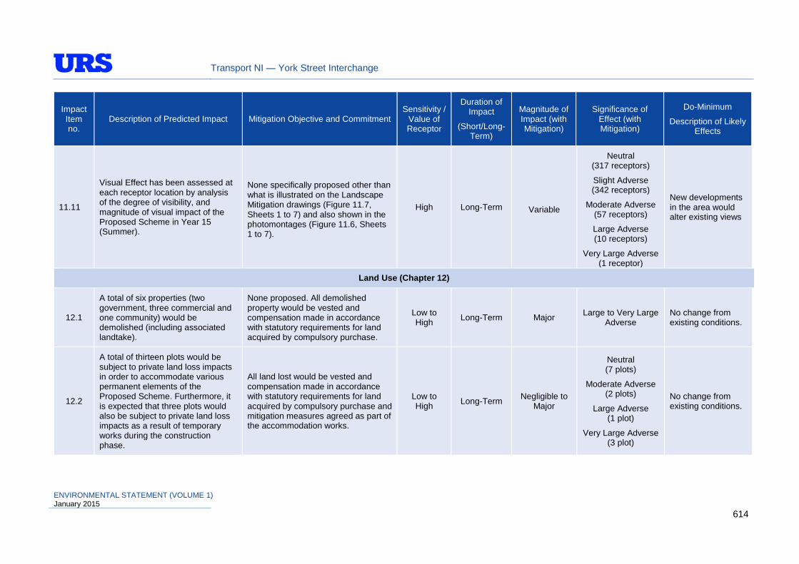
Transport NI — York Street Interchange
Impact Item no.
Description of Predicted Impact Mitigation Objective and Commitment Sensitivity /
Value of Receptor
Duration of Impact
(Short/Long-Term)
Magnitude of Impact (with Mitigation)
Significance of Effect (with Mitigation)
Do-Minimum
Description of Likely Effects
11.11
Visual Effect has been assessed at each receptor location by analysis of the degree of visibility, and magnitude of visual impact of the Proposed Scheme in Year 15 (Summer).
None specifically proposed other than what is illustrated on the Landscape Mitigation drawings (Figure 11.7, Sheets 1 to 7) and also shown in the photomontages (Figure 11.6, Sheets 1 to 7).
High Long-Term Variable
Neutral (317 receptors)
Slight Adverse (342 receptors)
Moderate Adverse (57 receptors)
Large Adverse (10 receptors)
Very Large Adverse (1 receptor)
New developments in the area would alter existing views
Land Use (Chapter 12)
12.1
A total of six properties (two government, three commercial and one community) would be demolished (including associated landtake).
None proposed. All demolished property would be vested and compensation made in accordance with statutory requirements for land acquired by compulsory purchase.
Low to High Long-Term Major Large to Very Large
Adverse No change from existing conditions.
12.2
A total of thirteen plots would be subject to private land loss impacts in order to accommodate various permanent elements of the Proposed Scheme. Furthermore, it is expected that three plots would also be subject to private land loss impacts as a result of temporary works during the construction phase.
All land lost would be vested and compensation made in accordance with statutory requirements for land acquired by compulsory purchase and mitigation measures agreed as part of the accommodation works.
Low to High Long-Term Negligible to
Major
Neutral (7 plots)
Moderate Adverse (2 plots)
Large Adverse (1 plot)
Very Large Adverse (3 plot)
No change from existing conditions.
ENVIRONMENTAL STATEMENT (VOLUME 1) January 2015
614
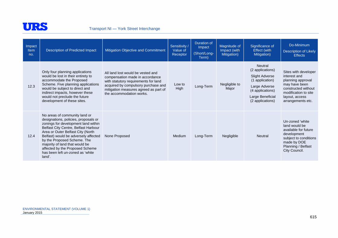
Transport NI — York Street Interchange
Impact Item no.
Description of Predicted Impact Mitigation Objective and Commitment Sensitivity /
Value of Receptor
Duration of Impact
(Short/Long-Term)
Magnitude of Impact (with Mitigation)
Significance of Effect (with Mitigation)
Do-Minimum
Description of Likely Effects
12.3
Only four planning applications would be lost in their entirety to accommodate the Proposed Scheme. Five planning applications would be subject to direct and indirect impacts, however these would not preclude the future development of these sites.
All land lost would be vested and compensation made in accordance with statutory requirements for land acquired by compulsory purchase and mitigation measures agreed as part of the accommodation works.
Low to High Long-Term Negligible to
Major
Neutral (2 applications)
Slight Adverse (1 application)
Large Adverse (4 applications)
Large Beneficial (2 applications)
Sites with developer interest and planning approval may have been constructed without modification to site layout, access arrangements etc.
12.4
No areas of community land or designations, policies, proposals or zonings for development land within Belfast City Centre, Belfast Harbour Area or Outer Belfast City (North Belfast) would be adversely affected by the Proposed Scheme. The majority of land that would be affected by the Proposed Scheme has been left un-zoned as ‘white land’.
None Proposed Medium Long-Term Negligible Neutral
Un-zoned ‘white land would be available for future development subject to conditions made by DOE Planning / Belfast City Council.
ENVIRONMENTAL STATEMENT (VOLUME 1) January 2015
615
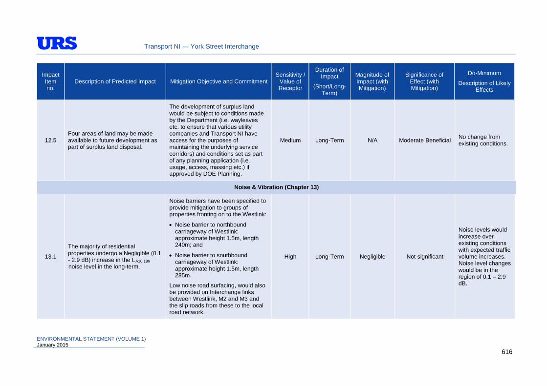
Transport NI — York Street Interchange
Impact Item no.
Description of Predicted Impact Mitigation Objective and Commitment Sensitivity /
Value of Receptor
Duration of Impact
(Short/Long-Term)
Magnitude of Impact (with Mitigation)
Significance of Effect (with Mitigation)
Do-Minimum
Description of Likely Effects
12.5 Four areas of land may be made available to future development as part of surplus land disposal.
The development of surplus land would be subject to conditions made by the Department (i.e. wayleaves etc. to ensure that various utility companies and Transport NI have access for the purposes of maintaining the underlying service corridors) and conditions set as part of any planning application (i.e. usage, access, massing etc.) if approved by DOE Planning.
Medium Long-Term N/A Moderate Beneficial No change from existing conditions.
Noise & Vibration (Chapter 13)
13.1
The majority of residential properties undergo a Negligible (0.1 - 2.9 dB) increase in the LA10,18h noise level in the long-term.
Noise barriers have been specified to provide mitigation to groups of properties fronting on to the Westlink:
• Noise barrier to northbound carriageway of Westlink: approximate height 1.5m, length 240m; and
• Noise barrier to southbound carriageway of Westlink: approximate height 1.5m, length 285m.
Low noise road surfacing, would also be provided on Interchange links between Westlink, M2 and M3 and the slip roads from these to the local road network.
High Long-Term Negligible Not significant
Noise levels would increase over existing conditions with expected traffic volume increases. Noise level changes would be in the region of 0.1 – 2.9 dB.
ENVIRONMENTAL STATEMENT (VOLUME 1) January 2015
616

Transport NI — York Street Interchange
Impact Item no.
Description of Predicted Impact Mitigation Objective and Commitment Sensitivity /
Value of Receptor
Duration of Impact
(Short/Long-Term)
Magnitude of Impact (with Mitigation)
Significance of Effect (with Mitigation)
Do-Minimum
Description of Likely Effects
13.2
Certain construction activities would result in increases in noise levels (particularly in the vicinity of structures and major earthworks)
Contractor to adopt good working practice on site as described in BS5228 (1997 and 2009), ‘Noise and Vibration Control on Construction and Open Sites’.
High Short-Term Variable Not significant N/A
Pedestrians, Cyclists, Equestrians & Community Effects (Chapter 14)
14.1
Strategic and local traffic interaction would occur through a much improved highway environment, with flows becoming more regulated and the safety of the highway environment would improve. Some roads would not be subject to physical alteration; however they would be subject to traffic redistributional effects as a result of proposed changes to other parts of the existing road network.
None proposed Variable Long-Term Variable
Significantly beneficial for
strategic road users, however the effect
associated with traffic redistribution
and changes to routes taken would be both beneficial
and adverse, depending upon the nature of changes
experienced.
Strategic and local vehicle movements would not experience the benefits associated with the improved highway, however other local routes would not experience traffic redistributional effects as a result of the changes
ENVIRONMENTAL STATEMENT (VOLUME 1) January 2015
617

Transport NI — York Street Interchange
Impact Item no.
Description of Predicted Impact Mitigation Objective and Commitment Sensitivity /
Value of Receptor
Duration of Impact
(Short/Long-Term)
Magnitude of Impact (with Mitigation)
Significance of Effect (with Mitigation)
Do-Minimum
Description of Likely Effects
14.2
Six community facilities (Pathways Project Building on York Street, McGurk's Bar Bombing Memorial and mock-up mural/sculpture, Jack Kirk Automobile Engineer workshop, Northside Park & Ride and Great George’s Street and Corporation Street car parks). A number of community facilities would also experience direct land loss or access impacts, however their continued usage during the operational phase is unlikely to be significantly affected.
Where necessary, specific mitigation measures to negate adverse impacts upon community facilities are described within sub-section 14.6.1.6. Whilst it would not be possible to eliminate adverse impacts at all community facilities, in the majority of cases, the proposed mitigation measures would significantly reduce impacts.
Variable Long-Term Variable Large Adverse to Neutral
No change from existing conditions. Northside Park & Ride was targeted to cease operation at this site as part of DRD Transportation Policy Division’s strategic review of Park & Ride services, however may have been retained for short-stay parking.
14.3
The reduction in strategic traffic interaction, resultant freer flowing traffic conditions, and inclusion of a southbound bus lane on York Street would be of benefit to (especially in terms of journey ambience, frequency and reliability) and help improve the quality of public transport services. However, a number of bus services would be adversely affected by the traffic redistributional effects associated with changes to the existing road network.
A new bus lane is proposed between a new signalised junction at Galway House and the junction of York Street and Great Patrick Street. All other existing bus lanes within the scheme would be maintained.
In consultation with Translink, any lost serviced bus stops would be appropriately relocated to new routes where feasible.
Variable Long-Term Variable
The effect of replacing lost bus
stops would be predominantly
Neutral; however the provision of the bus lane would be Large Beneficial.
With no change to the existing highway environment, no improvements in efficiency of public bus services would be experienced.
ENVIRONMENTAL STATEMENT (VOLUME 1) January 2015
618

Transport NI — York Street Interchange
Impact Item no.
Description of Predicted Impact Mitigation Objective and Commitment Sensitivity /
Value of Receptor
Duration of Impact
(Short/Long-Term)
Magnitude of Impact (with Mitigation)
Significance of Effect (with Mitigation)
Do-Minimum
Description of Likely Effects
14.4
In terms of amenity and relief from existing severance, the benefits associated with grade-separation of strategic links between the Westlink and M2/M3 (beneath York Street overbridge) would be significant, as pedestrians would no longer be in direct interaction with strategic through traffic within the interchange via signalised junction arrangements. However, some Pedestrian routes would be adversely affected in terms or routes taken and distance travelled.
Footways are provided on all surface streets, with existing widths maintained and where possible (within the constraints of the site), enhanced.
Medium Long-Term Variable
Overall Large Beneficial, however
some pedestrian routes would be
adversely affected by the Proposed
Scheme.
Existing pedestrian provision would remain unchanged.
14.5
With the proposed changes to York Street, the new cycling provision would be an enhancement over existing conditions and the improvements to the junction and surrounding road layout (particularly in relation to the separation of strategic and local traffic) would result in significant safety benefits, reduction in severance, and improvements in journey time and ambience for cyclists.
An additional with-flow cycle lane of 1.5m width is proposed for cyclists heading northbound along York Street, with the provision of Advanced Stop Lines at signalised junctions. In the southbound direction on York Street, a 1.5m wide with-flow cycle lane is proposed between signalised junctions at Dock Street and at Galway House. The new bus lane between Galway House and the junction of York Street and Great Patrick Street would be made accessible to cyclists. All other existing bus lanes, accessible by cyclists, within the scheme would be maintained.
N/A Long-Term Variable Overall Moderate Beneficial
Existing cycling provision would remain unchanged; however volume of passing strategic traffic would increase from existing conditions.
ENVIRONMENTAL STATEMENT (VOLUME 1) January 2015
619

Transport NI — York Street Interchange
Impact Item no.
Description of Predicted Impact Mitigation Objective and Commitment Sensitivity /
Value of Receptor
Duration of Impact
(Short/Long-Term)
Magnitude of Impact (with Mitigation)
Significance of Effect (with Mitigation)
Do-Minimum
Description of Likely Effects
14.6
Construction phase would potentially result in temporary impacts on local vehicle movements. Construction activities may also affect community facilities and local businesses with regards to accessibility and severance or disruption to routes used by pedestrians, cyclists and equestrians.
Careful traffic management to reduce delays, rat running, safe passage of pedestrian, cyclists and equestrians. Also measures to reduce dust, emissions and odour impacts and adoption of good working practice on site as described in BS5228 (1997 and 2009), ‘Noise and Vibration Control on Construction and Open Sites’.
Variable Short-Term Variable Minor / Moderate Adverse N/A
Vehicle Travellers (Chapter 15)
15.1
Negative changes in visual amenity associated with major earthworks / structures and changes within interchange area.
Where appropriate, mitigation would include open parapets on overbridges to allow views from the road and to reduce the mass of the structure and planting design which should be sensitive to the interaction between retaining views from the road and screening.
N/A Short to Long-Term
Negligible to Minor
Neutral to Slight Adverse
No change from existing conditions.
15.2
Positive changes in visual amenity associated with major earthworks and structures with the introduction of new and interesting views.
None proposed, as views from the road would be enhanced. N/A Long-Term Negligible to
Minor Neutral to Slight
Beneficial No change from existing conditions.
15.3
Slightly reduced stress levels resulting from grade-separation of strategic traffic from local routes, following implementation of the Proposed Scheme.
None proposed N/A Long-Term Moderate to High
Neutral to Slight Beneficial
No perceptible change from existing conditions.
ENVIRONMENTAL STATEMENT (VOLUME 1) January 2015
620
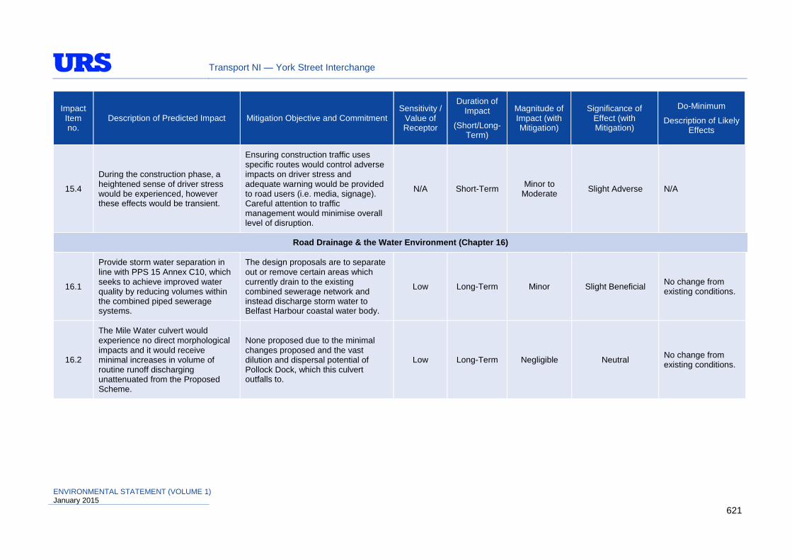
Transport NI — York Street Interchange
Impact Item no.
Description of Predicted Impact Mitigation Objective and Commitment Sensitivity /
Value of Receptor
Duration of Impact
(Short/Long-Term)
Magnitude of Impact (with Mitigation)
Significance of Effect (with Mitigation)
Do-Minimum
Description of Likely Effects
15.4
During the construction phase, a heightened sense of driver stress would be experienced, however these effects would be transient.
Ensuring construction traffic uses specific routes would control adverse impacts on driver stress and adequate warning would be provided to road users (i.e. media, signage). Careful attention to traffic management would minimise overall level of disruption.
N/A Short-Term Minor to Moderate Slight Adverse N/A
Road Drainage & the Water Environment (Chapter 16)
16.1
Provide storm water separation in line with PPS 15 Annex C10, which seeks to achieve improved water quality by reducing volumes within the combined piped sewerage systems.
The design proposals are to separate out or remove certain areas which currently drain to the existing combined sewerage network and instead discharge storm water to Belfast Harbour coastal water body.
Low Long-Term Minor Slight Beneficial No change from existing conditions.
16.2
The Mile Water culvert would experience no direct morphological impacts and it would receive minimal increases in volume of routine runoff discharging unattenuated from the Proposed Scheme.
None proposed due to the minimal changes proposed and the vast dilution and dispersal potential of Pollock Dock, which this culvert outfalls to.
Low Long-Term Negligible Neutral No change from existing conditions.
ENVIRONMENTAL STATEMENT (VOLUME 1) January 2015
621
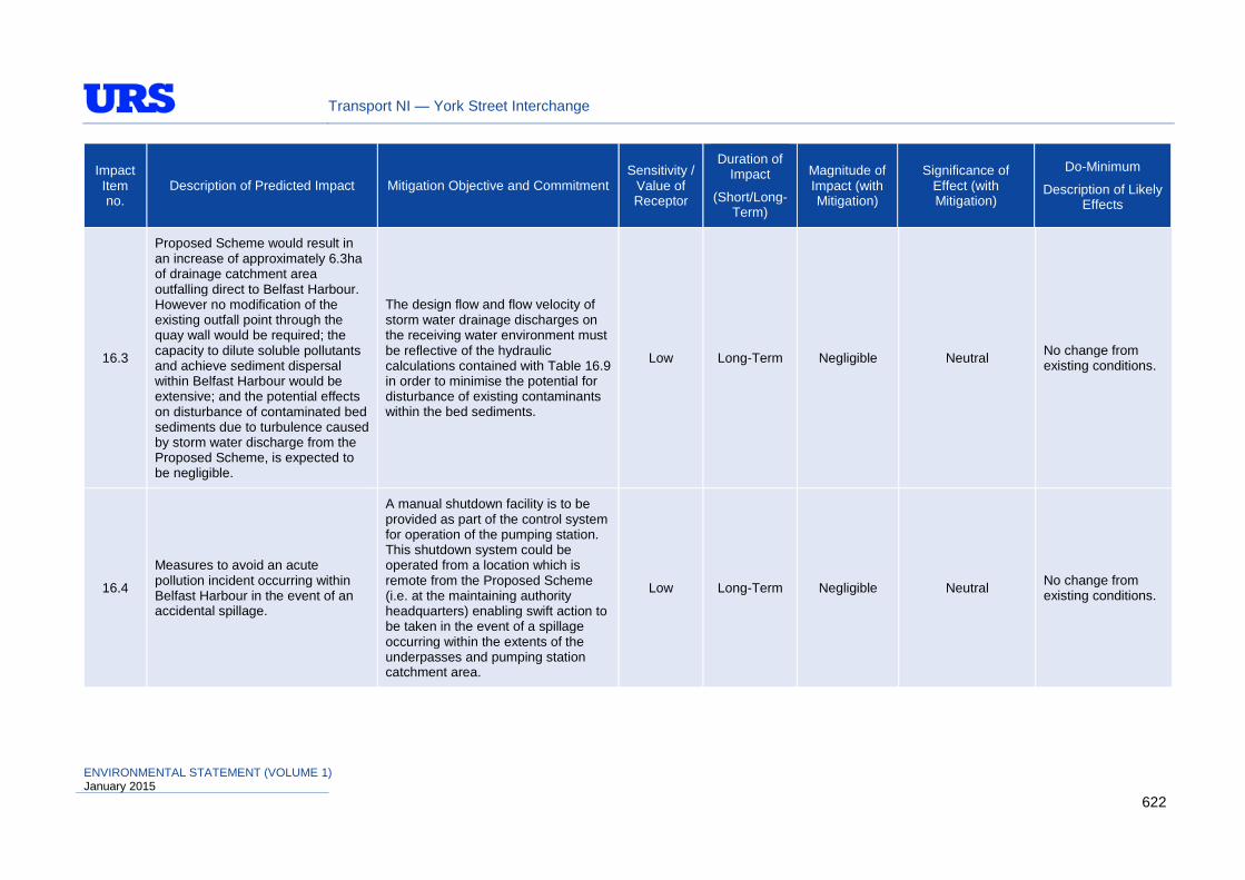
Transport NI — York Street Interchange
Impact Item no.
Description of Predicted Impact Mitigation Objective and Commitment Sensitivity /
Value of Receptor
Duration of Impact
(Short/Long-Term)
Magnitude of Impact (with Mitigation)
Significance of Effect (with Mitigation)
Do-Minimum
Description of Likely Effects
16.3
Proposed Scheme would result in an increase of approximately 6.3ha of drainage catchment area outfalling direct to Belfast Harbour. However no modification of the existing outfall point through the quay wall would be required; the capacity to dilute soluble pollutants and achieve sediment dispersal within Belfast Harbour would be extensive; and the potential effects on disturbance of contaminated bed sediments due to turbulence caused by storm water discharge from the Proposed Scheme, is expected to be negligible.
The design flow and flow velocity of storm water drainage discharges on the receiving water environment must be reflective of the hydraulic calculations contained with Table 16.9 in order to minimise the potential for disturbance of existing contaminants within the bed sediments.
Low Long-Term Negligible Neutral No change from existing conditions.
16.4
Measures to avoid an acute pollution incident occurring within Belfast Harbour in the event of an accidental spillage.
A manual shutdown facility is to be provided as part of the control system for operation of the pumping station. This shutdown system could be operated from a location which is remote from the Proposed Scheme (i.e. at the maintaining authority headquarters) enabling swift action to be taken in the event of a spillage occurring within the extents of the underpasses and pumping station catchment area.
Low Long-Term Negligible Neutral No change from existing conditions.
ENVIRONMENTAL STATEMENT (VOLUME 1) January 2015
622
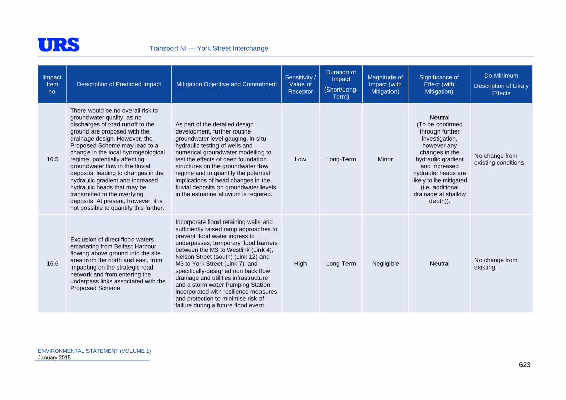
Transport NI — York Street Interchange
Impact Item no.
Description of Predicted Impact Mitigation Objective and Commitment Sensitivity /
Value of Receptor
Duration of Impact
(Short/Long-Term)
Magnitude of Impact (with Mitigation)
Significance of Effect (with Mitigation)
Do-Minimum
Description of Likely Effects
16.5
There would be no overall risk to groundwater quality, as no discharges of road runoff to the ground are proposed with the drainage design. However, the Proposed Scheme may lead to a change in the local hydrogeological regime, potentially affecting groundwater flow in the fluvial deposits, leading to changes in the hydraulic gradient and increased hydraulic heads that may be transmitted to the overlying deposits. At present, however, it is not possible to quantify this further.
As part of the detailed design development, further routine groundwater level gauging, in-situ hydraulic testing of wells and numerical groundwater modelling to test the effects of deep foundation structures on the groundwater flow regime and to quantify the potential implications of head changes in the fluvial deposits on groundwater levels in the estuarine alluvium is required.
Low Long-Term Minor
Neutral (To be confirmed through further investigation, however any
changes in the hydraulic gradient
and increased hydraulic heads are likely to be mitigated
(i.e. additional drainage at shallow
depth)).
No change from existing conditions.
16.6
Exclusion of direct flood waters emanating from Belfast Harbour flowing above ground into the site area from the north and east, from impacting on the strategic road network and from entering the underpass links associated with the Proposed Scheme.
Incorporate flood retaining walls and sufficiently raised ramp approaches to prevent flood water ingress to underpasses; temporary flood barriers between the M3 to Westlink (Link 4), Nelson Street (south) (Link 12) and M3 to York Street (Link 7); and specifically-designed non back flow drainage and utilities infrastructure and a storm water Pumping Station incorporated with resilience measures and protection to minimise risk of failure during a future flood event.
High Long-Term Negligible Neutral No change from existing.
ENVIRONMENTAL STATEMENT (VOLUME 1) January 2015
623

Transport NI — York Street Interchange
Impact Item no.
Description of Predicted Impact Mitigation Objective and Commitment Sensitivity /
Value of Receptor
Duration of Impact
(Short/Long-Term)
Magnitude of Impact (with Mitigation)
Significance of Effect (with Mitigation)
Do-Minimum
Description of Likely Effects
16.7
Uncontrolled sediment erosion and contaminated silty runoff discharging to surface waters during construction.
CEMP must include an Erosion Prevention and Sediment Control Plan (submitted to NIEA – PP) prior to commencement of any works.
Low Short-Term Negligible Neutral N/A
16.8
Risk of pollution due to accidental spillage from construction activities carried out within or near a watercourse.
Measures would be taken and procedures put in place to minimise the risk and potential effects of spillage incidents.
Low Short-Term Negligible Neutral N/A
16.9 Litter and debris pollution within surface waters.
The Contractor shall be required to maintain a tidy site as far as practicable and will be required to dispose of materials in a controlled and responsible manner.
Low Short-Term Negligible Neutral N/A
Geology & Soils (Chapter 17)
17.1
No designated or non-designated sites of geological or geomorphological interest would be directly affected.
None proposed. N/A N/A N/A Neutral No change from existing.
17.2 There would be no significant impacts on solid or drift geology, or on soils of the region.
None proposed. Variable Long-Term Negligible / Minor
Neutral / Slight Adverse
No change from existing.
17.3 Potential areas of contaminated land may be encountered within the Proposed Scheme area
Where contaminated land is encountered, further investigation will be necessary, including a contaminated land risk assessment to assess the appropriate remediation / mitigation measures.
N/A Short-Term Minor Slight / Moderate Beneficial
No change from existing.
ENVIRONMENTAL STATEMENT (VOLUME 1) January 2015
624
Transport NI — York Street Interchange
18.5 Schedule of Environmental Commitments
As described throughout each of the previous chapters, there are instances where the environmental effects associated with the Proposed Scheme may be of such a magnitude as to warrant mitigation measures. These measures are deemed necessary to minimise environmental impacts during the operation, construction and/or maintenance phases of the Proposed Scheme.
This Schedule of Environmental Commitments (Table 18.6) provides a collective summary of the proposed mitigation measures to ensure compliance during and beyond the construction contract period. As a prescriptive part of the construction and maintenance contract requirements, this schedule sets out responsibilities to ensure that measures are not only implemented, but monitored and inspected to ensure effective implementation on site and that all measures are correctly adhered to. Specifically, the following have been tabulated:
• Mitigation measure item number;
• Approximate location of mitigation measure;
• Mitigation objective and commitment;
• Potential mitigation measure;
• Potential timing of the mitigation measure;
• Potential monitoring requirements; and
• Potential additional consultation proposed.
As described in the schedule, there may be a requirement for additional consultation to be carried out during the contract period (i.e. with statutory bodies and other interested parties). Consequently there would be potential for revision to the proposed mitigation measures described in Table 18.6 and throughout each of the technical chapters as the design proceeds; however these would be in agreement between Transport NI, the Contractor and the interested/affected party.
Table 18.6 only provides a brief summary of the overall committed mitigation measures. Reference should be made to individual Chapters of the ES for more detail and further explanation. This table also forms the Register of Environmental Actions and Commitments (REAC) contained within the outline Environmental Management Plan (EMP) for the Proposed Scheme, which is included in Appendix 4 of this ES.
As detailed within Interim Advice Note (IAN) 183/14 of the Highways Agency, the identification of Environmental Actions and population of a REAC is critical to the success of an EMP and subsequently the environmental performance of a project. Depending on the scale of the project, there may be many sources of information from which Environmental Actions must be identified, such as an ES or Environmental Assessment Report, Ecological Surveys, Heritage or Tree Reports, Contaminated Land or Flood Risk Assessments, Public Inquiry Commitments, or standard requirements such as Statutory Authority consents.
The REAC should be in a tabular format with headings allowing for:
• clear and specific description of the Action;
• the objective of the Action;
• how the Action is to be implemented/achieved;
ENVIRONMENTAL STATEMENT (VOLUME 1) January 2015
625

Transport NI — York Street Interchange
• the source of the Action, including references for source documentation;
• naming of the person responsible for the Action i.e. Principal Contractor or Environmental Manager;
• achievement criteria and reporting requirements;
• the project stage or date or implementation and/or achievement;
• details of any monitoring required, what should be monitored and how results should be used to effect necessary action; and
• date and signature for completion of Action.
Where it is required that an Action must be monitored to determine success, the details of monitoring, success criteria, reporting requirements and trigger level for remedial works should be clearly defined.
ENVIRONMENTAL STATEMENT (VOLUME 1) January 2015
626

Transport NI — York Street Interchange
Table 18.6: Schedule of Environmental Commitments
Mitigation Item No. Location Mitigation Objective
and Commitment Potential Mitigation Measure Potential Timing
of Mitigation Measure
Potential Monitoring
Requirements
Potential Additional
Consultation Proposed
Air Quality (Chapter 8)
AQ1 Within & beyond proposed works
To minimise dust blow from site, site traffic, stockpiles and road network
Dust Minimisation Plan to be prepared as part of the CEMP to include dampening of haul roads and stockpiles; keeping roads clean and using covers over construction lorry trailer units; location of stockpiles and dust generating activities away from sensitive receptors (this list is not exhaustive).
In advance of and concurrent with construction
Monitoring of works to ensure compliance with requirements and standards.
Belfast City Council
AQ2 Within & beyond proposed works
To minimise emissions and odour from site
Air Quality Management Plan to be prepared as part of the CEMP, to include (where reasonable) selection of plant and vehicles to minimise exhaust emission levels and be well maintained. Traffic movements to be minimised throughout the site, limiting the use of public roads to essential movements only. Location of construction plant away from site boundaries, which are close to sensitive receptors. Effective waste management to avoid potential odour nuisance (this list is not exhaustive).
Cultural Heritage (Chapter 9)
CH1 In vicinity of proposed works
Archaeological trial trench and test pit evaluation of archaeological remains
A sample-based mechanical or hand-excavated trench or test pit based investigation to record the character of archaeological remains within the landtake required for the Proposed Scheme, including within the limits of the vesting boundary. Targeted investigations may also be appropriate where remains have been identified through non-intrusive survey (such as walkover survey) or where there is the potential for archaeological remains to be discovered. The results of these intrusive trenching or test pit works would inform decision making on further mitigation recording that may be appropriate.
In advance of construction
Monitoring of works to ensure compliance with requirements and standards
Consultant Archaeologist, NIEA-Built Heritage
ENVIRONMENTAL STATEMENT (VOLUME 1) January 2015
627

Transport NI — York Street Interchange
Mitigation Item No. Location Mitigation Objective
and Commitment Potential Mitigation Measure Potential Timing
of Mitigation Measure
Potential Monitoring
Requirements
Potential Additional
Consultation Proposed
CH2 In vicinity of proposed works
Detailed excavation (to include trench mitigation) of archaeological remains
Detailed excavation would be undertaken where significant archaeological remains are either known previously or discovered during the course of the works. This may be targeted at specific area locations, or a sample range of locations (e.g. test pits or specific investigation trenches).
In advance of and concurrent with construction
Monitoring of works to ensure compliance with requirements and standards
Consultant Archaeologist, NIEA-Built Heritage
CH3 In vicinity of proposed works
Geoarchaeological investigation of archaeological remains
A programme of sample recovery and analysis undertaken to investigate palaeo-environmental conditions and soil sediment development that may be relevant to the research of archaeological remains recovered within the vicinity. Achieved through trial pit excavations or other geotechnical soil sample retrieval methods (such as soil cores or boreholes).
In advance of and concurrent with construction
Monitoring of works to ensure compliance with requirements and standards
Consultant Archaeologist, NIEA-Built Heritage
CH4 In vicinity of proposed works
Targeted Watching Brief
A programme of observation, investigation and recording of archaeological remains during or alongside construction earthwork activities, in specific areas where the presence of moderate potential remains has been demonstrated, but where detailed investigation prior to the main construction programme is unjustified, unfeasible due to safety or logistical considerations, or undesirable due to environmental or engineering constraints. Under Targeted Watching Brief, as opposed to General Watching Brief, the contractor’s preferred method of working would be controlled as necessary to allow archaeological recording to take place to the required standard.
Concurrent with construction
Monitoring of works to ensure compliance with requirements and standards
Consultant Archaeologist, NIEA-Built Heritage
CH5 In vicinity of proposed works
General Watching Brief
A programme of observation, investigation and recording during construction activities where remains have not been identified by assessment and evaluation studies, but where there remains a residual risk of archaeological discoveries. In this case, the contractor’s preferred method of working would not be controlled for archaeological purposes, but access for recording any discovered archaeology would be provided.
Concurrent with construction
Monitoring of works to ensure compliance with requirements and standards.
Consultant Archaeologist, NIEA-Built Heritage
ENVIRONMENTAL STATEMENT (VOLUME 1) January 2015
628

Transport NI — York Street Interchange
Mitigation Item No. Location Mitigation Objective
and Commitment Potential Mitigation Measure Potential Timing
of Mitigation Measure
Potential Monitoring
Requirements
Potential Additional
Consultation Proposed
Ecology & Nature Conservation (Chapter 10)
ENC1 In vicinity of proposed works
To monitor and mitigate ecological and nature conservation impacts where required
The Contractor should appoint an Ecological Clerk of Works (ECoW). A Habitat Management Plan should also be prepared as part of the CEMP outlining how natural habitats would be managed through the construction and operation phases of the Proposed Scheme.
In advance of construction -
Consultant Ecologist, NIEA-Natural Heritage
ENC2 In vicinity of proposed works
Verify presence of, and whether new species and habitats have moved into the site
ECoW should ensure that a suite of pre-construction ecological surveys is undertaken in the appropriate field season immediately prior to scheme construction.
In advance of construction -
Consultant Ecologist, NIEA-Natural Heritage
ENC3 In vicinity of proposed works
To avoid adverse impacts on bats and birds.
All vegetation clearance works should take place ideally during the winter months (September to February) to avoid key breeding periods. Any vegetation clearance work undertaken between March and August should have the specific approval of the ECoW to ensure that no ecological constraints exist.
Concurrent with construction
Monitoring of works to ensure compliance with requirements and standards
Consultant Ecologist, NIEA-Natural Heritage
ENC4 In vicinity of proposed works
To reduce risk of water pollution and ensure water quality/habitats and species not detrimentally affected.
Construction methods (e.g. using full cut-off diaphragm walls) to prevent lateral movement of groundwater towards Belfast Harbour and prevent any leaching of dissolved contaminants reaching Belfast Lough through newly established pathways. Pollution Incident Response Plan will also need to be put in place.
Concurrent with construction
Monitoring of construction site water management measures
NIEA - WMU, DOE Marine Team and NIEA - Natural Heritage
ENC5 In vicinity of proposed works
To reduce risk of water pollution and ensure water quality/habitats and species not
A CEMP to be produced by the contractor, which would address likely sources of pollution and sedimentation which could potentially reach Belfast Harbour and onward into Belfast Lough.
In advance of and concurrent with construction
Monitoring of construction site water management
NIEA - WMU, DOE Marine Team and NIEA - Natural
ENVIRONMENTAL STATEMENT (VOLUME 1) January 2015
629

Transport NI — York Street Interchange
Mitigation Item No. Location Mitigation Objective
and Commitment Potential Mitigation Measure Potential Timing
of Mitigation Measure
Potential Monitoring
Requirements
Potential Additional
Consultation Proposed
detrimentally affected.
measures Heritage
ENC6 In vicinity of proposed works
Mitigate and compensate for the mosaic of semi-natural and artificial habitats
The overall landscape planting objectives should attempt to mitigate and compensate for the mosaic of semi-natural and artificial habitats to be lost as part of the development (i.e. incorporate existing trees where possible, especially where mature specimens occur; enhance the ecological interest through the creation of natural habitat with new planted areas and screen planting comprising trees and shrubs between link roads; maximise the number of native tree, shrub and plant species in new planted areas; provide food for insects, birds and animals (these would include nectar-rich, berry-bearing and seed-bearing plants), incorporate street trees into design of appropriate streetscapes).
Concurrent with construction
Regular monitoring of landscape planting during construction
Consultant Landscape Architect, Consultant Ecologist, NIEA-Natural Heritage
ENC7 In vicinity of proposed works
Prevent and control the spread of invasive species
The ECoW should undertake further pre-construction surveys to identify locations of any non-native invasive species, ensure that mitigation measures are carried out where required, and an Invasive Species Management Plan is developed. Great care should be taken when working close to the identified area of invasive species to prevent the spread of live plants or viable seeds. To enhance specific areas of the site, invasive species (in this case, Japanese knotweed) should be treated and managed. This would encourage the natural flora to flourish.
In advance of and concurrent with construction
Regular monitoring of site for invasive species
Consultant Ecologist, NIEA-Natural Heritage
ENC8 In vicinity of proposed works Provision for bats
ECoW should undertake pre-construction surveys on any semi-mature / mature trees to be felled and assess them for the likelihood of bat presence.
Bat boxes suitable for roosting pipistrelle bats should be provided at a suitable location around North Queen Street Bridge and the new Dock Street Overbridge.
Planting to encourage insects should be used to create suitable
In advance of and concurrent with construction
To be detailed in Method Statement
Consultant Ecologist, NIEA-Natural Heritage
ENVIRONMENTAL STATEMENT (VOLUME 1) January 2015
630
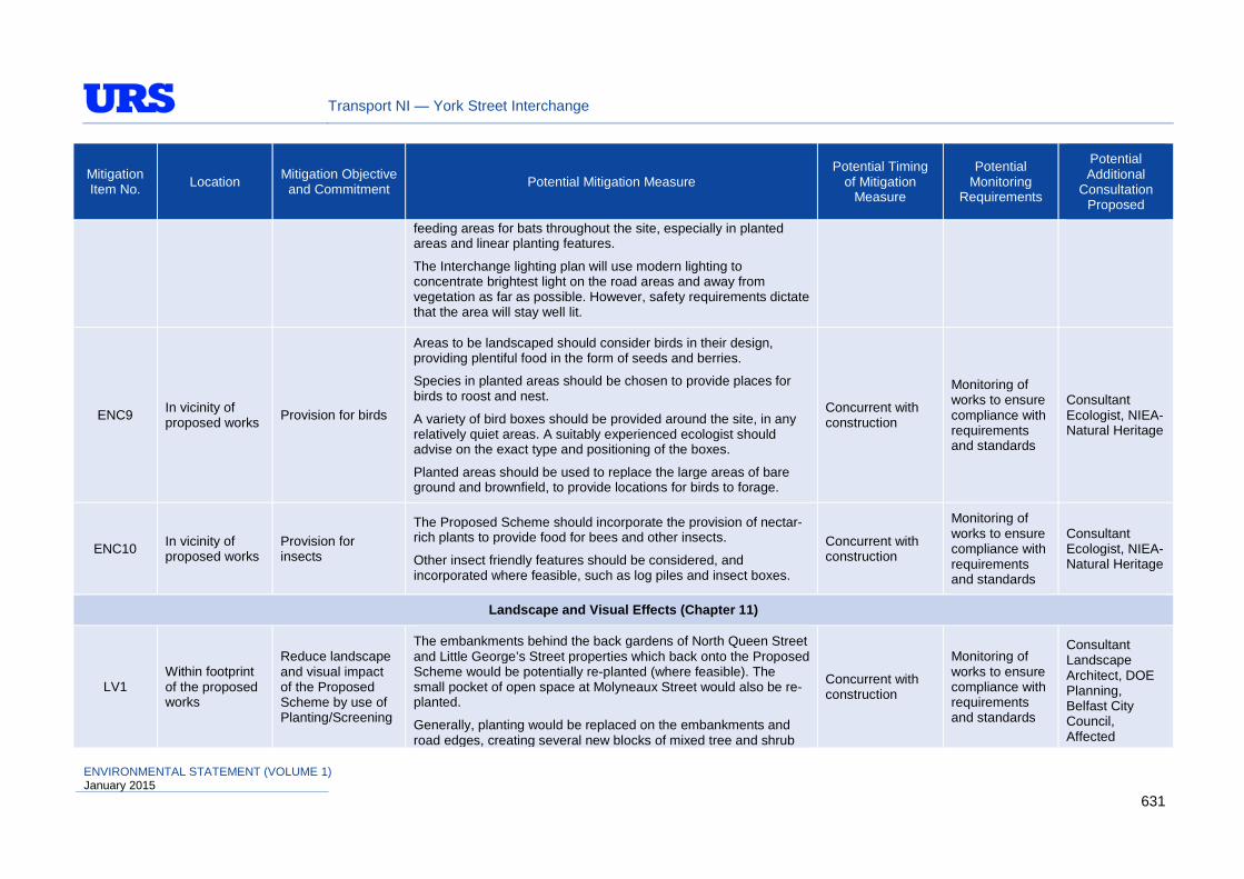
Transport NI — York Street Interchange
Mitigation Item No. Location Mitigation Objective
and Commitment Potential Mitigation Measure Potential Timing
of Mitigation Measure
Potential Monitoring
Requirements
Potential Additional
Consultation Proposed
feeding areas for bats throughout the site, especially in planted areas and linear planting features.
The Interchange lighting plan will use modern lighting to concentrate brightest light on the road areas and away from vegetation as far as possible. However, safety requirements dictate that the area will stay well lit.
ENC9 In vicinity of proposed works Provision for birds
Areas to be landscaped should consider birds in their design, providing plentiful food in the form of seeds and berries.
Species in planted areas should be chosen to provide places for birds to roost and nest.
A variety of bird boxes should be provided around the site, in any relatively quiet areas. A suitably experienced ecologist should advise on the exact type and positioning of the boxes.
Planted areas should be used to replace the large areas of bare ground and brownfield, to provide locations for birds to forage.
Concurrent with construction
Monitoring of works to ensure compliance with requirements and standards
Consultant Ecologist, NIEA-Natural Heritage
ENC10 In vicinity of proposed works
Provision for insects
The Proposed Scheme should incorporate the provision of nectar-rich plants to provide food for bees and other insects.
Other insect friendly features should be considered, and incorporated where feasible, such as log piles and insect boxes.
Concurrent with construction
Monitoring of works to ensure compliance with requirements and standards
Consultant Ecologist, NIEA-Natural Heritage
Landscape and Visual Effects (Chapter 11)
LV1 Within footprint of the proposed works
Reduce landscape and visual impact of the Proposed Scheme by use of Planting/Screening
The embankments behind the back gardens of North Queen Street and Little George’s Street properties which back onto the Proposed Scheme would be potentially re-planted (where feasible). The small pocket of open space at Molyneaux Street would also be re-planted.
Generally, planting would be replaced on the embankments and road edges, creating several new blocks of mixed tree and shrub
Concurrent with construction
Monitoring of works to ensure compliance with requirements and standards
Consultant Landscape Architect, DOE Planning, Belfast City Council, Affected
ENVIRONMENTAL STATEMENT (VOLUME 1) January 2015
631

Transport NI — York Street Interchange
Mitigation Item No. Location Mitigation Objective
and Commitment Potential Mitigation Measure Potential Timing
of Mitigation Measure
Potential Monitoring
Requirements
Potential Additional
Consultation Proposed
planting, and acting to partially screen the development; it may also assist wildlife habitat creation and the softscape would offer an informal drainage sink. The potential extent of planting may be limited by required service strips.
Corporation Street and Garmoyle Street would be potentially planted with street trees on a grass verge, to the west of the existing pedestrian path.
Great George’s Street (eastern portion) would be potentially planted with street trees on both sides. The development would narrow the road and widen the southern path to facilitate improved public realm.
Appropriate screening would be provided where possible (i.e. where road links would have a visual impact on adjacent properties or views). In selected locations where the visual impact is significant, immediate temporary screening would be required (if feasible).
Landowner
LV2 North Queen Street Bridge
Reduce landscape and visual impact of acoustic barriers
Proposed acoustic barriers along Westlink in the vicinity of North Queen Street Bridge should be sensitively located (if feasible) and designed to limit any potential visual and landscape impact and reduce potential for over-shadowing on residential receptors.
Concurrent with construction
Monitoring of works to ensure compliance with requirements and standards
Landscape Architect, Acoustic Consultant, DOE Planning, Belfast City Council, Affected Party
LV3
Within footprint of the proposed works – Boundary Locations
Reduce landscape and visual impact of boundary treatments
The boundary treatments for the development should be sensitive to the character of the area; this is particularly important in the case of proposed retaining walls.
Concurrent with construction
Monitoring of works to ensure compliance with requirements and standards
Landscape Architect, DOE Planning
ENVIRONMENTAL STATEMENT (VOLUME 1) January 2015
632

Transport NI — York Street Interchange
Mitigation Item No. Location Mitigation Objective
and Commitment Potential Mitigation Measure Potential Timing
of Mitigation Measure
Potential Monitoring
Requirements
Potential Additional
Consultation Proposed
LV4 Structure locations
Reduce landscape and visual impact of structures
Integration of parapets into the structure of overbridges and other structures to create the impression of one simple structure. The overbridges should be designed to allow the road corridors and cityscape to flow under the structures, in order to minimise its visual prominence (i.e. consideration should be given in the detailed design to minimise and strategically-locate the bridge piers).
Concurrent with construction
Monitoring of works to ensure compliance with requirements and standards
Landscape Architect, DOE Planning
LV5 Underbridge structures
Enhance landscape and visual impact of structures
Proposed enhancement lighting to the underbridges. Concurrent with construction
Monitoring of works to ensure compliance with requirements and standards
Landscape Architect, DOE Planning
LV6
Within footprint of the proposed works – Development areas
Enhance landscape and visual impact of potential development areas
The Proposed Scheme would create four main potential future development areas, which could potentially improve the appearance of the cityscape.
Concurrent with construction
Monitoring of works to ensure compliance with requirements and standards
Landscape Architect, DOE Planning
LV7 In vicinity of the proposed works
Potential future landscape and visual enhancement to benefit the appearance and usability of the cityscape around the Proposed Scheme.
The potential future enhancements measures listed below are only potential opportunities and would be subject to further consideration as part of a Strategic Advisory Group.
• creation of a feature entrance area, including pedestrian steps and ramp access, to link York Street and Henry Street;
• creation of large-scale land art, sculpture and landform around road network;
• addition of suitably designed parapets with enhanced aesthetics on York Street overbridges. The proposed bridge may become a positive landmark in the cityscape;
In advance of and concurrent with construction
Monitoring of works to ensure compliance with requirements and standards
Landscape Architect, SAG, DOE Planning, Belfast City Council, Transport NI
ENVIRONMENTAL STATEMENT (VOLUME 1) January 2015
633
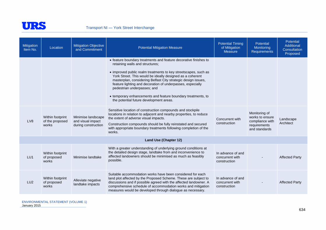
Transport NI — York Street Interchange
Mitigation Item No. Location Mitigation Objective
and Commitment Potential Mitigation Measure Potential Timing
of Mitigation Measure
Potential Monitoring
Requirements
Potential Additional
Consultation Proposed
• feature boundary treatments and feature decorative finishes to retaining walls and structures;
• improved public realm treatments to key streetscapes, such as York Street. This would be ideally designed as a coherent masterplan, considering Belfast City strategic design issues, feature lighting and decoration of underpasses, especially pedestrian underpasses; and
• temporary enhancements and feature boundary treatments, to the potential future development areas.
LV8 Within footprint of the proposed works
Minimise landscape and visual impact during construction
Sensitive location of construction compounds and stockpile locations in relation to adjacent and nearby properties, to reduce the extent of adverse visual impacts.
Construction compounds should be fully reinstated and secured with appropriate boundary treatments following completion of the works.
Concurrent with construction
Monitoring of works to ensure compliance with requirements and standards
Landscape Architect
Land Use (Chapter 12)
LU1 Within footprint of proposed works
Minimise landtake
With a greater understanding of underlying ground conditions at the detailed design stage, landtake from and inconvenience to affected landowners should be minimised as much as feasibly possible.
In advance of and concurrent with construction
- Affected Party
LU2 Within footprint of proposed works
Alleviate negative landtake impacts
Suitable accommodation works have been considered for each land plot affected by the Proposed Scheme. These are subject to discussions and if possible agreed with the affected landowner. A comprehensive schedule of accommodation works and mitigation measures would be developed through dialogue as necessary.
In advance of and concurrent with construction
- Affected Party
ENVIRONMENTAL STATEMENT (VOLUME 1) January 2015
634

Transport NI — York Street Interchange
Mitigation Item No. Location Mitigation Objective
and Commitment Potential Mitigation Measure Potential Timing
of Mitigation Measure
Potential Monitoring
Requirements
Potential Additional
Consultation Proposed
LU3 In vicinity of proposed works
Minimise impacts upon surrounding land uses
Construction compounds to be located in areas that would cause the least disturbance to existing land uses, and to be fully reinstated post construction. Any land used for construction works, and outside the area to be developed for the road, is also to be fully reinstated at a minimum.
Concurrent with / post construction
On-site observation and
inspection Adjacent Party
LU4 In vicinity of proposed works
Minimise impacts upon surrounding land uses
Land uses adjacent to the site should be able to continue with minimal disruption and inconvenience. A CEMP shall be prepared in advance of construction to mitigate potential impacts and maintain continued access to and operation of land as necessary.
In advance of and concurrent with construction
On-site observation and
inspection Adjacent Party
LU5 In vicinity of proposed works
Disposal of surplus land
DRD Transport NI to carry out a review of land vested for construction. If this exceeds the minimum required for the performance of DRD’s present and future responsibilities, any surplus land may be sold back to the original owner or others at the then market value.
Post construction -
Previous Landowner or Other Interested Parties
Noise & Vibration (Chapter 13)
NV1
Interchange links between Westlink, M2 and M3 and the slip roads from these to the local road network
To reduce noise levels generated from road traffic
Thin Surface Course Systems (TSCS), otherwise known as low noise road surfacing to be provided on Interchange links between Westlink, M2 and M3 and the slip roads from these to the local road network.
Concurrent with construction
Additional noise surveys may be required in accordance with the Noise Insulation Regulations (Northern Ireland) 1995 or at the discretion of Transport NI
Belfast City Council
NV2
North and south side of Westlink (either side of North Queen Street Bridge)
To provide noise mitigation to groups of properties fronting/backing on to the Westlink
Noise barrier adjacent to northbound carriageway of Westlink: approximate height 1.5m, approximate length 240m; and
Noise barrier adjacent to southbound carriageway of Westlink: approximate height 1.5m, approximate length 285m.
Concurrent with construction
Belfast City Council
ENVIRONMENTAL STATEMENT (VOLUME 1) January 2015
635
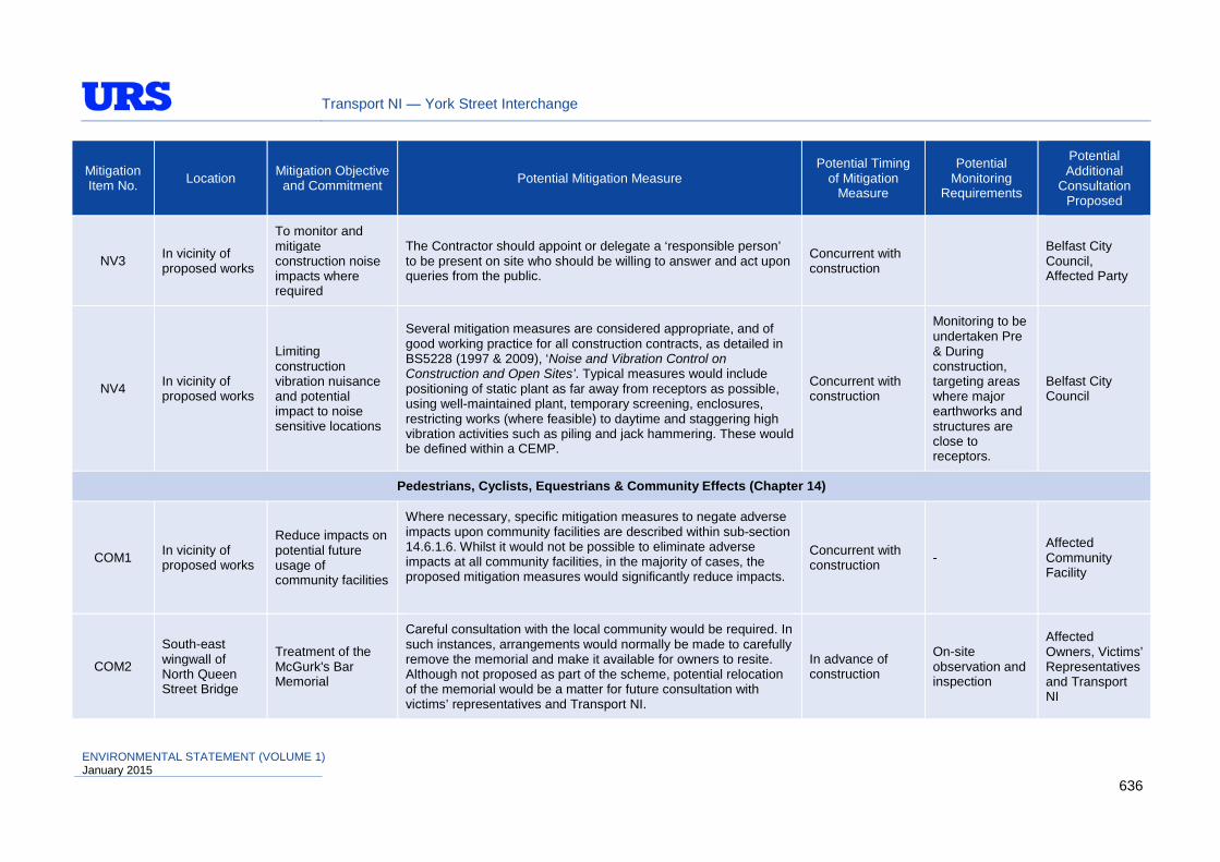
Transport NI — York Street Interchange
Mitigation Item No. Location Mitigation Objective
and Commitment Potential Mitigation Measure Potential Timing
of Mitigation Measure
Potential Monitoring
Requirements
Potential Additional
Consultation Proposed
NV3 In vicinity of proposed works
To monitor and mitigate construction noise impacts where required
The Contractor should appoint or delegate a ‘responsible person’ to be present on site who should be willing to answer and act upon queries from the public.
Concurrent with construction
Belfast City Council, Affected Party
NV4 In vicinity of proposed works
Limiting construction vibration nuisance and potential impact to noise sensitive locations
Several mitigation measures are considered appropriate, and of good working practice for all construction contracts, as detailed in BS5228 (1997 & 2009), ‘Noise and Vibration Control on Construction and Open Sites’. Typical measures would include positioning of static plant as far away from receptors as possible, using well-maintained plant, temporary screening, enclosures, restricting works (where feasible) to daytime and staggering high vibration activities such as piling and jack hammering. These would be defined within a CEMP.
Concurrent with construction
Monitoring to be undertaken Pre & During construction, targeting areas where major earthworks and structures are close to receptors.
Belfast City Council
Pedestrians, Cyclists, Equestrians & Community Effects (Chapter 14)
COM1 In vicinity of proposed works
Reduce impacts on potential future usage of community facilities
Where necessary, specific mitigation measures to negate adverse impacts upon community facilities are described within sub-section 14.6.1.6. Whilst it would not be possible to eliminate adverse impacts at all community facilities, in the majority of cases, the proposed mitigation measures would significantly reduce impacts.
Concurrent with construction -
Affected Community Facility
COM2
South-east wingwall of North Queen Street Bridge
Treatment of the McGurk's Bar Memorial
Careful consultation with the local community would be required. In such instances, arrangements would normally be made to carefully remove the memorial and make it available for owners to resite. Although not proposed as part of the scheme, potential relocation of the memorial would be a matter for future consultation with victims’ representatives and Transport NI.
In advance of construction
On-site observation and inspection
Affected Owners, Victims’ Representatives and Transport NI
ENVIRONMENTAL STATEMENT (VOLUME 1) January 2015
636

Transport NI — York Street Interchange
Mitigation Item No. Location Mitigation Objective
and Commitment Potential Mitigation Measure Potential Timing
of Mitigation Measure
Potential Monitoring
Requirements
Potential Additional
Consultation Proposed
COM3 Proposed Scheme
Provision of a dedicated bus lane on York Street and replacement of lost bus stops
A new bus lane is proposed between a new signalised junction at Galway House and the junction of York Street and Great Patrick Street. All other existing bus lanes within the scheme would be maintained.
In consultation with Translink, any lost serviced bus stops would be appropriately relocated to new routes where feasible.
In advance of and concurrent with construction
- Translink, Transport NI
COM4 Proposed Scheme
Replace, maintain and/or improve pedestrian/cyclist facilities/access.
Footways are provided on all surface streets, with existing widths maintained and where possible (within the constraints of the site), enhanced. An additional with-flow cycle lane of 1.5m width is proposed for cyclists heading northbound along York Street, with the provision of Advanced Stop Lines at signalised junctions. In the southbound direction on York Street, a 1.5m wide with-flow cycle lane is proposed between signalised junctions at Dock Street and at Galway House. The new bus lane between Galway House and the junction of York Street and Great Patrick Street would be made accessible to cyclists. All other existing bus lanes, accessible by cyclists, within the scheme would be maintained.
At all junctions, provision would be made for non-motorised users in accordance with Department for Transport Local Transport Notes and Traffic Advisory Leaflets. Accordingly, dropped kerbs and tactile paving is proposed at all controlled and uncontrolled crossing points, with pedestrian guardrail provided where considered necessary to control movements. At proposed signalised junctions, puffin crossings would be implemented in line with DMRB guidance. The Proposed Scheme layout would also include the provision of a new, modern road lighting system for the safety of motorised and non-motorised road users. The provision, or replacement of existing lighting systems has been considered as part of this process and the provision of additional lighting under proposed bridge structures would continue to be considered as part of future design development.
Concurrent with / post construction -
DRD Cycling Unit, Strategic Advisory Group, Transport NI
ENVIRONMENTAL STATEMENT (VOLUME 1) January 2015
637
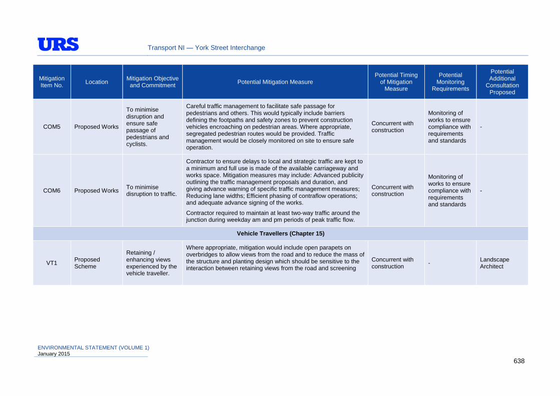
Transport NI — York Street Interchange
Mitigation Item No. Location Mitigation Objective
and Commitment Potential Mitigation Measure Potential Timing
of Mitigation Measure
Potential Monitoring
Requirements
Potential Additional
Consultation Proposed
COM5 Proposed Works
To minimise disruption and ensure safe passage of pedestrians and cyclists.
Careful traffic management to facilitate safe passage for pedestrians and others. This would typically include barriers defining the footpaths and safety zones to prevent construction vehicles encroaching on pedestrian areas. Where appropriate, segregated pedestrian routes would be provided. Traffic management would be closely monitored on site to ensure safe operation.
Concurrent with construction
Monitoring of works to ensure compliance with requirements and standards
-
COM6 Proposed Works To minimise disruption to traffic.
Contractor to ensure delays to local and strategic traffic are kept to a minimum and full use is made of the available carriageway and works space. Mitigation measures may include: Advanced publicity outlining the traffic management proposals and duration, and giving advance warning of specific traffic management measures; Reducing lane widths; Efficient phasing of contraflow operations; and adequate advance signing of the works.
Contractor required to maintain at least two-way traffic around the junction during weekday am and pm periods of peak traffic flow.
Concurrent with construction
Monitoring of works to ensure compliance with requirements and standards
-
Vehicle Travellers (Chapter 15)
VT1 Proposed Scheme
Retaining / enhancing views experienced by the vehicle traveller.
Where appropriate, mitigation would include open parapets on overbridges to allow views from the road and to reduce the mass of the structure and planting design which should be sensitive to the interaction between retaining views from the road and screening
Concurrent with construction - Landscape
Architect
ENVIRONMENTAL STATEMENT (VOLUME 1) January 2015
638

Transport NI — York Street Interchange
Mitigation Item No. Location Mitigation Objective
and Commitment Potential Mitigation Measure Potential Timing
of Mitigation Measure
Potential Monitoring
Requirements
Potential Additional
Consultation Proposed
VT2 In vicinity of proposed works
To maintain road safety and reduce driver stress
As part of the Traffic Management Plan, temporary warning and variable message signs would be erected as appropriate to draw attention to particular hazards including site accesses and temporary traffic management measures. Local & wider community should be notified of major works (i.e. road closures, diversions, etc) in advance in the local press, community facilities, radio, internet etc.
During construction
On-site observation
Local & Wider Community
Transport NI
Road Drainage & the Water Environment (Chapter 16)
RDWE1 Proposed scheme
Quick removal of surface water to improve safety and minimal nuisance.
Provide effective sub-surface drainage to maximise longevity of the pavement and its associated earthworks.
Minimise impact of runoff on the receiving water environment.
A centrally located storm water pumping station is proposed to collect surface water drainage and convey water to an appropriate outlet. Surface water run-off collection for the Proposed Scheme would be achieved through a combination of road drainage gullies and combined kerb and drainage (CKD) systems, discharging to longitudinal collector pipes.
In the outline design, CKD unit chambers would be provided at regular intervals and at locations further downstream on carrier drainage pipes, catch pit chambers would be provided with sump units to collect silt/sediment which would be subject to routine highway maintenance.
The pumping station wet well plan dimensions within the outline design are 11.8 x 7m. The 0.6m deep operational depth which the sump would deliver would incorporate significant storage volume, provided beneath the lowest pump operating stop levels. The mixing effect arising from the large storage volume would provide further dilution of dissolved contaminants prior to entry into the pumping system and some settlement within the sump. The pumping infrastructure mechanism proposed would ensure regular discharge of flows (i.e. low flow pumps to be provided, assisted by high flow pumps which would operate during extreme rainfall events).
Concurrent with construction
Monitoring of works to ensure compliance with requirements and standards
NI Water / NIEA – WMU / DOE Marine Team
ENVIRONMENTAL STATEMENT (VOLUME 1) January 2015
639

Transport NI — York Street Interchange
Mitigation Item No. Location Mitigation Objective
and Commitment Potential Mitigation Measure Potential Timing
of Mitigation Measure
Potential Monitoring
Requirements
Potential Additional
Consultation Proposed
This drainage design option also facilitates ‘storm water separation’, which would assist in reducing the frequency of flow surcharge experienced in the NIW sewerage network and would also reduce effluent volumes requiring treatment at Duncrue Street Wastewater Treatment Works.
RDWE2
In the vicinity of the quay wall outfall point from the abandoned Gamble Street NI Water CSO culvert.
Avoiding adverse effects upon water quality as a result of disturbing contaminated bed sediments within Belfast Harbour.
The design flow and flow velocity of storm water drainage discharges on the receiving water environment must be reflective of the hydraulic calculations contained with Table 16.9 in order to minimise the potential for disturbance of contaminants within the bed sediments.
Concurrent with / post construction
Monitoring of works to ensure compliance with requirements and standards
NI Water / NIEA – WMU / DOE Marine Team
RDWE3 Pumping Station catchment area
Measures to avoid an acute pollution incident occurring within Belfast Harbour in the event of an accidental spillage.
A manual shutdown facility is to be provided as part of the control system for operation of the pumping system. This shutdown system could be operated from a location which is remote from the Proposed Scheme (i.e. at the maintaining authority headquarters) enabling swift action to be taken in the event of a spillage occurring within the extents of the underpasses and pumping station catchment area.
Concurrent with construction - -
RDWE4 Proposed Scheme underpasses
Avoid drainage of groundwater and prevent flotation or seepage ingress from groundwater (which could potentially be contaminated)
Underpasses would be designed as sealed structures with sufficient load bearing capacity and flexural strength. This approach to the structural design of the underpasses would mean that within their structural formation between the finished road surface and the top of propping slab level, there would be no requirement to collect and dispose of significant quantities of groundwater.
Concurrent with construction - -
ENVIRONMENTAL STATEMENT (VOLUME 1) January 2015
640

Transport NI — York Street Interchange
Mitigation Item No. Location Mitigation Objective
and Commitment Potential Mitigation Measure Potential Timing
of Mitigation Measure
Potential Monitoring
Requirements
Potential Additional
Consultation Proposed
RDWE5 In the vicinity of the Proposed Scheme
Avoid ponding or accumulation of standing water within the Proposed Scheme footprint
Further drainage measures including surface water drainage solutions would be required in isolated areas adjacent to the site. These include the central scheme areas which may be landscaped and would, for example, be included in the pumping station catchment area, areas where the adjacent ground slopes towards the scheme, areas of proposed or existing engineered/earthworks slopes, footways or finally, paved areas within the site where storm water could potentially pond or accumulate.
Concurrent with construction - -
RDWE6 In the vicinity of the Proposed Scheme
Consideration of changes in the local hydrogeological regime, which may potentially affect groundwater flow in the fluvial deposits, leading to changes in the hydraulic gradient and increased hydraulic heads that may be transmitted to overlying deposits.
To quantify this issue further, the following additional information is required as part of the detailed design development:
• Further routine groundwater level gauging of boreholes (i.e. weekly monitoring be undertaken over several weeks);
• In-situ hydraulic testing of wells installed in the three hydrogeological units (i.e. the bedrock, the fluvial deposits and the estuarine alluvium); and
• Numerical groundwater modelling to test the effects of deep foundation structures on the groundwater flow regime and to quantify the potential implications of head changes in the fluvial deposits on groundwater levels in the estuarine alluvium.
In advance of construction - -
RDWE7 Proposed Scheme
Reduce the risk of coastal flood water ingress to underpasses.
It is proposed that scheme flood retaining walls would be provided and ramp approaches would be sufficiently raised to reduce the risk of coastal flood water ingress to underpasses.
Concurrent with construction - Rivers Agency
RDWE8 M3 to Westlink Underpass / Nelson Street
Reduce the risk of flood water ingress to underpasses.
A temporary flood barrier is to be incorporated into the Proposed Scheme to provide protection and remove the potential flood entry point. In addition, as part of the temporary flood barrier proposal, a Flood Risk Management Plan should be developed, the purpose of
Concurrent with construction - Rivers Agency
ENVIRONMENTAL STATEMENT (VOLUME 1) January 2015
641

Transport NI — York Street Interchange
Mitigation Item No. Location Mitigation Objective
and Commitment Potential Mitigation Measure Potential Timing
of Mitigation Measure
Potential Monitoring
Requirements
Potential Additional
Consultation Proposed
which would be to outline flood warning procedures, provide a safe work plan for erecting the temporary flood barrier, detail ownership and responsibility for the flood barrier, as well as methods for safe storage, and outline procedures for closing Nelson Street.
RDWE9 Proposed Scheme
Reduce the risk of flood water ingress to underpasses via drainage infrastructure
New drainage infrastructure would be designed in such a way so as to prevent back flow routes occurring into underpasses during flood events. The storm water pumping station would be designed with resilience measures and protection to reduce risk of failure.
To this extent, the drainage design is being progressed on the basis that the continual operation of the pumping station would be achieved through provision of adequate infrastructure, standby generator with permanent fuel storage and that the base level, of the pump controls and telemetry would be located above the 0.5%AEP flood level plus 600mm.
In advance of construction / concurrent with construction
- Rivers Agency
RDWE10 Proposed Works
To minimise impact and avoid contamination of watercourses and ensure compliance with the Water Framework Directive
Any works in, near or liable to impact a waterway (including measures to mitigate adverse impacts) ‘must’ gain the approval of NIEA – WMU Pollution Prevention (PP), DOE Marine Team and DARD Rivers Agency, a minimum of two months prior to commencement of such works. Works require Method Statements to be agreed prior to the commencement to demonstrate how they would be completed with minimum disturbance and would describe the specific procedures to be put in place to control sediment mobilisation and spillages. Measures established through dialogue with the NIEA WMU Major Client Interface Group and stakeholders engaged through the consultation process would be included within the Method Statements (where appropriate and technically feasible). An Environmental Liaison Group also to be set-up to ensure that potential for significant impact upon the water environment is addressed and appropriate measures to mitigate effects are employed for sensitive activities.
In advance of construction / concurrent with construction
Monitoring of works to ensure compliance with requirements and standards
Rivers Agency / NIEA – WMU / DOE Marine Team
ENVIRONMENTAL STATEMENT (VOLUME 1) January 2015
642

Transport NI — York Street Interchange
Mitigation Item No. Location Mitigation Objective
and Commitment Potential Mitigation Measure Potential Timing
of Mitigation Measure
Potential Monitoring
Requirements
Potential Additional
Consultation Proposed
RDWE11 Proposed Works
Protection of the water environment in accordance with best practice guidelines
The Contractor shall be required to comply with the Pollution Prevention Guidelines (PPGs) regarding pollution of watercourses and CIRIA manuals C532 (“Control of Water Pollution from Construction Sites”), C648 (“Control of Water Pollution from Linear Construction Projects”) and SP156 ‘Control of water pollution from construction sites – guide to good practice’.
An Emergency Response Plan shall be prepared to minimise the risk and potential effects of any spillage incidents.
In advance of construction / concurrent with construction
Monitoring of works to ensure compliance with requirements and standards
NIEA – WMU / DOE Marine Team
RDWE12 Proposed Works
Control sediment erosion and contaminated silty runoff
In principle it has been agreed that temporary discharges from the works area (with appropriate settlement and filtration measures to ensure treatment of runoff and settling out of sediments before discharge), would be possible to the existing NI Water sewerage network, subject to consultations and submission of design proposals to NI Water
On this basis, the CEMP should include an Erosion Prevention and Sediment Control Plan prior to commencement of any works.
In advance of construction / concurrent with construction
Monitoring of works to ensure compliance with requirements and standards
NIEA – WMU / DOE Marine Team
Geology & Soils (Chapter 17)
GS1 Proposed Works Minimise adverse effects on the geology and soils
Employment of high standards of soil / deposit handling and management during the construction, and avoiding creation of bare areas of permanently exposed deposits that would be vulnerable to erosion.
During Construction - -
GS2 Proposed Works
Remediate any areas of contaminated land which may be encountered
Measures to remediate contaminated land may include additional targeted testing and risk assessments if no existing ground investigation data is available, and then assess whether there is a need for containment or disposal of the material. The re-use of this material would need careful consideration to demonstrate that unacceptable risks are not posed to health or environmental receptors;
During Construction -
NIEA – Waste Management Unit / Belfast City Council
ENVIRONMENTAL STATEMENT (VOLUME 1) January 2015
643

Transport NI — York Street Interchange
Mitigation Item No. Location Mitigation Objective
and Commitment Potential Mitigation Measure Potential Timing
of Mitigation Measure
Potential Monitoring
Requirements
Potential Additional
Consultation Proposed
The Contractor would produce a CEMP, which would provide details of environmental control measures to deal with any contaminated land encountered during the site operations.
Management of all materials onto and off the site should be suitably authorised through the Waste Management Regulations (NI) 2006 and/or the Water Order (NI) 1999. This should be demonstrated through a Site Waste Management Plan (SWMP).
GS3 Proposed Works
Re-use of road construction materials, such as surfacing planings for capping materials, should be adopted where possible
If material cannot be reused elsewhere for approved agricultural improvements or as fill, its disposal would be at suitable licensed tips where it would be subject to landfill tax. There are strict legal controls preventing illegal dumping of surplus fill, including a requirement for a waste disposal license to be obtained and a Duty of Care on the Contractor. The Contractor would be required to make every effort to reuse as much of the material as possible within the area of the construction site. Any material to be reused, which is wet, should be stockpiled to allow it to dry out. Stockpiling should be well away from any sensitive areas of ecological or archaeological interest, or watercourses where pollution could occur.
ADEPT and MPA guidance on managing reclaimed road materials (ADEPT and MPA ‘Guidance on Managing Reclaimed Asphalt – Highways and Pavements’, July 2013) and the NIEA publication on bitumen road planings (NIEA ‘Guidance on the production of fully recovered asphalt road planings’) should be followed in the identification and management of road planings.
During Construction -
NIEA – Waste Management Unit / Belfast City Council
ENVIRONMENTAL STATEMENT (VOLUME 1) January 2015
644