volume ii 1983
TRANSCRIPT

VOLUME II 1983

L
COVER: TILES FROM THORNBURY CASTLE
These tiles depict the arms and badges of the builder of Thornbury Castle, Edward Stafford, 3rd Duke of Buckingham, Earl of Hereford, Stafford and Northampton, KG, born 1477, beheaded on 7th May 1521 and attainted.
The central shield of arms fa that of 'England in a bordure argent.' England is represented by the three fleur-de-lys of France (modern) quartering the three lions passant of England - these arms were first used by Henry IV in 1405. The charge of the silver border is significant as it indicates a cadet branch of the Royal Family. These arms were granted to Edward's father, Henry Stafford the 2nd Duke, in recognition of his claim to be the heir of Thomas of Woodstock, Duke of Gloucester, Earl of Buckingham and youngest son of Edward III. Henry Stafford's great grandfather, Edmund the 6th Baron and 5th Earl of , Stafford, had married Lady Anne Plantagenet the daughter and ultimate heiress of Thomas of Woodstock and his wife Eleanor de Bohun. The shield is supported by two antelopes or white harts and is surrounded by the Garter• the 3rd Duke was created a Knight of the Garter in 1495. Note St George and the Dragon at the end of the strap.
In the corners of the design. are four badges used by the 3rd Duke. The Stafford knot appears in the top left r:orner and in the top right is the flaming axle of Woodstock, a badge of Thomas, Duke of Gloucester. In the bottom left is the cloak or mantle'of Brecknock • Stafford was also Lord of Bree.on by distant descent from 'the Norman knight Bernard de Neufmarche. Finally, to the bottom right are two roses and a swan. The roses are probably the red roses of the House of Lancaster - the family was, on the whole, pro-Lancastrian during the War of the Roses. The white swan, which is chained or gorged, is the ancient symbol of the house of Bohun and also adopted as a royal badge by Henry IV in right of his wife, Mary one of the heiresses of Sir Humphrey de Bohun, Earl of Hereford, Essex and Northampton. The Bohun estate·s were granted to the 2nd Duke as a reward for his assistance to the Yorkist king, Richard III and probably in recognition of his claim to be the Bohun heir - Eleanor de Bohun, Thomas of Woodstock's wife, was the eldest daughter of Sir Humphrey. - JS E ·

BRISTOL AND AVON ARCHAEOLOGY II - 1983
CONTENTS
An Investigation of Surface Concentrations: Priddy I 977 2 Joan Taylor and Rebecca Smart
Romano-British Settlement at Filwood Park, Bristol 12 R G J Williams
Romano-British Burials at Henbury Comprehensive School, Bristol: A Preliminary Report 21 · James Russell ·
Stantonbury and District in the Tenth Century 25 MCosten
Environmental Sampling in Redcliff Street, 1982-3 35 J Shackleton and J Douglass
Excavations at 68-72 Redcliff Street, 1982 37 RH Jones ·
Discovery of a Possible Tide Mill at Kingston Seymour 40 Jane Evans
A Seventeenth Century House at 10 Lower Park Row, Bristol 45 John Bryant and John Winstone
Avon Archaeology 1982 48 Rob Iles
Book Reviews 58
© Authors and Bristol and Avon Archaeology Research Group 1982
Published by Bristol and Avon Archaeological Research Group, Bristol City Museum, Queens Road, Bristol BS8 lRL
COMMITTEE 1983-4
Chairman R Harrison
Vice Chairman R Williams Secretary Treasurer J Russell Associates Secretary Membership Secretary J Harrison BAA Editors Special Publications Editor L Grinsell Fieldworker Co-ordinator Parish Survey Co-ordinator M Campbell Publicity Offier M Aston, D & J Brimson, D Dawson, M Gilbert, P Jones, A Parker, J Saysell, N Thomas
T Coulson P Harper R Iles, M Stacey M Ponsford F Moor
BAARG Membership is open to all. Further details can be obtained from Membership Secretary, BAARG, Bristol City Museum, Queens Road, Bristol BS8 lRL. ·
Editorial communications should be sent to R Iles, 1 St Oswald's Ct, St Oswald's Road, Redland, Bristol.
BAA design and layout by Davina Langmuir
Printed by Typing Facilities, Old Market, Bristol
'-

r
2
AN INVESTIGATION OF SURFACE CONCENTRATIONS: PRIDDY 1977
· Joan Taylor & Rebecca Smart
The Mendip area around Priddy was recognised as important for its prehistoric activity by the 19th Century antiquarians, who excavated its monuments and caves,The Rev. John Skinner opened barrows in the Ashen Hill and Priddy Nine Barrows cemeteries, while Boyd Dorkins excavated Hyaena Den in Wookey Hole from 1859-63. Little attention has been directed towards the less spectacular, but equally important, dense flint concentrations on the Priddy Plateau lying in the area between the above mentioned sftes, apart from that of flint collectors. Implements from surface scatters demonstrate a continuing presence on the plateau from the Mesolithic into the Bronze Age. Later, as at Charterhouse, the Romans exploited the mineral wealth of the area and lead extraction continued from then onwards until mining ceased at St Cuthbert's Mine just prior to the First World War.
The Priddy plateau study stems from a request to have some flint implements identified at the Bristol City Museum in 1972. From this enquiry, systematic field walking in the same year led to a detailed investigation of 4 sq Km (about 900 • 1000 acres) of plateau bounded by the Ebbor Gorge and the Rookham Combe roads at a height of 240 metres O.D. Excavations from 1973-77 concentrated on a burnt structure, associated with flint of a Mesolithic character, which yielded a radio-carbon date (uncalibrated) of 3050 ±.BC (GrN-7800:5000 ±. BP). The Mesolithic site report is currently in preparation. The subject of this paper, however, is three small excavations to test the significance of flint concentrations noted during field walking : one at the east end of Yard Park field (ST 539502) and two in Hundred Acres field.
The plateau today exists without a natural water source; fields are ploughed level, punctuated only by major solution hollows and recent mining disturbance. No crop marks are evident, not even from aerial photographs. The topography of the past, from our still incomplete reconstruction, was sufficiently different from today for man to be attracted to the same sites at completely different prehistoric periods, or as in other cases, a particular type of economy seemed to repeatedly occupy one type of site, for example, in the Mesolithic period, but at no other time. This article will illustrate the former point, while the Mesolithic occupation at the west end of the field is an example of the latter. The water source for the plateau most likely ran as a stream through the valley along the northern edge of the study area, from Hunter's Lodge westward to the Priddy Green, a route now occupied by the road. Immediate access to the plateau was probably along natural depressions to the north, south and west. One runs from the dry stream valley south through the middle of Hundred Acres, the field immediately to the east of Yard Park, onto the plateau. The high ground on both sides of this hollow has significant concentrations of cores, flakes and implements not sustained in the rest of the field, which suggests that it was a preferred location, perhaps a vantage point, from the Mesolithic into the Bronze Age. Another depression which comes away from the Ebbor Gorge road
running to the east into Sandpits, again has concentrations on either side of the hollow and a third comes up to the plateau from the steep scarp to the northeast leading directly into Wookey Hole and Ebbor Gorge. This last natural path would have been a likely game trail to the plateau, and here again there are concentrations of flint on high ground to one side near the top of the depression.
The small plateau so defined forms an integral geographical unit. An indication of this cohesion has been observed in the distribution of types of objects bearing close similarity to each other in scatters from many widely spaced areas. For instance, the re-worked flakes from a number of polished flint axes appear to be dispersed over widely separated fields of the plateau, too far to have been transported by modern agencies such as the plough or the casual flint collector who discards waste flakes by the convenient wall or gate. Further statistical research is
0 0 0 <t C,
CJ 0
() ()
0 () ()
~ ()
()
.() ()
()
0 () ()
() a () C!
J J
() ()
()
C,
J ()
CJ J
()
,J
J
J
()
()
() J
'1 ()
() J ()
J J J
l•1•I • ■•Mr Iii fll ■ tt 111 n, .. u,11<111 f ,DDDDDDDDDDD.,, II l11ttr .. \1 ■ f JI ar1a1
'" IN aoru
Fig 1 Location Map of Cuttings and Distribution of flint in one hundred acre field

being conducted at present on this point by one of the authors (RS).
Flint is not native and must have been transported by man into the Priddy area. The nearest flint sources lie about forty kilometres (25 miles) away to the east in the Westbury and Tisbury area of Wiltshire.Tisbury, which is the type site for the Portland Beds that subsequently gave their name to Portland . Chert, no doubt was the source for this diagnostic chert which occurs in some of the Priddy scatters. The obvious need to
I~
- ., 0
• 0
• . . 0
0
0
0 0
0
0
Q 0
• 0
0
0
0
0 0
•
0
0
~
0 •
0
o•
0 C) •
o. 0 •
0 • 0
O 0
Q
0
N ,,, "' Section lines
TAYWR&SMART: PRIDDY 1977 3
make maximum use of flint is reinforced by the small size of cores and the number of re-worked tools. Nevertheless, the volume of flint not only recovered !by organized field walking, but known to have been removed by flint collectors in the past, must indicate a steady supply into the area from this great · distance.
The geology of the area is mixed. The solid geology of the plateau consists mainly of different formations of limestone, but other rocks occur nearby. In Ebbor Gorge there is
0
+ + + +
- - __ ., I + .+ +
++ +' I Q
• • I + + + I
+ + +, + + . . +G,.,,r,--♦ ~-... + + +
+ + + + + + + + + + +
+ + + V. + + + + + + + + +
"' + + +"+ + + + + + + +
+ + + + +
------q-~
·•
. - - - -•- - - - a
0 •
<l ~
6, ~-0 d
c:>
Q ..
0
r - - - - ., 0 • •0
0
0
-Fig 2 Eastern Trench,
Yard Park Field • Patches of dense burning
' Rolled flint in situ
G}) Thin scatter of charcoal , in mixed yellow loam and sand spread 0 2 metres

4 BRISTOL & A VON ARCHAEOLOGY 2
conglomerate; Pen Hill is old red sandstone; and the valley that contained the stream running into the present village of Priddy has a deposit of head or alluvium common to old stream beds. In the Mesolithic excavation, erratics of stone that had been carried to the site by prehistoric man were recovered from these adjacent areas.
The soils of Mendip have been carefully studied by Dr D C Findlay (I 965) with whom we consulted about the stratigraphy of the Mesolithic excavation. The complexity of the soil profiles on Mendip is encountered in Yard Park field. The natural profiles are disturbed through their further truncation by ploughing. Findlay describes the s"oils of the Yard Park field as Mendip Complex, which means that the depth of soil is variable between his shallow Lulsgate and the deeper Nordrach series of free draining brown earths. In the windbreaks on two sides of Yard Park field, the Nordrach Series profile with its uppermost component of loess mixed with brown silt loam was present, but in ploughed areas the recent practice of farmers to plough deeper into the reddish brown silty clay in order to gradually mix the poorer soils with the better top-soil has diluted loess beyond detection.Generally these soils are stone free until near the boundary of the weathering limestone and the dark brown clay, when it becomes mixed with friable chunks of limestone and black stains of manganese oxide (Findlay, 1965, 48-50, 68). In the Yard Park field, the greatest depth occurs at its eastern end. This variation of depth also affects the site destruction, as the actual top soil mixed by the plough remains fairly constant and shallow, but, as the build up of soil on the Mendip has been slow, the prehistoric sites lie close to the surface. When no rock outcrops keep the plough high or shallow, there is a tendency to plough in the manner just described and a shallow site with a deep depth of natural soil underlying it will gradually
II
be destroyed. Only where ancient topographical dips and/or ridges of limestone sheltered the sites as in the case of the burnt mesolithic structure, did satisfactory preservation take place.
The enclosure of this land at the end of the 18th century, and its lack of arable faming in the past, led us to assume the disturbance of sites by plough would be less than in other areas. The village of Priddy must go back beyond the 14th century as the sheep fair was transferred to Priddy from Wells during the Black Death of 1348-9. Although the fair never returned to Wells, perhaps because of an increasing interest in sheep in the Priddy area, it has been assumed from the scant records of the time that mineral extraction was likely to have had priority over all other activities between Charterhouse and the Wells/Bristol road (Findlay, 1965, 160).
FIELD SURVEY In surveying the Priddy Plateau, a natural unit of the plateau has been taken and studied as a whole. Apart from the funerary monuments, most of the surface evidence of prehistoric activity comes from the flint scatters revealed by ploughing. As flint is often the only remaining evidence, as much information as possible should be gleaned from it. For this reason the area was studied as a whole, with empty areas being just as important as the concentrations of flint. Essential too, was the study of the assemblage as a whole, recording all flints: waste flakes, chips and tools. Tools such as scrapers or awls, without a context of the rest of the industry, have a greatly reduced value in the amount of information they can reveal.
The method of surveying was very simple, and resulted from two basic premises: first it would be impossible to pick up and record every piece of flint in the area, all that was
QO~G ~ 14
~ 13 . . ~ ..
~12
□~ ocr,u~o ~ V c:>•'
18
CJ 16 • . ~ I 9
Fig 3 Flints from Eastern Trench, Yard Park Field
required was a representative sample; and second, it had to be systematic enough to allow for comparisons between widely separated fields. Each field was divided into transects 50 metres apart, each transect was then further subdivided into quarters or thirds, depending on the size of the field. Each transect was then walked in two directions, and every piece of flint seen was collected. (A more detailed discussion of the survey methods and why they were chosen is soon to be published as part of a dissertation). This method allows for an overall picture of flint distribution to be seen, as in Fig. 1. Once heavy concentrations had been identified it was then possible to ~o back and grid a smaller area (using a 25 metre grid), which allowed for detailed recovery for a limited area.
Earlier it was stated that a representative sample only was required, but there are limits on how representative any sample is going to be, given the number of variables which can affect the quantity and type of flint collected, The most obvious, such as soil and weather conditions, do not strictly apply in this case, as all the systematic field walking carried out in the Hundred Acres field was done over one weekend by the same group of people, thus minimising any skewing of results caused by differences in soil or weather conditions. However there are other elements which are difficult to quantify, which affect the accuracy of the results. Movement of• flints in the soil and damage caused by ploughing is extensive, a number of experiments are under way to see just how much and in which directions the plough does move objects, but there is insufficient space within this paper to discuss these results. Another serious problem occurs in dense flint concentrations, where a number of scatters from different periods may overlap, making it very difficult to differentiate between these variable time elements. The concentrations on the western side of Hundred Acres are a prime example of this. Finally, the most frustrating and least detectable variation is the activity of earlier flint collectors. Some-like Alfred Selley -were very good and conscientious in labelling all their finds and finally
7 cm
6
4
length 3
0
flake + tool
;-,
+
+
2 3 width
4 5cm
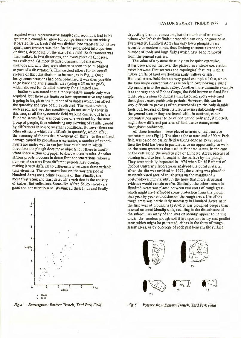
Fig 4 Scattergram: Eastern Trench, Yard Park Field
TAYLOR & SMART: PRIDDY 1977 5
depositing them in a museum, but the number of unknown others who left their finds unrecorded can only be guessed at. Fortunately, Hundred Acres has only been ploughed very recently in modern times, thus limiting to some extent the number of tools and large flakes which have been removed from the general scatters.
The value of a systematic study can be quite extensive. It has been shown that over the plateau as a whole correlation exists between flint scatters and topological features, such as higher bluffs of land overlooking slight valleys or rills. Hundred Acres field shows a very good example of this, where the two major concentrations are on land overlooking a slight dip running into the main valley. Another more dramatic example is atthe very top of Ebbor Gorge, the field known as Sand Pits. Other results seem to indicate that favoured spots were used throughout most prehistoric periods. However, this can be very difficult to prove as often arrowheads are the only datable tools but, because of their nature, have no relationship with the general scatter they are found with. In contrast, other concentrations appear to be of one period only and, if plotted, might .show different patterns of land use or management throughout prehistory.
All three trenches were placed in areas of high surface concentrations (Fig 1). The site at the eastern end of Yard Park field was based on earlier field walking done in 1972. Since then the field has been in pasture, with no opportunity to walk on the same system as that used in Hundred Acres. In the case of the cutting on the western side of Hundred Acres, patches of burning had also been brought to the surface by the plough. They were initially inspected in 1974 when Dr. M Barbetti of Oxford University laboratories analysed the burnt material. When the site was revisited in 1979, the cutting was placed in an uncultivated area of rough grass on the margins of a post-medieval mining adit, in the hope that more structural evidence would remain in situ. Similarly, the other trench in Hundred Acres was placed between two areas of rough grass which might have afforded some protection from the plough that year by year encroaches on the rough areas. Use of the rough areas was particularly necessary in Hundred Acres, as in the first year of ploughing ( 197 4), it was ploughed deeper than is usual on most Mendip soils, resulting in the disturbance of
· the sub-soil. As many of the sites on Mendip appear to lie just under the · modern plough soil it is important to try and predict areas which might be protected, either. in the form of rough grassy areas, or by outcrops of rock just beneath the surface.
-~ •?!J! @) ·~
Pl Pl
P4 rs PJ
Fig 5 Pottery from Eastern Trench, Yard Park Field

6 BRISTOL & A VON ARCHAEOLOGY 2
The system of flint analysis was the same for all trenches, each piece of flint being measured and recorded individually with complete flakes being measured after Smith (1965, 89). The flints were categorised into a number of sections, namely flakes, broken flakes,chips, blades, blade segments, tools, rejuvenation flakes, cores, bashed lumps, nodules and rolled chips (this last category applies only to the flints from the east trench in Yard Park). When tabulated, these categories give an overall picture of the assemblage, the number of broken flakes and chips perhaps showing to some extent the amount of damage done by the plough. Similarly, the number of cores and rejuvenation flakes, in proportion to tools and utilised flints, may indicate a knapping site rather than a settlement site where one might-expect mor,e tools. It is also important to remember the often low percentage of complete flakes in an assemblage, especially when considering their dimensions, as this is one of the major ways of studying flint grouping ( e g M'Pitts, I Smith). Complete flakes form only part of the assemblage, and on ploughed sites these are often damaged ones, as testified ·by the large number of broken flakes. In considering the dimensions of complete flakes, scattergrams have been used rather than the more usual histograms, as they give an indication of size and shape within the one diagram, while individual flakes or tools can be represented separately where the assemblage is small. An attempt was also made to record the extent of utilisation on flakes, but inability to accurately assess plough damage made this aspect too inaccurate and unreliable to record.
THE EXCAVATIONS
EAST YARD PARK FIELD Six flint concentrations which had been detected in 1972 and which lay near to each other, were selected for excavation and a 1 Om trench was laid down with an allowance for plough drag given on the western side. The only structural features were seven stakes and the tip of one post hole, all of which were sectioned. The tip of the post had a diameter of 24 ems and a depth of 10 ems. Two other possible post stains nearby were not amenable to sectioning as they were of slight depth. Only the tip of the stake holes remained, less than 5 cm in length. A lunate shaped stain suggestive of a spade mark was also present in the trench, but on sectioning it was too shallow for tis to come to any conclusion. From the stains and the distribution of the stakes no obvious pattern could be determined, and indeed no definite association could be estab• lished with any one of the many prehistoric periods (Mesolithic, Neolithic, Beaker or Later Bronze Age) represented by the assemblage found while·digging the plough soil. Over the bottom of the trench, colour and texture changes were present
TABLE 1. EASTERN YARD PARK FIELD. FLINT Flakes Broken Chips Blades 1
Flakes Total Number 50 45 95 3
% 14 12.6 26.7 0.8
% after rolled chips removed 23 20.7 43.7 1.3
1 Blades also includes 1 blade segment.
in several areas. It was noticeable that all features attributable to man's occupation of the area were now obliterated by the plough and the level of the undisturbed was below that of any occupation or living floor.
The trench produced a total of 356 flints, all but one from the plough soil, thus making any distribution of flints within the cutting meaningless. Of the 356, a very large proportion, nearly 40%, fell into a special category, for convenience called 'Rolled Chips', although this also included small blades and flakes. So far, these rolled chips are unknown from any other part of the plateau, not even from the western side in Hundred Acres less than 200 metres away. All of these chips are small, generally being less than 10 x 5 mm. and very weathered and smooth in appearance. The mechanical agency which produced this form of weathering is unexplained. Dr. Isobel Smith suggested some stream rolled parallels. The site however is at least 300 m south and 12 m above the present dry valley where the road runs. If brought from the stream bed by man, the reasons are obscure, as they are too small to have provided a source of raw material. Exposure to wind abrasion is another possibility, but this would imply large areas bare of vegetation and extremely long periods of exposure to wind abrasion would be necessary to achieve such a rolled condition.
It is possible that flints from this cutting belong to two differing periods, the Mesolithic and a later period, probably Bronze Age. The rolled flints might represent the earlier Mesolithic industry, their weathered condition merely being due to longer exposure and abrasive agencies. If this is the case, the one microlith which was recovered (Fig 3) shows no signs of weathering, although one of the rolled chips (Fig 3) vaguely resembles a crescent. The above mentioned microlith is probably a broken awl, it is of the later Mesolithic narrow blade tradition, and is very similar to an example from King Arthur's Cave, Ross-on-Wye (Clark 1932, 38 Fig. 18 No. 10). The one core fragment (Fig 3) might also be Mesolithic, it is very small but flakes do appear to have been detached regularly from one direction.
Once the category of rolled chips has been removed, the composition of the flint assemblage becomes more normal, with complete flakes making up 23% of the total, although the number of flakes is very small (50); too small to be of any statistical value.
The scattergram of lengths/widths ratios (Fig 4) does raise some interesting points. There seems to be a gap in the general distribution of flakes around the 3 x 2.5 cm mark. There are flakes around the edges of this void, but they tend towards blades and broader, squat flakes. When the length/width ratios of the tools are plotted on top, the majority of them cluster in this very gap. The few exceptions are the microlith, two of the triangular spoke shaves, (both on chips and bearing little
Tools 2 Rejuv Cores Bashed Nodules Rolled Flakes Lumps
13 2 7 1 139
4 0.5 0.2 2.0 0,2 39
5.9 0.9 0.4 3.2 0.4
2 Tools also includes broken tools, not necessarily illustrated or included in the scattergrams.

resemblance to the shape of the original flake), and the side · scraper on a very large seconary secondaryflake. Most tools in this group are scrapers and knives, neither of which require radical changes from their original flake dimensions. The gap in the flake distribution and the clustering of tools shows quite clearly that there was a preferred flake size which was worked out and at some stage reworked into tools. This would obviously depend on the type of tools required.Arrowheads were probably selected from similarly sized flakes but lost at great distances from the knapping site, and thus their connection with the rest of the industry is obscured beyond recall.
The tools themselves give little help in dating the assemblage, most of them being simple scrapers or knives. Three tools of particular interest are the spoke shaves (Fig 3); they are all similar in size and method of production, a large notch being taken out of the centre of the longest side on each chip. The general lack of blades and one fragment of polished flint axe suggest a date some.time after the early Neolithic. Taken as a whole, the later part of the flint assemblage does not disagree with the Bronze Age date suggested by the pottery, but it is not sufficiently diagnostic to date itself. The clustering on the scattergram and general appearance of the tools suggests the flints are all of a similar period, but with no stratigraphy this is impossible to show ~ith any certainty.
HUNDRED ACRES: WESTERN TRENCH The trench, although small (9m x 4m), produced a total of 315 flints, nearly as many as the larger Eastern Yard Park Site. This probably reflects the denser surface scatters in Hundred Acres, although no direct correlation can be made between the surface scattering of Hundred Acres and Yard Park as mentioned above.
The composition of the assemblage is very similar to that of Eastern Yard Park, but with the notable lack of "rolled chips" and a higher number and percentage of complete flakes.
The flint assemblage does not appear to be a single period (Fig 7). The small blade and burin with a number of blade segments suggest some Mesolithic intrusions into what appears to be a generally later industry. The fragment of polished stone axe and the transverse arrowhead suggest a date somewhere in the Neolithic. Although there is no need for all the flints to be of one period, the site might well represent a number of very loose, overlapping knapping sites, as the surface scatters certainly indicate use over a long period of time. Within the trench the distribution of flints is random, with only a slight concentration of flints around the burnt patches.
The scattergram of complete flakes and tools (Fig 8) differs in a number of interesting ways from the one for Yard Park. The percentage of small flakes is much higher, 22% having both dimensions under 20 mm and 46% having both dimensions between 10 mm and 20 mm, compared to Yard Park's 15% and 37% respectively. This could be the result of a number of factors: different knapping techniques, more retouching of tools, or it might merely represent the amount of damage done to small flakes from the Western Hundred Acres site, although the percentage of blade-like flakes is similar at around 10% for both trenches.
The gap noted in the Yard Park scattergram is again present (but not so obviously) centred around the 3 cm x 2.5 cm mark. What is more noticeable is the lack of clustering in the tools ( even excluding the transverse arrowhead and burin which bear little resemblance to their original shape), although the
(J . I\,
. .
•
.
0 •
' I
Fig 6
TAYLOR&SMART: PRIDDY 1977 7
0 ,t) ..
. ·, .. ~ .. I
• ,r
~-
g
•
• •
•
•
•
• (J 0
'<:)
• :
ri
~ <J
0 0 .. 0
\)
. ().
. 0 J,.
At~H of ·•ffli ■t f Tool,
W~ol• Flah,
Pott•rJ l ••t,e1
Western Trench, Hundred Acres

8 BRISTOL & A VON ARCHAEOLOGY 2
1-0 21
7 cm
6
4
ltnRth
3
2
0
:
: . •· :• .... .. .
I flake . 2 flak,, • 3 flakes + tool
..
,+ ... • ..
+ +
t .. . +
+
2 3 4 wi,hh
Fig 8 Scattergram: Western Trench, Hundred Acres
37 c:::::::> 3 8
Fig 7 Flints from Western Trench, Hundred Acres
ID ,-v IQ P7 Pl
P6
,o Fig 9 Pottery from Western Trench, Hundred Acres P9
tools do show a marked preference for the larger squarer flakes . The lack of clustering coµld be the-result of a number of factors, such as tools taken away from the area, or multiperiod activity in the area resulting in differing t_ool require- . ments· and thus differing shape ratios. The tools themselves are predominantly end scrapers (Fig 7) and are of little help in dating the assemblage. Other tools of interest are the abovementioned transverse arrowhead, which is made of Portland chert; a heavily burnt fabricator and· a fine example of a blade used as a knife.
. A group B2 core accoring to Clark's classification (Clark, 1960), along with four rejuvenation flakes clearly indicate that knapping occurred on site, but the small number of primary· flakes suggest the flint might not have been in its raw nodular form.

TABLE 2. HUNDRED ACRE FIELD: WESTERN TRENCH. FLINT
Flakes Broken Chips Blades Blade Flakes Segments
Total Number 102 76 107 I 7 ~
% 32-4 24.1 33.9 2.5
HUNDRED ACRES: EASTERN TRENCH Despite being the smallest trench ( 16 m x 2 m) it produced the largest number of flints, a total of 372, although many were tiny chips, so the weight of flint was probably slightly less than the other two trenches. Again, this reflects the very high surface concentrations in the area, indeed the highest in Hundred Acres.
The composition of the assemblage shows little of interest apart from the relatively high proportion of blades and blade segments at 5.6%, compared to the other two sites which had only 1.3% and 2.5%. More interestingly, the scattergram shows the very high proportion of small flakes, 40% having both their dimensions less than 10 mm and 49% with both length and breadth below 20 mm, a far greater percentage than the Yard Park and Hundred Acres Western Trenches.
Bearing in mind the size and distribution of flakes in the scattergram, it is not surprising there is no gap or void. It is quite possible that the large number of small flakes and very small chips indicates a secondary working site, rather than a knapping site, an impression reinforced by the lack of cores. Another feature very noticeable in the assemblage is the lack of tools, only 5, or 1.3% of the total assemblage and the presence of only one rejuvenation flake. The small microlith and thumbnail scraper are probably Mesolithic, and the higher percentage of blades and blade segments also suggest a strong Mesolithic presence. Pottery, however, was also found on the site and some of the flint might belong to a later period.
THE POTTERY All three trenches produced small amounts of pottery, that
from the east end of Yard Park was looked at by Dr I Smith who thought it was probably a Bronze Age type of fabric_ The pot has an orange-brown (Munsel colour: 5 yr. 5/6) exterior and black interior; there are no grits visible to the naked eye, but when they are sectioned and viewed under the microscope, a fine quartzite grit appears to have been used. Two of the sherds appear to be simple straight rims, and all of the sherds are similar and very plain and could easily have come from the same vesse L ·
The firing temperature of the fabric was probably very low as it rapidly turned back to clay when tested in the Geology laboratory of Liverpool University by grinding and mixing with water. This would explain why surface scatters never contain evidence of this pottery, as its colour is that of the oxidised plough soil and a winter of surface exposure would weather it
0 An11 of B ■ rai111 f • Tool,
Whol• Flali••
• Pott•ry
• J aetre1
Fig JO Eastern Trench, Hundred Acres
..
(J -t,.
.
Tools
16
5
"
. <)
0 .
TAYLOR & SMART: PRIDDY 1977
Rejuv Cores Flakes
4
1.2 0.3
0
g
" •
"
0 Cl
ri 0 .,. \)
. (/-
. 0 &,
Bashed Lumps
0
.o
◄ cJ .
•
0
- Stone Axe Frag.
1
0.3
9

10 BRISTOL&AVON ARCHAEOLOGY 2
TABLE 3. HUNDRED ACRES: EASTERN TRENCH. FLINT Flakes Broken Chips Blades Blade Tools Rejuv Cores Bashed
Flakes Segments Flakes Lumps Total Number 97 50 196 3 18 5 1 0 2 % 26
~ 13.4 52.5 5.6 1.3 0.2 0 0.5
· u LJ·' · · .. -e-~-'-<-u U' .. - -:: '\ ... -. .· .
I 41 ~
C,
40
42
~Gc:J Fig 11 Tools from Eastern Trench, Hundred Acres
7 cm
6
s
4
length
3
2
0
44
•· .
I flake • 2 flakes • 3 flakes + tool
+
+ +
• +
2 3 4 S cm width
Fig 12 Scattergram: Eastern Trench, Hundred Acres
away. The fine texture of the fabric suggests it was probably made from the local clay.
Thepottery from the Eastern trench in Hundred Acres is different, being sooty black throughout and very fragile. No grits or inclusions are visible to the naked eye, and the pot is . too friable for satisfactory sectioning. One of the sherds appears to be another very simple straight rim form and again all the sherds could have come from one vessel.
The small number of sherds from Hundred Acres and their poor quality makes any dating difficult, but a date somewhere in the Neolithic seems most likely.
.-o .--c:) Pll
P 10
Pl2
Fig 13 Pottery from Eastern Trench, Hundred Acres
CONCLUSION The flint assemblage from the three cuttings does raise questions of general importance for the whole of the Priddy Plateau. All flint had to be imported into the Mendip area from a minimum of 25 miles ( 40 kilometres) away, but the sources around Westbury and Tisbury, Wiltshire, could not be the only suppliers of flint as flint axes presumably from a greater distance are also found around Priddy, as are some small rolled nodules of flint and chert from beach and gravel sources. One large flint nodule from the eastern trench in Yard Park calls into question how the majority of the flint was transported into the Mendip · region. One suspects that the flint arrived after the nodules had undergone primary dressing, a theory which is reinforced by the fact that only a single undressed nodule has been retrieved over a period of eight years of controlled field work
Considering th~ amount of waste being produced in the primary dressing of raw nodules, it seems unlikely that natural nodules would be transported over long distances. Another more probable possibility is the importation of prepared cores or dressed nodules, such as the Slab House 'Mesolithic' core in Wells Museum. Other evidence which supports this theory is the small number of primary flakes, (particularly large ones,

which would be essential .in the dressing of primary working of natural nodules)being found in the Priddy area. Table 4 refers only to complete flakes from the excavations, but the evidence from surface scatters is very similar.
TABLE 4. COMPLETE FLAKE COUNT FROM THE THREE EXCAVATIONS.
Amount of Cortex 0
Total Number 181
% 71.7
1-25%
40
15.8
26 - 75%
24
9.5
76-100%
7
2.7
It is also interesting to note that, of the seven flakes with most cortex, only one has a length greater than 4 cm, and only three have a length greater than 2 cm. Another possibility is that complete tools, or blank blades or flakes, were brought into the area - certainly caches of blades have been found on the Somerset Levels (Coles 1978, 78).
A constant theme running beneath all theories as to the use and importation of flint into the area must be the lack of completeness in the evidence. The recovery rate from excavations and field walking is only a fraction of the total amount in use, and what is recovered has probably been severely displaced and damaged by the plough - for example, the plough had broken a scraper from the eastern trench in Hundred Acres. Similarly, it is practically impossible to differentiate between utilization wear and plough damage. It is also difficult to distinguish between the reworking of flint by man and the flaking caused by ploughing. Reworking of flint certainly took place, as seen in tools where the retouching has removed an older patinated surface, and there are also a number of examples of polished flint axes being reworked, as for example, an instance of a blade segment on a fragment of polished flint axe in Upper Eight Acres field. The re-use of flint
TAYLOR & SMART: PRIDDY 1977 11
probably reflects its value on Mendip as it had io be imported into the area. The reworking of flint might also be a factor in accounting for the small number of large primary or other large waste flakes on the plateau.
Overall, the systematic study of flint both from excavation and surface surveying can be of great use in showing the areas of occupation in prehistoric times, as well as throwing some light on aspects of their economy. This paper represents only a small part of a much larger project which is to be published later in more detail, but it outlines some of the directions in which research on the plateau is being developed.
ACKNOWLEDGEMENT BAARG is grateful to the Maltwood Fund of the Royal Society of Arts for a grant towards the cost of publishing this article.
BIBLIOGRAPHY Bradley, R, 1970
Clark, JG D, 1932
Clark, JG D 1960
Coles, J M, 1971
Coles, J M,1978 Findlay, D C 1965
Smith, I F, 1965
"The Excavation of a Beaker Settlement at Belle Tout, East Sussex, England" Proc Prehist Soc Vol 36, 312-379 The Mesolithic Age in Britain, C U P, 38, Fig 18 No 10 "Excavations at the Neolithic Site at Hurst Fen, Mildenhall, Suffolk, 1954, 1957 and 1958" Proc Prehist Soc Vol 26, 202-245 "The Early Settlement of Scotland: Excavations at Morton Fife", Proc Prehist Soc Vol 37, Part 2, 284-366 Somerset Levels Papers 4 The Soils of the Mendip District of Somerset Memoir of the Soil Survey of Britain, Harpenden Windmill Hill and Avebury, Excavations by A. Keil/er 1925 - 39

12
ROMANO-BRITISH SETTLEMENT AT FILWOOD PARK, BRISTOL
R G J Williams
In June 1982 machine levelling of the playing fields at Creswicke Road, Filwood Park, Bristol (ST 591692) exposed a RomanoBritish farming settlement of 2nd to 4th Century A.D. The location of the site and others in the district are shown in Fig 1. The settlement lay just to the north of the site of the l 7C Filwood Farm and was until 1930 in the former Somerset Parish of Whitchurch. Only 250 metres to the west is the 14th century Inn's Court. The site itself lies on a hill spur 57m high
0
GA TCOMBE
(I]
A38 ,,- - ,,..,,. , •:•·.:
/ c::: ;' (·'
. • ....
... Jr;;zi;:~::• .. :/~,, ' ,,
Fig 1 Filwood Park, Location
of stiff brown clay soil which slopes gently to the south to form a plateau extending 2km to Dundry Hill. The RomanoBritish site at Lyons Court Farm, Whitchurch, with its evidence of 3rd century coin counterfeiting, is 2.5 km to the south east. In 1869 a substantial Roman coin hoard was found on the west bank of the stream 1 km south east of the present site. Further finds in that same area when a housing estate was built about 1973 included potsherds and a pair of matching mill stones.
KEY
0 I.A. Hil I Fort
! Vi 11 a ■ Settlemenr H Coin Hoard
_.: .. Roman Roads
' ., :::t
.-.-.-.-., .-... -.:,,:
known and suggested
Med/ Modern Road
Land over 500 Feet
fNCLOSUR[ and R/8 Fl NOS
C. 1973_ , .... ,, l \ I
'-,J

\7 \ I '
ST 590692
I + \
\
(v
,,,
Fig2 Site Plan, Fi/wood Park
---.....
I
/
--~-~ ----·---57 m.---·
I
/ 0
I
/
/
I
I
/
/
( 2 00 f tJ
/
I
/
I
/ I
Met res
/
N
' '
•:~·,::.·-~::. , ........ .,,
@\{?·":j
--:-:-~---
'
--
I
I
I
./ I
I
-
/ /
I
50
R.G.J.W. 19B 3.

14 BRISTOL & AVON ARCHAEOLOGY 2
No structures were noted at the time but a recent study of air photographs taken in 194 7 revealed an univallate enclosure which may have been associated with the finds. The name Filwood is from Fil ton which is an early (?Saxon) name for Whitchurch, and Filwood Chase is reputed to have been an extension of the medieval Royal Forest of Kingswood. Filwood Park is shown on Saxton's map of Somerset (1577), and remnants of early woodland survived in the area until the late 19th century.
DESCRIPTION OF SITE As the levelling progressed the·features e,-posed were recorded (Fig 2) and limited excavations were carried out before the site was completely destroyed.
Parallel ditches_(!) bounded two sides of a rectangular enclosure with an area of cobbling in the north east corner. It is suggested that there may have been a stohe and earth baulk between the ditches surmounted.by a wooden fence. A . rectangular building (2) comprising two rooms, with a further room forming a wing, had wall foundations of dimensions which suggest that they supported low walls with a timber superstructure. The floors were of hard packed cobbling and an area of larger flat stones, with signs of burning, in the north east corner of the larger· room indicated a hearth. A large, stone lined post hole (3) may have been for an additional support for the building. A 'V' shaped ditch or gulley ( 4) ran from the central division of the building southwards through the middle of the enclosure and ap_peared to form the central axis of the
l
4
Vt AIDIID 8
9
LM A~ 'ir u Aill 11
Fig 3 Samian ( 1 ~6 half size; 7-12 actual size)
settlement. A water tank (5) which was hewn from a single block of oolitic limestone (likely source Dundry Quarries) lay at the end of a stone-lined drain. An area of cobbling (6), which had a line of obliquely laid stones along the northern edge, had two large oolitic stone blocks l .2rri apart set in the western edge. Similar blocks were used as corner posts of a doorway in building number 13/14 at Gatcombe (Branigan I 978). At Cattybrook, Almondsbury (Bennett 1980) similar features have been identified as bases for timber structures. A concentration of waste metal products was found in .a small area of cobbling (7) and these included the 'trial' lead mouldings (Fig 5.30). Further evidence of metal working, including a large quantity of cut coins, was found in another area of cobbling (8) where most of the quern stones were also located. An oval shaped pit which was found beneath the cobbling may have been a drainage sump in a metal working process.
A wide ditch (9) seemed to be the western edge of the enclosure and a confused area of stones (10) was probably used for drainage purposes. The axis gully ( 4) continued southwards outside the enclosure where it was joined by a parallel ditch (11) and these may have bounded a trackway. A shallow ditch (12) was on the same alignment as ditch (9), and this marked the western edge of the occupation· debris from the site. An area of cobbling (13) yielded lead and iron ore together with lumps of coal and the waste products of metal working. An oval shaped area of rough cobbling (14) had an area of burning and worked flints were found here. This feature was on the same alignment as an area (15) where flints were
~ 6
CM~~~ ll n. (bQ ~ O])
10
'@<f«f''.~-~ 12

found in association with a hardpacked clay floor which was cut across by the double ditch (1). A number of post holes and stone settings were observed in a roughly rectangular shape suggesting an early stage of occupation. The trackway (11) led to a small building (16) with fairly substantial faced stone walls. A stone-lined drain (17) led to an area of cobbling and flagstones (18) which could have been the base of another building. Six cast counterfeit coins were found together in this area. An area of hard packed burnt clay floor (19) had a line of laid stones on the south side indicating a furnace, possibly a corn dryer. The drain (17) continued further southwards to an area (20) where it was overlain by the foundations of the 17th century Filwood Farm. A dump of potsherds (21) was found east of the enclosure and (22) and (23) are existing and destroyed field boundaries.
FINDS
SAMIAN POTTERY The large quantity of unstratified pottery collected from the site has yet to be fully analysed but seems to compare in variety and type fabric with that found at Gatcombe and Butcombe. The following report on selected pieces of Samian ware (Fig 3) is largely based on the authoritative comments of Brian Hartley and his associates of Leeds University. The die numbers are from their index of potters' marks to be published shortly. The potters are from Central Gaul unless otherwise stated, with a production date range of c 90 - 190.
Abbreviations f Vessel Form No as per Dragendorff, 1895 Hermet Hermet, J La Graufesenque (Condatomago)
1934 Osw
CGP
Oswald, F Index to Figure Types on Te"e Sigilatto-Samian ware 1936/37 Stanfield, J A, and Simpson, G, Central Gaulish Potters, 1958
Dech Dechellette, J, Les vases ceramiques ornes de la Gau le Romaine 2, 1904
Young Young, C J, Oxfordshire Roman Pottery, BAR43, 1977
f 37. Cable panel with rosette at the corner. Left - a charging bull (Hermet Pl 23,251). Right - an erotic group (Osw pl XC,Q = Hermet pl 124, 1) by an unnamed potter from La Graufesenque, South Gaul c AD 90 - 110.
2 f 37. A double bordered ovolo, with a rosette placed slightly to the right of a plain tongue with a wavy line beneath (CGP Fig 6, 11) of the potter IGOCATUS of Lezoux. c AD 100 - 120.
3 f 37. Large rounded double bordered ovolo with a large blurred rosette used by DOCILIS @ DOCCALUS of Lezoux. (CGP, Fig 18,1; pl 74). The beaded panel and the figure holding a staff is probably (Dech 338 = Osw 9 used by the same potter. c/f Temple borough, Rotherham. (CGP pl 92,12) c AD 125 - 145.
4 f 37. A 'dansence' figure (Osw 361A) used on a bowl said to be in the style of DIVIXTUS of Lezoux. If his -c AD 150 - 180.
5 f 37. A neat small double bordered ovolo with a straight flat tongue and a beaded line beneath. This is ovolo No 5 used by CINNAMUS of Lezoux, which is not very
WILLIAMS: RB SETTLEMENT, FILWOOD 15
common but seems to be current in his main phase of production. The traces of a figure could be Perseus (Dech 146 = Osw 234) c/f Corbridge (CGP pl- 166, 4 and pl 168,14). This is a bowl of SENNIUS made from a ClNNAMUS mould. c AD 150 · 180.
6 f 37. A double bordered ovolo with a corded tongue and rosette. Tail of an animal in the decoration. Ovolo used by Advocisus, Clemous, Martio and Priscus, all of Lezoux. (CGP Fig 33,2) Probably Advocisus in view of the small neat bead border. c AD160 - 190.
7 ADVOCISUS Die 8a f 37 A vertical mark in the decoration of this potter of Lezoux. Beaded panel and the hand of cupid pouring a
. libation. (Dech 282 = Osw 508) c/f. Silchester (CGP pl 112,2) and Corbridge (CGP 114, 3) c AD 160 - 190.
8 BIGA Die 2a f 18/31 The potter BIGA of Lesoux. The fully impressed stamp would read BICA:FE (cit). Many from the Rheinland and one from Benwell Fort on Hadrian's Wall. c AD 120 - 145.
9 PA TILLUS Die la f 27 A stamp enclosed in a circle, a clear impression of which would read presumably - and exceptionally - F ( ecit) PATILLVS. Usually on f 27 and cups in Lezoux fabric c/f Verulanium, Period Ile and examples from Zugmantel are consistent with the Hadrianic-Antonine period c AD125 - 160.
10 MARCELLINIUS (ii)_Die 2 a (3J A potter of Lezoux where this stamp appears in a dump of wasters c AD 180. In Britain it turned up at Pudding Pan Rock and on Hadrian's Wall re-occupied c AD 163. c AD150 - 190.
11 · MARTIUS Die la f 31 This is a potter of Lezoux. This stamp was found at Gloucester (New Market Hall) and in sufficient quantities from the wall system and Pennine Forts re-occupied c AD 160 to be confident of a date c AD 160 - 190.
12 Illiterate Stamp. Tankard/Platter? See illustration (Dark areas in relief). This stamp is on a thin basal fragment of light buff (burnt?) fabric. Similar stamps originate from the Oxfordshire kilns but this one is not apparently recorded by Young. Other possible sources are kilns near Swindon, Wilts or in Hampshire.
BRONZE AND MET AL OBJECTS (Fig 4 and 5) The bronze bracelets, Nos 1 to 22, are only generally described using the classification of Collingwood ( 1930) and only local parallels are quoted. The date range is late 1st to early 3rd century but they may have continued in use for sometime afterwards. Types M - Tapering Bow Q - Head Stud L • Strip Bow X - Bow and Fantail Local Parallels
Nos 1 - 6, 10 - 15 and 20 Nos 7 - 9, 16, 17 and 19 No 18 Nos 21 and 22
1 and 2 - Camerton, Gloucester and Nettleton 5 and 14 - Butcombe 7 - Charterhouse, Barnsley Park (Pt.2) and Nettleton 8 - Nettleton 9 and 20 - Charterhouse and Kingsweston 10 and 11 - Butcombe, Gloucester (New Market Hall) and
Mells

16
Fig4
,-0
~~ij ;,~--~
11
····r -· .'•: II°
15
I 8
CMS ..
CMS
! .
_· ·r . I
1 3 ... ~ 6 19 Bronze and Metal objects
~
T l ·t/ - !-.6., ,.
6
:T.F.

12 - Bath Museum and Devizes (Rushall Down) 16 - Charterhouse, Chew Stoke and Nettleton 21 - Charterhouse 23 The bronze frame of an oval shaped disc brooch with
contiguous circle and dot pa~tern around the outside edge with a wave design around the inner edge. The blue glass stone was found nearby but may not be part of the brooch. c/f. Nettleton - an identical brooch had a conical shaped brown stone. Others from Silchester and in Devizes Museum.
24 A bronze belt buckle with rectangular side panels inlaid with yellow and brown glass 'millefiore'. One end has a hinge fastening but the pin is missing.The other end is semi circular with panels and three protruding 'pleta' shaped studs inlaid with red and green enamel. There are two rivet type studs on the back. Similar but not identical buckles found at Dorchester (Dudley and
WILLIAMS: RB SETTLEMENT, FILWOOD 17
Webster 1965) and Newstead Fort (Curle 1911) appear to be 2nd century; another at Lydney (Wheeler 1932) was found in a 4th century context.
25 Intaglio bronze ring with blue glass paste stone engraved with the crude figure of a standing man. c/f Nettleton -an identical ring but with a different figure. There are many other examples usually of the 3rd - 4th century.
26 Half of a hinged bronze bracelet. 27 A bronze bracelet in three parts with a castellated edge.
c/f. Gatcombe, Lydney Park (Type M) and Nettleton. 28 Two bronze dogs on a plate which is probably from the
back of a clasp knife. c/f Barnsley Park (Pt. 2). 29 A bronze bracelet with a hook and eye fastening and a
pattern of circles, dots and chevrons with oblique lines at ends. c/f Frocester Court, Lydney Park (Type F) and many sites in the Severn Valley, Cotswolds, North Wiltshire and Somerset of the 3rd - 4th centuries.
~~ I 29
30 Fig 5 Bronze and Metal objects
0
CMS I
l 3 -+
:J.F.

18 BRISTOL & AVON ARCHAEOLOGY 2
30 A lead casting in two parts with a central design of double handled urn with Dolphins either side. The casting tongue is still in position and it is probably a trial casting of a mould used in the manufacture of decorative items such as 'Patera' handles. Many similar castings were found on the site.
COINS Most of the coins collected from the site were examined by David Dawson at Bristol Museum, where a detailed list is filed.
2nd Century. (3) 138 - 161 Faustina Junior 1 196 - 211 Julia Domna 1 2C type Unidentified 1
3rd Century. (33) 244 - 249. Phillip II 2 270 Claudious 11 (Post ) 1 268 - 270 · Victoriartus 1 287 - 293 Carausius· 8 293 - 296 Allectus 7 3C Radiates and copies 14
4th Century. (27) 307 - 337 Constantine the Great 11 308 - 324 Lucinius l 324 - 326 Constantian 2 326 Helin a 1 332 - 333 Constantious II 3 337 - 350 Constans 1 c 350 Constantian (Fel Temp)5 4C copy 1 367 - 375 Gratian . 1
Total identified 63 Illegible coins 37 GRAND TOTAL 106
The finding of 6 cast forgeries together near feature 18 and the large quantity. of cut coin's found might indicate that counter-
Fig6
I . I I -
~ ~ Miscellaneous objects (half size) -
teiting was carried on in the settlement but this was not confirmed. The 2nd and 3rd Century coins were well used whereas the latest coin, that of the Emperor Gratian, was in very good condition. This coin was a silver silique (RIC 27 f(l)) which 'was minted between 24 August 376 and ·17 November 385. The coin hoard found in 1869 had a date range of c AD 50 to 310. The significance of the coin dating is discussed later.
MISCELLANEOUS FINDS (Fig 6) 1. A bone toggle slider of horse bridle cheek piece with a
rectangular slot, worn smooth and decorated with an incised lattice pattern. c/fMere Lake Village (lC AD) and in a military context from forts at Richborough (pre-AD 85), Cirencester (AD 80 - 100) and Bar Hill, Antonine Wall (AD 140 - 180). Feature 6.
2. Part of the base of a blue/green moulded square glass bottle with a·pattern. square:and two concentric circles. Common on sites AD 70-130 but continuing in use late in the 2C.
3. Utilised flint flake, steeply retouched at distal end and with fine denticulation along both edges. Feature 15. Also found but not illustrated: Bronze tweezers, spoon bowl, small conical boss, a stud and leg of small figurine, pieces of sheet lead and spindle whorls, varied selection of animal bones.
QUERNS AND STONE OBJECTS (Fig 7) A sample from the water trough (Fig. 2.5) was compared by thin section with a control from Dundry Quarries. Although there were slight differences, these could be as a result of local variation and the oolitic limestone outcrops at Dundry are the likely source. Most of the stone objects were thin sectioned and examined by Caroline J Ingle of Bristol University, who kindly gave her_permission for this summary to be extracted from her undergraduate dissertation (1982). Her general conclusion on the querns from Filwood Park was that four different sandstopes had been used , and although there are a number of sources in the region, it would be likely that the nearest outcrops, all within a radius of 5km of the site, would have been utilised.·
2

Description 1 Mortar
2 Lower Quern stone,with peg hole
Material Likely Source Sublith-arenite, Portishead Beds, out-Upper Old Red crops on the F ailand Sandstone Ridge Ferruginous Quartz- Upper Crornhall Sand-arenite, Lower stone, out crops on Carboniferous Failand Ridge (also
Cotham)
WILLIAMS: RB SETTLEMENT, FILWOOD 19
DISCUSSION The settlement which extended over at least 12 hectares was centred on a rectangular ditched enclosure, and included several structures, two of which had stone walls. It probably housed a small farming community but metal working was an important aspect of the economy, and probably included the manufacture of decorative items. The enclosure 1km to the south east may have been an annexed native settlement where there was
As 1 3 Upper Quern Stone, with hole and 'hopper' ridge
As 1 probably a water-powered horizontal mill. The finds were fairly rich and point towards a Romanised culture associated with one· of the local villas. Although early buildings are indicated the occupation seems to have been continuous and on the basis of coin and Samian dating probably commenced during the midsecond century. The end of the occupation can only be speculated on the vague coin evidence but a date of AD 370 - 380 would
4 Upper Quern Quartz-arenite, Stone Middle Carbon-
5 Pounder or pestal (2 others not illustrated)
6 Large Whetstone
7 Pointed Whetstone
8 Hand Rubber
iferous As 1 As4
Lithic-arenite Upper Carboniferous
Utilised limestone pebble As6
Brandon Hill Grit, out crops Long Ashton, (also central Bristol) Asl As4
Pennant Series, outcrops Broomhill, Brislington (also at Conham) ?
As6
be in keeping with the sudden abandonment of the main phase of occupation at Gatcombe and the destruction of Brislington Villa by the 'Barbarian Raiders' of AD 367 /369. Whether the local pattern of re-occupation on a small scale was followed at Filwood Park cannot be determined at present.
Only selected Bibliography and References have been published. The finds deposited at Bristol Museum have the Accession Number 49/82.
Not Illustrated 3 small whetstones and a flat slab with edge used as whetstone (as 6)
3
Fig 7 Stone objects
I I
/ /
5
0 .
I I 0 .
.
I i . . · ···, Q - ,~\
·. . . . . . ·~ .::· 1-:--·-v:·> .. :<_·•_>-.·_· .. ·
.... . . . . . . .. ' .. · .· :·~ . . .
_ ...... _____ ·.·., •• • • .,J •••
8
.. ·. : \f {:/W 4
0 10 20 30(1'1.
13/:!:EA::EHCEHDH:r:l:I ======t====~I
6 I I
~
',.,
. .
' .
. .
7
R.G.7.W.

20 BRISTOL & A VON ARCHAEOLOGY 2
ACKNOWLEDGEMENTS The writer is grateful for the assistance and guidance given by:-
The Avon County Council, as owners, and the plant operators of Messrs. Chivers and Potter, West Lavington, Wilts. Museum staff and BAARG members, in particular David Dawson, Georgina Plowright, Mike Ponsford, James Russell and Rob Iles. _ David Fine and his excavation team from Redcliffe Street. Brian Hartley F S A for his comments on the Samian. John Flanagan for his drawings of the metal objects. Caroline Ingle for her report on the stone. Metal detector operators who allowed their finds to be recorded.
REFERENCES Bennet, J, 1980 A Romano-British Settlement at Catty brook, Almondsbury, Avon. CRAAGS Branigan, K, 1978 Gatcombe. The Excavation and Study of a Romano-British Villa Estate, BAR 44 Collingwood, R G, 1930 The Archaeology of Roman Britain Curle, J, 1911 A Roman Frontier Post and its People. The Fort at Newstead, 329-330, pl LXXXIX, London Dudley, D R and Webster, G, 1965 The Roman Conquest of Britain, 109, pl 28, London Ingle, C J, 1982 A Petrological Study of some Quern Sto.nes from the Bristol Region, unpublished BA dissertation, University of Bristol Wheeler, RE M and T V, 1932 Report of the Excavation of the Prehistoric, Roman and Post Roman site in Lydney Park, Glos, 86, fig 20, 97

21
ROMANOABRITISH BURIALS AT HENBURY COMP' SIVE SCHOOL,BRISTOL: A Preliminary Report
James Russell
In June 1982, levelling work undertaken by Avon County Council Estates Department in the grounds of Henbury Comprehensive School, Bristol, (ST 562'.?7907) led to the discovery of at least six Romano-British inhumation burials of which four were fully examined in a salvage excavation ' carried out largely by amateur members of BA AR G. The present report deals with the results of this excavation; the anatomical report on the human remains has yet to be completed and will appear in a future volume of BA A. Parallels for the finds are briefly discussed, together with their relationships to other Roman sites in the area, and a gazetteer of Roman and sub-Roman burials in north west Bristol is appended.
The site of the burials lies near the south east corner of the present Henbury School playing field, which is bounded on the south by the moderI?, Avonmouth Way and on the east by Station Road, formerly Gloucester Lane, an older route leading south towards the church and village centre of Hen bury. The burial area was traversed from W N W to E S E by an old hedge-line of which only the eastern extremity now survives. Approximately 200m W N W of the burial area, this hedge-line formerly abutted a disused lane running SW to NE, represented now by a slight ridge in the field. This track, the "old Gloucester Road" (Seyer 71-2), probably 1follows the line of the Roman road from Sea Mills to Gloucester. ·The site lies at approximately 42m OD, with a barely perceptible downward gradient from south to north which the recent levelling work was intended to correct. Natural in the area of the burials was a mottled pink-green clay derived from the Keuper Marl, overlain by 50 · 60 cm of red loam containing flecks of charcoal and scattered Roman, Medieval and post-Medieval sherds. All the burials appear to have been deposited in pits cut slightly into the surface of the natural clay.
DISCOVERY AND EXCAVATION Levelling work on the eastern half of the playing field, using heavy mechanical scrapers, began early in May 1982. An initial examination of the site on 16th May revealed only sherds of Medieval and later pottery and traces of 18th to 19th Century land-drains. On 20th June a further visit was made by Mr John Hunt; by this time the south end of the site had been stripped to the ~urface of the natural clay, and he was quickly able to identify the remains of two burials (3 and 4). Between the 21st and 27th June, work was carried out on the site by a number of BA AR G members, including Messrs I Beckey, D Brimson, ACoulson, M Dunn, V Hallett, A Morgan and Mrs J Williams, led by John Hunt and the present writer, and assisted by Messrs DP Dawson, MW Ponsford and Miss G Plowright of Bristol City Museum and Miss S Wall of Bristol University. During this period,burials 1, 3 and 6 were excavated, recorded and lifted, together with the skull of burial 2. Burial 2 was fully excavated by John Hunt and the writer on 17th July. Conditions for excavation and observation were difficult throughout, the clay
having been heavily disturbed by the earth-moving equipment and in places obscured by up to 30cm. of redeposited top-soil. As a result it is probable that some burials were overlooked, while others had almost certainly been destroyed prior to 20th June. It is likely that further graves remain to be discovered in the undisturbed south east corner of the school grounds. All the
· human remains from the site, together with other finds and copies of the excavation records ha:ve been deposited in Bristol City Museum (Accession No 33/1982).
THE BURIALS (1.) Aligned north east/south west with head of the body to south west. Body placed on its left side with legs flexed and (?) left hand near knees. In sub-rectangular grave-pit 1.3m long, 0.8m wide, cut approximately 20cm into the surface of natural clay. (2) Aligned north/south with head to north. Body prone, with head turned to left, lower arms folded in front of pelvis, legs extended and slightly splayed with feet turned outwards. Three pieces of limestone were placed between the elbows and pelvis as though to keep the lower arms in position; other apparently placed stones were noted below the left tibia, between the ankles and around the skull. A group of approximately 55 hobnails was found within the left knee, exte_nding below the left femur; dark staining was noted within the area of hobnails, probably indicating the remains of decayed leather. During excavation, 14 nails were recorded in the area, while a further three were recovered loose during preliminary clearance. While most of the nails were located at the same level as the body, several of them (nos. 1, 2, 3, 5, 6, and 14) were found between 7 and 12cm above it. Where complete, the nails were between 4 and 7cm long, o·f tapering square or rectangular cross-section, and with circular heads 1.5 to 2cm in diameter; bends in nails 4 _and 5, above the left and right ankles, showed that they had passed through timber at least 3cm thick. (3) Aligned approximately north west/south east, with head to SO\,\th east. Body placed on left side, legs probably flexed. Bones badly fragmented and scattered, with only the skull and a flexed arm and hand in position. ( 4) Bones noted by John Hunt on 20th June and almost immediately reburied below redeposited top-soil; position on the plan is approximate only. (5) Scattered bone fragments only; alignment and body position unclear. (6) Aligned north/south with head to north. Body placed on the left side, left arm flexed with hand close to skull, legs tightly flexed with left knee close to left elbow. In sub-rectangular grave-pit approximately 1.2m long and 0.8m wide, cut approximately I 0cm into the surface of natural clay.

22 A M
+ ' i..-.- ;> HEN BURY SCHOOL 1qg2_
• < HENIURY "'·..._.,.,,__
I LO C ·AT ION PLANS
)
~'L ........ -0 15 KM
B
I
- - -- -- -------. ---\ ,,,,,,,_ ______ AvoN-,_, ___ _
/( I
I
\ I - _ o u T"f-f - _
- - - - - ~"-Y - - - - - -
~
LEVELLED "RE-' 1q 82
,~, -- ---,~, ------ ------
"" I'\.
--- ---lzl ------ ---1~1 0 IIOM - -,
,i, ------======-----! J;
C ~
@\ ~ ~ X
@
l @x I ©
,@ Fig 1 Henbury School 1982. Location Plan
0 . 2.SM
I'-_·
N
"" '\ I\
/4 ~I . I
/;/ . -.... / q I \
.- I
---· ---

------\
1 6
\ I \
I I I
RUSSELL: RB BURIALS, HENBURY 23
HENBURY SCHOOL 1qs2: BURIALS 2-0 50 100 150CM
Fig 2 Henbury School 1982. Burials
DISCUSSION From the evidence of burial 2 prone, extended, and accompanied by coffin nails and hobn_ails, the Henbury graves can be assumed to fall within the general period 200-400 A D. In the absence of closely dateable artefacts, such as coins or brooches, greater precision is difficult if not impossible. Although the burials, with their varying postures and seemingly haphazard arrangement, are clearly pagan rather than Christian in character, this gives little real clue to their date. While cemeteries of superficially Christian type, consisting of supine, extended burials regularly aligned east/west with heads to the west, seem to have become increasingly common in the Bristol region from the mid 4th century onwards, this trend was by no means uniform; the extra-mural graveyards so far excavated at Cirencester and Gloucester, for instance, display little tendency towards orientation, or indeed to any form of orderly arrangement, throughout their periods of use, which probably extended into the 5th century. Locally, the scattered graves found within the settlement area at Sea Mills (Gazetteer Site 3) have no set alignment and, as at Henbury, include both flexed and extended inhumations; these presumably post-date the abandonment of the Roman town and are thus unlikely to be earlier than c 370 AD. As already indicated, burial 2 is the most typically "Romano-British" of the Henbury inhumations. The prone position of the body is paralleled locally at Sea Mills (Gazetteer, Sites 2 and 3b) and further afield in many other cemeteries, such as Cirencester, where at least 33 face-downward burials were encountered (McWhirr et al, 78). The presence of hobnails is similarly a widespread feature of Romano-British inhumations, their location some distance from the feet being by no means uncommon (Cla.rke 178 - 80, 370; Leech 199 • ·201 ). The other nails found probably belonged to a coffin, although their distribution in lines across rather than around the body could indicate a flat wooden cover of the sort postulated in the case of a double burial at Gatcombe (Branigan 65).
TRRJ982 ~ STONE .A. NAIL
The remaining excavated burials, seemingly devoid of grave goods and all apparently placed on their left sides with the legs flexed, are less easy to parallel. With the obvious exception of infant burials, flexed or crouched inhumations are relativ~ly rar_e in Romano-British contexts, although isolated examples have been found in most large cemeteries so far excavated, as well as at Sea Mills (Gazetteer Site 3a). At Trentholme Drive, York, the flexed posture was said to be associated mainly with children and adolescents (Wenham 38); elsewhere, it has been attributed to arthrosis or rigor mortis preventing burial in the more conventional extended position (Leech 197, Mc Whirr et al 81 ). It is possible, however, that in some cases such inhumations have a deeper cultural or ritual significance, perhaps representing a survival of preRoman burial customs (Heighway 57).
The Henbury burials almost certainly formed part of ihe cemetery of a small agricultural settlement. Traces of a number of such sites have been found in the vicinity of Henbury, notably in the Kingsweston/Lawrence Weston area 2 to 3 Km south west of the village (Fig. 3). No definite evidence of a settlement was noted in the levelled area around the burials, although a thin scatter of potsherds suggests that for at least part of the Roman period the land was under cultivation and being manured with domestic refuse. Other burials, undated but potentially Roman, have been reported from Henbury Awdelett 200m to the south east (Gazetteer Site 9)) while close by Iron Age and Roman coins are said to have been found in 1708 on the site of the now-demolished Henbury Great House (ST 56327894; Seyer 157). Some 700m to the S W rise the steep slopes of Blaise Castle Hill, the Iron Age defences of which enclose the remains of at least one Roman building, probably a temple, associated with a cemetery of east-west burials (Gazetteer Site 8). The Henbury cemetery adds a further fragment to the emerging pattern of Roman settlement in north west Bristol; at the same time the

24 BRISTOL & A VON ARCHAEOLOGY 2
circumstances of its discovery illustrate the ease with which such evidence can disappear if the opportunities for observation offered by new development are not fully exploited.
ACKNOWLEDGEMENTS In ~ddition to the persons mentioned earlier in this report, the wnter is grateful to Avon County Council and the Headmaster of Henbury School for permission to excavate, and to Dr A J Parker of Bristol University for help and encouragement.
ROMAN SETTLE ME NT AND BURIALS IN N.W. BRISTOL 0 ca&MATIOMI
® JNHUMA.TIONI
EB 5TONE co,,ttr• T TOM ■ ITOMI.
~~~ U119AN IITT'I.UUNT 111.0 A~I:
' Yft..1.A --- ""-O•,t,•t..11: 110\,fTC
~ .,.~MPI.E •••••••••••• AL.T.Jllt.NATIYt llOUTl
■ OTM&" ~INDI 711.R lltll
Fig 3 Roman Settlement and burials in north west Bristol
GAZETTEER OF ROMAN AND SUB-ROMAN BURIALS IN NORTH WEST BRISTOL
(1) NAZARETH HOUSE, SEA MILLS, ST 55227557. Tombstone with crudely incised inscription SPES C SENTI... and female portrait bust, found 1873 (AJ 31, 41-6). Cremations, 9, excavated 1972; grave goods comprised pottery vessels, iron nails and a bronze bracelet (AR 7, 29). (2) NAZARETH HOUSE, SEA MILLS, ST 55317576. lnhumations, 3, excavated 1972; all extended, two lying in former quarry pits and the third in a shallow grave. Of the former, one was an adult, face down with an iron object in the mouth, and with hobnail boots; the second was a young girl, with head placed on pelvis. The third was also an adult, face down with an iron object in the mouth (AR 7, 29).
· (3a) HADRIAN CLOSE, SEA MILLS, ST550758. Inhumations, , 3, excavated 1946, within area of Roman settlement. Two w_ere flexed,aligned N .E. • S W and N -S respectively while a third was extended in a wooden coffin, aligned E N E -S S W (TBGAS 66, 271-77) •
. (3b) SEA MILLS LANE, SEA MILLS, ST55037589. Inhuma• tions, 3, excavated 1967, within area of Roman settlement. One was male, face downwards; second was female, in a wooden coffin, with hobnailed boots; third was an infant. Both adult burials were aligned E • W with heads to the east. (AR2, 14; additional information from Mr. J. Constant).
(4) GROVE ROAD/PITCHCOMBE GARDENS, COOMBE DINGLE, ST55687748. Stone coffin with rounded ends found 1972; inhumation accompanied by pottery flagon (BEP 28.7.72). ; (5) WEST TOWN ROAD, A VONMOUTH, ST52457735. Stone coffin ' found 1948; inhumation with hobnailed boots (BEP 5.3.48, WDP 9.3.48). (6) VILLA, KINGSWESTON, ST53397755. Male inhumation excavated 1948-9. Skull showed evidence of sword cuts, and body had been deposited in a collapsed hypocaust of Room 11,· after abandonment of the building in the late 4th. century. A second fragmentary inhumation was noted east of the building (TBGAS 49, 18, 57). (7) KINGSWESTON HILL, ST54937783. Inhumations, 10+, excavated 1966. All were extended and aligned E -W, with heads to the west. (PUBSS 13, 41-8). (8) BLAISE CASTLE HILL, ST55887838. Cemetery of extended inhumations in rock-cut graves, mostly aligned east/west with hel!,ds to the west. Inhumations, 10+, excavated 1918; associated with a rectangular building, variously interpreted as a Roman temple or Medieval chapel (TBGAS 41, 166-8). A further inhumatfon with a 4th century coin beneath the skull excavated 1957 (PUBSS 8, 147-171). Inhumations, 3, excavated below south east turret of Blaise Castle 1982 (information from Mr. M Baker). (9) HENBURY AWDELETT (HENBURY MANOR HOUSE SCHOOL), ST564788, Undated inhumation found 1898 in the garden of a house; reburied in Henbury churchyard next to the east boundary wall. Other undated inhumations, in "rough piles", allegedly found during road-widening "below-house" (Henbury WI Guide to Henbury, 22). (10) HENBURY SCHOOL PLAYING FIELD ST56227907. lnhumations, 6, excavated 1982; subject of present report.
ABBREVIATIONS AJ - Archaeological Journal AR - Archaeological Review (C.B.A. Groups 12 and 13) BEP - Bristol Evening Post · PUBSS - Proceedings, University of Bristol Speleological Society TBGAS - Transactions, Bdstol & Gloucester Archaeological Society WDP - Western Daily Press
EEFERENCES K. Branigan· Gatcombe Roman Villa (1977) .G. Clarke• The Roman Cemetery at Lankhills (1979). C. Heighway • Roman Cemeteries in Gloucester District (TBGAS 98 (1980), 57-72). R. Leech • Excavation of a Romano-British Farmstead & Ce1netery on Bradley Hill, Somerton, Somerset (Britannia 12 (1981) 177-252). A. McWhirr, L. Viner & C. Wells -Romano-British Cemeteries at Cirencester (1982). · S. Seyer -Memoirs of Bristol, Vol. 1 (1821). L. P. Wenham - The Romano-British Cemetery at Trentholme Drive, York (1968).

25
STANTONBURY AND DISTRICT IN THE TENTH CENTURY
M
Somerset is a county which is rich in Charters of the AngloSaxon period. Most of them have been published but remarkably little use has been made of the information contained in these documents as a source for study of the late Anglo-Saxon landscape of the county. This study is part of a much larger examination of all the evidence for the whole county, but here only the small area around Stantonbury (ST673637) now in south east Avon, is considered.
The charters are to be found in two sources. None of the material is in its original form, as individual charters, but exist only in late copies. The charter for Marksbury is in the Longleat Manuscripts (MS 39),1 the Chartulary of Glastonbury Abbey and Carston, Priston and Stanton Prior are in the Bath Priory Chartulary at Corpus Christi College, Cambridge (C.C.C. 111).2 The Marksbury charter is a fourteenth century copy of a document purporting to be dated A D 936 and the remaining charters are also of the tenth century, but in the twelfth centurj Chartulary. All these charters were printed by Birch (B.C.S.) and also in the publications of the Somerset Record Society (SRS 7,4 for Bath and SRS 59, 63,645, for Glastonbury).
However, there is no up-to-date translation of all of these charters apart from that given by Grundy in his study of the bounds (Grundy 1935). 6 There follows below a new transcription of the boundary clauses and a new translation together with a new examination of the boundaries. The second part of the study examines the implications of these bounds and their marks for our view of the landscape and settlement of the area in the tenth century.
MARKSBURY (BCS 709)
Longleat Ms 39, fo 186 (XIV cent) AD 936
pis be pe land mere at merkesbury. on radanford
panen endlangbrokes on conigrave eft and northward.
panen on rygte to wedergrave suthward panen by
wyrtwalen to aldres gate of aldresgate on middelgrave
sutherward. panen endlangweyes of pe wey burg west.
panen bi wirtwalen panen on wydencomb suthward panen
endlang wydecombes on sondbrok. endlangbrokes on
holen dych panen endlang pes mere hawen on kalwen
downe panen andlang calwedonne to pis forlanges est
ende panen par north on pe heved to grave. panen
on wyrthwale. panen on smalewey endlangweys in
wondes dychshot and foure acres by northan dych of
wondes dych by wyrtwalen. panen on Brigtynglegh
estward Panen on rygt up on Pinikesburgh panen on
merewelle panen on rigt to pis eft longfurlang eft
ende. endlang Par lete on stanwey endlangestane
weyes. par est on Radanford.
Costen
· This is the boundary of the land at Marksbu1. To redford 1
thence along the brook to the rabbit-warren on the north-east side. Thence straight to the wether-wood on the south side. Thence by the tree root to the gate by the alder tree to the soutl;iside of the middle wood. Thence along the road. West from the hill by the road. Thence by the tree roots. Thence to the southern side of the wide combe. Thence along,widecombe to the sandy brook. Along the brook to the hollow ditch. Thence along the boundary hedge to the bald hill. Thence along the bald hill to the east end of the furlong. Thence to the north on the headland to the wood. Thence to a tree root. Thence to a narrow road. Along the road into a steep part of Wansdyke. (And there are four acres north of the dyke). From Wansdyke by the tree roots. Thence to Edbyrhts3 clearing on the eastern side. Thence straight to' 1Pinik's burh 4. Thence to the boundary spring, thence to the east end of the east long furlong. Along the leat to the stone road. Thence once more to redford.
NOTES 1. This red ford might alternatively be the 'riding ford'. 2. There were no rabbits in Anglo-Saxon England, so this
charter, or this version of the bounds most postdate the fatroduction of that animal in the 12th century.
3. This is the place which also occurs in BCS 1164 for Stanton Prior and where the name occurs more clearly.
4. The confusion caused by the Old English form of the letter "W" is clearly shown here where the modern Winsbury shows the true sound.
THE BOUNDS 1. To Redford This is the point at which Marksbury and Prison meet and must be where the Priston western boundary crosses the river (now) called Conygre Brook and the modern parish boundary of Marksbury begins. Redfield in Priston, Radeforlang? cl 200 (SRS 73).7 . 2. Along the brook to the rabbit warren on the north east side. This name does not survive in Marksbury and ought to be in Farmborough from the description 'north-east'. 3. Thence straight to the south side of wether-wood. The modern parish Tithe Names include Wilgrove Tithe No 161. This appears as Whee/grove 17 59 (DD/PO 67) and is probably the Wlgrofe (SRS 73, 168/507)8 of c 1200. Wether-grove does not appear. 4. To Aldersgate. This is probably where the modern boundary meets the road. Unfortunately all the field names have been reduced to a uniform Tyning, 'enclosure'. 5. To the south side of the middle wood. This probably lay where the south field of Marksbury abuts the boundary. 6. West from the hill by the road. The boundary now leaves the line of the road and runs west past

do II •
o IO
•
•
0
•
•••• 5 0
"'
• P.v'r90 • o • o
Otll5 tll6
PP.IOR BC.5 II~+
~IS otlS. •
• 0
0
0
• II
0
•
•
I 7
tll::S o • ti~\ - :, lk
~r-MARKSBURY 6C::S 709
PARISH' BOUNDARY
ROAD
STANTONBURY HILL FORT
0
• 0
• 0
o tlW • 0 3
0 19 •o
• ::!!::,
• ti::13 2.0 0
""j(' 7[2.3
0
. I Fig J Anglo-Saxon Charter Boundaries.
0 0
0
0
• 0
• .,
0
0 ~ ~
:~.....,ui. ~ OlclDIC
--'"' IO STANTON PP.IOP. BC.5 1099
o • 09• o
COR.STON BC.5 957
. . o II
• • 0
• 0
10
' • t2.:57 0
• 0 •
0 • 0
0 •
• ... ~3 0 •
COR.~TON BC.5 767 \ \ l 1 \ -~ ~ ,' ... ,, I\
ANGLO· SAXON CHARTER BOUNDARY
CHURCH
TITHE MAP FIELD. NUMBER 231
SCALE

fields, Tithes. Nos. 183 & 184, both of which are Stawborough. 7. Thence by the tree roots. · This is a little vague. · 8. Thence to the southern side of the wide combe. Widecombe Tithe Nos 185, 186 etc. is where the boundary now runs to. 9. Thence along the wide com be to the sandy brook. The boundary runs due north down Widcombe to a spring. 10. Along the brook to the hollow ditch. The boundary now runs down the brook. This is now called Candelstick brook. I would like to suggest tentatively· that this
' \
name is a modern English rationalisation of Candle brook which in turn is the anglicised version of Caundle - a name which appears as a stream name in Athelney 62,9 'ls Candel dich - marking the boundary of Cannington and Hamp, and in the place names Caundle in Dorset and Quantock and Cannington in Somerset (Ekwall, 196610 Turner 1951 11) .. All these names contain the Old Welsh element Canto - an edge, or rim. Could this be a boundary brook of great antiquity, perhaps connected with the estates surrounding Stantonbury camp? The boundary follows;this stream but mµst then cr'oss toward Callow Down. The turning point is the 1hollow ditch'. Dr. Bettey has suggested privately that the large natural rifts in the ground now in Compton Dando parish at ST 636 622 are the hollow ditches. The major problem then left is where the boundary then ran along a hedge. 11. Along the boundary hedge to the bald hill. The area mentioned as Calvedon (SRS 73, 168/507).12 As Callydown (DD/PO 67 of 1759 13 ) now No 64 on the tithe map, there called Tyning, shows that calu or bald down was the hill which rises from Marksbury vale eastward towards Stantonbury. 12. Along bald hill to the east end of the furlong. 13. Thence nor.th on the headland to the wood. 14. Then to tree root. This may refer to where the bound runs off the edge of the hill. 15. Then to a narrow road. Along the road to a steep part of Wansdyke. The bound meets the Marksbury to Corston road and follows it as far as Wansdyke, which was Wonesdich in c.1200 (SRS 73, 158/507).14 16. And there are four acres on the northern side of the ditch. • The parish of Marksbury includes a curious diamond shaped projection north of Wansdyke which must have contained the 4 acres. 17. From Wansdyke by the tree root. The boundary turns south along the foot of Stantonbury camp. 18. To the east side of Brigtynglegh. In the Stanton Prior charter, B.C.S. 1164, this mark is also.
· quoted as edbyrhting leage. The boundary runs past Marksbury · Tithe No. 61 Everly. This is probably the surviving form of Edbyrhtingleage, suggesting that the Marksbury charter form is corrupt. The name may have been altered by a copyist, probably through carelessness. 19. Thence straight to Pinik's burh This is a clear copyists's corruption of Winec 's burh, again suggesting a mistranscription of an earlier charter copy. The boundary does indeed run up to the top of Winec's hill. There is possibly a confusion here between burh and beorg but if that is so it is a confusion shared by both the Marksbury and the two Stanton Prior charters. 20. Thence to the boundary spring. This clearly lay somewhere along the boundary near Tithe
COSTEN:STANTONBURY 27
nos. 133 and 134. 21. Thence to the east end of the east long furlong. Possibly this runs along the northern end of Tithe No. 134 (Tithing acre). 22. Along the channel to the stone road. Up the road from Marksbury towards the Bath Road. 23. Along the stone road once more to Redford. So along the existing boundary to the red ford, where we began.
PRISTON (BCS 670) Bath Abbey Chartulary. Corpus Christi Coll Ms 111 (XII cent) ms pp 61-65 Finberg 435 AD 934-9
Pis sindon l>!era X hida land g~111era ·et Psctune. !Erest
on pone ealdan edanan ford of pam forda on hwitda
cumb. Andlang cumbes on genstrem. on pone herepap.
Andlang herepa~es west on pone J,yrla stan. of pam
stane on )>one haran stan. And of pan stane innan
pone ealdan sele. And of pam sele norp on gerihte
innan loxan. on genstrem on leommanes graf.
Westweardan J>onne norp andlang l>!ere ealdan die on
readan ford. of reada forda on pa str~t. Andlang
strmt up on gerihte on'wynma dune weste wearde on
pone herepa~ andlang herepa~es east on gerehte on
~lfsiges stan. of pan stane eft adune on pone
ealdan edenan ford.
These are the bounds of the ten hides of land at Priston. First to the old ford. From the ford to Whitecombe. Along the combe against the flow of the stream. To the main road. West along the main road to the stone with a hole in it. From 'the stone to the hoar stone. From the stone to the former hall. From the hall north straight into the river Lox. Against the stream to Leofman's wood on the west side. Then north along the old ditch to Redford. From Redford to the street. Along the street straight up to Wynnamann's hill on the west end. To the main road. Along the main road east straight to AElfsige's stone. From the stone back down to the old ford.
THE BOUNDS 1. First to the old ford. Whether or not this lies at T231 is now impossible to say since nothing survives in field names to help. However, the ford was along this stream somewhere. 2. From the ford to white combe. Tl 56, 157, 158 are now 'Whiddecombe ', probably the modern form of the hwitda cumb of the charter. 3. Up the combe against the stream to the main road. The boundary runs up the brook until it meets 'blind lane' (16 in O.S. 1st ed.). 4. West along the main road to the stone with a hole in it. Where this was alorig Blind lane is impossible to say with certainty. Nothing survives now. It could have stood near Tunley where the present boundary leaves the road. Tunley farm itself stands against the edge of an Iron Age fort at ST686. 591. The boundary skirts the eastern edge of this camp. 5. From the stone to the hoar stone.
. This is probably a continuation of the process of skirting Tunley camp. 6. From the bound stone to the former hall.

28 BRISTOL & A VON ARCHAEOLOGY 2
This probably continues the boundary north. 7. From the hall north straight in to the river Lox. The modern boundary follows a massive hedge and bank straight down to a stream which must clearly be the river Lox. This Celtic stream name occurs at Loxton near WestonSuper-Mare, and at Locksbrook in Weston near Bath. 8. Up the stream to the west side of Leofman's wood. Here the charter boundary diverges from the modern boundary. It seems likely that the modern Lammas Field Farm in Camerton Parish ST6800 5981 is the site of 'Leommanes graf~ 9. Then north along the old ditch to Redford. For part of the way this boundary must follow the present road and then strikes north to the next river, passirtg Priest Barrow in the way. The ford, which appears in the Marksbury charter BCS 709 as radanford is marked by the field name of Redfield (T 111) and may be the 'Radeforlang ' ( of c 1200). 15
The boundary itself here as well as further north is marked by a substantial hedge and bank, which in places is followed by a lane with a hard surface. Thi.s boundary runs from the Timsbury area northwards as the boundaries of Priston and into Stanton Prior and may then run through Stanton Prior and Carston and then as lanes and boundaries north to Saltford. The 'old dyke' may therefore be an ancient road. 10. From Redford to the street. . The boundary continues from Redford as a bank and then a green lane until it meets the road from Marksbury to Newton St. Loe. (10a). 11. Along the street up to Wynnmann's hill on the west side. The road immediately climbs the west side of Wilmington Hill. 12. East along the main road to AElfsige's stone. AEfsiges stone has gone and it is not possible to be sure that the current point at which the boundary leaves the road is the same as the charter. 13. From the stone once more down to the ford. The boundary takes us back down to the river.
CORSTON (BCS 767) . Bath Abbey Chartulary. Corpus Christi Coll Msl 11 (XII cent) pp 65-6 Finberg 443 AD941
f>is syndon paland gelDl!!!ro pe hyrap to·corsantune.
!Erest on corsan stream up oppone ealdan stan weall
sup oppa hyrnan. pon on west rihte·op cilda stan.
of cilda on merces burh nor~wearde. ponne west on
~a burh oppa west hyrnan. ponne nor~ on herepa~
orpone an lipi gan porn. west ponan on pone hyrcg.
paet on Pone anlipian stan. ronan nor~ rihte on
1111ere llllede westewearde. ronan rihte on l>one herepa~
08 wifeles cumbes heafod. ponne of wifeles cumbes
su~ ecge on r.scwylle. ponan su8 on ecge oppaet
niegste slied, ponne of pam sliede on stan wealles
broc of due on afene, up on afene op corsan.
These are the land bounds that pertain to Carston. First to the course of the Cors 1 brook up to the old stone wall. South to the corner. Thence due west as far as the heirs' stone. From· the heirs' stone to Marksbury on the north side. Then west on the fort as far as the west corner. Then north to the main road as far as the solitary thorn tree. Thence west to the ridge. From there
to the solitary stone. Thence north straight to the north side of boundary meadow. Ttence straight to the main road as far as the head of beetle's combe. Then from beetle's combe's south edge to ashwell. Thence south on the edge as far as the nearest valley. Then from the valley to stonewall's brook. From the down to the Avon. Up the Avon as far as the Cors· brook. 1 See note on Stanton Prior
THE BOUNDS 1. First to ·Corse brook. . The boundary begins at the point where Carston brook runs into the river Avon. There is no reason to expect this to have moved. The boundary runs south-westward up the brook, 2. To the far southern corner of the old stone wall. The old stone wall may well have followed the line of the present boundary round the southern edge of Tithe No 339, Bullham and Tithe No 340 South Cleeve. This feature is common to all three charters. The rather awkward wording suggests more· than one corner to the wall, in which case the most westerly would be the one intended. 3. Then straight on westward as far as the Children's stone. Evidence of the stone in question is lacking. The modern boundary runs nearly directly across open ground which was at one time open field for both Carston and Stanton Prior. Modern short right· angle turns in the boundary can be explained as medieval or early modern deviations around acres and furlongs. The antiquity of the boundary is suggested by the tithe map field no 366 'Lower Holly Pits' which appears as "Horry Pitts" in a survey 1530 (DD/BR/Cr) i.e. the more common field name 'harepits'. This is probably either 'rubbish pits' from horn 'filth' or boundary pits from har 'grey', a description often applied to boundary marks. A pit as a boundary mark was common. 4. From the heirs:' stone to the north side of the boundary camp. The boundary runs along the northern side of Stantonbury Hill which is the boundary camp. 5. Then west to the camp's west corner. The boundary runs to the northwest corner of the foot of the hill. There is no reason to suppose that the boundary actually ran across the top of the hill. However, the central importance of the hill is shown by the fact that the men of Carston still had commoning rights on the hill in the early 16th century. 1530 (DD/BR/Cr/c 1402).16 6. Then north to the main road as far as the solitary thorn tree. The boundary now turns north-north-west to the road from Marksbury to Bath. The solitary thorn may have stood by the road here. 7. Then west to the ridge. The modern boundary then runs back along the road to the junction of the road to Keynsham. This could be the ridge. · 8. Then to the solitary stone. This may have stood where the modern boundary turns northnorth-east. 9. Then north straight to the west side of the boundary meadow. Tithe Nos. 257 and 258 are 'Mere Meads'
1 almost certainly the
Mare Meads of DD/BR/Cr/c 1402 15301 and the mtere mtede of the charter. The modern boundary now reaches this general area by a series of right angle turns. The charter boundary may well have run much more directly to a point near the road at Carston Farm. 10. Then straight on the main road as far as the top of Wifela's combe's head.

The boundary follows the road to Saltford. This road is probably of some importance and antiquity running up to form the boundary between Priston and Farmborough (see comments on Priston), crossing Stanton Prior and running into Corston near Stantonbury. It may have come from the Camerton area and have been aiming at a crossing of the Avon near Saltford to give access to Bitton and the Roman road to the port at Sea Mills. The boundary turns off the road at right angles and runs to the top of a small valley. This is probably Wifela's combe. 11. Then from Wifela's combe's south edge to the ash well. The boundary follows the high ground above this boundary all the way round to a point where a spring appeared until recently when it was cut by the Gas Board in the course of pipe-laying (information by Mr Richards 1980). It still has some ash trees. 12. Then south along the edge as far as the nearest valley. The boundary comes south east to a valley above 'dry leaze' (Tithe no. 152). 13. Then from the valley to the brook by the stone-wall. A brook did run down from here past 'dryleaze' to the River Avon. A stone wall may have divided it from Saltford. 14. From the hill to the Avon. Up the Avon as far as Corston brook. Self-explanatory.
CORSTON (BCS 957) Bath Abbey Chartulary.Corpus Christi Coll Ms 111 (Xl l cent) p 70 - 71 Finberg 471 AD 956
f>is is para X hida land gelllll!ra mt corsatune. 11!:rest
of afene up andlang corsan on ecles cumb suee
~eardne. eet west be wealle. eft synd be wealle
paer up ofer feld on ~a riht land gelllll!re on l>one
sideling weg to wudu. of wudu be ecge on pa l!reo
land gelllll!re. panon norfl to wege on gerihte on
wimundes stan. of pam stane nore andlang weges.
Pmre eft of pam wege on gerihte t0 brynescumb
sueeweardne. a nor~ be ecge.of ecge east on stan
well broc. andlang braces eft on afene.
This is the land bound of the 10 hides at Corston. First from the Avon up along Cors brook to the south side of Ecel's comb. Then west along the wall. Keeping by the wall there up over the open land on the straight land boundary to the road which runs along it to the wood. From the wood along the edge to the boundary of the three pieces of land. Thence north to the road straight to Winmunds's stone. From the stone north along the road. There again from the road straight to the south side of Brin's combe. Northward along the edge (of the combe). East to the stonewell brook. Along the brook once more to the Avon.
THE BOUNDS 1. First from the Avon up along the Cors brook to ecles combe on the south side. The boundary runs up the brook and then leaves it to climb up the southern edge of the valley. The Tithe map no 336 is "Ellscombe sleight" while in 1530 it was "El/escombe" (DD/BR/ cr/c 1402)18, 2. Then west along the wall. The modern boundary runs south west around T.340 "South Cleeve" but the next part of the description suggests that there
COSTEN: STANTONBURY 29
was a corner involved as in B.C S 767. 3. Keeping on along the wall. 4. Then up across the open land straight along the boundary. The charter boundary probably ran in a straight line across the open ground to the road from Stanton. 5. To the road running along the boundary to the wood. The 1st edition of the 6 11 ordnance survey shows the boundary running along a track which leads to the wooded area around Stantonbury Hill. This is probably the road which gave access to the common grazing on the hill. 6. From the wood along the hill edge to the boundary of the three pieces of plough land. The boundary runs round the wood and then north to the detached piece of ploughland belonging to Marksbury. 7. Then north to the road, straight to Winmund 's; stone. The charter boundary now seems to run directly across the open field to a point on the road where the modern boundary runs to. This is the only way in which 'Winmund's' stone can be kept in the same place for both charters. 8. From the stone north along the road. Three alternatives now present themselves:• (a) The literal interpretation of the charter suggests that the boundary would run up the road to Burnett, past the site of the modern village to make a right angled-tum towards the modern boundary. (b) _The charter may just ignore a turn off the modern road and then run across to the edge of mere meads joining the road there. ( c) The third alternative might be that the road from Marksbury to Bath ran further north than now. This makes such difficulties with BCS 767 that it seems unlikely. All three ideas present difficulties since (a) would lead to Corston being larger than 10 hides, unless the land in Burnett was so unproductive as to be ignored, (b) suggests that the charter is very clumsy and (c) that the road has moved. 9. Then once more from the road to the south side of Brinscombe. This must be the same as the 'wifeles cumb' of BC S 767. 10. North along the edge (of the combe). The combe does tend north-eastward and this must be correct but the description is very vague. 11. From the edge ( of the com be) eastward to the stony well brook. This is the same mark as that which occurs towards the end of B c·s 767 but the approach to it is not so elaborately described. 12. Along the brook once more to the river Avon. This is self explanatory.
CORSTON (BCS 1287) Bath Abbey Chartulary Corpus Christi Col. Ms 111 (XII cent) p 84-5, Finberg 515, AD 972
11!:rest on corsan stream up on Pone ealdan stan weall
sufl oflfla hyrnan. Panon west riht op cildastan. of
cilda stane on merces burh norflwearde. Pon west. pa
burh o~fla west hyrna. pan norp on herepae ofl Pone
ll!rllipigan l!orn. west Panon Pone hrycg p on pone
ielipian stan. ran norp rihte on mere ulll!de westwearde.
Pan rihte on !>one herepafl op wifeles cumbes heafod,
Pon of Pare sue ecge on mscwylle ofl p nehste slmd.
Pan on stan wylles broc of dune on afene, up on
afene ofl corsan.

30 BRISTOL & A VON ARCHAEOWGY 2
First into the stream of the River Cors. Up to the old stone wall. South to the corner. Thence straight up to the heir's stone. From the heir's stone to the north side of the boundary fort. Then west by the fort as far as the west corner. Then north on the main road as far as the solitary thorn tree. Thence west to the ridge thence to the solitary stone, Then due northlto the boundary meadow on the west side. Then straight on the main road as far as the top of beetle's combe. Then from the south edge ( of the combe) to Ash well as far as the nearest valley. Then to Stone well's brook down to the Avon. Up the Avon as far as Cors Bank.
This charter does not warrant a forth.er description of the bounds since they are identical to those given for BC S 767, except for some abbreviation of the boundary marks towards the end of the charter.
The major question therefore, is whether one charter is simply a copy of the other. Sin~e the two charters are sepa!ated by a charter (B C S 957) which is considerably different in the description of the bounds and names given, it is clear that either BC S 767 or BC S 1287 is not authentic. It is hardly conceivable that the boundary mark 'Wife/es cumb' could change to brynescumb and change back to wife/es cumb, or that boundary marks such as cilda stan could disappear and reappear.
On balance,it seems likely that BC S 1287 of AD 972 is the original from which BC S 767 was taken. The slightly fuller nature of the boundary in the early version could simply be due to better copying from an original. This would leave BC S 957 as the earliest description of the bounds, .wi.th an area of land later in Burnett included, while the later version of 972 finally laid down the bounds close to those seen today.
STANTON PRIOR (BCS 10019) · Bath Abbey Chartulary Corpus Christi Coll Ms 111 (XII cent) p 81-2, Finberg 487, AD 963
nis synt )>a land g_emiera to stantune, JErest on
wynllllll!d dune west heafod I> on )>a ealdan die. I>
upp on wineces burug, )>an on J,ere b}'Tig J:>weofer
rane sceagan, )>on fore a be wurtruman I>_ on wodnes
die. )>one of wodnes die on )>a b}'TUg norewearde
andlang gelllll!res I> innan corsan.. l>on upp andlang
braces on t, swelgend, !>on sue andlang braces, ')>
on )>a die, I> andlanges die on l>ane bae herpae. I>
west andlang herpaeea I> eft on wullllll!ddune west
heafod. l>onne is binnan )>am tyn hydun elfsiges
t,ridde healfe hide.
These are the land bounds of Stanton. First to the west head of the pasture-meadow hill. Then to the old ditch. Th«m ~p to Wineca's fort, Then from the fort across the woodland. Then along by the tree root. Then to Wansdyke. Then from Wansdyke to the north side of the fort. Along the boundary to the Cors brook 1. Then along the brook to the deep pool. Then south along the brook. Then to the ditch. Then along the ditch to the main road. Then once more to the west end of pasturemeadow hill. There is within the ten hides AElfsiges one and a half hides. 1. The modern Corston brook. A Welsh river name meaning 'a rushy place'.
THEBOUNns· 1. First to the west head of wynlmred hill. This is at a point just above Tithe Nos. 1 & 2 on the Stanton map. 2. Then to the old ditch. The boundary may have followed a more or less straight line from the top of the hill to the top of Winsbury hill. 3. So up to Wineca's Camp. The major puzzle is that both charters give burh and byrig • "A fortified place", when they actually seem to be describing a burial mound, or hill. 4. Then from the camp across the woodland. This suggests that the whole area between Winsbury Hill and Stantonbury was then wooded. . 5, Then along by the contour then to Wansdyke. This is exactly what the Stanton Prior parish boundary did. 6. Then from Wansdyke to the north side of the camp. At this point the modern boundary crosses Wansdyke and makes a , dog-leg before returning to the bottom of the hill on which Stantonbury camp stands. 7. Along the boundary to Cors brook. The term gemt£re used here is very much what one would expect to describe a defined boundary across open ground. The fields here in Stanton, Tithe Nos 115 and 116 called Ire/ands might preserve the name 'gemrere' lands. 8. Then up along the brook to the deep pool. The present boundary turns up the brook and the small divergences may be no more than diversions of the stream. 9. Then to the ditch. Whether or not the present boundary follows a ditch is not clear. Certainly the diversion around Tithe No 108 seems unlikely. 10. Then once more to the west end of Wynlmred hill.
STANTON PRIOR (BCS 1164) Bath Abbey Chartulary Corpus Christi Coll. Ms 111 (XII cent) p ~2-4, Fin berg 491, AD 965
Erest et wieig lllll!de on l>one weg oe hit sticae on'
e~re ealdan stan bricge, Syeean bean heafdan od
winces burch on ea ealdan die. of e~re die on
edb}'Thting leage, of eere leage be wyrt walan
oe wodnesdic. of eere die )>er upp on )>one wudu
oeeone ealdan wieg. Andlang w,ges, on ealdan leage.
of eere leage on cilda stan. of )>am stane andlang
hricges on )>one ealdan weall. on ten weall to
steorte. )>anon on corsan. be corsan andlang
streames on !>one sweliend. of }>am sweliende andlang
braces on ea ealdan die. of e~re die. on eone
ealdan ?erepae. Andlang herepaees on wynmedune
west heafdes. h!t eft on wieig lllll!de.
First at withymead to the road as far as it runs to the old stone bridge. Afterwards by the head.as far as Winec's fort into the old ditch. From the. ditch to Edbyrht's clearing. From the clearing by the tree roots as far as Wansdyke. From the ditch up into the wood as far as the old road. Along the road. To old clearing. From the clearing to the heir's stone. From the stone along the ridge to the old wall. From the wall to the projecting piece of ground. To the Cors• l brook. Along the current of the Cors to the deep pool. From the deep pool along the brook to the old ditch. From the ditch to the old main road to the west head of Wynnmann's hill. Then once more to withy mead.

1. The Old Welsh river name meaning 'a rushy place'. This is now the Corston brook.
THE BOUNDS 1. First at Withy mead. This could well have been near tithe map no 7 called west mead, but it is more likely that this is the point at which the parishes of Stanton Prior and Marksbury meet on the road as a cross roads. The field in Marksbury, Tithe No 125 is called Withy mead. Although this is possible as a place name it seems rather odd for a field on fairly high ground. This could therefore represent 'wynlmred' as given in BC S 1099 for Stanton Prior. 2. To the road as far as it runs to the old stone bridge. A road does run down here towards Stanton Prior and is now marked as a bridle path. Stone bridges look a little unlikely here -it remains to be seen whether it has left any traces. It might be at west mead Tithe No 7. 3. Afterwards by the head ( of a hill) as far as Winces fort ( or barrow). The barrow on the hill, Winsbury Hill, is clearly marked. Tithe Nos. 46 and 86 Wingsbury. 4. Into the old ditch. There is nothing in the field names to suggest where this was, but it must be near the hill on the northern side. 5. From the ditch to Edbyrhts clearing. Though there is nothing in Stanton Prior field names to confirm this, Tithe No. 61 in Marksbury is called Everly. This could well be the site of Edbyrhting leage. 6. From the clearing by the tree roots as far as Wansdyke. The boundary now swings round the side of Stantonbury until it reaches Wansdyke. 7. From the ditch thence up into the wood as far as the old road. Here the boundary may have run around the foot of the wood along the north side of Stantonbury instead of going north as far as the present boundary. The old road might be the road which now runs from Stantonbury Hill eastward. 8. Along the road to old clearing. This may have been near the present cross roads, though the field names in present Stanton Prior are Breaches. 9. From the clearing to the heirs' stone. This would have stood somewhere along the general course of the present boundary, though field names mean nothing here except for Tithe Nos. 115 and 116 which are Ire/ands. Is this actually 'gemaere 'lands? 10. From the stone along the ridge to the old wall. The fields on the Corston side here are called Rudge. The old wall is mentioned in the Corston charters and clearly ran between the two estates near the top of Elscombe. 11. From the wall to the projecting piece of ground. Possibly this refers to the sharp projection of Corston into Stanton Just here. 12. To the Cors brook. The boundary then runs down to the Corston brook. 13. Along the Cors brook to the deep pool. The modern boundary runs to the north-west of the river and parallel to it for some distance, probably due to a re-alignment of the river when the fish ponds were built in Newton Park, and then follows the stream. The 'pool' may now be under a pond. 14. From the pool, along the brook to the old ditch. There is nothing in the field names to show where this was. 15. From the ditch to the old main road. The boundary runs up to the modern road running to Twerton and Bath. 16. To the west head of Wynnmann's hill. The boundary runs east along the road to the eastern end of the long hill, most of which is in Priston Parish and which runs west as far ~s Wilmington farm in Pris ton.
COSTEN:STANTONBURY 31
17. Then once more to withy mead. And we now return down the hill to our starting point.
THE DISTRICT The survival of the charters of the estates in this area is due to their ownership by monastic institutions. However, there is more of a physical connection between this group of places than might be caused by fortuitous grouping of ownership. Indeed, there are grounds for thinking that this group of estates is based upon a central core formed by the iron age fort of Stantonbury and the subsequent connecting features which pass through the district, chiefly roads.
The fort of Stantonbury forms the core of the estates, with Marksbury, Stanton Prior and Corston using it as the central point at which their boundaries meet. Marksbury takes its name from the fort (0 EMearc 'a boundary', and burh 'a stronghold' - Ekwall 1966).19 It is noteworthy that at the time Marksbury was named - and we do not know when that was - the position of Stanton bury camp was still recognised as being important, and was probably so in conjunction with Wansdyke, although of a much earlier date. ·
The Marksbury charter is the most suspect of the charters in this group. The use of the word conigrave (see above) suggests that the bounds are much later than the purported date, perhaps twelfth century. Even so, the correspondence with the other charter boundaries in the area suggests that it is probably a 'modernised' version of earlier bounds. It seems probable therefore,that Marksbury had a boundary which in essentials was the same in the tenth century as it was in the twelfth. Furthermore, where the boundary of Marksbury meets Stanton Prior and Priston, it corresponds with the tenth century outline of those estates.
Stanton Prior itself has a name which means the 'stone' or 'stony' settlement. (0 E stan and tunn). Probably this name actually refers to Stantonbury Camp and reflects another, alternative name for the hill fort.
Corston, which lies on the north-eastern side of the fort, is the 'settlement by the Cors'. This in its turn is the name of the river which flows along the eastern boundary of Corston and is now called the Corston Brook, from O W Cars, a 'swampy place'.
Priston is the "settlement which lies among the bushes", 0 W prise a 'copse or thicket' and OE tun, a 'settlement or estate'. The naming of Corston after a Welsh stream name is not remarkable and frequently occurs elsewhere in the West of England. However, the use of the Old Welsh element prise is unique and points towards the probability that this was originally a Welsh place name to which the tun element was later added.
If the fort forms the pivot around which the estates are built, the axis is the remarkable road cum bank which runs from north to south. In Marksbury the starting point for the charter is radanford 'the red ford'. This suggests that the bank had a path or road of some kind running along it. Further evidence for the view that this is a road rather than simply a hedge or bank comes from the Marksbury charter which reads "along the stone road once more to the red ford': Here the present day boundary follows a length of green lane and then a hedge line to the ford. ·
The Priston charter provides further confirmation of this road. Here the boundary of Priston on the western side is described as running along baere ealdan die on readan ford.

32 BRISTOL & A VON ARCHAEOLOGY 2
• ••• • •
• • • • •••
COR.STON
• • • •• • ~--· • ,l~'°==::l • - .. t==:::::::::1' . ~ ,,,, ' . . , • 5to.t\t
• • • · Bury • • • 1/STAN
••• • • • • • {f p I . :, • • • • MAf\KSBU~Y
.:L -. • • •
ED FARM BOROUGH
TIMS~UR.Y 0
• • • • PARISH BOUNDARY
CHURCH
SCALE @
0
"' Fit 2 Map of Stantonbury and District
-,,. I I ,,
CAMER.TON
• • • •
Corston BrooK.
• •

This carries the boundary along a modern bank and hedge from a point near ST 678600 to ST 677613. Then "from red ford to the street ( or Roman road)". This last is the road along the top of Wilmington hill which is still the boundary between Priston and Stanton Prior. The bank or road is thus carried as far as ST 676620. In fact it is then possible to trace the track northwards through Stanton Prior, past the eastern flank of Stantonbury Hill and northwards towards Saltford. Southwards it extends nearly to Camerton and is traceable as far as ST 678585.
Since this feature is clearly a road, even if disused in parts by the tenth century, it looks as if it ran from Saltford, southwards to Camerton. This would suggest that it was a road of at least the Roman period, and perhaps carried salt from north of the Avon into the Camerton area. That such a feature should form the boundary between Marksbury and Priston points to these two estates being formed after the road was made and thus being divisions of a larger area.
The boundary between Priston and Stanton Prior is also formed by a road. In this case it was described in the Stanton Prior charter BCS 1099 as "the main road to Bath", and in the Priston charter as "the street". Again the use of a road as a boundary points to the antiquity of the bound itself, and suggests that the estate was laid out after the road. On the other hand, although the charters for Marksbury and Stanton Prior both mention Wansdyke, the bank is not used as a boundary. Instead the boundary crosses and recrosses the bank. The boundary between Stanton Prior and Corston runs just to the north of Wansdyke and diverges from it. If Wansdyke had existed at the time of the division of the estates in the area, it is difficult to see how it could have been ignored. It seems fairly clear therefore that the Wansdyke postdates the boundary between Corston and Stanton Prior.
The estates around Stantonbury may represent part of the land which belonged to the hill fort and the subdivisions occured at a time when the north-south road and the east-west road already existed, presumably during or just after the Roman period. However, by the time that Wansdyke was constructed, the estates were already divided up, so they ignored its existence. By the tenth century, the area was already well explored. This is particularly suggested by the relative absence of woodland and the occurence of the familiar /eah, O.E 'a clearing in woodland'. The name points to activity in clearing of trees and the cultivation of land in what had once been woodland.
Woodland in Somerset was relatively scarce by 1086 (Rackham 1980)20 but it was well distributed. Seventy per cent of all manors in the county had some woodland recorded in the Domesday Book, although it was not on average very large. Marksbury had forty acres of woodland in 1086 (DB)21 but had several woods mentioned in the charter. Three of these woods, conigrave, weldergrave and midde/grave lay on the southern side of the estate. An un-named grove lay near to Stantonbury. To the south-west of Stantonbury was Brigtyn/egh which was Everley in the Tithe award. This boundary point survives in a less mutilated form in the Stanton Prior charter where it was edbyrhting /eage, 'Eadbyrht's clearing'. Stanton Prior had a small wood on the eastern side of Stantonbury and there was also a /eah here. Although only 30 acres of underwood survived in 1086 (DB)22, the charter does provide some slight evidence to suggest that it was once m0re extensive. Corston had no woodland in the Domesday Book and neither did Priston. The charter for Priston suggests that Leofmannes graf lay inside the estate but by I 086 it had gone. Neither Priston or Corston
COSTEN: STANTONBURY 33
had evidence of leah names either. Clearly woodland in the area lay around the slopes of Stantonbury itself. What woodland there was had suffered some erosion by 1086 but the lack of 'wood' and leah names outside Marksbury points to the relative lack of woodland being an early feature of these estates. But cultivation of any estate was more important than woodland, central though wood was in the early medieval economy. Arable land is a natural target for investigation, but there is little positive evidence about it.
The charter for Corston BC S 957, has a reference to a 'feld' or field adjoining Stanton Prior. It is noteworthy that at much later dates the ground here, on both sides of the boundary, was in arable open-field cultivation. The modern boundary has one or two small right-angle turns in it which betray the existence of strips and headlands in the open fields. However the charter suggests that there were no such detours in the tenth century since it specifically says ofer feld on oa riht land gemaere 'over the field along the straight boundary'. This in turn suggests that the feld may not have been cultivated. Evidence from other places in Somerset suggests that the word was employ,ed to describe a piece of open ground, probably used as pasture and that it was 'field' in contradiction to 'wood' or 'meadow'. In the Marksbury charter there are references to furlongs, but this charter is so suspect in its details that no reliance can be placed upon it. We do not know where the ploughland was, but we should not assume that it was placed where the later open fields lay. It seems more likely that the areas of Co rs ton andperhaps-Stanton Prior, which later were ploughed, were used instead for grazing. Corston had a stone wall which separated it, in part, from Stanton Prior. The very existence of such a wall points to the keeping of sheep since it would have been an expensive and unnecessary construction for any other reason.
The .other site in this same area which also had a wall was Weston on Avon, where there is some evidence (BCS 814) of a wall separating Lansdown from the cultivated lands of Weston. At a much later date, both Lansdown and the Corston-Priston area were the grazing grounds of the 'flock of Lansdown' which lived on Lansdown in the summer and wintered in Corston, Stanton Prior and Priston. (DD/BR/cr)22. By the tenth century something of the same kind may already have been happening.
In Corston communal meadow land existed in the mere maede of BCS 1287, and other land use on the boundary mostly points to animal raising, not to arable. In Stanton Prior BCS 1164 refers to "Withy mead"; probably the arable land lay closer to the centres of the respective communities or was dispersed around the estates and had not yet developed into the open-field system with which we are familiar.
The general impression given by the charters is of a sniall group of estates around the hill fort which in the tenth century were not under great pressure for land. Instead, some areas of woodland still existed and open pasture land on which animals were grazed was extensive. Areas of meadow were well established but arable land, at least in open fields, was not yet as important as it became after the Norman Conquest. By the time these charters we-re written, mostly in the tentJ, century, these estates had bounds of great antiquity and tht nature of those bounds points to origins for the estates which lie in the Roman period.
34 BRISTOL & A VON ARCHAEOLOGY 2
NOTES AND REFERENCES l Longleat Manuscript Number 39 at Longleat House,
Wiltshire, the Chartulary of Glastonbury Abbey. 2 The Chartulary of Bath Priory rt Corpus Christi College,
Cambridge.
3 Cartularium Saxonicum GD Birch, 3 vols, London 1885-93. 4 Two Chartularies of Bath Priory ed E Green for the Somerset
Record Society, Taunton 1892. 5 The Glastonbury Chartulary, 3 vols ed by Dom A Watkins
for the Somerset Record Society, Taunton 1944-1949.
6 Saxon Charters and field names of Somerset, A Grundy Taunton 1935. -
7 Medieval Deeds of Bath and District, ed B R Kemp and D MM Shorrocks, Taunton 1974.
8 Op Cit 9 The Charter for Hamp, near Bridgwater.
10 Oxford Dictionary of Place Names, E Ekwell, Oxford 1968. 11 The Place Names of North Somerset, PhD Thesis, Cambs 1951.
A.G.C. Turner. 12 Op Cit 13 Survey of Marksbury, 17 59 in the Popham mss in the
Somerset Record Office, Taunton. 14 Op Cit 15 Op Cit 16 Survey in the Somerset Record Office 17 Op Cit 18 Op Cit
19 Op Cit 20Ancient Woodland: Its History, Vegetation and Uses in
England. 0. Rackham (London 1980) 21 Domesday Survey for Somerset ed F & C Thorne Chichester
1979. 22 Op Cit

35
ENVIRONMENT AL SAMPLING IN REDCLIFF ST_REET, 1982-3
J Shackleton
An extensive sampling programme for the recovery of environmental data is presently being carried out at Dundas Wharf
· excavation on the east bank of the River Avon, under the general supervision of J Shackleton. The excavation is being run by the City of Bristol Museum and Art Gallery with the support of Manpower Services Commission Community Enterprises Project.
The waterlogged conditions prevalent on the site have resulted in the preservation of organic materials not normally found on excavations. This material, from 13 - 15th century levels, is obtained from a six bucket sample of all the organic deposits, the aim being to recover a representative part of the whole context. This sample is wet sieved through a 2mm sieve, and from this large and small mammal, fish and bird bones, fruit stones and nut fragments, land and marine mollusca and egg shell are recovered, as well as leather and othe'r small artefacts which would not otherwise be recovered. Further small samples are taken from the drawn sections for more detailed analysis of sediments,.plant and insect remains.
THE PLANT REMAINS A detailed study of one of the organic layers, dated to the mid-14th century is described here. It was seen to contain a large amount of straw, bracken, reeds, and other finely divided vegetable material, and microscopic analysis revealed a rich seed species composition. From the range of species present it is possible to suggest the kind of human activities which were being carried out in the vicinity of the site. A large number of seeds of grasses and a range of other grassland plants such as buttercups, nipplewort, and hawkbit were present, which are indicative of fairly good quality grassland. These may indicate the presence of hay possibly used for roofing, or as animal feed or bedding. Spikerush and other species of sedges and rushes were also found. These occur in damp grassland habitats and may also have been gathered in like hay and used as flooring or roofing materials.
A few cereal seeds, (wheat, rye, barley, or oats) with a range of cornfield weeds, suggest that straw as well as hay was present. The seeds recovered include the corn marigold, cornflower, corncockle, and stinking mayweed which can be found today in cornfields. Many other weeds, such as common chickweed, and black nightshade may have been brought in with the straw, but could have easily grown more locally, perhaps in the immediate vicinity of the site. Many species will quickly spring up where there is disturbed ground: great plantain_thrives iri well trodden places, and members of.the dock family are often seen on waste ground.
Other seeds found are those of edible plants, although one cannot say definitely that these were grown on, or near, the site as vegetables, as they also grow as weeds. They include members of the cabbage family such as mustard, rape, cole and turnip. Fennel was used, as today, as a spice. Weld was well represented and may have been present as a weed. Ho~ever both this species
and· J Douglass
and saw-wort are recorded in dyeing; the leaves of the saw-wort when mixed with alum producing a yellow-green dye used to colour woollen cloth .
. Some plants were valued for their medicinal properties. Tormentil was described in 1616 by John Fletcher:
This Tormentil, whose virtue is to part All deadly killing poison froin the heart.
Selfheal had a reputation as a healer of wounds ~d was made into a syrup for internal injuries, and saw-wort was used for checking dysentry, '.vomiting and the flow of blood. The wild carrot was suggested to be beneficial by Nicholas Culpeper for would-be mothers stating they "helpeth conception" when boiled in wine and drunk.
This deposit can therefore be seen to contain a range of species.of seeds associated with grassland, cultivated ground and wasteland. Many of these are likely to have been brought in from the surrounding countryside, and others may have been found in the immetliate vicinity of the site. It is likely that material from these sources was dumped 'behind the revetments on the riverward side of the structures, and may represent . sweepings of dung and straw from stables and domestic refuse including the litter of rushes and straw which was spread on the floors.
Deposits from other areas of the site were seen to contain the fruits and seeds of plums, cherries, sloes, applies, walnuts and blackberries. Peach stones and grape pips may represent exotic imported fruit and reflect Bristol's function as a port, although vineyards are known in Gloucestershire.
mE FAUN AL REMAINS Two methods of recovery are being employed for the recovery of fauna! remains: manual recovery and wet sieving. An experiment carried out on one particular context has shown a marked difference between these two methods. Thus, for example, no fish bones were recovered manually. However, when 25% of the spoil was sieved, fish bones from five species were recovered. Large species are over-represented, while small species are rarely recovered or even absent. Similarly, the small bones from the larger animals ( e.g. toe and wrist bones) are underrepresented in manual recovery. Therefore the results of anatomical representation are biased, and the economic and
· environmental balance between various species will be distorted. Identification of the animal bones is providing three types
of information. Firstly, a picture of the local economy can be built up from the analysis of remains of animals exploited for food and other products. Secondly, various activities on the site can be identified by reference to the type of bone refuse. Thirdly, the local environment is reflected by the wild animals which came to be on the site, e.g. frogs, shrews and gulls. The wetland birds (woodcock, teal and mallard) could indicate a seasonality in resource exploitation, being mainly caught in the autumn. All the identified species of fish could hav.e been

I
I. I 36 BRISTOL & A VON ARCHAEOLOGY 2 I
caught locally, including the marine fish, all of which are found around the south-west coast of Britain. Three species of freshwater fish have been identified, eel, pike and dace. The dace is interesting as it is unlikely to have been fished for food (perhaps for sport). It inhabits clean rivers and lakes and it may not have been caught in the River Avon. Evidence for changes in the culinary habits compared with the present can be seen in the larger suite of food animals eaten, e.g. ling, formerly a common food fish, and birds such as skylark. .
The domestic animals not primarily exploited for food are here represented by dog, cat and ferret. Of these, som\! of the dogs and cats may have been semi-feral. That a cat's life was not particularly long on average, is indicated by the high number of bones of young individuals.
The largest component of the bone assemblage comprises the main food domesticates: cattle, sheep and pig, together with domestic fowl and goose. In the case of the large mammals the type of bone refuse can be related to different types of activity. The proximity of the site to a rural, agricultural environment is shown by the bones of a foetal sheep. The animal was probably stillborn and the carcase dumped on a rubbish heap. Poleaxed skulls of cattle and bones of the lower. leg (ankle bones and toes) relate to primary butchery and areprobably butchers' refuse. Industrial processes are indicated by the presence of horn cores which have been chopped or sawn off from the skull. This could relate to horn-working or tanning.
Besides the industrial and workshop refuse there is a large amount of domestic rubbish. Bones from this category are meat bearing, such as upper limbs and ribs. Analysis of the butchery cuts left on these bones will provide information on techniques of butchery and the jointing of carcases. For example, there is a difference between the methods of butchery used on cattle and sheep skulls. Cattle have a circular hole battered through the frontal bones of the skull, while the skulls of sheep were split axially in two. Evidence for the sex ratios of the domesticates is also belng elucidated. In the·case of sheep, based on the sexing of individuals from pelves and metacarpals, 14.3% are whole males, 35.7% are castrates and 50% females. Further work on the age structures of the populations will indicate whether , the animals were reared mainly for meat or whether other factors were important, e.g. wool and milk. The recovery of two pelves from two probably castrated goats indicates that they were being kept for meat. The pig bones show a normal pattern of meat production since most are young individuals. The high percentages of immature fowl bones indicate that they were reared mainly for meat rather than as egg-layers.
Such detailed study of the domestic and industrialrefuse in medieval Bristol can amply illustrate the changes in wealth, economy and lifestyle of its inhabitants. While only a slight impression has so far been gained into the wealth of environ• mental material present on a site such as this, it has become apparent that here is an opportunity to study the evolution and management of a landscape, not only in terms of its structures, but also its associated flora and fauna.
. TABLE 1. F AUNAL REMAINS: SPECIES Mammal Cattle Horse Pig Sheep/Goat Cat Dog
Bird Fowl
· Goose Duck Mallard Partridge Woodcock
Fish Eel Pike Dace Conger Eel Cod Hake
Mammal Ferret Hare Rabbit Red Deer Roe Deer Rat Small mammal (including shrew) Amphibian Frog?
Bird Teal Gull Raven Skylark Starling
TABLE 2. PLANT REMAINS
Fish Mackerel Roker Haddock Ling Plaice/ Flatfish
No present Possible origin Caltha palustris (marsh marigold) 5 Wet places Ranunculus acris/repens/bulbosus
(buttercup) 19 Ranunculus sardous (hairy ·
buttercup) 1
Meadows
Grassy Places Ranunculus flammula (lesser
spearwort) 1 Damp ground. Brassica sp (eg Cabbage,cole,rape) 1+13F ? Cultivated/weed Papaver argemone (prickly poppy) 6 Arable fields Reseda luteola (weld) 886 ? Cultivated for dye Potentilla erecta (tormentil) 11 Grassy places Agrostemma githago ( corncockle) 4F Cornfield weed Chenopodium album (fat hen) 1 Weed Chenopodium sp 1 Weed A triplex sp ( orache) 9 Disturbed ground Arenaria leptoclados ( slender
sand wort) 4 Linum usitatissimum(common flax)l Foeniculum vulgare (fennel) 1 Daucus carota (wild carrot) 1 Polygonum aviculare (knotgrass) 2 Polygonum convolvulus (black
bindweed) Rumex conglomeratus ( clustered
dock) 14 Rumex sp 15 Solanum nigum (black nightshade) 1 Plantago major(greater plantain) 51 Prunella vulgaris (self-heal) 18 Anthemis cotula (stinking
Dry soil/walls Cultivated Cultivated Grassy Places Weed
Weed
Waste places Waste places Weed Waste places Grassy places
camomile) 13+18F Cornfield weed Chrysanthemum segetum (corn
marigold) Centaurea cyanus (cornflower)
~Serratula tinctoriai cf1(saw-wort) Lapsana communis (nipplewort) Leontodon sp (hawkbit) Eleocharis palustris/uniglumis
(spike rush)
39+41F Cornfield weed 8 Cornfield weed
·15 ? Cultivated 1 Grassland,weed 8 Grassland
31 Wet places
Juncus sp (rush family) 18+1F Wet places Carex cf panicea ( carnation grass) 1 Carex cf divisa (salt: . 2
meadow sedge) Carex c f disticha ( creeping
brown sedge) Carex c f divulsa (grey sedge) Carex sp Gramineae (grasses, various) Cerealia ( e g wheat, rye, barley) F = fragments
5 3 5
213 13
Damp past,ures Meadows nr sea & estuaries
Wet meadows Woods & hedges Various VariousCultivated

37
EXCAVATIONS AT 68-72 REDCLIFF STREET, 1982
RH Jones
From March until June 1982,archaeologists from the Department of Archaeology and History of Bristol City Museum investigated the site now occupied by Rivergate House, previously the site of Nos 68-72 Redcliff Street (Fig 1). The increasing scale of redevelopment in Redcliffe is providing opportunities for archaeologists to examine the historical development of this area in some detail. Excavations have already been carried out next to Bristol Bridge (1981) and near Freshford Lane (1980), while excavations are currently in progress by the river, on the site of Nos 127-129 Red cliff Street.
--..... ,
' I I I
I
pJITE
#I, .......... --- ---------
---PROBABLE POSITION OF EARLY QUAY -- PROBABLE POSITION OF PORT WALL
0 SO 100 METRES '
Fig 1 Location plan of 68 - 72 Redcliff Street
N
1
TOPOGRAPHICAL AND HISTORICAL BACKGROUND
· Much of Redcliffe lies on marshy ground composed of alluvial deposits on the south side of a bend of the River Avon. To the south, the ground level rises on to the sandstone cliff (the 'Red Cliff'), on which St. Mary Redcliffe church is founded. The church is first mentioned in a charter of c 1158, although it may have been founded appreciably earlier than this. Its existence by this time shows that Redcliffe was settled, at least in part, by the middle of the 12th century. A survi¥ing charter dating to between 1164 and 1170 says that the men of Redcliffe should enjoy the same privileges as those of the burgesses of Bristol. In a tax levied by King John at the beginning of the 13th century, the citizens of Redcliffe contributed an equal amount to that of the citizens of Bristol. These and other. documents show that Redcliffe was extremely prosperous during the medieval period. Clearly, its merchants were benefitting from the superior harbour facilities along Redcliff Backs.
Until the middle of the 13th century, Redcliffe was administratively separate from Bristol, and was part of the manor of Bedminster, held by the Lords of Berkeley. There was bitter rivalry between the merchants of the two towns and, as the
. contemporary documents show, many disputes broke out. It was only with the utmost reluctance, therefore, that the citizens of Redcliffe agreed to co-operate with their neighbours in Bristol in the construction of the new Frome channel c 1240.
In the first half of the 13th century, Redcliffe and the neighbouring suburb of Temple were enclosed by a wall, the
_Portwall, and a ditch. Such works were primarily defensive, but would also have provided significant revenue; in the form of tolls charged to travellers entering Redcliff and Temple Gates. Redcliff Gate lay at the southern end of Redcliff Street and comprised an inner and outer gate. William Worcestre recorded c 1480 that the distance between the two parts oflt,he gate was 36 paces. The present site lay just within the inner gate, in the angle formed by Redcliff Street and a lane running along the inner edge of the Portwall, roughly followed by the modern Portwall Lane.
The medieval documents for this area show that there were many wealthy merchants living or owning property here. Much of the land was also owned by large religious foundations. References to 'orchards', 'vacant plots' and so on indicate that not all the land was fully developed, and there were many open spaces given over to cultivation and stock-rearing.
From the 18th century, surviving lists of Redcliffe inhabitants indicate that the properties were largely let to craftsmen and shopkeepers. Undoubtedly, many of the crafts were being carried out on the premises. A Photograph of 187 5 shows Nos 68-71 Redcliff Street. These buildings housed a cutler, a brassfounder, an eating house and a public house ('The OM Fox'). 'The Old Fox' is first mentioned in a document of 1782. With the exception of No. 69 which was of Georgian date, all the buildings shown in the photograph were
.. ,.
I
\
I \ !
38 BRISTOL & AVON ARCHAEOLOGY 2
jetted, timber-framed structures and seem to be of 16th or 17th centu·ry date. They were all demolished in 1875-7 in the · course of widening Redcliff Street. A new range of buildings had replaced them by 1880.
THE EXCAVATION
PERIOD I c 1200 - 1500 The earliest structures investigated dated to the latter half of the 12th century, or early 13th century. The whole area was probably laid out in a single operation, with property boundaries fixed at this period and remaining more or less constant until the 20th century. Only a small proportion of the area investigated was built up and there were initially large open ~lots which were only later developed.
At the northern end of the site part of a late 12th or early 13th century stone-founded building was excavated (structure 1). It .consisted of a street range and a much larger rear range. Within the street range was a hearth or oven of thick Pennant sandstone slabs set vertically. Its-size suggests that it may have had an industrial rather than domestic function. Possibly, therefore, Structure 1 housed a workshop on the street frontage with living quarters to· the rear and above. In the neighbouring plot to the south a similar hearth was found. It was probably contemporary with that in Structure 1, but was
. not enclosed within any building. To the south, occupying the central part of the site, came
abundant evidence for iron working; large quantities of iron· slag were recovered, associated with features which clearly had an industrial function. The earliest indication of a structure here was a narrow trench which would have accommodated a wooden sill beam, with vertical posts set into it. There were slight indications of a corresponding line of posts to the south. It is extremely unlikely that they supported a building, and they may have served as boundary fences to denote the area of the tenement prior to building work. Between the two fences, a con:ipact layer of orange sand was deposited, which acted as a'platform'for the iron workings which foliowed ..
Succeeding the boundary fences was a sequence of timber buildings, within which the iron working was carried out. The north wall of these workshops was set on a rough stone base. The south side may have been open,f acing on to a side passage leading from Redcliff Street. Within one of the earliest work• shops was a large rectangular feature, possibly a forge or furnace. The underlying orange sand had been scorched a deep red colour and there were widespread deposits of charcoal and ash in the area. This feature was enclosed on two sides by wooden partitions. In a neighbouring room were several shallow pits, possibly bowl hearths, and a shallow stone-lined 'trough'. When found, it was filled almost entirely with wood charcoal. Perhaps it was used as an 'ash pit', where the fuel for the furnace could be kept hot overnight.
Subsequently, the workshop was sub-divided by a stonefounded wall running north-south. A layer of stoney clay was laid down, possibly as a rough working surface. During this period, the iron working appeared to be centred on an area of flat Pennant sandstone slabs. The function of this feature is still uncertain, possibly, it formed the base of a forge or hearth used in the smithing process.
This marked the final phase of iron working. The workshop, and probably the associated buildings which lay beyond the area available for excavation, were demolished, ~t is u~certain
when this occurred, but it may have been during the latter part · of the 14th century.
The tenement to the north, previously open, had by now been developed. Low stone walls, with wide but shallow foundations, may have supported a timber, or cob super-structure (Structure 2). The construction technique was probably fairly unsophisticated, and may have been typical of artisans' dwellings during the medieval period. A baking oven was found to the rear of the building. Structure 1 had been demolished to make way for Structure 2. Rubble foundations in the north-west corner of the site may mark the rear of a succeeding building, perhaps contemporary with Structure 2.
The tenement at the southern end of the site, at the junction of Redcliff Street and Portwall Lane, was open for much of the medieval period. It was separated from the neighbouring tenement by a stone wall, most of which had been removed. A fairly substantial stone wall, running north-south, was found beside the eastern limit of the excavation. It. represents the western side wall of a building (Structure 3) of late 12th or early 13th century date, which lay to the east of the site, fronting on to Portwall Lane. There were few signs of structures in the area to the west of Structure 3, but a rectangular stone feature and quantities of iron slag closely associated may indicate that further iron working was being carried on here.
Later ,perhaps in the late 13th century, a furnace was constructed. All that remained were the holes which would have accommodated the supporting stakes, and layers of hard burnt clay which are probably the remains of the superstructure. Contemporary with the furnace was a shallow bowl-shaped feature, lined with lead and plaster. It is still not clear what these features were used for, but underlying both was a very hard layer of clay and charcoal. From it came large quantities of fired clay moulds which may have been used in the bell-making process. Numerous tiny fragments of bronze from this layer tend to add weight to this theory.
During the 14th century, this area was built on for the first time. Structure 3 was incorporated into a long building facing on to Redcliff Street (Structure 4). It had at least three rooms, with a small oven in the front room and a central hearth in the middle room. Its walls were plastered internally, and each room was reached via a side passage on the south side leading from Redcliff Street.
PERIODilclS00·PRESENT By the 16th century, all the buildings described above had been demolished. Unfortunately, much of the evidence from this period had been removed in the course of 19th century construction. However, the south wall of the building later to become the 'Old Fox' was found. It was probably built in the late 15th or early 16th century. All traces of the north wall of this building had been removed by its late 19th century successor. Abutting it on the south· side was a long wall built of flat Pennant sandstone slabs. It ·formed the back wall of a building which lay
· largely to the west of the excavation. It is interesting to note that this wall crossed l1 former property boundary, and shows that two separate tenements had now been amalgamated, although still Jet separately.
This: remained the picture until the.late 18th or early 19th century when a further building was constructed at the northern end of the site. Little of the building itself was found, but a large rectangular pit and associated stone flagged surface were probably used in the copper works documented from the early 19th century.

•
JONES: REDCLIFF ST EXCAVATIONS 39
CONJECTURED EDGE OF MEDIEVAL REDCLIFF STREET ,--------------- --- ------ ----, r---- ------,-, I I I I I I I I I I
(,--------------== I
U l; 1, ----- -----.,-------------- \ I ,---------1 I ti \ I I I
11 I I I I II \ I I II 11 I
I I
It : : l' 11 \ ', \ \ REDCLIFF STREET I MODE RN LINE l
.,, 0 XI ~
C: > ,,-
,> z ,.,
____ _.,.N
0--==--==-..,;5 m1tr11
PORT WALL TAVERN
I
~-· - ' - . - ' - ' - .
I
I
I
I
_____ . ..J
ICFy: ~ oilM ~ 12TH/13TH CENTURY WALLS
~ 14 TH CENTURY WALLS
HEARTH 61·72 AEDCLIFF STREET 12TH·1HH CENTURY IUILDINOS
I I I 1
Fig 2 68-72 Redcliff Street. l 2-14th century buildings
Finally, by c 1880, a new range of buildings had been constructed,isome of which were still standing until the I 970's.
CONCLUSIONS It is clear that during the medieval period this area was part of a primarily industrial quarter of the city. Iron working was the major industry here, with perhaps bell-founding also represented. It is common in medieval towns, as in their modern successors, to find the more unpleasant industries, such as metal working, pottery and glass manufacture and others producing noxious fumes and smells, to be banished to the outer fringes of the town.
Although the area was occupied principally by craftsmen, its inhabitants were clearly well off. Perhaps incorporated within the buildings were shops from which the craftsmen would sell their wares to travellers passing through Redcliff Gate. Pottery found on the site included some fine wares from south-west France Italy' and Spain. A locally made highly decorated jug of 14th' century date was found virtually complete in a pit.
Analysis of the pottery will provide firmer dates for the various structures found on the site. Tree-ring dating of two surviving timbers is currently being carried out at the University
EDGE OF EXCAVATED AREA
CONJECTURED WALLS
of Sheffield. One was contemporary with Structure 3, and the other associated with an early Jjhase of iron working. Such work should provide a precise date for these two features. Detailed analysis of the animal bones is well advanced and will give an insight into the diet of the inhabitants, as well as the trend~ i? stoc~-rearing and butchering techniques. The large qu~nt1t1.es of uo~ slag will be studied at the School of Chemistry, Umvers1ty of Bnstol, and it is hoped that the results of this study will give more information regarding the iron working processes which were being carried on here.
ACKNOWLEDGEMENTS The City Museum and Art Gallery would like to thank Grosvenor Estate Commercial Developments Ltd. for allowing the e~cav~tion of the _site to take place and for generously contnbutmg towards its cost; City of Bristol District Council and Bristol Threatened History Society for additional grants towards the cost of the work; Sir John Burnet, Tait, Powell and Partners and John F Farquharson and Partners for their cooperation throughout. The excavation was run as part of a Manpower Services Commission Community Enterprise Project.

40
DISCOVERY-OF A POSSIBLE TIDE MILL AT KINGSTON SEYMOUR
Jane Evans
In early 1982, whilst Wessex Water Authority was working on various improvements to the sea wall Qn the coast of south Avon, they uncovered a number of large worked timbers. The site was in the parish of Kingston Seymour, at the head of an outlet to the C~ngresbury Yeo River (GR 37785-66335) where a new sluice or clyce was to be installed on a slightly different alignment from the old one. The engineer realised there was something strange there when', during sheet piling,the ste'el shutters hit solid matter and refused to descend to the required depth. During the subsequent excavation of the pit for the clyce, several timbers were torn out whilst others remained crossing the floor of the 4.3m square pit. These were noticed by Ken Stuckey of Yew Tree House, who informed Woodspring Museum on 24th February. The writer immediately visited the site and, with
0
WICK ST LAWRENCE ...
Fig 1 Kingston Seymour parish
2 Km
the co-operation of the engineer in charge, endeavoured to make some record of the remains. By the next day, when the site was visited by Mike Ponsford and Dr Martin Bell,who collected samples, the floor of the pit had become waterlogged and by a day or so later, a concrete box built inside the pit effectively prevented further observation.
Although it was evident the timbers belonged to some sort of man-made structure, it was not clear, at the time, what the structure was or its age. Too little remained to attempt any meaningful reconstruction or interpretation. The anticipated opportunity to investigate further beyond the confines of the single excavated hole unfortunately did not materialise. In the event of another similar structure being found elsewhere, additional information to clarify its precise nature might be gained.
• • •• I
· Sea Wall . . .
•
• ·._ Bulbeck .. . .
•
Wemberham Roman Villa
''""' '" ~'--.

DESCRIPTION At a depth of about 3.66m below ground level and 2. lm above OD a large worked timber, A, (or possibly two timbers side by side) 0.94m wide and 0.3m deep, ran along the south side of the trench, with stone packing above and below. This was the timber which prevented the shuttering from being inserted to the required depth. According to the engineer, probing showed it continued eastwards to the rhyne for at least another 6m. At the west side of the trench lay another massive timber, Bat right-angles and probably immediately undernsath A: the point at which they would meet lay in the baulk. The top of this timber was 1.2m below the bottom edge of the new outlet pipe. Parallel with B but at the same level as A lay a roughly hewn tree trunk, C, 1.42m from B. This was 0.3m wide, the upper side worked .with a pair of stepped mortice holes towards the north end, where it ran into the baulk. Underneath and above this timber lay stone packing. In the northern baulk were remains of vertical stakes 8cm in diameter and others apparently were ripped out during the process of excavation.
Resting on the edge on the main beam A was a small timber, D, 0.1 Sm wide by 0.26m deep, running at an angle into the trench. Another similar timber lay 0.76m above and a little to the west, dipping back into the trench. At the highest level at 1.22m above A lay a large timber, F, running parallel with D. This timber of oak had been torn out by the excavator. It measured 0.27m by_ 0.20m and tapered to a wedge shape. Across the lower side ran a tooth and notch, well carved and not showing signs of wear. On either side the timber was worked flat but in different, albeit parallel, planes. Part of the upper side was almost concave and the shanks of five nails were sunk into the wood, in what was almost a circle of 0.14m diameter. Presumably, they ·
1held some
sort of metal plate or leather mixing, or laths. In the south section were several intermittent layers or patches
of grass or reed-like vegetation, all looking similar and fresh, predominantly lying horizontal. The clay section otherwise showed no variation and therefore perhaps had been re-deposited all at the same time by human hands rather than natural floods.
DISCUSSION Various possibilities as to the nature of the structure have been put forward. A boat-building slip or dock is one suggestion; if boats were built at Kingston Seymour they would need to be protected behind a sluice in the sea-wall as spring-tides would wash away anything left on the seaward I side of the wall. Sluices were a constant need where tributaries drained into the tidal rivers or the sea. The sluice gate at Wemberham (David's Ear, ST394652) was repaired in 1528 only to be in decay again twenty years later.
At Uphill Knight (1902) records a tidal lock with this inscription on the stonework:-
M G S B C
15.. 1606
The second date indicates the lock was repaired as a result of the great storm of 20th January 1607 when the sea broke through the existing walls and flooded all the coastal parishes; due to the calendar at that date not changing until March, contemporary accounts give the date as 1606. Much work on improving the seawall took place in the early 17th century and no doubt the schemes were given an impetus by this disastrous flood.
EVANS: KINGSTON SEYMOUR MILL 41
On the northern boundary of the parish of Kingston Seymour a fine inscribed stone was found some years ago re-used in a building at Sea Wall Farm (the one nearer the sea of the two farms bearing the same name!) Presumably, it came from Hooks Ear as the 'year' or sluice. The full inscription is as follows:•
THIS YER REBVLT BY WILLIAM LAESE ESQ VI 1684 JAMES HAYMAN YE MEN PA YMASTRE WORK MAEN THOMAS EDNE SAMVELWHIT
Ken Stuckey tells me an old gazeteer of Somerset records the seawall as being built in 1684 but, as is more likely, it was just another instance of it being rebuilt. He also tells me that the timber used in sluices was not as bulky as the woodwork discovered ,at Mill Lease. It was in this area that Wessex Water revealed yet another wooden structure lattlr in 1982, on land now farmed by Sea Wall Farm (the inland farm) and lying just in Clevedon Parish (ST 397688). The structure was 7 .32m long and consisted of four planks pegged horizontally and on edge to four uprights. It jutted out into the bed of an earlier outlet and could have been the front of a wharf (report by Mike Ponsford forthcoming).
Useful evidence is provided in the field name Mill Lease which covers the area east of the find spot. Today and on the tithe map of 1847 this area is sub-divided into 'lower', 'middle' and 'upper piece' but at an earlier date was presumably all one field. In a will dated 17th October 1701 one Richard Baber of Aldwick in Blagdon bequeathed "To grandson John Baber, Mill Leaze in Kingston Seymour". So far, no documentary evidence has been found referring to a mill. The Mill Lease name has also been used for the lane to the outlet, although the rhyne which bears this nam~, after following the lane for a distance, has its outlet at Tutshill Ear. Perhaps it is significant that of all the outlets in the parish, the one at Mill Lease has never borne the name of 'ear'. Could it be that there was no need for an ordinary sluice here
· as the water was controlled by the mill workings? There would need to be something at this major outlet. It is
strange too that no habitation survives here. Ken Stuckey investigated this problem and, about 180m away in a small field, located an area c7 by 7m of stones, mainly Pennant.
If there was a mill here, which the .name indicates is likely, it could have been a windmill or a water or tide mill. A windmill built into the seawall would presumably be for drainage purposes, since if it were required for milling corn, it would surely be placed in the more exposed situation on the main coastline. Apparently one of the new warths reclaimed at Bleadon in 1613 was drained by a windmill used for pumping although, as Michael Williams points out, it is difficult to understand why a windmill was necessary as the fall from the Level to low tide line is sufficiently great that a simple sluice would suffice to drain the area.
This leaves the more promising possibility of a water-mill augmented by tidal water. Such a mill would be used for milling grain for, although arable land is rare in the parish today, this has not always been the case (see below). The findspot is situated at the head of an outlet less than a mile upriver on the right bank of the Congresbury Yeo. The tributary draining into the outlet is called Broadstone Rhyne and forms the western boundary of Mill Lease. At the north-west corner of Mill Lease it is joined by Ham Rhyne. The greater part of the parish is drained through this outlet, the catchment area being some 2,000 acres. For most
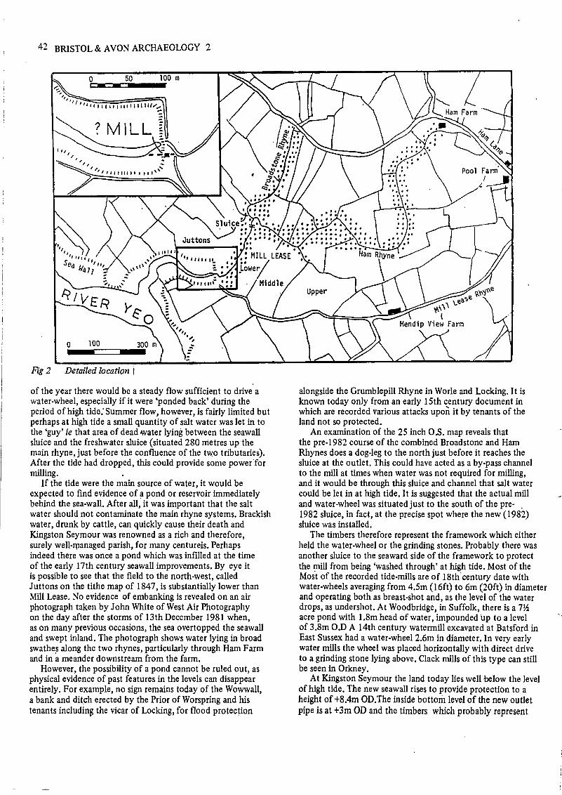
42 BRISTOL & AVON ARCHAEOLOGY 2
0 50 100 m ~ IMM ~~
~1,, ,~,~":"======-:=:::-:=:=='1 1 1 I I I I I f , I I I II I I 11 111 ,' _.. ...
O 100
Fig 2 Detailed location i
of the year there would be a steady flow sufficient to drive a water-wheel, especially if it were 'ponded back' during the period of high tide.' Summer flow, however, is fairly limited but perhaps at high tide a small quantity of salt water was let in to the 'guy' ie that area of dead water lying between the seawall sluice and the freshwater sluice (situated 280 metres up the main rhyne, just before the confluence of the two tributaries). After the tide had dropped, this could provide some power for milling.
If the tide were the main source of water, it would be expected to find evidence of a pond or reservoir immediately behind the sea-wall. After all, it was important that the salt water should not contaminate the main rhyne systems. Brackish water, drunk by cattle, can quickly cause their death and Kingston Seymour was renowned as a rich and therefore, surely well-rpanaged parish, for many centureis. Perhaps indeed there was once a pond which was infilled at the time of the early 17th century seawall improvements. By eye it is possible to see that the field to the north-west, called Juttons on the tithe map of 1847, is substantially lower than Mill Lease. No evidence of embanking is revealed on an air photograph taken by John White of West Air Photography on the day after the storms of 13th December 1981 when, as on many previous occasions, the sea overtopped the seawall and swept inland. The photograph shows water lying in broad swathe~ along the two rhynes, particularly through Ham Farm and in a meander downstream from the farm.
However, the possibility of a pond cannot be ruled out, as physical evidence of past features in the levels can disappear entirely. For example, no sign remains today of the Wowwall, a bank and ditch erected by the Prior of Worspring and his tenants including the vicar of Locking, for flood protection
alongside the Grumblepill Rhyne in Worle and Locking. It is known today only from an early 15th century document in which are recorded various attacks upon it by tenants of the land not so protected.
An examination of the 25 inch O.S. map reveals that the pre-1982 course of the combined Broadstone and Ham Rhynes does a dog-leg to the north just before it reaches the sluice at the outlet. This could have acted as a by-pass channel to the mill at times when water was not required for milling, and it would be through this sluice and channel that salt water could be let in at high tide. It is suggested that the actual mill and water-wheel was situated just to the south of the pre- . 1982 sluice, in fact, at the precise spot where the new (1982) sluice was installed,
The timbers therefore represent the framework which either held the water-wheel or the grinding stones. Probably there was another sluice to the seaward side of the framework to protect the IJlill from being 'washed through' at high tide. Most of the Most of the recorded tide-mills are of 18th. century date with water-wheels averaging from 4.Sm (16ft) to 6m (20ft) in diameter and operating both as breast-shot and, as the level of the water drops, as undershot. At Woodbridge, in Suffolk, there is a 7½ acre pond with 1.8m head of water, impounded up to a level of 3,8m O.D A 14th century watermill excavated at Batsford in East Sussex had a water-wheel 2.6m in diameter, In very early water mills the wheel was placed horizontally with direct drive to a grinding stone lying above. Clack mills of this type can still be seen in Orkney.
At Kingston Seymour the land today lies well below the level of high tide. The new seawall rises to provide protection to a height of +8.4m OD.The inside bottom level of the new outlet pipe is at +3m OD and the timbers which probably represent

the mill race (ie those traced by the waterworkers I probing) lay at+ 0.9m OD. If the water levels were similar to what they are now, a mill could effectively function here.
The date at which the mill was abandoned seems likely to have been the early 17th century. New works were being carried out on the seawalls of Somerset and warths reclaimed to provide increased pasturage: for cattle.The general improvements received considerable im~etus from the great storm of 20th January 1607 when the sea broke through the existing walls and flooded the parish to a depth of I .Sm. Around this outlet the existing wall was strengthened, the mill dismantled and the wheel pit filled in and the outlet for the Broadstone/Ham Rhynes retained on the by-pass line. The earliest schedules of maintenance work due on the seawall date to 1637 which could well be the completion date of the work carried out. For 350 years or more the timbers remained buried, only to be revealed when, in 1982, the outlet was put back to its earlier course.
TIDE MILLS IN THE BRISTOL CHANNEL With the colossal tidal range experienced by the Bristol Channel as a ready-made source of power only needing to be harnessed, it seems strange that more tide mills have not been found on the creeks and rivers which drain into the Channel. In the Thames estuary over 60 tide mills are known. Along the South Coast numbers of tide mills reached a peak in the .18th century for the reason that, after 1700, grain was milled before being sent to market. Before then it was sent to markel as grain not flour and the miller would only mill for local requirements. Tide mills may have been known to the Romans. Of the numerous witter mills listed in the Domesday Survey, some may have used tidal water. Portishead mill was mentioned in 1086 and was notorious as a tidal mill by the 18th century when it caused flooding of the moor. This not only made travel across the lowland exceedingly difficult but contributed to the closure of the Clapton coal mines, due. to prevention of drainage. The miller refused to control the amount of water let in at high tide and the problem was not resolved until the new Drainage Act of 1815 meant that the watermill had to be closed. It is the only definite tide mill on this section of coast. Nothing is known of the date of operatioJ?. cif the watermill at Uphill on a creek of the River Axe, except that it is marked on Greenwood's map (1822). It may be the mill referred to in a Steep Holm charter of 1199-1216, where the monks of the island were entitled to free multure (grinding) in the mill of Uphill. ·
In the Bristol Avon, the name Sea Mills is surely significant and documentary research might provide more information. Further up the River Severn there are a series of tide mills at Framilode, Glos, used variously for corn, fulling, iron and tin mills, the complex being a tin-plate works in 1786. On the Welsh side of the Channel opposite Avonmouth a mill is referred to in 1246 at Aberweythel in Gwent. Here the keepers of the mill were to assume responsibility for the watercourses and for the gout and sluice so that the Tintern monks who farmed the land should suffer no trouble. George Boon suggests the mill was
. a tide-mill and points out that it is indicative of a considerable acreage of corn growing on the Gwent Levels at that time.
Ther~ are hints of other tide mills to be found. For example, at Oldbury some eight years ago a millstone was found when deepening a rhyne near the Anchor Inn. In writing of Mendip Forest rights, Francis Knight quotes from the Close Rolls of 1229 an Order to allow Herebert son of Matthew fifteen oaks in
EVANS: KINGSTON SEYMOUR MILL 43
grass '°" ,,,,,
stones O
c:::>
SOUTH
• •
stakes •
• 0 I metre NORTH
Fig 3 Plan of timbers
the royal forest of Cheddar as a gift from the King, for repairing his mills at Huntspill .
THE ECONOMY OF KINGSTON SEYMOUR This coastal parish has always been at the mercy of the sea despite changes in sea-level over the centuries. The construction of the first seawall is thought to date to the 12th century yet the Romans must surely have provided themselves with some protection, although sea level is thought to have been 1 m lower then. Certainly the land was farmed in Romano-British times, as the scatter of sherds throughout the parish testify. The. sizeable

44 BRISTOL & A VON ARCHAEOLOGY 2
wealthy villa of Wemberham, lying 2 miles upriver on the banks of the River Yeo just outside the eastern boundary of the parish, was perhaps the home of the owner of an estate extending up and down the valley. Ships bringing in luxury requirements to his wharf would also export surplus grain from the estate, and a T-shaped kiln,thought to be for corn-drying, was excavated at North End Farm, 2 miles to the north, in 1955. In Domesday
. Book the parish appears as quite wealthy with 17 carucates of arable and 40 acres of pasture. No mill is mentioned. The present fabric of the church dates main1y from the 15th century. All building materials had to be brought in to the parish; the Churchwardens' :_accounts for the neighbouring parish of Yatton provide interesting information on 15th century economy, with stone brought in from Felton and oak variously from Brackley, Backwell,.Tickenham (Limbreach) and Congresbury. Medieval sherds have been found around the old manor house. The most remarkable medieval item from the parish is a stone measure. It is double-ended, each 'cup' holding about 3 pints, with a central pivot and cable decoration around the waist, which suggests a date in the 12th century. This splendid object, given to the old Weston-super-Mare Museum in 1932 in memory of the local historian Ernest Baker, is said to have come from Kingston Seymour Rectory. It is paralleled by examples in France, at Dinan, Quimper and Le Puy, where they were used for measuring out the proportion of produce, such as corn, which was due to the Lord of the Manor. The finding of such an object in Kingston Seymour surely indicates that corn was grown in the parish in medieval times and it would follow that the Lord of the Manor would take his due or tithe in return for it being ground at his mill. The Bulbec:k family was the most prominent local family for several centuries and both medieval and post-medieval pottery,including imported Saintonge ware of 16th century date, has been found on the site of their manor house (GR 40368&) just inside Kenn parish.
With the reclamation of the warths in the period 1600. 1640, more pasture for cattle was provided, implying corn growing had gone out of fashion, and Billingsley (1791) says that on the rich marshland near the Bristol Channel the grazing system prevailed. According to port book records, in 1666 alone more than 1160 cattle were brought across from Sully in South Wales to Uphill by three ships each of 20 tons making a total of 34 trips. Most of the shipments were in May and June to allow for fattening on the summer pastures before being driven to market in Bristol. Collinson (1791), however, differs and describes the village thus: A small straggling place consisting of 42 houses and 250 inhabitants. The lands are n:i~stly arable and very rich, being wo~th on average 35 shillings an acre throughout the parish. There is little wood and elm the principal. There are many large orchards. The many splendid barns associated with the farms have been subject to recent study by Ken Stuckey who believes they date to the late 18th century, many being built when, at the time of the Napoleonic Wars, there was. a.n increase in the growing of grain crops.
On the tithe map (1847), there are 127 acres of arable, nearly 5% of the total. Oats were the dominant crop followed by barley, then wheat. In the First World War, farmers were directed to plough up 10% of their land and even more in the
. Second World War , when mainly wheat and oats were grown. The evidence shows it is certainly possible to use the land for grain, provided that cultivation does not commence very early in the spring.
Fig4 Section of timber (f)
, Notched timber
SUMMARY
. 9..._. __ ----J!metre
To summarise: without further excavation, not now practicable as Wessex Water has. completed its current programme of alterations, it is not possible to identify the structure precisely. Documentary research might help in providing a date which dendrochronology has failed to supply so far. The local name of Mill Lease is the strongest evidence for the presence here of a water mill operated in association with the tides and it is suggested this would date to som.ewhere within the period 12th to 16th century. The mill was in disuse by the time the early 17th century reclamation of warths took place outside the seawall. During these improvements the mill was dismantled and the wheel-pit filled in to make good the seawall, leaving an outlet for the rhyne system along the bypass channel. The 1982 improvements reinstated the rhyne to the original, or earlier, line of the outlet.
Acknowledgements are due to the following:-Lester Durston and the men of Wessex Water for allowing access, Ken Stuckey for much help with local lore and documentary research, Keith Gardner, Mike Ponsford and Martin Bell for visiting the site and discussing its possible function, Pam Kostyla for drawing my attention to the inscribed stone (now on loan to Wood-spring Museum), Graham Morgan for identifying the wood, John White of West Air for air photographs of the area under floods (nos, 34138, 34140), John Clark of the Museum of London for parallels to the Kingston Seymour stone tithe measure, Vic Hallett for the Oldbury reference, Stan Rendell for reference to the Uphill Mill and Sha'ron Poole for noticing a watermill at Uphill on the Greenwood map. REFERENCES Bedwin O 1980, Excavations of Batsford Mill, East Sussex in Med Arch 24, 187-201 Billingsley J 1791 Agricultural Survey of Somerset. ,
. Boon G C 1980 Caerleon and the Gwent Levels in Early Historic Times, in Arch. and Coastal Change ed F H Thompson, Soc of Antiquaries, 0cc Paper no 1 Clarke M 1979-80, Articles in the News Sheet of the Axbridge Arch and Local History Soc nos 34, 35, 37, 38 . Co}linson 1791 History and Antiquities of Somerset Coward H 1980 The Wowall inPSANHS 124, 151-8 Hobhouse,Bishop (ed) 'Pre-Reformation church-wardens' accounts .... Yatton Somerset Record Society IV 1890 Knight F 1902 Seaboard of Mendip, 263 Knight F 1915 Heart of Mendip. 451 Lilly D and Usher G 1972. Romano-British Sites on the N Somerset Levels, PUBSS 13/ 11, 39 Miuchinton WE Article on Tide Mills in Transactions of the 4th symposium of the International Molinological Society, S.P.A.B. Wailes R 1940 Tide Mills in England and Wales S P A B Wigan E 1950. Tale of Gordano . Williams M 1970 Drainin~ of the Somerset Levels

45
A SEVENTEENTH CENTURY HOUSE AT 10 LOWER PARK ROW, BRISTOL
John Bryant and John Winstone
This fine 17th century town house became a cause celebre a few years ago. When it was threatened with demolition John Bryant did a survey for Bristol City Museum. This revealed just how intact this previously unnoticed building was. However, despite its obvious historical and visual importance, its retention was not backed by all local conservation groups, presumably because it was not 'polite' architecture. At this point the Society for the Protection of Ancient Buildings (SPAB) demonstrated that it could be repaired and used again. As a direct result of this debacle a local branch of the SPAB was set up. Owing to these special circumstances the following two accounts are written individually: the survey by an archaeologist (J Bryant); and the description of its restoration by a practising architect and SPAB member ( J H Winstone ).
SURVEY Number 10 Lower Park Row, is situated 400 metres west of the centre of the· medieval city of Bristol, on the south-east slopes of St Michael's hill Lower Park Row was formerly part of the main route to Clifton, and was known as Griffin Lane until the late 19th Century. The building is a substantial stone-built town house of early or mid- 17th century date, one of a number built in the area at that time. It is shown on Millerd's map of 1673. The house was recorded for the City of Bristol Museum and Art Gallery in 1978-79 in advance of its proposed demolition.
As built, the house comprised five storeys, including a basement and an attic storey. The main elevation was of five bays, and it faced westward towards the next house, which at that time was the Red Lodge. There were two gables on the west and east elevations, each eastern gable incorporating a chimney stack. North and south elevations each contained one bay and one gable. The north wall was set at an angle to other walls. Brandon Hill Grit (probably quarried on site) was used for the walls, laid a$ random rubble with semi-circular relieving arches over window openings. Rendering would have been applied to the exterior. String courses ran around the house above the first and second floor windows. Most windows were freestone with ovolomoulded mullions. The main entrance was at ground-floor level in the centre of the main elevation. Each storey comprised one room on each side of a central staircase, with a small room to the rear of the stairwell. The staircase probably consisted of three flights and two quarter-landings between each storey, with the flights against the north, east and south stdes of the stairwell. With the exception of one rubble wall in the basement, all internal partitions were of stud work and plaster. A timber privy block was attached to the south-east corner of the house.
Alterations were made in the early 19th century, including the installation of a new ceiling in the northern ground floor room. The title 'Park Row Lodge 1722', on a door lintel, may be associated with the alterations. Divisio,n into two dwellings took place in the early 19th century. Partial rebuilding of the house included the removal of the gables and staircase which were replaced by a brick built top floor with pantiled king-post roof and two dog-leg staircases. A pair of doorways replaced the 17th century entrance. During the 19th century, the northern groundfloor room was converted to a shop. An entrance WflS constructed direct from the street and a large window was fitted. Two buildings were later constructed abutting the house, but both have since . been dem9lished.
The mullioned windows in the main elevation were blocked, but fortunately many sills, jambs and lintels survived behind the blocking. Those in the end walls were later replaced by sash windows. One mullioned window survives intact in the east wall at second-storey level. Two small round-headed fre.estone windows remained ai the north end of the same wall, with parts of three slightly larger windows at the opposite end. Inside the house, each small window opened into a recess between the fireplace and the end wall of the building.
Seven early 17th century doors were recorded inside the house, mainly in the southern half, where five doors were found in just two rooms. Moulded motifs, such as lozenge and rectangle-within -rectangle, decorated the five doors: Similar decoration may be seen in the late 16th century panelling at the Red Lodge. A small door found in the basement had evidently begun life in the attic. One corner was cut at the same angle as that conjectured for the roof. Three doors were subsequently stolen, but not before each had been recorded. Several frames survived in situ in the front half of the building, minus their original doors. Seven contemporary ceilings still remained at the time of recording, but only one has survived.
Each of the six main rooms was heated by a freestone fireplace at the east side of the room. Three fireplaces remained when the building was recorded. Shape and dimensions varied, but there was a general design common to all. Above the grate was a flat four-centred arch, with each spandrel decorated with a small plain shield. The arch and jambs were moulded, each moulding ending in a carved stop a little above the base of the jamb. None of the chimney pieces rose to more than two-thirds of the wall height. Traces of decorative paintwork were found on .the chimney-piece of the southern ground-floor fireplace. It was impossible to tell if other fireplaces had been similarly decorated, but two layers of painted plasterwork were found inside the fireplace in the northern ground-floor room.
The northern basement room was partly cut into rock. It was probably used as a cellar. South of the staircase was the kitchen, lit by a mullioned window in the south wall adjacent to which was a doorway giving direct access from outside. Below the flagstone floor lay a well and a water cistern. Much of the east wall was occupied by the large kitchen fireplace, which was not of freestone but possessed a long timber lintel carved in a rough flat arch. Beside the fireplace was a ceramic bread oven, typical of those produced in North Devon in the 17th century and later .

I
46 BRISTOL & A VON ARCHAEOLOGY 2
Photographs, drawings and a more detailed description of No. 10 are held by the City of Bristol Museum and Art Gallery (Accession No. BRSMG 148/1980). A full report will be published in due course. The writer would like to thank all those who gave advice during the recording of the house, and especially George Ferguson of Ferguson Mann, for permitting access.
RETENTION AND RESTORATION Once, long before St. Michael's Hill and Christmas Steps were designated a Conservation Area, but for the most part within living memory, the area near the parish church boasted a number of fine 17th century stone buildings. These had emerged from, or merged with;-the expansion of the walled city at a period when Bristol was first in the land after London. Included in this loose domestic group we may list The Red Lodg_e (1589), The White Lodge (16th c. dem. RW 18_74-66 pl 27(lJ & Braikenridge Collection), The King David Inn (17th century . dem & rebuilt as a hotel 1893, RW 1880's pl 16,5, 166 & 1845-1900 forthc_oming), The Manor House (17th century burnt 1979 , presently ruinous, RW 1960-62 pl 52), a house in Tankard's Close (I 7th century dem. 1960, RW 1928-33 pl 107), a house in Upper Wells Street (17th or 16th century dem 1961, RW 1960-62 pl 55, 56, 1956-59 pl 23, 124, 1866-60 pls 44-50), the former rectory in Lower Church Lane ( 17th century kitchen, remainder r.emodelled by Paty c 177 5, altered 1981), several other unidentified triple gabled houses in Park Row and 10 Lower Park Row.
The character of these buildings is best seen in a painting sometime attributed to Peter Monaman, now ascribed 'Anon' c 1728-30, in the City Art Gallery. It includes a backdrop panorama of the hillside painted from an upper storey in Thunderbolt Street (site of Broad Quay House) and almost certainly shows No 10 where it should appear, above the Great House. However a four storey single gabled addition stands against the south-east elevation. The main house appears to have two gables. These substantial 17th century stone built houses command our attention for the way in which the English understanding of Renaissance design was impinging on an earlier more indigenous architecture.
It was inconceivable to the writer that anyone should wish to demolish this house in tlie late 1970's, notwithstanding the treatment of historic buildings in Bristol over the preceding 30 years (outside this group, but within the same geographic context, in St. J ames's parish, another 17th c house is in jeopardy of demolition). But in April 1979, without a survey being made, a demolition application was lodged, contrary to the planning and listed building policies of conservation areas. Accordingly a representation was made (2) for the retention of the house, suggesting the philosophy of repair of the Society for the Protection of Ancient Buildings (SPAB). Some local conservation groups gave the idea short shift, but to their merit the Planning Committee upheld. the view that here was a singular and largely intact 17th century house on a hillside which was reparable once a means of access to the backland had been found. Consent for demolition was refused and the house was reassessed Grade II* and generously grant aided for repair by the Historic Buildings Council.
A suggestion for further improving access to the rear .to scotch calls for demolition from e·meigency services was promptly taken up for development gain using the argument that the continuity of the street should prevail, notwithstanding the house was originally designed to stand upright on an open hillside. So the open view of the north-east elevation (John Bryant's 'east') will soon be masked. Objections to this proposal only circum•
vented the proposal to build across the historic east squints. An alternative treatment for the interior to save the intact 17th
century kitchen, the integrity of the plan and items of original fabric, based on the ethi_c of maximum repair and minimum alteration, was dismissed. Final!y after further representations by SPAB concerning the detailed treatment, listed building consent was granted for a 'restoration' scheme of conversion to flats. During the works the original floor beams and joists were stripped out, Georgian panelling in: the shop removed, one band of weatherings replaced where there ~ad been two, emphasising the upper part of the house, a new roof set to too flat a pitch with replacement chimney stacks of dressed Bath stone instead of rendered rubble and the building limewashed creating busy wall surfaces where the physics of the masonry walls required a lime plaster the texture of rag paper.
The house was arranged on three floors with a further floor carried into the hillside at the north-west end. Small window ·shafts once lit this lowest room, but these had been covered when the approach path was raised, detracting from the room and causing rotting of the floor joist ends. The entrance front faced south-west, five bays wide with a central door. From the entrance door a stair once arose around a generous stairhall. The side walls of this, plastered at the time of survey and carrying joists, formed the internal partition walls of the principle rooms to the left and right of the stairs. A further partition, unmoved plastered and intact, formed the back wall of the stairhall. This formed a closet reached from each of the principle rooms. This then was a regular and compact houseplan that had been selected for the site, without being entirely original in conception. At any rate, in a. terraced configuration entered on the short side the plan came to be ·used in later Bristol Georgian house plans.
The principle rooms were particularly well lit from a pair of cross mullion and transom windows moulded ovolo inside and out in stone. The kitchen, at the lowest level, faced south-east down the hillside garden. The space between the remaining stone jambs behind the later sash boxes on the south-east elevation showed that the kitchen at least had had
Fig 1 1 O Lower. Park Row. South west elevation

a six light mullion and transom window (3). This may have been repeated above. The kitchen with its surviving fireplace, cloam oven and well, deserved better than nomination to a bicycle store.
Stone fireplaces remained, some with later surrounds in front, all with their overmantles cut back above four centred arched openings. Traces of painted decoration remained on the fireplace jamb of the north-west room. A very similar firesurround appears in a photograph of Rupert House with an overmantle dated 167 4 ( dem 4). This is the best evidence of dating of the house yet available, taken in conjunction with Millerd's map of 1673.
Alongside the chimney breasts were set squints peeping down the hill and across the City. On the north corner the angle back of the end wall reduced the squints to round headed pierced stones. The upper floors were joisted northwest to south-east running onto the cross-partitions and into mortices ·in 330 x 250mm cross beams, laid entirely within the floor and angled to avoid bearing into flues. The lowest level floor beams were exposed, stop-chamfered, below a general ceiling level 2.80m above the floor. Both south-west lower floor beams needed repair from rot caused by the raising of the path.
Also at the lowest level was an unprovenanced length of casing timber moulded cima-reversa. A door trimmed for use in the attic provided evidence of the original roof pitch as 51 degrees. Fragments of silvery grey Cornish slate, peg holed and used as wedges in later alterations, suggested a sparkling slate roof before the Georgians promoted the mansard roof. This may explain a general provenance of similar salvaged slates used as weatheringhanging on several Georgian Kingsdown houses (in 1983 now only . remaining on Prospect House and 7 Somerset Street).
A survey in the 'King's Weston Book. of Drawings' dated 1702 (5) shows the Red Lodge, garden and boundary wall which survives in part (Fig 2). This plan shows the generous spacing of No 10 to the Lodge and something of the view from the windows can be imagined. The formal front of the house is worth comparison with other buildings once to be seen on the road to Clifton.
If we start our excursion at the Great House on the Quay, tiny gables dominate (6), inappropriately render blocked in the photograph. Then through Host Street with houses framed and jettied (7), turn left up Stepe Street where houses are irregular, rendered on the left and framed in part in the centre view (now rendered in 8). Leaving the City climb Griffin Lane passing 1
according to a watercolour in the Braikenridge Collection, a stone built gabled house with parapeted verges, and a framed house dated 1504 in the pargetted quoin decoration with No 10 rising sheer beyond. Pass on and compare the measured facade design with that of the earlier and less regular _Red Lodge.
BRYANT & WJNSTONE: 10 LOWER PARK ROW 47
The wholeness of the building mass (seen without it's privy block) and emphasis on the five bay front sets No 10 apart from the neighbouring buildings. It should be recorded that the two gables now reconstructed, although suggested by the painting described above, is to some extent conjecture as there was a relieving arch over the centre second floor window.
In postscript it is worth looking at George Oatley's Baptist College of 1913 facing the Royal Fort, as a personal interpretation of No 10. The College has chimney settings, windows and wall cappings similar to the Red Lodge and No 10 as well as a similar orientation. The case of No 10 confirmed the need for SPAB repair policies and conservation methods to be used on historic Bristol buildings. A SP AB Bristol Branch has now been formed . and holds regular meetings.
Fig 2 Site plan (from 1702 survey)
NOTES (1) RW refers to Reece Winstone 'Bristol As It Was' series.
Identified as being to the right of the brick chimney by Dr R Leech.
(2) Another agency was prevented from making written objection.
(3) Suggestion of John Schofield ( 4) RW 1866-1860 Pl 50. Also Redland Manor House &
Tilly's Court house, both 1658. RW 1880's Pl 133, 134 and 151. ·
(5) Pub in Architectural History Vol 10, 1976, Jrn of Soc of Arct Historians.
(6) RW 1850's Pl 9 (7) RW 1866-60 Pl 31 (8) RW Earliest Photographs Pl 57 (9) The following may repay detailed study; Spring Gardens
PH Hotwells, Cathedral School House, College Square, Oldbury Manor St Michael's Hill.
( 10) Horton Album 1908, photograph of house to East of St. Peter's Hospital. Also gable end of house in Stepe Street 'Earliest Photographs' Pl 58.
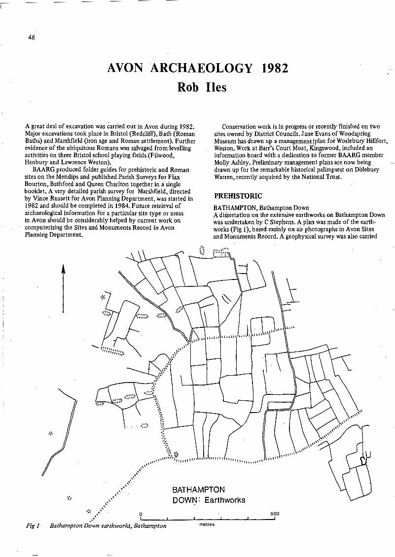
48
AVON 'ARCHAEOLOGY 1982
Rob Iles
A great deal of excavation was carried out in Avon during 1982. Major excavations took place in Bristol (Redcliff), Bath (Roman Baths) and Marshfield (iron age and Roman settlement). Further evidence of the ubiquitous Romans was s~vaged from levelling activities on three Bristol school playing fields (Filwood, Henbury and Lawrence Weston).
BAARG produced folder guides for prehistoric and Roman sites on the Men.dips and published Parish Surveys for Flax Bourton, Bathford and Queen Charlton together in a single booklet. A very detailed parish survey for Marshfield, dir~cted by Vince Russett for Avon Planning Department, was started in 1982 and should be completed in 1984. Future retrieval of archaeological information for a particular site type or areas in Avon should be considerably helped by current work on computerising the Sites and Monuments Record in Avon Plannirig Department.
Conservation work is in progress or recently finished on two sites owned by District Councils. J ime Evans of Woodspring Museum has drawn up a management jplan for Worlebury Hillfort, . Weston. Work at Barr's Court Moat, Kingswood, included an information board with a dedication to former BAARG member Molly Ashley. Preliminary management plans are now being drawn up for the remarkable historical palimpsest on Dolebury Warren, recently acquired by the National Trust.
PREHISTORIC
BATHAMPTON, Bathampton Down A dissertation on the extensive earthworks on Bathampton Down was undertaken by C Stephens. A plan was made of the earthworks (Fig 1), based mainly on air photographs in Avon Sites and Monuments Record. A geophysical survey was also carried
BAT HAMPTON DOWN: Earthworks
0 500
Fig J · Bathampton Down earthworks, Bathampton metres

out to establish the relationship between sections of rampart. Early in the iron age a sub-rectangular area, some 32.5ha in
extent, was enclosed by a weak drystone rampart and ditch. Although the latter follows a natural break of slope around the plateau of the Down, it is not very defensive apart from the eastern side, where any trace of a rampart has been lost in 18th century quarrying. No evidence for an entrance was found in the geophysical survey. At a later stage another rampart was constructed across the south-east corner of the original enclosure, thereby cutting off the Down from what is now Claverton Down.
Although 'brickwork' - pattern fields, like those on Bathampton Down, are generally thought to be Roman, air photos of Rossington, Yorkshire have revealed evidence for a late iron age date (Riley, 1980). There is no direct dating evidence for the fields on Bathampton Down but a terraced area on the northern slopes has produced surface finds of Roman date including a chip-carved stone table top fragment (Blagg, 1977; and Cheetham, personal comm). To the south-east is a drystone wall enclosure of unknown date which is built on a lynchet. There are further earthworks to the south west, not yet plotted as they were not visible on the aerial photos.
Other earthworks include four round barrows and ten pillow mounds with a possible warrener's house platform. Blagg, T F C, 1977 in Munby, J and Henig, M ( eds) Roman Life and Art in Britain (BAR 4 I) 51-54 Riley, D N, 1980 Early Landscape from the Air, 94 - 5
COLD ASHTON, ST7 57720 On north facing slopes are the earthwork remains of a possible
premedieval field system. They were seen from Cold Ashton village by R Iles.
KELSTON,Manor Farm ST694666 Four greensand chert implements (Fig 2) have been found by N Roberts in bare soil following heavy grazing. They are patinated with a reddish-brown tinge and have much coarse cortex. 1. The flaking of this chopping tool is crude and the cutting edge
has been bruised and flattened, suggesting use as a hammer rather than a cutting tool. It shows no signs of having been rolled.
2. This small chopping tool has a clearly defined cutting edge. It has not been rolled but the cutting edge shows signs of bruising.
ILES: A VON ARCHAEOLOGY 1982 49
3. A small flake tool has a working edge which has been fashioned along one third of its circumference. The flake scars are well defined on one side and the reverse shows a cortex deliberately left to facilitate handling. No signs of rolling are evident.
4. This triangular flake has a complete cortex on one side. Along one edge of the point there is accurate retouch. The patination is similar to the other implements but appears to be in the mesolithic tradition.
A further chert pebble which may have been a crude handaxe was found. Eleven other chert pieces with flaking were found along with several flints including one thumb scraper. Some of the flint flakes showed signs of retouch on previously patinated surfaces.
OLDBURY-ON-SEVERN, Oldbury Camp, ST61029285 A small section was dug by R Iles through the outer bank and ditch of this earthwork enclosure prior to the building of a bungalow. The outer ditch had already been infilled and most of the bank removed by medieval times. The outer side of the bank was probably used as a headland. The inner side of the bank had been very disturbed in medieval times. The only feature was a small hearth, probably of medieval date, near the top of what was left of the bank. Just above the bottom of the ditch was a thick layer of charcoal.
PORTBURY, Windmill Hill, ST506739 A small, widely-scattered series of flints, including a crude arrowhead, was found by N Roberts in a ploughed field. Two flint chips show signs of retouch and some of the pieces -are patinated.
TYTHERINGTON, Barmers Land Farm, ST66238938 A flint implement, probably axe-head, of unusual style was found by the farmer, R Hetherington (A Baddeley).
WRAXALL, Old Hill, ST727 504 A scatter of 12 flints was found along the edge of a ploughed field by N Roberts. Two of the fragments are retouched flakes; one is a crude scraper, the other a cutting blade. One of the flints is a round nodule, heavily bruised one side, suggesting use as a hammer ston.e.
3
2 61 I I ~ £1:'l'!t&-• ..;:;J
4
0 10 50 100 mm 11,----!...l:=•--==-MWl...i==--===--==:jl
Fig 2 Ozert implements, Manor Farm, Kelston

50 BRISTOL & A VON ARCHAEOLOGY 2
ROMAN
ALVESTON, Abbey Camp, ST64808870 Various Roman finds were recovered from a water pipe trench by T W J Solley. There was some 1st century AD material, including two coins.
BATH, Roman Baths, ST750647 Continued excavation of the Temple Precinct was directed by P Davenport of Bath Archaeological Trust for the City Council. All the available area of the Inner Temple precinct, over 80% of the original, has now been excavated down to the best preserved Roman levels (3rd century). The sacrificial altar, courtyard paving and precinct boundary walls and a monumental screen between the altar and hot springs have been exposed. Later Roman occupation revealed a probable Christianisation of the site - at least a deliberate deformation of its pagan aspects. More sculptural material was discovered, including parts of the Temple pediment. Medieval, probably monastic, buildings were uncovered and also the medieval and post-medieval cemetery of St Mary de Stalls. Foundations of the earlier 18th century pump room and access slips to the Kings Bath were also discovered.
BATH, Walcot Street, ST752656 Trial trenching by P Davenport for the Bath Archaeological Trust on the hill slope behind Hayes furniture shop down to the river Avon (south east of London St) revealed no pre-18th century occupation on the lower slope down to the river. Nearer the road, above the flood levels, slight remains of rubble-mortar foundations were found with much Roman pottery. There are verbal reports of a coin of Hadrian and 'pottery' from immediately north west of the site. The trenches probably clipped the extreme rear of roadside development along the London Road in Roman times.
BRISTOL, Lawrence Weston, ST544447862 An excavation of a Roman settlement was directed by A Parker for Bristol University Department of Classics and Archaeology. The site was discovered during levelling of playing fields to the north west of Long Cross. 1n an area of 250 sq. m. features of several phases ranging from the 1st to the 4th centuries were examined. The site appears to comprise the west side of an enclosed settlement or homestead, bounded by a succession of ditches, walls or fences; within the enclosed area the surviving late Roman remains consisted of a roughly cobbled open area round an oven or furnace. Finds consisted almost entirely of coarse pottery, animal bones and some metal working waste. Part of the site has been preserved.
BRISTOL Reports on the excavation and recording of Roman sites at Filwood Park and Henbury school playing fields can be found elsewhere in BAA 2.
HAWKESBURY/ALDERLEY, ST78869096 To the south-west of Tresham, on the county boundary, a Roman building was noted by D Watts in a cutting for a trackway. There are numerous earthworks along ,he hillside in this area.
KEYNSHAM, Charlton Bottom, ST63886830 Over 100 sherds of Roman coarse wares were found in a field by A K Borgelin. Other finds located were a piece of Samian, and iron and lead slag. Building remains were also noted in the same area.
MARSHFIELD, Ironmongers, ST798760 An excavation of an iron age and Romano-British settlement was directed by Kand M Blockley for Avon County Planning Department. An area of 3000 sq m of plough soil was stripped by hand and finds plotted. The plough soil averaged only 15-20cm in depth , but although walls, floors and graves were being destroyed it was found that material in the plough soil had not moved far and was a reliable indication of the buried archaeology. Pre-Roman Occupation (Fig 3) The earliest permanent occupation was indicated by a single hut circle (A on Fig 3) ditches and two gulleys (G and H); both with late iron age pottery. Early Roman Occupation Not long after the Roman conquest the ditches were backfilled and a 1.6m wide drystone wall (Bin Fig 3) was erected. This wall incorpor.ated an entrance flanked by two postern gates. At a date contemporary with this wall the pre-Roman circular structure was rebuilt in masonry. No domestic fittings were found in this building but it contained two sheep skulls and six legs. Its function as a shrine with, perhaps,a masonry precinct wall seems likely. To the south a single adult inhumation was found in an unlined grave on a north-south alignment within a post hole structure (E), possibly a mortuary enclosure. Also incorporated within this complex was a single crouched baby burial. Later Roman Occupation During the fourth century the boundary wall (B) and circular building were demolished and a large rectilinear building was constructed (C). This was a large farmhouse, with at least fourteen rooms towards the end of the fourth century. One room had an opus signinum floor suspended above a hypocaust with an oval foot bath sunk into it. Ceiling and wall plaster was recovered from four rooms, although decoration was limited to simple stripes and bands of colour. The remaining rooms had flagstone floors and typically contained ovens and hearths. One room contained a pitched stone emplacement which could have supported a considerable weight, perhaps a base to a water tank or a stacking area. The building underwent numerous structural alterations during its occupation. An addition to the southern end wall was used as a smithy.
At the northern limit of the excavation was a drystone circular building (D) similar to the one which pre-dated the farmhouse. To the east a large·, well-preserved drying oven was built in drystone walling. It had a centrally placed stokehole at the northern end, with a lined stone pit providing access and an intact limestone flue arch. Samples were collected from the burnt · deposits and primary silts in an attempt to clarify the oven's function, whether for malting or corn-drying.
To the south of the main building was a cemetery lying outside a dry stone wall. Twenty burials were excavated and comprised 14 infants and 6 adults. The majority of adults were on an east -west alignment adjacent to the boundary wall and were contained within stone-lined graves of the fourth century.
STEEP HOLM Surface finds from the plateau of Steep Holm near the island's summit include pottery, and roofing and flue tiles. They were collected by S and J Rendell and are adjacent to lines of stones surveyed in 1977 and published in Steep Holm · A Survey

Fig 3 Ironmongers excavation, Marshfield, 1982
MEDIEVAL AND LATER
HACKWELL, Downside, ST500665 The site of a deserted glebe farm (Fig 4) has been found by , M J Glasson and J M Pullan. A Hackwell Glebe Terrier of 1634 refers to a glebe farm at Downside consisting of' ... a dwelling house, one barne, one backhouse, one other little backhouse with 28 acres of ground lying all about the house except one ground called Standells containing two acres'. Most of the field names
ILES: AVON ARCHAEOLOGY 1982 51
MARSHFIELD 1982
~ Vertical stones
~ Dry stone walls
~ Mortared walls
E'.'.:3 Wall foundation
00 Child burial
l'f:II Opus Signinum
0 5 JO m
15
KH·MIJ
shown on Fig 4 are from maps made in 17 87 and 1812 for the Marquis of Bath and the Tithe Map. The farm land was sold in 1915 at a sale of glebe properties (Lot 11, 36 acres). A sketch survey (Fig 5) of the site of the farm shows a track, with slight indications of buildings on either side. Some 200 sherds of Donyatt and Wanstrow ware (late 16th • mid 17th centuries) were found in a small area close to the track near a stone trough. The existence of this farm so close to its neighbours, Edsons and Oatfield farms, helps to recreate the pattern of land
52 BRISTOL & A VON ARCHAEOLOGY 2
ftr
P'AllM -" BOUNDAllV
•o• 0 BR.lbLa 1"AT"4 PAR.ISM
e e. I 80UMDA'I.V
Soo 1000
holding in the 17th century, when there were many more small farms than exist today.
BATH, Roman Baths See reports on medieval finds under Roman section.
BRISTOL. Canons Marsh E Boore reports that a collection of pottery, in a box marked 'Canons marsh', has been discovered in Bristol Cathedral. It is believed to have been found earlier this century during roadworks. The pottery dates from 13th - 16th centuries and includes local wares (Ham Green, Redcliff and Minety) and more exotic pieces (medieval Saintonage ware, 16th century Spanish floor tile and German Bellarmine jugs). This group, although unstratified, does suggest the potential of the Canons Marsh area and is important in the light of future development.
BRISTOL, Dundas Wharf, ST590727 Excavation by G L Good for Bristol City Museum was begun in April 1982 and will contim~e till September 1983 as a part of a project to study the development of the Bristol suburb of Redcliffe, The site is located between Redcliff Street and the Floating Harbour (formerly the River Avon) and covers three tenements (nos 127-129) in Redcliff Street, though only one of these (no 128) can be excavated to the street frontage. So far it has been shown that the River Avon was considerably wider in the medieval period than I it is at present. Encroachme1 .. has been gradual since the 14th century with owners individually extending their properties. outwards into the river. Although
I I I
,,--
D Fig5
.. ,; ..
,.,. ... POTTEltY /?' f WALL ?
GOR.EY'S ROUGH GROUND
•. '•
'• '· '•
•. ., •. '•
'•
•, ..
'• .. TROUGH
", ,, / ...... ,._ ..., I ', I
' I (...... I BUILDINGS? ... ..,
.. I WALL ? 8CAU -fnt
0 IO 2o .Jo -1• 50
Survey of Glebe Farm remain .s; Hackwell
Fig 4 Site of Glebe Farm, Downside, Hackwell
most of these extensions were stone-built, some timber structures have been exposed. A narrow cobbled lane extending to the riverside, referred to in documents as the 'Common Slype', separated nos. 128 and 129. This was arched over and buildings extended above it in the 16th century. There is a separate report on the rich environmental deposits.
BRISTOL, Old Market, ST59577319 A watching brief by J Bryant for Bristol City Museum on the site of the Kings Cinema and former Baptist burial gtound produced only a scatter of post-medieval features.
BRISTOL, 68-72 Redcliff Street, ST59117245 See interim excavation report by RH Jones.
BRISTOL, 74-78 Redcliff Street, ST59117242 J Bryant excavated a section of the back-filled ditch outside the line of the 13th century Portwall for Bristol City Museum. The original cutting was 15 m wide and more than 5 m deep; excavation failed to locate the ditch bottom. Several medieval recuttings were evident as was a Civil War recut, 12 m wide and 4.5m deep. The latter was irregular in shape, suggesting a
· hasty excavation. Late in the 17th century the ditch was infilled and then built over in the following century. The results are similar to those found by Hebditch in 1965, some 80 m to the east (Trans Bristol Gloucestershire Archaeol Soc, 87, 131-43).

BRISTOL, 131-137 Redcliff Street, ST590728 A watching brief by B Williams for Bristol City Museum revealed a well-constructed medieval arched slipway and part of the quay wall.
BRISTOL, Temple Meads, ST59607260 Engineers' trial holes, dug on the site of Temple Meads Goods Depot, were observed by J Bryant for Bristol City Museum. The Portwall was observed in four places and found to be well-preserved and close to the present surface. Cellars of the 18th and 19th century were built against the wall, some later backfilled with wasters from local potteries. A former dock of c 1840, filled in during the l 870's and associated with Brunel's railway terminus, was also investigated.
CLEEVE, Bickley, ST451650 Excavations by BAARG, directed by M Ponsford, revealed a natural swallet which had become filled with soil and rubbish. Three or so small quarries were identified as well as the west wall of a building, possibly of cob, with clay floor, dated to the 12th-13th centuries. A bank, separating the nearby wood from the assart with these structures, was sectioned; the bank was topped with a few stones and a shallow ditch was found. Thanks are due to Mary and Ann Campbell.
A:: " ' I I
'
/2,;' " I
I I I
,, II
" ,, " " /,'
/I ,, ,, II ,,
/I II ,, ,, " ': I I
(
Fig 6 Pillowmounds, Dyrliam Park, Dyrham
ILES: AVON ARCHAEOLOGY 1982 53
DOYNTON, ST71757425 Evidence of village shrinkage was noted by R Iles and J Edgar. Earthworks are visible on opposite sides of road representing a_t least two deserted farm complexes.
DRYHAM, Dryham Park Two groups of pillow-mounds in Dryham Park have been surveyed (Fig 6). Those to the north of the house are generally slighter and broader than the larger group to the south west. The puzzling thing about these earthworks is no longer their function,(they were almost certainly used for breeding rabbits) but their date. In this instance they were presumably created after emparkment, for which there is a licence of 1511. The larger group overlie very slight ridge and furrow. The area to the north of the House is actually called a warren on maps of 1689 and 1766. There are records (GRO Dl 799, E47) as late as the mid - 19th century of considerable numbers of rabbits taken for the house and tenants ( J & R Iles).
EASTON-IN-GORDANO, Pill, ST527754 A number of sherds of Ham Green were found on the west bank of the stream that eventually becomes Pill harbour. The material is largely 'A' jugs and is the first find of waste pottery. Pill was known as Crockerne (Potter's) Pill in the me<;lieval period. (M Ponsford) •
N
t Al.6
0 500ft
0 250m
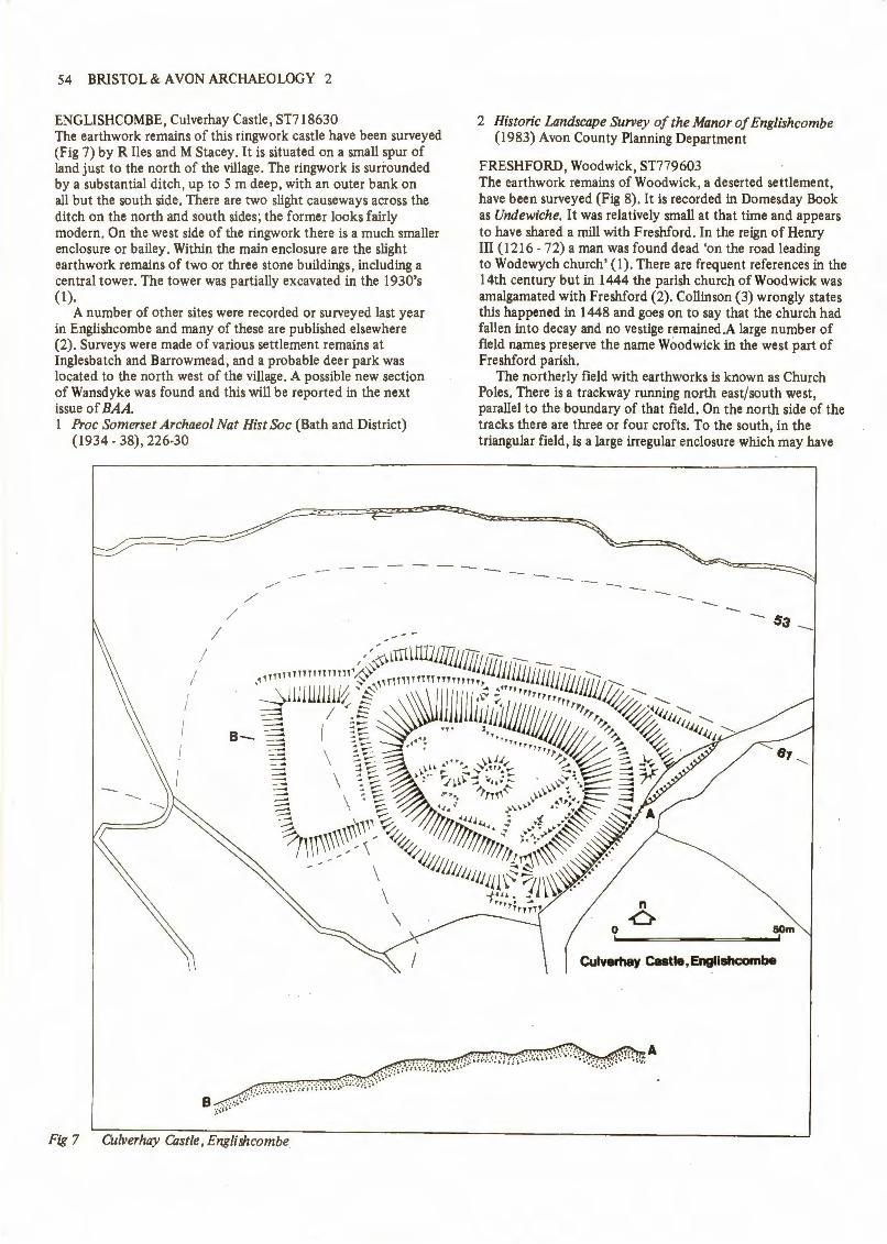
54 BRISTOL & A VON ARCHAEOLOGY 2
ENGLISHCOMBE, Culverhay Castle, ST7 l 8630 The earthwork remains of this ringwork castle have been surveyed (Fig 7) by R Iles and M Stacey. It is situated on a small spur of land just to the north of the village. The ringwork is surrounded by a substantial ditch, up to 5 m deep, with an outer bank on all but the south side. There are two slight causeways across the ditch on the north and south sides; the former looks fairly modern. On the west side of the ringwork there is a much smaller enclosure or bailey. Within the main enclosure are the slight earthwork remains of two or three stone buildings, including a central tower. The tower was partially excavated in the l 930's ( 1).
A number of other sites were recorded or surveyed last year in Englishcombe and many of these are published elsewhere (2). Surveys were made of various settlement remains at lnglesbatch and Barrowmead, and a probable deer park was located to the north west of the village. A possible new section of Wansdyke was found and this will be reported in the next issue of BAA. 1 Proc Somerset Archaeol Nat Hist Soc (Bath and District)
(1934 · 38), 226-30
I
/ /
-----
2 Historic Landscape Survey of the Manor of Eng/ishcombe (1983) Avon County Planning Department
FRESHFORD, Woodwick, ST779603 The earthwork remains of Woodwick, a deserted settlement, have been surveyed (Fig 8). It is recorded in Domesday Book as Undewiche. It was relatively small at that time and appears to have shared a mill with Freshford. In the reign of Henry III (1216 • 72) a man was found dead 'on the road leading to Wodewych church' (1). There are frequent references in the 14th century but in 1444 the parish church of Woodwick was amalgamated with Freshford (2). Collinson (3) wrongly states this happened in 1448 and goes on to say that the church had fallen into decay and no vestige remained.A large number of field names preserve the name Woodwick in the west part of Freshford parish.
The northerly field with earthworks is known as Church Poles. There is a trackway running north east/south west, parallel to the boundary of that field. On the north side of the tracks there are three or four crofts. To the south, in the triangular field, is a large irregular enclosure which may have
~
n 0
0 50m
Culverhay Castle, Engllshcombe
B .,.,.,,,."•·•C•i••i'''''•·C,,, ;,,y,,,,,iP''''!,'!><i'.',;;.:.,,, ,:;;,,,.,';' !, i :,,,,_,' '·-""''·i\ .. ;., 'l'i''"'•''-A
~;-:, \.
Fig 7 Culverhay Castle, Engli!izcombe

----+------► N
SMR NO 1829 EARTHWORKS AT PEIPARDS FARM
FRESHFORD a mom a 300 tt
Fig 8 Woodwick deserted settlement, Freshford
been a manorial complex. There are a number of building platforms in that area, including a circular foundation (?dovecot) on the west side (D Dodge & R Iles). 1 Somerset Rec Soc 2, 228 2 Somerset Rec Soc 49, 12 3 Collinson, A History of Somerset, (1791)1, 125
HAWKESBURY, Hawkesbury Upton, ST 77528725 Evidence of shrunken settlement remains, to the north west of. the village, was noted by R Iles.
HA WKESBURY, Hillesley, ST7 67 896 An earthwork site was cut by a sewerage pipe trench in 1977 (Fig 9). The site was levelled in 1979 and a salvage excavation was undertaken by B Williams and R Iles. The results of the 1977 watching brief and historical re.search will be published with the 1979 excavation. The earthwork probably represented a ringwork (P Ellis).
KEYNSHAM, Keynsham Abbey, ST655688 Continued excavation by the Folk House Archaeological Society of the ChapterHous.e and Novices room has uncovered much architectural and carved stonework. One stone slab has a Saxon design on it and was probably reused in Norman times. Under the eastern Chapter House were found some burials associated with a coin of Edward .the Confessor (c 1042 ·
1066).
ILES: A VON ARCHAEOLOGY 1982 55
Wansdyke District Council has agreed to consolidate the excavated walls of the Abbey over a period of time. The reverberatory furnace is to remain in situ in the Chapter House and will be protected by a temporary covering until funds are available for a permanent cover (B Lowe).
NEWTON ST LOE, St Loe's Castle, ST694639 An eighth season of excavation was directed by C J Arnold on behalf of Bath College of Education. A new area, K, on the western part of the medieval site was examined. A number of 14th century walls and structures were located including the barrel vault of a cellar which will be further examined in 1983.
·sTEEP HOLM, St Michael's Priory Excavation of the priory by S and J Rendell concentrated on the western end of the site. Deposits of a midden were intensively sampled and a further (late) east/west wall was discovered.
THORNBURY, Thornbury Castle The remains of a tile pavement were found in Thornbury Castle during the. felling of a tree. A subsequent small excavation was undertaken to ascertain further information about the structure in which the tiles were found. This was done by the field staff of Bristol City Museum (B Williams) and Avon Planning Department (J Edgar and R Iles). We are grateful to the owner of Thornbury Castle, Mr K Bell, for allowing the excavation to take place and for his help throughout the

56 BRISTOL & A VON ARCHAEOLOGY 2
hoUIH
hol!oways
-:✓
housn
HILLES LEY
Rirrgwork
Very Crofr ,o~li!,,' """'"""'"""'"""'"'""'-------------•oom
P ELLIS t,qAAOS 1978
Fig 9 Hillesley ringwork, Hawkesbury
project. · . The excavation was centred on the east side of the Inner
Court alongside an access road (Fig 10). The main trench, Sm x 17m, contained the tile pavement. Two additional trenches, one to the east of the main trench and the other against the garden wall to the south, were excavat~d in ~rder to ~stablish specific problems relating to the room m which the hies were found. That room is provisionally identified either as the Old Hall or the Duke of Bedford's Lodgings. The dimensions of the room are not known for certain. In width it measured about 6m across, extending almost from the garden wall to beneath the access road to the north. In length, the room appears to be quite substantial. The main north wall aligned east to west, traced for a distance of about 23 m, continued in an easterly direction. Since only part of the interior of the room was exposed, it is uncertain whether the room was partitioned . internally beyond the limits of the excavation. On the west side the room was entered through a doorway, 1.3m wide, from a small tiled room on the Inner Court. The same room gave access to another on its south side. A doorway in the north wall of the 'Old Hall' may have lead to the Great Hall located behind ie. south of the chapel.
The 'tnes each measuring about 170mm square, were laid diagonally t~ the walls of the room on a bed of hard, off-white mortar. Where sections of the pavement had been robbed, the impressions of the tiles could be clearly seen to a depth of about 20mm in the mortar. These were arranged in panels of sixteen decorated tiles composed of four juxtaposed, four-tile
patterns, enclosed by plain tiles. The centre of the room was established from a single row of plain tiles laid square to the walls along the axis of the room, in contrast to the rest of the tiles. 387 tiles were found in situ, together with hundreds of fragments, most of which came from a layer of demolition rubble overlying the floor. The tiles are particularly important as they are related to the construction of the castle in the early 16th century and show the armorial devices of Edward Stafford, third Duke of Buckingham, owner of Thornbury Castle from 1510 to his untimely death in 1521. The castle was never completed and fell into ruin soon after his death. The eastern wing of the castle, however, formerly representing the manor house and containing the Old Hall, was apparently finished, though part of the original manor house may have been demolished as a result of Edward's licence in 1510 from Henry VIII to fortify, crenellate and embattle his mansion. A date between 151 O and 1521 can probably be assigned to the manufacture of the tiles, probably nearer 1521 as tiled floors would have been laid only after the major works were completed. Tiles of this type exist in the nearby churches of Littleton-on•Severn +Elberton, probably taken from Thornbury Castle. Similar. tiles have been found at Wotton-under-Edge and sites in Bristol, including the Lord Mayor's Chapel and Canynges House, Redcliff Street.
N
f 50 METRES ..._ __ !!!=:!!!!'!!!
THORNBURY CASTLE . \
SITE ,
Fig 10 Thornbury Castle excavation, 1982
BUILDING RECORDING
.t::-
Avon County Planning Department is continuing the programme of listed building resurvey in the rural parts of Avon. A preliminary account of the Kingswood Chapels Survey by D Dawson and J Spittal has been published. Apologies are due to R G Gilson whose initials (RGG) were given for a number of buildings last year but without his name. He also recorded Bell House, Worle, and Holly Lodge, Lye Hole with EH D Williams.
The following is.a list of measured building surveys carried out last year. Many of the surveyors deposit copies of the detailed plans with Avon Sites and Monuments Record. The dates given are for earliest features and subsequent major alterations. The initials of the contributors are J BJ Bryant; L H L Hall; R JR Jones; EH D W EH D Williams; J W J Winstone.

ILES: AVON ARCHAEOLOGY 19.82 57
ALMONDSBURY, Hillside Cottage, ST567720 (? Long House) LH AUST, Elberton Manor, ST603882 c 1660-70, L H Link Farm, ST600887, medieval(?) and 1592.~ L H BRISTOL, 17 Christmas St, J W 41-41 Old Market St, 17C, J B 95 • 96 Redcliff St, (Canynges House), J W 117 -12 5 Redcliff St, medieval and later, J B 55 • 67 Union St/1-3 Silver St, medieval and later, R J Unity St,Old Market, l 7C wall(? Civil War defences) on the line of medieval defences, J B BLAGDON, Gilcombe House, ST505386, early 16C, EH D W CHEW STOKE, Rectory, ST558619, 15C (?),EH D W CHEW STOKE, Yew Tree Farm, ST557616, lSC (cruck framed), EHDW CONGRESBURY, 26 Venus St, 16C, J W LONG ASHTON, Chapel, barn and Linhay at Lower Court Farm, lSC and 16C, J W PILNING, Little Ellington Farm, ST55R842, medieval, L H SALTFORD, Brassmill furnace, (Fig 11) J Edgar, R Iles, D Pollard, J Roberts STANTON DREW, The Cottage, ST598632, EH D W
Slot in which the beam moved
Outer muffle wall
Fire holes
~
Furn Pt.AN
1 metre
Fig 11 Saltford Brassmill Furnace, Saltford

58
BOOK REVIEWS
The Excavation of the Shrine of Apollo at Nettleton, Wiltshire, 1956 - 71 by W J Wedlake (Reports of the Research Committee of the Society of Antiquaries of London, 40). 1982. ISBN 0 500 99032 8 !30.
Between Bath and Cirencester, where the Fosse Way crosses the Broadmead Brook (a tributary of the Avon), there grew up the Romano-British settlement known as Nettleton Shrub . The steep-sided valley provided a natural location for a small community which supplied food, lodging and other services to travellers. In fact, finds show that there had been a late Iron Age settlement of some form in the vicinity before the Fosse Way was built, though to what extent the Roman site developed from it is not known. Moreover, the Roman settlement also served a religious function. About 100 m west of the Fosse Way stood a distinctive, circular structure, augmented in the 3rd century with an octagonal outer ambulatory, which dominated the score or so of buildings which clustered between it and the road. This shrine overlooked the brook, which was incorporated architecturally into the complex of buildings, by being confined between stone embankments, and possibly stepped in terraces so as to create little waterfalls; a substantial hall, fitted in between the shrine and the brook, incorporated an arcade overlooking the brook, into which many small objects were dropped by visitors. In the mid 3rd century this hall was extended over the brook on a row of piers laid in the stream-bed. This imaginative development of the site echoes some features of the great sanctuary at Bath.
The later history of the shrine is complicated: from c. 330 to c. 370, the partly ruinous building may have been used as a church. Subsequently part of the structure was converted back to p·agan use, and then the remains of the building were turned into a dwelling. The residents evidently met their end by violence in the last years of the fourth century; fires in other parts of the settlement seem to indicate terrorizing raids at the same period, though there is some evidence of occupation by new settlers in the fifth century.
Wedlake's excavation and the substantial report on it are a considerable achievement. Stone-robbing, quarrying, farmers, cows, and earlier diggings all obstructed the excavation in their several ways. Processing the finds must also have been a laborious task, and assembling the report ( of which about onethird is by numerous specialists) must have been difficult. Wedlake is generous in acknowledging assistance ( of which one should certainly single out the important work by E.W. Richardson on the painted plaster and the cut human bones), and the excavation atmsophere to which he refers in his Preface, and which he must himself have inspired, is reflected in the teamwork whose product is the present volume. However, this is a real excavation report, in which the author does not shirk judgments or present the work of 'experts' uncritically. Many pages are enlivened with flashes of common sense and . insight, as where, discussing the last Roman occupants, he wntes:
'For a modem example of this type of life, a visit to some of the derelict Roman buildings off the Appian Way in Italy, where happy families can be seen surrounded by their domestic animals, is revealing'.
The settlement at Nettleton Shrub is not yet completely excavated, and, partly for this reason, some remaining q~estions may yet find an answer. One problem which s~ands out 1~ the chronology of the pagan cult. The circular shone was built between AD 69 and AD 210, doubtless in the middle or later 2nd century (as stated by Wedlake on p.11, though earlier dates are stated or implied elsewhere). Excavation revealed no_ trac~ of prior structures or activities beneath the first floor. Smee, m any case, the heyday of the settlement as a whole was evidently the 3rd century, the cult might be entirely a Roman period development. The lists of coins and terra sigillata, however, indicate general occupation from the mid 1st century AD onwards. Was there, then, an earlier shrine, as yet undiscovered? Indeed, do the origins of the sanctuary in fact go back to the Iron Age, as discoveries elsewhere in Roman Britain increasingly show to have occurred? In this context the curious triangular enclosure on the high ground south east of the Fosse Way might be considered, not as a 'camp' or 'settlement', but as a religious site.
The shrine of Apollo Cunomaglos (where Diana, Mercury, the Emperor's Godhead, and doubtless other deities were also worshipped) reminds us of the extraordinary nature of life in Roman Britain, whose religious dimension lies outside the terminology of pseudo-Marxist determinism. Confrontation with the 'spirit of the place' may stimulate new explanations for the origin and development of Romano-British religious sites. What a pity, then, that the shrine at Nettleton Shrub, as much a part of our cultural heritage as any church or abbey of a later age, lies buried and inaccessible to the public. At least in this magnificent report we have material for extensive armchair study, as well as . a monument to one of the most important archaeological projects to have taken place in our area in recent years.
AJPARKER
The Rural Houses of North Avon and South Gloucestershire 1400 - 1720 by Linda Hall, City of Bristol Museum and Art Gallery Monograph Nos. 6 ISBN O 900199 21 2, !.12.50.
After and long and difficult gestation period (I hope Mrs. Hall didn't have the same problems with her other recent offspring), the joint midwives of the City of Museum and the City Printing and Stationery Department have delivered the baby. It is healthy, heavy and fat. Many of us, including Mrs. Hall I suspect, and some of the owners of the houses in question, had begun to worry that this be just another never-never archaeological publication, Of course we have already seen the product in utero through Mrs Hall's numetous lectures and her published articles. I have used dozens of her individual reports in my work and I would personally like to thank her for that contribution.
-
This book furthers that contribution - it is an invaluable reference work, a mine of information and an essential purchase for all those who work with and study the historic architecture of North Avon and South Gloucestershire. The wealth of detail, as exemplified by the 148 line drawings and the 68 plates, is excellent.
The strength of the book undoubtedly lies in the description and analysis of the 17th century buildings.Mrs Hall has produced a corpus of original information on this period and has shown these buildings to be of considerable interest. The work is based on 135 or more surveyed buildings and centres around 46 dated examples with careful analysis of plan and roof types, construction, details and decoration.
Perhaps the book would have been more impressive if its subject matter had been confined to the post-medieval buildings - an area somewhat ignored by vernacular architecture studies. The information on the medieval buildings is descriptive and although some important points are made, especially with regard. to building periods, the analysis is brief. This partly reflects the paucity of the material, and it is a pity that other important buildings could not be included - for instance, the excellent medieval roofs at Bagstone Court Farmhouse, Wickwar ( discovered by Mrs Hall) and at Blanchard's Farmhouse, Old Sod bury ( discovered by the reviewer).
With a restriction. of the period, an expansion of the nonarchaeological information would have been possible. The arguments over the value of physical versus historical evidence are often counter-productive and meaningless. Mrs Hall has dabbled into the documentary side and we are all fortunate that John Moore's book Goods and Chattels of our Forefathers was available - albeit dealing with an a typical part of the survey area Chapter 7 (Documentary Evidence) was a particularly useful attempt to put the flesh on a fascinating skeleton. Obviously one of the major areas for future research should utilise docume.ntary evidence to answer such questions as: who built the houses, how much did they cost and how were they financed; who were the craftsmen and how did the building trades function; what were the general social and economic systems in operation? Some of these points could have been raised in Chapter 5 (Outbuildings). It was disappointingly brief, especially when the anomaly of the Winterbourne Court Barn is removed. (It is surely outside the criteria as it belongs to a rich manorial complex). Further description and analysis of domestic and agricultural outbuildings would prove fascinating and would perhaps give some indication of types of occupancy and tenancy, land usage, farm sizes and other elements of the historic landscape, all of which would put the houses in context. I hope that the forthcoming study on Frampton Cotterell will answer some of these points.
The main reservation concerns the idea of Regional Style. Mrs Hall begins and ends with this concept and nowhere is it fully defined - dormer gables and rubble walls with wooden windows and door frames is far too vague. It seems wrong not to have made extensive reference to the Cotswold escarpment and plateau where, superficially, the major difference seems to be only in the quantity of freestone used in dressings, as in the eastern part of the survey area this difference is not significant. We are not shown the evidence that the two traditions are separate. Obviously there must be differences but there must also be many similarities and links, and is it not possible that the survey area is really the fringe of the Cotswold tradition rather than an entity in itself? The towns do indeed warrant
REVIEWS 59
study in their own right but it is impossible to divorce their influence as centres for the diffusion of ideas and methods.
Further study of Chipping Sodbury, Marshfield -and Rrobably Bristol in particular (although the built evidence is now scanty), is essential. Furthermore, although historic Somerset is still a fringe area, there are clearly more buildings than suspected south of the Avon that meet the criteria.
The second part of the book is a gazetteer of 67 recorded buildings and it is nearly twice as long as the main text (although there are many costly blank pages). This will be useful as I shall visit every building surveyed but how many others will have this opportunity? Was this really the best way of presenting the recorded evidence? Perhaps microfiches could have been used or more comparative summaries and figures could have been inserted in the main text.
Further discussion of the text would only involve minor details. I would like to have seen the conservation drum beaten more furiously - it was implicit and briefly touched upon -as these buildings are of special architectural and historic interest and ought to be protected. Already many details and some whole buildings have been lost and plate XI is itself merely a record. It is somewhat amazing that the name of Northavon District Council does not appear on the list of subscribers - I hope that this will be rectified and indeed I hope that many others will take the opportunity to benefit from Mrs Hall's labours.
JAMES EDGAR
The Archaeology of Somerset -4 Review to 1500 AD, edited by M Aston and I Burrow, Somerset County Council, 1982. !5.25.
This volume of essays, covering every period of human occupation in Somerset from the Lower Paleolithic to Medieval times, is the product of a conference held in 1981 to commemorate the 50th anniversary of the late Mrs D P Dobson-Hinton's well-known handbook of the same title. Comparing the present work with its 1931 predecessor one cannot help being struck by how far Somerset archaeology has advanced, both technically and conceptually, in the intervening half-century. The introduction (by Rahtz and Fowler)makes it clear, however, that until very recently most of this progress has been instiguated by individuals and organisations based outside the county. Particular attention is drawn to the weakness of the fieldwork tradition within the county; with the exception of Grimes' elegant 1940 survey of Charmy Down and the sterling work of the UBSS north of the Mendips, little advance was made in this direction between 1911 and the late 1960s.
The thirteen papers making up the present volume are all by experts in their respective fields, and generally achieve a very high standard of conciseness and readability; the present reviewer was particularly struck by Ian Burrow's wide-ranging discussion of hill-top settlement and Rahtz's entertaining and thoughtprovoking reassessment of the "Dark Ages". The numerous maps and plans, all redrawn in a common style, are mostly clear and adequate, if occasionally over-simplified and nearly always lacking North-points; one balks, however, at the grainy blow-up of a Mesolithic scraper on p.14. The photographs, which include some excellent aerial shots by West Air Photography, are generally well chosen and reasonably well reproduced. BAARG readers will be pleased to find that most contributors take as their study area the historic, pre-197 4 county of Somerset. Well-produced, readable and modestly priced, this important survey is in every respect a worthy successor to Dobson-Hinton's pioneering study.
JAMES RUSSELL

60 BRISTOL & A VON ARCHAEOLOGY 2
Air Photo Interpretation for Archaeologists by D R Wilson, BT Batsford Ltd London. 1982. 212pp, 121 illus. !9.95
This is probably the first definitive study of the subject in the English Language. The author, as Curator in Aerial Photography at Cambridge University, with 17 years' experience behind him,
. is highly qualified for the task. The book is concerned mainly with the British Isles but is largely applicable elsewhere.
The Preface states that 'until now there has-been no handbook to guide those working on their own'. True enough; but CBA Group XIII issued a 4-page Guide to Air-photographic Archaeology in the South West in 1961; a •pamphlet onAir Photographs for Small Expeditions (Geog J 1973 311-322) is available (50p) from the Royal Geographical Society; and there may well be other relevant publications lurking around.
Chapter 1, air photography and archaeology, opens with a short history of the subject, illustrated by classics including Stonehenge from a balloon 1906 (pl.I) and the aerial view of Woodhenge by S/Ldr Insall 1926 (pl.2). (This reviewer had the pleasure of meeting Insall's son, then a boy at Marlborough College, when lecturing there in 1950). It closes by noting repositories where air photographs can be consulted, To these may be added the collection of air photos taken during the 1939 • 45 War (Department of Geography, Keele University), and collections held by the National Patk authorities ( certainly Exmoor, at Dulverton.
In Chapter 2, the nature of the evidence, the author gets to the root of the subject with a penetrating analysis of the reasons why archaeological features often show so clearly from the air: light and shadow revealing three-dimensional sites; soil-marks showing many others; and in particular crop-marks, in which he discusses the archaeological potentials of the different types of crop and their growing seasons; soils; and a great deal more. The utility of light snowfalls in revealing archaeological details e.g. Roman roads and field systems, is not forgotten. He quotes (68) a Roman site at Ytham Wells (Aberdeenshire), expertly photographed from the air at a suitable season for 23 consecutive years, before the slender ditch of a second camp produced crop-marks which enabled it to be recorded.
Chapter 3 covers the identification of specific types of site . His analysis of the criteria for trying to distinguish between the ring-ditches of ploughed-down barrows and those of circular huts and houses is particularly useful to this reviewer; others would select from this chapter according to their interests.
Chapter 4, identification of non-archaeological features, is essential reading for all. It includes the relics of recreational usage and the manifestations of agriculture (note the 'henges' or large'barrows'produced by the use of rotary sprinklers, pl 103). Confusing geological features are illustrated by the 'multivallate hillfort' at Upper Coscombe east of Winchcombe (pl 87), caused by the differential erosion of oolitic strata of varying composition. Some paragraphs on the relics of the 1914-19 and 1939-45 Wars would seem to be classed as military a_rchaeology rather than nonarchaeology. Examples given includr. emplacements for searchlights and guns (pl 111). To these we could add the decoy-mounds on Blackdown, Mendip ( ProcUBSS 11, 44-5), erected 1939 • 45 for some kind of defence purpose, and 'disc-barrow' Upavon 1 b in V CH Wiltshire, i., now known to have been the Target Circle for Upavon Aerodrome c 1920.
Chapter 5, on interpretation, stresses that an interpreter can no more be without his magnifying glass than a digger without his trowel. On stereoscopic examination we might have been told where a stereoscope can be purchased (CF Casella London Ltd, 109 Britannia Walk, London Nl, price from !3.50 (pocket folding
type with plastic lenses) upwards to !240 for the most developed mirror type). For the benefit of those functioning on a financial shoestring it can be added that the pocket folding stereoscope can 1
be applied to successive prints whose identical images are too far · apart to achieve the third dimension, by 'losing' the unwanted parts of the prints down the central slot of a slotted wooden table which any carpenter can make in a few minutes.
Throughout this book the juxtaposition of air photos of the same site taken under different conditions brings home the need to consult the whole of the available air cover. Finally one cannot overstate the need to ground-check the air photographic evidence, wherever possible under similar conditions of season and crop, for which purpose the relevant air photos should themselves be taken into the field (186), inserted in waterproof transparent envelopes.
The Bibliography is set in type so small as to induce the interpreter to reach for his magnifying glass if not his microscope.
LESLIE GRINSELL
The Megalithic Chambered Tombs of the Cotswold-Severn Region, by TC Darvill, Vorda Publications, Highworth, Wilts. 1982. A4. 149 + vii pp. !9.95 post free.
Derivation of the laterally chambered (false or blind entrance type) from the terminally chambered (true entrance type) long barrow was implicit in the classification by Thurnam (1869), typified by (i) Stoney Littleton (true entrance with passage and side-chambers);: (ii) Rodmarton (false entrance with opposed lateral chambers); and (iii) Littleton Drew (false entrance with cists). The false entrance appeared so obviously to be a skeuomorph of the true entrance. This view was reaffirmed by Crawford (1922, 1925) and has been followed without question by almost all authorities until now.
The central thesis of this book, which largely incorporates the writer's BA thesis on Concealment and Constriction in the Cotswol. -Severn Long Ba"ow Group (1979), is an attempt to show that the • 'false·entrance' of the laterally chambered barrows was derived from the portal dolmen and that barrows of this type may therefore be earlier than those with true entrance leading to either a terminal chamber or a passage with side-chambers. In support of his thesis hi:i invokes the grave-goods (especially the pottery), the very few available C14 dates., and various kinds of circumstantial evidence. The author has not attempted to 'regurgitate all the known facts about Severn-Cotswold tombs' (p.14), and his survey is limited to a consideration of some 45 examples which provide the necessary evi~ence of typology and chronology. He has little to say on the residue of some 130 other examples. As he does not give the national grid references of those which he discusses, his book hiis to be used in conjucntion with other publications. ·
It is of course splendid that an archaeologist from a University (Southampton) notecj. for its avant-garde archaeological teaching, should critically examine a concept which has held the field for so long, However, most of the book was written five years ago and although updated here and there to 1981, it might have been preferable to have totally revised it. Four ,of the five maps are dated 1978. Minor errors of punctuation, awkward phrasing, misspellings etc., occur about one per page. With certain exceptions ( e g distributed for disturbed, p 59 last paragraph; restrictions for constrictions, p 72 second paragraph), these are trivial and do not affect the sense. Most of-these short-comings could have been avoided by consulting Collins' Authors and Printers Dictionary or a similar book, A statement of a fresh view is however more likely to convince if well expressed in simple language. The reading of this text is not helped (at least for older readers) by the author's use of 'new archaeology' jargon and words derived from
--- ___.

the social sciences. A man-made post-hole has to be anthropogenic (p 52); a chronological sequence to be diachronic (pp 6, 14, 17 ); material in the filling of chambers is either artifactual or ecofactual or both (p 56) -~ It is however on this reviewer's conscience that he was almost as bad himself when his first paper was published (Grinsell 1929). Perhaps the strangest detail is the author's use of dolmen as a plural as well as a singular noun in much of his text (pp 8 top, 19 twice, 28, 49, 54, 59, 66, 68).
The author may or may not have shown that by separating long barrows into 'territories' by Thiessen polygons (Fig 15, p 81) it is possible to reconstruct a pattern of segmentary social groups into which neolithic society may have been divided. One wonders what conclusions might result if modern cemeteries were treated similarly in order to reconstruct the social structure of our own times. We are perhaps entitled to ask whether we are not trying
... Ao extract from the distribution of the various types of chambered J· tomb more information thanthey are capable of yielding. None the .
less, all luck to the effort! ) To conclude: this book will serve a useful purpose if it sets us
t I J:
thinking, and that it will undoubtedly do. LVGRINSELL
REFERENCES Crawford, 0 GS (1922) Ordnance Survey Professional Papers, no 6 [Long barrows of the Cotswolds and the Welsh Marches]. Crawford, 0 GS 1925 The Long Barrows of the Cotswolds. Gloucester Grinsell, L V 1929, The Lower and Middle Palaeolithic Periods in Sussex, Sussex Archaeol Collns 10, 172-182 Thurnam, John 1869 On Ancient British Barrows. Part I: long barrows,Archaeo/ogia 42, 161-244
REVIEWS 61