waas for telecom sync applications - freqelec.comfreqelec.com/gps_gnss/waas_for_telecom_2-07.pdf ·...
TRANSCRIPT

WAAS for Telecom WAAS for Telecom Sync ApplicationsSync Applications
……part of the Satellitepart of the Satellite--Based Based Augmentation Systems (SBAS) programsAugmentation Systems (SBAS) programs
http://GPS.FAA.GOV/Programs/WAAS/waas.htm
Hugo [email protected] 2007Rev 2-7-07Frequency Electronics Inc.Frequency Electronics Inc.
2Frequency Electronics Inc.Frequency Electronics Inc.
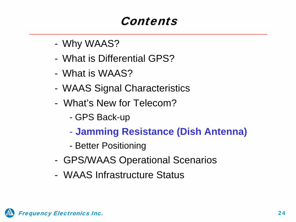
ContentsContents
- Why WAAS?- What is Differential GPS?- What is WAAS?- WAAS Signal Characteristics- What’s New for Telecom?
- GPS Back-up- Jamming Resistance (Dish Antenna)- Better Positioning
- GPS/WAAS Operational Scenarios- WAAS Infrastructure Status

3Frequency Electronics Inc.Frequency Electronics Inc.
DefinitionsDefinitions
Ground-based Differential GPS Augmentation System designed to meet the needs of world’s Civil Aviation Navigation Community:
– WAAS - Wide Area Augmentation System (USA & territories, Canada, Mexico)
– EGNOS - European Geostationary Navigation Overlay System (Europe, Africa, Venezuela)
– MSAS - Multifunctional Transport Satellite Space-Based Augmentation System (Japan, Australia, Hawaii)
– GAGAN - GPS-Aided Geo Augmented Navigation (India, China, and other Asian territories)

4Frequency Electronics Inc.Frequency Electronics Inc.
Why has it taken 20 years to use GPS for Civil Aviation?Why has it taken 20 years to use GPS for Civil Aviation?
• With SPS, accuracies are not good enough to meet FAA’s Category I, II, and III requirements
- Needs Differential Corrections (DGPS) and elimination of SA (in case SA is activated)
- Needs improved Vertical Accuracy through use of addedRange Signals from overhead satellites
- Needs improved Ionospheric Corrections
• With SPS, Signal Reliability is not good enough; Can be out of limits without real-time user knowledge
- Needs to be forward looking enough to allow a safe abort- Receiver Autonomous Integrity Monitoring (RAIM)
addresses the “Reliability/Integrity” need
5Frequency Electronics Inc.Frequency Electronics Inc.
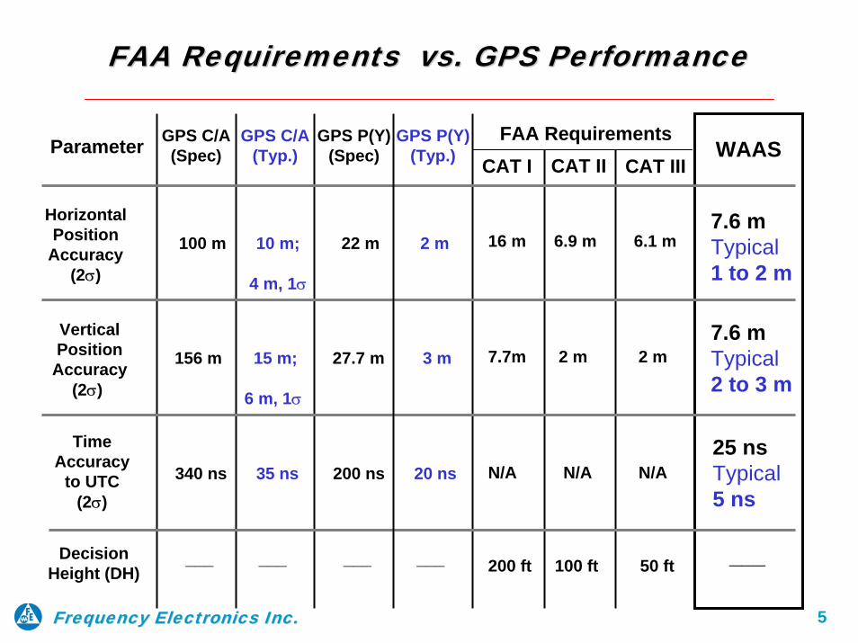
FAA Requirements vs. GPS PerformanceFAA Requirements vs. GPS Performance
Parameter FAA RequirementsCAT II CAT III
16 m 6.9 m 6.1 m
7.7m 2 m 2 m
N/A N/A N/A
200 ft 100 ft 50 ft
VerticalPosition
Accuracy (2σ)
Time Accuracy
to UTC (2σ)
DecisionHeight (DH)
___ ___
HorizontalPosition
Accuracy(2σ)
WAAS
7.6 mTypical1 to 2 m
___
7.6 mTypical2 to 3 m
25 nsTypical5 ns
100 m 10 m;
4 m, 1σ
156 m 15 m;
6 m, 1σ
340 ns 35 ns
CAT I
___ ___
GPS P(Y) (Spec)
22 m 2 m
27.7 m 3 m
200 ns 20 ns
GPS P(Y) (Typ.)
GPS C/A (Typ.)
GPS C/A (Spec)

6Frequency Electronics Inc.Frequency Electronics Inc.
ContentsContents
- Why WAAS?
- What is Differential GPS?- What is WAAS?- WAAS Signal Characteristics- What’s New for Telecom?
- GPS Back-up- Jamming Resistance (Dish Antenna)- Better Positioning
- GPS/WAAS Operational Scenarios- WAAS Infrastructure Status

7Frequency Electronics Inc.Frequency Electronics Inc.
Local Area Differential GPS ConceptLocal Area Differential GPS Concept
GPS Sats
Exact Known Location
DGPS Ref. Sta.
User Applies Correction to Range
Measurements
Data Link Transmitter
Position Correction
transmitted to User
ErrorGPS Solution for DGPS Sta. Z
Y
X

8Frequency Electronics Inc.Frequency Electronics Inc.
ContentsContents
- Why WAAS?- What is Differential GPS?
- What is WAAS?- WAAS Signal Characteristics- What’s New for Telecom?
- GPS Back-up- Jamming Resistance (Dish Antenna)- Better Positioning
- GPS/WAAS Operational Scenarios- WAAS Infrastructure Status

Wide Area Augmentation System ConceptWide Area Augmentation System Concept
9Frequency Electronics Inc.Frequency Electronics Inc.
(21 to 30) GPSs(½ GeoSync Orbits)
InmarSats, plus other
(GeoSync Sats)
L1-C/A from GPS Sats
Ionospheric Effects
(2) Ground Uplink Stations
(2) Wide AreaMaster StationsWide Area Reference Stations:
WAAS - 18 WRSs for USA Mainland, ~25 Total (13 more being added, ~38 Total)EGNOS - 44 WRSs for Europe, Africa, VenezuelaMSAS - 6 WRSs for Japan, Australia, HawaiiGAGAN - 18 WRSs for India, China and other Asian areas
GPSANT.
L1-C/A50 bps
C-BandUplink, 6.4 GHz
WRSWRS WRS WMS DGPS DataGUS USNOTime
USER
Data-Link
C-Band C/A from Uplink Station
Transponded “bent-pipe”to L1 - C/A
L1-C/A“look-alike”
250 bps

10Frequency Electronics Inc.Frequency Electronics Inc.
Mobile Satellite CommunicationsWorldwide Coverage Map
0°
0°
10°
20°
30°
40°
50°
60°
70°
80°
90°
10°
20°
30°
40°
50°
60°
70°
80°
90°
20°40°60°80°100°120°140°160°180° 20° 40° 60° 80° 100° 120° 140° 160° 180°
WAAS WAAS WAAS SV# 122 SV# 122 SV# 122
142W142W142W
WAAS WAAS WAAS SV# 134 SV# 134 SV# 134
178E178E178E
EGNOS EGNOS EGNOS SV# 120SV# 120SV# 120
Satellites onSatellites on--line for the SBAS/WAAS Infrastructureline for the SBAS/WAAS Infrastructure
EGNOS EGNOS EGNOS SV# 126 SV# 126 SV# 126
25E25E25EEGNOS EGNOS EGNOS SV# 124 SV# 124 SV# 124
21.5E21.5E21.5E MSAS MSAS MSAS SV# 129 SV# 129 SV# 129
140E140E140E
MSAS MSAS MSAS SV# 137 SV# 137 SV# 137
145E145E145E
WAAS WAAS WAAS SV# 135 SV# 135 SV# 135
133W133W133W
WAAS WAAS WAAS SV# 138 SV# 138 SV# 138 107.5W107.5W107.5W
Limit of global beam coverage for Inmarsat A,B,C,D,E,M
Pacific Ocean RegionAtlantic Ocean Region-WestAtlantic Ocean Region-EastIndian Ocean Region
Inmarsat-phone coverage
Land earth stations
The availability of service at the edge of coverage beams fluctuates depending upon a variety of conditions. The map depicts Inmarsat’s expectations of coverage but does not represent a guarantee of service.
Inmarsat Customer CareTel:+44 (0)171 728 1777Fax:+44 (0) 171 728 1746E-Mail:[email protected]
© Inmarsat, International Mobile Satellite Organization, 1998ISSUE 1

11Frequency Electronics Inc.Frequency Electronics Inc.
Satellites onSatellites on--line for the SBAS/WAAS Infrastructureline for the SBAS/WAAS Infrastructure
C/AC/A--codes (PRN Nocodes (PRN No’’s) s) –– 120 to 138 are reserved for the SBAS/WAAS Infrastructure120 to 138 are reserved for the SBAS/WAAS Infrastructure‘‘ss

12Frequency Electronics Inc.Frequency Electronics Inc.
ContentsContents
- Why WAAS?- What is Differential GPS?- What is WAAS?
- WAAS Signal Characteristics- What’s New for Telecom?
- GPS Back-up- Jamming Resistance (Dish Antenna)- Better Positioning
- GPS/WAAS Operational Scenarios- WAAS Infrastructure Status

13Frequency Electronics Inc.Frequency Electronics Inc.
WAAS WAAS DownlinkDownlink
• L1-C/A GPS 'Look-Alike' signal from each GEO-Satellite with no
SA (same signal strength as GPS satellites)
• DGPS Vector Corrections for each GPS Satellite
• Added Pseudo-range Signals (available) via each GEO-Satellite
• Receiver Autonomous Integrity Monitor (RAIM) in Airborne
WAAS receivers (a “Use/Don’t Use” flag)
• Improved Ionospheric Correction
• 250 bps data rate rather than the GPS 50 bps
- Needed to transmit DGPS correction data for each GPS Sat
- More frequent update - every 6 Sec. for DGPS and RAIM
- Time to “Not-Use” Alarm 5.2 seconds

14Frequency Electronics Inc.Frequency Electronics Inc.
WAAS Message TypeWAAS Message TypeType Contents Summary0 Don’t use for Safety applications1 PRN Mask assignments, set up to 51 of 210 bits2-5 Fast corrections6 Integrity information7 Fast Correction Degradation Factor8 Estimated RMS Error message9 GEO navigation message (X, Y, Z, time, etc.)
11 Reserved for future messages12 WAAS Network Time/UTC offset parameters13-16 Reserved for future messages17 GEO almanacs message18 Ionospheric grid point masks19-23 Reserved for future messages24 Mixed fast corrections/long term satellite error corrections25 Long term satellite error corrections26 Ionospheric delay corrections27 Reserved (Service Level Message)
29-61 Reserved for future messages62 Reserved (Internal Test Message)63 Null Message
10 Degradation Parameters
28 Clock-Ephemeris Covariance Matrix
Spec Sect. #4.4.14.4.24.4.34.4.44.4.54.4.6
4.4.114.4.16
-4.4.15
-4.4.124.4.9
-4.4.84.4.74.4.10
-
4.4.134.4.14
-4.4.17
WAAS Spec - DTFA01-96-C-00025, Modification No. 0111
15Frequency Electronics Inc.Frequency Electronics Inc.
ContentsContents
- Why WAAS?- What is Differential GPS?- What is WAAS?- WAAS Signal Characteristics
- What’s New for Telecom?- GPS Back-up- Jamming Resistance (Dish Antenna)- Better Positioning
- GPS/WAAS Operational Scenarios- WAAS Infrastructure Status

16Frequency Electronics Inc.Frequency Electronics Inc.
WhatWhat’’s New for Timing/Sync?s New for Timing/Sync?
• WAAS/EGNOS/MSAS/SNAS capability is designed for high-end airborne GPS Receivers for Civil Aviation Navigation ($5K to 10K?) - No thoughts given to other users
• New - Making the typical low cost, ($100 or so) small GPS Timing Receiver capable to receive and process WAAS-only signals (both DGPS corrections as well as ranging with WAAS)
• Advantages:
For Timing Users, partial backup to GPS L1-C/A in case of GPS C/A signal loss (done through use of the “Don’t Use” WAAS Warning Flag)
For Timing Users, more resistant to unintentional or intentional jamming/noise environments (done through use of a dish antenna)
For Timing Users, a more accurate position solution (done though better Multipath Mitigation and Ionospheric Corrections)

17Frequency Electronics Inc.Frequency Electronics Inc.
ContentsContents
- Why WAAS?- What is Differential GPS?- What is WAAS?- WAAS Signal Characteristics- What’s New for Telecom?
- GPS Back-up- Jamming Resistance (Dish Antenna)- Better Positioning
- GPS/WAAS Operational Scenarios- WAAS Infrastructure Status

18Frequency Electronics Inc.Frequency Electronics Inc.
WAAS backup to GPS C/A signals for the Timing CommunityWAAS backup to GPS C/A signals for the Timing Community
GPS Sats
GPS GeneratedL1-C/A, 50 bps
WMSGUS
Cesium Stds/WRS + Data-Link
WRS
Transponder
USNO Timing
InmarSats, plus other
(GeoSync Sats)
Timing from Cs Stds(C/A Look-alike created here from Cs Clocks, not GPS Sats)
C-Band C/A from Uplink Station
C-BandUplinkInmarSat-
generatedL1-C/A
“Look-alike”250 bps
“bent-pipe”
Std. GPS Ant. or18” Dish pointed to GeoSync Sat Telecom
Terminal
GPS Sats
When GPS Navigation Solution is unusable in a number of SBAS areas (in How Many?
No one knows at present)
“Don’t Use” Flag

19Frequency Electronics Inc.Frequency Electronics Inc.
““WAASWAAS--only capableonly capable”” GPS/WAAS Rcvr PerformanceGPS/WAAS Rcvr Performance
Sat Visibility and Rcvr Configuration
With Std GPS Antenna
Stability Performance
With Dish Antenna
Stability Performance
Test PlotNo.
Std. (12) Channels GPS Sats in view,
+ WAAS Sat;position averaging
< 50 ns P-P (< 20 ns RMS) * < 20 ns P-P (< 10 ns RMS)1 **
(3) Channels GPS Sats in view, + WAAS Sat;
40° mask angle;fixed position
< 50 ns P-P (< 20 ns RMS) * (unchanged)
< 20 ns P-P (< 10 ns RMS)(unchanged)
2 **
(1) Channel GPS Sat in view,
+ WAAS Sat;40° mask angle; fixed position
< 150 ns P-P (< 50 ns RMS) * < 20 ns P-P (< 10 ns RMS)(unchanged)
3 **
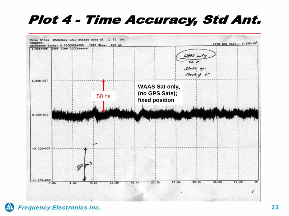
WAAS Sat only,(no GPS Sats); fixed position
< 20 ns P-P (10 ns RMS) *** < 12 ns P-P (~5 to 6 ns RMS) ***4 **

20Frequency Electronics Inc.Frequency Electronics Inc.
50 ns
Std. (12) Channels GPS Sats in view, + WAAS Sat;position averaging

21Frequency Electronics Inc.Frequency Electronics Inc.
50 ns
(3) Channels GPS Sats in view,
+ WAAS Sat; 40° mask angle;fixed position

22Frequency Electronics Inc.Frequency Electronics Inc.
50 ns
(1) Channel GPS Sat in view, + WAAS Sat;40° mask angle; fixed position
23Frequency Electronics Inc.Frequency Electronics Inc.
50 ns
WAAS Sat only,(no GPS Sats); fixed position
24Frequency Electronics Inc.Frequency Electronics Inc.
ContentsContents
- Why WAAS?- What is Differential GPS?- What is WAAS?- WAAS Signal Characteristics- What’s New for Telecom?
- GPS Back-up- Jamming Resistance (Dish Antenna)- Better Positioning
- GPS/WAAS Operational Scenarios- WAAS Infrastructure Status
25Frequency Electronics Inc.Frequency Electronics Inc.
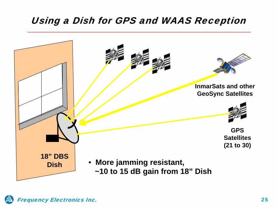
Using a Dish for GPS and WAAS ReceptionUsing a Dish for GPS and WAAS Reception
18” DBS Dish
GPS Satellites (21 to 30)
InmarSats and other GeoSync Satellites
• More jamming resistant,~10 to 15 dB gain from 18” Dish

26Frequency Electronics Inc.Frequency Electronics Inc.
1818”” TV Satellite Dish Test for WAASTV Satellite Dish Test for WAAS
The goal for the test was to determine: • Obtain signal gain through the use of a parabolic dish• Determine if enough GPS Sats are visible for a position solution
Set-up• Modify 18 inch Satellite TV dish (DBS) by removing its receiver • Replace receiver with a standard GPS antenna at the focal point• With indicated signal strength of the receiver, estimate the gain• Manually focus antenna on WAAS satellite AOR-W (SV# 122)
Results• Signal increased from ~ 35 dB to ~47 dB, an approx. 12 dB
additional gain (w/o reversing signal polarization)• Receiver tracked up to 8 GPS satellites at the same time• No problem or additional delay in the initial acquisition was noted• No noticeable change in signal strength of the GPS satellites that
were being tracked

27Frequency Electronics Inc.Frequency Electronics Inc.
Modified 18 inch commercial TV Sat. DishModified 18 inch commercial TV Sat. Dish
Replace DBS Receiver at
focal point with GPS Antenna

28Frequency Electronics Inc.Frequency Electronics Inc.
WAAS AOR-W Satellite
GPS Satellites
Tracking (1) WAAS and (7) GPS Satellites with Tracking (1) WAAS and (7) GPS Satellites with an 18 inch modified commercial TV Sat. Dishan 18 inch modified commercial TV Sat. Dish

29Frequency Electronics Inc.Frequency Electronics Inc.
ContentsContents
- Why WAAS?- What is Differential GPS?- What is WAAS?- WAAS Signal Characteristics- What’s New for Telecom?
- GPS Back-up- Jamming Resistance (Dish Antenna)- Better Positioning
- GPS/WAAS Operational Scenarios- WAAS Infrastructure Status
30Frequency Electronics Inc.Frequency Electronics Inc.
Multipath Signal Mitigation and better Ionospheric Corrections
• For GPS, multipath-caused delays are ever changing, because GPS satellites are in motion. This changes signal direction and consequently a reflection change from thesurrounding objects.
• Contrary to GPS, the WAAS satellites are stationary. Therefore, with std. GPS antenna,
the WAAS signal will see a “standing” (constant) multipath.
o This will appear as an UTC time offset of ~30 to 40 nanoseconds with a Std. GPSAntenna
o With a Dish Antenna pointed to a WAAS satellite, it rejects stray signals from entering
dish aperture. In the same way, the dish also reduces the GPS-generated multipath signals.
• WAAS signal provides (dish or no dish) near real-time Ionospheric delay resolution
through the use of the WAAS DGPS ground stations.
o The corrections are updated every ~3 hours and transmitted as part of the WAASsignal 250 bit data stream.
o This compares to the GPS signal 50 bit data stream, which transmits an Ionospheric
correction model, infrequently. Will be resolved in the future with L2-C/A

31Frequency Electronics Inc.Frequency Electronics Inc.
ContentsContents
- Why WAAS?- What is Differential GPS?- What is WAAS?- WAAS Signal Characteristics- What’s New for Telecom?
- GPS Back-up- Jamming Resistance (Dish Antenna)- Better Positioning
- GPS/WAAS Operational Scenarios- WAAS Infrastructure Status
32Frequency Electronics Inc.Frequency Electronics Inc.
Conditions Conditions GPS SPS GPS SPS (CIVIL)(CIVIL)
T/F UsersT/F UsersNavigation UsersNavigation Users
Normal GPS Normal GPS ServiceServiceUnder Under
StandardStandardConditionsConditions
C/A becomes C/A becomes unavailable in unavailable in a a LocalLocal AreaArea
(due to (due to friendly or friendly or
hostile hostile Jamming)Jamming)
C/A, No SA(Navigation
Solution <10 m,Time Error <100 ns)
No GPS C/A
(SPS goes down in local
area)
GPS PPSGPS PPS(MIL)(MIL)
P(Y)(Good P(Y)
PVT Solution
Normal PPSP(Y) Continues
(Need Direct P(Y) Acq.
Receiver for Cold-Start in Local Area)
WAAS Signals WAAS Signals (EGNOS, MSAS, (EGNOS, MSAS,
GAGAN)GAGAN)
C/A w/o SA, (even if SA is
On, WAAS Filters it Out;(Nav Solution <3 m typical)
No WAASC/A in local
area
(Civil Navigation
goes down in local area)
GPS Signals vs. WAAS Signals AvailabilityGPS Signals vs. WAAS Signals Availability
GPS + WAAS C/A w/o SA
+ Corrections(Time Error
<10ns typical)
Terminal inlocal area goes on “Holdover”
Clocks
(If Dish Ant. is used, it may defeat the Jammer !!)
At TelecomAt TelecomTerminal Terminal
(for T/F Sync)(for T/F Sync)
WAAS not setup to detect local signal reception problems

33Frequency Electronics Inc.Frequency Electronics Inc.
Conditions Conditions GPS SPSGPS SPS(CIVIL)(CIVIL)
T/F UsersT/F UsersNavigation UsersNavigation Users
Satellite SA is Satellite SA is turned on and turned on and cranked Highcranked High
C/A is C/A is Unavailable Unavailable
from Satellite, from Satellite, (unthinkable (unthinkable scenario, but scenario, but
possible)possible)
C/A with sever SA
(Navigation Solution
1000 m??Time Error>1 us ??)
No GPS C/A
(SPS Goes Down
Worldwide)
Normal PPSP(Y)
Continues;Increased SA
does not materially affect P(Y)
NormalPPS P(Y)
Continues(Need Direct
P(Y)Acquisition
Receivers for Cold-Start)
C/A w/o SA from GeoSats, but
WAAS may be out of Spec (Most SA is
filtered by WAAS)USA may ask EGNOS/ MSAS/GAGAN to be
turned off
GPS/WAAS Civil Aviation
Navigation goes down Worldwide.
(WAAS - GUS generated C/A
transmits “Don’t Use” message)
GPS PPSGPS PPS(MIL)(MIL)
At TelecomAt TelecomTerminal Terminal
(for T/F Sync)(for T/F Sync)
GPS Signals vs. WAAS Signals AvailabilityGPS Signals vs. WAAS Signals Availability
Note (1): With no GPS Satellite-generated C/A, all civil navigation is down. No need to shut down WAAS, EGNOS, MSAS & GAGAN; signals cannot be used for navigation, but ok for Timing/Sync.
WAAS - GUS generated C/A will maintain Timing/Sync -GUS Clocks
referenced to USNO(1) (50ns)
Terminal filters SA, WAAS C/A
is w/o SA, Time should stay in 100ns
area
WAAS Signals WAAS Signals (EGNOS, MSAS, (EGNOS, MSAS,
GAGAN)GAGAN)
34Frequency Electronics Inc.Frequency Electronics Inc.
ContentsContents
- Why WAAS?- What is Differential GPS?- What is WAAS?- WAAS Signal Characteristics- What’s New for Telecom?
- GPS Back-up- Jamming Resistance (Dish Antenna)- Better Positioning
- GPS/WAAS Operational Scenarios
- WAAS Infrastructure Status

Europe(EGNOS
35Frequency Electronics Inc.Frequency Electronics Inc.
Future of WAAS Future of WAAS )
WAAS
MSAS
EGNOSGAGAN
EGNOS
EGNOS
• ~6 Stations- Japan- Australia- Hawaii
• Initial TestingSince 1999IOC 2007
MSAS EGNOS• ~44 Stations- Europe- Africa- Venezuela
• Initial TestingSince 2000IOC 2007
• WAAS – IOC was July 2003, presently (4) GeoSats (a FAA Project)
• EGNOS in test with (3) GeoSats (an EU, ESA Project)
• MSAS in test with (2) GeoSats (a Japanese Space Agency Project)
• GAGAN in start-up stage (an India/China – Aviation Cooperation Program (ACP), controlled by the Indian Space Research Agency (ISRO)
• Interoperability between all Systems expected 2009?