walabanba hills project - todd river · 1.1 trm organisational structure ... gabbro hosted...
TRANSCRIPT

NORTHERN TERRITORY DEPARTMENT OF PRIMARY INDUSTRY AND RESOURCES
MINING MANAGEMENT PLAN (MMP) FOR
EXPLORATION OPERATIONS
TODD RIVER METALS PTY LTD
WALABANBA HILLS PROJECT
February 2017
Compiled Reviewed Approved
Date 15/02/17 15/02/17 15/02/17
Name Cath Wetherley Kim Grey Paul Burton
Signature
I Paul Burton (Managing Director) declare that to the best of my knowledge the information contained in this mining management plan is true and correct and commit to undertake the works detailed in this plan in accordance with all the relevant Local, Northern Territory and Commonwealth Government legislation.
SIGNATURE:
DATE:
Document Distribution: TNG Ltd (Todd River Metals Pty Ltd)
Department of Primary Industry and Resources

Todd River Metals Pty Ltd Walabanba Hills Exploration Operations MMP 2017
Page 2 of 29
CONTENTS
1.0 OPERATOR DETAILS ...................................................................................... 5
1.1 TRM ORGANISATIONAL STRUCTURE............................................................................................................... 5
1.2 WORKFORCE .............................................................................................................................................................. 5
2.0 IDENTIFIED STAKEHOLDERS ........................................................................ 6
3.0 PROJECT DETAILS ......................................................................................... 6
3.1 PREVIOUS ACTIVITIES AND CURRENT STATUS ............................................................................................ 8
3.2 PROPOSED ACTIVITIES IN 2017 ............................................................................................................................ 9
4.0 CURRENT PROJECT SITE CONDITIONS ........................................................ 12
4.1 LOCAL AND REGIONAL GEOLOGY ................................................................................................................. 12
4.2 HYDROLOGY............................................................................................................................................................. 12
4.3 FLORA AND FAUNA ............................................................................................................................................... 12
4.4 CURRENT LAND USE .............................................................................................................................................. 14
4.5 HISTORICAL, ABORIGINAL, HERITAGE SITES ............................................................................................... 15
5.0 ENVIRONMENTAL MANAGEMENT SYSTEM / PLAN ....................................... 16
5.1 ENVIRONMENTAL POLICY AND RESPONSIBILITIES .................................................................................. 16
5.2 STATUTORY AND NON-STATUATORY REQUIREMENTS ....................................................................... 16
5.3 INDUCTION AND TRAINING ............................................................................................................................. 17
5.4 IDENTIFICATION OF ENVIRONMENTAL ASPECTS AND IMPACTS ...................................................... 17
5.5 ENVIRONMENTAL AUDITS, INSPECTIONS AND MONITORING .......................................................... 21
5.6 ENVIRONMENTAL PERFORMANCE ........................................................................................................... 23
5.7 ENVIRONMENTAL EMERGENCY PROCEDURES AND INCIDENT REPORTING .............................. 25
6.0 EXPLORATION REHABILITATION ................................................................ 27
6.1 EXPLORATION REHABILITATION REGISTER ............................................................................................... 28
6.2 COSTING OF CLOSURE ACTIVITIES................................................................................................................. 28
7.0 APPENDICES ............................................................................................... 29

Todd River Metals Pty Ltd Walabanba Hills Exploration Operations MMP 2017
Page 3 of 29
FIGURES
Figure 1: Walabanba Hills Project Location and Site Layout. ................................................................................. 7
Figure 2: Location of historic exploration, water bores and Toro’s drilling in 2010-2011. ....................................... 8
Figure 3: Access Tracks and Drillers Camp Location. .......................................................................................... 10
Figure 4: Walabanba Hills project cadastral boundaries. ...................................................................................... 15
APPENDICES
APPENDIX 1 – LANDHOLDER APPROVAL
APPENDIX 2 – ACCESS TRACKS – DIGITAL DATA
APPENDIX 3 – NT NRM BOOKLETS
APPENDIX 4 – AAPA – ABSTRACT OF RECORDS
APPENDIX 5 – ENVIRONMENTAL MANAGEMENT GUIDELINES
APPENDIX 6 – ENVIRONMENTAL POLICY
APPENDIX 7 – ACCIDENT/INCIDENT REPORT FORM
APPENDIX 8 – WALABANBA REHABILITATION CHECKLIST
APPENDIX 9 – WALABANBA REHABILITATION REGISTER
APPENDIX 10 – WALABANBA SECURITY CALCULATION SPREADSHEET

Todd River Metals Pty Ltd Walabanba Hills Exploration Operations MMP 2017
Page 4 of 29
AMENDMENTS
Section Amendment

Todd River Metals Pty Ltd Walabanba Hills Exploration Operations MMP 2017
Page 5 of 29
1.0 OPERATOR DETAILS
Operator Name: Todd River Metals Pty Ltd (TRM: ACN: 600 314 038) is a wholly owned subsidiary of TNG Ltd. TNG Ltd (ACN: 000 817 023) is a company Listed on the Australian Stock Exchange (ASX).
Key Contact Person/s:
Kim Grey (Exploration Manager) Mobile 0421 735 118
Postal Address: PO BOX 2019, SUBIACO, WA, 6904
Street Address: Level 1, 282 Rokeby Road, SUBIACO, WA, 6008
Phone: +61 8 9327 0950
Fax: +61 8 9327 0901
Email: [email protected]
1.1 TRM ORGANISATIONAL STRUCTURE
1.2 WORKFORCE
1 Exploration Manager
1 Senior Exploration Geologist
1 Junior Geologist
1 Senior Field Technician
1 Field Assistant

Todd River Metals Pty Ltd Walabanba Hills Exploration Operations MMP 2017
Page 6 of 29
2.0 IDENTIFIED STAKEHOLDERS
Parts of the following NT Portions are affected by the granted EL’s (Figure 1):
EL26848: NT Portion 362, PPL1057 “Anningie Station” – Davmax Pty Ltd. Mr Steven Fogarty
EL27115:
NT Portion 362, PPL1057 “Anningie Station” – Davmax Pty Ltd. Mr Steven Fogarty
NT Portion 655, PPL1103 “Stirling Station” – Stirling Station Pty Ltd. Matthew McCarthy
Other stakeholders consulted with:
Traditional Landowners
Central Land Council (CLC), Native Title Representative Body for the region.
Aboriginal Areas Protection Authority (AAPA).
Department of Primary Industry and Resources (DPIR)
TRM promotes its exploration programs to all known and affected stakeholders prior to any exploration work being carried out to avoid or minimise disruption to the daily routines of the pastoralist activities and to have input into the exploration process if they see it necessary.
All statutory stakeholder notifications and newspaper advertisements are submitted with the exploration licence applications. Before field exploration commences each of the station owners/managers affected by exploration are notified and consulted with. Station owners are visited prior to exploration activities commencing and accommodation will often be arranged onsite at the station homestead. Routine updates are provided as to the onset, progress and cessation of field activities. Excellent pastoralist relationships have been established by TRR.
Communication with station owners is paramount and relevant parties are encouraged to bring any foreseeable issue prior to, during and after exploration to the immediate attention of the company.
As per DPIR Land Access Guidelines land managers will be notified 14 days prior to any non-intrusive exploration activity being carried out.
Landholder Access Approvals for this MMP are included in Appendix 1.
3.0 PROJECT DETAILS
Authorisation Number
Project Name: WALABANBA HILLS
Location: Centred approximately 250 kilometres north-northwest of Alice Springs via the Stuart Highway, and 60 kilometres northwest of Ti Tree
Site Access: Turn off is 16.3 kilometres north of Ti Tree onto the Anningie - Willowra Road which runs through the centre of the tenements. Access into the project areas is along well maintained station tracks.
Mining Interest/s: EL26848 and EL27115
Title holder/s: Todd River Metals Pty Ltd (A wholly owned subsidiary of Todd River Resources Ltd)

Todd River Metals Pty Ltd Walabanba Hills Exploration Operations MMP 2017
Page 7 of 29
Figure 1: Walabanba Hills Project Location and Site Layout.

Todd River Metals Pty Ltd Walabanba Hills Exploration Operations MMP 2017
Page 8 of 29
3.1 PREVIOUS ACTIVITIES AND CURRENT STATUS
The Walabanba Hills project is located immediately to the west of TNG Ltd’s Mount Peake world-class V-Ti-Fe project. The tenements are situated on Anningie and Stirling stations approximately 250km north-northwest of Alice Springs with good access via the Stuart Highway then unsealed station tracks. The tenement group is on the Mt Peake 1:250,000 map sheet with the majority of the tenement area in the Anningie 1:100,000 mapsheet extending into the Conical Hill 1:100,000 mapsheet. Numerous companies have been exploring in the region over the past 40 years in search of uranium, gold, base metals and diamonds. Within the tenement boundaries, most drilling was carried out in search of gold and the only assays carried out were for gold. Holes tended to be quite shallow (<10 m). Historic exploration has not advanced to mine development within the tenements. Toro Energy drilled 16 aircore holes totalling 2440 metres, 2 holes in November 2010 and 14 holes in October 2012 which represent only a small part of the originally planned program. Both programs were hampered by heavy unseasonal rain. TNG Ltd signed a Heads of Agreement (HOA) with the Australian uranium exploration and project development company, Toro Energy Limited in April 2012. The agreement gave TNG the right to explore for all minerals except uranium. TNG took out the JV agreement with a view to exploration for primary base metal sulphides, nickel and magnetite gabbro hosted vanadium-titanium, as found in the Mount Peake Fe-V-Ti deposit to the east. After satisfying the expenditure commitment to acquire 51% of the project TNG bought out Toro’s remaining interest in EL 26848 and EL 27115 with the transfer completed in June 2016. In February 2017, the licences were transferred to subsidiary company Todd River Metals Pty Ltd, the current holder and operator of the licences.
Figure 2: Location of historic exploration, water bores and Toro’s drilling in 2010-2011.

Todd River Metals Pty Ltd Walabanba Hills Exploration Operations MMP 2017
Page 9 of 29
3.1.1 TNG 2011 – 2016 Exploration Activities
A review of historical geochemistry, drilling and geophysics in the area resulted in a HELITEM survey being undertaken in August 2012 with limited on-ground follow-up work completed in October 2012 and June 2013. A FLEM survey was carried out in March 2014 over three priority targets. Drillholes have been designed to further test these targets.
In the 2013 MMP TNG proposed drilling of nine holes on EL27115 to investigate available water for a future mine at the adjacent Mount Peake Project. This drilling never went ahead and there are no plans for the programme to be carried out in the future.
Over the past two years tenure has been significantly reduced across the Walabanba Project area, EL 27876, which was originally included under Authorisation 0746-01 was surrendered in July 2014 and significant reductions of licence area have taken place across EL 26848 and EL 27115. There has been no ground-disturbing work carried out on these licences under Authorisation 0746-01.
3.1.2 Exploration Activities Completed to 31 December 2016
Mining Interests (i.e. titles) EL26848 EL27115
Number of holes drilled
Maximum depth of holes
Number of drill pads cleared (Length: 20 x Width: 15m)
Number of sumps cleared (Length: 3 x Width: 2 x Depth: 1.5m)
Length of line / track cleared (Kilometres: 6.3 x Width: 2.5 m)
Camp area/s cleared (30m x 30m)
Total area disturbed (hectares) NA NA
Total area rehabilitated (hectares) NA NA
3.2 PROPOSED ACTIVITIES IN 2017
An application for Authorisation has been submitted under the new name of the new licence holder and operator Todd River Metals Pty Ltd.
Eight holes for 1850m have been designed (see table below) across targets EM 1c(A-D), 1d, 5b and 5c (Figure 3) and drilling will take place during April/May 2017.
Access tracks will deviate off existing station tracks and are shown in Figure 3 and digital files are attached in Appendix 2. Approximately 5km worth of track clearing will be required. A drillers camp will be located at the turnoff to Target 1c at 301820E, 7621885N (Figure 3). TRM staff will most likely stay at Anningie Homestead.
Target Tenure Easting Northing Azimuth Dip Depth
1c_A EL26848 301300 7621350 0 -55 250
1c_B EL26848 301850 7621350 0 -65 250
1c_C EL26848 301700 7621800 0 -60 200
1c_D EL26848 301600 7621600 0 -60 200
1d EL27115 309000 7628250 0 -65 200
5b EL26848 304600 7595400 180 -65 225
5b_mag EL26848 304600 7595250 180 -65 225
5c EL26848 304100 7595850 0 -65 300

Todd River Metals Pty Ltd Walabanba Hills Exploration Operations MMP 2017
Page 10 of 29
Figure 3: Access Tracks and Drillers Camp Location.
Todd River Metals Pty Ltd Walabanba Hills Exploration Operations MMP 2017
Page 11 of 29
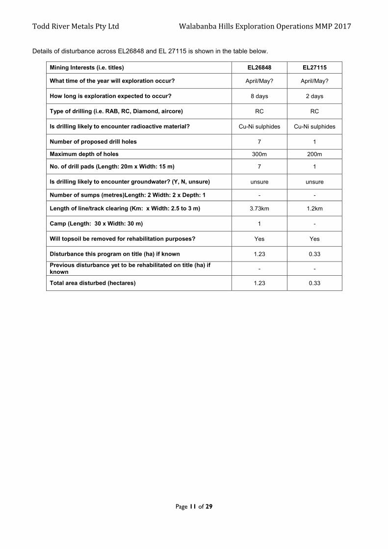
Details of disturbance across EL26848 and EL 27115 is shown in the table below.
Mining Interests (i.e. titles) EL26848 EL27115
What time of the year will exploration occur? April/May? April/May?
How long is exploration expected to occur? 8 days 2 days
Type of drilling (i.e. RAB, RC, Diamond, aircore) RC RC
Is drilling likely to encounter radioactive material? Cu-Ni sulphides Cu-Ni sulphides
Number of proposed drill holes 7 1
Maximum depth of holes 300m 200m
No. of drill pads (Length: 20m x Width: 15 m) 7 1
Is drilling likely to encounter groundwater? (Y, N, unsure) unsure unsure
Number of sumps (metres)Length: 2 Width: 2 x Depth: 1 - -
Length of line/track clearing (Km: x Width: 2.5 to 3 m) 3.73km 1.2km
Camp (Length: 30 x Width: 30 m) 1 -
Will topsoil be removed for rehabilitation purposes? Yes Yes
Disturbance this program on title (ha) if known 1.23 0.33
Previous disturbance yet to be rehabilitated on title (ha) if known
- -
Total area disturbed (hectares) 1.23 0.33

Todd River Metals Pty Ltd Walabanba Hills Exploration Operations MMP 2017
Page 12 of 29
4.0 CURRENT PROJECT SITE CONDITIONS
4.1 LOCAL AND REGIONAL GEOLOGY
The licence areas are generally flat with some broad low ridges of silcretised or ferruginous rock formations. Broad flood plains associated with the Murray Creek which runs through the licence area are also a feature.
The project area lies within the north-central portion of the Paleoproterozoic Arunta Province. The stratigraphy of the Arunta province comprises relics of 2500 Ma Archaean basement overlain by >1800 Ma Palaeoproterozoic, turbiditic sequences of greywacke, quartz, sandstone, siltstone and shale along with mafic rocks and their high-grade metamorphic equivalents. The Arunta also has minor calc-silicates and meta-felsic volcanic units. During the Barramundi Orogeny, the sedimentary units were intruded by mafic rocks which have been deformed and metamorphosed to greenschist or amphibolite facies. During the closing stages of the Barramundi Orogeny (~1830 Ma) granite plutons intruded rocks of the Arunta Province.
In the tenement area, rocks of the Palaeoproterozoic Lower Hatches Group/ Reynolds Range Group occur, comprising undifferentiated granite/granite gneiss and gabbro-dolerite. Neoproterozoic to Palaeozoic rocks of the Georgina Basin cover the Palaeoprotoeozoic rocks in the south to southeast. Cainozoic sediments also cover parts of the tenements. Quaternary and Tertiary cover sequences of variable depth (ranging from a few metres to in excess of 100m) conceal the basement rocks. Mafic/ ultramafic units have been recorded from previous drilling within and adjacent to the tenement, enhancing the prospectivity for Ni-Sulphide and other mineralisation.
4.2 HYDROLOGY
This project lies within the headwaters of the Lander and Hanson Rivers, which flow only during seasonal downpours associated with the monsoon. Seasonal creeks and small playa lakes also exist in the area (Ingallan and Anningie creeks run through the project area).
TRM has limited knowledge regarding the location of significant groundwater flows as only limited previous drilling has been undertaken in the project area. The area is known by the NT Water Resources Branch to have poor water resources of generally below average quality. Recognised bores are shown in Figure 2. Local pastoralists utilise a number of bores for stock. Any water strikes encountered during drilling will be reported in the Annual Technical Report submitted for the project and also in the subsequent MMP.
4.3 FLORA AND FAUNA
The project tenement sits within the Burt Plains Bioregion which is dominated by earthy, alluvial soils. The bioregion is broadly characterised by plains of Acacia shrubland, tussock and hammock grassland, and Acacia and Eucalyptus woodlands, NRETAS (2009).
The broad habitat types within the tenement area may include:
Low open Eucalypt woodland with grass understorey; Tall sparse Mulga shrub-land with low sparse shrub-land understorey; Spinifex hummock grassland with Acacia tall sparse shrub-land overstorey: and Ephemeral creek systems.
The Territory is rich in wildlife. Documentation of the Territory's biodiversity is relatively recent, although Aboriginal Territorians have long held a profound knowledge of their environments. The bird and mammal fauna is now close to comprehensively described, but new species of fish, frogs, reptiles, invertebrates and plants continue to be discovered. Our knowledge of invertebrates is particularly vague.
4.3.1 Weeds and Introduced Flora
A declared weed is a plant or species of plant which has been identified for control, eradication, or prevention of entry in all or part of the Territory under the Northern Territory Weeds Management Act 2001 (the Act).
A weed may be declared as:
Class A To be eradicated Class B Growth and spread to be controlled Class C Not to be introduced to the Territory
All Class A and Class B weeds are also considered to be Class C weeds.

Todd River Metals Pty Ltd Walabanba Hills Exploration Operations MMP 2017
Page 13 of 29
Weeds have the potential to be introduced and spread via vehicle and stock movements and the stripping of topsoil. The locations of significant infestation of weeds and introduced flora species will be marked on a handheld GPS unit, including species present, and an estimate of the density and extent of any infestations and reported to a Weed Officer from the Department of Land Resource Management. TRM environmental policies require that exploration is conducted in a manor such that the spread of weeds is minimised driving around affected areas and washing down vehicles leaving areas where weeds have been observed. While no obvious weed infestations have been noted in the project area as a precaution TRM vehicles are washed down at the Anningie Station homestead in an area designated by the station staff. Vehicles are washed down at the start and end of the program. Anningie Station staff will advise any weed growth at this washdown station and act as necessary. Additional vehicle washdowns at specific sites may be required if weeds become prevalent.
According to the most recent available information on the Department of Land Resource Management website (NT NRM Infonet) there are several weed species which may be present in the Walabanba project area. A brief summary of these are provided in the Table below with more details available in the ‘Guidelines for the Management of Weeds of Walabanba’ booklet as Appendix 3_1.
Weeds – Walabanba region
Common Name Scientific Name Status (NT, Other)*
Buffel Grass Cenchrus ciliaris MP Gr G&M DEU
Purpletop Chloris Chloris barbata DEU
Camel Melon Citrullus lanatus G&M
Elastic Grass Eragrostis tenuifolia DEU
Spiked Malvastrum Malvastrum americanum DEU
Parkinsonia Parkinsonia aculeata B C WONS MP K2 WA1 WA4 Q2 G&M CYP DEU NSW SA
Carribean Stylo Stylosanthes hamata DEU
Townsville Lucerne Stylosanthes humilis DEU
Caltrop Tribulus terrestris B C CYP SA
Sabi Grass Urochloa mosambicensis DEU
Sweet Acacia Vachellia farnesiana DEU
CYP – Draft Cape York Peninsula Pest ManagementPlan 2006-2011
DEU – Plants listed as environmental weeds by the Desert Uplands Strategic Land Resource Assessment
G&M – Grice AC, Martin TG. 2005. The Management of Weeds and Their Impact on Biodiversity in the Rangelands.
Gr – Groves et al. 2003. Weed categories for natural and agricultural ecosystem management.
K2 – High Priority Weeds posing existing threats in the Katherine region
MP – Northern Territory Parks & Conservation Masterplan
NSW – Declared Noxious Weed in NSW
Q2 – Class 2 Weed (eradicate where possible, not to be introduced, kept or supplied)
SA – Declared Plant in South Australia
WA1 – WA Weed Class P1 (movement prohibited)
WA4 – WA Weed Class P4 (prevent spread)
WONS – Weeds of National Significance
Maps produced from the NT Land Information Website (2006 data, Natural Resource Maps, NT) also note that within the Mount Peake (SF5305-5454) and Anningie (SF5305-5554) 100K mapsheet the following weeds have been identified:
Parkinsonia (Present – density unknown) Mesquite (Eradicated and monitored)
It should be noted that none of these species, have been observed in the current exploration area.

Todd River Metals Pty Ltd Walabanba Hills Exploration Operations MMP 2017
Page 14 of 29
4.3.2 Introduced Fauna – Feral Animals According to the most recent available information on the Department of Land Resource Management website a number of feral animals are present within the Walabanba region. The tables below outline the species identified and more information is included in Appendix 3_2. Feral animals including the house mouse, cats, wild dogs, camels and cattle have been noted.
Feral Animals – Walabanba Region
Group Common Name Scientific Name Status (NT, National)*
Birds Red-tailed Black-cockatoo Calyptorhynchus banksii samueli N
Mammals House Mouse Mus musculus P
Mammals Dingo/Wild Dog Canis lupus N
Mammals Fox Vulpes vulpes P
Mammals Cat Felis catus P
Mammals Rabbit Oryctolagus cuniculus P
Mammals Donkey Equus asinus P
Mammals Horse Equus caballus P
Mammals Pig Sus scrofa P
Mammals Camel Camelus dromedarius P
Mammals Swamp Buffalo Bubalus bubalis P
Mammals Cattle Bos taurus P
* N – Native species with pest potential, P – Prohibited species.
4.3.3 Threatened Species A number of threatened species are present within the Walabanba region according to the most recent available information on the Department of Land Resource Management website. The table below outlines the species identified in the region and more information is included in Appendix 3_3.
Threatened Species – Walabanba Region
Group Common Name Scientific Name Status (NT, National)*
Flowering Plants Dwarf Desert Spike Rush Eleocharis papillosa VU, VU
Reptiles Great Desert Skink Liopholis kintorei VU, VU
Birds Malleefowl Leipoa ocellata CR, VU
Birds Grey Falcon Falco hypoleucos VU, -
Birds Princess Parrot Polytelis alexandrae VU, VU
Mammals Night Parrot Pezoporus occidentalis CR, EN
Mammals Brush-tailed Mulgara Dasycercus blythi VU, VU
Mammals Crest-tailed Mulgara Dasycercus cristicauda VU, EN
Mammals Golden Bandicoot Isoodon auratus EN, VU
Mammals Greater Bilby Macrotis lagotis VU, VU
Mammals Common Brushtail Possum Trichosurus vulpecula vulpecula EN, -
Mammals Black-footed Rock-Wallaby Petrogale lateralis - , VU
Mammals Southern Marsupial Mole Notoryctes typhlops VU, EN
* CR – Critically endangered, EN – Endangered, VU – Vulnerable.
4.4 CURRENT LAND USE
The current land use over the project area is predominantly pastoral activity (Figure 4). The tenements lay within:
PPL 1057 “Anningie Station”, and
PPL 1103 “Stirling Station”.

Todd River Metals Pty Ltd Walabanba Hills Exploration Operations MMP 2017
Page 15 of 29
Figure 4: Walabanba Hills project cadastral boundaries.
4.5 HISTORICAL, ABORIGINAL, HERITAGE SITES
Toro Energy requested a heritage clearance by AAPA in May 2010, prior to undertaking any ground disturbing exploration. AAPA conducted a Work Area Clearance (WAC) in August 2010, the results of which were issued to Toro in October in the form of an Authority Certificate, C2101/279.
TNG requested an update of the Abstract of Records from AAPA in May 2013 and again in February 2017. A copy of the most recent information is included in Appendix 4.

Todd River Metals Pty Ltd Walabanba Hills Exploration Operations MMP 2017
Page 16 of 29
5.0 ENVIRONMENTAL MANAGEMENT SYSTEM / PLAN
TRM is committed to ensuring that environmental responsibility is incorporated as part of their normal business practice. It is the duty of all employees to exercise care in their work to ensure this commitment is achieved.
The procedures outlined in the company’s Environmental Management Guidelines document (Appendix 5) must be followed by all staff and contractors during the course of our field activities and aim to minimise any general degradation of the surroundings that may result from carelessness or neglect. In general these guidelines express common sense practices that might be described as “good housekeeping”.
Access to land for exploration and mining is usually by a lease agreement with the government and other private land users, including pastoralists and aboriginal groups. Individuals therefore have certain obligations on a personal and company basis, to protect the environment.
All work will be conducted in accordance with TRM’s Environmental Management Guidelines. Environmental impacts will be minimal. All drill hole collars will rehabilitated in accordance with DPIR documentation - Construction and Rehabilitation of Exploration Drill Sites. Drill pads will be scarified using a grader, when the sumps have dried they will be back filled and covered with stockpiled topsoil. All sample bags will be removed to TRM’s Alice Springs holding yard at the end of exploration programs. Rubbish will be cleaned up and removed immediately after the hole is completed.
Access tracks and grid lines will be located and prepared to provide minimal damage to vegetation and topsoil as per DPIR documentation - Clearing and Rehabilitation of Grid Lines and Tracks Guide.
Destruction or damage of mature trees is strictly forbidden for the duration of TRM’s exploration program.
Environmental reports will be commissioned where intensive exploration is proposed and involves substantial disturbance to the vegetation.
5.1 ENVIRONMENTAL POLICY AND RESPONSIBILITIES
TRM has an Environmental Management Policy under which it operates (Appendix 6). All work will be overseen by the company’s experienced Exploration Manager who is responsible for all site inductions, site preparations, clean-up and rehabilitation operations (described above). These operations will be implemented to industry best practice standards.
5.2 STATUTORY AND NON-STATUATORY REQUIREMENTS
TRM has obligations to meet the requirements of many components of the Northern Territory legislation, which
includes:
Mining Management Act (and Regulations)
Mineral Titles Act (and Regulations)
Aboriginal Land Rights (NT) Act (Com)
Aboriginal and Torres Strait Islander Heritage Protection Act (Com)
Bushfires Act (and Regulations)
Environmental Protection and Biodiversity Conservation Act (Com)
Heritage Act (and Regulations)
Northern Territory Aboriginal Sacred Sites Act (and Regulations)
Soil Conservation and Land Utilisation Act
Waste Management and Pollution Control Act (and Regulations)
Water Act (and Regulations)
Weeds Management Act
Work Health and Safety (National Uniform Legislation) Act (and Regulations)
Exploration Licence conditions of grant
Authorisation conditions
Other reporting to statutory bodies as required or requested.

Todd River Metals Pty Ltd Walabanba Hills Exploration Operations MMP 2017
Page 17 of 29
TRM operates under the Code of Conduct for Mineral Explorers in the Northern Territory of Australia (2002). All TRM’s field programs are provided to relevant Stake Holders before exploration commences for comment and discussion. Other agreements include contractual agreements with drilling, earthworks and other exploration associated companies as required.
5.3 INDUCTION AND TRAINING
All site personnel will be given a formal induction incorporating Occupational Health and Safety (OHS), heritage, cultural and environmental issues and issued with (PPE), hard hats, safety glasses, ear plugs, dust masks and long sleeve work shirts (as required). All personnel must wear steel capped safety boots when on-site. Before drilling commences a drill rig inspection will be carried out by the exploration geologist and drill rig safety inductions will be organised by the driller. Records of all inductions will be kept either at the Alice Springs or Perth office.
Environmental topics will be included in the site induction programme which all site personnel are required to participate in. The induction program stresses industry best practice guidelines as outlined above. All personnel are required to keep the environment as clean as possible and to maintain minimal impact on waterways, land and vegetation. Destruction or damage of mature trees is strictly forbidden during the course of TRM’s exploration program.
Specific topics covered in the environmental induction:
Dust creation on the way to site and on site must be minimized. Destruction or damage of mature trees is strictly forbidden
Each drill site should show only wheel marks and a hole collar at the completion of the drill hole.
All rubbish will be collect and taken to the Alice Springs rubbish tip for proper disposal.
All oil spills must be reported and contaminated soil must be collected in plastic bags and disposed of in
Alice Springs.
Water flow from drilling must be managed so that the outflow is contained in the nearby sump.
Driving on site should utilize prepared and existing tracks and the disturbance of vegetation must be minimized.
All contact with animals is to be avoided.
All vehicles must be washed before entering and exiting site to minimised transporting seeds. All vehicles
will be fitted with mesh to eliminate seed collecting in radiators.
Field staff will be trained in identifying weeds using the Northern Territory Weed Identification Tool for the Burt Plain Region. All TRM vehicles carry copies of the Guidelines for management of Pest Animals and Weeds in the Walabanba region (Appendix 3).
5.4 IDENTIFICATION OF ENVIRONMENTAL ASPECTS AND IMPACTS
The main environmental aspects that come into force when conducting exploration (including drilling and associated clearing, vehicle movement and fuel storage applicable to the planned work programme) are listed in the table below. The impacts of these are discussed along with the ways these impacts can be minimized and prevented. Remediation measures are also outlined.
Aspect Impact Risk Rating
Management measures (prevention)
Management measures (remediation)
Clearing of tracks / camps
Damage and loss of
High All site works / clearing will be located and
Take site photos prior to clearing and during

Todd River Metals Pty Ltd Walabanba Hills Exploration Operations MMP 2017
Page 18 of 29
/ drill pads & sumps.
vegetation/flora and habitat for native fauna.
prepared to provide minimal damage to vegetation. Minimize movement of fallen vegetation. Destruction or damage to mature trees is strictly forbidden.
Use existing tracks where possible. New tracks and site works, minimal width and size.
Keep vehicle movement to a minimum.
rehabilitation restore the area as best can be to pre-cleared topography.
Rehabilitate all site works as quickly as possible.
Monitor sites annually.
Erosion and redirection of surface water.
High
All site works / clearing will be located and prepared to provide minimal damage to existing waterways or changes in surface water flow directions.
Use existing tracks where possible. New tracks and site works, minimal width and size.
Keep vehicle movement to a minimum.
Take site photos prior to clearing taking note of regions of water flow and any pooling.
During rehabilitation restore the area as best can be to pre-cleared topography.
Monitor sites annually for erosion and changed water flow patterns.
Pollution from dust and noise.
Medium to high
Ensure water trucks are on hand during clearing to dampen the soil and prevent excessive dust production.
Do not conduct clearing on windy days.
Limit vehicle noise
If necessary use water truck to spray excessive dust from vegetation – post clearing and post rehabilitation.
Introduction of invasive weed species by machinery.
Medium
Keep vehicle movement to a minimum through cleared sites.
Washdown vehicles (at Anningie) prior to them entering the drill sites.
Check vehicles and machinery daily for weeds and seeds.
Monitor rehabilitated sites annually for weed growth and take note of any species that make occur at washdown station.
Take appropriate action, in consultation with Station Owners, if required.
Damage to cultural and heritage sites.
High
Contact relevant authorities prior to undertaking clearing in order to make sure significant sites are avoided.
No work should be undertaken in exclusion zones and care should be taken in restricted work areas.
Drilling Contamination to soil, surface and ground
Medium to High
All equipment checked daily and signed off as
Isolate the source.
Contain the spill.

Todd River Metals Pty Ltd Walabanba Hills Exploration Operations MMP 2017
Page 19 of 29
water from hydrocarbon spills and drill slurry.
being in good working order prior to use onsite.
Drilling companies and TRM carry spill kits.
Use trays to place under areas of potential leaks.
Excessive drill slurry and ground water captured in lined sump.
Add litter if required.
Remove contaminated soil as quickly as possible and place in plastic bags.
Replace with stockpiled topsoil.
Take contaminated material offsite for disposal.
In case of spill monitor site regularly and take necessary measures to ensure vegetation regrowth and minimal long-term effect on surroundings.
Pollution from dust and noise.
Very High
Drilling rigs and support vehicles must have dust and noise suppressors.
All equipment checked daily and signed off as being in good working order prior to use onsite.
Stop work if excessive dust or very windy conditions.
Have extra water source on hand to dampen surroundings and minimize dust if required.
If necessary use water truck to spray excessive dust from nearby vegetation – post drilling and post rehabilitation.
Danger to fauna from open drill holes, excessive drill cuttings and drill sumps.
Very High
Spread or tip excessive drill cutting back down drill hole and cap drill collar immediately after hole has been completed.
Ensure there is access available out of sumps (ie tree branches) should fauna fall in prior to it drying out.
Clean up around drill collar and cap as soon drill rig leaves the drill pad.
Remove the sump liner as soon as the sump has dried out. Fill in sump and replace topsoil.
Monitor drillsites annually.
Damage to cultural and heritage sites.
High
Contact relevant authorities prior to undertaking clearing in order to make sure significant sites are avoided.
No work should be undertaken in exclusion zones and care should be taken in restricted work areas.
Campsites
Contamination to soil, surface and ground water from
Medium
All equipment checked daily and signed off as being in good working order prior to use onsite.
Isolate the source.
Contain the spill.
Add litter if required.

Todd River Metals Pty Ltd Walabanba Hills Exploration Operations MMP 2017
Page 20 of 29
hydrocarbon spills and generated waste.
Drilling companies and TRM carry spill kits.
Use trays to place under areas of potential leaks.
Place all rubbish in covered skip bins.
Dispose sewerage into eco pit.
Remove contaminated soil as quickly as possible and place in plastic bags.
Replace with stockpiled topsoil.
Take contaminated material offsite for disposal.
In case of spill monitor site regularly and take necessary measures to ensure vegetation regrowth and minimal long-term effect on surroundings.
Remove all rubbish and waste to the Alice Springs rubbish tip.
Apply lime as required for odour, disease control and waste breakdown.
Danger to flora and fauna from contact with personnel and campsite infrastructure.
Medium to High
Induct field staff in the care and wellbeing of native animals.
Avoid contact with native birds and animals.
Ensure food is left well secured and place all rubbish in covered skip bins.
Dispose sewerage into eco pit.
Remove all rubbish and waste to the Alice Springs rubbish tip.
Appy lime as required for odour, disease control and waste breakdown.
During rehabilitation restore the area as best can be to pre-cleared condition.
Monitor site annually.
Fuel Storage
Contamination of soil, surface and ground water from hydrocarbon leaks or spills.
High
All bulk fuels and oils will be place in bunded areas and monitored daily. The bund will have a heavy duty plastic liner to stop hydrocarbon spillage contaminating soil and ground water.
Only hand held filling nozzles will be use and emergency stop / isolation buttons will be fitted.
All small drums up to 20 litres will be place in heavy duty PVC trays.
Train and induct field staff in the method of using bulk fuel and emergency shutdown procedures.
Isolate the source.
Contain the spill.
Add litter if required.
Remove contaminated soil as quickly as possible and place in plastic bags.
Replace with stockpiled topsoil.

Todd River Metals Pty Ltd Walabanba Hills Exploration Operations MMP 2017
Page 21 of 29
Spill kits, fire extinguishers and filling procedures will be placed near the bunds / filling station.
Take contaminated material offsite for disposal.
In case of spill monitor site regularly and take necessary measures to ensure vegetation regrowth and minimal long-term effect on surroundings.
Sampling
Pollution from sample material and sample bags.
High
Drill samples will be collected in plastic bags and will remain on-site for up to 6 months.
Sample bags to be placed in naturally clear areas rather than vegetated sites.
Once the samples are no longer required the sample will be tipped into a pit and covered with stored topsoil.
All plastic sample bags will be removed from site and disposed of at the Alice Springs rubbish tip.
Remove all plastic sample bags before they start to deteriorate.
Monitor site annually.
Note: It is a requirement to seal aquifers that are intersected during drilling operations and major aquifers will be sealed to prevent inter-aquifer contamination as per the guidelines set out in DPIR document - Construction and Rehabilitation of Exploration Drill Sites. Drilling will be abandoned if necessary to prevent inter-aquifer contamination.
Any water strikes encountered during drilling will be reported in future MMP’s and recorded as part of the drillhole logging procedure.
5.5 ENVIRONMENTAL AUDITS, INSPECTIONS AND MONITORING
This section describes the framework and accountabilities for verifying TRM environmental performance. All environmental audits should be systematic and structured, using an established protocol.
5.5.1 Environmental Audits
Procedure
Conduct systems audits to verify whether the environmental management procedures meet the requirements of:
TRM Environmental Policy Australian Minerals Industry (AMI) Code for Environmental Management Action Items from previous audit reports TRM environmental objectives
Audit process
The audit process will generally include the following steps:
Establish and agree on timing of the audit. Contact audit participants.

Todd River Metals Pty Ltd Walabanba Hills Exploration Operations MMP 2017
Page 22 of 29
Develop a checklist of items to be reviewed. Collect documentation and background information for the area to be audited. Plan the audit. Conduct opening meeting with audit participants. Conduct audit. Collate and present audit observations Prepare and issue audit report.
Audit Schedules
Internal Audits
Internal initiated audits shall be undertaken on an annual basis while exploration activities are in place. Not all aspects of the environmental management procedures need verification each year. The target is that over a two year period all procedures will be audited at least once.
An audit of existing tracks into the drilling areas will be undertaken prior to the commencement of the drilling programme early in 2017.
External Audits
The Department of Primary Industry and Resources conducts site inspections on exploration projects at regular intervals. No further external parties are required to undertake audits within the Walabanba project at this stage due to the limited disturbance. Once a report is received from the DPIR all recommendations and requirements are addressed as soon as possible and reported in the next MMP.
Audit Findings
The audit findings will be distributed to the Managing Director and once reviewed, will be distributed to employees responsible for actioning any of the audit recommendations prior to the end of the field season. These findings will also be reported in the subsequent MMP, usually appended as a Rehabilitation Report.
5.5.2 Site Monitoring
TRM will ensure that any site monitoring will be managed so as to reduce any adverse environmental impact.
The purpose of this Environmental Procedure is to ensure that TRM exploration sites are monitored to accurately measure the impact our activities have on the environment. The monitoring process also provides a guide to how successful or unsuccessful rehabilitation programs have been. Photographic evidence is used in the monitoring and is included in any Environmental Monitoring Reports.
This section covers the process of site monitoring of areas of environmental impact over TRM tenements. The monitoring involves establishing monitoring sites and taking “before and after” photographs. The photographs provide a record of the company’s environmental impact and a measure of rehabilitation progress. Areas covered are:
Due diligence involves the locating and recording of environmental degradation existing on a tenement or access tracks to that tenement prior to disturbance by TRM;
Existing and new access tracks must be monitored at representative intervals to determine the amount of impact that TRM have on the tracks for the duration of the program. The nature of the ground and how often ground condition changes will also assist in determining the number of monitoring station. Trouble spots on tracks such as bulldust areas and creek crossings are of a high monitoring priority. It is best to photograph tracks during your first pass of the area so a record is kept of the condition they were in prior to TRM use. Ongoing monitoring of track conditions assists in compiling the annual environmental report.
Archaeological/heritage sites: Take before and after shots of archaeological / heritage sites prior to any exploration activity that may endanger these sites. Monitor the sites, record any adverse impacts and enter into the annual environmental monitoring report.
Rare or endangered flora and fauna sites: Take before and after shots of rare or endangered flora and fauna sites prior to any exploration activity that may endanger these sites. Monitor the sites, record any adverse impacts and enter into the annual environmental monitoring report.
Camp sites: Take before and after shots of campsites in the camp area.

Todd River Metals Pty Ltd Walabanba Hills Exploration Operations MMP 2017
Page 23 of 29
Hydrocarbon or hazardous substance storage facility (fuel dumps): Take before and after shots of fuel dumps and hazardous substance storage areas.
Sample sites: Set up characteristic monitoring stations that represent at least 25% of all the impact areas. However, it is important to emphasise that areas, which are or have the potential to become environmentally degraded are to be included in monitoring.
Grid lines: If the gridding is of low environmental significance then one monitoring site is adequate to show the low environmental impact of the work. If the gridding is of high impact significance that is, it involves vehicles driving along the grid line and scrub clearing then a representative number of monitoring stations must be set up. The size of the grid and the nature of the ground will determine the minimum number of monitoring stations. The monitoring program must be designed so that all ground types affected are represented.
Drill pads: For drilling set up a representative number of monitoring stations. The recommended minimum number of monitoring stations is 25% of all disturbed sites. Extra monitoring stations will be set up for sites that could potentially become an environmental issue.
Monitoring Stations
Three monitoring stations will be set up at drill sites (one in each target area – Target 1c, Target 1d and Target 5b/c) and additional monitoring stations will be set up along each access track (four in total) and at the Drillers Campsite. Total of eight Monitoring Stations. Exact locations will be reported after clearing takes place.
Before and after photographs will be taken at each monitoring station on an annual basis and submitted with each MMP.
Walabanba Hills - Environmental Monitoring Stations
Station Easting Northing Tenement Description
1 EL26848 Target 1c
2 EL27115 Target 1d
3 EL26848 Target 5b/c
4 EL26848 Access Track to hole 1 and 2 (Target 1c)
5 EL26848 Access Track to hole 3 and 4 (Target 1c)
6 EL27115 Access Track to hole 5 (Target 1d)
7 EL26848 Access Track to hole 6, 7 and 8 (Target 5b/c)
8 EL26848 Drillers Campsite
5.6 ENVIRONMENTAL PERFORMANCE
5.6.1 Objectives and Targets
Principal closure objectives: The principal closure objective at all exploration sites is the restoration of all areas of ground disturbance back to their pre-disturbance condition at completion of field activities. Site monitoring will be routinely undertaken both as an environmental record and gauge of rehabilitation effectiveness.
TRM will complete planned exploration programs at the Walabanba Hills Project within the confines of relevant statutory Acts and company procedures leaving a negligible residual land, fauna and flora impact following rehabilitation activities.
The objectives listed below relate specifically to the site disturbance brought about by planned exploration and take into account the current site conditions.

Todd River Metals Pty Ltd Walabanba Hills Exploration Operations MMP 2017
Page 24 of 29
Description Objective Target and Date Comments
Regrowth of vegetation on drill sites
For drill sites to be returned to pre-disturbance condition
Hole capped – completion of drilling.
Site left clean and tidy – completion of drilling.
Hole cut and plugged. Topsoil and leaves/branches spread as required to avoid erosion and encourage regrowth – late 2017.
Complete revegetation by April 2022.
Site revegetation should increase each year and will be monitored accordingly with photographs provided.
Regrowth of vegetation on camp site
For drill sites to be returned to pre-disturbance condition
Site left clean and tidy – completion of drilling program.
Topsoil and leaves/branches spread as required to avoid erosion and encourage regrowth – late 2017.
Complete revegetation by April 2022.
Site revegetation should increase each year and will be monitored accordingly with photographs provided.
Regrowth of vegetation on access tracks
For access tracks to be returned to pre-disturbance condition
Windrows flattened as necessary. Topsoil and leaves/branches spread as required to avoid erosion and encourage regrowth – late 2017.
Complete revegetation and rehabilitation by April 2022.
This timeframe (2022) will increase should erosion remediation measures be required.
Site revegetation should increase each year and will be monitored accordingly with photographs provided.
Erosion of tracks Minimise erosion along access tracks
Topsoil and leaves/branches spread as required to avoid erosion – late 2017.
Assess annually and undertake remediation if required.
Persons responsible for achieving objectives:
Mr Kim Grey (Exploration Manager)
The overall objectives for TRM exploration sites are as follows:
To have minimal, preferably zero impact on the environment and minimise pollution.
To continue rehabilitation and monitoring after exploration activities.
Maintain a healthy and safe working environment.
Comply with legal and other requirements and to continue improvement as directed by environmental audits and the Department of Primary Industry and Resources, Mining Compliance division.

Todd River Metals Pty Ltd Walabanba Hills Exploration Operations MMP 2017
Page 25 of 29
Advance TRM’s staff knowledge-awareness of Indigenous cultural and heritage values through structured programs.
To protect sacred or significant sites as indicated by Traditional Owners and/or AAPA Clearance
Certificates.
5.6.2 Performance Reporting
Reporting on progress of rehabilitation will take place in the MMP each year. No significant disturbance has been carried out of the Walabanba site to date.
5.7 ENVIRONMENTAL EMERGENCY PROCEDURES AND INCIDENT REPORTING
Environmental incidents and emergencies are defined as, sudden-onset disasters or unplanned events resulting from natural, technological or human-induced factors, or a combination of these, that cause or threaten to cause severe environmental damage. Most environmental incidents and emergencies involve the release of toxic and hazardous substances into the environment. TRM and its controlled entities are committed to applying best practice environmental procedures at all levels. The procedures described below give an outline as to how to deal with the most likely occurring environmental emergencies along with less serious events. Serious incidents are more likely to happen during a significant exploration drilling programme when drill rigs and support vehicles are on site. Less serious incidents, such as a leakage from a dripping fuel tank etc are still possible during sampling and rehabilitation programmes as have recently been undertaken within the project area. These procedures are not meant to be exhaustive and when dealing with the environment, local conditions should be reviewed and accounted for when making an action plan to deal with any form of pollution or environmental risk. TRM is committed to reporting environmental incidents in accordance with Section 29 of the Mining Management Act (see section 5.7.2). There were no incidents during on site activities in 2015/16.
5.7.1 Spill Containment Procedure
Matter is present in the natural environment in three forms – solids, liquid and gas. Spillage is the event where by substances that do not occur in the local environment are unintentionally released into that area in any of these forms.
Containment of spillage of liquids and fluid/solid mixtures is probably the most difficult task to manage and the most common environmental incident. This is because the fluid can spread out more easily than a solid.
Hydrocarbons Hydrocarbons come in the form of petrol and diesel fuel, oils, solvents, grease etc. Hydrocarbons readily impregnate into soils and are useless once contaminated. The following guidelines will be used for the containment of hydrocarbon spillage such as fuels, oils, solvents, grease etc:
Isolate the source of the spill, report to your supervisor. Contain the spill with bunds. Add litter if soakage rate is slow. Dig up the contaminated area and seal in plastic bags, remove from site and dispose of in appropriate
facility in Alice Springs. Rehabilitate the area under guidance of your supervisor.
Drill Slurry Slurry release from the drilling plant should have minimal impact as the design is such that a sump will collect these flows or they will be captured within tanks if sumps are not possible. The drill slurry consists of water, added

Todd River Metals Pty Ltd Walabanba Hills Exploration Operations MMP 2017
Page 26 of 29
bio-degradable drill mud and drill core cuttings. The slurry is usually allowed to settle and is then recycled and/or released. The sump if used will be rehabilitated at the end of the project.
The ultimate incident involving slurry will be whereby the bund or sump is exceeded due to the leak going un-noticed for an extended period of time. The drill slurry will not contain any material that will have an adverse impact on the environment however, whenever slurry is released from the drill plant area, or the plant bund capacity is exceeded, the following procedures must be followed:
Attempt to isolate the leak. Shut down the drill plant. Report to your supervisor. If the slurry leak exceeds the outer controls (plant drainage sump, pipe bund)
then the following additional actions items are required: o Bund the area to stop the spill spreading. o Dig up the contaminated area and seal in plastic bags, remove from site and dispose of in
appropriate facility in Alice Springs. o Rehabilitate the area under guidance of your supervisor.
5.7.2 Incident Reporting All environmental incidents will be recorded on a TRM Accident/Incident Report Form (Appendix 7) and submitted annually with the MMP. All environment incidents will also be reported to the Mining Compliance division within the Department of Primary Industry and Resources on the Notification of an environmental incident form as per section 29 of the Mining Management Act.
This section describes TRM’s guidelines and accountabilities for all environmental related communication and reporting. Local communities unless otherwise stated generally refer to pastoralists, indigenous groups and their representatives.
The objectives of communicating environmental issues include:
Provides access to information from local sources for TRM’s employees, Ensures that employees are aware of, and understand, their accountabilities for environmental management, Facilitates internal TRM reporting, Enables regulatory reporting, Encouraging employee involvement in continuously improving environmental systems and procedures, Providing information on TRM’s environmental performance to the broader community, Addresses environmental concerns of local communities.
TRM inducts its personnel to report all incidents and accidents immediately upon notice to the Exploration Manager or his delegate. A TRM Accident/Incident Report Form is filled out and sent to the Managing Director along with a Notification of an environmental incident form which is forwarded directly to the DPIR Mining Compliance Division.
New employees are briefed on TRM’s environmental systems and procedures during their induction programme. The Exploration Manager will be accountable for ensuring the appropriate induction takes place.
Todd River Metals Pty Ltd Walabanba Hills Exploration Operations MMP 2017
Page 27 of 29
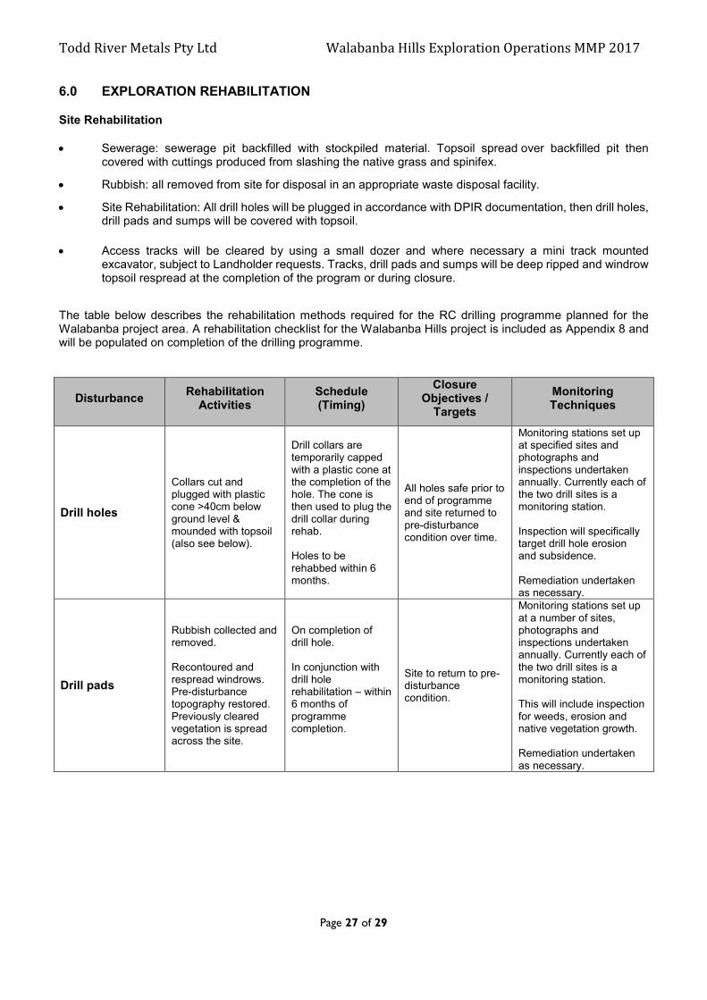
6.0 EXPLORATION REHABILITATION
Site Rehabilitation Sewerage: sewerage pit backfilled with stockpiled material. Topsoil spread over backfilled pit then
covered with cuttings produced from slashing the native grass and spinifex.
Rubbish: all removed from site for disposal in an appropriate waste disposal facility.
Site Rehabilitation: All drill holes will be plugged in accordance with DPIR documentation, then drill holes, drill pads and sumps will be covered with topsoil.
Access tracks will be cleared by using a small dozer and where necessary a mini track mounted excavator, subject to Landholder requests. Tracks, drill pads and sumps will be deep ripped and windrow topsoil respread at the completion of the program or during closure.
The table below describes the rehabilitation methods required for the RC drilling programme planned for the Walabanba project area. A rehabilitation checklist for the Walabanba Hills project is included as Appendix 8 and will be populated on completion of the drilling programme.
Disturbance Rehabilitation
Activities Schedule (Timing)
Closure Objectives /
Targets
Monitoring Techniques
Drill holes
Collars cut and plugged with plastic cone >40cm below ground level & mounded with topsoil (also see below).
Drill collars are temporarily capped with a plastic cone at the completion of the hole. The cone is then used to plug the drill collar during rehab. Holes to be rehabbed within 6 months.
All holes safe prior to end of programme and site returned to pre-disturbance condition over time.
Monitoring stations set up at specified sites and photographs and inspections undertaken annually. Currently each of the two drill sites is a monitoring station. Inspection will specifically target drill hole erosion and subsidence. Remediation undertaken as necessary.
Drill pads
Rubbish collected and removed. Recontoured and respread windrows. Pre-disturbance topography restored. Previously cleared vegetation is spread across the site.
On completion of drill hole. In conjunction with drill hole rehabilitation – within 6 months of programme completion.
Site to return to pre-disturbance condition.
Monitoring stations set up at a number of sites, photographs and inspections undertaken annually. Currently each of the two drill sites is a monitoring station. This will include inspection for weeds, erosion and native vegetation growth. Remediation undertaken as necessary.

Todd River Metals Pty Ltd Walabanba Hills Exploration Operations MMP 2017
Page 28 of 29
Tracks/Gridlines
Windrows and piles of dirt from initial track creation respread. Any areas of erosion remediated. Allowed to revegetate but not fully rehabilitated in order to allow continued access to drillholes. Ripping of tracks if required.
Recontour windrows and dirt piles and conduct erosion remediation in conjunction with drillhole rehabilitation. Ripping may take place (if necessary) when tracks are no longer required or at closure. They may be left open at the request of the Landholders and if so will be officially signed over.
Tracks will be made safe and may remain open for Landholder use if requested. If not to remain open, site to return to pre-disturbance condition.
Inspected for safety and erosion. Monitoring stations set up at two sites and photographs and inspections undertaken annually. Remediation undertaken as necessary. Responsibility handed over to Landowners at closure should they request use of the tracks.
Camp sites
All rubbish collected and removed. Recontoured and respread windrows. Pre-disturbance topography restored. Previously cleared vegetation is spread across the site.
In conjunction with drillhole rehabilitation.
Site to return to pre-disturbance condition.
Monitoring stations set up at campsite and photographs and inspections undertaken annually. Remediation undertaken as necessary.
Clarification of drill collar capping and plugging.
Capped at completion of hole. Dug out/cut/plugged during rehab. After rehabilitation.
6.1 Exploration Rehabilitation Register
The exploration rehabilitation registers for the Walabanba Hills Project are included as Appendix 9 and will be populated on completion of the drilling programme and included in the next MMP.
6.2 Costing of Closure Activities
The cost of closure activities has been calculated as per the Department Security Calculation Spreadsheet – Exploration Operations Security Calculation Tool which is included as Appendix 10.

Todd River Metals Pty Ltd Walabanba Hills Exploration Operations MMP 2017
Page 29 of 29
7.0 APPENDICES
Appendices 1-10 have been included as separate documents.