waldridge fell leaflet (pdf) - durham · car parks are signposted. nearest ... chase and even a...
TRANSCRIPT

Waldridge Fell Country Park
Area: 284 acres (115 hectares)
Total length of Easy Access route: 0.8 miles (1.3km)
Grid Reference: NZ 250 498
MapOrdnance Survey: Explorer 308
Directions: 5.5 milenorth of DurhamCity centre, 1.5 milewest of Chester-le-Street. From A167Chester Moorroundabout taketurning ontoWaldridge Lane.Alternatively, accessvia the Edmondsleyto Waldridge road.Car parks aresignposted. Nearestpostcode is DH2 3RY
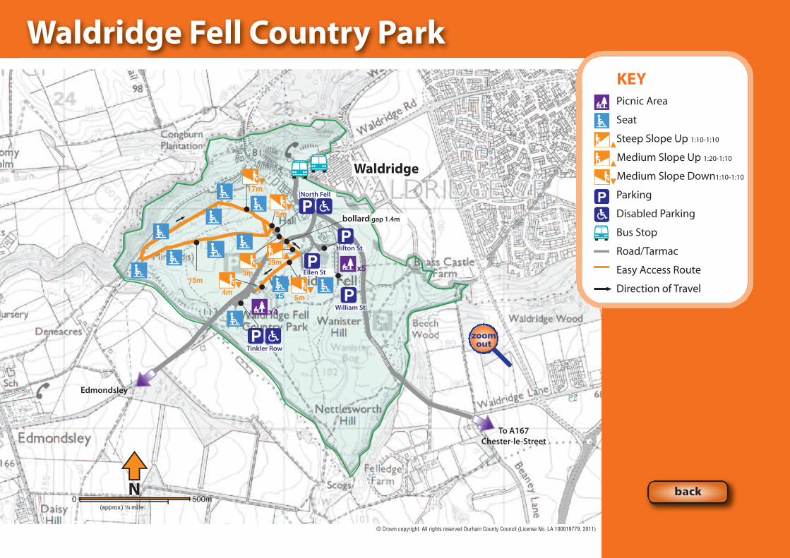
Parking: There are five car parks: William St NZ 252 497,Hylton St NZ 251 498, Ellen St NZ 250 497 (2 disabledbays), Tinkler Row NZ 248 496 (2 disabled parking bays), North Fell NZ 249 498 (2 disabled parking bays)
Public transport: Service 25 (Go Northern). Bus stop is atChester Street in Waldridge Village, approximately 500metres to the car parks
Dogs: Allowed under control on a lead during bird nestingseason (March to August). Please clean up after your dog
Designation: Country Park, Site of Special ScientificInterest (SSSI), Open Access Land, UK Woodland AssuranceScheme certified, Local Wildlife Site
Suitable for: Walkers and wheelchair users.Cyclists and horse-riders are not allowed
Habitats: Lowland heath, wetland, woodland, grassland
What is special? Waldridge Fell has had many uses over the years; grazing, part of the Prince Bishops' huntingchase and even a military training ground during the Napoleonic Wars. Extensive coal miningtook place from the early 1800's until 1963. Waldridge colliery and village community thrivedhere. The present car parks are named after the rows of houses that once stood here.
There are panoramic views across the Fell and surrounding countryside. A number of waymarkedroutes around the site enable you to experience different parts of the Fell. Guided walks oftentake place around this fascinating site. More information can be found in the Country Durhambooklet, call 0191 372 9100 for your free copy.
Waldridge Fell is an extensive area of lowland heath (moorland less than 300m above sea level),and contains heather, bilberry and moorland grasses. These look stunning in late summer andautumn when the purple heather is in flower. Lowland heath is globally rare and makes itespecially important to manage it carefully.
Coppicing of birch trees takes place on a rotational basis. If we did not do this the Fell would turnto woodland and the rare heathland habitat would be lost. The heather itself is cut on rotation.This encourages new growth and creates stands of different aged heather which benefits abroader range of animals.
Whilst every effort has been made by Durham County Council to ensure accuracy of information,the Council cannot accept any liability resulting from omissions or inaccuracies.
Contact the Countryside Servicetelephone: 0191 372 9100email: [email protected]/countryside
zoomin
more info...
© Durham County Council License No. LA 100019779. 2011
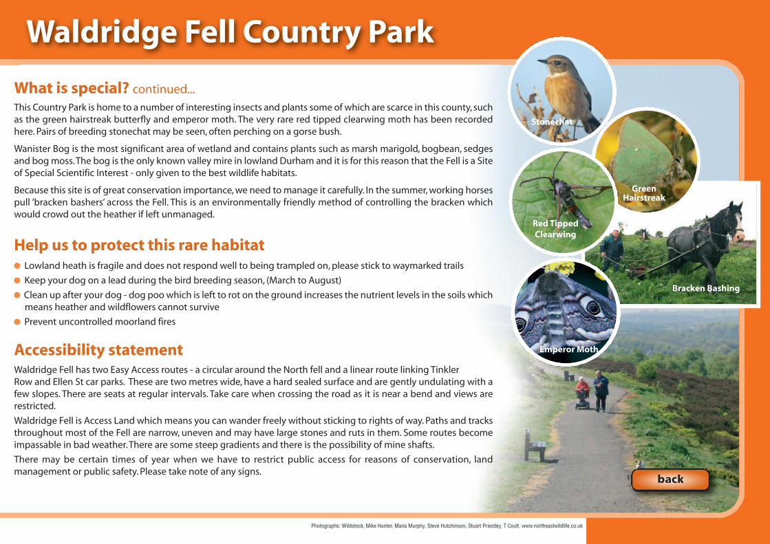
What is special? continued...This Country Park is home to a number of interesting insects and plants some of which are scarce in this county, suchas the green hairstreak butterfly and emperor moth. The very rare red tipped clearwing moth has been recordedhere. Pairs of breeding stonechat may be seen, often perching on a gorse bush.
Wanister Bog is the most significant area of wetland and contains plants such as marsh marigold, bogbean, sedgesand bog moss. The bog is the only known valley mire in lowland Durham and it is for this reason that the Fell is a Siteof Special Scientific Interest - only given to the best wildlife habitats.
Because this site is of great conservation importance, we need to manage it carefully. In the summer, working horsespull ‘bracken bashers’ across the Fell. This is an environmentally friendly method of controlling the bracken whichwould crowd out the heather if left unmanaged.
Help us to protect this rare habitatLowland heath is fragile and does not respond well to being trampled on, please stick to waymarked trails
Keep your dog on a lead during the bird breeding season, (March to August)
Clean up after your dog - dog poo which is left to rot on the ground increases the nutrient levels in the soils whichmeans heather and wildflowers cannot survive
Prevent uncontrolled moorland fires
Accessibility statement Waldridge Fell has two Easy Access routes - a circular around the North fell and a linear route linking TinklerRow and Ellen St car parks. These are two metres wide, have a hard sealed surface and are gently undulating with afew slopes. There are seats at regular intervals. Take care when crossing the road as it is near a bend and views arerestricted.
Waldridge Fell is Access Land which means you can wander freely without sticking to rights of way. Paths and tracksthroughout most of the Fell are narrow, uneven and may have large stones and ruts in them. Some routes becomeimpassable in bad weather. There are some steep gradients and there is the possibility of mine shafts.
There may be certain times of year when we have to restrict public access for reasons of conservation, landmanagement or public safety. Please take note of any signs.
Waldridge Fell Country Park
Photographs: Wildstock, Mike Hunter, Maria Murphy, Steve Hutchinson, Stuart Priestley, T Coult, www.northeastwildlife.co.uk
Bracken Bashing
GreenHairstreak
Red TippedClearwing
Stonechat
Emperor Moth
back

Waldridge Fell Country Park
back
zoomin
© Durham County Council License No. LA 100019779. 2011
15m
x5x4
x5
N0 500m
(approx) 1/4 mile
29m
5m
17m
5m
Tinkler Row
William St
Ellen St
|North Fell
Hilton St
bollard gap 1.4m
Edmondsley
To A167Chester-le-Street
Waldridge
3m
4m
Waldridge Fell Country Park
zoomout
© Crown copyright. All rights reserved Durham County Council (License No. LA 100019779. 2011)
KEYPicnic Area
Seat
Steep Slope Up 1:10-1:10
Medium Slope Up 1:20-1:10
Medium Slope Down1:10-1:10
Parking
Disabled Parking
Bus Stop
Road/Tarmac
Easy Access Route
Direction of Travel
back