walking near chanctonbury and steyning, chanctonbury ... · the trail also takes you past...
TRANSCRIPT

Walking near Steyning, Chanctonbury and Washington
© A
dil H
ussa
in
Leave your car at home, take the bus
On leaving the Ring, the route descends to Washington, where an optional extension allows for a lunch break in the village. You can then return past Wiston House to Steyning.
South Downs National Park The South Downs National Park is Britain’s newest National Park, rich in landscape, culture and wildlife. Discover ancient woodland and enjoy spectacular views as you explore the open downs and heathlands. Within these landscapes lie bustling market towns and peaceful rural villages, historic houses and the remains of ancient settlements.
Walking near Steyning, Chanctonbury and WashingtonDiscover another way to visit the South Downs National Park. Go to www.traveline.co.uk or call 0871 200 22 33 to find public transport information. For train timetables, visit www.nationalrail.co.uk or call 08457 484950.
This walk was developed using an original route provided by the Steyning & District Community Partnership. Visit www.steyningsouthdowns.com for details.
Discover Steyning, Chanctonbury and WashingtonSteyning town is rich in history, with scores of timber-framed buildings in and around the ancient high street. It was once a port on the River Adur and was prized by the Normans; their legacy today includes the magnificent parish church and the ruins of the castle in nearby Bramber. Visit some of the many shops, restaurants, pubs and tea rooms, or pop by for the monthly farmers’ market.
The route of this circular walk takes you out of Steyning and then steeply up to join the South Downs Way. You’ll see views of Cissbury Ring, which covers 60 acres and is one of the largest Middle Iron-Age hill forts in Europe. The earthworks date back to 250 BC.
The trail also takes you past Chanctonbury Ring, another Iron Age hill fort. The Ring’s current fame stems from a crown of Beech trees planted in 1750 by Charles Goring of Wiston House. Although not well received initially, the trees later became a well-known landmark.
The trees in the centre of the ring didn’t grow too well, and it was later discovered that they had been planted on an old Roman temple. Many of the trees were destroyed in the great storm of 1987, and the Goring family, who still own Wiston House, are working to restore the ring to its former glory.
© C
issb
ury
Rin
g, W
SCC
© S
teyn
ing V
illag
e Si
gn, S
DN
PA
Details correct at time of going to print. Please be aware that routes are shared with other users (vehicles, pedestrians, dogs, horses etc) and users of the SDNPA Walk and Ride Leaflet Series do so at their own risk. We do not accept any responsibility for loss, damage or injury, however caused, arising directly or indirectly from use of this leaflet. Contains Ordnance Survey data © Crown copyright and database right 2013.
Contact usSouth Downs National Park Authority
Tel: 0300 303 1053 Web: www.southdowns.gov.uk
Twitter: @SDNPA Facebook: SDNPA
Please follow the Countryside Code: Leave gates as you find them and keep dogs under close control or on a lead.
Where in the South Downs National Park:
Steyning
Start/Finish
A283
A283
A283
PoliceStation
South Downs Way
South Downs Way
Monarch’s W
ay Monarch’s Way
South
Dow
ns Way
CissburyRing
ChanctonburyRing
WistonHouse
FranklandArms
Steyning
Frankland
Washington
Option 1
hBramber
Option 2
/Fi
WaWW
Sheep
Pen Lane
Mouse Lane
B
S
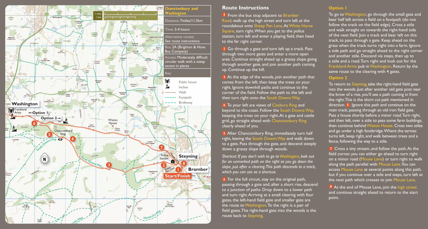
Route Instructions From the bus stop adjacent to Bramber
Road, walk up the high street and turn left at the roundabout onto Sheep Pen Lane. At White Horse Square, turn right. When you get to the police station, turn left and enter a playing field, then head to the far right corner.
Go through a gate and turn left up a track. Pass through two more gates and enter a more open area. Continue straight ahead up a grassy slope going through another gate, and join another path coming up. Continue up the hill.
At the edge of the woods, join another path that comes from the left, then keep the trees on your right. Ignore downhill paths and continue to the corner of the field. Follow the path to the left and then turn right onto the South Downs Way.
To your left are views of Cissbury Ring and beyond to the coast. Follow the South Downs Way, keeping the trees on your right. At a gate and cattle grid, go straight ahead with Chanctonbury Ring clearly ahead of you.
After Chanctonbury Ring, immediately turn half right, leaving the South Downs Way and walk down to a gate. Pass through the gate, and descend steeply down a grassy slope through woods.
Shortcut: If you don’t wish to go to Washington, look out for an unmarked path on the right as you go down the slope, just after a clearing. This path descends to a track, which you can use as a shortcut.
For the full circuit, stay on the original path, passing through a gate and, after a short rise, descend to a junction of paths. Drop down to a lower path and turn right. Arriving at a small clearing with four gates, the left-hand field gate and smaller gate are the route to Washington. To the right is a pair of field gates. The right-hand gate into the woods is the route back to Steyning.
Chanctonbury and Washington
Distance: 7miles/11.5km
Time: 3-4 hours
Alternative routes: See route instructions
Bus: 2A (Brighton & Hove Bus Company)
Access: Moderately difficult circular walk with a steep ascent in places
Key:
Public house
Incline Walk Footpath Bridleway
Option 1To go to Washington, go through the small gate and bear half left across a field on a footpath (do not follow the track on the field edge). Cross a stile and walk straight on towards the right-hand side of the next field. Join a track and bear left on this track, to pass through a gate. Keep ahead on the grass when the track turns right into a farm. Ignore a side path and go straight ahead to the right corner and another stile. Descend via steps, then up to a stile and a road. Turn right and look out for the Frankland Arms pub in Washington. Return by the same route to the clearing with 4 gates. Option 2To return to Steyning, take the right-hand field gate into the woods. Just after another old gate post near the brow of a rise, you’ll see a path coming in from the right. This is the short cut path mentioned in direction . Ignore this path and continue on the main track, passing through an old iron field gate. Pass a house shortly before a minor road. Turn right, and then left, over a stile to pass some farm buildings, then continue behind Wiston House. Cross two stiles and go under a high footbridge. Where the tarmac turns left, keep right, and walk between trees and a fence, following the way to a stile.
Cross a tiny stream, and follow the path. At the field corner, you can either go ahead to turn right on a minor road (Mouse Lane) or turn right to walk along the path parallel with Mouse Lane. You can access Mouse Lane at several points along this path, but if you continue over a stile and steps, turn left at the next path which crosses to join Mouse Lane.
At the end of Mouse Lane, join the high street and continue straight ahead to return to the start point.
1 mile1 km