wallingford: the castle and the town in context · wallingford: the castle and the town in context...
TRANSCRIPT
Wallingford: The Castle and the Town
in Context
Edited by
K. S. B. Keats-RohanNeil ChristieDavid Roffe
BAR British Series 6212015

BARSince 1974
Bri sh Archaeological Reports
First published in 2015BAR Bri sh Series 621
Wallingford: The Castle and the Town in Context
ISBN: 978 1 4073 1418 1
© The individual authors 2015
The authors’ moral rights under the 1988 UK Copyright, Designs and Patents Act are hereby expressly asserted.All rights reserved. No part of this work may be copied, reproduced, stored, sold, distributed, scanned, saved in any form of digital format or transmi ed in any form digitally, without the wri en permission of the Publisher.
Cover Image:
Aerial view of Wallingford Castle © TWHAS
This publica on was generously supported by a grant from the Marc Fitch Fund
Printed in England
All BAR tles are available from:
Bri sh Archaeological Reports LtdOxfordUnited KingdomPhone +44 (0)1865 310431Fax +44 (0)1865 316916Email: [email protected]
Originally published by Archaeopress in conjunc on with Bri sh Archaeological Reports (Oxford) Ltd//Hadrian Books Ltd the Series principal publisher, in 2015
i
CoNTENTS
FoREWoRD ...................................................................................................................................................................... xiRobert Liddiard
PREFACE AND ACKNoWLEDGEMENTS ..................................................................................................................xiii
1 INTRoDUCTIoN ............................................................................................................................................................ 1David Roffe
Wallingford ..................................................................................................................................................................... 2The castle ........................................................................................................................................................................ 3The fabric ....................................................................................................................................................................... 4The castle as palace, fortress, and estate centre ............................................................................................................. 5Castle and town .............................................................................................................................................................. 6Swansong ....................................................................................................................................................................... 7Conclusion ...................................................................................................................................................................... 8
2 THE ARCHAEoLoGY oF WALLINGFoRD CASTLE: A SUMMARY oF THE CURRENT STATE oF KNoWLEDGE .............................................................................................................................. 9Oliver Creighton and Neil Christie
Introduction .................................................................................................................................................................... 9Early Interventions ....................................................................................................................................................... 11The 1960s: the North Gate site ..................................................................................................................................... 11The 1970s: the middle bailey ....................................................................................................................................... 12The 1990s: developer-funded interventions ................................................................................................................. 14The 2000s: the Wallingford Burh to Borough Research Project – surveys and excavations ....................................... 14Discussion: Wallingford Castle’s archaeology in context ............................................................................................ 18
3 URBAN CASTLES IN THE MIDDLE AGES: WALLINGFoRD IN CoNTEXT ....................................................... 20Michael Fradley
Introduction .................................................................................................................................................................. 20The urban castle: definitions ........................................................................................................................................ 20The European context of the urban castle .................................................................................................................... 22The Norman Conquest narrative and the interpretation of the urban castle ................................................................. 23Archaeological evidence of the urban castle form ....................................................................................................... 25Wallingford Castle: a typical urban castle? .................................................................................................................. 26
4 AN ENGLISH LEGACY: THE LIBERTY oF THE HoNoUR oF WALLINGFoRD ................................................ 28David Roffe
Introduction .................................................................................................................................................................. 28The honour and honorial jurisdiction ........................................................................................................................... 28The liberty of the honour of Wallingford ..................................................................................................................... 29origins .......................................................................................................................................................................... 29The honour and defence of the middle Thames valley ................................................................................................ 30The honour and the borough ........................................................................................................................................ 32
5 ‘MOST SECURELY FORTIFIED’: WALLINGFoRD CASTLE 1071–1540 .............................................................. 34K. S. B. Keats-Rohan
Introduction .................................................................................................................................................................. 34In the beginning: foundations of a royal castle and honour 1066–1272 ...................................................................... 36‘The bones of the kingdom’: evolution of a royal stronghold 1139–1540 ................................................................... 55Maintaining a royal stronghold: building accounts 1284–1438 ................................................................................... 67Summary and conclusions .......................................................................................................................................... 105Documents List 1 ....................................................................................................................................................... 108
ii
6 TWo TUDoR SURvEYS oF WALLINGFoRD CASTLE FRoM THE ROtuLuS De WaLLiNgFORDia .......... 116John L. Lloyd†
Introduction ............................................................................................................................................................... 116The certificate and the keep ....................................................................................................................................... 120The Surveyor’s Plan .................................................................................................................................................. 124The numbers in detail ................................................................................................................................................. 127Geophysical survey and the true plan ........................................................................................................................ 130Conclusion and afterword, K. S. B. Keats-Rohan ...................................................................................................... 133Documents List 2 ....................................................................................................................................................... 133Appendix 1: A codicological overview of the Wallingford Roll, Bod. MS. Top. Berks. b. 41 K. S. B. Keats-Rohan 135Appendix 2: John L. Lloyd’s account of the motte as surveyed during the late 1990s .............................................. 137
7 LANDSCAPES, LEASES AND LAWSUITS: REAPING THE REWARDS oF PoST-DEMoLITIoN DETECTIoN AT WALLINGFoRD CASTLE ........................................................................... 138Judy Dewey
Introduction ................................................................................................................................................................ 139outline post-medieval history .................................................................................................................................... 140Boundaries .................................................................................................................................................................. 146Baileys and buildings ................................................................................................................................................. 151Getting in and keeping out – changing gateways ....................................................................................................... 155The river, riverside and water controls ...................................................................................................................... 167Summary and Conclusions ......................................................................................................................................... 176Documents List 3 ....................................................................................................................................................... 189
8 A TALE oF TWo ToWNS AND TWo CASTLES: NoTTINGHAM AND WALLINGFoRD CoMPARED ......... 194David Roffe
Introduction ................................................................................................................................................................ 194Nottingham ................................................................................................................................................................. 194The borough and urbanization .................................................................................................................................... 196Wallingford ................................................................................................................................................................. 197A type-site for the 9th- and 10th-century burh? ......................................................................................................... 198
9 RECENT WoRK oN oXFoRD CASTLE: NEW FINDS AND NEW INTERPRETATIoNS .................................. 200andrew Norton
Introduction ................................................................................................................................................................ 200The late Saxon town, 900–1071 ................................................................................................................................. 200The Norman and later medieval castle, 1071–1577 ................................................................................................... 203Conclusions ................................................................................................................................................................ 208
10 oXFoRD CASTLE IN 1327: INQUISITIoN AS To THE STATE oF CASTLES IN oXoN AND BERKS 1 EDWARD III, TNA, E143/10/2 ................................................................................................ 210K. S. B. Keats-Rohan
11 THE oRIGINS oF WALLINGFoRD PRIoRY: THE EvIDENCE oF A MID-TWELFTH-CENTURY TERRIER ....................................................................................................................... 213K. S. B. Keats-Rohan
Acknowledgements .................................................................................................................................................... 219Appendix: Translation and text of the Wallingford Priory Terrier, BL Royal 5 D xi., fol. 153v ............................... 220
12 WALLINGFoRD PRIoRY ........................................................................................................................................ 221David e. Pedgley
From foundation to dissolution .................................................................................................................................. 221The priory and its precinct ......................................................................................................................................... 222Conclusion .................................................................................................................................................................. 225Appendix: Documentary references to the buildings of Wallingford Priory. ............................................................. 226
iii
13 RENTS AS INDICAToRS oF THE MEDIEvAL SETTLEMENT PATTERN IN WALLINGFoRD, BERKSHIRE ............................................................................................................................... 227David e. Pedgley
14 THE IMPACT oF THE CIvIL WAR oN WALLINGFoRD, CASTLE AND ToWN ............................................. 232Judy Dewey
The historical context ................................................................................................................................................. 232Wallingford at war ...................................................................................................................................................... 234Wallingford the town in the 17th century ................................................................................................................... 234Garrisons and defences .............................................................................................................................................. 236Fear and manoeuvres in summer and autumn 1643 ................................................................................................... 240War and Wallingford in 1644–46 ............................................................................................................................... 240Fairfax and the siege of Wallingford .......................................................................................................................... 242After the surrender: demolitions, damages and disputes ............................................................................................ 243Conclusion .................................................................................................................................................................. 247Appendix: Extract from the printed articles of agreement for the handing over of Wallingford Castle, 25 July 1646 (BRo, W/Z5). Spelling and punctuation as printed. ................................................................................................. 248
15 THE LAST STAND: WALLINGFoRD CASTLE AND THE CIvIL WAR. IMAGES AND INSIGHTS FRoM ARCHAEoLoGY .................................................................................................. 250Neil Christie
Introduction ................................................................................................................................................................ 250Civil War archaeology at Wallingford ....................................................................................................................... 250Conclusions ................................................................................................................................................................ 257
BIBLIoGRAPHY ............................................................................................................................................................ 259
INDEX ............................................................................................................................................................................. 271
9
2THE ARCHAEoLoGY oF WALLINGFoRD CASTLE:
A SUMMARY oF THE CURRENT STATE oF KNoWLEDGEOliver Creighton and Neil Christie
AbstractWallingford Castle survives as a complex suite of multi-phase earthworks, with minimal upstanding remains, sealing a deeply stratified sequence stretching back to the late anglo-Saxon period. Following antiquarian-style investigations in the 19th century, large-scale excavation on the North gate site in the 1970s demonstrated how the castle expanded over the Saxo-Norman town; work in the Middle Bailey in the 1970s revealed a cob-built kitchen; and piecemeal developer-funded archaeology since the 1990s has evaluated small areas of the motte, bailey and surrounding area. in the 2000s the Wallingford Burh to Borough Research Project conducted large-scale topographical and geophysical surveys and carried out targeted excavation within the inner bailey, on the ‘barbican’ area, in the Castle Meadows, and in the Queen’s arbour. When synthesized and evaluated alongside the documentary sources, this rich archaeological record transforms our understanding of the castle’s form, and
development; its place within Wallingford’s overall urban story and in the development of the hinterland; and can help us engage with medieval experiences and perceptions of these spaces and places.
Introduction
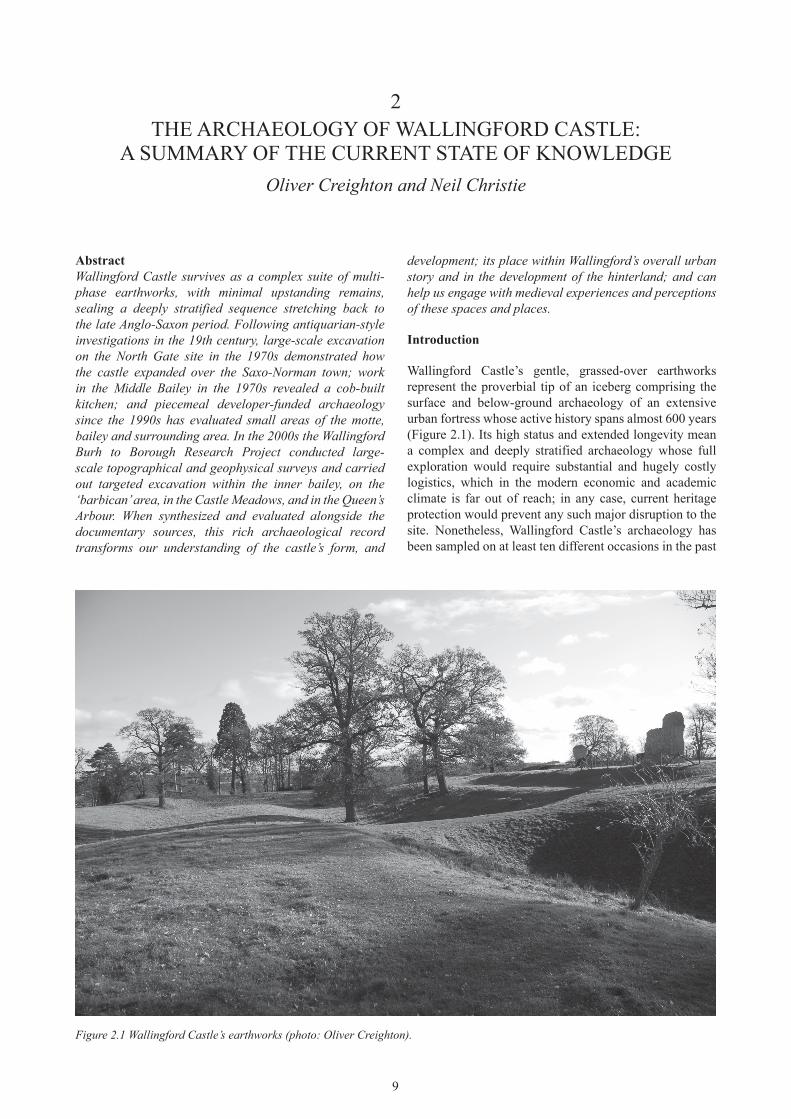
Wallingford Castle’s gentle, grassed-over earthworks represent the proverbial tip of an iceberg comprising the surface and below-ground archaeology of an extensive urban fortress whose active history spans almost 600 years (Figure 2.1). Its high status and extended longevity mean a complex and deeply stratified archaeology whose full exploration would require substantial and hugely costly logistics, which in the modern economic and academic climate is far out of reach; in any case, current heritage protection would prevent any such major disruption to the site. Nonetheless, Wallingford Castle’s archaeology has been sampled on at least ten different occasions in the past
Figure 2.1 Wallingford Castle’s earthworks (photo: Oliver Creighton).

10
and present – for curiosity, for academic research and in advance of building development, sometimes realized and sometimes not (Figure 2.2).
This paper presents a digest of and commentary on all the known archaeological interventions on Wallingford Castle. It forms a summary statement in support of a comprehensive monograph on the town’s archaeology that is the principal output of the Wallingford Burh to
Borough Research Project (Christie and Creighton 2013). In particular it serves to flag the rich archaeological potential of the site, to sit alongside the wealth of related documentary data that have been explored in this volume. The discussion that concludes this paper reflects upon the myriad ways in which archaeological investigation has illuminated Wallingford Castle’s landscape context.
Figure 2.2 Map showing archaeological excavations and other interventions on the castle site (illustration: Mike Rouillard).
11
Early Interventions
The first known archaeological excavations on the castle are recorded in the late 19th century by John Kirby Hedges – gentleman scholar, owner of the site and historian of the town (1881, I, 149–52). While Hedges was keen to document his erroneous belief in a Roman ancestry for Wallingford, and reported the recovery of Roman objects and coins from the castle, he readily acknowledged that the archaeological features he described there were certainly medieval. He reported much earlier explorations of c. 1700 that revealed a passageway between two walls, apparently near the castle mound, as well as 19th-century investigations of a passageway with a staircase at each end (possibly the same feature) and a sluice. In addition we are told that near the base of the motte Hedges revealed the earthwork to have apparently been built upon a large saucer-like masonry foundation (although he was in all probability describing a stone-lined ditch).
The 1960s: the North Gate site
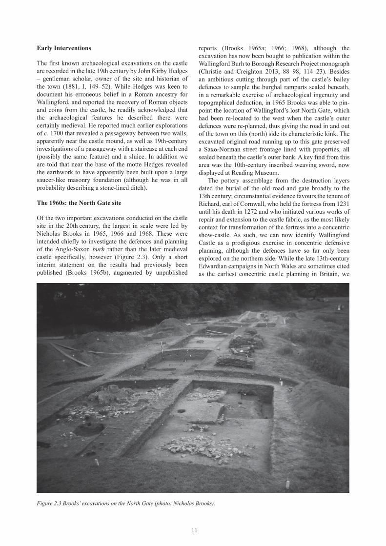
of the two important excavations conducted on the castle site in the 20th century, the largest in scale were led by Nicholas Brooks in 1965, 1966 and 1968. These were intended chiefly to investigate the defences and planning of the Anglo-Saxon burh rather than the later medieval castle specifically, however (Figure 2.3). only a short interim statement on the results had previously been published (Brooks 1965b), augmented by unpublished
reports (Brooks 1965a; 1966; 1968), although the excavation has now been bought to publication within the Wallingford Burh to Borough Research Project monograph (Christie and Creighton 2013, 88–98, 114–23). Besides an ambitious cutting through part of the castle’s bailey defences to sample the burghal ramparts sealed beneath, in a remarkable exercise of archaeological ingenuity and topographical deduction, in 1965 Brooks was able to pin-point the location of Wallingford’s lost North Gate, which had been re-located to the west when the castle’s outer defences were re-planned, thus giving the road in and out of the town on this (north) side its characteristic kink. The excavated original road running up to this gate preserved a Saxo-Norman street frontage lined with properties, all sealed beneath the castle’s outer bank. A key find from this area was the 10th-century inscribed weaving sword, now displayed at Reading Museum.
The pottery assemblage from the destruction layers dated the burial of the old road and gate broadly to the 13th century; circumstantial evidence favours the tenure of Richard, earl of Cornwall, who held the fortress from 1231 until his death in 1272 and who initiated various works of repair and extension to the castle fabric, as the most likely context for transformation of the fortress into a concentric show-castle. As such, we can now identify Wallingford Castle as a prodigious exercise in concentric defensive planning, although the defences have so far only been explored on the northern side. While the late 13th-century Edwardian campaigns in North Wales are sometimes cited as the earliest concentric castle planning in Britain, we
Figure 2.3 Brooks’ excavations on the North gate (photo: Nicholas Brooks).
12
should remember that the plan of Dover castle exhibited concentricity by the late 12th century; specific inspiration for the planning of Wallingford Castle may be sought at the Tower of London, where Edward I likely re-activated an initiative of Henry III in 1238 or 1239 to add an outer moat and wall to the royal castle, or even at Ascalon, on the Mediterranean coast of Israel, where Richard, earl of Cornwall, had been personally involved in the construction of a double-walled castle completed by the end of April 1241 (Pringle 1984, 143–46; Goodall 2011, 139–42, 191, 200–27).
The 1970s: the middle bailey
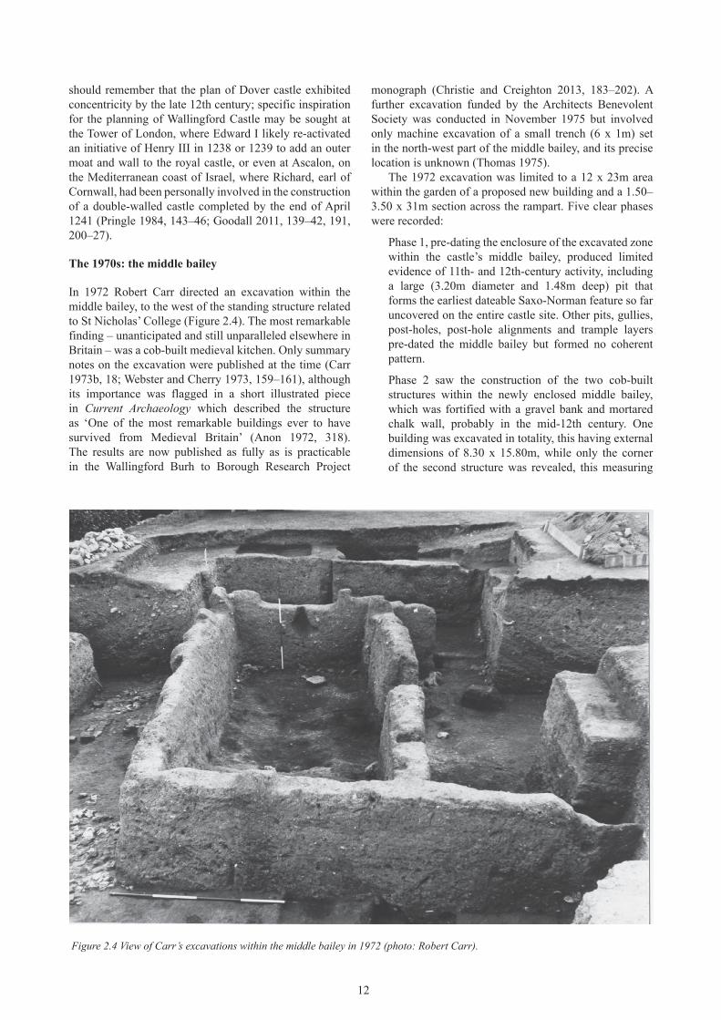
In 1972 Robert Carr directed an excavation within the middle bailey, to the west of the standing structure related to St Nicholas’ College (Figure 2.4). The most remarkable finding – unanticipated and still unparalleled elsewhere in Britain – was a cob-built medieval kitchen. only summary notes on the excavation were published at the time (Carr 1973b, 18; Webster and Cherry 1973, 159–161), although its importance was flagged in a short illustrated piece in Current archaeology which described the structure as ‘one of the most remarkable buildings ever to have survived from Medieval Britain’ (Anon 1972, 318). The results are now published as fully as is practicable in the Wallingford Burh to Borough Research Project
monograph (Christie and Creighton 2013, 183–202). A further excavation funded by the Architects Benevolent Society was conducted in November 1975 but involved only machine excavation of a small trench (6 x 1m) set in the north-west part of the middle bailey, and its precise location is unknown (Thomas 1975).
The 1972 excavation was limited to a 12 x 23m area within the garden of a proposed new building and a 1.50–3.50 x 31m section across the rampart. Five clear phases were recorded:
Phase 1, pre-dating the enclosure of the excavated zone within the castle’s middle bailey, produced limited evidence of 11th- and 12th-century activity, including a large (3.20m diameter and 1.48m deep) pit that forms the earliest dateable Saxo-Norman feature so far uncovered on the entire castle site. other pits, gullies, post-holes, post-hole alignments and trample layers pre-dated the middle bailey but formed no coherent pattern.
Phase 2 saw the construction of the two cob-built structures within the newly enclosed middle bailey, which was fortified with a gravel bank and mortared chalk wall, probably in the mid-12th century. one building was excavated in totality, this having external dimensions of 8.30 x 15.80m, while only the corner of the second structure was revealed, this measuring
Figure 2.4 View of Carr’s excavations within the middle bailey in 1972 (photo: Robert Carr).
13
1.90 x 4.60m. Rising to a height of 1.80m, the cob walls of the main building had been preserved by a massive operation of earth movement related to the refortification and extension of the castle in the mid-13th century. Doorways and internal hearths were identified and the complex can confidently be identified as a medieval kitchen.
Phase 3 comprised the episode of soil dumping in the 13th century that infilled the middle bailey and raised the ground level within this zone by at least 2.00m. No structures were excavated that could be associated with this phase. It is feasible to link this work, presumably associated with construction of new, ‘modernized’ kitchens elsewhere in the castle site, perhaps in the inner bailey, with large-scale reorganization of the site during the tenure of Richard, earl of Cornwall.
Phase 4 features relate to a mid-17th-century Civil War rebuild of the curtain wall, here comprising a crude arrangement of mortar-bonded chalk blocks rising to a height of 1.30m and at least 0.70m wide.
Lastly, Phase 5 was directly related to the 19th-century landscaping of the outer ward. Perhaps John Kirby Hedges’ various finds came about from such works.
Besides the ceramics, important information derives from the fairly rich animal bone assemblage from the Carr excavations. This zooarchaeological assemblage produced evidence for a wide range of species with sheep the most common, followed by cattle and then pig – a sequence that
is unusual for a castle site, where pig typically predominate. Horse, dog and cat bones were next in the sequence, and, although less frequently encountered, were present in similar quantities. Although all parts of the carcass were recovered for the major domestic species, when these are compared in terms of their likely survival it seems apparent that only pig remains were consistent with the deposition of relatively complete carcasses. The pig, sheep and cattle assemblages show a cull of prime meat age animals, while evidence for sheep and pig neonatal fatalities implies that they were bred on or close to the site. Indeed, there is good documentary evidence for this, as shown by Dr Keats-Rohan in this volume (p. 70). Wild mammals included red, roe and fallow deer, hare and rabbit, as well as wild bird species hunted for the table, including mallard and teal, partridge, pheasant and woodcock. oysters and fish, including cod, were also noted, but in low numbers.
Medieval kitchens are notoriously ephemeral structures and the fact that most of the surviving evidence elsewhere in Britain relates to service buildings incorporated into masonry structures such as towers and donjons (as at Durham) or built against curtain walls (as at Pontefract and Berkeley) makes the existence of a freestanding example within the middle bailey at Wallingford more remarkable still (see Kenyon 1990, 138–50). The context of the Wallingford Castle cob buildings is problematic, since, while kitchens within the castle are documented from the 13th century onwards, it is not always clear whether these remained on the same site/s, and evidence for multiple kitchens within castle complexes is well known. Most
Figure 2.5 the curtain wall on the south side of the middle bailey (photo: Oliver Creighton).
14
probably they were linked to an adjacent hall within the middle bailey before their destruction in the 13th century, being too distant to have served diners within the motte-top donjon, which had its own kitchens (for full discussion, see Christie and Creighton 2013, 198–202).
The 1990s: developer-funded interventions
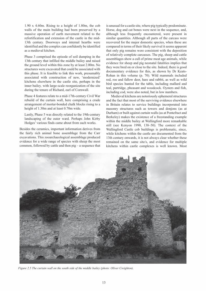
Interventions across the 1980s were limited to only a small-scale piece of archaeological recording in 1987, although this was centred on the surveying of a segment of the 30m-long surviving stretch of curtain wall on the south-east side of the middle bailey (Figure 2.5); the work was undertaken in advance of attempts to rectify an outward lean (Durham 1987). This survey revealed that the masonry was originally squared and finished to an ashlar face, although its heavily eroded condition gives the outward impression of coursed rubble.
The changing context of professional archaeology since the earlier campaigns of excavation on Wallingford Castle ensured that the next interventions into the site’s rich archaeological sequence, in the early 1990s, took a very different form – namely as small-scale evaluations funded by developers. Two such evaluations took place, both in the vicinity of the Castle Farm site to the south-east of the motte and beyond the zone of the Scheduled Ancient Monument. First, a watching brief and small-scale excavation of a 16 x 9m trench by the oxford Archaeological Unit in advance of the insertion of a slurry tank encountered a substantial ditch, interpreted as the bailey ditch but more likely to be that of the motte, filled with layers of re-deposited building materials (oAU 1992). Subsequent building development on the site (with construction of Thameside Mansion) entailed a Thames valley Archaeological Services field evaluation involving two machine-cut trenches, which revealed made-up ground thought to relate to 17th-century Civil War refurbishment
(Ford 1995). A related watching brief observed an area of unmortared rubble, conceivably representing part of the bailey defences and tentatively dated to the 13th/14th century on the basis of related pottery (Saunders 1995; Ford et al. 2012).
other developer-funded evaluations have sampled areas on the fringe of the castle, including the former Lamb Garage site on Castle Street, where interventions revealed evidence of late 11th-century activity seemingly corresponding to an intensification of occupation in the immediate environs of the newly established Norman fortress (Hull and Pine 2001; Mundin 2008).
The 2000s: the Wallingford Burh to Borough Research Project – surveys and excavations
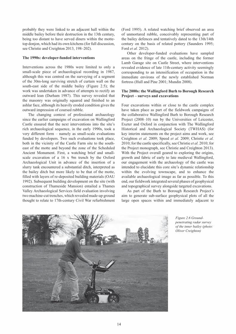
Four excavations within or close to the castle complex have taken place as part of the fieldwork campaigns of the collaborative Wallingford Burh to Borough Research Project (2008–10) run by the Universities of Leicester, Exeter and oxford in conjunction with The Wallingford Historical and Archaeological Society (TWHAS) (for key interim statements on the project aims and work, see Creighton et al. 2009; Speed et al. 2009; Christie et al. 2010; for the castle specifically, see Christie et al. 2010; for the Project monograph, see Christie and Creighton 2013). With the Project overall geared to exploring the origins, growth and fabric of early to late medieval Wallingford, our engagement with the archaeology of the castle was intended to elucidate this core site’s dynamic relationship within the evolving townscape, and to enhance the available archaeological image as far as possible. To this end, our fieldwork integrated several phases of geophysical and topographical survey alongside targeted excavations.
As part of the Burh to Borough Research Project’s aim to generate sub-surface geophysical plots of all the large open spaces within and immediately adjacent to
Figure 2.6 ground-penetrating radar survey of the inner bailey (photo: Oliver Creighton)
15
the historic urban core, resistivity and magnetometry surveys of accessible areas across the castle site have been conducted, as well as more limited use of GPR (ground-penetrating radar) (Figure 2.6). Covering a large swathe of the castle’s inner and outer baileys, plus Castle Meadows beyond, and alongside the river at Queen’s Arbour and King’s Mead, these data have helped pinpoint targeted excavations to answer key questions, but they also form an immensely valuable source of information in their own right about the castle and its context, to be interpreted in tandem with our extensive topographical earthwork survey. Particularly striking is the high level of stonework survival despite the site’s apparently thorough slighting, including clear traces of multiple curtain walls; a complex of internal buildings; outlying features including a curving feature projecting into the Queen’s Arbour (see below); and plentiful evidence also of post-medieval landscaping and gardening (see Figure 2.6).
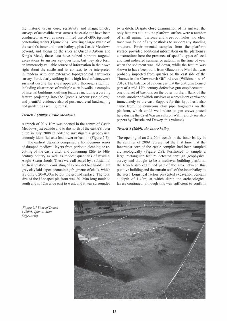
Trench 1 (2008): Castle Meadows
A trench of 20 x 10m was opened in the centre of Castle Meadows just outside and to the north of the castle’s outer ditch in July 2008 in order to investigate a geophysical anomaly identified as a lost tower or bastion (Figure 2.7).
The earliest deposits comprised a homogenous series of dumped medieval layers from periodic cleaning or re-cutting of the castle ditch and containing 12th- to 14th-century pottery as well as modest quantities of residual Anglo-Saxon sherds. These were all sealed by a substantial artificial platform, consisting of a compact but friable light grey clay laid deposit containing fragments of chalk, which lay only 0.20–0.30m below the ground surface. The total size of the U-shaped platform was 20–25m long north to south and c. 12m wide east to west, and it was surrounded
by a ditch. Despite close examination of its surface, the only features cut into the platform surface were a number of small animal burrows and tree-root holes; no clear trace was found of any postholes to support any standing structure. Environmental samples from the platform surface provided additional information on the platform’s construction: here the presence of specific types of seed and fruit indicated summer or autumn as the time of year when the sediment was laid down, while the feature was shown to have been built from Glauconitic Marl that was probably imported from quarries on the east side of the Thames in the Crowmarsh Gifford area (Wilkinson et al. 2010). The balance of evidence is that the platform formed part of a mid-17th-century defensive gun emplacement – one of a set of bastions on the outer northern flank of the castle, another of which survives as a prominent earthwork immediately to the east. Support for this hypothesis also came from the numerous clay pipe fragments on the platform, which could well relate to gun crews posted here during the Civil War assaults on Wallingford (see also papers by Christie and Dewey, this volume).
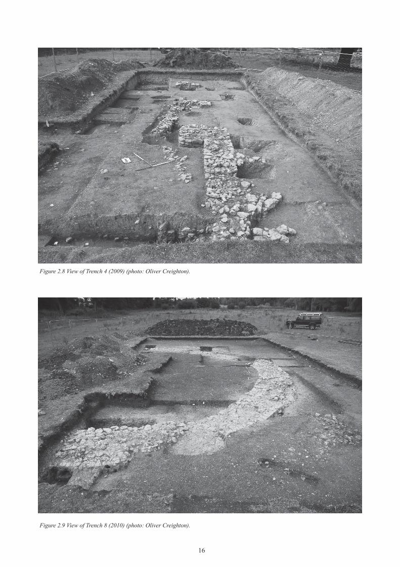
Trench 4 (2009): the inner bailey
The opening of an 8 x 20m trench in the inner bailey in the summer of 2009 represented the first time that the innermost core of the castle complex had been sampled archaeologically (Figure 2.8). Positioned to sample a large rectangular feature detected through geophysical survey and thought to be a medieval building platform, the trench also examined part of the area between this putative building and the curtain wall of the inner bailey to the west. Logistical factors prevented excavation beneath a depth of 1.42m, at which depth the archaeological layers continued, although this was sufficient to confirm
Figure 2.7 View of trench 1 (2008) (photo: Matt edgeworth).
16
Figure 2.8 View of trench 4 (2009) (photo: Oliver Creighton).
Figure 2.9 View of trench 8 (2010) (photo: Oliver Creighton).
17
a sequence of occupation extending back to the first phase of the Norman castle.
The earliest archaeological feature was an oval oven or dryer in the south-eastern corner of the trench; it had a heat-affected clay base and was datable to the late 11th to 12th century. Above this, and beneath a much later spread of demolition rubble relating to the castle’s post-17th-century Civil War slighting, a complex suite of archaeological features including pits, gullies, and walls was cut into a series of imported silty marl layers that formed the level ground surface of the bailey interior. The core of the excavated site could be rationalized as part of an undercroft attached to a larger domestic building – perhaps a storage area associated with a kitchen, or a wine cellar. valuably, the presence of intact stretches of (partially robbed) medieval walling alongside robber trenches demonstrates some structural survival despite the apparently heavy post-medieval slighting and later landscaping.
This trench produced the largest and most important ceramic assemblage of any of the Wallingford Burh to Borough Research Project excavations within the castle. The main fabric type was Wallingford medieval fabric 37, with vessel types including sooted and burnt cooking pots with thumbed and splayed rims dated to the 11th–12th century and incised decorated and glazed pitchers and jugs of the 12th century; there were also applied decorated and rouletted band pitchers and jugs with olive green and light green glaze. Alongside cooking pots, other vessels may
have been jars for storage, industrial or even medicinal usage; skillets and pipkins (medieval frying pans and saucepans with internal glaze and external sooting) were also recovered as well as glazed and decorated jugs and pitchers for serving liquids, and tripod pitchers for liquid storage. The animal bone assemblage was perhaps relatively modest, but showed, somewhat unusually, that the Norman phase material was dominated by chicken, with sheep and pig recorded in similar quantities followed by cattle, and dog, cat, goose, duck, hare and red deer (antler only). For possible identification of this area with one of the castle’s documented halls, see Keats-Rohan below, p. 84.
Trench 8 (2010): the Queen’s Arbour
The area known as the Queen’s Arbour, located between the east curtain wall of the inner bailey and the River Thames, was the focus of an excavation in the summer of 2010 (Figure 2.9). A trench of 12 x 25m was positioned to reveal the total plan of a large U-shaped masonry structure initially identified through resistivity survey and sampled through a small-scale evaluation trench by members of the Pilot Project team in 2003. The main stone wall of the U-shaped structure proved to be the earliest feature on the site, underlain by/set into a thick layer of alluvial clay. Formed from a chalk wall between 1.55m and 1.8m in width, the structure itself was 16.6m across and extended westwards out of the trench towards the elevated eastern
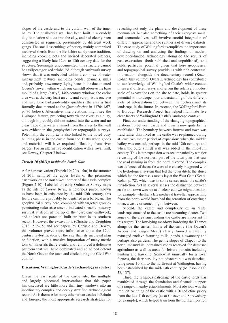
Figure 2.10 View of trench 10 (2011) (photo: Neil Christie).
18
slopes of the castle and to the curtain wall of the inner bailey. The chalk-built wall had been built in a crudely dug foundation slot cut into the clay, and had clearly been constructed in segments, presumably by different work gangs. The small assemblage of pottery mainly comprised medieval sherds from the Berkshire sandy ware tradition, including cooking pots and incised decorated pitchers, suggesting a likely late 12th- to 13th-century date for the structure. Seemingly undocumented, this structure cannot be easily categorized or labelled, although earthwork survey shows that it was embedded within a complex of water management features including ponds, channels, mills and, probably, a swannery. Lying beneath the documented Queen’s Tower, within which one can still observe the base mould of a large (early?) 14th-century window, the entire area was at the very least an elite and very private enclave and may have had garden-like qualities (the area is first formally documented as the Quenesherber in 1376: 1.57, p. 76 below). Alternative interpretations might see the U-shaped feature, projecting towards the river, as a quay, although it probably did not extend into the water and no clear trace of a water channel from the river to the wall was evident in the geophysical or topographic surveys. Potentially the complex is also linked to the noted busy building phase in the castle from the 1230s when goods and materials will have required offloading from river barges. For an alternative identification with a royal mill, see Dewey, Chapter 7 below.
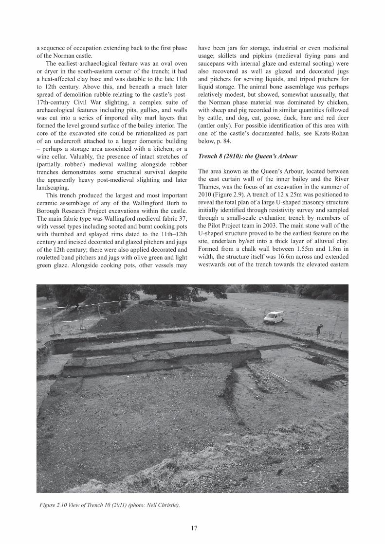
Trench 10 (2011): inside the North Gate
A further excavation (Trench 10; 20 x 15m) in the summer of 2011 sampled the upper levels of the prominent earthwork on the north-west corner of the castle complex (Figure 2.10). Labelled on early ordnance Survey maps as the site of Cloere Brien, a notorious prison known to have been in existence by the mid-12th century, this feature can more probably be identified as a barbican. The geophysical survey here, combined with targeted ground-penetrating radar assessment, indicated sizeable masonry survival at depth at the lip of the ‘barbican’ earthwork, and at least one potential built structure in its southern sector. However, the excavations (Christie and Creighton 2013, 212–15; and see papers by Christie and Dewey, this volume) proved more informative about the 17th-century re-fortification of the site than its medieval plan or function, with a massive importation of many metric tons of materials that elevated and reinforced a defensive platform that will have dominated and so helped defend the North Gate to the town and castle during the Civil War conflict.
Discussion: Wallingford Castle’s archaeology in context
Given the vast scale of the castle site, the multiple and largely piecemeal interventions that this paper has discussed are little more than tiny windows into an inordinately complex and deeply stratified archaeological record. As is the case for many other urban castles in Britain and Europe, the most appropriate research strategies for
revealing not only the plans and development of these monuments but also something of their everyday social and economic lives, will involve careful integration of different approaches and the synthesis of diverse datasets. The case study of Wallingford exemplifies the importance of drawing on and analysing the findings of modern developer-funded archaeology alongside the results of past excavations (both published and unpublished), and holds particular potential given that here geophysical and topographical survey provide us with rich contextual information alongside the documentary record (Keats-Rohan, this volume). overall, archaeology has contributed to our knowledge of Wallingford Castle’s wider context in several different ways and, given the relatively modest scale of excavations on the site to date, holds its greater potential still to deepen our understanding of the different sorts of interrelationship between the fortress and its landscape in the future. In essence, the Wallingford Burh to Borough Research Project has helped illuminate five clear facets of Wallingford Castle’s landscape context.
First, our understanding of the changing topographical relationship between castle and town is now quite firmly established. The boundary between fortress and town was fluid rather than fixed as the castle was re-planned during at least two major period of expansion: when the middle bailey was created, perhaps in the mid-12th century; and when the outer (third) wall was added in the mid-13th century. This latter expansion was accompanied by a major re-casting of the northern part of the town plan that saw the road running in from the north diverted. The complex wet defences of the castle were also closely integrated with the hydrological system that fed the town ditch: the sluice which fed the fortress’s moats lay at the West Gate (Keats-Rohan p. 72), which was in some senses under the castle’s jurisdiction. Yet in several senses the distinction between castle and town was not at all clear-cut: we might question, for example, whether a late medieval traveller approaching from the north would have had the sensation of entering a town, a castle or something in between.
Second, the extent and complexity of an ‘elite’ landscape attached to the castle are becoming clearer. Two zones of the area surrounding the castle are important in this regard. The low-lying meadows bordering the Thames alongside the eastern limits of the castle (the Queen’s Arbour and King’s Mead) clearly formed a carefully managed enclave featuring mills, ponds, a swannery and perhaps also gardens. The gentle slopes of Clapcot to the north, meanwhile, contained zones reserved for demesne agriculture as well as areas for leisure pursuits including hunting and hawking. Somewhat unusually for a royal fortress, the deer park lay not adjacent but was detached, lying some 10 km to the north-east at Watlington, having been established by the mid-13th century (Mileson 2009, 58, 137).
Third, the religious patronage of the castle lords was manifested through the foundation and financial support of a range of nearby establishments. Most obvious was the implicit twinning of the castle with a Benedictine priory from the late 11th century (as at Chester and Shrewsbury, for example), which helped transform the northern portion
19
of the town into a tangibly elite enclave. The castle also embraced within its defences (at least from the early 12th century) a collegiate church, while further afield hospitals at the South Gate and on the opposite (east) side of the bridge of the town were additional elements within the royal re-shaping of Wallingford’s urban space.
Fourth, archaeology has been a little less successful in informing about lines of social and economic contact between castle and territory. Analysis of ceramic goods might tell us about the economic ‘pull’ or ‘reach’ of the castle and how this increased and decreased, but our limited dataset ensures these remain research questions for the future (see discussion by Underwood Keevill in Christie and Creighton 2013, 359–65). At Sandal (West Yorkshire) detailed studies of the pottery assemblage suggested that tenurial linkages between the widely scattered de Warenne estates had a profound influence on the array of ceramic products at the site (Moorhouse 1983; see also McCarthy and Brooks 1988, 92–3). Might such patterns be replicated at Wallingford, which similarly acted as the hub of a large and wealthy honour? Would such patterns reflect commercial trade or the physical movement of individuals such as estate officials between parts of the honour?
Archaeology has been much more successful, however, in illuminating ‘foodways’: comparison of animal bone assemblages within town and castle tells us much about the differential access of communities to foodstuffs procured from surrounding estates (Christie and Creighton 2013, 365–74).
Fifth, and still more difficult to come to grips with, is the visual relationship between castle and its setting – i.e. the ways in which the fortress was perceived as approached from vantage points including the great stone bridge, for example, or via the convoluted approach from the north that by the late medieval period skirted the castle’s dramatic concentric defences. Fortunately, the rich and wide-ranging documentary study by Keats-Rohan and Dewey in this book has transformed this situation.
When considered in conjunction with the documentary sources, it is clear that archaeology can feed strongly into our understanding not only of the castle’s place in Wallingford’s overall urban story and in the development of its hinterland, but can also help us engage more with medieval experiences and perceptions of these environments as they evolved and were transformed through the centuries.